famsi © 2006: micaela raquel macario cálgua · cross-section of the north and east wall of pit 1...
TRANSCRIPT

FAMSI © 2006: Micaela Raquel Macario Cálgua
The Inhabitants of Q'umarkaaj, Late Postclassic K'iche'-Mayan Capital: Guatemalan Highlands
Archaeological Data and Current Representations
Translation of the Spanish by Kim Goldsmith
Research Year: 2004 Culture: K'iche'-Maya Chronology: Late Postclassic Location: Santa Cruz de El Quiché, Guatemala Site: Q'umarkaaj Table of Contents
Abstract Resumen Introduction Excavations at Q'umarkaaj South Terrace Staircase East Platform and West Platform in the Central Terrace Ceramic Obsidian Conclusions Acknowledgements List of Figures Sources Cited

Abstract
The 2002-2004 Q'umarkaaj Project used three disciplines as principle axes of investigation: Ethnohistory, Ethnography and Archaeology. The third part of the project, that is, the archaeological excavations and the analysis of cultural material, was made possible through a generous grant by the Foundation for the Advancement of Mesoamerican Studies, Inc. (FAMSI - grant #03057). By means of these excavations we were able to detect the presence of architectural remains, as well as determine their morphology and the possible functions of the two structures further away from the Main Plaza of the site. The location and dimension of these structures, though modest, and the cultural material associated with them provide indispensable information for the understanding of the social organization of the last K'iche'-Mayan capital.
Resumen
En el proyecto Q'umarkaaj 2002-2004, se utilizaron tres disciplinas, como ejes principales de investigación: la etnohistoria, la etnografía y la arqueología. El tercer eje del proyecto, es decir, las excavaciones arqueológicas y el análisis del material cultural excavado se realizó gracias a la ayuda financiera de la Fundación para el Avance de los Estudios Mesoamericanos, Inc., (FAMSI - Beca #03057). A través de estas excavaciones se pudo detectar la presencia de vestigios arquitectónicos, determinar su morfología y las posibles funciones de dos estructuras alejadas de la Plaza Principal del sitio. La situación de estas estructuras, sus dimensiones modestas y el material cultural asociado a ellas proporcionan información indispensable para la comprensión de la organización social en la última capital Maya-K'iche'.
Introduction
The archaeological site of Q'umarkaaj, also known as Utatlán, is 2 km from Santa Cruz, provincial capital of El Quiché. It is located to the southwest of Santa Cruz in the village of Las Ruinas. Its elevation is 2,021 meters above sea level, with a Northern latitude of 15º01'15" and a western longitude of 91º10'15". This Postclassic city was constructed on a natural, defensive headland of less than 1 km2, surrounded by ravines from 80 to 100 m deep with its only current access to the northeast. Various tributaries of the Chixoy River run downward, which are the rivers of La Estancia, Ismachi, Pachitac, Chuiguilaj and Quebrada Xatinab (Figure 1).
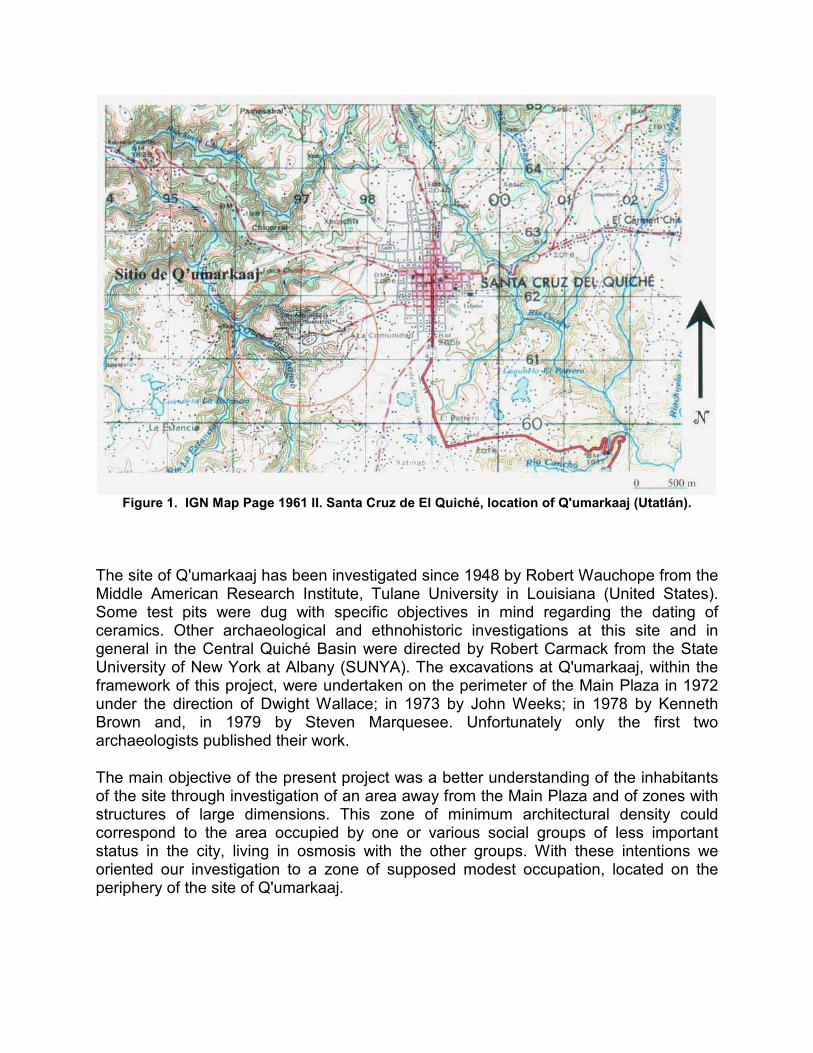
Figure 1. IGN Map Page 1961 II. Santa Cruz de El Quiché, location of Q'umarkaaj (Utatlán).
The site of Q'umarkaaj has been investigated since 1948 by Robert Wauchope from the Middle American Research Institute, Tulane University in Louisiana (United States). Some test pits were dug with specific objectives in mind regarding the dating of ceramics. Other archaeological and ethnohistoric investigations at this site and in general in the Central Quiché Basin were directed by Robert Carmack from the State University of New York at Albany (SUNYA). The excavations at Q'umarkaaj, within the framework of this project, were undertaken on the perimeter of the Main Plaza in 1972 under the direction of Dwight Wallace; in 1973 by John Weeks; in 1978 by Kenneth Brown and, in 1979 by Steven Marquesee. Unfortunately only the first two archaeologists published their work.
The main objective of the present project was a better understanding of the inhabitants of the site through investigation of an area away from the Main Plaza and of zones with structures of large dimensions. This zone of minimum architectural density could correspond to the area occupied by one or various social groups of less important status in the city, living in osmosis with the other groups. With these intentions we oriented our investigation to a zone of supposed modest occupation, located on the periphery of the site of Q'umarkaaj.

Figure 2. Plan of Q'umarkaaj. Architectural groups according to D. Wallace (1977) and the
indication of the investigation zone 2003.
Excavations at Q'umarkaaj
Our archaeological investigations began with the partial topographic survey of the site and with a series of exhaustive surface surveys. These surveys allowed us to locate the structures reported by Archaeologist Dwight Wallace (1977) (Figure 2), to see its actual state of conservation (which is very deteriorated), and to locate the areas which did not have visible structures (Figure 3). The potential excavation zone was selected for its regular topography and for its location away from the large buildings of the Main Plaza, in the western zone at least 6 m from the edge of the west ravine. This zone, made up of 160x50 m and apparently empty, presented three sections whose reliefs varied slightly, called: North Terrace, South Terrace and Central Terrace.

Figure 3. Topographic survey of the West sector of Q'umarkaaj and location of the excavations
(R. Cambranes and E. Ortega 2003).
With these surveys it was evident that Q'umarkaaj is a highly looted archaeological site, with dozens of regular trenches that followed the borders of the majority of the structures.
The excavations were carried out in October of 2003. They began with a total clearing of the sector that was to be investigated and of the structures that were closest to the three terraces, the mounds of the RC 5b Minor Complex and Mound M2. In order to obtain preliminary information regarding the stratigraphic composition of the terraces, seven test pits were dug. Five of them in the South Terrace were laid out on a southwest/northeast axis, from the edge of the ravine toward the west of Mound M2, with 5 m of distance between each one. Another two test pits were dug parallel, 15 m to the northwest in the Central Terrace. These test pits showed clear human activity on the terraces.

Figure 4a. Photograph of the Staircase on the South Terrace (R. Macario 2004).
South Terrace Staircase
In Pit 1 (2x3 m) a staircase was discovered (Figure 4a, above, and Figure 4b) formed of three rows, one on top of another. This staircase with a north-south orientation to 16º NE corresponds to an access system toward the structures of the RC 5b Minor Complex and particularly toward Mound M2. The stairway, with access from the west side, unites two different areas: the terraces without visible surface structures and the areas with large structures. The scarcity of ceramic and lithic material could signify a function of an architectural element for public use where repetitive activities were not undertaken.

Figure 4b. Cross-section of the North and East wall of Pit 1 (R. Macario 2004).
A second pit, Pit 2, was made in the North Terrace; this intervention was limited to the localization of new alignments of worked pumice stone.
A relevant point of these operations is the localization of different types of constructive material in optimum condition: adobe, river stones, worked sediments, soapstone (jaboncillo), and worked pumice stone, as well as fill material, raw pumice stone, mica sheets and the reuse of artifacts such as fragments of grinding manos. It is necessary to point out that up until now the type of constructive material used at this site was unknown, and because of this, this information constitutes a good basis for future restoration work.
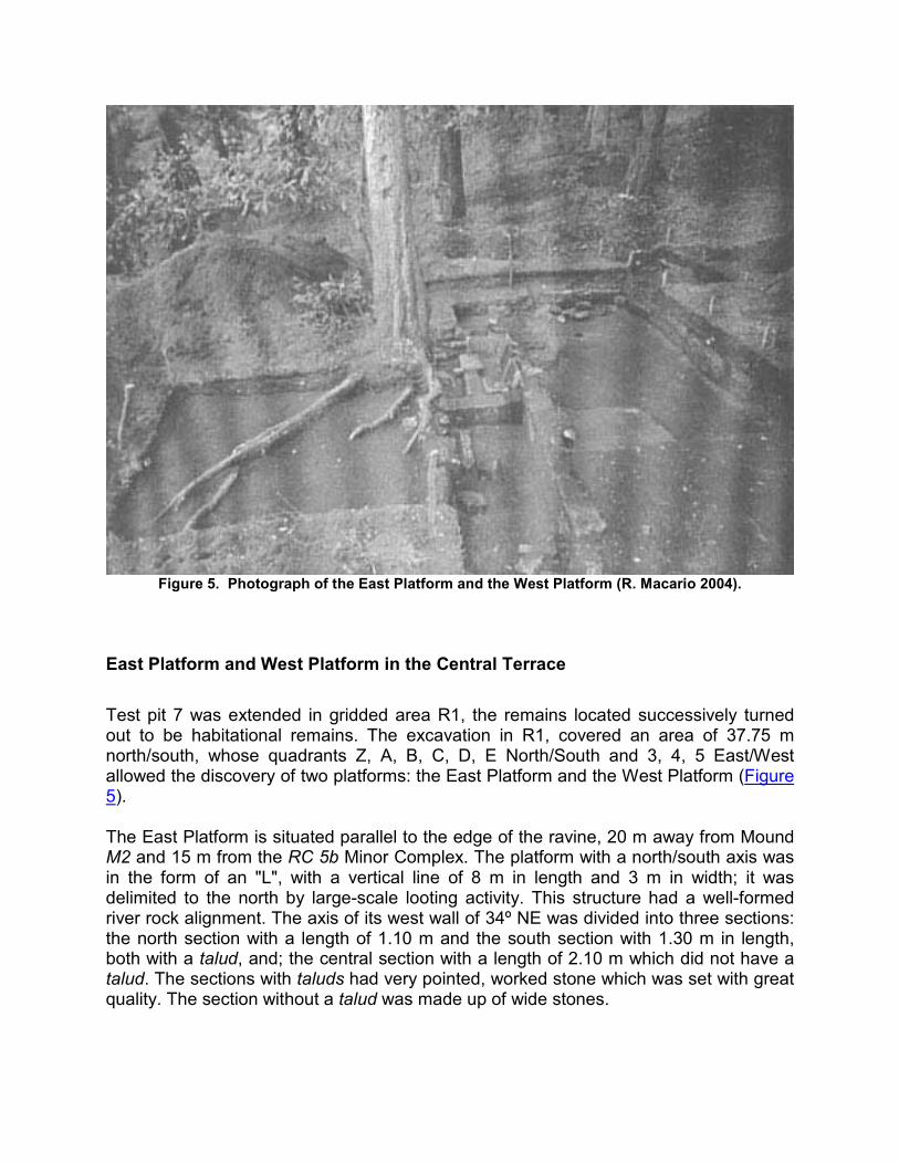
Figure 5. Photograph of the East Platform and the West Platform (R. Macario 2004).
East Platform and West Platform in the Central Terrace
Test pit 7 was extended in gridded area R1, the remains located successively turned out to be habitational remains. The excavation in R1, covered an area of 37.75 m north/south, whose quadrants Z, A, B, C, D, E North/South and 3, 4, 5 East/West allowed the discovery of two platforms: the East Platform and the West Platform (Figure 5).
The East Platform is situated parallel to the edge of the ravine, 20 m away from Mound M2 and 15 m from the RC 5b Minor Complex. The platform with a north/south axis was in the form of an "L", with a vertical line of 8 m in length and 3 m in width; it was delimited to the north by large-scale looting activity. This structure had a well-formed river rock alignment. The axis of its west wall of 34º NE was divided into three sections: the north section with a length of 1.10 m and the south section with 1.30 m in length, both with a talud, and; the central section with a length of 2.10 m which did not have a talud. The sections with taluds had very pointed, worked stone which was set with great quality. The section without a talud was made up of wide stones.

For the majority the interior of the East Platform, three occupational floors were located. A clay fire pit in the form of a deep basin was located on floor 2. The presence of this type of fire pit turned out not to be peculiar at Q'umarkaaj, since in the palace zones at least 10 fire pits of this type had been reported (D. Wallace 1977). With this find we could confirm the regular use of clay fire pits in the deep basin form in the palace zones and in less sumptuous structures, as with this platform. The great quantity of eroded and soot-stained ceramics, fragments of obsidian blades, animal bones, and a midden on the exterior of the East Platform, support the possible function of a domestic living area.
The West Platform is situated in front of the East Platform and is constructed of less elaborately worked river stone. The West Platform was partially discovered. Due to its placement at +5 cm over the exterior floor of the East Platform, it can be affirmed that this construction is subsequent to the first.

Figure 6. Photograph of the West façade of the East Platform (R. Macario 2004).
In the corridor between the two living areas, of 0.70/0.80 cm, three access systems were located. Two corresponded to the East Platform and one to the West Platform. One of the access systems of the East Platform was formed of worked stones partially added to the wall without a talud; this layout seems very comfortable for the threshold of wide stones. The second access, made up of crudely worked stone, was added to the

wall with a talud and placed at +5 cm from the exterior floor. The third access system corresponded to the West Platform and shares the same characteristics as the second. By the same token, a separation wall was located in this corridor between the last entrances of the two platforms. The last two entrances could have been constructions that were contemporary to the West Platform, while the access system that was placed over the wall without a talud could have been the original entrance to the East Platform. The layout may reflect a new spatial conditioning due to the construction of the new living area, that is to say, the West Platform, provoking the construction of the second entrance that was placed over the wall with the talud (Figure 6).
The constructive material in these platforms is worked river stone and some adobe blocks. The superstructures could be made up of perishable constructive material: some indications of this are prints of wooden ceiling beam supports located on the floors, daub (bajareque), and cane impregnations located in almost this whole operation.
Figure 8a. Brief catalog of the ceramics from Q'umarkaaj. Xola Orange Type (R. Macario 2004).
Ceramic
The objective of this analysis was to establish a preliminary typology and chronology of the site's ceramics. The idea was to make a report and a type collection of the ceramic groups as part of getting better acquainted with the cultural material of this site.

Figure 8b. Brief catalog of the ceramics from Q'umarkaaj. Raxaca Red Type (R. Macario 2004).
Our study ("Type-Variety" method) was based on a thorough comparative analysis of the samples of vessels from the Main Plaza of Q'umarkaaj which had been deposited in the storerooms of the National Museum of Archaeology and Ethnology of Guatemala, (Museo Nacional de Arqueología y Etnología de Guatemala), from the ceramic type collections dating from the Postclassic in the ceramic storerooms at the Institute of Anthropology and History, (Instituto de Antropología e Historia), and the data from the only ceramic study from the central basin of El Quiché, undertaken by Archaeologist John Weeks (1975, 1980).

Figure 8c. Brief catalog of the ceramics from Q'umarkaaj. Quiejche unslipped Type (R. Macario
2004).
Figure 8d. Brief catalog of the ceramics from Q'umarkaaj. Chinautla Polychrome (R. Macario
2004).

Figure 7. Graphs of the distribution of ceramic types in two interventions (R. Macario 2004).
Six groups were cataloged using systematic analysis: Xola, Raxaca, Cacá, Quiejché, polychrome groups, monochromes and five potential types (Figure 7). The ceramic forms are: large and small bowls; large globular jars and ollas, and, to a lesser extent; censers with anthropomorphic effigies or spines, comales and cups; the decoration boils down to simple grooves, double or multiple. The preliminary chronology is made up of the Late Postclassic; the localization of diagnostic ceramic groups and types for this period, such as Xola, Raxaca, Chinautla Polychrome, and White Fortaleza on Red (Fortaleza Blanca sobre Rojo) and White Fortaleza on Orange (Fortaleza Blanco sobre Naranja) suggest that the occupation, of the sectors investigated, correspond to the last phase of the Late Postclassic, between 1400 to 1524 A.D. (Figure 8a, Figure 8b, Figure 8c, Figure 8d, Figure 8e, Figure 8f).

Figure 8e. Samples of vases from the palace zones of Q'umarkaaj, conserved in the Museum of
Archaeology (R. Macario 2004).
Figure 8f. Sample of constructive material from the superstructures of the East Platform. Daub
(bajareque) impressions (R. Macario 2004).
Obsidian
The study results come essentially from the analysis of the technological aspect and the macroscopic analysis of the morphological attributes to determine the source of origin of

the material. The sample was constituted mainly of waste, fragmented or non-fragmented prismatic blades (some which were not used), projectile points and flakes with or without cortex. This analysis also considered the lithic sample from the nearby site El Resguardo, which was composed mostly of polyhedral cores, debitage (some with cortex) and macro flakes. The important concentration of material in different phases of manufacture could signify a strong activity, probably specialized in the production of prismatic blades. The obsidian used at both sites comes from the San Martín Jilotepeque source in Chimaltenango, 40 km from Q'umarkaaj (Figure 9). This information confirms Susan Norris' (2001) and John Weeks' (1975, 1980, 1988) data regarding the use of obsidian from San Martín Jilotepeque in the Central Basin of El Quiché.

Figure 9. Graph of the distribution and samples of the obsidian from Q'umarkaaj (R. Macario
2004).
Conclusions
The Q'umarkaaj Archaeological Project included three years of investigation. In October of 2003, a series of surface surveys were done which allowed us to show evidence that Q'umarkaaj is one of the sites in the Central Basin of El Quiché that is the most preyed upon by looters. The principal structures that form the Main Plaza and the larger groups have had their constructive materials removed. The second phase of our research consisted of precise excavations in the West sector of the site, where two platforms were located. The first could correspond to the living area of a growing family, which progressively occupied the available nearby spaces. The construction of the West living area in the space immediately between the East living area and the ravine could reflect a certain overpopulation of the city, on the eve of the arrival of the Spanish.
On the other hand, a stairway was located in Pit 1 that probably led to the M2 structures and the RC 5b Minor Complex. This staircase could correspond to the access system of the inhabitants of the terraces toward the major structures that probably served for relevant public functions.
The objectives of the precise excavations were fully reached. With our interventions we were able to discover the occupation of this sector away from the Main Plaza, besides determining the type of constructive material of this zone in situ. This information is of great importance since large scale looting has left the site without samples of the material used in the visible surface structures.
The excavated zone, as a probable modest living area, was minimally explored. With our operations, many expectations for future investigations in this same sector and in the whole site were opened. By the same token, another of the general objectives of the Q'umarkaaj Project was to take up again the investigations in Santa Cruz del Quiché, establishing a certain cooperation with the neighbors and the users of the site. With our investigations we were able to find out about the interest and preoccupation for the protection and conservation of this site, but above all to initiate a positive dialog with its users. It is evident that the local population needs to be taken into consideration for all intervention and management strategies regarding the use of cultural patrimony sites, as well as a revaluation of the system of local knowledge. The site is widely visited by the Ajq'ij or Maya priests as well as by indigenous and mestizo families. This affection for the site by the nearby populations, which appears throughout our ethnographic interviews (R. Macario 2004), is an attachment that is summed up in the commentary by Don Salvador, a Q'umarkaaj user: "We profoundly respect this place which is sacred and is the ancient city of our ancestors."

Acknowledgements
To Sandra Noble, Executive Director, and the Granting Committee of the Foundation for the Advancement of Mesoamerican Studies, Inc. (FAMSI) for the interest and indispensable support of this investigation. Thank you to Eric Taladoire, Director of the Department of Precolumbian Archaeology of the University of Paris I-La Sorbonne and to Marie-Charlotte Arnauld, Director of Research for the National Center for Scientific Research (Centre National de la Recherche Scientifique - CNRS-France) for the direction and indefatigable accompaniment during these years of work. Thanks to the support of Salvador López and Yvonne Putzeys from the Guatemalan Institute of Anthropology and History (Instituto de Antropología e Historia de Guatemala); the French Center for Mexican and Central American Studies (Centro Francés de Estudios Mexicanos y Centroamericanos - CEMCA); to the French Cultural and Scientific Cooperation in Central America (Cooperación Cultural y Científica en América Central de Francia - CCCAC). My sincere recognition to Robert Carmack, Alain Breton, John Weeks, Marie-France Fauvet-Berthelot, Sébastien Perrot-Minnot and Edgar Suyuc. Xuquje, sib'laj k' ben maltioxej ri Alfonso Yat, Apolinario Recancoj, Jesús Tipaz, Cleto Rojas, Antonio, Salvador, Juan Ixchop, xuquje ri, Felipe Gomez.
List of Figures
Figure 1. IGN Map Page 1961 II. Santa Cruz de El Quiché, location of Q'umarkaaj (Utatlán).
Figure 2. Plan of Q'umarkaaj. Architectural groups according to D. Wallace (1977) and the indication of the investigation zone 2003.
Figure 3. Topographic survey of the West sector of Q'umarkaaj and location of the excavations (R. Cambranes and E. Ortega 2003).
Figure 4a. Photograph of the Staircase on the South Terrace (R. Macario 2004).
Figure 4b. Cross-section of the North and East wall of Pit 1 (R. Macario 2004).
Figure 5. Photograph of the East Platform and the West Platform (R. Macario 2004).
Figure 6. Photograph of the West façade of the East Platform (R. Macario 2004).
Figure 7. Graphs of the distribution of ceramic types in two interventions (R. Macario 2004).
Figure 8a. Brief catalog of the ceramics from Q'umarkaaj. Xola Orange Type (R. Macario 2004).

Figure 8b. Brief catalog of the ceramics from Q'umarkaaj. Raxaca Red Type (R. Macario 2004).
Figure 8c. Brief catalog of the ceramics from Q'umarkaaj. Quiejche unslipped Type (R. Macario 2004).
Figure 8d. Brief catalog of the ceramics from Q'umarkaaj. Chinautla Polychrome (R. Macario 2004).
Figure 8e. Samples of vases from the palace zones of Q'umarkaaj, conserved in the Museum of Archaeology (R. Macario 2004).
Figure 8f. Sample of constructive material from the superstructures of the East Platform. Daub (bajareque) impressions (R. Macario 2004).
Figure 9. Graph of the distribution and samples of the obsidian from Q'umarkaaj (R. Macario 2004).
Sources Cited
Arnauld, Marie-Charlotte
1986 Archéologie de l'habitat en Alta Verapaz (Guatemala). Centre d'Etudes Mexicaines et Centraméricaines (CEMCA), Mexico-Guatemala.
Breton, Alain
1999 Rabinal Achi. Un drama dinástico maya del siglo XV. CEMCA. Guatemala.
Brown, L. Kenneth
1982 "Prehistoric demography within the Central Quiche area, Guatemala." In: The Historical demography of Highland Guatemala. Pp. 3547. Robert Carmack, John Early and Christopher Lutz, Edit. Institute for Mesoamerican Studies. State University of New York at Albany, publication No. 6.
Brown, L. Kenneth and Teresa Majewski
1983 "Una historia cultural de los quiches centrales desde el punto de vista arqueológico." In: Nuevas perspectivas sobre el Popol Vuh. Pp. 217-225. Piedra santa, Guatemala.
Carmack, Robert, Juan Fox and Rosalío Stewart
1975 La formación del Reino Quiché. Instituto de Antropología e Historia, Ministerio de Educación. Guatemala.

Carmack, Robert M.
1977a) "Los Quiches de Utatlán." In: Anales de la Sociedad de Geografía e historia. Año L–Tomo L. Pp. 17-24. Guatemala.
1981b) The Quiché Mayas of Utatlán. The evolution of a highland Guatemala kingdom. University of Oklahoma Press. Norman. U.S.A.
2001d) Kik'aslemaal le K'iche'aab'. Historia Social de los Quichés. Fondo de Desarrollo Indígena Guatemalteco y Cholsamaj. Guatemala.
Carmack, Robert and John Weeks
1981 "The archaeology and ethnohistory of Utatlán: A conjunctive approach" In: American Antiquity. Journal of the Society for American Archaeology. Vol. 46, No. 2. Abril. U.S.A.
Fauvet-Berthelot, Marie-France
1986 Ethnopréhistoire de la maison maya. (Guatemala 1250-1525). CEMCA, Mexico.
Fox, John W.
1977 "Quiché expansion processes: differential ecological growth bases within an archaic state." In: Archaeology and ethnohistory of the Central Quiché. Publication No. 1. Pp. 82-97. Institute for Mesoamerican Studies, State University of New York, Albany. New York, U.S.A.
Guillemin, George F.
1965 "Iximché. Capital del antiguo reino Cakchiquel." In: Revista de la Sociedad de Geografía e Historia de Guatemala. Pp. 5-53. Sociedad de Geografía e Historia de Guatemala, Guatemala.
1969 Exploration du Groupe C d'Iximché (Guatemala). Tire à Part. Bulletin de la Société Suisse des Américanistes. No. 33 Suisse.
1977 "Urbanism and hierarchy at Iximche" In: Social Processes in Maya Prehistory. Pp. 227-264. Norman Hammond (Ed.) Academic Press, New York & Londres.
Hill II, M. Robert
1999 "Los Quichés." In: Historia General de Guatemala. Tomo I, época prehispánica. Pp. 651-662. Jorge Luján Muñoz Dir. Asociación Amigos del País. Guatemala.
Ichon, Alain
1975 Organisation d'un centre Quiché protohistorique: Pueblo Viejo-Chichaj. R.C.P. 294. Ministère des Affaires Etrangères. Paris.
Nance, Roger C.
1998 "La cerámica y palacios de Iximché: Examen preliminar de la colección Guillemin proveniente de la capital Kaqchikel." In: Revista Mesoamérica 35. Junio 1998. Pp. 93-115. CIRMA, Plumsock Mesoamerican Studies. Vermont, U.S.A.
1996 The Guillemin ceramic collection form Iximché, the Cakchiquel capital in highland Guatemala. Report. CIRMA-Guatemala.
Navarrete, Carlos
1961 "La cerámica de Mixco Viejo." In: Humanidades, Vol. III, No. 7. Revista fascicular editada por la Facultad de Humanidades de la Universidad de San Carlos de Guatemala. Pp. 1-50. Guatemala.
Norris, Susan
2001 "Ethnohistory, archaeology, and the K'iche' Maya: An interdisciplinary approach to political economy." In: The past and present maya. Essays in honor of Robert Carmack. Pp. 29-45, Labyrinthos, California, U.S.A.
Popenoe de Hatch, Marion
1987 "La importancia de la Cerámica utilitaria en arqueología, con observaciones sobre la prehistoria de Guatemala." In: Anales de la Academia de Geografía e Historia de Guatemala 61. Pp. 151-184. Guatemala.
Stewart, Russell
1977 "Classic postclassic period settlement trends in the region of Santa Cruz del Quiché." In: Archaeology and ethnohistory of the Central Quiché. Publication No. 1. Pp. 68-81. Institute for Mesoamerican Studies, State University of New York, Albany. New York, U.S.A.
Wallace, Dwight
1977 "An intra-site locational analysis of Utatlan: The structure of an urban site." In: Archaeology and ethnohistory of the Central Quiché. Publication No. 1. Pp. 20-54. Institute for Mesoamerican Studies, State University of New York, Albany. New York, U.S.A.
Wauchope, Robert
1949 "Las edades de Utatlán e Iximché." In: Revista Antropología e Historia Vol. 1 No. 1. Pp. 10-22. IDAEH, Guatemala.
Weeks, John M.
1975 The archaeology of Greater Utatlán, El Resguardo and Pakaman excavations. Tesis de maestría, State University of New York at Albany, U.S.A.
1977 "Evidence for metalworking on the periphery of Utatlán" In: Archaeology and ethnohistory of the Central Quiché. Publication No. 1. Pp. 55-67. Institute for Mesoamerican Studies, State University of New York, Albany. New York, U.S.A.
1980 Dimensions of social differentiation at Chisalin, El Quiché, Guatemala, A.D. 1400-1524. Tomo I-II. Tesis doctoral de la State University of New York at Albany, U.S.A.
1988 Chisalin. A late postclassic Maya settlement in Highland Guatemala. British Archaeological Records, (BAR International). Series 169. England.