fall meeting and field trip - news - segsmatson, g.c., and clapp, f.g., 1909, a preliminary report...
TRANSCRIPT

Southeastern Geological Society Guidebook No. 51
Fall Meeting and Field Trip
November 20, 2010
Alum Bluff
Looking north along Alum Bluff (photo by H. Means)

2
Southeastern Geological Society Officers for 2009 – 2010:
Dave DeWitt, President (Southwest Florida Water Management District)
Andy Lawn, Vice President (HSW Engineering)
Harley Means, Secretary-Treasurer (Florida Geological Survey)
Todd Kincaid, Past President (H2H Associates)
Field Trip Leader:
Harley Means, P.G.
For information regarding the Southeastern Geological Society please visit our
website at: www.segs.org or mail a request for information to: SEGS, P.O. Box
1636, Tallahassee, FL 32302. The SEGS is affiliated with the American
Association of Petroleum Geologists and the Gulf Coast Association of Geological
Societies.

3
Table of Contents
Location map of Alum Bluff…………………………………………….. 4
Introduction……………………………………………………………… 5
Chipola Formation……………………………………………………….. 8
Undifferentiated Alum Bluff Group……………………………………... 14
Jackson Bluff Formation………………………………………………….. 15
Citronelle Formation………………………………………………………. 18
References……………………………………………………………….... 19
4
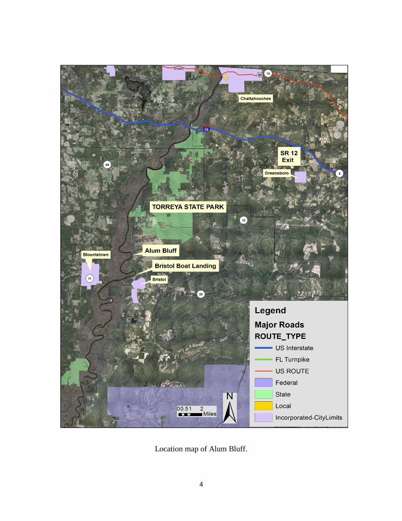
Location map of Alum Bluff.
5
Introduction
Alum Bluff is a classic geological exposure located along the east bank of the
Apalachicola River approximately 1.8 miles north of the town of Bristol in Liberty County,
Florida. Alum Bluff is the tallest natural exposure in Florida with elevations near the base of the
bluff at about 50 feet above MSL and elevations at the top of the bluff near 175 feet above MSL.
During low stages of the Apalachicola River approximately 125 feet of vertical exposure can be
observed.
Numerous authors have described the geology and paleontology of this famous locality.
Two previous SEGS field trips have focused on this area (SEGS Guidebook 25 and 42).
Excellent overviews of the geology as well as the nomenclatural history of the lithostratigraphic
units exposed at Alum Bluff can be found in the previously mentioned guidebooks and as such
will not be focused on here.
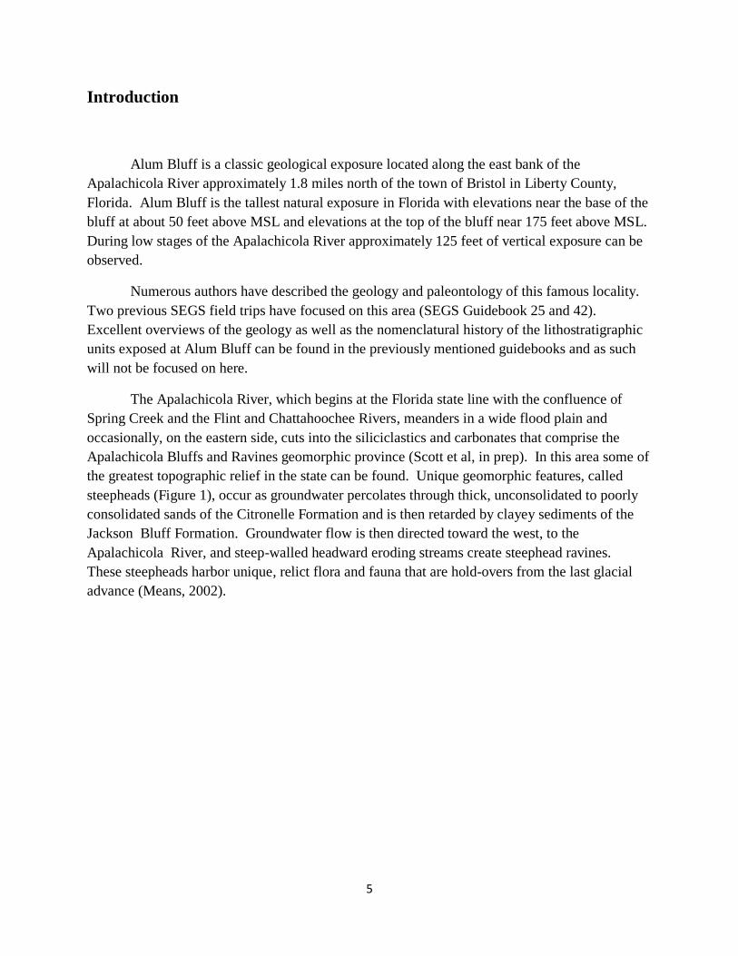
The Apalachicola River, which begins at the Florida state line with the confluence of
Spring Creek and the Flint and Chattahoochee Rivers, meanders in a wide flood plain and
occasionally, on the eastern side, cuts into the siliciclastics and carbonates that comprise the
Apalachicola Bluffs and Ravines geomorphic province (Scott et al, in prep). In this area some of
the greatest topographic relief in the state can be found. Unique geomorphic features, called
steepheads (Figure 1), occur as groundwater percolates through thick, unconsolidated to poorly
consolidated sands of the Citronelle Formation and is then retarded by clayey sediments of the
Jackson Bluff Formation. Groundwater flow is then directed toward the west, to the
Apalachicola River, and steep-walled headward eroding streams create steephead ravines.
These steepheads harbor unique, relict flora and fauna that are hold-overs from the last glacial
advance (Means, 2002).
6
Figure 1 – Steephead ravines near Alum Bluff.
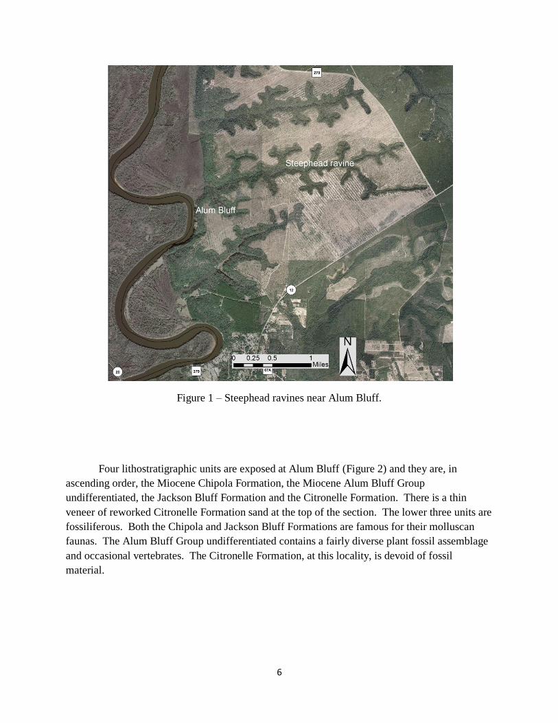
Four lithostratigraphic units are exposed at Alum Bluff (Figure 2) and they are, in
ascending order, the Miocene Chipola Formation, the Miocene Alum Bluff Group
undifferentiated, the Jackson Bluff Formation and the Citronelle Formation. There is a thin
veneer of reworked Citronelle Formation sand at the top of the section. The lower three units are
fossiliferous. Both the Chipola and Jackson Bluff Formations are famous for their molluscan
faunas. The Alum Bluff Group undifferentiated contains a fairly diverse plant fossil assemblage
and occasional vertebrates. The Citronelle Formation, at this locality, is devoid of fossil
material.
7
Figure 2 – Stratigraphic column at Alum Bluff (modified from Schmidt, 1983).

8
Chipola Formation
The name Chipola Formation was first used by Burns (1899) for molluscan-rich deposits
that occurred along both the Apalachicola and Chipola Rivers. The fossil fauna (primarily
mollusks) from this unit has been extensively studied by numerous paleontologists including
Gardner (1926), Cushman and Ponton (1932), Puri and Vernon (1964), Banks and Hunter
(1973), Vokes (1963 – 1983). Current stratigraphic nomenclature places the Chipola Formation
within the Alum Bluff Group along with the Oak Grove Sand, Shoal River Formation,
Choctawhatchee Formation and the Jackson Bluff Formation (Scott, 2001).
The lithology of the Chipola Formation is variable ranging from a clayey, variably sandy
carbonate to a shelly, quartz sand. At Alum Bluff the Chipola is primarily a highly fossiliferous
quartz sand to a sandy biocalcarenite.
The Chipola Formation is considered Early Miocene (~18.3 mya) based upon
biostratigraphy and isotopic data (Bryant et al, 1992). The molluscan fauna preserved in the
Chipola Formation is considered to be one of the most ecologically diverse and species-rich
faunas in the western Atlantic (Vokes, 1989). It is estimated that there are at least 1100 mollusk
species in the Chipola Formation.
Paleoecological interpretations for the Chipola Formation suggest that the deposit
represents the last time tropical conditions existed in northern Florida. The diversity and
abundance of mollusks and coral species support this hypothesis. Some biofacies of the Chipola
Formation represent a near-shore, shallow marine environment and range to lagoonal and
backshore reef with water depths not exceeding 30 meters (Jones, 1997).
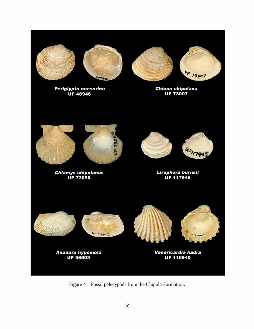
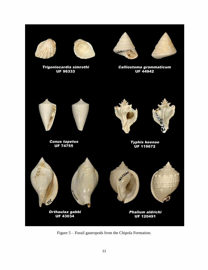
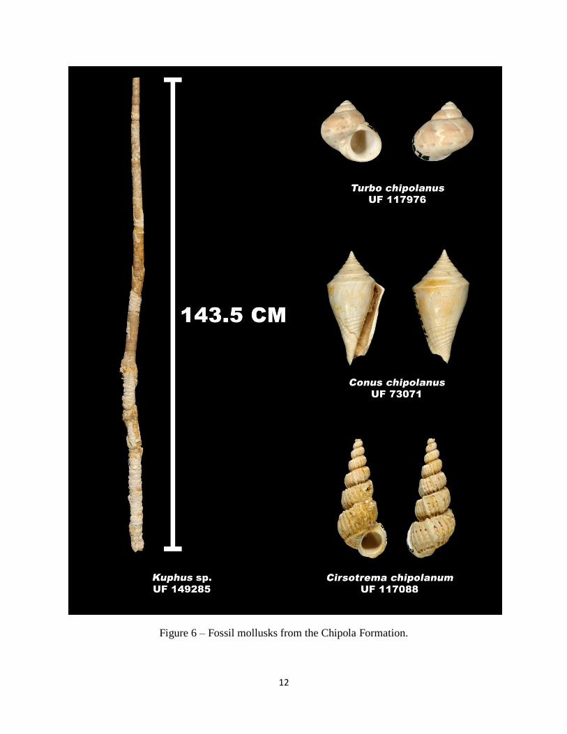
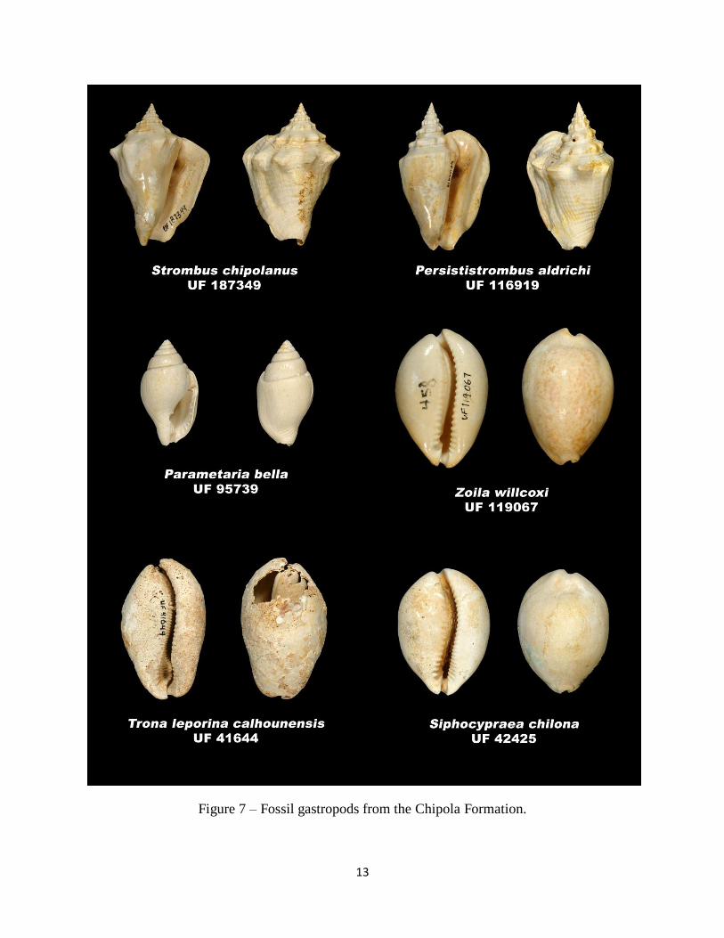
The following plates represent some of the more commonly found fossils from the
Chipola Formation. These plates are courtesy of Roger Portell with the Florida Museum of
Natural History.

9
Figure 3 – Fossil pelecypods from the Chipola Formation.
10
Figure 4 – Fossil pelecypods from the Chipola Formation.
11
Figure 5 – Fossil gastropods from the Chipola Formation.
12
Figure 6 – Fossil mollusks from the Chipola Formation.
13
Figure 7 – Fossil gastropods from the Chipola Formation.

14
Figure 8 – Chipola Formation at Alum Bluff (photo by H. Means).
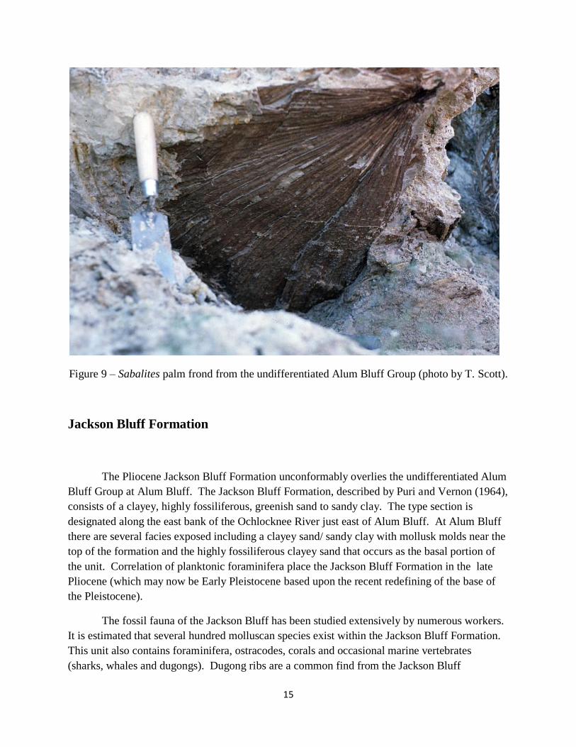
Undifferentiated Alum Bluff Group
Unconformably overlying the Chipola Formation at Alum Bluff is the Middle Miocene
undifferentiated Alum Bluff Group. This unit consists of sands and clays with interbedded,
organic-rich beds containing plant fossils. Matson and Clapp (1909) first proposed the Alum
Bluff Formation to describe units containing lithologies ranging from sandy clay and clay to
sandy carbonates (units now comprising the Alum Bluff Group). The plant fossils were first
identified and described by Berry (1916). His work on this fossil flora suggested that the deposit
represented a subtropical to tropical climate during the deposition of this unit. Later work done
by Corbett (2004) suggests that the flora of the undifferentiated Alum Bluff Group represents a
warm-temperate climate with a more diverse fauna than earlier described by Berry.
15
Figure 9 – Sabalites palm frond from the undifferentiated Alum Bluff Group (photo by T. Scott).
Jackson Bluff Formation
The Pliocene Jackson Bluff Formation unconformably overlies the undifferentiated Alum
Bluff Group at Alum Bluff. The Jackson Bluff Formation, described by Puri and Vernon (1964),
consists of a clayey, highly fossiliferous, greenish sand to sandy clay. The type section is
designated along the east bank of the Ochlocknee River just east of Alum Bluff. At Alum Bluff
there are several facies exposed including a clayey sand/ sandy clay with mollusk molds near the
top of the formation and the highly fossiliferous clayey sand that occurs as the basal portion of
the unit. Correlation of planktonic foraminifera place the Jackson Bluff Formation in the late
Pliocene (which may now be Early Pleistocene based upon the recent redefining of the base of
the Pleistocene).
The fossil fauna of the Jackson Bluff has been studied extensively by numerous workers.
It is estimated that several hundred molluscan species exist within the Jackson Bluff Formation.
This unit also contains foraminifera, ostracodes, corals and occasional marine vertebrates
(sharks, whales and dugongs). Dugong ribs are a common find from the Jackson Bluff

16
Formation at Alum Bluff. Large shark teeth from the extinct Carcharodon megalodon are
occasionally found here as well.
Figure 10 – Turritella dominated fauna in the Jackson Bluff Formation at Alum Bluff (photo by
T. Scott).

17
Figure 11 – Common fossils from the Jackson Bluff Formation.

18
Citronelle Formation
The late Pliocene (or early Pleistocene) Citronelle Formation unconformably overlies the
Jackson Bluff Formation at Alum Bluff. The unit consists of reddish, slightly clayey quartz sand
with occasional quartz pebbles. The Citronelle Formation was named by Matson (1916) for
deposits that crop out near the town of Citronelle, Alabama. The unit was extended into the
Florida panhandle where it grades laterally into the Miccosukee Formation in Gadsden County.
In parts of western Florida the Citronelle Formation contains marine fossils that represent
nearshore facies (Means, 2009). At Alum Bluff there have been on fossils recovered from the
Citronelle Formation. Most likely the sediments of the Citronelle Formation at Alum Bluff were
deposited in a fluvial environment. The surficial sands that sit at the top of Alum Bluff probably
represent reworking of Citronelle Formation sediments during the Pleistocene and Holocene.
Figure 11 – Stratigraphy of Alum Bluff (photo by H. Means).
19
References
Banks, J.E., and Hunter, M.E., 1973, Post-Tampa, pre-Chipola sediments exposed in Liberty,
Gadsden, Leon and Wakulla Counties, Florida, Transactions of the Gulf Coast Association of
Geological Societies, Volume 23, pages 355 – 363.
Berry, E. W., 1916, The physical conditions and age indicated by the flora of the Alum Bluff
Formation, USGS Professional Paper, Report: P0098-E, pages 41-59.
Bryant, J.D., MacFadden, B.J. and Mueller, P.A., 1992, Improved chronologic resolution of the
Hawthorn and Alum Bluff groups in northern Florida, Bulletin of the Geological Society of
America 104:208 – 218.
Burns, F., 1889, Unpublished field notes, USGS.
Corbett, S.L., 2004, The Middle Miocene Alum Bluff flora, Liberty County, Florida, University
of Florida unpublished masters thesis, 97 pages.
Cushman, J.A., and Ponton, G.M., 1932, The foraminifera of the Upper Middle and part of the
Lower Miocene of Florida, Florida Geological Survey Bulletin 9, 147 pages.
Gardner, J.A., 1926 – 1944, The molluscan fauna of the Alum Bluff Group of Florida, USGS
Professional Paper 142, parts 1 through 7.
Jones, D.S., and Randazzo, A.F., 1997, The Geology of Florida, University Press of Florida, 327
pages.
Matson, G.C., and Clapp, F.G., 1909, A preliminary report on the geology of Florida with special
reference to the stratigraphy, Florida Geological Survey 2nd
Annual Report, pages 25 – 173.
Matson, G.C., 1916, The Pliocene Citronelle Formation of the Gulf Coastal Plain, US Geological
Survey Professional Paper 98, pages 167 – 192.
Means, G.H., 2009, A marine-influenced siliciclastic unit (Citronelle Formation) in western
panhandle Florida, Florida State University Department of Geological Sciences unpublished
masters thesis, 120 pages.
Puri, H.S., and Vernon, R.O., 1964, Summary of the geology of Florida and a guidebook to the
classic exposures, Florida Geological Survey Special Publication Number 5 (Revised), 312
pages.
Scott, T.M., et al, Geomorphic Map of Florida, in prep.
Scott, T.M., 2001, Text to accompany the geologic map of Florida, Florida Geological Survey
Open-File Report 80, 28 pages.