fall) 08! - wordpress.com08!...
TRANSCRIPT

W e s t f i e l d S t a t e U n i v e r s i t y
ArcMap Online Tutorial Sarah Pierce How to map in ArcMap Online using the Fresh Prince of Bel Air as an example
Fall GARP
08 Fall

Let’s say you’ve never used ArcGIS before and your professor asks you to make a professional grade map illustrating something you enjoyed doing as a child such as a trail you liked walking on. Well, that sounds a bit boring to you; you were, after all, a pretty cool 90’s kid and absolutely loved watching the Fresh Prince of Bel Air and Will Smith was your idol (and secretly still is).
So you decide to make yourself a map showing the location Mr. Smith rapped about in the theme song to the show. Since you don’t know a thing about maps, you head over to your friend Sarah Pierce’s dorm since she minors in something called GIS. You ask her for help and she says, “Lucky for you, Professor Braun had me make something similar for a class of mine. Let me show you how it’s done.”
She whips out a pretty lengthy looking tutorial and hands it to you. You head back to Bates 22 and start your project. Luckily, since you know nothing about GIS, your friend has included some background about the software and what you can use it for:
What is GIS? Geographic Information Systems allow users to display data in a
meaningful way. For example, instead of having boring numbers in a chart, a GIS application can map the information and utilize spatial data.
There are a few important things to know about GIS: It can get very complicated, it’s frustrating, and it’s extremely useful to know. ArcGIS Online shows you the basics of GIS and is the user-‐friendliest. You can set up a free account by heading here: https://www.arcgis.com/home/signin.html
I recommend using the 30-‐day trial if you only need to use it once or twice.
Figure 1: This screen-‐shot shows the log-‐in or sign-‐up screen in ArcGIS Online

As per instruction, you open up an Internet browser (preferably Chrome
since applications tend to work better with it) and head over to ArcGIS Online. You sign up and, once you have an account, start to play around on the website. One of the links that pops out at you is the “Map” tab located on the home screen. You decide to check it out. When you click this tab, a map of the world appears along with a pretty useful explanation of how to use it. You look back to your tutorial to figure out where to start.
In ArcGIS Online, you may notice that you can add editable layers;
what is a layer? A layer is basically a page of information that can be shown on a map over a basemap. What is a basemap, you ask? A basemap shows the existing layer of information (usually aerial) that cannot be changed. Today, you will be creating an editable layer of information that will fit directly above a basemap of your choice. I suggest using Bing maps hybrid, located under “Basemap.”
Before you start clicking away at your map, you should be thinking of what it is you want to map. Make a list of what you may need in terms of lines, shapes, or points.
Since you want to map the Fresh Prince, you make an organized list of things
mentioned in the theme song that may be cool to see digitally. You also think “Hey, wouldn’t it be cool to embed the music video in my map? Maybe there’s a way to do that…”
First thing’s first though: your data • West Philadelphia • Playground • School • Basketball • Plane ticket (airports) • Cab • Bel Air, California
After a little bit of research, you find the general location of West
Philadelphia, and by looking at it’s Wikipedia page, http://en.wikipedia.org/wiki/West_Philadelphia you figure that the Fresh Prince most likely went to West Philadelphia High School, located on the corner of Market Street and S 49 Street. Cool! Now you think, “hey, it would be cool if I could mark that somehow on my ArcGIS map” so you turn back to your tutorial.
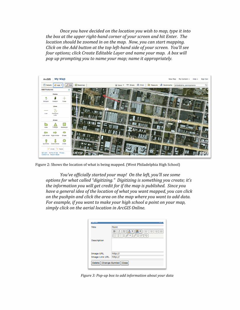
Once you have decided on the location you wish to map, type it into the box at the upper right-‐hand corner of your screen and hit Enter. The location should be zoomed in on the map. Now, you can start mapping. Click on the Add button at the top left-‐hand side of your screen. You’ll see four options; click Create Editable Layer and name your map. A box will pop up prompting you to name your map; name it appropriately.
Figure 2: Shows the location of what is being mapped. (West Philadelphia High School)
You’ve officially started your map! On the left, you’ll see some options for what called “digitizing.” Digitizing is something you create; it’s the information you will get credit for if the map is published. Since you have a general idea of the location of what you want mapped, you can click on the pushpin and click the area on the map where you want to add data. For example, if you want to make your high school a point on your map, simply click on the aerial location in ArcGIS Online.
Figure 3: Pop-‐up box to add information about your data

Here you decide to name your point “West Philadelphia High School.” You
think, “Oh cool, a description box! Maybe I can add a link to the high schools web page?” You check back in the tutorial and it turns out you can! It’s pretty easy too: Just type in what you’re linking to (ie: High School), highlight it, and click the hyperlink button. Once you’ve found the high school’s web page, copy and paste the URL into the hyperlink box. If you want the web page to open up in a new tab when someone clicks on it, select New Window in the Target dropdown menu. Click OK. While you’re at it, you might as well add some meaningful information to the description, so you find the address of the school and type that it. You find you can also link an image to the school. Cool! You look up an image that looks good and copy and paste the URL into the Image URL box, making sure there are two http’s or anything silly like that.
You also notice that you can change the symbol, so you click the Change Symbol button and, while browsing, notice that there is a school icon. Perfect! You add this in and click Done, then Close in the popup windows.
Now, to check to make sure everything in your map works, click the Edit button, so you can view the map as a nearly finished product. Click on the school icon and check to make sure everything is working properly with no broken links or spelling errors (that would be embarrassing). It looks pretty professional already, but you decide to add a few more things to really tell the story of the Fresh Prince of Bel Air.
You know (since you’ve memorized the theme song) that the “playground is where I spent most of my days.” It would make sense that if there were a playground near the school, it would be where Mr. Smith would hang out and play basketball. You do some more research and, as it turns out, the Granahan Playground & Skate park is almost within walking distance from the high school. You add this to your map following the same instructions you used to add the high school, but this time, you change the symbol to a dark blue circle. You find that this playground is also a skate park and some people want to renovate it. There are also tournaments held here so you find a picture of a flyer and copy and paste the URL into the Image URL box. You find a cool webpage about the park, so you copy and paste that link into the Image Link URL box. This will allow people to click on the picture in the description and it will bring them to the web page.
You panic when you realize you haven’t saved your map yet, so you mouse over to the Save, then Save As button on your map. You add a title and tags and save it to an appropriate folder.

Right now, you’re map should look just like this:
Figure 4: Map of high school and playground Now you decide to move on to when the Fresh Prince’s mom makes him
move to California. You check out the airports nearby and decide he would most likely fly from the Philadelphia International Airport to LAX. You locate the airport, find it’s website and a picture, and mark it with an airplane icon. Then, you realize Will Smith will probably be singing the theme song all the way to California, so you link the lyrics to your popup box. Now, you move on to LAX in California and do the same but instead of linking the lyrics to the theme song, you remember you saw a funny video of Jimmy Fallon singing the song like Neil Young, so you find the video and link that instead.
You’re pretty much done now! You decide to zoom out to a full view of the
US so the map shows everything you’ve put on it. Now, you can share your map so your friends and professor can see it. Simply click the Share button at the top and check off the box that says “Everyone (public).” You can use the URL provided to copy and paste your map and send it to people or you could make something a bit more professional looking. Click the Make A Web Application button and choose a format you would like to display your map as. Click Publish and add a title and description to your map. You may say something like “This map shows the locations mentioned in the theme song from the hit 90's show Fresh Prince of Bel Air.” Click Save and Publish and then click “go to the item now” on the next popup page.

You will be brought to a page that looks like this:
Figure 5: This page shows your final map as a stand alone web page. Click the Share button directly under your map icon. Make sure you check off
the “Everyone” box. Now, click on the icon of your map and explore! You can always go back and edit it if you need to. The URL at the top of your screen shows where the map is located. You can copy and paste this link anywhere to share it, such as Facebook, Twitter, or a blog.
Here it is: http://www.arcgis.com/apps/OnePane/basicviewer/index.html?appid=020f938346674bec898cb7380ce2169f

Now that you have your finished map, you may be curious as to what else you can do with ArcGIS Online. Luckily, your friend has included some helpful websites along with her tutorial. ArGIS Online Help:
http://help.arcgis.com/en/arcgisonline/content/index.html#//011q00000005000000
ESRI Discussion Forums: http://forums.esri.com/forums.asp?c=188
ArcMap Online Tutorial Video http://www.youtube.com/watch?v=7cRKBC8fURs