fact sheet: jacksonville integrated … brunson eastside park a. phillip randolph heritage park...
TRANSCRIPT
Location and extent of Superfund sites in Health Zone 1.
JIPP Coalition members prioritize strategies.
Jacksonville, FL
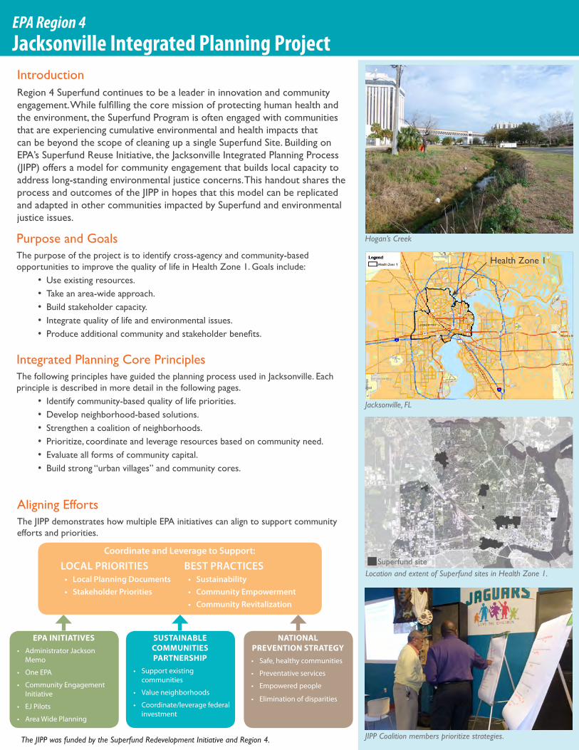
Hogan’s Creek
INTRODUCTIONEPA Region 4Jacksonville Integrated Planning Project
EPA INITIATIVES• AdministratorJackson
Memo
• OneEPA
• CommunityEngagementInitiative
• EJPilots
• AreaWidePlanning
SUSTAINABLE COMMUNITIES PARTNERSHIP
• Supportexistingcommunities
• Valueneighborhoods
• Coordinate/leveragefederalinvestment
NATIONAL PREVENTION STRATEGY• Safe,healthycommunities
• Preventativeservices
• Empoweredpeople
• Eliminationofdisparities
Coordinate and Leverage to Support:
LOCAL PRIORITIES• Local Planning Documents• Stakeholder Priorities
BEST PRACTICES • Sustainability• Community Empowerment• Community Revitalization
Aligning EffortsThe JIPP demonstrates how multiple EPA initiatives can align to support community efforts and priorities.
Purpose and GoalsThe purpose of the project is to identify cross-agency and community-basedopportunities to improve the quality of life in Health Zone 1. Goals include:
•Use existing resources.• Take an area-wide approach.• Build stakeholder capacity.• Integrate quality of life and environmental issues.• Produceadditionalcommunityandstakeholderbenefits.
Health Zone 1
IntroductionRegion 4 Superfund continues to be a leader in innovation and community engagement.Whilefulfillingthecoremissionofprotectinghumanhealthandthe environment, the Superfund Program is often engaged with communities that are experiencing cumulative environmental and health impacts that can be beyond the scope of cleaning up a single Superfund Site. Building on EPA’s Superfund Reuse Initiative, the Jacksonville Integrated Planning Process (JIPP) offers a model for community engagement that builds local capacity to address long-standing environmental justice concerns. This handout shares the process and outcomes of the JIPP in hopes that this model can be replicated and adapted in other communities impacted by Superfund and environmental justice issues.
Superfund site
Integrated Planning Core PrinciplesThe following principles have guided the planning process used in Jacksonville. Each principle is described in more detail in the following pages.
• Identify community-based quality of life priorities.•Develop neighborhood-based solutions.• Strengthen a coalition of neighborhoods.• Prioritize, coordinate and leverage resources based on community need.• Evaluate all forms of community capital.• Build strong “urban villages” and community cores.
The JIPP was funded by the Superfund Redevelopment Initiative and Region 4.

INTRODUCTION Jacksonville Health Zone 1
A history of industry and neglect hasledtosignificantcontaminationand pollution across Health Zone 1.
The maps below illustrate the cumulative prevalence of contamination risk in air quality, water and sites among residential areas and schools.
Health Zone 1 in Jacksonville, FL demonstrates dramatic and measurable environmental justice disparities across economic, health and environmental indicators.
The median income of Health Zone 1 is almost half that of Duval County as a whole. This stark economicdisparityrepresentsasignificantlack of capital within Health Zone 1 to effect positive change.
47,005 Households x $25,096 = $1.2 Billion Economic Activity Deficit
Health Zone 1Rest of
Duval CountyPopulation 122,089 742,174
Increase since 2000 0.2% 12%
Median Household Income $27,792 $52,888
African-American 75% 21%
Keyindicatorsrevealsignificantlyhigherratesofhealthconditionsamong the population in Health Zone 1 compared to Duval County as a whole. Limited access to affordable healthcare, healthy food and health and wellness resources likely contribute to the disparity.
Diabetes-related ER visits +820%
Asthma-related ER visits +413%
Low birth weight babies +86%
Diabetes mortality +100%
Heart disease morality +65%
Cancer mortality +31%Percentage of occurrence in Health Zone 1 compared to Duval County as a whole.
Dramatic Health Disparities
Economically Under Resourced
Environmentally Overburdened
Data Source: City of Jacksonville, FDEPA and EPA. Analysis by Skeo Solutions for EPA SRI and Region 4.
Residential & School Land Usefurther than .25 miles from a Site
within .25 miles of 1 Site
within .25 miles of 2-5 Sites
within .25 miles of 6-15 Sites
0 1 20.5 Miles ¯
Residential & School Land Usefurther than .25 miles from a Site
within .25 miles of 1 Site
within .25 miles of 2-5 Sites
within .25 miles of 6-15 Sites
0 1 20.5 Miles ¯
Residential and School ParcelsResidential and School Land Use
With Proximity to 2 or more AQ Risks
0 1 20.5 Miles ¯
Residential and School ParcelsResidential and school land use
0 1 20.5 Miles ¯
Residential and school land usewithin basins that have documentedfishing and swimming restrictions
Residential and School ParcelsResidential and School Land Use
With Proximity to 2 or more AQ Risks
0 1 20.5 Miles ¯
Residential and School ParcelsResidential and school land use
0 1 20.5 Miles ¯
Residential and school land usewithin basins that have documentedfishing and swimming restrictions
Residences and Schools with Proximity to Contaminated Sites
Residences and Schools with Proximity to Water Access Risks
Residences and Schools with Proximity to Potential Air Quality Risks
!(
!(
!(
!(
!(
!(
!(
Distribution of Environmental Factorsnone of the factors are presentone of the factors is presenttwo of the factors are presentthree of the factors are present
!( Superfund site
0 1 20.5 Miles ¯
!(
!(
!(
!(
!(
!(
!(
Distribution of Environmental Factorsnone of the factors are presentone of the factors is presenttwo of the factors are presentthree of the factors are present
!( Superfund site
0 1 20.5 Miles ¯
Residences and Schools Experiencing Three or more Risk Factors
This map highlights areas that may be experiencing three or more of the following environmental factors: Residential and School areas that:• Are near two or more potential air
quality risks (such as high traffic roads and industrial uses)
• Are within a ¼ mile of six or more potentially contaminated sites under cleanup oversight
• Are within a drainage basin that has documented fishing or swimming restrictions.
These indicators represent only a subset of factors that may influence health and quality of life. The location of these factors does not indicate actual health or quality of life conditions for specific households.
INTRODUCTION
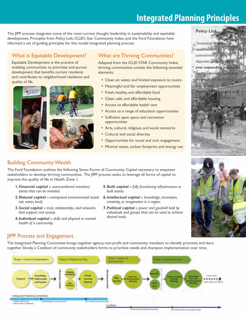
Integrated Planning PrinciplesThe JIPP process integrates some of the most current thought leadership in sustainability and equitable development. Principles from Policy Link, ICLEI’s Star Community Index, and the Ford Foundation have informed a set of guiding principles for this model integrated planning process.
Policy Link
“Innovative revitalization coalitions share a commitment to bring disparate parties together in ever expanding networks, raising expectations, keeping an eye on the big picture, but focusing on small attainable successes and relentlessly building on them.”
Voices from Forgotten Cities by Lorene Hoyt and Andre Leroux
Florida East Coast Railway, 1910. State Library and Archives of Florida
Building Community WealthThe Ford Foundation outlines the following Seven Forms of Community Capital necessary to empower stakeholders to develop thriving communities. The JIPP process seeks to leverage all forms of capital to improve the quality of life in Health Zone 1.
1. Financial capital » unencumbered monetary assets that can be invested.
2. Natural capital » unimpaired environmental assets (air, water, land).
3. Social capital » trust, relationships, and networks that support civil society.
4. Individual capital » skills and physical or mental health of a community.
5. Built capital » fully functioning infrastructure or built assets.
6. Intellectual capital » knowledge, innovation, creativity, or imagination in a region.
7. Political capital » power and goodwill held by individuals and groups that can be used to achieve desired ends.
JIPP Process and EngagementTheIntegratedPlanningCommitteebringstogetheragency,non-profitandcommunitymemberstoidentifyprioritiesandlearntogether. Slowly, a Coalition of community stakeholders forms to prioritize needs and champion implementation over time.
What is Equitable Development?Equitable Development is the practice of enabling communities to prioritize and pursue developmentthatbenefitscurrentresidentsand contributes to neighborhood resilience and quality of life.
What are Thriving Communities?Adapted from the ICLEI STAR Community Index, thriving communities contain the following essential elements:
•Clean air, water, and limited exposure to toxins
•Meaningful and fair employment opportunities
• Fresh, healthy, and affordable food
•Clean, safe, and affordable housing
• Access to affordable health care
• Access to a range of education opportunities
• Sufficientopenspaceandrecreationopportunities
• Arts, cultural, religious, and social networks
•Cultural and social diversity
•Opportunities for social and civic engagement
•Minimal waste, carbon footprint, and energy use

INTRODUCTIONMoving Forward
Community Actions: Looking Forward• Build a strong community coalition to drive the revitalization
agenda.
•Opportunity to align with HUD/LISC – EPIC Communities project.
•Opportunity to have a better seat at the table with City of Jacksonville.
• Support strong grassroots voices like the Eastside Environmental Council.
•Develop a community agenda to bring to City, State and Federal Agencies that have resources to help the community.
• Emphasize the value of social and political capital.
BenefitsofIntegratedPlanning• Brings together a broad range of stakeholders in
a productive dialogue.
•Documents measurable environmental justice disparities.
•Demonstrates a One EPA approach.
• Puts Superfund reuse in a neighborhood context.
•Outlines appropriate roles for the community, non-profit,andagencystaff.
• Builds capacity within the community to effect positive change.
In the Solution Development workshop, participants identified gaps in access to affordable health care (red) and healthy food sources (green), and identified ways to fill the gaps by providing additional and/or mobile services to meet community needs at the neighborhood scale.
STATE
BRO
AD
JEFF
ERSO
N
UNION
2ND
I 95
Hogans Creek
8TH
MAI
N
MARTIN LUTHER KING JR
MA
RTI
N L
UTH
ER
KIN
G J
RFLO
RID
AP.
RA
ND
OLP
H
Kerr McGee
Shands Medical Center
Affordable Primary CareProviders
Periodic DCHD Dental Van Stops
Central Dental (DCHD)
Public Schools
1/4 Mile Walk Radius
Residential
Park
Commercial/Services
Community Center
Community Garden
Grocery Store
Kids Kampus
Catherine Hester McNair Park
Emmett Reed Park
Northbank Riverwalk
Henry J. Klutho Park
Confederate Park
Glen Myra Park
Flossie Brunson Eastside Park
A. Phillip Randolph Heritage Park
Julius Guinyard Park
Edwards Park
Russell “Bill” CookJr. Park
Henry L. Brown Kooker Park
Robert F. Kennedy Park
Hogan's Creek Greenway Expansion
S-Line Rail Trail
S-Line Rail Trail
Armory Building
Confederate Playground
S-Line Rail Trail
Hemming Plaza
Warren W. Schell Jr. Memorial Park
Oakland Park
East Northbank Riverwalk Extension
Liberty Park
John N. McPherson Park
Main St Pocket Park
Ritz Pocket Park
Bay and Broad Pocket Park
Sister Cities Plaza
Jessie B. Smith Pocket ParkWater & Broad St. Pocket Park
Stanton College Prep School
LaVilla School of the Arts
Matthew W. Middle School
Kirby-Smith Middle School
Andrew A Robinson Elementary School
Darnell Cookman Middle School
John E. Ford Elementary School
Urban League Nes Head Start
Darnell Cookman Middle School
John LoweElementary School
Darnell Cookman Middle School
Mattie B. Rutherford Alternative Education Center
Strategy Development and Implementation PlanningWorking with residents and community-based organizations, the JIPP project teamidentifiedeightkeycommunityprioritiestoguidestrategydevelopmentandimplementation. Based on those priorities, the group decided to focus strategies and actions around three goals: improve access to health care, open space, and healthy food.
Participants in the solution development discussions have formed work groups around the goals, and have taken steps to build a functioning, sustainable Coalition to guide the implementation of strategies that support the community’s three goals.
STATE
BRO
AD
JEFF
ERSO
N
UNION
2ND
I 95
Hogans Creek
8TH
MAI
N
MARTIN LUTHER KING JR
MA
RTI
N L
UTH
ER
KIN
G J
RFLO
RID
AP.
RA
ND
OLP
H
Kerr McGee
Shands Medical Center
Affordable Primary CareProviders
Periodic DCHD Dental Van Stops
Central Dental (DCHD)
Public Schools
1/4 Mile Walk Radius
Residential
Park
Commercial/Services
Community Center
Community Garden
Grocery Store
Potential Food Co-op Site LocationsPotential Food Processing Site Location
Potential Mobile Clinic Sites
Kids Kampus
Catherine Hester McNair Park
Emmett Reed Park
Northbank Riverwalk
Henry J. Klutho Park
Confederate Park
Glen Myra Park
Flossie Brunson Eastside Park
A. Phillip Randolph Heritage Park
Julius Guinyard Park
Edwards Park
Russell “Bill” CookJr. Park
Henry L. Brown Kooker Park
Robert F. Kennedy Park
Hogan's Creek Greenway Expansion
S-Line Rail Trail
S-Line Rail Trail
Armory Building
Confederate Playground
S-Line Rail Trail
Hemming Plaza
Warren W. Schell Jr. Memorial Park
Oakland Park
East Northbank Riverwalk Extension
Liberty Park
John N. McPherson Park
Main St Pocket Park
Ritz Pocket Park
Bay and Broad Pocket Park
Sister Cities Plaza
Jessie B. Smith Pocket ParkWater & Broad St. Pocket Park
Stanton College Prep School
LaVilla School of the Arts
Matthew W. Middle School
Kirby-Smith Middle School
Andrew A Robinson Elementary School
Darnell Cookman Middle School
John E. Ford Elementary School
Urban League Nes Head Start
Darnell Cookman Middle School
John LoweElementary School
Darnell Cookman Middle School
Mattie B. Rutherford Alternative Education Center
JIPP Participants100 Black MenAgency for Toxic Substances and Disease RegistryCardno TBE/EECCity of JacksonvilleClara White MissionDuval County Health DepartmentEastside Environmental CouncilEL-Beth-EL Development CenterFlorida Department of Environmental ProtectionFlorida Department of HealthFresh Ministries
Funders Network for Smart Growth and Livable CommunitiesGrace and Truth Community Development CorporationGreenscape JacksonvilleHabitat for Humanity of Jacksonville (HabiJax)Health Planning Council of Northeast FloridaHelpful CitizensJacksonville Area Legal Aid, Inc.Jacksonville Gullah/Geechee NationJacksonville Port Authority
Jacksonville UniversityLISC JacksonvilleMayo ClinicMen in and Out of SchoolNorth Riverside Community Development Corp.Northwest Jacksonville CDCOperation New HopePepsiResidentsRoland Udenze ArchitectsSafe & Healthy Duval
Second Chance Help CenterSpringfieldAreaMerchantsSulzbacher CenterThe Bridge of NE FLThe Greater EL-Beth-EL Divine Holiness ChurchTrust for Public LandUniversity of North FloridaUrban Core CPAC & ShAdCoUrban Library Centers/Public LibraryWar on Poverty, FLWealth Watchers Inc.
Developed by Skeo Solutions for Region 4.
Map 1. Gaps Map 2. Potential services to fill gaps