extending hirs high cloud trends with modis donald p. wylie richard frey hong zhang w. paul menzel...
TRANSCRIPT
Extending HIRS High Cloud Trends with MODIS
Donald P. WylieRichard FreyHong Zhang
W. Paul Menzel
12 year trendsEffects of orbit drift and ancillary Tsfc
Comparison with MODIS
July 2002
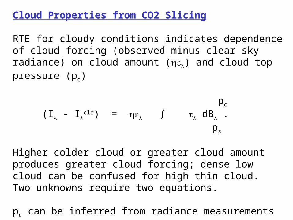
Cloud Properties from CO2 Slicing
RTE for cloudy conditions indicates dependence of cloud forcing (observed minus clear sky radiance) on cloud amount () and cloud top pressure (pc)
pc
(I - Iclr) = dB .
ps
Higher colder cloud or greater cloud amount produces greater cloud forcing; dense low cloud can be confused for high thin cloud. Two unknowns require two equations.
pc can be inferred from radiance measurements in two spectral bands where cloud emissivity is the same. is derived from the infrared window, once pc is known.
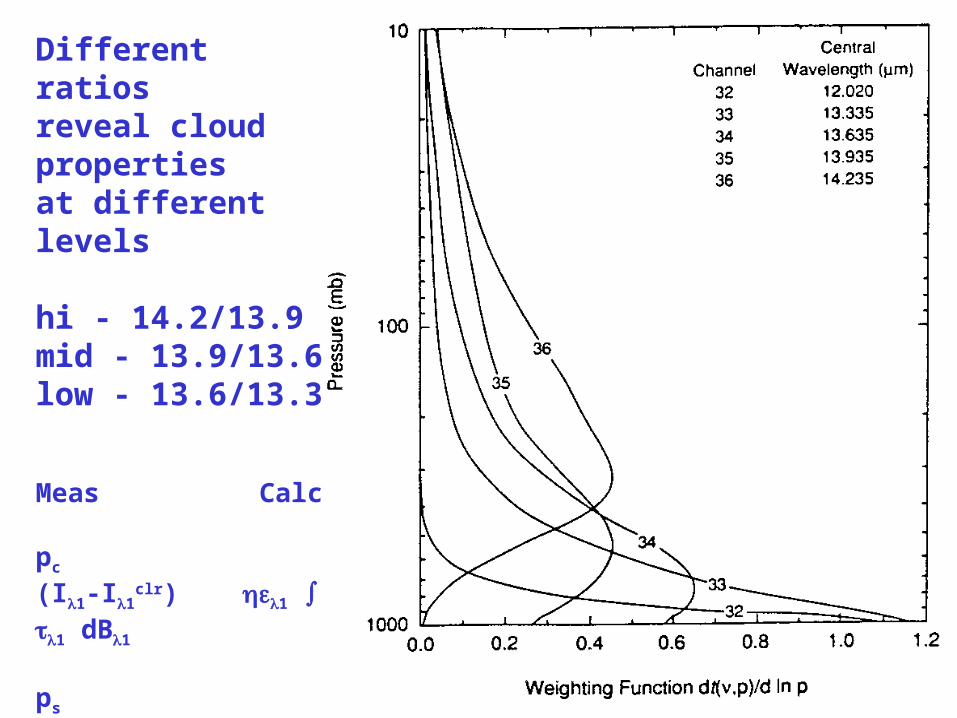
Different ratios reveal cloud properties at different levels
hi - 14.2/13.9mid - 13.9/13.6low - 13.6/13.3
Meas Calc pc
(I1-I1clr) 1 1 dB1
ps
----------- = ---------------- pc
(I2-I2clr) 2 2 dB2
ps

Generating HIRS Clear Sky Radiances in Cloudy FOVs
Use IR Window Moisture Corrected Brightness Temperature Test against a priori surface temperature to identify nearby clear sky FOVs
BT11 + aPW * (BT11 - BT12) - Sfc Temp < 2 CaPW of 0.8 has been usedSfc Temp estimated from GDAS
Estimate Iclr by interpolating nearby clear FOVs
cld = x x x o o = clrx x x o oo x x o oo x x x oo x x o ox x x o o
Attempt to derive CO2 cloud properties in x (note that CO2 cloud algorithm attempt on x can change FOV to o)
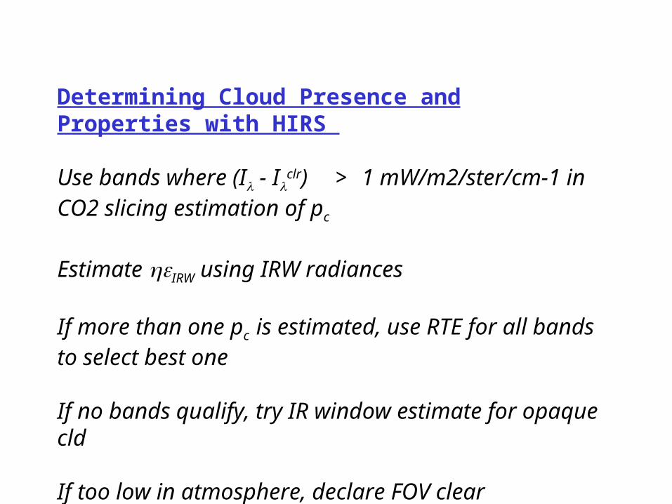
Determining Cloud Presence and Properties with HIRS
Use bands where (I - Iclr) > 1 mW/m2/ster/cm-1 in CO2
slicing estimation of pc
Estimate IRW using IRW radiances
If more than one pc is estimated, use RTE for all bands to select best one
If no bands qualify, try IR window estimate for opaque cld
If too low in atmosphere, declare FOV clear

D i u r n a l C h a n g e o f F r e q u e n c y o f C l o u d s d u r i n g W i n t e r 1 9 9 9
0 . 0
1 0 . 0
2 0 . 0
3 0 . 0
4 0 . 0
5 0 . 0
6 0 . 0
7 0 . 0
8 0 . 0
1 : 3 0 4 : 3 0 7 : 3 0 1 0 : 3 0 1 3 : 3 0 1 6 : 3 0 1 9 : 3 0 2 2 : 3 0
L S T
Freq
uenc
y of
Oc
curre
nce
C lo u d y ( % )
H ig h ( % )
D i u r n a l C h a n g e o f F r e q u e n c y o f C l o u d s f o r S u m m e r 1 9 9 9
0 . 0
1 0 . 0
2 0 . 0
3 0 . 0
4 0 . 0
5 0 . 0
6 0 . 0
7 0 . 0
8 0 . 0
1 : 3 0 4 : 3 0 7 : 3 0 1 0 : 3 0 1 3 : 3 0 1 6 : 3 0 1 9 : 3 0 2 2 : 3 0
L S T
Freq
uenc
y of
Occu
rrenc
e C lo u d y ( % )
H ig h ( % )
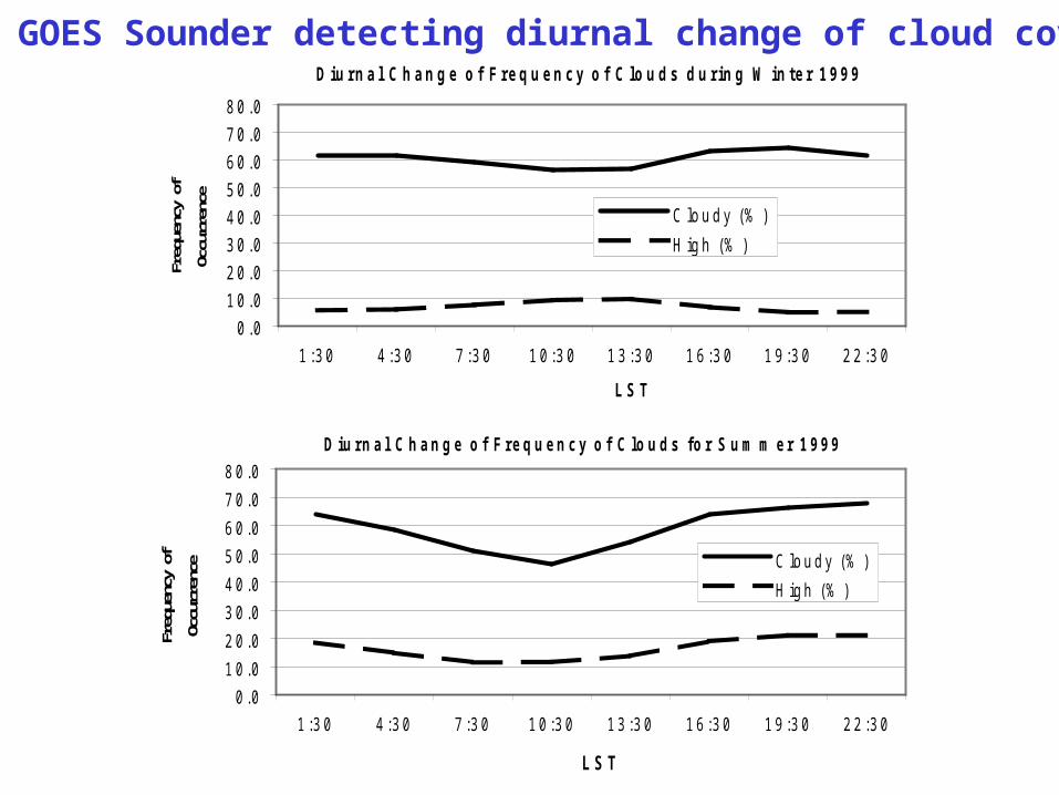
GOES Sounder detecting diurnal change of cloud cover
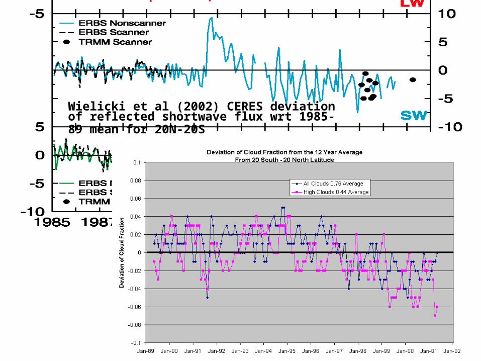
Wielicki et al (2002) CERES deviation of reflected shortwave flux wrt 1985-89 mean for 20N-20S
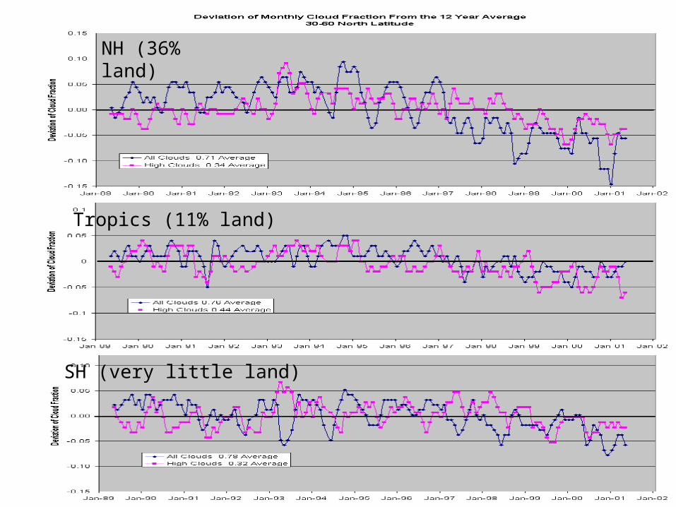
NH (36% land)
Tropics (11% land)
SH (very little land)

Determining Cloud Presence and Properties with MODIS
Use MODIS Cloud Mask to determine cloud presence
Calculate Iclr from GDAS
Attempt CO2 slicing estimation of pc on 5x5 FOV average when (I - I
clr) > 1 mW/m2/ster/cm-1
Estimate IRW using IRW radiances
If no bands qualify, try IR window estimate for opaque cld
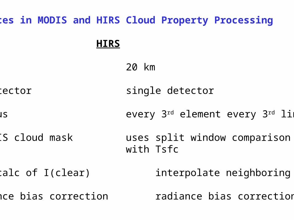
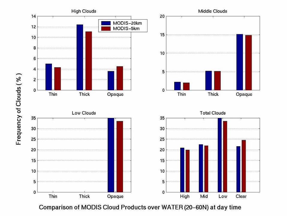
Differences in MODIS and HIRS Cloud Property Processing
MODIS HIRS
5 km 20 km
multi-detector single detector
contiguous every 3rd element every 3rd line
uses MODIS cloud mask uses split window comparison with Tsfc
forward calc of I(clear) interpolate neighboring I(clear)
no radiance bias correction radiance bias correction
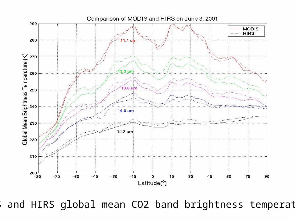
MODIS and HIRS global mean CO2 band brightness temperatures
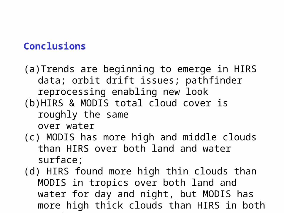
Conclusions
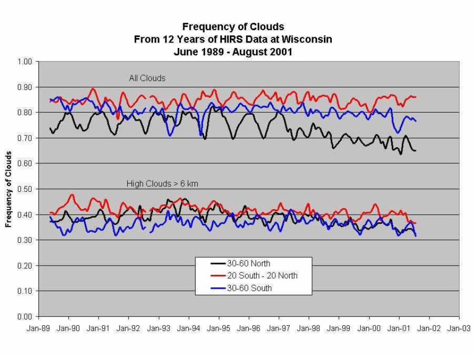
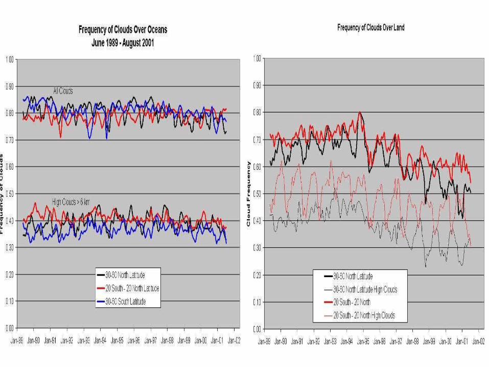
(a) Trends are beginning to emerge in HIRS data; orbit drift issues; pathfinder reprocessing enabling new look
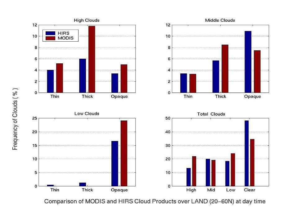
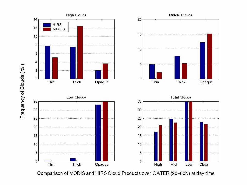
(b) HIRS & MODIS total cloud cover is roughly the same over water
(c) MODIS has more high and middle clouds than HIRS over both land and water surface;
(d) HIRS found more high thin clouds than MODIS in tropics over both land and water for day and night, but MODIS has more high thick clouds than HIRS in both tropics & 20-60N.
(e) More work remains