exploring medieval longhouses in the duddon valley, cumbria
TRANSCRIPT

©Oxford Archaeology Ltd i 2 July 2019
`
Exploring Medieval Longhouses in the Duddon Valley, Cumbria:
Final Report
June 2019
Client: Duddon Valley Local History Group
Issue No: 2018‐9/1951 NGRs: 32426 49758; 32429 49784; 32454 49738

Exploring Medieval Longhouses in the Duddon Valley, Cumbria: Final Report
©Oxford Archaeology Ltd iii 2 July 2019
Client Name: Duddon Valley local History Group
Document Title: Exploring Medieval Longhouses in the Duddon Valley, Cumbria: Final Report
Document Type: Final Report
Report No.: 2018‐9/1951
Grid Reference: 32426 49758; 32429 49784; 32454 49738
Site Code: THA16; LHC17; THB18
Invoice Code: L10953
OA Document File Location: Jamie/projects/10953/report
OA Graphics File Location: Jamie/projects/10953/cad
Issue No: Final
Date: June 2019
Prepared by: Jeremy Bradley (Project Officer)
Checked by: Jamie Quartermaine (Senior Project Manager)
Edited by: Rachel Newman (Executive Officer Publication)
Signature:
……………………………………………………………..
Disclaimer: This document has been prepared for the titled project or named part thereof and should not be relied upon or used for any other project without an independent check being carried out as to its suitability and prior written authority of Oxford Archaeology being obtained. Oxford Archaeology accepts no responsibility or liability for the consequences of this document being used for a purpose other than the purposes for which it was commissioned. Any person/party using or relying on the document for such other purposes agrees and will by such use or reliance be taken to confirm their agreement to indemnify Oxford Archaeology for all loss or damage resulting therefrom. Oxford Archaeology accepts no responsibility or liability for this document to any party other than the person/party by whom it was commissioned.
OA South Janus House Osney Mead Oxford OX2 0ES
OA East 15 Trafalgar Way Bar Hill Cambridge CB23 8SG
OA North Mill 3 Moor Lane Mills Moor Lane Lancaster LA1 1QD
t. +44 (0)1865 263 800 t. +44 (0)1223 850 500 t. +44 (0)1524 541 000
e. [email protected] w. oxfordarchaeology.com
Oxford Archaeology is a registered Charity: No. 285627

Exploring Medieval Longhouses in the Duddon Valley, Cumbria: Final Report
©Oxford Archaeology Ltd iv 2 July 2019
Exploring Medieval Longhouses in the Duddon Valley, Cumbria: Final Report
Written by Jeremy Bradley and Jamie Quartermaine
With contributions from Mike Birtles, Dot Boughton, Antony Dickson, Denise Druce, Mairead Rutherford, Peter Schofield and Adam Tinsley; i llustrations by Anne Stewardson and
Mark Tidmarsh
Contents
Summary .................................................................................................................................................................... ix
Acknowledgements .................................................................................................................................................... xi
1 INTRODUCTION ....................................................................................................... 1
1.1 Scope of Work ................................................................................................................................................. 1
1.2 Location, Topography and Geology ................................................................................................................. 1
1.3 Archaeological and Historical Background ...................................................................................................... 1
1.4 SITE HISTORY ................................................................................................................................................... 3
2 PROJECT AIMS AND METHODOLOGY ...................................................................... 7
2.1 Project Design .................................................................................................................................................. 7
2.2 Aims and Objectives ........................................................................................................................................ 7
2.3 Methodology ................................................................................................................................................... 8
3 TOPOGRAPHICAL SURVEY RESULTS ...................................................................... 15
3.1 Introduction ................................................................................................................................................... 15
3.2 Tongue House A ............................................................................................................................................. 15
3.3 Tongue House B ............................................................................................................................................. 16
3.4 The Tongue House Field System .................................................................................................................... 17
3.5 Long House Close .......................................................................................................................................... 18
4 GEOPHYSICAL SURVEY RESULTS ............................................................................ 24
4.1 Introduction ................................................................................................................................................... 24
4.2 Magnetometry ............................................................................................................................................... 24
4.3 Resistivity ....................................................................................................................................................... 24
4.4 Discussion ...................................................................................................................................................... 25
5 EXCAVATION RESULTS .......................................................................................... 26
5.1 Introduction ................................................................................................................................................... 26
5.2 General soils and ground conditions ............................................................................................................. 26

Exploring Medieval Longhouses in the Duddon Valley, Cumbria: Final Report
©Oxford Archaeology Ltd v 2 July 2019
5.3 Tongue House A ............................................................................................................................................. 26
5.4 Tongue House B ............................................................................................................................................. 33
5.5 Long House Close .......................................................................................................................................... 36
6 FINDS ................................................................................................................. 50
6.1 Quantification ................................................................................................................................................ 50
6.2 Prehistoric Ceramics ...................................................................................................................................... 51
6.3 Lithics ............................................................................................................................................................. 53
6.4 Medieval/Post‐medieval Material ................................................................................................................. 53
7 THE PALAEOENVIRONMENTAL PROGRAMME ...................................................... 55
7.1 Introduction ................................................................................................................................................... 55
7.2 Reconnaissance Survey .................................................................................................................................. 55
7.3 Archaeobotanical Assessment ....................................................................................................................... 58
7.4 Radiocarbon Dating ....................................................................................................................................... 61
7.5 Monolith sample 556 from Testpit 2, Long House Close ............................................................................... 62
8 DISCUSSION .......................................................................................................... 65
8.1 Introduction ................................................................................................................................................... 65
8.2 Prehistoric Activity ......................................................................................................................................... 65
8.3 The Medieval Period and Later ...................................................................................................................... 69
8.4 Conclusion ..................................................................................................................................................... 77
BIBLIOGRAPHY ................................................................................................................. 79
APPENDIX 1: PROJECT DESIGN ............................................................................................ 84
APPENDIX 2: POLLEN CORING LITHOLOGY ......................................................................... 95
APPENDIX 3: CONTEXT LIST FOR TONGUE HOUSE A .............................................................................. 105
APPENDIX 4: CONTEXT LIST FOR TONGUE HOUSE B .............................................................................. 108
APPENDIX 5: CONTEXT LIST FOR LONG HOUSE CLOSE .......................................................................... 109
APPENDIX 6: RADIOCARBON DATES ........................................................................................................... 112
APPENDIX 7: POLLEN COUNTS FROM PALAEO‐SITE 3 ........................................................................... 121

Exploring Medieval Longhouses in the Duddon Valley, Cumbria: Final Report
©Oxford Archaeology Ltd vi 2 July 2019
List of Plates
Plate 1: OS First Edition 1:10,560 map, 1850 ....................................................................... 5
Plate 2: OS Revised Edition 1:10,560 map, 1919 ................................................................. 6
Plate 3: Resistivity survey at Long House Close ................................................................. 10
Plate 4: Tongue House A prior to excavation, looking south‐east ..................................... 15
Plate 5: Tongue House B, looking south ............................................................................ 16
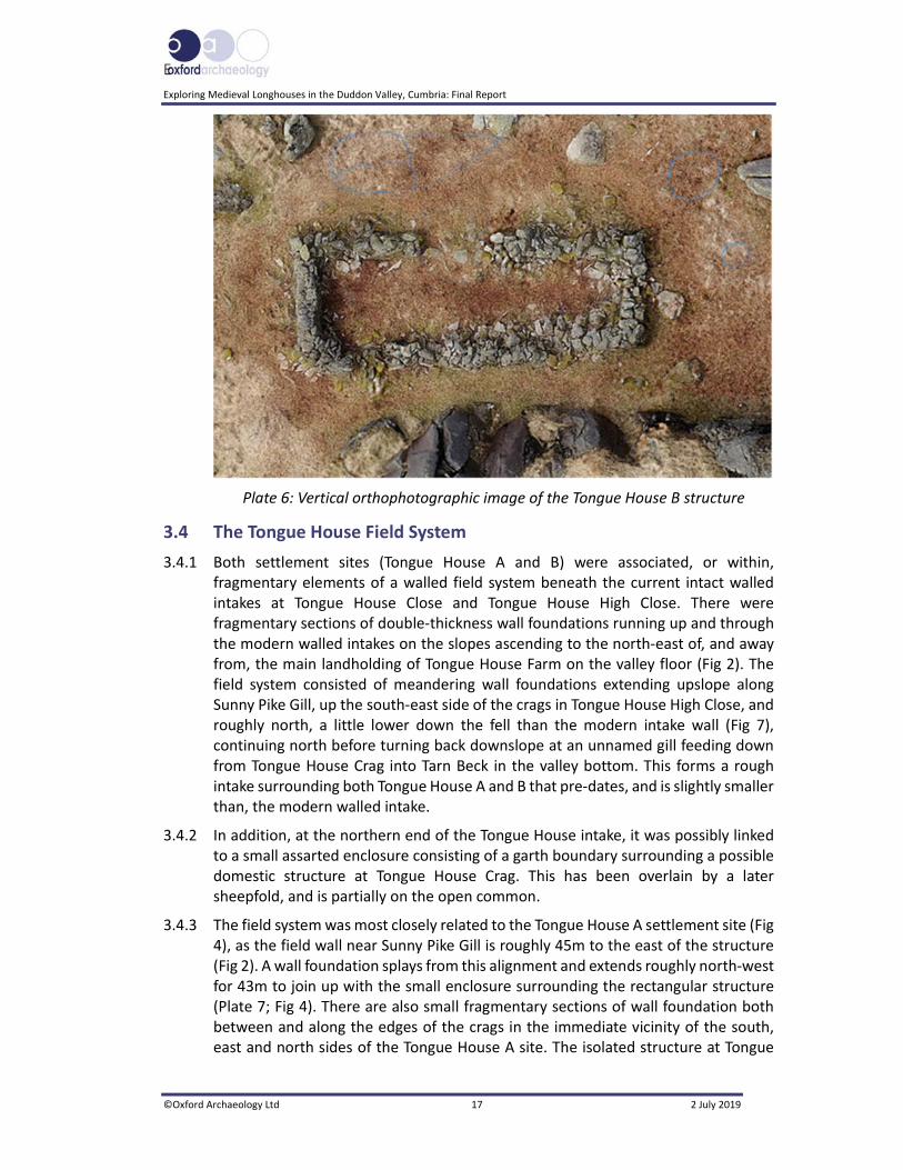
Plate 6: Vertical orthophotographic image of Tongue House B ........................................ 17
Plate 7: The relict walls associated with the Tongue House A structure ........................... 18
Plate 8: Long House Close Structure 1, partially surrounded by the ‘pound’ ................... 20
Plate 9: Long House Close Structure 3, with a later bield built on top of the western half ............................................................................................................................... 21
Plate 10: Aerial view of the northern structure (LC4) .......................................................... 22
Plate 11: The enclosure (LC5) linking the individual structures and the field wall to the east ............................................................................................................................... 23
Plate 12: Resistivity plot superimposed on the Long House Close plan .............................. 25
Plate 13: Possible palaeochannel 1063 below Tongue House A ......................................... 27
Plate 14: Orthophotographic image of Tongue House A in its earliest form (Phase 1) ...... 28
Plate 15: Interior of the structure looking north‐west, showing hearth 1006 and surface 1020....................................................................................................................... 29
Plate 16: The southern cell, looking south‐east, showing hearth 1007 and structure 1008 ............................................................................................................................... 30
Plate 17: Phase 2, showing the blocked north‐eastern entrance (1025) of the cross‐passage ............................................................................................................................... 31
Plate 18: Drain 1047, looking north‐west, next to wall 1018 .............................................. 32
Plate 19: Enclosure wall 3002, immediately south of Tongue House A .............................. 33
Plate 20: Tongue House B during excavation, on a natural shelf overlooking the valley.... 34
Plate 21: The formerly much broader entrance marked by threshold 3007 ....................... 35
Plate 22: East wall of Tongue House B, showing the lower course of larger stones, with the upper courses being less well constructed ........................................................... 36
Plate 23: Cut 1099 ................................................................................................................ 37
Plate 24: Kerb 1082 with revetment 1034 to the left .......................................................... 38
Plate 25: Structure 1052, looking east ................................................................................. 39
Plate 26: Setting 1055 .......................................................................................................... 39
Plate 27: Cobbles 1057 with kerb 1058 ............................................................................... 40

Exploring Medieval Longhouses in the Duddon Valley, Cumbria: Final Report
©Oxford Archaeology Ltd vii 2 July 2019
Plate 28: Stony deposit 1073, underlying wall 1018 ............................................................ 41
Plate 29: Building 1016, partially enclosed by walls 1019 and 1018, during the 2017 season ............................................................................................................................... 42
Plate 30: Stone surface 1025 during excavation .................................................................. 43
Plate 31: Possible hearth 1020 ............................................................................................. 44
Plate 32: Layer 1046, butting against wall 1014, yet continuing below 1018 ..................... 45
Plate 33: Pit 1087 with a kerb of pitched stone ................................................................... 46
Plate 34: Surfaces 1071, 1075 and 1076 during excavation ................................................ 46
Plate 35: Wall 1041, at the junction with wall 1072 ............................................................ 48
Plate 36: Possible blocked entrance in field wall 1042 ........................................................ 49
Plate 37: Silverdale ware from deposit 1033 ....................................................................... 54
Plate 38: Coring with a gouge auger near Tongue House B ................................................ 55
Plate 39: The kerb (1082) forming the western end of the Bronze Age platform ............... 65
Plate 40: Possible hearth 1060 ............................................................................................. 66
Plate 41: Long House Close from beyond the eastern enclosure wall, with Harter Fell on the right ....................................................................................................................... 70
Plate 42: Peat store in an unrestored traditional ‘firehoose’, at Kirbuster Museum, Orkney ............................................................................................................................... 71
Plate 43: The south wall of Tongue House B, showing the remains of the gable end ........ 73
Plate 44: Building 1016 and surrounding walls (1017), looking west, during the 2017 excavation season ................................................................................................. 74
Plate 45: Wall 2019, showing the construction technique .................................................. 75
Plate 46: Possible head‐dyke, depicted on the OS six‐inch map, marking the transition from enclosed land to unenclosed fells ......................................................................... 80
List of Tables
Table 1: Finds Catalogue ..................................................................................................... 51
Table 2: Summary of the potential prehistoric pottery by context .................................... 52
Table 3: Radiocarbon dates from Palaeo‐Site 3 (Tongue House B) .................................... 58
Table 4: Palaeoenvironmental assessment results Tongue House A ................................. 60
Table 5: Radiocarbon dates ................................................................................................ 61
Table 6: Lithology of monolith sample 556 ........................................................................ 62

Exploring Medieval Longhouses in the Duddon Valley, Cumbria: Final Report
©Oxford Archaeology Ltd ix 2 July 2019
Summary
Oxford Archaeology North (OA North) has provided supervision and enablement for a community archaeology survey and excavation project of three sites in the Duddon Valley (Tongue House A and B, and Long House Close; NGR 32426 49758; 32429 49784; 32454 49738). This was undertaken on behalf of the Duddon Valley Local History Group, in conjunction with the National Trust and the Lake District National Park Authority; the project was largely financed by the Heritage Lottery Fund. The survey took place in April 2016, followed by the excavation of three stone‐founded buildings over three seasons in June/July of 2016, 2017 and 2018.
The archaeological survey entailed a detailed record of each site using a theodolite and disto, with data plotted in the field. A further process of photogrammetric survey was undertaken across a wide area, using photographs taken from an AUV, to record the wider landscape, and a palaeoenvironmental survey was also conducted. In conjunction with this, a geophysical survey was undertaken to identify any sub‐surface features, with magnetometry undertaken to identify any possible hearths. This preliminary work then culminated with excavations at the three sites.
At Tongue House A, the structure was aligned north‐west/south‐east, and was 10.45m long by a maximum of 4m across. The building in its earliest phase comprised two cells, divided by a cross‐passage. The interior of the upper, northern, cell was floored by two layers of cobbles; alder/hazel charcoal from the lower of the two floors provided a radiocarbon determination of cal AD 1515‐1800. A hearth, later modified, was found toward the south‐eastern end of this cell, close to the cross‐passage. The cross‐passage itself had again been floored with two phases of cobbles, presumably contemporary with those found in the northern cell, although they were less defined.
A drain on the west side of the building appeared to empty into a soakaway, although it continued beyond the limits of excavation; oak charcoal from this feature produced radiocarbon dates of cal AD 65‐230 (1875±33 BP; SUERC‐70994) and cal AD 675‐880 (1248±33 BP; SUERC‐69186). The likely explanation for this wide discrepancy is that carbon from an adjacent palaeochannel had been reworked when the building was constructed, possibly from a woodland clearance event.
The building named Tongue House B comprised a single cell, with no internal divisions, although the upper northern end was furnished with a rough flagstone floor, whilst the floor in the lower end was earthen. Despite no evidence of a hearth, charcoal recovered from within the building produced a radiocarbon determination of cal AD 1476‐1639 (337±24 BP; SUERC‐81433). No artefacts were recovered.
Tongue House A was associated with a series of walls, creating a pair of pounds, which were linked by field walls into a wider field system, within which Tongue House B was also situated. This field system, marked on the Ordnance Survey maps as Tongue House High Close, extended down the fellside to the fields and meadows of the valley bottom of Tongue House Farm.

Exploring Medieval Longhouses in the Duddon Valley, Cumbria: Final Report
©Oxford Archaeology Ltd x 2 July 2019
Long House Close proved to be the most complex of the sites, comprising two main phases of activity, the earliest in the Middle Bronze Age, over which was a building dating from the fifteenth to seventeenth century. The site also yielded a single late Bronze Age/early Iron Age date. Bronze Age activity comprised a levelled platform cut into the east‐west slope. At its western end, a rubble revetment was bounded by a curving kerb of large stones and earthfast boulders. Rubble surfaces seemed to extend to the east of this revetment. A possible hearth, visible as an area of reddened material, lay above the platform. A second possible hearth, in the form of a pit, contained charcoal from which radiocarbon dates of c 1425‐1135 cal BC were returned.
A doubled‐celled stone structure, with a cross‐passage, and areas of hardstanding to the north and south, had been constructed on the levelled area. There was evidence that the eastern cell of the building was subsequently rebuilt and enhanced, and may have continued in use as a single‐celled structure. A radiocarbon determination from under a stone surface produced a date of cal AD 1485‐1643 (327±24 BP; SUERC‐76928) and a pit immediately north of the building produced another date of cal AD 1415‐1451 (470±24 BP; SUERC‐81431). Finds recovered from the site included late medieval to post‐medieval pottery, and a number of iron objects, including horseshoes.
The two large boulder walls on either side of the building appeared to post‐date it. Testpits to the south of the building identified a buried soil that produced possible cereal pollen, and charcoal from this yielded a Middle Bronze Age radiocarbon determination, although an iron object appears to suggest that this layer had been reworked in a later period.
The kerbed levelled area had certain elements in common with sites found throughout the north of England. Numerous such sites have been recorded by the Lake District National Park Survey, comprising oval or circular platforms partly cut into a slope, and these are usually associated with unenclosed roundhouses, although most are not closely dated. Similar sites have been investigated in the North East, where they seem to span the period c 1500‐100 BC. Sites described as unenclosed ‘scooped platforms’ have also been identified in Kentmere and Windermere. In addition, such sites have been found in southern Scotland and the Peak District.
The excavations have demonstrated that the three later structures were all broadly contemporary, having been built at some point between the late fifteenth century and the mid‐seventeenth. This calls their purpose into question, as this is at the later end of the period when summer transhumance was practised, and these structures did not conform to contemporary descriptions of shielings. Perhaps the closest parallels are found in the tradition of small cross‐passage houses built in this period across northern England, and Snowdonia, to exploit more marginal farming landscapes. It is also clear that the buildings were modified during their lifetime, presumably also changing their functions to suit changing farming requirements.

Exploring Medieval Longhouses in the Duddon Valley, Cumbria: Final Report
©Oxford Archaeology Ltd xi 2 July 2019
Acknowledgements
Oxford Archaeology North would like to thank the Duddon Valley Local History Group (DVLHG) and the Lake District National Park Authority for commissioning the project, and the Heritage Lottery Fund for providing the bulk of the funding. This project was also made possible in part by a grant from the Council for British Archaeology's Mick Aston Fund, which is supported by Historic England.
Thanks must go in particular to Stephe Cove, Kenneth Day, Mervyn Cooper, Bob Bell, Sue Lydon, and Peter Matthiessen of the DVLHG, and Eleanor Kingston of the Lake District National Park Authority, for their considerable involvement and support. We would also like to thank the landowners, the National Trust, and its archaeologist, Jamie Lund, in particular, for giving permission to access the three excavated sites, and for considerable support. We thank Gail Batten for enabling the use of the Parish Rooms at Seathwaite, and also Anthony and Hilary Hartley, from Turner Hall, for allowing access and parking. In addition, the landowner, David Pennefather, is thanked for giving permission to access the site at Long House Close. The heads and staff of all the schools are thanked for facilitating the children's involvement.
The topographical surveys and excavations were primarily undertaken by volunteers, many of whom also assisted with the geophysical survey, but who are so numerous that it is impossible to mention them individually. We thank them all for their boundless enthusiasm and energy throughout the project but, in particular, we should mention Christine Anderzen, who came all the way from Sweden to help out on the excavation.

Exploring Medieval Longhouses in the Duddon Valley, Cumbria: Final Report
©Oxford Archaeology Ltd xii 2 July 2019
The volunteers were aided in the topographical survey by Peter Schofield and Jamie Quartermaine. The palaeoenvironmental survey was undertaken by Mairead Rutherford, with the help of the DVLHG volunteers, and Stephe Cove and Brian Hardwick, in particular, are gratefully acknowledged. The geophysical survey was undertaken by Mike Birtles. The excavations were supervised by Jeremy Bradley, Pete Schofield, Jon Onraet, Hannah Leighton and Debbie Lewis.

Exploring Medieval Longhouses in the Duddon Valley, Cumbria: Final Report
©Oxford Archaeology Ltd xiii 2 July 2019
The charcoal was identified by Denise Druce, who also supervised the environmental processing. The finds were identified by Adam Tinsley, Dot Boughton and Antony Dickson. The report was written by Jeremy Bradley, with Mairead Rutherford, Mike Birtles, Peter Schofield, and Jamie Quartermaine, and the illustrations were produced by Anne Stewardson. The report was edited by Rachel Newman, with Jamie Quartermaine, who also managed the project.

E
Exploring Medieval Longhouses in the Duddon Valley, Cumbria: Final Report
©Oxford Archaeology Ltd 1 2 July 2019
1 INTRODUCTION
1.1 Scope of Work
1.1.1 Oxford Archaeology North (OA North) has provided supervision and enablement for a community archaeology survey and excavation project of three buildings in the Duddon Valley (Tongue House A and B, and Long House Close; NGR 32426 49758; 32429 49784; 32454 49738; Fig 1). The project was undertaken on behalf of the Duddon Valley Local History Group (DVLHG), in conjunction with the National Trust and the Lake District National Park Authority, and was financed largely by the Heritage Lottery Fund, although many other organisations provided additional funding. The surveys took place in April 2016, followed by the excavation of the first of these buildings (Tongue House A) in late June and early July 2016. The first season of excavation at Long House Close followed in late June‐July 2017, with the final season of work divided between Long House Close and Tongue House B in late June‐July 2018. The following report documents the results of the archaeological surveys and excavation, and discusses them within their archaeological and historical context.
1.2 Location, Topography and Geology
1.2.1 The Duddon Valley (Dunnerdale) leads southwards from its head at Harter Fell, Little Stand and Grey Friar; the River Duddon flows to the south‐west past Dale Head, Seathwaite and Duddon Bridge, then on to the Duddon estuary. The three sites studied, Tongue House A and B and Long House Close, were on the unenclosed fell north‐east of Seathwaite and Long House, on either side of the track between Long House (at the northern end of the Seathwaite Road) and Seathwaite Tarn, at altitudes of 273m, 300m and 294m (respectively). Tongue House A and B are in the steep and rocky outcrops west of this track, around 1km north of Long House, and Long House Close is to the south of the Tongue House sites, on the east side of the track. The sites have very clear visual remains, with bedrock and natural boulders close to the surface, and are associated with an extensive field system (Fig 2).
1.2.2 The underlying geology is the Birker Fell Andesite Formation, laid down in an environment previously dominated by volcanic eruptions (Mosley 1978). The soil cover is from Devensian ‐ Diamicton till formed by Ice Age glaciers (Lawes 1983; Jarvis et al 1984).
1.3 Archaeological and Historical Background
1.3.1 Two key pieces of work have been compiled about the sites: Longhouses in the Duddon Valley, Cumbria, collated by the Duddon Valley Local History Group in 2013 (DVLHG 2013), and a more recent work, A Survey of Longhouse Structures in the Duddon Valley, Cumbria (Matthiessen et al 2015, on behalf of the DVLHG). As part of its work on the historical background for the survey sites, the DVLHG searched the National Archive catalogues and undertook a thorough, and wide‐ranging, study of the available primary and secondary sources (DVLHG 2013, 12, 103). The primary sources mainly comprised legal documents, church and manorial records, some
Exploring Medieval Longhouses in the Duddon Valley, Cumbria: Final Report
©Oxford Archaeology Ltd 2 2 July 2019
dating from the early seventeenth century, although most were from the eighteenth to twentieth centuries (op cit, 12). For an understanding of the patterns of settlement in the Duddon Valley and the Lake District, the DVLHG drew heavily upon the works of Angus Winchester (Winchester 1987; 2000). A third document has also been studied: the relevant chapter of the Lake District World Heritage Site Nomination (LDNPA 2015).
1.3.2 Sites Studied: a short‐list of sites was identified from an initial identification survey, which were deemed worthy of more detailed archaeological survey. Within this group were the three sites examined by the present project: Tongue House A; Tongue House B; and Long House Close (DVLHG 2013, 17, 20). The sites formed a cluster, within some 0.5km square, on the unenclosed fells flanking the track from Long House Farm to Seathwaite Tarn.
1.3.3 Historic Environment Record: Tongue House A is listed in the Lake District Historic Environment Record (HER 36559; NTSMR 20024) as a longhouse or shieling with associated walls; there are also two other HER sites associated with Tongue House (HER 33590 and HER 36558). Tongue House B is also in the National Trust Sites and Monuments Record (NTSMR 23862) as a longhouse or shieling (DVLHG 2013, 76). Long House Close is also recorded (HER 38570; NTSMR 23863).
1.3.4 Previous Archaeological Work: these surveys demonstrated that the sites were near to surface water and their surrounding landscape had evidence for ancient agricultural activity (DVLGH 2013, 14). All the structures were similar, being rectangular, most with cross‐passages and lateral door openings (ibid) and having a single‐wall perimeter (op cit, 17, 20). Both structures at Tongue House were of approximately similar sizes (c 10 x 3.5m) and had three to six courses in their perimeter walls (ibid). These appeared to be the best‐surviving buildings of the survey, with little robbing of stone (op cit, 102). Both structures had been built with outcropping rock behind them, and their entranceways faced south‐west, with a view of the lower Duddon Valley (op cit, 76). However, they were 220m apart, and were not necessarily contemporaneous or even associated with each other.
1.3.5 Tongue House A was seen to be a two‐celled structure with a cross wall, and had a series of pounds and enclosures around it (DVLHG 2013, 20, 76, 103‐4). The walls of Tongue House B stood higher, with one end rising to a low gable, but no surrounding enclosure was visible, only low walls c 100m to the north and east (DVLHG 2013, 77). No cross wall was observed in Tongue House B (DVLHG 2013, 20), and it was thought likely to have been a single‐celled structure, perhaps a shieling associated with summer pastures (Matthiessen et al 2015, 131).
1.3.6 There were several structures identified at Long House Close, the southern building being 9 x 3.9m and its walls stood to one or two courses; it was uncertain whether there was a cross wall, although there may have been two entrances (DVLHG 2013, 41). It was closely associated with another structure to the west, a circular sheepfold and enclosure walls, clearly pre‐dating eighteenth‐ and nineteenth‐century walls (ibid). The southern structure was surrounded by a wall, which may have enclosed a yard (ibid).

E
Exploring Medieval Longhouses in the Duddon Valley, Cumbria: Final Report
©Oxford Archaeology Ltd 3 2 July 2019
1.3.7 The initial survey identified patterns of low or collapsed walls that had enclosed cleared land. They were perhaps topped by fences or palisades of brushwood and may have contained herds of cattle or flocks of sheep (ibid; Matthiessen et al 2015, 131); there was no evidence for ploughing or cultivation (DVLHG 2013, 103). The surveys also found many clearance cairns and disused tracks (ibid). At the time of these surveys, it was tentatively suggested that these structures all belong to the mid‐ to late medieval period (op cit, 104).
1.4 SITE HISTORY
1.4.1 Prehistoric and Roman Periods: there is evidence for a significant number of sites in the Duddon Valley dating from the prehistoric period, including the Neolithic stone circle at Swinside Farm, on the north side of the Duddon estuary. Extensive Bronze Age cairnfields, and associated settlements and field systems, are to be found across the south‐west fells, recognised in surveys of the western side of the Duddon Valley (Quartermaine and Leech 2012). The Roman fort on Hardknott stands at the head of Eskdale, close to the watershed with the Duddon, and the Roman road from there to the fort of Ambleside crossed the valley at Cockley Beck (ibid).
1.4.2 Early Medieval and Medieval Periods: studies of surviving manorial documents, place names, and pollen evidence have indicated three phases of early medieval and medieval expansion in the Lake District and thus, perhaps, in the Duddon Valley (DVLHG 2013, 86; Winchester 1987; 2000). An early phase of colonisation is indicated by place names, such as those ending in ‐thwaite, and ‐scale, suggesting clearance and agricultural settlement by Scandinavian‐speaking peoples (LDNPA 2015, 154). It is generally thought that the colonists built longhouses, and certainly structures housing both people and animals were used in the medieval period (Matthiessen et al 2015, 117‐18, 123). Pollen analysis suggests there was a period of increased clearance from the tenth century onwards (DVLHG 2013, 86), but this was followed by a period of reduced activity, suggested by the regeneration of woodlands.
1.4.3 A second period of expansion seems to have begun in the later twelfth and thirteenth centuries (DVLHG 2013, 86). In the Duddon Valley, evidence of farming can be seen on the sides at the valley at c 200‐300m (ibid). This may have been the period when many of the identified sites and enclosures were occupied, being worked all year round (Matthiessen et al 2015, 123). The practice of transhumance and living part‐year in shielings also seems to have been in operation at this time (DVLHG 2013, 86; Matthiessen et al 2015, 118). By c 1300, there had been further clearances and enclosures (for instance within the forest of Ulpha; DVLHG 2013, 86‐7), 'assarting' in places such as Seathwaite (LDNPA 2015, 156). The influence of the Abbey of Furness became important, through cultivation and later sheep farming, stock farming, such as at Ulpha, building fishponds, and producing iron (LDNPA 2015, 155‐6). The population declined, however, during the fourteenth and fifteenth centuries, as a result of the Black Death, poor harvests, and animal plagues (DVLHG 2013, 87).
Exploring Medieval Longhouses in the Duddon Valley, Cumbria: Final Report
©Oxford Archaeology Ltd 4 2 July 2019
1.4.4 The third period of population growth in the Lake District took place from the second half of the fifteenth century and during the sixteenth and seventeenth centuries, when there was a substantial increase in 'assarting' and in the lease or ownership of enclosed agricultural farmsteads, which linked to form small hamlets (LDNPA 2015, 156‐7; DVLHG 2013, 87). At Seathwaite, two hamlets, comprising two or three farmsteads, were surrounded, at a distance, by smaller farms such as Tongue House, and each farmstead was directly adjacent to small, irregular, enclosed or inbye fields (LDNPA 2015, 157). Larger intakes (perhaps through assarting) were on the lower slopes of the unenclosed fell, perhaps using the becks as boundaries (ibid). This might reflect the increase in sheep farming in this period as a response to the growth of the textile industry in the Lake District. Some family estates also became larger (DVLHG 2013, 88). Thus the open fellside became farmed as enclosed pastures.
1.4.5 Early Post‐medieval Period: there is no reference to the two Tongue House buildings in the documentary record and it has been argued that the paucity of primary sources relating to these sites might be explained by the abandonment of the farmsteads on the upper fells during the later medieval period (DVLHG 2013, 91, 103). It was also noted that the two sites had seen little disturbance (op cit, 15) before the building of the eighteenth/nineteenth‐century walls in the vicinity (op cit, 77). Long House Farm is referenced in a source of 1683, and thus the farmhouse may be of seventeenth‐century date or earlier (Higgins 1986; NTSMR 20632).
1.4.6 The Long House Close fells would seem to have been associated with Long House Farm, sited on the lower levels. Nineteenth‐century Ordnance Survey (OS) mapping marks the intakes on Long House Close adjacent to the inbyes clustered next to Long House Farm (1850; DVLHG 2013, 41), but there seems no documentary confirmation of any relationship between the enclosures on the upper fells and Long House Farm itself. Long House Farm may originally have been a single‐storey longhouse prior to being remodelled as a two‐storey structure (ibid), implying a longevity of occupation.
1.4.7 A press cupboard at Tongue House Farm was possibly dated 1691 (LDNPA 2015, 150). In the same way that Long House Farm related to intakes at Long House Close, it is possible that Tongue House Farm retained pasture on the open fell on Tongue House (close to the sites of Tongue House A and B).
1.4.8 It is possible that, during the seventeenth century, farmhouses may have retained lands on the upper fells for summer pasture (Historic England 2011). Tongue House B has been suggested as a shieling (Matthiessen et al 2015, 131), and if this was so, the structure may have been associated with Tongue House Farm.
1.4.9 There are references to the Walney Scar settlement, which may have been a farmstead close to the Walna Scar Road, the east/west track leading towards Broughton (DVLHG 2013, 90). The location of the settlement of Walney Scar is uncertain, but records suggest that it may have been ‘on the fellside north‐east of Long House up the old Lonin and in fields to the left. Three sides of a building stand...Near it is ..... Barn remains....’ (Wade documents, cited by DVLHG 2013, 90).
E
Exploring Medieval Longhouses in the Duddon Valley, Cumbria: Final Report
©Oxford Archaeology Ltd 5 2 July 2019
The ‘fields to the left’ might have been those north of the Walna Scar Road, in the same area as the Long House Close site.
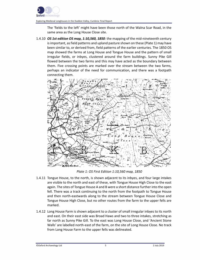
1.4.10 OS 1st edition OS map, 1:10,560, 1850: the mapping of the mid‐nineteenth century is important, as field patterns and upland pasture shown on these (Plate 1) may have been similar to, or derived from, field patterns of the earlier centuries. The 1850 OS map showed the farms at Long House and Tongue House and the pattern of small irregular fields, or inbyes, clustered around the farm buildings. Sunny Pike Gill flowed between the two farms and this may have acted as the boundary between them. Five crossing points are marked over the stream between the two farms, perhaps an indicator of the need for communication, and there was a footpath connecting them.
Plate 1: OS First Edition 1:10,560 map, 1850
1.4.11 Tongue House, to the north, is shown adjacent to its inbyes, and four large intakes are visible to the north and east of these, with Tongue House High Close to the east again. The sites of Tongue House A and B were a short distance further into the open fell. There was a track continuing to the north from the footpath to Tongue House and then north‐eastwards along to the stream between Tongue House Close and Tongue House High Close, but no other routes from the farm to the upper fells are marked.
1.4.12 Long House Farm is shown adjacent to a cluster of small irregular inbyes to its north and east. On their east side was Broad Haws and two to three intakes, stretching as far north as Sunny Pike Gill. To the east was Long House Close, and ‘Ancient Stone Walls’ are labelled north‐east of the farm, on the site of Long House Close. No track from Long House Farm to the upper fells was delineated.

Exploring Medieval Longhouses in the Duddon Valley, Cumbria: Final Report
©Oxford Archaeology Ltd 6 2 July 2019
1.4.13 This pattern of farm buildings surrounded by inbyes with intakes on the lower slopes of the upper fells was a feature of the later medieval dispersed farmsteads and settlements of the sixteenth and seventeenth centuries (LDNPA 2015, 156‐8; DVLHG 2013, 87); the shapes of the enclosed fields and larger intakes persisted into the post‐medieval period, to be mapped by the OS in the nineteenth century. The track between Long House and Seathwaite Tarn was not marked on the 1850 map but was on the OS map of 1919, being associated with the building of the Seathwaite Dam for the Barrow Corporation, completed in 1904.
1.4.14 OS map, 1:10,560, 1919: the chosen sites were marked on the revised edition OS map of 1919 (Plate 2). Stone walls were again marked east of the track from Long House to Seathwaite Tarn, and two short sections of straight stone wall and a possible enclosure were noted west of the track, adjacent to one of the rocky outcrops of Tongue House High Close.
Plate 2: OS Revised Edition 1:10,560 map, 1919

E
Exploring Medieval Longhouses in the Duddon Valley, Cumbria: Final Report
©Oxford Archaeology Ltd 7 2 July 2019
2 PROJECT AIMS AND METHODOLOGY
2.1 Project Design
2.1.1 A project design (Appendix 1) was submitted by OA North in response to an invitation to provide supervision and enablement for a community archaeology survey and excavation project of three structures in the Duddon Valley (Tongue House A and B, and Long House Close). The project design was adhered to in full, and the work was consistent with the relevant CIfA and Historic England guidelines (Chartered Institute for Archaeologists (CIfA) 2014a; 2014b; 2014c; Historic England 2015).
2.1.2 This was part of a long‐standing community project which had already been involved in both identification and detailed surveys throughout the Duddon Valley, the results of which have been widely disseminated (DVLHG 2009; Matthiessen et al 2015). The survey programme identified a number of stuctures that warranted further investigation, potentially longhouses, a class of monument that has rarely been subject to detailed excavation. The wider aim of the project was to involve local people and to provide training in excavation on three of the sites, together with the survey of four sites.
2.1.3 OA North provided supervision of volunteers undertaking both geophysical, landscape and palaeoenvirnonmental surveys and excavation. Detailed surveys of each of the three sites were undertaken, using both resistivity and magnetometry techniques, and supervision of the excavation of each site over three seasons was provided.
2.2 Aims and Objectives
2.2.1 A principal aim of the project was to involve the local community as widely as possible, and to provide new information on the wealth of archaeological remains in the area through survey and excavation. Presentations to the volunteers were given and they were encouraged to be involved in undertaking the field surveys and excavation. Interpretation panels were also provided during the fieldwork, and presentations were given to schools. The results of each season were compiled in overview reports (OA North 2016; 2017), this report representing the culmination of this process, to be followed by publications (Bell et al 2019). At the end of the project, the Lake District National Park Authority HER and the National Trust SMR will be updated.
2.2.2 The objectives of the project were:
i. To excavate part of each site with the help of local volunteers to obtain evidence for dates of construction (charcoal, pottery, other artefacts etc) from secure contexts undamaged by bracken;
ii. To look for evidence of stock husbandry (livestock types and numbers) associated with each structure;
iii. To look for any evidence of crop‐growing in the vicinity of the structures;

Exploring Medieval Longhouses in the Duddon Valley, Cumbria: Final Report
©Oxford Archaeology Ltd 8 2 July 2019
iv. To investigate deposits from secure contexts within and around the structures for palaeoenvironmental evidence of foods (eg seeds, grains, bones etc) eaten by the former inhabitants;
v. To obtain evidence from pollen and other deposits in peat beds to indicate the nature of the environments surrounding the structures when they were in use.
2.3 Methodology
2.3.1 Several types of survey were undertaken, including a detailed topographical survey, a palaeoenvironmental survey, and a geophysical survey (Sections 2.3.2‐19), which were followed by the partial excavations of Tongue House A, Long House Close, and Tongue House B (Section 5.4).
2.3.2 Detailed Topographical Survey: a detailed topographical survey of each of the house sites was undertaken, equating to Historic England’s Level 2 (Ainsworth et al 2007). As the survey was in part intended to serve as a training exercise for the volunteers, the survey techniques employed were easy to understand, allowed for plotting in the field, and would be easily affordable by volunteers in future work, but at the same time provided a range of processes. Because of these constraints, some technologies were what in commercial terms would be considered old‐fashioned, and this had a significant impact on productivity. This was, however, off‐set by the use of more current techniques that enabled detailed three‐dimensional recording.
2.3.3 Thus, in conjunction with the traditional survey techniques applied as part of the training programme, more modern photogrammetric methods were used, particularly aerial photography from a drone. This work was undertaken with respect to survey control established by GPS/ total station.
2.3.4 Theodolite / Disto Survey: the use of a theodolite/disto was found to be very effective and easy to use as a training methodology. The theodolite measured angles and the disto measured the distances, with the data then drawn up in the field by volunteers using an accurate film‐based protractor and ruler. This allowed the volunteers to be involved in all stages of the process. The technique uses equipment which can be economically acquired and is within the financial range of most non‐professional groups, allowing them to develop their own survey abilities.
2.3.5 Photogrammetric Recording: where possible, the sites and immediate environs were recorded by means of photogrammetry using high‐altitude photography, which, using specialist software, allowed the creation of accurate three‐dimensional models of the site and topographical surfaces. This was achieved using a UAV, a small multi‐engined drone, providing photography from any altitude up to approximately 100m in height. Survey control was introduced to the photographs by the placement of control targets across the site, which were located by means of a survey‐grade GPS or total station.
2.3.6 The photogrammetric processing was undertaken using Agisoft Photoscan software, which provides detailed modelling using the overlap of up to 300 photographs, enabling the creation of a very detailed Digital Terrain Model (DTM) for each site.

E
Exploring Medieval Longhouses in the Duddon Valley, Cumbria: Final Report
©Oxford Archaeology Ltd 9 2 July 2019
The photographs were then digitally draped over the model to create an accurate three‐dimensional model of the ground surface. The primary output, however, was an accurate two‐dimensional image, which was used to generate accurate plans or profiles.
2.3.7 Survey Control: where possible, survey control was introduced to the sites by means of a high‐accuracy survey‐type differential GPS. This can achieve an accuracy of ±20mm, and ensured that the survey was located accurately onto the Ordnance Survey National Grid. Where mobile reception (necessary to provide corrections for the GPS) was unavailable, then a base station was established to provide consistent accurate control.
2.3.8 Detail Survey Overview: the detailed survey by theodolite recorded all structural and earthwork components. Survey points were marked on the ground using spray paint and the survey drawing was manually compiled with respect to them. On completion of the survey, the field drawings were digitised into a CAD system. The survey recorded all archaeological features, earthworks and elements, and aimed to identify, locate and record all built elements in the landscape.
2.3.9 Photographic Record: a photographic archive was generated in the course of the project, comprising landscape and detailed photography. Detailed photographs were taken of the archaeological features using a scale bar. All photography was recorded on photographic pro‐forma sheets which show the subject, orientation and date, and was typically undertaken using a digital SLR camera with 18‐megapixel resolution.
2.3.10 Palaeoenvironmental Survey: three sites were examined by rapid coring on traverses to assess the potential for the preservation of organic sediments. At two of these sites (Tongue House A and Tongue House B), sufficient peat was recorded to investigate the deposits further. Transects were set up around an initial point, and gouge auger samples taken at 5m intervals (Fig 3). A further small area of potential peat, between Tongue House A and B, was also investigated, but this yielded only a thin peat accumulation, which was only 0.50m thick. A fourth site was investigated some distance from the other sites, as this looked like a large expanse of low‐lying peaty ground, with potential for good peat accumulation, but in the event only 0.50m of mossy sediments were present above bedrock.
2.3.11 The location of each transect was accurately located using a survey‐grade GPS. The coring equipment used comprised a 30mm gouge auger and a standard hand‐operated Eijkelkamp (Russian) auger.
2.3.12 Each profile was recorded in a field notebook and the data transferred to pro‐forma lithology tables, with significant layers identified. Relative depths were noted and a description of the deposits recorded, using standard terminology (colour, texture, compaction and inclusions; Appendix 2), following the English Heritage (now Historic England) guidelines (Ayala et al 2007; Campbell et al 2011).
2.3.13 The sediments in the monoliths were described and cleaned prior to sub‐sampling for pollen. Volumetric samples were taken from ten sub‐samples from two monoliths, and one tablet containing a known number of Lycopodium spores was added, so that pollen concentrations could be calculated (Stockmarr 1972). The samples were

Exploring Medieval Longhouses in the Duddon Valley, Cumbria: Final Report
©Oxford Archaeology Ltd 10 2 July 2019
prepared using a standard chemical procedure (method B of Berglund and Ralska‐Jasiewiczowa 1986), using HCl, NaOH, sieving and Erdtman’s acetolysis, to remove carbonates, humic acids, particles greater than 170μm, and cellulose, respectively. The samples were then stained with safranin, dehydrated in tertiary butyl alcohol, and the residues mounted in 2000cs silicone oil. Slides were examined at a magnification of x400 by ten equally spaced traverses across two slides, to reduce the possible effects of differential dispersal on the slides (Brooks and Thomas 1967) or until at least 100 total land pollen grains and spores were counted. Pollen identification was made following the keys of Moore et al (1991), Faegri and Iversen (1989), and a small modern reference collection. Plant nomenclature follows Stace (2010). Non‐pollen palynomorph (NPP) nomenclature follows van Geel (1978). The preservation of the pollen was noted and an assessment was made of the potential for further analysis.
2.3.14 Geophysical Survey: magnetometry surveys were carried out at all three sites, concentrating on the interiors of the structures, and a resistivity survey was undertaken on the Long House Close site (Plate 3). Magnetometry is not the best technique for recording rocky landscapes, or where there is the potential for bedrock near the surface; however, it is very effective for the identification of hearths. At all three sites, the survey extended some way beyond the extent of each structure.
Plate 3: Resistivity survey at Long House Close
2.3.15 The detailed magnetic survey was carried out using a Bartington Grad601‐2 gradiometer, which has an internal datalogger. Data were collected in zig‐zag mode over a half grid (15 x 30m), the magnetic data being collected at 0.25m intervals on profiles 1m apart (3600 readings per grid). In total, an area of approximately 0.18ha was surveyed with magnetometry, and most of the recording was undertaken by the volunteers under supervision.
E
Exploring Medieval Longhouses in the Duddon Valley, Cumbria: Final Report
©Oxford Archaeology Ltd 11 2 July 2019
2.3.16 Resistance survey is most effective at identifying stone structures; however, it can be masked, and the results confused, by the proximity of natural stones and bedrock. The detailed resistance survey was carried out using a Geoscan RM15 resistance meter, which has an internal datalogger. Data were collected by the volunteers in zig‐zag mode over 30 x 30m grids, at 1m intervals, on profiles 1m apart (900 readings per grid).
2.3.17 Data Capture and Processing: the magnetometer survey was carried out in scan mode. The operator walked along survey tapes set out as a guide and observed the changes in reading on the left‐hand tube, whilst walking slowly forward. Any readings above the background of 1.5nT were recorded in spray paint on the ground, to be surveyed in.
2.3.18 Resistance data were captured in the internal memories of the instruments and downloaded to a portable computer on‐site, being backed‐up on to a USB drive. The grid was processed to produce an overall plan of the surveyed area, or ‘composite’. The results were analysed and basic initial processing was carried out on‐site using Terrasurveyor, by DW Consulting.
2.3.19 Final processing of resistivity raw data was undertaken off‐site, in accordance with Historic England guidelines (English Heritage 2008), to remove any instrument error or survey effects, to enhance subtler anomalies normally associated with archaeological features. All data were clipped by the appropriate values where necessary and the following processing steps carried out:
The datasets were despiked in order to remove high contact readings;
The grids were edge‐matched, to correct for changes in the position of the remote probes;
A high‐pass filter was applied, which removes variations in the background geological response;
A low‐pass filter was applied where appropriate, which can improve the visibility of weak archaeological features.
2.3.20 Excavation: of the three sites excavated, determined by the 2016 surveys (Section 3), for practical and planning purposes Tongue House A was explored first, because it was conveniently near to the Seathwaite Tarn track, and was a logistically straightforward site to excavate. This was followed in 2017 by one structure at Long House Close. However, given the complexity found there, and radiocarbon dates of the Middle Bronze Age being received (OA North 2017), it was realised that further work on that site would be necessary. Therefore, in the final season, excavation took place at both Long House Close and at Tongue House B. It was considered that the latter site could be examined within a shorter time period of four to five days, with a smaller team, because of its simpler plan, since there was no evidence of an internal partition or associated enclosure.
2.3.21 Excavation of the sites was supervised by a core staff of three from OA North, with the intention that the excavation should allow an area of sufficient size to be excavated and completed over the course of 16 working days, including three weekends. Initially, in the first season, excavation was at Tongue House A and its

Exploring Medieval Longhouses in the Duddon Valley, Cumbria: Final Report
©Oxford Archaeology Ltd 12 2 July 2019
environs, targeting those areas which would provide the most data, such as wall junctions and geophysical‐survey anomalies.
2.3.22 In practice, however, for all three sites, a flexible approach was used, whereby small areas were to be opened initially, and subsequently expanded, or additional areas opened as the work progressed. The end result was that the interior of Tongue House A was stripped and excavated down to extant floor layers, with sondages examining sub‐floor levels. Almost a complete circuit immediately outside the building was also examined, in particular the area between the western wall and a western enclosure wall. Initially, three ‘breaches’ were made through the surrounding enclosure walls; however, due to the large size of the boulders in the north‐west/south‐east wall to the south‐east of Tongue House A, an area some 30m to the south‐west of the structure was ultimately chosen to be excavated.
2.3.23 Similarly, at Long House Close, the end result was that much of the interior of the building was stripped and excavated down to extant floor layers, whilst the more substantial, parallel walls, and the area to the east of the building, were only partially investigated. The prime reason for this was the realisation that it was not going to be possible to understand the archaeological sequence fully in the course of one season of excavation. This became more apparent once the programme of scientific dating had commenced as part of the post‐excavation programme, which identified hitherto unexpected Bronze Age activity below both the building and the outer parallel walls. The 2018 season at Long House Close continued this flexible approach. Due to factors such as the heatwave in June/July 2018, which resulted in reduced working hours, work concentrated on tracing the extent of Bronze Age activity, and examining the two outer walls partially surrounding the building.
2.3.24 The emphasis for the excavation was upon providing a valuable experience for the participants, rather than undertaking extensive areas of excavations to tight timetables. Whilst it was important that all areas opened were fully excavated, the extent of the excavation areas was restricted, so as to ensure that the participants could comfortably complete these areas within the time allowed.
2.3.25 Turf Clearance and Excavation: the turf was carefully removed from the excavation areas by hand and stored separately from the spoil, adjacent to the excavation. All excavation was carried out using manual techniques. Stone was stacked adjacent to the site.
2.3.26 Structural remains were cleaned to define their extent, nature, form and, where possible, date. All information identified in the course of the site works was recorded stratigraphically, using a system adapted from that used by the Research Department of English Heritage (now Historic England). Results were recorded on pro‐forma context sheets, and were accompanied by sufficient pictorial record (plans, sections and colour digital photographs) to identify and illustrate individual features. Primary records were available for inspection at all times.
2.3.27 Samples were taken from within each structure to enable phosphate analysis. This work was undertaken by the participants under the guidance of the core OA North staff members, after consultation with the OA North palaeoenvironmentalist.

E
Exploring Medieval Longhouses in the Duddon Valley, Cumbria: Final Report
©Oxford Archaeology Ltd 13 2 July 2019
2.3.28 A full and detailed photographic record of individual contexts was maintained and, similarly, general views from standard viewpoints of the overall site were taken at all stages of the excavation. Photographic records were maintained on pro‐forma sheets.
2.3.29 Planning: the precise position of all archaeological structures encountered was surveyed digitally by experienced surveyors utilising GPS to record the site with reference to OS co‐ordinates. In this case, a Leica Differential GPS was employed that uses real‐time (RTK) corrections using mobile SmartNet technology to achieve an accuracy of ±0.01m. The accuracy of the OA North GPS system provides for a quick and effective means of recording the position and extent of sites. The digital survey data were transferred, via Leica Geo Office (V.4), as .shp (shape) files into a CAD system (AutoCAD 3D 2015), and superimposed onto the embedded digital OS data.
2.3.30 Additionally, the site and general environs were recorded during excavation by means of aerial photography, using specialist photogrammetric software, which was used to create accurate three‐dimensional models of the site and topographical surfaces. Two methods were utilised; the first used a UAV (drone), that enables photography from any altitude up to approximately 200m in height. This technique was primarily used when placing each building within its wider environs. The second technique used a mast with a camera mounted on top. The latter is not effective for recording large areas, but could be undertaken by the volunteers, and allowed them to get involved in the photogrammetric process using inexpensive equipment. This was used on a day‐to‐day basis to record the progress of the excavation and provide accurate plans. Survey control was introduced to the photographs by the placement of control targets across the site, which were located by means of survey‐grade GPS.
2.3.31 This process, using Agisoft software (Section 2.3.6), generated scaled plans within an AutoCAD system, which were refined by manual draughting. The drawings were generated at an accuracy appropriate for 1:20 scale. Sections were manually drafted at a scale of 1:10. All information was tied into Ordnance Datum using the GPS. On completion of the excavations, aerial photographs were taken of the site using a photographic mast.
2.3.32 Backfilling: the excavation areas were manually backfilled by OA North and the participants, and the turfs were relaid. In practice, after discussions with Jamie Lund, the National Trust archaeologist, the stone heaps at Tongue House A were retained, and only smaller stones and rocks were used to consolidate various of the deeper features. The remaining stone was left, either as cairns adjacent to the site, or used to reconstruct the building, undertaken by the National Trust field team. At Tongue House B, where it was not considered necessary to remove any of the standing walls, a similar methodology was employed, with the smaller stones used to consolidate the excavation area, which was then returfed. At Long House Close, after the 2017 season, the site was partially covered with a permeable membrane, in anticipation that it would be uncovered for a second season. For the final season, it was decided, after consultation with Eleanor Kingston (LDNPA), rather than using a plastic‐based membrane to cover the site, that the practice of using smaller stones to define areas disturbed by the excavation should be continued. Some attempt was made to redefine the walls removed during the excavation works, with the larger stones being replaced by the National Trust field team.
Exploring Medieval Longhouses in the Duddon Valley, Cumbria: Final Report
©Oxford Archaeology Ltd 14 2 July 2019
2.3.33 Finds Policy: finds recovery and sampling programmes were in accordance with best practice (following current Chartered Institute of Field Archaeologists guidelines CIfA 2014a; 2014b) and subject to expert advice, in order to minimise deterioration. OA employs in‐house artefact and palaeoecology specialists, with considerable expertise in the investigation, excavation, and finds management of sites of all periods and types, who were readily available for consultation. Finds storage during fieldwork followed professional guidelines (UKIC 1998). Emergency access to conservation facilities is maintained by OA North.

E
Exploring Medieval Longhouses in the Duddon Valley, Cumbria: Final Report
©Oxford Archaeology Ltd 15 2 July 2019
3 TOPOGRAPHICAL SURVEY RESULTS
3.1 Introduction
3.1.1 An archaeological survey of the three chosen sites was carried out between 4th and 15th April 2016. This was undertaken using instrument survey and photogrammetry, with aerial photographs taken from a drone.
3.2 Tongue House A
3.2.1 The Tongue House A structure was revealed as a north‐west/south‐east‐aligned building, 10.45m long by a maximum of 4m across (Fig 3; Plate 4). At the time of survey, it was observed to be a two‐celled structure with a single entrance in the south‐western wall, and a cross wall which extended at a slightly diagonal angle through the building, with the larger cell, making up two‐thirds of the building, to the north‐west. The entrance to the building led into the smaller, south‐eastern, cell, which was at the lower end of the slope on which it stands. This was thought potentially to be the remains of a shieling.
Plate 4: Tongue House A prior to the excavation, looking south‐east
3.2.2 The structure clearly had more than one phase of occupancy, since a blocked entrance was visible opposite the primary entrance, which would indicate that the north‐west and south‐east cells were once divided by a cross‐passage. The cross wall was seen to butt onto the side walls of the structure, and was evidently a later element.
3.2.3 Enclosure walls: the building was enclosed within a north‐west/south‐east‐aligned irregular pentagonal enclosure (Fig 4), with a south‐eastern entrance and another entrance to the south‐west, opposite the cross‐passage. The eastern side of the house was bounded by an outcrop of rock. This small enclosure, which closely

Exploring Medieval Longhouses in the Duddon Valley, Cumbria: Final Report
©Oxford Archaeology Ltd 16 2 July 2019
surrounds the house, occupied the northern corner of a larger, approximately north‐west/south‐east‐aligned enclosure that opened onto a marshy area at the base of the slope. A large outcrop of rock formed a natural barrier to the south‐west of the house, with small areas of wall blocking any obvious gaps, whilst a wall, aligned north‐west/south‐east, sealed a gap between the outcrop and its neighbour, some 15m to the south‐east. The enclosure walls were generally consistent in their construction, being formed from large irregular boulders with a rubble core, and in the case of the enclosure wall around the building, survived in places to a height of c 1m. Widths of between 1.2m and 1.5m were recorded for the walls.
3.3 Tongue House B
3.3.1 The Tongue House B site consisted of the foundations of a single isolated, rectangular structure located in the northern half of the walled intake of Tongue House High Close, at approximately 300m AOD elevation (Plate 5; Fig 2). It was orientated north/south and measured approximately 10.5m long by 4.16m wide, with roughly straight‐sided walls, 0.7m wide, surviving up to 0.5m high (Fig 5). The southern gable wall was more pronounced, with well‐defined kerbed foundations, and survived up to 0.7m high. The structure stood on a small natural shelf set in the lee of a west‐facing crag (1.4m away), within a series of north‐east/south‐west aligned craggy knolls, which descend down the valley side (Fig 6).
Plate 5: Tongue House B, looking south
3.3.2 Features associated with it were limited, with a single collapsed entranceway set into the centre of the western wall; there was no evidence for a door sill or jamb (Plate 6). Slight evidence existed for wall collapse, both internally and to a lesser degree externally. There never appears to have been any internal divisions, nor any visible features within the structure.
E
Exploring Medieval Longhouses in the Duddon Valley, Cumbria: Final Report
©Oxford Archaeology Ltd 17 2 July 2019
Plate 6: Vertical orthophotographic image of the Tongue House B structure
3.4 The Tongue House Field System
3.4.1 Both settlement sites (Tongue House A and B) were associated, or within, fragmentary elements of a walled field system beneath the current intact walled intakes at Tongue House Close and Tongue House High Close. There were fragmentary sections of double‐thickness wall foundations running up and through the modern walled intakes on the slopes ascending to the north‐east of, and away from, the main landholding of Tongue House Farm on the valley floor (Fig 2). The field system consisted of meandering wall foundations extending upslope along Sunny Pike Gill, up the south‐east side of the crags in Tongue House High Close, and roughly north, a little lower down the fell than the modern intake wall (Fig 7), continuing north before turning back downslope at an unnamed gill feeding down from Tongue House Crag into Tarn Beck in the valley bottom. This forms a rough intake surrounding both Tongue House A and B that pre‐dates, and is slightly smaller than, the modern walled intake.
3.4.2 In addition, at the northern end of the Tongue House intake, it was possibly linked to a small assarted enclosure consisting of a garth boundary surrounding a possible domestic structure at Tongue House Crag. This has been overlain by a later sheepfold, and is partially on the open common.
3.4.3 The field system was most closely related to the Tongue House A settlement site (Fig 4), as the field wall near Sunny Pike Gill is roughly 45m to the east of the structure (Fig 2). A wall foundation splays from this alignment and extends roughly north‐west for 43m to join up with the small enclosure surrounding the rectangular structure (Plate 7; Fig 4). There are also small fragmentary sections of wall foundation both between and along the edges of the crags in the immediate vicinity of the south, east and north sides of the Tongue House A site. The isolated structure at Tongue

Exploring Medieval Longhouses in the Duddon Valley, Cumbria: Final Report
©Oxford Archaeology Ltd 18 2 July 2019
House B is situated approximately 80‐100m downslope of the intake wall on the northern end of Tongue House High Close (Fig 2), but there was no direct connection with the field system.
Plate 7: The relict walls associated with the Tongue House A structure
3.4.4 The walls consist of double‐thickness foundations with some rubble infill and, in places, there is much obvious collapse downslope, whilst in other places any superstructure has been removed, possibly to build the later intake wall. It is uncertain if the walling ever reached a full stock‐proof height, or if they acted as foundations to hedges, or fences, or indeed whether they were just defining field plots and were not stock‐proof in themselves, although it is likely that the outer intake wall must once have been stock‐proof. Essentially, these walls sub‐divide areas of cleared ground between the crags into discrete enclosed areas of pasture/rough grazing within the wider intake boundary, with a minimum of construction and economy of effort, since they use the available craggy outcrops. There are two discernible enclosed pastures on the east side, upslope and downslope of Tongue House A, but these have not been dated.
3.5 Long House Close
3.5.1 A detailed survey of the Long House Close settlement was undertaken by a process of instrument survey of the structure, and aerial survey, using a drone, to record the wider field system (Fig 8). It was located on an area of fell called Long House Close,

E
Exploring Medieval Longhouses in the Duddon Valley, Cumbria: Final Report
©Oxford Archaeology Ltd 19 2 July 2019
which is an historic holding of Long House Farm, and is divided from the area of fell called Tongue House High Close by Sunny Pike Gill (Fig 2).
3.5.2 The settlement is on an area of moorland which has a west‐facing, uniform, gentle slope and is covered by coarse scree, with localised outcropping. A stream flows some 30m to the south of it. The Long House Close settlement is particularly significant, comprising two buildings, and a smaller structure, which are all linked by an encompassing enclosure boundary. Linked to the settlement are the walls of an open‐sided field system that extends to the east.
3.5.3 Southern Building (Sites LC1 and LC2): the southernmost building (LC1) was elongated, 10.1 x 4.1m in size (Fig 9), constructed of low (0.35m high) dwarf walls, which were typically 0.9m in width. These dwarf walls had a uniform, flat upper surface and served as the foundations for a superstructure that would have been of an organic material, such as wood or peat; only the foundation is now left and, characteristically, little or no stone collapse was associated with the walls. There appeared to be a cross‐passage through the building, since there were two opposing gaps in the walling; however, these contained evidence of a sheep trod through the structure and it was not apparent if this adopted the line of pre‐existing entrances or whether it created the gaps. The interior of the structure was terraced, although there was some slippage that had resulted in a scarp slope at the eastern, upper, end of the building.
3.5.4 This structure was partially surrounded by a semi‐elliptical ‘pound’ (LC2), which had curved sides and a straight end (20.4 x 8.4m; Plate 8). There was a small area to the east of the building, but the side walls were set very close to those of the building. Its walls were of dry‐stone masonry, and stood up to 0.8m in height, incorporating some large stones, particularly on the southern side. The northern wall (1019) was lower, with a uniform construction, up to 1.8m in width, and had no visible tumble associated with it; thus, this wall probably never stood to full height. The southern wall was constructed of very large boulders, similar to other sections of the field wall. Wall section 1041, at the eastern end, incorporated large boulders, and was in a relatively good and intact condition, but continued the line of field wall 1072, which was mostly collapsed and degraded. It would appear that the earlier line of wall 1072 had been built up and enhanced by the incorporation of large stones, which suggests that the line of wall 1041 is old but the wall fabric is later, reflecting a rebuild. Wall section 1018 was similar in construction to wall section 1041, and may also have been rebuilt on the line of an earlier wall. Wall section 1019, however, was very different in construction, comprising revetted stone facades with rubble fill, and this appeared to butt against the fabric of the older, and partly collapsed, wall 1072. A further section of field wall extends south from the southern wall (1019), which has partly been built over this wall, and is by implication later.

Exploring Medieval Longhouses in the Duddon Valley, Cumbria: Final Report
©Oxford Archaeology Ltd 20 2 July 2019
Plate 8: Long House Close Structure 1, partially surrounded by the ‘pound’
3.5.5 The preliminary assessment of the phasing of the structure indicates that this section of walling has had a complex, multi‐phase, history, which would suggest that the partial enclosure was developed from the curved line of the field wall (1072), enhanced on the southern side (1019) to repair and build up the wall, and that the northern section of wall was new, and later than wall 1072. The fact that 1018 and 1019 were of such different structural form may suggest that they were not constructed at the same time. That the walls of the partial enclosure (LC2) partly developed from an irregular field wall would at least explain why the shape of the resultant structure was also fairly irregular.
3.5.6 Western Building (Site LC3): the western building is shorter than LC1, being 9.1 x 6.0m in size (Fig 9). It is of dry‐stone construction, and there is some collapsed material was visible in association with the walls; the average width of the wall and its collapse is 1.5m, of which the wall appears to be 0.9m wide. The stones are substantially earthfast and the walls are typically 0.3m high. A square dry‐stone bield (4.2 x 4.7m in size) has been constructed on top of the building, which has walls that are in places in good condition, and are up to 1m in height. To judge by the condition, this structure (LC3b) is not particularly old, being consistent with a later post‐medieval shepherd’s bield. The western and south‐western faces of the underlying walls are in very good condition, and have probably been built up and maintained as part of the bield, whereas the eastern and northern walls are decayed. The construction of the bield has obscured much of the earlier building and it is not evident if the earlier structure had a cross wall or entrance (Plate 9).
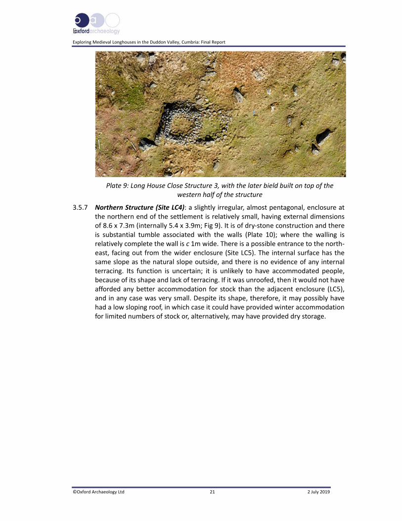
E
Exploring Medieval Longhouses in the Duddon Valley, Cumbria: Final Report
©Oxford Archaeology Ltd 21 2 July 2019
Plate 9: Long House Close Structure 3, with the later bield built on top of the western half of the structure
3.5.7 Northern Structure (Site LC4): a slightly irregular, almost pentagonal, enclosure at the northern end of the settlement is relatively small, having external dimensions of 8.6 x 7.3m (internally 5.4 x 3.9m; Fig 9). It is of dry‐stone construction and there is substantial tumble associated with the walls (Plate 10); where the walling is relatively complete the wall is c 1m wide. There is a possible entrance to the north‐east, facing out from the wider enclosure (Site LC5). The internal surface has the same slope as the natural slope outside, and there is no evidence of any internal terracing. Its function is uncertain; it is unlikely to have accommodated people, because of its shape and lack of terracing. If it was unroofed, then it would not have afforded any better accommodation for stock than the adjacent enclosure (LC5), and in any case was very small. Despite its shape, therefore, it may possibly have had a low sloping roof, in which case it could have provided winter accommodation for limited numbers of stock or, alternatively, may have provided dry storage.

Exploring Medieval Longhouses in the Duddon Valley, Cumbria: Final Report
©Oxford Archaeology Ltd 22 2 July 2019
Plate 10: Aerial view of the northern structure (LC4)
3.5.8 Settlement Enclosure (Site LC5): a decayed wall foundation forms an irregularly shaped enclosure, linking LC4 with the structures (LC1, LC3) to the south (Fig 9; Plate 11). The wall butts against each of the component features and was evidently a later feature. For the most part, it is low‐lying, containing relatively small amounts of stone and, as such, would not have, by itself, been able to control stock; it is probable therefore that this was augmented by a fence or similar structure. The eastern part of the enclosure has been overlain by a field‐boundary wall (Site LC6), which is far more substantial and would have been able to contain stock. There is, however, a short, insubstantial section of the original wall extending between the corner of field wall LC6 and LC4 (Plate 10). There is also a low, narrow, bank that extends between south‐western structure LC3 and the eastern wall of the enclosure, effectively dividing the space, although unevenly. The western wall extends through an area of poorly drained ground, which indicates that this enclosure was an afterthought, since if the enclosure was the primary feature and the structures secondary, then the enclosure would logically have been moved a small distance upwards onto better‐drained ground.

E
Exploring Medieval Longhouses in the Duddon Valley, Cumbria: Final Report
©Oxford Archaeology Ltd 23 2 July 2019
Plate 11: The enclosure (Site LC5), linking the individual structures and the field wall to the east
3.5.9 Field System (Site LC6): extending east from the settlement is a field system formed of a single dry‐stone wall (LC6) now substantially decayed (Fig 8). To the east, it has been built through an area of scree, before terminating at a small crag, but it is evident that, beyond the crag to the north, is a series of further walls between lines of crags that extend up to 400m from the enclosure (Fig 2).
3.5.10 A field wall also extends to the south of the settlement into an area of scree, and it has been possible to trace it for at least 400m through this scree, where it follows an erratic course between large boulders. There is, however, no wall to the east. The scattered, linear elements of this field system would appear to define an area of upland intake, with this intermittent boundary defining the eastern limit of the Long House Close holding. There is a possibility that these walls would have provided a funnel‐type arrangement to lead stock off the fell into the intake lands and the settlement enclosure to the west, and a convenient entrance between LC4 and the field system would have enabled this.
3.5.11 Phasing: it is evident that there has been considerable development of the site over time, indicating that it probably had an extended life, which certainly continued into the post‐medieval period.
Exploring Medieval Longhouses in the Duddon Valley, Cumbria: Final Report
©Oxford Archaeology Ltd 24 2 July 2019
4 GEOPHYSICAL SURVEY RESULTS
4.1 Introduction
4.1.1 Magnetometry survey can be quite limited when recording rocky landscapes, or where there is the potential for bedrock near the surface (Section 2.2.1); therefore its main use, at Tongue House A, was for the identification of hearths. Resistivity, meanwhile, is most effective at identifying buried stone structures, although, again, the results are typically confused by the proximity of natural stones and bedrock (Section 1.2.2), both of which were encountered during the excavations.
4.2 Magnetometry
4.2.1 Tongue House A produced one discrete area of magnetic enhancement, with a further four to the west of the building, but within the area bounded by the enclosure walls (Fig 10). A further 13 anomalies with readings up to 6nT were identified on the plateau south of the structure and enclosure.
4.2.2 At Tongue House B, there was one broad magnetic anomaly to the west of the structure, and a further two small anomalies to the north (Fig 11). Inside the structure, a small magnetic anomaly at the southern end, adjacent to the extant gable wall, had the potential to be a hearth.
4.2.3 At Long House Close (Fig 12), a potentially significant anomaly (5nT) was recorded inside LC3, at its eastern end, where a hearth might have been expected. Two 5nT anomalies were within LC1, one being small and localised at the western end, with another against the southern wall. The latter would be in an unusual location for a hearth, but the western anomaly could be interpreted as such.
4.2.4 Other anomalies beyond the structures include an 11nT anomaly (6) to the east of LC3 and one against the enclosure wall (5). A further anomaly (4) was located just outside the north‐eastern corner of LC1, but within the wider ‘pound’ (LC2).
4.3 Resistivity
4.3.1 Resistivity was only undertaken at Long House Close, as this site appeared to have the greatest potential for useful results. However, the exposed geology and the difficulties in getting both probes in contact with the soils made the results unreliable. As a consequence, dummy readings were generated over much of the grid, and the results were very erratic. It is therefore not possible to make any reliable interpretation of structural remains indicated by the resistivity plot (Plate 12).
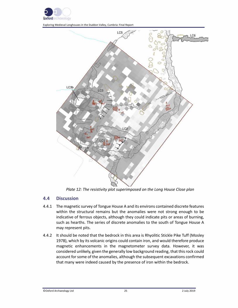
E
Exploring Medieval Longhouses in the Duddon Valley, Cumbria: Final Report
©Oxford Archaeology Ltd 25 2 July 2019
Plate 12: The resistivity plot superimposed on the Long House Close plan
4.4 Discussion
4.4.1 The magnetic survey of Tongue House A and its environs contained discrete features within the structural remains but the anomalies were not strong enough to be indicative of ferrous objects, although they could indicate pits or areas of burning, such as hearths. The series of discrete anomalies to the south of Tongue House A may represent pits.
4.4.2 It should be noted that the bedrock in this area is Rhyolitic Stickle Pike Tuff (Mosley 1978), which by its volcanic origins could contain iron, and would therefore produce magnetic enhancements in the magnetometer survey data. However, it was considered unlikely, given the generally low background reading, that this rock could account for some of the anomalies, although the subsequent excavations confirmed that many were indeed caused by the presence of iron within the bedrock.

Exploring Medieval Longhouses in the Duddon Valley, Cumbria: Final Report
©Oxford Archaeology Ltd 26 2 July 2019
5 EXCAVATION RESULTS
5.1 Introduction
5.1.1 A stratigraphic description of the archaeological remains is given for the three excavations, presented sequentially, starting with Tongue House A and Tongue House B, followed by Long House Close. The full details of all the contexts, with dimensions and depths of all deposits, can be found in Appendices 3‐5.
5.2 General soils and ground conditions
5.2.1 The soil sequence in all sites was fairly uniform. The natural geology comprised localised glacio‐fluvial deposits, composed of brownish‐orange silt, or clay‐silt containing poorly sorted sub‐rounded pebbles, and these were overlain by a shallow humic turf/topsoil.
5.3 Tongue House A
5.3.1 Four separate areas were investigated during the course of the excavation of Tongue House A, with the largest area focusing on the building itself, which was examined by a trench (Trench 1) comprising some 102.5m2, with maximum dimensions of 14 x 3m (Fig 13). Three further trenches, generally 2 x 2m, targeted the various associated enclosure walls. Trench 2 was placed immediately to the north‐west of the structure, with Trench 3 situated to the south, and Trench 4 was excavated across the south‐western enclosure wall, across the plateau from the structure.
5.3.2 Natural deposits: the earliest strata were mixed bands of glacio‐fluvial deposits (1062/1010), in which were preserved small amounts of oak charcoal (five fragments or less). Cutting through these deposits was a north‐west/south‐east‐aligned cut, probably a palaeochannel (1063; Fig 14), filled with cobbles and silt, seen as a layer of cobbles and boulders (1064; Plate 13). Some of the stones were later used as a rough area of hardstanding, to the west of the building. A feature, originally thought to be a posthole, was more likely to be part of this palaeochannel, within which was a deposit that produced charcoal, most of which was oak (26‐100 fragments). Exactly what the source for this charcoal was remains unclear, but it was fairly ubiquitous on the site, being also found within a later soakaway (1027), immediately to the south of the structure.

E
Exploring Medieval Longhouses in the Duddon Valley, Cumbria: Final Report
©Oxford Archaeology Ltd 27 2 July 2019
Plate 13: Possible palaeochannel 1063 below Tongue House A
5.3.3 Phase 1: the earliest recognisable phase of human activity was the construction of the building, which generally had no foundations, being built directly on the natural substrate (Fig 15). There was, however, some evidence of a foundation course of cobbles (1042) on the south‐west side, below wall 1018, which is likely to have been used to level this part of the structure. The ground within the footprint of the structure fell sharply, by 0.82m from north‐west to south‐east.
5.3.4 The building was rectangular, being aligned north‐west/south‐east, and measured externally 10.45m long by a maximum of 4m wide, with internal dimensions of 8.62m long and between 2.09m and 2.42m across (Plate 14). The dry‐stone walls (1019, 1018, 1058, 1059 and 1060) survived to a height of 1.15m in places.

Exploring Medieval Longhouses in the Duddon Valley, Cumbria: Final Report
©Oxford Archaeology Ltd 28 2 July 2019
Plate 14: Orthophotographic image of Tongue House A in its earliest form (Phase 1)
5.3.5 The Phase 1 building comprised two cells divided by a cross‐passage, with the northern cell measuring 4.49m long and comprising walls 1018, 1022, and 1060, and the southern measuring 2.49m long, with the cross‐passage being between 1.19m and 1.33m wide. A tumbled orthostat, interpreted as a door jamb, appeared to mark the position of the entrance on the north‐east side. Cobbled floors were evident in the northern cell (1028, lower; 1020, upper), with charcoal from 1028 providing a radiocarbon determination of cal AD 1514‐1798 (275±30 BP; SUERC‐69651), although statistically it is more likely that the date is in the sixteenth or seventeenth century (Appendix 6).
5.3.6 A hearth made of flat stone slabs (1006) was situated centrally in the northern cell, toward the cross‐passage, and built on the upper cobbled surface (1020; Plate 14). It was 0.96 x 0.97m (Plate 15), and had subsequently been modified by the placing of a rough kerb of stones around part of it (1005), expanding it somewhat, with dimensions of 1.4 x 0.8m.

E
Exploring Medieval Longhouses in the Duddon Valley, Cumbria: Final Report
©Oxford Archaeology Ltd 29 2 July 2019
Plate 15: Interior of the structure looking north‐west, showing hearth 1006 on surface 1020
5.3.7 The surface within the cross‐passage (1033) was cobbled, the earliest layer later sealed by a second (1026/1029). Large earthfast boulders at either entrance may have provided basic thresholds.
5.3.8 The southern cell, comprising walls 1019, 1058 and 1059, contained an apparent small structure (1008), within the angle formed by walls 1058 and 1019 (Plate 16). A single course of boulders, each between 0.69m and 0.3m, formed the edges, giving external dimensions of 1.86 x 1.14m, whilst earthfast rocks (within natural deposit 1034) formed the north and part of the north‐east edges. A layer of cobbles (1031) formed the internal surface of the southern cell; it was sealed below a layer of silty clay (1030/1037), although this did not cover small structure 1008, so it is not not clear whether this was a natural deposit or had been deliberately laid. Within the eastern corner of the cell was a possible hearth (1007), created by a semi‐circle of stones.

Exploring Medieval Longhouses in the Duddon Valley, Cumbria: Final Report
©Oxford Archaeology Ltd 30 2 July 2019
Plate 16: The southern cell, looking south‐east, showing hearth 1007 (top left) and structure 1008 (centre right)
5.3.9 Phase 2: at some point, the north‐east entrance was blocked (1025), this being placed upon a foundation layer of silty clay and cobbles (1044; Fig 16; Plate 17). A wall (1014) had been constructed across the end of the northern cell, entirely blocking it off, and the surface of the former cross‐passage had been relaid (1026). Dark‐brown silt (1012, 1013 and 1023), heavily disturbed by bracken rhizomes, had accumulated over the entirety of the interior of the structure, but was much deeper in the northern cell (1012).
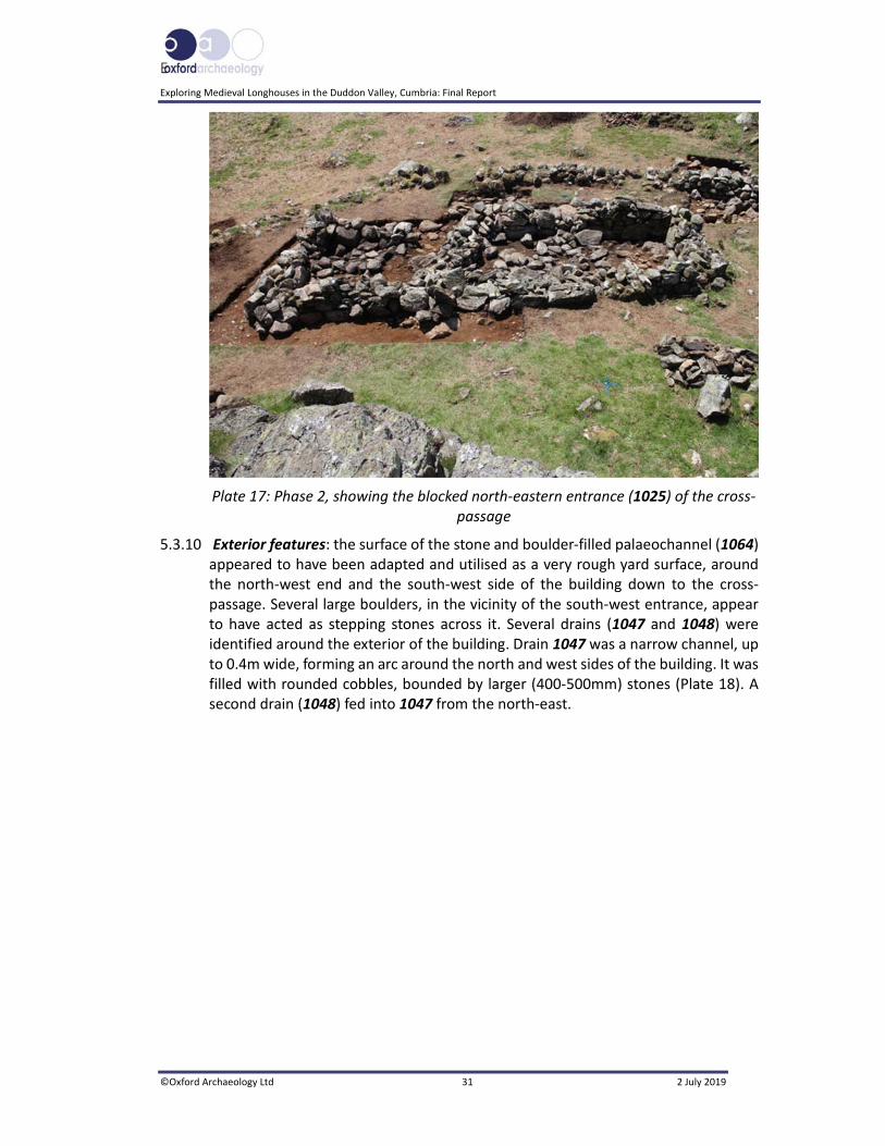
E
Exploring Medieval Longhouses in the Duddon Valley, Cumbria: Final Report
©Oxford Archaeology Ltd 31 2 July 2019
Plate 17: Phase 2, showing the blocked north‐eastern entrance (1025) of the cross‐passage
5.3.10 Exterior features: the surface of the stone and boulder‐filled palaeochannel (1064) appeared to have been adapted and utilised as a very rough yard surface, around the north‐west end and the south‐west side of the building down to the cross‐passage. Several large boulders, in the vicinity of the south‐west entrance, appear to have acted as stepping stones across it. Several drains (1047 and 1048) were identified around the exterior of the building. Drain 1047 was a narrow channel, up to 0.4m wide, forming an arc around the north and west sides of the building. It was filled with rounded cobbles, bounded by larger (400‐500mm) stones (Plate 18). A second drain (1048) fed into 1047 from the north‐east.

Exploring Medieval Longhouses in the Duddon Valley, Cumbria: Final Report
©Oxford Archaeology Ltd 32 2 July 2019
Plate 18: Drain 1047, looking north‐west, next to wall 1018
5.3.11 This drain may have emptied into a soakaway in front of the south‐west entrance. This was a 0.9m long by 0.4m wide feature (1027), filled by a dark‐brown silt (1021), which contained occasional charcoal fragments. Two radiocarbon determinations were obtained from this material, providing dates of cal AD 66‐229 (1875±33 BP; SUERC‐70994), from a fragment of birch charcoal, and cal AD 676‐876 (1248±33 BP; SUERC‐69186) from oak charcoal. The discrepancy between the dates may be due to the longevity of oak (the ‘old wood’ effect), as opposed to birch, which is a short‐lived tree species, although the latter is likely to be residual.
5.3.12 The building was enclosed within a north‐west/south‐east‐aligned irregular pentagonal enclosure (walls 1061, 1065, 2003 and 3002; Fig 17), with an entrance to the south‐east, whilst the eastern side of the house was bounded by an outcrop of rock. Another entrance was located on the south‐west side, opposite the cross‐passage.
5.3.13 The enclosure walls were examined in three locations (Plate 19), and were found to be generally consistent in construction technique, being built without a foundation cut, but they were usually bedded on a layer of cobbles and redeposited natural deposits. The walls were formed from large irregular boulders with a rubble core, and in the case of enclosure wall 2003, survived in places to a height of c 1m. Widths of between 1.2m and 1.5m were recorded.

E
Exploring Medieval Longhouses in the Duddon Valley, Cumbria: Final Report
©Oxford Archaeology Ltd 33 2 July 2019
Plate 19: Enclosure wall 3002, immediately south of Tongue House A, showing the typical construction technique
5.3.14 This enclosure was itself part of a larger group of enclosures associated with the house site (Section 3.3; Fig 2), occupying the northern corner of a larger, approximately north‐west/south‐east‐aligned enclosure that opened onto a marshy area at the base of the slope. The enclosure comprised north‐west/south‐east‐aligned wall 1066, which extended from the ‘V’ formed by walls 1065 and 3002. Wall 1061 to the north terminated at the outcrop of rock, but continued south‐west as wall 1067. A large outcrop of rock also formed a natural barrier to the south‐west of the house, with small areas of wall blocking any obvious gaps, whilst wall 4002, aligned north‐west/south‐east, sealed a gap between this outcrop and its neighbour, some 15m to the south‐east.
5.4 Tongue House B
5.4.1 The structure had been built on a small natural shelf at approximately 300m AOD, the land gently descending from north to south. The building stood in front of a west‐facing cliff face (c 1.4m away), which is itself within a range of north‐east/south‐west‐orientated craggy knolls (Fig 5), which descend down the valley side (Plate 20). There was no evidence of earlier activity on the site.

Exploring Medieval Longhouses in the Duddon Valley, Cumbria: Final Report
©Oxford Archaeology Ltd 34 2 July 2019
Plate 20: Tongue House B during excavation, on a natural shelf overlooking the valley
5.4.2 The site was stripped of turf prior to the construction of the building (3003), as the foundations were directly on the natural substrate (3005), without a foundation trench. Aligned north/south, and measuring some 11.6m long, the structure widened from 3.4m at the north end to 4m wide at the southern end. The walls were composed of uncoursed, roughly hewn and unworked stones of the local volcanic tuff, and were 0.6m wide and, in the case of the southern wall (3010), stood to a height of 1.3m. In places, particularly noticeable on the east wall (3009), it was clear that the lowest course was constructed of larger boulders. South wall 3010 was the most complete, still retaining part of the gable. Access was gained through the west wall (3011 and 3013), the entrance being marked by two squared jambs, and measured 2.5m wide (Plate 21; Fig 18).

E
Exploring Medieval Longhouses in the Duddon Valley, Cumbria: Final Report
©Oxford Archaeology Ltd 35 2 July 2019
Plate 21: The formerly much broader entrance (later reduced in size) marked by
threshold 3007
5.4.3 The uneven surface of the underlying natural geology (3001) had been levelled by a series of shallow stony spreads (3002), from which small indeterminate fragments of charcoal were recovered. A radiocarbon determination from this deposit yielded a date of cal AD 1476‐1639 (337±24 BP; SUERC‐81433). A roughly hewn/split‐stone surface (3004) had been placed on this, covering the northern third of the structure, but no evidence for substantial domestic occupation, in the form of hearths or other features, was identified. There was also no evidence that the structure had ever been divided by internal walls.
5.4.4 There was some evidence that the walls had at some time collapsed and been rebuilt in a more ad‐hoc manner, particularly apparent in the upper courses of east wall 3009 (Plate 22). The entrance had also been partially blocked, with the addition of two coarsely constructed areas of walling (3012) and a narrower threshold inserted, marked by a large flat boulder (3007), some 1m wide (Plate 21).

Exploring Medieval Longhouses in the Duddon Valley, Cumbria: Final Report
©Oxford Archaeology Ltd 36 2 July 2019
Plate 22: East wall of Tongue House B, showing a lower course of larger stones, with the upper courses being less well constructed
5.5 Long House Close
5.5.1 The area investigated at Long House Close, comprising an irregular‐shaped trench, some 105m2, with maximum dimensions of 17.5 x 21m (Fig 19), focused on rectilinear stone structures LC1, and LC2, at the southern end of the enclosure (Fig 9). The excavation trench was placed on the prevailing east to west slope, which descended from 294.3m OD to 290.2m OD. The first season of excavation (2017) concentrated on this area, and features and deposits associated with it. The subsequent programme of radiocarbon assay indicated that there was potentially Middle Bronze Age and Early Iron Age activity on the site, and led to a further season of excavation to try to characterise and establish the extent of prehistoric activity.
5.5.2 In addition to the open‐area excavation, some 17 testpits were excavated. Thirteen of these, each measuring 1 x 1m, were opened as part of the outreach element of the project, and were either within the enclosure or beyond its eastern boundary. These served as control trenches, testing for the presence or absence of archaeological features and/or deposits, with the exception of Testpit 3, which targeted a faint wall line. Four other testpits, which each measured 1.5 x 1.5m, were intended to locate the extent of distinct stony layers that extended both south and north of the excavated site.
5.5.3 Phase 1 (Prehistoric): prehistoric activity occupied a levelled area partially terraced into the fellside (1099), which was defined to the west by a stepped revetment (1034) and curving kerb of boulders (1082). This platform was approximately 11m north to south and 13m east to west. Evidence that it had been cut into the slope

E
Exploring Medieval Longhouses in the Duddon Valley, Cumbria: Final Report
©Oxford Archaeology Ltd 37 2 July 2019
could be seen at its eastern edge (1099), where the prevailing slope had been artificially steepened (Plate 23). To the west, the turf had been removed down to the underlying natural substrate (1040), in an area extending some 8.3m from cut 1099. To counter the gradient at the western end of the trench, as the ground fell by 1.3m over a distance of 6m, the revetment comprised, firstly, a layer of brownish‐orange silt (1049) lying above the natural substrate, which contained charcoal flecks and a fragment of iron (OR 1007), which was felt to be intrusive. This deposit was perhaps used to level the area.
Plate 23: Cut 1099 (0.5m scale), dropping to the west (right)
5.5.4 The kerb (1082) curved around from the north to south‐east. It was constructed from a combination of large earthfast boulders, some of which measured over 2 x 1m, with smaller rocks infilling the gaps (Plate 24). Packing the area behind the kerb was a deposit of abundant angular and sub‐angular stones (25 x 20 ‐ 180 x 170mm) within orange‐brown silt, containing noticeable small fragments of charcoal (<5mm; 1032/1093). A radiocarbon determination from 1093 produced a date of 1401‐1231 cal BC (3052±24 BP; SUERC‐81432).

Exploring Medieval Longhouses in the Duddon Valley, Cumbria: Final Report
©Oxford Archaeology Ltd 38 2 July 2019
Plate 24: Kerb 1082, with revetment 1034 to the left (1m scale)
5.5.5 Where investigated, this deposit butted against a second, and higher, step in the revetment (1034), which was located 1.5m to the east. This was constructed in a similar manner, with a combination of earthfast and placed boulders, though these were generally of smaller size (<600 x 500mm), positioned in an approximately north/south alignment. This could be traced northwards as far as nearby structure LC3, and may have been later than the original revetment, and the southern extent was sealed below a later feature. As with kerb 1082, the area to the rear (east) was packed with rubble.
5.5.6 Only a single feature was noted on this platform, on the southern edge of the excavated area. This took the form of what may have been a shallow stakehole (1050), some 90mm wide by 60mm deep, filled with a dark silty deposit (1051).
5.5.7 A series of surfaces, and stone features, was found on the platform, extending between cut 1099 and revetment 1034, in an area some 8m across. The earliest was 1053, composed of sub‐rounded stones set within a matrix of brownish–orange silt (Fig 20). Within this surface were frequent charcoal fragments, dominated by alder/hazel, with a little oak, Malaoideae and charred hazelnut shell, the latter yielding a radiocarbon determination of 1339‐1228 cal BC (3012±34 BP; SUERC‐75308), suggesting, like the material from packing 1093, a Middle Bronze Age date for this activity.
5.5.8 Several rather enigmatic stone features were associated with surface 1053. A stone structure (1052; Plate 25), comprising four stones placed in an L‐shaped configuration, measuring c 1 x 1m, had been set into the underlying geology. That there was no evidence of burning within this feature suggests it was not a hearth. A sample (510) taken from this area (1059) was likely to be from the layer above, although alder charcoal yielded a radiocarbon determination of 1426‐1278 cal BC

E
Exploring Medieval Longhouses in the Duddon Valley, Cumbria: Final Report
©Oxford Archaeology Ltd 39 2 July 2019
(3090±29 BP; SUERC‐74369). Some 2m to the south was 1055, which comprised an upright stone to the west and two levels of stone to the east, spaced c 0.5m apart; it was open to the north, and was sealed below a later wall (Plate 26).
Plate 25: Structure 1052, looking east (2m scale)
Plate 26: Setting 1055 (0.5m scale)
5.5.9 Also visible in layer 1053 was a discrete feature, approximately 0.75m square, which appeared to comprise an area of fire‐affected material (1064/1065), the burning

Exploring Medieval Longhouses in the Duddon Valley, Cumbria: Final Report
©Oxford Archaeology Ltd 40 2 July 2019
also having affected the underlying natural deposits. The lack of charcoal, however, might predicate against its interpretation as a hearth.
5.5.10 Deposits that may have been a continuation of layer 1053 could only be investigated in discrete areas. Two areas of cobbles (1048 and 1057) were of note, as they appeared to have been deliberately laid. Layer 1057 was bounded to the east by a north/south‐aligned stone kerb (1058), located 1m from cut 1099 (Plate 27). The area between the kerb and the edge of the cut was filled with stony deposit 1063. In some respects, features 1057, 1058 and 1063 resemble a drain, particularly when considered with cut 1099. Alternatively, it is possible that these were inserted subsequently. To the south, and again interrupted by later features, was a layer of silt (1047), containing abundant stones, which sealed stakehole 1051.
Plate 27: Cobbles 1057, with kerb 1058 (0.5m scale)
5.5.11 Surface 1053, in the centre of the site, was sealed below another layer or surface (1023; Fig 22) which covered the western part of the site, almost to revetment 1034. A hearth (1060), or at least a shallow depression containing a layer of sub‐angular stones and charcoal dominated by alder/hazel, cut into surface 1023, and a fragment of roundwood charcoal (Corylus avellana) from it produced a radiocarbon determination of 1406‐1207 cal BC (3035±34 BP; SUERC‐75307).
5.5.12 Similar discrete areas of cobbling were noted to the east and south, layer 1022 being above 1048, whilst surface 1046 was above 1057. This appears to have been modified in a later phase. To the south, cobble layer 1045, above 1047, contained fragments of oak charcoal, from which a radiocarbon determination of 1404‐1261 cal BC was obtained (3060±21 BP; SUERC‐76932). This date is statistically contemporary with that from 1053. Surface 1045/1079 was significant in that it also produced small fragments of pottery, their size and lack of diagnostic elements
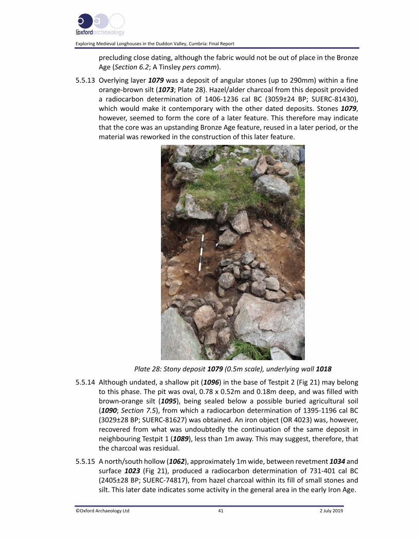
E
Exploring Medieval Longhouses in the Duddon Valley, Cumbria: Final Report
©Oxford Archaeology Ltd 41 2 July 2019
precluding close dating, although the fabric would not be out of place in the Bronze Age (Section 6.2; A Tinsley pers comm).
5.5.13 Overlying layer 1079 was a deposit of angular stones (up to 290mm) within a fine orange‐brown silt (1073; Plate 28). Hazel/alder charcoal from this deposit provided a radiocarbon determination of 1406‐1236 cal BC (3059±24 BP; SUERC‐81430), which would make it contemporary with the other dated deposits. Stones 1079, however, seemed to form the core of a later feature. This therefore may indicate that the core was an upstanding Bronze Age feature, reused in a later period, or the material was reworked in the construction of this later feature.
Plate 28: Stony deposit 1079 (0.5m scale), underlying wall 1018
5.5.14 Although undated, a shallow pit (1096) in the base of Testpit 2 (Fig 21) may belong to this phase. The pit was oval, 0.78 x 0.52m and 0.18m deep, and was filled with brown‐orange silt (1095), being sealed below a possible buried agricultural soil (1090; Section 7.5), from which a radiocarbon determination of 1395‐1196 cal BC (3029±28 BP; SUERC‐81627) was obtained. An iron object (OR 4023) was, however, recovered from what was undoubtedly the continuation of the same deposit in neighbouring Testpit 1 (1089), less than 1m away. This may suggest, therefore, that the charcoal was residual.
5.5.15 A north/south hollow (1062), approximately 1m wide, between revetment 1034 and surface 1023 (Fig 21), produced a radiocarbon determination of 731‐401 cal BC (2405±28 BP; SUERC‐74817), from hazel charcoal within its fill of small stones and silt. This later date indicates some activity in the general area in the early Iron Age.
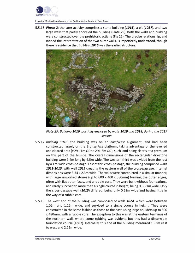
Exploring Medieval Longhouses in the Duddon Valley, Cumbria: Final Report
©Oxford Archaeology Ltd 42 2 July 2019
5.5.16 Phase 2: the later activity comprises a stone building (1016), a pit (1087), and two large walls that partly encircled the building (Plate 29). Both the walls and building were constructed over the prehistoric activity (Fig 22). The precise relationship, and indeed the interpretation of the two outer walls, is imperfectly understood, though there is evidence that Building 1016 was the earlier structure.
Plate 29: Building 1016, partially enclosed by walls 1019 and 1018, during the 2017 season
5.5.17 Building 1016: the building was on an east/west alignment, and had been constructed largely on the Bronze Age platform, taking advantage of the levelled and cleared area (c 291.1m OD to 291.6m OD), such land being clearly at a premium on this part of the hillside. The overall dimensions of the rectangular dry‐stone building were 9.4m long by 4.5m wide. The western third was divided from the rest by a 1m‐wide cross‐passage. East of this cross‐passage, the building comprised walls 1012‐1015, with wall 1015 creating the eastern wall of the cross‐passage. Internal dimensions were 3.34 x 2.3m wide. The walls were constructed in a similar manner, with large unworked stones (up to 600 x 400 x 380mm) forming the outer edges, often with flat outer faces, and a rubble core. They were built without foundations, and rarely survived to more than a single course in height, being 0.86‐1m wide. Only the cross‐passage wall (1015) differed, being only 0.68m wide and having little in the way of a rubble core.
5.5.18 The west end of the building was composed of walls 1024, which were between 1.05m and 1.15m wide, and survived to a single course in height. They were constructed in the same fashion as those to the east, using large boulders up to 800 x 480mm, with a rubble core. The exception to this was at the eastern terminus of the northern wall, where some robbing was evident, but this had a discernible foundation course (1067). Internally, this end of the building measured 1.93m east to west and 2.25m wide.
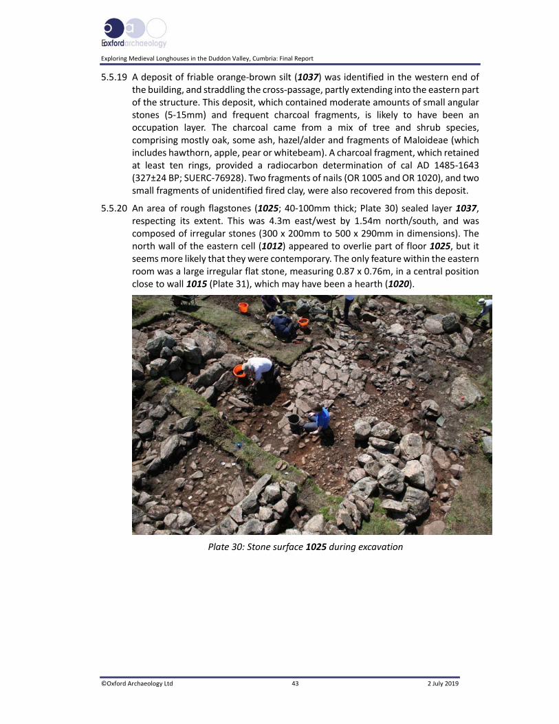
E
Exploring Medieval Longhouses in the Duddon Valley, Cumbria: Final Report
©Oxford Archaeology Ltd 43 2 July 2019
5.5.19 A deposit of friable orange‐brown silt (1037) was identified in the western end of the building, and straddling the cross‐passage, partly extending into the eastern part of the structure. This deposit, which contained moderate amounts of small angular stones (5‐15mm) and frequent charcoal fragments, is likely to have been an occupation layer. The charcoal came from a mix of tree and shrub species, comprising mostly oak, some ash, hazel/alder and fragments of Maloideae (which includes hawthorn, apple, pear or whitebeam). A charcoal fragment, which retained at least ten rings, provided a radiocarbon determination of cal AD 1485‐1643 (327±24 BP; SUERC‐76928). Two fragments of nails (OR 1005 and OR 1020), and two small fragments of unidentified fired clay, were also recovered from this deposit.
5.5.20 An area of rough flagstones (1025; 40‐100mm thick; Plate 30) sealed layer 1037, respecting its extent. This was 4.3m east/west by 1.54m north/south, and was composed of irregular stones (300 x 200mm to 500 x 290mm in dimensions). The north wall of the eastern cell (1012) appeared to overlie part of floor 1025, but it seems more likely that they were contemporary. The only feature within the eastern room was a large irregular flat stone, measuring 0.87 x 0.76m, in a central position close to wall 1015 (Plate 31), which may have been a hearth (1020).
Plate 30: Stone surface 1025 during excavation
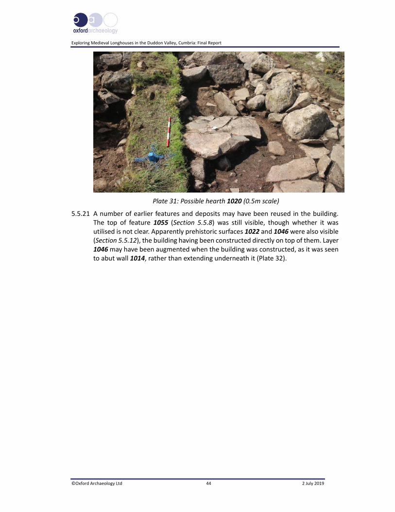
Exploring Medieval Longhouses in the Duddon Valley, Cumbria: Final Report
©Oxford Archaeology Ltd 44 2 July 2019
Plate 31: Possible hearth 1020 (0.5m scale)
5.5.21 A number of earlier features and deposits may have been reused in the building. The top of feature 1055 (Section 5.5.8) was still visible, though whether it was utilised is not clear. Apparently prehistoric surfaces 1022 and 1046 were also visible (Section 5.5.12), the building having been constructed directly on top of them. Layer 1046 may have been augmented when the building was constructed, as it was seen to abut wall 1014, rather than extending underneath it (Plate 32).

E
Exploring Medieval Longhouses in the Duddon Valley, Cumbria: Final Report
©Oxford Archaeology Ltd 45 2 July 2019
Plate 32: Layer 1046, butting against wall 1014 (left), yet continuing below 1018 (right)
5.5.22 Both the pre‐excavation survey and the excavated plan of the house demonstrate a significant difference in the structural form of the western and eastern cells (Plate 29). The western cell has very ill‐defined and insubstantial walls comprising only a single course, and only part of the western gable has any distinct dry‐stone structure. By contrast, the eastern cell was well‐built, with faced masonry and in places infilled core. The western wall of this cell has a similarly well‐built form even though this was potentially only a partition wall. This wall coincides with the terminals of external ‘pound’ walls 2018 and 2019 (Sections 5.5.27‐32), and mark what is considered to be the cross‐passage. While in part the different characters of the west and east cells may reflect the cross‐passage and subsequent erosion along this line, this very marked difference suggests that this is not simply a feature of differential wear, but that the walls of the eastern cell have been rebuilt and consolidated, whereas those of the western cell have not. The eastern walls have apparently been rebuilt on the foundations of the earlier walls. As such, the enhancement and rebuilding of the eastern cell reflects a second phase of construction, and may indicate also a change of function, perhaps from a domestic structure to one solely involving the corralling of stock.

Exploring Medieval Longhouses in the Duddon Valley, Cumbria: Final Report
©Oxford Archaeology Ltd 46 2 July 2019
5.5.23 Pit 1087 had been dug against a large earthfast boulder, immediately beyond the north‐west corner of the building, and cut deposits producing both Bronze Age and Iron Age radiocarbon dates (Section 5.5.11). It was sub‐circular in shape, 0.9m across and 0.28m deep, and tapered toward the base. The lower fill (1086; Fig 20) was composed of dark brown‐grey sandy silt containing Maloideae charcoal, from which a radiocarbon determination of cal AD 1415‐1451 was returned (470±24 BP; SUERC‐81431). The upper fill (1085) contained a similar deposit, and there was a possible kerb of pitched stones marking its outer northern edge (Plate 33).
Plate 33: Pit 1087, with a kerb of pitched stone (0.4m scale)
5.5.24 Extending north, south and east of Building 1016 was a series of stone surfaces, not that dissimilar to the underlying prehistoric surfaces (Section 5.5.7). Surfaces 1043 and 1044/1070, along with 1071, 1075 and 1076, extended some 8m south of Building 1016, overlying the earlier deposits (Plate 34). Surface 1075 was composed of slightly larger stones than the others and appeared to overlie 1071 and 1076. Three iron nails were recovered from surface 1071 (OR 4002, OR 4004‐5).
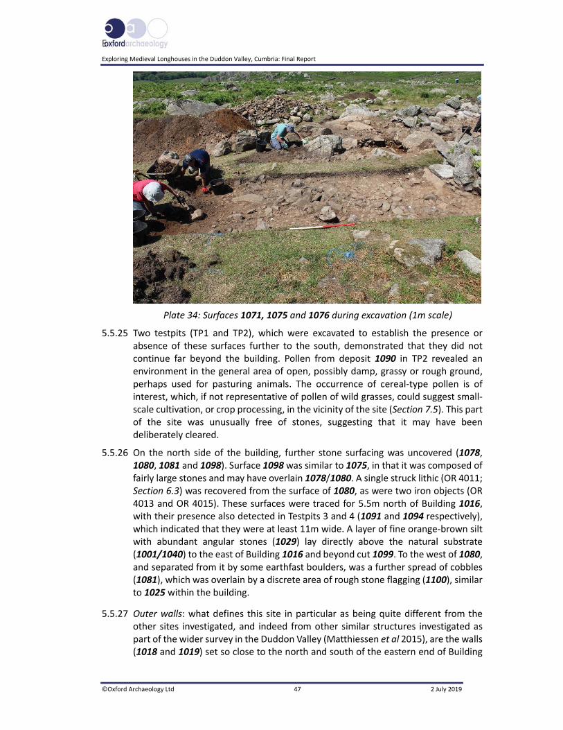
E
Exploring Medieval Longhouses in the Duddon Valley, Cumbria: Final Report
©Oxford Archaeology Ltd 47 2 July 2019
Plate 34: Surfaces 1071, 1075 and 1076 during excavation (1m scale)
5.5.25 Two testpits (TP1 and TP2), which were excavated to establish the presence or absence of these surfaces further to the south, demonstrated that they did not continue far beyond the building. Pollen from deposit 1090 in TP2 revealed an environment in the general area of open, possibly damp, grassy or rough ground, perhaps used for pasturing animals. The occurrence of cereal‐type pollen is of interest, which, if not representative of pollen of wild grasses, could suggest small‐scale cultivation, or crop processing, in the vicinity of the site (Section 7.5). This part of the site was unusually free of stones, suggesting that it may have been deliberately cleared.
5.5.26 On the north side of the building, further stone surfacing was uncovered (1078, 1080, 1081 and 1098). Surface 1098 was similar to 1075, in that it was composed of fairly large stones and may have overlain 1078/1080. A single struck lithic (OR 4011; Section 6.3) was recovered from the surface of 1080, as were two iron objects (OR 4013 and OR 4015). These surfaces were traced for 5.5m north of Building 1016, with their presence also detected in Testpits 3 and 4 (1091 and 1094 respectively), which indicated that they were at least 11m wide. A layer of fine orange‐brown silt with abundant angular stones (1029) lay directly above the natural substrate (1001/1040) to the east of Building 1016 and beyond cut 1099. To the west of 1080, and separated from it by some earthfast boulders, was a further spread of cobbles (1081), which was overlain by a discrete area of rough stone flagging (1100), similar to 1025 within the building.
5.5.27 Outer walls: what defines this site in particular as being quite different from the other sites investigated, and indeed from other similar structures investigated as part of the wider survey in the Duddon Valley (Matthiessen et al 2015), are the walls (1018 and 1019) set so close to the north and south of the eastern end of Building

Exploring Medieval Longhouses in the Duddon Valley, Cumbria: Final Report
©Oxford Archaeology Ltd 48 2 July 2019
1016. These walls were 11.5m and 12m long respectively, 1.5‐1.8m wide, up to 0.4m high, and were 5m apart, narrowing to 4.5m at the eastern end. Wall 1041, which seemed to be a continuation of enclosure wall 1072 (Section 3.5.4), formed the eastern end of this ‘structure’.
5.5.28 The western ends of both walls were composed of a core of angular stones within orange‐brown silt, with occasional charcoal flecks, with large boulders above. On the south side this had been built partially above Phase 1 deposit 1079 and an earthfast boulder, whilst to the north, surface 1046 had been utilised. A sherd of probably medieval unglazed pottery (OR 4007) was retrieved from this northern area.
5.5.29 The difference in construction techniques used in both walls suggests that they were built at different times, and, indeed, the topographical survey suggests this (Section 3.5.5). In particular, large stones seem to have been added to wall 1018, and may indicate that this had been rebuilt and enhanced on the line of an earlier field wall, represented by wall 1072; indeed, there are similarities between this section and other rebuilt enclosure walls. Wall 1019 had been constructed with outer faces of large unworked stones (with a maximum size of 610 x 300mm), with a rubble core. This directly sealed surfaces 1078, 1098, and 1029.
5.5.30 Two other sherds of pottery were recovered from the site. A base fragment (OR 1017) came from a layer of silt and stones (1033) overlying the natural geology west of the Building 1016, and a rim fragment (OR 1018) was found in the topsoil (1000). Both were in a late medieval to early post‐medieval fabric (Section 6.4.1).
5.5.31 Walls 1018 and 1041 were broadly of similar construction, although wall 1041 seemed to have been built of smaller stones (Plate 35), and may represent yet another episode of construction, albeit still post‐dating wall 1072, which was composed of large boulders, and constructed directly onto the underlying natural geology, but was very decayed and partly collapsed; it was over 2m wide in places, although this was at least partly due to its collapse. This wall was clearly earlier than both 1019 and 1041. Boundary wall 1042, extending south from wall 1018, was again built of boulders and appeared to be later than 1018, seemingly built up against it, although the relationship is complex and there is evidence of blocking at this point (Plate 36).

E
Exploring Medieval Longhouses in the Duddon Valley, Cumbria: Final Report
©Oxford Archaeology Ltd 49 2 July 2019
Plate 35: Wall 1041, at the junction with Wall 1072
Plate 36: The possible blocked entrance in field wall 1042
5.5.32 The excavation evidence seems to reinforce the survey evidence that wall 1041, and possibly 1018, were enhanced and rebuilt sections of former field wall, of which 1072 was an undisturbed section. Wall 1019 also seemingly post‐dated wall 1072. Given that there is no direct relationship between 1018 and 1019, and that they had very different construction techniques, it is possible to suggest that they were not contemporary, but it is not possible to demonstrate stratigraphically which was the earlier.

Exploring Medieval Longhouses in the Duddon Valley, Cumbria: Final Report
©Oxford Archaeology Ltd 50 2 July 2019
6 FINDS
6.1 Quantification
6.1.1 Some 44 objects were recovered during the course of the excavations, just under half of which came from stratified contexts (20 objects); 24 objects were recovered from the topsoil (1000: seven objects) or were unstratified (1500/US: 17 objects). The bulk of the finds were iron objects, whilst there were also ceramic fragments and unidentified lead objects (see Table 1). The material from Tongue House A was all clearly intrusive, being entirely modern.
Site Code OR number Context Quantity Material Identification
THA16 1003 3000 1 Bone Animal
THA16 1004 U/S 1 Silver Pocket watch
THA16 1005 U/S 1 Glass Window
THA16 9001 1002 1 Plastic Pigeon ring
THA16 9002 1000 1 Iron Horseshoe
THA16 9003 1001 1 Iron Horseshoe
LHC17 1001 1500 1 Lead Unidentified object
LHC17 1002 1500 1 Iron Nail shank
LHC17 1003 1000 1 Lead Unidentified object
LHC17 1004 1000 1 Iron Nail or ring fragment
LHC17 1005 1037 2 Iron Nail shank
LHC17 1006 1000 1 Iron Nail head
LHC17 1007 1049 1 Iron Object forming an eye
LHC17 1008 1059 1 Iron Nail head and shank
LHC17 1009 1001 1 Iron Horseshoe (pony)
LHC17 1010 1500 1 Iron Nail or pin
LHC17 1011 1000 1 Iron Horseshoe (pony)
LHC17 1012 1000 2 Iron Horseshoe (pony)
LHC17 1013 1001 4 Iron Horseshoe
LHC17 1014 1500 1 Iron Tool: file or chisel
LHC17 1015 1500 1 Iron Nail?
LHC17 1016 1500 1 Iron Horseshoe?
LHC17 1017 1033 1 Ceramic Silverdale‐type pottery
LHC17 1018 1000 1 Ceramic Silverdale‐type pottery
LHC17 1019 1045 1 Ceramic ?Bronze Age pottery
LHC17 1020 1037 1 Iron Nail shank or ring fragment
LHC17 1021 1037 1 Ceramic Crumbs
LHC17 1022 1037 3 Ceramic Unidentified fired clay
LHC17 4000 1069 1 Iron Knife
LHC17 4001 1069 1 Iron Horseshoe
LHC17 4002 1071 1 Iron Nail
LHC17 4004 1071 1 Iron Nail
LHC17 4005 1071 1 Iron Nail
LHC17 4006 1500 1 Iron Nail head
LHC17 4007 1074 1 Ceramic Medieval body sherd, unglazed
LHC17 4008 1073 1 Iron Tool, possibly narrow chisel
LHC17 4009 1075 1 Iron Tool
LHC17 4010 1500 1 Iron Possible tool
LHC17 4011 1080 1 Stone Struck lithic
LHC17 4012 1079 1 Ceramic ?Bronze Age pottery
LHC17 4013 1080 1 Iron Horseshoe nail

E
Exploring Medieval Longhouses in the Duddon Valley, Cumbria: Final Report
©Oxford Archaeology Ltd 51 2 July 2019
Site Code OR number Context Quantity Material Identification
LHC17 4014 1078 1 Iron Possible horseshoe nail
LHC17 4015 1080 1 Iron Possible tool
LHC17 4016 1500 1 Iron Horseshoe
LHC17 4017 U/S 1 Iron Object
LHC17 4018 U/S 1 Iron Nail
LHC17 4019 1500 1 Iron Unidentified object
LHC17 4020 1500 1 Iron Nail fragment
LHC17 4021 1500 1 Iron Nail head
LHC17 4022 1500 1 Iron Ring fragment
LHC17 4023 1089 1 Iron Possibly tool
LHC17 4024 1500 1 Iron Nail head
Table 1: Finds catalogue
6.2 Prehistoric Ceramics
6.2.1 In total, three ceramic sherds, and an assortment of small crumbs, were recovered by the excavation at Long House Close. While there are very few diagnostic features within the assemblage, the character of the material suggests they probably represent up to two prehistoric vessels. The majority of the excavation focused upon activity associated with the later structure, but this assemblage would seem to fit with tantalising traces of prehistoric activity at the site, radiocarbon assay indicating this to be Late Bronze Age in origin (Appendix 6). The pottery, while not totally secure in its typology, may well therefore add to a very rare body of evidence for this period within the Lake District.
6.2.2 Methodology: all the material was set out by context and the quantity and weight of individual sherds were recorded, with diagnostic features such as rim and body form, decorative treatment, fabric type, colour and wall thickness also noted. A sherd is classified as an individual ceramic fragment with a diameter above 10mm. Material of smaller dimensions was classified as crumbs, which, due to their restricted size, were held to be of little interpretative value and consequently were collectively recorded by weight only. Examination of material to determine fabric groups was carried out using a hand‐held x10 magnifying glass, with details relating to the type, frequency and character of any deliberately included temper agents, as well as the general colour and consistency of paste, recorded and used to formulate relevant fabric types and codes. On the basis of variation in diagnostic features, sherd material was divided according to the minimum number of vessels represented. The material so grouped was then further examined for the occurrence of adjoining sherds in order to check against any potential replication of vessel groupings and to develop a firmer impression of the original vessel form. Discussion of the diagnostic features, their typological affinities, and the justification for any groupings are ordered according to criteria established in guidelines for the production of ceramic reports issued by the Prehistoric Ceramic Research Group (PCRG 2011; 2016).
6.2.3 Quantification: in total, three sherds and a selection of crumbs, collectively weighing 39.28g, were recovered from three different contexts (see Table 2). The majority of this material, including a single large body sherd, two smaller body sherds, and a collection of crumbs, derive from two contexts, but based upon similarities in fabric and colour may be from the same or a similar vessel. All such material appears poorly

Exploring Medieval Longhouses in the Duddon Valley, Cumbria: Final Report
©Oxford Archaeology Ltd 52 2 July 2019
fired and highly friable, with moderate to high degrees of abrasion, showing few clean edge surfaces. Three small crumbs derive from a separate context (1037; Section 5.5.19) and, while perhaps too small to allow firm conclusions, based upon colour and fabric, appear slightly different in character. This may indicate that the three crumbs derive from a different vessel than the larger body of material.
Context Sherd Count
Weight (g)
Sherd Size (mm)
Form Decoration Fabric
1045 1
OR 1019
1.22 10mm diameter 5mm thick
Body None Light grey‐brown external surface, darker grey internal surface and core, poorly fired, friable; common angular igneous rock inclusions (10%) or more, poorly sorted, 1‐4mm in size
1079 2 sherds and
crumbs
OR 4012
37.58 >50mm diameter >15mm thick
Body None As above
1037 3 crumbs
OR 1022
0.48 Less than 10mm
diameter
Uncertain None Medium orange surface and dark grey core, no
visible inclusions
Total 3 sherds and
crumbs
39.28g N/A N/A N/A N/A
Table 2. Summary of the potential prehistoric pottery by context
6.2.4 Form: all material appears to represent fragments deriving from the body of the parental vessel, although the majority are too small and degraded to be certain. The single large body sherd appears to derive from a relatively thick‐walled vessel, but is equally lacking in clear diagnostic features indicative of the wider vessel form. No clear idea of the form of the vessels can therefore be discerned, and, consequently, no clear typological assignation can be made.
6.2.5 Fabric: with the exception of the three small crumbs deriving from layer 1037 (Section 5.5.19), the assemblage appears to be executed in a poorly fired and friable fabric, predominantly grey in colour, with slight variation from core to surface. This seems to have been tempered with the commonly used crushed igneous stone, probably deriving from local bedrock sources, with individual elements visible in cross‐section, but also protruding prominently from internal and external surfaces. The use of crushed igneous stone as a temper is known locally throughout most periods, from the early prehistoric (Neolithic and Bronze Age, eg Vyner 2017; Young 2017) into the medieval period, where it can feature as a component of local ‘Gritty Wares’ (McCarthy and Brooks 1988; 1992; Bradley and Miller 2009). However, later use of such fabrics unsurprisingly tends to be better refined, formed, and fired than this rather crude and ill‐fired material suggests, and it is perhaps with earlier prehistoric wares that the material may more readily be aligned, probably with an origin in the Bronze Age.

E
Exploring Medieval Longhouses in the Duddon Valley, Cumbria: Final Report
©Oxford Archaeology Ltd 53 2 July 2019
6.2.6 Decoration: none of the sherds demonstrate any sign of decorative or surface treatment of any kind. Again, the lack of slips, or even cursory refinement, may align with an earlier, prehistoric, origin, rather than a medieval assignation.
6.2.7 Conclusions: the assemblage is small and very limited in terms of diagnostic traits, but appears to indicate the presence of two possible vessels, defined by variation in fabric type alone. While the near‐total absence of diagnostic traits within this assemblage does not allow a definitive statement of the typological affinities of the group, the poor and relatively crude nature of the pottery, with prominent, ill‐sorted individual elements of the igneous temper protruding from the surface of consitituent sherds, would suggest a prehistoric origin, most likely during the Bronze Age. If this is the case, the material is significant, given the relative scarcity of prehistoric ceramics overall, but that most derive from a funerary context, which these do not (Hodgson and Brennand 2006).
6.3 Lithics
6.3.1 A single struck flint (OR 4011) was recovered from layer 1080, overlying the stone‐built platform at Long House Close, which seems to be of Bronze Age date (Section 5.5.3). It comprises a complete flake, 26.2 x 19.7 x 4.7mm, removed from the parent nodule during the later stage of the reduction process. The proximal end is characterised by a very thin platform and a flat bulb of percussion, whilst the distal end has a feathered termination. The platform is also crushed, which suggests that the flake was detached using a bipolar reduction strategy. The raw material is a fine‐grained flint, with linear black inclusions and small pale brown spots, which has patinated to a dark brown colour. A similar raw material type has been recorded from excavated contexts in the north of Cumbria and is known to have originated from the Flamborough Head area of East Yorkshire (Brown et al in prep). The artefact has some significance, as it represents a very rare find of worked flint from an excavated context within the Lake District National Park.
6.4 Medieval/Post‐medieval Material
6.4.1 Medieval pottery: three sherds of late medieval Silverdale‐type ware (White 2000) were recovered from Long House Close, a rim sherd from the topsoil (1000; OR 1018), a base fragment from deposit 1033 (OR 1017; Plate 37), to the north‐west of Building 1016 (Section 5.5.29), and an unglazed fragment from the core (1074) of wall 1019 (Section 5.5.28). The simple upright rim probably belongs to a jug, similar vessels having been identified from Silverdale itself (White 2000) and from Kendal (Whitehead et al 2013). Conceivably, the base fragment may derive from the same vessel. Fragments of the same type of pottery were also recovered from Stephenson’s Ground nearby (DVLHG 2009, 83). This pottery is part of a much broader grouping known as Late Medieval Reduced Grey ware, which had broad currency stretching from North Lancashire to Cumbria, and northern England in general. It is generally thought to have begun production in the mid‐fourteenth century and continued to be made into the seventeenth century (White 2000; McCarthy and Brooks 1992, 29). A radiocarbon determination of cal AD 1485‐1643 from Building 1016 suggests that the pottery was likely to be contemporary.

Exploring Medieval Longhouses in the Duddon Valley, Cumbria: Final Report
©Oxford Archaeology Ltd 54 2 July 2019
Plate 37: Silverdale ware from deposit 1033
6.4.2 Iron: iron objects were the most numerous, the corpus of ferrous material mainly comprising horse‐ or pony shoes, nails, fragments of tools, a ring and eye fragment, as well as a small number of unidentified objects (three). The majority of the nine horse‐ and pony shoes were recovered either from topsoil 1000 or subsoil 1001 at Long House Close. Assessment suggests they are of Clark’s late medieval Type 4 (Clark 2004, 88‐90), which correlates with Sparkes’ Guildhall‐or Dove‐type shoes (Sparkes 1976, 11‐15), dating to the later fourteenth and fifteenth centuries (Clark 2004, 92, fig 74). Sixteen nail fragments were identified, some of which were almost certainly from horse‐ or pony shoes, at least four coming from demolition deposits (OR 1002, OR 1004, OR 1008 and OR 1010). A nail fragment from deposit 1059 (associated with structure 1052; Section 5.5.8), may well have been intrusive, as other evidence suggests this may have been a prehistoric feature. Rather, it may have been related to the continuation of wall 1012, which was built on top of 1052. A possible blade fragment was recovered from layer 1069 (Building 1016). In addition, there were two unidentified fragments of lead.

E
Exploring Medieval Longhouses in the Duddon Valley, Cumbria: Final Report
©Oxford Archaeology Ltd 55 2 July 2019
7 THE PALAEOENVIRONMENTAL PROGRAMME
7.1 Introduction
7.1.1 The palaeoenvironmental assessment initially comprised, in 2016, prior to the commencement of the excavations, a reconnaissance survey of boggy areas adjacent to the three sites (Fig 23), with the objective of establishing the presence, or otherwise, of organic‐rich sediments. This had the intention of extracting a continuous sequence from the modern surface to a depth of 1.15m. Subsequently, a monolith was taken from Testpit 2 at Long House Close (Section 7.4), and bulk samples were collected from all three sites, primarily to provide material for radiocarbon assay.
7.2 Reconnaissance Survey
7.2.1 A reconnaissance survey, using a gouge auger, was undertaken of boggy areas adjacent to the three sites (Plate 38). The objective was to establish the presence, or otherwise, of organic‐rich sediments adjacent to the structures and, if possible, to collect samples for palaeobotanical assessment. It was hoped that this work might shed light on the local environment at the time of occupation of the sites. Following this survey, two of the sites (Palaeo‐Sites 2 and 3) were selected for sample collection using a Russian corer.
Plate 38: Coring with a gouge auger near Tongue House B
7.2.2 The gouge auger survey demonstrated that boggy areas do indeed exist adjacent to the excavation sites, but that, in many cases, these are filled with potentially recent Sphagnum growth. Two transect lines, each with five cores, were arranged in a cross

Exploring Medieval Longhouses in the Duddon Valley, Cumbria: Final Report
©Oxford Archaeology Ltd 56 2 July 2019
configuration through Palaeo‐Site 2, to the south of Tongue House A (Fig 23). At Palaeo‐Site 3, to the west of Tongue‐House B, two parallel transects were taken, comprising five cores. In addition, an area to the south‐west of Long House Close (Palaeo‐Site 1) was explored, where approximately 0.50m of fresh, mossy organics proved to have accumulated above the bedrock, so no formal transects were established. At Palaeo‐Site 2, Tongue House A, peat was present to a maximum depth of 1.70m, and at Palaeo‐Site 3, to a maximum depth of 1.15m.
7.2.3 Although gouge augering identified the upper, wet, moss‐rich deposits at each of the sites, it was not able to sample these. Augering was, therefore, undertaken using a Russian corer, to recover the humified peat deposits from Palaeo‐Sites 2 and 3. Samples from the midpoint of the transect at Palaeo‐Site 2 (Core P3), at 0.85‐1.35m (as well as a duplicate core from 0.80‐1.30m), were collected. Gouge augering had revealed the presence of small wood chips at Core P1, so a further Russian sample was taken from there to collect peat at 0.50‐1.00m; above this, only very wet, fibrous material, that slid off the auger blade, was encountered.
7.2.4 At Palaeo‐Site 3, west of Tongue House B, it proved possible to use the Russian corer to collect a continuous sequence from the middle of the transect, of a depth of 0‐1.15m from the ground surface. This core sample was selected for pollen assessment, along with two sub‐samples from the deeper peat at Tongue House A.
7.2.5 Previous Work: previous environmental analysis in the Duddon Valley includes the creation of a pollen diagram from cores collected from Seathwaite Tarn (Pennington 1964). This material was originally undated but, subsequently, the level at which a permanent change in the forest composition occurred was identified, and was dated to 1663‐937 cal BC (3080±140 BP; NPL‐124), in the middle to late Bronze Age (Pennington 1970). More recent research in the Cumbrian uplands includes pollen data from Tewit Moss and the Devoke Water cairn (Quartermaine and Leech 2012, 199‐204) and, from the lowlands, the Duddon Mosses (Wimble et al 2000).
7.2.6 Most relevant to the present study, however, is work from both beneath and above several ring cairns, close to Seathwaite Tarn, as part of the Ring Cairns to Reservoirs project (OA North 2010). These Bronze Age features had become blanketed by a layer of very amorphous peat, the base of which was dated in two places; both dates indicated that the peat had accumulated in the fifth and sixth centuries AD (cal AD 550‐650 (1465±30 BP; Poz‐24072) and cal AD 430‐600 (1535±30 BP; Poz‐24071)). Subsequently, a peat sequence was collected from a boggy area close to the ring cairns, and peat below a depth of approximately 1m from the ground surface was shown to be of Mesolithic age, although above a depth of 1.04m, the character of the peat changed from a very dark brown sedge/herbaceous peat to a more fibrous peat. This was reflected by an abrupt change in the pollen record, where an assemblage dominated by tree pollen with some herb taxa was replaced by an assemblage of grasses, herbs and heather, suggesting that there was an hiatus in the accumulation of peat within the basin (ibid). The top of the peat was dated at 0.70‐0.71m from the ground surface to AD 1650‐1960 (185±30 BP; Poz‐23166). Cereal‐type pollen was recorded in sub‐samples beneath as well as above this dated horizon (ibid), suggesting that arable cultivation may have taken place in the area prior to AD 1650‐1960. Nearby, pollen data from the Devoke Water cairn suggest

E
Exploring Medieval Longhouses in the Duddon Valley, Cumbria: Final Report
©Oxford Archaeology Ltd 57 2 July 2019
that, from the early medieval period onwards, the landscape remained largely cleared and was used for upland grazing. There is some evidence for arable farming, and radiocarbon dating suggests that locally this may have been practised for at least part of the second half of the first millennium AD (Quartermaine and Leech 2012).
7.2.7 Results: rich pollen assemblages were obtained from six of the sub‐samples assessed from Core P3 at Palaeo‐Site 3 (Appendix 7), though two levels produced less rich assemblages; preservation of pollen was generally good to mixed. The assessment seems to indicate that two clear pollen zones are present within the sedimentary sequence: an older one dominated by arboreal pollen; and a younger one comprising mostly pollen of sedges and grasses. These are separated by pollen showing a gradual transition from the older to the younger.
7.2.8 The older zone, recorded from the deepest sub‐sample at 1.32‐0.80m, comprises tree pollen, which contributes approximately 70‐80% of that recorded. Taxa such as birch (Betula), alder (Alnus), oak (Quercus), hazel‐type (Corylus avellana‐type) and heather (Calluna) are present, with fewer and sporadic counts for holly (Ilex), pine (Pinus), elm (Ulmus) and crowberry (Empetrum). The herb pollen is dominated by grasses (Poaceae), which, at 0.80m, account for approximately 20% of the pollen counted; other herbs recorded include ribwort plantain (Plantago lanceolata), pollen of the carrot family (Apiaceae, a large group containing plants such as pennyworts, water‐dropworts and hedge‐parsleys), cinquefoils (Potentilla‐type), devil's bit scabious (Succisa pratensis), docks/sorrels (Rumex spp), dandelion‐type (Taraxacum‐type) and buttercup‐type (Ranunculaceae). Fern spores were commonly recorded, with the exception of the sub‐sample at 1.00m, and include monolete fern spores (Pteropsida), polypodies (Polypodium), and fewer counts for bracken (Pteridium aquilinum). The recovery of non‐pollen palynomorphs (NPP) was variable but there were occurrences of Glomus (HdV‐207), Sordaria (HdV‐55A/B) and, at 0.80m, Gelasinospora (HdV‐1). The record for microcharcoal is also variable, with generally small numbers of microcharcoal particles present but with an apparent peak at 1.00m.
7.2.9 Two sub‐samples, at 0.72m and 0.64m, show a gradual change in composition, with pollen at 0.72m comprising approximately 30% tree pollen, while that at 0.64m recorded 23% tree pollen. The pollen count at 0.64m was less than 100 grains, as recovery was poorer than from the other sub‐samples.
7.2.10 In the three upper sub‐samples, the pollen and associated amorphous plant matter appeared much fresher than in the lower sub‐samples. The pollen zones are also strikingly different in composition. Arboreal pollen is reduced to less than 15% of the pollen counted, mostly grasses dominating the herb component. Other herb taxa recorded include sedges (Cyperaceae), ribwort plantain, docks/sorrels and cinquefoils. There are also occurrences of common knapweed (Centaurea nigra), milkwort (Polygala) and pollen of the cabbage family (Brassicaceae, another large group including plants such as garlic, mustard, winter‐cresses and shepherd's‐purses). Sphagnum‐moss spores were recorded in relative abundance at 0.60m and 0.40m, and spores of the club‐mosses (Selaginella) are also present. Spores of bracken are present in abundance, especially at 0.60m. Fungal spores are present in

Exploring Medieval Longhouses in the Duddon Valley, Cumbria: Final Report
©Oxford Archaeology Ltd 58 2 July 2019
small numbers but, at 0.24m, an abundance of cf Byssothecium circinans (HdV‐16C) was recorded. Small quantities of microcharcoal particles were recorded in the upper two sub‐samples. Diatom frustules are present within all three sub‐samples but are particularly abundant at 0.60m.
7.2.11 Interpretation: the pollen in the deeper sub‐samples (1.32–0.80m) suggest possible mixed woodland environments, potentially with small cleared areas. The pollen in the sub‐sample at 0.80m may be indicative of a decline in tree pollen and a greater degree of openness, as shown by increases in the pollen of grasses and other herbs. Sub‐samples at 0.72m and 0.64m show a continued gradual decline in tree pollen, and an increase in herbs, mostly grasses and sedges. The three upper sub‐samples appear to show a predominantly open environment, dominated by grasses, mosses and bracken.
7.2.12 The data also suggest a possible break in the palaeovegetational sequence, possibly above 0.80m. Correlation with the pollen diagram from the Seathwaite ring cairns suggests this could have happened at any time post‐dating the late Mesolithic period (OA North 2010), such a break or hiatus perhaps resulting from peat being cut away and used for fuel. The radiocarbon dates obtained at 0.71‐0.72m (Table 3) suggest that peat began to regrow at this site during the late medieval or early post‐medieval period, and it is tempting to speculate that peat was potentially used for fuel by people living in the area and that, after the sites had been abandoned, peat growth recommenced.
Depth (m)
Lithology Fraction Date,
cal AD
Date BP δ13C value ‰
Age SUERC GU‐lab code
0.71‐0.72 peat Humin 1450‐1635 362±30 ‐27.8 late medieval to early post post‐medieval
70704 42482
0.71‐0.72 peat Humic 1419‐1615 433±30 ‐28.6 late medieval to early post‐medieval
70703 42481
Table 3: Radiocarbon dates from Palaeo‐Site 3 (Tongue House B)
7.3 Archaeobotanical Assessment
7.3.1 Quantification and Methodology: bulk samples taken during all three seasons of excavations were processed and assessed for plant remains and charcoal, and any small artefacts and other cultural material were recovered. In total, 34 bulk samples, ranging from 10 litres to 50 litres in volume, were selected for assessment. The samples were processed using hand flotation, where the flots were collected on a 250µm mesh and air‐dried. Heavy residues greater than 0.3mm were checked for artefacts and ecofacts, which were extracted and quantified, the latter being kept and assessed with the rest of the flot. The dried flot was examined using a binocular microscope, during which any surviving organic material, such as charred plant remains, waterlogged plant remains, and charcoal, was quantified. Other remains, such as snails, insects, bone, fired clay, coal, and heat‐affected vesicular material, was also quantified. Preliminary seed/fruit identifications were made with the aid

E
Exploring Medieval Longhouses in the Duddon Valley, Cumbria: Final Report
©Oxford Archaeology Ltd 59 2 July 2019
of standard texts (eg Cappers et al 2006; Stace 2010) and a reference collection. Plant nomenclature follows Stace (2010). The presence of modern contaminants, such as roots, insect eggs and modern seeds, was also noted as an aid to assessing the likelihood of any contamination. Material was quantified on a scale of 1 to 4, where 1 is rare (one to five items); 2 is frequent (six to 50 items); 3 is common (51–100 items); and 4 is abundant (greater than 100 items).
7.3.2 Charcoal identification was carried out using a binocular microscope at up to x40 magnification, to record the presence of any small roundwood, and to determine whether either diffuse porous (generally short‐lived) or ring porous (generally long‐lived) wood taxa was included. Due to anatomical similarities, charcoal identified as hawthorn‐type (Maloideae) may include hawthorn, apple, pear or whitebeam. Similarly, alder (Alnus glutinosa) and hazel (Corylus avellana) are not generally differentiated during assessment, unless selected for radiocarbon dating. Fragments selected for radiocarbon dating were fractured to reveal transverse, radial and tangential sections, which were examined under a Meiji incident‐light microscope at up to x400 magnification. Identifications were made with reference to Hather (2000), and modern reference material. The assessment results were recorded on a pro‐forma, which will be kept with the site archive.
7.3.3 Preservation of any palaeobotanical remains was through charring. The samples were devoid of plant remains preserved through waterlogging, but all of the samples contained extremely abundant plant debris and probable bracken roots, which, judging by the present conditions at the site, are likely to be modern.
7.3.4 Tongue House A: the samples from Tongue House A came from various features and layers (including cobbled surfaces) underlying and associated with the structure; the contents of a drain (1021/1027), thought to be a soakaway (Section 5.3.11), were also investigated. The samples (Table 4) produced rare charred plant remains, which comprised a few indeterminate charred buds, and a fragment of hazelnut (Corylus avellana) shell from soakaway 1027. Charcoal, dominated by fragments of mature oak (Quercus sp), was better represented, and was particularly abundant in deposit 1039, palaeochannel fill 1043 (Section 5.3.2), and layer 1045, below the structure. It is notable that all of these deposits were associated with features believed to pre‐date the construction of the visible structure. Also of note was the similarity of the charcoal from these and the rest of the samples, including the cobbled layers associated with the structure, and the charcoal‐rich fill from soakaway 1027. Although this does not preclude mature oak wood also being used as fuel during the life of the structure, consideration should be given with regard to its taphonomy.
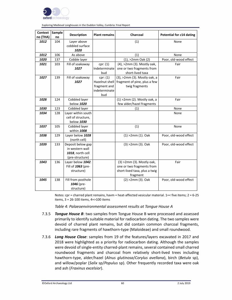
Exploring Medieval Longhouses in the Duddon Valley, Cumbria: Final Report
©Oxford Archaeology Ltd 60 2 July 2019
Context no (THA)
Sample no
Description Plant remains Charcoal Potential for c14 dating
1012 104 Layer above cobbled surface
1020
(1) None
1012 106 As above (1) None
1020 137 Cobble layer (1), >2mm Oak (2) Poor, old‐wood effect
1021 103 Fill of soakaway 1027
cpr: (1) Indeterminate
bud
(4), >2mm (3). Mostly oak, one or two fragments from
short‐lived taxa
Fair
1027 139 Fill of soakaway 1027
cpr: (1) Hazelnut shell fragment and indeterminate
bud
(3), >2mm (3). Mostly oak, a fragment of pine, plus a few
twig fragments
Fair
1028 124 Cobbled layer below 1020
(1) >2mm (2). Mostly oak, a few alder/hazel fragments
Fair
1030 123 Cobbled layer (1) None
1034 128 Layer within south cell of structure, below 1030
None
1037 105 Cobbled layer within 1008
(1) None
1038 129 Layer below 1028 (north cell)
(1) >2mm (1). Oak Poor, old‐wood effect
1039 133 Deposit below gap in western wall 1018, north cell (pre‐structure)
(3) >2mm (3). Oak Poor, old‐wood effect
1043 136 Layer below 1042. Fill of 1063 (pre‐
structure)
(3) >2mm (3). Mostly oak, one or two fragments from short‐lived taxa, plus a twig
fragment
Fair
1045 138 Fill from posthole 1046 (pre‐structure)
(2) >2mm (3). Oak Poor, old‐wood effect
Notes: cpr = charred plant remains, havm = heat‐affected vesicular material. 1=< five items; 2 = 6‐25 items, 3 = 26‐100 items, 4=>100 items
Table 4: Palaeoenvironmental assessment results at Tongue House A
7.3.5 Tongue House B: two samples from Tongue House B were processed and assessed primarily to identify suitable material for radiocarbon dating. The two samples were devoid of charred plant remains, but did contain common charcoal fragments, including rare fragments of hawthorn‐type (Maloideae) and small roundwood.
7.3.6 Long House Close: samples from 19 of the features/layers excavated in 2017 and 2018 were highlighted as a priority for radiocarbon dating. Although the samples were devoid of single‐entity charred‐plant remains, several contained small charred roundwood fragments and charcoal from relatively short‐lived trees including hawthorn‐type, alder/hazel (Alnus glutinosa/Corylus avellana), birch (Betula sp), and willow/poplar (Salix sp/Populus sp). Other frequently recorded taxa were oak and ash (Fraxinus excelsior).

E
Exploring Medieval Longhouses in the Duddon Valley, Cumbria: Final Report
©Oxford Archaeology Ltd 61 2 July 2019
7.4 Radiocarbon Dating
7.4.1 Material from 13 deposits was submitted for dating. One sample, from surface 1053, Long House Close, comprised a fragment of charred hazelnut shell, although the remainder consisted of charcoal fragments. Where possible, this comprised small roundwood and/or short‐lived wood, such as hazel or birch, but a fragment of mature oak was submitted from deposit 1021, the fill of the soakaway at Tongue House A (Section 7.3.11), given that no other material was available during the preliminary assessment. Although it is acknowledged that heartwood from long‐lived trees, such as oak, may have a significant age at death (Bowman 1990), it was thought that even an approximate date for this deposit would be useful. Further processing of deposit 1021, however, produced rare birch fragments, which were also submitted for radiocarbon dating (sample 103 B) in the hope of refining the initial date.
7.4.2 The selected samples were measured using the accelerator mass spectrometry (AMS) technique, which allows small quantities of carbon to be dated. This was undertaken at the Scottish Universities Environmental Research Centre (SUERC). The results (Table 5; Appendix 6) have been calibrated using IntCal13 (Reimer et al 2013), and OxCal v4.3.2 (Bronk Ramsey 2009a, 2017), and the date ranges have been calculated using the maximum intercept method (Stuiver and Reimer 1986).
Site Sample no
Context no
Feature type Material Radiocarbon age BP
δ13C value ‰
Calibrated date (95% probability)
Laboratory code
Tongue House A
103 1021 Fill of soakaway 1027
Charcoal: Quercus sp
1248 ± 33 ‐26.0 cal AD 676‐876
SUERC‐69186
Tongue House A
103 B 1021 Fill of soakaway 1027
Charcoal: Betulasp
1875 ± 33 ‐26.5 cal AD 66‐229
SUERC‐70994
Tongue House A
124 1028 Cobbled layer below 1020
Charcoal roundwood: Alnus glutinosa/Corylus avellana
275 ± 30 ‐26.2 cal AD 1514‐1798
SUERC‐69651
Tongue House B
302 3002 Levelling layer/surface
Charcoal: indeterminate twig fragment
337 ± 24 ‐25.6 cal AD 1476‐1639
SUERC‐81433
Long House Close
511 1059 Fill within possible hearth 1052
Charcoal: Alnus glutinosa
3090 ± 29 ‐26.8 1426‐1278 cal BC
SUERC‐74369
Long House Close
507 1061 Fill of hearth 1060
Charcoal roundwood: Corylus avellana
3035 ± 34 ‐23.8 1406‐1135 cal BC; (1406‐1207; 94.6%)
SUERC‐75307
Long House Close
503 1045 Layer above surface 1044
Charcoal ‐ twig fragment: Quercus sp
3060 ± 21 ‐24.8 1404‐1261 cal BC
SUERC‐76932

Exploring Medieval Longhouses in the Duddon Valley, Cumbria: Final Report
©Oxford Archaeology Ltd 62 2 July 2019
Site Sample no
Context no
Feature type Material Radiocarbon age BP
δ13C value ‰
Calibrated date (95% probability)
Laboratory code
Long House Close
510 1053 Cobbled surface
Charred nut‐shell fragment: Corylus avellana
3012 ± 34 ‐27.0 1339‐1128 cal BC
SUERC‐75308
Long House Close
508 1062 Gully Charcoal: Corylus avellana
2405 ± 28 ‐26.1 731‐401 cal BC
SUERC‐74817
Long House Close
501 1037 Occupation layer
Charcoal roundwood: Maloideae
327 ± 24
‐26.5 cal AD 1485‐1643
SUERC‐76928
Long House Close
551 1073 Beneath wall 1018
Charcoal: Alnus glutinosa/Corylus avellana
3059 ± 24 ‐26.7 1406‐1236 cal BC
SUERC‐81430
Long House Close
559 1086 Fill of pit 1087
Charcoal: Maloideaea
470 ± 24 ‐25.3 cal AD 1415‐1451
SUERC‐81431
Long House Close
561 1093 Deposit butting kerb 1082
Charcoal: Alnus glutinosa/Corylus avellana
3052 ± 24 ‐27.3 1401‐1231 cal BC
SUERC‐81432
Long House Close
563 1090 Layer in Testpit 2
Charcoal: Corylus avellana
3029 ± 28 ‐26.9 1395‐1196 cal BC
SUERC‐81627
Table 5: Radiocarbon dates
7.5 Monolith sample 556 from Testpit 2, Long House Close
7.5.1 Introduction: a monolith sample was collected from Testpit 2, dug a little to the south of the main excavation site (Fig 19). The sample was of a buried soil, preserved beneath turf (Section 5.5.24).
7.5.2 Methodology: the sediments in the monolith were cleaned and described prior to sub‐sampling for pollen (Table 5). Four sub‐samples were prepared by Palaeolab Ltd using a standard chemical procedure (method B of Berglund and Ralska‐Jasiewiczowa 1986), using HCI, NaOH, sieving and Erdtman’s acetolysis, to remove carbonates, humic acids, particles greater than 170μm, and cellulose, respectively. The samples were then stained with safranin, dehydrated in tertiary butyl alcohol, and the residues mounted in 2000cs silicone oil. Slides were examined at a magnification of x400 by ten equally spaced traverses across two slides, to reduce the possible effects of differential dispersal on the slides (Brooks and Thomas 1967) or until at least 100 land pollen grains and spores were counted. Pollen identification was made following the keys of Moore et al (1991), Faegri and Iversen (1989), and a small modern reference collection. Plant nomenclature follows Stace (2010). Non‐pollen palynomorph (NPP) nomenclature follows van Geel (1978). The preservation of the pollen was recorded, and an assessment was made of the potential for analysis.
E
Exploring Medieval Longhouses in the Duddon Valley, Cumbria: Final Report
©Oxford Archaeology Ltd 63 2 July 2019
Depth (m) Context Lithology description Sub‐samples (m)
0‐0.06 1000 Disturbed brown soil, stones, rootlets (base of turf)
0.06‐0.18 1090 Consolidated light–dark brown soil/clay, abundant fresh rootlets
0.07‐0.08; 0.15‐0.16
0.18‐0.25 1090 Large stone
0.25‐0.40 1090 Largely unconsolidated loose soil with stones and rootlets; light brown/orange
0.31‐0.32
0.40‐0.515
1097 Slightly less loose orange‐brown silty soil 0.47‐0.48
Table 6: Lithology of monolith sample 556
7.5.3 Assessment: rich pollen assemblages were present in all four sub‐samples assessed, and preservation of the pollen was good, except in the deepest sub‐sample, where it was mixed/poor. Pollen, comprising mostly grasses (Poaceae) and sedges (Cyperaceae), with an abundant occurrence of pollen of ribwort plantain (Plantago lanceolata) and commonly occurring dandelion‐type (Taraxacum‐type), was recorded in the top three sub‐samples. Pollen of other herbs of note included occurrences of common knapweed (Centaurea nigra), cinquefoils (Potentilla), bedstraws (Rubiaceae), pinks family (Caryophyllaceae) and devil’s bit scabious (Succisa pratensis). Of interest was the presence of cereal‐type pollen in three of the sub‐samples. The dimensions of the grains suggest a possible affinity with barley (Hordeum‐type) within the upper sub‐sample, and possibly wheat / oats (Triticum/Avena) in the deeper sub‐samples. However, the dimensions of cereal‐type pollen overlap with those of wild grasses, and therefore the identification cannot be certain (Andersen 1979). Tree and shrub pollen were present in low numbers and included common occurrences of alder (Alnus) and hazel‐type (Corylus avellana‐type), with fewer counts for birch (Betula), oak (Quercus), elm (Ulmus) and heather (Calluna). Fern spores were relatively well represented and comprised mostly monolete spores of Pteropsida, but the deepest sub‐sample contained abundant common polypody (Polypodium vulgare). Spores of the lesser clubmoss (Selaginella), fir clubmoss (Huperzia selago) and bracken (Pteridium aquilinum) were also recorded. Sphagnum moss spores were present in the pollen assemblages. Small amounts of microcharcoal were also present, with potentially higher counts in the deepest sub‐sample. Non‐pollen polymorph taxa were restricted to a few specimens of Sordaria (HdV‐55A).
7.5.4 Interpretation: the pollen spectra, which includes abundant grasses, sedges, ribwort plantain and dandelion‐type, suggests an open, possibly damp, grassy or rough‐ground palaeoenvironment. A range of other herb taxa, including thistles, common knapweed, bedstraw, cinquefoils, pollen of the pinks family and devil’s bit scabious, is all also found in grassy areas (Stace 2010). Such palaeoenvironments may have been used for pasturing animals; high counts for pollen of ribwort plantain have been linked to grazing pressure in upland areas (Tipping 2002). Rare occurrences of the largely coprophilic fungal spore, Sordaria (HdV‐55A), suggests the possible presence of animals in the environment.

Exploring Medieval Longhouses in the Duddon Valley, Cumbria: Final Report
©Oxford Archaeology Ltd 64 2 July 2019
7.5.5 Of interest is the occurrence of cereal‐type pollen, which, if not representative of wild grasses, could suggest some possible attempt at small‐scale cultivation or crop processing near or at the site, or could perhaps have entered the pollen record through deposition in animal dung. Cereal pollen is heavy and does not travel far from the site of deposition (McKerracher 2018).
7.5.6 Tree pollen was probably wind‐blown; the trees were most probably at some distance from the site, perhaps in the valley below. Shrubs such as heather may represent plants growing on‐site or collected from elsewhere and used, for example, for roofing or animal bedding. This may also have been the case for ferns and bracken. The deepest sub‐sample contained abundant common polypody fern spores (>50% of the total land pollen count). This high count may represent the proliferation of this plant on acidic and exposed habitats, of which it is tolerant (Stace 2010). Only small amounts of microcharcoal were present within the pollen assemblages, and may possibly have been derived from local or regional fires.
7.5.7 Analysis could provide a detailed reconstruction of the palaeonvironmental record at the site, and allow the potential for arable, as well as pastoral, farming in the vicinity to be investigated.

E
Exploring Medieval Longhouses in the Duddon Valley, Cumbria: Final Report
©Oxford Archaeology Ltd 65 2 July 2019
8 DISCUSSION
8.1 Introduction
8.1.1 The excavation and subsequent radiocarbon dating of the three structures at Tongue House A and B, and Long House Close, between 2016 and 2018, have revealed not only evidence of occupation at all three sites dating from the end of the medieval period through the sixteenth and seventeenth centuries, but firm evidence of Middle Bronze Age activity at Long House Close. Radiocarbon dates also suggest some Iron Age and early medieval activity in the area.
8.1.2 The main focus of the project was to investigate the sites by means of detailed topographical surveys, in particular using UAV and digital terrain modelling, as well as geophysical survey, environmental survey and excavation. Few such sites in the region have been subject to such a detailed programme of work (OA North 2016, 8‐11).
8.2 Prehistoric Activity
8.2.1 The excavation and subsequent radiocarbon dating of features at Long House Close have revealed activity dating to the Bronze Age and perhaps the Early Iron Age, the latter at least in the general vicinity. Surfaces, structures, and a possible hearth can be interpreted as prehistoric features, and additionally, three sherds of Bronze Age pottery and a struck lithic were recovered. A stone‐filled hollow also produced an early Iron Age radiocarbon date, although this can be construed as ‘background noise’.
8.2.2 Middle Bronze Age Activity: the only comparable site examined in the south‐west Lake District was at Stephenson Ground, where activity was recorded dating from the prehistoric period and also the early medieval and medieval/post‐medieval periods (DVLHG 2009, 80). There, the Bronze Age activity, as at Long House Close, was not visible or predicted prior to excavation.
8.2.3 Seven radiocarbon determinations, spanning the period c 1425‐1130 cal BC (Appendix 6.3), were obtained from Long House Close, from a levelled platform cut into the east‐west slope. At the western end of the platform was a rubble revetment (1034) bounded by a curving kerb of large stones and earthfast boulders (1082; Fig 19; Plate 39). Several rubble surfaces, some of better quality than others (compare 1023 to 1046), extended to the east of this. These covered an area of approximately 13.5m east/west and 10m north/south.
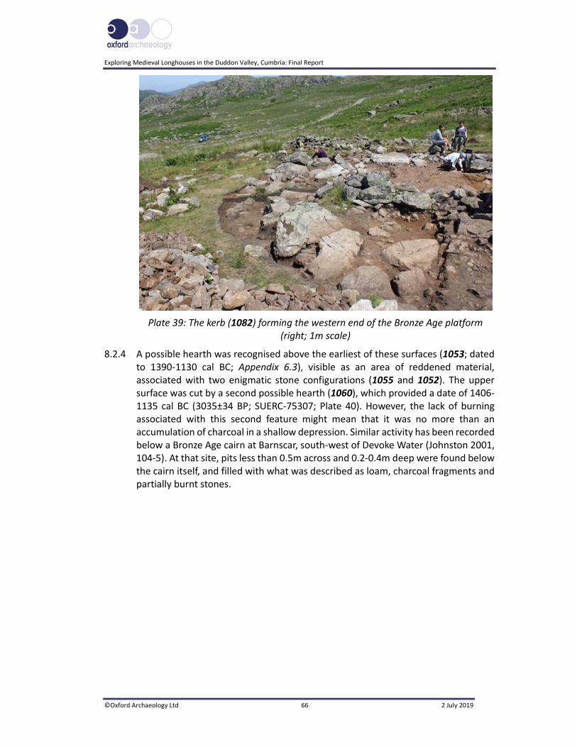
Exploring Medieval Longhouses in the Duddon Valley, Cumbria: Final Report
©Oxford Archaeology Ltd 66 2 July 2019
Plate 39: The kerb (1082) forming the western end of the Bronze Age platform (right; 1m scale)
8.2.4 A possible hearth was recognised above the earliest of these surfaces (1053; dated to 1390‐1130 cal BC; Appendix 6.3), visible as an area of reddened material, associated with two enigmatic stone configurations (1055 and 1052). The upper surface was cut by a second possible hearth (1060), which provided a date of 1406‐1135 cal BC (3035±34 BP; SUERC‐75307; Plate 40). However, the lack of burning associated with this second feature might mean that it was no more than an accumulation of charcoal in a shallow depression. Similar activity has been recorded below a Bronze Age cairn at Barnscar, south‐west of Devoke Water (Johnston 2001, 104‐5). At that site, pits less than 0.5m across and 0.2‐0.4m deep were found below the cairn itself, and filled with what was described as loam, charcoal fragments and partially burnt stones.

E
Exploring Medieval Longhouses in the Duddon Valley, Cumbria: Final Report
©Oxford Archaeology Ltd 67 2 July 2019
Plate 40: Possible Bronze Age hearth 1060
8.2.5 The core (1073) of the later wall (1018) to the south of Building 1016 produced a Middle Bronze Age radiocarbon determination, similar to other dates from the site. This deposit lay directly above similar material (1079) that yielded a fragment of Bronze Age pottery, implying reworking of older material. The core (1074) of northern wall 1019 also lay directly above an earlier Bronze Age surface (1023).
8.2.6 Regional and National Parallels: the nature of the site at Long House Close is not entirely clear, but it does share similarities with known Bronze Age sites in the South‐West Fells, as well as elsewhere in the Lake District and Northern England in general. Some of these have been identified from extensive surveys in the region; the Duddon Valley has benefited from archaeological survey work on the South‐West Fells between 1982 and 1989 (Quartermaine and Leech 2012, 33) and more recently, surveys have been undertaken by the Duddon Valley Local History Group (DVLHG 2009). These have identified a wealth of apparently Bronze Age remains, dated by typological parallels from other parts of the Lake District and beyond the region. Sites characterised as house platforms have been recorded in a number of areas of the Lake District, including Town Bank, in Western Cumbria, and Stainton Fell, to the west of the valley (Quartermaine and Leech 2012, 33).
8.2.7 Site 636 on Town Bank (Tongue How; Town Bank XI) is a good parallel for the Long House Close monument (op cit, 59‐60); it is a sub‐oval terraced platform set into the slope (c 25 x 25m in size), with a clearly defined upper terrace edge, and a very substantial front apron built up with large stones. The terrace surface is artificially flat, and has no visible internal features. It is also significant to note that it is linked to a field system defined by stone banks and a series of erratically defined enclosures, and was seemingly the focus for a prehistoric farmstead (op cit, fig 29). The main terraced platform is typologically comparable to the Long House Close

Exploring Medieval Longhouses in the Duddon Valley, Cumbria: Final Report
©Oxford Archaeology Ltd 68 2 July 2019
structure, although it was not confirmed that the banks associated with that structure had their origins in the prehistoric period.
8.2.8 Such sites may well be similar to what have been described as unenclosed ‘scooped platforms’, identified in Kentmere, north of Kendal, and Troutbeck (Ridley 2009, 7). One particular example at Garburn, Kentmere, although undated, has a platform terraced into the hillside with a stone kerb at the base, which compares favourably with the remains at Long House Close (op cit, 3). Similar sites, dating from the later Neolithic period to the Middle Bronze Age, have been identified in Lanarkshire, in the Scottish Borders. For instance, a site near the head of the Clyde Valley at the Lintshie Gutter revealed no less than 31 platforms terraced into the hillside, five being investigated archaeologically (Terry 1995). Several of these platforms displayed evidence of ring‐grooves and post‐impressions, indicating the presence of a roundhouse. Platform 1, which measured 14 x 8m internally, on the other hand, did not reveal evidence of a timber structure, but some structural features were noted (ibid). There are no dated parallels for the large domestic terrace monument, but some smaller examples have been investigated in the North East, where they span the period c 1500‐100 cal BC (Quartermaine and Leech 2012, 34).
8.2.9 Platforms have also been excavated at Gardom’s Edge, in the Peak District National Park, where again there was evidence of post‐structures. Houses 1 and 2 at that site both had a partial or semi‐circular stone bank (Barnatt et al 2017, 96, 114). Slightly later in date than Long House Close, the Gardom’s Edge houses were occupied in the Late Bronze Age and Early Iron Age (tenth to fifth centuries BC; op cit, 114).
8.2.10 Certain elements of these sites have similarities with Long House Close. These shared characteristics comprise a terraced platform, that sometimes has a kerb or stone apron partially enclosing the platform. If not exactly numerous, such sites are present over large parts of Northern England and Southern Scotland. Where excavated, most are characterised by some form of dwelling, usually a timber roundhouse. It is a matter of conjecture what may lie below the Bronze Age and later deposits at Long House Close, notwithstanding the single stakehole recorded on the site (1051; Fig 19). Despite this, comparable sites do suggest that the Bronze Age features revealed at Long House Close were neither isolated nor unusual finds.
8.2.11 Well‐dated Bronze Age activity in the Duddon Valley is relatively rare, given the lack of excavation in the area, the Seathwaite Tarn ring cairns, c 800m to the north‐east and nearly 100m higher, being the most recently studied (DVLHG 2009). A roundhouse and later surfaces were excavated at Stephenson Ground in the 1980s and early 1990s (Thorpe nd; Thorpe and Ball 1992), whilst below Caw at Stephenson Haw, there are well‐preserved, albeit undated, cists (Thorpe and Ball 1992).
8.2.12 Permanent change in the forest composition was identified at Seathwaite Tarn, dated to c 1665‐935 cal BC (Pennington 1964; 1970), at the same time as the Bronze Age activity in the area. Evidence from the Seathwaite Tarn burial cairns, which produced two sherds of Bronze Age pottery and two flaked lithics, have indicated that they were constructed just before 1400 BC (DVLHG 2009, 105‐7), which would make them contemporary with the activity found at Long House Close.

E
Exploring Medieval Longhouses in the Duddon Valley, Cumbria: Final Report
©Oxford Archaeology Ltd 69 2 July 2019
8.2.13 An aspect of the pattern of Bronze Age sites in the Lake District is a clear awareness of the landscape, particularly in the siting of funerary monuments, such as the ring cairns at Seathwaite Tarn, on high summits (Evans 2008a,79). Combined with this is the idea that such sites are on natural routeways between areas of low and high ground, and may be connected with activities such as transhumance (ibid; Plate 41). Ultimately, these routeways, with their connections to water, in this case the River Duddon and its estuary, may have been a way that particular groups of people identified themselves with particular rivers (op cit, 79, 97, 99). The connection between the local communities that inhabited the area, and may have visited the cairns, as well as seasonal occupation and transhumance regimes, may be an expression of their long‐term connection with the locale (op cit, 99).
Plate 41: Long House Close from beyond the eastern enclosure wall, with Harter Fell on the right
8.3 The Medieval Period and Later
8.3.1 All three structures investigated by excavation had the same basic rectangular shape and were all constructed using dry‐stone walls. They did, however, have subtly differing layouts. Tongue House B had a single west‐facing entrance, was paved at its northern end, with bare earth to the south, and no formal internal division. Tongue House A had a single south‐west‐facing entrance with the upper, north‐west, end being cobbled, and containing a hearth, indicating that this was domestic. There was also a possible blocked entrance opposite the obvious entrance, so it may once have contained a cross‐passage. The other end had a second hearth and a platform that may have been a peat store. The structure at Long House Close was the closest to what approximates to a conventional longhouse, with a central cross‐passage, a domestic area shielded by a wall, and a lower end paved with a stone surface. This, however, had clearly been rebuilt at some point. At all three sites, some elements

Exploring Medieval Longhouses in the Duddon Valley, Cumbria: Final Report
©Oxford Archaeology Ltd 70 2 July 2019
of a two‐celled layout existed, but none provided any concrete evidence that animals had been housed in the lower end of the buildings. Moreover, the relatively small size of the buildings casts doubt on the number of animals that could have been accommodated.
8.3.2 What technically constitutes a longhouse has been the subject of debate over the last few decades, and there are some differences of opinion as to the definition (Grenville 1997, 136‐7). David Austin provided a formal description of a longhouse, requiring six criteria to be met (1985, 76), based on evidence from Dartmoor: a cross‐passage; a byre indicated by a central or lateral drain; domestic accommodation separate from the byre; a stone hearth; cooking pits near the hearth; and a complex domestic arrangement. The term has, however, been used to refer to a house with a cross‐passage, regardless of the use of the lower end (eg Beresford and Hurst 1971), though this approach has been criticised (Harrison and Hutton 1984).
8.3.3 Guy Beresford (1988) has highlighted that this type of structure tends to be a later medieval development, differing from dated early medieval buildings in significant details (some of which, particularly those thought to be associated with Viking settlement, have been loosely termed longhouses). Those excavated in the Yorkshire Dales, for instance, are smaller in size and typified by their rounded corners and dwarf walls (Johnson 2013; IAG 2015a; 2015b). Longhouses are not widespread in England until the late twelfth or thirteenth century, and they certainly continued to be built in upland areas into the post‐medieval period (Mercer 1975, 35; Grenville 1997, 135). As Ronald Brunskill notes (1985,142), however, no sooner were the ‘classic’ versions of such buildings constructed in a manner in which they survive as standing structures, than the plan was modified and ‘improved’, so the variations on the basic theme are numerous.
8.3.4 Shielings seem to have been constructed either in turf or with dry‐stone walling and, like the putative medieval longhouses, vary considerably in size and construction, when they are examined in detail (Ramm et al 1970, 9). Some square examples have been found, but most seem to have been rectangular structures, the majority ranging from 6m to 9m, with a width of c 2.5‐7m. Perhaps contrary to popular perceptions, the larger structures mostly had two rooms, and whilst the majority had a single doorway near the middle of the southern long wall, a few had a cross‐passage (ibid). These were also prevalent in the medieval period, but some at least survived into the seventeenth century. Perhaps the key defining features are that they are invariably unenclosed, whilst more permanently inhabited farmsteads are always associated with enclosures (op cit, 7). Shielings are, however, normally found in groups, and tend to be sited near streams used as routeways into the uplands, or on the boundaries of the area allotted for grazing, at a distance from the permanently occupied farms (ibid). As Mary Atkin has pointed out, though, they did not tend to be insubstantial structures, being permanent dwellings but only temporarily in use (Atkin 1991, 76).
8.3.5 Tongue House A and B: the excavation and subsequent dating of the buildings at Tongue House High Close have established that they were in use during the period c 1475‐1640 for Tongue House B and c 1515‐1800 for Tongue House A. There was
E
Exploring Medieval Longhouses in the Duddon Valley, Cumbria: Final Report
©Oxford Archaeology Ltd 71 2 July 2019
also the possibility of earlier activity in the vicinity of Tongue House A, since deposits from a possible palaeochannel below the structure produced both Roman‐period and early medieval radiocarbon dates. It is likely, however, that these represent clearance of the land, rather than on‐site activity. Radiocarbon determinations from one of the Seathwaite ring cairns indicated that peat was accumulating between the fifth and seventh centuries AD (see Section 7.3), whilst at nearby Devoke Water, woodland clearance of the high fells was occurring into the high medieval period (Quartermaine and Leech 2012, 199‐200).
8.3.6 Tongue House A was set within a small stone‐walled enclosure, which was within the corner of a much larger sub‐rectangular stone‐walled enclosure, now overlain by the more recent intake walls that define Tongue House High Close (Fig 7). Tongue House B was perched on a small natural shelf facing west down the valley, at an elevation of approximately 300m OD.
8.3.7 Tongue House A: Tongue House A displays considerable development over its life. In the earliest phase it was a north‐west/south‐east‐aligned two‐celled building, with a cross‐passage (Fig 14; Plate 14). The interior of the upper, or northern, cell was floored by two layers of cobbles (1020 and 1028; Section 5.3.5).
8.3.8 A hearth (1006), and its later modification (1005; Section 5.3.6), were found towards the south‐eastern end of the northern cell, close to the cross‐passage. The cross‐passage itself had two phases of cobble floor (1026/1029 and 1033; Section 5.3.7), which were most probably contemporary with those in the northern cell, although they were more sporadic, perhaps being displaced by use. A tumbled orthostatic boulder on the north‐west side of the north‐east entrance may have been a partly dislodged door jamb. A second possible hearth (1007; Section 5.3.8) and a rectangular stone feature, interpreted as a peat store, were found in the southern cell. The latter has some similarities with such use in Orkney during the eighteenth and nineteenth centuries (Plate 42; Kirbuster Museum, Birsay, 2017). That there was no charcoal associated with the hearths suggests wood was not generally used as fuel. In the second phase, the north‐eastern entrance was blocked and a partition wall was constructed at the southern end of the northern cell.

Exploring Medieval Longhouses in the Duddon Valley, Cumbria: Final Report
©Oxford Archaeology Ltd 72 2 July 2019
Plate 42: Peat store in an unrestored example of a traditional ‘firehoose’ at Kirbuster Museum, Orkney
8.3.9 A peat moss was situated within the confines of the enclosure (Palaeo‐Site 2; Fig 23) surrounding Tongue House A, and may have been exploited for fuel. In contrast to the extensive peat deposits in the Pennines, those in the Lake District are less widespread (Winchester 2000, 126) and are often contained in settings like that of Tongue House High Close. The historical record suggests that these more discrete, and very much more finite, peat resources were subject to control throughout the period that Tongue House A was occupied (ibid), but commoners using the land would typically have rights of turbary, allowing the cutting of peat. Even at the end of the nineteenth century, something of the importance of peat can be seen on the 1892 six‐inch to one‐mile Ordnance Survey map of the area, which depicts individual peat beds on the fell‐side.
8.3.10 Tongue House B: the second site on Tongue House High Close was accessed by a steep climb from Tongue House A, and was not within an enclosure, although there is some evidence that it was within the same wider field system (Fig 2). It was also the longest of the three structures, at 11.6m. It differed from the other two buildings examined, in that it had a single room, with no internal divisions, although the upper north end was furnished with a rough flagstone floor (Fig 18). There was also no evidence of a hearth, though the charcoal recovered from deposit 3002 (Section 5.4.3) would suggest that a fire had been kindled somewhere in the building. In addition, no artefacts were directly associated with the building. It was the only structure to indicate how the roof was supported, as the south wall retained part of a gable (Plate 43).
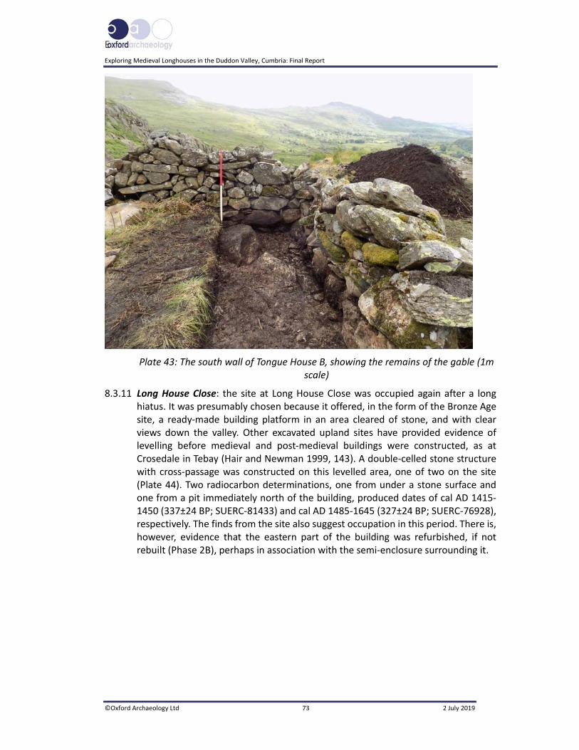
E
Exploring Medieval Longhouses in the Duddon Valley, Cumbria: Final Report
©Oxford Archaeology Ltd 73 2 July 2019
Plate 43: The south wall of Tongue House B, showing the remains of the gable (1m scale)
8.3.11 Long House Close: the site at Long House Close was occupied again after a long hiatus. It was presumably chosen because it offered, in the form of the Bronze Age site, a ready‐made building platform in an area cleared of stone, and with clear views down the valley. Other excavated upland sites have provided evidence of levelling before medieval and post‐medieval buildings were constructed, as at Crosedale in Tebay (Hair and Newman 1999, 143). A double‐celled stone structure with cross‐passage was constructed on this levelled area, one of two on the site (Plate 44). Two radiocarbon determinations, one from under a stone surface and one from a pit immediately north of the building, produced dates of cal AD 1415‐1450 (337±24 BP; SUERC‐81433) and cal AD 1485‐1645 (327±24 BP; SUERC‐76928), respectively. The finds from the site also suggest occupation in this period. There is, however, evidence that the eastern part of the building was refurbished, if not rebuilt (Phase 2B), perhaps in association with the semi‐enclosure surrounding it.

Exploring Medieval Longhouses in the Duddon Valley, Cumbria: Final Report
©Oxford Archaeology Ltd 74 2 July 2019
Plate 44: Building 1016 and its surrounding walls (1017) looking west, during the 2017 excavation season
8.3.12 The two walls (1017 (walls 1018 and 1019)) forming the ‘pound’ on either side of this eastern cell of Building 1016 appear to post‐date it, enclosing only this uphill portion of the building (Phase 2B). This was a juxtaposition unique in the valley, and, indeed, so far in the Lake District (Matthiessen et al 2015). An interpretation prior to excavation was that these walls were part of an earlier boat‐shaped structure, as its shape in plan, with bowed walls, shared superficial similarities to early medieval structures associated with Viking settlement, as, for instance, at the Brough of Birsay in Orkney (Morris 1996, 245). One issue against this was the position of these walls on a fairly steep slope, although some of the structures at Birsay were also on a significant slope. However, excavation demonstrated that the walls were actually not bowed (Fig 22). Comparisons have also been made with a double‐walled building at Ennerdale, assumed to be a miner’s hut (Ramm et al 1970, 11, 37), although this structure seems genuinely to have been double‐walled, rather than having an outer enclosure, as at Long House Close, and is square rather than rectangular, the outer elements being universally close to the inner, rather than varying in distance, as at Long House Close.
8.3.13 A middle Bronze Age date from the core (1073) of wall 1018 (Fig 20) should be treated with caution, since it may well represent reworked material, or equally it might suggest the remnant of a Bronze Age feature later incorporated into the wall; the very similar core (1074) of wall 1019 produced a sherd of late medieval‐ or early post‐medieval pottery. The walls were constructed using different techniques, which seems to indicate that they were not contemporary, wall 1019 being built on top of probable medieval surfaces 1078, 1080 and 1081 (Fig 22), with a double skin and rubble infill (Plate 45), not that dissimilar to enclosure wall 3002, immediately south of Tongue House A (Plate 19).

E
Exploring Medieval Longhouses in the Duddon Valley, Cumbria: Final Report
©Oxford Archaeology Ltd 75 2 July 2019
Plate 45: Wall 2019, showing the construction technique
8.3.14 This contrasted with wall 1018, which was constructed of boulders, and appears to reflect a rebuild of boundary wall 1072, perhaps following the same line as this former boundary. Logically, this section of the wall was constructed after Building 1016, as the Bronze Age surface (1046; Section 5.5.12), upon which wall 1018 was seemingly constructed, was reused and added to during the life of the building, and therefore was already in place when the eastern end of wall 1018 was built.
8.3.15 Wall 1018 may have formed the southern boundary of the wider surrounding enclosure, of which 1072 was an original section (Section 5.5.29). As the topographical survey (Section 3.4.8) and subsequent excavation have shown, this enclosure appears to be a piecemeal construction with a number of additions and infillings (Section 5.5.28). Given that walls 1018 and 1019 were both seemingly later than the section of wall 1072, their development clearly post‐dates the Bronze Age platform and also the earliest use of the enclosure.
8.3.16 The Wider Landscape: pollen data from the Devoke Water cairn suggest that, from the early medieval period onwards, the landscape remained largely cleared and was used for upland grazing (Quartermaine and Leech 2012). The names of the areas in which the three sites are situated, Tongue House High Close and Long House Close, reinforce the connection with the farms in the valley bottom. Similarly, the name Scales Brow, to the south‐west of Tongue House A, suggests that there were once shielings in the vicinity.
8.3.17 All the sites are within the remains of an elongated series of irregular stone‐walled fields (Fig 2), first identified and surveyed by the DVLHG (Matthiessen et al 2015).

Exploring Medieval Longhouses in the Duddon Valley, Cumbria: Final Report
©Oxford Archaeology Ltd 76 2 July 2019
These enclosures ascend the fellside following the tributaries of Sunny Pike Gill, and ultimately appear to be connected to the valley‐bottom fields belonging to Tongue House and Long House. It seems likely that these enclosures, which clearly pre‐date the more regular boundary walls that were probably built in the nineteenth century, were part of the upland grazing associated with the two valley‐bottom farms. It should be noted, however, that the site at Long House Close has been tentatively identified with a settlement at ‘Walney Scar’ from the eighteenth century, although this site has not been located definitively (DVLHG 2013, 90).
8.3.18 All three buildings date from the same period, with activity potentially spanning the late fifteenth to seventeenth centuries. It is worth noting that there is a documentary reference to Long House Farm in 1683, and thus this farmhouse is likely to be of seventeenth‐century date or earlier (Higgins 1986; NTSMR 20632). The three sherds of Silverdale‐type pottery (Section 6.2), usually dated to the later fifteenth to seventeenth centuries and later (White 2000), and a number of horseshoes, some datable to the same period, tools and nails all indicate activity at the Long House Close site confirming the radiocarbon date‐range. This small assemblage, however, contrasts with the assemblage from a building excavated at Holwick in Teesdale, which was one of number of medieval and post‐medieval structures forming part of a deserted settlement, albeit at a considerably lower altitude. Some 750 sherds of medieval and post‐medieval pottery were recovered from this (Altogether Archaeology 2018, 15), perhaps indicating the levels of pottery consumption that might be expected at a permanently occupied site, although it is just possible that the disparity in the amounts of pottery from these sites might be bound up with regional supply networks. It is perhaps relevant that the Percy Survey of 1578, covering large areas of the north‐western Lake District, lists squatter settlements as well as more ‘regular’ farmsteads, which were charged rents (Whyte 1985, 111), individual herdsmen’s dwellings perhaps having gone largely unmentioned, although there is a single specific reference to a shieling.
8.3.19 It seems that there was a significant expansion of enclosed pasture on the fellsides in the sixteenth and seventeenth centuries (Winchester 2000, 69). These lay between the enclosed fields and meadows in the valley bottom and the unenclosed wastes of the higher fells beyond the head dyke (Plate 46), and offered a more controlled management of the resource. Although the appropriation of the lower fellsides, generally at 200‐300m, may have been met with resistance from tenants, some communities were taking this type of land for themselves with the tacit approval of the lords, as long as rent was paid, with such in‐taking being ubiquitous in the Lake District valleys between c 1450 and 1600 (op cit, 68‐9). There are references to late medieval in‐taking and shielings in the Derwent fells, which also included the creation of fields from the fellside fringe (op cit, 148‐9).

E
Exploring Medieval Longhouses in the Duddon Valley, Cumbria: Final Report
©Oxford Archaeology Ltd 77 2 July 2019
Plate 46: Possible head‐dyke, depicted on the OS six‐inch map, marking the boundary of the enclosed land
8.3.20 All three sites were constructed on the north‐facing side of the Duddon Valley, at elevations of above 280m OD. This contrasts with the south‐facing side of the valley, where several farms still exist at about the same elevation (250m OD and above), or there is evidence for assart‐like fields systems. These farms, or former farmhouses, include Grassguards, an unnamed assart‐type field system to the east of Crosby Gill, Pike Side, a site with possible longhouses set within assart‐like field systems (see DVLHG 2009, 84‐8, for the history of this site). Further west, Bowscale, below Plough Fell, is also set within what appears to be an assart. This site is of note, as it might be inferred that this was a shieling that became a permanent farmstead, a phenomenon observed by the RCHM(E) survey of northern Cumbria and Tynedale (Ramm et al 1970, 22). The name retains the skali element, referring to a shieling, a name that in the Lake District is often found at high altitudes (Whyte 1985, 105). The incidence of farmsteads or former farmsteads and assarting on the south‐facing fellsides might be due to environmental factors, as they would receive more sunlight than those on the other side of the valley, and generally the terrain is more suitable to permanent occupation. This contrasts with the much rockier environment on the north‐facing fellsides, so apparent around Long House Close.
8.4 Conclusion
8.4.1 The superimposition of the two main periods of occupation at Long House Close is probably not a coincidence, since it is recurrent in the upland Lake District that favourable places were repeatedly reused (Evans 2008b). At Long House Close, the location of which occupied an attractive prime site, an area had already been cleared of boulders in the Bronze Age, and because the thin upland soils were unlikely to promote colluviation and thus bury the site, it remained visible and

Exploring Medieval Longhouses in the Duddon Valley, Cumbria: Final Report
©Oxford Archaeology Ltd 78 2 July 2019
became the focus for renewed occupation in the late medieval/post‐medieval period.
8.4.2 The excavations have demonstrated that the three later structures were all broadly contemporary, having been built at some point between the late fifteenth and the mid‐seventeenth centuries. This calls their purpose into question, as this is at the later end of the period when summer transhumance was practised, and these structures did not conform to contemporary descriptions of shielings. Nor do they seem to have been successful farm sites, at least for any long period of time, though perhaps their closest parallels are found in the tradition of small cross‐passage houses built in this period across northern England (Brunskill 1985), and Snowdonia (Wiliam 2010), to exploit more marginal farming landscapes. It is also clear that the buildings were modified during their lifetime, presumably also changing their functions to suit changing farming requirements.
E
Exploring Medieval Longhouses in the Duddon Valley, Cumbria: Final Report
©Oxford Archaeology Ltd 79 2 July 2019
BIBLIOGRAPHY
PRIMARY SOURCES
Ordnance Survey, 1850 First edition map, 1:10,560, Lancashire Sheet 6
Ordnance Survey, 1892, 1:10,560 map revised edit ion, Lancashire Sheet 6
Ordnance Survey, 1919 1:10,560 map revised edit ion, Lancashire Sheet 6
SECONDARY SOURCES
Ainsworth, S, Bowden, M, McOmish, M, and Pearson, T, 2007 Understanding the archaeology of landscapes: a guide to good recording practice, Swindon
Altogether Archaeology, 2018 Well Head deserted settlement, Holwick, Teesdale: project design for 2018 (2nd season) excavation and interim report on 2017 excavation, unpubl rep
Andersen, STh, 1979 Identification of wild grasses and cereal pollen, Danm Geol Unders 1978, 69‐92
Atkin, M, 1991 The medieval land use of Kentmere, Trans Cumberland Westmorland Antiq Archeol Soc, n ser, 91, 69‐78
Austin, D, 1985 Dartmoor and the upland villages of the southwest of England, in D Hooke (ed), Medieval Villages: a review of current work, Oxford, 71‐9
Ayala, G, Canti, H, Heathcote, J, Sidell, J, and Usai, R, 2007 Geoarchaeology: using earth sciences to understand the archaeological record, London
Barnatt, J, Bevan, J, and Edmonds, M, 2017 An upland biography: landscape and prehistory on Gardom’s Edge, Derbyshire, Macclesfield
Bell, B, Cove, S, Day, K, Gregory, R, Kingston, E, Lydon, S, and Matthiessen, P, 2019 High Life in the uplands: the Duddon Dig Project, Lancaster
Beresford, G, 1988 Three deserted medieval settlements on Dartmoor, Medieval Archaeol, 23, 98‐158
Beresford, MW, and Hurst, JG, 1971 Deserted medieval villages: studies, London
Berglund, BE, and Ralska‐Jasiewiczowa, M, 1986 Pollen analysis and pollen diagrams, In BE Berglund (ed), Handbook of Holocene palaeoecology and palaeohydrology, Chichester, 455‐84
Bowman, S, 1990 Radiocarbon dating, London
Bradley, J, and Miller, I, 2009 The medieval and post‐medieval pottery, in C Howard‐Davis (ed), The Carlisle Millennium Project, excavations in Carlisle, 1998‐2001. Volume 2: the finds, Lancaster Imprints, 15, Lancaster, 660‐77
Bronk Ramsey, C, 2009 Bayesian analysis of radiocarbon dates, Radiocarbon, 51 (1), 337‐60

Exploring Medieval Longhouses in the Duddon Valley, Cumbria: Final Report
©Oxford Archaeology Ltd 80 2 July 2019
Bronk Ramsey, C, 2017 Methods for summarizing radiocarbon datasets, Radiocarbon, 59 (2), 1809‐33
Brooks, D, and Thomas, KW, 1967 The distribution of pollen grains on microscope slides. The non‐randomness of the distribution, Pollen et Spores, 9, 621‐9
Brown, F, Clark, P, Dickson, A, Gregory, RA, and Zant, J, in prep From an ancient Eden to a new frontier: an archaeological journey along the Carlisle Northern Development Route, Lancaster Imprints
Brunskill, RW, 1985 Vernacular building traditions in the Lake District, in JR Baldwin and ID Whyte (eds), The Scandinavians in Cumbria, Edinburgh, 135‐59
Campbell, G, Moffett, L, and Straker, V, 2011 Environmental archaeology: a guide to the theory and practice of methods, from sampling and recovery to post‐excavation, 2nd edn, Portsmouth
Cappers, RTJ, Bekker, RM, and Jans, JEA, 2006 Digitalezadenatlas van Nederland: digital seed atlas of the Netherlands, Groningen
Chartered Institute for Archaeologists, 2014a Standard and guidance for archaeological excavation, Reading
Chartered Institute for Archaeologists, 2014b Standard and guidance for the creation, preparation, transfer and deposition of archaeological archives, Reading
Chartered Institute for Archaeologists, 2014c Code of conduct, Reading
Clark, J, 2004 The medieval horse and its equipment c. 1150‐ c. 1450, Medieval finds from excavations in London, 5, rev edn, London
Duddon Valley Local History Group (DVLHG), 2009 Ring cairns to reservoirs, Kendal
Duddon Valley Local History Group (DVLHG), 2013 Longhouses in the Duddon Valley, Cumbria: a survey of building remains and their surrounding landscapes [Online] Available at: www.duddonhistory.org.uk/downloads/longhouse_report.pdf (accessed 16 September 2016)
English Heritage, 2008 Geophysical survey in archaeological field evaluation, 2nd edn, Swindon
Evans, H, 2008a Neolithic and Bronze Age landscapes of Cumbria, BAR Brit Ser, 463, Oxford
Evans, H, 2008b After the axe: ways into the upland landscapes of Cumbria, in AM Chadwick, Recent approaches to the archaeology of land allotment, BAR Int Ser, 1875, Oxford, 129‐42
Faegri, K, and Iversen, J, 1989 Textbook of pollen analysis, 4th edn, Chichester
Grenville, J, 1997 Medieval housing, London
Hair, N, and Newman, R, with Howard‐Davis, C, and Newman, C, 1999 Excavation of medieval settlement remains at Crosedale in Howgill, Trans Cumberland Westmorland Antiq Archaeol Soc, n ser, 99, 141‐58

E
Exploring Medieval Longhouses in the Duddon Valley, Cumbria: Final Report
©Oxford Archaeology Ltd 81 2 July 2019
Harrison, B, and Hutton, B, 1984 Vernacular houses of North Yorkshire and Cleveland, Edinburgh
Hather, JG, 2000 The identification of the northern European woods, London
Higgins, M, 1986 Vernacular building survey for Tongue House Farm, National Trust, unpubl rep
Historic England, 2011 Introduction to heritage assets, shielings [Online] Available at: https://content.historicengland.org.uk/images‐books/publications/iha‐shielings/shielings.pdf/ (accessed 16 July 2018)
Historic England, 2015 Management of research projects in the Historic Environment (MoRPHE), Swindon
IAG (Ingleborough Archaeology Group), 2015a Excavation of a multi‐period site in Top Cow Pasture, Selside, Upper Ribblesdale, Ingleton
IAG (Ingleborough Archaeology Group), 2015b The Crummack Dale Project: excavation of three early medieval steadings and a lime kiln, Ingleton
Jarvis, RA, Bendelow, VC, Bradley, RI, Carroll, DM, Furness, RR, Kilgour, INL, and King, SJ, 1984 Soils and their use in Northern England, Harpenden
Johnson, D, 2013 Excavation of two Anglo‐Saxon‐period farmsteads in Brows Pasture, Chapel‐le‐Dale, North Yorkshire, Yorkshire Dales Landscape Research Trust, Kettlewell
Johnston, R, 2001 ‘Breaking new ground’: land tenure and fieldstone clearance during the Bronze Age, in J Brück, Bronze Age landscapes: tradition and transformation, Oxford, 99‐109
Lake District National Park Authority (LDNPA), 2015 World Heritage nomination, 4. Duddon, description, history and development [Online] Available at: www.lakedistrict.gov.uk/data/assets/ pdf_file/0011/729713/4.‐Duddon.pdf (accessed 5 August 218)
Lascelles, V, 2015 Field names of the Duddon Valley, Broughton‐in‐Furness
Lawes Agricultural Trust, 1983 Soils of Northern England, 1:25,000, Harpenden
McCarthy, MR, and Brooks, CM, 1988 Medieval pottery in Britain AD 900‐1600, Leicester
McCarthy, MR, and Brooks, CM, 1992 The establishment of a medieval pottery sequence in Cumbria, England, in D Gaimster and M Redknap (eds), Everyday and exotic pottery from Europe c 650‐1900: studies in honour of John G Hurst, Oxford, 21‐37
Matthiessen, P, Cooper, M, Cove, S, Day, K, Gallagher, J, Harrison, L, and Taylor, P (DVLHG), 2015 A survey of longhouse structures in the Duddon Valley, Cumbria, Trans Cumberland Westmorland Antiq Archaeol Soc, 3 Ser, 15, 117‐38
McKerracher, M, 2018 Farming transformed in Anglo‐Saxon England – agriculture in the long eighth century, Macclesfield
Mercer, E, 1975 English vernacular houses, London
Moore, PD, Webb, JA, and Collinson, ME, 1991 Pollen analysis, 2nd edn, Oxford
Exploring Medieval Longhouses in the Duddon Valley, Cumbria: Final Report
©Oxford Archaeology Ltd 82 2 July 2019
Morris, CD, 1996 The Birsay Bay Project, 2: sites in Birsay Village and on the Brough of Birsay, Durham
Mosley, F (ed), 1978 The geology of the Lake District, Yorkshire Geol Soc, Occ Pap, 3, Leeds
OA North, 2010 Seathwaite Tarn environmental report, unpubl rep
OA North, 2016 Exploring medieval longhouses in the Duddon Valley, Cumbria: Tongue House A: interim report, unpubl rep
OA North, 2017 Interim archaeological assessment reports, Duddon Valley longhouses, unpubl rep
Pennington, W, 1964 Pollen analyses from the deposits for six upland tarns in the Lake District, Phil Trans Royal Soc London, B, 248, 205‐44
Pennington, W, 1970 Vegetational history in the north‐west of England: a regional synthesis, in D Walker and RG West (eds), Studies in the vegetational history of the British Isles, London, 41‐79
Prehistoric Ceramic Research Group (PCRG), 2011 The study of Later Prehistoric pottery: general policies and guidelines for analysis and publications, Occas Pap 1 and 2, 3rd edn, Oxford
Prehistoric Ceramic Research Group (PCRG), 2016 A standard for pottery studies in archaeology, Medieval Pottery Research Group on behalf of the Prehistoric Ceramics Research Group, the Study Group for Roman Pottery and the Medieval Pottery Research Group [Online] Available at: romanpotterystudy.org/2016/06/29/now‐standard‐pottery‐studies‐archaeology/ (Accessed 10 December 2018)
Quartermaine, J, and Leech, RH, 2012 Cairns, fields and cultivation: archaeological landscapes of the Lake District uplands, Lancaster Imprints, 19, Lancaster
Ramm, HG, McDowall, RW, and Mercer, E, 1970 Shielings and bastles, RCHME, London
Reimer, PJ, Bard, E, Bayliss, A, Beck, JW, Blackwell, PG, Bronk Ramsey, C, Buck, CE, Cheng, H, Edwards, RL, Friedrich, M, Grootes, PM, Guilderson, TP, Haflidason, H, Hajdas, I, Hatté, C, Heaton, TJ, Hoffmann, DL, Hogg, AG, Hughen, KA, Kaiser, KF, Kromer, B, Manning, SW, Niu, M, Reimer, RW, Richards, DA, Scott, EM, Southon, JR, Staff, RA, Turney, CSM, van der Plicht, J, 2013 Intcal13 and Marine13 radiocarbon age calibration curves 0‐50,000 years cal BP, Radiocarbon, 55 (4), 1869‐87
Ridley, R, 2009 A prehistoric and Romano‐British field survey of Kentmere, Staveley District Hist Soc, Occas Pap, 25, Kentmere
Sparkes, IG, 1976 Old horseshoes, Shire Album, 19, Princes Risborough
Stace, C, 2010 New flora of the British Isles, 3rd edn, Cambridge
Stockmarr, J, 1972 Tablets with spores used in absolute pollen analysis, Pollen et Spores, 13, 615‐21
Stuiver, M, and Reimer, PJ, 1986 A computer‐program for radiocarbon age calibration, Radiocarbon, 28 (2B), 1022‐30
E
Exploring Medieval Longhouses in the Duddon Valley, Cumbria: Final Report
©Oxford Archaeology Ltd 83 2 July 2019
Terry, J, 1995 Excavation at Lintshie Gutter unenclosed platform settlement, Crawford, Lanarkshire, 1991, Proc Soc Antiq Scot, 125, 369‐427
Thorpe, IJN, nd Stephenson Groundscale, Lickle Valley, unpubl rep
Thorpe, IJN, and Ball, P, 1992 Stephenson Groundscale, Lickle Valley, 1992 season, unpubl rep
Tipping, RM, 2002 Climatic variability and “marginal” settlement in upland British landscapes: a re‐evaluation, Landscapes, 19, 333‐48
United Kingdom Institute for Conservation (UKIC), 1998 First aid for finds, London
van Geel, B, 1978 A palaeoecological study of Holocene peat bog sections in Germany and the Netherlands based on the analysis of pollen, spores and macro‐ and microscopic remains of fungi, algae, cormophytes and animals, Rev Palaeobot Palynol, 25, 1‐120
Vyner, B, 2017 Bronze Age pottery, in D Jackson and D Churchill (eds), Life, death and landscape on the Abbeytown Ridge in the 2nd and 3rd millennium BC: excavations at Overby Quarry and New Cowper Quarry, Cumbria Archaeol Res Rep, 7, Cumberland Westmorland Antiq Archaeol Soc, Bowness on Windermere, 35‐8
White, AJ, 2000 Pottery making at Silverdale, Trans Cumberland Westmorland Antiq Archaeol Soc, n ser, 100, 285‐91
Whitehead, A, Williams, D, and Mace, T, 2013 Excavation of medieval burgage plots to the rear of 130‐136 Stricklandgate, Kendal, Trans Cumberland Westmorland Antiq Archaeol Soc, 3 ser, 13, 89‐115
Whyte, ID, 1985 Shielings and the upland pastoral economy of the Lake District in medieval and early modern times, in JR Baldwin and ID Whyte (eds), The Scandinavians in Cumbria, Edinburgh, 103‐117
Wiliam, E, 2010 The Welsh cottage, building traditions of the rural poor, 1750‐1900, Aberystwyth
Wimble, G, Wells, CE, and Hodgkinson, D, 2000 Human impact on mid‐and late Holocene vegetation in south Cumbria, UK, Vegetation Hist Archaeobot, 9, 17‐30
Winchester, AJL, 1987 Landscape and society in medieval Cumbria, Edinburgh
Winchester, AJL, 2000 The harvest of the hills: rural life in Northern England and the Scottish Borders, 1400‐1700, Edinburgh
Young, R, 2017 Prehistoric ceramic, in D Jackson and D Churchill (eds), Life, death and landscape on the Abbeytown Ridge in the 2nd and 3rd millennium BC: excavations at Overby Quarry and New Cowper Quarry, Cumbria Archaeol Res Rep, 7, Cumberland Westmorland Antiq Archaeol Soc, Carlisle, 69‐80