exploring earth - iodp
TRANSCRIPT

a
EXPLORING EARTH BY SCIENTIFIC OCEAN DRILLING
2050 SCIENCE FRAMEWORK
Summary
b
Scientific Ocean Drilling Through 2050
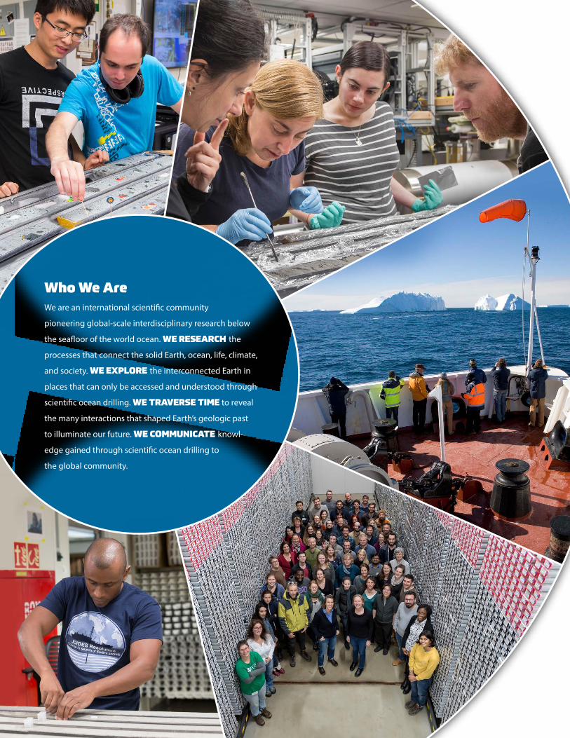
Who We Are We are an international scientific community
pioneering global-scale interdisciplinary research below
the seafloor of the world ocean. WE RESEARCH the
processes that connect the solid Earth, ocean, life, climate,
and society. WE EXPLORE the interconnected Earth in
places that can only be accessed and understood through
scientific ocean drilling. WE TRAVERSE TIME to reveal
the many interactions that shaped Earth’s geologic past
to illuminate our future. WE COMMUNICATE knowl-
edge gained through scientific ocean drilling to
the global community.

1
Scientific Ocean Drilling Through 2050
Two hundred million years of Earth history are locked in sediments and rocks beneath the world
ocean. Scientific ocean drilling provides access to this archive, allowing scientists to examine the inter-
connected processes that characterize the complex Earth system. It furnishes critical details about
geologic processes as well as natural hazards that pose risks to society. Analyses of samples recovered
by scientific ocean drilling establish the geologic context for interpreting human impact on climate
and the environment, providing the data needed to improve the accuracy of computer models that
predict the pace of rising sea levels and the melting of polar and glacial ice. Sampling and analyses also
offer glimpses of the types of microbial life that might exist elsewhere in our solar system and beyond.
The 2050 Science Framework guides scientists on important research frontiers that scientific ocean
drilling should pursue. Seven Strategic Objectives focus on understanding the interconnections within
the Earth system. Five Flagship Initiatives integrate these objectives into long-term research efforts
that address issues facing society. Four Enabling Elements advance the goals of scientific ocean drilling
through broader impacts and outreach initiatives, partnerships, collaborations, continued technology
development, and innovative applications of advanced data analytics.
The 2050 Science Framework Structure
ENDURING PRINCIPLESOpen access to samples and data. Standard measurements. Bottom-up proposal submissions and peer review.
Transparent regional planning. Promoting safety and success through site characterization. Regular framework assessments. Collaborative and inclusive international program. Enhancing diversity.
STRATEGIC OBJECTIVES
Broad areas of scientific inquiry that focus on understanding the
interconnected Earth system.
FLAGSHIP INITIATIVES
Long-term drilling endeavors that aim to inform issues of particular
interest to society, typically combining goals from multiple
Strategic Objectives.
ENABLING ELEMENTS
Key facets of scientific ocean drilling that facilitate our research activities, enhance our scientific outputs, and
maximize their impact.

2
STRATEGICOBJECTIVES
TIPPING POINTS IN EARTH’S HISTORY
Using Earth’s geological past to illuminate future
environmental change.
Studying critical environmental thresh-olds in Earth history that led to rapid transitions into much warmer or colder states provides the information needed to evaluate the rates and consequences of today’s changing climate.
FEEDBACKS IN THE EARTH SYSTEM
Constraining the processes that regulate or destabilize the
Earth system.
Investigating Earth system feed- backs that have resulted in the repeated reconfiguring of conti-nents, climate alternating between hot and cold extremes, and the evolution of vastly different plants and animals at different periods provides insight into our planet’s processes and responses over time.
NATURAL HAZARDS IMPACTING SOCIETY
Understanding natural hazards in the marine environment.
Analyzing the sedimentary record of past hazardous events and installing subseafloor observatories to monitor conditions before, during, and after modern events, illuminate the sub-seafloor conditions that influence haz-ardous events, the mechanisms that control their recurrence and timing, and the likelihood that they will occur in the future.
THE OCEANIC LIFE CYCLE OF TECTONIC PLATES
Investigating the genesis, aging, motion, and destruction
of oceanic plates.
Sampling Earth’s oceanic crust at dif-ferent ages globally provides insight into the processes that govern the occurrence of earthquakes, tsunamis, and volcanoes and the global cycling of energy and matter that produces critical economic resources and makes Earth’s surface habitable.
GLOBAL CYCLES OF ENERGY AND MATTER
Determining the role, mechanisms, and magnitude of
Earth system cycles.
Examining energy, chemical, nutrient, and fluid exchanges between Earth’s sediments and rocks, ocean, atmo-sphere, and life reveals how global cycles moderate Earth’s climate, form natural resources, and control the long-term evolution of life.
EARTH’S CLIMATE SYSTEM
Unraveling ice sheet history, sea level changes, and
ocean-atmosphere interactions.
Comprehending how Earth’s climate system operates requires documenting the onset, interconnectivity, and resil-ience of potentially vulnerable compo-nents of the system, including global ocean circulation, sea ice and large Arctic and Antarctic ice sheets, and pat-terns of precipitation and aridity.
HABITABILITY AND LIFE ON EARTH
Defining the conditions for, and the role of, life in the marine realm.
Understanding what makes our planet habitable, and where and how life orig-inated and evolved, requires knowl-edge of the complex exchanges that occur between the subseafloor bio-sphere, Earth’s crust, and atmosphere.
2

3
Predicting how the Earth system will respond to increasing global temperatures is one of the greatest challenges facing geoscientists. Atmospheric CO2 concentrations have already exceeded 410 ppm in 2020 and, without action to reduce anthropogenic CO2 emissions, could surpass 900 ppm by 2100. Paleoclimate data collected through sci-entific ocean drilling established that atmospheric CO2 last exceeded 410 ppm more than 3 million years ago. Values approaching 900 ppm were only realized during the hot “greenhouse” climate that existed ~50 million years ago. Numerical climate and Earth system models are used to simulate Earth’s response to projected increases in atmospheric greenhouse gas concentrations. Model projections can provide informa-tion about shifts in rainfall and temperature patterns and rising sea levels that can be used in the design of mitigation and adaptation strategies. Scientific ocean drilling provides the robust baseline data on global climate evolution over extended geologic time periods that are critical for improving climate model performance.
Scientific ocean drilling will:
• Provide information about the ocean’s response to past natural climate variability to help improve models that predict future change.
• Assemble paleoclimate records from globally distributed sites in the ocean to identify which parts of the climate system are most suscepti-ble to abrupt and irreversible change.
• Compare past and modern records of climate variability to help identify where human inputs are most influencing Earth’s climate system.
• Improve the accuracy of models of global and regional sea level changes by probing how the deep Earth cools down and how different mantle material gets redistributed.
FLAGSHIPINITIATIVES
GROUND TRUTHING FUTURE CLIMATE CHANGE
3
4
Crus
tU
pper
Man
tle
LavasSheeted Dikes
Gabbro
Peridotite
Tectonic Window Intact Sections
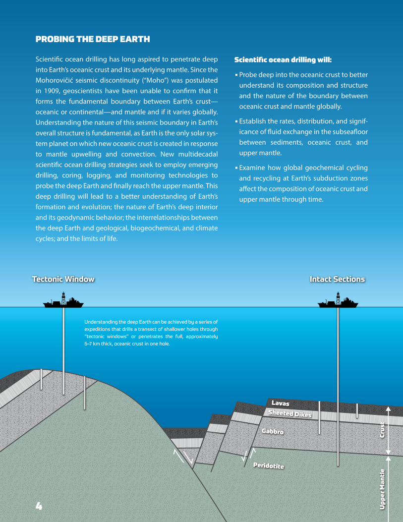
PROBING THE DEEP EARTH
Scientific ocean drilling has long aspired to penetrate deep into Earth’s oceanic crust and its underlying mantle. Since the Mohorovičić seismic discontinuity (“Moho”) was postulated in 1909, geoscientists have been unable to confirm that it forms the fundamental boundary between Earth’s crust—oceanic or continental—and mantle and if it varies globally. Understanding the nature of this seismic boundary in Earth’s overall structure is fundamental, as Earth is the only solar sys-tem planet on which new oceanic crust is created in response to mantle upwelling and convection. New multidecadal scientific ocean drilling strategies seek to employ emerging drilling, coring, logging, and monitoring technologies to probe the deep Earth and finally reach the upper mantle. This deep drilling will lead to a better understanding of Earth’s formation and evolution; the nature of Earth’s deep interior and its geodynamic behavior; the interrelationships between the deep Earth and geological, biogeochemical, and climate cycles; and the limits of life.
Understanding the deep Earth can be achieved by a series of expeditions that drills a transect of shallower holes through “tectonic windows” or penetrates the full, approximately 6–7 km thick, oceanic crust in one hole.
Scientific ocean drilling will:
• Probe deep into the oceanic crust to better understand its composition and structure and the nature of the boundary between oceanic crust and mantle globally.
• Establish the rates, distribution, and signif-icance of fluid exchange in the subseafloor between sediments, oceanic crust, and upper mantle.
• Examine how global geochemical cycling and recycling at Earth’s subduction zones affect the composition of oceanic crust and upper mantle through time.
4

5
Undersea earthquakes and associated tsunamis cause some of our planet’s deadliest and costliest natural disasters. The 2011 magnitude 9.0 Tōhoku-oki earthquake and tsunami in northern Japan took over 15,000 lives, with economic losses estimated at US$235 billion, making it the most expensive natural disaster in history. The 2004 magnitude 9.2 Sumatra-Andaman earthquake and tsunami in the Indian Ocean killed more than 230,000 people in 15 countries and caused losses close to ~US$15 billion. The potential earthquake and tsunami hazards of many of the world’s coastal zones are poorly known, as many large events have no historical record due to their long recurrence intervals. Advancing our understanding of the earthquake and tsunami potential of tectonic plate boundaries worldwide through scientific ocean drilling and long-term sub-seafloor monitoring will enable more reliable forecasts of the risks posed to vulnerable populations and infrastructure and improve hazard preparedness and response.
Scientific ocean drilling will:
• Acquire a comprehensive set of con-tinuous measurements of changes in Earth’s crust over many decades to better understand the processes leading to the occurrence of large earthquakes.
• Use the ocean sedimentary record to document the spatial distribution and frequency of prehistoric large earth-quakes and tsunamis.
• Collect a broad range of physical and chemical measurements from the sub-seafloor to establish the key factors that trigger large earthquakes and tsunamis.
ASSESSING EARTHQUAKE AND TSUNAMI HAZARDS

6
DIAGNOSING OCEAN HEALTH
Ocean warming, acidification, deoxygenation, and rising and falling nutrient levels are causing global changes in marine ecosystems. Declining ocean health can dev-astate biodiversity, habitats, productivity, and fisheries, putting life at risk. Similarly, in the pre-Anthropocene epochs, periods of rapid global warming and cooling, ocean deoxygenation and acidification events, as well as meteorite impacts and episodes of excessive volca-nism greatly perturbed ocean ecosystems. The ocean’s sediment and rock records show how catastrophic envi-ronmental changes altered marine ecosystems and food webs. Scientific ocean drilling will offer a diagnosis of ocean health through geologic time and inform society about the expected rates, durations, and magnitudes of future ocean health deterioration.
Scientific ocean drilling will:
• Reveal how increased rates of change in ocean temperature and acidification affect marine ecosystems and establish the mechanisms and timeframes of adaptation and recovery.
• Establish how future climate change and exces-sive nutrient inputs may affect oxygen avail-ability in the ocean and the magnitude and extent of the resulting ecological responses.
• Explore changes in ecosystem functioning in the geologic past to provide insight into how impaired, transformed, and potentially new ecosystems will respond to future warming.

7
Scientific ocean drilling has provided samples from differ-ent subseafloor environments that harbor microbes, for example, subduction zones where large earthquakes occur, extinct undersea volcanoes or “seamounts,” and oceanic crust near mid-ocean ridges.
Subduction Zones
Seamounts
Oceanic Crust
Marine sediments and oceanic crust host a com-plex, active, globe-spanning ecosystem in which microorganisms live, interact, evolve, and die. Microbiologists know little about the features and strategies that enable deep life to persist in these geologic habitats, what communities form under these extremely energy-limited con-ditions, and what geochemical and biochem-ical processes create their novel biosignatures. Sustained scientific ocean drilling is required to sample and monitor a representative range of Earth’s diverse subseafloor environments and the multitude of microbial communities that they inhabit in Earth’s interior.
Scientific ocean drilling will:
• Provide samples that will help elucidate the rules of life for microbes that persist in a range of sedimentary regimes and rock environments beneath the seafloor.
• Access the subseafloor in diverse environments to reach the depths at which life is no longer able to survive.
• Provide insight into the potential adaptations of pri-mordial life, the constraints under which it evolved, and hence the origins of life on Earth.
• Establish what life might look like in analogous environ-ments on other worlds and what new organisms and functions reside in Earth’s subseafloor that might prove useful in biotechnology.
7
EXPLORING LIFE AND ITS ORIGINS

8
BROADER IMPACTS AND OUTREACH Scientific ocean drilling contributes vital data for improving climate models, advancing earthquake knowledge, and assessing the possibility of life on other worlds. Over the last 50 years, it has facilitated global collaboration in science that has resulted in enduring cross-disciplinary partnerships in science and engineering. By providing opportunities for a diverse population of early career scientists, graduate students, undergraduates, and educators to work alongside international teams of experienced sci-entists and engineers, scientific ocean drilling will remain a preeminent scientific and technical training ground. Communicating about the scientific process and sharing data and results from this international collaboration are essential for developing a scientif-ically literate global citizenry. Broader impact and outreach efforts will be designed to support educators and inform and inspire the public to be better stewards of our planet.
LAND TO SEA Our multidisciplinary science does not stop at the shoreline. Strengthened collaborations between the ocean and land scientific drilling communities will advance their closely allied objective to establish the underlying causes of earthquakes, tsunamis, and explosive volcanism. Land-to-sea drilling collabora-tions will also enhance investigations of the connec-tions between plate tectonics, Earth’s climate system, ecosystems, life and habitability, sea level change, and subseafloor freshwater flow beneath the coastline.
ENABLINGELEMENTS

9
TERRESTRIAL TO EXTRATERRESTRIAL Space agencies around the globe aim to expand knowledge of Earth and other worlds in our solar system. Through space exploration, humankind aspires to discover the fundamental physical laws of the universe, decipher the conditions required for planetary formation and evolution, and, ultimately, unravel the origin of the universe and life. Scientific ocean drilling’s investigations into Earth’s structure, magnetic field, and volcanism, the requirements for planetary habitability, and the limits of life promote these goals. Collaboration between space agencies and scientific ocean drilling will benefit efforts to better understand planetary evolution, evaluate the potential for indigenous life elsewhere in the universe, and assess the risks posed by extraterrestrial impacts. Earth’s ocean basins provide a reference frame for exploring challenging environments and offer a nat-ural laboratory for testing remote and space explora-tion robotic technologies.
TECHNOLOGY DEVELOPMENT AND BIG DATA ANALYTICS Scientific progress requires continuous advances in the technology used to obtain samples and data and the tools used to analyze them. Developments in drilling, coring, logging, and observatory tech-nologies are needed to establish more accurately how the Earth system responded to and recovered from past rapid environmental perturbations. They are also needed to continuously measure activity in zones where large earthquakes initiate and to collect pristine samples of microbes that survive under extreme conditions. Innovations in analytical tools and techniques will maximize the scientific potential of existing and future sediment and rock samples. Scientific advancements also depend on the cyber-infrastructure to store, process, analyze, and model the resultant large data sets and diverse data types and integrate them with information gathered by other programs and disciplines.
October 2020
CITATION. Koppers, A.A.P., and R. Coggon, eds. 2020. Exploring Earth by Scientific Ocean Drilling: 2050 Science Framework. 124 pp., https://doi.org/10.6075/J0W66J9H.
LEAD EDITORS. Anthony Koppers and Rosalind Coggon
AUTHORS. Cara Burberry, Steve D’Hondt, Sarah Feakins, Marguerite Godard, Patrick Fulton, Kliti Grice, Patrick Grunert, Chris Lowery, Katsuyoshi Michibayashi, Ken Miller, Rob McKay, Antony Morris, Richard Norris, Matt O’Regan, Anais Pages, Ross Parnell-Turner, Brian Romans, and Laura Wallace
About the 2050 SCIENCE FRAMEWORK
COUNTRIES INVOLVED IN THE DEVELOPMENT. Australia, Austria, Brazil, Canada, China, Denmark, Finland, France, Germany, India, Ireland, Italy, Japan, Netherlands, New Zealand, Norway, Portugal, South Korea, Spain, Sweden, Switzerland, United Kingdom, and United States of America
EDITING AND DESIGN. Ellen Kappel and Johanna Adams, Geo Prose
Get the full report at https://doi.org/10.6075/J0W66J9H
FRONT COVER. Microbes: Jason Sylvan, Texas A&M University. Hydro-thermal Vent: MARUM − Zentrum für Marine Umweltwissenschaften, Universität Bremen (CC-BY 4.0, https://creativecommons.org/licenses/by/4.0/). Hurricane Damage: iStock.com/skrum. Coral Reef: iStock.com/xrender. Desert: iStock.com/gorsh13. Glacier: iStock.com/Bernhard_Staehli. Volcano: iStock.com/KalypsoWorldPhotography. Earth Image: https://www.ngdc.noaa.gov/mgg/image/etopo1_large.jpg.
FRONT INSIDE COVER. (clockwise from the top) • Core Description Scientist Jianghong Deng (University of Science and
Technology of China) and Organic Geochemist Olivier Sissmann (IFP Energies Nouvelles, France) sample a core, International Ocean Discov-ery Program (IODP) Expedition 366, Mariana Convergent Margin. Credit: Tim Fulton, IODP/JRSO.
• Sedimentologist Francesca Meneghini (Università degli Studi di Pisa, Italy), Structural Geologist Heather Savage (Lamont-Doherty Earth Observatory [LDEO], Columbia University, USA), Sedimentologist Hannah Rabinowitz (LDEO, Columbia University, USA), and Structural Geologist Ake Fagereng (Cardiff University, UK) describe a core during IODP Expedition 375, Hikurangi Subduction Margin. Credit: Tim Fulton, IODP/JRSO.
• Enjoying some sunshine during Integrated Ocean Drilling Program Expe-dition 318, Wilkes Land Glacial History. Credit: John Beck, IODP/TAMU.
• IODP Expedition 381 Science Party and ECORD Science Operator team in the Bremen Core Repository. Credit: V. Diekamp, ECORD/IODP.
• Paleontologist Thiago Pereira dos Santos (Universidade Federal Fluminense, Brazil) works at the sample table, IODP Expedition 361, South African Climates. Credit: Tim Fulton, IODP/JRSO.
IMAGE CREDITS
PAGE 3. (top right) Forest fire at night. Credit iStock.com/Byronsdad. (bottom left) Drone view of flooded neighborhood. Credit iStock.com/RoschetzkyIstockPhoto.
PAGE 4. Illustration by Antony Morris and Geo Prose.
PAGE 5. (top left) Tsunami devastation in Japan after the 2011 Mw 9.0 Tōhoku-oki earthquake. Credit: iStock.com/enase. (bottom right) Damage from the 2010 Mw 8.8 earthquake in Chile. Credit: Simon Haberle, Australian National University.
PAGE 6. (top right) Heart Reef aerial shot taken near Whitsunday islands, Queensland. Credit: iStock.com/byrneck. (bottom left) Tropical coral reef off of Nakinyo Island, Myanmar. Credit: iStock.com/Waranya Sawasdee.
PAGE 7. Illustration by Geo Prose, inspired by Figure 4 in D’Hondt et al. (2019), https://doi.org/10.5670/oceanog.2019.146. Photo credits: (left) Deep sediments. From Figure 2 in Inagaki et al. (2015), https://doi.org/ 10.1126/science.aaa6882. (middle) Young oceanic crust. From Figure 3 in Ramirez et al. (2019), https://doi.org/10.3389/fmicb.2019.01983. (right) Old oceanic crust. Courtesy of Jason Sylvan, Texas A&M University.
PAGES 8/9. (left) The IODP Bremen Core Repository at MARUM. Image credit: MARUM − Zentrum für Marine Umweltwissenschaften; Universität Bremen; V. Diekamp. (middle) Copper River Delta glacier runoff flows into the coastal waters of the Gulf of Alaska. NASA Earth Observatory image by Robert Simmon and Jesse Allen, using Landsat 8 data from the USGS Earth Explorer. (right) ECORD Summer School 2016 in Bremen, Germany. The goal of the summer schools is to train the next generation of scien-tists. Credit: V. Diekamp, MARUM & IODP.