exploring children’s perceptions and experiences of ... proceedings of the 10th international...
TRANSCRIPT

SSS10 Proceedings of the 10th International Space Syntax Symposium
N Özgece, E Edgü & M Taluğ Exploring children’s perceptions and experiences of outdoor spaces
125:1
Exploring children’s perceptions and experiences of outdoor spaces Nezire Özgece PhD Candidate, Cyprus International University [email protected], [email protected]
Erincik Edgü PhD, Associate Professor, Düzce University [email protected], [email protected]
Meray Taluğ PhD Candidate, Cyprus International University [email protected], [email protected]
Abstract
All people employ their senses in order to locate themselves in their environment; however the perception of space is not common to everyone and differs related to various factors. Considering these differences in perception and the factors affecting it, it should be stated that children’s perceptions and experiences of spaces are different from adults’. Unless the places are created by them to play, children perceive and experience environments that are created by adults. Thus, spaces that children experience are generally based on adult’s logic of design configuration.
As children are the active participants of their home and school environments, the present study focuses on a pilot study which is conducted at a primary school with the 5
th year students. Therefore,
the aim is to discover children’s landmark recognition and preferences of outdoor spaces in terms of their home- school routes, playing areas and reveal the underlying syntactic structures of the spaces as well.
Considering the main structure of the research which is based on the comparison between children’s responses to a questionnaire and syntactic properties of the significant places, the methodology is organised as two phases including the individual interviews with students and syntactic analyses of the spaces identified and preferred by children. The first phase of the methodology is based on the examination of children’s perceptions and uses of outdoor spaces with the help of a questionnaire where students answer the questions and draw their route from home to school. In this phase, students are also asked to comment on the photographs taken from the predetermined city landmarks. For the second phase, spaces identified by children are analysed due to the syntactic properties based on various calculations.
The results of the research emphasise that the edges of the city and especially the city walls seem to affect the spatial perceptions of children. Although children mostly prefer to stay in the close vicinity to their home-school environment, they can identify significant city landmarks. The outcomes of the research also indicate that there’s a difference between the female and male students considering the preferences of playing areas.
Keywords
Children’s spatial perception, historic city, outdoor space, wayfinding.

SSS10 Proceedings of the 10th International Space Syntax Symposium
N Özgece, E Edgü & M Taluğ Exploring children’s perceptions and experiences of outdoor spaces
125:2
1. Introduction
The environmental features have direct or indirect effects on people’s spatial behaviour and experience through the process of interpreting the sensory information. As it’s mentioned by Zube and Moore (1989), environments provide information conveyed by patterns of sensory inputs that are not specific to particular sensory channels. Environmental images gathered through these sensory inputs form the basis of human activity pattern. It’s stated by Lang (1987) that people’s spatial behaviour depends partially on the environmental images they have. The environmental image, which is accepted as the generalised picture of the exterior physical world, is the key element for individuals (Lynch, 1997). According to Lynch, “this image is the product both immediate sensation and of memory of past experience, and it’s used to interpret information and guide to action” (Lynch, 1997; p.4).
Knowledge about spatial perception and cognition is important for exploring spatial experiences of people from all age groups. Although perception and cognition have sometimes overlapping definitions, perception can be defined as becoming aware through the senses and getting knowledge by the mind (Canter, 1977), whereas cognition is the more general term and includes perception as well as thinking, problem solving and the organisation of information and ideas (Downs & Stea, 1973). Movement through spaces and wayfinding are fundamental aspects of spatial exploration. As a part of perceiving and experiencing the environment, wayfinding represents spatial decision making with the aim of reaching a destination. Golledge (1999) defines wayfinding as the process of determining and following a path or route between a specified origin and a specified destination. As being a cognitive element, it also includes mental representation, route planning and distance estimation. As stated by Lynch (1997, p.4), “in the process of wayfinding, the strategic link is the environmental image, the generalised picture of the exterior physical world that is held by an individual”. According to Downs & Stea (1973, p.9), cognitive mapping is “a process composed of a series of psychological transformations by which an individual acquires, codes, stores, recalls, and decodes information about the relative locations and attributes of phenomena in his everyday spatial environment.”
The perception of environments is unique for humans as it’s related to the background, including knowledge and experience, or familiarity within the environment. On the other hand, the children’s perception and experience of environment is different comparing to adults’. The studies on children’s conception of space, especially the theories of Piaget, provided a background for the researches in environmental and spatial cognition fields. Piaget studied the way that children react to their environment and categorised children’s cognitive learning process as sensorimotor stage (infancy), pre-operational stage (toddlerhood and early childhood), concrete operational stage (elementary and early adolescence) and formal operational stage (adolescence and adulthood).
According to Piaget's theory, on concrete operational stage that is also supported by Tuan (1977), this stage is formed during the later phases of elementary school. Children are expected to build new experiences on their past ones and their idea of place becomes more specific and geographical. Therefore, the case study of this research is conducted with the fifth graders aiming to reveal their outdoor perceptions and preferences in terms of their home- school routes and playing areas.
Children view and experience both the natural and built environments different than adults as they have a unique and direct way of interacting with their environment. As it’s mentioned by White & Stoecklin (1998), adults typically see nature as background for what they are doing whereas children experience nature rather as a stimulator and experiential component of their activities. Although the past experiences form the basis for understanding the new (Lang, 1989), child’s imagination is of a special kind which is tied mostly to the activity (Tuan, 1977). According to Tuan, place can acquire deep meaning for the adult through the steady accretion of sentiment over the years, however, child not only has a short past, but her/his eyes more than the adult’s are on the present and immediate future, therefore a shorter but more condensed time span.
On the other hand, there is also strong evidence that young children respond more positively to experiences in the outdoors than adults as they have not yet adapted to unnatural, man-made, indoor environments (White and Stoecklin, 1998). Regarding this, it’s known that children mostly
SSS10 Proceedings of the 10th International Space Syntax Symposium
N Özgece, E Edgü & M Taluğ Exploring children’s perceptions and experiences of outdoor spaces
125:3
prefer to spend their time in outdoor environments as they offer unique opportunities inducing development of independence and autonomy as well. Outdoor environments are important not only for children’s sense of well-being but also for their cognitive development. According to Moore and Wong (1996), active learning in outdoor settings stimulates all aspects of child development more readily than indoor environments. The effects of outdoor environments on children development are also associated with the cognitive development of children through opportunities for exploration, experimentation and play (Fisman, 2001). Participating outdoor activities helps to improve children’s awareness, reasoning and observational skills within the outdoor environment.
Within this context, this paper focuses on the evaluation of children’s unique way of interaction with their outdoor environment. Therefore, the way that children perceive and experience outdoor spaces within their home-school environment as well as the spatial characteristics of these spaces are the main concerns of the paper. As the paper aims to reveal the reasons underlying children’s space preferences, syntactic properties are used to evaluate and discuss the spatial characteristics of significant areas.
2. Case study area as an environmental challenge
Nicosia, the capital of Cyprus, evolved as overlapping layers of cultures as being ruled by many different conquerors and colonial powers throughout its history. The walled city of Nicosia, which is the core of the capital of the island, has undergone substantial changes throughout history under the influences of different cultures. Having a unique star shape and a labrynthlike spatial pattern, the historical city presents a complicated urban structure where the wayfinding becomes difficult especially for inexperienced visitors. Following the division of island, where the border (known as Green Line) is passing through the middle of the Walled city, the integrity of the urban structure and thus the city’s centrality has been lost. The dividedness of the city undermines the wayfinding process as well. Therefore, outdoor experience of children within a city having that kind of unique spatial characteristics seems to be more interesting to be researched.
The division of the island have had some effects on social and economic conditions in Nicosia, where the north part of the Walled city has lost its attractiveness for local residents. Especially by mid 80’s, changes in socio-economic profile have followed a completely different route, which indicated a state of migrants to the area by different population segments calling for instability of population. As the local residents abandoned the Walled city and moved to the periphery of Nicosia, the migrants have become the predominant group in the city. Accordingly, the city has become a region dominated by a new population that are unfamiliar to the city’s historical context. Therefore, unlike the local residents, they are mostly focused on more function related and pragmatic landmarks, in terms of wayfinding.
Due to the changing population in the north part of the Walled city, the student profile of the schools in the region is also changed. Against this background; the research was conducted at Lefkoşa Atatürk İlkokulu (Nicosia Atatürk Primary School), located in the Walled city (Figure 1). As being one of the oldest of the city, the selection of this primary school is also based on the large population of the immigrant children being educated in here. As the main aim of the paper is to reveal the perception and experience of outdoor spaces by children; the historic centre, as a case study area, presents a strong identity and a cohesive texture with its well-defined and well-used outdoor spaces.

SSS10 Proceedings of the 10th International Space Syntax Symposium
N Özgece, E Edgü & M Taluğ Exploring children’s perceptions and experiences of outdoor spaces
125:4
Figure 1: Location of Lefkoşa Atatürk İlkokulu (Nicosia Atatürk Primary School) within the context of walled city of Nicosia (map from Google Earth).
3. Methodology of the analysis
In this study, the main structure of the analysis is based on the comparison between children’s responses to a questionnaire and space syntax data of the places and landmarks derived from this questionnaire. Thus, the methodology has two phases including the individual interviews with forty nine students (female: 27, male: 22) and syntactic analyses of the spaces identified and preferred by children.
In the first phase; students were interviewed individually with the help of a questionnaire where they were asked to answer the questions and draw their route from home to school in order to assess the way in which they perceive their outdoor environment and use outdoor spaces. Thus, measures of children's awareness of surrounding built environment, their descriptions for special spaces, activities and behaviours while outdoors were obtained through individual interviews and pictures drawn by students. As drawings are the reflections of mental image, the drawings of children are valuable tools for exploring children’s way of thinking. According to Piaget (1955), if children don’t have a spatial mental image, they are not expected to present accurate drawings (Yavuzer, 1992). Within this context, mental maps of children were used as a method for revealing their cognitive understanding of the environment.
Questionnaire survey consists of three parts. In the first part of the questionnaire, students were interviewed individually where they answered the open ended or multiple choice questions. The questions of this section mainly focused on the description and use of the spaces on their route from home to school. In the second part, students were asked to draw their route adding the home and the school buildings as well. During the drawings students were interviewed informally about their drawings in order to give children multiple opportunities to express their perceptions and experiences of the environment in terms of defining landmarks and using outdoor spaces for their playing activities. As walking through the city plays a fundamental role in terms of environmental perception, students were expected to specify some significant places that attract and/or orient
SSS10 Proceedings of the 10th International Space Syntax Symposium
N Özgece, E Edgü & M Taluğ Exploring children’s perceptions and experiences of outdoor spaces
125:5
them in their wayfinding process. Thus, references to landmarks, such as a remarkable place/building for them, were explored through both their environmental/route descriptions and drawings.
In the last part of the individual interviews, the environmental perceptions of students were examined by a visual query through maps and photographs. In order to explore their awareness of the city landmarks, they were asked to identify the predetermined landmarks presented as a series of photographs.
In the second phase; syntactic properties of the area are analysed through grid analysis by University of Michigan’s Syntax 2D software. Analyses of spaces, identified city landmarks and preferred playing areas by students, are executed due to syntactic properties through various calculations including integration-n, mean depth, compactness and occlusivity. Although it exceeds the maximum public distance of interaction, span size is set to be 1000 so that we could represent the semi urban scale of Walled city. Combining the conversations with their own personal drawings of the spaces and interpreting the syntactic values of the spaces are expected to highlight their personal responses to their environment.
4. Results and discussion
In the context of the research, results of the analyses are discussed in two parts. First part presents the interpretation of individual interviews including drawings of students and visual query through maps and photographs. The second part consists of the evaluation of syntactic findings in terms of spatial characteristics of identified landmarks and preferred playing areas by children.
Individual interviews
In the first part of the individual interviews, carried out with forty nine students (female: 27, male: 22), the data regarding their descriptions and uses of spaces on their home-school route is gathered through open ended or multiple choice questions. Through the interviews; almost all of the students (96.1%) stated that they are walking to school while only 2 students stated that they are coming by a car. 50% of the students are walking alone and the others are walking either with their friends or siblings. Even though they’re always using the same route, as they stated through the informal interview, walking through the city plays a fundamental role in terms of children’s environmental perception and interaction with it.
On the other hand, the students described their home and school environment more with built environmental elements while few students preferred to use human figures in their drawings. Additionally, the natural environmental elements such as trees, flowers, etc. appeared with different frequencies and combinations in some of the drawings (Figure 2). Their use of these elements can be the result of their perception of built environment together with natural environment, which is sometimes imaginary.
As it is seen from Figure 1, the walled city of Nicosia has a dense cohesive pattern of row houses, however majority all of the students (77.6 %) drew an “individual home building” and an “individual school building” to describe the route they are using to come from home to school (Figure 2). Nevertheless, 22.5 % of the students added few buildings located on the home-school route but again as detached buildings.
As the students seemed to have difficulty in perceiving the built environment as a whole, the drawings of individual buildings may be associated with their order of importance within the perceived environment. On the other hand, it’s observed that the students were mostly question-driven; in relation to the question of home-school route, they were focusing on the home and the school specifically skipping the urban layout altogether.

SSS10 Proceedings of the 10th International Space Syntax Symposium
N Özgece, E Edgü & M Taluğ Exploring children’s perceptions and experiences of outdoor spaces
125:6
In the drawings including the schoolyard it was seen that students have an imaginary boundary in their mind defining the schoolyard; in fact the area is defined by surrounding row houses in most parts. Additionally the schoolyard gates were appeared as dominant elements in defining the schoolyard drawings. It’s observed that the students have a tendency to emphasise the home, school and schoolyard entrances with a possible attempt to express indoor-outdoor space relations.
Although we didn't include the bastions among our predetermined landmarks, it is also observed during the interview that majority of students are aware of the bastions with the city walls and their contribution to the city’s name (83%). As living in a divided city, children are also aware of the existence of the borders. The city walls together with the Green Line, which represents the border line of northern and southern parts of the city, define the edges of the city. These physical restrictions are the important factors that affect the spatial perceptions and experiences of children. Although the majority of students are aware of the city walls, none of them reflected this knowledge to their drawings. Nevertheless, some of them put a mountain view to their pictures (Figure 2) although it doesn’t exist within their perceivable environment. Mountains drawings may also present a kind of border as well.
Figure 2: Four samples of student drawings representing “individual home building” and “individual school building” with the use of ground line, sky line, human figure and natural environmental elements.
SSS10 Proceedings of the 10th International Space Syntax Symposium
N Özgece, E Edgü & M Taluğ Exploring children’s perceptions and experiences of outdoor spaces
125:7
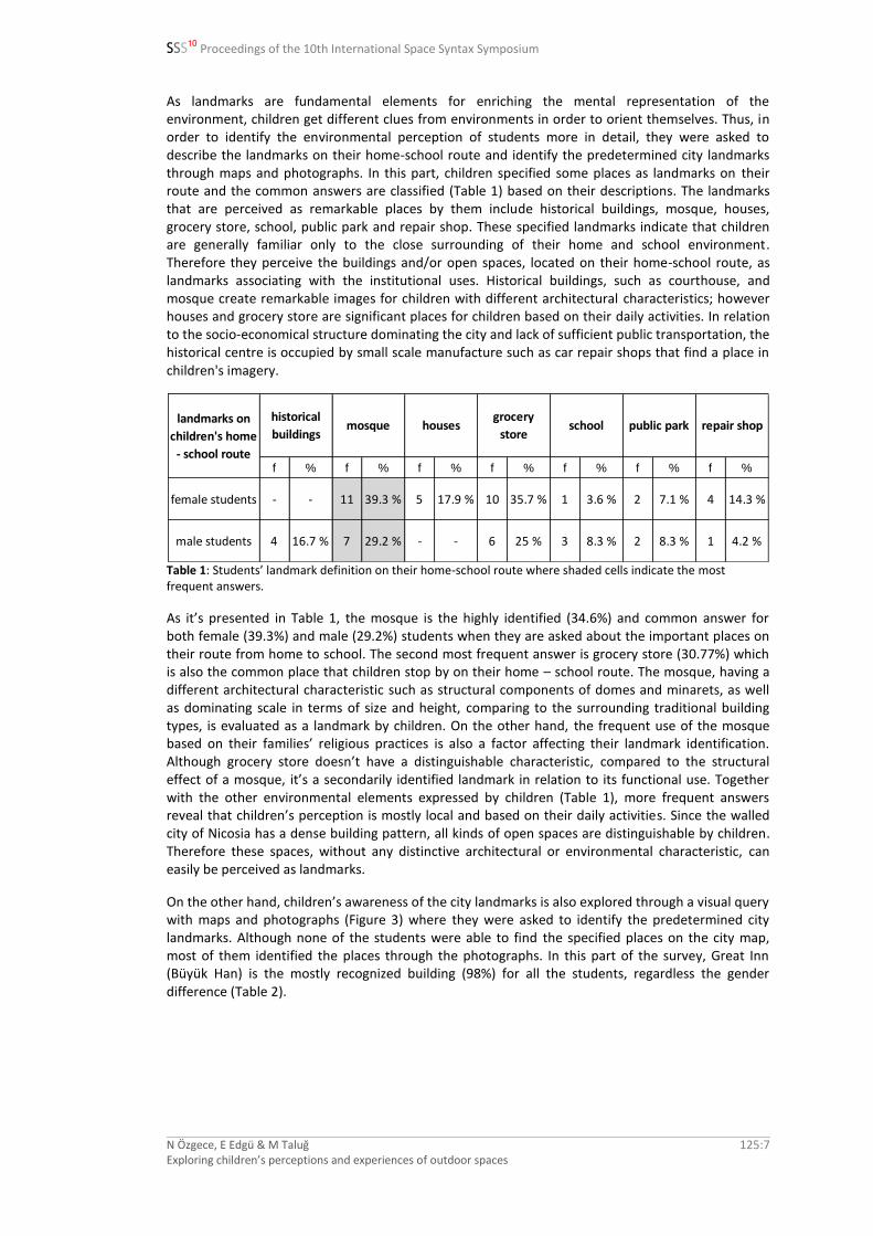
As landmarks are fundamental elements for enriching the mental representation of the environment, children get different clues from environments in order to orient themselves. Thus, in order to identify the environmental perception of students more in detail, they were asked to describe the landmarks on their home-school route and identify the predetermined city landmarks through maps and photographs. In this part, children specified some places as landmarks on their route and the common answers are classified (Table 1) based on their descriptions. The landmarks that are perceived as remarkable places by them include historical buildings, mosque, houses, grocery store, school, public park and repair shop. These specified landmarks indicate that children are generally familiar only to the close surrounding of their home and school environment. Therefore they perceive the buildings and/or open spaces, located on their home-school route, as landmarks associating with the institutional uses. Historical buildings, such as courthouse, and mosque create remarkable images for children with different architectural characteristics; however houses and grocery store are significant places for children based on their daily activities. In relation to the socio-economical structure dominating the city and lack of sufficient public transportation, the historical centre is occupied by small scale manufacture such as car repair shops that find a place in children's imagery.
f % f % f % f % f % f % f %
female students - - 11 39.3 % 5 17.9 % 10 35.7 % 1 3.6 % 2 7.1 % 4 14.3 %
male students 4 16.7 % 7 29.2 % - - 6 25 % 3 8.3 % 2 8.3 % 1 4.2 %
school public park repair shophistorical
buildingslandmarks on
children's home
- school route
mosque housesgrocery
store
Table 1: Students’ landmark definition on their home-school route where shaded cells indicate the most frequent answers.
As it’s presented in Table 1, the mosque is the highly identified (34.6%) and common answer for both female (39.3%) and male (29.2%) students when they are asked about the important places on their route from home to school. The second most frequent answer is grocery store (30.77%) which is also the common place that children stop by on their home – school route. The mosque, having a different architectural characteristic such as structural components of domes and minarets, as well as dominating scale in terms of size and height, comparing to the surrounding traditional building types, is evaluated as a landmark by children. On the other hand, the frequent use of the mosque based on their families’ religious practices is also a factor affecting their landmark identification. Although grocery store doesn’t have a distinguishable characteristic, compared to the structural effect of a mosque, it’s a secondarily identified landmark in relation to its functional use. Together with the other environmental elements expressed by children (Table 1), more frequent answers reveal that children’s perception is mostly local and based on their daily activities. Since the walled city of Nicosia has a dense building pattern, all kinds of open spaces are distinguishable by children. Therefore these spaces, without any distinctive architectural or environmental characteristic, can easily be perceived as landmarks.
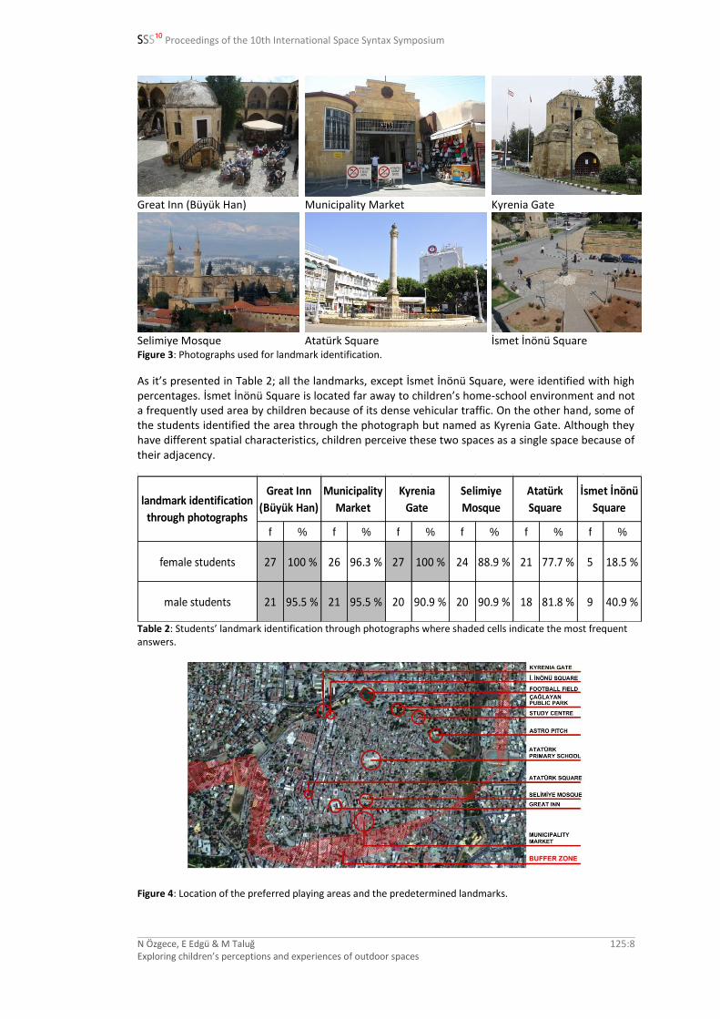
On the other hand, children’s awareness of the city landmarks is also explored through a visual query with maps and photographs (Figure 3) where they were asked to identify the predetermined city landmarks. Although none of the students were able to find the specified places on the city map, most of them identified the places through the photographs. In this part of the survey, Great Inn (Büyük Han) is the mostly recognized building (98%) for all the students, regardless the gender difference (Table 2).
SSS10 Proceedings of the 10th International Space Syntax Symposium
N Özgece, E Edgü & M Taluğ Exploring children’s perceptions and experiences of outdoor spaces
125:8
Great Inn (Büyük Han) Municipality Market Kyrenia Gate
Selimiye Mosque Atatürk Square İsmet İnönü Square Figure 3: Photographs used for landmark identification.
As it’s presented in Table 2; all the landmarks, except İsmet İnönü Square, were identified with high percentages. İsmet İnönü Square is located far away to children’s home-school environment and not a frequently used area by children because of its dense vehicular traffic. On the other hand, some of the students identified the area through the photograph but named as Kyrenia Gate. Although they have different spatial characteristics, children perceive these two spaces as a single space because of their adjacency.
f % f % f % f % f % f %
female students 27 100 % 26 96.3 % 27 100 % 24 88.9 % 21 77.7 % 5 18.5 %
male students 21 95.5 % 21 95.5 % 20 90.9 % 20 90.9 % 18 81.8 % 9 40.9 %
landmark identification
through photographs
Great Inn
(Büyük Han)
Municipality
Market
Kyrenia
Gate
Selimiye
Mosque
Atatürk
Square
İsmet İnönü
Square
Table 2: Students’ landmark identification through photographs where shaded cells indicate the most frequent answers.
Figure 4: Location of the preferred playing areas and the predetermined landmarks.

SSS10 Proceedings of the 10th International Space Syntax Symposium
N Özgece, E Edgü & M Taluğ Exploring children’s perceptions and experiences of outdoor spaces
125:9
The results indicate that the students are mostly aware of the city landmarks, shown in Figure 4, as they’re able to recognise the photographs. Nevertheless, they have problems in orienting themselves, through their environmental description and map survey, possibly as a result of the labyrinth like organic pattern of the Walled city. Although they couldn’t find the locations of the landmarks on the city map, most of them stated that they don’t get lost while walking around. The statement verifies the importance of landmarks in terms of way finding, as they are visually familiar to the most of the students. Students’ spatial preferences for playing are obtained through open ended questions. Responses related with the preferred playing areas, which are the most distinguishing answers representing the gender difference, are classified (Table 3) based on students’ identifications. Locations of these specific places, together with the predetermined city landmarks, are also shown in Figure 4.
f % f % f % f % f % f %
weekday - - 8 29.6 % 3 11.1 % 11 40.7 % 4 10.8 % - -
weekend - - 5 18.5 % - - 14 51.9 % 5 18.5 % 1 4.5 %
weekday 11 50 % 5 22.7 % 2 9.1 % 1 4.5 % 2 9.1 % - -
weekend 13 59.1 % 1 4.5 % 2 9.1 % 1 4.5 % 4 18.2 % 2 7.4 %
study centre neighbourhood public park homes of
relatives
female
students
male
students
spatial
preferences
for playing
football fieldhome /
home garden
Table 3: Students’ spatial preferences for playing where shaded cells indicate the most frequent answers.
Football Field Astro Pitch
Study Centre Çağlayan Public Park Figure 5: Public playing areas that are specifically preferred by students.
Results, presented in Table 3, indicate that female students mostly prefer to stay within their neighbourhood after school time (40.7%) whereas the rest prefers to play at home environment (29.6%), at Public Park (14.8%) or at Study Centre (11.1%). On the other hand, most of the male students stated that they prefer a football field for playing activities (50%) while the other majority group prefers to stay at home during weekdays (22.7%). Being the favourite place of male students, football field was also specified as the place that is preferred most for playing at the weekends (59.1%). Additionally, other places that were identified as playing areas through the interview are Public Park, Study Centre and their own garden/courtyard. Similarly to their weekday preferences,

SSS10 Proceedings of the 10th International Space Syntax Symposium
N Özgece, E Edgü & M Taluğ Exploring children’s perceptions and experiences of outdoor spaces
125:10
female students mostly prefer to play within their neighbourhood environment (51.9%). The public spaces that are specifically preferred for playing by students are shown in Figure 5.
According to the results, the possible reasons for the spatial preferences of female students are the tendency to stay in a defined environment due to both security and privacy concerns mainly imposed by their own families. On the contrary, male students seem to be more outdoor activity oriented as they mostly stated about playing football without any specific place definition in terms of distance to home-school route (Table 4).
f % f % f % f % f % f %
weekday 4 36.4 % 3 27.3 % 1 9.1 % 1 9.1 % 3 27.3 % 2 18.2 %
weekend 3 27.3 % 4 36.4 % - - 2 18.2 % 1 9.1 % 3 7.3 %
football field
preferences of
male students
astro pitch - 3
football field
(no any specific
definition)
astro pitch
(no any specific
definition)
football field astro pitch - 1 astro pitch - 2
Table 4: Football field preferences of male students where shaded cells indicate the most frequent answers.
Syntactic findings
Syntactic properties of the area are analysed through grid analysis with a span size of 1000 where integration-n, mean depth, compactness and occlusivity measurements are used for the spatial analyses of the significant places.
The integration-n analysis of the northern part of the Green Line in the Nicosia walled city, where the integration levels are graded from red zones (the highest integration levels) to the dark blue zones (the lowest integration levels) is presented in Figure 6. As mentioned before, although there's a connection to south of Nicosia, through Lokmacı Gate, since the children cannot pass the border without presence of their parents, we considered only the northern part of the city in our syntactic and perceptual evaluation. In this case, as the average global integration of northern part is 6,49x10
10, the highly integrated spaces in the city are mainly located around the Kyrenia Gate
expanding towards north-south and east-west directions denoting a shift from central squares to wider streets of fringes. As this is the main traffic and pedestrian entrance to the Walled city, integration levels derived from the syntactic structure of the area verify the responses of children related to photograph based landmark perception presented in Table 2.
Figure 6: Integration-n analysis of the northern part of the Green Line in the Nicosia walled city.

SSS10 Proceedings of the 10th International Space Syntax Symposium
N Özgece, E Edgü & M Taluğ Exploring children’s perceptions and experiences of outdoor spaces
125:11
Spaces children identify
İsmet İnönü Square, located on the east direction of Kyrenia Gate, has the most integrated spaces within the city. The main pedestrian and vehicular street of the city, Kyrenia Avenue, is the most integrated axis connecting the Kyrenia Gate and Atatürk Square (traditionally, Sarayönü). Two main public squares, İsmet İnönü Square and Atatürk Square, are spatially important areas as being the landmarks of the city which are also recognised by most of the children through visual query with photographs (Table 2). Although İsmet İnönü Square has higher integration levels comparing Atatürk Square (Figure 6, Table 5), majority of students recognised the area while the recognition level is lower for İsmet İnönü Square (Table 2). This is probably due to the existence of Venetian pillar as a prominent landmark on its own. On the other hand, İstanbul Street, originating from the İsmet İnönü Square and continuing towards the east side, has the second highest integration level. It should be noted that, this street is one of the main axes passing through the bastions connecting the interior and exterior of the circular organic pattern of the Walled city.
integration-n mean depth compactness occlusivity
6,49E+10 8,83E+06 1,12E+09 0.26E-01
Study Centre 7,35E+10 7,94E+06 1,35E+09 2,44E-01
Çağlayan Public
Park1,10E+11 8,33E+06 2,37E+09 1,40E-01
Football Field 1,02E+11 8,42E+06 2,56E+09 4,10E-02
Astro Pitch 7,49E+10 9,25E+06 1,23E+09 1,18E-01
Great Inn
(Büyük Han)7,76E+09 1,10E+07 6,26E+08 6,60E-02
Municipality
Market2,31E+10 1,07E+07 7,37E+08 3,32E-01
Kyrenia Gate 2,14E+11 5,95E+06 1,31E+09 1,81E-01
Selimiye Mosque 2,23E+10 1,07E+07 8,01E+08 1,87E-01
Atatürk Square 1,88E+11 6,20E+06 9,81E+08 1,93E-01
İsmet İnönü
Square2,15E+11 6,13E+06 1,41E+09 2,32E-01
mean syntactic values
northern part of the walled city
of Nicosia
sp
ati
al p
refe
ren
ce
s o
f
stu
de
nts
fo
r p
lay
ing
lan
dm
ark
s
preferred / identified mostly by
females
preferred / identified mostly by
males
most preferred / identified in
common Table 5: Mean syntactic values of the northern part of the walled city of Nicosia in relation to preferred public playing areas and identified predetermined landmarks.
Although Great Inn is the mostly identified landmark through photographs (Table 2), the integration value presents a lower degree (Table 5), as it is located closer to the buffer zone which is also the boundary of the analysed area, as it’s seen in Figure 6. It’s important to emphasise that the inner parts of the city mostly present lower integration levels due to the denser housing structure and the narrow winding streets. In this regard, Municipality Market and Selimiye Mosque, being the other mostly recognised landmarks (Table 2), don’t have higher integration levels in terms of syntactic structure. However, it should be mentioned that; within the semi urban scale of the walled city, which represents the accessible areas for children, Great Inn and Municipality Market seem to be located at the deeper parts of the city because of the borderline.

SSS10 Proceedings of the 10th International Space Syntax Symposium
N Özgece, E Edgü & M Taluğ Exploring children’s perceptions and experiences of outdoor spaces
125:12
Spaces children play
Çağlayan Public Park, as one of the identified spaces for playing activities, presents a high integration-n level (1,10x10
11) of the northern side of the city, as it’s presented in Table 5. This place
has higher global integration value than the mean of the Walled city itself; therefore it is natural for the students to socialize in this section. Although it’s seen that the area is mostly preferred by female students both at weekday and weekend (Table 3), it’s also the most common preferred area for playing activities (Table 5). Being the most integrated area comparing to other preferred playing areas, Football Field is not stated specifically by male students although most of them stated that they prefer a football field for playing (Tables 3, 4 and 5, Figure 6). Results of syntactic analysis also indicate that the Astro Pitch is in moderate degree of integration levels which is preferred by some male students for outdoor playing for both weekend and weekday (Tables 4 and 5, Figure 6). On the other hand, Study Centre is another preference for both female and male students for playing activities where the mean integration n level is 7.35x10
10. In spite of having a low integration level
comparing to the other outdoor playing areas, Study Centre is preferred probably because of the functional use. It’s also a common activity area for the children living in the Walled city as it has a well defined and protected playing area.
Occlusivity analysis is an important spatial characteristic that helps to examine the identified playing areas as it presents the surprising spaces within the city which can be a factor affecting the student’s space preferences for playing. Benedikt (1979) includes occlusivity definition among his six geometric measures of isovist fields as the length of occluding boundaries within the isovist. As Kaynar, (2004) suggests, since these boundaries are the non physical surfaces of the isovist, occlusivity value provides the degree of perceptual uncertainty within the isovist. Kalff, et al (2010) on the other hand, emphasized that occluded portions of the isovist are still permeable. When occlusivity value is high, space encourages people to move along the path to discover the unforeseen views. Therefore occlusivity value presents the surprise factor within a space.
Through the occlusivity analysis of the preferred playing areas, the results indicate that the Study Centre presents most surprising spaces within the system which is preferred by both female and male students for playing activities (Table 5, Figure 7). Having a higher occlusivity level (1, 40E-01) comparing to the average occlusivity level of the city (0, 26E-01), the Public Park is more attractive for female students for playing, as it is preferred more frequently than male students both during weekdays and weekends. Within the overall analysis based on space preferences, results indicate the spaces with high occlusivity levels are preferred mostly by female students (Tables 3 and 5), probably as it offers more privacy. Contrarily, majority of male students preferred the area with the lowest occlusivity, probably in accordance with their activity oriented spatial preferences requiring a wider range of visual field.
Figure 7: Occlusivity analysis of the northern part of the walled city of Nicosia.
SSS10 Proceedings of the 10th International Space Syntax Symposium
N Özgece, E Edgü & M Taluğ Exploring children’s perceptions and experiences of outdoor spaces
125:13
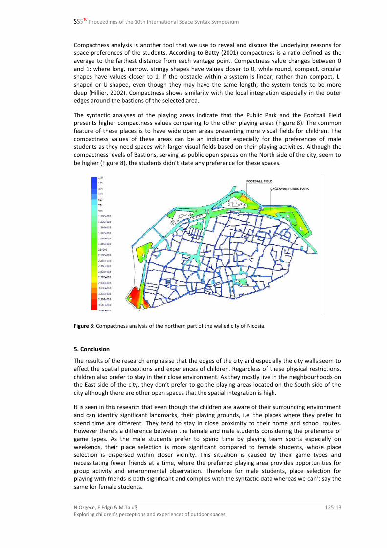
Compactness analysis is another tool that we use to reveal and discuss the underlying reasons for space preferences of the students. According to Batty (2001) compactness is a ratio defined as the average to the farthest distance from each vantage point. Compactness value changes between 0 and 1; where long, narrow, stringy shapes have values closer to 0, while round, compact, circular shapes have values closer to 1. If the obstacle within a system is linear, rather than compact, L-shaped or U-shaped, even though they may have the same length, the system tends to be more deep (Hillier, 2002). Compactness shows similarity with the local integration especially in the outer edges around the bastions of the selected area.
The syntactic analyses of the playing areas indicate that the Public Park and the Football Field presents higher compactness values comparing to the other playing areas (Figure 8). The common feature of these places is to have wide open areas presenting more visual fields for children. The compactness values of these areas can be an indicator especially for the preferences of male students as they need spaces with larger visual fields based on their playing activities. Although the compactness levels of Bastions, serving as public open spaces on the North side of the city, seem to be higher (Figure 8), the students didn’t state any preference for these spaces.
Figure 8: Compactness analysis of the northern part of the walled city of Nicosia.
5. Conclusion
The results of the research emphasise that the edges of the city and especially the city walls seem to affect the spatial perceptions and experiences of children. Regardless of these physical restrictions, children also prefer to stay in their close environment. As they mostly live in the neighbourhoods on the East side of the city, they don’t prefer to go the playing areas located on the South side of the city although there are other open spaces that the spatial integration is high.
It is seen in this research that even though the children are aware of their surrounding environment and can identify significant landmarks, their playing grounds, i.e. the places where they prefer to spend time are different. They tend to stay in close proximity to their home and school routes. However there’s a difference between the female and male students considering the preference of game types. As the male students prefer to spend time by playing team sports especially on weekends, their place selection is more significant compared to female students, whose place selection is dispersed within closer vicinity. This situation is caused by their game types and necessitating fewer friends at a time, where the preferred playing area provides opportunities for group activity and environmental observation. Therefore for male students, place selection for playing with friends is both significant and complies with the syntactic data whereas we can’t say the same for female students.

SSS10 Proceedings of the 10th International Space Syntax Symposium
N Özgece, E Edgü & M Taluğ Exploring children’s perceptions and experiences of outdoor spaces
125:14
In this research it is also seen that selection of spaces along the boundary of the case study area was more significant than identified landmarks. As being surrounded by a dried ditch, thus being located on higher grounds, the bastions become memorable especially for the children. Therefore selection of these places for playing area is not only confirmed by syntactic outcomes but with imagination as well.
References
Batty, M. (2001), ‘Exploring isovist fields: space and shape in architectural and urban morphology’. Environment and Planning B, 28(1), p. 123-150.
Benedikt, M. L. (1979), ‘To take hold of space: isovists and isovist fields’. Environment and Planning B, 6(1), p. 47-65.
Canter, D. (1977), The Psychology of Place, New York: St. Martin’s Press. Downs, R. M. and Stea, D. (1973), ‘Cognitive Maps and Spatial Behavior: Process and Products, In: Downs, R. M.
and Stea, D. (eds.), Image & Environment: Cognitive Mapping and Spatial Behavior, Chicago: Aldine Transaction, p. 8-26.
Fishman, L. (2001), ‘Child's Play: An empirical study of the relationship between the physical form of schoolyards and children's behavior’. Available at: <www.yale.edu/hixon/research/pdf/LFisman_Playgrounds.pdf>
Gärling, T. and Golledge, R. G. (1989), ‘Environmental Perception and Cognition’. In: Zube, E. H. and Moore, G. (eds.), Advances in Environment, Behavior, and Design, New York: Plenum Press, p. 203-236.
Golledge, R., (1999): Human Wayfinding and Cognitive Maps. In: Golledge, R. (Ed.), Way-finding Behavior - Cognitive Mapping and Other Spatial Processes, Baltimore: Johns Hopkins Univer-sity Press, p. 5-45.
Hillier, B., (2002), ‘A theory of the city as object: Or, how spatial laws mediate the social construction of urban space’. Urban Design International, 7, pp.153-179.
Kaynar, İ. (2004), Visibility, movement paths and preferences in open plan museums: An observational and descriptive study of the Ann Arbor Hands on Museum, Paper presentation, University of Michigan.
Kalff, C., Kühner, D., Senk, M., Conroy Dalton, R., & Hoelscher, C. (2010), Turning the Shelves: Empirical findings and Space Syntax analyses of two virtual supermarket variations.
Lang, J. (1987), Creating Architectural Theory: The Role of the Behavioral Sciences in Environmental Design, New York: Van Nostrand Reinhold.
Lynch, K. (1960), The Image of the City, Cambridge: MIT Press. Moore, R. C. & Wong, H. H. (1997), Natural Learning: The Life History of an Environmental Schoolyard: Creating
Environments for Rediscovering Nature's Way of Teaching, Berkley, CA: MIG Communications. Tolman, E. C. (1948), ‘Cognitive maps in rats and men’. Psychological Review, 55, p. 189-208. Tuan, Y. (1977), Space and Place, University of Minnesota Press, the United States of America. White, R. & Stoecklin, V. (1998), ‘Children's Outdoor Play & Learning Environments: Returning to Nature’. In
Early Childhood News, March/April 1998 Issue. Available at: <www.whitehutchinson.com/children/articles/outdoor.shtml>
Yavuzer, H. (1992), Resimleriyle Çocuk, İstanbul: Remzi Kitabevi AŞ.