explorers club flag 60 report · chinese people migrated into the region. ... [email protected]...
TRANSCRIPT

EXPLORERS CLUB FLAG 60 REPORTArchaeological Exploration of Lop Nor Desert Xinjiang, China.
November 17th 2007 – January 1st 2008
Dr. Christoph Baumer, FI’04President, Society for the Exploration of EurAsia
Fellow of The Royal Asiatic Society and of The Royal Geographical Society
Dwelling L.M. i (1)
© Christoph Baumer

1
Table of Contents Page
I Summary 1
II Introduction & Background 3
III Objectives 4
IV Expedition Members & Areas of Responsibility 4
V Methods 5
VI Expedition Route 6
VII Findings & Results 7
A. Desert Crossing 7- 8
B. Target Area 9-19
VIII Main Conclusions & Open Questions 20
Appendices 21
Endnotes
Acknowledgement
Photo Credits
I Summary
This Flag 60 Report describes the findings from the crossing of the central western part of the Lop Nor Desert never surveyed so far and from the systematic archaeological exploration of a search area c. 177 sq. km large. The two fortresses Haitou (L.K.) and L.M. as well as the settlement L.M., found in 1914 by Sir Aurel Stein, were rediscovered and the alleged existence of another settlement L.R, found in 1915 by one of Stein’s surveyors, was confirmed. All sites date from the Han (202 BC – 220 AD), Wei (220-265 AD) and Western Jin Dynasties (263-316 AD).
F.l.t.r. Ernst Rüegg, Dr. Christoph Baumer FI’04, Urs Möckli, Ueli Nüesch (2)
© Christoph Baumer

2
Des
ert T
akla
mak
an w
ithin
the
Tarim
Bas
in (3
)
© N
atur
al V
ue C
opyr
ight
MD
A F
eder
al In
c.; G
AF
AG
, Mun
ich;
Urs
Möc
kli
3
The Lop Nor area forms with its surface of c. 52.000 sq. km the most eastern part of the Taklamakan Desert in the Uigur Autonomous Region Xinjiang, P.R. China. It is one of the least researched regions of Central and Eastern Asia due to its hostile environment, harsh climatic conditions and the fact that the northern edge of Lop Nor was used from 1964 to 1996 for atmospheric and subterranean nuclear tests.
The Lop Nor was partly explored in the first three decades of the 20th century by explorers such as Sven Hedin, Sir Aurel Stein, Folke Bergman and Parker Chen. From 1935 to 1994 it was closed to Westerners. As of the 1950s, a few Chinese expeditions went to Loulan L.A. In the late 1970s and early 1980s, important discoveries were made in northern Lop Nor. Namely around Loulan, the discovery of 4000-years old mummies of Indo-European stock and of the tomb of Yingpan in the north-western area. Then, in 2002-2005, a 4000-3500 years old necropolis was excavated at Xiaohe in the north-western corner of Lop Nor. All these discoveries prove that two to four millennia ago the Lop Nor area was more fertile than today.
Lop Nor and the other eastern parts of the Taklamakan Desert were first home of the Proto-Tocharians, who were of Indo-European stock and probably migrated before 2000 BC into the Lop Nor area from Southern Siberia and Western Mongolia. As of the 8./7th centuries BC, Mongolian, and then later, Chinese people migrated into the region. Most of Lop Nor belonged to the Kingdom of Loulan, which was subjugated in 176 BC by the Xiongnu of Turco-Mongolian stock and became in 108 BC for the first time a tributary to China. As of the 4th century AD, most places in the Lop Nor started to be abandoned due to lack of water, as the River Tarim changed its course of flow around 320-330 AD. After a place called Yuli, south of today’s Korla, it stopped flowing eastward to Loulan, but flowed southward in the direction of Qarkilik. The oases in Lop Nor were fully dependent from glacial water feeding the Tarim.
Between the 2nd century BC and the 4th-5th centuries AD two of the Silk Road branches passed through Lop Nor. Both started at the Jade Gate Yumen Guan, 80 km west of present Dunhuang, and ran 380 km westwards to the fortified city of Loulan, Stein’s L.A., where they bifurcated. 1 The northern one followed the ancient River Tarim further westwards and reached the ancient Kingdom of Kuqa, while the central one headed south-westwards through Lop Nor to Miran and then to Qiemo (Calmadana), Niya and Khotan. The distance between Loulan and Miran was c. 150 km as the crow flies, however after 55 km trade caravans would reach the two fortresses of L.K. and L.L. The original name of L.K. is revealing, for it means ‘lake’ (hai) ‘head’ (tou), suggesting that Haitou once stood at the south-western shore of ancient Lake Lop Nor, at whose northern end Loulan was situated.
In addition to the change of flow of the Tarim, the collapse in western China of the regional dynasties of the Former Liang (320-376 AD) and Later Liang (386-403 AD) further damaged trade on these Silk Roads.
The Uigur hunter Tokhta Akhun first discovered L.K. in 1910 and led Aurel Stein there in February 1914, following the ancient central Silk Road from Miran to Loulan. Stein briefly investigated L.K. and the second fortress L.L. as well as a nearby settlement labelled L.M. One year later, his surveyor Afraz Gul chanced upon a second settlement called L.R. without investigating it. Apart from Afraz Gul, nobody ever saw L.M. and there existed neither sketch plans nor photographs. 2 The only other expedition able to reach L.K. and L.L. after Stein was a Chinese survey team in 1988, but it failed finding both settlements. Like Stein, it came from the south. It 1994, Christoph Baumer failed to reach L.K. from the south due to an accident and missed the site by c. 6 km.
No archaeological expedition ever attempted to reach these four sides from the west and to cross the central western part of Lop Nor. No map exists of western Lop Nor and Aurel Stein’s maps of the region between Miran, L.K. and L.A. were useless for our expedition since they are flawed by major triangulation mistakes affecting longitudinal indications. 3
II Introduction & Background

4
III Objectives
1. To explore the unknown central western part of the Lop Nor Desert between the southern course of the former River Tarim (dried up in 1921) and the fortress L.K. and to search for possible traces of ancient trading routes and ruins unknown so far. 2. To find the fortresses L.K. and L.L., and to rediscover the settlements of L.M. and L.R. not visited since 1914 respectively 1915. 3. To investigate, survey and document these four sites and explore their surroundings.4. To search for new, unknown ruins and cultural relics, in order to pave the way for future archaeolo-gical expeditions. 5. To contribute to the understanding of the hydrological changes in the western part of Lop Nor which led to the desertification of this once more fertile region.
IV Expedition Members & Areas of Responsibility
Dr. Christoph Baumer, Switzerland. Expedition leader, archaeologist and photographer. Leader of three previous expeditions into the desert Taklamakan 1994, 1998, 2003. [email protected] [email protected]
Urs Möckli, Switzerland. Photographer and navigator. Member of the Taklamakan Desert expedition 1998. [email protected]
Ueli Nüesch, Switzerland. Film producer and cameraman. [email protected] 4
Ernst Rüegg, Switzerland. Surveyor. Member of the Taklamakan Desert expedition 1998. [email protected]
Chinese support team: Organizer/translator, cook, three truck drivers, one mechanic.
The team at the end of the expedition (4)
© Christoph Baumer

5
V Methods
Orientation:Two different satellite pictures were purchased over which a coordinate grid based on the World Geo-detic System WGS 84 was laid:
1. A 15m/pixel Landsat picture of total Lop Nor was used for navigation in the unknown western part of Lop Nor.
Satellite picture of Lop Nor (5)
2. A high resolution 63cm/pixel Quickbird picture of the rectangular, c. 177 sq km large search area defined by the following coordinates:North/top: N 40° 12’ 00’’/ E 89° 36’ 50’’East/right: N 40° 07’ 00’’/ E 89° 43’ 70’’South/bottom: N 40° 02’ 00’’/ East 89° 40’ 25’’West/left: N 40° 07’ 00’’/ East 89° 33’ 00’’
32 spots were identified for investigation on foot. They were divided between Christoph Baumer, Urs Möckli and Ernst Rüegg and individually investigated. In order to find the settlements L.M. and L.R., certain areas were systematically searched in a close-meshed way. Logistics:Due to the length of the expedition, the expected total lack of water and the short duration of daylight, camels were disregarded as means of transport and special desert trucks were rented from an oil com-pany based in Korla. They were modified MOL trucks with DEUTZ engines. Everything, including 5000 kg of diesel, had to be brought along.
© Natural Vue Copyright MDA Federal Inc.; GAF AG, Munich; Urs Möckli
6
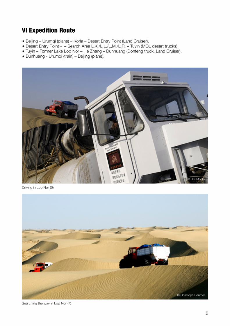
VI Expedition Route
• Beijing – Urumqi (plane) – Korla – Desert Entry Point (Land Cruiser).• Desert Entry Point - – Search Area L.K./L.L./L.M./L.R. – Tuyin (MOL desert trucks).• Tuyin – Former Lake Lop Nor – He Zhang – Dunhuang (Donfeng truck, Land Cruiser).• Dunhuang - Urumqi (train) – Beijing (plane).
Driving in Lop Nor (6)
Searching the way in Lop Nor (7)
© Christoph Baumer
© Urs Möckli

7
A. Desert CrossingThe crossing of the western part of the Lop Nor Desert from the Desert Entry Point at N 39° 59’ 17.4”/ E 88° 21’ 49.5” to the first target L.K. stretched over a distance of 113 km as the crow flies and took us 10 full days of hard work. We started at dawn and stopped at dusk, putting up the tents in the light of the trucks’ headlights. Progress over the up to 50 m high sand dunes and soft, mesa-like yardangs – chalk deposits on the bottom of former lakes – was made additionally difficult by the fact that 90% of the winds blow from the north-east, which means that we had to climb the dunes on the soft lee side.
VII Findings & Results
Freshwater snails on the ground of Lop Nor (8)
10 km east of Desert Entry Point we chanced upon the remains of a 10 x 4 m large stable consisting of a fence made by poplar branches aligned in straight lines and reed. No objects were found. Since it stands 10 km from the edge of the desert, it might be c. 200-300 years old.
16 km east of the Desert Entry Point we discovered on a 2 m high elevation the ruin of a small dwel-ling 10 x 8.5 m in size consisting of two rooms and stables. Based on the scraps of linen and cotton textiles found, it is judged to be about 300-500 years old. Probably it served as an occasional shelter for sheep herdsmen as suggested by ancient sheep and goat droppings. Since it practically never rains in the desert for decades, organic matters remain for centuries. Next to the shelter stood living tamarisk trees called tograk in Uigur language. 5
About 35 to 40 km east of the Desert Entry Point all life stopped. We saw no traces of fauna, except the bleached and very worn skulls of two deer, and all flora remaining, e.g. tamarisks and poplars, were dead. There were even no insects.
Pieces of petrified horsetails indicate that life flourished in this part of the desert millennia ago.
Accumulations of ancient freshwater snails (exact determination of type follows) testify to formerly flowing and standing waters.
•
•
•
•
•
© Christoph Baumer

8
The fact that we found several times yardangs on the top of lower dunes and not only at their bottom indicates, that the bottom of the former lake (or lakes) was uneven with elevations up to c. 20-25 m.
Between the shelter and a point 14 km west of L.K., a distance of 83 km as the crow flies, we found no cultural relic whatsoever, neither ruin, nor shards, nor flints. Also no indicators of an ancient trading route.
14 km west of L.K., the first Neolithic flint was found.
•
•
•
On top of a sand dune (9)
© Christoph Baumer

9
B. Target Area
1. L.K. and surroundingsThe fortress L.K was found based on the high resolution picture. Along an ancient riverbed, hundreds of dead poplar trees lined both shores for a length of c. 2 km starting 2.7 km south-west of the fort. Another long row of dead poplars stands in a similar distance in the south-east of L.K. The fort has an irregular ground shape of c. 190 x 102 m, the walls reached a height of 6.5 to 7 m and were crowned by a parapet. At their base they are 9.5 m thick, at the top c. 2.3 m. The walls are built of air-dried clay bricks of different sizes ranging from 70 x 50 cm to 50 x 35 cm. Layers of clay alternate with layers of poplar trunks and tamarisk branches.
Satellite picture of fort L.K. “Haitou” (10)
Fort L.K. seen from the south (11)
© Christoph Baumer
© LANDinfo Worldwide mapping LLC; GAF AG, Munich; Urs Möckli

10
The upper third of the southern wall is singed on the outer side; some layers of poplar and tamarisks have burnt.
Inside L.K., most of the wooden pillars still standing on Steins photograph dating from 1914, have fallen to the ground. It is unknown if they fell due to Stein’s excavation or due to continued aeolian erosion.
Like Stein, we found very few relics such as various pottery shards, a stone spindle, a clay spindle, blue glass beads, a millstone, fragments of coins, 2 ropes made out of camel hair. 6
The excavation of a two-storeyed construction north of the eastern gate, which was covered by a dune at Stein’s time, yielded only minor pieces of cotton textiles, a round granite ball used as a pestle and dozens of bones from sheep, goats and birds.
Like Stein, we did not find any inscription on wood, leather, silk or paper.
•
•
•
•
•
Within a 5 km perimeter around L.K were found on the surface: 2 probably ceremonial green jade axes, a worked piece of yellow serpentine in the shape of a miniature stele, 3 stone spindles, coarse red, black and grey pottery from the Han (202 BC–220 AD), Wei (220-265 AD) and Western Jin Dy-nasties (263-316 AD).
•
Ceremonial jade axe (14) Christoph Baumer, FI’04, inside Fort L.K. (13)
Inside Fort L.K. (12)
© Christoph Baumer
© Urs Möckli© Urs Möckli

11
The
targ
et a
rea
of th
e ex
pedi
tion
with
all
maj
or r
uin
com
plex
es (1
5)
© N
atur
al V
ue C
opyr
ight
MD
A F
eder
al In
c.; G
AF
AG
, Mun
ich;
Urs
Möc
kli

12
2. L.L. and surroundingsThe fortress L.L. lies 5 km north-west of L.K. and is visible with the naked eye from there. It stands 600 m south of a dry riverbed. Its construction method is similar to L.K, but its shape is, with c. 67 x 42 m, smaller. On the western side stretches a more than 100 m long dune which the wind has brought through the large breach in the eastern wall and carried over the western wall.
50 m north of L.L. stood an isolated building of unknown function; only a few worked beams remain on top of a small mesa.
Inside the fort, nothing remains standing. On the eastern side, wooden pillars stemming from the gate lie on the ground; also on the inner northern part a few worked beams lie on the ground.
Inside L.L. we find: the neck and handle of a red ceramic pot, a wuzhou coin, a bronze heart shaped locket, a millstone, a black stone spindle, yellow glass beads and apricot kernels.
On the south-eastern part of L.L. stands a separate, probably once two-storeyed construction, measuring 20 x 20 m. After a 40 cm thick layer of sand only strongly singed wood was brought to light by the excavation.
•
•
•
•
Sketch of Fort L.L. (17)
Fort L.L. seen from south-east (16)
© Christoph Baumer
© Ernst Rüegg, Urs Möckli
13
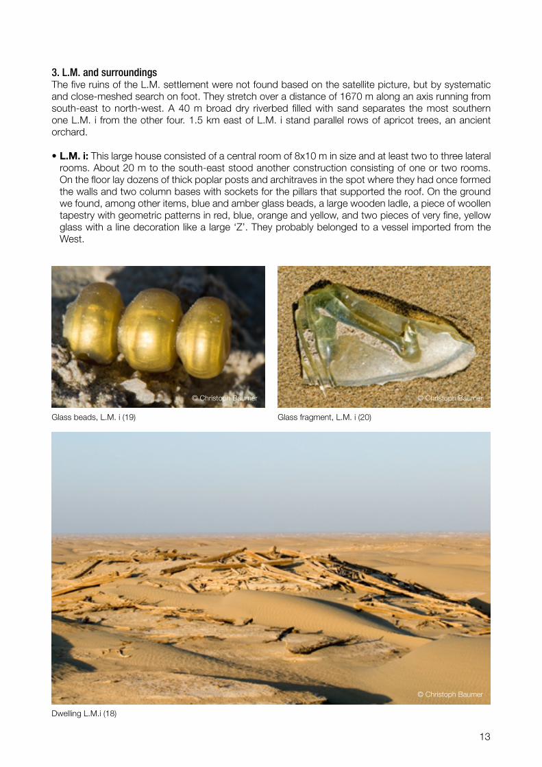
3. L.M. and surroundingsThe five ruins of the L.M. settlement were not found based on the satellite picture, but by systematic and close-meshed search on foot. They stretch over a distance of 1670 m along an axis running from south-east to north-west. A 40 m broad dry riverbed filled with sand separates the most southern one L.M. i from the other four. 1.5 km east of L.M. i stand parallel rows of apricot trees, an ancient orchard.
L.M. i: This large house consisted of a central room of 8x10 m in size and at least two to three lateral rooms. About 20 m to the south-east stood another construction consisting of one or two rooms. On the floor lay dozens of thick poplar posts and architraves in the spot where they had once formed the walls and two column bases with sockets for the pillars that supported the roof. On the ground we found, among other items, blue and amber glass beads, a large wooden ladle, a piece of woollen tapestry with geometric patterns in red, blue, orange and yellow, and two pieces of very fine, yellow glass with a line decoration like a large ‘Z’. They probably belonged to a vessel imported from the West.
•
Glass beads, L.M. i (19) Glass fragment, L.M. i (20)
Dwelling L.M.i (18)
© Christoph Baumer © Christoph Baumer
© Christoph Baumer

14
L.M. ii: Inside the main room (10.8 x 8.1 m) lay four poplar bases with sockets at their original place indicating where the beams once supported the roof. The floor was covered with more than 70 bron-ze coins of two types: A few „wuzhou“ coins and mostly Kuqa small coins without inscription which were cast in the Chinese vassal Kingdom of Kuqa. Also a copper vessel affixed to a hollow bronze rod was found on the ground, maybe it was part of an oil lamp. Additionally, a 4 cm long, tubular, greenish-blue glass bead and an aquamarine glass bead consisting of five flattened spheroids clin-ging together were found.
•
Kuqa Wuzhou coins, dwelling L.M. ii (22) Kuqa Wuzhou coins, dwelling L.M. ii (23)
Dwelling L.M. ii (21)
© Christoph Baumer © Christoph Baumer
© Christoph Baumer

15
L.M. iii: A few pillars and two bases with sockets remained on the floor; on the top of the 4 m high mesa lay a very well preserved green jade axe.
L.M. iv: As at L.M. iii, only a few pillars and two bases with sockets remained on the floor. South of the ruin, the strong winds have eroded the ground 7 m deep.
L.M. v: Also here, only a few pillars and two bases with sockets were left. Both fortresses are visible from here; the distance to L.K. is 10.8 km.
Other: Small heaps of shards standing between the five ruins indicate either kilns or, more probably, former dwellings only built out of clay. 450 m south-east of L.M. i, fragments of a c. 10 cm high bron-ze pot with fine line and circle decorations were found.
•
•
•
•
Christmas in Lop Nor (24)
© Urs Möckli

16
4. L.R. and surroundingsThe three ruins of the L.R. settlement, not visited by Aurel Stein, were not found based on the satellite picture, but by systematic and close-meshed search on foot.
L.R. i: The ruin is not a dwelling, as suggested by Stein based on Afraz Gul’s description, but a beacon tower. It consists of two sections lying on the top of separate small mesas, 3 and 4 metres high. On the lower one lay fine poplar posts and branches; on the higher one two piles of unusually thick and long beams, some of which had fallen to the ground. Their shape is not as usual round, but rectangular or square. The top of the mesa is crowned by a 1.5 m high, tight layer of poplar branches and covered by rough blocks of clay, recalling the construction method used at both fortresses. Two beams 4.5 metres long had 11 holes and notches, once serving as an architrave and as a lower cross-beam for the wall-supporting pillars lying next to them. On the western side of the mesa lay two short beams measuring 85 centimetres, at both ends of which 25 centimetre-long wooden pegs were stuck. They were two window frames.
Like those standing west of Dunhuang and along the Konqe Darya near Yingpan, this tower would have consisted of a c. five-metre-high mesa with a room on top, built out of strong wooden beams and thick layers of mud. The only entrance would have been here, reached either by a ladder that could be lifted, or by a rope. The two window frames formed the embrasures for archers. It is the first beacon tower ever found inside Lop Nor.
•
Beacon tower L.R. i ( 25)
© Christoph Baumer

17
L.R. ii: At this dwelling, more than 30 wooden posts forming the outer walls are still standing, some of them badly eroded by the wind. Attached to one huge poplar pillar was its wooden capital with scroll-shaped brackets at each end cut in one piece, looking similar to a Ionic volute.
•
Site L.R.: f.l.t.r the bottom of tower L.R. i, dwellings L.R ii and L.R. iii (26)
Dwelling L.R. iii with freshwater snails in the foreground and a capital on the right. (27)
© Christoph Baumer
© Christoph Baumer
18
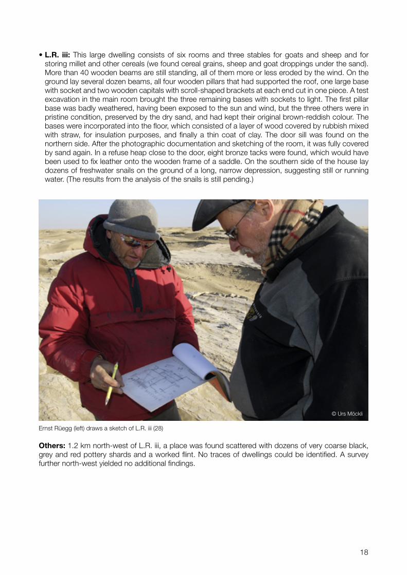
L.R. iii: This large dwelling consists of six rooms and three stables for goats and sheep and for storing millet and other cereals (we found cereal grains, sheep and goat droppings under the sand). More than 40 wooden beams are still standing, all of them more or less eroded by the wind. On the ground lay several dozen beams, all four wooden pillars that had supported the roof, one large base with socket and two wooden capitals with scroll-shaped brackets at each end cut in one piece. A test excavation in the main room brought the three remaining bases with sockets to light. The first pillar base was badly weathered, having been exposed to the sun and wind, but the three others were in pristine condition, preserved by the dry sand, and had kept their original brown-reddish colour. The bases were incorporated into the floor, which consisted of a layer of wood covered by rubbish mixed with straw, for insulation purposes, and finally a thin coat of clay. The door sill was found on the northern side. After the photographic documentation and sketching of the room, it was fully covered by sand again. In a refuse heap close to the door, eight bronze tacks were found, which would have been used to fix leather onto the wooden frame of a saddle. On the southern side of the house lay dozens of freshwater snails on the ground of a long, narrow depression, suggesting still or running water. (The results from the analysis of the snails is still pending.)
•
Others: 1.2 km north-west of L.R. iii, a place was found scattered with dozens of very coarse black, grey and red pottery shards and a worked flint. No traces of dwellings could be identified. A survey further north-west yielded no additional findings.
Ernst Rüegg (left) draws a sketch of L.R. iii (28)
© Urs Möckli

19
The four sites form a 14.1-kilometre, virtually straight line stretching from L.K. in the south-east to L.R. in the north-west.
The tower L.R. i and both fortresses had direct contact with each other via smoke and fire signals.
The axis of the long side of all dwellings and both forts was oriented to the north-east so that the winds blowing from there would only hit the short side, causing less damage.
A bronze wuzhou coin from Emperor Zhaodi (ruled 87-74 BC) was found 48 km north-north-east of L.R. and 15 fragments from a bronze plate or vessel where chanced upon.
All remaining target spots identified on the high resolution satellite picture were either round or rectan-gular formation of yardangs or ancient trees which had fallen by chance at a right-angle.
•
•
•
•
•
5. Other findings
Wuzhou coin of Emperor Zhaodi (ruled 87-74 BC) (29)
Target point 32 with natural formations (30)
© Urs Möckli
© LANDinfo Worldwide mapping LLC; GAF AG, Munich; Urs Möckli

20
No other ruins visible above the ground are expected to be found within the search area.
Ancient dry riverbeds, lines of dead poplars and freshwater snails indicate that the region consisted until c. 1600 years ago of a patchwork of meandering rivers, shallow waters, reed, poplar groves and spreading sand dunes. It was the lower part of a delta of a tributary of the former River Tarim flowing until c. 320-330 AD towards Loulan, roughly comparable to the delta of the Okavango in Botswana in dry seasons.
•
•
At L.M. and L.R., apricots were grown and probably also millet; sheep and goats were raised. The inhabitants probably supplied themselves.
The beacon tower L.R. i suggest, that the two settlements were threatened in spite of being close to both fortresses.
The aeolian erosion in Lop Nor is significantly stronger than in the more western parts of the Takla-makan Desert.
Several questions remain open: Why were two fortresses built so close to each other? Why and when exactly (probably towards the end of the 4th century AD) where these four sites abandoned? Has Buddhism reached the sites? (Neither Stein nor we found clear signs apart from a very few scraps of paper.) Where is the graveyard located?
•
•
•
•
VIII Main Conclusions and Open Questions
Dead forest along an ancient riverbed south of L.K. (31)
The camp at night (32)
© Christoph Baumer
© Urs Möckli

21
Appendices
Endnotes1 Stein labelled all ruins he visited in Lop Nor with two letters: The first ‘L’ stands for ‘Loulan’ and the second Stein allocated in the chronological order of his visits.
2 Stein, Marc Aurel, Innermost Asia (Clarendon, Oxford, 1928) pp.180-204, 746.
3 Stein, Marc Aurel and Masson, Major K, Memoir on Maps of Chinese Turkistan and Kansu (Trigonometrical Survey Office, Dehra Dun, 1923) pp.79, 81, 83, 85, 87, 95.
4 The video documentation is as per March 2008 in post-production.
5 As required by the local authorities we do not publish at this time coordinates of cultural relics found.
6 As agreed with local authorities, we left all findings in situ after photographing them.
AcknowledgementI would like to thank the following persons whose help was essential:
Mr. Klaus Dobler, Germany, for installing the FUGAWI navigation software on the expedition’s note-book and for his instructions.
Mr. Felix Neukom from SWISSPHOTO, Switzerland, for putting the coordinate grid over the satellite pictures.
GAF AG, Munich Germany, for allowing the non-commercial publication of the satellite pictures.
Photo CreditsChristoph Baumer: 1, 2, 4, 7, 8, 9, 11, 12, 16, 18, 19, 20, 21, 22, 23, 25, 26, 27, 31LANDinfo Worldwide mapping LLC; GAF AG, Munich; Urs Möckli: 10, 30Natural Vue Copyright MDA Federal Inc.; GAF AG, Munich; Urs Möckli: 3, 5, 15 Urs Möckli: 6, 13, 14, 24, 28, 29, 32Ernst Rüegg, Urs Möckli: 17
© Christoph Baumer, March 2008