exhibit b corridor district plan - sanantonio.gov
TRANSCRIPT

Exhibit B: Northeast Gateway Corridor District Plan Site Development Standards
1
Setbacks Front building setbacks along IH-35 shall be a minimum of 60 feet. For lots fronting another street but with a side yard along IH-35, the side building setback along IH-35 shall be a minimum of 60 feet. All other front, side and rear building setbacks within the Corridor District shall be a minimum of 20 feet.
Lighting Exterior lighting fixtures for entrances, parking lots or walkways shall not emit a significant amount of the fixture’s total output above a vertical cut-off angle of 90 degrees. Any structural part of the fixture providing this cut-off angle shall be permanently affixed. Lighting of building exteriors (uplighting or downlighting) that is positioned to highlight a building or outdoor artwork shall be aimed at the object to be illuminated, not pointed into the sky. Flood lamps should be shielded so that the light sources are not visible from a public right-of-way.

Exhibit B: Northeast Gateway Corridor District Plan Site Development Standards
2
Sidewalks – along property frontage
Sidewalks along IH-35 shall be at least 5 feet in width. Along IH-35 a minimum planting strip of 5 feet shall be maintained between the curb and sidewalk. Sidewalks shall be aligned with any existing adjacent sidewalks.
Pedestrian circulation – internal to property
At least one direct pedestrian route shall be provided within the parking lot of commercial uses shall be provided from the building to the edge of the front parking lot to provide linkage with the public sidewalk along the property frontage. The pedestrian route should be separated from the parking stalls with a combination of landscaping and edging. Where the pedestrian route crosses drive lanes, the pedestrian route shall be clearly striped to warn vehicle drivers of the pedestrian crossing. The minimum width of the pedestrian walkway, including landscaping, should be 10 feet.

Exhibit B: Northeast Gateway Corridor District Plan Site Development Standards
3
Landscaping In addition to the mandatory landscaping requirements established by §35-511, landscape plans shall be required to earn a minimum of 85 points as awards for elective requirements. Existing trees and understory plants may be preserved to meet this requirement. The awarding of points is specified in §35-511, which at the effective date of this ordinance provides for the following: Tree preservation = 2 to 40 points Parking lot screening = 25 points Parking lot shading = 20 to 35 points Street trees = 25 points Understory preservation & installation = 15 to 30 points
Parking Lot Screening
All parking areas visible from the IH-35 right of way shall be screened to a minimum height of 3 feet with earthen berms and/or dense landscaping. If plants are used, they must achieve the minimum height and form an opaque visual barrier at maturity. If berms are used to satisfy this requirement, plants must be provided along a minimum of 25% of the screen’s frontage. This screening shall count toward the minimum landscaping requirements.
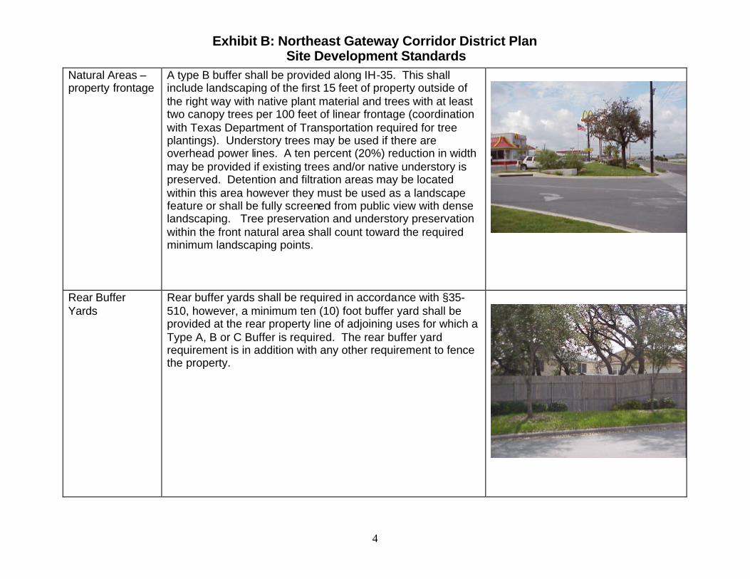
Exhibit B: Northeast Gateway Corridor District Plan Site Development Standards
4
Natural Areas – property frontage
A type B buffer shall be provided along IH-35. This shall include landscaping of the first 15 feet of property outside of the right way with native plant material and trees with at least two canopy trees per 100 feet of linear frontage (coordination with Texas Department of Transportation required for tree plantings). Understory trees may be used if there are overhead power lines. A ten percent (20%) reduction in width may be provided if existing trees and/or native understory is preserved. Detention and filtration areas may be located within this area however they must be used as a landscape feature or shall be fully screened from public view with dense landscaping. Tree preservation and understory preservation within the front natural area shall count toward the required minimum landscaping points.
Rear Buffer Yards
Rear buffer yards shall be required in accordance with §35-510, however, a minimum ten (10) foot buffer yard shall be provided at the rear property line of adjoining uses for which a Type A, B or C Buffer is required. The rear buffer yard requirement is in addition with any other requirement to fence the property.
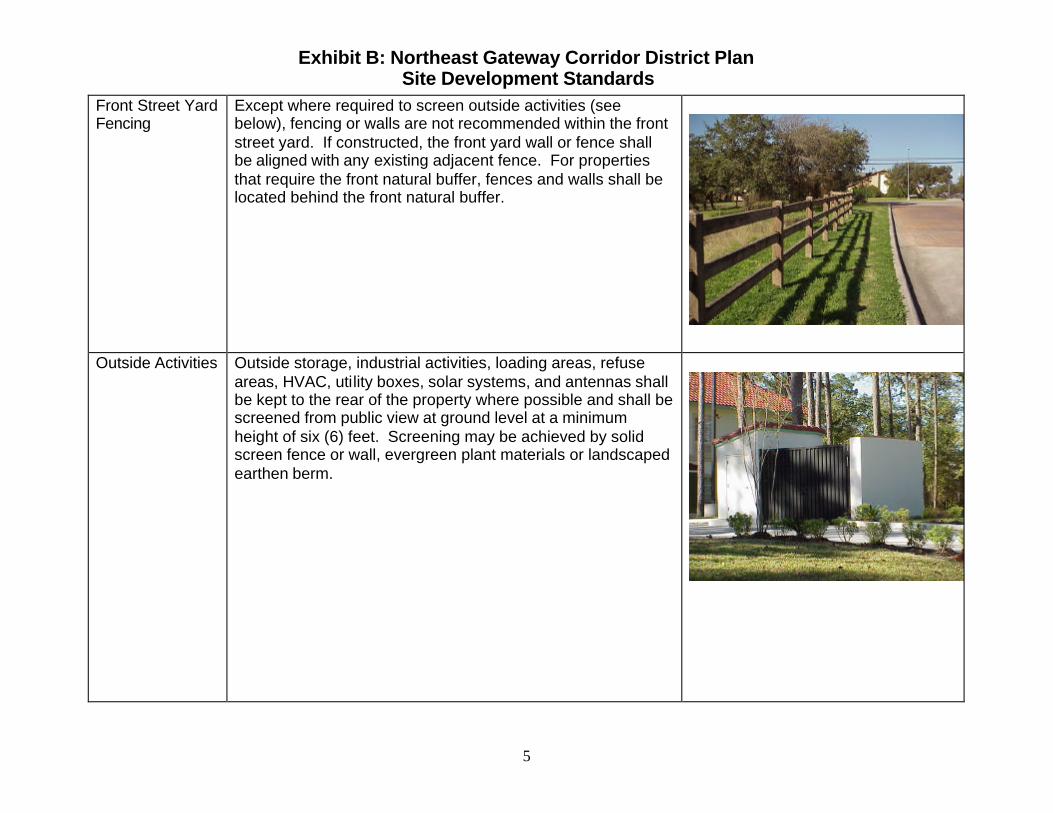
Exhibit B: Northeast Gateway Corridor District Plan Site Development Standards
5
Front Street Yard Fencing
Except where required to screen outside activities (see below), fencing or walls are not recommended within the front street yard. If constructed, the front yard wall or fence shall be aligned with any existing adjacent fence. For properties that require the front natural buffer, fences and walls shall be located behind the front natural buffer.
Outside Activities Outside storage, industrial activities, loading areas, refuse areas, HVAC, utility boxes, solar systems, and antennas shall be kept to the rear of the property where possible and shall be screened from public view at ground level at a minimum height of six (6) feet. Screening may be achieved by solid screen fence or wall, evergreen plant materials or landscaped earthen berm.

Exhibit B: Northeast Gateway Corridor District Plan Site Development Standards
6
Elevation Features – windows and openings
Window or clearly marked public entries or any combination thereof that allow for visibility into the commercial building from the street shall be provided as set forth below.
1. Zoning - The window façade requirements shall only apply to: a) businesses located within the “C-2” and “C-3” zoning districts; and b.) non-industrial uses located within an industrial zoning district. For purposes of this section, “industrial use” shall include the following categories under Table 311-2 of the Unified Development Code: Industrial, Manufacturing, Processing, Utility, Warehousing and Wholesale.
2. Exempted Uses – For security purposes, the following uses are specifically exclude from the window façade requirement: a. Armory b. Correction Institution
3. Percentages for Buildings Under 25,000 Square Feet – The window/public entry façade requirement for buildings with a gross floor area of less than 25,000 square feet shall be at least fifty percent (50%) of the first floor street frontage.
4. Percentages for Buildings 25,000 Square Feet to 75,000 square feet -The window/public entry façade requirement for buildings with a gross floor area of at least 25,000 square feet but no more than 75,000 shall be at least twenty-five percent (25%) of the first floor street frontage.
5. Percentages for Buildings over 75,000 square feet - The window/public entry façade requirement for buildings with a gross floor area greater than 75,000 square feet shall be at least fifteen percent (15%) of the first floor street frontage.
6. Calculation of Façade Area – For purposes of the minimum required area of windows and public entries, the first floor street frontage is the area of the façade that faces the public street between the finished floor level and ten feet (10’) above the finished floor level.
7. Buildings Oriented Away from the Street Frontage – A building with a primary public entrance that does not have street frontage shall not be required to locate windows within the first floor area when the use and enjoyment of the property is unreasonably burdened because of lot configuration or topography. The window requirement shall be met on the street frontage above the first floor level.
Buildings shall be articulated so facades that face public streets and exceed 40 feet in horizontal length shall include design elements such as: texture, canopies, projection or indentations, vertical expression of structural bays, or roof design.

Exhibit B: Northeast Gateway Corridor District Plan Site Development Standards
7
Building Materials - Permitted
The following material lists may be chosen to apply to at least 75% or more of the exterior surfaces of primary buildings and accessory buildings located within the corridor district that are visible from public rights-of-way.
a. Masonry consisting of stone, brick, glass block, or decorative concrete panel (e.g. concrete tilt wall).
b. Glass curtain wall consisting of seventy-five percent (75%) or less greater or combination of glass, metal, or other material in a metal framework.
c. Brick or brick veneer. d. Stucco or concrete masonry unit. e. Hardiplank or cement fiberboard siding f. Other similar materials approved by the Planning
Director as part of Certificate of Compliance review. Concrete finish must be profiled, sculptured, fluted, exposed aggregate or other architectural concrete finish.
Building Materials - prohibited
The following material lists are prohibited for use on 25% or more of the exterior surfaces of primary buildings and accessory buildings located within the corridor district that are visible from public rights-of-way.
a. Siding made of vinyl, wood fiber hardboard, oriented strand board, plastic or fiberglass panels.
b. Corrugated, ribbed, galvanized, aluminum coated, zinc-aluminum coated or unpainted exterior metal finished. This prohibition does not include metals used on roofs, awnings or canopies.
c. Unfired or underfired clay, sand, or shale brick. d. Unfinished concrete masonry units (i.e. cinderblock). e. Smooth or untextured concrete finishes. f. Mirrored glass with a reflectance of greater than twenty
percent (20%).

Exhibit B: Northeast Gateway Corridor District Plan Site Development Standards
8
On-premises signage
Expressway: 30’ height/150 square feet single tenant 35’ height/200 square feet dual tenant 35’ height/300 square feet multiple tenant Arterial A: 20’ height/65 square feet single tenant 25’ height/150 square feet dual tenant 35’ height/200 square feet multiple tenant Up to an additional ten feet of overall sign height may be added if the adjacent street grade is elevated; the difference in elevation between the property and the street grade shall be the determining factor in the height allowed. No provision in this section may be construed to prohibit a Sign Master Plan Development Agreement as defined by Chapter 28, §244 of the Municipal Code. Signs prohibited by Chapter 28, §220 of the Municipal Code shall be prohibited within this Corridor. The right to maintain any nonconforming sign shall terminate and shall cease to exist whenever the device is damaged or destroyed from any cause whatsoever and the cost of repairing such damage or destruction exceeds sixty percent (60%) of the replacement cost of the sign on the date of such damage or destruction.
Wall Signs The maximum allowable sign area, as a percentage of the area of each building elevation shall be fifteen percent (15%) for a cabinet sign; painted or flat sign or twenty percent (20%) for channel letters raised or incised.

AN ORDINANCE gws58
AMENDING $35-304 OF THE UNIFIED DEVELOPMENT CODE PERTAINING TO THE “OFFICIAL ZONING MAP” TO ESTABLISH NHS HIGH PRIORITY CORRIDOR 1 (IH-1) OVERLAY DISTRICT LOCATED ALONG IH-35 NORTH BETWEEN WALZEM ROAD AND THE CITY LIMITS AND TO PROVIDE FOR A CORRIDOR PLAN.
WHEREAS, the M-35 North Corridor is significant because it is a gateway to the city and is surrounded by commercial areas and neighborhoods that contribute to the economic development of the City of San Antonio; and
WHEREAS, the M-35 North Corridor is an amenity and asset of great value to the city, its inhabitants, its visitors and its economy; and
WHEREAS, 835339.03 of the Unified Development Code provides for the adoption of National Highway System High Priority Corridor Districts; and
WHEREAS, the NHS High Priority Corridor District (M-l) was initiated pursuant to City Council resolution no. 2003-10-l 1, adopted on March 13,2003; and
WHEREAS, a Corridor District Plan was developed, and all property owners within the proposed corridor district and adjacent areas were afforded an opportunity to participate in drafting the proposed regulations which shall be included as part of the zoning ordinance creating the Corridor District; and
WHEREAS, the Zoning Commission recommended adoption of the amendment to the Official Zoning Map and provided for the Corridor Plan at a public hearing on June 1, 2004 at which parties in interest and citizens were given an opportunity to be heard; NOW, THEREFORE,
BE IT ORDAINED BY THE CITY COUNCIL OF THE CITY OF SAN NTONIO:
SECTION 1. Chapter 35, Unified Development Code, Section 35-304, Official Zoning Map of the City Code of the City of San Antonio, Texas is hereby amended to include changes of classification and the rezoning of property as follows:
CASE NO. 22004091
The rezoning and reclassification of property from R-5, R-6, MH, O-2, C-l, C-2, C-3, C-3R, I-l, I-2 and 1-2s to R-5, R-6, MH, O-2, C-l, C-2, C-3, C-3R, I-l, I-2 and 1-2s “NHS High Priority Corridor District 1 (M-l)“, a map describing such tracts is attached hereto as EXHIBIT “A” and incorporated herein for all purposes.
NCB 14099, BLK 3, LOTS 1 through 5 and LOT 7 NCB 14102, BLK 6, LOTS 18,19 and 21 through 23 NCB 14550, BLK 3, LOT 1 NCB 14543, BLK 1, LOT 1 NCB 14952, the north irregular 336.47 feet of the south 660.65 feet of LOT 32 NCB 14952, the north 146.76 feet of the south 324.28 feet of LOT 32 NCB 14952, the south 372.99 feet of LOT 32 NCB 16450, BLK 1, LOTS 1, and 19 through 24 NCB 13804, the northwest 90.35 feet of LOT 6B and the northeast irregular 106.66 feet of LOT 7 NCB 13804, the east 585.3 feet of the south part of LOT 5 NCB 15724, the northwest 69 feet of the south 191.59 feet of LOT 1 NCB 15724, the north 591.49 feet of LOT 1

NCB 15930, BLK 7, LOTS 51,53, and 54 NCB 15724, LOT P-8 and the south 122.59 feet of LOT 1 NCB 14102, BLK 6, LOT 1 NCB 13773, BLK 11, LOTS 14 and 19 NCB 13776, the northwest irregular 40 feet by 135.17 feet of BLK 15 (drain easement) NCB 13805, LOT B NCB 14049, LOTS P-l 1 and P-12 NCB 13807, LOTS 12 and 13 NCB 13778, BLK 17, LOT 1 NCB 14042, BLK 1, LOTS 1,6,8, and 10 through 13 NCB 13773, BLK 11, LOTS 13,18, and 20 NCB 13776, BLK 15A NCB 13776, BLK 15, LOTS 3 and 4 NCB 13765, BLK 3, LOT 23 and the southwest irregular 50.48 feet of LOT 24 NCB 13776, BLK 15, the northeast irregular 995.59 feet of LOT 1 NCB 13765, BLK 3, LOT 35 NCB 13765, BLK 3, the northeast 115 feet of LOT 25 NCB 13765, BLK 3, LOTS 40 and 41 NCB 13765, BLK 3, the north 118 feet of LOT 33 NCB 13765, BLK 3, LOTS 36 through 39 NCB 13804, LOTS 1,2, 3, 8, 9, 10, E, H, and the west 57.2 feet of LOT G NCB 13763, BLK 1, LOT 1 NCB 13806, the northwest irregular 130.8 feet of LOT 1 NCB 13806, LOTS 7 and 13 NCB 13804, the north irregular 395.5 feet of LOT 4 NCB 16112, LOTS 3 through 13, 16 through 20, and the east 11.59 feet of LOT 2 NCB 13804, the southeast 110 feet of LOT 6B NCB 14946, LOTS 35 through 38 and LOT 40 NCB 14946, the northeast irregular 565.58 feet of LOT 41 NCB 14946, LOT 33 and the southwest triangular 91.07 feet of LOT 34 NCB 14946, the northeast irregular 106.5 feet of LOT 34 NCB 14952, Part of Tracts 1A and 2A ABS 676 NCB 14952, the north 59.62 feet of LOT 32 NCB 14952, the northeast irregular 240.25 feet of LOT 30 NCB 14952, LOT P 27 D and the northwest irregular 35.77 feet of LOT 30 NCB 14952, BLK 1, LOTS 36 and 37 NCB 16834, BLK 1, LOTS 1 through 3 NCB 15724, LOTS 18,20 and 21 NCB 14952, LOT 33 NCB 17621, LOTS 5 through 7 NCB 17621, LOT P-l 3 and P-28 NCB 15724, LOT P-2 and P-l 2A NCB 15930, BLK 7, LOTS 57 and 58 NCB 17622, LOTS P-23F, P-26 and P-27 NCB 15930, BLK 7, the west irregular 602 feet of LOT 55 NCB 17622, BLK 1, LOTS 2 and 3 NCB 15930, BLK 7, the east irregular 586 feet of LOT 55 NCB 17622, LOTS P-18, P-l 9A and P-20A NCB 17106, BLK 1, the northwest irregular 497.44 feet of LOT 1 NCB 17106, BLK 1, LOTS 2 and 4 NCB 13807, LOT 1 save and except the southwest irregular 370 feet NCB 15724, P-47, P-48, and the west irregular 211.44 feet of LOT 2 NCB 17621, LOTS 3 and 4

NCB 14946, LOT 42 NCB 15724, the east irregular 59.50 feet of the west 270.94 feet of LOT 2 NCB 17622, BLK 1, LOT 4 NCB 13765, BLK 3, the northeast irregular 179.83 feet of LOT 24 NCB 13806, LOT A-6 NCB 14049, LOTS P-IOB and P-12A NCB 15724, P-6 ABS 57 NCB 14952, Tracts 7, 8, 19B, 20,23, 23A, and P-l 00 NCB 14952, BLK 1, LOTS 34 and 35 NCB 15911, LOTS 24 and 25 NCB 15911, BLK 1, LOT27 NCB 17621, LOT 2 (ROW dedication) NCB 14952, BLK 2, LOT 1 NCB 14952, LOT 19 A NCB 14952, the northwest irregular 196.01 feet of LOT 18 NCB 17621, LOT P-14 and P-29 NCB 17622, LOT P-19, P-20, and P-20B NCB 17624, BLK 36, LOTS 14 through 20 and 23 through 25 NCB 17624, BLK 36, LOTS 1, through 3, P-l 00 (part of 25-foot alley), and P-l 01 (part of Wesp Way) NCB 17625, BLK 40, LOTS 6 through 11 NCB 17626, BLK 43, LOTS 1 through 8 NCB 17625, BLK 40, LOT P-l 02 (part of former Wesp Way r-o-w) NCB 17625, BLK 40, LOTS 1 and 4 NCB 17624, BLK 36, LOT 4 NCB 17625, BLK 40, the southeast 45 feet of LOTS 2 & 3 NCB 17625, BLK 40, the northeast 55 feet of LOTS 2 & 3 NCB 16450, BLK 1, LOTS 13 and 14 NCB 13807, LOT B NCB 14049, the southern 1000 feet of P-13, P-14, P-15, and P-22 NCB 13806, the south 90.01 feet of the north 200 feet of LOT 1 NCB 13806, the north 109.99 feet of the south 90.1 feet of the north 200 feet of LOT 1 NCB 13806, LOTS 2 and 6 NCB 13804, the north irregular 362.58 feet of LOT 6 NCB 14102, LOT 9 and the northwest 25.02 feet of LOT 8 NCB 14102, BLK 6, the southwest 200.15 feet of LOT 8 NCB 12179, the southwest irregular 9 by 11 feet of LOT 0 NCB 12117, LOTS 19 and 24 NCB 14101, BLK 5, the east irregular 84.89 feet of LOT 12 NCB 12179, LOTS TR-Kl, TR-K2, TR-K3, and P-l 01 NCB 12179, P-IOOB NCB 12117, the north irregular 182.45 feet of LOT M NCB 13805, the south 80 feet of LOT K NCB 12258, LOTS 1,2A, 3, and 4 NCB 13807, the northeast irregular 50.03 feet of LOT 9 NCB 12117, BLK 1, LOTS 1 and 2 NCB 14043, BLK 2, LOTS 1 through 7 NCB 13807, LOT 14 NCB 13807, the south irregular 400 feet of LOT C NCB 14043, BLK 2, LOTS W, N, and E NCB 13807, the southwest irregular 200 feet of LOT 1 NCB 13807, the southwest 170 feet of the northwest 709.64 feet of LOT 1 NCB 12188, the southwest 147 by 203 feet of LOT 1 NCB 12188, LOT TR-D and P-l 03

NCB 12258, ARB 2B, TR-2D, 2C and the northeast irregular 102.77 feet of LOT 2 NCB 12179, LOT ARB TR-J2 NCB 12179, the west irregular 422.87 feet of LOT 6 NCB 12179, LOTS ARB J-3, TR-KG, and the southwest irregular g-foot by 1 l-foot triangle of LOT 0 NCB 12188, P-1OOC NCB 12179, LOT 14, and the north irregular 270.51 feet of LOT 27 NCB 12179, LOT TR-KS NCB 12258, the south irregular 225 feet of LOT 2 ARB 2E NCB 12117, LOT N and the north irregular 421.05 feet of TR-H NCB 12188, LOT 4, P-IO, and TR-SD NCB 13801, BLK 1, LOTS A, B and C NCB 13807, the northeast irregular 50.03 feet of LOT 11 NCB 13807, LOTS 2,15 and 16 NCB 12179, LOTS 22,26, and 31 NCB 17140, BLK 1, LOT 1 NCB 12179, the northwest 30.47 feet of the southwest 730.65 feet of LOT 13 NCB NCB NCB NCB NCB NCB
2179, the northeast 253.86 feet of LOT 13 2179, the southwest 49.13 feet of LOT 13 2179, the south irregular 65.52 feet of LOT 4 2179, the north 466.20 feet of LOT 4 2179, the eastern 400 feet of the southwest irregular 1121.48 feet of TR-J 5911, the southern 1000 feet of P-3, P-5, and P-6
NCB 15911, the southern 400 feet of P-5A, P-5B, P-7A, P-7B, and P-35 NCB 14062, the eastern 800 feet of Tracts A and B NCB 16605, BLK 7, LOTS 1 and 7 NCB 14102, BLK 6, the east 89.15 feet of LOT 2 NCB 14101, BLK 5, LOTS 1,14 and the east 50 feet of LOT 11 NCB 14100, BLK 4, LOT 1 and the east 37.5 feet of LOT 2 NCB 12117, the eastern 500 feet of LOT 23 NCB 12117, the eastern 285 feet of TR-27 and of the north irregular 460 feet of ARB TR-G
SECTION 2. The Corridor Plan that provides development standards for NHS High Priority Corridor District (M-l), more particularly described in EXHIBIT “B” is hereby approved.
SECTION 3: All other provisions of Chapter 35, as amended shall remain in full force and effect, including the penalties for violations as provided in Article VI, Division 11.
SECTION 4: The Planning Director shall change the zoning records and maps in accordance herewith and the same shall be available and open to the public for inspection.
PASSED AND APPROVED ON THIS 24th day of June 2004.
ATTEST:
APPROVED AS TO FORM:

Bexar CountyBexar County
Live OakLive Oak
WindcrestWindcrest
ConverseConverse
35
410
WALZEM RD
LOOKOUT R
D
JUD
SON
RD
O'C
ON
NO
R R
D
PE
RR
IN B
EIT
EL
RANDOLPH B
V
NACOGDOCHES RD
CRESTWAY RD
WE
IDN
ER
RD
N
TOEPPER
WEIN
RD
WURZBACH PKWY
MILLER RD
SCHERTZ RD
AUSTIN H
WY
GIB
BS S
PRAW
L
EA
GLE
CR
ES
T B
V
EISENHAUER R
D
HIG
GIN
S RD
TH
OU
SA
ND
OA
KS
WEIDNER RD S
KITTY H
AWK R
D
EA
GLE
CR
ES
T B
LVD
RANDOLPH B
V
O'CONNO
R RD
TOE
PP
ER
WE
IN R
D
THOUSAND OAKS
OCL
I1
OCL
OCL
OCL
I1
I1
R6
I1I2-S
C3
OCL
R5
I1
C2
R6
R6
I1I1
I1
C3
I1
R5
I1
OCL
R6
OCL
I1
C3
I1
I1
I1
R6
OCL
R5
MH
C2
C3
R6
OCL
I2-S
MH
OCL
R6
I2-S
R4
I1
I1
I1
R6
OCL
I1
R5
OCL
MF33
C3
BP
C2
BP
BP
I2-S
OCL
I1
C3
R5
MF33
OCL
R4
R4
OCL
I1
OCL
R6
I1
R6
I2-S
R6
OCL
OCL
C3
OCL
R6
OCL
C2
I1
OCL
R6
OCL
I1
I1
OCL
I2
R6
OCL
C2
R6
R6
I1
R6
OCL
C3
C2
I1
NP-10-S
R6
MF33
R5
OCL
OCL
I1
I1
I2
OCL
I1
R6
OCL
R6
C3
OCL
R6
R6
R6
C2
OCL
RM4
R6
OCL
MH
R6
C3
R6
PUD
I1
I1
C3
OCL
OCL
C3
R6R6
R6
R6
R6
C3
C3
R6
R6
R6R6
PUD
I1R6
R5
C3
R6
R6
R6
C3
R6
R6
C2
R6
C3
I2
R6
I1
R5
C3
C3
C3
I1
R6
I2
I1
MF33
I1R6
R6
R6
C3
R6
C3
I1
R6
R6
R6
R6
R6
R6
I1
R5
C3NA
MF33
I1-S
R6
I1
I1
R6
R6
R6
I2
R6
R6
R6
I2
C3
R5
R6
R6
R6
C3
C3
R5
R6
R5
C3
R6
R6R6
R6
C2
C3
C2
NP-10-S
R6
R6
R6
C3
I2
R6
R6
R6
R5
R6
NP-10
R6
MF33
R6
C3R
R4
R6
R5
R6
C2
R6
R6
C2
R4
R6
R6
R6
C2
R6
C3
R6
R6
R6
R6
R6
O2
R6
I2
C3
R6
R6
R6
R6
R6
R6
C2
R6
R6
R5
R6
R6
R6
R6
R6
R6C2
C3
R6
R6
C3
C2
MF33
R6
R6
R5
R6
R6
MF33
R6
C3
C2
C3
R6R6
R6
R6
R6
R6
R6R6
R6
R6
R6R5
C3
R6
R6
R6
R5
R5
R5
C2
R5
R6R6
R6
MH
R6
R6
R5
R6
R6
R5
R6
R5
R6
R6
R5
MF33
R6
RM4
R6
R6
R6
R6
R6
R6
R6
R6
R6
R6
RM4
R6
R6
R5
R6
R6
R5
NP-10
R6
R6
R5
R5
C3
R5C2
R5
C2
R5
C3
PUD
NP-10
C3
R5R5
C3
R5
NP-10-S
C3
R5
R5
R5
C2
MH
R20
R5
C2
C2
R4
NP-10
C2
R5
R5
R5
R4
C3R
C2
MH
C3-S
NP-10
MF33
O2
MF33
RM4
PUD
RM4
C3NA
MH
RM4
I2
MH
C1
PUD
NP-10
NP-10
NP-10
C3NA
C1
MF33
C3NA
RM4
MF33
NP-10
NP-10NP-10
NP-10
MF33
NP-10
R4
MF33
C1
C3R
C3R
O2
C1
NP-10-S
MF33MF33
RM4
I2
MF33
C3R
C3-S
RM4
C3R
O2
C3NA
C3NA-S
C3R
C3R-C
RM4
C3R
NP-10
C3R
C1
RM4
C3NA
C3-C
RM4
O2
C3NA
C3NA
C1 C1
RM4
C3R
RM4
RM4
C3NA
RM4
C1
I1-S
C3NA
C1
C3R
RM4
C3R
C3NA-C
C3NA
RM4
C3R
C1
C3NA
C2-C
NP-10
C3RO2
C3NA
C3R
O2
C2-C
C3NA
C3NA
C3NA
O2C2-C
C3R
C3R
C3RNP-10
O2
L-S
C1
C1
C1
R6-C
P.553 C-3ZONING CASE: Z2004-091
City Council District No. 2 & 10Requested Zoning Change To: Designate Northeast Gateway Corridor District (IH-1)Date: June 24, 2004Scale: 1" = 3000' C:\Arcview\Projects-4\IH-35 Corridor-Walzem-2.mxd
San Antonio - 2003
WALZEM RD
EISENHAUER RD
LOOKOUT R
D
JUD
SO
N R
D
PE
RR
IN B
EIT
EL
O'CONNO
R RD
GIB
BS SPR
AWL
RANDOLPH B
V
STAHL
RD
AUSTIN H
WY
TOE
PP
ER
WE
IN R
D
CRESTWAY RD
HIG
GIN
S R
D
SCHERTZ RD
EA
GLE
CR
ES
T B
V
410
200' Notification
Subject Property
_____ Notices Mailed _____ In Opposition
_____ In Favor
C:\Arcview\PDF\March\0403GC01.pdf