executive summary - delta stewardship...
TRANSCRIPT

Executive Summary

This page intentionally left blank.

DELTA PLAN, 2013 ES-1
The Sacramento-San Joaquin River Delta is the grand confluence of California’s
waters, the place where the state’s largest rivers merge in a web of channels—and
in a maze of controversy. The Delta is a zone where the wants of a modern
society come into collision with each other and with the stubborn limitations of a
natural system. In 2009, seeking an end to decades of conflict over water, the
Legislature established the Delta Stewardship Council with a mandate to resolve
long-standing issues. The first step toward that resolution is the document you
have before you, the Delta Plan.
Though more than 50 miles inland from the Golden Gate,
Delta waters rise and fall with ocean tides. The Delta is in
fact the upstream, mostly freshwater portion of the San
Francisco Estuary, the largest estuarine system on the West
Coast of the Americas, and one of California’s prime natural
assets. It is a major stop on the Pacific Flyway and the portal
through which important fish species, including anadromous
Chinook salmon, pass on their way to and from their
spawning grounds in the interior.
The system of waters in which the Delta is so central has
changed dramatically since California became a state. Rivers
have been dammed and aqueducts built. Natural flows and
fluxes have been disrupted to support cities and make the
Central Valley the fruit basket and salad bowl of the nation.
Approximately half of the water that historically flowed into
and through the Delta is now diverted for human use, never
reaching the sea. Much of this diversion occurs at points
upstream, before the rivers come down to the Delta; but the
last and largest draws take place in the Delta itself. On the
southeast edge of the region, near Byron, two sets of mighty
pumps extract water for shipment as far south as San Diego.
Two-thirds of California’s people and 4.5 million acres of
farmland receive some part of their water from the Delta.
The Delta landscape we know is itself the result of a great
transformation, from a primeval wetland complex to an
archipelago of diked islands, where soils that once grew vast
thickets of tules now yield bountiful corn, alfalfa, tomatoes,
and many other crops. The Delta is home to about
12,000 people on farms and in small historic communities,
and to about half a million in the larger cities that are
Executive Summary

EXECUTIVE SUMMARY
ES-2 DELTA PLAN, 2013
pressing into the region from the fringe. More millions
come to it for boating, fishing, hunting, bird watching, even
windsurfing on its 700 miles of channels. Steeped in history,
combining notes of the American heartland and of Holland,
the Delta looks and feels like no other place in California.
This is a land that people love.
It is not doing so well.
The very shape of the modern Delta is in danger. Farming
of peat-rich ground like this always leads to oxidation, the
literal vanishing of soil, and thus to subsidence. Many Delta
islands now lie 15 feet or more below sea level and depend
on aging dikes to prevent the water in adjacent channels
from pouring in. Higher river flows in winter or spring, pre-
dicted results of climate change, will add to the pressure, and
a great earthquake, sooner or later, will shake the region like
a paint can on a mixer. Encroaching urbanization, mean-
while, puts more people and property on dangerous ground.
After years of slow decline, the condition of the Delta’s
watery ecosystem, as measured especially by the population
of wild salmon and other native fishes, has gone critical. The
list of causes begins, but does not end, with all those water
withdrawals, a kind of tax that leaves the system in a condi-
tion of chronic drought. The specific, peculiar manner in
which the last large gulps of water are withdrawn adds to the
ecological cost. The continual introduction of alien aquatic
species from around the world is altering the web of life,
often at the expense of native and other valued species.
Pollution from the vast and busy watershed does its share
of harm.
Today, all those who depend on or value the Delta are, in a
word, afraid. Delta residents face the possibility of floods
from the east when the rivers flow strongly and of salinity
intrusion from the west if they flow too feebly. Fishermen,
both commercial and recreational, fret about the future of
salmon and other species. Water suppliers that receive water
from the Delta find those supplies insecure, subject to
Steeped in history, combining notes of the American heartland and of
Holland, the Delta looks and feels like no other place in California.
This is a land that people love.
It is not doing so well.
interruption by weather vagaries, levee failures, or pumping
restrictions imposed in the desperate attempt to stem the
decline of fish.
The Coequal Goals, the Delta
Stewardship Council,
and the Delta Plan
Since the middle 1980s, California has been looking for ways
to secure the natural and human values of the Delta while
maintaining its place in the state’s water plumbing. These
efforts have generally started in hope and ended in impasse.
In recent years environmentalists turned to the courts, using
the blunt tool of the federal Endangered Species Act to
force curtailment of water exports at certain times. In reac-
tion, water suppliers south of the Delta have complained of
“regulatory drought.”
In 2009 the Legislature made its latest, most determined
bid to find solutions, passing the Delta Reform Act and
associated bills. First and foremost, it declared that State
policy toward the Delta must henceforth serve two
“coequal goals”:
■ Providing a more reliable water supply for
California, and
■ Protecting, restoring, and enhancing the
Delta ecosystem.
EXECUTIVE SUMMARY
DELTA PLAN, 2013 ES-3
These goals, the Legislature added, must be met in a
manner that:
■ Protects and enhances the unique cultural,
recreational, natural resource, and agricultural
values of the Delta as an evolving place.
By affirming the equal status of ecosystem health and water
supply reliability, the Legislature changed the terms of the
conversation. It changed them further with the following
pronouncement: “The policy of the state of California is to
reduce reliance on the Delta in meeting California’s future
water supply needs.” Here was recognition that, for the sake
of the water system and the Delta both, a partial weaning of
the one from the other is required.
The Delta Stewardship Council is the body entrusted with
giving practical meaning to these directives. Publication of
this Delta Plan completes its first assignment. The product
of eight drafts, almost 100 public meetings, and nearly
10,000 comments, the Delta Plan pulls together in one place
the steps that need to be taken to meet the coequal goals—
measures that, in one way or another, could affect almost
everyone in California. The Plan is to be revised every
5 years, or sooner as circumstances change.
The Delta Plan contains 87 provisions, some broad and
some narrowly technical, some novel, some commonsensi-
cally familiar. What, in essence, does the Plan propose be
done differently? At the risk of oversimplification, we can
say that it asks California and Californians to do six
large things:
■ In order to improve and secure our water supply, while
taking pressure off the Delta, we must use water more
efficiently in cities and on farms, and develop alterna-
tive, usually local, sources.
■ We must also get much better at capturing and storing
the surplus water that nature provides in the wettest
years, building reserves that can be drawn on in
dry ones.
■ To revitalize the Delta ecosystem, we must provide
adequate seaward flows in Delta channels, on a
schedule more closely mirroring historical rhythms:
what the Plan calls natural, functional flows.
■ We must also bring back generous wetlands and ripari-
an zones in the Delta for the benefit of fish and birds.
■ To preserve the Delta as a place, we must restrict new
urban development to those peripheral areas already
definitely earmarked for such growth, while supporting
farming and recreation in the Delta’s core.
■ And we must floodproof the Delta, as far as feasible,
mainly by improving levees and by providing more
overflow zones where swollen rivers can spread without
doing harm.
What about today’s headline issue concerning the Delta—
the proposed construction of tunnels to improve the way
water destined for export southwards reaches the pump in-
takes near Byron? This initiative is part of what is called the
Bay Delta Conservation Plan (BDCP). The BDCP is a dif-
ferent and more narrowly focused undertaking than the
Delta Plan, into which, if certain conditions are met, it will
be fused (see section, A Better System: Delta Conveyance).
The Delta Plan is California’s plan for the Delta, prepared in
consultation with, and to be carried out by, all agencies in
the field: the State Water Resources Control Board, ultimate
arbiter of water rights and water quality; the California
Department of Water Resources, the state’s water planner
and also operator of the great State Water Project; the
California Department of Fish and Wildlife, responsible for
the welfare of the living system of the Delta; the Delta
Protection Commission, which oversees land use and devel-
opment on low-lying Delta islands; and many more agencies,
State and local. Add to the list federal players like the Bureau
of Reclamation, which runs the Central Valley Project; the
U.S. Fish and Wildlife Service; the National Marine Fisheries
Service; and the U.S. Army Corps of Engineers. Their
cooperation has been promised, and it is vital.

EXECUTIVE SUMMARY
ES-4 DELTA PLAN, 2013
The working parts of the Plan are 73 Recommendations and
14 Policies. Recommendations call attention to tasks being done
or to be done by others. Policies are legal requirements that
anyone undertaking a significant project in the Delta must
meet. See the sidebar, From Plan to Reality, for more on the
mechanics of realizing the Plan and pages ES-15 to ES-35
for a survey of all 87 provisions.
Where Is the Money?
The Legislature sees “adequate and secure funding” as a
need “inherent in the coequal goals.” In order to know what
this entails, we need to form a clearer picture of the costs of
the work now proposed for the Delta or on its behalf and
how those costs might be met. This first edition of the Delta
Plan proposes research toward that clarity.

EXECUTIVE SUMMARY
DELTA PLAN, 2013 ES-5
First step is an inventory: How much is now actually being
spent, by all the agencies involved, that can be chalked up to
furthering the coequal goals? Second comes an assessment
of costs: How much will it take to carry out the projects and
programs described in the Delta Plan, and what might the
sources of support be for each one? The third step must be
a comparison of resources and needs, and a reckoning of
gaps: What key elements lack probable funding, and what
might be done to fill these holes? (Funding Principles
Recommendations 1 through 3.)
Providing a More Reliable Water
Supply for California…
The Delta’s contribution to the overall statewide water
supply is smaller than many people think. The proportion
drawn directly from the Delta, mostly through the pumps
near Byron, is only about 8 percent of the total. The bulk of
California’s water comes from more local sources, and
always has.
Nevertheless, the Delta supply is important to many regions.
Southern California imports about 25 percent of its water
via the Byron pumps. The Tulare Lake Basin, the southern
end of the Great Central Valley, gets 27 percent of its water
by that route. Even the San Francisco Bay Area takes
16 percent of its supply from Delta pumps. On a more local
scale, several water suppliers rely entirely on the Delta, and
others have become dependent on this one overtaxed
source to a risky degree.
In addition to water pulled directly from the Delta, a great
deal is drawn from the Delta’s tributary streams before they
come down to sea level. San Francisco Bay Area cities reach
far inland to tap the Tuolumne and Mokelumne Rivers in
the Sierra Nevada, taking 27 percent of their water needs
from these sources. Parts of the Central Valley tributary to
the Delta get all of their water from that watershed by
California water planning is full of good intentions. If the laws and policies
that are now on the books were consistently carried out, the state’s water
system—including that part that is tied to the Delta—would work much better.
definition, as do the people and farms of the Delta
itself. (See also sidebar, The Problem with Numbers.)
The Delta Plan addresses water supply on three scales:
California-wide, on the Delta watershed level, and in the
areas that receive water from the Delta pumps. (See
Figure ES-1, The Delta Watershed and Areas Receiving
Delta Water.)
California water planning is full of good intentions. If the
laws and policies that are now on the books were consistent-
ly carried out, the state’s water system—including that part
that is tied to the Delta—would work much better. The
Delta Plan calls on all water suppliers to obey the many laws
and guidelines that exist, and on the State’s regulatory
agencies to insist on compliance (Water Resources
Recommendation 1).

EXECUTIVE SUMMARY
ES-6 DELTA PLAN, 2013
The Delta Watershed and Areas Receiving Delta Water
Figure ES-1
Whatever the outcome of some current
debates, California’s next large increment of
water supply will not come from major new
engineering but from water conservation,
recycling, local stormwater capture, and rea-
sonable use of aquifers (see section, A Better
System: Storing Floods to Ride Out
Droughts). These measures can yield an
amount of water larger than the total that is
drawn from the Delta today. State agencies in
charge of water matters should systematically
promote these practices, and all State agencies
should model them in their own water usage.
(Water Resources Recommendations 6, 8,
and 14.)
Zooming in a bit from the statewide picture,
the Delta Plan calls for all water users linked to
the Delta—whether they take water from it di-
rectly, or tap the watershed—to reduce their
draws. The State Water Resources Control
Board should give special scrutiny to water use
applications that could boost demand on the
watershed. Urban and agricultural water sup-
pliers are already required to write water
management plans; these now should include
“water supply reliability elements,” discussing,
among other things, how to deal with the
cascading effects if Delta pumping were halted
for as long as 3 years. (Water Resources
Recommendations 3, 4, 5, and 7.)
The Plan speaks most directly to those suppliers that serve
water within the Delta or pump water out of the region—
including the State Water Project, the Central Valley Project,
and by extension the many agricultural and urban water
purveyors that are the customers of these giants. Any organ-
ization that receives water from the projects must do its
share to reduce reliance on the Delta, setting specific
reduction targets and actually putting measures in place.
The State Water Project is called on to write the correspond-
ing provisions into contracts with its clients when these
agreements are renewed or revised (Water Resources
Policies 1 and 2, WR Recommendation 2).
A Better System: Storing Floods to Ride Out
Droughts (and Give the Delta a Break)
The measures so far mentioned will take pressure off the
Delta while actually increasing California’s developed water
supply. The further key to both goals is to harvest and store
the water that is available from Central Valley rivers in the
EXECUTIVE SUMMARY
DELTA PLAN, 2013 ES-7
wettest years, at the least environmental cost. The need is
heightened by the fact of climate change, which stands to
make rainy years all the wetter, and droughts all the
more severe.
There are few opportunities left in California to build large
new dams (or to raise the height of old dams), and the
options that exist are dauntingly expensive. The California
Department of Water Resources and the Bureau of Recla-
mation have been studying the possibilities. The Delta Plan
urges the agencies to wrap up these studies, so that the State
can decide the fate of these proposals once and for all
(Water Resources Recommendations 13 and 14).
Much more water storage space exists right under our feet:
in groundwater basins, or aquifers.
California began its history with a vast supply of water
stored naturally in underground gravel fields and free for the
taking via wells. In parts of the state, including most of the
southern Central Valley, this endowment has been squan-
dered, and groundwater levels have dropped, sometimes by
hundreds of feet. One of the rationales for sending water
south from the Delta has been to recharge aquifers, but not
enough recharging has occurred. And the State’s last com-
prehensive assessment of its groundwater situation was
published in 1980—a third of a century ago.
The Delta Plan calls for a rededication to the conservative
idea of using aquifers like bank accounts: to be filled up in
wet times, in order that they may be drawn from in dry. It
calls on the State to do the indispensable groundwater
update, on local suppliers to write plans for sustainable
groundwater management, and on the State Water
Resources Control Board to stand ready to intervene in
seriously overdrafted areas, if good local plans are not forth-
coming, leading perhaps to the court procedure called
groundwater adjudication. (Water Resources
Recommendations 9, 10, 11, and 14.)
The Delta Plan calls for a rededication to the conservative idea of using
aquifers like bank accounts: to be filled up in wet times, in order that
they may be drawn from in dry.
There is another tool for making the supply stretch further:
the sale or trade of water between suppliers, especially in
times of shortage. Existing rules governing such transfers
are found cumbersome by some and insufficiently protective
of water rights and the environment by others. The State
Water Resources Control Board should reformulate the
guidelines by mid-2016 (Water Resources
Recommendations 14 and 15).
A Better System: Delta Conveyance
As noted, many of the state’s water suppliers take their
water from rivers at points upstream of the Delta. The two
biggest, however—the State Water Project and the Central
Valley Project—are different. Though most of the water
they transport has its origin to the north, in the Sacramento
River, their withdrawal points are deep in the Delta and well
to the south, on the channel called Old River. Unlike most
other water withdrawals, these affect the region not only by
removing water but also by distorting flows.
The pumps at Byron have so much power that they
essentially give the Delta a second mouth. In many channels,
water runs backward at times, toward the pump intakes, not
toward the sea. This situation is bad for salmon, Delta smelt,
and other sensitive and legally protected species. Under the
Bay Delta Conservation Plan, the Department of Water
Resources and the federal Bureau of Reclamation are
planning a kind of arterial bypass, segregating the water
meant for the pumps at a new northern intake on the
Sacramento River. The water corralled at this point would
be sent to the pumps via a pair of tunnels. This arrangement

EXECUTIVE SUMMARY
ES-8 DELTA PLAN, 2013
is intended to alleviate the backward flows that harm fish; in
conjunction with major habitat improvements and other
measures, it is supposed to bring endangered species far
enough back from the brink to satisfy protective laws. Many
Delta residents and environmentalists, though, fear that the
new system will simply allow more water to be shipped
south, doing, on balance, more harm than good.
The Delta Stewardship Council is not the author of the
BDCP. Its role for now is to advise and to urge timely com-
pletion (Water Resources Recommendation 12). Later
on, though, the Council may have a decisive say. Once the
proposal is complete, the Department of Fish and Wildlife
must declare that it meets the standards of the Delta Reform
Act, and this declaration can in turn be appealed to the
Council. If the Council does not concur, certain aspects of
the BDCP will lose access to State funding. If all hurdles
have been cleared, on the other hand, the BDCP will take its
place as a component of the Delta Plan.
…and Protecting, Restoring, and
Enhancing the Delta Ecosystem…
The effort to improve the fortunes of the Delta ecosystem
has two components that are vital: guaranteeing adequate
flows from the rivers feeding into and through Delta chan-
nels, and creating new wetlands and other habitats in partial
replacement for what has been lost. Three other compo-
nents are merely very important: combating harmful exotic
species, improving the management of salmon hatcheries,
and protecting and improving water quality.
Toward “Natural Functional Flows”
Humans have not only reduced the total quantity of runoff
through the Delta toward the ocean but also have changed
its timing, decreasing the historical torrents of spring and
increasing the formerly feeble flows of autumn. In a natural
system that evolved with wide variation, this shift toward a
steady state is itself a source of harm.
Humans have not only reduced the total quantity of runoff through the Delta
toward the ocean but also have changed its timing, decreasing the historical
torrents of spring and increasing the formerly feeble flows of autumn.
The minimum seaward flows to be maintained in Delta
channels are set by the State Water Resources Control
Board, according to season and year type (wet, above
normal, below normal, dry, or critical). These required flows
help fish; they also prevent saltwater intrusion. As a not-
incidental side effect, the rules limit the amount of water
that can be exported through the pumps.
The Water Board is now preparing to revise this flow
regime, last updated in 2006. As a later step, the Water
Board is to issue comparable flow standards for the major
tributary rivers of the Delta. The Delta Plan recommends
deadlines for these processes (mid-2014 and mid-2018). The
adopted regulations will become elements of the Plan. The
Delta Stewardship Council can be called upon to review any
project that could affect Delta flows in the light of adopted
flow criteria (Ecosystem Restoration Policy 1,
ER Recommendation 1).
Habitat Restoration
In its primeval state, the Delta was no uniform sea of reeds
but a vast mesh of habitats including tule marsh threaded
with rivers and sloughs, perched lakes filled by floods and
very high tides, natural levees with big trees on them, and
seasonal overflow basins behind the levees. Most of this
mosaic has disappeared, converted to fifty large and many
small leveed islands. Evidence of what was remains in
agricultural soils of uncommon quality (and fragility).
The old scene will never return, but careful habitat
restoration projects can help to reverse the region’s
EXECUTIVE SUMMARY
DELTA PLAN, 2013 ES-9
ecological decline. Biologists have spent years locating the
likeliest areas for such revival. The Delta Plan incorporates
the latest thinking, essentially the Conservation Strategy
drafted in 2011 by the Department of Fish and Wildlife
(formerly the Department of Fish and Game).
Since the heart of the Delta is now well below sea level, due
to subsidence, the suitable restoration sites are mostly found
near Delta margins, where the soil surface is still high
enough to permit marsh plants and riparian vegetation to
take root. The Plan outlines six such zones: the Yolo
Bypass, the floodplain west of Sacramento into which the
Sacramento River spills in wet years; the Cache Slough
Complex, where the Bypass rejoins the body of the Delta;
a nexus in the eastern Delta, where the Mokelumne River
and the Cosumnes River add their strands to the Delta’s
web; a zone in the southern Delta along the San Joaquin
River; a collection of small tracts at the western apex of the
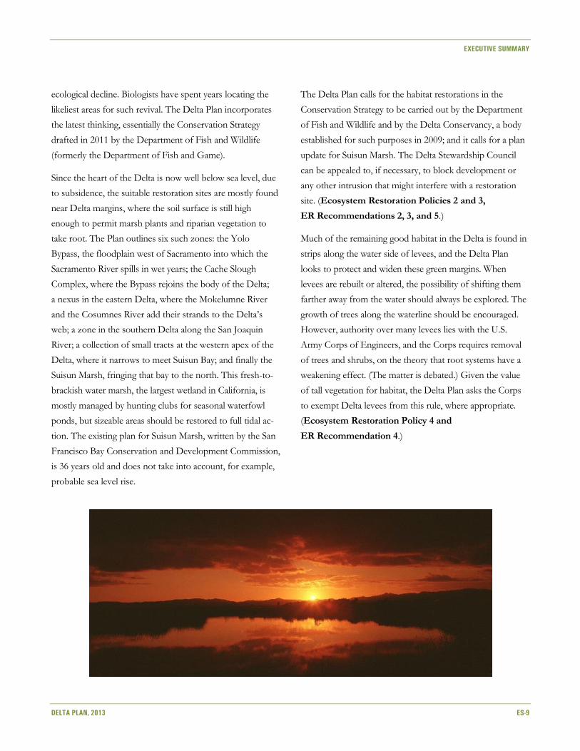
Delta, where it narrows to meet Suisun Bay; and finally the
Suisun Marsh, fringing that bay to the north. This fresh-to-
brackish water marsh, the largest wetland in California, is
mostly managed by hunting clubs for seasonal waterfowl
ponds, but sizeable areas should be restored to full tidal ac-
tion. The existing plan for Suisun Marsh, written by the San
Francisco Bay Conservation and Development Commission,
is 36 years old and does not take into account, for example,
probable sea level rise.
The Delta Plan calls for the habitat restorations in the
Conservation Strategy to be carried out by the Department
of Fish and Wildlife and by the Delta Conservancy, a body
established for such purposes in 2009; and it calls for a plan
update for Suisun Marsh. The Delta Stewardship Council
can be appealed to, if necessary, to block development or
any other intrusion that might interfere with a restoration
site. (Ecosystem Restoration Policies 2 and 3,
ER Recommendations 2, 3, and 5.)
Much of the remaining good habitat in the Delta is found in
strips along the water side of levees, and the Delta Plan
looks to protect and widen these green margins. When
levees are rebuilt or altered, the possibility of shifting them
farther away from the water should always be explored. The
growth of trees along the waterline should be encouraged.
However, authority over many levees lies with the U.S.
Army Corps of Engineers, and the Corps requires removal
of trees and shrubs, on the theory that root systems have a
weakening effect. (The matter is debated.) Given the value
of tall vegetation for habitat, the Delta Plan asks the Corps
to exempt Delta levees from this rule, where appropriate.
(Ecosystem Restoration Policy 4 and
ER Recommendation 4.)

EXECUTIVE SUMMARY
ES-10 DELTA PLAN, 2013
Exotic Species
One of the less-visible forces to buffet the Delta ecosystem
is the proliferation of nonnative aquatic species—fish, crus-
taceans, plants, and even the microscopic floating animals of
zooplankton. Some were introduced deliberately; others ar-
rived by random routes including the discharge of bilgewater
from oceangoing ships and the dumping of goldfish bowls.
New arrivals keep appearing. Some of these intruders
affect the system little, but other species, notably certain
aquatic plants and filter-feeding clams, transform the web of
life profoundly. The Delta Plan prohibits actions that could
bring in new exotics or improve conditions for exotics that
are here, and endorses the measures the Department of Fish
and Wildlife is already planning to take against them. (Eco-
system Restoration Policy 5, ER Recommendation 7.)
Among the exotics are game species introduced in the
nineteenth century and well-loved by fishermen: striped,
largemouth, and smallmouth bass. It has become apparent
that these voracious game fish are helping to deplete salm-
on, Delta smelt, and other species in trouble. The Delta Plan
asks the Department of Fish and Wildlife to change angling
rules to permit heavier fishing and somewhat suppress the
bass population (Ecosystem Restoration
Recommendation 6).
Management of Hatchery Fish
When dams on many rivers cut off spawning grounds for
salmon and steelhead trout, hatcheries were built to com-
pensate. Now there is worry that hatchery-raised salmon,
less genetically diverse than their wild cousins, may mix with
and reduce the fitness of the wild strains. Various solutions
are proposed, including capturing wild fish to add their eggs
to hatchery stock. The Delta Plan asks the Department of
Fish and Wildlife and the U.S. Fish and Wildlife Service
to put these ideas and recommendations into effect
(Ecosystem Restoration Recommendations 8 and 9).
Water Quality
Pollution from the watershed is bad for the Delta ecosystem
and for water users. The Delta Plan urges the responsible
agencies—the State Water Resources Control Board, the
Central Valley Regional Water Quality Control Board, and
the San Francisco Bay Regional Water Quality Control
Board—to protect “beneficial uses” of water in the Delta
and Suisun Bay. Various ongoing projects of planning, rule-
making, and construction should be brought to conclusion.
All agencies should look at water quality when weighing ac-
tions covered under the Delta Plan. Special attention should
be paid to pollution that might degrade habitat restoration
sites. (Water Quality Recommendations 1 through 12.)
…In a Way that Protects
and Enhances the Values
of the Delta as an Evolving Place
Because of its role in greater systems—the San Francisco
Estuary, the state water plumbing—the Delta is a subject of
statewide debate. The conversation can seem to take place
over the heads of the people who actually live in the region;
and it can seem to overlook the lasting values of the place
that is: its thriving agriculture, the beauty of its countryside,
its cultural heritage, and its recreational bounty. The Delta
Plan strives to redress this balance without promising what
is probably impossible: the retention of the landscape
exactly as it is today.
Honorific labels do not protect valuable assets, but they
can help us recognize them. The Delta Plan asks that the
Delta be declared a National Heritage Area by Congress and
that Highway 160, its north-south artery, be designated a
National Scenic Byway by the U.S. Department of Trans-
portation (Delta-as-Place Recommendations 1 and 2).
Many Delta people fear that their concerns will be brushed
aside as new water facilities and habitat restorations get
under way. While deference cannot be guaranteed,
EXECUTIVE SUMMARY
DELTA PLAN, 2013 ES-11
the Delta Plan calls on the agencies to respect local plans in
siting such projects, to minimize conflict when possible, and
to buy land from willing sellers when they can (Delta-as-
Place Policy 2, DP Recommendation 4).
The distinctive Delta landscape has been much altered by
urban encroachment, often entailing higher flood risk. The
Delta Protection Commission, created in 1992 and strength-
ened by the Delta Reform Act of 2009, oversees develop-
ment in the core area called the Primary Zone: Local
decisions affecting this zone can be appealed to the
Commission and overturned by it. However, this authority
does not extend to the peripheral Secondary Zone, where
the development pressure is strongest. The Delta Plan
tightens control further, steering new development to the
26,000 acres in the Peripheral Zone that are already
earmarked for urbanization in local plans. Small housing
developments that may occur outside these limits must meet
high flood control standards (Delta-as-Place Policy 1,
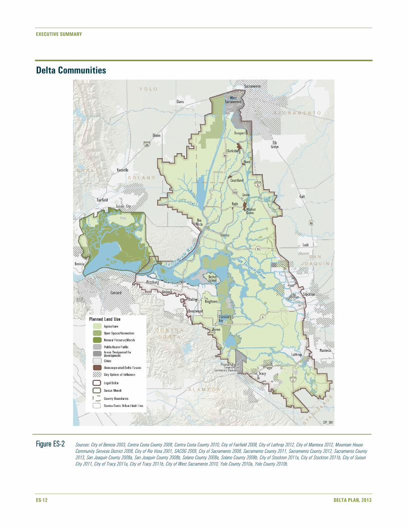
Risk Reduction Policy 2). (See Figure ES-2, Delta
Communities.)
A little more bustle might actually benefit 11 historic small
towns or settlements within the Delta, known as the legacy
communities. Most are spaced along the Sacramento River:
Freeport, Clarksburg, Hood, Courtland, Locke, Walnut
Grove, Ryde, Isleton, and Rio Vista. Knightsen and Bethel
Island are near the lower channel of the San Joaquin River.
Planners at all levels should respect the character, and
promote the vitality, of these places (Delta-as-Place
Recommendation 3).
The Delta Protection Commission has written an Economic
Sustainability Plan containing numerous ideas for the
support of the region’s farm economy, parks and recreation,
and roads and infrastructure. The Delta Plan adapts many of
these as Delta-as-Place Recommendations 5 through 19.
Flood Risk Reduction
In its primeval state, most of the Delta was wetland and
slightly above sea level. Since levees created the modern
islands and cultivation began, soils have subsided deeply.
Many Delta tracts are strikingly below the level of the water
in adjacent channels; rising sea level will make the differen-
tial worse. While the occasional levee break is part of Delta
lore, multiple failures could bring disaster to the Delta land-
scape, economy, and ecosystem.
The Delta Plan urges all agencies in the Delta to plan for
emergencies and to join forces in a regional response con-
sortium, as proposed by the Delta Multi-Hazard Coord-
ination Task Force. Every responsible party, public and
private, should allocate money for flood prevention and
reaction. Utilities should plan to minimize interruptions of
service. The Department of Water Resources should expand
its stockpiles of stone and earth for the use of all when
breaches require rapid plugging. Higher levels of private
flood insurance should be required, and the State should
gain immunity from lawsuits related to flooding beyond its
power to prevent. (Risk Reduction Recommendations 1,
9, and 10.)
It is estimated that only about half the Delta’s acreage is adequately protected.
There is not enough money for all the desirable improvements,
nor is there a mechanism for sharing costs among all who benefit.
EXECUTIVE SUMMARY
ES-12 DELTA PLAN, 2013
Delta Communities
Figure ES-2 Sources: City of Benicia 2003, Contra Costa County 2008, Contra Costa County 2010, City of Fairfield 2008, City of Lathrop 2012, City of Manteca 2012, Mountain House
Community Services District 2008, City of Rio Vista 2001, SACOG 2009, City of Sacramento 2008, Sacramento County 2011, Sacramento County 2012, Sacramento County
2013, San Joaquin County 2008a, San Joaquin County 2008b, Solano County 2008a, Solano County 2008b, City of Stockton 2011a, City of Stockton 2011b, City of Suisun
City 2011, City of Tracy 2011a, City of Tracy 2011b, City of West Sacramento 2010, Yolo County 2010a, Yolo County 2010b.

EXECUTIVE SUMMARY
DELTA PLAN, 2013 ES-13
There are more than 1,000 miles of Delta levees. The State
is directly responsible for about one-third of the system;
nearly 70 local Reclamation Districts are in charge of the
rest. It is estimated that only about half the Delta’s acreage is
adequately protected. There is not enough money for all the
desirable improvements, nor is there a mechanism for shar-
ing costs among all who benefit. The Delta Plan calls on the
Legislature to establish a locally based Delta Flood Risk
Management Assessment District to raise money for
combined defenses. Public and private utilities, too, should
invest in defense of their facilities and lines. (Risk Reduc-
tion Recommendations 2 and 3.)
The State contributes massively to levee costs throughout
the Delta, but on a not very systematic basis. The Legislature
directed the Delta Stewardship Council to set priorities for
these investments. Risk Reduction Policy 1 offers broad
principles. Urban areas come first; special attention must be
paid to levees guarding roads and energy facilities. The
channels through which water flows toward export pumps
require protection, as does the pipeline that brings Sierra
water across the Delta for the East Bay Municipal Utility
District. Levees on the western islands, whose failure could
bring salinity deep into the Delta, are also of high concern.
A more detailed study is to follow. Building on work being
done by the Department of Water Resources, the Council
will assess, island by island, the state of levees, the degree of
subsidence, the extent and value of assets to be protected,
and the cost of long-term defense. The result, due at the end
of 2014, will be a tiered priority list for the expenditure of
State levee funds (Risk Reduction Recommendation 4).
To take pressure off the levee system, floodwaters need
room to move and to spread without causing harm (and of-
ten to the benefit of plants, birds, and fish). Two such safety
valves already exist at the Yolo Bypass and the Cosumnes-
Mokelumne floodplain; a third such zone is proposed for
the lower San Joaquin River at Paradise Cut. The Delta Plan
urges expansion of the flood relief system, and requires that
present or potential overflow areas be kept free of
encroachments. Levee setbacks are also encouraged. (Risk
Reduction Policies 3 and 4, RR Recommendations 5
through 8.)
Given time, land subsidence can actually be reversed.
Experimental plots show that soils can be deepened by
growing tules in shallowly flooded fields, at a rate of a little
over an inch a year. The tule plots also fix a lot of atmos-
pheric carbon and thus do their bit toward slowing climate
change. The Delta Plan encourages expansion of this work
(Delta-as-Place Recommendation 7).
Finding the Way Through
When the first Spanish explorers took their boats into the
Sacramento-San Joaquin River Delta, they were feeling their
way. They could see the channel they were in, as far as the
next bend or junction of sloughs. They had a general idea of
where they were going. Between the near and the far,
though, were mysteries. Which waterways connected to
others, which petered out in the marshes? Where was the
real way through?
Tangible marks of progress may at first be as subtle as shifting shoreline
features seen from a Delta boat.
This first edition of the Delta Plan is a little like such an
exploration. A short reach of channel is visible; another
stretch can be assessed from local information. After that,
the route is a matter of educated guesswork.
The Delta Plan can be fairly specific about steps to be taken
in the next 5 years. The Delta Science Plan is already under
way. The in-depth study of levees will begin by fall 2013.
The Interagency Implementation Committee will meet by

EXECUTIVE SUMMARY
ES-14 DELTA PLAN, 2013
the end of the year. Just around the next bend, the State
Water Resources Control Board will adopt its momentous
new flow rules; a final decision on Delta conveyance (the
Bay Delta Conservation Plan) looms beyond that.
It will not have escaped the reader how many of these
measures seem rather abstract, involving studies, rule-
making, the gathering of information, the refining of
procedures, the testing of powers—not so much doing as
planning, and even planning how to plan. This is simply the
phase we are in. Tangible marks of progress may at first be
as subtle as shifting shoreline features seen from a Delta
boat. Here, though, are some markers to look for. We will
be doing well if, in a few years’ time:
■ Many urban and rural water suppliers that draw on the
Delta have taken real steps to reduce that reliance, with
measured, reported results.
■ Flows in Delta channels, controlled under new State
Water Resources Control Board rules, are looking a good
deal more like the historical ones.
■ Several new habitat restoration projects in the
Delta have moved from the planning to the construc-
tion stage.
■ Subsidence reversal planting has expanded from the
small pilot projects seen today.
■ Measurably less acreage of Delta waters is dominated by
nonnative water plants.
■ Stocks of endangered fish are showing a rebound.
■ Key levees have been strengthened, especially in the
environs of Stockton and Sacramento.
■ No further rural farmland has been lost to urbanization.
The next edition of the Delta Plan, due in 2018 or sooner,
will be a little longer on specifics and a little shorter on
question marks. A few more miles of the channel ahead will
have come into view. New uncertainties, no doubt, will have
replaced old. The captains will continue to disagree. But, just
as it was in the old days, the route through the Delta will be
the one way forward.
Beyond all local debates and confusions, the destination is
clear. We want a Delta landscape that remains essentially
itself while adapting gradually and gracefully to a future
marked by climate change and sea level rise. We want a
Delta ecosystem that works markedly better than today’s,
reflected partly in a resurgence of native fish. And we want
an end to the endless wrangling about Delta flows and
plumbing—a truce that can only be achieved if the entire
California water system undergoes a measure of reform.
In solving the “Delta problem,” we will not only be doing right by a treasured
land- and waterscape. We will be putting the entire state of California
on a sounder development path.
Driven by cost, environmental concern, and sheer practi-
cality, the water world is already shifting away from reliance
on distant dams and aqueducts and toward trust in conser-
vation, local sources, and better use of groundwater storage.
This change is reflected in the fact, startling to many, that
California’s total water consumption has not climbed in
recent years; in fact, despite our increasing population, use
has slightly dropped. The Delta Plan gives a push to trends
already under way.
In solving the “Delta problem,” we will not only be doing
right by a treasured land- and waterscape. We will be
putting the entire state of California on a sounder
development path.
EXECUTIVE SUMMARY
DELTA PLAN, 2013 ES-15
References
California Department of Fish and Game. 2011. Conservation Strategy for Restoration of the Sacramento-San Joaquin Delta Ecological
Management Zone and the Sacramento and San Joaquin Valley Regions. Draft. July.
City of Benicia. 2003. General Plan land use designations within Suisun Marsh. Digitized into GIS format by AECOM from City of Benicia Land
Use map in 2012.
City of Fairfield. 2008. General Plan land use designations within Suisun Marsh. Received from the City of Fairfield in 2012.
City of Lathrop. 2012. General Plan Land Use map for the City of Lathrop. October. Site accessed March 14, 2013.
http://www.ci.lathrop.ca.us/cdd/documents/.
City of Manteca. 2012. General Plan land use designations in GIS format. Received by Eryn Pimentel, AECOM, from Jeffrey Davis, City of
Manteca, on September 4.
City of Rio Vista. 2001. General Plan land use designations in electronic non-GIS format. Site accessed 2009.
http://www.riovistacity.com/images/Documents/chapter_04.pdf.
City of Sacramento. 2008. General Plan land use designations in electronic GIS format. Site accessed 2009.
http://www.cityofsacramento.org/gis/data.html.
City of Stockton. 2011a. GIS layers for city spheres of influence and General Plan land use designations. Site accessed April 14, 2011.
http://www.stocktongov.com/services/gis/mapdatDat.html.
City of Stockton. 2011b. General Plan land use designations in GIS format and General Plan land use designations within Suisun Marsh
(digitized into GIS format by AECOM from Land Use map in 2012). Site accessed April 14, 2011.
http://www.stocktongov.com/services/gis/mapdatDat.html.
City of Suisun City. 2011. General Plan land use designations within Suisun Marsh. Digitized into GIS format by AECOM from Land Use map
in 2012.
City of Tracy. 2011a. General Plan land use designations provided in GIS format. Delivered via file transfer protocol from Victoria Lombardo,
Senior Planner, City of Tracy, to Jessica Law, Urban and Environmental Planner, AECOM, on March 10, 2011.
City of Tracy. 2011b. City of Tracy. 2011. City of Tracy Sphere of Influence provided in GIS format. Delivered via file transfer protocol from
Victoria Lombardo, Senior Planner, City of Tracy, to Jessica Law, Urban and Environmental Planner, AECOM, on March 10, 2011.
City of West Sacramento. 2010. General Plan land use designations in GIS format. Site accessed December 28, 2010.
http://www.cityofwestsacramento.org/services/gis/downloads.cfm.
Contra Costa County. 2008. GIS layer for Urban Limit Line for Contra Costa County. October. Site accessed June 27, 2011.
http://ccmap.us/Details/asp?Product=134490.
Contra Costa County. 2010. GIS layer for City Spheres of Influence in Contra Costa County. January. Site accessed January 28, 2011.
https://www.ccmap.us/catalog.asp?UserChoice=2&Layercntrl=0000000000000000000000.
Mountain House Community Services District. 2008. Mountain House Zoning map. September 18, 2008. Site accessed July 27, 2011.
http://www.ci.mountainhouse.ca.us/master-plan.asp.
SACOG (Sacramento Area Council of Governments). 2009. GIS layer for Spheres of Influence in SACOG region. December. Site accessed
January 28, 2011. http://sacog.org/mapping/clearinghouse/Mapping Center.
Sacramento County. 2011. General Plan land use designations in GIS format. Site accessed 2012. http://www.sacgis.org/GISDataPub/Data/.

EXECUTIVE SUMMARY
ES-16 DELTA PLAN, 2013
Sacramento County. 2012. Letter from Sacramento County to the Delta Stewardship Council, Re: Revised Maps of the Unincorporated Delta
Communities. November 20.
Sacramento County. 2013. Sacramento County Online Map, Sacramento County, California. Site accessed March 10, 2013.
http://generalmap.gis.saccounty.net/JSViewer/county_portal.aspx
San Joaquin County. 2008a. City of Lathrop SOI map. March 4. Site accessed February 3, 2011.
http://www.sjgov.org/lafco/SOI%20Maps/Lathrop_Sphere_new%202008.pdf.
San Joaquin County. 2008b. City of Manteca SOI map. October 29. Site accessed February 3, 2011.
http://www.co.san-joaquin.ca.us/lafco/Manteca%20MSR/Manteca_Sphere.pdf.
Solano County. 2008a. GIS layer for City Spheres of Influence in Solano County. May. Site accessed August 10, 2011.
http://regis.solanocounty.com/data.html.
Solano County. 2008b. General Plan land use designations provided in GIS format. Obtained 2009.
Yolo County. 2010a. General Plan land use designations in GIS format. Site accessed 2010.
http://www.yolocounty.org/Index.aspx?page=823.
Yolo County. 2010b. Yolo County General Plan 2030 layer provided in GIS format. Delivered via file transfer protocol from Marcus Neuvert,
GIS Specialist, Yolo County DITT, to Dillon Cowan, Staff Engineer, CH2M HILL, Inc., on July 1.
Photo Credits
Chapter divider (clockwise from top left): California Department of Water Resources, Chris Austin, L.A. Yarbrough, California
Department of Water Resources

EXECUTIVE SUMMARY
DELTA PLAN, 2013 ES-17
Delta Plan Policies and Recommendations
The Delta Plan contains a set of regulatory policies that will be enforced by the Delta Stewardship Council’s appellate authority
and oversight. The Delta Plan also contains priority recommendations, which are nonregulatory but call out actions essential to
achieving the coequal goals.
POLICY OR
RECOMMENDATION
NUMBER SHORT TITLE POLICY/RECOMMENDATION LANGUAGE
Chapter 2
G P1
(23 CCR section 5002)
Detailed Findings to
Establish Consistency
with the Delta Plan
(a) This policy specifies what must be addressed in a certification of consistency filed by a
State or local public agency with regard to a covered action. This policy only applies after
a “proposed action” has been determined by a State or local public agency to be a
covered action because it is covered by one or more of the regulatory policies contained
in Article 3. Inconsistency with this policy may be the basis for an appeal.
(b) Certifications of consistency must include detailed findings that address each of the
following requirements:
(1) Covered actions, in order to be consistent with the Delta Plan, must be consistent
with this regulatory policy and with each of the regulatory policies contained in
Article 3 implicated by the covered action. The Delta Stewardship Council acknowl-
edges that in some cases, based upon the nature of the covered action, full
consistency with all relevant regulatory policies may not be feasible. In those cases,
the agency that files the certification of consistency may nevertheless determine that
the covered action is consistent with the Delta Plan because, on whole, that action is
consistent with the coequal goals. That determination must include a clear identifica-
tion of areas where consistency with relevant regulatory policies is not feasible, an
explanation of the reasons why it is not feasible, and an explanation of how the
covered action nevertheless, on whole, is consistent with the coequal goals.
That determination is subject to review by the Delta Stewardship Council on appeal;
(2) Covered actions not exempt from CEQA must include applicable feasible mitigation
measures identified in the Delta Plan’s Program EIR (unless the measure(s) are within
the exclusive jurisdiction of an agency other than the agency that files the certifica-
tion of consistency), or substitute mitigation measures that the agency that files the
certification of consistency finds are equally or more effective;
(3) As relevant to the purpose and nature of the project, all covered actions must
document use of best available science;
(4) Ecosystem restoration and water management covered actions must include
adequate provisions, appropriate to the scope of the covered action, to assure
continued implementation of adaptive management. This requirement shall be
satisfied through both of the following:
(A) An adaptive management plan that describes the approach to be taken
consistent with the adaptive management framework in Appendix 1B, and
(B) Documentation of access to adequate resources and delineated authority by the
entity responsible for the implementation of the proposed adaptive management
process.
EXECUTIVE SUMMARY
ES-18 DELTA PLAN, 2013
POLICY OR
RECOMMENDATION
NUMBER SHORT TITLE POLICY/RECOMMENDATION LANGUAGE
(c) A conservation measure proposed to be implemented pursuant to a natural community
conservation plan or a habitat conservation plan that was:
(1) Developed by a local government in the Delta; and
(2) Approved and permitted by the California Department of Fish and Wildlife prior to
May 16, 2013
is deemed to be consistent with sections 5005 through 5009 of this Chapter if the
certification of consistency filed with regard to the conservation measure includes a
statement confirming the nature of the conservation measure from the California
Department of Fish and Wildlife.
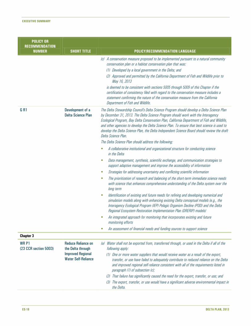
G R1 Development of a
Delta Science Plan
The Delta Stewardship Council’s Delta Science Program should develop a Delta Science Plan
by December 31, 2013. The Delta Science Program should work with the Interagency
Ecological Program, Bay Delta Conservation Plan, California Department of Fish and Wildlife,
and other agencies to develop the Delta Science Plan. To ensure that best science is used to
develop the Delta Science Plan, the Delta Independent Science Board should review the draft
Delta Science Plan.
The Delta Science Plan should address the following:
A collaborative institutional and organizational structure for conducting science
in the Delta
Data management, synthesis, scientific exchange, and communication strategies to
support adaptive management and improve the accessibility of information
Strategies for addressing uncertainty and conflicting scientific information
The prioritization of research and balancing of the short-term immediate science needs
with science that enhances comprehensive understanding of the Delta system over the
long term
Identification of existing and future needs for refining and developing numerical and
simulation models along with enhancing existing Delta conceptual models (e.g., the
Interagency Ecological Program (IEP) Pelagic Organism Decline (POD) and the Delta
Regional Ecosystem Restoration Implementation Plan (DRERIP) models)
An integrated approach for monitoring that incorporates existing and future
monitoring efforts
An assessment of financial needs and funding sources to support science
Chapter 3
WR P1
(23 CCR section 5003)
Reduce Reliance on
the Delta through
Improved Regional
Water Self-Reliance
(a) Water shall not be exported from, transferred through, or used in the Delta if all of the
following apply:
(1) One or more water suppliers that would receive water as a result of the export,
transfer, or use have failed to adequately contribute to reduced reliance on the Delta
and improved regional self-reliance consistent with all of the requirements listed in
paragraph (1) of subsection (c);
(2) That failure has significantly caused the need for the export, transfer, or use; and
(3) The export, transfer, or use would have a significant adverse environmental impact in
the Delta.

EXECUTIVE SUMMARY
DELTA PLAN, 2013 ES-19
POLICY OR
RECOMMENDATION
NUMBER SHORT TITLE POLICY/RECOMMENDATION LANGUAGE
(b) For purposes of Water Code section 85057.5(a)(3) and section 5001(j)(1)(E) of this
Chapter, this policy covers a proposed action to export water from, transfer water
through, or use water in the Delta, but does not cover any such action unless one or
more water suppliers would receive water as a result of the proposed action.
(c) (1) Water suppliers that have done all of the following are contributing to reduced
reliance on the Delta and improved regional self-reliance and are therefore consistent
with this policy:
(A) Completed a current Urban or Agricultural Water Management Plan (Plan) which
has been reviewed by the California Department of Water Resources for compli-
ance with the applicable requirements of Water Code Division 6, Parts 2.55,
2.6, and 2.8;
(B) Identified, evaluated, and commenced implementation, consistent with the
implementation schedule set forth in the Plan, of all programs and projects
included in the Plan that are locally cost effective and technically feasible which
reduce reliance on the Delta; and
(C) Included in the Plan, commencing in 2015, the expected outcome for measurable
reduction in Delta reliance and improvement in regional self-reliance. The
expected outcome for measurable reduction in Delta reliance and improvement in
regional self-reliance shall be reported in the Plan as the reduction in the amount
of water used, or in the percentage of water used, from the Delta watershed.
For the purposes of reporting, water efficiency is considered a new source of
water supply, consistent with Water Code section 1011(a).
(2) Programs and projects that reduce reliance could include, but are not limited to,
improvements in water use efficiency, water recycling, stormwater capture and use,
advanced water technologies, conjunctive use projects, local and regional water
supply and storage projects, and improved regional coordination of local and regional
water supply efforts.
WR R1 Implement Water
Efficiency and Water
Management
Planning Laws
All water suppliers should fully implement applicable water efficiency and water management
laws, including urban water management plans (Water Code section 10610 et seq.); the
20 percent reduction in statewide urban per capita water usage by 2020 (Water Code section
10608 et seq.); agricultural water management plans (Water Code section 10608 et seq. and
10800 et seq.); and other applicable water laws,
regulations, or rules.
WR R2 Require SWP
Contractors to
Implement Water
Efficiency and Water
Management Laws
The California Department of Water Resources should include a provision in all State Water
Project contracts, contract amendments, contract renewals, and water transfer agreements
that requires the implementation of all State water efficiency and water management laws,
goals, and regulations, including compliance with Water Code
section 85021.
WR R3 Compliance with
Reasonable
and Beneficial Use
The State Water Resources Control Board should evaluate all applications and petitions for a
new water right or a new or changed point of diversion, place of use, or purpose of use that
would result in new or increased long-term average use of water from the Delta watershed
for consistency with the constitutional principle of reasonable and beneficial use. The State
Water Resources Control Board should conduct its evaluation consistent with Water Code
sections 85021, 85023, 85031, and other provisions of California law. An applicant or

EXECUTIVE SUMMARY
ES-20 DELTA PLAN, 2013
POLICY OR
RECOMMENDATION
NUMBER SHORT TITLE POLICY/RECOMMENDATION LANGUAGE
petitioner should submit to the State Water Resources Control Board sufficient information to
support findings of consistency, including, as applicable, its urban water management plan,
agricultural water management plan, and environmental documents prepared pursuant to the
California Environmental Quality Act.
WR R4 Expanded Water
Supply Reliability
Element
Water suppliers that receive water from the Delta watershed should include an expanded
water supply reliability element, starting in 2015, as part of the update of an urban water
management plan, agricultural water management plan, integrated water management plan,
or other plan that provides equivalent information about the supplier’s planned investments in
water conservation and water supply development. The expanded water supply reliability
element should detail how water suppliers are reducing reliance on the Delta and improving
regional self-reliance consistent with Water Code section 85201 through investments in local
and regional programs and projects, and should document the expected outcome for a meas-
urable reduction in reliance on the Delta and improvement in regional self-reliance. At a
minimum, these plans should include a plan for possible interruption of water supplies for up
to 36 months due to catastrophic events impacting the Delta, evaluation of the regional
water balance, a climate change vulnerability assessment, and an evaluation of the extent to
which the supplier’s rate structure promotes and sustains efficient water use.
WR R5 Develop Water
Supply Reliability
Element Guidelines
The California Department of Water Resources, in consultation with the Delta Stewardship
Council, the State Water Resources Control Board, and others, should develop and approve,
by December 31, 2014, guidelines for the preparation of a water supply reliability element so
that water suppliers can begin implementation of WR R4 by 2015.
WR R6 Update Water
Efficiency Goals
The California Department of Water Resources and the State Water Resources Control Board
should establish an advisory group with other State agencies and stakeholders to identify and
implement measures to reduce impediments to achievement of statewide water conserva-
tion, recycled water, and stormwater goals by 2014. This group should evaluate and
recommend updated goals for additional water efficiency and water resource development
by 2018. Issues such as water distribution system leakage should be addressed. Evaluation
should include an assessment of how regions are achieving their proportional share of
these goals.
WR R7 Revise State Grant
and Loan Priorities
The California Department of Water Resources, the State Water Resources Control Board,
the California Department of Public Health, and other agencies, in consultation with the Delta
Stewardship Council, should revise State grant and loan ranking criteria by December 31,
2013, to be consistent with Water Code section 85021 and to provide a priority for water
suppliers that includes an expanded water supply reliability element in their adopted urban
water management plans, agricultural water management plans, and/or integrated regional
water management plans.
WR R8 Demonstrate State
Leadership
All State agencies should take a leadership role in designing new and retrofitted State-owned
and -leased facilities, including buildings and California Department of Transportation facili-
ties, to increase water efficiency, use recycled water, and incorporate stormwater runoff
capture and low-impact development strategies.
EXECUTIVE SUMMARY
DELTA PLAN, 2013 ES-21
POLICY OR
RECOMMENDATION
NUMBER SHORT TITLE POLICY/RECOMMENDATION LANGUAGE
WR R9 Update Bulletin 118,
California’s
Groundwater Plan
The California Department of Water Resources, in consultation with the Bureau of
Reclamation, U.S. Geological Survey, the State Water Resources Control Board, and other
agencies and stakeholders should update Bulletin 118 information using field data, California
Statewide Groundwater Elevation Monitoring (CASGEM), groundwater agency reports, satel-
lite imagery, and other best available science by December 31, 2014, so that this information
can be included in the next California Water Plan Update and be available for inclusion in
2015 urban water management plans and agricultural water management plans. The Bulletin
118 update should include a systematic evaluation of major groundwater basins to determine
sustainable yield and overdraft status; a projection of California’s groundwater resources in
20 years if current groundwater management trends remain unchanged; anticipated impacts
of climate change on surface water and groundwater resources; and recommendations for
State, federal, and local actions to improve groundwater management. In addition, the Bulle-
tin 118 update should identify groundwater basins that are in a critical condition of overdraft.
WR R10 Implement
Groundwater
Management Plans in
Areas that Receive
Water from
the Delta Watershed
Water suppliers that receive water from the Delta watershed and that obtain a significant
percentage of their long-term average water supplies from groundwater sources should
develop and implement sustainable groundwater management plans that are consistent with
both the required and recommended components of local groundwater management plans
identified by the California Department of Water Resources Bulletin 118 (Update 2003) by
December 31, 2014.
WR R11 Recover and Manage
Critically Overdrafted
Groundwater Basins
Local and regional agencies in groundwater basins that have been identified by the California
Department of Water Resources as being in a critical condition of overdraft should develop
and implement a sustainable groundwater management plan, consistent with both the
required and recommended components of local groundwater management plans identified
by the California Department of Water Resources Bulletin 118 (Update 2003), by
December 31, 2014. If local or regional agencies fail to develop and implement these plans,
the State Water Resources Control Board should take action to determine if the continued
overuse of a groundwater basin constitutes a violation of the State’s Constitution Article X,
Section 2, prohibition on unreasonable use of water and whether a groundwater adjudication
is necessary to prevent the destruction of or irreparable injury to the quality of the ground-
water, consistent with Water Code sections 2100 and 2101.
WR R12 Complete Bay Delta
Conservation Plan
The relevant federal, State, and local agencies should complete the Bay Delta Conservation
Plan, consistent with the provisions of the Delta Reform Act, and receive required incidental
take permits by December 31, 2014.
WR R13 Complete Surface
Water Storage
Studies
The California Department of Water Resources should complete surface water storage
investigations of proposed off-stream surface storage projects by December 31, 2012,
including an evaluation of potential additional benefits of integrating operations of new
storage with proposed Delta conveyance improvements, and recommend the critical projects
that need to be implemented to expand the state’s surface storage.
WR R14 Identify Near-term
Opportunities
for Storage, Use,
and Water Transfer
Projects
The California Department of Water Resources, in coordination with the California Water
Commission, Bureau of Reclamation, State Water Resources Control Board, California
Department of Public Health, the Delta Stewardship Council, and other agencies and stake-
holders, should conduct a survey to identify projects throughout California that could be
implemented within the next 5 to 10 years to expand existing surface and groundwater
storage facilities, create new storage, improve operation of existing Delta conveyance

EXECUTIVE SUMMARY
ES-22 DELTA PLAN, 2013
POLICY OR
RECOMMENDATION
NUMBER SHORT TITLE POLICY/RECOMMENDATION LANGUAGE
facilities, and enhance opportunities for conjunctive use programs and water transfers in
furtherance of the coequal goals. The California Water Commission should hold hearings and
provide recommendations to the California Department of Water Resources on priority
projects and funding.
WR R15 Improve Water
Transfer Procedures
The California Department of Water Resources and the State Water Resources Control Board
should work with stakeholders to identify and recommend measures to reduce procedural
and administrative impediments to water transfers and protect water rights and environmen-
tal resources by December 31, 2016. These recommendations should include measures to
address potential issues with recurring transfers of up to 1 year in duration and improved
public notification for proposed water transfers.
WR P2
(23 CCR section 5004)
Transparency in
Water Contracting
(a) The contracting process for water from the State Water Project and/or the Central Valley
Project must be done in a publicly transparent manner consistent with applicable policies
of the California Department of Water Resources and the Bureau of Reclamation
referenced below.
(b) For purposes of Water Code section 85057.5(a)(3) and section 5001(j)(1)(E) of this
Chapter, this policy covers the following:
(1) With regard to water from the State Water Project, a proposed action to enter into
or amend a water supply or water transfer contract subject to California Department
of Water Resources Guidelines 03-09 and/or 03-10 (each dated July 3, 2003), which
are attached as Appendix 2A; and
(2) With regard to water from the Central Valley Project, a proposed action to enter into
or amend a water supply or water transfer contract subject to section 226 of
P.L. 97-293, as amended or section 3405(a)(2)(B) of the Central Valley Project
Improvement Act, Title XXXIV of Public Law 102-575, as amended, which are
attached as Appendix 2B, and Rules and Regulations promulgated by the Secretary
of the Interior to implement these laws.
WR R16 Supplemental Water
Use Reporting
The State Water Resources Control Board should require water rights holders submitting
supplemental statements of water diversion and use or progress reports under their permits
or licenses to report on the development and implementation of all water efficiency and
water supply projects and on their net (consumptive) use.
WR R17 Integrated Statewide
System for Water
Use Reporting
The California Department of Water Resources, in coordination with the State Water
Resources Control Board, California Department of Public Health, California Public
Utilities Commission, California Energy Commission, Bureau of Reclamation, California Urban
Water Conservation Council, and other stakeholders, should develop a coordinated statewide
system for water use reporting. This system should incorporate recommendations for inclu-
sion of data needed to better manage California’s water resources. The system should be
designed to simplify reporting; reduce the number of required reports where possible; be
made available to the public online; and be integrated with the reporting requirements for the
urban water management plans, agricultural water management plans, and integrated
regional water management plans. Water suppliers that export water from, transfer water
through, or use water in the Delta watershed should be full participants in the data base.

EXECUTIVE SUMMARY
DELTA PLAN, 2013 ES-23
POLICY OR
RECOMMENDATION
NUMBER SHORT TITLE POLICY/RECOMMENDATION LANGUAGE
WR R18 California Water Plan The California Department of Water Resources, in consultation with the State Water
Resources Control Board, and other agencies and stakeholders, should evaluate and include in
the next and all future California Water Plan updates information needed to track water
supply reliability performance measures identified in the Delta Plan, including an assessment
of water efficiency and new water supply development, regional water balances, improve-
ments in regional self-reliance, reduced regional reliance on the Delta, and reliability of Delta
exports, and an overall assessment of progress in achieving the coequal goals.
WR R19 Financial Needs
Assessment
As part of the California Water Plan Update, the California Department of Water Resources
should prepare an assessment of the state’s water infrastructure. This should include the
costs of rehabilitating/replacing existing infrastructure, an assessment of the costs of new
infrastructure, and an assessment of needed resources for monitoring and adaptive manage-
ment for these projects. The California Department of Water Resources should also consider
a survey of agencies that may be planning small-scale projects (such as storage or
conveyance) that improve water supply reliability.
Chapter 4
ER P1
(23 CCR section 5005)
Delta Flow Objectives (a) The State Water Resources Control Board’s Bay Delta Water Quality Control Plan flow
objectives shall be used to determine consistency with the Delta Plan. If and when the
flow objectives are revised by the State Water Resources Control Board, the revised flow
objectives shall be used to determine consistency with the Delta Plan.
(b) For purposes of Water Code section 85057.5(a)(3) and section 5001(j)(1)(E) of this
Chapter, the policy set forth in subsection (a) covers a proposed action that could
significantly affect flow in the Delta.
ER R1 Update Delta Flow
Objectives
Development, implementation, and enforcement of new and updated flow objectives for the
Delta and high-priority tributaries are key to the achievement of the coequal goals. The State
Water Resources Control Board should update the Bay Delta Water Quality Control Plan
objectives as follows:
(a) By June 2, 2014, adopt and implement updated flow objectives for the Delta that are
necessary to achieve the coequal goals.
(b) By June 2, 2018, adopt, and as soon as reasonably possible, implement flow objectives
for high-priority tributaries in the Delta watershed that are necessary to achieve the
coequal goals.
Flow objectives could be implemented through several mechanisms including negotiation and
settlement, Federal Energy Regulatory Commission relicensing, or adjudicative proceeding.
Prior to the establishment of revised flow objectives identified above, the existing Bay Delta
Water Quality Control Plan objectives shall be used to determine consistency with the Delta
Plan. After the flow objectives are revised, the revised objectives shall be used to determine
consistency with the Delta Plan.

EXECUTIVE SUMMARY
ES-24 DELTA PLAN, 2013
POLICY OR
RECOMMENDATION
NUMBER SHORT TITLE POLICY/RECOMMENDATION LANGUAGE
ER P2
(23 CCR section 5006)
Restore Habitats
at Appropriate
Elevations
(a) Habitat restoration must be carried out consistent with Appendix 3, which is Section II of
the Draft Conservation Strategy for Restoration of the Sacramento-San Joaquin Delta
Ecological Management Zone and the Sacramento and San Joaquin Valley Regions
(California Department of Fish and Wildlife 2011). The elevation map attached as
Appendix 4 should be used as a guide for determining appropriate habitat restoration
actions based on an area’s elevation. If a proposed habitat restoration action is not
consistent with Appendix 4, the proposal shall provide rationale for the deviation based
on best available science.
(b) For purposes of Water Code section 85057.5(a)(3) and section 5001(j)(1)(E) of this
Chapter, this policy covers a proposed action that includes habitat restoration.
ER P3
(23 CCR section 5007)
Protect Opportunities
to Restore Habitat
(a) Within the priority habitat restoration areas depicted in Appendix 5, significant adverse
impacts to the opportunity to restore habitat as described in section 5006, must be
avoided or mitigated.
(b) Impacts referenced in subsection (a) will be deemed to be avoided or mitigated if the
project is designed and implemented so that it will not preclude or otherwise interfere
with the ability to restore habitat as described in section 5006.
(c) Impacts referenced in subsection (a) shall be mitigated to a point where the impacts have
no significant effect on the opportunity to restore habitat as described in section 5006.
Mitigation shall be determined, in consultation with the California Department of Fish
and Wildlife, considering the size of the area impacted by the covered action and the
type and value of habitat that could be restored on that area, taking into account existing
and proposed restoration plans, landscape attributes, the elevation map shown in
Appendix 4, and other relevant information about habitat restoration opportunities
of the area.
(d) For purposes of Water Code section 85057.5(a)(3) and section 5001(j)(1)(E) of this
Chapter, this policy covers proposed actions in the priority habitat restoration areas
depicted in Appendix 5. It does not cover proposed actions outside those areas.
ER P4
(23 CCR section 5008)
Expand Floodplains
and Riparian Habitats
in Levee Projects
(a) Levee projects must evaluate and where feasible incorporate alternatives, including the
use of setback levees, to increase floodplains and riparian habitats. Evaluation of setback
levees in the Delta shall be required only in the following areas (shown in Appendix 8):
(1) The Sacramento River between Freeport and Walnut Grove, the San Joaquin River
from the Delta boundary to Mossdale, Paradise Cut, Steamboat Slough, Sutter Slough;
and the North and South Forks of the Mokelumne River, and (2) Urban levee
improvement projects in the cities of West Sacramento and Sacramento.
(b) For purposes of Water Code section 85057.5(a)(3) and section 5001(j)(1)(E) of this
Chapter, this policy covers a proposed action to construct new levees or substantially
rehabilitate or reconstruct existing levees.
ER R2 Prioritize and
Implement Projects
that Restore Delta
Habitat
Bay Delta Conservation Plan implementers, California Department of Fish and Wildlife,
California Department of Water Resources, and the Delta Conservancy should prioritize and
implement habitat restoration projects in the areas shown on Figure 4-8. Habitat restoration
projects should ensure connections between areas being restored and existing habitat areas
and other elements of the landscape needed for the full life cycle of the species that will
benefit from the restoration project.

EXECUTIVE SUMMARY
DELTA PLAN, 2013 ES-25
POLICY OR
RECOMMENDATION
NUMBER SHORT TITLE POLICY/RECOMMENDATION LANGUAGE
Where possible, restoration projects should also emphasize the potential for improving water
quality. Restoration project proponents should consult the California Department of Public
Health’s Best Management Practices for Mosquito Control in California.
Yolo Bypass. Enhance the ability of the Yolo Bypass to flood more frequently to provide
more opportunities for migrating fish, especially Chinook salmon, to use this system as
a migration corridor that is rich in cover and food.
Cache Slough Complex. Create broad nontidal, freshwater, emergent-plant-dominated
wetlands that grade into tidal freshwater wetlands, and shallow subtidal and deep
open-water habitats. Also, return a significant portion of the region to uplands with
vernal pools and grasslands.
Cosumnes River–Mokelumne River confluence. Allow these unregulated and minimally
regulated rivers to flood over their banks during winter and spring frequently and regu-
larly to create seasonal floodplains and riparian habitats that grade into tidal marsh and
shallow subtidal habitats.
Lower San Joaquin River floodplain. Reconnect the floodplain and restore more natural
flows to stimulate food webs that support native species. Integrate habitat restoration
with flood management actions, when feasible.
Suisun Marsh. Restore significant portions of Suisun Marsh to brackish marsh with land-
water interactions to support productive, complex food webs to which native species
are adapted and to provide space to adapt to rising sea level action. Use information
from adaptive management processes during the Suisun Marsh Habitat Management,
Preservation, and Restoration Plan’s implementation to guide future habitat restoration
projects and to inform future tidal marsh management.
Western Delta/Eastern Contra Costa County. Restore tidal marsh and channel margin
habitat at Dutch Slough and western islands to support food webs and provide habitat
for native species.
ER R3 Complete
and Implement Delta
Conservancy
Strategic Plan
As part of its Strategic Plan and subsequent Implementation Plan or annual work plans, the
Delta Conservancy should:
Develop and adopt criteria for prioritization and integration of large-scale ecosystem
restoration in the Delta and Suisun Marsh, with sustainability and use of best available
science as foundational principles.
Develop and adopt processes for ownership and long-term operations and management
of land in the Delta and Suisun Marsh acquired for conservation or restoration.
Develop and adopt a formal mutual agreement with the California Department of Water
Resources, California Department of Fish and Wildlife, federal interests, and other State
and local agencies on implementation of ecosystem restoration in the Delta
and Suisun Marsh.
Develop, in conjunction with the Wildlife Conservation Board, the California Department
of Water Resources, California Department of Fish and Wildlife, Bay Delta Conservation
Plan implementers, and other State and local agencies, a plan and protocol for acquiring
the land necessary to achieve ecosystem restoration consistent with the coequal goals
and the Ecosystem Restoration Program Conservation Strategy.

EXECUTIVE SUMMARY
ES-26 DELTA PLAN, 2013
POLICY OR
RECOMMENDATION
NUMBER SHORT TITLE POLICY/RECOMMENDATION LANGUAGE
Lead an effort, working with State and federal fish agencies, to investigate how to
better use habitat credit agreements to provide credit for each of these steps:
(1) acquisition for future restoration; (2) preservation, management, and enhancement
of existing habitat; (3) restoration of habitat; and (4) monitoring and evaluation of
habitat restoration projects.
Work with the California Department of Fish and Wildlife and the U.S. Fish and Wildlife
Service to develop rules for voluntary safe harbor agreements with property owners in
the Delta whose actions contribute to the recovery of listed threatened or endangered
species.
ER R4 Exempt Delta Levees
from the U.S. Army
Corps of Engineers’
Vegetation Policy
Considering the ecosystem value of remaining riparian and shaded riverine aquatic habitat
along Delta levees, the U.S. Army Corps of Engineers should agree with the California
Department of Fish and Wildlife and the California Department of Water Resources on a
variance that exempts Delta levees from the U.S. Army Corps of Engineers’ levee vegetation
policy where appropriate.
ER R5 Update the Suisun
Marsh Protection
Plan
The San Francisco Bay Conservation and Development Commission should update the Suisun
Marsh Protection Plan and relevant components of the Suisun Marsh Local Protection
Program to adapt to sea level rise and ensure consistency with the Suisun Marsh
Preservation Act, the Delta Reform Act, and the Delta Plan.
ER P5
(23 CCR section 5009)
Avoid Introductions
of and Habitat
Improvements for
Invasive Nonnative
Species
(a) The potential for new introductions of or improved habitat conditions for nonnative
invasive species, striped bass, or bass must be fully considered and avoided or mitigated
in a way that appropriately protects the ecosystem.
(b) For purposes of Water Code section 85057.5(a)(3) and section 5001(j)(1)(E) of this
Chapter, this policy covers a proposed action that has the reasonable probability of
introducing or improving habitat conditions for nonnative invasive species.
ER R6 Regulate Angling for
Nonnative Sport Fish
to Protect Native
Fish
The California Department of Fish and Wildlife should develop, for consideration by the Fish
and Game Commission, proposals for new or revised fishing regulations designed to increase
populations of listed fish species through reduced predation by introduced sport fish. The
proposals should be based on sound science that demonstrates these management actions
are likely to achieve their intended outcome and include the development of performance
measures and a monitoring plan to support adaptive management.
ER R7 Prioritize and
Implement Actions to
Control Nonnative
Invasive Species
The California Department of Fish and Wildlife and other appropriate agencies should
prioritize and fully implement the list of “Stage 2 Actions for Nonnative Invasive Species”
and accompanying text shown in Appendix J taken from the Conservation Strategy for
Restoration of the Sacramento–San Joaquin Delta Ecological Management Zone and the
Sacramento and San Joaquin Valley Regions (DFG 2011). Implementation of the Stage 2
actions should include the development of performance measures and monitoring plans to
support adaptive management.
ER R8 Manage Hatcheries
to Reduce Genetic
Risk
As required by the National Marine Fisheries Service, all hatcheries providing listed fish for
release into the wild should continue to develop and implement scientifically sound Hatchery
and Genetic Management Plans (HGMPs) to reduce risks to those species. The California
Department of Fish and Wildlife should provide annual updates to the Delta Stewardship
Council on the status of HGMPs within its jurisdiction.

EXECUTIVE SUMMARY
DELTA PLAN, 2013 ES-27
POLICY OR
RECOMMENDATION
NUMBER SHORT TITLE POLICY/RECOMMENDATION LANGUAGE
ER R9 Implement Marking
and Tagging Program
By December 2014, the California Department of Fish and Wildlife, in cooperation with the
U.S. Fish and Wildlife Service and the National Marine Fisheries Service, should revise and
begin implementing its program for marking and tagging hatchery salmon and steelhead to
improve management of hatchery and wild stocks based on recommendations of the Califor-
nia Hatchery Scientific Review Group, which considered mass marking, reducing hatchery
programs, and mark selective fisheries in developing its recommendations.
Chapter 5
DP R1 Designate the Delta
as a National
Heritage Area
The Delta Protection Commission should complete its application for designation of the Delta
and Suisun Marsh as a National Heritage Area, and the federal government should complete
the process in a timely manner.
DP R2 Designate State
Route 160 as a
National Scenic
Byway
The California Department of Transportation should seek designation of State Route 160 as a
National Scenic Byway, and prepare and implement a scenic byway plan for it.
DP P1
(23 CCR section 5010)
Locate New Urban
Development Wisely
(a) New residential, commercial, and industrial development must be limited to the following
areas, as shown in Appendix 6 and Appendix 7:
(1) Areas that city or county general plans as of May 16, 2013, designate for residential,
commercial, and industrial development in cities or their spheres of influence;
(2) Areas within Contra Costa County’s 2006 voter-approved urban limit line, except no
new residential, commercial, and industrial development may occur on Bethel Island
unless it is consistent with the Contra Costa County general plan effective as of
May 16, 2013;
(3) Areas within the Mountain House General Plan Community Boundary in San Joaquin
County; or
(4) The unincorporated Delta towns of Clarksburg, Courtland, Hood, Locke, Ryde, and
Walnut Grove.
(b) Notwithstanding subsection (a), new residential, commercial, and industrial development
is permitted outside the areas described in subsection (a) if it is consistent with the land
uses designated in county general plans as of May 16, 2013, and is otherwise consistent
with this Chapter.
(c) For purposes of Water Code section 85057.5(a)(3) and section 5001(j)(1)(E) of this
Chapter, this policy covers proposed actions that involve new residential, commercial,
and industrial development that is not located within the areas described in
subsection (a). In addition, this policy covers any such action on Bethel Island that is
inconsistent with the Contra Costa County general plan effective as of May 16, 2013.
This policy does not cover commercial recreational visitor-serving uses or facilities for
processing of local crops or that provide essential services to local farms, which are
otherwise consistent with this Chapter.
(d) This policy is not intended in any way to alter the concurrent authority of the Delta
Protection Commission to separately regulate development in the Delta’s Primary Zone.

EXECUTIVE SUMMARY
ES-28 DELTA PLAN, 2013
POLICY OR
RECOMMENDATION
NUMBER SHORT TITLE POLICY/RECOMMENDATION LANGUAGE
DP P2
(23 CCR section 5011)
Respect Local Land
Use When Siting
Water or Flood
Facilities or Restoring
Habitats
(a) Water management facilities, ecosystem restoration, and flood management infrastruc-
ture must be sited to avoid or reduce conflicts with existing uses or those uses described
or depicted in city and county general plans for their jurisdictions or spheres of influence
when feasible, considering comments from local agencies and the Delta Protection
Commission. Plans for ecosystem restoration must consider sites on existing public lands,
when feasible and consistent with a project’s purpose, before privately owned sites are
purchased. Measures to mitigate conflicts with adjacent uses may include, but are not
limited to, buffers to prevent adverse effects on adjacent farmland.
(b) For purposes of Water Code section 85057.5(a)(3) and section 5001(j)(1)(E) of this
Chapter, this policy covers proposed actions that involve the siting of water management
facilities, ecosystem restoration, and flood management infrastructure.
DP R3 Plan for the Vitality
and Preservation of
Legacy Communities
Local governments, in cooperation with the Delta Protection Commission and Delta
Conservancy, should prepare plans for each community that emphasize its distinctive
character, encourage historic preservation, identify opportunities to encourage tourism,
serve surrounding lands, or develop other appropriate uses, and reduce flood risks.
DP R4 Buy Rights of Way
from Willing Sellers
When Feasible
Agencies acquiring land for water management facilities, ecosystem restoration, and flood
management infrastructure should purchase from willing sellers, when feasible, including
consideration of whether lands suitable for proposed projects are available at fair prices.
DP R5 Provide Adequate
Infrastructure
The California Department of Transportation, local agencies, and utilities should plan
infrastructure, such as roads and highways, to meet needs of development consistent with
sustainable community strategies, local plans, the Delta Protection Commission’s Land Use
and Resource Management Plan for the Primary Zone of the Delta, and the Delta Plan.
DP R6 Plan for State
Highways
The Delta Stewardship Council, as part of the prioritization of State levee investments called
for in Water Code section 85306, should consult with the California Department of
Transportation as provided in Water Code section 85307(c) to consider the effects of flood
hazards and sea level rise on State highways in the Delta.
DP R7 Subsidence
Reduction
and Reversal
The following actions should be considered by the appropriate State agencies to address
subsidence reversal:
State agencies should not renew or enter into agricultural leases on Delta or Suisun
Marsh islands if the actions of the lessee promote or contribute to subsidence on the
leased land, unless the lessee participates in subsidence reversal or reduction programs.
State agencies currently conducting subsidence reversal projects in the Delta on State-
owned lands should investigate options for scaling up these projects if they have been
deemed successful. The California Department of Water Resources should develop a
plan, including funding needs, for increasing the extent of their subsidence reversal and
carbon sequestration projects to 5,000 acres by January 1, 2017.
The Delta Stewardship Council, in conjunction with the California Air Resources
Board (CARB) and the Delta Conservancy, should investigate the opportunity for the
development of a carbon market whereby Delta farmers could receive credit for
carbon sequestration by reducing subsidence and growing native marsh and wetland
plants. This investigation should include the potential for developing offset protocols
applicable to these types of plants for subsequent adoption by the CARB.

EXECUTIVE SUMMARY
DELTA PLAN, 2013 ES-29
POLICY OR
RECOMMENDATION
NUMBER SHORT TITLE POLICY/RECOMMENDATION LANGUAGE
DP R8 Promote Value-added
Crop Processing
Local governments and economic development organizations, in cooperation with the Delta
Protection Commission and the Delta Conservancy, should encourage value-added processing
of Delta crops in appropriate locations.
DP R9 Encourage
Agritourism
Local governments and economic development organizations, in cooperation with the Delta
Protection Commission and the Delta Conservancy, should support growth in agritourism,
particularly in and around legacy communities. Local plans should support agritourism where
appropriate.
DP R10 Encourage
Wildlife-friendly
Farming
The California Department of Fish and Wildlife, the Delta Conservancy, and other ecosystem
restoration agencies should encourage habitat enhancement and wildlife-friendly farming
systems on agricultural lands to benefit both the environment and agriculture.
DP R11 Provide New and
Protect Existing
Recreation
Opportunities
Water management and ecosystem restoration agencies should provide recreation
opportunities, including visitor-serving business opportunities, at new facilities and habitat
areas whenever feasible; and existing recreation facilities should be protected, using
California State Parks’ Recreation Proposal for the Sacramento-San Joaquin Delta and Suisun
Marsh and Delta Protection Commission’s Economic Sustainability Plan for the Sacramento-
San Joaquin Delta as guides.
DP R12 Encourage
Partnerships
to Support
Recreation
and Tourism
The Delta Protection Commission and Delta Conservancy should encourage partnerships
between other State and local agencies, and local landowners and business people to expand
recreation, including boating, promote tourism, and minimize adverse impacts to
nonrecreational landowners.
DP R13 Expand State
Recreation Areas
California State Parks should add or improve recreation facilities in the Delta in cooperation
with other agencies. As funds become available, it should fully reopen Brannan Island State
Recreation Area, complete the park at Delta Meadows-Locke Boarding House, and consider
adding new State parks at Barker Slough, Elkhorn Basin, the Wright-Elmwood Tract, and
south Delta.
DP R14 Enhance
Nature-based
Recreation
The California Department of Fish and Wildlife, in cooperation with other public agencies,
should collaborate with nonprofits, private landowners, and business partners to expand
wildlife viewing, angling, and hunting opportunities.
DP R15 Promote Boating
Safety
The California Department of Boating and Waterways should coordinate with the U.S. Coast
Guard and State and local agencies on an updated marine patrol strategy for the region.
DP R16 Encourage Recreation
on Public Lands
Public agencies owning land should increase opportunities, where feasible, for bank fishing,
hunting, levee-top trails, and environmental education.
DP R17 Enhance
Opportunities
for Visitor-serving
Businesses
Cities, counties, and other local and State agencies should work together to protect and
enhance visitor-serving businesses by planning for recreation uses and facilities in the Delta,
providing infrastructure to support recreation and tourism, and identifying settings for private
visitor-serving development and services.
DP R18 Support the Ports of
Stockton and West
Sacramento
The ports of Stockton and West Sacramento should encourage maintenance and carefully
designed and sited development of port facilities.
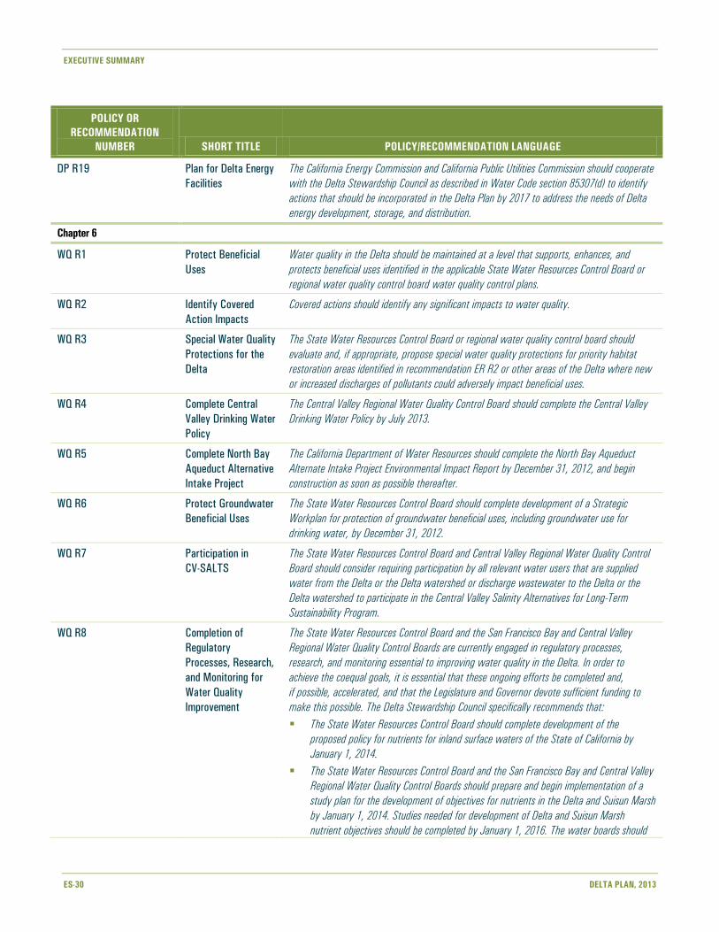
EXECUTIVE SUMMARY
ES-30 DELTA PLAN, 2013
POLICY OR
RECOMMENDATION
NUMBER SHORT TITLE POLICY/RECOMMENDATION LANGUAGE
DP R19 Plan for Delta Energy
Facilities
The California Energy Commission and California Public Utilities Commission should cooperate
with the Delta Stewardship Council as described in Water Code section 85307(d) to identify
actions that should be incorporated in the Delta Plan by 2017 to address the needs of Delta
energy development, storage, and distribution.
Chapter 6
WQ R1 Protect Beneficial
Uses
Water quality in the Delta should be maintained at a level that supports, enhances, and
protects beneficial uses identified in the applicable State Water Resources Control Board or
regional water quality control board water quality control plans.
WQ R2 Identify Covered
Action Impacts
Covered actions should identify any significant impacts to water quality.
WQ R3 Special Water Quality
Protections for the
Delta
The State Water Resources Control Board or regional water quality control board should
evaluate and, if appropriate, propose special water quality protections for priority habitat
restoration areas identified in recommendation ER R2 or other areas of the Delta where new
or increased discharges of pollutants could adversely impact beneficial uses.
WQ R4 Complete Central
Valley Drinking Water
Policy
The Central Valley Regional Water Quality Control Board should complete the Central Valley
Drinking Water Policy by July 2013.
WQ R5 Complete North Bay
Aqueduct Alternative
Intake Project
The California Department of Water Resources should complete the North Bay Aqueduct
Alternate Intake Project Environmental Impact Report by December 31, 2012, and begin
construction as soon as possible thereafter.
WQ R6 Protect Groundwater
Beneficial Uses
The State Water Resources Control Board should complete development of a Strategic
Workplan for protection of groundwater beneficial uses, including groundwater use for
drinking water, by December 31, 2012.
WQ R7 Participation in
CV-SALTS
The State Water Resources Control Board and Central Valley Regional Water Quality Control
Board should consider requiring participation by all relevant water users that are supplied
water from the Delta or the Delta watershed or discharge wastewater to the Delta or the
Delta watershed to participate in the Central Valley Salinity Alternatives for Long-Term
Sustainability Program.
WQ R8 Completion of
Regulatory
Processes, Research,
and Monitoring for
Water Quality
Improvement
The State Water Resources Control Board and the San Francisco Bay and Central Valley
Regional Water Quality Control Boards are currently engaged in regulatory processes,
research, and monitoring essential to improving water quality in the Delta. In order to
achieve the coequal goals, it is essential that these ongoing efforts be completed and,
if possible, accelerated, and that the Legislature and Governor devote sufficient funding to
make this possible. The Delta Stewardship Council specifically recommends that:
The State Water Resources Control Board should complete development of the
proposed policy for nutrients for inland surface waters of the State of California by
January 1, 2014.
The State Water Resources Control Board and the San Francisco Bay and Central Valley
Regional Water Quality Control Boards should prepare and begin implementation of a
study plan for the development of objectives for nutrients in the Delta and Suisun Marsh
by January 1, 2014. Studies needed for development of Delta and Suisun Marsh
nutrient objectives should be completed by January 1, 2016. The water boards should

EXECUTIVE SUMMARY
DELTA PLAN, 2013 ES-31
POLICY OR
RECOMMENDATION
NUMBER SHORT TITLE POLICY/RECOMMENDATION LANGUAGE
adopt and begin implementation of nutrient objectives, either narrative or numeric,
where appropriate, for the Delta and Suisun Marsh by January 1, 2018.
The State Water Resources Control Board and the Central Valley Regional Water Quality
Control Board should complete the Central Valley Pesticide Total Maximum Daily Load
and Basin Plan Amendment for diazinon and chlorpyrifos by January 1, 2013.
The State Water Resources Control Board and the Central Valley Regional Water Quality
Control Board should prioritize and accelerate the completion of the Central Valley
Pesticide Total Maximum Daily Load and Basin Plan Amendment for pyrethroids by
January 1, 2016.
The State Water Resources Control Board and the San Francisco Bay and Central Valley
Regional Water Quality Control Boards have completed Total Maximum Daily Load and
Basin Plan Amendments for methylmercury, and efforts to support their implementation
should be coordinated. Parties identified as responsible for current methylmercury loads
or proponents of projects that may increase methylmercury loading in the Delta or
Suisun Marsh should participate in control studies or implement site-specific study plans
that evaluate practices to minimize methylmercury discharges. The Central Valley
Regional Water Quality Control Board should review these control studies by
December 31, 2018, and determine control measures for implementation starting
in 2020.
WQ R9 Implement Delta
Regional Monitoring
Program
The State Water Resources Control Board and Regional Water Quality Control Boards should
work collaboratively with the California Department of Water Resources, California
Department of Fish and Wildlife, and other agencies and entities that monitor water quality
in the Delta to develop and implement a Delta Regional Monitoring Program that will be
responsible for coordinating monitoring efforts so Delta conditions can be efficiently assessed
and reported on a regular basis.
WQ R10 Evaluate Wastewater
Recycling, Reuse, or
Treatment
The Central Valley Regional Water Quality Control Board, consistent with existing water
quality control plan policies and water rights law, should require responsible entities that
discharge wastewater treatment plant effluent or urban runoff to Delta waters to evaluate
whether all or a portion of the discharge can be recycled, otherwise used, or treated in order
to reduce contaminant loads to the Delta by January 1, 2014.
WQ R11 Manage Dissolved
Oxygen in Stockton
Ship Channel
The State Water Resources Control Board and the Central Valley Regional Water Quality
Control Board should complete Phase 2 of the Total Maximum Daily Load and Basin Plan
Amendment for dissolved oxygen in the Stockton Deep Water Ship Channel by
January 1, 2015.
WQ R12 Manage Dissolved
Oxygen in Suisun
Marsh
The State Water Resources Control Board and the San Francisco Bay Regional Water Quality
Control Board should complete the Total Maximum Daily Load and Basin Plan Amendment
for dissolved oxygen in Suisun Marsh wetlands by January 1, 2014.

EXECUTIVE SUMMARY
ES-32 DELTA PLAN, 2013
POLICY OR
RECOMMENDATION
NUMBER SHORT TITLE POLICY/RECOMMENDATION LANGUAGE
Chapter 7
RR R1 Implement
Emergency
Preparedness and
Response
The following actions should be taken by January 1, 2014, to promote effective emergency
preparedness and response in the Delta:
Responsible local, State, and federal agencies with emergency response authority
should consider and implement the recommendations of the Sacramento-San Joaquin
Delta Multi-Hazard Coordination Task Force (Water Code section 12994.5). Such actions
should support the development of a regional response system for the Delta.
In consultation with local agencies, the California Department of Water Resources
should expand its emergency stockpiles to make them regional in nature and usable by
a larger number of agencies in accordance with California Department of Water
Resources’ plans and procedures. The California Department of Water Resources, as a
part of this plan, should evaluate the potential of creating stored material sites by
“over-reinforcing” west Delta levees.
Local levee-maintaining agencies should consider developing their own emergency
action plans, and stockpiling rock and flood-fighting materials.
State and local agencies and regulated utilities that own and/or operate infrastructure in
the Delta should prepare coordinated emergency response plans to protect the
infrastructure from long-term outages resulting from failures of the Delta levees. The
emergency procedures should consider methods that also would protect Delta land use
and ecosystem.
RR R2 Finance Local Flood
Management
Activities
The Legislature should create a Delta Flood Risk Management Assessment District with fee
assessment authority (including over State infrastructure) to provide adequate flood control
protection and emergency response for the regional benefit of all beneficiaries, including
landowners, infrastructure owners, and other entities that benefit from the maintenance
and improvement of Delta levees, such as water users who rely on the levees to protect
water quality.
This district should be authorized to:
Identify and assess all beneficiaries of Delta flood protection facilities.
Develop, fund, and implement a regional plan of flood management for both project and
nonproject levees of the Delta, including the maintenance and improvement of levees, in
cooperation with the existing reclamation districts, cities, counties, and owners of infra-
structure and other interests protected by the levees.
Require local levee-maintaining agencies to conduct annual levee inspections per the
California Department of Water Resources subventions program guidelines, and update
levee improvement plans every 5 years.
Participate in the collection of data and information necessary for the prioritization of
State investments in Delta levees consistent with RR P1.
Notify residents and landowners of flood risk, personal safety information, and available
systems for obtaining emergency information before and during a disaster on an
annual basis.
Potentially implement the recommendations of the Sacramento-San Joaquin Delta
Multi-Hazard Coordination Task Force (Water Code section 12994.5) in conjunction with
local, State, and federal agencies, and maintain the resulting regional response system
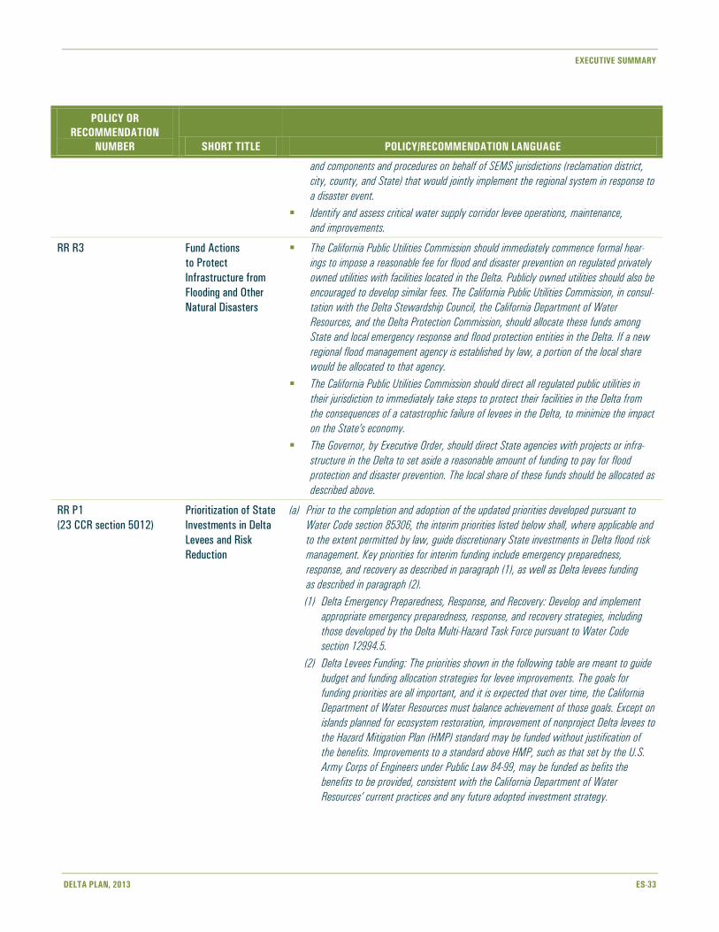
EXECUTIVE SUMMARY
DELTA PLAN, 2013 ES-33
POLICY OR
RECOMMENDATION
NUMBER SHORT TITLE POLICY/RECOMMENDATION LANGUAGE
and components and procedures on behalf of SEMS jurisdictions (reclamation district,
city, county, and State) that would jointly implement the regional system in response to
a disaster event.
Identify and assess critical water supply corridor levee operations, maintenance,
and improvements.
RR R3 Fund Actions
to Protect
Infrastructure from
Flooding and Other
Natural Disasters
The California Public Utilities Commission should immediately commence formal hear-
ings to impose a reasonable fee for flood and disaster prevention on regulated privately
owned utilities with facilities located in the Delta. Publicly owned utilities should also be
encouraged to develop similar fees. The California Public Utilities Commission, in consul-
tation with the Delta Stewardship Council, the California Department of Water
Resources, and the Delta Protection Commission, should allocate these funds among
State and local emergency response and flood protection entities in the Delta. If a new
regional flood management agency is established by law, a portion of the local share
would be allocated to that agency.
The California Public Utilities Commission should direct all regulated public utilities in
their jurisdiction to immediately take steps to protect their facilities in the Delta from
the consequences of a catastrophic failure of levees in the Delta, to minimize the impact
on the State’s economy.
The Governor, by Executive Order, should direct State agencies with projects or infra-
structure in the Delta to set aside a reasonable amount of funding to pay for flood
protection and disaster prevention. The local share of these funds should be allocated as
described above.
RR P1
(23 CCR section 5012)
Prioritization of State
Investments in Delta
Levees and Risk
Reduction
(a) Prior to the completion and adoption of the updated priorities developed pursuant to
Water Code section 85306, the interim priorities listed below shall, where applicable and
to the extent permitted by law, guide discretionary State investments in Delta flood risk
management. Key priorities for interim funding include emergency preparedness,
response, and recovery as described in paragraph (1), as well as Delta levees funding
as described in paragraph (2).
(1) Delta Emergency Preparedness, Response, and Recovery: Develop and implement
appropriate emergency preparedness, response, and recovery strategies, including
those developed by the Delta Multi-Hazard Task Force pursuant to Water Code
section 12994.5.
(2) Delta Levees Funding: The priorities shown in the following table are meant to guide
budget and funding allocation strategies for levee improvements. The goals for
funding priorities are all important, and it is expected that over time, the California
Department of Water Resources must balance achievement of those goals. Except on
islands planned for ecosystem restoration, improvement of nonproject Delta levees to
the Hazard Mitigation Plan (HMP) standard may be funded without justification of
the benefits. Improvements to a standard above HMP, such as that set by the U.S.
Army Corps of Engineers under Public Law 84-99, may be funded as befits the
benefits to be provided, consistent with the California Department of Water
Resources’ current practices and any future adopted investment strategy.

EXECUTIVE SUMMARY
ES-34 DELTA PLAN, 2013
POLICY OR
RECOMMENDATION
NUMBER SHORT TITLE POLICY/RECOMMENDATION LANGUAGE
Priorities for State Investment in Delta Integrated Flood Management
Categories of Benefit Analysis
Goals
Localized Flood
Protection Levee Network
Ecosystem
Conservation
(b) For purposes of Water Code section 85057.5(a)(3) and section 5001(j)(1)(E) of this
Chapter, this policy covers a proposed action that involves discretionary State
investments in Delta flood risk management, including levee operations, maintenance,
and improvements. Nothing in this policy establishes or otherwise changes existing
levee standards.
RR R4 Actions for the
Prioritization of State
Investments in Delta
Levees
The Delta Stewardship Council, in consultation with the California Department of Water
Resources, the Central Valley Flood Protection Board, the Delta Protection Commission, local
agencies, and the California Water Commission, should develop funding priorities for State
investments in Delta levees by January 1, 2015. These priorities shall be consistent with the
provisions of the Delta Reform Act in promoting effective, prioritized strategic State invest-
ments in levee operations, maintenance, and improvements in the Delta for both levees that
are a part of the State Plan of Flood Control and nonproject levees. Upon completion, these
priorities shall be considered for incorporation into the Delta Plan.
The priorities should identify guiding principles, constraints, recommended cost share
allocations, and strategic considerations to guide Delta flood risk reduction investments,

EXECUTIVE SUMMARY
DELTA PLAN, 2013 ES-35
POLICY OR
RECOMMENDATION
NUMBER SHORT TITLE POLICY/RECOMMENDATION LANGUAGE
supported by, at a minimum, the following actions to be conducted by the California
Department of Water Resources, consistent with available funding:
An assessment of existing Delta levee conditions. This should include the development
of a Delta levee conditions map based on sound data inputs, including, but not
limited to:
Geometric levee assessment
Flow and updated stage-frequency analysis
An island-by-island economics-based risk analysis. This analysis should consider, but not
be limited to, values related to protecting:
Island residents/life safety
Property
Value of Delta islands’ economic output, including agriculture
State water supply
Critical local, State, federal, and private infrastructure, including aqueducts, state
highways, electricity transmission lines, gas/petroleum pipelines, gas fields,
railroads, and deep water shipping channels
Delta water quality
Existing ecosystem values and ecosystem restoration opportunities
Recreation
Systemwide integrity
An ongoing assessment of Delta levee conditions. This should include a process for
updating Delta levee assessment information on a routine basis.
This methodology should provide the basis for the prioritization of State investments in Delta
levees. It should include, but not be limited to, the public reporting of the following items:
Tiered ranking of Delta islands, based on economics-based risk analysis values
Delta levee conditions status report, including a levee conditions map
Inventory of Delta infrastructure assets
RR P2
(23 CCR section 5013)
Require Flood
Protection for
Residential
Development
in Rural Areas
(a) New residential development of five or more parcels shall be protected through flood-
proofing to a level 12 inches above the 100-year base flood elevation, plus sufficient
additional elevation to protect against a 55-inch rise in sea level at the Golden Gate,
unless the development is located within:
(1) Areas that city or county general plans, as of May 16, 2013, designate for
development in cities or their spheres of influence;
(2) Areas within Contra Costa County’s 2006 voter-approved urban limit line, except
Bethel Island;
(3) Areas within the Mountain House General Plan Community Boundary in San Joaquin
County; or
(4) The unincorporated Delta towns of Clarksburg, Courtland, Hood, Locke, Ryde, and
Walnut Grove, as shown in Appendix 7.
(b) For purposes of Water Code section 85057.5(a)(3) and section 5001(j)(1)(E) of this
Chapter, this policy covers a proposed action that involves new residential development
of five or more parcels that is not located within the areas described in subsection (a).

EXECUTIVE SUMMARY
ES-36 DELTA PLAN, 2013
POLICY OR
RECOMMENDATION
NUMBER SHORT TITLE POLICY/RECOMMENDATION LANGUAGE
RR P3
(23 CCR section 5014)
Protect Floodways (a) No encroachment shall be allowed or constructed in a floodway, unless it can be
demonstrated by appropriate analysis that the encroachment will not unduly impede
the free flow of water in the floodway or jeopardize public safety.
(b) For purposes of Water Code section 85057.5(a)(3) and section 5001(j)(1)(E) of this
Chapter, this policy covers a proposed action that would encroach in a floodway that
is not either a designated floodway or regulated stream.
RR P4
(23 CCR section 5015)
Floodplain Protection (a) No encroachment shall be allowed or constructed in any of the following floodplains
unless it can be demonstrated by appropriate analysis that the encroachment will not
have a significant adverse impact on floodplain values and functions:
(1) The Yolo Bypass within the Delta;
(2) The Cosumnes River-Mokelumne River Confluence, as defined by the North Delta
Flood Control and Ecosystem Restoration Project (McCormack-Williamson), or as
modified in the future by the California Department of Water Resources or the U.S.
Army Corps of Engineers (California Department of Water Resources 2010); and
(3) The Lower San Joaquin River Floodplain Bypass area, located on the Lower
San Joaquin River upstream of Stockton immediately southwest of Paradise Cut on
lands both upstream and downstream of the Interstate 5 crossing. This area is de-
scribed in the Lower San Joaquin River Floodplain Bypass Proposal, submitted to the
California Department of Water Resources by the partnership of the South Delta
Water Agency, the River Islands Development Company, Reclamation District 2062,
San Joaquin Resource Conservation District, American Rivers, the American Lands
Conservancy, and the Natural Resources Defense Council, March 2011. This area
may be modified in the future through the completion of this project.
(b) For purposes of Water Code section 85057.5(a)(3) and section 5001(j)(1)(E) of this
Chapter, this policy covers a proposed action that would encroach in any of the flood-
plain areas described in subsection (a).
(c) This policy is not intended to exempt any activities in any of the areas described in
subsection (a) from applicable regulations and requirements of the Central Valley Flood
Protection Board.
RR R5 Fund and Implement
San Joaquin River
Flood Bypass
The Legislature should fund the California Department of Water Resources and the Central
Valley Flood Protection Board to evaluate and implement a bypass and floodway on the
San Joaquin River near Paradise Cut that would reduce flood stage on the mainstem
San Joaquin River adjacent to the urban and urbanizing communities of Stockton, Lathrop,
and Manteca in accordance with Water Code section 9613(c).
RR R6 Continue Delta
Dredging Studies
The current efforts to maintain navigable waters in the Sacramento River Deep Water Ship
Channel and Stockton Deep Water Ship Channel, led by the U.S. Army Corps of Engineers
and described in the Delta Dredged Sediment Long-Term Management Strategy (USACE
2007, Appendix K), should be continued in a manner that supports the Delta Plan and the
coequal goals. Appropriate dredging throughout other areas in the Delta for maintenance
purposes, or that would increase flood conveyance and provide potential material for levee
maintenance or subsidence reversal should be implemented in a manner that supports the
Delta Plan and coequal goals. Coordinated use of dredged material in levee improvement,
subsidence reversal, or wetland restoration is encouraged.

EXECUTIVE SUMMARY
DELTA PLAN, 2013 ES-37
POLICY OR
RECOMMENDATION
NUMBER SHORT TITLE POLICY/RECOMMENDATION LANGUAGE
RR R7 Designate Additional
Floodways
The Central Valley Flood Protection Board should evaluate whether additional areas both
within and upstream of the Delta should be designated as floodways. These efforts should
consider the anticipated effects of climate change in its evaluation of these areas.
RR R8 Develop Setback
Levee Criteria
The California Department of Water Resources, in conjunction with the Central Valley Flood
Protection Board, the California Department of Fish and Wildlife, and the Delta Conservancy,
should develop criteria to define locations for future setback levees in the Delta and
Delta watershed.
RR R9 Require Flood
Insurance
The Legislature should require an adequate level of flood insurance for residences, businesses,
and industries in floodprone areas.
RR R10 Limit State Liability The Legislature should consider statutory and/or constitutional changes that would address
the State’s potential flood liability, including giving State agencies the same level of immunity
with regard to flood liability as federal agencies have under federal law.
Chapter 8
FP R1 Conduct Current
Spending Inventory
An inventory of current State and federal spending on programs and projects that do or may
achieve the coequal goals will be conducted. Data sources to be used include the CALFED
cross-cut budget, State bond balance reports, and the annual State budget, among others.
Consideration will be given to selecting an independent agency (which could include a
non governmental organization) to conduct the inventory.
FP R2 Develop Delta Plan
Cost Assessment
Costs will be assigned to the projects and programs proposed in the Delta Plan
(Chapters 2 through 7) and sources of funding will be identified.
FP R3 Identify Funding Gaps Current State and federal funding gaps will be identified that are determined to hinder
progress toward meeting the coequal goals.
EXECUTIVE SUMMARY
ES-38 DELTA PLAN, 2013
This page intentionally left blank.