excavation report - welcome to the oa library · pdf fileexcavation report oa east report no:...
TRANSCRIPT

Ex
ca
va
tion
Re
po
rt
OA East Report No: 1398
OASIS No: oxfordar3-132147
NGR: TL 688 734
Client: Sweett UK Ltd. On behalf of Iceni Homes
Medieval Settlement Activityon Land at FreckenhamRoad, Worlington, Suffolk
April 2013
Excavation Report
Medieval Settlement Activity on Land at Freckenham Road,
Worlington, Suffolk
Archaeological Excavation
By Taleyna Fletcher MA, MifA
With contributions by Carole Fletcher BA, AifA, Rachel Fosberry HNC. AifA
and Dr Paul Spoerry
Editor: James Drummond-Murray MIfA
Illustrators: Stuart Ladd BA, MA, PifA, Lucy Offord MA and Severine Bezie MA
Report Date: April 2013
© Oxford Archaeology East Page 1 of 56 Report Number 1398

..................................................................................................
2
Table of Contents
Summary.......................................................................................................................................5
1 Introduction..............................................................................................................................7
1.1 Location and scope of work.......................................................................................7
1.2 Geology and topography............................................................................................7
1.3 Archaeological and historical background.................................................................7
1.4 Acknowledgements....................................................................................................9
2 Aims and Methodology..........................................................................................................10
2.1 Aims.........................................................................................................................10
2.2 Methodology.............................................................................................................10
3 Results....................................................................................................................................12
3.1 Phase 1 : c.11th-12th century..................................................................................12
3.2 Phase 2 : c.11th-13th century..................................................................................13
3.3 Phase 3 : c.12th-14th century..................................................................................14
3.4 Undated....................................................................................................................19
3.5 Natural Features......................................................................................................20
3.6 Finds Summary........................................................................................................20
3.7 Environmental Summary..........................................................................................21
4 Discussion and Conclusions................................................................................................22
Appendix A. Context Inventory : Evaluation and Excavation..............................................23
Appendix B. Finds Reports......................................................................................................38
B.1 Pottery......................................................................................................................38
Appendix C. Environmental Reports......................................................................................45
C.1 Environmental Samples...........................................................................................45
C.2 Shell........................................................................................................................50
Appendix D. Faunal Remains .................................................................................................52
Appendix E. Bibliography .......................................................................................................53
Websites Consulted...................................................................................................................54
Appendix F. OASIS Report Form.............................................................................................55
© Oxford Archaeology East Page 3 of 56 Report Number 1398

List of FiguresFigure 1 Site location map
Figure 2 Extract from 1840 parish map of Worlington (SRO EF505/1/84) showing location of excavation area (red)
Figure 3 Extract from 1904 Ordnance Survey map showing location of excavation area (red)
Figure 4 Excavation plan overlying evaluation trenches
Figure 5 Phased excavation plan overlying evaluation trenches
Figure 6 Selected sections
Figure 7 Storage jar from context 0056
List of PlatesPlate 1 Excavation area (taken from west)
Plate 2 Ditches 180 and 182Plate 3 East-west boundary ditches 202 et al
Plate 4 Pit 285Plate 5 North-south orientated ditches at southern edge of site
Plate 6 East-west boundary ditches 245 et al
Plate 7 Semi-articulated calf burial (132)
Plate 8 Possible structure comprising ditches 117 and 123 et al and postholes 111 et al
Plate 9 Pit 107Plate 10 Elongated pit 215
List of TablesTable A1 Evaluation Context Inventory
Table A2 Excavation Context List
Table B1 Fabric abbreviations and summary by fabric, sherd count and weight
Table B2 Pottery Catalogue
Table C1 Results of environmental sampling
Table C2 Quantification of shell recovered from hand collection and environmental processing
© Oxford Archaeology East Page 4 of 56 Report Number 1398

Summary
Between 30th July and 10th August 2012, an archaeological excavation was carried out by Oxford Archaeology East (OA East) on land to the north of Freckenham Road on the western outskirts of the village of Worlington in East Suffolk.
An area of approximately 0.10 hectares was investigated in advance of the construction of a small residential development on behalf of Iceni Homes.
The site had previously been evaluated by the field unit of Suffolk County Council's Archaeology Service in 2011. This evaluation identified evidence of medieval occupation on the site in the form of ditches, pits and postholes. The evaluation recorded least two or more phases of occupation, from the 10th to the 14th century as well as several other undated features.
The excavation area was located in close proximity, to the north-west of The Green which is considered to be medieval in origin and it is therefore very likely that the site lies within the area of medieval green edge settlement.
The excavation revealed the presence of settlement-related activity from the medieval period, spanning approximately 400 years. Although there was no certain presence of houses, the waste material from pits, representing disposal of accidentally burnt food products, meal refuse such as mussel shell and other domestic kitchen waste along with fuel from domestic hearths as well as charred grains, would all indicate that settlement must be located close by. The discovery of settlement activity is of no surprise given the site's position on the very edge of the village. However, previous investigations closer to the present settlement core have also failed to identify any structures, or any more significant remains than this most recent excavation.
Pottery recovered during the excavation confirms the presence of remains predominantly from the 12th-14th century, however three distinct phases were noted representing approximately 400 years of settlement on, or within,. close proximity of the site starting from the 11th century. Ditches from all phases recorded continuing beyond the northern edge of the excavation area would suggest further archaeological remains may be located to the immediate north.
There were three ditches, three pits and a number of postholes which could not be dated or attributed to a particular phase either by finds, association or stratigraphic relationship. These features are mostly isolated and the inability to assign them to any phase would not affect the overall interpretation of the site.
© Oxford Archaeology East Page 5 of 56 Report Number 1398

© Oxford Archaeology East Page 6 of 56 Report Number 1398

1 INTRODUCTION
1.1 Location and scope of work1.1.1 An archaeological excavation was conducted on land at Freckenham Road on the
western side of the village of Worlington in the Forest Heath district of Suffolk (TL 688 734) (Figure 1).
1.1.2 This archaeological excavation was undertaken in accordance with a Brief issued by Jess Tipper of Suffolk County Council's Archaeological Service (SCCAS), supplemented by a Specification prepared by OA East.
1.1.3 The work was designed to assist in defining the character and extent of any archaeological remains within the proposed redevelopment area, in accordance with the guidelines set out in National Planning Policy Framework (Department for Communities and Local Government March 2012). The results will enable decisions to be made by Suffolk County Council, on behalf of the Local Planning Authority, with regard to the treatment of any archaeological remains found.
1.1.4 The site archive is currently held by OA East and will be deposited with the Suffolk county stores in due course.
1.2 Geology and topography1.2.1 The geology of the site consists of superficial river terrace deposits of sand and gravel,
with localised lenses of silt, clay or peat, overlying bedrock formations of Zig Zag chalk (BGS, 2011). On site, the geology was primarily a pale yellow to mid orange sand with a band of gravel running from north-west to south-east across the site. Within the gravel band were small distinctive patches of firm, white chalk.
1.2.2 The site was almost level, with excavated ground heights varying between 7.43m and 7.70m above the Ordnance Datum.
1.2.3 Topsoil coverage varied very little across the site ranging from 0.29m to 0.36m, however there was significant changes in subsoil depths with 0.84m recorded on the eastern edge of site and 0.38m at the western side. This is likely to be a result of ploughing, with the creation of a headland where the plough has turned at the eastern end of the field, close to the field boundary.
1.3 Archaeological and historical background1.3.1 “The site lies within an area already defined within the Historic Environment Record
(HER) as having produced Roman, Saxon and medieval metal finds (WGN 027). However, close to the site there are also several other sites of interest. These include a Bronze Age tracer/awl and further Roman and medieval metalwork to the north-west (WGN 004, 023 and 025 respectively), Iron Age, Roman and medieval metalwork and Roman pottery to the south-west (WGN 009, 015 and 021 respectively), with WGN 015 possibly indicating the site of a medieval fair. There is also more medieval metalwork directly west of the site (WGN Misc), a medieval moated site, fish pond, architectural fragments and pits to the east (WGN 002, 017 and 036 respectively), as well as a Mesolithic flint point, medieval pits, more Roman and medieval metalwork and the medieval church to the north-east (WGN 007, 014, 018 and 024 respectively). “ (Brooks 2011).
1.3.2 The earliest available map which show the site in any detail is the 1840 parish map of Worlington (SRO EF505/1/84) (Figure 2). This map shows that The Green, presumably
© Oxford Archaeology East Page 7 of 56 Report Number 1398

of medieval origin, was located immediately to the south-east of the site. This may well indicate that the planned development lies within the area of medieval green edge settlement. There is no evidence to suggest that the development site, at this time, was in any other use than agricultural.
1.3.3 The First and Second Edition Ordnance Survey maps show very little change to the development site or to the surrounding area than the previous 1840 map. The most obvious difference is the addition of the Cambridge and Mildenhall Great Eastern Railway line depicted on the 1904 map (Figure 3).
1.3.4 The Tithe map for this site was unavailable for reference. The 1799 Enclosure map made no reference to The Green, only indicating that the area was owned by William Harlock, and no details were listed regarding the field immediately to the west (apportionment 81)
1.3.5 In 2011 the excavation site was evaluated by Suffolk County Council's Archaeology Service Contracting Team (Brooks 2011). Four trenches were investigated (Figure 4), all of which revealed evidence of medieval occupation on the site in the form of ditches, pits and a large buried deposit. The features produced pottery, animal bone, ceramic building material (CBM), marine shells and lava quern. Some unstratified worked flint was also recovered. There appeared to be at least two or more phases of occupation, from the 10th to the 14th century. Several other undated features were also excavated. The archaeological levels were well preserved below topsoil and plough-soil layers.
1.3.6 In 2008, Suffolk County Council's Archaeological Services Field Team conducted an evaluation at 21 The Street, approx 515m to the north-east of the site (Caruth 2008). This investigation revealed a small discrete group of medieval pits, dating from between the 11th and 14th centuries, and an in-filled pond, which was probably contemporary with the pits, from which a worked bone socketed point was recovered. Environmental evidence from the lower pond deposits showed that this had lain within managed grassland and evidence from the southern edge of the pond suggests that it may have served as a village amenity, accessed by people and animals. Both the pond and the pits were sealed by deposits of loam and topsoil.
1.3.7 An evaluation was carried out at 21/23 Church Lane by SCCAS Field Team in 2010 Brooks 2010), approximately 268m to the north-east of the site. No features or finds were uncovered by the work, which revealed an unexpected depth of topsoil and subsoil above the natural geology. There was slight disturbance relating to a modern pit, which did not truncate the natural, and a concrete cess pit.
1.3.8 Monitoring at of footing trenches at Elevenways, Freckenham Road approximately 114m to the south-east of the current investigation site was carried out in 2006 by SCCAS Field Team (Craven 2006). The investigation recorded an undated pit and possible peat filled hollow but did not locate a former green boundary or indication of associated medieval settlement. There was no indication of the former boundary marked on the 1880 OS although its probable route may have been largely removed by a swimming pool on the site Also, it may not have been a substantial boundary as it is clearly differentiated on the map from the ditch to the east; perhaps it was just a simple fencepost. Evidence of such a boundary could well have been missed by the placement of the trenches..
1.3.9 Archaeological monitoring of groundwork at Hawthorn Farm, Freckenham Road, West Row, Worlington in 2007 by SCCAS Field Team (Atfield 2007). Positioned approximately 1.6km to the north-west of the current excavation site, this piece of work comprised the monitoring of footing trenches and associated ground disturbance which
© Oxford Archaeology East Page 8 of 56 Report Number 1398
failed to reveal any archaeological features or finds. The deposits consisted of very shallow topsoil over an undisturbed natural chalk subsoil.
1.4 Acknowledgements1.4.1 The author would like to thank Robert Gurnham of Sweett UK Ltd for commissioning
the work on behalf of Iceni Homes and for supplying the architects drawings used in this report. The excavation was directed and surveyed by the author, assisted by Tam Webster, Pat Moan and Pete Boardman. Thanks also to Jess Tipper from Suffolk County Council's Archaeology Service (SCCAS)who wrote the brief for the works and visited the site.
© Oxford Archaeology East Page 9 of 56 Report Number 1398

2 AIMS AND METHODOLOGY
2.1 Aims2.1.1 The objective of this excavation was to determine as far as reasonably possible the
presence/absence, location, nature, extent, date, quality, condition and significance of any surviving archaeological deposits within the development area.
2.1.2 The site specific aims were:
▪ Anglo-Saxon2.1.3 Any evidence for Late Saxon settlement growth, on a site adjacent to the Village green,
should be looked for.
▪ Medieval2.1.4 The regional research agenda and strategy document identified the following generic
research theme for rural archaeology in East Anglia, regardless of period, but which in this instance can be applied effectively to remains expected on this site:
Settlement patterns and field systems.
The region’s distinctive patterns of fields, farms, hamlets and villages are vital to an understanding of past social organisation and economy, and form the matrix of the historic environment. (Brown and Glazebrook 2000, 57).
At this site there is clear evidence to suggest that information regarding the evolution of village form, particularly in respect of the establishment, growth, utilisation and infilling around the village green is potentially recoverable from a dated sequence of boundary systems. Evidence for the uses to which the spaces they enclosed were put; pasture/stock management, settlement, craft production etc. is potentially recoverable.
Period-based research themes such as study of rural settlement diversity, and the evolution of the agrarian economy (op. cit., 25) are provided with similar potential on the basis of the evaluation results.
▪ Post-Medieval2.1.5 In the case of this site the implications are that those themes that are significant in the
medieval period can be assessed in late centuries also.
2.2 Methodology2.2.1 Machine excavation was carried out under constant archaeological supervision with a
tracked 360o excavator using a toothless ditching bucket. Topsoil and subsoils were removed to the level of undisturbed geology of sands and gravels, where archaeological features were revealed (Plate 1). Most spoil was stored on site, however, due to the volume of topsoil encountered, in particular at the eastern side of the site, a significant amount had to be taken away.
2.2.2 Spoil, exposed surfaces and features were scanned with a metal detector. All metal-detected and hand-collected finds were retained for inspection, other than those which were obviously modern.
2.2.3 All archaeological features and deposits were recorded using OA East's pro-forma sheets. Colour and monochrome photographs were taken of all relevant features and
© Oxford Archaeology East Page 10 of 56 Report Number 1398

deposits supplemented by digital photographs using an Olympus M760 7.1mega pixel camera. .
2.2.4 The excavation area was set out using a Leica 1200 smartnet enabled GPS, based on a drawing which was agreed in advance with Jess Tipper of SCCAS. A site grid was set out at 10m intervals, on the Ordnance Survey grid and a temporary benchmark was established also using the GPS.
2.2.5 The site was planned by hand at a scale of 1:50 and sections of features were drawn at either 1:10 or 1:20.
2.2.6 A total of 23 environmental samples were collected from a representative cross-section of feature types and locations. These samples were taken to analyse the preservation of micro- and macro-botanical remains. A full report is presented in Appendix C1.
2.2.7 Site conditions were good throughout the excavation with only one day of heavy rain.
© Oxford Archaeology East Page 11 of 56 Report Number 1398
3 RESULTS
The results are presented below, by period and then feature type. Cut numbers are displayed in bold text, all other context in normal text. A plan of the excavation area is presented in Figure 4 and a phase plan in Figure 5. Selected sections are shown in Figure 6.
3.1 Phase 1 : c.11th-12th century3.1.1 This is the earliest phase of activity recorded on the site and comprises six linear and
curvilinear ditches, one with a posthole in the base, on a north-east to south-west orientation (Figures 4 and 5). All features from this phase were dated by pottery or stratigraphic relationship. Ditches recorded against the northern edge of the site and further north in Evaluation Trench 4 indicates a continuation of activity beyond the site in this direction. The presence of cooking vessels amongst the pottery vessel types would suggest domestic settlement nearby.
Ditches▪ Ditch 161 was oriented north-northeast to south-southwest. Measuring 0.98m wide and
0.2m deep it had a U-shape profile and contained a single fill. Fill 160 (also recorded as 164) was a pale to mid grey sandy silt with moderate flint inclusions. This fill contained a single sherd of pottery from a storage jar, dating to the 11th-12th century (Appendix B1). This ditch was truncated by ditch 154 et al.
▪ Ditch 171 (equivalent to 0017) was aligned north-north-east to south-south-west It measured 0.5m wide and 0.16m deep, with a U-shaped profile. The only fill (170) was a mid greyish brown sandy silt with moderate flint inclusions. This ditch was truncated by ditch 154.
▪ Ditch 221 was aligned north to south, 0.45m wide and 0.26m deep, with a wide U-shaped profile. Secondary fill 222 was a mid yellowish brown silty sand with frequent flint inclusions. This ditch was truncated by ditch 223 and ditch 218.
▪ Ditch 225 (equivalent to 230 and 232) was curvilinear in plan. It was between 0.32m to 0.48m wide and 0.1m to 0.2m deep with a bowl-shaped profile. The single fill (226 equivalent to 231 and 233) was a mid yellowish brown silty sand with regular flint inclusions. The feature was truncated by ditch 218.
▪ Ditch 227 was oriented north-east to south-west, 1.2m wide and 0.48m deep with a wide U-shape profile. Primary fill 228 was a dark greyish brown silty sand, 0.14m thick, with flint inclusions. Upper fill 229 was a mid greyish brown silty sand, 0.38m thick, with regular flint and rare charcoal inclusions. A single sherd of 10th-11th century pottery (Appendix B1) and a number of loose ribs and fragmentary long bones from cattle were recovered from this deposit (Appendix D). This ditch was truncated by ditch 218.
▪ Ditch 199 was aligned north-east to south-west, 0.38m wide and 0.14m deep with a U-shaped profile. Secondary fill 198 was a dark grey sandy silt with moderate pebble inclusions. A single sherd of 10th-mid 11th century pottery was recovered from this fill (Appendix B1).
▪ Ditch 197 was aligned north-east to south-west, 0.3m wide and 0.08m deep with a U-shaped profile. The only fill (196) was a pale grey sandy silt with moderate pebble inclusions. This ditch was truncated by pit 195.
© Oxford Archaeology East Page 12 of 56 Report Number 1398
Postholes▪ Posthole 167 was sub-circular in plan, between 0.2m to 0.29m in diameter and 0.07m to
0.19m deep with a U-shaped profile. The fill (166) was a pale grey sandy silt with occasional flint pebbles.
3.2 Phase 2 : c.11th-13th century3.2.1 Activity from this period includes a narrow east-west boundary ditch which appears to
have been re-instated several times, possibly during a 100-200 year period. It was possibly re-cut in sections or as a segmented ditch as one isolated surviving example suggests (Figures 4 and 5). The fills within this re-cut boundary ditch contained sherds of domestic cooking and storage vessels indicating the close proximity of the site to settlement. In addition to the east-west boundaries was a north-south orientated ditch continuing beyond the northern limit of the excavation area. This would indicate the possible survival of more features from this period beyond the northern limits of the excavation area.
3.2.2 In addition to the ditches, a single large rubbish pit was investigated. This contained nine distinct fills indicating separate, clearly identified episodes of waste deposition. Evidence of meal waste was noted from the environmental samples including charred cereals, mussel shells and sheep bones.
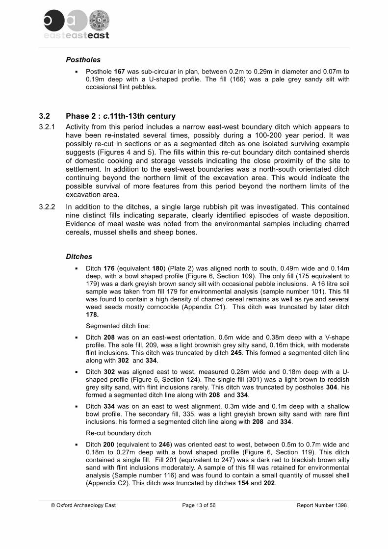
Ditches▪ Ditch 176 (equivalent 180) (Plate 2) was aligned north to south, 0.49m wide and 0.14m
deep, with a bowl shaped profile (Figure 6, Section 109). The only fill (175 equivalent to 179) was a dark greyish brown sandy silt with occasional pebble inclusions. A 16 litre soil sample was taken from fill 179 for environmental analysis (sample number 101). This fill was found to contain a high density of charred cereal remains as well as rye and several weed seeds mostly corncockle (Appendix C1). This ditch was truncated by later ditch 178.
Segmented ditch line:
▪ Ditch 208 was on an east-west orientation, 0.6m wide and 0.38m deep with a V-shape profile. The sole fill, 209, was a light brownish grey silty sand, 0.16m thick, with moderate flint inclusions. This ditch was truncated by ditch 245. This formed a segmented ditch line along with 302 and 334.
▪ Ditch 302 was aligned east to west, measured 0.28m wide and 0.18m deep with a U-shaped profile (Figure 6, Section 124). The single fill (301) was a light brown to reddish grey silty sand, with flint inclusions rarely. This ditch was truncated by postholes 304. his formed a segmented ditch line along with 208 and 334.
▪ Ditch 334 was on an east to west alignment, 0.3m wide and 0.1m deep with a shallow bowl profile. The secondary fill, 335, was a light greyish brown silty sand with rare flint inclusions. his formed a segmented ditch line along with 208 and 334.
Re-cut boundary ditch
▪ Ditch 200 (equivalent to 246) was oriented east to west, between 0.5m to 0.7m wide and 0.18m to 0.27m deep with a bowl shaped profile (Figure 6, Section 119). This ditch contained a single fill. Fill 201 (equivalent to 247) was a dark red to blackish brown silty sand with flint inclusions moderately. A sample of this fill was retained for environmental analysis (Sample number 116) and was found to contain a small quantity of mussel shell (Appendix C2). This ditch was truncated by ditches 154 and 202.
© Oxford Archaeology East Page 13 of 56 Report Number 1398
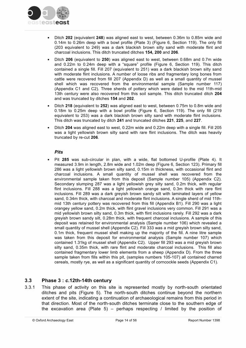
▪ Ditch 202 (equivalent 248) was aligned east to west, between 0.36m to 0.85m wide and 0.14m to 0.26m deep with a bowl profile (Plate 3) (Figure 6, Section 119). The only fill (203 equivalent to 249) was a dark blackish brown silty sand with moderate flint and charcoal inclusions. This ditch truncated ditches 154, 200 and 206.
▪ Ditch 206 (equivalent to 250) was aligned east to west, between 0.68m and 0.7m wide and 0.22m to 0.24m deep with a “square” profile (Figure 6, Section 119). This ditch contained a single fill. Fill 207 (equivalent to 251) was a dark blackish brown silty sand with moderate flint inclusions. A number of loose ribs and fragmentary long bones from cattle were recovered from fill 207 (Appendix D) as well as a small quantity of mussel shell which was recovered from the environmental sample (Sample number 117) (Appendix C1 and C2). Three sherds of pottery which were dated to the mid 11th-mid 13th century were also recovered from this soil sample. This ditch truncated ditch 204 and was truncated by ditches 154 and 202.
▪ Ditch 218 (equivalent to 252) was aligned east to west, between 0.75m to 0.8m wide and 0.18m to 0.25m deep with a bowl profile (Figure 6, Section 119). The only fill (219 equivalent to 253) was a dark blackish brown silty sand with moderate flint inclusions. This ditch was truncated by ditch 241 and truncated ditches 221, 225, and 227.
▪ Ditch 204 was aligned east to west, 0.22m wide and 0.22m deep with a single fill. Fill 205 was a light yellowish brown silty sand with rare flint inclusions. The ditch was heavily truncated by re-cut 206.
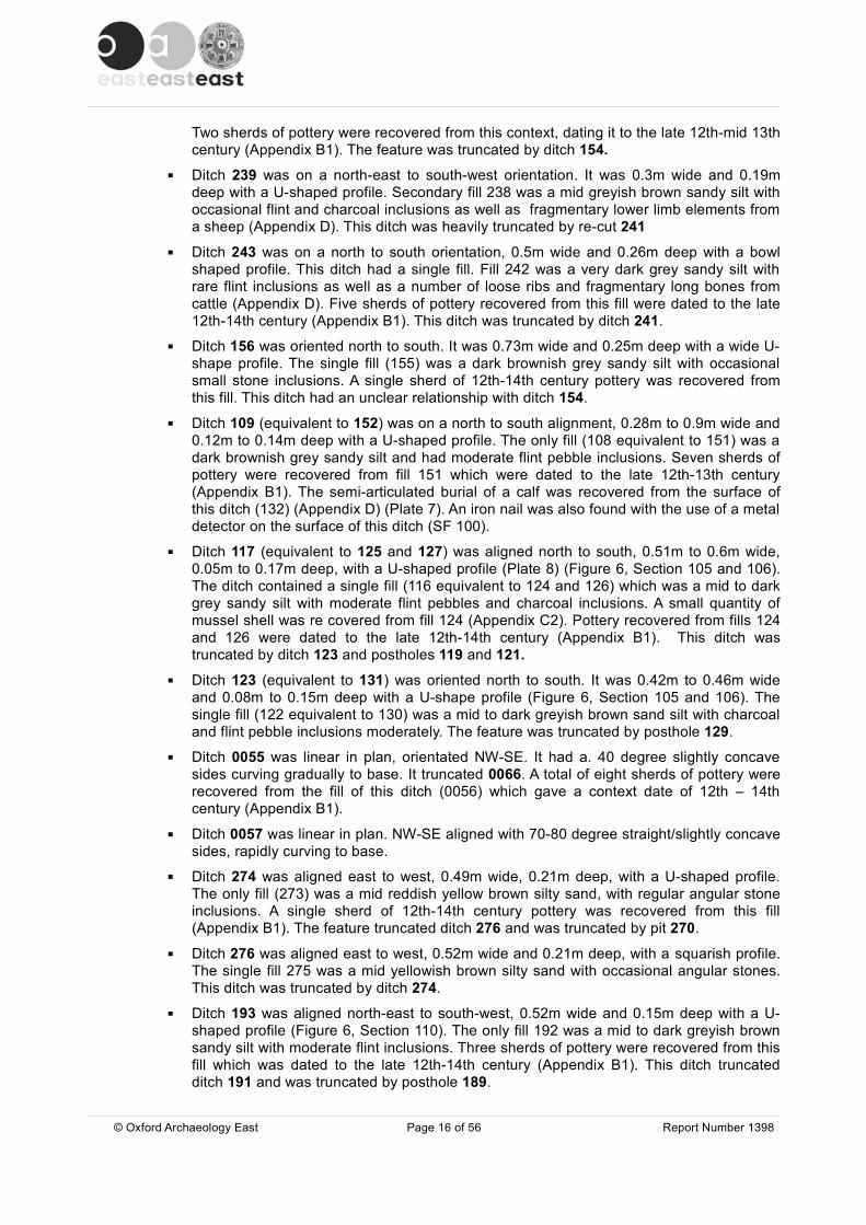
Pits▪ Pit 285 was sub-circular in plan, with a wide, flat bottomed U-profile (Plate 4). It
measured 3.9m in length, 2.8m wide and 1.02m deep (Figure 6, Section 123). Primary fill 286 was a light yellowish brown silty sand, 0.15m in thickness, with occasional flint and charcoal inclusions. A small quantity of mussel shell was recovered from the environmental sample taken from this deposit (Sample number 105) (Appendix C2). Secondary slumping 287 was a light yellowish grey silty sand, 0.2m thick, with regular flint inclusions. Fill 288 was a light yellowish orange sand, 0.3m thick with rare flint inclusions. Fill 289 was a dark greyish brown sandy silt with laminated layers of yellow sand, 0.34m thick, with charcoal and moderate flint inclusions. A single sherd of mid 11th-mid 13th century pottery was recovered from this fill (Appendix B1). Fill 290 was a light orangey yellow sand, 0.2m thick, with flint gravel inclusions very common. Fill 291 was a mid yellowish brown silty sand, 0.3m thick, with flint inclusions rarely. Fill 292 was a dark greyish brown sandy silt, 0.28m thick, with frequent charcoal inclusions. A sample of this deposit was retained for environmental analysis (Sample number 106) which revealed a small quantity of mussel shell (Appendix C2). Fill 333 was a mid greyish brown silty sand, 0.1m thick, frequent mussel shell making up the majority of the fill. A nine litre sample was taken from this deposit for environmental analysis (Sample number 107) which contained 1.31kg of mussel shell (Appendix C2). Upper fill 293 was a mid greyish brown silty sand, 0.35m thick, with rare flint and moderate charcoal inclusions. This fill also contained fragmentary lower limb elements from a sheep (Appendix D). From the three sample taken from fills within this pit, (samples numbers 105-107) all contained charred cereals, mostly rye, as well as a significant quantity of corncockle seeds (Appendix C1).
3.3 Phase 3 : c.12th-14th century3.3.1 This phase of activity on this site is represented mostly by north-south orientated
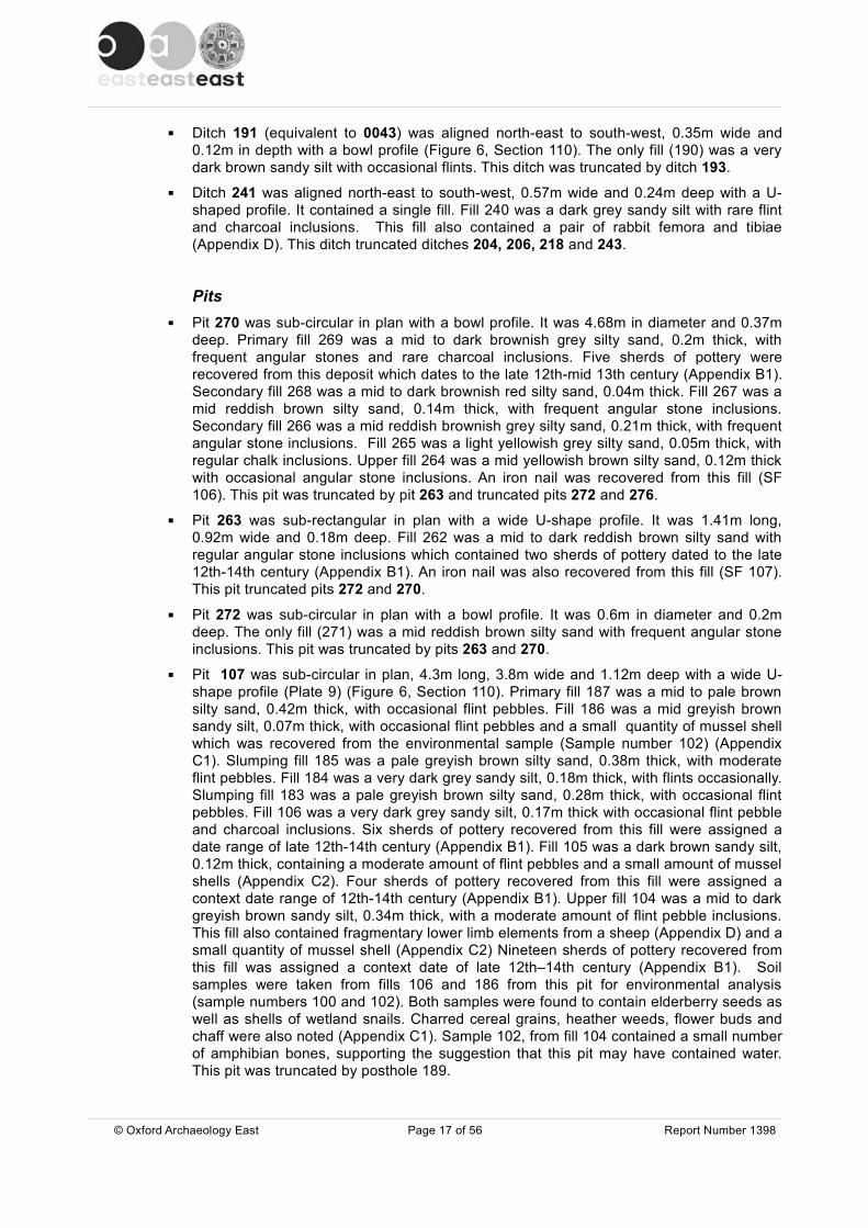
ditches and pits (Figure 5). The north-south ditches continue beyond the northern extent of the site, indicating a continuation of archaeological remains from this period in that direction. Most of the north-south ditches terminate close to the southern edge of the excavation area (Plate 5) – perhaps respecting / limited by the position of
© Oxford Archaeology East Page 14 of 56 Report Number 1398

Freckenham Road. Finds from these ditches include cooking vessels and storage jars indicating close proximity to settlement, and a large pit containing mussel shell, animal bone, chaff and other cereals, supports this suggestion.
3.3.2 A cluster of pits was positioned against the western edge of the excavation area. It was noted that these were positioned within a small patch of gravel. Given their shallow profiles and indistinct differences in fills, these are thought to represent small extraction pits, possibly dug to obtain gravel for the nearby road.
3.3.3 A cluster of postholes and what may be beamslots against the eastern edge of the site may represent a structure and an east-west fenceline may be a reinstatement of the earlier Phase 2 boundary.
3.3.4 The majority of the pottery assemblage came from this period of activity and comprised for the most part cooking pots rather than other storage vessels, indicateing this is almost entirely a kitchen assemblage from a domestic site.
Ditches▪ Ditch 178 (equivalent 182, 23 and 324) was on a north to south alignment, 0.7m wide,
between 0.15m and 0.3m deep with a bowl profile (Figure 6, Section 109) . The secondary fill (177/181/323) was a mid greyish brown sandy silt with occasional sub angular stone inclusions. A single sherd of pottery was recovered from fill 177 which was dated to the 12th-14th century and a sherd of 10th-11th century pottery which is considered to be residual, was recovered from fill 181 (Appendix B1). A 16 litre soil sample was taken from fill 323 for environmental analysis (sample number 121). This sample contained more rye seeds than any other sample from this phase, however, preservation was poor and may indicate incorporation of earlier material (Appendix C1). A small sherd of 12th-14th century pottery was also recovered from this sample. This ditch truncated ditch 176 and posthole 328.
▪ Ditch 332 was orientated north to south, measured 0.42m in width and 0.07m in depth with a flat based bowl profile. Secondary fill 331 was a mid orangey brown silty sand with rare angular stone inclusions.
▪ Ditch 158 (equivalent to 245, 0037 and 0003) (Plate 6) was on a north to south alignment. It was between 0.3m and 0.37m wide and 0.17m to 0.27m deep with a U-shape profile. The only fill (157 equivalent to 244, 0038 and 0004) was a dark grey sandy silt with occasional stone inclusions. Five sherds of pottery were recovered from fill 157 and two from 244 which were dated to the late 12th-14th century (Appendix B1). An iron nail was recovered from this surface of this ditch with the use of a metal detector (SF 104). The feature truncated ditch 208 and was truncated by ditch 241.
▪ Ditch 154 (equivalent to 237) was aligned north to south. The feature was 0.48m to 0.58m wide and 0.19m to 0.33m deep with a wide U-shape profile. Fill 153 (equivalent to 236) was a dark brownish grey sandy silt and had occasional small stone inclusions. Three sherds of pottery were recovered from fill 153 and two from 236 which were dated to the late 12th-14th century (Appendix B1). An eight litre soil sample was taken from fill 153 for environmental analysis (sample number 109). This sample contained a high density of cereal remains considered to be a secondary deposition. This sample also contained some weed seeds, the type of which are relatively rare and indicative of autumn-grown crops (Appendix C1) and a small quantity of mussel shell (Appendix C2). The feature had an unclear relationship with ditch 156 and truncated earlier ditches 161, 200, 204, 206, 208, 218 and 235.
▪ Ditch 235 was oriented north-east to south-west, 0.35m wide and 0.1m deep with a bowl profile. Fill 234 was a dark grey sandy silt with flint and moderate charcoal inclusions.
© Oxford Archaeology East Page 15 of 56 Report Number 1398
Two sherds of pottery were recovered from this context, dating it to the late 12th-mid 13th century (Appendix B1). The feature was truncated by ditch 154.
▪ Ditch 239 was on a north-east to south-west orientation. It was 0.3m wide and 0.19m deep with a U-shaped profile. Secondary fill 238 was a mid greyish brown sandy silt with occasional flint and charcoal inclusions as well as fragmentary lower limb elements from a sheep (Appendix D). This ditch was heavily truncated by re-cut 241
▪ Ditch 243 was on a north to south orientation, 0.5m wide and 0.26m deep with a bowl shaped profile. This ditch had a single fill. Fill 242 was a very dark grey sandy silt with rare flint inclusions as well as a number of loose ribs and fragmentary long bones from cattle (Appendix D). Five sherds of pottery recovered from this fill were dated to the late 12th-14th century (Appendix B1). This ditch was truncated by ditch 241.
▪ Ditch 156 was oriented north to south. It was 0.73m wide and 0.25m deep with a wide U-shape profile. The single fill (155) was a dark brownish grey sandy silt with occasional small stone inclusions. A single sherd of 12th-14th century pottery was recovered from this fill. This ditch had an unclear relationship with ditch 154.
▪ Ditch 109 (equivalent to 152) was on a north to south alignment, 0.28m to 0.9m wide and 0.12m to 0.14m deep with a U-shaped profile. The only fill (108 equivalent to 151) was a dark brownish grey sandy silt and had moderate flint pebble inclusions. Seven sherds of pottery were recovered from fill 151 which were dated to the late 12th-13th century (Appendix B1). The semi-articulated burial of a calf was recovered from the surface of this ditch (132) (Appendix D) (Plate 7). An iron nail was also found with the use of a metal detector on the surface of this ditch (SF 100).
▪ Ditch 117 (equivalent to 125 and 127) was aligned north to south, 0.51m to 0.6m wide, 0.05m to 0.17m deep, with a U-shaped profile (Plate 8) (Figure 6, Section 105 and 106). The ditch contained a single fill (116 equivalent to 124 and 126) which was a mid to dark grey sandy silt with moderate flint pebbles and charcoal inclusions. A small quantity of mussel shell was re covered from fill 124 (Appendix C2). Pottery recovered from fills 124 and 126 were dated to the late 12th-14th century (Appendix B1). This ditch was truncated by ditch 123 and postholes 119 and 121.
▪ Ditch 123 (equivalent to 131) was oriented north to south. It was 0.42m to 0.46m wide and 0.08m to 0.15m deep with a U-shape profile (Figure 6, Section 105 and 106). The single fill (122 equivalent to 130) was a mid to dark greyish brown sand silt with charcoal and flint pebble inclusions moderately. The feature was truncated by posthole 129.
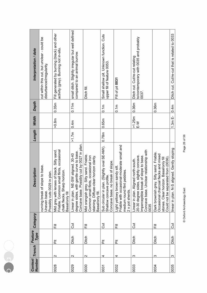
▪ Ditch 0055 was linear in plan, orientated NW-SE. It had a. 40 degree slightly concave sides curving gradually to base. It truncated 0066. A total of eight sherds of pottery were recovered from the fill of this ditch (0056) which gave a context date of 12th – 14th century (Appendix B1).
▪ Ditch 0057 was linear in plan. NW-SE aligned with 70-80 degree straight/slightly concave sides, rapidly curving to base.
▪ Ditch 274 was aligned east to west, 0.49m wide, 0.21m deep, with a U-shaped profile. The only fill (273) was a mid reddish yellow brown silty sand, with regular angular stone inclusions. A single sherd of 12th-14th century pottery was recovered from this fill (Appendix B1). The feature truncated ditch 276 and was truncated by pit 270.
▪ Ditch 276 was aligned east to west, 0.52m wide and 0.21m deep, with a squarish profile. The single fill 275 was a mid yellowish brown silty sand with occasional angular stones. This ditch was truncated by ditch 274.
▪ Ditch 193 was aligned north-east to south-west, 0.52m wide and 0.15m deep with a U-shaped profile (Figure 6, Section 110). The only fill 192 was a mid to dark greyish brown sandy silt with moderate flint inclusions. Three sherds of pottery were recovered from this fill which was dated to the late 12th-14th century (Appendix B1). This ditch truncated ditch 191 and was truncated by posthole 189.
© Oxford Archaeology East Page 16 of 56 Report Number 1398
▪ Ditch 191 (equivalent to 0043) was aligned north-east to south-west, 0.35m wide and 0.12m in depth with a bowl profile (Figure 6, Section 110). The only fill (190) was a very dark brown sandy silt with occasional flints. This ditch was truncated by ditch 193.
▪ Ditch 241 was aligned north-east to south-west, 0.57m wide and 0.24m deep with a U-shaped profile. It contained a single fill. Fill 240 was a dark grey sandy silt with rare flint and charcoal inclusions. This fill also contained a pair of rabbit femora and tibiae (Appendix D). This ditch truncated ditches 204, 206, 218 and 243.
Pits▪ Pit 270 was sub-circular in plan with a bowl profile. It was 4.68m in diameter and 0.37m
deep. Primary fill 269 was a mid to dark brownish grey silty sand, 0.2m thick, with frequent angular stones and rare charcoal inclusions. Five sherds of pottery were recovered from this deposit which dates to the late 12th-mid 13th century (Appendix B1). Secondary fill 268 was a mid to dark brownish red silty sand, 0.04m thick. Fill 267 was a mid reddish brown silty sand, 0.14m thick, with frequent angular stone inclusions. Secondary fill 266 was a mid reddish brownish grey silty sand, 0.21m thick, with frequent angular stone inclusions. Fill 265 was a light yellowish grey silty sand, 0.05m thick, with regular chalk inclusions. Upper fill 264 was a mid yellowish brown silty sand, 0.12m thick with occasional angular stone inclusions. An iron nail was recovered from this fill (SF 106). This pit was truncated by pit 263 and truncated pits 272 and 276.
▪ Pit 263 was sub-rectangular in plan with a wide U-shape profile. It was 1.41m long, 0.92m wide and 0.18m deep. Fill 262 was a mid to dark reddish brown silty sand with regular angular stone inclusions which contained two sherds of pottery dated to the late 12th-14th century (Appendix B1). An iron nail was also recovered from this fill (SF 107). This pit truncated pits 272 and 270.
▪ Pit 272 was sub-circular in plan with a bowl profile. It was 0.6m in diameter and 0.2m deep. The only fill (271) was a mid reddish brown silty sand with frequent angular stone inclusions. This pit was truncated by pits 263 and 270.
▪ Pit 107 was sub-circular in plan, 4.3m long, 3.8m wide and 1.12m deep with a wide U-shape profile (Plate 9) (Figure 6, Section 110). Primary fill 187 was a mid to pale brown silty sand, 0.42m thick, with occasional flint pebbles. Fill 186 was a mid greyish brown sandy silt, 0.07m thick, with occasional flint pebbles and a small quantity of mussel shell which was recovered from the environmental sample (Sample number 102) (Appendix C1). Slumping fill 185 was a pale greyish brown silty sand, 0.38m thick, with moderate flint pebbles. Fill 184 was a very dark grey sandy silt, 0.18m thick, with flints occasionally. Slumping fill 183 was a pale greyish brown silty sand, 0.28m thick, with occasional flint pebbles. Fill 106 was a very dark grey sandy silt, 0.17m thick with occasional flint pebble and charcoal inclusions. Six sherds of pottery recovered from this fill were assigned a date range of late 12th-14th century (Appendix B1). Fill 105 was a dark brown sandy silt, 0.12m thick, containing a moderate amount of flint pebbles and a small amount of mussel shells (Appendix C2). Four sherds of pottery recovered from this fill were assigned a context date range of 12th-14th century (Appendix B1). Upper fill 104 was a mid to dark greyish brown sandy silt, 0.34m thick, with a moderate amount of flint pebble inclusions. This fill also contained fragmentary lower limb elements from a sheep (Appendix D) and a small quantity of mussel shell (Appendix C2) Nineteen sherds of pottery recovered from this fill was assigned a context date of late 12th–14th century (Appendix B1). Soil samples were taken from fills 106 and 186 from this pit for environmental analysis (sample numbers 100 and 102). Both samples were found to contain elderberry seeds as well as shells of wetland snails. Charred cereal grains, heather weeds, flower buds and chaff were also noted (Appendix C1). Sample 102, from fill 104 contained a small number of amphibian bones, supporting the suggestion that this pit may have contained water. This pit was truncated by posthole 189.
© Oxford Archaeology East Page 17 of 56 Report Number 1398
▪ Elongated pit 215 was linear in plan with a U-shaped profile. It was 6.5m long, 1.1m wide and 0.57m deep (Plate 10) (Figure 6, Section 113). Primary fill 214 was a yellowish grey brown sandy silt, 0.13m thick, with frequent chalk lumps. Secondary fill 213 was a mid to dark grey sandy silt, 0.18m thick, with occasional flint gravel inclusions. Tertiary fill 212 was a mid orangey brown silty sand, 0.13m thick, with moderate flint pebble inclusions. Upper fill 211 was a mid brown silty sand with moderate flint inclusions, from which a number of loose ribs and fragmentary long bones from cattle were recovered (Appendix D).
▪ Pit 0008 was sub-circular in plan. Its profile was unclear as cut by other features, but irregular concave sides with gradual breaks and a flat base. Cut by pit 0010 and 0012
▪ Pit 0010 Circular in plan? Irregular shallow slightly concave sides with gradual breaks. Flat base. Cuts pit 0008.
▪ Pit 0012 was sub circular in plan with steep sides at south end, quite sharp breaks. Base quite flat. Truncates [0008]. A single sherd of pottery recovered from the fill was dated to the 12th-14th century (Appendix B1).
▪ Pit 0031. was sub circular in plan. (Sl ightly oval, orientated SE-NW). It had a shallow concave profile and concave base, no break of slope. Two sherds of pottery recovered from the fill of this pit was dated to the 12th-14th century.
▪ Pit 195 was sub-circular in plan with a U-shaped profile. It was 1.1m long, 0.85m wide and 0.17m deep. This pit contained a single fill. Fill 194 was a very dark grey sandy silt with moderate charcoal and flint inclusions. A sample of this fill was retained for analysis and was found to contain a small quantity of mussel shell (Appendix C1 and C2). This pit truncated ditches 197 and 199.
▪ Pit 174 was circular in plan, 0.56m in diameter and 0.4m deep with an irregular profile (Figure 6, Section 104). Primary fill 173 was a light brownish grey sandy silt, 0.15m thick, with moderate large flint stone inclusions. Secondary fill 172 was a dark grey sandy silt, 0.24m thick, with rare small stone inclusions and contained a single sherd of late 12th-14th century pottery (Appendix B1).
PostholesPosthole 189 was sub-circular in plan, 0.31m in diameter and 0.5m deep (Figure 6, Section 110). Single fill 188 was a dark greyish brown sandy silt with occasional flint pebble inclusions. This posthole truncated pit 107 and ditch 193.
Fencline▪ Fence-line postholes 304 (cuts 306, 308, 310, 312, 314 and 316) were all circular in plan,
measuring between 0.18m and 0.28m in diameter and 0.14m to 0.2m in depth with a U-shaped profile. The fills (303, 305, 307, 309, 311, 313 and 316) were a mid brownish grey sandy silt with stone inclusions rarely. Some of the postholes truncated ditch 302.
Building?▪ Postholes 111, 113 and 115 formed a line of sub-circular postholes (Plate 8) between
0.2m and 0.36m in diameter, 0.08m and 0.14m deep and had a U-shaped profile. The fills (110, 112 and 114) were a pale grey sand silt with occasional flint inclusions.
▪ Posthole 119 was sub-circular in plan, 0.32m in diameter and 0.08m deep with a shallow U-shape profile. Single fill 118 was a dark greyish brown sandy silt with moderate flint pebble inclusions. This posthole truncated the terminus of ditch 117.
▪ Posthole 121 was sub-circular in plan, 0.48m in diameter and 0.14m deep with a bowl shape profile (Figure 6, Section 105). Fill 120 was a mid grey sandy silt with occasional flint inclusions. This posthole truncated ditch 117.
© Oxford Archaeology East Page 18 of 56 Report Number 1398
▪ Posthole 129 was sub-circular in plan, 0.3m in diameter and 0.14m deep with a bowl profile (Figure 6, Section 106). Fill 128 was a mid to dark greyish brown sandy silt with charcoal and moderate flint pebble inclusions. This posthole truncated ditch 123.
▪ Postholes 134, 136 and 138 formed a line of sub-circular postholes, 0.2m to 0.23m in diameter and 0.08m to 0.13m deep with a U-shaped profile. The fills (133, 135 and 137) were a mid brownish grey sandy silt with occasional small stone inclusions.
▪ Posthole 140 was sub-circular in plan, 0.44m in diameter and 0.17m deep with a wide U-shape profile (Figure 6, Section 100). The fill (139) was a dark grey sandy silt with rare stone inclusions.
3.4 Undated3.4.1 There were three ditches, three pits and a number of postholes which could not be
dated or attributed to a particular phase either by finds, association or stratigraphic relationship. These features are mostly isolated and the ability to assign them to any phase would not affect he overall interpretation of the site.
Ditches▪ Ditch 278 (equivalent to 280) was on an east to west alignment. It was between 0.45m to
0.5m wide and 0.11m to 0.13m deep with a wide U-shaped profile. The only fill (277 equivalent to 279) was a dark greyish black silty sand, with moderate mussel shell inclusions and rare small flint stones. This ditch truncated pit 282.
▪ Ditch 223 was aligned north-west to south-east, 0.4m wide and 0.14m deep. The only fill (224) was a mid greyish brown silty sand with regular flint inclusions. This ditch truncated ditch 221.
Pits▪ Pit 261 was oval in plan with a wide U-shape profile. It was 0.9m long, 0.6m wide and
0.26m deep with a single fill. Fill 260 was a dark blackish grey silty sand, with occasional stone and charcoal inclusions.
▪ Pit 295 was circular in plan, with a wide, shallow U profile. It was 0.75m in diameter and 0.19m deep. Fill 294 was a light greyish brown silty sand with frequent large gravel stone inclusions.
▪ Pit 282 was linear in plan with a wide, shallow U-shaped profile. It was 0.5m long, 0.43m wide and 0.11m deep. The fill (281) was a mid grey silty sand with occasional small stone inclusions. This pit was truncated by ditch 278.
▪ Pit 326 (equivalent to 0025) was sub circular in plan with a bowl profile. It measured 0.65m in diameter and 0.22m deep. Fill 325 was a mid greyish brown sandy silty with occasional flint inclusions. The pit was truncated by ditch 324 et al.
Postholes▪ Postholes 255, 257 and 259 were all sub-rectangular in plan, between 0.26m to 0.3m in
diameter and 0.15m to 0.36m in depth with a straight sided U-shape profile. The fill (254, 256 and 258) was a light yellowish grey silty sand, with rare stone inclusions.
▪ Posthole 318 was rectangular in profile, 0.27m in diameter and 0.2m deep with a U-shaped profile. Fill 317 was a light brownish grey silty sand with rare flint stone inclusions.
▪ Posthole 320 was rectangular in plan, 0.36m in diameter and 0.38m deep with a narrow bottomed U-shaped profile. Fill 319 was a mid orangey brown silty sand, with medium sized moderate gravel stone inclusions.
© Oxford Archaeology East Page 19 of 56 Report Number 1398

▪ Posthole 322 was sub-circular in plan, 0.2m in diameter and 0.12m deep with a U-shaped profile. Fill 321 was a light brownish grey silty sand.
▪ Posthole 217 was sub-circular in plan, 0.5m in diameter and 0.2m deep with a U-shaped profile. Fill 216 was a dark greyish brown sandy silt with charcoal lumps and flint inclusions moderately.
▪ Posthole 142 was sub-circular in plan, 0.44m in diameter and 0.15m deep with a wide U-shape profile. Fill 141 was a light grey sandy silt with occasional small stone inclusions.
▪ Posthole 144 was circular in plan, 0.47m in diameter and 0.23m deep with a deep, flat based U-shaped profile. Fill 143 was a light grey sandy silt with occasional small stone inclusions.
▪ Posthole 146 was circular in plan, 0.53m in diameter and 0.16m deep, with a wide shallow U-shaped profile (Figure 6, Section 101). The only fill 145 was a light grey sandy silt with occasional small stone inclusions.
▪ Posthole 148 was circular in plan, 0.55m in diameter and 0.1m deep, with a wide U-shaped profile (Figure 6, Section 101). Fill 147 was a light grey sandy silt with occasional small stone inclusions.
▪ Posthole 150 was circular in plan,. 0.33m in diameter and 0.16m deep with a wide U-shaped profile. Fill 149 was a light grey sandy silt with occasional small stone inclusions.
▪ Posthole 328 was sub-circular in plan, 0.4m in diameter with a U-shaped profile. Fill 329 was a mid greyish brown sandy silt with rare flint pebble inclusions. This posthole was truncated by ditch 178.
▪ Posthole 330 was sub-circular in plan, 0.22m in diameter and 0.2m deep with a U-shaped profile. Fill 329 was a mid greyish brown silty sand with rare flint inclusions. This posthole was truncated by pit 326.
3.5 Natural Features3.5.1 There were only two natural features excavated during the excavation. These
comprised two tree throws located in the north-eastern part of the site.▪ Tree bole 300 was circular in plan with a shallow bowl profile. It measured 1.45m in
diameter and 0.18m deep. Fill 299 was a mid yellowish brown silty sand, with regular angular stone inclusions.
▪ Tree bole 298 was sub-circular in plan with an irregular profile. It was 2.85m in diameter and 0.32m deep. The primary fill (297) was a mottled brownish orange sand, 0.16m thick,with occasional angular stone inclusions. Upper fill 296 was a mid orangey brown silty sand, 0.16m thick, with frequent angular stones.
3.6 Finds Summary3.6.1 The evaluation and subsequent excavations produced a small post-Roman pottery
assemblage of 158 sherds, weighing 1.888kg. Unstratified material includes one post-medieval sherd found in the evaluation (Fabric GRE – not included in medieval assemblage statistics here). The assemblage is mainly 'high' medieval, but a small number of late Saxon (6 sherds) and early medieval (11 sherds) are present. The condition of the overall assemblage is moderately abraded and the average sherd weight is small to moderate at approximately 12g (Appendix B1).
3.6.2 Fifty four fragments of animal bone were recovered with 39 identifiable to species, mostly cattle and sheep (Appendix D).
© Oxford Archaeology East Page 20 of 56 Report Number 1398

3.6.3 The entire excavation and all spoil heaps were scanned with a metal detector. This resulted in the recovery of seven iron artefacts. Four nails were recovered from features and three nails/iron objects were recovered from the spoil heaps. The location of these finds is shown on Figure 4.
3.7 Environmental Summary3.7.1 The results of the environmental analysis of the the features sampled indicate the
disposal of food products and other domestic kitchen waste along with fuel from domestic hearths. Rubbish appears to be disposed of in both pits and ditches. Crops are represented by the full range of cereals; wheat, barley, rye and oats along with pulses including peas and beans. These findings are typical of Medieval towns in Suffolk as described in a review of excavated sites in this area (Murphy & De Moulins, 2001). The lack of chaff suggests that crop plants were imported into this site as semi-cleaned grain (Appendix C1).
© Oxford Archaeology East Page 21 of 56 Report Number 1398

4 DISCUSSION AND CONCLUSIONS
4.1.1 Excavations at Freckenham Road have revealed the presence of settlement related activity from the medieval period, spanning approximately 400 years. Although there was no definite presence of houses, the waste material from pits represented disposal of hearth waste, food products as well as charred grains and would indicate settlement located close by. Evidence collected from environmental samples may also indicate close-by structures as it included heather and sedge, both of which are often used for thatching. Great fen sedge was one of the major vegetation types of the Fen and was commonly used for thatching and as fuel. Sedge-beds were intensively managed during the medieval period for use in thatching as well as flooring material but also as a favoured fuel in bread ovens.
4.1.2 Following on from the evaluation, this investigation has allowed for further analysis of the site stratigraphy and, in conjunction with analysis of a larger pottery assemblage, it has enabled a better understanding of the date ranges present. Since the evaluation, more recent work on the medieval type series for Cambridgeshire has enabled pottery specialists to be more explicit regarding some fabric identifications. The whole assemblage is consistent in character, and is probably a kitchen assemblage from a domestic site. Although Late Saxon and early medieval sherds are present, indicating activity in the 11th to 12th centuries, the majority of pottery dates from the mid-12th century onwards. Although the pottery fabrics present for the most continued to be made until the 14th century, there are no vessel forms datable to the later part of this bracket, suggesting that activity on the site, ceased by the end of the 13th century.
4.1.3 The discovery of settlement activity is of no surprise given the site's position on the very edge of the village, however, previous investigations closer to the present settlement core have also failed to identify structures or any more significant remains than this most recent excavation.
4.1.4 The excavation area is located in close proximity, to the north-west of The Green which is considered to be medieval in origin and it is therefore very likely that the site lies within the area of medieval green edge settlement. Unfortunately, there were no useful maps earlier than 1840 available to consult, however, it is interesting that the east-west ditches assigned to the 11th-13th century are heading in the direction of the Green and their relationship with the main road (Freckenham Road) would be significant in helping to understanding more about the development of this part of the village.
4.1.5 The continuation of ditches and the presence of possible structures of 12th-14th century date beyond the northern edge of the site not only suggest a continuation of archaeological remains in this part of Worlington, but also suggest the settlement may pre-date the road which bounds the site to the north and that it sat within an immediate landscape far different than the layout present today.
© Oxford Archaeology East Page 22 of 56 Report Number 1398

AP
PE
ND
IX A
. C
ON
TEX
T IN
VE
NTO
RY
: EVA
LUAT
ION A
ND E
XC
AVAT
ION
Tabl
e A
1 : E
valu
atio
n C
onte
xt In
vent
ory
Con
text
N
umbe
rTr
ench
Feat
ure
Type
Cat
egor
yD
escr
iptio
nLe
ngth
Wid
thD
epth
Inte
rpre
tatio
n / d
ate
0002
2D
itch
Fill
Mid
pal
e m
ixed
gre
yish
bro
wn
silty
san
d.
Fria
ble.
Mod
erat
e sm
all a
ngul
ar a
nd
roun
ded
flint
s. R
are
fleck
s of
cha
lk. H
oriz
on
clea
r.
0.22
mFi
ll of
ditc
h
0003
2D
itch
Cut
Line
ar in
pla
n. A
ligne
d N
-S. B
reak
of s
lope
45
deg
rees
app
rox,
nea
r stra
ight
sid
es.
Con
cave
bas
e. C
uts
ditc
h [0
006]
0.88
m0.
22m
Cut
of d
itch
0004
2D
itch
Fill
Dar
k gr
eyis
h br
own
silty
san
d. F
riabl
e.M
oder
ate
smal
l ang
ular
flin
ts. H
oriz
on c
lear
. U
pper
fill.
1 p
iece
pot
0.24
mFi
ll of
ditc
h 00
03
0006
2D
itch
Cut
Line
ar in
pla
n co
min
g to
a ro
unde
d en
d to
th
e no
rth. A
ligne
d no
rth to
sou
th.
Ste
ep to
ver
tical
con
vex
side
s, e
xcep
t in
sect
ion
whe
re th
ey a
re c
onca
ve. S
quar
ed
flat b
ase.
Cut
by
[000
3]
>0.4
m0.
36m
Pro
babl
e di
tch
term
inus
.
0005
2D
itch
Fill
Mid
/pal
e gr
ey b
row
n si
lty s
and.
Fria
ble.
Freq
uent
ang
ular
flin
t gra
vels
. Occ
asio
nal
fleck
s of
cha
lk. H
oriz
on c
lear
. Bas
al fi
ll.
0.12
mBa
sal f
ill of
ditc
h
0007
4U
nstra
tifie
d fin
ds tr
ench
4.
0008
1P
itC
utS
ub-c
ircul
ar in
pla
n. P
rofil
e un
clea
r as
cut b
y ot
her f
eatu
res,
but
irre
gula
r con
cave
sid
es
with
gra
dual
bre
aks.
Fla
t bas
e. C
ut b
y pi
t [0
010]
and
[001
2]
1.26
m0.
29m
Cut
of p
it
0009
1P
itFi
llM
id-d
ark
yello
wis
h gr
eyis
h br
own.
Silt
y ch
alky
san
d. F
irm. C
omm
on a
ngul
ar
1.26
m0.
24m
Fill
of p
it.
© O
xfor
d A
rcha
eolo
gy E
ast
Pag
e 23
of 5
6
Con
text
N
umbe
rTr
ench
Feat
ure
Type
Cat
egor
yD
escr
iptio
nLe
ngth
Wid
thD
epth
Inte
rpre
tatio
n / d
ate
fragm
ents
of s
mal
l flin
t and
sto
ne.
Occ
asio
nal f
leck
s of
cha
rcoa
l. C
omm
on
fleck
s of
cha
lk. C
lear
hor
izon
. Sin
gle
fill.
0010
1P
itC
utC
ircul
ar in
pla
n? Ir
regu
lar s
hallo
w s
light
ly
conc
ave
side
s w
ith g
radu
al b
reak
s. F
lat
base
. Cut
s pi
t [00
08]
0.72
m0.
24m
0011
1P
itFi
llda
rk g
reyi
sh b
row
n sa
ndy
silt.
Occ
asio
nal
angu
lar s
mal
l flin
t. C
lear
hor
izon
. Sin
gle
fill.
0.72
m0.
24m
fill o
f pit
0010
.
0012
1P
itC
utS
ub c
ircul
ar in
pan
. Ste
ep s
ides
at s
outh
en
d, q
uite
sha
rp b
reak
s. B
ase
quite
flat
. C
uts
[000
8]
0.66
m0.
12m
Cut
of p
it
0013
1P
itFi
llM
id-li
ght g
reyi
sh b
row
n sa
ndy-
clay
ey s
ilt.
Firm
com
pact
ion.
Fre
quen
t fra
gmen
ts o
f ch
alk.
Diff
use
horiz
on c
larit
y. S
ingl
e fil
l.
0.66
m0.
12m
fill o
f pit
0014
2Po
stho
leFi
llda
rk g
reyi
sh b
row
n si
lty s
and.
Fria
ble
com
pact
ion.
Occ
asio
nal v
ery
smal
l flin
ts,
angu
lar a
nd ro
unde
d. C
lear
hor
izon
cla
rity.
S
ingl
e fil
l.
0.06
mFi
ll of
pos
thol
e.
0015
2Po
stho
leC
utO
val i
n pl
an, a
ligne
d E
-W. P
rofil
e ve
ry
shal
low,
sha
llow
con
cave
sid
es. N
early
flat
ba
se. T
o w
est o
f ditc
h [0
003]
.
0.5m
0.26
m0.
06m
cut o
f pit/
post
hole
.
0016
2D
itch
Fill
Mid
/pal
e gr
eyis
h br
own
silty
-san
d. F
riabl
e co
mpa
ctio
n. M
oder
ate
smal
l ang
ular
flin
ts.
Cle
ar H
oriz
on c
larit
y.
0.16
mfil
l of d
itch
0017
2D
itch
Cut
Line
ar in
pla
n, a
ligne
d N
-S. S
hallo
w U
sh
aped
pro
file.
Cut
s [0
019]
0.32
m0.
16m
Cut
of d
itch.
0022
2La
yer
Mid
-dar
k gr
ey s
ilty-
sand
. Firm
com
pact
ion.
C
omm
on s
mal
l-med
ium
flin
ts. C
lear
hor
izon
cl
arity
.
0.3m
Sam
e as
006
5
© O
xfor
d A
rcha
eolo
gy E
ast
Pag
e 24
of 5
6
Con
text
N
umbe
rTr
ench
Feat
ure
Type
Cat
egor
yD
escr
iptio
nLe
ngth
Wid
thD
epth
Inte
rpre
tatio
n / d
ate
0018
2P
itFi
llM
id g
reyi
sh b
row
n si
lty s
and.
Fria
ble
com
pact
ion.
No
incl
usio
ns. H
oriz
on c
lear
. N
o fin
ds.
0.12
mFi
ll of
pos
sibl
e pi
t
0019
2pi
tC
utTr
unca
ted
in p
lan
- cut
by
0017
- cu
rved
ed
ge. S
hallo
w p
rofil
e, s
hallo
w c
onca
ve
side
s. F
latti
sh b
ase.
0.42
m0.
12m
Cut
of p
oss
pit.
0020
2U
nstra
tifie
d fin
ds fr
om tr
ench
2.
0021
2La
yer
Dar
k or
angi
sh-b
row
n si
lty-s
and.
Firm
co
mpa
ctio
n. C
omm
on s
mal
l sto
nes,
oc
casi
onal
cha
lk fl
ecks
. Diff
use
horiz
on
clar
ity.
0.4m
sam
e as
006
4.
0064
4La
yer
Mid
bro
wn
grey
silt
y sa
nd. F
irm c
ompa
ctio
n.
Com
mon
sm
all f
lints
. Diff
use
horiz
on c
larit
y.0.
2-0.
3mP
loug
h-so
il? H
ard
to d
efin
e fro
m 0
065.
Sa
me
as 0
048?
And
002
100
654
Laye
rM
id g
rey
silty
san
d. F
irm c
ompa
ctio
n.
Com
mon
sm
all f
lints
. Diff
use
horiz
on c
larit
y.0.
35m
plou
gh-s
oil?
Har
d to
def
ine
from
006
4. s
ame
as 0
049?
And
002
200
232
Ditc
hC
utLi
near
in p
lan,
alig
ned
north
-sou
th. 4
0-45
de
gree
irre
gula
r sid
es, w
ith c
urvi
ng b
reak
to
base
. Bas
e is
stra
ight
, slo
ping
to th
e ea
st.
1m0.
4mD
itch
cut.
Par
t of s
erie
s of
dar
k fil
led
encl
osur
e di
tche
s on
site
. Pro
babl
y cu
ts
0025
, whi
ch is
a c
ut /r
e-cu
t of 0
023.
0024
2D
itch
Fill
Dar
k gr
ey b
lack
silt
y-sa
nd. F
riabl
e co
mpa
ctio
n. F
requ
ent s
mal
l flin
ts a
nd
char
coal
flec
ks. D
iffus
e-cl
ear h
oriz
ons.
B
asal
/onl
y fil
l.
fill o
f ditc
h. B
urnt
con
tent
.
0026
2D
itch
Fill
Mid
gre
y si
lty-s
and.
Fria
ble
com
pact
ion.
Fr
eque
nt s
mal
l sto
nes.
Ditc
h fil
l
0025
2D
itch
Cut
Line
ar, a
ligne
d no
rth-s
outh
. 30-
35 d
egre
e co
ncav
e si
des,
gra
dual
ly c
urvi
ng b
reak
of
slop
e to
bas
e. S
light
ly c
onca
ve b
ase.
P
ossi
bly
cut b
y 00
23.
0.86
m0.
34m
Ditc
h cu
t. S
ee 0
023
0027
2P
itC
utC
ircul
ar?
Goe
s un
der t
renc
h ed
ge.
20-4
0 de
gree
con
cave
sid
es, w
ith g
radu
al
1.8?
N
E-S
W>0
.8m
N
W-S
E0.
35m
Pit
cont
aini
ng re
depo
site
d bu
rnt m
ater
ial.
Poss
ibly
cut
s 00
29 in
pla
n. P
ossi
ble
extra
© O
xfor
d A
rcha
eolo
gy E
ast
Pag
e 25
of 5
6
Con
text
N
umbe
rTr
ench
Feat
ure
Type
Cat
egor
yD
escr
iptio
nLe
ngth
Wid
thD
epth
Inte
rpre
tatio
n / d
ate
curv
ing
brea
k of
slo
pe to
bas
e.U
neve
n ba
se.
Pos
sibl
y cu
ts 0
029
in p
lan.
cut w
ithin
this
cut
, but
unc
lear
- co
uld
be
dist
urba
nce/
irreg
ular
ity.
0028
2P
itFi
llM
id g
rey
with
lens
es o
f bla
ck. S
ilty
sand
. Fr
iabl
e. C
omm
on s
mal
l flin
ts, o
ccas
iona
l ch
alk
fleck
s. S
harp
hor
izon
.B
asal
/onl
y fil
l
>0.8
m0.
35m
Fill
gene
rate
d by
bur
ning
(bla
ck) a
nd o
ther
ac
tivity
(gre
y). B
urni
ng n
ot in
-situ
.
0029
2D
itch
Cut
Line
ar in
pla
n. N
E-S
W a
ligne
d. 3
0-40
de
gree
sid
es, w
ith g
entle
cur
ve to
bas
e.
Con
cave
bas
e. P
ossi
bly
cut b
y 00
27 in
pla
n.
>1.7
m0.
4m0.
11m
smal
l ditc
h. S
light
ly ir
regu
lar b
ut w
ell d
efin
ed
com
pare
d to
an
anim
al b
urro
w.
0030
2D
itch
Fill
Mid
ora
ngis
h gr
ey. S
ilty
sand
. Fria
ble.
Com
mon
sm
all f
lints
, occ
asio
nal i
ron
stai
ning
. Diff
use-
clea
r hor
izon
cla
rity.
Bas
al/o
nly
fill.
Ditc
h fil
l.
0031
4P
itC
utS
ub c
ircul
ar in
pla
n. (S
light
ly o
val S
E-N
W).
Sha
llow
con
cave
pro
file.
Con
cave
bas
e, n
o br
eak
of s
lope
.
0.78
m0.
65m
0.1m
Smal
l sha
llow
pit.
Unk
now
n fu
nctio
n. C
uts
uppe
r fill
of fe
atur
e 00
53.
0032
4P
itFi
llLi
ght y
ello
wy
brow
n sa
ndy
silt.
Fria
ble
with
occ
asio
nal-m
oder
ate
smal
l and
m
ediu
m ro
und
flint
peb
bles
.2
x po
t she
rds.
0.1m
Fill
of p
it 00
31
0033
3D
itch
Cut
Line
ar in
pla
n. A
ligne
d no
rth-s
outh
.20
-30
degr
ee s
ides
, slig
htly
con
cave
. Im
perc
eptib
le b
reak
of s
lope
to b
ase.
Con
cave
bas
e. U
ncle
ar re
latio
nshi
p w
ith
0035
>1.2
5m
E-W
0.36
mD
itch
cut.
Cut
/re-c
ut re
latin
g to
/con
tem
pora
ry w
ith 0
035
and
prob
ably
00
37.
0034
3D
itch
Fill
Dar
k br
owni
sh g
rey.
Silt
y sa
nd. F
riabl
e.O
ccas
iona
l cha
rcoa
l fle
cks
and
mix
ed
ston
es. C
lear
hor
izon
. Bas
al/o
nly
fill
Cou
ld n
ot b
e se
para
ted
from
(003
6).
0.36
m
0035
3D
itch
Cut
linea
r in
plan
. N-S
alig
ned.
Gen
tly s
lopi
ng
1.3m
E-
0.4m
Ditc
h cu
t. C
ut/re
-cut
that
is re
late
d to
003
3
© O
xfor
d A
rcha
eolo
gy E
ast
Pag
e 26
of 5
6

Con
text
N
umbe
rTr
ench
Feat
ure
Type
Cat
egor
yD
escr
iptio
nLe
ngth
Wid
thD
epth
Inte
rpre
tatio
n / d
ate
(20
degr
ee) s
light
ly c
onve
x si
des,
with
an
impe
rcep
tible
bre
ak o
f slo
pe to
bas
e.
Con
cave
bas
e. U
ncle
ar re
latio
nshi
p w
ith
0033
.
Wan
d pr
obab
ly 0
037
0036
3D
itch
Fill
Dar
k br
owni
sh g
rey.
Silt
y sa
nd. F
riabl
e.O
ccas
iona
l cha
rcoa
l fle
cks.
Cle
ar h
oriz
on.
Bas
al/o
nly
fill.
0.4m
fill o
f ditc
h 00
35
0037
3D
itch
Cut
linea
r in
plan
. N-S
alig
ned.
40
degr
ee
conc
ave
side
s, w
ith g
radu
ally
cur
ving
bre
ak
of s
lope
to b
ase.
Con
cave
bas
e.
1.06
m0.
33m
Ditc
h cu
t. C
ut/re
-cut
rela
ting
to 0
033
and
0035
.
0038
3D
itch
Fill
Dar
k br
owni
sh g
rey.
Silt
y sa
nd. F
riabl
e.O
ccas
iona
l sto
nes.
Cle
ar h
oriz
on.
Bas
al/o
nly
fill.
0.33
mFi
ll of
ditc
h 00
37
0039
3D
itch
Cut
Line
ar in
pla
n. N
-S a
ligne
d.
40 d
egre
e st
raig
ht s
ide,
cur
ving
bre
ak o
f sl
ope
to b
ase.
Slig
htly
con
cave
bas
e. C
ut b
y 00
41, u
nsur
e of
re
latio
nshi
p to
004
3.
0.58
m0.
26m
prob
able
ditc
h cu
t. C
ould
be
part
of p
it co
mpl
ex th
ough
as
its u
ncle
ar if
it ru
ns in
to
Tr 4
.
0040
3D
itch
Fill
Dar
k gr
eyis
h br
own.
Silt
y sa
nd. F
riabl
e.C
omm
on s
mal
l ang
ular
flin
ts. C
lear
hor
izon
. B
asal
/onl
y fil
l.
Ditc
h fil
l 003
9
0041
3D
itch
Cut
Line
ar in
pla
n? N
-S a
ligne
d. 4
5-60
deg
ree
conc
ave
side
s, w
hich
ste
p in
slig
htly,
to 6
0-65
deg
rees
slig
htly
con
cave
, cur
ving
to
base
. Con
cave
bas
e. C
uts
0039
and
004
3.
0.78
m0.
4mSe
e 00
39. p
roba
ble
re-c
ut o
f 003
9 an
d 00
43
0042
3D
itch
Fill
Mid
bro
wni
sh g
rey.
Silt
y sa
nd. F
riabl
e.C
omm
on s
mal
l flin
ts. D
iffus
e-cl
ear h
oriz
on.
Bas
al/o
nly
fill.
Fill
of d
itch
0041
0046
3pi
t/ditc
hFi
llD
ark
brow
nish
gre
y. S
ilty
sand
. Fria
ble.
Com
mon
sm
all f
lints
. Diff
use.
Top
fill.
0.2m
0043
3pi
t/ditc
hC
utLi
near
in p
lan?
N-S
alig
ned.
45-
50 d
egre
e sl
ight
ly c
onca
ve e
dge
with
cur
ving
bre
ak o
f 0.
6m0.
75m
Poss
ible
ditc
h - s
ee 0
039.
Po
ssib
le q
uarr
y pi
t?
© O
xfor
d A
rcha
eolo
gy E
ast
Pag
e 27
of 5
6

Con
text
N
umbe
rTr
ench
Feat
ure
Type
Cat
egor
yD
escr
iptio
nLe
ngth
Wid
thD
epth
Inte
rpre
tatio
n / d
ate
slop
e to
bas
e. C
onca
ve (o
bscu
red)
bas
e.
Cut
by
0041
0044
3pi
t/ditc
hFi
llda
rk b
row
nish
gre
y an
d pa
le y
ello
w. S
ilty
sand
lens
es. F
riabl
e. C
omm
on s
mal
l flin
ts.
Cle
ar h
oriz
on. B
asal
fill.
0.22
m
0045
3pi
t/ditc
hFi
llM
ixed
pal
e ye
llow
and
mid
bro
wni
sh g
rey.
S
ilty
sand
. Fria
ble.
Com
mon
sm
all f
lints
. D
iffus
e ho
rizon
. Mid
dle
fill.
0.36
m
0047
4de
posi
tLa
yer
Laye
r of l
ight
yel
low
/bro
wn
very
silt
y sa
nd
and
grav
el (w
ell s
orte
d). N
o fin
ds. S
een
in
SW e
nd o
f Tr 4
. Mac
hine
exc
avat
ed.
11m
ap
prox
0.25
mG
roun
d le
velli
ng?
0048
4de
posi
tLa
yer
Laye
r of m
id s
light
ly o
rang
ey b
row
n si
lty
sand
. Occ
asio
nal s
mal
l rou
nded
and
sub
an
gula
r flin
t peb
bles
. Occ
asio
nal s
mal
l cha
lk
nodu
les
and
fleck
s. S
een
in la
st 2
.5m
at S
W
end
of T
renc
h 4
0.2m
grou
nd le
vellin
g?
0049
4de
posi
tLa
yer
Laye
r of m
id b
row
n fa
irly
hom
ogen
eous
fri
able
san
dy s
ilt. O
ccas
iona
l sm
all-m
ediu
m
roun
ded
and
sub-
angu
lar f
lint p
ebbl
es a
nd
cobb
les.
Som
e pa
tche
s of
cha
lk n
odul
es
and
mod
erat
e fle
cks
thro
ugho
ut. O
ccas
iona
l ch
arco
al fl
ecks
. No
finds
. Mac
hine
ex
cava
ted.
trenc
h w
ide
0.65
mO
ld p
loug
h so
il?
0050
4Fi
llD
ark
grey
ish
brow
n, fr
iabl
e sa
ndy
silt.
Fai
rly
char
coal
rich
. Occ
asio
nal s
mal
l rou
nded
and
su
b-an
gula
r flin
t. P
ebbl
es fa
irly
wel
l sor
ted.
O
ccas
iona
l fin
ds. V
ery
occa
sion
al c
halk
fle
cks.
0.18
mU
pper
fill
of fe
atur
e 00
53
0051
4Fi
llM
id-d
ark
grey
ish
brow
n. F
riabl
e sa
nd a
nd
silt
50:5
0. M
oder
ate-
occa
sion
al c
harc
oal
fleck
s. O
ccas
iona
l sm
all r
ound
ed fl
int
0.18
mFi
ll of
feat
ure
0053
© O
xfor
d A
rcha
eolo
gy E
ast
Pag
e 28
of 5
6
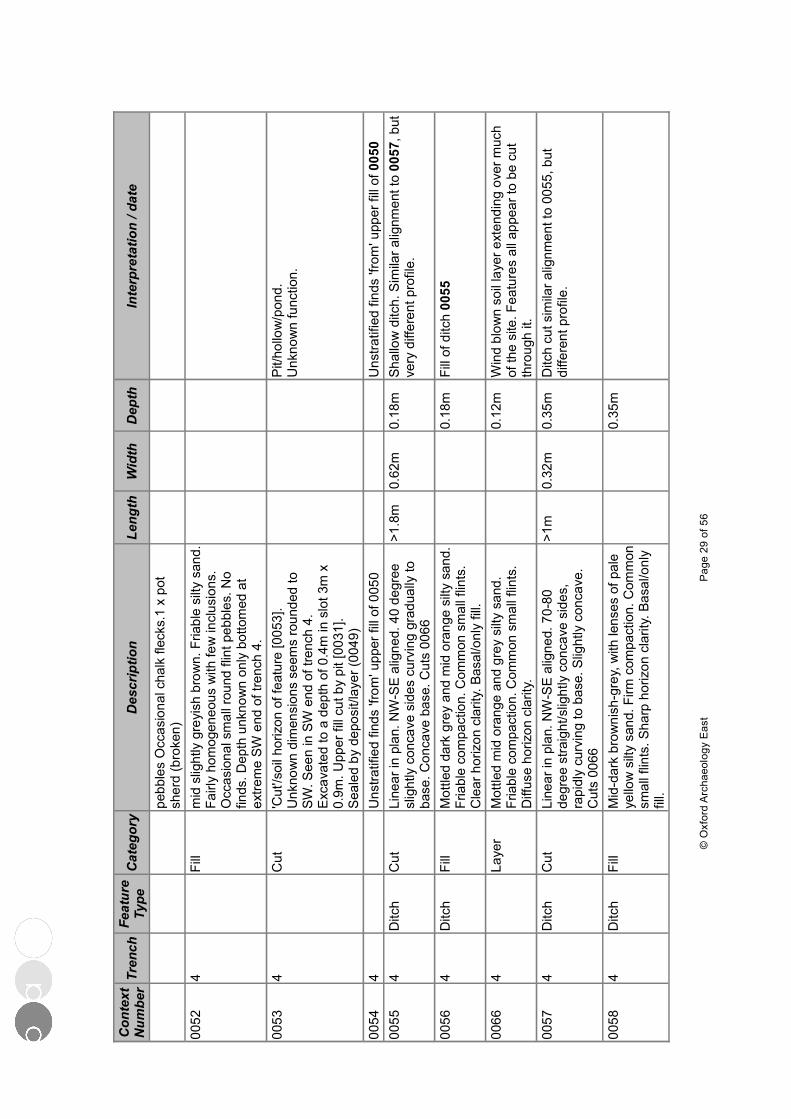
Con
text
N
umbe
rTr
ench
Feat
ure
Type
Cat
egor
yD
escr
iptio
nLe
ngth
Wid
thD
epth
Inte
rpre
tatio
n / d
ate
pebb
les
Occ
asio
nal c
halk
flec
ks.1
x p
ot
sher
d (b
roke
n)00
524
Fill
mid
slig
htly
gre
yish
bro
wn.
Fria
ble
silty
san
d.
Fairl
y ho
mog
eneo
us w
ith fe
w in
clus
ions
. O
ccas
iona
l sm
all r
ound
flin
t peb
bles
. No
finds
. Dep
th u
nkno
wn
only
bot
tom
ed a
t ex
trem
e SW
end
of t
renc
h 4.
0053
4C
ut'C
ut'/s
oil h
oriz
on o
f fea
ture
[005
3].
Unk
now
n di
men
sion
s se
ems
roun
ded
to
SW. S
een
in S
W e
nd o
f tre
nch
4.E
xcav
ated
to a
dep
th o
f 0.4
m in
slo
t 3m
x
0.9m
. Upp
er fi
ll cu
t by
pit [
0031
].S
eale
d by
dep
osit/
laye
r (00
49)
Pit/
hollo
w/p
ond.
Unk
now
n fu
nctio
n.
0054
4U
nstra
tifie
d fin
ds 'f
rom
' upp
er fi
ll of
005
0U
nstra
tifie
d fin
ds 'f
rom
' upp
er fi
ll of
005
000
554
Ditc
hC
utLi
near
in p
lan.
NW
-SE
alig
ned.
40
degr
ee
slig
htly
con
cave
sid
es c
urvi
ng g
radu
ally
to
base
. Con
cave
bas
e. C
uts
0066
>1.8
m0.
62m
0.18
mSh
allo
w d
itch.
Sim
ilar a
lignm
ent t
o 00
57, b
ut
very
diff
eren
t pro
file.
0056
4D
itch
Fill
Mot
tled
dark
gre
y an
d m
id o
rang
e si
lty s
and.
Fr
iabl
e co
mpa
ctio
n. C
omm
on s
mal
l flin
ts.
Cle
ar h
oriz
on c
larit
y. B
asal
/onl
y fil
l.
0.18
mFi
ll of
ditc
h 00
55
0066
4La
yer
Mot
tled
mid
ora
nge
and
grey
silt
y sa
nd.
Fria
ble
com
pact
ion.
Com
mon
sm
all f
lints
. D
iffus
e ho
rizon
cla
rity.
0.12
mW
ind
blow
n so
il la
yer e
xten
ding
ove
r muc
h of
the
site
. Fea
ture
s al
l app
ear t
o be
cut
th
roug
h it.
0057
4D
itch
Cut
Line
ar in
pla
n. N
W-S
E a
ligne
d. 7
0-80
de
gree
stra
ight
/slig
htly
con
cave
sid
es,
rapi
dly
curv
ing
to b
ase.
Slig
htly
con
cave
. C
uts
0066
>1m
0.32
m0.
35m
Ditc
h cu
t sim
ilar a
lignm
ent t
o 00
55, b
ut
diffe
rent
pro
file.
0058
4D
itch
Fill
Mid
-dar
k br
owni
sh-g
rey,
with
lens
es o
f pal
e ye
llow
silt
y sa
nd. F
irm c
ompa
ctio
n. C
omm
on
smal
l flin
ts. S
harp
hor
izon
cla
rity.
Bas
al/o
nly
fill.
0.35
m
© O
xfor
d A
rcha
eolo
gy E
ast
Pag
e 29
of 5
6
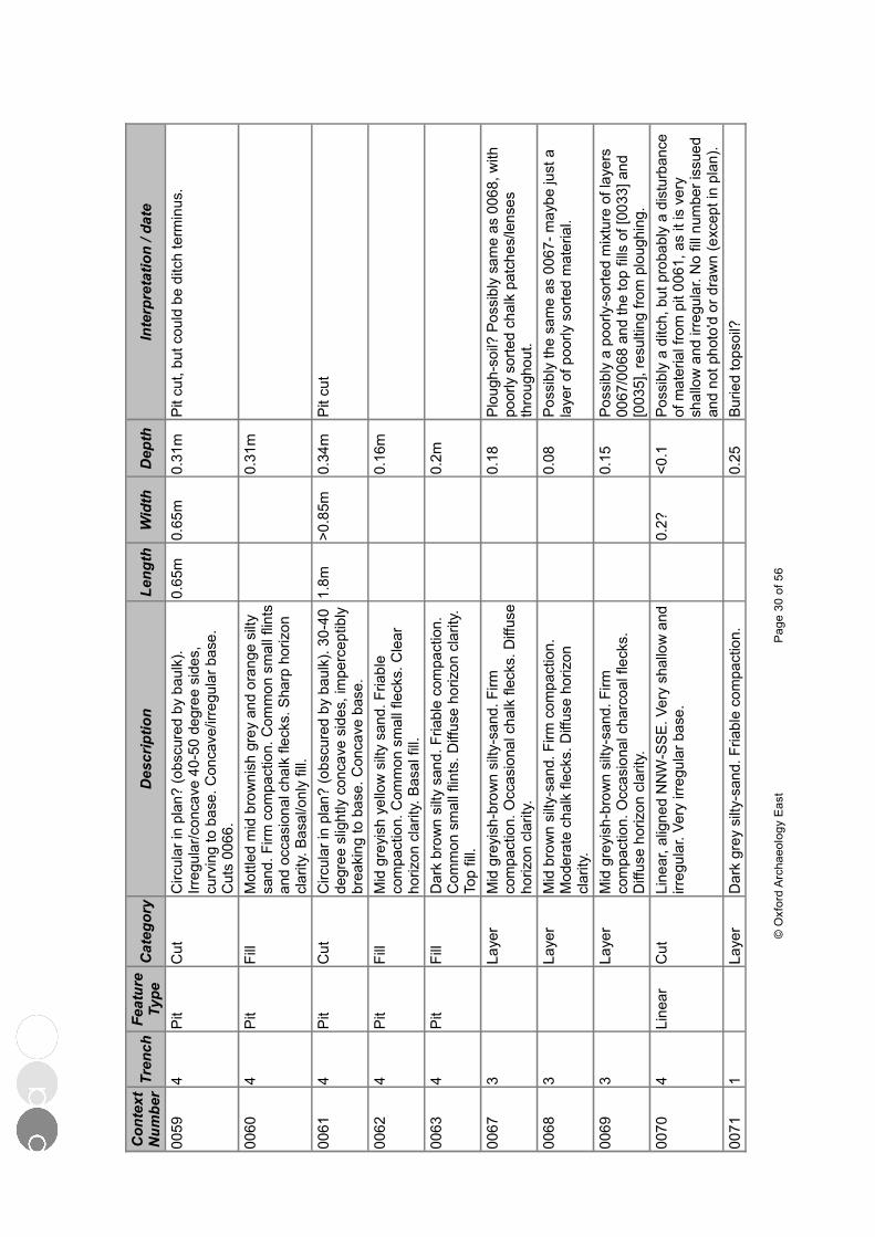
Con
text
N
umbe
rTr
ench
Feat
ure
Type
Cat
egor
yD
escr
iptio
nLe
ngth
Wid
thD
epth
Inte
rpre
tatio
n / d
ate
0059
4P
itC
utC
ircul
ar in
pla
n? (o
bscu
red
by b
aulk
). Irr
egul
ar/c
onca
ve 4
0-50
deg
ree
side
s,
curv
ing
to b
ase.
Con
cave
/irre
gula
r bas
e.
Cut
s 00
66.
0.65
m0.
65m
0.31
mP
it cu
t, bu
t cou
ld b
e di
tch
term
inus
.
0060
4P
itFi
llM
ottle
d m
id b
row
nish
gre
y an
d or
ange
silt
y sa
nd. F
irm c
ompa
ctio
n. C
omm
on s
mal
l flin
ts
and
occa
sion
al c
halk
flec
ks. S
harp
hor
izon
cl
arity
. Bas
al/o
nly
fill.
0.31
m
0061
4P
itC
utC
ircul
ar in
pla
n? (o
bscu
red
by b
aulk
). 30
-40
degr
ee s
light
ly c
onca
ve s
ides
, im
perc
eptib
ly
brea
king
to b
ase.
Con
cave
bas
e.
1.8m
>0.8
5m0.
34m
Pit
cut
0062
4P
itFi
llM
id g
reyi
sh y
ello
w s
ilty
sand
. Fria
ble
com
pact
ion.
Com
mon
sm
all f
leck
s. C
lear
ho
rizon
cla
rity.
Bas
al fi
ll.
0.16
m
0063
4P
itFi
llD
ark
brow
n si
lty s
and.
Fria
ble
com
pact
ion.
C
omm
on s
mal
l flin
ts. D
iffus
e ho
rizon
cla
rity.
To
p fil
l.
0.2m
0067
3La
yer
Mid
gre
yish
-bro
wn
silty
-san
d. F
irm
com
pact
ion.
Occ
asio
nal c
halk
flec
ks. D
iffus
e ho
rizon
cla
rity.
0.18
Plo
ugh-
soil?
Pos
sibl
y sa
me
as 0
068,
with
po
orly
sor
ted
chal
k pa
tche
s/le
nses
th
roug
hout
.00
683
Laye
rM
id b
row
n si
lty-s
and.
Firm
com
pact
ion.
M
oder
ate
chal
k fle
cks.
Diff
use
horiz
on
clar
ity.
0.08
Poss
ibly
the
sam
e as
006
7- m
aybe
just
a
laye
r of p
oorly
sor
ted
mat
eria
l.
0069
3La
yer
Mid
gre
yish
-bro
wn
silty
-san
d. F
irm
com
pact
ion.
Occ
asio
nal c
harc
oal f
leck
s.
Diff
use
horiz
on c
larit
y.
0.15
Poss
ibly
a p
oorly
-sor
ted
mix
ture
of l
ayer
s 00
67/0
068
and
the
top
fills
of [
0033
] and
[0
035]
, res
ultin
g fro
m p
loug
hing
.00
704
Line
arC
utLi
near
, alig
ned
NN
W-S
SE
. Ver
y sh
allo
w a
nd
irreg
ular
. Ver
y irr
egul
ar b
ase.
0.2?
<0.1
Poss
ibly
a d
itch,
but
pro
babl
y a
dist
urba
nce
of m
ater
ial f
rom
pit
0061
, as
it is
ver
y sh
allo
w a
nd ir
regu
lar.
No
fill n
umbe
r iss
ued
and
not p
hoto
'd o
r dra
wn
(exc
ept i
n pl
an).
0071
1La
yer
Dar
k gr
ey s
ilty-
sand
. Fria
ble
com
pact
ion.
0.
25Bu
ried
tops
oil?
© O
xfor
d A
rcha
eolo
gy E
ast
Pag
e 30
of 5
6

Con
text
N
umbe
rTr
ench
Feat
ure
Type
Cat
egor
yD
escr
iptio
nLe
ngth
Wid
thD
epth
Inte
rpre
tatio
n / d
ate
Freq
uent
sm
all f
lints
.00
721
Laye
rM
id o
rang
ish-
grey
silt
y-sa
nd. F
riabl
e co
mpa
ctio
n. F
requ
ent s
mal
l flin
ts.
0.23
0073
1La
yer
Mot
tled
mid
gre
y si
lty-s
and,
ora
nge
sand
an
d ch
alk
patc
hes.
Firm
com
pact
ion.
O
ccas
iona
l sm
all f
lints
.
0.22
Dis
turb
ed n
atur
al a
nd w
indb
low
n m
ater
ial?
Fe
atur
es p
roba
bly
cut t
his
laye
r as
they
do
in o
ther
tren
ches
.00
742
Laye
rM
ottle
d m
id g
rey
and
oran
ge s
ilty-
sand
pa
tche
s. F
irm c
ompa
ctio
n. O
ccas
iona
l flin
ts.
0.1
Laye
r of d
istu
rbed
nat
ural
, cut
by
feat
ures
.
0075
2La
yer
Mot
tled
mid
gre
y an
d or
ange
silt
y-sa
nd.
Fria
ble
com
pact
ion.
Occ
asio
nal s
mal
l flin
ts.
0.1
Dis
turb
ed n
atur
ally
der
ived
laye
r, as
see
n in
ot
her t
renc
hes.
Cut
by
feat
ures
.
© O
xfor
d A
rcha
eolo
gy E
ast
Pag
e 31
of 5
6
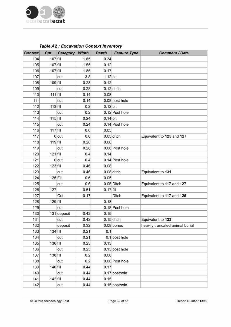
Table A2 : Excavation Context InventoryContext Cut Category Width Depth Feature Type Comment / Date
104 107 fill 1.65 0.34105 107 fill 1.55 0.12106 107 fill 1.85 0.17107 cut 3.8 1.12 pit108 109 fill 0.28 0.12109 cut 0.28 0.12 ditch110 111 fill 0.14 0.08111 cut 0.14 0.08 post hole112 113 fill 0.2 0.12 pit113 cut 0.2 0.12 Post hole114 115 fill 0.24 0.14 pit115 cut 0.24 0.14 Post hole116 117 fill 0.6 0.05117 0 cut 0.6 0.05 ditch Equivalent to 125 and 127118 119 fill 0.28 0.08119 cut 0.28 0.08 Post hole120 121 fill 0.4 0.14121 0 cut 0.4 0.14 Post hole122 123 fill 0.46 0.08123 cut 0.46 0.08 ditch Equivalent to 131124 125 Fill 0.6 0.05125 cut 0.6 0.05 Ditch Equivalent to 117 and 127126 127 0.51 0.17 fill127 Cut 0.17 Ditch Equivalent to 117 and 125128 129 fill 0.18129 cut 0.18 Post hole130 131 deposit 0.42 0.15131 cut 0.42 0.15 ditch Equivalent to 123132 deposit 0.32 0.08 bones heavily truncated animal burial133 134 fill 0.21 0.1134 cut 0.21 0.1 post hole135 136 fill 0.23 0.13136 cut 0.23 0.13 post hole137 138 fill 0.2 0.08138 cut 0.2 0.08 Post hole139 140 fill 0.44 0.17140 cut 0.44 0.17 posthole141 142 fill 0.44 0.15142 cut 0.44 0.15 posthole
© Oxford Archaeology East Page 32 of 56 Report Number 1398
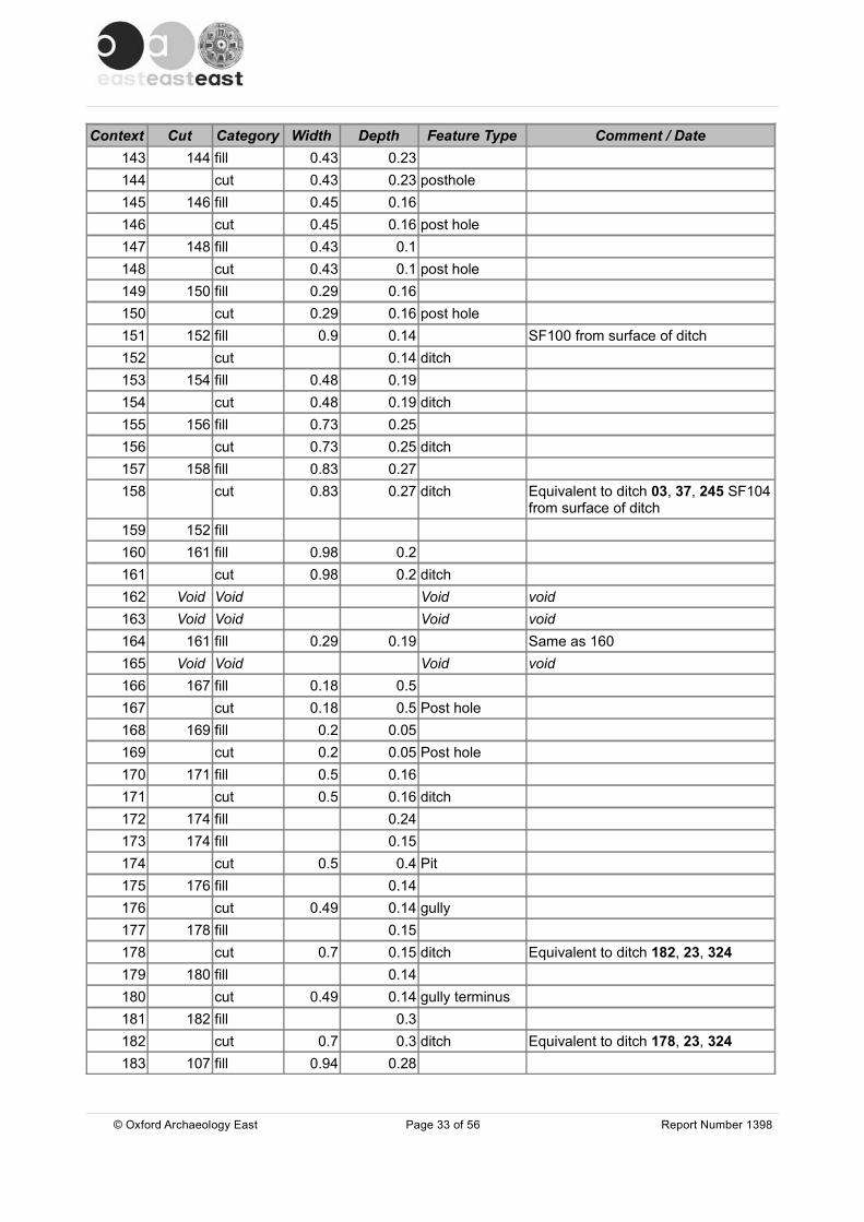
Context Cut Category Width Depth Feature Type Comment / Date143 144 fill 0.43 0.23144 cut 0.43 0.23 posthole145 146 fill 0.45 0.16146 cut 0.45 0.16 post hole147 148 fill 0.43 0.1148 cut 0.43 0.1 post hole149 150 fill 0.29 0.16150 cut 0.29 0.16 post hole151 152 fill 0.9 0.14 SF100 from surface of ditch152 cut 0.14 ditch153 154 fill 0.48 0.19154 cut 0.48 0.19 ditch155 156 fill 0.73 0.25156 cut 0.73 0.25 ditch157 158 fill 0.83 0.27158 cut 0.83 0.27 ditch Equivalent to ditch 03, 37, 245 SF104
from surface of ditch159 152 fill160 161 fill 0.98 0.2161 cut 0.98 0.2 ditch162 Void Void Void void163 Void Void Void void164 161 fill 0.29 0.19 Same as 160165 Void Void Void void166 167 fill 0.18 0.5167 cut 0.18 0.5 Post hole168 169 fill 0.2 0.05169 cut 0.2 0.05 Post hole170 171 fill 0.5 0.16171 cut 0.5 0.16 ditch172 174 fill 0.24173 174 fill 0.15174 cut 0.5 0.4 Pit175 176 fill 0.14176 cut 0.49 0.14 gully177 178 fill 0.15178 cut 0.7 0.15 ditch Equivalent to ditch 182, 23, 324179 180 fill 0.14180 cut 0.49 0.14 gully terminus181 182 fill 0.3 182 cut 0.7 0.3 ditch Equivalent to ditch 178, 23, 324183 107 fill 0.94 0.28
© Oxford Archaeology East Page 33 of 56 Report Number 1398

Context Cut Category Width Depth Feature Type Comment / Date184 107 fill 1.52 0.18 185 107 fill 1.62 0.38186 107 fill 2.25 0.07187 107 fill 2.85 0.42188 189 fill 0.31 0.5 189 cut 0.31 0.5 Post hole190 191 fill 0.35 0.12191 cut 0.35 0.12 ditch192 193 fill 0.52 0.15193 cut 0.52 0.15 ditch194 195 fill 0.85 0.17195 cut 0.85 0.17 pit196 197 fill 0.3 0.08197 cut 0.3 0.08 ditch198 199 fill 0.38 0.14199 cut 0.38 0.14 ditch200 cut 0.7 0.18 ditch201 200 fill 0.7 0.18202 0 cut 0.36 0.14 ditch203 202 fill 0.36 0.14204 cut 0.22 0.22 ditch205 204 fill 0.22 0.22206 cut 0.68 0.22 ditch207 206 fill 0.68 0.22208 cut 0.6 0.38 ditch terminals209 208 fill 0.22 0.16210 208 fill 0.6 0.24211 215 fill 1.1 0.23212 215 fill 0.75 0.13213 215 fill 0.7 0.18214 215 fill 0.56 0.13215 215 cut 1.1 0.57 ditch216 217 fill 0.43 0.2217 cut 0.43 0.2 Post hole218 cut 0.8 0.18 ditch219 218 fill 0.8 0.18220 layer 0.4 0.1 overburden221 cut 0.45 0.26 ditch222 221 fill 0.45 0.26223 cut 0.4 0.14 ditch224 223 fill 0.4 0.14225 cut 0.48 0.1 ditch Equivalent to 230 and 232
© Oxford Archaeology East Page 34 of 56 Report Number 1398

Context Cut Category Width Depth Feature Type Comment / Date226 225 fill 0.45 0.1227 cut 1.2 0.48 ditch228 227 fill 0.4 0.14229 227 fill 1.2 0.48230 cut 0.32 0.2 ditch Equivalent to 225 and 232231 230 fill 0.32 0.2232 cut 0.35 0.1 ditch Equivalent to 225 and 230233 232 fill 0.35 0.1234 235 fill 0.38 0.1235 cut 0.38 0.1 ditch236 237 fill 0.58 0.33237 cut 0.58 0.33 ditch238 239 fill 0.19239 cut 0.19 ditch240 241 fill 0.57 0.04241 cut 0.57 0.24 ditch242 243 fill 0.5 0.26243 cut 0.5 0.26 ditch244 245 fill 0.57 0.17245 cut 0.57 0.17 ditch Equivalent to ditch 03, 37, 158246 cut 0.5 0.27 ditch247 246 fill 0.5 0.27248 cut 0.85 0.26 ditch249 248 fill 0.85 0.26250 cut 0.7 0.24 ditch251 250 fill 0.7 0.24252 cut 0.75 0.25 ditch253 252 fill 0.75 0.25254 255 fill 0.32 0.15255 cut 0.32 0.15 posthole256 257 fill 0.3 0.36257 cut 0.3 0.36 post hole258 259 fill 0.26 0.26259 cut 0.26 0.26 post hole260 261 fill 0.26261 cut 0.6 0.26 pit262 263 fill 0.92 0.18 pit Contained SF107263 cut 0.92 0.18 pit264 270 fill 3.28 0.12 Contained SF106265 270 fill 0.73 0.06266 270 fill 2.02 0.21267 270 fill 1.15 0.14
© Oxford Archaeology East Page 35 of 56 Report Number 1398
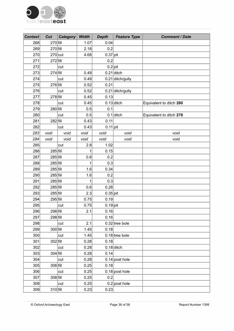
Context Cut Category Width Depth Feature Type Comment / Date268 270 fill 1.07 0.04269 270 fill 2.18 0.2270 270 cut 4.68 0.37 pit271 272 fill 0.2272 cut 0.2 pit273 274 fill 0.49 0.21 ditch274 cut 0.49 0.21 ditch/gully275 276 fill 0.52 0.21276 cut 0.52 0.21 ditch/gully277 278 fill 0.45 0.13278 cut 0.45 0.13 ditch Equivalent to ditch 280279 280 fill 0.5 0.1280 cut 0.5 0.1 ditch Equivalent to ditch 278281 282 fill 0.43 0.11282 cut 0.43 0.11 pit283 void void void void void void284 void void void void void void285 cut 2.8 1.02286 285 fill 1 0.15287 285 fill 0.8 0.2288 285 fill 1 0.3289 285 fill 1.6 0.34290 285 fill 1.6 0.2291 285 fill 1 0.3292 285 fill 0.6 0.28293 285 fill 2.3 0.35 pit294 295 fill 0.75 0.19295 cut 0.75 0.19 pit296 298 fill 2.1 0.16297 298 fill 0.16298 cut 2.1 0.32 tree bole299 300 fill 1.45 0.18300 cut 1.45 0.18 tree bole301 302 fill 0.28 0.18302 cut 0.28 0.18 ditch303 304 fill 0.28 0.14304 cut 0.28 0.14 post hole305 306 fill 0.25 0.18306 cut 0.25 0.18 post hole307 308 fill 0.25 0.2308 cut 0.25 0.2 post hole309 310 fill 0.23 0.23
© Oxford Archaeology East Page 36 of 56 Report Number 1398
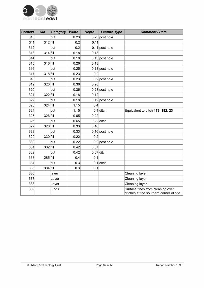
Context Cut Category Width Depth Feature Type Comment / Date310 cut 0.23 0.23 post hole311 312 fill 0.2 0.11312 cut 0.2 0.11 post hole313 314 fill 0.18 0.13314 cut 0.18 0.13 post hole315 316 fill 0.26 0.13316 cut 0.25 0.13 post hole317 318 fill 0.23 0.2318 cut 0.23 0.2 post hole319 320 fill 0.36 0.28320 cut 0.36 0.28 post hole321 322 fill 0.18 0.12322 cut 0.18 0.12 post hole323 324 fill 1.15 0.4324 cut 1.15 0.4 ditch Equivalent to ditch 178, 182, 23325 326 fill 0.65 0.22326 cut 0.65 0.22 ditch327 328 fill 0.33 0.16328 cut 0.33 0.16 post hole329 330 fill 0.22 0.2330 cut 0.22 0.2 post hole331 332 fill 0.42 0.07332 cut 0.42 0.07 ditch333 285 fill 0.4 0.1334 cut 0.3 0.1 ditch335 334 fill 0.3 0.1336 layer Cleaning layer337 Layer Cleaning layer338 Layer Cleaning layer339 Finds Surface finds from cleaning over
ditches at the southern corner of site
© Oxford Archaeology East Page 37 of 56 Report Number 1398

APPENDIX B. FINDS REPORTS
B.1 Pottery
By Dr Paul Spoerry and Carole Fletcher BA, AIfA
Introduction and methodologyB.1.1 Evaluation and subsequent excavations at Worlington, produced a small post-Roman
pottery assemblage of 158 sherds, weighing 1.888kg. This total includes material from both the evaluation ((WGN 041 – 68 sherds, 0.912kg) and the excavation (WGN 049 – 90 sherds, 0.976kg). Unstratified material includes one post-medieval sherd found in the evaluation (Fabric GRE – not included in medieval assemblage statistics here).
B.1.2 The assemblage is mainly 'high' medieval, but a small number of late Saxon (6 sherds) and early medieval (11 sherds) are present. The condition of the overall assemblage is moderately abraded and the average sherd weight is small to moderate at approximately 12g.
B.1.3 Study of the pottery from the evaluation was originally carried out by Richenda Goffin (2009), whose useful contribution is acknowledged here. Since that study was completed more recent work on the medieval type series for Cambridgeshire has enabled the current authors to be more explicit regarding some fabric identifications (Spoerry forthcoming). Fabric types and codings are for the most part based on that more recent document, that nonetheless, itself incorporates older works for established ware names definitions.
MethodologyB.1.4 The Medieval Pottery Research Group (MPRG) A guide to the classification of medieval
ceramic forms (MPRG, 1998) and Minimum Standards for the Processing, Recording, Analysis and Publication of Post-Roman Ceramics (MPRG, 2001) act as a standard.
B.1.5 Recording was carried out using OA East’s in-house system based on that previously used at the Museum of London. Fabric classification has been carried out for all previously described medieval and post-medieval types. All sherds have been counted, classified and weighed on a context-by-context basis. The pottery and archive are curated by Oxford Archaeology East until formal deposition.
Sampling BiasB.1.6 The excavation was carried out by hand and selection made through standard sampling
strategies on a feature by feature basis. There are not expected to be any inherent biases. Where bulk samples have been processed for environmental remains, there has also been some recovery of pottery. These small quantities of sherds are abraded, not closely datable and have not been considered in this report.
The AssemblageB.1.7 Ceramic fabrics and abbreviations and a summary catalogue by fabric, sherd count and
weight are given in Table B1. Unstratified material has not been excluded from this list, but all calculations in the body of this report ignore the one sherd of post-medieval pottery.
© Oxford Archaeology East Page 38 of 56 Report Number 1398
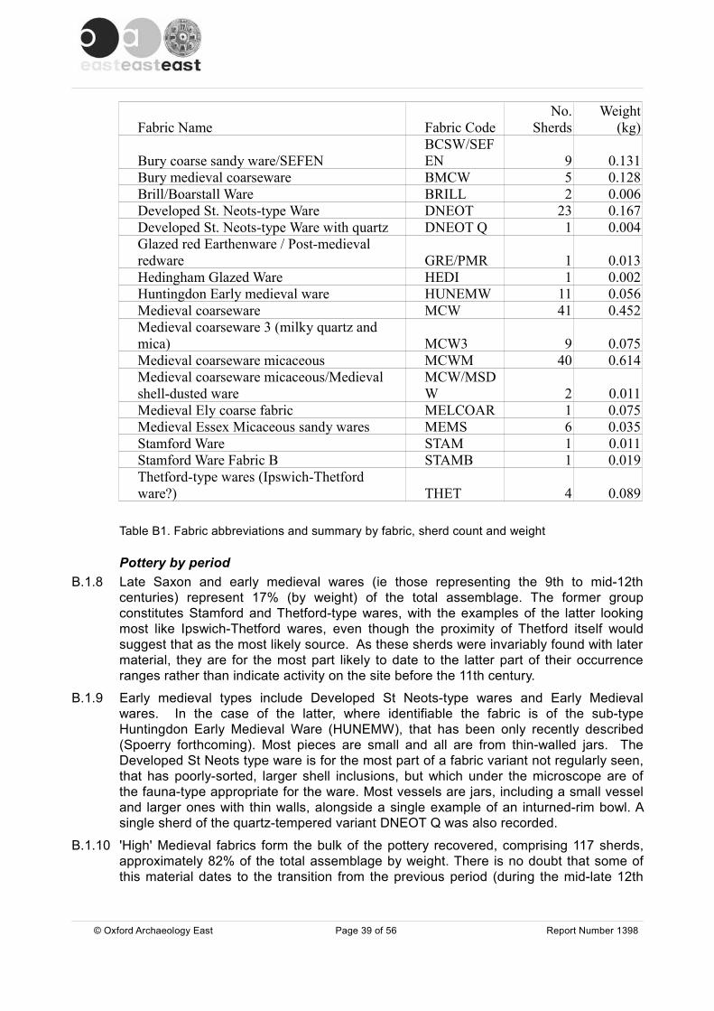
Fabric Name Fabric CodeNo.
SherdsWeight
(kg)
Bury coarse sandy ware/SEFENBCSW/SEFEN 9 0.131
Bury medieval coarseware BMCW 5 0.128Brill/Boarstall Ware BRILL 2 0.006Developed St. Neots-type Ware DNEOT 23 0.167Developed St. Neots-type Ware with quartz DNEOT Q 1 0.004Glazed red Earthenware / Post-medieval redware GRE/PMR 1 0.013Hedingham Glazed Ware HEDI 1 0.002Huntingdon Early medieval ware HUNEMW 11 0.056Medieval coarseware MCW 41 0.452Medieval coarseware 3 (milky quartz and mica) MCW3 9 0.075Medieval coarseware micaceous MCWM 40 0.614Medieval coarseware micaceous/Medieval shell-dusted ware
MCW/MSDW 2 0.011
Medieval Ely coarse fabric MELCOAR 1 0.075Medieval Essex Micaceous sandy wares MEMS 6 0.035Stamford Ware STAM 1 0.011Stamford Ware Fabric B STAMB 1 0.019Thetford-type wares (Ipswich-Thetford ware?) THET 4 0.089
Table B1. Fabric abbreviations and summary by fabric, sherd count and weight
Pottery by periodB.1.8 Late Saxon and early medieval wares (ie those representing the 9th to mid-12th
centuries) represent 17% (by weight) of the total assemblage. The former group constitutes Stamford and Thetford-type wares, with the examples of the latter looking most like Ipswich-Thetford wares, even though the proximity of Thetford itself would suggest that as the most likely source. As these sherds were invariably found with later material, they are for the most part likely to date to the latter part of their occurrence ranges rather than indicate activity on the site before the 11th century.
B.1.9 Early medieval types include Developed St Neots-type wares and Early Medieval wares. In the case of the latter, where identifiable the fabric is of the sub-type Huntingdon Early Medieval Ware (HUNEMW), that has been only recently described (Spoerry forthcoming). Most pieces are small and all are from thin-walled jars. The Developed St Neots type ware is for the most part of a fabric variant not regularly seen, that has poorly-sorted, larger shell inclusions, but which under the microscope are of the fauna-type appropriate for the ware. Most vessels are jars, including a small vessel and larger ones with thin walls, alongside a single example of an inturned-rim bowl. A single sherd of the quartz-tempered variant DNEOT Q was also recorded.
B.1.10 'High' Medieval fabrics form the bulk of the pottery recovered, comprising 117 sherds, approximately 82% of the total assemblage by weight. There is no doubt that some of this material dates to the transition from the previous period (during the mid-late 12th
© Oxford Archaeology East Page 39 of 56 Report Number 1398
century) as early medieval and 'high' medieval pottery is invariably found together in context groups.
B.1.11 The most common medieval pottery types are two categories that have been defined to represent coarsewares of unknown source, but which are probably quite local in origin. These are Medieval Coarseware (MCW) and Medieval Coaseware Micaceous (MCWM). There is some overlap between sherds identified as representing these two types and they are probably related through similar or common kiln sites. These fabrics are not unlike those of some 13th century coarsewares seen in Cambridge, for which a production source has not yet been identified. All vessels seen are jars, many sooted and used in cooking, including the full profile of a MCWM straight-sided jar with a convex base and an everted, near square thickened rim of 12th to early 13th century date. A local coarseware fabric variant typified by milky quartz grains and a shell-dusted version of MCW have also been identified here.
B.1.12 Less common medieval coarsewares include a buff sandy fabric identified in Suffolk as Bury coarse sandy ware, but now known to be a product of the Cambridgeshire fen edge near Soham (Spoerry forthcoming) and given the name Southeast Fenland light firing sandy ware (SEFEN).
B.1.13 Products of the Ely ware industry are surprisingly rare bearing in mind geographical proximity and the direct link via the River Lark, but the upper part of a rounded cooking vessel (jar) is present.
B.1.14 Products of the north Essex industries, typified by smooth, micaceous fabrics, include a single Hedingham fineware jug sherd and a handful of coarseware, jar fragments. It is possible that some of the MCWM sherds might also be coarseware products of the north Essex industries, but the majority, if not all, of the MCWM does appear different to typical Essex products and it is instead likely to be a north Suffolk product.
B.1.15 Other glazed pottery present constitutes two sherds of Brill-Boartstall glazed ware from Buckinghamshire, of 13th to 14th century date.
B.1.16 The latest fabrics represented, perhaps BCSW/SEFEN, MEMS and BRILL, do not include recognisably 'late' vessel/rim forms and this suggests that activity may have ceased here during the 13th century. Certainly no late medieval pottery was identified, indicating an end to activity at the site before c. 1350.
B.1.17 Overall the very low incidence of any vessel type save jars, and those for the most part cooking pots rather than other storage vessels, indicates this is almost entirely a kitchen assemblage from a domestic site.
Assemblage in relation to excavated featuresB.1.18 Pottery 'spotdates' assign ditches with cut numbers 182,199 and 227 to the 10th to mi-
11th centuries due to the presence of Stamford ware and Thetford type ware (Table B2), but in each case there is only one sherd, so there is ample potential for each of these features to be later. Similar caution should be applied to 'spotdates' of the mid-11th to mid-13th centuries, assigned to the fills of ditch 161 and pit 285, as each is based on one sherd only of Developed St Neots type ware. Conversely, a similar sherd in the lower fill of ditch 53 might correctly assign an earlier date as there is more other material of this date in the upper fills of ditch 53 suggesting that there was later reworking of the primary deposit.
B.1.19 Almost all other context groups are dated in general terms to the late 12th to 14th centuries, but many of the jar rim forms could be more closely assigned to the late 12th
© Oxford Archaeology East Page 40 of 56 Report Number 1398
to early/mid13th centuries. Even the later fabrics such as MEMS and SEFEN appear not to be represented by later vessel types.
ConclusionB.1.20 As stated above the whole assemblage is consistent in character, and is probably a
kitchen assemblage from a domestic site. Although Late Saxon and early medieval sherds are present, indicating some activity in perhaps the 11th to 12th centuries, the majority of pottery dates from the mid-12th century onwards. Additionally, although the pottery fabrics present for the most continued to be made until the 14th century, there are no vessel forms datable to the later part of this bracket, and it is likely that this assemblage, and thus activity on the site, ceased by the end of the 13th century.
B.1.21 The pottery present includes late Saxon and early medieval types from across the region. By the late 12th century the assemblage is, however, dominated by two fabrics that are of unknown origin (MCW and MCWM). These fabrics may be local in origin, but little pottery has been excavated and recorded in the vicinity to confirm this. These fabrics also look rather like unprovenanced sandy and micaceous coarsewares that are very common in the City of Cambridge's assemblage at this time (see Cessford and Hall 2007). This possible link is important because it relates to ceramic supply in a major town, as well as in the locality around Worlington. Further opportunities to investigate assemblages from around Worlington and in Cambridge, should include consideration of this point. Less common pottery types present here include pottery known from Bury St Edmunds and believed to have been made there (BMCW) and pottery also known from Bury, but now known to be made in the southeast Cambridgeshire fenland (BCSW, now called SEFEN; Spoerry forthcoming). Bearing in mind the proximity of Ely, and the presence of the River Lark linking Worlington to this major pottery production centre, it is surprising that so little Ely ware is present. This might be due to the presence of both very local wares, and to the ease of transport downstream from Bury, rather than upstream from Ely.
Illustration Catalogue B.1.22 Figure 7 : Near complete profile of a full profile of a MCWM straight-sided jar from
context 0056 with a convex base and an everted, near square thickened rim ,of 12th to early 13th century date, with heavy sooting externally and limescale internally.
Pottery Catalogue
Context Fabric IDBasic Form
Sherd Count
Sherd Weight Context date range
1 MCW 1 0.047 L.12th-14th c. Unstrat4 MCWM 1 0.006 12th-14th c.7 BMCW Jar 1 0.002 L.12th-14th c. Unstrat7 MCW Jar 3 0.0297 MELCOAR Jar 1 0.07511 MCWM 1 0.003 12th-14th c.20 BMCW 1 0.002 16th-18th c Unstrat20 DNEOT 2 0.00920 GRE Bowl 1 0.01320 MCW Jar 1 0.02232 MCW 2 0.001 L.12th-14th c.
© Oxford Archaeology East Page 41 of 56 Report Number 1398

36 BCSW/SEFEN 1 0.007 L.12th-14th c.
36 BCSW/SEFEN Jar 2 0.02936 MCW Jar 1 0.00436 MCWM Jar 1 0.006
38 BCSW/SEFEN Jar 1 0.017 L.12th-14th c.
38 BCSW/SEFEN Jug 1 0.02638 MCWM Jar 1 0.00640 MCW 1 0.019 L.12th-14th c.40 MCW Jar 1 0.00340 MCW3 Jar 1 0.01540 MCWM 1 0.00340 MCWM Jar 1 0.004
40 MCWM/MSDW 1 0.00340 STAMB Jug 1 0.01942 MCWM 1 0.006 L.12th-14th c.50 DNEOT 1 0.002 L.12th-14th c.50 DNEOT Jar 1 0.00750 HUNEMW 2 0.00350 MCW 1 0.01650 MCW3 5 0.03350 MCWM 2 0.01251 DNEOT Jar 3 0.011 Mid 11th-mid 13th
54 DNEOT Jar 1 0.00512th-14th C Unstrat upper fill of 50
54 HUNEMW 1 0.002
54 MCWM 1 0.017
54 MCWM Jar 1 0.01756 MCW 1 0.006 L.12th-14th c.56 MCWM Jar 7 0.346104 DNEOT 1 0.002 L.12th-14th c.104 HUNEMW Jar 1 0.004104 MCW 6 0.017104 MCW Jar 4 0.051104 MCWM Jar 4 0.056104 MEMS Jar 3 0.026105 HUNEMW Jar 2 0.008 12th-14th c (12th)105 MCWM 1 0.004105 THET Jar 1 0.021106 MCW Jar 2 0.002 L.12th-14th c106 MCW3 2 0.006106 MCWM 1 0.003
© Oxford Archaeology East Page 42 of 56 Report Number 1398

106 MCWM Jar 1 0.007124 MCW 1 0.010 L.12th-14th c126 MCW 1 0.009 L.12th-14th c126 MCW Jar 1 0.007126 MCWM Jar 1 0.011151 HUNEMW Jar 1 0.009 L.12th-13th c151 MCW Jar 1 0.004151 MCWM Jar 1 0.008
151 MCWM/MSDW Jar 1 0.008151 MEMS Jar 3 0.009153 MCW Jar 1 0.025 L.12th-14th c153 MCW3 1 0.021155 MCWM Jar 1 0.016 12th-14th c
157 BCSW/SEFEN Jar 1 0.028 L.12th-14th c157 BMCW Jar 1 0.013157 BRIL Jug 2 0.006157 MCW 1 0.003164 HUNEMW Jar 1 0.003 11th-12th c.172 MCW 1 0.006 L.12th-14th c177 MCW Jar 1 0.019 L.12th-14th c181 THET Jar 1 0.004 10th-11th c.192 MCW Jar 1 0.024 L.12th-14th c192 MCWM 1 0.002192 MCWM Jar 1 0.010198 STAM Jug 1 0.011 10th-mid 11th c.
229 THETh Jar or pitcher 1 0.058 10th-11th c
234 HEDI Jug 1 0.002 L.12th-mid 13th234 MCW Jar 1 0.009
236 BCSW/SEFEN Jug 1 0.011 L.12th-14th c.236 MCWM Jar 1 0.011
242 BCSW/SEFEN Jar 1 0.007 L.12th-14th c.242 MCW 1 0.005242 MCW Jar 1 0.011242 MCWM 1 0.012242 MCWM Jar 1 0.007244 BMCW Jar 1 0.045 L.12th-14th c.244 HUNEMW Jar 1 0.002262 MCW 2 0.012 L.12th-14th c.269 BMCW 1 0.066 L.12th-mid 13th c/14th.269 DNEOT Bowl 1 0.008269 MCWM 1 0.003269 MCWM Jar 2 0.008273 MCWM 1 0.002 12th-14th c
© Oxford Archaeology East Page 43 of 56 Report Number 1398
289 DNEOT S Jar 1 0.004 Mid 11th-mid 13th336 DNEOT 1 0.011 Mid 11th-mid 13th339 DNEOT Jar 2 0.018 12th-mid 13th/14th339 MCWM Jar 1 0.012
99999 BCSW/SEFEN 1 0.00612th-mid 13/14th unstrat
99999 DNEOT Jar 1 0.04299999 HUNEMW Jar 2 0.02599999 MCW 1 0.04299999 MCW Jar 2 0.04999999 MCWM Jar 2 0.01699999 THET Jar 1 0.006
Table B2 Pottery Catalogue
© Oxford Archaeology East Page 44 of 56 Report Number 1398
APPENDIX C. ENVIRONMENTAL REPORTS
C.1 Environmental Samples
By Rachel Fosberry
Introduction C.1.1 Twenty-three bulk samples were taken during excavations at Framlingham Road,
Worlington, Suffolk. Features sampled include pits, ditches and post holes dating primarily to the late medieval period with the possibility of some earlier late Saxon deposits. Samples from previous evaluation of the site had shown good archaeobotanical potential with the recovery of significant quantities of cereal grains (Gray in Brookes 2011).
C.1.2 The purpose of the initial assessment was to determine whether plant remains are present, their mode of preservation and whether they are of interpretable value with regard to domestic, agricultural and industrial activities, diet, economy and rubbish disposal. The results showed that preservation of plant remains was good and four samples were chosen for more detailed study. The results of all analyses are included in this report.
MethodologyC.1.3 The total volume (up to thirty-five litres) of each of the samples was processed by tank
flotation for the recovery of charred plant remains, dating evidence and any other artefactual evidence that might be present. The flot was collected in a 0.3mm nylon mesh and the residue was washed through a set of 10mm, 4mm, 2mm and 0.5mm sieve. Both flot and residue were allowed to air dry. A magnet was dragged through each fraction of the dried residue prior to sorting for artefacts and ecofacts. The flot was examined under a binocular microscope and the presence of any plant remains or other artefacts are noted on Table C1. Identification of plant remains is with reference to the Digital Seed Atlas of the Netherlands and the authors' own reference collection. Nomenclature is according to Stace (1997).
QuantificationC.1.4 For the purpose of the initial assessment, items such as seeds, cereal grains and small
animal bones have been scanned and recorded qualitatively according to the following categories
# = 1-10, ## = 11-50, ### = 51+ specimens #### = 100+ specimens
Items that cannot be easily quantified such as charcoal, magnetic residues and fragmented bone have been scored for abundance
+ = rare, ++ = moderate, +++ = abundant
C.1.5 Four samples were chosen for full quantification. Individual plant remains were picked out of both the flots and the residues. These items were identified where possible and counted. Fragmented cereal grains were counted as single items if over half the grain was present.
© Oxford Archaeology East Page 45 of 56 Report Number 1398

ResultsPreservation
C.1.6 Plant remains are preserved by carbonization and are comprised of cereal grains and weed seeds in addition to charcoal, charred saw-sedge (Cladium mariscus) leaflets and heather (Calluna sp.). Preservation is variable; carbonized seeds, by the process of burning and burial, become blackened and often distort and fragment. Many of the cereal grains in this assemblage are abraded making full identification difficult.
Cereals
C.1.7 All four cereal types are represented with wheat (Triticum sp.) predominating over rye (Secale cereale) and oats (Avena sp.). Barley (Hordeum sp.) occurs less frequently. Many of the wheat grains have a rounded, compact morphology suggesting they are of the bread wheat (T. aestivum spp.) variety. Cereal chaff elements are relatively rare in this assemblage. Culm nodes indicating straw are more common than rachis fragments from cereal ears.
C.1.8 Cultivated pulses appear occasionally and include peas (Pisum sativum) and beans (Fabaceae). Other economic food plants possibly include hazelnut (Corylus avellana) fragments of which were recovered from two ditch deposits and may be naturally occuring.
Weed seedsC.1.9 Charred weed seeds are abundant in many of the samples. Both segetal and ruderal
weeds are represented; seeds of plants found growing amongst crops (segetal) include corn-cockle (Agrostemma githago), corn gromwell (Lithospermum arvense), fat hen (Gallium aparine), cornflower (Centaurea sp.), vetch/tare (Vicia/Lathyrus sp.), brome (Bromus sp.), knotgrass (Polygonum aviculare) and stinking mayweed (Anthemis cotula) which is a common crop weed but it has a specific habitat, preferring heavy clay soils.
C.1.10 Weeds such as dock (Rumex sp.), buttercup (Ranunculus sp.) clover (Trifolium sp.) and ribwort plantain (Plantago lanceolata) have a broader habitat including pasture and/or disturbed ground and are described as ruderal plants.
C.1.11 Exploitation of local resources is indicated by the presence of wetland plants such as Great fen-sedge, sedges (Carex sp.) and rushes (Juncus sp.) and also heathland plants such as heather (Calluna sp.).
Samples by phase:
Phase 1: 11th - 13th Century
C.1.12 Ditch 215 is thought to be the earliest feature on site. Sample 122 from fill 215 was found to contain a single charred grain which is probably intrusive.
Phase 2: 11th - 13th Century
C.1.13 Nine samples were taken from deposits within features dating to Phase 2. Three samples (105 - 107) taken from the only pit (285) contain charred cereals of which rye
© Oxford Archaeology East Page 46 of 56 Report Number 1398

predominates and significant quantity of corncockle seeds. All of the ditch samples contain charred grains suggesting use for waste disposal Sample 101, fill 179 of ditch 180 was examined in more detail and contains the highest density of charred cereal remains at approximately sixty grains per litre. Like contemporary pit 285 it also contains a high predominance of rye although poor preservation precludes confident identification and the majority of grains have been classified as rye or wheat. This sample contains several weed seeds with corncockle the most abundant.
Phase 3: 12th - 14th Century
C.1.14 The majority of the samples were taken from deposits dating to the high-medieval period. Charred cereal grains are common with wheat predominating over rye. Barley and oat grains occur in most of the samples in low numbers. Four samples were examined in detail; Samples 100 (fill 106) and 102 (fill 186) were taken from pit 107. Both samples contains numerous elderberry seeds and also contains the shells of wet-land snails. This feature was thought to have originally been a waterhole and these remains may be differentially preserved. Charred cereal grains are common in both deposits (approximately eleven per litre in Sample 100 and six per litre in Sample 102) and occasional chaff elements were noted but not in sufficient quantities to imply on-site processing. The charred weed assemblage is consistent with plants that would have been growing amongst the cereal crops and have been harvested at the same time. Small fragments of charred heather leaves and flower buds are present in both samples.
C.1.15 Several of the samples were from ditch deposits and are relatively rich in charred plant remains. Sample 109, fill 153 of ditch 154 contains the highest density of cereal remains at approximately 30 grains per litre. The majority of the grains are abraded which may suggest secondary deposition. Weed seeds are relatively rare and include cleavers and corn gromwell both of which may indicate an autumn-sown crop. Sample 121, fill 323 of ditch 324 contains approximately 12 cereal grains per litre and contains more rye than the other samples from this later phase. Again, preservation is poor and this may suggest incorporation of earlier material.
C.1.16 A few samples contain mollusc shells, some of which are burnt, which suggests that the snails were attached to vegetation that was burnt, presumably as fuel.
C.1.17 Small rodent bones are common in the samples suggesting the presence of vermin. Amphibian bones were also noted, particularly in Sample 102, fill 104 of pit 107 which would be consistent with this feature originally containing water.
Discussion
C.1.18 The charred plant remains are dominated by cereal grains along with seeds of weeds commonly encountered growing alongside cereal crops on cultivated soils and were most likely harvested with the cereal crop. Larger seeds such as corncockle and corn gromwell are of a similar size to cereal grains so could not be removed by sieving. Additionally smaller seeds such as stinking mayweed were possibly harvested in seed heads which have subsequently broken into individual seeds. The presence of corncockle denticidal capsule fragments is indicative of this species being harvested with the cereal crop after it has developed the seed head. These small fragments are likely to have broken off during cereal processing. Corncockle contains a toxin (saponin) that is poisonous to both humans and livestock, even if cooked, so any contaminating seeds would have had to be picked out of the grain store prior to grinding/cooking. This
© Oxford Archaeology East Page 47 of 56 Report Number 1398
was possibly a task carried out by the fireside with the seeds thrown onto the fire as they were picked out by hand.
C.1.19 The single sample from the earliest deposit does not contain anything to suggest that there was occupation at this time. There are only slight variations in the content of the Phase 2 and Phase 3 samples. Similarities between the samples from the Phase 2 deposits suggest that rye was the principle crop that was commonly contaminated with corncockle. Wheat appears to predominate in Phase 3 although rye is still common. Very little cereal chaff was noted in any of the samples suggesting that semi-processed grain was imported onto the site with the earlier stages of winnowing, threshing and primary sieving occurring elsewhere. Peas occur occasionally and a single fragment of a bean was noted. Legumes are generally under-represented in the archaeobotanical record as they do not need to be exposed to heat for drying as cereals do. It may be significant that imported foodplants such as figs and raisins are not encountered on this site. Imports from other countries would have been a significant part of the medieval diet (Schofield, Vince, 1984). The lack of these imports may suggest a low-status site.
C.1.20 It would appear that a range of environments were exploited. Heather has been brought in from acid heathland soils possibly for thatching. Great fen sedge was one of the major vegetation types of the Fen and was commonly used for thatching and as fuel. Along with rushes which had similar uses these indicate exploitation of wetland soils. Sedge-beds in the fens were intensively managed during the medieval period for use in thatching and flooring material but also as a favoured fuel in bread ovens (Rowell, 1986). Only small quantities of these plants were recovered in the charred assemblages. Additionally there is evidence that imported crops have been grown on clay soils (as indicated by the presence of stinking mayweed).
Conclusion
C.1.21 It would appear that the majority of the features sampled were used to dispose of accidentally burnt food products and other domestic kitchen waste along with fuel from domestic hearths. Rubbish appears to be disposed of in both pits and ditches. Crops are represented by the full range of cereals; wheat, barley, rye and oats along with pulses including peas and beans. These findings are typical of Medieval towns in Suffolk as described in a review of excavated sites in this area (Murphy & De Moulins, 2001). The lack of chaff suggests that crop plants were imported into this site as semi-cleaned grain.
C.1.22 The results of the environmental sampling are presented in Table C1 below:
© Oxford Archaeology East Page 48 of 56 Report Number 1398
Tabl
e C
1 R
esul
ts o
f env
ironm
enta
l sam
plin
g
Sam
ple
No.
122
101
105
106
107
114
115
116
117
118
100
102
103
104
108
109
110
111
112
113
119
120
121
Con
text
No.
213
179
286
292
333
301
210
201
207
219
106
186
269
277
260
153
155
157
172
173
309
194
323
Cut
No.
215
180
285
285
285
302
208
200
206
218
107
107
270
278
261
154
156
158
174
174
310
195
324
Pha
se1
22
22
22
22
23
33
33
33
33
33
33
Feat
ure
Type
ditc
hdi
tch
pit
pit
pit
ditc
hdi
tch
ditc
hdi
tch
ditc
hpi
tpi
tpi
tpi
tpi
tdi
tch
ditc
hdi
tch
pit?
pit?
pit
ditc
h S
ampl
e S
ize (L
)26
1616
189
810
99
926
1830
355
88
916
34
916
Cere
als
Oat
(wild
or c
ultiv
ated
)27
##
##
##
24
#4
#O
at (c
ultiv
ated
)6
10O
at
1oa
t/gra
ss6
75
Bar
ley
4#
##
#2
5#
#8
#1
1w
heat
/bar
ley
4R
ye31
###
##
##
53
###
7#
##
6R
ye1
Rye
/whe
at13
211
1813
391
11
whe
at48
##
####
##17
23#
#81
####
##41
1#
189
###
#77
51#
#10
6##
###
##
104
43
12
1O
ther
food
pla
nts
21
+ 1f
#1f
##
11
1Dr
y la
nd h
erbs
26 +
8f
f##
31f
##1
91f
1S
tinki
ng C
ham
omile
3 11
1#
smal
l-see
ded
Pin
k Fa
mily
41
1fFa
t hen
21
31
82
#1
2B
lack
-bin
dwee
d1
1#
#C
leav
ers
1#
42
#S
mal
l-see
ded
Cle
aver
s2
1#
2#
smal
l-see
ded
Gra
ss F
amily
1#
41
1
cf. M
eado
w/C
reep
ing/
Bulb
ous
Butte
rcup
#sm
all-s
eede
d D
ocks
33
11
3sa
ge1
81
2sm
all-s
eede
d C
love
rs1
#
1W
etla
nd/a
quat
ic p
lant
ssm
all t
riang
ular
-see
ded
Sed
ges
##
1#
21
31
8G
reat
Fen
-sed
ge#
##
#R
ushe
s#
1cl
ub/b
ull r
ush
##
#C
omm
on C
lub-
rush
Haz
elnu
t#
#1f
21
Eld
erbe
rry##
#u2
Cha
rcoa
l <2m
m+
+++
+++
+++
+++
+++
+++
+++
+++
+++
+++
+++
+++
+++
+++
+++
+++
+C
harc
oal >
2mm
+++
++++
+++
+++
++++
+++
++
+++
+++
+++
++++
++C
harc
oal >
10m
m++
++
++
++
+++
++
+++
+++
++
++
Cha
rred
root
/ste
m+
+++
+++
++
+++
++
+1 3
1O
ther
rem
ains
mol
lusc
s#
#b#
###b
#b##
##b
###
###
##b
##b
smal
l mam
mal
bon
es##
###
##b
##b
Amph
ibia
n bo
nes
###
Egg
shel
l#b
#bFi
sh b
one/
scal
e0/
##/
030
100
125
51
21
201
240
301
4012
050
250
4025
11
3080
###
###
###
###
###
###
###
###
###
###
###
###
###
###
###
###
###
###
###
###
###
###
###
post
ho
le
Ave
na s
p. C
aryo
psis
Ave
na s
ativ
a L.
flor
ets
Ave
na s
p. C
aryo
psis
spr
oute
dAv
ena/
Poa
ceae
car
ypos
isH
orde
um s
p. C
aryp
osis
Hor
deum
sp.
rach
isH
orde
um/T
ritic
um s
p. C
aryo
psis
Sec
ale
cere
ale
cary
opsi
sS
ecal
e ce
real
e ca
ryop
sis
spro
uted
Sec
ale
cere
ale/
Triti
cum
car
ypos
isS
ecal
e ce
real
e ra
chis
Triti
cum
sp.
cary
posi
sTr
iticu
m a
estiv
um ra
chis
Cer
eal i
ndet
car
ypos
isC
erea
l cul
m n
odes
Pis
um s
ativ
umLa
rge
Faba
ceae
inde
t.
Agr
oste
mm
a gi
thag
o L.
see
d Cor
ncoc
kle
Agr
oste
mm
a gi
thag
o L.
cap
sule
Cor
ncoc
kle
Ant
hem
is c
otul
a L.
ach
ene
Atri
plex
pro
stra
ta B
ouch
er e
x DC
./ pa
tula
L.
seed
Spe
ar-le
aved
/Com
mon
Ora
che
Brom
us s
pp.
cary
opsi
sB
rom
esC
aryo
phyl
lace
ae in
det.
[<2m
m]
seed
Cen
taur
ea s
p. a
chen
eK
napw
eeds
Che
nopo
dium
alb
um L
. see
dC
heno
podi
um c
f. hy
brid
um L
. see
dM
aple
-leav
ed G
oose
foot
C
heno
podi
acea
e in
det.
see
dGoo
sefo
ot F
amily
Fallo
pia
conv
olvu
lus
(L.)
Á. L
öve
ach
ene
Gal
ium
apa
rine
L.
nutle
tG
aliu
m s
p. n
utle
tLi
thos
perm
um a
rven
se L
. nu
tlet
Fiel
d G
rom
wel
lP
oace
ae in
det.
[< 2
mm
] ca
ryop
sis
Poa
ceae
inde
t. [2
-4m
m]
cary
opsi
sm
ediu
ml-s
eede
d G
rass
Fam
ilyPl
anta
go la
nceo
lata
L.
seed
Rib
wor
t Pla
ntai
nPo
lygo
num
avi
cula
re L
. ac
hene
Kno
tgra
ssR
anun
culu
s cf
. acr
is L
./rep
ens
L./b
ulb
osus
L. a
chen
eR
umex
sp.
ach
ene
Sal
via
cf. o
ffici
nalis
see
dS
ilene
sp.
see
dC
ampi
ons
smal
l Trif
oliu
m s
pp. [
<1m
m]
seed
larg
eTrif
oliu
m/M
edic
ago
spp.
[2-3
mm
] se
edla
rge-
seed
ed C
love
rs/M
edic
ksV
icia
/Lat
hyru
s sp
. se
edVe
tchl
ing
smal
l trig
onou
s C
arex
spp
. [<2
mm
] nu
tC
allu
na s
p. B
uds
Cal
luna
sp.
Lea
flets
Cla
dium
mar
iscu
s (L
.) Po
hl l
eaf
Junc
us s
p. s
eed
Scir
pus
sp.
ache
neSc
hoen
ople
ctus
cf.
lacu
stri
s (L
.) Pa
lla n
utTr
ee/s
hrub
mac
rofo
ssils
Cor
ylus
ave
llana
L. n
utC
allu
na s
p. B
udS
amb
ucus
nig
ra
Oth
er p
lant
mac
rofo
ssils
Vitri
fied
chac
oal
Inde
t.cul
m n
odes
inde
t cap
sule
frag
men
tIn
det.s
eeds
Volu
me
of fl
ot (l
itres
)%
flot
sor
ted

C.2 Shell
By Rachel Fosberry
Introduction and Methods C.2.1 A total of 1.981 Kg of marine shell was recovered from twelve contexts during
excavations at Freckenham Road, Worlington, Suffolk. The shells were quantified and examined in order to assess the diversity and quantity of these ecofacts and their potential to provide useful data as part of the archaeological investigations. Quantification is by weight of shell per context. The most significant assemblage was counted to provide a Minimum Number of Individuals (MNI). Only shell apices were counted in order to obtain the MNI, bearing in mind that each individual originally had two apices.
C.2.2 This assemblage is the result of both hand collection and shell recovered from environmental samples.
Results
Context No. 104 105 124 126 153 186 194 201 207 286 292 333
Cut No. 107 107 125 127 154 187 195 200 206 285 285 285
Sample No. 109 102 120 116 117 105 106 107
Feature Type pit pit ditch ditch ditch pit pit ditch ditch pit pit pit
Sample Size (L) 8 8 9 7 8 18 9 9 9 16 18 9
Mussel (Kg) 0.002 0.002 0.003 0.003 0.001 0.001 0.001 0.640 0.001 0.002 0.007 1.318
Table C2. Quantification of shell recovered from hand collection and environmental processing
C.2.1 The assemblage is comprised of mussel (Mytilus edulis) shells. Only two contexts contain significant quantities, the remaining contain only one or two shells. Sample 107, fill 333 of pit 285 contains the largest quantity of mussel shells and was noted during excavation as being a single deposit placed within the pit. A shell count of 491 apices suggests an MNI of 245 mussels. Sample 116, fill 201 of ditch 200 also contained a small assemblage of shell. All of the bivalve shells were unhinged.
DiscussionC.2.2 The majority of the mussel shells are well preserved and do not appear to have been
deliberately broken or crushed and do not show any sign of infestation. Marine mussels would have been collected from the low and mid intertidal zone from the coast and transported inland. The large assemblage in pit 107 possible represents a single meal for a number of people.
© Oxford Archaeology East Page 50 of 56 Report Number 1398

C.2.3 Shellfish are common in medieval times as fish and shellfish were religiously consumed on Fridays and during Lent. The assemblage from pit 107 may have represented a single meal. The shells were frequently discarded in middens which were often then used for manuring cultivated fields. At Freckenham Road it would appear that shells were discarded in rubbish pits and within ditches.
Further Work and Methods Statement C.2.4 The presence of mussel shell shows that these species are a food resource that was
exploited. The assemblage has been fully quantified and no further work is required.
© Oxford Archaeology East Page 51 of 56 Report Number 1398

APPENDIX D. FAUNAL REMAINS
By Chris Faine
ResultsD.1.1 Fifty four fragments were recovered with 39 identifiable to species (72% of the total
sample).
D.1.2 Cattle are the most prevalent taxon (NISP: 25). This largely consisted of a semi articulated burial of calf aged around 1-8 months at death from context 132 (a burial recovered from the surface of ditch 152). The remainder consisted of loose ribs and fragmentary long bones from contexts 207 (fill of ditch 206), 211 (fill of pit 215), 229 (fill of ditch 227) and 242 (fill of ditch 243). Context 242 also contained an intact radius from animal around 91cm at the shoulder.
D.1.3 Sheep remains were recovered from contexts 104 (fill of pit 207), 238 (fill of ditch 239) and 293 (fill of pit 285). These consisted of fragmentary lower limb elements and a portion of cranium from context 238. The only faunal remains recovered came from context 240 (fill of ditch 241) and took the of a pair of rabbit femora and tibiae (most likely intrusive).
DiscussionD.1.4 The assemblage is too small to draw and significant conclusions from and most likely
represents general settlement debris.
© Oxford Archaeology East Page 52 of 56 Report Number 1398
APPENDIX E. BIBLIOGRAPHY
Atfield, R. 2007 Archaeological Monitoring Report: Hawthorn Farm, Freckenham Road, West Row, Worlington(WGN 031) SCCAS Report No. 2007/57
Brooks, R. 2010 21/23 Church Lane, WorlingtonWGN 039 SCCAS Report No. 2010/139
Brooks, R. 2011 Freckenham Road, Worlington WGN041 SCCAS Report No. 2011/152
Cappers, R.T.J., Bekker, R.M. and Jans J.E.A.
2006 Digital Seed Atlas of the NetherlandsGroningen Archaeological Studies 4, Barkhuis Publishing, Eelde, The Netherlands.www.seedatlas.nl
Caruth, J. 2008 21, The Street, Worlington (WGN 036)SCCAS Report no. 2008/227
Cessford, C. with Hall, D.
2007 'The Pottery' in The Grand Arcade, Cambridge, An Archaeological excavation. Volume 1: Main text and Specialist Reports, CAU Report No 800, 297-328
Craven, J.A 2006 Archaeological Monitoring Report:Elevenways, Freckenham Road, WorlingtonWGN 030. Suffolk County Council Archaeological Service Report No. 2006/99
Dobney, K & Reilly, K.
1998 A method for recording archaeological animal bones: the use of diagnostic zones. Circaea 5(2): 79-96
Davis, S. 1992 A rapid method for recording information about mammal bones from archaeological sites. AML rep. 81/91 London.
Drummond-Murray, J.
2012 Specification for Archaeological Excavation : Freckenham Road, Worlington
Medieval Pottery Research Group
1998 A Guide to the Classification of Medieval Ceramic Forms, Medieval Pottery Research Group Occasional Paper
Medieval Pottery Research Group
2001 Minimum Standards for the Processing, Recording, Analysis and Publication of Post-Roman Ceramics, Medieval Pottery Research Group Occasional Paper 2
© Oxford Archaeology East Page 53 of 56 Report Number 1398

Moulins, de, D., and Murphy P.,
2001 Review of plant macrofossils from sites in the East of England and the East and West Midlands. Draft report, English Heritage.
Rowell, T.A. 1986 Sedge (Cladium mariscus) in Cambridgeshire: its use and production since the seventeenth century. Agricultural History Review 34 (2): 140–8.
Schofield, J. and Vince, A.
1984 Medieval Towns. The Archaeology of Medieval Britain. London: Leicester University Press p.186
Spoerry, P. Forthcoming
The Production and Distribution of Medieval Pottery in Cambridgeshire
Stace. C. 1997 New Flora of the British Isles. Second edition. Cambridge University Press
Tipper, J. 2011 Brief and Specification for Excavation : Freckenham Road, Worlington
WEBSITES CONSULTED
Resource Web Address Date Accessed
British Geological Society (BGS)
www.bgs.ac.uk/products/digitalMaps/data_625k.html
15th August 2012
© Oxford Archaeology East Page 54 of 56 Report Number 1398
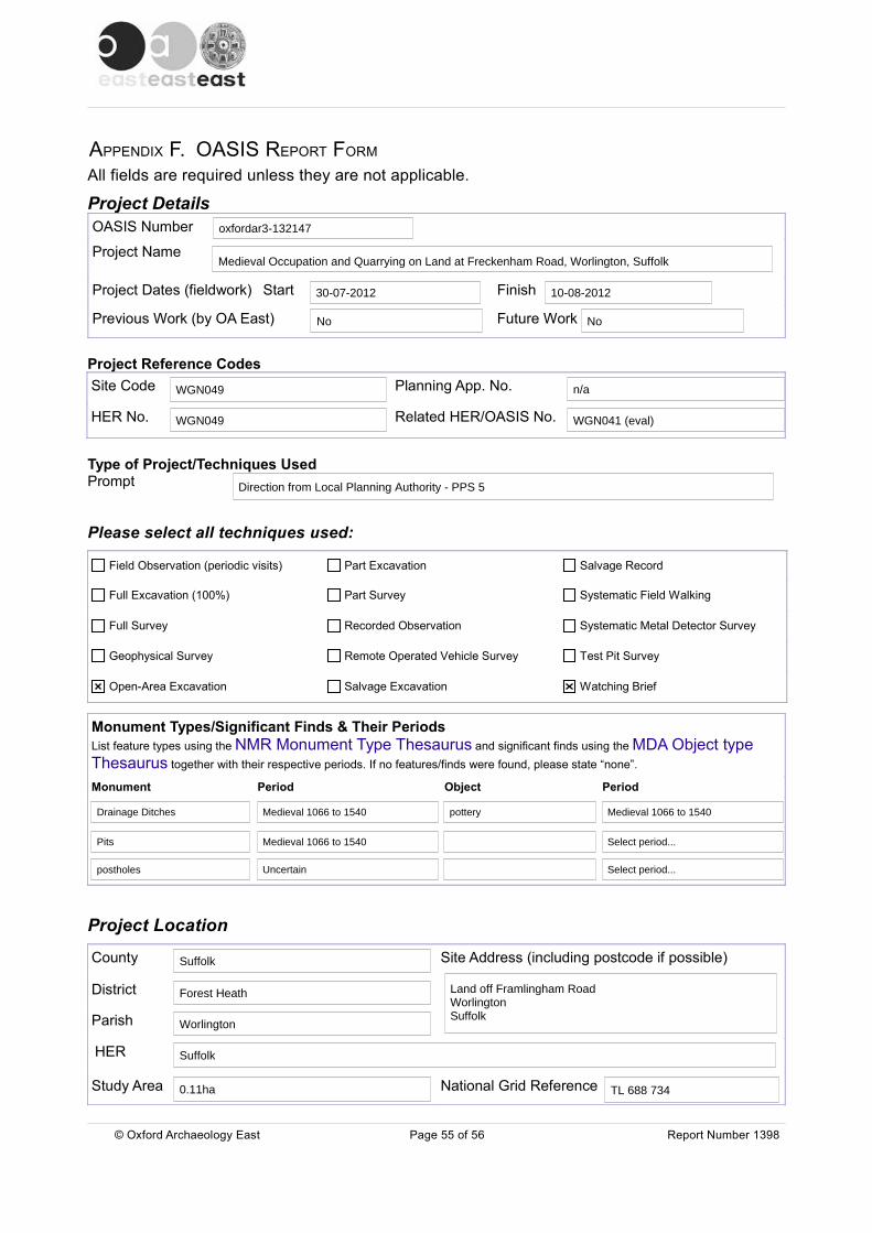
APPENDIX F. OASIS REPORT FORM
All fields are required unless they are not applicable.
Project DetailsOASIS Number
Project Name
Project Dates (fieldwork) Start Finish
Previous Work (by OA East) Future Work
Project Reference CodesSite Code Planning App. No.
HER No. Related HER/OASIS No.
Type of Project/Techniques UsedPrompt
Please select all techniques used:
Monument Types/Significant Finds & Their Periods List feature types using the NMR Monument Type Thesaurus and significant finds using the MDA Object type Thesaurus together with their respective periods. If no features/finds were found, please state “none”.
Monument Period Object Period
Project Location
County Site Address (including postcode if possible)
District
Parish
HER
Study Area National Grid Reference
© Oxford Archaeology East Page 55 of 56 Report Number 1398
Field Observation (periodic visits) Part Excavation Salvage Record
Full Excavation (100%) Part Survey Systematic Field Walking
Full Survey Recorded Observation Systematic Metal Detector Survey
Geophysical Survey Remote Operated Vehicle Survey Test Pit Survey
Open-Area Excavation Salvage Excavation Watching Brief
oxfordar3-132147
Medieval Occupation and Quarrying on Land at Freckenham Road, Worlington, Suffolk
30-07-2012 10-08-2012
No No
WGN049 n/a
WGN049 WGN041 (eval)
Direction from Local Planning Authority - PPS 5
Drainage Ditches Medieval 1066 to 1540 pottery Medieval 1066 to 1540
Pits Medieval 1066 to 1540 Select period...
postholes Uncertain Select period...
Suffolk
Land off Framlingham Road Worlington Suffolk
Forest Heath
Worlington
Suffolk
0.11ha TL 688 734
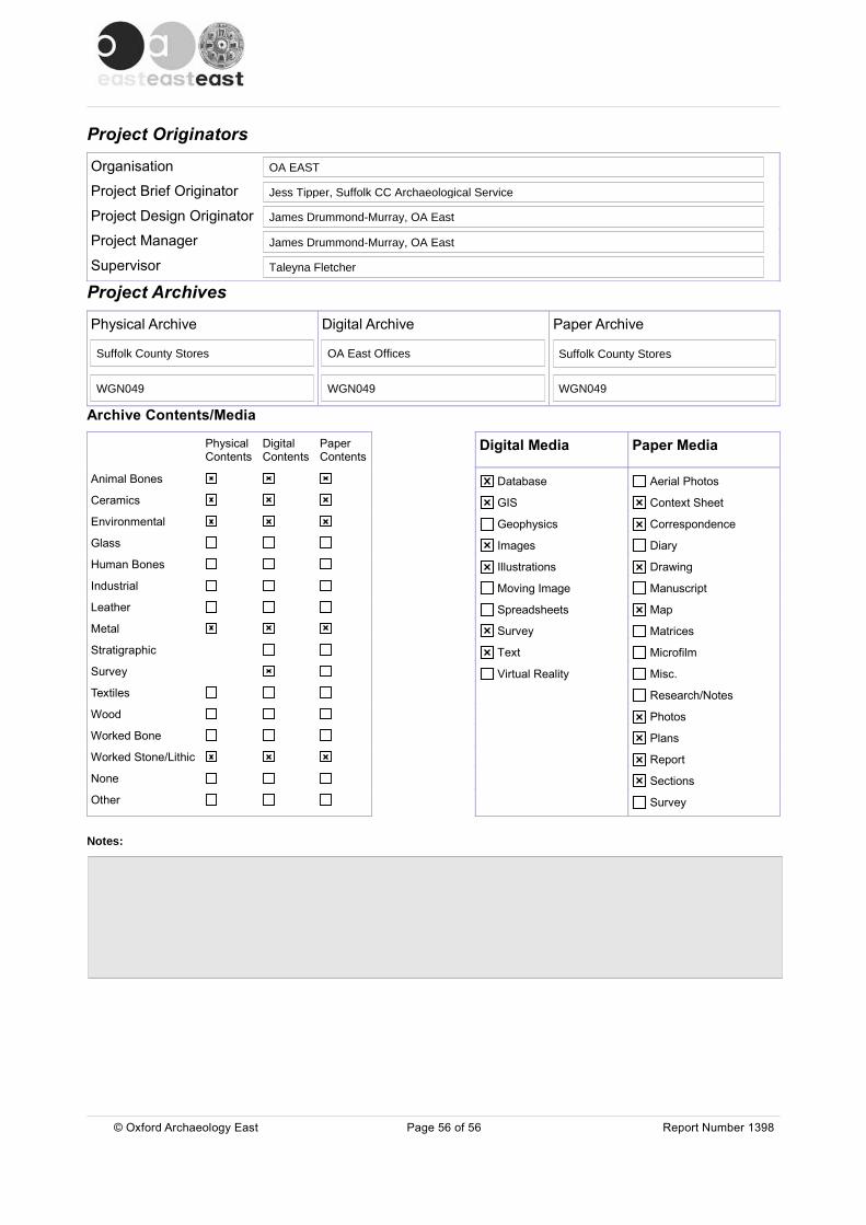
Project Originators
Organisation
Project Brief Originator
Project Design Originator
Project Manager
Supervisor
Project Archives
Physical Archive Digital Archive Paper Archive
Archive Contents/Media
PhysicalContents
DigitalContents
PaperContents
Digital Media Paper Media
Animal Bones
Ceramics
Environmental
Glass
Human Bones
Industrial
Leather
Metal
Stratigraphic
Survey
Textiles
Wood
Worked Bone
Worked Stone/Lithic
None
Other
Notes:
© Oxford Archaeology East Page 56 of 56 Report Number 1398
Database
GIS
Geophysics
Images
Illustrations
Moving Image
Spreadsheets
Survey
Text
Virtual Reality
Aerial Photos
Context Sheet
Correspondence
Diary
Drawing
Manuscript
Map
Matrices
Microfilm
Misc.
Research/Notes
Photos
Plans
Report
Sections
Survey
OA EAST
Jess Tipper, Suffolk CC Archaeological Service
James Drummond-Murray, OA East
James Drummond-Murray, OA East
Taleyna Fletcher
Suffolk County Stores OA East Offices Suffolk County Stores
WGN049 WGN049 WGN049
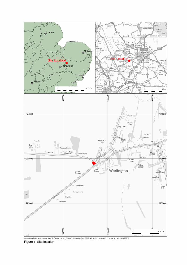
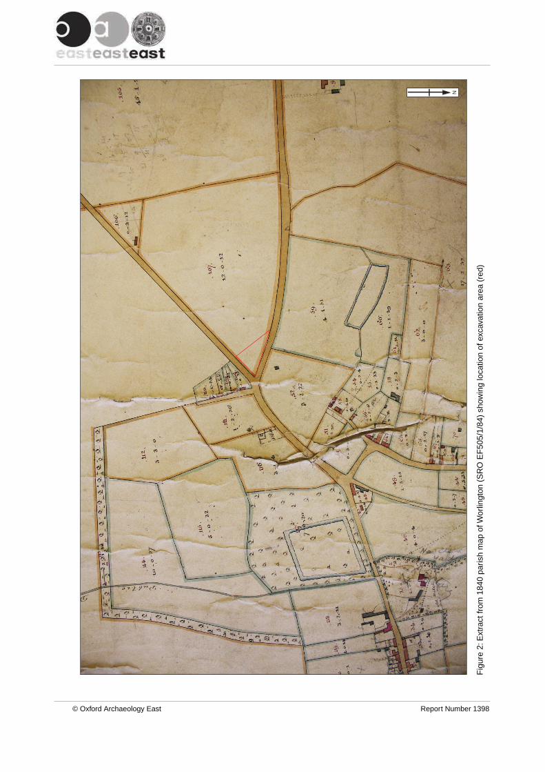
Fig
ure
2: E
xtra
ct fr
om 1
840
paris
h m
ap o
f Wor
lingt
on (
SR
O E
F50
5/1/
84)
show
ing
loca
tion
of e
xcav
atio
n ar
ea (
red)
© Oxford Archaeology East Report Number 1398
N
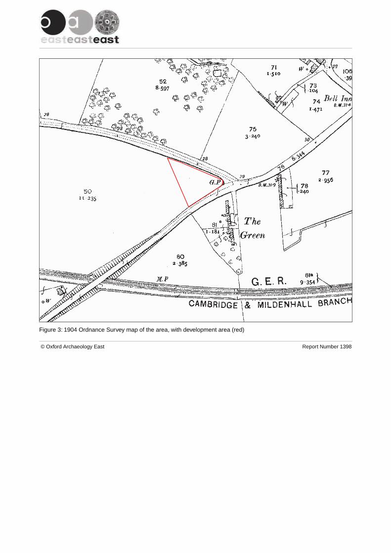
Figure 3: 1904 Ordnance Survey map of the area, with development area (red)
© Oxford Archaeology East Report Number 1398
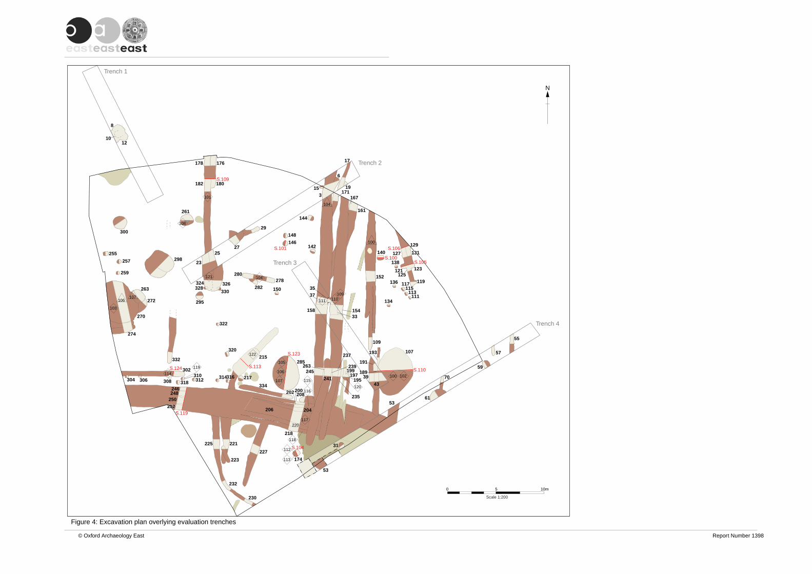
0 5 10m
Scale 1:200
103
114
119
121
108
101
112
113
117
118
116
115
105
106
107
122
120
100 102
111 110109
104
106107
100
104
S.123
S.113S.110
S.119
S.124
S.101
S.100S.105
S.106
S.109
S.104
12
8
10
39
43
3735
33
23
25
29
27
6
153
17
19
53
31
53
70
61
59
57
55
252252
246248
250
302310
308 318304 306 312 314316
320
322
332
274
270
225 221
223
232
272
263
259
257
255
300
298
261
295
330328324 326
180182
178 176
230
174
218
206
227
217
215285
334
208200202
204
245
241
235
197199
195
239
237
263
109
193
191
189
107
280278
282 150
158 154
152
140
123
127
129
131131
138
121125
117 119
111113
115136
134
148
146142
171
161
167
144
220
Trench 1
Trench 2
Trench 4
Trench 3
© Oxford Archaeology East Report Number 1398
Figure 4: Excavation plan overlying evaluation trenches
N
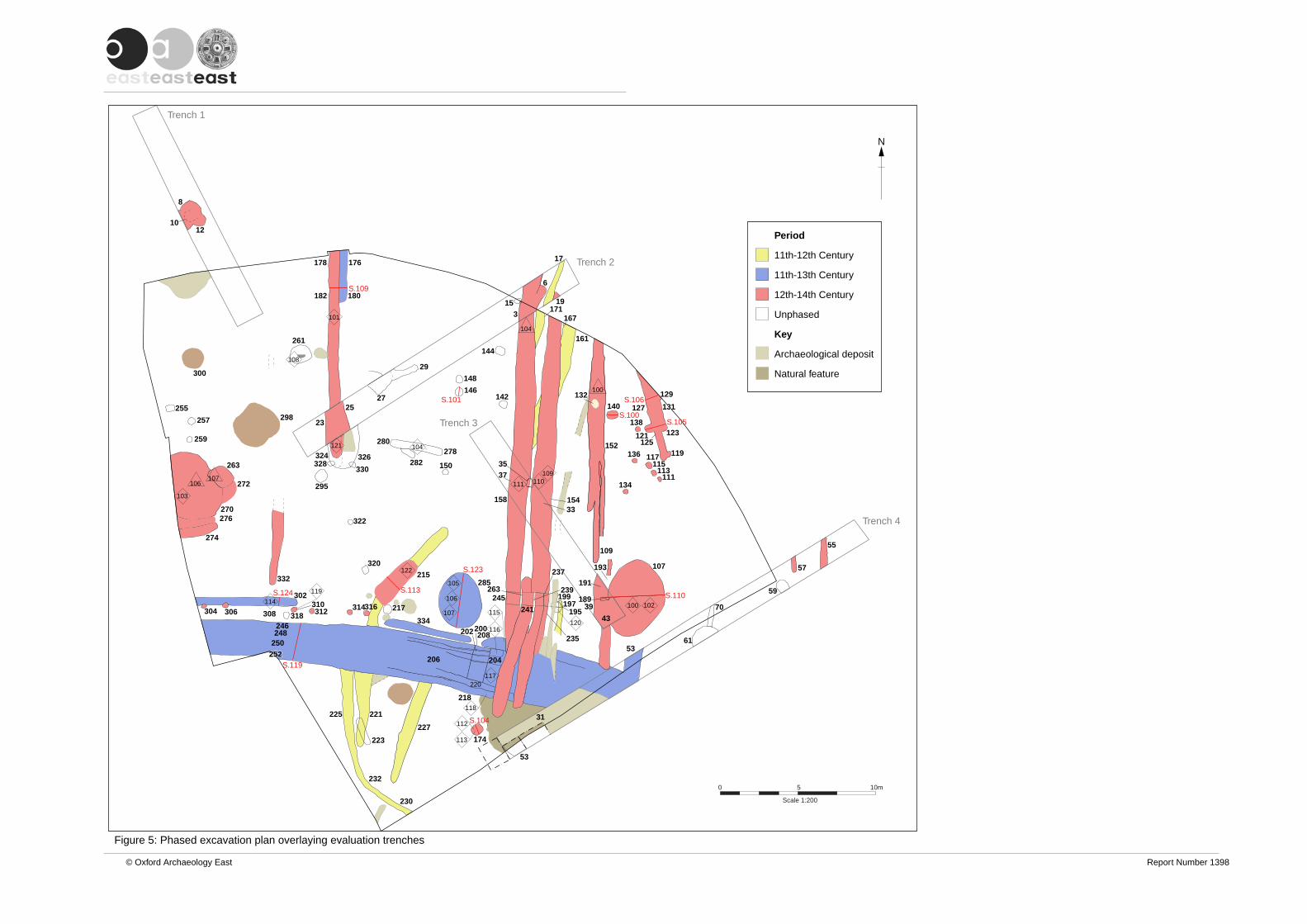
0 5 10m
Scale 1:200
103
114
119
121
108
101
112
113
117
118
116
115
105
106
107
122
120
100 102
111 110109
104
106107
100
104
S.123
S.113S.110
S.119
S.124
S.101
S.100S.105
S.106
S.109
S.104
12
8
10
39
43
3735
33
23
25
29
27
6
153
17
19
53
31
53
70
61
59
57
55
252252
246248
250
302310
308 318304 306 312 314316
320
322
332
274
270
225 221
223
232
272
263
259
257
255
300
298
261
295
330328324 326
180182
178 176
230
174
218
206
227
217
215285
334
208200202
204
245
241
235
197199
195
239
237
263
109
193
191
189
107
280278
282 150
158 154
152
140
123
127
129
131131
138
121125
117 119
111113
115136
134
148
146142
171
161
167
144
220
Trench 1
Trench 2
Trench 4
Trench 3
© Oxford Archaeology East Report Number 1398
Figure 5: Phased excavation plan overlaying evaluation trenches
N
Period
11th-12th Century
11th-13th Century
12th-14th Century
Unphased
Key
Archaeological deposit
Natural feature
276
132
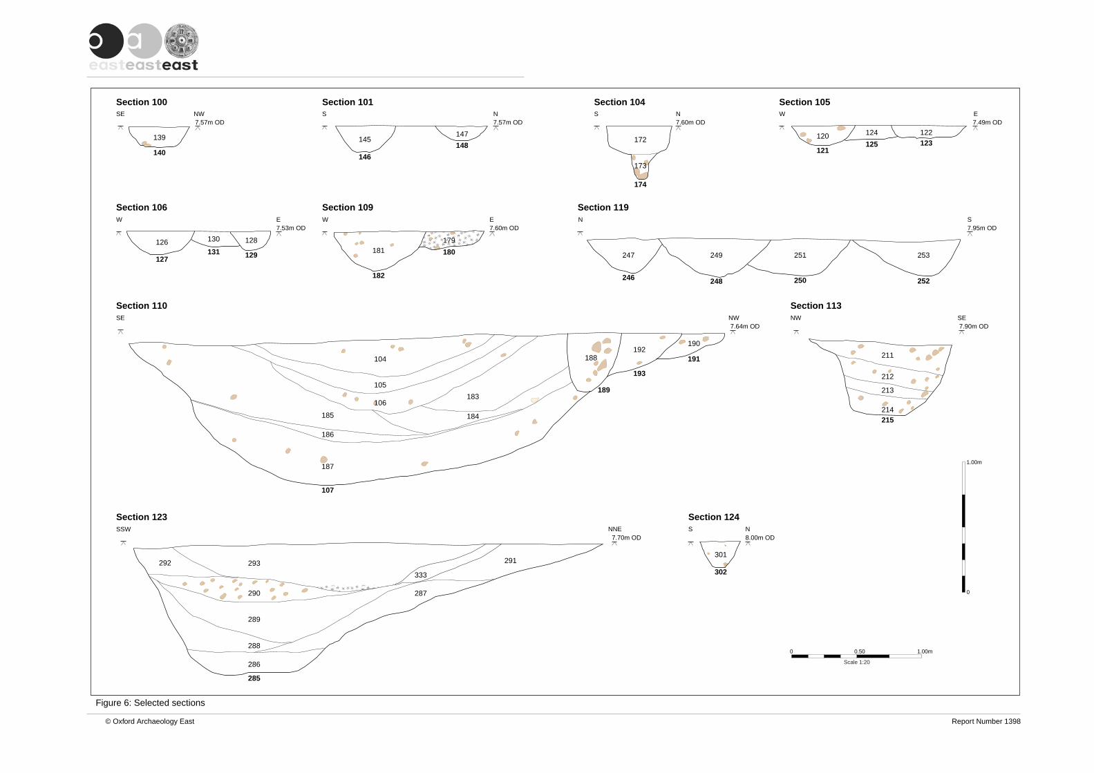
© Oxford Archaeology East Report Number 1398
Figure 6: Selected sections
7.57m OD
Section 100NWSE
140
139
Section 101
7.57m OD
146
145148
147
NS
Section 104
7.60m OD
174
172
NS
173
301
302
Section 124
8.00m ODS N
W E
Section 109
7.60m OD
182
181 180
179
Section 105
Section 106
120 124 122
126 130 128
121125 123
127131 129
7.49m OD
7.53m OD
W E
W E
Section 110SE NW
7.64m OD
107
189
193
191
187
185
104
105
106
184
183
188192
190
186
7.90m OD
7.95m OD
NW SE
N S
Section 113
Section 119
211
212
214
213
247 249 251 253
215
246 248 250 252
Section 123NNE
7.70m OD
293
290
289
288
286
287
292 291
333
285
0 0.50 1.00m
Scale 1:20
SSW
0
1.00m

Figure 7: Storage jar from context 0056
© Oxford Archaeology East Report Number 1398
0 100 mm
1:2
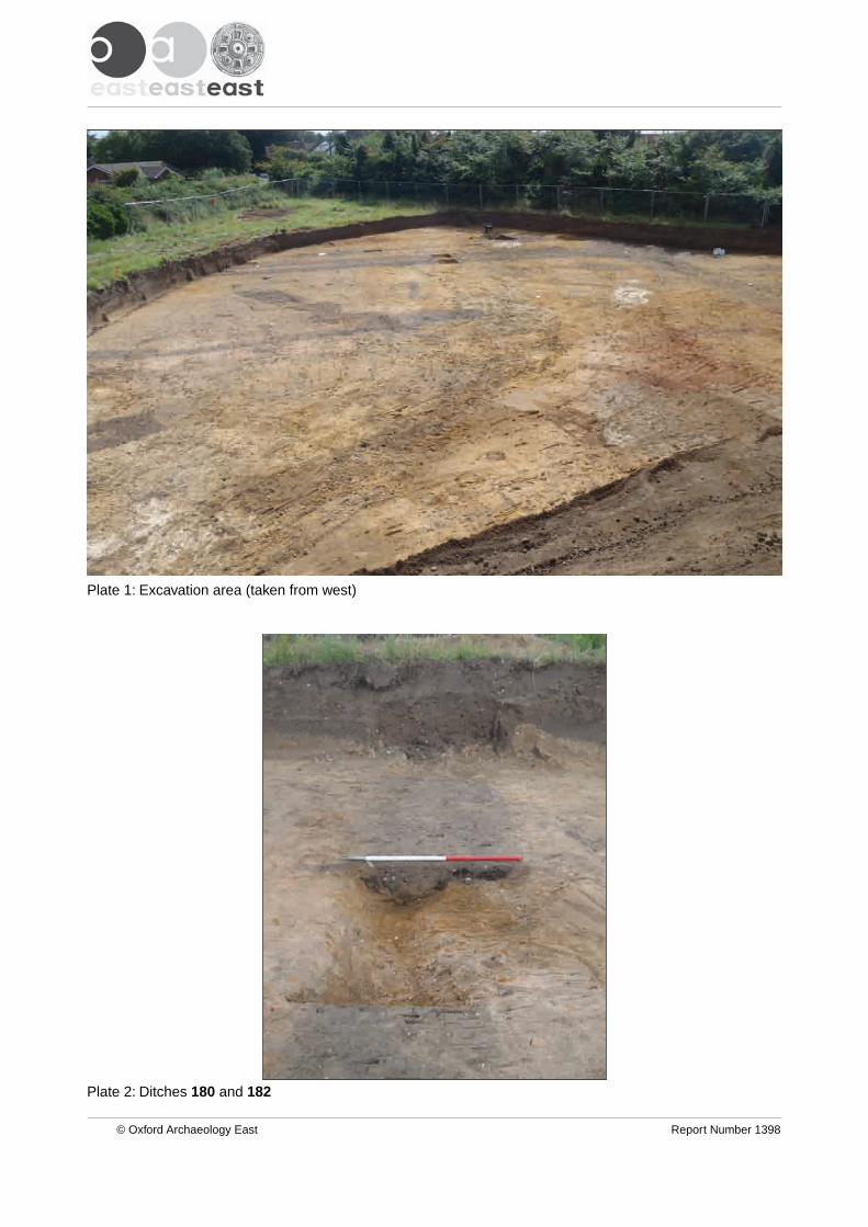
Plate 2: Ditches 180 and 182
Plate 1: Excavation area (taken from west)
© Oxford Archaeology East Report Number 1398

Plate 4: Pit 285
Plate 3: East-west boundary ditches 202 et al
© Oxford Archaeology East Report Number 1398

Plate 6: East-west boundary ditches 245 et al
Plate 5: North-south oriented ditches at southern edge of site
© Oxford Archaeology East Report Number 1398

Plate 8: Possible structure comprising ditches 117 and 123 et al and postholes 111 et al
Plate 7: Semi-articulated calf burial (132)
© Oxford Archaeology East Report Number 1398
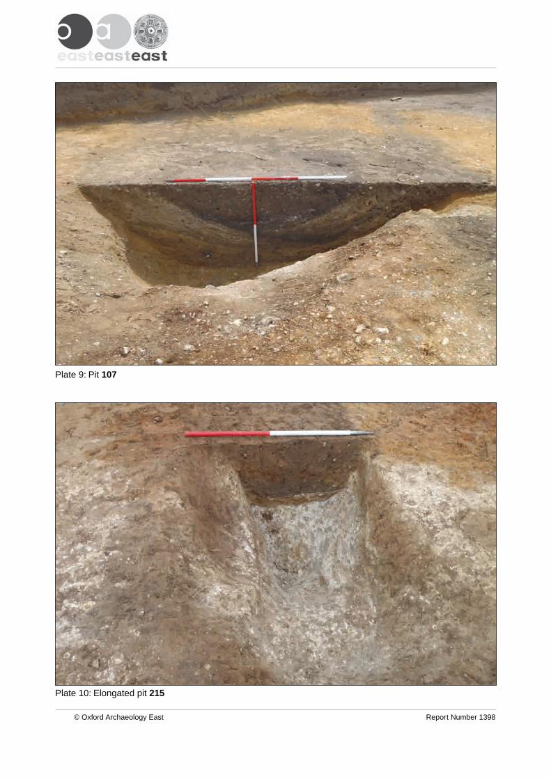
Plate 10: Elongated pit 215
Plate 9: Pit 107
© Oxford Archaeology East Report Number 1398
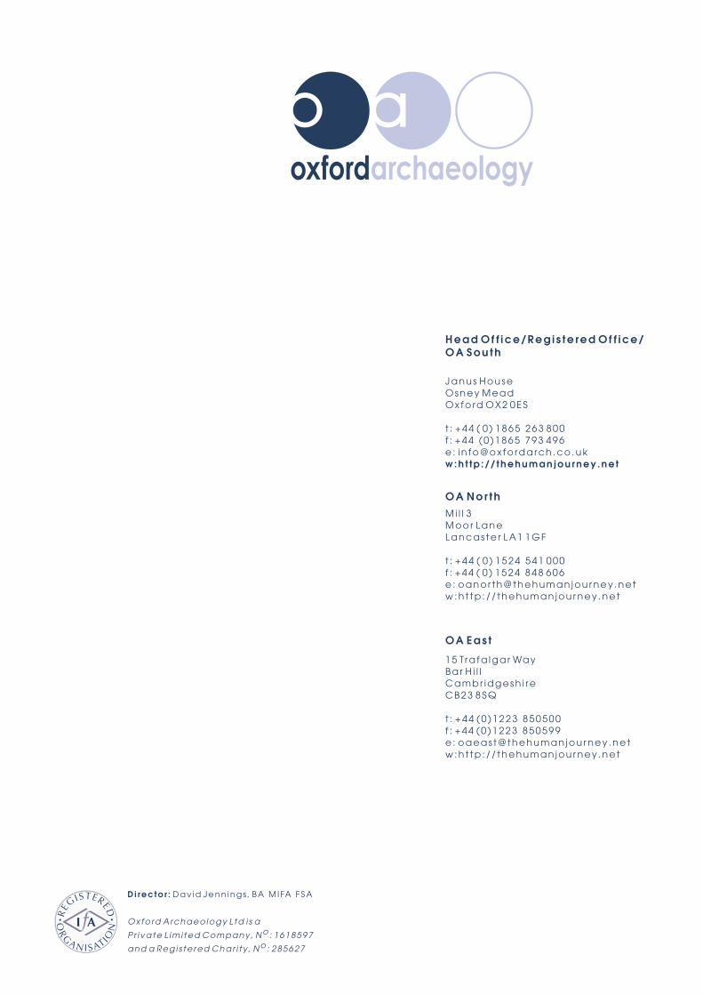
Di rec to r : Dav id Jenn ings , BA M I FA F SA
Oxfo rd A rchaeo logy L td i s a
P r i va te L im i ted Company , N o : 1618597
and a Reg i s te red Char i t y , N o : 285627
OA Nor thMi l l 3Moor LaneLancas te r LA1 1GF
t : +44 ( 0 ) 1524 541 000f : +44 ( 0 ) 1524 848 606e : oanor th@thehuman jou r ney .netw:h t tp : / / thehuman jou r ney .net
Head Of f ice/Reg i s te red O f f ice/OA Sou th
Janus HouseOsney MeadOxfo rd OX2 0ES
t : +44 ( 0 ) 1865 263 800f : +44 ( 0 )1865 793 496e : i n fo@ox fo rdarch .co .ukw:h t tp : / / th eh u m an j ou rn ey .ne t
OA Eas t
15 Tra fa lga r WayBar H i l lCambr idgesh i reCB23 8SQ
t : +44 (0 )1223 850500f : +44 (0 )1223 850599e : oaeas t@thehuman jou r ney .netw:h t tp : / / thehuman jou r ney .net