examples of management of forests for conservation in ... · examples of management of forests for...
TRANSCRIPT
1
Examples of Management of Forests for Conservation in Northern, Eastern, and
Southern Europe
Alfred Toepfer Natural Heritage Scholarship Report 2011/12
Royal Society for the Protection of Birds Sabbatical Report
2011/12
Ross Watson
2
Contents Introduction.......................................................................................................................................Page 3 Germany – 20th to the 25th of September 2011....................................................................Pages 4 to 7 • EUROPARC Conference site visit to deadwood site in Black Forest Slovenia – 14th to the 25th of November 2011................................................................... Pages 8 to 32 • Ptuj, Pohorje, Kocevje, Steznik, Masun, Skojcan Bay and Karst areas Poland – 11th to the 22nd of May 2012...............................................................................Pages 33 to 57 • Bialowieza Forest Sweden – 23rd to the 27th of May 2012..............................................................................Pages 58 to 72 • Vastmanland and fire in Ramnas Norway – 25th June to the 5th of July 2012.......................................................................Pages 73 to 98 • Dovrefjell – Sunndalsfjella National Park, nature reserve management and interpretation
centres in Nordland and Hordaland Counties. Report Summary...............................................................................................................Pages 99 to 100

3
Introduction Through this scholarship and sabbatical I have spent time with fellow practitioners in five other European countries to gain an understanding of how they manage woodland habitats. In particular, I was pursuing information on the following: • Field layer diversity. How wild animals and grazing animals are used, which species and
densities are thought appropriate and how the relationships between predator and prey affect the field layer structure.
• Creation, retention and destruction of deadwood by grazing animals and to hear the opinions of a range of people on the value of deadwood retention in a forest.
• Forest expansion and regeneration. How wild animals are managed, how domestic stock is manipulated and how a sustainable hunting industry may be maintained.
The purpose of this project was twofold. Firstly, to allow me to become better informed about the work of different land managers across Europe. This will improve my ability to make contributions and be part of the decision making process of the management of the Royal Society for the Protection of Birds (RSPB) Abernethy National Nature Reserve in the North of Scotland. Intensive management has taken place on the reserve here since it’s purchase, and this continues to be at a bigger scale, more strategic and more innovative. The experiences I will gain through this project will equip me with a breadth of knowledge that can be tapped into to inform management decisions and improve upon current management practices. The second purpose was to seek examples where traditional land management, conservation land management and local communities work well together and how this was achieved. The reason for this is that the management of Abernethy can sometimes be radically different from that of a traditional landowner and this has created a degree of negativity from local communities on the edge of the reserve and also from national land management organisations. I was brought up on a hill farm within a highland estate and can see the potential for traditional land managers and conservationists to work together on a common aim; to manage land that is viable both environmentally and economically. When submitting my application to EUROPARC and to RSPB, the partners I had contacted in Slovenia, Poland and Norway agreed to host me for the duration of the trip. As this situation evolved, so to did the project. In Slovenia and Norway, I met with several people from a range of organisations and this diversified the knowledge base I learned from and enriched the discussions with people as the year went by. Another country was also added to the project to make use of a unique opportunity offered to me by a EUROPARC contact in Sweden. This short addition was extremely valuable to the project and to our work here at Abernethy.

4
Details of visits Germany 20th -25th September 2011 The Scholarship was presented as part of the EUROPARC Annual Conference in Bad Urach, within the Swabian Alps Biosphere reserve in Southern Germany. As part of this, I made a site visit to a forest near Offenburg in the Black Forest. This site was hit during the so called ‘Lothar’ hurricane in the winter of 1999, so named after the German Politian of the same name who had a hurricane style of politics.
Part of the 10ha windblown site left
During this storm, around 1.6% of the entire black forest was affected with trees being blown over or damaged in some form. While almost all was felled, extracted and removed as a sellable product and also for fear of a bark beetle population explosion, an experimental 10ha site was left untouched to see how the forest would react to such an event. In addition to observing the forest changes, an innovative interpretation trail was built allowing people to experience these changes first hand and to understand the value of deadwood within the forest.
5
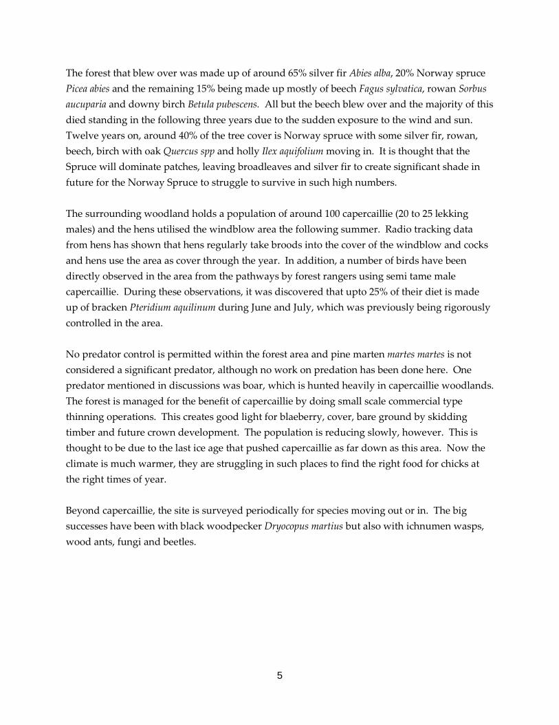
The forest that blew over was made up of around 65% silver fir Abies alba, 20% Norway spruce Picea abies and the remaining 15% being made up mostly of beech Fagus sylvatica, rowan Sorbus aucuparia and downy birch Betula pubescens. All but the beech blew over and the majority of this died standing in the following three years due to the sudden exposure to the wind and sun. Twelve years on, around 40% of the tree cover is Norway spruce with some silver fir, rowan, beech, birch with oak Quercus spp and holly Ilex aquifolium moving in. It is thought that the Spruce will dominate patches, leaving broadleaves and silver fir to create significant shade in future for the Norway Spruce to struggle to survive in such high numbers. The surrounding woodland holds a population of around 100 capercaillie (20 to 25 lekking males) and the hens utilised the windblow area the following summer. Radio tracking data from hens has shown that hens regularly take broods into the cover of the windblow and cocks and hens use the area as cover through the year. In addition, a number of birds have been directly observed in the area from the pathways by forest rangers using semi tame male capercaillie. During these observations, it was discovered that upto 25% of their diet is made up of bracken Pteridium aquilinum during June and July, which was previously being rigorously controlled in the area. No predator control is permitted within the forest area and pine marten martes martes is not considered a significant predator, although no work on predation has been done here. One predator mentioned in discussions was boar, which is hunted heavily in capercaillie woodlands. The forest is managed for the benefit of capercaillie by doing small scale commercial type thinning operations. This creates good light for blaeberry, cover, bare ground by skidding timber and future crown development. The population is reducing slowly, however. This is thought to be due to the last ice age that pushed capercaillie as far down as this area. Now the climate is much warmer, they are struggling in such places to find the right food for chicks at the right times of year. Beyond capercaillie, the site is surveyed periodically for species moving out or in. The big successes have been with black woodpecker Dryocopus martius but also with ichnumen wasps, wood ants, fungi and beetles.

6
The site is interpreted not only through panels on site and organised guided walks but also through a large interpretive centre. At this centre, the stuffed animals with corresponding noises and interactive games for children allow people to identify the sights and sounds of the forest more clearly. Upstairs, artily draped photographs printed on cloth suspended from the ceiling, poems and oil paintings depict a similar story in a more visual fashion. A large information pack and helpful rangers also provide as much, or as little, information as you require. This centre is funded through LIFE and updates the interpretation every season, donating last seasons artwork to the local schools who have come along on school trips. Once the LIFE pot is empty, however, the head ranger is unsure how the centre will be funded. The local authority are currently placing a bid to make the Black Forest a National Park in the hope that this will bring more money and tourists to support centres like this one. A wooden walkway has been built through the area, making every effort not to cut or remove anything. The result is a fantastic adventure of a trail that takes you under, over and through fallen trees and root plates upto a view point that looks across the whole site. This has been a key part in convincing local people that the retention of such a large volume of deadwood in site of a busy road and within the forest that could be susceptible to a bark beetle outbreak from the area is a good thing. The local people have seen this site develop and the walkway has become the second most popular trail anywhere in the Baden-Wurttemberg region in Germany, due to the interest of the surroundings and the style of the walkway itself. It can attract up to 20,000 people in a year.
Walkway over and under fallen trees

7
Benefits of this trip While deadwood is being created at Abernethy, it is created in a way that is not visually obtrusive to most people to attempt to minimise confrontation with people who feel that this style of management is wrong. An interpretive plan based around deadwood would be beneficial to Abernethy so deadwood can be created where it needs to be, whilst the public are aware of the benefits of this and how the future of the forest is being shaped. The actual creation of deadwood at Abernethy is bold. None of the forest managers I met created any deadwood, but managed the wood bearing deadwood in mind and left a percentage of the cut crop and high topped trees. The deadwood was a bi-product of the productive management of the forest. This appeared to be accepted by the public more, according to the foresters on this visit. This visit was inspiring as it was a bold step to leave such a volume of deadwood in the public eye and to use the site as a showcase to allow foresters and the general public the opportunity to see how the forest would react naturally to such an event. The site has also, through the capercaillie research, shown the importance of deadwood and cover through the forest system.

8
Slovenia – 14th – 25th November 2011
Summary of travel Day one – Maribor with students from Maribor University Day two – Ptuj, Ormoz and Jeruzalem with Forestry Student and private foresters Day three – Pohorje with ZGS and private foresters Day four – Kocevje and Strmec Virgin Forest with ZRSVN and ZGS Day five – Sneznik with ZRSVN Day six – Masun with ZRSVN and ZGS Day seven – Ljubljana with DOPPS Day eight – Skojcan Bay with DOPPS Day nine – Karst edge with DOPPS and farmer Day ten – Ljubljana Introduction My 10 days visit to Slovenia took me to visit private foresters, state foresters, hunters, farmers, Government environmental staff and a conservation NGO. I travelled the length and breadth of the country meeting these knowledgeable, patient, hospitable people who gave up their time to show how proud they are of this fantastic country and how it is managed.

9
Slovenia has a long and very complex history, which has resulted in a range of land management practices and changes from small scale family farms to Soviet style collectivism to whole scale abandonment of land, in some places. This has resulted in a rich and varied landscape managed by man but often in such a scale that the patchwork of habitats across the land are a perfect blend for so much biodiversity. Since joining the EU in 2004, intensification has been inevitable and this vibrant, beautiful, and productive landscape has become threatened. Slovenia has worked with long term forest plans since 1864 and less than 1% of the forest is planted. Regeneration is promoted through skidding of timber to create bare ground. The result is that the natural zonations of forest habitats still exist. These are: Mountain top Grasses Dwarf Mountain Pine Norway Spruce Silver Fir, Beech, Maple, Elder Norway Spruce Dwarf Mountain Pine Valley Bottom Grasses Forest types on Sneznik (1796m) The land of Slovenia is covered by around 70% forest, and this is increasing as the land becomes afforested due to abandonment. This abandonment of land appears to be due to the Soviets arrival in 1937, where land became common and was managed for the Soviets objectives to maximise production of the land. When, in 1948, Yugoslavia broke free from the Soviet Union, families could begin to reclaim land that was rightfully theirs pre 1937. As entire families had been wiped out through the German recruitment of Slovenians during the Second World War and genocide by communists and fascists, together with few formal written records, huge areas of land are left unmanaged as owners could not, and cannot, be found. In addition to this, land abandonment is also occurring due to the aging rural population while the young people flee to Ljubljana or Western Europe to make their fortune.

10
Current Management of Forests Protection of forest habitats has been in existence in Slovenia since 1864, and protected areas have been in existence since 1892, when Dr Hufnagel deemed several compartments within Kocevje as Virgin Forest Protection Zones. Forestry is now managed under a National Forestry Programme and has been since 2007. The country is split into 14 regions and a ten year plan is written for each region. Within these, there are a further 235 forestry unit plan, each of around 2000 to 3000 hectares in size. There is then the Operational Plan, which details what will be cut, when, what will be left and the features that will be encouraged. Through these plans, nature conservation measures are written throughout. An eco-cell is designated in different locations and are around 20ha in size. They are typically the areas within the forest that are difficult to extract timber from so are already less managed due to their geography. They can contain cave systems, water bodies, old trees or bogs and are havens for biodiversity as no management may take place within an eco-cell. Even in private forests, eco-cells are part of the management. They are areas selected in cooperation with the landowner and no financial incentive is given to have an eco-cell on private land. The result is that the eco-cell becomes a thicket within a thinning, managed woodland so becomes a refuse for some species. This can be a positive but can also be a honey pot for predators. Forest protection is catergorised into four types: Virgin Forest Reserve – No access or intervention Buffer Zone – Some access, some very light silvacultural management, no hunting Eco-cell – 20ha zone within managed woodland Exceptional Tree/ Habitat Tree – An individual tree within commercial woodland worthy of protection. ‘Habitat Tree’
11
As land is handed down through generations, it has been divided down in size. The result is many hundreds of single owned units of forest just 1.2m wide in some places. Of a population of a little over two million, 460,000 of those are registered as forest owners. This seems to have happened the further North East you travel. This practice has now stopped and a 5ha piece of woodland cannot be made smaller. A long term forest plan is written by the Zavod za Gozdove Slovenije (ZGS), who are the Slovenia Forestry Service for each forestry owner covering a ten year period. Even in the case of a small strip of woodland, the owner must meet with the area forester on site to discuss which trees they wish to fell and why. The forester will consult the Forest Plan and the Regional Plan and discuss the options. Once the ZGS forester and the owner have agreed, each individual tree is marked by the ZGS forester using a hammer containing a number particular to that ZGS forester on the trunk and on the stump to ensure the owner does not cut more than agreed. The balance of species must be maintained. This is typically around 30% beech, 25 % spruce, 25% silver fir, 6% oak, 5% valuable deciduous species and the remainder a mix of other conifers and deciduous species. This would be typical of areas such as Kocevje where there are habitat inversions in valleys and high hills are also present. Specific requirements of all plans and owners are that at least 3% of the timber in the forest must be deadwood and that trees which are native to the area that have grown to a width of more than 120cm at breast height must not be felled. Clear felling is not permitted, unless for reclaiming farmland or for building development and even these have to follow a strict set of guidelines and have each individual tree okayed by the ZGS staff. This is to ensure the zonations of forest habitats are retained through regeneration of thinned woodlands and to ensure the landscape is not scarred dramatically by large holes in the forest. During the period of management, unusual trees or dead trees maybe marked up as ‘habitat trees’. These become a fixture within the forest plan and must be protected. During the next spell of management, further habitat trees are marked up as trees change or die.

12
Due to the style of small scale forestry and cottage industry sawmilling, forestry used to employ many thousands of people across Slovenia. With decreasing transportation costs, most timber is now sent to Austria for milling, where the timber is purchased for around 40 Euros per ton, compared to eight Euros in Slovenia. The quantity of timber per hectare is impressive, as the typical canopy height in this area is between 35 and 40m, totalling around 900 cubic metres per hectare, of which 30% is dead. The forest is recognised as having value beyond the value of the timber as it is a place to access for enjoyment and is also the aesthetic value of the landscape. The forests are open to the public and access can be taken on foot, mountain bike, ski’s or on horseback. Tracks that are heavily used by the public must be actively managed to keep them open. Dead trees nearby must be cut down to prevent them falling on people. People and the forests One quarter of Slovenia’s population is registered as forest owners and, in addition to that, there are farmers, hunters and fishermen who are all utilising the countryside in a traditional fashion. People who live in Ljubljana often have a holiday home in the country or have older relatives in the country. The population of rural areas is directly linked to the countryside through their livelihood, their family or their past times. The educational establishments appear aware of this and curriculums within schools are geared towards learning about the forests around the schools, maintaining this connection. The foresters themselves, whether private or state, are respected members of the community as they are providing fuel for the families, a home for the game and a recreational facility for people. Their rules of the forest are observed always. In large forests, staff are recruited from the nearest villages and the offices are within the village, making the people who work there accessible to the public. Ormoz area, south of Maribor To learn about the management of woodlands, I met with a number of people across the country to gain an insight. My first meeting was with a forestry student from Maribor University called Matjaz Premz. He is an interesting person and kindly took two days to show me a lot of different places and also arranged meetings with other foresters. His family, who have lived in the same village for the last 400 years, warmly invited me into their home for meals with them, in exchange for a bit of work on their farm on the edge of a small village south of Maribor called Zrkovci.
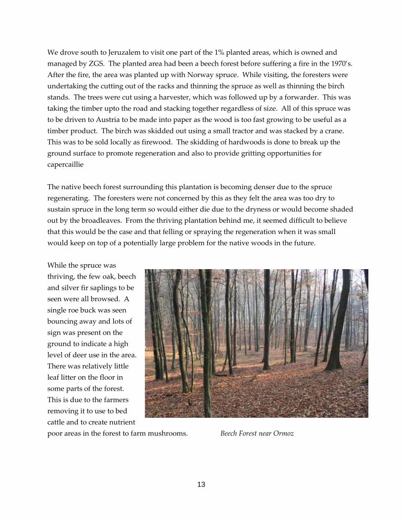
13
We drove south to Jeruzalem to visit one part of the 1% planted areas, which is owned and managed by ZGS. The planted area had been a beech forest before suffering a fire in the 1970’s. After the fire, the area was planted up with Norway spruce. While visiting, the foresters were undertaking the cutting out of the racks and thinning the spruce as well as thinning the birch stands. The trees were cut using a harvester, which was followed up by a forwarder. This was taking the timber upto the road and stacking together regardless of size. All of this spruce was to be driven to Austria to be made into paper as the wood is too fast growing to be useful as a timber product. The birch was skidded out using a small tractor and was stacked by a crane. This was to be sold locally as firewood. The skidding of hardwoods is done to break up the ground surface to promote regeneration and also to provide gritting opportunities for capercaillie The native beech forest surrounding this plantation is becoming denser due to the spruce regenerating. The foresters were not concerned by this as they felt the area was too dry to sustain spruce in the long term so would either die due to the dryness or would become shaded out by the broadleaves. From the thriving plantation behind me, it seemed difficult to believe that this would be the case and that felling or spraying the regeneration when it was small would keep on top of a potentially large problem for the native woods in the future. While the spruce was thriving, the few oak, beech and silver fir saplings to be seen were all browsed. A single roe buck was seen bouncing away and lots of sign was present on the ground to indicate a high level of deer use in the area. There was relatively little leaf litter on the floor in some parts of the forest. This is due to the farmers removing it to use to bed cattle and to create nutrient poor areas in the forest to farm mushrooms. Beech Forest near Ormoz

14
The wood is thinned by around 30% initially, after growing for around 25 years, and the remainder is thinned by a further 30% each further 10 year spell until only 30% of the original stand is remaining. By this stage, a lot of young trees should be regenerating through as the canopy opens up. Different species require different levels of light so this gradual opening gives the less competitive species a chance to gain some height before opening the canopy too much at once. Once the regeneration is above browse height, the rest of the original trees are felled and extracted, unless there are trees on site that are native and are above 120cm diameter at breast height (dbh). Trees as large as this are protected within the forest plans and are not allowed to be felled. The retention of deadwood within these situations is at the whim of the machine operators. As the tree density is fairly high in this plantation, there is no concern about dropping below the 3% requirement from the ZGS plan as there is lots of natural die off. Speaking to the forest managers, it depends on the operators how much deadwood is left. Some are good and some are not so good. There appeared to be a tendency for the older forest managers to mention ‘tidiness’ so the removal of fallen deadwood became part of the tidying in some parts. The cut product is removed down to 3cm diameter, leaving very little timber in the way of deadwood as a bi-product in this plantation. All branches cut off the felled trees must be in the racks and not spread through the wood to minimise the amount of new deadwood across the forest floor to attempt to minimise infestations of bark beetles, which are a massive pest in the majority of this country. From here, we drove through the wine growing areas of Jeruzalem to Lake Ptuj, which is on the Drava River and is the largest man made lake in Slovenia. This and a series of others were used to create hydro dams in the 1970’s but has caused a lot of hydrological issues for farmers and foresters with water levels being too high in winter and too low in summer. It has also affected migratory fish species and stopped the industry of floating timber down the Drava River to Croatia instantly.

15
Norway Spruce Plantation
We spent the remainder of the day on Matjaz’s family farm. As with the forests, farmed land can also be split into 1.2m wide strips. These strips of land are managed by families for their own consumption of fruit or vegetables, mostly. Others rent their strip out to others to grow and excess to sell. The result of this varied size of small fields is a very diverse landscape that is full of colour and wildlife. Matjaz’s farm is 5 hectares, a typical size of farm in this area. Little has changed on the farm in last fifty years, says Matjaz’s father except for one thing – the way they keep their cattle. In the past, the eight dairy cattle would have spent their days outside and been fed hay, carrots or turnips grown in the field in the winter. Now the cattle are kept inside year round and are fed corn that is grown on the fields. The excess corn is sold, which brings money to the rest of the house. The result of this is that, with less cattle outside in the fields, the vegetation becomes longer quicker so becomes unsuitable for the wading bird species and the corn is a tall foreboding monoculture that few farmland birds have adapted to.
16
Across the country, the Government is attempting to intensify the use of farmland by creating large units of land managed the same through incentives. This appears to be a mixed blessing as it will bring money to rural areas, it will also destroy a way of life and a rich landscape and habitat for hundreds of species. The payment is done through hectares so the farmers who manage many hectares already will become richer and will eventually buy up other farms. Hunting After a successful fishing trip on the Drava River at last light in Matjaz’s hand built punt, we discussed another of Matjaz’s interests, hunting. Deer and boar are on the increase as the Government and hunting organisations seek to improve the hunting within the country to increase the economic viability of some rural areas. Milder winters are also allowing more animals to survive. The hunting quotas are set by the Government and strict fines are imposed for shooting more than permitted. In order to hunt, people become a member of a hunting organisation who hunt over many different areas of land and crossing hundreds of landowners. This has led to conflict, in some places, between forest owners and hunters who hunt insufficient animals within parts of the forest, which is leading to high browsing levels in some places. The increase of deer is also causing an increase in the instances of Lyme’s Disease amongst rural people and this is becoming a real concern across parts of the country. In this system, foresters lose out as they have no say on how many animals are in their forests browsing the regeneration and are not allowed to shoot any, unless they are in the hunting organisation. Farmers are in the same boat. They are not allowed to remove marauding deer from crops and are fined heavily when they do. The hunting appears to take precedence over all other rural objectives. Pohorje, West of Maribor I spent a day with Matjaz as interpreter at three on site, in forest, meetings with a member of staff from ZGS called Mihel Dascman. He is a recent graduate from Maribor University and is a keen member of a hunting organisation. His role with ZGS is to liaise with private forest owners in this region of the country, a very large job. He was very open with me from the beginning and could speak excellent English, which was a huge help.

17
The first visit was to a section of forest made up of beech, oak, aspen and lime with a lot of young Norway spruce coming through in places. As so many forest owners manage thin strips, a major part of his role is to solve disputes over boundaries. The two areas we were looking at were 1.5ha each in size and with no line on the ground to determine the boundary, it is down to Mihel to settle the dispute. He commands respect from the elderly forest owners and they agree with the boundary that he marks from his GPS. These forest owners remove a small amount of timber each year to provide their family with firewood and perhaps make a few things to sell in their spare time. Mihel, as a young minded forester, sees the value of deadwood and persuades the forest owners to retain any standing deadwood that is in any way substantial. It is marked as a habitat tree and GPS’d. The two older foresters clearly want to remove all deadwood as the abundance of deadwood is seen by the older generations as a sign of a badly managed forest. The Universities spend a lot of time working with students to remove this feeling as, over the many decades of long term forest plans have shown, deadwood is a huge resource and needs to be managed carefully. The balance of timber removal has to be right though, too much and there is too much light too quickly and not a sustainable quantity of wood for the family. Too little and the regeneration is not given the chance to get away. In order for one of the forest owners to be allowed to cut as few trees as he is requesting, he must manage the field layer to allow the oak saplings, in particular, to grow without being choked by the grassy undergrowth, a lot of work for an older man. Each sapling is marked by the ZGS forester and counted. There is no penalty for not doing this, but without the regeneration, the owner will be left with a large open meadow with a few trees on it, not much use for the fire. He is also asked not to remove some of the trees as it would open the canopy enough to allow the few Norway Spruce, that would normally grow at a higher altitude, to grow up and dominate the broadleaves. Right: Young Norway Spruce in lowland woodland.

18
The second site visit began with a dispute over boundaries before agreeing which trees would be removed. The two owners here were very different in their ideas. The younger owner wanted to remove all the Norway Spruce to allow the birch, beech and oak to come through, and leave all deadwood. The other, older owner, wanted to fell only dead trees and leave the spruce as a crop for future years. To keep the owners happy, a compromise is reached, where the large dead trees that are left by the older owner are marked up as habitat trees and will appear in the next plan and some spruce is removed from both pieces of land. The third visit was to one of the few potential clear fell areas, for a house on the edge of a village. At this site around 0.75ha will be felled for one house. The trees are mostly large oak trees, some as large as 1.14dbh so the income from the timber alone is large. Each tree was measured and marked by ZGS, with the owner present. From here, we went to inspect some work a forestry harvester training course had done, to find that the 40 tonnes of timber produced has all been stolen. Timber theft is common place here, as the timber industry is so heavily regulated. The wood was very attractive with lime, chestnut, cherry, beech and oak mixed through the frosty afternoon light. Some theft of timber is tolerated by the Government as chasing the criminals would take a disproportionate amount of effort. Hunting In between the site visits, Mihel was talking about the hunting in the area as he is part of the hunting organisation that includes Pohorje. Within an area 5000ha in size, they must shoot 100 roe, 70 red, 30 chamois and 50 boar to sustain the local population and prevent damage to crops of trees or in farmers fields. Pohorje holds a small population of lynx, who kill around 200 roe deer per year. Mihel says that this helps as the deer keep away from the areas that the lynx likes. This then creates thickets of regenerating woodland. The older hunters, whose parents would have been responsible for the lynx becoming extinct in Slovenia in the early 1900’s, do not like the 1973 reintroduction as the lynx are eating the hunters sport. Some lynx are killed illegally. The cull targets are set by the Government and are reviewed every ten years through a consultation with foresters and farmers to assess damage to trees and crops. The result of the consultation can often be that there are a sufficient number of deer to cause damage, but not enough to be easy sport. Through the ten years, the hunters are asked to prioritise their efforts to where the damage is happening most. In this way, the hunting arrangement can be positive as farmer, forester and hunter all work together.
19
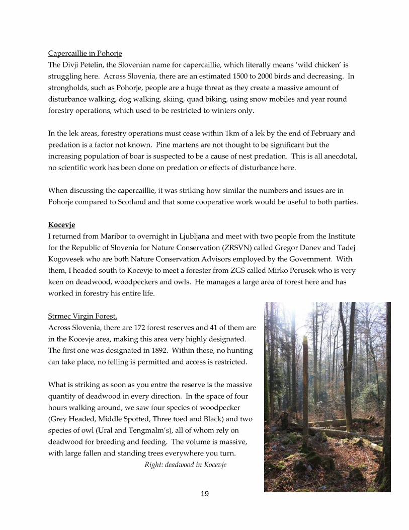
Capercaillie in Pohorje The Divji Petelin, the Slovenian name for capercaillie, which literally means ‘wild chicken’ is struggling here. Across Slovenia, there are an estimated 1500 to 2000 birds and decreasing. In strongholds, such as Pohorje, people are a huge threat as they create a massive amount of disturbance walking, dog walking, skiing, quad biking, using snow mobiles and year round forestry operations, which used to be restricted to winters only. In the lek areas, forestry operations must cease within 1km of a lek by the end of February and predation is a factor not known. Pine martens are not thought to be significant but the increasing population of boar is suspected to be a cause of nest predation. This is all anecdotal, no scientific work has been done on predation or effects of disturbance here. When discussing the capercaillie, it was striking how similar the numbers and issues are in Pohorje compared to Scotland and that some cooperative work would be useful to both parties. Kocevje I returned from Maribor to overnight in Ljubljana and meet with two people from the Institute for the Republic of Slovenia for Nature Conservation (ZRSVN) called Gregor Danev and Tadej Kogovesek who are both Nature Conservation Advisors employed by the Government. With them, I headed south to Kocevje to meet a forester from ZGS called Mirko Perusek who is very keen on deadwood, woodpeckers and owls. He manages a large area of forest here and has worked in forestry his entire life. Strmec Virgin Forest. Across Slovenia, there are 172 forest reserves and 41 of them are in the Kocevje area, making this area very highly designated. The first one was designated in 1892. Within these, no hunting can take place, no felling is permitted and access is restricted. What is striking as soon as you entre the reserve is the massive quantity of deadwood in every direction. In the space of four hours walking around, we saw four species of woodpecker (Grey Headed, Middle Spotted, Three toed and Black) and two species of owl (Ural and Tengmalm’s), all of whom rely on deadwood for breeding and feeding. The volume is massive, with large fallen and standing trees everywhere you turn. Right: deadwood in Kocevje

20
The trees are regenerating well, despite a lack of hunting. Wolves, bear and lynx are present here but not in sufficient numbers to affect the movement of prey, according to Mirko. The signs of bear were common throughout the walk, with fresh dung, beds and scratch marks on trees. Capercaillie in the Kocevje area Capercaillie use the reserves, although exact numbers are not known. It is thought that the mixed canopy, lots of deadwood and lots of young trees provide the birds with excellent brood habitat. The population across the country is dropping slowly and it is thought that this cannot be helped as climate change is the largest factor. Capercaillie were pushed down this far in the last ice age approximately ten thousand years ago and they cannot now survive here as beech is out competing the silver fir and Norway spruce further up the mountains, resulting in capercaillie attempting to breed between 1000 and 1500m above sea level. Beech regeneration in an eco-cell Despite the lack of hunting, silver fir is also regenerating well here, something of a rarity in this part of Slovenia. It is possible that the presence of the bears here reduces the amount of time that deer spend browsing in the area. Right: silver fir regeneration

21
Farmland around Kocevje As the grazing pressure has reduced, due to the abandonment of land by families who are often unaware of their ownership, the field systems here on the limestone are gradually disappearing under trees. The regeneration of natural species is swift enough but the afforestation is not helped by a large belt of black pine that was planted here in the 1970’s to act as a shelter belt from the bora winds that come off the Adriatic. These trees are regenerating quickly and with few farmers managing the land, the new trees are not kept in check. Renewables on the Karst areas The land that is farmed is remote, poor and too small too be economically viable so one way people are starting to look to make money off their land is through renewable energy – turbines. Slovenia currently has no wind turbines but the Government are keen to meet a renewable energy target set by the EU. The site of the first, and only application, sits on the Karst in view of most of the country. There are three anemometers here, within a golden eagle territory, to survey the wind in the hope of installing nearly 100 turbines. An NGO called DOPPS, a conservation NGO primarily focussed on birds, has taken the Government to court over these turbines and won five times. The current application is for 45 turbines.
Windfarm site with anemometers and Triglav in the far distance

22
Sneznik and Masun Hunting
Hunting clearing near Sneznik
Heading further West with Gregor and Tadej from ZRSVN, into another Virgin Forest area, known as Sneznik, we stopped in at a hunting area to discuss practices. As the forest is so dense, the hunting organisations maintain rides and open areas within the forest to allow themselves the opportunities to shoot. These areas, on the edge of the Virgin Forest area, can be cut but must not be fertilised as the run off may entre the Virgin Forest areas. Despite this, the green we visited was covered in chicken feathers, as a lot of chicken dung from farms had been spread here illegally. To encourage deer into parts of this green, trees are felled high then hollowed. Salt is then poured into the cavity for the deer to lick off the sides as the rain allows the salt to seep through the tree. During the winter, hay is put out to encourage animals here. Right: Salt lick stump Within the Masun hunting area, the average cull is 660 red deer, 1800 roe deer, 220 boar, 400 red fox and 13 bears.

23
Forest Management The forest reserves near Sneznik were curious as there was no evidence of stumps but no deadwood either and feeling of tidiness. As this is very close to the Croation border, it may be that some timber is taken across and the enforcement of retaining deadwood is harder on the border areas. From the tops of some of the hills, the view into Croatia was stunning as forest spread across the horizon like a huge blanket. Masun is a 40,000 hectare state owned forest, and has a large forest reserve within it of around 800ha. In addition, it has a number of eco-cells of 20ha. The reserve and the eco-cells are relatively high in the forest at around 1300ha and within a glacially carved Karst limestone area that is very difficult to harvest. There is a vast amount of deadwood in this forest and the foresters are not concerned about the bark beetle infestations here as it is too high for the beetles to survive. The natural zonations were very clear on the hills here and it is a fantastic site to see. It is changing, however, as the Norway spruce and beech attack the silver fir from above and below due to the tree adapting to the changing weather and the increasing deer numbers browse the silver fir preferentially. This is creating conflict between foresters and hunters. ZGS and ZRSVN, both Government organisations, are now battling with the Government departments for hunting and with private hunting organisations to reduce the browsing levels over vast areas of forest in Slovenia. The hunters do not want this to happen as it will make the hunting harder for them. This will allow the silver fir to grow without being browsed but will not halt the competition from the other species moving from their usual zone. Only with active management will this be done so a two tiered approach would be appropriate.
View from Masun to Sneznik

24
Interpretation Within the forest reserve, a LIFE project has been established to renovate an old building to become an interpretation centre focussing on brown bear conservation. Schools are invited up to use the well equipped classroom facilities and admire a massive stuffed bear before heading to a restaurant to taste the animal itself! Conservation with a difference. Beyond the centre a number of trails with very good interpretive panels explain to people about the management of the forest and some of the historical management. The LIFE project is finished now and there is now no money to keep the centre open. When schools book to come, they open the centre but it is now locked up to the general public. It is a waste of a great resource and forecasting of funds for these projects beyond LIFE needs to be done to prevent this happening. Interpretation showing birds using deadwood I met with one of the foresters, who also has the job of managing the visitor facilities in Masun. There is no budget for interpretation and any work she does for the public is the lowest priority, resulting in crumbling facilities and dropping visitor numbers. DOPPS This small conservation NGO and Birdlife Partner, employing 21 people, is based out of a subtly marked building in an industrial estate in Western Ljubljana. They are ambitious and their story is impressive. Established in 1979, they have a membership of 1000. They are tasked by the Government to identify areas for SPA designation and propose the boundaries, they have written a bird atlas for Slovenia, run international projects on hunting in the Adriatic, became the first NGO in Slovenia to have been awarded a management license over a protected area and implement two LIFE projects. Their passionate director, Damijan Denac, agreed to spend some time with me discussing the management of forests in Slovenia and for me to visit their grazing project at Skojcan Bay.

25
At their office, I made a presentation of the work of the RSPB at Abernethy and in Fermangh and talked about grazing issues on these sites. An interesting discussion followed this where they were amazed by the intensity of our land management when we were seeking a near natural forest. The countries history is different from Scotland and the forest we are managing is far more degraded than the majority of theirs. Forest management for capercaillie While the idea of forest reserves and eco-cells are good, their lack of management creates habitats too thick for capercaillie. The areas that have been chosen as eco-cells are often the quiet areas within a forest already so attract the capercaillie. Once the eco-cell thickens up, the birds move out into more heavily managed areas and are susceptible to disturbance. These areas can be good for other species such as woodpeckers though. The natural events that change habitats in the forest that the capercaillie respond to best are massive deadwood events by wind and snow and also large land slides and avalanches on steeper ground. The birds will move the sites of leks to make more use of this open space as the forest is left to regenerate at a density too thick. Deer numbers were reduced heavily during the collapse of the political system between 1918 and 1929 when it was a free for all and many animals were hunted by anybody. This allowed a huge pulse of regeneration that created a dense monocultural forest that was too dense for blaeberry to survive. There are some leks that have disappeared since the last census in 1986 and this is due to the forest being left to regenerate at a density that is undesirable for capercaillie. It is felt that thinning should be done at an earlier stage to keep the forest at a density optimal for the birds requirements. Predation is a factor, although the true extent is not known. Pine marten, fox, badger and boar are all responsible but when a piece of research was done using dummy nests with wax eggs, 80% of the predations recorded were by boar. The boar numbers are increasing and this will increase the levels of predation. Boar can also be good when breaking up ground and maintaining a good blaeberry field layer, though. If the boar were managed to a level that allowed the ground to be managed by them but a smaller level of predation was occurring, it would assist greatly.

26
Disturbance is also a factor that is creating problems for capercaillie, outside the Virgin Forest areas that capercaillie are utilising. Places such as Pohorje are being used at an increasing rate by the public and this is pushing the capercaillie further away from suitable brood rearing habitats. There is also an increasing number of rogue males in these areas as the males attempt to drive people and dogs out of their habitats. The result is often that the bird is shot or killed by dogs. Wider land management views from DOPPS It is felt that the Forest reserves and Eco-cells are lazy forestry where the pieces of land that are difficult to manage are left. The move by ZGS to reduce the number of forest owners to ease the administrative burden is a bad one as it will reduce peoples connectivity with the land and will lose diversity in the structure of woodlands. To pay off Slovenia’s national debt (one billion Euros), timber exports are being increased from three million cubic tonnes to seven million cubic tonnes for the next few years. This is concerning as deadwood will be used to make the quantities up by forest owners and the forests will be thinned in larger blocks, losing the diversity that is currently created by the forest management practices. The changing trend by farmers to keep livestock inside year round is having a massive detrimental affect on farmland birds. This change, together with the pressure from the EU to intensify farmland, will force the countryside into a monocultural habitat. The way the land is managed now by farmers and foresters is ideal as it creates a vast range of diversity for lots of species. The Government should be placing more emphasis on the active management of the Karst farmland areas due the species rich nature of this habitat. While they are now establishing an incentive programme for existing farmers, additional farmers should be sought to take up this land. Other management should also be looked into, burning for example. With most major rivers already dammed, the Governement is keen to continue to battle DOPPS to build a windfarm in a golden eagle territory. In addition to the targets set by EU, the Government see wind farms as income generation. The country has so much timber, it would be far more sensible to put Government money into woodfuel schemes with timber coming from well managed woods. In addition, the increased production of corn by farmers could be utilised by burning the waste corn to heat houses, as is done in some rural parts of Slovenia already.

27
Skocjan Bay Nature Reserve This 120ha site is a triumph of conservation management. It was previously a dumping ground for the mud in the main port of Koper so the densities of pollution within the mud was massive. Through a LIFE and INTERREG project, this mud has been pumped into farmland and dried out to be used as crop growing land and the lagoon has been turned into a fantastic nature reserve. 20ha is fresh water and 100ha is brakish. DOPPS managed the European money to recreate the freshwater area and the EU forced the Slovenia Government to repair all the damage to the brakish lagoons. The five staff on site are still paid by the Government, via DOPPS. Since DOPPS have been involved in this site, 235 bird species have been recorded here. My reason for visiting this site was due to their grazing regimes and ideas. Brackish lagoon Grazing The main management of the reserve is through grazing and the manipulation of water levels using sluice gates. Grazing is done using Camargue Horses and Istrian Cattle. As the cattle were on site before Slovenia joined the EU, the embryos were brought into the country from Italy then implanted in cattle in Slovenia. The result is one bull and one cow, that is now in calf. Live cattle could not be transported into Slovenia prior to joining the EU for fear of contracting

28
Blue Tongue. The host cattle were provided by a local farmer who provided his cattle free of charge in return for a loan of the reserve tractor to help him make hay. Up close, the Istrian Bull is massive – a ground shaking 1.5 tonnes and runs straight for the poor soul holding the feed bucket. An intimidating sight. The choice of the horses and cattle are due to their historical links with this part of the Adriatic but also because of their suitability to live in this very wet habitat. The animals work well together with the cattle breaking down large path ways through the reed and eating the tall vegetation while the horses eat the willows that threaten to close up the wetter areas. Interpretation The reserve has some fantastic artwork on show that helps people to identify the birds that can be seen throughout the year. There is a 2km footpath that is used by local runners as much as bird watching enthusiasts and there are a number of screens that allow people to be close up to some of the birds. An Interpretation Officer is employed on the site to engage with schools and visitors. Istrian Bull There is a new lot of INTERREG funding won by DOPPS, totalling three million Euros to radically change the way the reserve is interpreted. This will involve the building of a large viewing tower, an office building that will also be a hide and interpretation centre and creating webpages and materials that can be given to schools. It all sounds very impressive but it sounds like, without EU money, these centres will become closed spaces, similar to that in Masun.
An example of the fantastic artwork on the interpretation

29
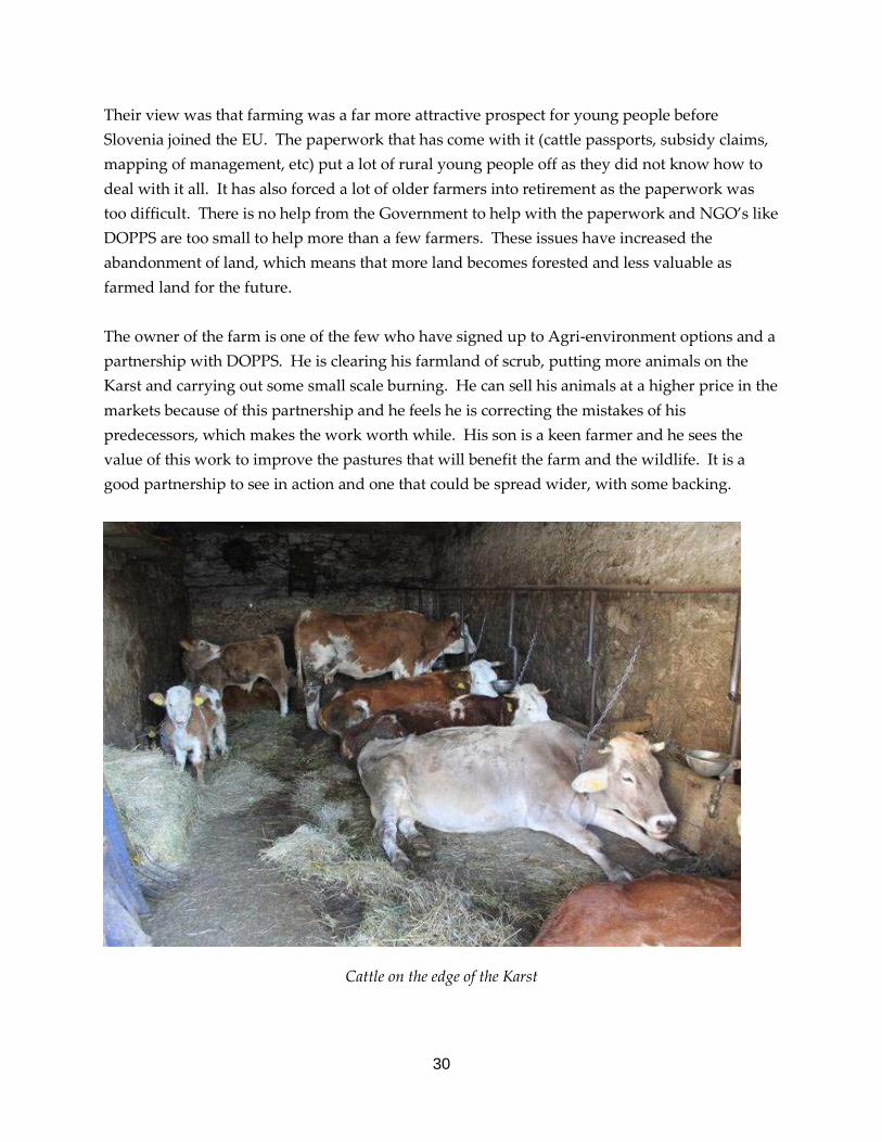
Farming on the Karst Edge Having heard about and seen the problems the Karst area is facing, I could not refuse the opportunity to visit with Bojana, Igor and Tadeja of DOPPS, who know the area well and have offered to arrange a meeting with some of the farmers in a small community to discuss how they survive in this landscape. The farm we visited was right in the middle of a small village that has been built up a very steep bank on the edge between the Karst and the flatter and more fertile land on the edge of the Adriatic. Here, the farmers have pigs, sheep and cattle who are mostly inside and are fed hay and silage grown on the Karst where it is baled. The animals are killed by them and sold privately round the villages, this way, they can make a larger profit from the animals.
Abandoned farmland with black pine belt in background
30
Their view was that farming was a far more attractive prospect for young people before Slovenia joined the EU. The paperwork that has come with it (cattle passports, subsidy claims, mapping of management, etc) put a lot of rural young people off as they did not know how to deal with it all. It has also forced a lot of older farmers into retirement as the paperwork was too difficult. There is no help from the Government to help with the paperwork and NGO’s like DOPPS are too small to help more than a few farmers. These issues have increased the abandonment of land, which means that more land becomes forested and less valuable as farmed land for the future. The owner of the farm is one of the few who have signed up to Agri-environment options and a partnership with DOPPS. He is clearing his farmland of scrub, putting more animals on the Karst and carrying out some small scale burning. He can sell his animals at a higher price in the markets because of this partnership and he feels he is correcting the mistakes of his predecessors, which makes the work worth while. His son is a keen farmer and he sees the value of this work to improve the pastures that will benefit the farm and the wildlife. It is a good partnership to see in action and one that could be spread wider, with some backing.
Cattle on the edge of the Karst

31
Conclusions My original plan for Slovenia was to spend the majority of my time with ZRSVN staff, shadowing their work and learning from them. What I finally managed to achieve was a much more rounded view of the management of grazing, forestry, land use changes and life in general across a large chunk of the country and met with a diverse bunch of people. The views and knowledge on forestry policy varied greatly depending on who you spoke to, which made it difficult to pin down the real version. This was useful though, as the different people had a different opinion on the management of forests. Having said that, people were all generally supportive of a policy to ensure the landscape value was maintained, including a proportion of deadwood. This is recognised as valuable to the biodiversity of the country, although actual quantities can be a contentious point. The views that deadwood is untidy appears to be a view that is dying out with the older foresters and the younger ones are very environmentally focussed, which is excellent to see. The grazing of woodlands is obviously an issue, but not one that organisations are tackling hard or fast enough to save habitats and the zonation of silver fir in particular. Foresters should be setting the cull targets to allow them the power to limit the damage caused by grazing animals but recognising that the diverse range of species in different densities can be a good thing for the structure of the forest. The foresters could also be taking a far more proactive approach at removing trees that are encroaching into the zones of others to prevent the merging of zones or the creep up the hills that is already evident. The mix of species and density of grazing animals is a positive one and the use of historic grazing animals, in the case of Skojcan Bay is also encouraging. At Abernethy, this could be done by the use of traditional cattle breeds in the right locations, in the absence of a natural balance. Through the trip, a lot of emphasis was placed on the fact that Slovenia held populations of wolf, lynx and bear and that this was assisting the management of the forest through these predators moving prey species around. It would be interesting to learn more about this relationship and plan to do so when in Bialowieza in Poland. Funding does not appear to be utilised as well as it might in many of the projects, particularly LIFE. These projects have taken millions of Euros and once the money runs out there is no plan for future funding, so the money does not create jobs, tourism and benefit habitats in the long term. Support by the Government for farmers and foresters to create these opportunities through schemes would benefit the rural communities beyond the length of a LIFE project.

32
Further Reading Through my time, I collected a small pile of booklets, papers and other information that would provide additional information to the sites that I visited over my time. This is all at Forest Lodge and can be lent to interested people. In addition, DOPPS’ membership publication, Svet Ptic, published an article about RSPB Abernethy Reserve. This would have been sent to 1000 households across Slovenia. The article, in Slovenian, introduces the reserve and explains the work being done to conserve capercaillie and black grouse. It also includes a short piece about my project and Slovenia’s part in it. The article is below. Acknowledgements I was fortunate enough to meet up with some fantastic people during my time in Slovenia. In the run up to the first meeting, Rebecca Siling, who arranged the meeting with Matjaz Premzl was so helpful in introducing me to Matjaz and showing me the sites of Maribor. Thank you to Matjaz for taking the time to show me Ptuj, Ormoz and Jeruzalem, and for inviting me into his home with his family. Thanks also to Mihel Dascman from ZGS for passing on so much knowledge and information and the offer of some hunting. Gregor Danev and Tadej Kogovesek from ZRSVN spent a lot of time planning three days around Kocevje and Sneznik, which was a fantastic insight into the management of virgin forest areas. Thank you Mirko Perusek from ZGS for sharing his enthusiasm and to Damijan, Borut, Bojana, Igor, Tadeja and Sandi from DOPPS who were a pleasure to meet and are a truly inspiring bunch of people who carry out a vast amount of work for this organisation.
33
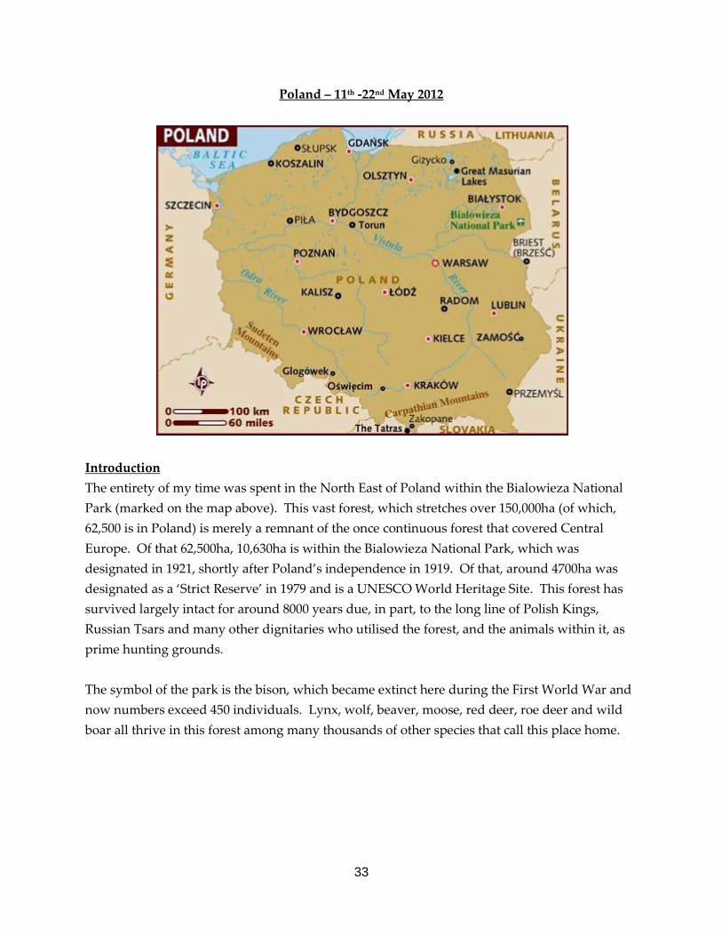
Poland – 11th -22nd May 2012
Introduction The entirety of my time was spent in the North East of Poland within the Bialowieza National Park (marked on the map above). This vast forest, which stretches over 150,000ha (of which, 62,500 is in Poland) is merely a remnant of the once continuous forest that covered Central Europe. Of that 62,500ha, 10,630ha is within the Bialowieza National Park, which was designated in 1921, shortly after Poland’s independence in 1919. Of that, around 4700ha was designated as a ‘Strict Reserve’ in 1979 and is a UNESCO World Heritage Site. This forest has survived largely intact for around 8000 years due, in part, to the long line of Polish Kings, Russian Tsars and many other dignitaries who utilised the forest, and the animals within it, as prime hunting grounds. The symbol of the park is the bison, which became extinct here during the First World War and now numbers exceed 450 individuals. Lynx, wolf, beaver, moose, red deer, roe deer and wild boar all thrive in this forest among many thousands of other species that call this place home.

34
The forest itself is named after a white castle built nearby the current Bialowieza Village when the forest became originally protected as a hunting reserve in 1541. It was protected by local villagers who acted as game wardens, but this changed quickly when the Russians sold the forest workers as slaves and the number of bison was reduced dramatically through poaching. In 1801, it was reinstated as a game reserve and the bison once again recovered. Through the 1800’s, the aims of the forest changed as Poland changed hands. Untill 1860, hunting was a popular past time and some small scale haymaking, fishing, charcoal making, and bee keeping was permitted. From 1860, wholesale persecution of predators was done to minimise loss for the hunters and, once the Russians occupied again in 1888, bison were removed and given as gifts. Poland regained independence in 1919 but by then the bison was extinct in Poland. Ten years on, bison from collectors were recovered and a breeding programme commenced, which has been a fantastic success story. Having heard so much about the Bialowieza Forest and the vast quantities of deadwood that is here, it has been an ambition of mine to see this for myself and to allow me to visualise what it was that we are trying to achieve at Abernethy with the plantation restructuring programme. During my time, I was to meet with specialists from the Mammal Research Institute, based in the small town of Bialowieza to discuss the management of the forest, hear about their research into mammals use of the forest and how the forest is changing.
Red deer hind in Bialowieza National Park
35
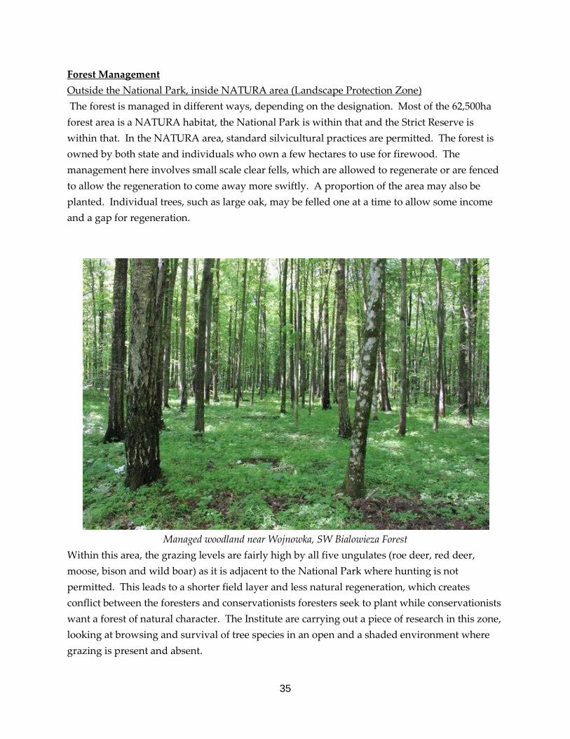
Forest Management Outside the National Park, inside NATURA area (Landscape Protection Zone) The forest is managed in different ways, depending on the designation. Most of the 62,500ha forest area is a NATURA habitat, the National Park is within that and the Strict Reserve is within that. In the NATURA area, standard silvicultural practices are permitted. The forest is owned by both state and individuals who own a few hectares to use for firewood. The management here involves small scale clear fells, which are allowed to regenerate or are fenced to allow the regeneration to come away more swiftly. A proportion of the area may also be planted. Individual trees, such as large oak, may be felled one at a time to allow some income and a gap for regeneration.
Managed woodland near Wojnowka, SW Bialowieza Forest
Within this area, the grazing levels are fairly high by all five ungulates (roe deer, red deer, moose, bison and wild boar) as it is adjacent to the National Park where hunting is not permitted. This leads to a shorter field layer and less natural regeneration, which creates conflict between the foresters and conservationists foresters seek to plant while conservationists want a forest of natural character. The Institute are carrying out a piece of research in this zone, looking at browsing and survival of tree species in an open and a shaded environment where grazing is present and absent.
36
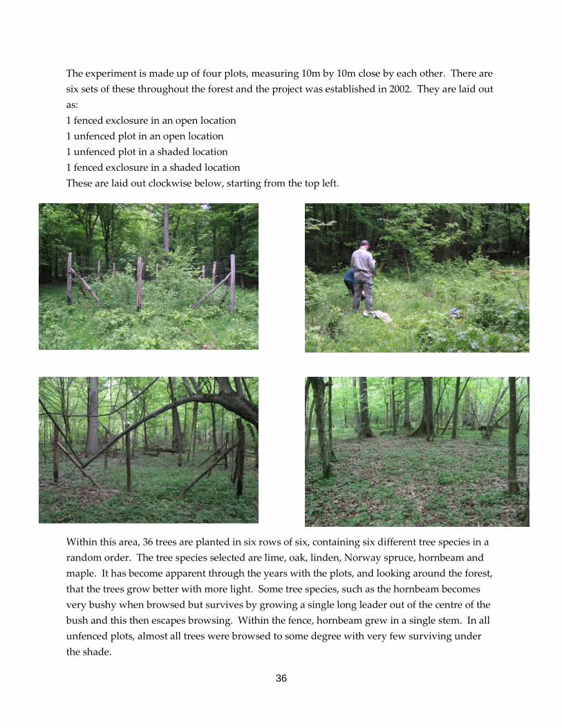
The experiment is made up of four plots, measuring 10m by 10m close by each other. There are six sets of these throughout the forest and the project was established in 2002. They are laid out as: 1 fenced exclosure in an open location 1 unfenced plot in an open location 1 unfenced plot in a shaded location 1 fenced exclosure in a shaded location These are laid out clockwise below, starting from the top left.
Within this area, 36 trees are planted in six rows of six, containing six different tree species in a random order. The tree species selected are lime, oak, linden, Norway spruce, hornbeam and maple. It has become apparent through the years with the plots, and looking around the forest, that the trees grow better with more light. Some tree species, such as the hornbeam becomes very bushy when browsed but survives by growing a single long leader out of the centre of the bush and this then escapes browsing. Within the fence, hornbeam grew in a single stem. In all unfenced plots, almost all trees were browsed to some degree with very few surviving under the shade.
37
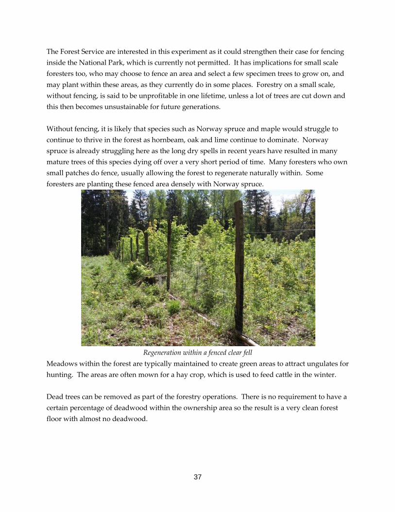
The Forest Service are interested in this experiment as it could strengthen their case for fencing inside the National Park, which is currently not permitted. It has implications for small scale foresters too, who may choose to fence an area and select a few specimen trees to grow on, and may plant within these areas, as they currently do in some places. Forestry on a small scale, without fencing, is said to be unprofitable in one lifetime, unless a lot of trees are cut down and this then becomes unsustainable for future generations. Without fencing, it is likely that species such as Norway spruce and maple would struggle to continue to thrive in the forest as hornbeam, oak and lime continue to dominate. Norway spruce is already struggling here as the long dry spells in recent years have resulted in many mature trees of this species dying off over a very short period of time. Many foresters who own small patches do fence, usually allowing the forest to regenerate naturally within. Some foresters are planting these fenced area densely with Norway spruce.
Regeneration within a fenced clear fell
Meadows within the forest are typically maintained to create green areas to attract ungulates for hunting. The areas are often mown for a hay crop, which is used to feed cattle in the winter. Dead trees can be removed as part of the forestry operations. There is no requirement to have a certain percentage of deadwood within the ownership area so the result is a very clean forest floor with almost no deadwood.
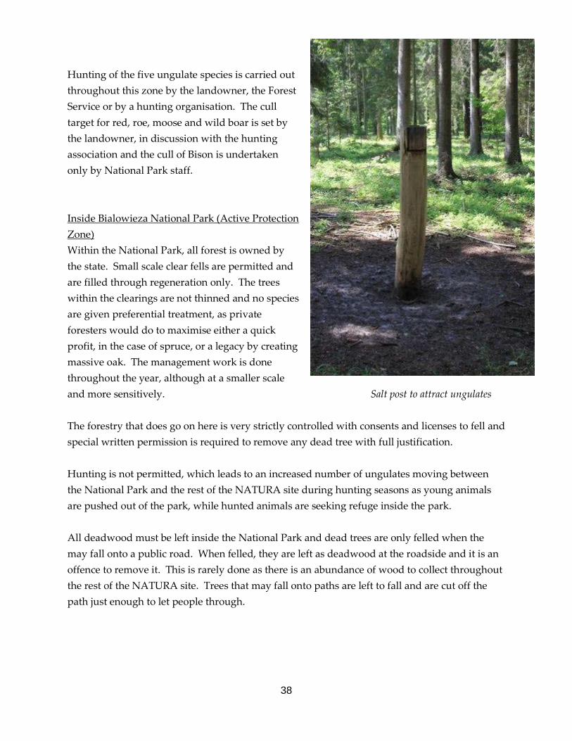
38
Hunting of the five ungulate species is carried out throughout this zone by the landowner, the Forest Service or by a hunting organisation. The cull target for red, roe, moose and wild boar is set by the landowner, in discussion with the hunting association and the cull of Bison is undertaken only by National Park staff. Inside Bialowieza National Park (Active Protection Zone) Within the National Park, all forest is owned by the state. Small scale clear fells are permitted and are filled through regeneration only. The trees within the clearings are not thinned and no species are given preferential treatment, as private foresters would do to maximise either a quick profit, in the case of spruce, or a legacy by creating massive oak. The management work is done throughout the year, although at a smaller scale and more sensitively. Salt post to attract ungulates The forestry that does go on here is very strictly controlled with consents and licenses to fell and special written permission is required to remove any dead tree with full justification. Hunting is not permitted, which leads to an increased number of ungulates moving between the National Park and the rest of the NATURA site during hunting seasons as young animals are pushed out of the park, while hunted animals are seeking refuge inside the park. All deadwood must be left inside the National Park and dead trees are only felled when the may fall onto a public road. When felled, they are left as deadwood at the roadside and it is an offence to remove it. This is rarely done as there is an abundance of wood to collect throughout the rest of the NATURA site. Trees that may fall onto paths are left to fall and are cut off the path just enough to let people through.
39
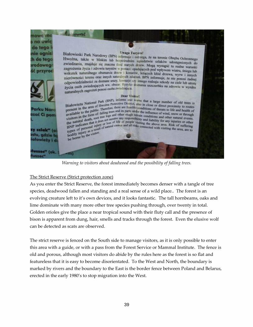
Warning to visitors about deadwood and the possibility of falling trees.
The Strict Reserve (Strict protection zone) As you enter the Strict Reserve, the forest immediately becomes denser with a tangle of tree species, deadwood fallen and standing and a real sense of a wild place.. The forest is an evolving creature left to it’s own devices, and it looks fantastic. The tall hornbeams, oaks and lime dominate with many more other tree species pushing through, over twenty in total. Golden orioles give the place a near tropical sound with their fluty call and the presence of bison is apparent from dung, hair, smells and tracks through the forest. Even the elusive wolf can be detected as scats are observed. The strict reserve is fenced on the South side to manage visitors, as it is only possible to enter this area with a guide, or with a pass from the Forest Service or Mammal Institute. The fence is old and porous, although most visitors do abide by the rules here as the forest is so flat and featureless that it is easy to become disorientated. To the West and North, the boundary is marked by rivers and the boundary to the East is the border fence between Poland and Belarus, erected in the early 1980’s to stop migration into the West.
40
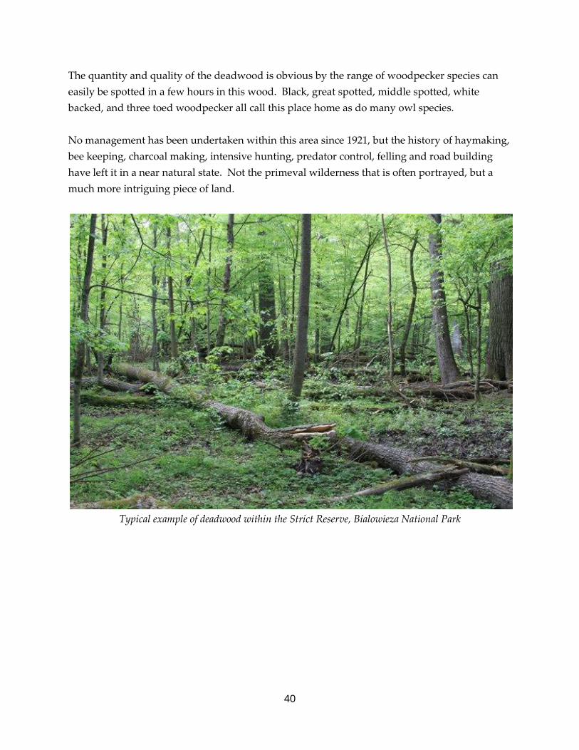
The quantity and quality of the deadwood is obvious by the range of woodpecker species can easily be spotted in a few hours in this wood. Black, great spotted, middle spotted, white backed, and three toed woodpecker all call this place home as do many owl species. No management has been undertaken within this area since 1921, but the history of haymaking, bee keeping, charcoal making, intensive hunting, predator control, felling and road building have left it in a near natural state. Not the primeval wilderness that is often portrayed, but a much more intriguing piece of land.
Typical example of deadwood within the Strict Reserve, Bialowieza National Park

41
Permanent research plots have been monitored within the strict reserve area for over one hundred years to observe changes in the forest structure over time. The big indicator is with the tree species and this, in turn, is changing birds, plants, fungi, insects and almost everything else that survives here. When the plots started, most of the strict reserve was a forest of Scot’s pine and Oak. Seventy Five years ago, this switched to a forest of around 80% Norway spruce due to a lack of fire. Bark beetle and an increase in fires (see page 45) arrived and decimated the spruce, that now are a small component of the current stand. Scot’s pine is all but extinct here now and Norway spruce is struggling to hang on as lime, oak and hornbeam occupy the gaps created by fallen trees swifter than spruce can manage. This structure is more akin to the forest post ice age in the 16th Century.
Changes in forest structure within the Strict Reserve of Bialowieza Forest and projected predications under current climatic predictions. Within the strict reserve, there are fewer Scot’s pine and Norway spruce regenerating as within the rest of the National Park. This is likely to be due to the forestry operations and is not a difference in the soil types.
42
The Mammal Research Institute The mission of the institute is ‘to acquire, advance, and disseminate knowledge of the natural patterns and processes in order to improve the basis for effective nature conservation activities and sustainable development. The Institute pursues its mission by conducting research on all aspects of mammalian biology, publishing in renown scientific journals, developing international scientific co-operation, providing academic training, offering advice for governmental and non-governmental organisations, and interacting with the general public.’
The Mammal Research Institute was founded in 1952 and is an independent research institution of the Biology Department of the Polish Academy of Sciences. The Institute conducts research in morphology, taxonomy, systematics, evolution, population genetics, ethology, and ecology of mammals. From 1952-2006, researchers from the Institute published 23 books and over 1400 scientific papers. The list of international journals, where the research papers were published, exceeds 60 titles and includes the world’s best biological, zoological, ecological, and nature conservation journals. Since 2003 the Institute has attained status as a European Union Centre of Excellence and in 2006 was assessed as one of Poland’s five best scientific institutions in the field of biology.
My main contact with the institute was with Dr. Karol Zub, who co-authored a WWF publication titled ‘The Afterlife of a Tree’. Through him, I was able to meet with several staff and students based here that would kindly spend time with me discussing their work. The following pages are a result of meetings and site visits with several staff from the institute and referring to published papers, from the institute. Predators and Prey My interest in this topic is due to one of the core parts of my job and of the team which I lead at Abernethy, deer management. Here, we are becoming increasingly strategic in how we manage our deer so learning from other places is a great advantage. Wolf and lynx are absent from Scotland and present in Bialowieza but there are still lessons to be learned on monitoring, regeneration and research into deer behaviour. In time, lynx may well become part of the forest ecosystem in Scotland again so hearing how they impact upon roe deer was especially beneficial. The ungulate numbers have fluctuated greatly over the history of the existing forest, mostly due to human factors. This has had a direct impact on the structure of the forest as higher deer populations allowed only the less palatable tree species to grow, while lower numbers allowed a greater diversity of species to flourish (see graph on page 40). The current levels within the strict reserve are around 3 times higher than in the rest of the National Park.

43
What is apparent is that, despite healthy deer numbers (around six red deer and four roe deer per square km inside the strict reserve) and presence of moose, bison and wild boar, the trees manage to regenerate successfully within gaps. As ungulates are moved around by the presence of wolf, lynx and man (researchers, not hunters), regeneration has an opportunity to flush on the heavily grazed field layer. Once this regeneration reaches a certain density, it appears to be a case of safety in numbers and regeneration is inevitable, in gaps created by felled or falling trees. Research done within the strict reserve, similar to that in the wider National Park using exclosures, (see pages 34 to 36) shows that ungulates do have an impact on tree regeneration but regeneration does still occur outside fenced areas, despite the density of ungulates present. The research has also shown that it is only the taller size classes of regeneration that are affected (over 50cm). Younger trees are not affected by ungulates but by climatic conditions created by ground vegetation. In addition to the changing densities of deer over time changing the forest structure, predators have also had a direct effect, as they have changed the behaviour of the ungulates present in parts of the forest. Just by being present, they are influencing the behaviour of ungulates and creating a ‘landscape of fear’. The research demonstrated that browsing within a wolf territory is 10% less than outside it. Ungulates also avoid the areas with wolf and lynx territories that have a large composition of fallen deadwood as this reduces their view of approaching predators. This shows another example of importance of deadwood in a forest. Wolf scent, by using scats, has been used to demonstrate a reduction in browsing by red deer. Once they smell this, they become more vigilant, browse less and move on quicker. While hunting by people may simulate natural predation, they do not (often!) create this landscape of fear through scent. Using roe deer as a test case, the levels of predation impact in lesser and greater productive environments were researched across their range in Europe. The abundance of roe deer increased in more open woodland habitats with lots of ground vegetation. In habitats were ground vegetation allowed high productivity of roe deer, predation by wolves and lynx was not a significant factor in affecting the population but it became an increasing factor as the habitats became less favourable. Less animals were living in these areas so the animals killed represented a higher proportion of the population.

44
Wolves and lynx have a significantly greater impact on the populations of deer during harder snowy winters when they require more food to survive and the condition of the prey is poorer. During mild winters, wolves and lynx do not have a significant effect on deer numbers. Annually, wolves killed on average 72 red deer, 16 roe deer, and 31 wild boar over a 100km2 area. Wild Boar: a good food source for lynx and wolf Bison Bison also have an effect on the forest structure. These animals became extinct during the First World War and were reintroduced using a breeding programme from captive bison. The result is a growing population of around 450 animals all from just four individuals. They do not seem to show any issues with this small genetic diversity and it is thought that they may be designed to cope with such an event, as small numbers of animals trapped by ice would have had to breed in a small group to survive. Research done in the 1980’s put the forests carrying capacity of bison at around 200 individuals. The population is now at 450 and increasing. As part of a LIFE project, bison are fed during the winter. This decreases mortality, increases calving rates from 0.3 to 0.5 calves per female, but also encourages the animals to spend a larger amount of time together than would be usual. By eating in the same place for many months, dung is transported to the hay on the feet, which is then eaten by the bison. This is allowing levels of disease amongst the bison to increase, which then reduces the condition of the animals. As the condition decreases, the females cannot produce strong calves so they opt to produce females who can produce a calf, rather than a weak male, who will probably not get the opportunity to breed. The result of this, over time, will be that there will be fewer males and more females producing more female calves. A 10% cull is done each year, by National Park staff, to remove marauding animals as well as the old, weak and mis-formed, but this still allows an increasing population.

45
Bison were reintroduced to the Bialowieza Forest as a forest animal but as the years have gone by, it is becoming obvious that these animals are not woodland animals by choice but had to live there to attempt to survive the much increased level of hunting during the First World War. By choice they are a grassland animal, much like their close American cousins. In areas where the bison’s diet is heavily supplemented in the winter, 16% of their diet was made up of tree matter, compared to 65% in areas where they were not supplementary fed. Inversely, intensely fed bison’s diet was made up of 82% of grasses, sedges and herbs compared to 32% in non fed bison.
The LIFE project, that ran from 2006 to 2010, aimed to create the conditions to disperse the population, which would increase the number and robustness of the species. It also aimed to decrease the concentrations of bison at the feeding sites, improvement of bison living conditions, modification to the management of the population within Bialowieza, increase in the social acceptance of the species and promotion of the species as a tourist attraction. Bison are present everywhere – on the bank signs, as wooden models outside hotels, on the menu of up market restaurants. They title nature trails, beer and vodka and are the symbol of the National Park. As a tourist draw, they certainly pull there weight. During the weekends, this quiet village only 2km from the Belarusian border buzzed with tourists from the UK, Lithuania and Italy to see, primarily, bison. As with the other ungulates, they are shot, but bison are not commercially hunted. The 10% shot are done so by National Park staff. The reason for this appears to be mostly political. Here is an animal being fed, which boosts the population and tourism to be shot and fed to the tourists. The conservation of this species seems to take on a Norwegian view of wolves: shoot a few to protect the masses. If this shooting of such an iconic creature was done by a rich aristocrat for sport, animal right organisations (who are growing in number and support in Poland) would have a field day and it would potentially be damaging to the tourist trade. There is serious discussion taking place on whether it would be worth selling the shooting of the 40 odd bison to boost the income to protect the remaining animals. It will be an interesting debate to watch.

46
Here at Abernethy, it is often a question we are asked: why don’t we sell the stalking here? The reason is primarily for animal welfare. The deer are only shot by professional deer stalkers to reduce the likelihood of wounded animals. Shooting of deer is done commercially on most other estates in the highlands and welfare is not a significant issue there. The outcome of the debate on bison may have knock on effects for other such sites that are being politically sensitive about the shooting of iconic animals. Monitoring ungulate densities using technology Throughout the Bialowieza Forest, annual drive counts take place to count total numbers of ungulates present in the forest. This does not give a truly accurate record of numbers, densities in parts of the forest or information for private landowners to choose their quota. In order to attempt to carry out a count that does do all of these, the Mammal Institute is trialling a method using camera traps. The traps are set in locations of continuous forest that are at least 50m from tracks and 100m from houses or fields, as these may change the behaviour of the animals within the forest, which would give a false reading. Once the suitable areas are mapped out, they are split into manageable blocks of between 50 and 70 hecatres. These areas are then overlaid by a 250m grid and 40 of these plotsare chosen at random as positions for the camera traps. Ten traps are put out at a time in ten of the 40 random locations and left for ten days. These are then retrieved, images downloaded, batteries charged and put out on the next set of points two days later. Using the ‘Ideal Gas’ model, which calculates the movement of animals in space and time, researchers can predict population by using the photo trapping rate across the blocks. Initial trials of this have worked well and, using small drive counts to ground truth the camera traps, they are very accurate indeed. This information will allow Foresters to calculate cull levels and where to concentrate their effort. Using the count data from the cameras, the population variations can be predicted across the entire forest using satellite remote sensing. This uses reflections of light particles to give an initial idea of habitat: water reflects all light, green vegetation absorbs red and infra red light and bare ground absorbs and reflects a mixture. Using high resolution satellite images, where each pixel contains only 0.5m, it is possible to identify tree species and density, then predict the forest floor vegetation. All of this allows forest managers to see where the problem hot spots are, or where they may be in future by modelling changes.

47
Some of the images and technology being used to carry this out are very expensive software but some used was free off the internet and of very high quality for the standard of work required for forest management at this scale. The satellite images (1 pixel = 30m) came from Landsat Images. Camera traps were Ecotone Camera 30HE-trap held on by a Master Python coil that held the camera snugly to the tree and contained a lock. In addition to camera traps, roe deer, red deer, wild boar, bison, lynx and wolf have all been live trapped and adorned with GPS tacking collars or standard telemetry collars. These are used to monitor territory size, seasonal movements, changes in behaviour of ungulates in the presence of predators (lynx, wolf or man) and provide a massive bank of data that can be called upon, should it be required for any future study. Fire in the Forest Fire is a natural part of a forest ecosystem but, throughout the majority of the world, fires are extinguished as quickly as they can be to prevent damage to property or commercial interests, whether they be trees, grouse moors or farming. On Abernethy, fire has shaped parts of the forest, with large fires as recent as 1921. Currently, fire is used as a management tool to break up the monocultural forest floor habitats that are a result of much reduced grazing following years of deer management to encourage regeneration. Throughout Europe, most of the forest is now fragmented, so it is almost impossible to accurately understand fire frequency and it’s affects on the forest structure in the last few hundred years. By understanding this, it informs future management of woodlands in the area, using fire. As Bialowieza is the largest intact area of forest in Europe, fire frequency can be dated accurately back to the early 1600’s. From 1653 to the late 1700’s, fires that affected individual trees occurred, on average every 18 years, with fires affecting a stand occurring every six years on average. After 1781, fire frequency increased dramatically and no major fires have occurred since 1920.

48
With the earlier fire frequencies, Scot’s Pine could regenerate well but only sporadically once fires became so frequent that young trees could not grow a crown above flame height. Now that few fires occur, Norway spruce is out competing Scot’s Pine in every natural location. The results of the fires would have been an open pine dominated forest, ideal for capercaillie, amongst many other species. As the forest becomes denser, it has become far less suited to capercaillie, it would appear. The climate predictions from IPCC would indicate that central Europe will become drier and hotter for longer, which may well result in fire frequency increasing and this will benefit Scot’s pine once more. Meadow management and a LIFE project
Example of a mown meadow in the NATURA zone that is mown to feed bison

49
Many of the meadow areas within the Bialowieza Forest are areas that were cleared for settlement in the 16th and 17th century, with some meadow complexes reaching over 1300 hectares. Larger meadows were also created by the Russians to ease the hunting of bison. Once the people were removed from these areas, they remained open for many years, due to the high numbers of ungulates utilising the green vegetation and moving to and from the area. During the wars, ungulate numbers were decimated by hungry soldiers, which allowed a flush of regeneration to come away. As the meadows become more rank, they become less suited to the feeding behaviour of lesser spotted eagle and white stork. Both species population are reducing in this location. To reduce conflict with farmers, bison are fed at a number of strategic locations through the forest, to hold them inside the National Park. The hay they are fed has come from mowing some of the old meadows. In doing this, this opens the meadow up to allow lesser spotted eagle and white stork to feed in the areas. This management is expensive though, and only addresses the issue at a few locations were bison, lesser spotted eagle, and white stork coexist.
Meadow with regeneration Meadow reverting to marshland Lesser spotted eagle LIFE project To reverse the decline of this species, a LIFE project bid is currently being submitted to carry out management. This will include the removal of encroaching scrub and mowing but will also look at the issues that wider agricultural improvements are having on this species. Due to the intensification of farmland, the fields are becoming less suited to voles and more suited to mice, trapping across much of North East Poland has shown. The vole species here are mostly diurnal, with the mice mostly being nocturnal. Voles are the main prey of lesser spotted eagle so it may be that this change is one of the largest factors in the birds decline. Within the strict reserve, there are meadow complexes that are becoming heavily encroached due to the lack of management for so many years. There is a debate to be had here about whether they manage the meadows within the strict reserve or not, to protect the eagles population.

50
Capercaillie in Bialowieza It was thought that capercaillie were only in the Bialowieza Forest on the Belarusian side but a recent camera trap image has shown that at least one is present in the North part of the forest. Capercaillie numbers are thought to have declined drastically due to fires not being a part of the process of the forest, leading to their habitat changing dramatically to a broadleaved dominated woodland. As boar numbers increase throughout the birds range, this increased level of predation in an already declining population can not be helping either. Interpretation and access Bialowieza Forest is a globally renowned site as a primeval site of international significance. It has achieved this status due to it’s history and, now the way it is managed. The strict reserve is promoted as a place so special that it has to be protected from the threats of unmanaged human disturbance, and quite rightly so. With this label comes the fascination of the ‘forbidden fruit’ and this restriction attracts people by it’s intrigue. The forest is a multi functional area with people making a living from it, whether an employee of an organisation or a private forester. It is used by local people for walking dogs and taking bike rides, groups camp in a variety of locations and the forest is intersected by public roads and an international border. A huge draw is also the bison. The largest mammal to have survived the human induced extinctions through Europe is certainly something to see. There are a number of villages on the outskirts of the forest, and Bialowieza village within, who all have good tourist information services with information on the forest, maps of the trails and a booking service for guided walks or tours into the strict reserve. The trails are well marked through the forest, utilising the track network used by forestry vehicles. Notice boards and directional arrows are placed often enough to keep you right but not so often as to feel intrusive.
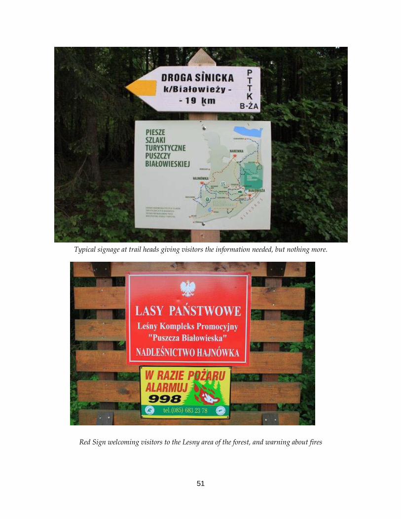
51
Typical signage at trail heads giving visitors the information needed, but nothing more.
Red Sign welcoming visitors to the Lesny area of the forest, and warning about fires

52
The real draw to many is not the forest itself, but what it contains. Here, there is the possibility to see bison, moose, beaver, wild boar, red deer, roe deer, lynx and wolf, although it is only the lucky few who see any of these. Being in this landscape, knowing that these species are present out there, is a special feeling and the fact that it exists enhances the lives of many people. There are also hundreds of bird species that can be tricky to spot through the vegetation. The call of a black woodpecker or a fleeting glimpse of a collared flycatcher is enough to make most birdwatchers day so this place becomes a bird spectacular by the quantity of different species that are present, although, not often seen. The bison in themselves have a good story to tell. From extinction in this forest to reintroduction to a success so good that there is now conflict over their numbers is a fascinating one, and one that could be told at the place where the breeding programme was run. This site, now called the ‘Show Reserve’ is home to bison as well as tarapan horses, wolves, lynx, red deer and roe deer and has the feeling of a small run down safari park. The whole park is very small, poorly maintained with very little information and was something of a disappointment.
A large visiting group enjoy a tour of the show reserve In addition to a subtly marked forest, with good trail head information supported by useful tourist information points, there is a fantastic museum. The museum is a modern building within the National Park on the edge of the village of Bialowieza. The exhibition was very impressive with scenes depicted of different forest habitats, containing the flora and fauna typically expected there. From this, a viewing tower can be climbed where a view can be gained over the village and out into the forest. It gives a sense of scale of the forest, and the village within. The museum also has temporary exhibitions, which can be artwork or projects from schools or from local amateur photographers. It builds a link with the community and the reduced entry fee on these Saturday evening opening events for local exhibits prove a real draw to the people in the village.
53
There are also a number of locations, often a mown field with a small shelter for cooking in, that are designated camp sites that are the only areas permitted to camp, and the only areas where visitors are allowed to make a fire. There are no exceptions at any time of the year and the staff will move you on if you try to camp out somewhere else. Dogs must be kept on a lead at all times during the breeding season and within 100 yards of the owner during the rest of the year. Staff can shoot dogs that are more than 100 yards from their owners and do use this right. Threats and conflicts On Abernethy, there is conflict between traditional land management and conservation land management practices, as Abernethy can often be the trail blazers in trialling new methods of management that can seem ‘off the wall’ to many people. In the Bialowieza Forest, the conflict is at another level and it was almost comforting to meet the people dealing with the conflicts to know that there is an international network of colleagues who are dealing with similar issues of conflict. At Abernethy, it is easy to feel isolated from other groups, because what we do is different, although this is changing as more land owners start to take on more sympathetic land management practices to encourage natural forestry. Bison Bison - an iconic animal, a symbol of the National Park, and an early conservation success story. It is also an animal that became a refugee before it’s extinction, and continues to behave as such now. With numbers increasing, it has no choice but to leave the forest and face it’s greatest enemy, man. Bison are naturally a grazing animal, not a browser, which made them easy to increase during the Tsarist era for their hunting. Using data from tagged animals, bison can hold a large range but spend roughly 50% of their time on the old meadows within them, grazing grass. As bison numbers improve, they are increasly moving onto productive farmland and destroying fences and crops. People have been attacked by bison, who have reacted angrily to being poked or barked at and the likelihood of traffic accidents caused by bison outside the National Park is on the up. Compensation is paid to landowners (100,000 Euros around Bialowieza Forest alone in 2011) for loss of crops but this is unsustainable in the long term. The original thinking of densities has changed dramatically, and calls are being made to reduce the numbers, while some members of the Mammal Institute think that the numbers could rise from a current level of around 450 to 1500, without any major issues.

54
Each year around 10% of the population is shot. These can be the marauders, old or misformed animals but their numbers are still increasing, with an increase being desirable so it makes little sense to shoot 10% for no gain, other than to remove the marauders. It is proposed to stop shooting all bison, apart from the marauders as there is no gain from it, or to sell it commercially to raise money to continue to protect the remaining animals. It is thought of as good practice by the hunting industry so there is pressure to continue. For now, the only option is to keep talking to all the parties affected and pay compensation to those who are losing out. The economic gain of these animals is hard to ignore though and the thousands of tourists who come to see these very rare animals might be turned away by a cull. Forestry Since joining the EU, there have been plans to increase the size of the National Park, much to the dismay of the foresters who would be very much restricted in what they do and how within this very large area. Working groups have been set up by foresters and the Government, the working groups concluded that, unsurprisingly, the forest should be managed by the Forest Service, not via the County Governor. The main reasons for this were due to the look of the forest with too much deadwood making the forest untidy, susceptible to disease and a danger to the public. The conflict between the traditional foresters and the more conservation based approaches to forestry is very alive here but the next generations seem wiser to realising the economic value of this forest as it is. Predators and ungulates The density of browsers is also a cause of conflict as the Forest Service cannot fence inside the park but cannot hunt, making it very difficult to ensure there is a sufficient quantity of regeneration through the forest. From looking on the ground, this does not seem to be an issue. The issue would appear to be that the trees that are growing are not the trees that they would prefer to dominate. A Polish TV crew found a shot deer carcass inside the National Park and the Forest Service confessed to having shot this animal, which led to a massive debate about the numbers of ungulates inside the Park. Wolf and lynx are also a cause of conflict as there is fear that they are reducing the numbers of hunting animals outside the National Park and can take sheep and lambs. Farmers are paid compensation for the loss of animals, but hunters have to make do. The result can be illegal persecution of the two species. Satellite tagging is starting to prevent this. There is the interesting flip side to this, where research has shown that ungulates browse trees more heavily in the absence of predators, so the loss of animals would be a loss to foresters too.

55
Conclusions The time I spent in Poland was very valuable indeed. I have learned a lot about the management of the forest and the history that has created this landscape. I have really seen the value of the scientific work that backs up the management decisions here, and how helpful it can be if directed well and managed properly. In some cases, and I think both Bialowieza and Abernethy fall into this catergory, conservation land management can be over researched and too much information can cause confusion, a lack of direction and does not allow for any flexibility to use the experience and knowledge of the team of people who carry the work out. This so called ‘Opinion based’ management can be thought of as unscientific, by scientists, but it can get the job done right with a combination of the two working in harmony. Part of this project was to find examples where local communities and conservation are working well together. Instead of finding this, I am finding more examples where there is conflict, and I shouldn’t be surprised at this really. In days gone by, any change in land use was met by resistance, then eventually accepted, with time. I am empowered knowing that Abernethy is not a lone voice and that support can be found around the continent for our aims and visions here. The management of access is interesting here. Where there are restrictions, more people are present, or so it appears from my time there. The strict reserve is disturbed by groups, horse drawn carts and many many researchers tramping around. If the strict reserve is being left to get on with it, let it do that. It does not need to be researched to the level it is if there are no plans to manage it. The research does not answer management questions but it is research for it’s own sake. Having now seen the volume of deadwood here, and how positive most people regard this, I feel we should be doing far more to ‘sell’ deadwood at Abernethy and create an interpretation plan around deadwood. I also have far more faith in what we are doing and am much more comfortable with the scale we are doing it at. In the strict reserve of Bialowieza, 25% of all wood is dead. I like the idea of monitoring deer through the use of camera traps and it is something that could possibly be done in higher density population areas in Abernethy through a PhD student or similar. The relationship between lynx and roe deer was fascinating to hear about and I will continue to follow the discussion on the reintroduction of lynx to Scotland closely. Abernethy would be an ideal location.
56
In the absence of boar, bison, moose and aurach, I think we should be far more proactive in using large herbivores in pulsed management at Abernethy to ensure we have a healthy grouse population and regeneration. With the community, we could make a real effort to consult with the local people who care passionately about the land that is currently owned by the RSPB. A useful excersize, that has been used in the Netherlands to minimise conflict zones in the management of land, is to map the conflict zones. Consultation events can be held with all the interest groups who would map the sites that they are interested in and a justification. The land not marked is the zone where no conflict can result, as nobody has spoken up about it. It would also allow further conversations to be more targeted to the groups and people who would be most affected. References/ Further reading The Mammal Institute published a huge number of papers every year. A few of the most relevant papers I found were: • Kill rates and predation by Wolves on ungulate populations in Bialowieza: A Primeval
Forest (Poland). • A 350-year tree-ring fire record from Białowieza Primeval Forest, Poland: implications for
Central European lowland fire history. • Influence of management practices on large herbivore diet—Case of European bison in
Białowieza Primeval Forest (Poland). • Conservation implications of the refugee species concept and the European bison: king of
the forest or refugee in a marginal habitat? • Fluctuating ungulate density shapes tree recruitment in natural stands of the Biazowieza
Primeval Forest, Poland. • Predation has a greater impact in less productive environments: variation in roe deer,
Capreolus capreolus, population density across Europe. • Bottom-up versus top-down control of tree regeneration in the Białowie_za Primeval Forest, • Poland. • Lack of natural control mechanisms increases wildlife–forestry conflict in managed
temperate European forest systems. I have electronic versions of these papers and can send them on if required. In addition to these, I have publications on bison ecology and history, a book on deadwood in Bialowieza, maps of the forest and publications on bison from the LIFE project. These are all at Forest Lodge and can borrowed.
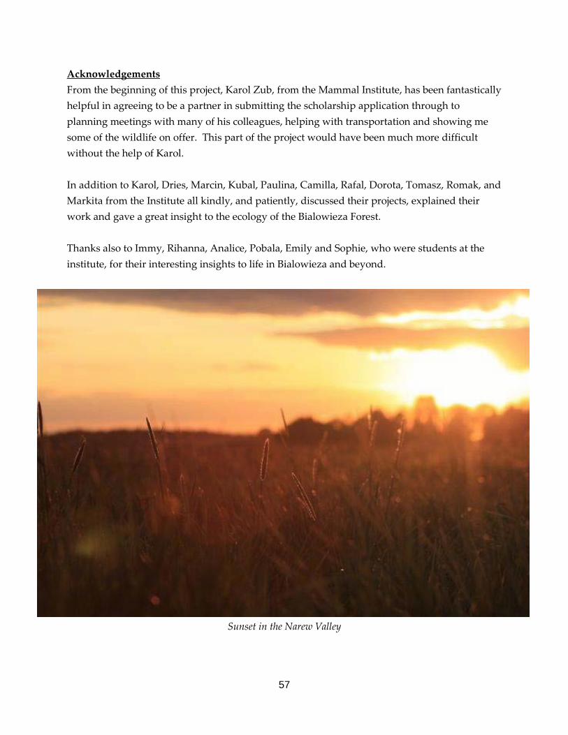
57
Acknowledgements From the beginning of this project, Karol Zub, from the Mammal Institute, has been fantastically helpful in agreeing to be a partner in submitting the scholarship application through to planning meetings with many of his colleagues, helping with transportation and showing me some of the wildlife on offer. This part of the project would have been much more difficult without the help of Karol. In addition to Karol, Dries, Marcin, Kubal, Paulina, Camilla, Rafal, Dorota, Tomasz, Romak, and Markita from the Institute all kindly, and patiently, discussed their projects, explained their work and gave a great insight to the ecology of the Bialowieza Forest. Thanks also to Immy, Rihanna, Analice, Pobala, Emily and Sophie, who were students at the institute, for their interesting insights to life in Bialowieza and beyond.
Sunset in the Narew Valley

58
Sweden – 23rd to 27th May 2012
Introduction Sweden was not part of the original scholarship project, or my sabbatical application, but the opportunity came about through the meeting of Jan-Inge Tobiasson at the EUROPARC Conference in Bad Urach, who kindly invited me to see what work he was doing to create deadwood and manage the field layer. I was accommodated by Jan-Inge and his family in their home in a small village around 30km North West of Västerås, which is about 70km North West of Stockholm. From here, we travelled around the county of Vastmanland, where Jan-Inge manages 92 nature reserve for the County Council. The reserves varied in size, complexity and habitat and, as we travelled round, Jan-Inge would explain how much work is required on these, some of which will take a long time due to the resources he has to manage the sites. The main reason for my interest in coming here was to see how they are using fire to create deadwood. How they manage the fire, what people think of it and what the effects are. The fire would be the first prescribed fire to create deadwood in the Vastmanland County so was a highlight for all involved. To maximise the impact the fire has, very dry conditions were required before it could be lit. I was very fortunate to time my visit with the fire management trial.

59
Within some of the reserves, deadwood is being created, either through proactive management or through non intervention, allowing the forest to build up a resource of deadwood itself. Trees that are killed to create deadwood are done so through similar methods to Abernethy with ringbarking, felling and damaging trees. The image to the right is of damaging using an axe, where rot is encouraged by leaving the bark on as it is. The result is a very natural stump when the tree falls and the ring barking is not as visible as that done by chainsaw. Using fire to create deadwood Throughout the Western Taiga Forest, which stretches from Norway to Siberia, the dominant tree species are Scot’s pine and Norway spruce. In a natural system, where fire is a feature, fire would burn through parts of this forest on a fairly regular basis. The role of fire here is to reduce the quantity of spruce regeneration, which grows faster than Scot’s pine, and allow Scot’s pine to grow to a height where the crown height of the trees will be above the typical flame height. Over time, man has stopped using fire, and put out any natural fires, which has led to Norway spruce over dominating this habitat, leading to a denser forest. Fire has been used to remove spruce regeneration for a few years in Sweden now in state and private forests and is an essential part of the management of the forest, to maintain FSC certification. In undesignated forests, or forests not on nature reserves, most of the sellable spruce is felled and extracted before the fire is put through the site to ensure some income, but also to minimise the likelihood of a crown fire. The fires done on nature reserves do not remove any trees before the fire, unless to create a fire break if necessary, and use the opportunity to maximise the creation of deadwood using this management technique. As spruce is not tolerant of fire, these trees are almost all killed during the fires.

60
Previous fires Walking through some of the nature reserve sites, scars from different fires in history could be seen. These can be read to see how many fires have past through these woods by looking at the directions of the scars. Scarring, as seen in the photograph below occurs on the downwind side of the tree, giving you and indication of directions, then allowing people to map routes of historical fires.
Fire scarring and recovery on all trees in foreground of photograph above. Right – Fire site from 2002.
In more recent fire sites, it is possible to see the effects of fire on the field layer and with the deadwood component of the forest. The photograph (above right) shows the site of a wild fire through a forest in 2002. In 2009, the Forest Service began to use fire to remove spruce regeneration and create deadwood. We visited their fire site (around 11ha). where they have successfully killed almost all spruce left and successfully created deadwood and Scot’s pine regeneration in some places. A male capercaillie was lekking 50 yards away from the site during our evening visit and droppings could be seen through the area. The photograph overleaf shows the site, together with an image of the forest immediately adjacent to the site to give an idea of the type of densities of regeneration being burned.

61
Site of 2009 fire Example of forest burned in 2009 The Ramnas Fire – 25th May 2012 Fire on nature reserves to create deadwood and reduce spruce regeneration, not felling out any trees, has been done a small number of times further north in Sweden. This fire would be the first in Vastmanland County. To ensure the first prescribed fire for deadwood in the County does not escape, a site was chosen within a bog slightly isolated from the canopy of the wider forest. The site could be driven round using an ATV, was easily reached by emergency services, should something go wrong, and had Typical bog around the site a good water supply.

62
The forest itself is around 20m in height with a variety of densities through the stand, with the structure becoming denser and with more spruce regeneration the further South you go in the fire site.
Photographs of the fire site the day of the fire, prior to lighting

63
When to burn? When carrying out prescribed fires, the manager of the fire consults with the Swedish weather fire index, a tool used to predict when fire risk is high. This information is gained by measuring the moisture content of the ground vegetation, air humidity and evaporation rates throughout the country, and modelling from previous data. The risks are categorised as: 1 = Very low fire risk. 2 = Low fire risk 3 = Normal fire risk. 4 = High fire risk. 5 = Very high fire risk. 5E = Extreme high fire risk.
Prescribed fires will only be attempted once the fire weather index is at level 4 but is not attempted once it reaches 5E. The map displays the zones according to colour. Once level 4 is reached, the Fire Service have a plane that flies over all level 4, 5 and 5E areas on a grid constantly until the risk drops. The model used to measure the fire weather index (FWI) is modelled on the globally renowned Canadian system. In the UK, a basic system can be used from the European Forest Fire Information System (EFFIS), which can indicate the danger in a European context. The map below is for the 25th of May, the day that we had the fire in Sweden, regarded as a level 4 using the FWI. In the EFFIS system, which uses 1-5 categories, much of southern Sweden was a 4, with Scotland a 3.

64
Machinery and Equipment Used All equipment was purchased new for this project, which would be used more and more as the teams confidence developed. A large Albin pump, pumping 1000 litres per minute, was the main feed, with a Honda 15hp pump nearby for backup. These were feeding a 76mm hose with Swedish fire fighters couplings, which can attach to either end of the hoses. Water was then branched into two 76mm hoses to be spread round either side of the site. At the end of each hose was a further Honda 15hp pump with either a bunded tank or a water hole in which to collect additional water, should the Albin pump fail and the main pump needs to be swapped onto the standby Honda. From the four branch sites, further 25mm hoses were on site to create wet lines or fight the fire, if required. The diagram below shows the layout of the equipment.
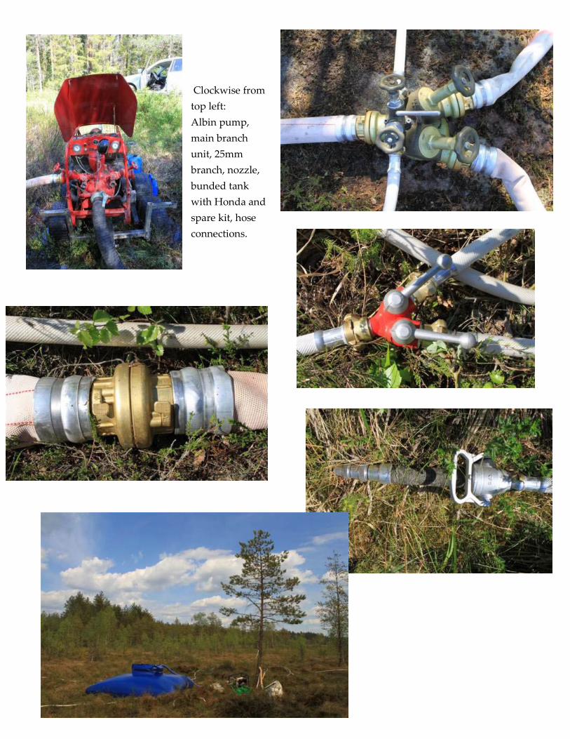
65
Clockwise from top left: Albin pump, main branch unit, 25mm branch, nozzle, bunded tank with Honda and spare kit, hose connections.

66
Preparing for the fire The day before the fire was lit, all the equipment was taken onto the site, set up and tested. In addition to the kit mentioned and mapped on page 64, at each site where a pump was, there was also three watering cans, three mattocks, a spare nozzle, three spare rolls of 25mm hose, five buckets with holes drilled into the lid to double as a watering can, three spades, petrol, oil, food and water for the crew and a general tool kit. On the morning of the fire, all kit was retested and refuelled. Any additional kit that couldn’t be left out overnight was checked in to the site. A wet line was created around the site by driving on the bog using a Hagglund and a tracked ATV to bring up the ground water to soak the ground vegetation. Where the trees were close enough to the fire site, and close enough to each other to carry a fire, these were soaked using the 25mm hoses on the East side of the fire area. The burn boss, from the Forest Service, arrived and allocates tasks to the 15 strong team. The reporters from a newspaper and a TV crew are briefed on where to be, and not to be, and a fire lighting pattern is agreed with the two people using the drip torches.
Hagglunds and Tracked ATV

67
The Fire To test wind direction and fire behaviour, a small test fire was lit on the Eastern side (with the wind coming from the SW). This was allowed to run for a few minutes then extinguished using a watering can. The main fire was then started on the North East corner to create a black line.
Extinguishing the test fire
The fire was lit in a series of strips, increasing in length to the full width of the site (up to a 200m wide fire front). Once a strip was lit, the front burned forward and the rear flames back burned towards the wind. As the front flames met the back burning flames from the previously lit line, a much hotter fire was created on that line. By lighting the line every ten metres or so apart, the frequency of these hot spots was maximised, while the flame length was maintained below the majority of the canopy height. The image (right) shows the locations of lighting having quickly spread and joining together to form a hot spot line with the back burning flames from the next line and also forming a back burning line to meet with the next lit line.

68
As the black line increases in size, and the wet line is extinguishing the flank fires on either side, or the equipment is extinguishing the flanks, the distance between the lit lines can expand to allow the flame heights to increase. The increase in flame height would increase the heat and intensity of the fire, ensuring more trees would be killed through the site.
Lot of spruce regeneration killed instantly through the fire passing through.
In the more mature trees, the flames became most intense on the down wind side of the tree, and it would be here that the scars would be created for others to find and interpret in future years. Through the majority of the fire, the flames were around 2 to 5m high, there would be occasions where a tall spruce would take the flame height right into the canopy. With the heat being much lower down, and the more mature trees not being as dense, the canopy did not catch fire. This would be undesirable as all trees could be killed and it would be harder to control.

69
After the fire Lighting Once the whole site was burned and the burn boss and lighting team left, the site was supervised closely for five days. This could have been made quicker but as a key objective to this management is to create deadwood, no water is taken inside the wet line to dampen down. This is to leave the ground as hot as possible for as long as possible to burn through the shallow roots of the Norway spruce and to burn deep into old stumps.
The stumps, trees, ant nests and anything else that was still on fire was left until it went out itself. Once the last smoke was observed, the fire site had to be closely monitored for three days before the Fire Service would consider the fire
to be out. The site very quickly looked radically different, as you might expect. Exposed boulders appeared, much of the old standing deadwood had fallen over and new trees had fallen during the fire. The ground above the root systems was collapsing as roots turned to ash and the tree became less stable. It was also amazing to see a few saplings that appeared to have escaped the flames, but the needles were dry and came off with ease. The damper area in the centre of the fire also remained unscathed as the flames were stopped by the sphagnum field layer, which added to the shape of the fire and created an island within the new habitat.

70
Above: A collapsed root system Right: A few missed spruce, which will die off Left: The edge of the sphagnum in the centre of the wood Below: The forest floor after the fire.

71
Conclusions This was an absolutely fantastic experience to have gained through the project, and an extremely valuable addition. Through this, I have learned about the management techniques used to create deadwood, the equipment used, the resources required and the amount of planning to ensure that nothing can go wrong, It was also very interesting to see how the local community and the press responded to this. People here, in general, appear to be accepting of this, and can understand why it is that this work is being done. In the run up to this work, Jan-Inge and his colleagues consulted with lots of local people and the necessary agencies and has taken their concerns on board when planning this work. The press who were there were well briefed and featured a full page in the Vastmanland paper, a slot on the news and on the website with all of this media attention giving positive images to the public. At Abernethy, we can struggle with this, and it is not always down to our messages being wrong. In addition to the many lessons I have learned here about fire behaviour, I will not only be more proactive in the way I use the local media to tell our stories, I will ensure that the people who are writing and editing the stories really do understand what it is they are writing about.

72
Article on the fire in the County newspaper the day after the fire.

73
Norway – 25th June to the 5th of July 2012
Summary of Travel Day one and two – Meeting with representative from NINA to discuss land management changes and management of the Dovrefjell - Sunndalsfjella National Park. Day three – Walk to examine habitat changes through the Western part of the National Park. Day four – Visit Nordland National Park Centre and nature reserve adjacent to Junkerdal National Park with staff from Statens Natur Oppsyn and Nordland Fylkesmannen. Day five – Visit landowner on the island of Bliksvær. Day six – Visit woodland areas around Bodø. Day seven – Visiting grazing projects on nature reserves with staff from Nordland Fylkesmannen. Day eight – Travel from Bodø to Bergen, via Trondheim. Day nine – Visiting reserves with staff from Statens Natur Oppsyn Day nine – Visiting large pine wood reserve on an island south of Bergen. Day ten – Travel to Oslo.
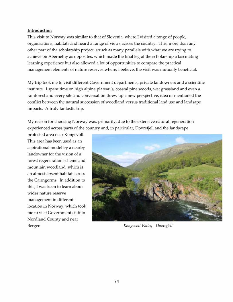
74
Introduction This visit to Norway was similar to that of Slovenia, where I visited a range of people, organisations, habitats and heard a range of views across the country. This, more than any other part of the scholarship project, struck as many parallels with what we are trying to achieve on Abernethy as opposites, which made the final leg of the scholarship a fascinating learning experience but also allowed a lot of opportunities to compare the practical management elements of nature reserves where, I believe, the visit was mutually beneficial. My trip took me to visit different Government departments, private landowners and a scientific institute. I spent time on high alpine plateau’s, coastal pine woods, wet grassland and even a rainforest and every site and conversation threw up a new perspective, idea or mentioned the conflict between the natural succession of woodland versus traditional land use and landsape impacts. A truly fantastic trip. My reason for choosing Norway was, primarily, due to the extensive natural regeneration experienced across parts of the country and, in particular, Dovrefjell and the landscape protected area near Kongsvoll. This area has been used as an aspirational model by a nearby landowner for the vision of a forest regeneration scheme and mountain woodland, which is an almost absent habitat across the Cairngorms. In addition to this, I was keen to learn about wider nature reserve management in different location in Norway, which took me to visit Government staff in Nordland County and near Bergen. Kongsvoll Valley - Dovrefjell

75
Norway has experienced a massive increase in forest cover in the last forty years and this is thought to be due to two factors: land use changes and climatic changes, with the first being the larger influence by far. Small hill farms where once commonplace through large parts of the country and the activities of these operations – grazing by sheep and cattle, cutting hay and felling trees for building materials and fuel – kept the trees down. As the standard of living could increase, and the discovery of oil brought more money into the country, people moved away from these farms and into the cities, and this migration is still continuing today. With the land not being farmed and the numbers of ungulates being very low due to climatic conditions or hunting through the Second World War, the trees were able to shoot up very quickly with little competition from other vegetation. The current situation is one of contrasts. The environmental agencies and supporters are celebrating this rewilding of areas, in most locations, while the traditional land managers see this as a waste of land and a change too radical in the landscape they were raised in. It is not the fault of policy or landowners but a movement by an entire nation towards an urban lifestyle that is still sought after by many rural dwellers. Despite a much larger percentage of the population living in towns and cities compared to forty years ago, Norwegians are proud of their cultural and natural landscape and see it as something to be protected and enjoyed. It was within this context that I began to learn just how different the situations between Abernethy and reserves and National Parks in Norway are, but also how we can learn from each other and share experience. Designations Throughout this section of the report, I will be mentioning National Parks, Nature Reserves and Landscape Protected Areas, these are the main designations in Norway. As Norway is not a member of the EU, there are no SPA’s, no SAC’s and no availability to LIFE funding so the set up is slightly different here to managing land protected for biodiversity. A National Park is land that is purely state owned and only limited grazing and hunting is permitted. Cabins built before the designation may be kept but not extended or changed. A National Park boundary can be determined by the land that can be purchased but is more focussed on the habitats.
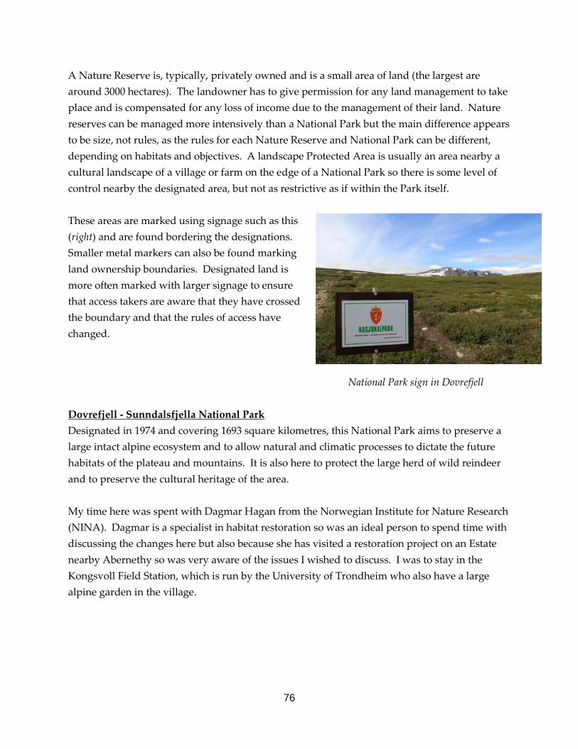
76
A Nature Reserve is, typically, privately owned and is a small area of land (the largest are around 3000 hectares). The landowner has to give permission for any land management to take place and is compensated for any loss of income due to the management of their land. Nature reserves can be managed more intensively than a National Park but the main difference appears to be size, not rules, as the rules for each Nature Reserve and National Park can be different, depending on habitats and objectives. A landscape Protected Area is usually an area nearby a cultural landscape of a village or farm on the edge of a National Park so there is some level of control nearby the designated area, but not as restrictive as if within the Park itself. These areas are marked using signage such as this (right) and are found bordering the designations. Smaller metal markers can also be found marking land ownership boundaries. Designated land is more often marked with larger signage to ensure that access takers are aware that they have crossed the boundary and that the rules of access have changed. National Park sign in Dovrefjell Dovrefjell - Sunndalsfjella National Park Designated in 1974 and covering 1693 square kilometres, this National Park aims to preserve a large intact alpine ecosystem and to allow natural and climatic processes to dictate the future habitats of the plateau and mountains. It is also here to protect the large herd of wild reindeer and to preserve the cultural heritage of the area. My time here was spent with Dagmar Hagan from the Norwegian Institute for Nature Research (NINA). Dagmar is a specialist in habitat restoration so was an ideal person to spend time with discussing the changes here but also because she has visited a restoration project on an Estate nearby Abernethy so was very aware of the issues I wished to discuss. I was to stay in the Kongsvoll Field Station, which is run by the University of Trondheim who also have a large alpine garden in the village.

77
During my time there, we walked through the natural woodland zones and discussed how this has been allowed to happen and just how quickly the forest responded to the changes in land management in the area. The scale of regeneration is staggering. The trees will grow anywhere and have quickly restored their natural zones from Scot’s pine and Norway spruce dominated woodland to birch woodland to a birch and willow scrub layer out to low lying willow species and dwarf birch. Beyond that is an alpine habitat where sedges and grasses dominate but some small scrub still persists.
Dwarf birch, juniper and woolly willow scrub above encroaching birch woodland
This has all happened due to the sudden reduction in grazing pressure. There are no red or roe deer in this area, the ungulates are reindeer, moose and musk oxen. The reindeer eat some trees but not enough to be detrimental, the moose preferentially eat rowan, birch and aspen so do not slow the pine down and musk oxen are too few over too large an area to have any real impact. The climate is also having an impact on these mountains. In the last 20 years, summer rainfall has increased by 20 %, which is having an effect on the make up of species that are colonising and surviving.
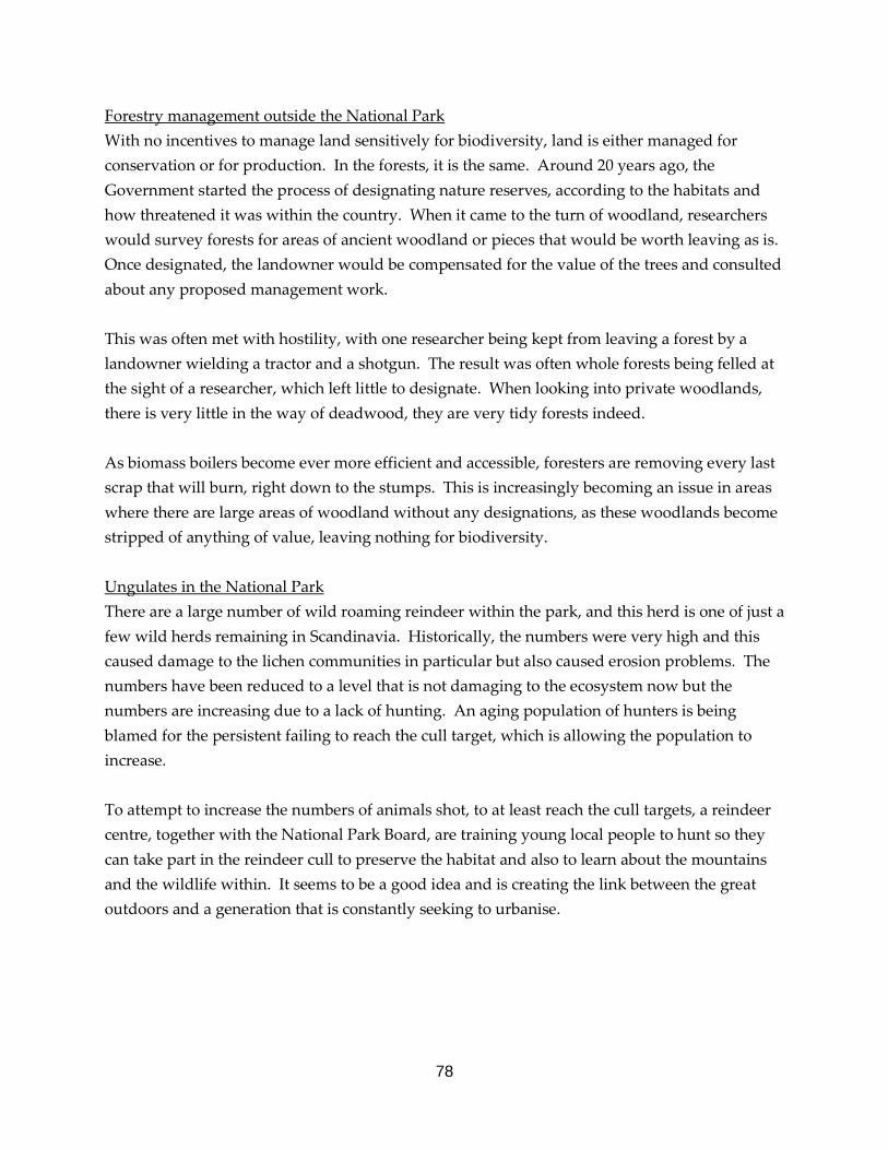
78
Forestry management outside the National Park With no incentives to manage land sensitively for biodiversity, land is either managed for conservation or for production. In the forests, it is the same. Around 20 years ago, the Government started the process of designating nature reserves, according to the habitats and how threatened it was within the country. When it came to the turn of woodland, researchers would survey forests for areas of ancient woodland or pieces that would be worth leaving as is. Once designated, the landowner would be compensated for the value of the trees and consulted about any proposed management work. This was often met with hostility, with one researcher being kept from leaving a forest by a landowner wielding a tractor and a shotgun. The result was often whole forests being felled at the sight of a researcher, which left little to designate. When looking into private woodlands, there is very little in the way of deadwood, they are very tidy forests indeed. As biomass boilers become ever more efficient and accessible, foresters are removing every last scrap that will burn, right down to the stumps. This is increasingly becoming an issue in areas where there are large areas of woodland without any designations, as these woodlands become stripped of anything of value, leaving nothing for biodiversity. Ungulates in the National Park There are a large number of wild roaming reindeer within the park, and this herd is one of just a few wild herds remaining in Scandinavia. Historically, the numbers were very high and this caused damage to the lichen communities in particular but also caused erosion problems. The numbers have been reduced to a level that is not damaging to the ecosystem now but the numbers are increasing due to a lack of hunting. An aging population of hunters is being blamed for the persistent failing to reach the cull target, which is allowing the population to increase. To attempt to increase the numbers of animals shot, to at least reach the cull targets, a reindeer centre, together with the National Park Board, are training young local people to hunt so they can take part in the reindeer cull to preserve the habitat and also to learn about the mountains and the wildlife within. It seems to be a good idea and is creating the link between the great outdoors and a generation that is constantly seeking to urbanise.
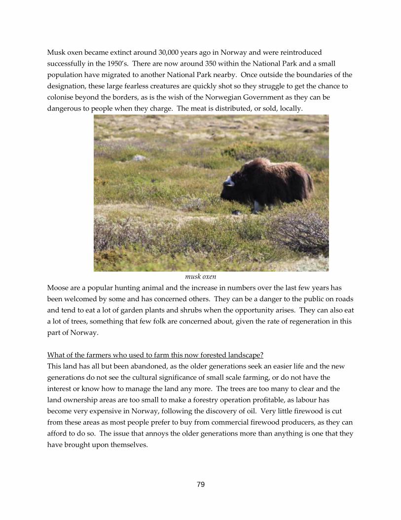
79
Musk oxen became extinct around 30,000 years ago in Norway and were reintroduced successfully in the 1950’s. There are now around 350 within the National Park and a small population have migrated to another National Park nearby. Once outside the boundaries of the designation, these large fearless creatures are quickly shot so they struggle to get the chance to colonise beyond the borders, as is the wish of the Norwegian Government as they can be dangerous to people when they charge. The meat is distributed, or sold, locally.
musk oxen Moose are a popular hunting animal and the increase in numbers over the last few years has been welcomed by some and has concerned others. They can be a danger to the public on roads and tend to eat a lot of garden plants and shrubs when the opportunity arises. They can also eat a lot of trees, something that few folk are concerned about, given the rate of regeneration in this part of Norway. What of the farmers who used to farm this now forested landscape? This land has all but been abandoned, as the older generations seek an easier life and the new generations do not see the cultural significance of small scale farming, or do not have the interest or know how to manage the land any more. The trees are too many to clear and the land ownership areas are too small to make a forestry operation profitable, as labour has become very expensive in Norway, following the discovery of oil. Very little firewood is cut from these areas as most people prefer to buy from commercial firewood producers, as they can afford to do so. The issue that annoys the older generations more than anything is one that they have brought upon themselves.
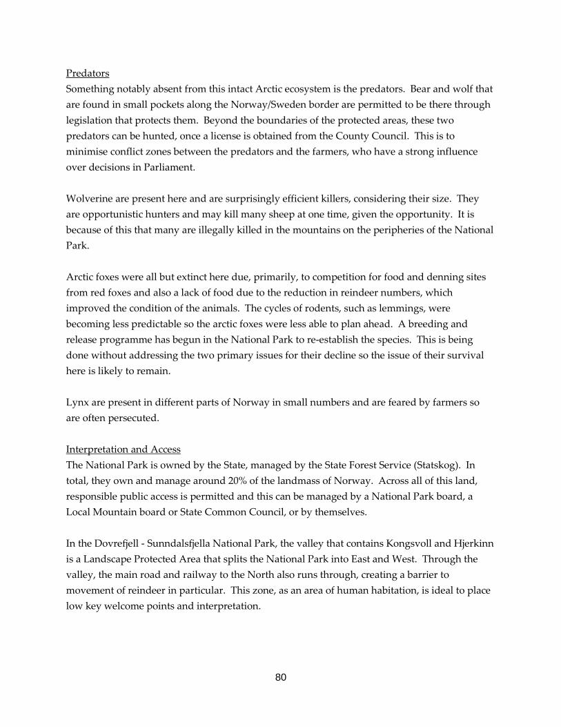
80
Predators Something notably absent from this intact Arctic ecosystem is the predators. Bear and wolf that are found in small pockets along the Norway/Sweden border are permitted to be there through legislation that protects them. Beyond the boundaries of the protected areas, these two predators can be hunted, once a license is obtained from the County Council. This is to minimise conflict zones between the predators and the farmers, who have a strong influence over decisions in Parliament. Wolverine are present here and are surprisingly efficient killers, considering their size. They are opportunistic hunters and may kill many sheep at one time, given the opportunity. It is because of this that many are illegally killed in the mountains on the peripheries of the National Park. Arctic foxes were all but extinct here due, primarily, to competition for food and denning sites from red foxes and also a lack of food due to the reduction in reindeer numbers, which improved the condition of the animals. The cycles of rodents, such as lemmings, were becoming less predictable so the arctic foxes were less able to plan ahead. A breeding and release programme has begun in the National Park to re-establish the species. This is being done without addressing the two primary issues for their decline so the issue of their survival here is likely to remain. Lynx are present in different parts of Norway in small numbers and are feared by farmers so are often persecuted. Interpretation and Access The National Park is owned by the State, managed by the State Forest Service (Statskog). In total, they own and manage around 20% of the landmass of Norway. Across all of this land, responsible public access is permitted and this can be managed by a National Park board, a Local Mountain board or State Common Council, or by themselves. In the Dovrefjell - Sunndalsfjella National Park, the valley that contains Kongsvoll and Hjerkinn is a Landscape Protected Area that splits the National Park into East and West. Through the valley, the main road and railway to the North also runs through, creating a barrier to movement of reindeer in particular. This zone, as an area of human habitation, is ideal to place low key welcome points and interpretation.

81
At the beginning of the main paths, there is a large standing stone, that fits well in the landscape, which has the information panels screwed on. The panels have information that accommodates for Norwegian and English readers. Within this, it explains what it is that you are walking through, why it is protected and how you need to exercise your access rights on this particular National Park. There is a map showing the boundary of the Park, and the main paths, mountains and mountain huts. For people to take access through the vast majority of the National Park, they need to carry a map, compass and supplies for a good day on the hill. Once along the path and where the National Park and Landscape Protected Area meets, there is a sign on the path (see photo on page 76) to make you aware that you have entered the National Park and that, from here, you must behave in accordance with the rules laid out in the boards at the trail head.
There is one location that is used as a honey pot site that provides a large car park, toilets, lots of interpretation about the natural and cultural heritage and also a high quality footpath with interpretation set into the path surface that leads to an award winning viewpoint building, that is a draw in itself. On entering the view point, a fantastic landscape is front of you but most visitors turn to admire the architecture of the interior before admiring the view!
Timeline on footpath to viewpoint Inside the viewpoint
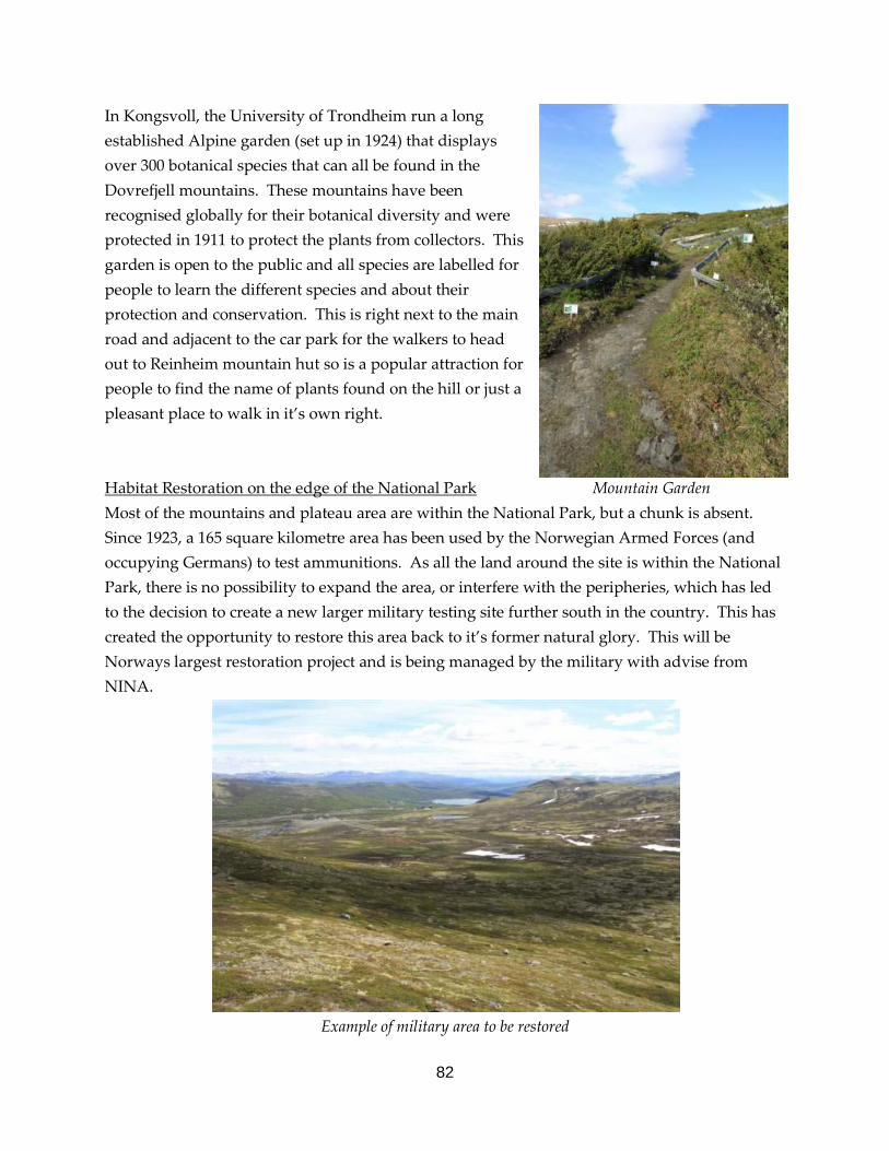
82
In Kongsvoll, the University of Trondheim run a long established Alpine garden (set up in 1924) that displays over 300 botanical species that can all be found in the Dovrefjell mountains. These mountains have been recognised globally for their botanical diversity and were protected in 1911 to protect the plants from collectors. This garden is open to the public and all species are labelled for people to learn the different species and about their protection and conservation. This is right next to the main road and adjacent to the car park for the walkers to head out to Reinheim mountain hut so is a popular attraction for people to find the name of plants found on the hill or just a pleasant place to walk in it’s own right. Habitat Restoration on the edge of the National Park Mountain Garden Most of the mountains and plateau area are within the National Park, but a chunk is absent. Since 1923, a 165 square kilometre area has been used by the Norwegian Armed Forces (and occupying Germans) to test ammunitions. As all the land around the site is within the National Park, there is no possibility to expand the area, or interfere with the peripheries, which has led to the decision to create a new larger military testing site further south in the country. This has created the opportunity to restore this area back to it’s former natural glory. This will be Norways largest restoration project and is being managed by the military with advise from NINA.
Example of military area to be restored
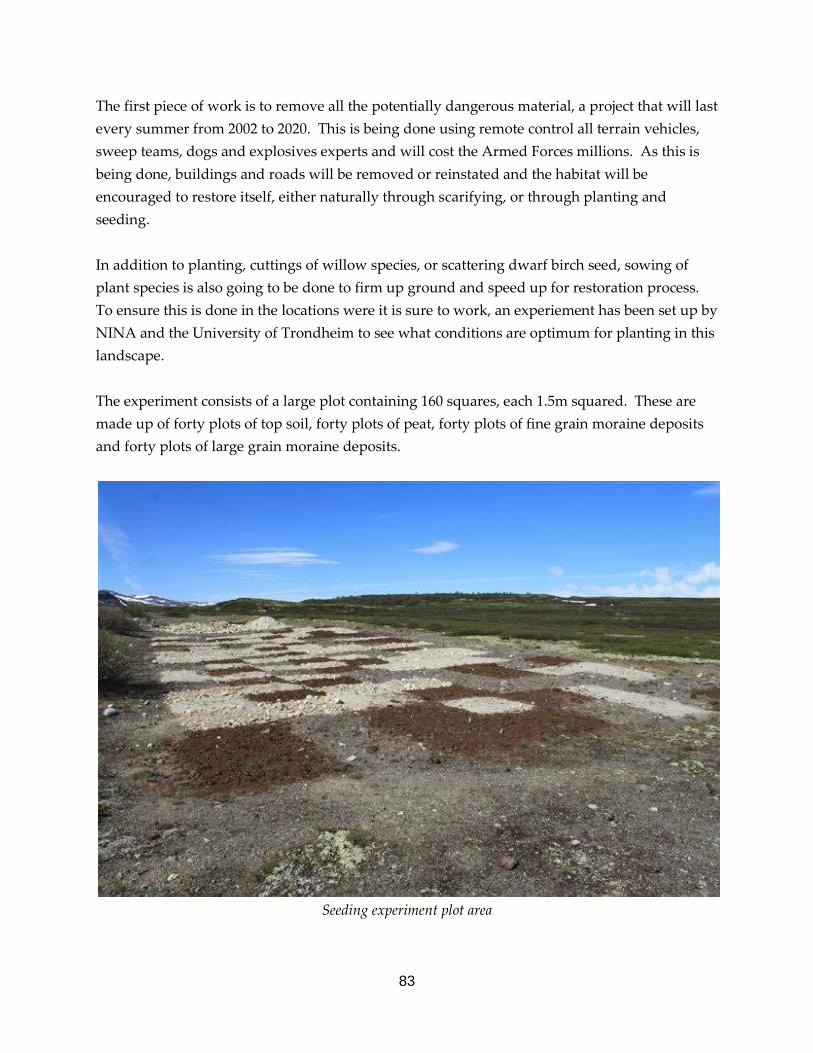
83
The first piece of work is to remove all the potentially dangerous material, a project that will last every summer from 2002 to 2020. This is being done using remote control all terrain vehicles, sweep teams, dogs and explosives experts and will cost the Armed Forces millions. As this is being done, buildings and roads will be removed or reinstated and the habitat will be encouraged to restore itself, either naturally through scarifying, or through planting and seeding. In addition to planting, cuttings of willow species, or scattering dwarf birch seed, sowing of plant species is also going to be done to firm up ground and speed up for restoration process. To ensure this is done in the locations were it is sure to work, an experiement has been set up by NINA and the University of Trondheim to see what conditions are optimum for planting in this landscape. The experiment consists of a large plot containing 160 squares, each 1.5m squared. These are made up of forty plots of top soil, forty plots of peat, forty plots of fine grain moraine deposits and forty plots of large grain moraine deposits.
Seeding experiment plot area

84
These are laid out at random and are around 50cm deep. Within these, seeds of three common upland plant species are spread over part of each plot and these are marked and monitored. Predictably, the peat plots have shown the most success with the fine and large grain moraines showing almost no regrowth after one year. With the results, it allows Dagmar to prioritise the Armed Forces seeding resources to the sites where they are most likely to have a quick success rate, rather than attempting to seed the whole site that requires it. Management of Nature Reserves in Nordland County To begin this section of the trip, I met with nine staff from the County Council, Nordland Fylkesmannen, to give a presentation about my project and scholarship, the RSPB and Abernethy and to discuss with them their set up and management of nature reserves in the county, and in Norway. The team here had been guests of the Cairngorms National Park Authority in 2009 so knew some information about how the National Park operates in Scotland and about the issues with the habitats that we were discussing. Few nature reserves here have written objectives or a management plan. The management is more on the requirements of the land owner or a feeling of changes in the habitat structures that need management to maintain the area in a suitable condition for the habitat that was originally protected. The reserves (around 200 in Nordland County) are managed by the County Council, who employ a small team of people to be responsible for a number of them, around 40 to 50 each. The work of these people is to discuss and agree management of the land, creation of interpretation boards and trails and to manage the budgets and write plans for the larger reserves. There job is not to carry out practical work or maintain any infrastructure. Statens Natur Oppsyn (SNO) is a Government agency responsible for the practical management and interpretation of protected land, whether that be a National Park, Landscape Protected Area or Nature Reserve. With the nature reserves, the County Council staff feed down a work programme of management required on the reserves to be carried out. This is sent to a central office in Trondheim and is disseminated to SNO staff across the whole of Norway.

85
Site Visits During my time here, I visited six different nature reserves that were all very different in habitats, size and issues. The first of which was Junkerdalsura, a nature reserve that is on the edge of a National Park. The land is state owned so could become part of the National Park if the boundary was redone but this is thought to not be an effective use of resources as the place is already protected. Junkerdalsura Junkerdalsura is a steep sided river valley with a mix of Scot’s pine and aspen dominated forest on the north facing side of the valley and a much more diverse broadleaved woodland on the south facing side. To the left of the river in the photograph below, where there is a line of dense birch, a public road negotiated it’s way through until recent years when the rock on the tops of the cliffs became very unstable and caused a number of rock slides and avalanches that are a hazard year round.
The road is now a footpath that is strewn with boulders and signage warns of the dangers of entering the area. There is a narrow waymarked trail that takes visitors about half way up the left hand side of the photograph and traverses along nearby the tops of some very high drops amongst unstable rocks and fallen trees. Management of this site is limited to the removal of non native planted trees – mainly Norway spruce that do not naturally grow north of the Arctic Circle in Norway, and managing people’s behaviour of lighting camp fires (between 15/4 and 15/9), hunting and fishing, which are both forbidden on this reserve. The rest of the area is left to it’s own devices and it is continuing to develop into a fantastic forest. The sites where the rock falls have been happening are great for lots of aspen deadwood and fresh suckering.

86
The reserve is right next to a large National Park interpretation centre for the Nordland County. Built in 1999, this impressive ring shaped building has sections of fantastic information on the natural heritage, cultural heritage, Sami people and Geology. Rangers are based here who can speak to visitors and lead tours into the National Park, for those that want them.
Inside the ring shaped building Interpretation within the building itself The design of the pathing replicates part of the Sami flag and the central seating fire is similar to that of a meeting place within Sami culture. The banner around the top displays the view from the top of the highest hill in the National Park and the roof is grassed over, grazed by goats, until one fell off. Within the building, the interpretation is a mix of written information, audiovisual information and interactive displays for adults and children. The centre does not shy away from conflict either, as it displays a stuffed lynx eating a sheep.
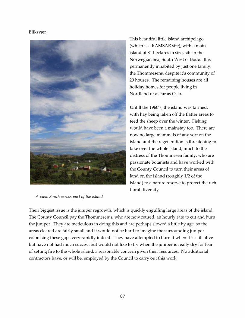
87
Bliksvær This beautiful little island archipelago (which is a RAMSAR site), with a main island of 81 hectares in size, sits in the Norwegian Sea, South West of Bodø. It is permanently inhabited by just one family, the Thommesens, despite it’s community of 29 houses. The remaining houses are all holiday homes for people living in Nordland or as far as Oslo. Untill the 1960’s, the island was farmed, with hay being taken off the flatter areas to feed the sheep over the winter. Fishing would have been a mainstay too. There are now no large mammals of any sort on the island and the regeneration is threatening to take over the whole island, much to the distress of the Thommesen family, who are passionate botanists and have worked with the County Council to turn their areas of land on the island (roughly 1/2 of the island) to a nature reserve to protect the rich floral diversity
A view South across part of the island Their biggest issue is the juniper regrowth, which is quickly engulfing large areas of the island. The County Council pay the Thommesen’s, who are now retired, an hourly rate to cut and burn the juniper. They are meticulous in doing this and are perhaps slowed a little by age, so the areas cleared are fairly small and it would not be hard to imagine the surrounding juniper colonising these gaps very rapidly indeed. They have attempted to burn it when it is still alive but have not had much success but would not like to try when the juniper is really dry for fear of setting fire to the whole island, a reasonable concern given their resources. No additional contractors have, or will be, employed by the Council to carry out this work.

88
The best tool for this family, and the island, would clearly be some grazing animals but this would require some commitment from the Council and the Thommesens to build a shed for the winter time and to create the hay required for them. This would also require a change in practices from the holiday makers cutting vast swathes of the island every couple of weeks on their ride on mowers to make their house look nice. Old hay fields encroached by scrub In Norway, perhaps as unemployment is so low, there are no large voluntary organisations to arrange work parties to hit the island hard for a few days. This could be a real benefit to the family and I plan to meet with the British Trust for Conservation Volunteers (BTCV) to discuss their international programme to attempt to include this site. It is a unique place and would be a fantastic experience for people to make a big difference very quickly.
This beautiful little island is also not free from conflict. Some of the other home and land owners on the island are resentful towards the Thommesen’s for allowing their land to become a reserve and for them to be paid to manage it, while their own land scrubs over without any offer of help from the Council. Few of these people have any historical ties to this island, as the Thommesen’s do, or show such passion for the flora of the island.
Area of juniper cleared
89
Tverlandet, Sundstraumlian, Straumøya, and Seinesodden Nature Reserves These four small reserves are on the island of Straumøya, just South of Bodø and can be reached by crossing a bridge over the largest maelstrom on Earth, quite impressive when the tide is at its peak. The reserves are a mixture of coastal wet grassland, raised bog and coastal woodland. They are all privately owned, with some owners more receptive than others. The purpose of my visit to these four reserves was to accompany Espen Henrikson, the new manager of these sites, to view work done on marking the boundaries, review management for the coming winter, to look at the installation of interpretation and to discuss, on the woodland sites, the creation of deadwood. As these sites are rarely visited by staff representing either the County Council or SNO (sometimes only once per year on the non intervention sites) it was not surprising that we came upon a few unexpected electric fences, locked gates and such like. At all four sites, Espen was looking for suitable locations to place interpretation panels to make visitors aware of the reserve and it’s purpose. On some sites this would be appropriate but I felt that treating all the reserves with the same format of interpretive panels and perhaps a short trail was unimaginative and potentially damaging to the purpose of the designation. As Espen will be instructing SNO staff where to put panels, etc, there is the potential for information to be lost between him passing it to his colleague who passes it to the SNO staff who may further delegate the task. The manager appears to be too disjointed from the practical application on the ground, resulting in the possibility of lost messages or changed objectives. All four sites were interesting, but the most relevant for me was the Sundstraumlian reserve on the South side of the island. Here, the reserve is a strip of forest dominated by pine and aspen and is grazed by cattle to keep the forest floor open for the botanical interest. On this site, cattle are kept on the reserve by an electric fence to ensure their is sufficient grazing pressure and it works. On the non grazed side of the fence, juniper scrub is covering the ground and there are fewer small trees coming away. On the grazed side, regeneration is coming away, juniper is kept down and orchids, wintergreens and twinflower are covering the ground in a wonderful carpet of colour, despite the heavy rain experienced on this day.

90
Ungrazed side of fence Grazed side of fence Management of Nature Reserves in South West Norway Following four days in Nordland with the County Council discussing the management of the reserves from their perspective, I travelled South to Bergen to meet Ragni Nordas, a member of staff from SNO, to see and hear about the practical application of management work on the ground on a number of reserves there. Ragni had recently returned to Norway after a three month sabbatical on the Creag Mheagaidh National Nature Reserve in the South of Strathspey so was also aware of the issues and could speak English with a fantastic Scottish accent! Ragni is one of a team of three people managing about 160 nature reserves, a National Park and a large interpretive centre. She is personally responsible for the practical application of the management for 56 of the reserves, a huge job. Klyvelia Nature Reserve This reserve is around 10ha in size and is designated due to the large number of yew trees here. As grazing pressure is so low and the landowner is removing very little timber for firewood, the yew trees are disappearing under rowan, birch and Scot’s pine. To ensure the survival of the yew trees, felling of the surrounding trees should be done to free them up and this should be done periodically. Instead, Ragni is left frustrated as she is not given the resources to cut the required number of trees down. She tends to work alone so cannot operate the chainsaw to carry out the work and has insufficient funds to employ contractors as the flagship reserves, diesel and ferry costs swallow up all her budget. Hunting is permitted on the reserve but the ground is so steep that few people would attempt it. There are also very few ungulates to hunt, which is why the trees have grown up so quickly.
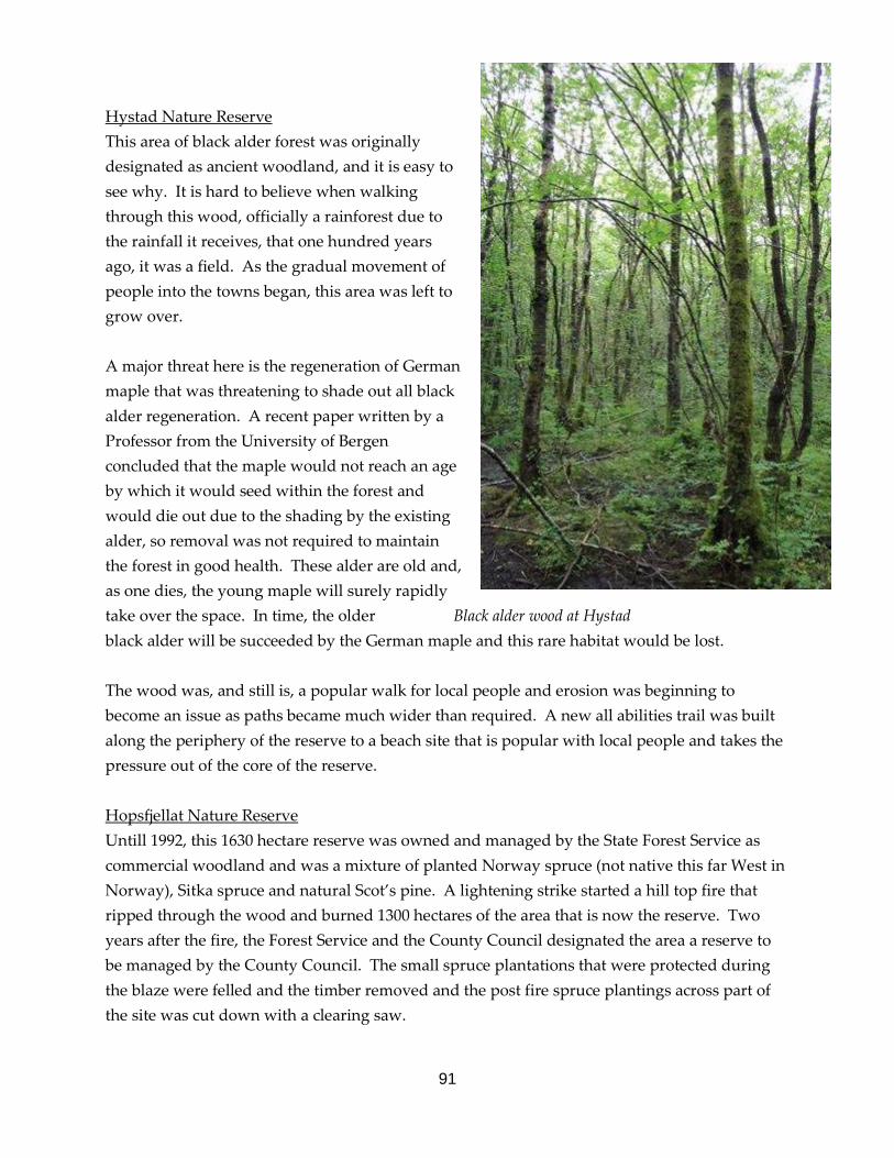
91
Hystad Nature Reserve This area of black alder forest was originally designated as ancient woodland, and it is easy to see why. It is hard to believe when walking through this wood, officially a rainforest due to the rainfall it receives, that one hundred years ago, it was a field. As the gradual movement of people into the towns began, this area was left to grow over. A major threat here is the regeneration of German maple that was threatening to shade out all black alder regeneration. A recent paper written by a Professor from the University of Bergen concluded that the maple would not reach an age by which it would seed within the forest and would die out due to the shading by the existing alder, so removal was not required to maintain the forest in good health. These alder are old and, as one dies, the young maple will surely rapidly take over the space. In time, the older Black alder wood at Hystad black alder will be succeeded by the German maple and this rare habitat would be lost. The wood was, and still is, a popular walk for local people and erosion was beginning to become an issue as paths became much wider than required. A new all abilities trail was built along the periphery of the reserve to a beach site that is popular with local people and takes the pressure out of the core of the reserve. Hopsfjellat Nature Reserve Untill 1992, this 1630 hectare reserve was owned and managed by the State Forest Service as commercial woodland and was a mixture of planted Norway spruce (not native this far West in Norway), Sitka spruce and natural Scot’s pine. A lightening strike started a hill top fire that ripped through the wood and burned 1300 hectares of the area that is now the reserve. Two years after the fire, the Forest Service and the County Council designated the area a reserve to be managed by the County Council. The small spruce plantations that were protected during the blaze were felled and the timber removed and the post fire spruce plantings across part of the site was cut down with a clearing saw.
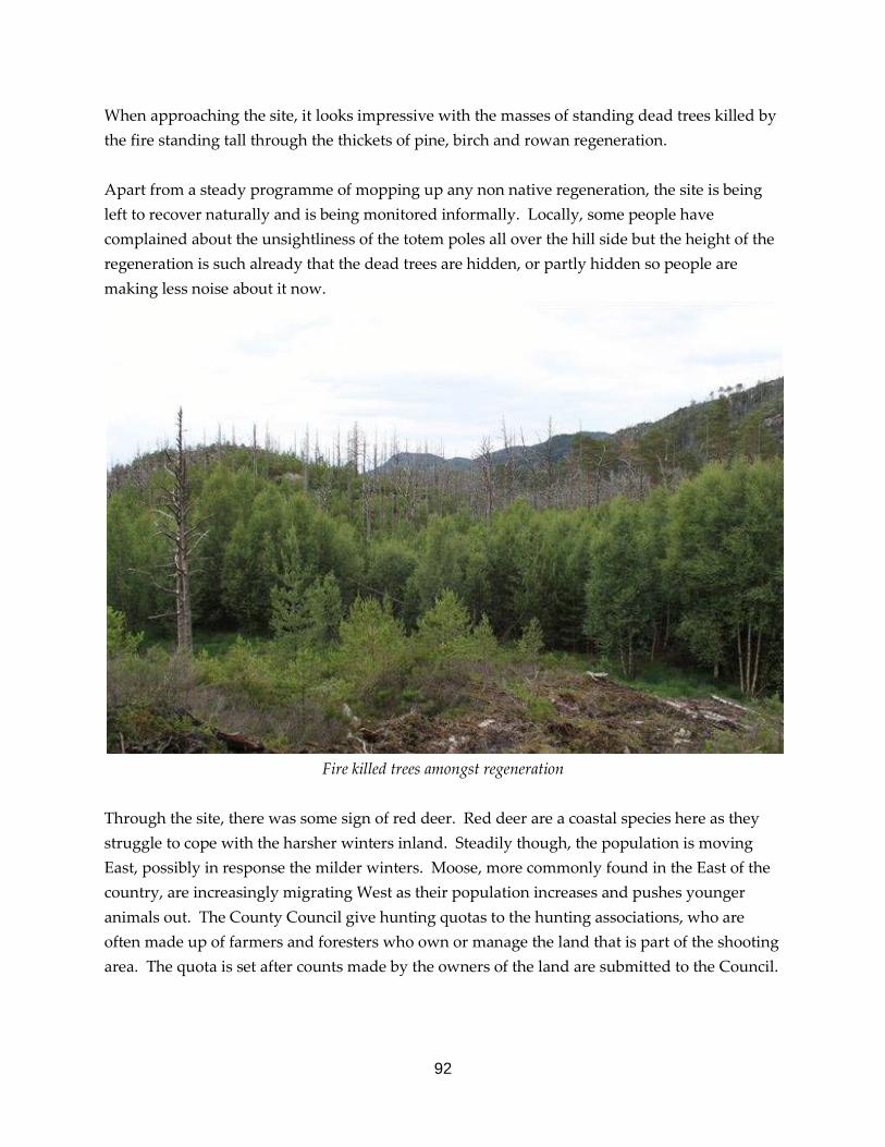
92
When approaching the site, it looks impressive with the masses of standing dead trees killed by the fire standing tall through the thickets of pine, birch and rowan regeneration. Apart from a steady programme of mopping up any non native regeneration, the site is being left to recover naturally and is being monitored informally. Locally, some people have complained about the unsightliness of the totem poles all over the hill side but the height of the regeneration is such already that the dead trees are hidden, or partly hidden so people are making less noise about it now.
Fire killed trees amongst regeneration
Through the site, there was some sign of red deer. Red deer are a coastal species here as they struggle to cope with the harsher winters inland. Steadily though, the population is moving East, possibly in response the milder winters. Moose, more commonly found in the East of the country, are increasingly migrating West as their population increases and pushes younger animals out. The County Council give hunting quotas to the hunting associations, who are often made up of farmers and foresters who own or manage the land that is part of the shooting area. The quota is set after counts made by the owners of the land are submitted to the Council.

93
It would appear that this system could be abused as the counters, landowners and hunters can often be the same people they could fudge the results to suit their own land management objectives to ensure a cull target that is set artificially low or high.The system does seem to work though as the deer are neither extinct or running amok and the hunters are content enough with the quality of hunting and the number of animals over a period of time. Kvernavatnet Nature Reserve This is a large nature reserve, of just under 3000 hectares and is predominantly an old Scot’s pine forest with little history of silvicultural intervention. It looks just like Abernethy. Same tree species, same flowering plant species, same bird species. The reserve was designated in
1999, during the period when coastal pine wood reserves were being sought after. The reserve boundary is a long way into the forest and designates the core area of the forest furthest away from human disturbance. On arrival to the reserve, clear signage explains that fires, hunting and damaging the forest in any way is against the law so that visitors are aware of how to behave in the area. A new path is marked using spray on trees to allow visitors to access the top of the hill. The path is not well worn and some sections would be impossible to find, if it wasn’t for the occasional red markers, showing that this site is not often frequented by the public. The hill at the top is called Veten. It is one of a network of hills called Veten, which were used in historic times to light fire beacons to communicate messages across the fjords.
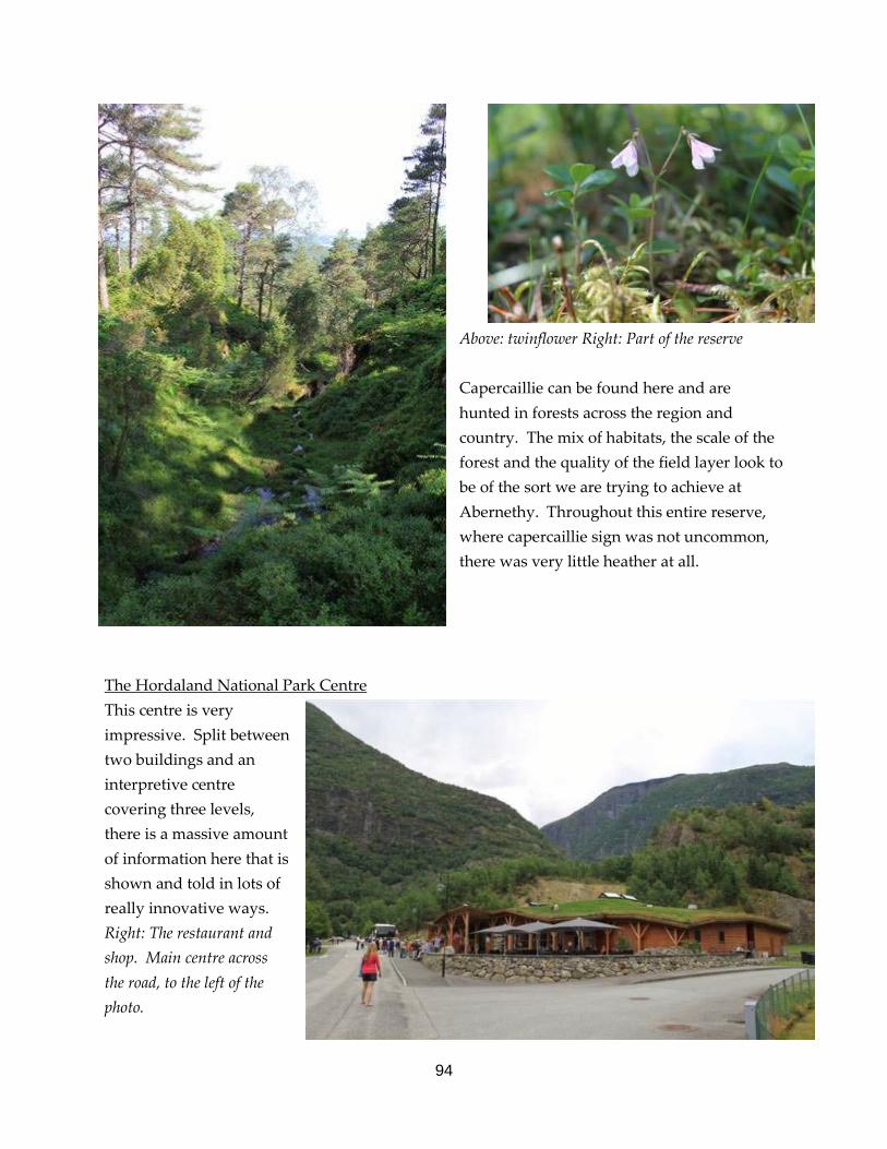
94
Above: twinflower Right: Part of the reserve Capercaillie can be found here and are hunted in forests across the region and country. The mix of habitats, the scale of the forest and the quality of the field layer look to be of the sort we are trying to achieve at Abernethy. Throughout this entire reserve, where capercaillie sign was not uncommon, there was very little heather at all.
The Hordaland National Park Centre This centre is very impressive. Split between two buildings and an interpretive centre covering three levels, there is a massive amount of information here that is shown and told in lots of really innovative ways. Right: The restaurant and shop. Main centre across the road, to the left of the photo.

95
The building on the South side of the road is a wooden, grass roofed (with an electric fence to keep the goat on) building of very high quality that features a well stocked shop of local handicrafts as well as the usual tourist tat and a very professionally run restaurant that can sit well over 100 people, with an outside space that site a further 100. The menu features game, fish and vegetables from the villages and hills around the area and gives you a flavour of the produce of this part of Norway. The centre entrance is adorned with a tall waterfall feature, relevant to this area as the centre is only a short drive away from Voringfoss, a massive waterfall and the most visited natural attraction in Norway. Once in the centre, the three levels are split between habitat zones. The top is dedicated to the high mountain species, the middle floor the forest area and the lower concentrating on the valley bottoms and water. On the middle floor there is also an amazing cinema. The bold aim of the centre The clever interpretation shows the visitors how animals life and survive the harsh climates, interact with each and how they have evolved to be there in the first place. Materials used vary in colour and textures and how you have to deal with them physically, such as the glass floor display in the photograph overleaf looking at geological features. Display looking at mammal survival

96
Some of the examples of types of displays used within this centre. The top floor, featuring the mountain ground, looked at glacial features, had lots of stuffed animals and birds showing the types of creatures you may come across and featured artificial arctic fox dens and lots of lemmings. The second floor explained the changes in forest cover and abandonment of farmland and also housed the cinema. This cinema has a screen that is the shape of half an oval and is 180 degrees in a curved structure. The film that is shown is shot from a super wide angle video camera in high definition from the bottom of a helicopter. The film takes you on a ride through the valleys, forests and mountains that you had just read about in the rest of the centre and is very much the centre piece of the centre. Looking at the reactions of the other people sitting in the room, people had the illusion of sitting in the helicopter as they looked from left to right or up and down to see different features and would point interesting features out to their friends before they flew past. At the end, it almost did feel like you had just been in the helicopter and many of the people there talked about getting a real buzz from watching it. The lower floor, concentrating on the valley bottom, features a ‘glacier’ created using an inside out freezer of sorts and lots of tanks of different fish species that can be found. These were a big hit with the kids in the centre. Walking round, taking the time to understand the interpretation, watching the film and going for a meal at the restaurant, a good afternoons entertainment would be had by the whole family.

97
Conclusions This trip has been incredibly informative and inspiring but also a reality check. Abernethy’s aims are a drop in the ocean and without a massive landscape, or national land management change, it is unlikely that reserves and estates that have similar aims to Abernethy will be any more than an isolated oasis in a multi use landscape of farming, forestry, hunting, shooting and recreation. This is encouraging too though, and firmed up my beliefs that what we are doing with Abernethy is the right thing. On the management of protected land, from the experience of other visits, particularly to Poland, I discovered within myself a limit to which I believe the land can be researched to answer management questions for a purpose, and where it can go beyond what we need and actually limit management that is essential. In Norway, some base line monitoring of vegetation structures and key indicators such as birds, would be a benefit to the people who are making the decisions to manage protected land. As staff change, objectives, ideas and experience are not written down so lots of information can be lost quickly. It appears that the nature reserves have been designated rapidly without much thought about how they will be managed and what is required to either keep them as they are, return them to a state required or to let them evolve naturally. Due to this, there is a lot of work required on some of these reserves that desperately needs done but the resources have not been forecast to allow the people on the ground to do what they feel is right. While unemployment is low, there are a lot of fit and healthy retired people who have time on their hands an I feel that this resource could be tapped into to assist SNO with some of the most essential management work required. One of the surprises of this trip was the ever present mentioning of the Sami people, the indigenous people of the mountainous areas, and the talk of conflicts, that paralleled conversations here about the conflict between RSPB and the local communities. The situation is not so different. The people of Nethybridge are the indigenous people and the RSPB are the new comers with new ways of managing the land. By the RSPB working sensitively with the local people, employing local young people and providing opportunities for local people to understand what it is that is being done, and why, this will contunue to break down barriers.
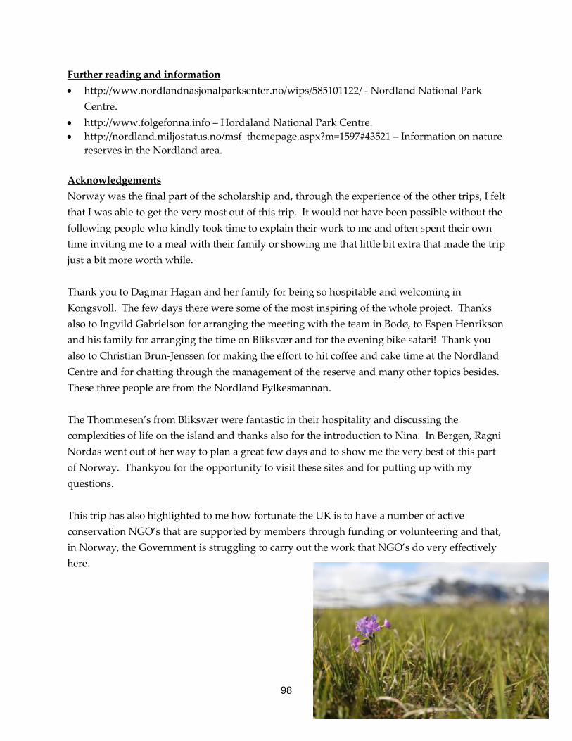
98
Further reading and information • http://www.nordlandnasjonalparksenter.no/wips/585101122/ - Nordland National Park
Centre. • http://www.folgefonna.info – Hordaland National Park Centre. • http://nordland.miljostatus.no/msf_themepage.aspx?m=1597#43521 – Information on nature
reserves in the Nordland area. Acknowledgements Norway was the final part of the scholarship and, through the experience of the other trips, I felt that I was able to get the very most out of this trip. It would not have been possible without the following people who kindly took time to explain their work to me and often spent their own time inviting me to a meal with their family or showing me that little bit extra that made the trip just a bit more worth while. Thank you to Dagmar Hagan and her family for being so hospitable and welcoming in Kongsvoll. The few days there were some of the most inspiring of the whole project. Thanks also to Ingvild Gabrielson for arranging the meeting with the team in Bodø, to Espen Henrikson and his family for arranging the time on Bliksvær and for the evening bike safari! Thank you also to Christian Brun-Jenssen for making the effort to hit coffee and cake time at the Nordland Centre and for chatting through the management of the reserve and many other topics besides. These three people are from the Nordland Fylkesmannan. The Thommesen’s from Bliksvær were fantastic in their hospitality and discussing the complexities of life on the island and thanks also for the introduction to Nina. In Bergen, Ragni Nordas went out of her way to plan a great few days and to show me the very best of this part of Norway. Thankyou for the opportunity to visit these sites and for putting up with my questions. This trip has also highlighted to me how fortunate the UK is to have a number of active conservation NGO’s that are supported by members through funding or volunteering and that, in Norway, the Government is struggling to carry out the work that NGO’s do very effectively here.
99
Report Summary This report is the culmination of 17 months of work, from the initial application to EUROPARC, where I put some meat on the bones of an idea to travel to these countries to learn about woodland management. To then seeking the time away from work through the RSPB sabbatical process and then planning the day to day meetings, travel and seeking out the best people to spend time with and all amongst a very busy work programme on Abernethy. I set out to learn about grazing systems in woodland habitats and how field layer is managed, how deadwood is regarded and how forests can expand. I was also interested to find examples of harmony between conservation land management and traditional land managers and communities. At the start of this, I wondered to myself if I had bitten off more than I could chew. How would I find these sites and people, what would I learn and would it be relevant? As the project evolved, I have learnt a huge amount about the management of forests, grazing, deadwood and field layer but also about land use history and it’s relationships to what it is that the conservation work is trying to achieve. No management is in isolation and the past, future and surrounding current situation have a huge impact that must be considered when carrying out management of the land. Throughout the journey, I asked almost every person I spent time with about conflict in their roles, with colleagues, farmers, hunters, the Governement and anyone else who may like to put forward a contrary view. I could not find one place where there was harmony between all parties and this was to be expected. Conservation land management is different, the subjects that are discussed are not often mainstream and the restoration of ecosystems can have detrimental impacts on the cosy lives that human have made for themselves. If the people managing these areas are prepared for it, I believe that it is a good thing. The people who have a contrary view have gone to the effort to think about the area being managed and probably care for it passionately. They want to understand why the land is being managed so differently and how it will affect the livelihood of themselves or their community. Debate can create new ideas and reshape existing management. If everyone agreed on how to manage the land, it could become a less diverse habitat that is less interesting for the people living and visiting the area but also the biodiversity that call this place home.

100
The photographs through the report were all taken by me and have been reduced to make the report manageable on a computer. The originals are higher quality and available to those who would like them. Through this project there have been a number of situations, locations, and people that I have met that did not fit into the report. I have begun to write a less formal story that documents the joys of travel with a snoring granny on your lap in the Arctic Circle and the dangers of cycling in a Polish National Park after midnight. If, or when, I finish this document, I will gladly pass it onto EUROPARC and RSPB. I have gained a real confidence in what it is that we are trying to achieve here at Abernethy and, with this, will use the experience I have built up through this project to assist my colleagues in reaching the ambitious goals set by the organisation to restore this area to it’s former glory. A huge thank you to the EUROPARC Federation, the Alfred Toepfer Foundation and the RSPB for creating, funding and allowing this opportunity and for me to make this idea a reality. My final thanks to my forgiving and tolerant wife Rosalind, who supported me in applying for the scholarship, providing a sounding board for ideas and being there where she was needed most – at the airport!
Ross Watson, 17th July 2012. [email protected]