examining the sustainability and developmentchallenge in
TRANSCRIPT
1
Examining the sustainability and development challenge in agricultural-forest frontiers of the Amazon Basin through the eyes of locals Irene Blanco-Gutiérrez1,2, Rhys Manners3, Consuelo Varela-Ortega1,2, Ana Tarquis1,4, Lucieta G. Martorano5, Marisol Toledo6 5 1 CEIGRAM, Universidad Politécnica de Madrid (UPM), C/ Senda del Rey 13, 28040, Madrid, Spain 2 Department of Agricultural Economics, Statistics and Business Management, ETSIAAB, Universidad Politécnica de Madrid (UPM), Av. Complutense s/n, 28040 Madrid, Spain 3 International Institute of Tropical Agriculture (IITA), KG 563, Kigali, Rwanda 10 4 Department of Applied Mathematics, ETSIAAB, Universidad Politécnica de Madrid (UPM), Av. Complutense s/n, 28040 Madrid, Spain 5 EMBRAPA Eastern Amazon, Trav. Dr. Enéas Pinheiro s/n° Caixa Postal, 48, CEP 66.095-100 Belém, Brazil 6 Instituto Boliviano de Investigación Forestal, Km 9 Carretera al Norte, El Vallecito, Santa Cruz de la Sierra, Bolivia
Correspondence to: Irene Blanco-Gutiérrez ([email protected]) 15
Abstract
The Amazon basin is the world’s largest rainforest and the most biologically diverse place on Earth. Despite the critical
importance of this region, Amazon forests continue inexorably to be degraded and deforested for various reasons, mainly a
consequence of agricultural expansion. The development of novel policy strategies that provide balanced solutions,
associating economic growth and environmental protection, is still challenging, largely because the perspective of those most 20
affected- local stakeholders- is often ignored. Participatory Fuzzy Cognitive Mapping (FCM) was implemented to examine
stakeholder perceptions towards the sustainable development of two agricultural-forest frontier areas in the Bolivian and
Brazilian Amazon. A series of development scenarios and a climate change scenario were explored and applied to
stakeholder derived FCM. Stakeholders in both regions perceived landscapes of socio-economic impoverishment and
environmental degradation driven by governmental and institutional deficiencies. Under such abject conditions, governance 25
and well-integrated social and technological strategies offered socio-economic development, environmental conservation,
and resilience to climatic changes. The results suggest the benefits of a new type of thinking for development strategies in
the Amazon basin, and that continued application of traditional development policies reduce the resilience of the Amazon to
climate change, whilst limiting socio-economic development and environmental conservation.
30
Key words: agriculture expansion, deforestation, stakeholder perception, fuzzy cognitive mapping, sustainable development
strategies, Amazon basin.
Nat. Hazards Earth Syst. Sci. Discuss., https://doi.org/10.5194/nhess-2019-144Manuscript under review for journal Nat. Hazards Earth Syst. Sci.Discussion started: 23 May 2019c© Author(s) 2019. CC BY 4.0 License.

2
1 Introduction
The Amazon basin is one of the richest terrestrial biodiversity hotspots, a globally significant carbon sink, a leading supplier
of agricultural commodities (Lapola et al., 2014), and home to millions (INE, 2014). The contemporary basin is the product
of prolonged socio-natural interactions (Ioris, 2016), with environmental destruction and degradation increasingly
commonplace (Foley et al., 2007). This degradation constitutes a threat to biodiversity (Haddad et al., 2015), ecosystem 5
service provision (Brandon, 2014), and climate change mitigation (Harris et al., 2012). These environmental changes have
been driven by agricultural and other extractive activities (Hosonuma et al. 2012), which have expanded to profit from the
basin’s resources (Weinhold et al., 2013). The changes are so widespread that Davidson et al. (2012) describe the basin as a
region in transition. Furthermore, the basin is threatened by climate change, with temperatures having already increased at
least 1°C since the 19th century (Victoria et al., 1998). Continued environmental degradation and climatic changes could 10
increase regional weather pattern variability (Spracklen and Garcia-Carreras, 2015) and threaten both biodiversity (Phillips
et al., 2009) and agricultural activities (Oliviera et al., 2013). Further, future scenarios suggest a continuation of this
precarious state (e.g. Folhes et al., 2015; Tejada et al., 2016), with Lenton (2011) proposing that tipping points could be
reached.
Activities responsible for the current state of the basin have, in many cases, been supported by policies to encourage rural 15
development (Diversi, 2014), and in some instances have catalysed socio-economic improvements (Le Tourneau et al.,
2013). However, the long-term developmental benefits of such activities are unclear (Rodrigues et al. 2009; Celentano et al,
2012; Weinhold et al., 2015), with Ioris (2016) positing that developmental improvements from extracionist activities are far
from universal and are overshadowed by long-term environmental costs. Policies that solely concentrate upon agricultural
intensification and resource extraction may provide only marginal economic gains (Ioris, 2016), and may be responsible for 20
social and environmental negative effects in a long-term perspective (Weinhold et al., 2015). Conversely, conservation
policies have been implicated as drivers of negative socio-economic impacts (Chomitz, 2007; Carr, 2009; Guedes et al.,
2014). These findings point toward the trade-offs in rural development objectives (McNeil et al., 2012), which increasingly
focus upon socio-economic development through extracionist activities, or environmental conservation that excludes them.
This dichotomy has dominated the political and developmental discourse of the Amazon for decades, with Nobre et al. 25
(2016) suggesting they represent the basin’s established development model.
The bleak state and outlook of the Amazon basin, along with the limitations of the entrenched development policies, beg the
question as to whether other options exist to transition the basin towards a sustainable, less conflict-ridden state. Nobre et al.
(2016) promote a “third-way”, driven by investment in technical and social capital, catalysing a localised industrial
revolution. Guedes et al. (2014) offer that increased access to technical assistance may permit communities to develop more 30
sustainable livelihoods, converting natural capital to social capital. Lapola et al. (2014) infer that technological
improvements along with sustainable land management could drive a sustainable shift in land use in the Brazilian Amazon.
A further possibility may lie in the results of recent analyses (e.g. Weinhold et al., 2015; Caviglia-Harris et al., 2016). These
Nat. Hazards Earth Syst. Sci. Discuss., https://doi.org/10.5194/nhess-2019-144Manuscript under review for journal Nat. Hazards Earth Syst. Sci.Discussion started: 23 May 2019c© Author(s) 2019. CC BY 4.0 License.
3
analyses suggest that socio-economic development in forest frontier regions of Brazil has uncoupled from environmental
exploitation and degradation, due to policy development and implementation (Lapola et al., 2014; Caviglia-Harris et al.,
2016). Tritsch and Arvor (2016) suggest that recent improved governance structures have begun to address competing rural
development goals. Godfray et al. (2011) and Newton et al. (2013) advocate that governance and institutional improvements
could provide a balance between conservation, development, and climate change mitigation. The implementation of such 5
reforms, or similar strategies could offer an interesting discussion point to reassess the emphasis of rural development
policies. However, consideration of novel strategies would be reliant upon modelling and testing, offering scope for scenario
development and application. The development of such scenarios could aid in quantifying the impacts of potential strategies
in improving factors within the three main rural development dimensions, social, economic, and environmental, whilst
simultaneously mitigating climate change. 10
However, in analysing the Amazon basin, development strategies and scenario development, it is easy to ignore the
perspective of those most likely to be affected- local stakeholders. Local perspectives can be drowned out by the largely
expert derived knowledge base that dominates the understanding of the Amazon basin. Stakeholder involvement can provide
new interpretations to previously studied problems, improve the understanding of complex situations, reduce unforeseen
consequences of policy implementation, and empower local communities (Folhes et al., 2015; Olazabal and Pascual, 2016). 15
Application of scenarios to stakeholder derived information may broaden the understanding of localised issues within the
basin and highlight the effectiveness of traditional and novel development strategies in addressing such issues. A number of
methods are available to incorporate stakeholder perspectives into such analyses (e.g. Verburg et al., 2014), including Fuzzy
Cognitive Mapping (FCM). FCM involves the development of a visual representation (map) of perceptions of a given system
or situation (Kok, 2009) and permits the application of scenarios to these maps (e.g. Vasslides and Jensen, 2016). 20
Using stakeholder derived information collected from workshops performed in forest frontier communities of the Bolivian
and Brazilian Amazon (the province of Guarayos in Bolivia and the Tapajós National Forest in Brazil), this paper aims to
identify how such communities perceive the present state of their region using FCM. Further, this analysis will apply
development and climate scenarios to these cognitive maps, analysing how each region reacts to the sustainability and
development challenge, changing socio-economic, political, and climatic conditions. 25
2 Methodology
2.1 Description of the study area
The Amazon basin is the largest tropical rainforest in the world. It covers an area of approximately 6 million km2, extends
over eight South American countries, and consists of wide mosaic of ecosystem and vegetation types. Given the size of the
Nat. Hazards Earth Syst. Sci. Discuss., https://doi.org/10.5194/nhess-2019-144Manuscript under review for journal Nat. Hazards Earth Syst. Sci.Discussion started: 23 May 2019c© Author(s) 2019. CC BY 4.0 License.

4
region, two study sites have been selected in the framework of the ROBIN1 project. Firstly, the Province of Guarayos
(20,029 km2, covering the municipalities of Ascensión de Guarayos, El Puente, and Urubichá), in the northwest corner of the
Department of Santa Cruz in lowland Bolivia; the second, the Tapajós National Forest (5,449 km2) bound by the Tapajós
River, the Cupari River, and the Santarém–Cuiabá highway (BR-163), in the western part of the State of Pará
(municipalities of Belterra, Placas, Rurópolis and Aveiro), in northern Brazil (Fig. 1). 5
Figure 1 here
Both study sites provide representative examples of the threats that endanger the Amazon basin. Despite this, these threats
are highly conditioned by the specific characteristics for each region, which offers an interesting perspective for comparison. 10
The Province of Guarayos (henceforth Guarayos) is located at the southernmost extent of Amazonian rainforest in Bolivia, in
the transition zone between the humid Amazon forest and the dry Chiquitano forest. The climate is tropical, with a mean
annual temperature and precipitation of approximately 22°C and 1600 mm. This region, like all southern Amazon regions, is
prone to changes in precipitation and is expected to be most affected by rainfall declines caused by climate change (Malhi et
al., 2008). In Guarayos, half of the territory is covered by natural forests. It hosts protected forest areas, such as the ‘Reserva 15
Nacional de Vida Silvestre Ríos Blanco y Negro’ created in 1990, which are hugely important in terms of biological
diversity. In the vicinity of theses protected areas lives the Guarayos indigenous community (a branch of the Guaraní),
whose livelihoods depend on fishing, hunting, and gathering fruit, as well as the cultivation of rice, pineapples, bananas,
manioc, and other crops. The extraction of wood is limited. In spite of significant efforts to promote formal sustainable forest
management at the community and industrial level, only informal timber networks have been developed (Albornoz et al., 20
2008). Since 1996, land is collectively owned and managed by the Guarayos through a ‘community land of origin’ (TCO, by
its Spanish acronym), which has contributed to the sustainable conservation and utilisation of forests. However, the legal
uncertainty surrounding the system of land tenure in Bolivia, coupled with the increasingly frequent arrival of outside
investors in the area, mainly large-scale farm operators, have resulted in highly conflicted situations, with illegal
appropriation of TCO lands and environmental degradation (deforestation, contamination, habitat destruction, soil 25
degradation, etc.) (Killeen et al., 2008; Stavenhagen, 2009). Between 2001 and 2012, the population of Guarayos almost
doubled to 48,301 inhabitants. Currently, agriculture is the primary economic activity, with almost 50% of the working
population employed in agricultural activities (INE, 2011). Of the total arable land (4% of the province's land surface area),
soya dominates both winter and summer cultivation, followed by sunflower, maize, rice, and sorghum (INE, 2015). In
general, deforestation and the expansion of the agricultural frontier in Bolivia has been less well studied than in Brazil, 30
probably due to its relatively recent development and it being concentrated in the Department of Santa Cruz to the east 1 The research project ROBIN (The Role of Biodiversity in Climate change Mitigation) (2011-2015), funded by the European Union Seventh Framework Programme under grant agreement No 283093, aims at quantifying interactions between terrestrial biodiversity, land use and climate change potential in tropical Latin America. More information can be found at https://cordis.europa.eu/project/rcn/100815/reporting/.
Nat. Hazards Earth Syst. Sci. Discuss., https://doi.org/10.5194/nhess-2019-144Manuscript under review for journal Nat. Hazards Earth Syst. Sci.Discussion started: 23 May 2019c© Author(s) 2019. CC BY 4.0 License.

5
(Pacheco, 2006; Killeen et al., 2008). The socio-ecological implications of the expansion of agricultural frontier in this
region are huge, with increasing efforts being made to study this part of the Amazon basin.
The Tapajós National Forest (henceforth Tapajós) is located at the heart of the Amazonian rain forest in Brazil. In this
region, the climate is humid tropical; the mean temperature is 26°C and annual precipitation averages approximately 1,820
mm. The dry season lasts roughly two months, falling between August and October, with rainfall of < 60 mm month -1 5
(IBAMA, 2004). The natural vegetation is dominated by dense moist and wet forest types with emergent trees (Dubois,
1976). Tapajós is the second oldest conservation unit in the Brazilian Amazon. It has been protected since 1974, when it was
officially designated as a ‘National Park’, and classed as an IUCN category VI protected area (protected area with
sustainable use of forest resources and scientific research) (IBAMA, 2004).
The area is home to 5,000 ‘ribeirinhos’ (traditional South American populations living near rivers), distributed across 16 10
communities mostly along the Tapajós River. These communities are well organised and have historically been very active
in governance processes. During the 30-year period (1980-2010), the traditional riverine population held an important
resistance movement to avoid eviction and gain land tenure and resource rights. This movement was a pioneer in Brazil and
led to a commercial community forest management system that has attracted both national and international attention
(Bicalho and Hoefle, 2015). Despite this, these communities face difficult living conditions, with poor access to services 15
(education, health, etc.). Logging is the main source of employment and revenue for the population, who subsist on very low
incomes subsidised by small-scale subsistence farming activities (manioc, beans, and corn), fishing, hunting, and non-
logging activities (eco-tourism and the sale of wood-latex-leather handicrafts). As a result, most residents are dependent on
government transfer payments (Hoefle, 2016). Although forestry exploitation in Tapajós is mostly carried out in a
sustainable way, by the local population, growing concerns regarding the conservation of protected areas have recently 20
emerged. External pressures on these protected areas are increasingly being applied by private forestry companies to acquire
concessions, expansion of intensive agriculture and cattle grazing areas coming mainly from the neighbouring Cerrado, and
the development of infrastructure (highways and dams) for the acceleration of growth (Gibbs et al., 2015; Verburg, 2014).
The bordering Santarém-Cuiabá (BR-163) and Transamazonian (RB-230) highways, planned to be reconstructed, are
considered major corridors of deforestation as they stimulate migration and exportation of livestock, soybean, minerals 25
(gold), and forestry products via the Amazon River (Fearnside, 2007). Beyond this, the Tapajós River is at the centre of
some of the most recent and dynamic hydroelectric development activity in Brazil (Fearnside, 2015). In 2012, the Brazilian
government approved a law (No. 12,678) to enable the construction of the São Luiz do Tapajós mega dam, which would
have reduced the geographical limits of the Tapajós National Park by 11,990 ha. This particular project was highly criticised
and finally cancelled in 2016, but similar ones are still planned and threaten the study area. 30
2.2 Participatory development of FCMs
FCM is attributed to Kosko (1986) who provided the fuzziness to earlier cognitive mapping techniques (Tolman, 1948;
Axelrod, 1976). Maps developed from FCM visualise components and their causal relationships within a system (Kok, 2009)
Nat. Hazards Earth Syst. Sci. Discuss., https://doi.org/10.5194/nhess-2019-144Manuscript under review for journal Nat. Hazards Earth Syst. Sci.Discussion started: 23 May 2019c© Author(s) 2019. CC BY 4.0 License.

6
as perceived by an individual, or group. This mapping can be developed through participatory interviews or workshops,
where components (nodes, concepts or vertices) representing features of the system are identified, and causal relationships
(links, connections or arcs) between them are defined through weighted and meaningful directed linkages (Gray et al., 2015).
These relationships range from -1 to +1 (Özesmi and Özesmi, 2004) and define the scale of influence (positive or negative)
that one component has upon another. 5
The causal networks developed from FCM have considerable flexibility for analysis in a range of fields (e.g. Papageorgiou et
al., 2013) and support scenario development (e.g. Kok, 2009). The methodology can incorporate multiple stakeholders’
perspectives and knowledge (Gray et al., 2015) through combination of multiple maps into one ‘community’ map
(Fairweather, 2010) or development of a single map by a group of stakeholders (Varela-Ortega et al., 2014), aggregating and
incorporating distinct perspectives of different groups into a single vision. Participatory development of FCMs can improve 10
communication through the development of an open, neutral, and informal forum for participants to give their opinions. The
FCM methodology can incorporate both measurable (e.g. deforestation) and qualitative concepts (e.g. awareness of
environmental problems). FCM can provide useful output for data scare problems or in areas where data it is difficult to
obtain and can be complementary to quantitative models (Olazabal and Pascual, 2016). The results of FCM are semi-
quantitative and can only be interpreted relative to other values within the system (Kok, 2009). 15
In this study, we use FCMs to visualise the perceptions of local stakeholders concerning the direct or indirect interactions of
variables that influence the state of the local environments in both Guarayos and Tapajós. The steps implemented as part of
the methodology are illustrated in Fig. 2.
Figure 2 here 20
In each of the case studies, two stakeholder workshops were held within the framework of the ROBIN project. In the first,
we facilitated two focus groups, consisting of diverse groups of stakeholders providing a heterogeneous perspective (Table
1).
25
Table 1 here
Each focus group developed its own FCM. Participants were invited to offer their perspectives on the present state of the
environment in the region and what they considered to be the key features and processes inherent to it. Participants discussed
and identified the components, causal component connections, and the weights of these connections in the development of 30
the maps.
After the first stakeholder workshop and following Ösezmi and Ösezmi (2004), the two group maps from each case study
were combined into one ‘Case Study FCM’. As part of the combination process, components identified as representing
similar features were merged, where possible. However, in combining components, conflicting connections were identified,
Nat. Hazards Earth Syst. Sci. Discuss., https://doi.org/10.5194/nhess-2019-144Manuscript under review for journal Nat. Hazards Earth Syst. Sci.Discussion started: 23 May 2019c© Author(s) 2019. CC BY 4.0 License.
7
normally involving the wording “Lack of…” In these cases, and following Vasslides and Jensen (2016), wording of the more
prevalent component was kept, and connection weights were inverted appropriately.
The combined FCM was presented in the second workshop for enrichment, validation, and interpretation. Once the ‘Case
Study FCM’ was agreed, a discussion on possible futures and sustainable strategies was held, serving as input for scenario
development and simulation. To ensure continuity, care was taken that similar stakeholders (or stakeholder groups) were 5
present in the second workshop.
2.3 FCM analysis
The two ‘Case Study FCMs’ were analysed following Reckien (2014) and Olazabal and Pascual (2016) considering their
structure, dynamics, and the impacts of scenarios on their dynamics.
2.3.1 Structural metrics 10
As FCM are considered complex networks, the structural metrics here used to analyse them are complex network parameters
commonly applied in the literature (see Table 2). Further, we also include two novel metrics for the measurement of
centrality in FCM analysis: page rank (PR) and betweeness (Bw). In the two networks analysed (FCM of Guarayos and
Tapajós) the ties among nodes have weights assigned to them, therefore the FCM are considered weighted networks and the
centrality measures are weighted as well. 15
Table 2 here
Bw was first introduced by Freeman (1977) to quantify the control that an individual can achieve on the communication
between other humans in a social network. PR was named after Larry Page (Page, 1999), one of the founders of Google, and 20
is used by Google Search to rank websites in their search engine results. While Bw measures the influence of a node within a
network by calculating the number of times a node acts as an intermediary along the shortest path between two other nodes,
PR calculates the probability of visiting each node if we were randomly ‘surfing’ the net.
2.3.2 Dynamic analysis
Besides the structural metrics of Table 2, the dynamic behaviour of the maps was also analysed to gain an insight into how 25
components interact with each other, over various iterations (Gray et al., 2015). This analysis permitted comparison between
the steady state values (Kosko, 1994) for each component, as well as the simulation of scenarios.
To calculate the steady state values and perform the dynamic analysis, each Case Study FCM was converted into an
adjacency matrix, which was then multiplied by a state vector 𝐴 (Eq. 1) over various iterations (𝑘). According to Kok
(2009), this calculation results in four potential dynamic outcomes: components return to zero, components continuously 30
increase/ decrease, components continuously cycle, and components stabilise at a fixed value.
Nat. Hazards Earth Syst. Sci. Discuss., https://doi.org/10.5194/nhess-2019-144Manuscript under review for journal Nat. Hazards Earth Syst. Sci.Discussion started: 23 May 2019c© Author(s) 2019. CC BY 4.0 License.
8
𝐴𝑖(𝑘+1) = 𝑓 �𝐴𝑖
(𝑘) + ∑ 𝐴𝑗(𝑘)𝑤𝑗𝑖𝑁
𝑗≠𝑖𝑗=1
� (1)
Where 𝐴𝑖(𝑘+1) is the value of the component 𝐶𝑖 at iteration 𝑘 +1; 𝐴𝑖
(𝑘) is the value of component 𝐶𝑖 at iteration 𝑘; 𝐴𝑗(𝑘) is the
value of the component 𝐶𝑗 at iteration 𝑘; and 𝑤𝑖𝑗 is the weight of the connection between components 𝐶𝑖 and 𝐶𝑗. 5
The state vector 𝐴 initially sets values for all components to 1 (Olazabal and Pascual, 2016), assuming all components are
equally important and is multiplied against the adjacency matrix. The resultant vector is transformed to a logistic expression
𝑓, binding values between 0 and 1 (Kosko, 1986). This output vector is once again multiplied against the adjacency matrix,
producing bound results between 0 and 1. This process is repeated until the dynamic outcome becomes evident, usually after
20-30 iterations (Kok, 2009). 10
Output (steady state) values close to 0 are representative of a strong decrease in the component, whereas values closer to 1
represent a strong increase (Reckien, 2014). The steady state values were interpreted as the current state of each component
within the system (map) and were used as a baseline for interpreting the impacts of the scenarios.
2.4 Scenario development
Five scenarios were developed to identify how Guarayos and Tapajós may react to the conditions of four development 15
strategies and to climate change (Table 3). The four development strategies were characterised to replicate the traditional
binary strategies applied in conflicting agricultural-forest frontier areas (environmental conservation, associated with
scenario 3 in Table 3; and agricultural development, scenario 4) (Nobre et al., 2016), with two others characterising
governance (scenario 1) and techno-social reforms (scenario 2). Further, a climate change scenario (scenario 5) was applied
to analyse the impact of climatic changes on the current state of the system. Although addressing similar concepts and 20
themes, the scenarios differ in their application and characterisation across the case studies due to differences in the mapped
systems’ constituent structure.
To analyse the impacts of the scenarios, the same calculation as for the baseline (Eq. 1: Sect. 2.3.2) was performed.
However, unlike the baseline, where the state vector for each component was fixed at 1, the scenarios fixed the values of
certain components within state vector. Those components included within the scenario (Table 3) had their values fixed at a 25
set value between 0-1, depending upon the assumed impacts of the scenario on that component. All other components had
their values set to 0 within the state vector (Kosko, 1986). If for example ‘Lack of Government Coordination’ was included
within an improved governance strategy, its value would be set lower than that the steady state value of the baseline,
characterising the assumption that the strategy will reduce the impact of this component. The five scenarios, their
description, the components, and the fixed values are presented in Table 3. 30
Nat. Hazards Earth Syst. Sci. Discuss., https://doi.org/10.5194/nhess-2019-144Manuscript under review for journal Nat. Hazards Earth Syst. Sci.Discussion started: 23 May 2019c© Author(s) 2019. CC BY 4.0 License.

9
Table 3 here
The output values for components under each scenario were then compared to their baseline values, with differences
suggesting the relative impacts of each scenario. Further, the effects of the four development scenarios were also tested
under the conditions of climate change scenario. 5
To determine the wider impacts of the scenarios on the system, cumulative impacts for each scenario were analysed. To do
so, components were categorised as positive, negative, or neutral (Reckien, 2014; Olazabal and Pascual, 2016)
(Supplementary Table S1). Categorisation of components was based upon the perception of the role that each component
would have in developing more sustainable regions. Components were categorised to recognise the equal importance of a
reduction in a negative component, as an increase in a positive one, when considering the cumulative impacts of the 10
scenarios. As with Reckien (2014), an aggregated impact value was calculated as the sum of: increases in positive
components and decreases in negative components (from baseline to scenario).
It should be noted that the output results of FCMs are semi-quantitative. As such, outcomes can only be used to determine
impacts on components, relative to other components, rather than absolute changes (Özesmi and Özesmi, 2004; Kok, 2009).
Impact comparisons can only be made within the system and cannot be compared with absolute indicator values (Reckien, 15
2014; Devisscher et al.,2016).
3 Results
3.1 Structure analysis of FCM 20
Analysis of the two Case-Study FCMs demonstrated structurally similar systems (Table 4), with divergent contents (Fig. 3, 4
and 5).
Table 4 here 25
The two maps have comparable component numbers and similar densities of 0.052 (Guarayos) and 0.048 (Tapajós). The
density difference may suggest that stakeholders in Tapajós perceive greater causal relationships between components.
According to Özesmi and Özesmi (2004) this may offer greater possibilities to elicit change within Tapajós, compared to
Guarayos. The complexity of the Guarayos map (0.57) was almost double that of Tapajós (0.33), suggesting that Tapajós is a 30
more hierarchical system (Özesmi and Özesmi, 2004), with more transmitting components. This hierarchical lean is reflected
in the components of the Tapajós map (Fig. 5), dominated by political and institutional concepts and problems, whilst the
Guarayos map (Fig. 4) appears more heterogeneous.
Nat. Hazards Earth Syst. Sci. Discuss., https://doi.org/10.5194/nhess-2019-144Manuscript under review for journal Nat. Hazards Earth Syst. Sci.Discussion started: 23 May 2019c© Author(s) 2019. CC BY 4.0 License.

10
A first look at the results obtained in Bw and PR (Table 4) shows that the maximum Bw value in Guarayos is double than in
Tapajós, 0.21 and 0.09 respectively, as we observed with Complexity. In both cases the highest Bw corresponds to
Deforestation. Meanwhile PR maximum values are more similar in both case studies being higher in Tapajós than in
Guarayos. Studying the values distribution for both metrics (Bw and PR) in percentage of components, it is possible to
compare both cases. With respect to Bw (Fig. 3a), the highest six values are quite differentiated from the rest, in Guarayos 5
showing a range from 0.05 till 0.21. These correspond with ordinary components: Agricultural Expansion, Climate change,
Illegal logging, Lower crop yields and Deforestation. In the case of Tapajós, there is only one differentiated value
corresponding to Deforestation. With respect to PR (Fig. 3b), both cases present several differentiated values that are
visualized in the network (Fig. 3 and 4) for a deeper analysis.
10
Figure 3 here
Figure 4 here
Figure 5 here
Both systems are dominated by environmental problems, with deforestation and biodiversity loss having the highest page 15
rank value in Guarayos and Tapajós. It is also important to note, the importance of poverty and low crop yields in Guarayos
and forest products value and population purchasing power in Tapajós. In Guarayos, deforestation is the most influential
component (highest outdegree, see Table S2) driving climate change, soil erosion, and biodiversity loss (Figure 4), whereas
in Tapajós deforestation is the most influenced component (highest indegree, see Table S3) affected by amongst others:
infrastructure projects, lack of public policy, and agricultural expansion (Fig. 5). In Tapajós, a lack of efficiency in policies 20
for subsistence farmers enacts the greatest influence (highest outdegree, see Table S3), causing incomplete production
chains, lack of technical capacity, and access to viable economic activities (Fig. 5). Components including contamination
and biodiversity loss were found in both maps to have high indegrees (see Tables S2 and S3), suggesting their sensitivity to
other components.
In Guarayos and Tapajós the aggregated page rank of the component groups was dominated by the environmental and 25
economic groups, followed by political, social, and technical. In both maps, the environmental grouping is the most heavily
influenced and sensitive group with the highest group indegree values. The components identified as transmitters (square
components) were largely political and economic, mostly defined as ineffective or with negative connotations, with the use
of words such as “Lack of...”or “Poor...” The influence of these components in driving the situation in both regions (Fig. 4
and 5) is supported by their outdegree values (Tables S2 and S3). The sensitivity of environmental components was once 30
again demonstrated by the majority of receiver components (diamonds) being environmental.
Despite the differences in components within each map there was still overlap between them, with 15 of the 61 total
components representing similar concepts (environmental degradation, worsening socio-economic situations, and poor
Nat. Hazards Earth Syst. Sci. Discuss., https://doi.org/10.5194/nhess-2019-144Manuscript under review for journal Nat. Hazards Earth Syst. Sci.Discussion started: 23 May 2019c© Author(s) 2019. CC BY 4.0 License.
11
governance). This suggests that despite the maps being developed in distinct regions and with unique stakeholders, there is
some continuity in the problems that afflict both regions and potentially the basin as a whole.
3.2 Dynamic analysis of FCM
3.2.1 Baseline situation 5
Dynamic analysis of the aggregated maps (Fig. 6 and 7) demonstrate significant overlap, despite the ~2000km that separate
the case studies them. Both regions (Guarayos and Tapajós) are characterised by worsening environmental degradation and
apparently bleak socio-economic opportunities for local communities, coupled with low institutional safeguards.
Figure 6 here 10
Figure 6 characterises Guarayos as a region where environmental degradation is high, facilitated by low (and declining)
application of the forest law and poor (and worsening) compliance with land zoning, coupled with low socio-economic
opportunities. The system is dominated by increasing contamination, deforestation, loss of biodiversity, soil erosion, fires,
poverty and agricultural expansion. 15
Figure 7 here
The situation in Tapajós (Fig. 7) depicts a similarly degraded system, where environmental conditions are deteriorating,
facilitated by limited economic opportunities, and poor environmental monitoring. Tapajós is dominated by loss of 20
environmental services and biodiversity; and increasing contamination, deforestation, infrastructure projects, and agricultural
expansion. Contrarily, socio-economic opportunities for locals are apparently diminishing with reducing value of forest
products and limited access to viable economic activities. Further, monitoring of environmental degradation is inhibited by
limited environmental monitoring.
3.2.2 Scenario outcomes 25
Figure 8 establishes the aggregate effects of the four development strategies and the climate scenario on the mapped system.
The values for the components fixed within each scenario have not been included, to highlight the subsequent systemic
impacts of changes to components fixed within each strategy.
Figure 8 here 30
Nat. Hazards Earth Syst. Sci. Discuss., https://doi.org/10.5194/nhess-2019-144Manuscript under review for journal Nat. Hazards Earth Syst. Sci.Discussion started: 23 May 2019c© Author(s) 2019. CC BY 4.0 License.
12
The governance strategy was responsible for the greatest ‘desired’ change in both Guarayos and Tapajós, with the climate
change scenario causing the biggest ‘undesired’ change. The techno-social and conservation strategies also resulted in
desirable changes. However, application of the agricultural development strategy worsened the situation in both regions.
Guarayos is more heavily influenced by climate change than Tapajós, which considering the page rank of climate change in
both systems (Fig. 4 and 5) may have been expected. 5
A more detailed description of the individual impacts of the scenarios on components in both systems is given below, with
the extent of component changes shown in Supplementary Fig. 1 and 2. In general, implementation of these strategies results
in greater changes to individual components in Guarayos than in Tapajós, which may be attributable to the higher density of
the Guarayos map.
The governance strategy results in the greatest systemic relative changes and some of the greatest changes to individual 10
components. This may demonstrate the integrated nature of governance components and their connectivity within both
systems. The strategy encourages reductions in environmental degradation across the two systems including deforestation,
logging, and forest fires. It also drives socio-economic improvements reducing poverty, increasing access to financial aid
and viable economic alternatives, improving population purchasing power in Tapajós and reducing the inequality of benefits
in Guarayos. In Tapajós, it also elicits considerable improvements in the technical capacity of the region. 15
The techno-social strategy encourages a suite of positive changes to both systems, reducing environmentally degrading
activities, whilst providing simultaneous economic development. In Guarayos poverty is reduced, along with reductions in
contamination, deforestation, illegal hunting, and logging. The strategy provides similar reductions in environmental
degradation in Tapajós, with large reductions in deforestation and fires, whilst increasing population purchasing power and
improving the value of forest products. Further, it also encourages greater social organisation and political participation, 20
demonstrating a potentially beneficial unforeseen knock-on effect of such reforms.
The conservation strategy has limited impacts across the two systems, fomenting change only on environmental
components. In Guarayos it reduces deforestation, whilst in Tapajós it reduces deforestation as well as other environmental
degrading activities including; forest fires, logging, deforestation, and biodiversity loss.
The agricultural development strategy encourages substantial differences in the responses of the two systems. In Guarayos, 25
crop yields improve with the expansion in both agriculture and grazing expansion, and results in reductions in poverty.
Further, it also encourages positive environmental change with reduced illegal logging, hunting and fishing. However, in
general environmental conditions worsen greatly with for example deforestation increasing, along with contamination, soil
erosion, loss of biodiversity and destruction of pampas. In Tapajós, the rural development strategy results in no socio-
economic benefits, but encourages considerable environmental degradation with deforestation, forest fires, loss of 30
environmental services and biodiversity and contamination all increasing.
The climate change scenario suggests that without immediate reforms to mitigate or adapt, the situation in Guarayos and
Tapajós will worsen into the future.
Nat. Hazards Earth Syst. Sci. Discuss., https://doi.org/10.5194/nhess-2019-144Manuscript under review for journal Nat. Hazards Earth Syst. Sci.Discussion started: 23 May 2019c© Author(s) 2019. CC BY 4.0 License.

13
Figure 9 demonstrates the sensitivity of the systems under each scenario, whilst experiencing continued climate change, with
some scenarios demonstrating greater resilience than others.
Figure 9 here
5
Figure 9 reveals that the governance reforms (and to a lesser extent techno-social reforms) may provide the most effective
and resilient means of instigating regional improvements, even under climate change. In Guarayos, the effect of climate
change was so great that despite the conservation strategy the overall state worsened, compared with the baseline. In
Tapajós, the impacts of climate change were still notable, but not to such an extreme extent as to further worsen the region.
In both Guarayos and Tapajós, the agricultural development strategy offered the least resilient development strategy. 10
4 Discussion
4.1 The Amazon as mapped by Stakeholders
15
The utility and flexibility of Fuzzy Cognitive Mapping to elicit a stakeholder-derived interpretation of the present state of
two forest frontier regions of the Amazon basin has been demonstrated in this analysis. FCM afforded the combination of
knowledge from regional experts and local community members, offering the opportunity to improve and enrich the
understanding of these regions, whilst providing a low-resolution demonstration of their present state. We also outline the
potential to include novel network analysis metrics into parsing out the current situation of the Amazon. The highest values 20
in PageRank and Betweeness are useful to detect the key components in the network. The use of FCM also facilitated the use
of scenarios to analyse how these regions may react to development strategies, and climate change.
Despite the two maps reflecting systems on opposite sides of the Amazon basin, they yielded strikingly similar results.
Stakeholders in both Bolivia and Brazil mapped systems plagued by environmental degradation, with social and governance
support structures absent or ineffective, inhibiting local community benefits. The perceived lack of effective governance is 25
apparently incongruent to the contemporary literature, which suggests recent improvements in the governance model (World
Bank, 2016). The presence of inequality, poverty, and deforestation are consistent with the paradox of poverty in resource
rich systems (Ioris, 2016), with stakeholders appearing to characterise the same “...landscapes of impoverishment...” as Ioris
(2016, p. 187). Stakeholders in both Bolivia and Brazil identified similar barriers to development, with poor governance and
conflicting policy measures inhibiting widespread socio-economic development, and hindering environmental conservation, 30
supporting previous findings (Simmons et al., 2007). Further, the inconsequential nature of climate change for stakeholders
in both cases was unexpected, considering its already noted impacts (Victoria et al., 1998) and potential future impacts (e.g.
Spracklen and Garcia-Carreras, 2015). This unanticipated outcome may support the findings of Brondizio and Moran (2008),
Nat. Hazards Earth Syst. Sci. Discuss., https://doi.org/10.5194/nhess-2019-144Manuscript under review for journal Nat. Hazards Earth Syst. Sci.Discussion started: 23 May 2019c© Author(s) 2019. CC BY 4.0 License.

14
who suggest that the memory of climatic changes is short-lived. However, Varela-Ortega (2014) found that stakeholders
considered climate change a fundamental component in the future of both regions.
4.2 Affecting positive change in the Amazon
5
Implementation of the suite of scenarios affected substantial and variable changes. Governance and institutional reforms
appear to offer the most effective means of transitioning Amazonian regions towards more sustainable ‘desirable’ states,
even under the conditions of climate change. The positive effects of governance and institutional reforms are unsurprising
considering the constraining effect (McNeil et al., 2012) that poor governance can have in inhibiting sustainable
development, with its effects well documented in the Amazon (e.g. Rodrigues-Filho et al., 2015). The results evidence the 10
liberating effect that improving institutional capacity can have in instigating desirable social, economic, and environmental
change. These multi-dimensional benefits apparently confirm the transversal nature of institutions and governance in the
context of sustainable development (McNeil et al., 2012). The positive impacts of governance have precedence in the
Amazon, where institutional and governance improvements have encouraged environmental conservation (Nepstad et al.,
2014; Tritsch and Arvor, 2016) and socio-economic development (Caviglia-Harris et al., 2016). Further, the literature widely 15
supports the need for strong governance and institutions with Müller (2014), Verburg et al. (2014b), and Høiby and Zenteno-
Hopp (2014) contending that the likelihood for long-term environmental conservation is slim under poor governance
conditions. Lapola et al. (2014) promotes the need for policy enforcement and institutional support to encourage sustainable
development, whilst Guedes et al. (2014) propose that pathways towards future environmental conservation can be founded
upon investments in local institutions. 20
Techno-social reforms also represent an alternative strategy, driving environmental protection, economic development, and
social improvements. In Brazil, the difference in desired change between this strategy and governance reforms was minimal,
suggesting its considerable potential. These results support the vision of Nobre et al. (2016), where rural development is
encouraged through social and technological reforms, with both environmental and social components improving. The
implementation of this scenario suggests that investments in technical capacity building and social reforms may reverse the 25
poverty traps (Reardon and Vosti, 1995) in which stakeholders mapped both regions appear to be locked. Investments in
social and technical reforms may have wider unforeseen benefits, improving societal attitudes towards natural capital
conservation (Salahodjaev, 2016), aiding in flattening environmental Kuznet´s curves (Tritsch and Arvor, 2016), and driving
positive changes in agricultural methods (Assunção et al., 2013). Many of these points are suggested in the results of this
analysis. However, this strategy was admittedly found to be susceptible to climate change, more so than the institutional 30
reforms.
Traditional developmental strategies relying upon conservation or extractionist policy implementation have driven trade-offs
across the Amazon (Le Tourneau et al., 2013). The impacts of these binary choices can be stark, with decision makers
having to make substantial compromises between environmental conservation and agricultural development (e.g. Manners
Nat. Hazards Earth Syst. Sci. Discuss., https://doi.org/10.5194/nhess-2019-144Manuscript under review for journal Nat. Hazards Earth Syst. Sci.Discussion started: 23 May 2019c© Author(s) 2019. CC BY 4.0 License.

15
and Varela-Ortega, 2018). The application of the conservation strategy had limited system wide impacts, resulting in
environmental improvements, but offering little opportunity for socio-economic development, potentially confining local
communities to conditions of poverty and limited development. Further, implementation of such a narrow strategy was found
to be particularly susceptible to climate change. The application of this strategy, or one similar, may have little chance of
providing sustainable rural development without concomitant offering of economic alternatives for locals, or the need for 5
systems like Payments for Ecosystem Services to potentially alleviate poverty and encourage conservation (Pinho et al.
2014). Tejada et al. (2016) found that limiting future environmental degradation, specifically deforestation, in the Bolivian
lowlands without offering new economic alternatives is unlikely.
The results also outline the negative effects of a strategy solely focussing upon agricultural development, with the long-term
benefits limited, especially under climate change. This strategy improved social factors like poverty and inequality (in 10
Bolivia), but at a cost to local ecosystems in both Bolivia and Brazil. The outcomes of this scenario appear consistent with
the literature, suggesting that purely agriculturally orientated strategies, without supporting policies may result in limited
economic benefits for locals (Rodrigues et al. 2009; Ioris 2016) and some environmental costs (Weinhold et al., 2015).
Further, these results appear not to demonstrate the uncoupling of agricultural development from environmental degradation
as identified in Brazil (Caviglia-Harris et al., 2016). However, focussing solely upon the local-scale economic and social 15
benefits of such extractive strategies, as touched upon by Celentano et al. (2012), may ignore their wider national
developmental benefits.
In summary, application of the two traditional scenarios for rural development (agricultural development and environmental
conservation) demonstrate the trade-offs in their application and their ability to improve regional economic, social, and
environmental conditions. Development of new strategies concentrating upon governance and techno-social reforms could 20
instigate positive shifts in the trajectory of these regions, even under the effects of climate change. However, moving from
the modelled world to the real, where implementation of such strategies requires: consideration of social acceptability;
likelihood of implementation; willingness of politicians and institutions to reform; coherence with current policy landscapes;
and funding availability may result in complications. Despite improvements in governance across many Amazonian
countries in recent decades (World Bank, 2016), implementation of the governance reform may be challenging, especially 25
under increasingly turbulent political landscapes, exemplified by Brazil. Further, potentially intangible (in the short-term)
and time-consuming governance and institutional reforms may be unpalatable for voter conscious and electioneering
administrations. Governments wanting to appear proactive in terms of rural development may consider other, more palpable
options. The benefits of institutional reforms may only be reaped in the long-term, by which time governments may have
changed and the benefits of change lost for the implementing administration. This may highlight the space for market-based 30
interventions to encourage more sustainable development (e.g Nepstad et al., 2014; Gibbs et al., 2015). Beyond this,
strategies aimed at techno-social reforms may garner less systemic positive changes but offer more tangible actions for
voters and governments alike, whilst fomenting positive change, even under worsening climatic conditions. However, the
Nat. Hazards Earth Syst. Sci. Discuss., https://doi.org/10.5194/nhess-2019-144Manuscript under review for journal Nat. Hazards Earth Syst. Sci.Discussion started: 23 May 2019c© Author(s) 2019. CC BY 4.0 License.

16
financial implications of such reforms must be considered, with them likely requiring significant and long-term public or
private investments. However, such funding is invariably scarce (Ferraro and Pattanayak, 2006).
5 Conclusions
5
The use of FCM to visualise the perceptions of stakeholders across the Amazon basin has shown that on both sides of the
basin, landscapes of socio-economic impoverishment and environmental degradation are present, driven to varying degrees
by governmental and institutional deficiencies. Even under such abject conditions, these processes have been modelled to be
theoretically reversible through application of governance and well-integrated technical and social reform strategies. These
strategies were found to encourage positive regional changes even under the pressure of climatic change. However, what is 10
apparent in both regions is that a continuation of the current rural development programmes cannot continue, with these
results showing that concentration on only conservation or agricultural development policies would reduce the resilience of
both regions to climate change, whilst also providing limited socio-economic development and continued environmental
degradation.
15
Author contribution
The conceptualisation and methodology design were done by CVO (PI of Spain’s research team in the ROBIN project) and
IB. The development and implementation of the stakeholder workshops were done by IB, CVO, LGM and MT. AT carried
out the mathematical analysis of FCM. RM performed the simulations and supported the scenario development and 20
processing of results. IB and RM prepared the manuscript with contributions from all co-authors.
Competing interests
The authors declare that they have no conflict of interest. 25
Acknowledgements
This investigation received funding from the research project ROBIN (The Role of Biodiversity in Climate change
Mitigation) (2011-2015) of the European Union Seventh Framework Programme under grant agreement No 283093- 30
(https://cordis.europa.eu/project/rcn/100815/reporting/). Further financial support was also received from the Universidad
Politécnica de Madrid through their Latin American Cooperation Programmes- Biodiversidad y bienestar humano ante el
cambio global en áreas tropicales protegidas de América Latina (Project No AL13-PID-18) and Biodiversidad y cambio
climático en la Amazonía: Perspectivas socio-económicas y ambientales (Project No AL14-PID-12). The authors are
Nat. Hazards Earth Syst. Sci. Discuss., https://doi.org/10.5194/nhess-2019-144Manuscript under review for journal Nat. Hazards Earth Syst. Sci.Discussion started: 23 May 2019c© Author(s) 2019. CC BY 4.0 License.

17
indebted to the numerous stakeholders that have taken part in this research and to Dr. Paloma Esteve for their valuable
comments throughout the development of the research.
References
5
Albornoz, M., Cronkleton, P., and Toro, M.: Estudio regional Guarayos: Historia de la configuración de un territorio en
conflicto, CEDLA and CIFOR, Santa Cruz, Bolivia, 2008.
Assunção, J., Bragança, A., and Hemsely, P.: High productivity agricultural techniques in Brazil: Adoption barriers and
potential solutions, Technical paper, Climate Policy Initiative, 2013.
Axelrod, R. (Ed.): Structure of decision: The cognitive maps of political elites, Princeton University Press, Princeton, NJ, 10
422 pp, 1976.
Berkhim, P.: A survey on PageRank computing. Internet Mathematics, 2(1), 73-120,
https://doi.org/10.1080/15427951.2005.10129098, 2005.
Bicalho, A.M.S.M., and Hoefle, S.W.: Conservation units, environmental services and frontier peasants in the Central
Amazon: Multi-functionality, juxtaposition or conflict?, in: Climate change, culture, and economics: Anthropological 15
investigations (Research in economic anthropology, Volume 35), edited by: Wood, D.C., Emerald Group Publishing
Limited, 65 – 105, https://doi.org/10.1108/S0190-128120150000035004, 2015.
Brandes, U.: A Faster Algorithm for Betweenness Centrality. J. of Mathematical Sociology, 25(2), 163-177,
https://doi.org/10.1080/0022250X.2001.9990249, 2001.
Brandon, K.: Ecosystem services from tropical forests: Review of current science, Working Paper 380, Climate and Forest 20
Paper Series 7, Center for Global Development, Washington, D.C., 2014.
Brondizio, E.S., and Moran, E.F.: Human dimension of climate change: The vulnerability of small farmers in the Amazon,
Philos Trans R Soc Lond B Biol Sci., 363(1498), 1803- 1809, https://doi.org/10.1098/rstb.2007.0025, 2008
Carr, D.: Population and deforestation: Why rural migration matters. Prog Hum Geog, 33, 355–378,
https://doi.org/10.1177/0309132508096031, 2009. 25
Caviglia-Harris, J., Sills, E., Bell, A., Harris, D., Mullan, K., and Roberts, D.: Busting the boom- Bust pattern of
development in the Brazilian Amazon, World Dev, 79, 82- 96, https://doi.org/10.1016/j.worlddev.2015.10.040, 2016.
Celentano, D., Sills, E., Sales, M. and Veríssimo, A.: Welfare outcomes and the advance of the deforestation frontier in the
Brazilian Amazon, World Dev, 40, 850–864, https://doi.org/10.1016/j.worlddev.2011.09.002, 2012.
Chomitz, K.M.: At loggerheads? Agricultural expansion, poverty reduction, and environment in the tropical forests, World 30
Bank, Washington, DC, 2007.
Davidson, E.A., de Araújo, A.C., Artaxo, P., Balch, J.K., Brown, I.F., Bustamante, M.M.C., Coe, M.T., DeFries, R.S.,
Keller, M., Longo, M., Mungerm J.W., Schroeder, W., Soares-Filho, B.S., Souza, C.M., and Wofsy. S.C.: The Amazon basin
in transition, Nature, 481, 321- 328, https://doi.org/10.1038/nature10717, 2012.
Nat. Hazards Earth Syst. Sci. Discuss., https://doi.org/10.5194/nhess-2019-144Manuscript under review for journal Nat. Hazards Earth Syst. Sci.Discussion started: 23 May 2019c© Author(s) 2019. CC BY 4.0 License.

18
Devisscher, T., Boyd, E., and Malhi, Y.: Anticipating future risk in social-ecological systems using fuzzy cognitive mapping:
The case of wildfire in the Chiquitania, Bolivia, Ecology and Society, 21(4), 18, http://dx.doi.org/10.5751/ES-08599-
210418, 2016.
Diversi, M.: Damming the Amazon: The postcolonial march of the wicked wes, Cultural Studies – Critical Methodologies,
14, 242– 246, https://doi.org/10.1177/1532708614527557, 2014. 5
Dubois, J.: Preliminary forest management guidelines for the National Forest of Tapajós. Belém, FAO/PRODEPEF Northern
Region, 41pp, 1976.
Fairweather, J.: Farmer models of socio-ecologic systems: Application of causal mapping across multiple locations,
Ecological Modelling, 221(3), 555-562, https://doi.org/10.1016/j.ecolmodel.2009.10.026, 2010.
Fearnside, P.M.: Amazon dams and waterways: Brazil's Tapajós Basin plans, Ambio, 44, 426–439, 10
https://doi.org/10.1007/s13280-015-0642-z, 2015.
Fearnside, P.M.: Brazil’s Cuiabá- Santarém (BR-163) Highway: The environmental cost of paving a soybean corridor
through the Amazon, J Environ Manage, 39, 601-14, https://doi.org/10.1007/s00267-006-0149-2, 2007.
Ferraro, P.J., and Pattanayak, S.K.: Money for nothing? A call for empirical evaluation of biodiversity conservation
investments, PLoS Biology, 4(4), 482-488, https://doi.org/10.1371/journal.pbio.0040105, 2006. 15
Foley, J.A., Asner, G.P., Costa, M.H., Coe, M.T., DeFries, R., Gibbs, H.K., Howard, E.A., Olson, S., Patz, J., Ramankutty,
N., and Snyder, P.: Amazonia revealed: Forest degradation and loss of ecosystem good and services in the Amazon Basin.
Front Ecol Environ, 5, 25- 32, https://doi.org/10.1890/1540-9295(2007)5[25:ARFDAL]2.0.CO;2, 2007.
Freeman, Lipton C.: A Set of Measures of Centrality Based on Betweenness. Sociometry, 40(1), 35-41,
https://www.jstor.org/stable/3033543, 1977. 20
Folhes, R. T., Aguiar, A. P. D., de Stoll, E., Dalla-Nora, E. L., Araújo, R., Coelho, A., and do Canto, O.: Multi-scale
participatory scenario methods and territorial planning in the Brazilian Amazon, Futures, 73, 86– 99,
https://doi.org/10.1016/j.futures.2015.08.005, 2015.
Gibbs, H.K., Rausch, L., Munger, J., Schelly, I., Morton, D.C., Noojipady, P., Soares-Filho, B., Barreto, P., Micol, L., and
Walker, NF.: Brazil’s Soy Moratorium. Supply-chain governance is needed to avoid deforestation, Science, 347, 377-378, 25
https://doi.org/10.1126/science.aaa0181, 2015.
Godfray, H.C.J., Pretty, J., Thomas, S.M., Warham, E.J., and Beddington, J.R.: Linking policy on climate and food, Science,
331(6020), 1013-1014, https://doi.org/10.1126/science.1202899, 2011.
Gray, S. A., Gray, S., de Kok, J. L., Helfgott, A. E. R., O’Dwyer, B., Jordan, R., and Nyaki, A.: Using fuzzy cognitive
mapping as a participatory approach to analyze change, preferred states, and perceived resilience of social-ecological 30
systems, Ecol and Soc, 20(2), 11, https://doi.org/10.5751/ES-07396-200211, 2015.
Guedes, G.R., VanWey, L.K., Hull, J.R., Antigo, M., and Barbieri, A.F.: Poverty dynamics, ecological endowments, and
land use among smallholders in the Brazilian Amazon, Soc Sci Res, 43, 74-91,
https://doi.org/10.1016/j.ssresearch.2013.09.002, 2014.
Nat. Hazards Earth Syst. Sci. Discuss., https://doi.org/10.5194/nhess-2019-144Manuscript under review for journal Nat. Hazards Earth Syst. Sci.Discussion started: 23 May 2019c© Author(s) 2019. CC BY 4.0 License.

19
Haddad, N.M., Brudvig, L.A., Clobert, J., Davies, K.F., Gonzalez, A., Holt, R.D., Lovejoy, T.E., Sexton, J.O., Austin, M.P.,
Collins, C.D., Cook, W.M., Damschen, E.I., Ewers, R.M., Foster, B.L., Jenkins, C.N., King, A.J., Laurence, W.F., Levey,
D.J., Margules, C.R., Melbourne, B.A., Nicholls, A.O., Orrock, J.L. Song, D-X., and Townshend, J.R.: Habitat
fragmentation and its lasting impact on Earth’s ecosystems, Science Advances, 1(2), 1-9,
https://doi.org/10.1126/sciadv.1500052, 2015. 5
Hage, P., and Harary, F.: Structural models in anthropology, Oxford University Press, New York, 1983.
Harris, N.L., Brown, S., Hagen, S.C., Saatchi, S.S., Petrova, S., Salas, W., Hansen, M.C., Potapov, P.V., and Lotsch, A.:
Baseline map of carbon emissions from deforestation in tropical regions, Science, 336 (6088), 1573‐1576,
https://doi.org/10.1126/science.1217962, 2012.
Hoefle, S.W.: Multi-functionality, juxtaposition and conflict in the Central Amazon: Will tourism contribute to rural 10
livelihoods and save the rainforest? J Rural Stud, 44, 24-36, https://doi.org/10.1016/j.jrurstud.2015.12.009, 2016.
Høiby, M., and Zenteno Hopp, J.: Bolivia: Emerging and traditional elites and the governance of the soy sector, in:
Environmental politics in Latin America: Elite dynamics, the left tide and sustainable development, edited by: Bull, B., and
AguilarStøen, M.C., Routledge, London, UK, 51–70, 2015.
Hosonuma, N., Herold, M., De Sy V., De Fries, R.S., Brockhaus, M., Verchot, L., Angelsen, A., and Romijn, E.: An 15
assessment of deforestation and forest degradation drivers in developing countries. Environ Res Lett, 7(4), 1-12,
https://doi.org/10.1088/1748-9326/7/4/044009, 2012.
IBAMA (Instituto Brasileiro do Meio Ambiente e dos Recursos Naturais Renováveis): Plano de manejo Floresta Nacional do
Tapajós, 1, Informações Gerais, Brasilia, Brazil, 580 pp, 2004.
INE (Instituto Nacional de Estadistica de Bolivia): Estadísticas socioeconómicas del Departamento de Santa Cruz, available 20
at: http://www.hombresnuevos.org/pdfs/EstadisticaDepartamentodeSantaCruz.pdf?, 2011.
INE (Instituto Nacional de Estadistica de Bolivia): Ficha resumen Censo Nacional Agropecuario 2013, available at:
http://fm.ine.gob.bo/censofichacna, 2015.
INE (Instituto Nacional de Estadística): Bolivia: Población estimada y proyectada por Departamento (2000-2025), available
at: https://www.ine.gob.bo/subtemas_cuadros/demografia_html/PC20106.htm, 2014. 25
Ioris, A.A.R.: The paradox of poverty in rich ecosystems: Impoverishment and development in the Amazon of Brazil and
Bolivia, Geogr J, 182, 178–189, https://doi.org/10.1111/geoj.12124, 2016.
Killeen, T.J., Guerra, A., Calzada, M., Correa, L., Calderon, V., Soria, L., Quezada, B., and Steininger, M.K.: Total
historical land-use change in eastern Bolivia: Who, where, when, and how much? Ecol Soc, 13(1), 36,
https://doi.org/10.5751/ES-02453-130136, 2008. 30
Kok, K.: The potential of Fuzzy Cognitive Maps for semi-quantitative scenario development, with an example from Brazil.
Global Environmental Change, 19, 122- 133, https://doi.org/10.1016/j.gloenvcha.2008.08.003, 2009.
Kosko, B.: Fuzzy cognitive maps, Int J Man Mach Stud, 24(1), 65-75, https://doi.org/10.1016/S0020-7373(86)80040-2,
1986.
Nat. Hazards Earth Syst. Sci. Discuss., https://doi.org/10.5194/nhess-2019-144Manuscript under review for journal Nat. Hazards Earth Syst. Sci.Discussion started: 23 May 2019c© Author(s) 2019. CC BY 4.0 License.
20
Kosko, K.: Fuzzy systems as universal approximators, ISEE Transactions on Computers, 43, 1329-1333, 1994.
Lapola, D.M., Martinelli, L.A., Peres, C.A., Ometto, J.P.H.B., Ferreira, M.E., Nobre, C.A., Aguiar, A.P.D., Bustamante,
M.M.C., Cardoso, M.F., Costa, A.J., Leite, C.C., Sampaio, G., Strassburg, B.N., and Vieira, I.C.G: Pervasive transition of
the Brazilian land-use system, Nat Clim Change, 4, 27–35, https://doi.org/10.1038/nclimate2056, 2014.
Le Tourneau, F-M., Marchand,G., Greissing, A., Nasuti, S., Droulers, M., Bursztyn,M., Léna, P., and Dubreui,l V.: The 5
DURAMAZ indicator system: A cross-disciplinary comparative tool for assessing ecological and social changes in the
Amazon, Philos T Roy Soc B, 368, 20120475, https://doi.org/10.1098/rstb.2012.0475, 2013.
Lenton, T.M.: Early warning of climate tipping points, Nat Clim Change, 1, 201- 209, https://doi.org/10.1038/nclimate1143,
2011.
Malhi, Y., Roberts, J.T., Betts, R.A., Killeen, T.J., Li, W.H., and Nobre, C.A.: Climate change, deforestation, and the fate of 10
the Amazon, Science, 319 (5860), 169–172, https://doi.org/10.1126/science.1146961, 2008.
Manners, R. and Varela-Ortega, C.: The role of decision-making in ecosystem service trade-offs in lowland Bolivia’s
Amazonian agricultural systems, Ecological Economics, 153, 31-42, https://doi.org/10.1016/j.ecolecon.2018.06.021, 2018.
McNeil, D., Verburg, R., Bursztyn, M.: Institutional context for sustainable development, in: Land use policies for
sustainable development. Exploring integrated assessment approaches, edited by: McNeil, D., Nesheim, I., Brouwer, F., 15
Edward Elgar, Cheltenham, UK, Northampton, MA, USA, 24-44, 2012.
Müller, R., Pacheco, P., and Montero, J.C.: The context of deforestation and forest degradation in Bolivia: Drivers, agents
and institutions, Occasional Paper, 108, CIFOR, Bogor, Indonesia, https://doi.org/10.17528/cifor/004600, 2014.
Nepstad, D., McGrath, D., Stickler, C., Alencar, A., Azevado, A., Swette, B., Bezerra, T., DiGiano, M., Shimada, J., Serioa
da Motta, R., Armijo, E., Castello, L., Brando, P., Hansen, M.C., McGrath-Horn, M., Carvalho, O., and Hess, L.: Slowing 20
Amazon deforestation through public policy and interventions in beef and soy supply chains, Science, 344 (6188), 1118–
1123, https://doi.org/10.1126/science.1248525, 2014.
Newton, P., Argawal, A., and Wollenberg, L.: Enhancing the sustainability of commodity supply chains in tropical forest
and agricultural landscapes. Global Environ Chang, 23, 1761- 1772, https://doi.org/10.1016/j.gloenvcha.2013.08.004, 2013.
Nobre, C.A., Sampaio, G., Borma, L.S., Castilla-Rubio, J.C., Silva, J.S., and Cardoso, M.: Land-use and climate change risks 25
in the Amazon and the need of a novel sustainable development paradigm, P Natl Acad Sci USA, 113(39), 10759-10768,
https://doi.org/10.1073/pnas.1605516113, 2016.
Olazabal, M., and Pascual, U.: Use of fuzzy cognitive maps to study urban resilience and transformation. Environmental
Innovation and Societal Transitions, 18, 18- 40, https://doi.org/10.1016/j.eist.2015.06.006, 2016.
Oliviera, L.J.C., Costa, M.H., Soares-Filho, B.S. and Coe, M.T.: Large-scale expansion of agriculture in Amazonia may be a 30
no-win scenario, Enviro Res Lett, 8:024021, https://doi.org/10.1088/1748-9326/8/2/024021, 2013.
Özesmi, U., and Özesmi, S.L.: A Participatory Approach to Ecosystem Conservation: Fuzzy Cognitive Maps and
Stakeholder Group Analysis in Uluabat Lake, Turkey. J Environ Manage, 31(4), 518–531, https://doi.org/10.1007/s00267-
002-2841-1, 2003.
Nat. Hazards Earth Syst. Sci. Discuss., https://doi.org/10.5194/nhess-2019-144Manuscript under review for journal Nat. Hazards Earth Syst. Sci.Discussion started: 23 May 2019c© Author(s) 2019. CC BY 4.0 License.

21
Özesmi, U., and Özesmi, S.L.: Ecological models based on people’s knowledge: A multi-step fuzzy cognitive mapping
approach. Ecol Model, 176, 43- 64, https://doi.org/10.1016/j.ecolmodel.2003.10.027, 2004.
Pacheco, P.: Agricultural expansion and deforestation in lowland Bolivia: The import substitution versus the structural
adjustment model, Land Use Policy, 23, 206-225, 2006.
Papageorgiou, E. I., Aggelopoulou, K. D., Gemtos, T. A., and Nanos, G. D.: Yield prediction in apples using Fuzzy 5
Cognitive Map learning approach. Comput Electron Agr, 91:19– 29, https://doi.org/10.1016/j.compag.2012.11.008, 2013
Page, L., Brin, S., Motwani, R. and Winograd, T.: The PageRank citation ranking: Bringing order to the Web. Technical
Report SIDL-WP-1999-0120, Stanford Digital Library, 1999.
Phillips, O.L., Aragão, L.E.O.C., Lewis, S.L., Fisher, J.B., Lloyd, J., López-González, G., Malhi, Y., Monteagudo, A.,
Peacock, J., Quesada, C.A., van der Heijden, C., Almeida, S., Amaral, I., Arroyo, L., Aymard, G., Baker, T.R., Bánki, O., 10
Blanc, L., Bonal, D., Brando, P., Chave, J., Alves de Oliveira, A.C., Cardozo, N.D., Czimczik, C.I., Feldpausch, T.R.,
Freitas, M.A., Gloor, E., Higuchi, N., Jiménez, E., Lloyd, G., Meir, P., Mendoza, C., Morel, A., Neill, D.A., Nepstad, D.,
Patiño, S., Peñuela, M.C., Prieto, A., Ramírez, F., Schwarz, M., Silva, J., Silveira, M., Thomas, A.S., ter Steege, H., Stropp,
J., Vásquez, R., Zelazowski, P., Dávila, E.A., Andelman, S., Andrade, A., Chao, K-J., Erwin, T., Di Fiore, A., Honorio C, E.,
Keeling, H., Killeen, T.J., Laurance, W.F., Cruz, A.P., Pitman, N.C.A., Vargas, P.N., Ramírez-Angulo, H., Rudas, A., 15
Salamão, R., Silva, N., Terborgh, J., and Torres-Lezama, A.: Drought sensitivity of the Amazon rainforest, Science, 323,
1344- 1347, https://doi.org/10.1126/science.1164033, 2008.
Pinho, P., Patenaude, G., Ometto, J.P., Meir, P., Toledo, P.M., Coelho, A., and Young, C.E.F.: Ecosystem protection and
poverty alleviation in the tropics: Perspective from a historical evolution of policy-making in the Brazilian Amazon. Ecosyst
Serv, 8, 97- 109, https://doi.org/10.1016/j.ecoser.2014.03.002, 2014. 20
Reardon, T., and Vosti, S.A.: Links between rural poverty and the environment in developing countries: Asset categories
and investment poverty, World Dev, 23, 1495- 1506, https://doi.org/10.1016/0305-750X(95)00061-G, 1995.
Reckien, D.: Weather extremes and street life in India-Implications of Fuzzy Cognitive Mapping as a new tool for semi-
quantitative impact assessment and ranking of adaptation measures, Global Environ Chang, 26, 1-13,
https://doi.org/10.1016/j.gloenvcha.2014.03.005, 2014. 25
Rodrigues, A.S.L., Ewers, R.M., Parry, L., Souza Jr, C., Veríssimo, A., and Balmford, A.: Boom-and-bust development
patterns across the Amazon deforestation frontier, Science, 324, 1435- 1437, https://doi.org/10.1126/science.1174002, 2009.
Rodrigues-Filho, S., Verburg, R., Bursztyn, M., Lindoso, D., Debortoli, N., and Vilhena, A.M.G.: Election-driven
weakening of deforestation control in the Brazilian Amazon, Land Use Policy, 43, 111–118,
https://doi.org/10.1016/j.landusepol.2014.11.002, 2015. 30
Salahodjaev, R.: Intelligence and deforestation: International data, Forest Policy Econ, 63, 20-27,
https://doi.org/10.1016/j.forpol.2015.12.003, 2016.
Simmons, S.S., Walker, R.T., Arima, E.Y., Aldrich, S.P., and Caldas, M.M.: The Amazon land war in the South of Pará,
Ann Assoc Am Geogr, 97, 567- 592, https://doi.org/10.1111/j.1467-8306.2007.00564.x, 2007.
Nat. Hazards Earth Syst. Sci. Discuss., https://doi.org/10.5194/nhess-2019-144Manuscript under review for journal Nat. Hazards Earth Syst. Sci.Discussion started: 23 May 2019c© Author(s) 2019. CC BY 4.0 License.

22
Spracklen, D.V., and Garcia-Carreras, L.: The impact of Amazonian deforestation on Amazon basin rainfall. Geophys Res
Lett, 42, 9546- 9522, https://doi.org/10.1002/2015GL066063, 2015.
Stavenhagen, R.: Promotion and protection of all human rights, civil, political, economic, social and cultural rights,
including the right to development- Report on the situation of human rights and fundamental freedoms of indigenous people.
Mission to Bolivia. United Nations (UN), available at: 5
https://www2.ohchr.org/english/bodies/hrcouncil/docs/11session/A.HRC.11.11.pdf , 2009.
Tejada, G., Dalla-Nora, E., Cordoba, D., Lafortezza, R., Ovando, A., Assis, T. and Aguiar, A.P.: Deforestation scenarios for
the Bolivian lowlands, Environ Res, 144, 49- 63, https://doi.org/10.1016/j.envres.2015.10.010, 2016.
Tolman, E.C.: Cognitive maps in rats and men, Psychological Review, 55, 189–208, 1948.
Tritsch, I., and Arvor, D.: Transition in environmental governance in the Brazilian Amazon: Emergence of a new pattern of 10
socio-economic development and deforestation, Land Use Policy, 59(31), 446–455,
https://doi.org/10.1016/j.landusepol.2016.09.018, 2016.
Varela-Ortega, C., Blanco, I., Manners, R., Esteve, P., Kok, K., Toledo, M., Martorano, L., Simoes, M., Diniz, F., Lazos, E.,
and Gerritsen, P.: Methods and results from the first and second of local stakeholder meetings- Part 1, Deliverable D3.1.3,
ROBIN Project (No 283093), FP7, DG Research, European Commission, 192pp, 2014. 15
Vasslides, J.M. and Jensen, O.P.: Fuzzy cognitive mapping in support of integrated ecosystem assessments: Developing a
shared conceptual model among stakeholders, J Environ Manage, 15, 348-356,
https://doi.org/10.1016/j.jenvman.2015.10.038
Verburg, R., Rodrigues-Filho, S., Debortoli, N., Lindoso, D., Nesheim, I. and Bursztyn, M.: Evaluating sustainability options
in an agricultural frontier of the Amazon using multi-criteria analysis, Land Use Policy, 37, 27-39, 20
https://doi.org/10.1016/j.landusepol.2012.12.005, 2014.
Victoria, R.L., Martinelli, A., Moraes, J.M., Ballester, M.V., Krusche, A.V., Pellegrino, G., Almedia, R.M.B., and Richey,
J.E.: Surface air temperature variations in the Amazon region and its borders during this century, J Climate, 11, 1105-1100,
https://doi.org/10.1175/1520-0442(1998)011<1105:SATVIT>2.0.CO;2, 1998.
Weinhold, D., Killick, E., and Reis, E.J.: Soybeans, poverty and inequality in the Brazilian Amazon. World Dev, 52, 132- 25
143, https://doi.org/10.1016/j.worlddev.2012.11.016, 2013.
Wasserman, S., Faust, K.: Social Network Analysis: Methods and Applications. Cambridge: Cambridge University Press,
1994.
Weinhold, D., Reis, E.J., and Vale, P.M.: Boom–bust patterns in the Brazilian Amazon, Global Environ Chang, 35, 391–399,
https://doi.org/10.1016/j.gloenvcha.2015.09.013, 2015. 30
World Bank: The Worldwide Governance Indicators (WGI) project, available at:
http://info.worldbank.org/governance/wgi/index.aspx#home,, World Bank, Washington, DC, 2016.
Nat. Hazards Earth Syst. Sci. Discuss., https://doi.org/10.5194/nhess-2019-144Manuscript under review for journal Nat. Hazards Earth Syst. Sci.Discussion started: 23 May 2019c© Author(s) 2019. CC BY 4.0 License.
23
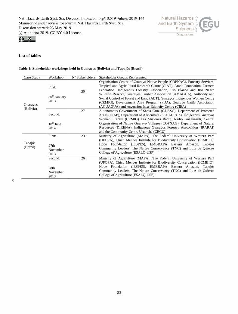
List of tables
Table 1: Stakeholder workshops held in Guarayos (Bolivia) and Tapajós (Brazil).
Case Study Workshop Nº Stakeholders Stakeholder Groups Represented
Guarayos (Bolivia)
First:
30th January 2013
30
Organisation Centre of Guarayo Native People (COPNAG), Forestry Services, Tropical and Agricultural Research Centre (CIAT), Arado Foundation, Farmers Federation, Indigenous Forestry Association, Rio Blanco and Rio Negro Wildlife Reserve, Guarayos Timber Association (AMAGUA), Authority and Social Control of Forest and Land (ABT), Guarayos Indigenous Women Centre (CEMIG), Development Area Program (PDA), Guarayo Cattle Association (AGUAGUA) and Ascensión Inter‐Ethnicity Centre (CIEA)
Second:
18th June 2014
27 Autonomous Government of Santa Cruz (GDASC), Department of Protected Areas (DIAP), Department of Agriculture (SEDACRUZ), Indigenous Guarayos Women’ Centre (CEMIG) Las Misiones Radio, Radio Guaguazuti, Central Organisation of Native Guarayo Villages (COPNAG), Department of Natural Resources (DIRENA), Indigenous Guarayos Forestry Asscoaition (IRARAI) and the Community Centre Urubichá (CECU)
Tapajós (Brazil)
First:
27th November 2013
23 Ministry of Agriculture (MAPA), The Federal University of Western Pará (UFOPA), Chico Mendes Institute for Biodiversity Conservation (ICMBIO), Hope Foundation (IESPES), EMBRAPA Eastern Amazon, Tapajós Community Leaders, The Nature Conservancy (TNC) and Luiz de Quieroz College of Agriculture (ESALQ‐USP)
Second:
28th November 2013
26 Ministry of Agriculture (MAPA), The Federal University of Western Pará (UFOPA), Chico Mendes Institute for Biodiversity Conservation (ICMBIO), Hope Foundation (IESPES), EMBRAPA Eastern Amazon, Tapajós Community Leaders, The Nature Conservancy (TNC) and Luiz de Quieroz College of Agriculture (ESALQ‐USP)
5
Nat. Hazards Earth Syst. Sci. Discuss., https://doi.org/10.5194/nhess-2019-144Manuscript under review for journal Nat. Hazards Earth Syst. Sci.Discussion started: 23 May 2019c© Author(s) 2019. CC BY 4.0 License.

24
Table 2: Structural metrics of Fuzzy Cognitive Maps analysed.
Structural Metric Definition Source
Outdegree
(od(vi))
Cumulative total of transmitted connection weights from each component (horizontal
cumulative sum within adjacency matrix).
Wasserman and Faust
1994
Indegree
(id(vi))
Cumulative total of received connection weights to each component (vertical sum within
adjacency matrix).
Wasserman and Faust
1994
Receiver variables
(R)
Components that receive connections from other components but does not influence others through outward connections (components with zero od(vi))
Özesmi and Özesmi 2003
Transmitter variables
or drivers
(T)
Components that solely influences other components through outward connections but does not receive connections (components with zero id(vi))
Özesmi and Özesmi 2003
Ordinary variables
(O)
Components that both influence and are influenced upon within the system Özesmi and Özesmi 2003
Density
(D)
Number of connections (𝐶) divided by the maximum number of possible connections between
a number N of components
𝐷 = 𝐶
𝑁(𝑁 − 1)
Devisscher et al. 2016;
Hage and Harary, 1983
Complexity
(CM)
Number of receiver components (R) divided by the number of transmitters (T). A receiver
being a
𝐶𝐶 = 𝑅𝑇
Devisscher et al. 2016;
Özesmi and Özesmi 2004
Betweeness
(Bw)
Betweenness is a centrality measure of influence of a node within a network. This measure quantifies the number of times a node acts as an intermediary along the shortest path between two other nodes.
Freeman, 1977;
Brandes, 2001
Page Rank
(PR)
Used to determine a node’s relevance or importance. PageRank value for a node 𝑢 is dependent on the PageRank values for each node v contained in the set 𝐵𝑢 (the set containing all nodes linking to node 𝑢), divided by the number L(𝑣) of links from page 𝑣.
𝑃𝑅 (𝑢) = �𝑃𝑅(𝜐)𝐿 (𝑣)
𝑣∈𝐵𝑢
Page et al., 1999;
Berkhim, 2005; this study
Nat. Hazards Earth Syst. Sci. Discuss., https://doi.org/10.5194/nhess-2019-144Manuscript under review for journal Nat. Hazards Earth Syst. Sci.Discussion started: 23 May 2019c© Author(s) 2019. CC BY 4.0 License.

25
Table 3: Overview of the simulated scenarios. 5
Scenario Description Case Study Guarayos Tapajós
Component Value change (with respect to steady state
baseline)
Scenario fixed value
Component Value change (with respect to steady state
baseline)
Scenario fixed value
1. Governance Reform
Introduces institutional and governance improvements to the system, with policies widely implemented and governmental communication and efficiency improved
Lack of understanding, application and coordination of laws
Decrease 0.4 Lack of governmental co-ordination
Decrease 0.4
Poor administration by community leaders
Decrease 0.3 Lack of efficiency in policies for subsistence Farming
Decrease 0.4
Lack of public policy Decrease 0.4
2. Techno-Social Reform
Considers a system in which investments are made in technical and social capital through capacity building, improvements in education and protection of traditional communities.
Lack of awareness of environmental problems
Decrease 0.2 Lack of environmental awareness
Decrease 0.2
Land encroachment Decrease 0.3 Lack of technical training and assistance
Decrease 0.3
Loss of subsistence agriculture by Guarayos Communities
Decrease 0.3 Technical and productive capacity
Increase 0.8
Lack of protection of traditional communities
Decrease 0.3
3. Conservation
Focusses solely upon conserving the environment, with no consideration of socio-economic development.
Compliance with land zoning
Increase 0.8 Environmental monitoring
Increase 0.8
Application of forest law
Increase 0.8
4. Agricultural Development
Encourages extractionist activities, such as agricultural expansion, encouraged to improve the socio-economic conditions of each region.
Agricultural expansion Increase 0.9 Agricultural expansion
Increase 0.9
Application of agricultural Law
Increase 0.8 Use of agrochemicals Increase 0.9
Agricultural intensification
Increase 0.8
5. Climate Change
The current system where climate change continues.
Climate change Increase 1.0 Climate change Increase 1.0
Nat. Hazards Earth Syst. Sci. Discuss., https://doi.org/10.5194/nhess-2019-144Manuscript under review for journal Nat. Hazards Earth Syst. Sci.Discussion started: 23 May 2019c© Author(s) 2019. CC BY 4.0 License.
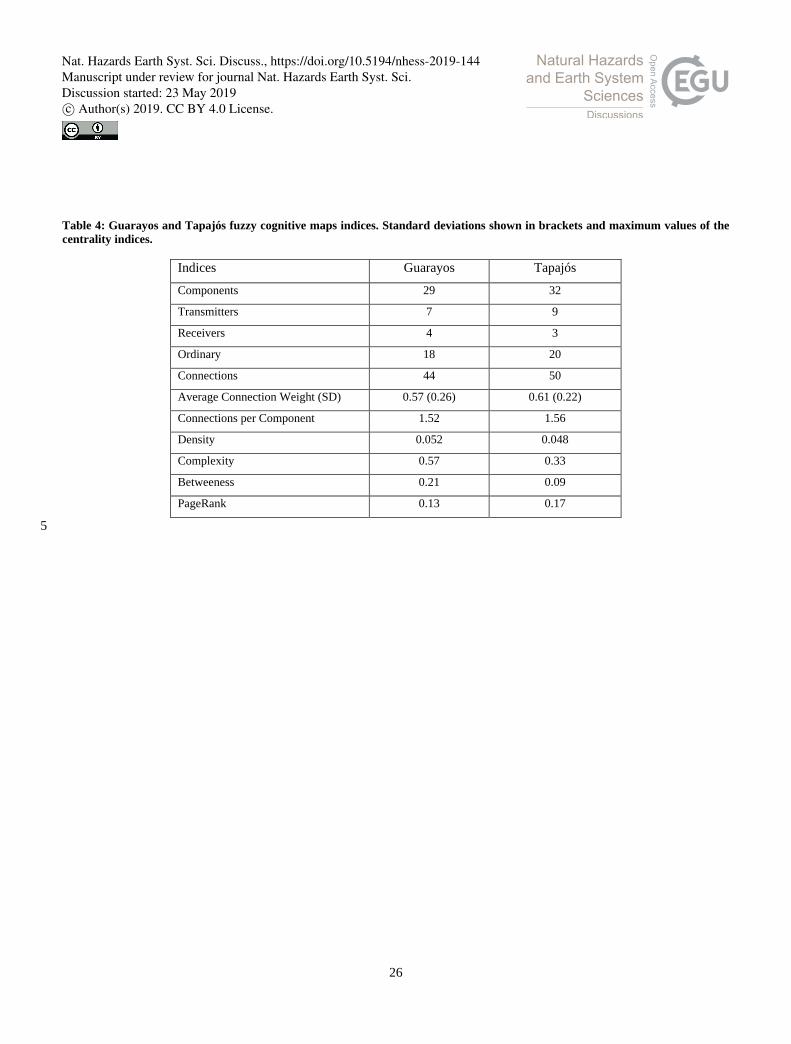
26
Table 4: Guarayos and Tapajós fuzzy cognitive maps indices. Standard deviations shown in brackets and maximum values of the centrality indices.
Indices Guarayos Tapajós
Components 29 32
Transmitters 7 9
Receivers 4 3
Ordinary 18 20
Connections 44 50
Average Connection Weight (SD) 0.57 (0.26) 0.61 (0.22)
Connections per Component 1.52 1.56
Density 0.052 0.048
Complexity 0.57 0.33
Betweeness 0.21 0.09
PageRank 0.13 0.17
5
Nat. Hazards Earth Syst. Sci. Discuss., https://doi.org/10.5194/nhess-2019-144Manuscript under review for journal Nat. Hazards Earth Syst. Sci.Discussion started: 23 May 2019c© Author(s) 2019. CC BY 4.0 License.

27
List of figures
Figure 1: Location of the case study sites (the Province of Guarayos in Bolivia and the Tapajós National Forest in Brazil). Case 5 studies shaded in brown. The Department of Santa Cruz (Bolivia) shaded in dark blue and the State of Pará (Brazil) in dark
green. The extent of the Amazon Basin is outlined in red.
Nat. Hazards Earth Syst. Sci. Discuss., https://doi.org/10.5194/nhess-2019-144Manuscript under review for journal Nat. Hazards Earth Syst. Sci.Discussion started: 23 May 2019c© Author(s) 2019. CC BY 4.0 License.
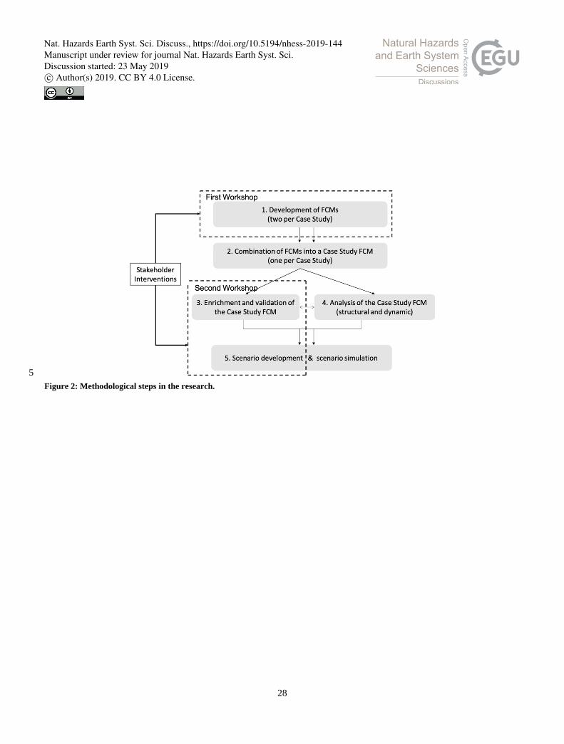
28
5 Figure 2: Methodological steps in the research.
Nat. Hazards Earth Syst. Sci. Discuss., https://doi.org/10.5194/nhess-2019-144Manuscript under review for journal Nat. Hazards Earth Syst. Sci.Discussion started: 23 May 2019c© Author(s) 2019. CC BY 4.0 License.

29
(a)
(b)
Figure 3: Frequencies of Betweeness (A) and PageRank values (B) in both case studies: Guarayos (red) and Tapajós (green)
0%
10%
20%
30%
40%
50%
60%
70%
80%0.
000.
010.
020.
030.
040.
050.
060.
070.
080.
090.
100.
110.
120.
130.
140.
150.
160.
170.
180.
190.
200.
21
Com
pone
nts (
%)
Betweeness
0%
5%
10%
15%
20%
25%
30%
35%
40%
45%
50%
0.00
0.01
0.02
0.03
0.04
0.05
0.06
0.07
0.08
0.09
0.10
0.11
0.12
0.13
0.14
0.15
0.16
0.17
Com
pone
nts (
%)
PageRank
Guarayos
Tapajós
Nat. Hazards Earth Syst. Sci. Discuss., https://doi.org/10.5194/nhess-2019-144Manuscript under review for journal Nat. Hazards Earth Syst. Sci.Discussion started: 23 May 2019c© Author(s) 2019. CC BY 4.0 License.
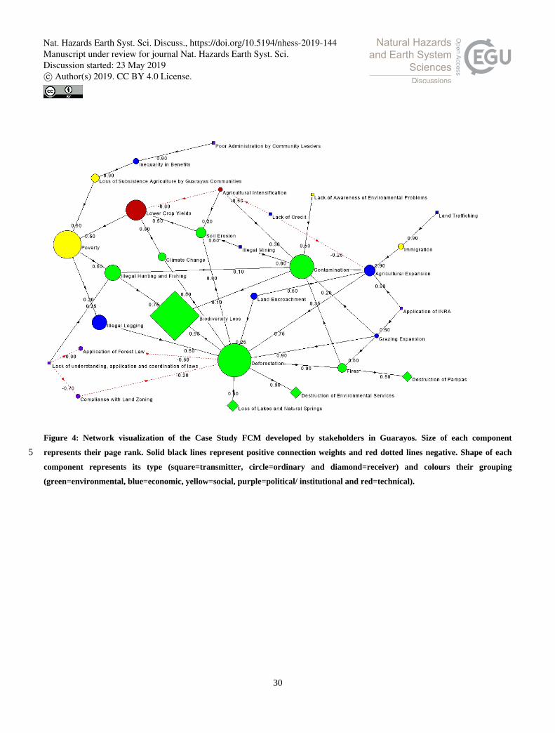
30
Figure 4: Network visualization of the Case Study FCM developed by stakeholders in Guarayos. Size of each component
represents their page rank. Solid black lines represent positive connection weights and red dotted lines negative. Shape of each 5 component represents its type (square=transmitter, circle=ordinary and diamond=receiver) and colours their grouping
(green=environmental, blue=economic, yellow=social, purple=political/ institutional and red=technical).
Nat. Hazards Earth Syst. Sci. Discuss., https://doi.org/10.5194/nhess-2019-144Manuscript under review for journal Nat. Hazards Earth Syst. Sci.Discussion started: 23 May 2019c© Author(s) 2019. CC BY 4.0 License.

31
Figure 5: Network visualization of the Case Study FCM developed by stakeholders in Tapajós. Size of each component represents
their page rank. Solid black lines represent positive connection weights and red dotted lines negative. Shape of each component 5 represents its type (square=transmitter, circle=ordinary and diamond=receiver) and colours their grouping
(green=environmental, blue=economic, yellow=social, purple=political/ institutional and red=technical).
Nat. Hazards Earth Syst. Sci. Discuss., https://doi.org/10.5194/nhess-2019-144Manuscript under review for journal Nat. Hazards Earth Syst. Sci.Discussion started: 23 May 2019c© Author(s) 2019. CC BY 4.0 License.
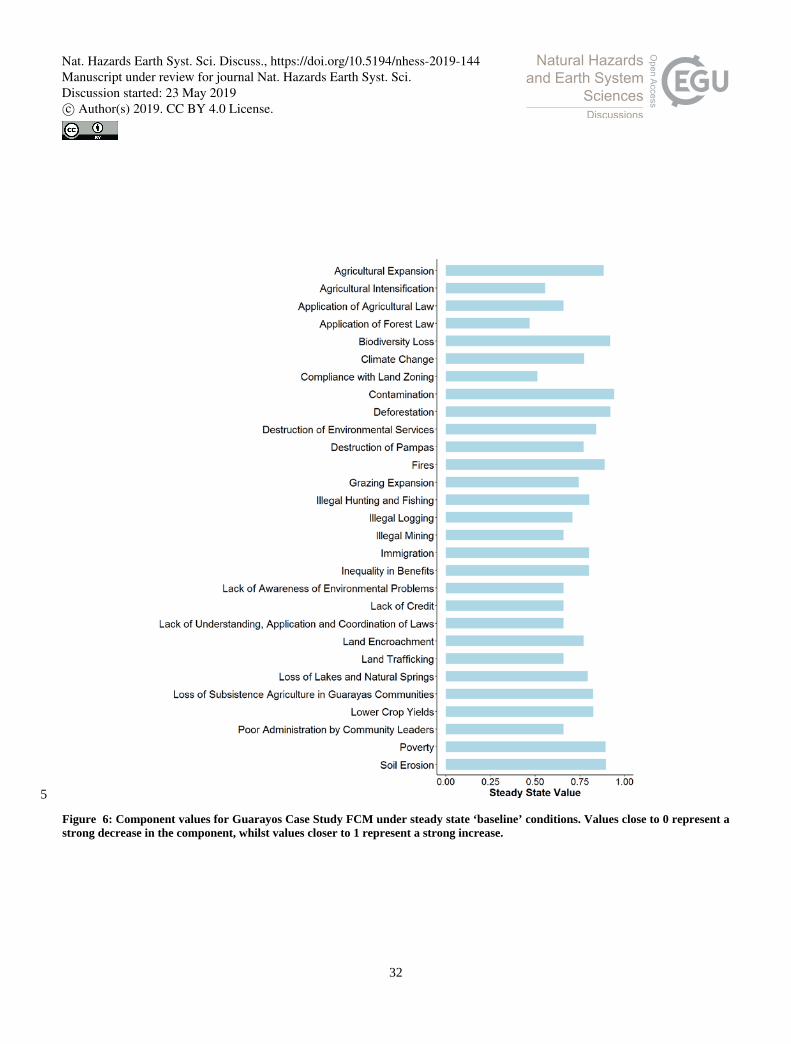
32
5
Figure 6: Component values for Guarayos Case Study FCM under steady state ‘baseline’ conditions. Values close to 0 represent a strong decrease in the component, whilst values closer to 1 represent a strong increase.
Nat. Hazards Earth Syst. Sci. Discuss., https://doi.org/10.5194/nhess-2019-144Manuscript under review for journal Nat. Hazards Earth Syst. Sci.Discussion started: 23 May 2019c© Author(s) 2019. CC BY 4.0 License.

33
Figure 7: Component values for Tapajós Case Study FCM under steady state ‘baseline’ conditions. Values close to 0 represent a
strong decrease in the component, whilst values closer to 1 represent a strong increase.
Nat. Hazards Earth Syst. Sci. Discuss., https://doi.org/10.5194/nhess-2019-144Manuscript under review for journal Nat. Hazards Earth Syst. Sci.Discussion started: 23 May 2019c© Author(s) 2019. CC BY 4.0 License.

34
Figure 8: Aggregated relative change and response of scenarios, compared with baseline. Negative values represent a ‘desirable’
change in the system. Positive values represent an ‘undesirable’ change in the system.
Nat. Hazards Earth Syst. Sci. Discuss., https://doi.org/10.5194/nhess-2019-144Manuscript under review for journal Nat. Hazards Earth Syst. Sci.Discussion started: 23 May 2019c© Author(s) 2019. CC BY 4.0 License.
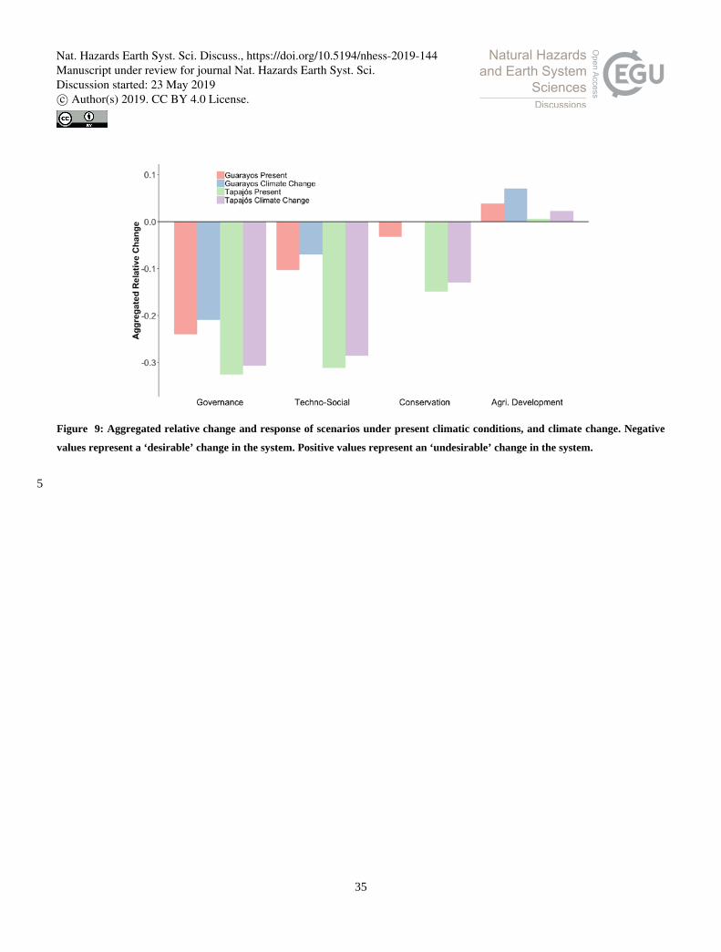
35
Figure 9: Aggregated relative change and response of scenarios under present climatic conditions, and climate change. Negative
values represent a ‘desirable’ change in the system. Positive values represent an ‘undesirable’ change in the system.
5
Nat. Hazards Earth Syst. Sci. Discuss., https://doi.org/10.5194/nhess-2019-144Manuscript under review for journal Nat. Hazards Earth Syst. Sci.Discussion started: 23 May 2019c© Author(s) 2019. CC BY 4.0 License.