evolution of a deep-seated rock mass movement observed with
TRANSCRIPT

Tazio Strozzi and Urs WegmüllerGamma Remote Sensing, Gümligen, Switzerland
Eric Perruchoud and Reynald DelaloyeDept. of Geosciences - Geography, University of Fribourg, Switzerland
Andreas KääbDept. of Geosciences, University of Oslo, Norway
Christian AmbrosiInstitute of Earth Sciences, University of Applied Sciences of Southern Switzerland
EVOLUTION OF A DEEP-SEATED ROCK MASS MOVEMENT OBSERVED WITH SATELLITE SAR INTERFEROMETRY

Aletschwald (VS), Switzerland
Length of the glacier: ~20 km

~1900 Aletschgletscher ~2000
(http://www.gletscherarchiv.de/karte.htm)

Aletschwald (VS), Switzerland

ERS-1/2 INSAR (Strozzi et al., IGARSS’02)
23ºfromnadir
2π
16.07.1999 - 29.10.1999 10.08.1995 - 26.07.1996 105 days, 7 m 351 days, 69 m
<-5 cm >+1 <-5 cm >+1
2π

1993.06.17_1996.08.041144 days / 45 m
JERS-1 and ALOS INSAR
2π
2006.06.13_2006.10.29138 days / -496 m
+ 35º from nadir_

ALOS PALSAR InSAR
+ 35º from nadir2π_
2006.09.13_2006.10.2946 days / 368 m
2006.06.13_2006.09.13, 92 days / -864 m
Rockglacier am Chriegelppass (VS)Landslide above Guttannen (BE)

1993.06.17_1996.08.041144 days / 45 m
JERS-1 and ALOS INSAR
2π
2006.06.13_2006.10.29138 days / -496 m
+ 35º from nadir_
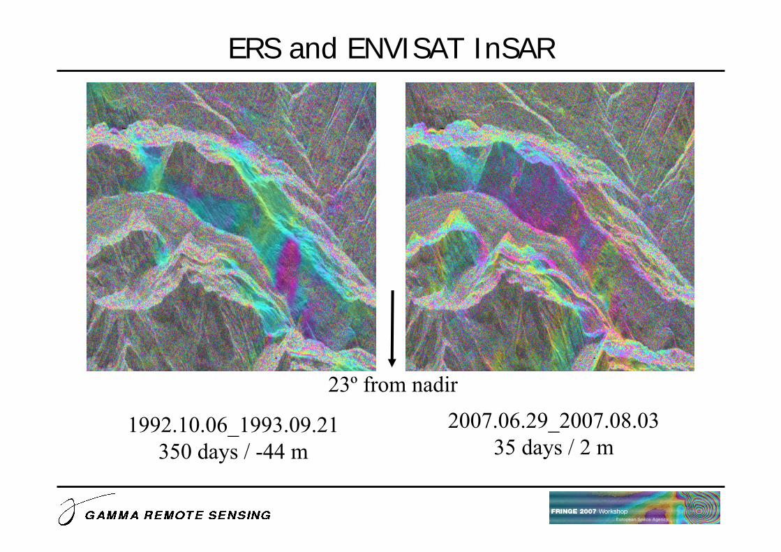
2007.06.29_2007.08.0335 days / 2 m
ERS and ENVISAT InSAR
23º from nadir
1992.10.06_1993.09.21350 days / -44 m

Gufer Rockglaciers (VS)
Reynald Delaloye, Landslide-like developement of rockglaciers detected with ERS-1/2 SAR interferometry, Poster at FRINGE 2007

2007.06.29_2007.08.0335 days / 2 m
ERS and ENVISAT InSAR
23º from nadir
1992.10.06_1993.09.21350 days / -44 m

20030829_20040709315 days / -69 m1046 Hz 1227 Hz
ERS-2 ZGM InSAR
23º from nadir20020913_20030829
350 days / 64 m1053 Hz 1046 Hz

Aletschwald landslide

Aletschwald landslide
Area of more than 1 km2

End of cableway
-10.00
-8.00
-6.00
-4.00
-2.00
0.00
01.01
.1992
31.12
.1993
31.12
.1995
31.12
.1997
31.12
.1999
30.12
.2001
31.12
.2003
30.12
.2005
31.12
.2007Li
ne-o
f-sig
ht d
ispl
acem
ent r
ate
(cm
/yea
r)
ERS▲ JERS◊ ENVISATΔ ALOS

-20.00
-16.00
-12.00
-8.00
-4.00
0.00
01.01
.1992
31.12
.1993
31.12
.1995
31.12
.1997
31.12
.1999
30.12
.2001
31.12
.2003
30.12
.2005
31.12
.2007Li
ne-o
f-sig
ht d
ispl
acem
ent r
ate
(cm
/yea
r)
Center of the landslide
ERS▲ JERS◊ ENVISATΔ ALOS

0.00
4.00
8.00
12.00
16.00
20.00
01.01
.1992
31.12
.1993
31.12
.1995
31.12
.1997
31.12
.1999
30.12
.2001
31.12
.2003
30.12
.2005
31.12
.2007
Dis
plac
emen
t rat
e (c
m/y
ear)
End of cableway
ERS▲ JERS◊ ENVISATΔ ALOS

0.00
8.00
16.00
24.00
32.00
40.00
01.01
.1992
31.12
.1993
31.12
.1995
31.12
.1997
31.12
.1999
30.12
.2001
31.12
.2003
30.12
.2005
31.12
.2007
Dis
plac
emen
t rat
e (c
m/y
ear)
Center of the landslide
ERS▲ JERS◊ ENVISATΔ ALOS

Geology (Crisinel, 1978)

Evolution of landslide instability
Ambrosi and Thüring, 2nd Swiss Geoscience Meeting, Lausanne, 2004

Evolution of landslide instability

Aletschwald landslide 2-Oct-1995
JERS-11993.06.171996.08.041144 days
45 m

Aletschwald landslide
ALOS PALSAR
2006.06.132006.10.29138 days-496 m
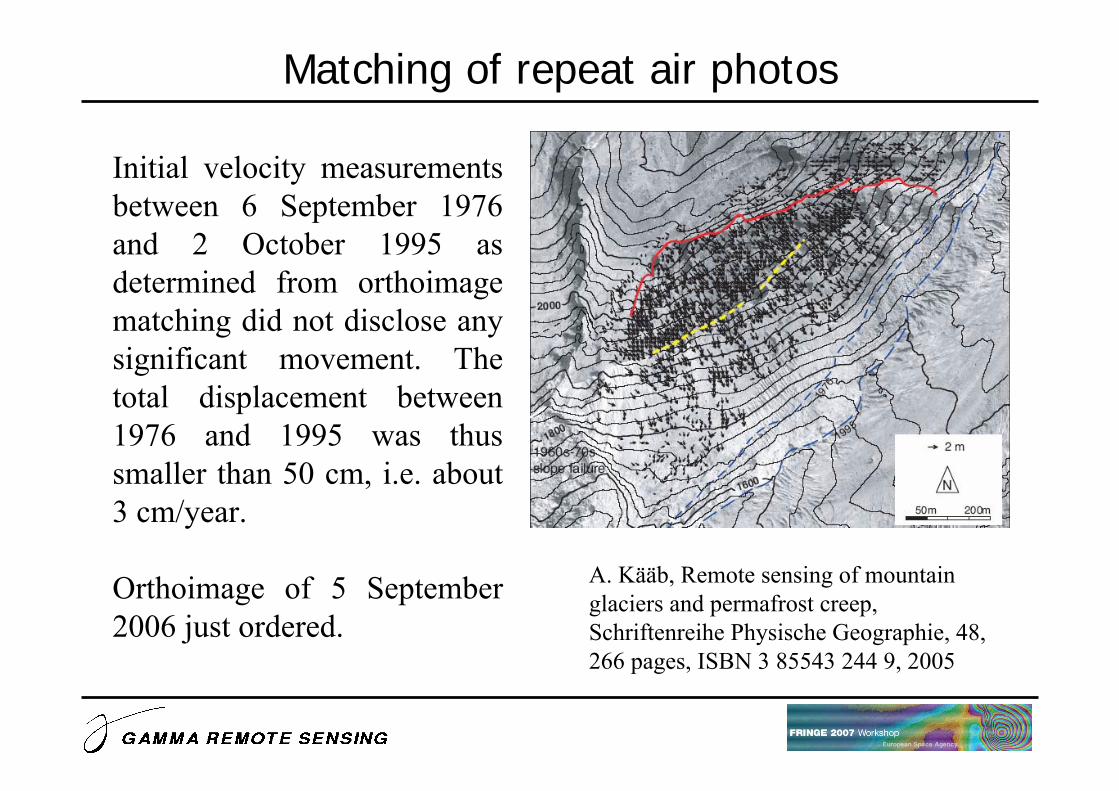
Matching of repeat air photos
Initial velocity measurements between 6 September 1976 and 2 October 1995 as determined from orthoimage matching did not disclose any significant movement. The total displacement between 1976 and 1995 was thus smaller than 50 cm, i.e. about 3 cm/year.
Orthoimage of 5 September 2006 just ordered.
A. Kääb, Remote sensing of mountain glaciers and permafrost creep, Schriftenreihe Physische Geographie, 48, 266 pages, ISBN 3 85543 244 9, 2005

Differential GPS measurementsJERS-1
1993.06.171996.08.041144 days
45 m

The displacement of an unstable slope in the Aletschwald region has been observed between 1992 and 2007 with SAR interferometry from the ERS-1, JERS, ERS-2, ENVISAT and ALOS satellites
Differential GPS measurements, matching of repeat air photos, aerial photography interpretation, numerical modeling of the slope deformation, and analysis of precipitation are ongoing to complement the differential SAR interferometric analysis
Conclusions
Archive of SAR acquisitions from 1992 up to now
ERS-2 ZGM InSAR data were used to complement the analysis from 2002 to 2004
ALOS PALSAR InSAR is of extremely high value for landslide studies