evidence for superelevation, channel incision, and … of turbidity currents geological society of...
TRANSCRIPT

For permission to copy, contact [email protected]© 2007 Geological Society of America
463
ABSTRACT
We performed a multibeam survey of Eel Canyon, offshore northern California. The survey revealed a signifi cant bend in the canyon that appears to be due to the oblique compressional tectonics of the region. A series of steps within a linear depression, ~280 m above the canyon fl oor, extends from the canyon rim at this bend to the subduction zone and a distinct fan-like topographic rise. We hypothesize that the linear depression is a distributary channel and the steps are cyclic-step bedforms created by turbidity currents. Our interpretation indicates that turbidity currents are able to run up and overspill the 280-m-high canyon wall, resulting in a partial avulsion of the canyon and the con-struction of a fan lobe that is offset from the canyon mouth. Simple hydraulic calculations show that turbidity currents generated in the canyon head from failure of 2–3 m of mate-rial would be capable of partially overfl ow-ing the canyon at this bend, assuming steady- uniform fl ow, full conversion of the failed mass into a turbidity current, and a range of friction coeffi cients. These estimates are con-sistent with analyses of sediment cores col-lected in the head of Eel Canyon, which sug-
gest that 2–3 m of material fails on decadal time scales. Our calculations show that the overfl owing parts of the currents would have large shear velocities (>10 cm/s) and super-critical Froude numbers, consistent with ero-sion of the distributary channel and forma-tion of cyclic steps by turbidity currents.
Keywords: submarine canyons, Eel River, tur-bidity currents, cyclic steps, channel formation, superelevation, avulsion.
INTRODUCTION
Turbidity currents are considered to be the dominant mechanism for carving submarine canyons (Daly, 1936; Kuenen, 1937), yet the interactions between turbidity currents and the canyons they incise are poorly known. Strati-graphic models suggest that submarine canyons and their associated fans are most active during sea-level lowstands, when rivers’ mouths are near the shelf-slope break and sediment loads are high (e.g., Stow et al., 1985; Posamentier et al., 1991). On collisional margins, however, can-yons can be active conduits for sediment even during sea-level highstands due to the relatively narrow continental shelves and high sediment loads found there. For example, the head of Monterey Canyon, California, is currently near the mouth of the Salinas River, and turbidity
currents occur frequently within the canyon (Johnson et al., 2001; Paull et al., 2003). In such settings, tectonics, sea level, climate, and sedi-ment supply all play important roles in shaping submarine geomorphology (e.g., Orange, 1999; Burger et al., 2002). Understanding the interac-tion of turbidity currents with the evolving mor-phology of submarine canyons is necessary for predicting the morphodynamics of the canyons, as well as the stratigraphic evolution of the sub-marine fans that they feed.
While turbidity currents are analogous to riv-ers in many respects, they differ in important ways. Like rivers, turbidity currents are driven by their excess density over the ambient fl uid. The density difference between a turbidity cur-rent and the surrounding seawater, however, is much less than the density difference between a river and the surrounding air. One important result of this is that turbidity currents are able to run up obstacles several times their fl ow depth through a process known as superelevation (Rott-man et al., 1985; Muck and Underwood, 1990; Lane-Serff et al., 1995; Kneller and McCaffery, 1999). While superelevation has received con-siderable attention for understanding overbank deposition in meandering submarine-fan chan-nels (Komar, 1969; Hay, 1987; Peakall et al., 2000; Pirmez and Imran, 2003) and overspill from enclosed minibasin topography (Pratson and Ryan, 1994; Edwards, 1993; Lamb et al.,
Evidence for superelevation, channel incision, and formation of cyclic steps by turbidity currents in Eel Canyon, California
Michael P. Lamb*Department of Earth and Planetary Science, University of California, Berkeley, California 94720-4767, USA
Jeffrey D. ParsonsHerrera Environmental Consultants, 2200 Sixth Avenue, Seattle, Washington 98121, USA
Beth L. MullenbachDepartment of Oceanography, Texas A&M University, College Station, Texas 77843-3146, USA
David P. FinlaysonSchool of Oceanography, University of Washington, Seattle, Washington 98195-7940, USA
Daniel L. OrangeUniversity of California, Santa Cruz, California 95064, USA, and AOA Geophysics Inc., Moss Landing, California 95039; now at Black Gold Energy, Jakarta, Indonesia
Charles A. NittrouerSchool of Oceanography, University of Washington, Seattle, Washington 98195-7940, USA
*E-mail: [email protected]
GSA Bulletin; March/April 2008; v. 120; 3/4; p. 463–475; doi: 10.1130/B26184.1; 12 fi gures.

Lamb et al.
464 Geological Society of America Bulletin, March/April 2008
2006), it is generally not considered for fl ows within incised canyons on the continental slope (Shepard and Dill, 1966). In fact, submarine canyons are considered to be the “type example of point sources turbidite systems” (Normark et al., 1993, p. 102), indicating that overspill is not thought to occur.
Herein we examine the interaction of turbid-ity currents with the topography of Eel Canyon, offshore northern California, based on a new bathymetric survey of the region. Eel Canyon is morphologically complex, which in part is due to the active tectonics of the region (Clarke, 1992). Of note is a large-scale ~90° bend in the canyon that turbidity currents must negotiate. In this paper we discuss a channel-like feature that extends outside of the canyon from this bend to the continental rise and a fan-like topographic feature. The fl oor of the channel is composed of long-wavelength quasi-periodic steps, which we interpret to be cyclic-step bedforms created by turbidity currents. We hypothesize that tur-bidity currents are capable of overfl owing the canyon at the bend due to superelevation, and are responsible for incision of the distributary channel, formation of the cyclic steps, and con-struction of the fan lobe. We use simple hydrau-lic calculations to show that modern failures in the canyon head can produce turbidity currents capable of overfl owing the canyon wall. Our interpretation is signifi cant because it implies that turbidity currents can partially avulse deeply
incised canyons and shift the locus of submarine fan deposition.
BACKGROUND
The Eel Canyon is located in the tectoni-cally complex region of the Cascadia subduc-tion zone and the Mendocino Triple Junction (MTJ) (Clarke, 1992) (Fig. 1). The region north of the MTJ is characterized by east-northeast compression related to the subduction of the Gorda plate beneath the North American plate. South of the MTJ, transpression associated with the San Andreas system dominates. The junc-tion is migrating northward at an average rate of 64 mm/yr (Atwater, 1970; McCrory, 1989); this produces a zone of north-south compression extending ~80 km north of the MTJ (Burger et al., 2002; Gulick and Meltzer, 2002). The Eel Canyon is within the zone where the structural grain has been deformed in response to the migrating MTJ (Fig. 1). Burger et al. (2002) hypothesized that the Eel Canyon formed ca. 500 ka when arrival of the MTJ (Gulick and Meltzer, 2002) resulted in uplift-induced ero-sion and shelf bypass of sediment.
The Eel River basin has been the subject of recent work to connect terrestrial sediment sources to the resulting depositional record (Nit-trouer and Kravitz, 1996; Nittrouer, 1999, Nit-trouer et al., 2007). The Eel River is the primary source of sediment to the offshore basin and has
exceptionally high sediment yields (~2 × 10⁷ ton/yr) for its drainage area (~9400 km2) (Griggs and Hein, 1972; Milliman and Syvitski, 1992). Much of the sediment discharged from the river during glacioeustatic and tectonic sea-level low-stands was probably funneled down Eel Can-yon, as indicated by buried channels (formed between 363 and 300 ka) imaged on the pres-ent-day shelf (Burger et al., 2001). Currently, ~50% of the sediment discharged from the Eel River is deposited on the shelf and open slope, and the remaining 50% remains unaccounted for over decadal time scales (Sommerfi eld and Nittrouer, 1999; Crockett and Nittrouer, 2004; Alexander and Simoneau, 1999). It is likely that much of the missing modern sediment resides in or is funneled through Eel Canyon (Scully et al., 2003; Mullenbach and Nittrouer, 2006).
The upper Eel Canyon has been shown to be an active pathway for gravity-driven sediment trans-port over seasonal time scales. An instrumented tripod was deployed in the uppermost reaches of the canyon at 120-m water depth and docu-mented the passage of a series of sediment-laden gravity currents (Puig et al., 2003; 2004). These events were generally not correlated with river discharge, and the gravity-driven transport was strongly infl uenced by wave motions. Though the gravity fl ows were not directly related to a particular fl ood event, surfi cial sediment found in the upper canyon was recently discharged from the river (on the order of days to months) based on short-time scale radioisotopic tracers found in cores (Mullenbach et al., 2004). Seasonal depos-its reaching thicknesses greater than ten centime-ters are common in cores from the canyon head following periods of elevated fl uvial discharge. Most deposits are physically stratifi ed, and some exhibit stratigraphic and radioisotopic discon-tinuities that point to the importance of slope failure over decadal time scales (Mullenbach and Nittrouer, 2006; Drexler et al., 2006).
Multibeam and multichannel seismic sur-veys of the Eel continental margin have been performed to understand how the overall struc-ture of the region (Clarke, 1992; Orange, 1999; Gulick et al., 1998, 2002; Gulick and Meltzer, 2002) and the topography of the shelf (Goff et al., 1996; Burger et al., 2001) relate to the mid-shelf mud depocenter (Sommerfi eld and Nittrouer, 1999; Wheatcroft and Borgeld, 2000). Concur-rent coring and multibeam surveys of the abyssal plain and rise complemented these earlier studies (Nelson et al., 2000). A survey focusing on Eel Canyon, however, was not performed. Owing to the newly appreciated importance of the canyon as a conduit for sediment (i.e., Mullenbach et al., 2004; Puig et al., 2004), we have mapped the canyon and identifi ed features that we interpret to be evidence for turbidity currents.
MendocinoTriple Junction
San A
ndreas Fault
Fig. 2
km
Figure 1. Regional map of offshore northern California showing major plate boundaries (after Clarke, 1992). The box roughly outlines the area shown in Figure 2.
Superelevation of turbidity currents
Geological Society of America Bulletin, March/April 2008 465
BATHYMETRY OF THE EEL CANYON
We obtained bathymetry by using the Krupp Atlas Elektronik Hydrosweep system aboard the R/V Thomas G. Thompson in mid-Octo-ber of 2001. The nominal echo frequency of the Hydrosweep is 15.5 kHz, with 59 beams spread throughout 90°. The outer beams were subject to large error associated with cross-contamination between beams (particularly in areas of rough topography) and variability in the speed of sound calculation. As a result, we truncated the outer 1–5 beams, depending on the degree of overlap with adjacent lines. The result is an along-track artifact (rail or seam) that appears at the junction between adjacent swaths. Considering that the topography of the canyon is extremely rough, we have not spa-tially fi ltered the output to eliminate the along-track artifact.
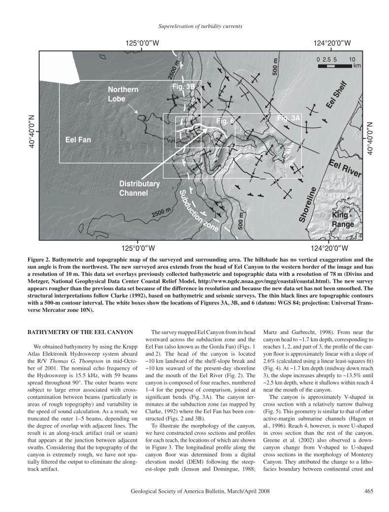
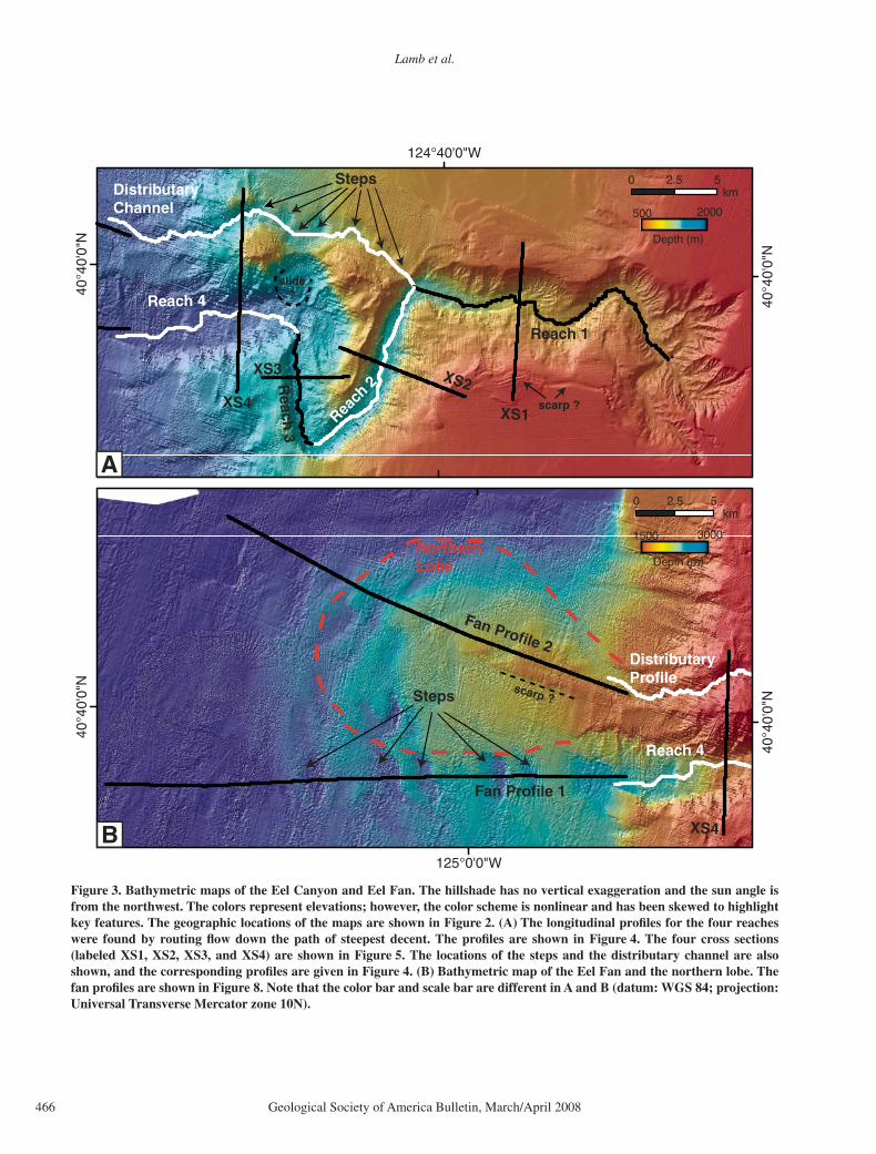
The survey mapped Eel Canyon from its head westward across the subduction zone and the Eel Fan (also known as the Gorda Fan) (Figs. 1 and 2). The head of the canyon is located ~10 km landward of the shelf-slope break and ~10 km seaward of the present-day shoreline and the mouth of the Eel River (Fig. 2). The canyon is composed of four reaches, numbered 1–4 for the purpose of comparison, joined at signifi cant bends (Fig. 3A). The canyon ter-minates at the subduction zone (as mapped by Clarke, 1992) where the Eel Fan has been con-structed (Figs. 2 and 3B).
To illustrate the morphology of the canyon, we have constructed cross sections and profi les for each reach, the locations of which are shown in Figure 3. The longitudinal profi le along the canyon fl oor was determined from a digital elevation model (DEM) following the steep-est-slope path (Jenson and Domingue, 1988;
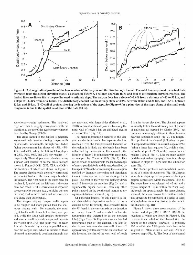
Martz and Garbrecht, 1998). From near the canyon head to ~1.7 km depth, corresponding to reaches 1, 2, and part of 3, the profi le of the can-yon fl oor is approximately linear with a slope of 2.6% (calculated using a linear least-squares fi t) (Fig. 4). At ~1.7 km depth (midway down reach 3), the slope increases abruptly to ~13.5% until ~2.5 km depth, where it shallows within reach 4 near the mouth of the canyon.
The canyon is approximately V-shaped in cross section with a relatively narrow thalweg (Fig. 5). This geometry is similar to that of other active-margin submarine channels (Hagen et al., 1996). Reach 4, however, is more U-shaped in cross section than the rest of the canyon. Greene et al. (2002) also observed a down-canyon change from V-shaped to U-shaped cross sections in the morphology of Monterey Canyon. They attributed the change to a litho-facies boundary between continental crust and
124°20′0″W
124°20′0″W
125°0′0″W
125°0′0″W
40
°40′
0″N
40
°40′
0″N
0 5 102.5km
Eel River
KingRangeS
ho
relin
e
Eel S
helf
Northern Lobe
Eel Fan
500 m2500 m
Fig. 3B
Fig. 3AFig. 6
Distributary Channel
500 m
2500
m
Subduction zone
Figure 2. Bathymetric and topographic map of the surveyed and surrounding area. The hillshade has no vertical exaggeration and the sun angle is from the northwest. The new surveyed area extends from the head of Eel Canyon to the western border of the image and has a resolution of 10 m. This data set overlays previously collected bathymetric and topographic data with a resolution of 78 m (Divins and Metzger, National Geophysical Data Center Coastal Relief Model, http://www.ngdc.noaa.gov/mgg/coastal/coastal.html). The new survey appears rougher than the previous data set because of the difference in resolution and because the new data set has not been smoothed. The structural interpretations follow Clarke (1992), based on bathymetric and seismic surveys. The thin black lines are topographic contours with a 500-m contour interval. The white boxes show the locations of Figures 3A, 3B, and 6 (datum: WGS 84; projection: Universal Trans-verse Mercator zone 10N).
Lamb et al.
466 Geological Society of America Bulletin, March/April 2008
124°40'0"W
40°4
0'0"
N
40°4
0'0"
N
0 52.5km
Reach 1
Reach
2Reach
3
Reach 4
DistributaryChannel
Steps
XS1
XS2XS3
XS4
125°0'0"W
40°4
0'0"
N
40°4
0'0"
N
0 52.5km
DistributaryProfile
Reach 4
XS4
Fan Profile 1
Fan Profile 2
Steps
NorthernLobe
slide?
scarp ?
500 2000
Depth (m)
1500 3000
Depth (m)
scarp ?
A
B
Figure 3. Bathymetric maps of the Eel Canyon and Eel Fan. The hillshade has no vertical exaggeration and the sun angle is from the northwest. The colors represent elevations; however, the color scheme is nonlinear and has been skewed to highlight key features. The geographic locations of the maps are shown in Figure 2. (A) The longitudinal profi les for the four reaches were found by routing fl ow down the path of steepest decent. The profi les are shown in Figure 4. The four cross sections (labeled XS1, XS2, XS3, and XS4) are shown in Figure 5. The locations of the steps and the distributary channel are also shown, and the corresponding profi les are given in Figure 4. (B) Bathymetric map of the Eel Fan and the northern lobe. The fan profi les are shown in Figure 8. Note that the color bar and scale bar are different in A and B (datum: WGS 84; projection: Universal Transverse Mercator zone 10N).
Superelevation of turbidity currents
Geological Society of America Bulletin, March/April 2008 467
accretionary-wedge sediments. The landward edge of reach 4 roughly corresponds with the transition to the toe of the accretionary complex described by Orange (1999).
The cross section of the canyon is generally asymmetric with steeper sloping canyon walls on one side. For example, the right wall (when facing downstream) has slopes of 45%, 43%, 42%, and 48%, while the left wall has slopes of 25%, 30%, 50%, and 23% for reaches 1–4, respectively. These slopes were calculated using a linear-least-squares fi t to the cross sections shown in Figure 5 (XS1, XS2, XS3, and XS4), the locations of which are shown in Figure 3. The steeper dipping walls generally correspond to the outer banks of the three major bends in the canyon. The right bank is the outer bank for reaches 1, 2, and 4, and the left bank is the outer bank for reach 3. This correlation is expected because gravity currents (e.g., turbidity currents or rivers) tend to move faster and are more ero-sive along their outer banks.
The steeper sloping canyon walls appear to be rougher and more gullied than the shal-lower sloping walls. For example, the north (right bank) wall of reach 1 is steep and gul-lied, while the south wall appears hummocky, and several small landslide scarps and deposits are visible (Fig. 3A). The south wall of reach 1 is also bounded by a canyon-parallel scarp near the canyon rim, which is similar to those observed on the Atlantic continental margin that
are associated with large slides (Driscoll et al., 2000). A potential slide deposit visible along the north wall of reach 4 has an estimated area in excess of 3 km2 (Fig. 3A).
The major morphologic features of the can-yon are the large bends that separate the four reaches. Given the transpressional tectonics of the region, it is likely that the bends have been infl uenced by deformation. For example, the location of reach 3 is coincident with anticlines, as mapped by Clarke (1992) (Fig. 2). This region also is coincident with the landward edge of trench-parallel folds and thrusts, described by Orange (1999) as the accretionary toe—a region typifi ed by dramatic shortening and signifi cant tectonic distortion due to the subducting Gorda plate. The crest of the west wall halfway down reach 2 intersects an anticline (Fig. 2), and is signifi cantly higher (>200 m) than any other point mapped on the continental margin at any equivalent distance seaward (Fig. 3).
Of particular interest for this paper is a lin-ear channel-like depression (referred to as a channel herein for brevity) that emanates from the 90° bend in the canyon axis at the junction of reaches 1 and 2, and extends to a fan-like topographic rise (referred to as the northern lobe) (Figs. 2 and 3). Figure 6 shows a detailed topographic map of this channel. The axis of the channel intersects the west wall of reach 2 approximately 280 m above the canyon fl oor. At this location, the rim of the west wall of reach
2 is at its lowest elevation. The channel appears to initially follow the northwest grain of a series of anticlines as mapped by Clarke (1992) but becomes increasingly oblique to these features near the subduction zone (Fig. 2). The longitu-dinal profi le of the channel (following the path of steepest descent) has an overall slope of 2.9% (using a linear least-squares fi t), which is simi-lar to the slope of ~2.6% of the canyon fl oor in reaches 1 and 2 (Fig. 4). Like the main canyon (and the regional topography), there is an abrupt increase in slope to 13.8% near the subduction zone (Fig. 4).
The channel profi le is not smooth but is com-posed of a series of seven steps (Fig. 4B). In plan view, these steps appear as quasi- circular topo-graphic depressions within the channel (Fig. 6). The steps have a wavelength of ~2 km and a typical height of 100 m within the 2.9% slop-ing reach. At approximately the same distance seaward, the main canyon fl oor within reach 2 also appears to be composed of a series of steps, although these are not as distinct as the steps in the channel (Fig. 4B).
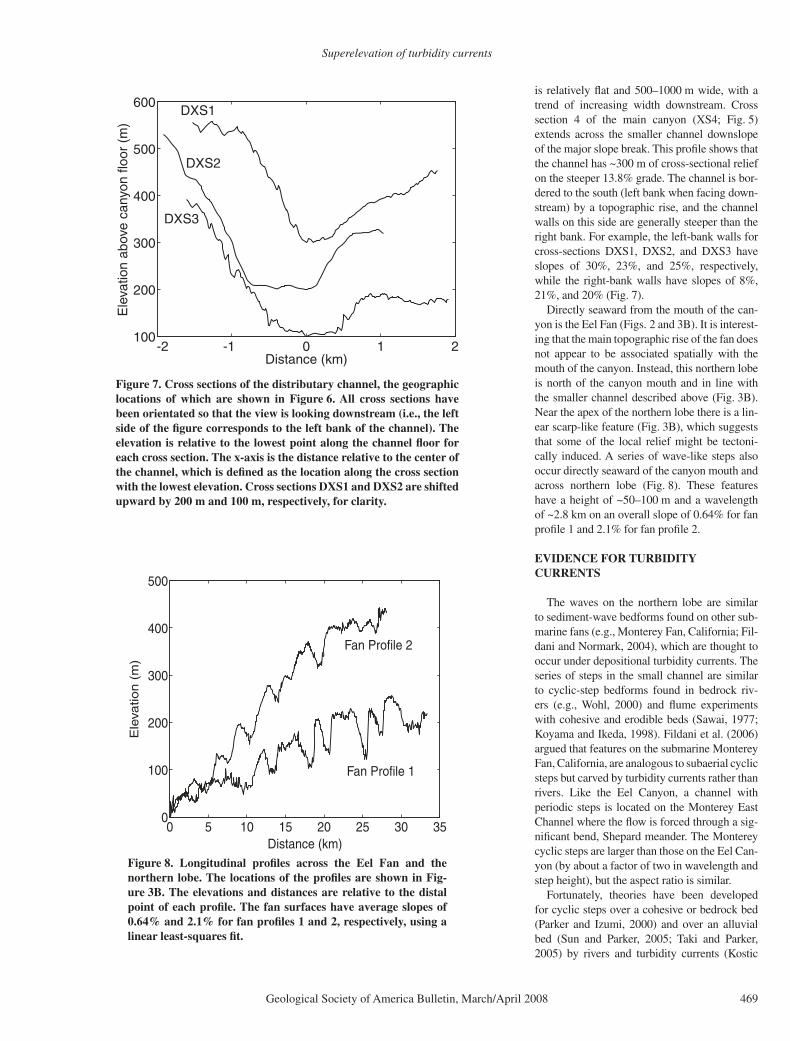
Figure 7 shows three cross sections of the channel and steps (DXS1, DXS2, DXS3), the locations of which are shown in Figure 6. The cross-sectional relief of the channel (i.e., the height of the channel sidewalls) is typically 100 m within the 2.9% grade reach but can be as great as 150 m within a step and ~50 m in between steps (Fig. 7). The fl oor of the channel
0 10 20 30 40 50
2.6
2.4
2.2
2
1.8
1.6
1.4
1.2
1
0.8
0.6D
epth
bel
ow s
ea le
vel (
km)
Distance (km)
Reach 1
Reach 2Reach 3
Reach
4
Distributary Channel
Distributary Channel
Fig. 4B
18 20 22 24 26 28 30 321700
1600
1500
1400
1300
1200
1100
1000
900
Dep
th b
elow
sea
leve
l (m
)
Distance (km)
Steps
Reach 2
Distributary channel
A B
Figure 4. (A) Longitudinal profi les of the four reaches of the canyon and the distributary channel. The solid lines represent the actual data extracted from the digital elevation model, as shown in Figure 3. The lines alternate thick and thin to differentiate between reaches. The dashed lines are linear fi ts to the profi les used to estimate slope. The canyon fl oor has a slope of ~2.6% from a distance of ~12 to 55 km, and a slope of ~13.8% from 5 to 12 km. The distributary channel has an average slope of 2.9% between 20 km and 31 km, and 13.8% between 12 km and 20 km. (B) Detail of profi les showing the locations of the steps. See Figure 6 for a plan view of the steps. Some of the small-scale roughness is due to the spatial resolution of the data (10 m).

Lamb et al.
468 Geological Society of America Bulletin, March/April 2008
-6 -4 -2 0 2 4 6 80
200
400
600
800
1000
1200
1400
1600
Ele
vatio
n ab
ove
cany
on fl
oor
(m)
Distance (km)
XS1XS2
XS3
XS4
0 1 2km
DX
S2
XS
4
Steps
Reach 4
Rea
ch 2
Reach 1
DistributaryChannel
124°40′0″W124°45′0″W124°50′0″W
40°4
0′0″
N
124°40′0″W124°45′0″W124°50′0″W
40°4
0′0″
NDXS1
DXS
3
900
m
1150
m
800
m
Figure 5. Cross sections of Eel Canyon. The locations of the sec-tions are shown in Figure 3A. All cross sections have been orien-tated so that the view is looking downstream (i.e., the left side of the fi gure corresponds to the left bank of the canyon). The eleva-tion is relative to the lowest point along the canyon fl oor for each cross section. The x-axis is the distance relative to the center of the canyon, which is defi ned as the location along the cross section with the lowest elevation. Cross sections XS1, XS2, and XS3 are shifted upward by 300 m, 200 m, and 100 m, respectively, for clar-ity. Note that the right most part of XS4 crosses the distributary channel (see Fig. 6).
Figure 6. Bathymetric map of the distributary channel and steps. The geographic location of the map is given in Figure 2. The hillshade has no vertical exaggeration, and the sun angle is from the northwest. The black lines are topographic contours with a contour interval of 50 m. Much of the small-scale roughness along contour is due to the spatial resolution of the data (10 m). The longitudinal profi les (following the path of steepest descent) of the distributary channel, reaches 1, 2, and 4, and cross section 4 (XS4) are shown by white lines. Cross sections of the distributary channel (DXS1, DXS2, and DXS3) are shown by black lines and are given in Figure 7. Note that the steps appear as quasi-circular depressions in plan view (datum: WGS 84; projection: Universal Transverse Mercator zone 10N).
Superelevation of turbidity currents
Geological Society of America Bulletin, March/April 2008 469
is relatively fl at and 500–1000 m wide, with a trend of increasing width downstream. Cross section 4 of the main canyon (XS4; Fig. 5) extends across the smaller channel downslope of the major slope break. This profi le shows that the channel has ~300 m of cross-sectional relief on the steeper 13.8% grade. The channel is bor-dered to the south (left bank when facing down-stream) by a topographic rise, and the channel walls on this side are generally steeper than the right bank. For example, the left-bank walls for cross-sections DXS1, DXS2, and DXS3 have slopes of 30%, 23%, and 25%, respectively, while the right-bank walls have slopes of 8%, 21%, and 20% (Fig. 7).
Directly seaward from the mouth of the can-yon is the Eel Fan (Figs. 2 and 3B). It is interest-ing that the main topographic rise of the fan does not appear to be associated spatially with the mouth of the canyon. Instead, this northern lobe is north of the canyon mouth and in line with the smaller channel described above (Fig. 3B). Near the apex of the northern lobe there is a lin-ear scarp-like feature (Fig. 3B), which suggests that some of the local relief might be tectoni-cally induced. A series of wave-like steps also occur directly seaward of the canyon mouth and across northern lobe (Fig. 8). These features have a height of ~50–100 m and a wavelength of ~2.8 km on an overall slope of 0.64% for fan profi le 1 and 2.1% for fan profi le 2.
EVIDENCE FOR TURBIDITY CURRENTS
The waves on the northern lobe are similar to sediment-wave bedforms found on other sub-marine fans (e.g., Monterey Fan, California; Fil-dani and Normark, 2004), which are thought to occur under depositional turbidity currents. The series of steps in the small channel are similar to cyclic-step bedforms found in bedrock riv-ers (e.g., Wohl, 2000) and fl ume experiments with cohesive and erodible beds (Sawai, 1977; Koyama and Ikeda, 1998). Fildani et al. (2006) argued that features on the submarine Monterey Fan, California, are analogous to subaerial cyclic steps but carved by turbidity currents rather than rivers. Like the Eel Canyon, a channel with periodic steps is located on the Monterey East Channel where the fl ow is forced through a sig-nifi cant bend, Shepard meander. The Monterey cyclic steps are larger than those on the Eel Can-yon (by about a factor of two in wavelength and step height), but the aspect ratio is similar.
Fortunately, theories have been developed for cyclic steps over a cohesive or bedrock bed (Parker and Izumi, 2000) and over an alluvial bed (Sun and Parker, 2005; Taki and Parker, 2005) by rivers and turbidity currents ( Kostic
-2 -1 0 1 2100
200
300
400
500
600
Ele
vatio
n ab
ove
cany
on fl
oor
(m)
Distance (km)
DXS1
DXS2
DXS3
Figure 7. Cross sections of the distributary channel, the geographic locations of which are shown in Figure 6. All cross sections have been orientated so that the view is looking downstream (i.e., the left side of the fi gure corresponds to the left bank of the channel). The elevation is relative to the lowest point along the channel fl oor for each cross section. The x-axis is the distance relative to the center of the channel, which is defi ned as the location along the cross section with the lowest elevation. Cross sections DXS1 and DXS2 are shifted upward by 200 m and 100 m, respectively, for clarity.
0 5 10 15 20 25 30 350
100
200
300
400
500
Ele
vatio
n (
m)
Distance (km)
Fan Profile 1
Fan Profile 2
Figure 8. Longitudinal profi les across the Eel Fan and the northern lobe. The locations of the profi les are shown in Fig-ure 3B. The elevations and distances are relative to the distal point of each profi le. The fan surfaces have average slopes of 0.64% and 2.1% for fan profi les 1 and 2, respectively, using a linear least-squares fi t.

Lamb et al.
470 Geological Society of America Bulletin, March/April 2008
and Parker, 2006). This work indicates that cyclic steps occur in Froude-supercritical fl ows (Fr
d > ~1), which are expected for turbidity cur-
rents in steep canyon systems. The bulk densi-metric Froude number is defi ned as
Frd = U
RCgh (1)
where U is the depth-averaged velocity, C is the depth-averaged volumetric sediment concentra-tion, R is the submerged specifi c gravity of the sediment (~1.6), g is the gravitational accelera-tion (9.8 m/s2), and h is the fl ow depth. Figure 9 shows an illustration of self-formed cyclic steps (following Parker and Izumi, 2000). The fl ow accelerates and becomes supercritical (Fr
d > 1)
over a step. At the base of the step, a hydraulic jump (Fr
d = 1) forms, and the fl ow is subcritical
downstream of the jump (Frd < 1). Acceleration
then occurs over the next step and the process continues. Over an erodible bed, the steps are stable and migrate upstream.
The drainage-network algorithm used to gen-erate the channel and canyon profi les shown in Figure 4 (Jenson and Domingue, 1988; Martz and Garbrecht, 1998) indicates that a gravity current capable of overfl owing the 280-m wall at the 90° bend in the canyon (at the junction of reaches 1 and 2) would fl ow downslope, through the channel-like depression, and to the northern lobe of the submarine fan (Fig. 3). This suggests that this linear depression could be a distribu-tary channel that serves as a conduit for turbid-ity currents. This interpretation explains why the depression is parallel to the trend of the regional slope (i.e., the direction gravity currents would fl ow), nearly the same slope as the main can-yon, along strike with reach 1 of the main can-yon, bounded upstream by a major bend in the canyon (where one might expect superelevation and overspill of turbidity currents), and bounded downstream by the apex of the northern lobe. Furthermore, the presence of steps in the chan-nel is consistent with cyclic-step bedforms gen-erated by turbidity currents.
Nonetheless, without direct observation (e.g., core samples or seismic-refl ection profi les) it is diffi cult to rule out a tectonic origin for some of these features. Tectonics have likely played a role in deforming the canyon and creating the abrupt bends. It seems unlikely, however, that the 90° bend in the canyon, the linear channel-like depression, the quasi-periodic steps, and the northward displaced fan all were created and coincidently aligned by tectonic deformation. In contrast, these features would be expected from erosion and deposition by turbidity currents.
The morphologic features described herein do not resolve the origin of the turbidity currents forming the canyon or the distributary channel.
The cyclic steps imply that fl ow was sustained long enough for setup of periodic hydraulic jumps. This suggests fl ow durations of tens of minutes or more (e.g., Lamb et al., 2004a). One possible generation mechanism is plunging hyperpycnal river plumes (Nemec, 1995; Mulder et al., 1997; Kineke et al., 2000; Parsons et al., 2001, 2007; Walsh and Nittrouer, 2003; Myrow et al., 2006). Hyperpycnal plumes were probably more common at sea-level lowstand because the Eel River would have fed directly into the canyon (Burger et al., 2001). Modeling efforts suggest, however, that large fl oods of the Eel River can produce hyperpycnal plumes during sea-level highstand as well (Mulder and Syvitski, 1995).
Nonetheless, oceanographic measurements indicate that Eel River fl oods and transport events in the canyon are generally not correlated in time (Puig et al., 2003). Much of the sedi-ment discharged from the river is deposited on the inner and middle shelf (e.g., Wheatcroft and Borgeld, 2000; Crockett and Nittrouer, 2004), and some of this sediment is later suspended and moved seaward by wave-supported gravity cur-rents (i.e., fl uid muds) (e.g., Ogston et al., 2000; Traykovski et al., 2000, Scully et al., 2003). Lab-oratory experiments in a wave duct have shown that waves typical of the Eel continental shelf during storms are capable of supporting near-bed suspensions with depth- averaged concen-trations of 25 kg/m3 and high sand contents (up to 80%) (Lamb et al., 2004b; Lamb and Parsons, 2005). Gravity fl ows in the uppermost part of the canyon also have been attributed to failure of recently deposited material due to wave loading (Puig et al., 2004). Both wave-supported grav-ity currents and wave-induced failures probably
contribute to the seasonal deposits in the canyon heads, which can be many centimeters thick, physically stratifi ed, and in some cases contain high concentrations of sand (up to 50%) (Drex-ler et al., 2006). It is failure of these deposits on decadal time scales (Mullenbach and Nit-trouer, 2006) that probably forms turbidity cur-rents large enough to traverse the lower canyon, superelevate at the 90° bend in the canyon, overfl ow the 280-m-high canyon wall, carve the distributary channel, and form the cyclic steps. In the following section we test this hypothesis by using simple fl uid- mechanical arguments to illustrate conditions necessary for overfl ow at the canyon bend.
ANALYSIS
To determine the size and speed of turbid-ity currents that might occur in the canyon, the amount of sediment contained within the fl ows needs to be established. Mullenbach and Nit-trouer (2006) found that, at 160-m and 200-m water depth in the canyon head, ~2–3 m of sediment could fail about every 10–30 yr. These results were derived from the seasonal deposi-tion rate, a stability analysis of the sediment accumulating on a fi xed surface, and observed erosional contacts. The sharp contacts (evident from X- radiographs) were found to be coin-cident with down-core discontinuities in 210Pb activity at some thalweg locations; this indi-cates that a signifi cant portion of the sediment record had been removed. The failed material obtained from this analysis can be used as a one- dimensional estimate for the amount of sediment participating in a turbidity current.
Hydraulic jumpsFrd = 1
Frd < 1 > 1
Frd
Clear water
Turbid water
Basement
within step
Figure 9. Illustration of cyclic steps formed by a turbidity current (modifi ed from Parker and Izumi, 2000). Frd in the schematic is local densimetric Froude number.

Superelevation of turbidity currents
Geological Society of America Bulletin, March/April 2008 471
The thickness of a turbidity current h can be calculated from continuity as
h f C= −( )1 φ η / , (2)
where f is the fraction of failed mass that par-ticipates in the turbidity current, η is the thick-ness of sediment to fail, and φ is the porosity of the seabed (0.65, which is consistent with core data). The sediment concentration of a turbidity current (i.e., its driving force) must be within a relatively small range and is typi-cally ~20 kg/m3 (i.e., C ≈ 0.75%; Parsons and Garcia, 1998). Flows that are substantially more concentrated (i.e., >100 kg/m3) generally do not behave as a Newtonian fl uid. Less concen-trated fl ows (<10 kg/m3) do not produce enough shear and turbulence to maintain the suspension. Unfortunately, the fraction of a failed mass that can become a turbidity current is poorly known. To proceed, we simply assume that all of the failed mass participates in the turbidity current (f = 1), making our estimate of h a maximum. This assumption is discussed in detail in the next section. Figure 10A shows the calculated maximum fl ow depth from equation 2 as a func-tion of failure thickness, assuming C = 0.75% and f = 1. For a failed mass that is typical of the upper Eel Canyon (~2–3 m; Mullenbach and Nittrouer, 2006), the height of the current is cal-culated to range from 93 to 140 m. Note that this is signifi cantly smaller than the height the fl ow must achieve to overfl ow the 280-m-high can-yon wall at the bend between reaches 1 and 2.
There are two mechanisms that might explain how turbidity currents generated from failure of 2–3 m of material can overfl ow the 280-m-high canyon wall. First, turbidity currents can erode sediment from the bed and entrain ambient sea-water. This can cause fl ows to grow large and fast due to a feedback between sediment entrain-ment and fl ow depth (or velocity) (Parker, 1982). The growth of a turbidity current due to entrain-ment, however, is diffi cult to quantify without introducing substantial assumptions (e.g., the erodibility of the bed). This effect, therefore, is neglected in our analysis, making our estimates of current height somewhat conservative.
The second mechanism is superelevation, which is expected for turbidity currents (or any gravity current) where the fl ow is directed around a bend or confronted by an obstacle (e.g., see Hay [1987] for a documented fi eld case of turbidity-current superelevation). Turbidity cur-rents superelevate because of the conversion of kinetic to potential energy, which allows them to abandon a confi ning channel or fl ow over an obstruction (e.g., Edwards, 1993; Lane-Serff et al., 1995; Kneller and Buckee, 2000; Lamb et al., 2004a). In order to estimate the magnitude
0
50
100
150
200
250
Flo
w d
epth
h (
m)
0
0.5
1
She
ar v
eloc
ity u
* (m
/s)
0 1 2 3 4 50
100
200
300
400
500
Run
up h
eigh
t H (
m)
Failure thickness η (m)
u* h
Suspension threshold D = 1 mm
0
5
10
15
20
Flo
w v
eloc
ity U
(m
/s)
c f = 0.001
cf = 0.005 cf
= 0.01c f
= 0.
001
c f = 0.005
c f = 0.01
Height of Eel Canyon wall
A
B
C
Figure 10. Estimates of turbidity-current characteristics within reach 1 (S = 2.6%) as a function of thickness of a failed mass (η). These calculations assume that 100% of the failed mass is converted into a turbidity current. The shaded region represents the size of failures that occur on decadal time scales in Eel Canyon, following the analysis of Mullenbach and Nittrouer (2006). (A) The fl ow depth h (solid line) calculated from equation 2 and bed shear velocity u* (dashed line) calculated from equation 4 for various failure thicknesses. The horizontal dashed line represents the shear velocity necessary to suspend 1-mm-diameter (D) sediment. This was found by equating the shear velocity to the particle-settling velocity calculated for natural sediment following Diet-rich (1982). (B) The depth-averaged fl ow velocity (U) of a turbidity current, calculated from equation 3, as a function of failure thickness for three different values of the friction coeffi cient (c
f). (C) The total runup height (H) of a turbid-
ity current calculated from equation 5 for a range of failure thicknesses and friction coeffi cients. The height of the canyon wall at the junction of reaches 1 and 2 is shown as a dashed line for reference.

Lamb et al.
472 Geological Society of America Bulletin, March/April 2008
of superelevation, the velocity of the current fi rst must be established.
For dilute turbidity currents (i.e., C <<1), the depth-averaged velocity U can be estimated by assuming steady and uniform fl ow conditions, as
U u cf= *2 . (3)
The bed shear velocity u* is given by
u RCghS* = , (4)
where S is the bed slope (where a low-slope approximation has been used: sin θ ≈ tan θ) and c
f is a coeffi cient of friction that accounts
for bed and entrainment drag along the bound-aries of the current. The friction coeffi cient has been shown to range from 10−3 to 10−2 (Parker et al., 1987) although c
f ≈ 5 × 10⁻³ is typically
considered accurate for fi eld-scale turbidity cur-rents (e.g., Parker et al., 1986; Dade et al., 1994; Mulder et al., 1997; Pirmez and Imran, 2003). Because c
f is poorly known, we solve equations
3 and 4 for a range in friction coeffi cients as shown in Figure 10B. This, for example, results in a fl ow velocity ranging from 5.3 to 16.8 m/s for fl ow through reach 1 (S = 2.6%) generated from a 2-m-thick failure. This velocity is some-what smaller than the calculations made by Heezen and Ewing (1952) of the turbidity cur-rent associated with the Grand Banks slide, but it is comparable to estimates for smaller turbid-ity currents in canyons and fan channels (e.g., Monterey East Channel: Fildani et al., 2006; Scripps Canyon: Inman et al., 1976; Amazon Fan: Pirmez and Imran, 2003).
Our calculated shear velocities u* (Fig. 10A)
are large, suggesting that the fl ows considered would be able to suspend sediment. Flows typi-cally are considered competent to suspend sedi-ment if the shear velocity is greater than the fall velocity of sediment w
s (i.e., u
* > w
s). For refer-
ence, Figure 10A shows the settling velocity for 1-mm sand, which is substantially larger than that for the unconsolidated mud or very fi ne sand typical of the upper canyon (Mullenbach and Nittrouer, 2006; Drexler et al., 2006). This supports the idea that our estimates of fl ow thickness and velocity are conservative because we have neglected the potential for fl ows to grow by entrainment of bed sediment.
The magnitude of superelevation can be esti-mated by balancing the centrifugal force and the resulting pressure gradient force in a bend (e.g., Komar, 1969; Pirmez and Imran, 2003). Recent experiments, however, have shown that this method substantially underestimates superel-evation of turbidity currents: Straub et al. (2008) found more success by assuming full conver-sion of kinetic to potential energy, which is a common way to assess the overfl ow of obsta-cles by turbidity currents (e.g., Rottman et al., 1985; Muck and Underwood, 1990; Kneller and McCaffery, 1999). Therefore, we estimate the potential runup height of a turbidity current (H) as the sum of the current height and the magni-tude of superelevation, assuming full conversion of kinetic to potential energy,
H hU
RCg= +
2
2. (5)
For all of the conditions considered, a 3-m failure would produce a fl ow capable of over-fl owing the 280-m-high canyon wall at the junction of reaches 1 and 2 (in some cases by hundreds of meters) (Fig. 10C). A 2-m failure would overfl ow the canyon at the bend as long as c
f <~7 × 10⁻³, which is likely. While these esti-
mates are crude, they nonetheless illustrate that it is plausible for modern failures in the head of Eel Canyon to produce turbidity currents capable of partially avulsing the canyon due to superelevation.
Because overspill of turbidity currents into the distributary channel seems possible, it is worth considering the fl ow conditions that might be prevalent there. Using the overall slope within the upper part of the distributary channel (S = 2.9%) and assuming C = 0.75%, we calculated the fl ow velocity and shear velocity (using equa-tions 3 and 4) for a range in overfl ow depths and friction coeffi cients. From the estimates of runup, it seems likely that the overspilling tur-bidity currents would have fl ow depths of tens of meters or more (Fig. 10C). For these condi-tions, the calculated shear velocities are large in comparison with the competency thresholds for suspension of unconsolidated sand or mud (Fig. 11). Like the estimates for the main can-yon, the calculated fl ow velocities in the dis-tributary channel are meters per second or more (Fig. 11).
Equations 1–4 can be combined to estimate the bulk densimetric Froude number for the fl ows within the main canyon and in the dis-tributary channel. Combining these equations shows that for steady uniform fl ow, the Froude
0
0.2
0.4
0.6
She
ar v
eloc
ity u
* (m
/s)
0 50 1000 50 1000
2
4
6
8
10
Flo
w v
eloc
ity U
(m
/s)
Flow thickness h (m)
c f =
0.00
1
c f = 0.005
c f = 0.01
Suspension threshold D = 1 mm
A B
Flow thickness h (m)
Figure 11. Estimates of turbidity-current characteristics within the distributary channel (S = 2.9%) as a function of thickness of the over-fl owing turbidity current (h). (A) The bed shear velocity u* was calculated from equation 4. The horizontal dashed line represents the shear velocity necessary to suspend 1-mm-diameter (D) sediment (see Fig. 10 for details). (B) The depth-averaged fl ow velocity (U) of a turbidity current, calculated from equation 3), for three different values of the friction coeffi cient (c
f).

Superelevation of turbidity currents
Geological Society of America Bulletin, March/April 2008 473
number is simply a function of the channel slope and the friction coeffi cient, i.e.,
Frd = =U
RCgh
S
cf
. (6)
For slopes >1%, supercritical Froude numbers are expected for all friction coeffi cients con-sidered (Fig. 12). Given that the slopes in both the main canyon and the distributary channel exceed 1% by nearly a factor of three or more indicates that turbidity currents that occur there would be supercritical. This is consistent with our hypothesis that turbidity currents are respon-sible for formation of the cyclic steps, because cyclic steps require supercritical fl ow conditions (Parker and Izumi, 2000).
DISCUSSION
Perhaps the biggest limitation in our quan-titative analysis of turbidity currents is the assumption of full conversion of a failed mass into a turbidity current. Because natural events are extremely destructive to any sort of equip-ment, most of the estimates of the effi ciency of failures to produce turbidity currents have been based upon laboratory experiments (e.g., Moh-rig et al., 1998; Marr et al., 2001). In the experi-ments analyzed by Mohrig and Marr (2003), ~1% of a failed mass was converted into a tur-bidity current. There are two key differences between previous experiments of slide-induced turbidity currents and the failures within the Eel Canyon. First, the sand contents typically examined in the laboratory experiments were much higher and the porosities were much lower than those found within the canyon. The individual beds found within Eel Canyon are predominantly silty with highly variable sand contents (0%–50%). The sand contents averaged over 30-cm-long cores are generally <20%, however, and the porosities are typi-cally 0.65 or greater (Drexler et al., 2006). The experiments analyzed by Mohrig and Marr (2003) used mixtures that were predominantly sandy (48%–96%) with low porosities (0.34–0.53), and therefore were less easily sheared and mixed into turbidity currents. Second, and probably most important, is that mixing pro-cesses responsible for incorporation of failed material into a turbulent continuum are highly scale dependent (Parsons and Garcia, 1998). The addition of a large amount of sediment to the water column increases the effective viscos-ity of the fl ow, which in turn reduces the spec-tral gap between the large-scale mean motions of the fl ow and those associated with viscosity. The result is that fully turbulent behavior is
extremely diffi cult to attain from a slope failure in any small-scale laboratory experiment.
Cyclic steps can occur in net-erosional (Parker and Izumi, 2000) or net-depositional fl ows (Sun and Parker, 2005): Fildani et al. (2006) suggested that the steps in the distribu-tary channel on the Monterey Fan are analogous to the former, whereas fi elds of sediment waves found throughout the fan are analogous to the latter. From the topographic low of the distribu-tary channel on the Eel Canyon, we know that depositional fl ows in this region are rare. The fi elds of sediment waves on the northern lobe, however, could be depositional cyclic steps. The difference in size of the cyclic steps in Eel Canyon compared to the Monterey Fan might be due to differences in the size of the characteris-tic turbidity currents in the distributary channels (smaller Fr
d favors larger steps), the erodibility
of the bed (more easily erodible material favors larger steps), or the overall channel slope (lower channel slope favors larger steps) (Parker and Izumi, 2000). This latter prediction is consistent with observations. The overall slope in the Eel Canyon distributary channel is ~2.9%, whereas the Monterey Fan distributary has a lower slope ranging from 0.3% to 1.3% (Fildani et al., 2006), and has larger steps.
Despite the uncertainty in the role of tecton-ics in regulating the depth and history of the distributary, the location of the distributary
head is likely a result of tectonic activity. The oblique compressional tectonics has had a tendency to juxtapose different reaches of the canyon. Where margin-parallel perturba-tions become too large, turbidity currents can migrate because of the propensity of these fl ows to superelevate. Targeted multichannel seismic imaging of the canyon may help resolve the relative strengths of turbidity- current incision and tectonic deformation.
Another interesting problem motivating future exploration of the canyon is determination of the percentage of fl ow that exits the canyon via the distributary. Such an analysis is diffi cult because only rough estimates for the sizes of fl ows can be determined. A controversial idea is that the distributary could be an indication of avulsion and abandonment of the main canyon. If ignitive fl ows (i.e., fl ows that are able to erode a consid-erable amount of material along their path and thus become signifi cantly larger than the original event) are common, their size may be suffi cient to propel most of the material outside of the can-yon. If incision of the distributary channel out-paces tectonic deformation, the distributary may become an increasingly important pathway of abyssal-bound sediment, reinforcing the avulsion of the main canyon. This could lead to complex patterns in the depositional record, including interfi ngering turbidite beds and fan lobes, offset stacking of channel-levee complexes (Weimer,
10-2 10-1 100 1010
0.5
1
1.5
2
2.5
3
Channel slope (%)D
ensi
met
ric F
roud
e nu
mbe
r Fr
d
c f =
0.00
1c f
= 0.
005
c f =
0.01
S =
2.9
%
Frd = 1
Figure 12. The bulk densimetric Froude number (Frd) calculated from equation 6 as a function of channel slope (S) and the fric-tion coeffi cient (c
f). The horizontal dashed line represents (Frd) = 1,
which is a minimum value needed for formation of cyclic steps. The vertical dashed line represents the average slope of the dis-tributary channel (S = 2.9%). Note that all fl ows considered within the distributary channel would be supercritical and therefore capable of forming cyclic steps.

Lamb et al.
474 Geological Society of America Bulletin, March/April 2008
1991; Twichell et al., 1991), and a shift in the depocenter of Eel River sediment.
CONCLUSIONS
The oblique compressional tectonics of the Eel continental margin have forced a signifi cant bend in the submarine Eel Canyon. A distribu-tary channel extends from the canyon rim, at the bend in the canyon, to a northern lobe of the Eel Fan. We have interpreted features within the channel to be cyclic-step bedforms generated by Froude-supercritical turbidity currents. Mea-surements from cores taken in the upper canyon heads indicate that 2–3 m of predominantly fi ne-grained sediment fails on decadal time scales (Mullenbach and Nittrouer, 2006). Failure of this material provides the simplest explanation for turbidity currents in the canyon. We propose that the bend in the canyon acts as an obstruc-tion to turbidity currents, forcing them to super-elevate and partially overfl ow the 280-m-high outerbank canyon wall. Our calculations indi-cate that turbidity currents generated from these failures are capable of partially overfl owing the canyon, and that the overfl ow portion is compe-tent to suspend sand and form the cyclic steps. Superelevation of turbidity currents and channel formation are potentially important processes in the Eel Canyon for shifting the depocenter of Eel River sediments through a partial avulsion of the canyon. Such processes might be important on other continental margins where tectonics can alter the course of a submarine canyon.
APPENDIX 1 – NOTATION
C Depth-averaged volumetric sediment concentra-tion
cf Bulk friction coeffi cient
f Fraction of a failed mass that becomes a turbid-ity current
Frd Bulk densimetric Froude number
g Acceleration due to gravity h Flow depthH Total run-up heightR Submerged specifi c density of sedimentS Average channel slope u
* Bed shear velocity
U Depth-averaged velocity w
s Terminal settling velocity of sediment
η Thickness of a failed mass φ Porosity of the seabed
ACKNOWLEDGMENTS
This study was funded by Offi ce of Naval Research grant N000149910028 and National Undersea Research Program grant UAF(WA-00–05). Norman Maher helped plan the bathymetric survey. We thank Wayne McCool, John Crockett, David Drake, and Leda Beth Gray for assisting on the cruise. Rob Hagg helped ensure the success in later stages of the cruise by supplying us with on-the-fl y imagery of the can-yon. Tina Lomnicky aided in post-processing of the
multibeam data. Paul Heller, Roger Slatt, John Warme, and Gerilyn Soreghan provided helpful reviews of an earlier draft. Paul Heller and Carlos Pirmez provided constructive reviews of this manuscript. Gary Parker inspired our interpretation of the cyclic steps.
REFERENCES CITED
Alexander, C.R., and Simoneau, A.M., 1999, Spatial vari-ability in sedimentary processes on the Eel continen-tal slope: Marine Geology, v. 154, p. 243–254, doi: 10.1016/S0025-3227(98)00116-9.
Atwater, T., 1970, Implications of plate tectonics for the Cenozoic tectonic evolution of western North Amer-ica: Geological Society of America Bulletin, v. 81, p. 3513–3536, doi: 10.1130/0016-7606(1970)81[3513:IOPTFT]2.0.CO;2.
Burger, R.L., Fulthrope, C.S., and Austin, J.A., 2001, Late Pleistocene channel incisions in the southern Eel River Basin, northern California: Implications for tectonic vs. eustatic infl uences on shelf sedimentation patterns: Marine Geology, v. 177, p. 317–330, doi: 10.1016/S0025-3227(01)00166-9.
Burger, R.L., Fulthrope, C.S., Austin, J.A., and Gulick, S.P.S., 2002, Lower Pleistocene to present structural deformation and sequence stratigraphy of the continen-tal shelf, offshore Eel River Basin, northern California: Marine Geology, v. 185, p. 249–281, doi: 10.1016/S0025-3227(02)00196-2.
Clarke, S.H., 1992, Geology of the Eel River basin and adjacent region: Implications for the late Cenozoic tec-tonics of the southern Cascadia subduction zone and Mendocino triple junction: American Association of Petroleum Geologists Bulletin, v. 76, p. 199–224.
Crockett, J.S., and Nittrouer, C.A., 2004, The sandy inner shelf as a repository for muddy sediment: An example from northern California: Continental Shelf Research, v. 24, p. 55–73, doi: 10.1016/j.csr.2003.09.004.
Dade, W.B., Lister, J.R., and Huppert, H.E., 1994, Fine-sedi-ment deposition from gravity surges on uniform slopes: Journal of Sedimentary Research, ser. A, Sedimentary Petrology and Processes, v. 64, no. 3, p. 423–432.
Daly, R.A., 1936, Origin of submarine canyons: American Journal of Science, v. 31, p. 853–862.
Dietrich, W.E., 1982, Settling velocity of natural particles: Water Resources Research, v. 18, p. 1615–1626.
Drexler, T.D., Nittrouer, C.A., and Mullenbach, B.L., 2006, Impact of local morphology on sedimentation in Eel submarine Canyon: Journal of Sedimentary Research, v. 76, doi: 10.2110/jsr.2006.064.
Driscoll, N.W., Weissel, J.K., and Goff, J.A., 2000, Poten-tial for large-scale submarine slope failure and tsunami generation along the U.S. Mid-Atlantic coast: Geology, v. 28, p. 407–410, doi: 10.1130/0091-7613(2000)28<407:PFLSSF>2.0.CO;2.
Edwards, D.A., 1993, Turbidity currents: Dynamics, depos-its and reversals: Springer-Verlag, Lecture Notes in Earth Sciences, v. 44, 175 p.
Fildani, A., and Normark, W.R., 2004, Late Quaternary evo-lution of channel and lobe complexes of Monterey Fan: Marine Geology, v. 206, p. 199–223, doi: 10.1016/j.margeo.2004.03.001.
Fildani, A., Normark, W.R., Kostic, S., and Parker, G., 2006, Channel formation by fl ow stripping: Large-scale scour features along the Monterey East Channel and their rela-tion to sediment waves: Sedimentology, v. 53, p. 1265–1287, doi: 10.1111/j.1365-3091.2006.00812.x.
Goff, J.A., Mayer, L.A., Hughes-Clarke, J., and Pratson, L.F., 1996, Swath mapping on the continental shelf and slope: The Eel River Basin, northern California: Oceanography, v. 9, p. 178–182.
Greene, H.G., Maher, N.M., and Paull, C.K., 2002, Physiog-raphy of the Monterey Bay National Marine Sanctuary and implications about continental margin develop-ment: Marine Geology, v. 181, p. 55–82, doi: 10.1016/S0025-3227(01)00261-4.
Griggs, G.B., and Hein, J.R., 1972, Sources, dispersal and clay-mineral composition of fi ne-grained sediment off of central and northern California: Journal of Geology, v. 88, p. 541–566.
Gulick, S.P.S., and Meltzer, A.S., 2002, Effect of the north-ward-migrating Mendocino triple junction on the Eel River forearc basin, California: Structural evolu-tion: Geological Society of America Bulletin, v. 114, p. 1505–1519, doi: 10.1130/0016-7606(2002)114<1505:EOTNMM>2.0.CO;2.
Gulick, S.P.S., Meltzer, A.S., and Clarke, S.H., 1998, Seis-mic structure of the southern Cascadia subduction zone and accretionary prism north of the Mendocino triple junction: Journal of Geophysical Research, v. 103, p. 27,207–27,222, doi: 10.1029/98JB02526.
Gulick, S.P.S., Meltzer, A.S., and Clarke, S.H., 2002, Effect of the northward-migrating Mendocino triple junction on the Eel River forearc basin, California: Stratigraphic devel-opment: Geological Society of America Bulletin, v. 114, p. 178–191, doi: 10.1130/0016-7606(2002)114<0178:EOTNMM>2.0.CO;2.
Hagen, R.A., Vergara, H., and Naar, D.F., 1996, Morphol-ogy of San Antonio submarine canyon on the central Chile forearc: Marine Geology, v. 129, p. 197–205, doi: 10.1016/0025-3227(96)83345-7.
Hay, A.E., 1987, Turbidity currents and submarine channel formation in Rupert Inlet, British Columbia: 1. Surge observations: Journal of Geophysical Research, v. 92, p. 2875–2881.
Heezen, B.C., and Ewing, W.M., 1952, Turbidity currents and submarine slumps, and the 1929 Grand Banks earthquake: American Journal of Science, v. 250, p. 849–873.
Inman, D.L., Nordstrom, and Flick, R.E., 1976, Currents in submarine canyons: An air-sea-land interaction: Annual Review of Fluid Mechanics, v. 8, p. 275–310.
Jenson, S.K., and Domingue, J.O., 1988, Extracting topo-graphic structure from digital elevation data for geo-graphic information systems analysis: Photogrammetric Engineering and Remote Sensing, v. 54, p. 1593–1600.
Johnson, K.S., Paull, C.K., Barry, J.P., and Chavez, F.P., 2001, A decadal record of underfl ows from a coastal river into the deep sea: Geology, v. 29, p. 1019–1022, doi: 10.1130/0091-7613(2001)029<1019:ADROUF>2.0.CO;2.
Kineke, G.C., Woolfe, K.J., Kuehl, S.A., Milliman, J.D., Dellapenna, T.M., and Purdon, R.G., 2000, Sediment export from the Sepik River, Papua New Guinea: Evi-dence for a divergent sediment plume: Continental Shelf Research, v. 20, p. 2239–2266, doi: 10.1016/S0278-4343(00)00069-8.
Kneller, B., and Buckee, C., 2000, The structure and fl uid mechanics of turbidity currents: A review of some recent studies and their geological implications: Sedimentology, v. 47, p. 62–94, doi: 10.1046/j.1365-3091.2000.047s1062.x.
Kneller, B.C., and McCaffrey, W.D., 1999, Depositional effects of fl ow non-uniformity and stratifi cation within turbidity currents approaching a bounding slope: Defl ection, refl ection and facies variation: Journal of Sedimentary Research, v. 69, p. 980–991.
Komar, P.D., 1969, The channelized fl ow of turbidity cur-rents with application to Monterey Deep-Sea Chan-nel: Geological Society of America Bulletin, v. 79, p. 4544–4558.
Kostic, S., and Parker, G., 2006, The response of turbidity currents to a canyon-fan transition: Internal hydraulic jumps and depositional signatures: Journal of Hydrau-lic Research, v. 44, p. 631–653.
Koyama, T., and Ikeda, H., 1998, Effect of riverbed gradient on bedrock channel confi guration: A fl ume experiment: Proceedings of the Environmental Research Center, Tsukuba University, Japan, v. 23, p. 25–34.
Kuenen, P.H., 1937, Experiments in connection with Daly’s hypothesis on the formation of submarine canyons: Leidsche Geolgische Mededeelingen, v. 8, p. 316–351.
Lamb, M.P., and Parsons, J.D., 2005, High-density suspen-sions formed under waves: Journal of Sedimentary Research, v. 75, p. 386–397, doi: 10.2110/jsr.2005.030.
Lamb, M.P., Hickson, T., Marr, J.G., Sheets, B., Paola, C., and Parker, G., 2004a, Surging vs. continuous tur-bidity currents: Flow dynamics and deposits in an experimental intraslope minibasin: Journal of Sedi-mentary Research, v. 74, p. 148–155.
Lamb, M.P., D’Asaro, E., and Parsons, J.D., 2004b, Tur-bulent structure of high-density suspensions formed
Superelevation of turbidity currents
Geological Society of America Bulletin, March/April 2008 475
under waves: Journal of Geophysical Research, v. 109, C121026, doi: 10.1029/2004JV002355.
Lamb, M.P., Toniolo, H., and Parker, G., 2006, Trapping of sustained turbidity currents by intraslope minibasins: Sedimentology, v. 53, p. 147–160, doi: 10.1111/j.1365-3091.2005.00754.x.
Lane-Serff, G.F., Beal, L.M., and Hadfi eld, T.D., 1995, Gravity current fl ow over obstacles: Journal of Fluid Mechanics, v. 292, p. 39–54, doi: 10.1017/S002211209500142X.
Marr, J.G., Harff, P.A., Shanmugam, G., and Parker, G., 2001, Experiments on subaqueous sandy gravity fl ows: The role of clay and water content in fl ow dynamics and depositional structures: Geological Society of America Bulletin, v. 113, p. 1377–1386, doi: 10.1130/0016-7606(2001)113<1377:EOSSGF>2.0.CO;2.
Martz, L.W., and Garbrecht, W.P., 1998, The treatment of fl at areas and depressions in automated drainage analy-sis of raster digital elevation models: Hydrological Processes, v. 12, p. 843–855, doi: 10.1002/(SICI)1099-1085(199805)12:6<843::AID-HYP658>3.0.CO;2-R.
McCrory, P.A., 1989, Late Neogene geohistory analysis of the Humboldt Basin and its relationship to convergence of the Juan de Fuca Plate: Journal of Geophysical Research, v. 94, no. B3, p. 3126–3138.
Milliman, J.D., and Syvitski, J.P.M., 1992, Geomorphic/tec-tonic control of sediment discharge to the ocean: the importance of small mountain rivers: Geology, v. 100, p. 525–544.
Mohrig, D., and Marr, J.G., 2003, Constraining the effi -ciency of turbidity current generation from submarine debris fl ows and slides using laboratory experiments: Marine and Petroleum Geology, v. 20, p. 883–899, doi: 10.1016/j.marpetgeo.2003.03.002.
Mohrig, D., Whipple, K.X., Hondzo, M., Ellis, C., and Parker, G., 1998, Hydroplaning of subaqueous debris fl ows: Geological Society of America Bulletin, v. 110, p. 387–394, doi: 10.1130/0016-7606(1998)110<0387:HOSDF>2.3.CO;2.
Muck, M.Y., and Underwood, M.B., 1990, Upslope fl ow of turbidity currents: A comparison among fi eld observa-tions, theory, and laboratory methods: Geology, v. 18, p. 54–57, doi: 10.1130/0091-7613(1990)018<0054:UFOTCA>2.3.CO;2.
Mulder, T., and Syvitski, J.P.M., 1995, Turbidity cur-rents generated at river mouths during exceptional discharges to the world oceans: Journal of Geology, v. 103, p. 285–299.
Mulder, T., Savoye, B., Syvitski, J.P.M., and Parize, O., 1997, Hyperpycnal turbidity currents at the head of the Var Canyon? Hydrological data and geological obser-vations: Oceanologica Acta, v. 20, p. 607–626.
Mullenbach, B.L., and Nittrouer, C.A., 2006, Decadal record of sediment export to the deep sea via Eel Canyon: Continental Shelf Research, v. 26, p. 2157–2177, doi: 10.1016/j.csr.2006.07.019.
Mullenbach, B.L., Nittrouer, C.A., and Puig, P., 2004, Sedi-ment deposition in a modern submarine canyon: Eel Canyon, northern California: Marine Geology, v. 211, p. 101–119, doi: 10.1016/j.margeo.2004.07.003.
Myrow, P.M., Lamb, M.P., Lukens, C., and Houck, K., 2006, Paleohydraulic interpretations of wave-modifi ed hyperpycnal fl ow deposits: Eos (Transactions, Ameri-can Geophysical Union), v. 87, Fall Meeting Supple-ment, abs. PP23B-1763.
Nelson, C.H., Goldfi nger, C., Johnson, J.E., and Dunhill, G., 2000, Variation of modern turbidite systems along the subduction zone margin of Cascadia Basin and implications for turbidite reservoir beds: Houston, GCSSEPM Foundation 20th Annual Research Confer-ence Proceedings, p. 714–738.
Nemec, W., 1995, The dynamics of deltaic suspension plumes, in Oti, M.N., and Postma, G., eds., Geology of deltas: Rotterdam, A.A. Balkema, p. 31–93.
Nittrouer, C.A., 1999, STRATAFORM: Overview of its design and synthesis of its results: Marine Geology, v. 154, p. 3–12, doi: 10.1016/S0025-3227(98)00128-5.
Nittrouer, C.A., and Kravitz, J.H., 1996, STRATAFORM: A program to study the creation and interpretation of
sedimentary strata on continental margins: Oceanogra-phy, v. 9, p. 146–152.
Nittrouer, C.A., Austin, J.A., Jr., Field, M.E., Kravitz, J.H., Syvitski, J.P.M., and Wiberg, P.L., eds., 2007, Conti-nental-margin sedimentation: From sediment transport to sequence stratigraphy: International Association of Sedimentologists Special Publication 37, 549 p.
Normark, W.R., Posamentier, H., and Mutti, E., 1993, Turbidite systems: State of the art and future direc-tions: Reviews of Geophysics, v. 31, p. 91–116, doi: 10.1029/92RG02832.
Ogston, A.S., Cacchione, R., Sternberg, W., and Kineke, G.C., 2000, Observations of storm and river fl ood-driven sediment transport on the northern California continental shelf: Continental Shelf Research, v. 20, p. 2141–2162, doi: 10.1016/S0278-4343(00)00065-0.
Orange, D.L., 1999, Tectonics, sedimentation, and erosion in northern California: Submarine geomorphology and sediment preservation potential as a result of three competing processes: Marine Geology, v. 154, p. 369–382, doi: 10.1016/S0025-3227(98)00124-8.
Parker, G., 1982, Conditions for the ignition of catastrophi-cally erosive turbidity currents: Marine Geology, v. 46, p. 307–327, doi: 10.1016/0025-3227(82)90086-X.
Parker, G., and Izumi, N., 2000, Purely erosional cyclic and solitary steps created by fl ow over a cohesive bed: Journal of Fluid Mechanics, v. 419, p. 203–238, doi: 10.1017/S0022112000001403.
Parker, G., Fukushima, Y., and Pantin, H.M., 1986, Self-accelerating turbidity currents: Journal of Fluid Mechanics, v. 171, p. 145–181, doi: 10.1017/S0022112086001404.
Parker, G., Garcia, M., Fukushima, Y., and Yu, W., 1987, Experiments on turbidity currents over an erodible bed: Journal of Hydraulic Research, v. 25, p. 123–147.
Parsons, J.D., and Garcia, M.H., 1998, Similarity of gravity current fronts: Physics of Fluids, v. 10, p. 3209–3213, doi: 10.1063/1.869848.
Parsons, J.D., Bush, J.W.M., and Syvitski, J.W.M., 2001, Hyperpycnal plumes with small sediment concentra-tions: Sedimentology, v. 48, p. 465–478, doi: 10.1046/j.1365-3091.2001.00384.x.
Parsons, J.D., Friedrichs, C.T., Traykovski, P.A., Mohrig, D., Imran, J., Syvitski, J.P.M., Parker, G., and Puig, P., Buttles, J.L. and Garcia, M.H., 2007, The mechanics of marine sediment gravity fl ows, in Nittrouer, C.A., et al., eds., Continental-margin sedimentation: From sed-iment transport to sequence stratigraphy: International Association of Sedimentologists Special Publication 37, p. 275–337.
Paull, C.K., Ussler, W., Greene, H.G., Keaten, R., Mitts, P., and Barry, J., 2003, Caught in the act: The 20 Decem-ber 2001 gravity fl ow event in Monterey Canyon: Geo-Marine Letters, v. 22, p. 227–232, doi: 10.1007/s00367–003–0117–2.
Peakall, J., McCaffrey, B., and Kneller, B., 2000, A process model for the evolution, morphology, and architecture of sinuous submarine channels: Journal of Sedimen-tary Research, v. 70, p. 434–448.
Pirmez, C., and Imran, J., 2003, Reconstruction of tur-bidity currents in Amazon Channel: Marine and Petroleum Geology, v. 20, p. 823–849, doi: 10.1016/j.marpetgeo.2003.03.005.
Posamentier, H.W., Erksine, R.D., and Mitchum, R.M., 1991, Models for submarine fan deposition within a sequence stratigraphic framework, in Weimer, P., and Link, M.H., eds., Seismic facies and sedimentary pro-cesses of submarine fans and turbidite systems: Berlin, Springer, p. 127–136.
Pratson, L.F., and Ryan, W.B.F., 1994, Pliocene to recent infi lling and subsidence of intraslope basins offshore Louisiana: American Association of Petroleum Geolo-gists Bulletin, v. 78, p. 1483–1506.
Puig, P., Ogston, A.S., Mullenbach, B.L., Nittrouer, C.A., and Sternberg, R.W., 2003, Shelf-to-canyon sedi-ment-transport processes on the Eel continental margin (northern California): Marine Geology, v. 193, p. 129–149, doi: 10.1016/S0025-3227(02)00641-2.
Puig, P., Ogston, A.S., Mullenbach, B.L., Nittrouer, C.A., and Parsons, J.D., 2004, Storm-induced sediment gravity fl ows at the head of the Eel submarine canyon, northern Californian Margin: Journal of Geophysical Research, v. 109, C03019, doi: 10.1029/2003JC001918.
Rottman, J.W., Simpson, J.E., and Hunt, J.C.R., 1985, Unsteady gravity current fl ows over obstacles: some observations and analysis related to the Phase II trials: Journal of Hazardous Materials, v. 11, p. 325–340, doi: 10.1016/0304-3894(85)85044-5.
Sawai, K., 1977, Sediment hydraulics research on the mechanism of variation of the bed of cohesive chan-nels [Ph.D. thesis]: Kyoto, Japan, Kyoto University (in Japanese).
Scully, M.E., Friedrichs, C.T., and Wright, L.D., 2003, Numerical modeling of gravity-driven sediment transport and deposition on an energetic continental shelf: Eel River, northern California: Journal of Geo-physical Research—Oceans, v. 108, no. C4, 3120, doi: 10.1029/2002JC001467.
Shepard, F.P., and Dill, R.F., 1966, Submarine canyons and other sea valleys: Chicago, Illinois, Rand McNally, 381 p.
Sommerfi eld, C.K., and Nittrouer, C.A., 1999, Modern accu-mulation rates and a sediment budget for the Eel shelf: A fl ood-dominated depositional environment: Marine Geology, v. 154, p. 227–241, doi: 10.1016/S0025-3227(98)00115-7.
Stow, D.A.V., Howell, D.G., and Nelson, C.H., 1985, Sedi-mentary, tectonic, and sea-level controls, in Bouma, A.H., et al., eds., Submarine fans and related turbidite systems: New York, Springer, p. 15–22.
Straub, K.M., Mohrig, D.C., Buttles, J., McElroy, B., and Pirmez, C., 2008, Interactions between turbidity cur-rents and topography in aggrading sinuous submarine channels: A laboratory study: Geological Society of America Bulletin (in press).
Sun, T., and Parker, G., 2005, Transportational cyclic steps created by fl ow over an erodible bed. Part 2. Theory and numerical simulation: Journal of Hydraulic Research, v. 43, p. 502–514.
Taki, K., and Parker, G., 2005, Transportational cyclic steps created by fl ow over an erodible bed. Part 1. Experiments: Journal of Hydraulic Research, v. 43, p. 488–501.
Traykovski, P., Geyer, W.R., Irish, J.D., and Lynch, J.F., 2000, The role of wave-induced density-driven fl uid mud fl ows for cross-shelf transport on the Eel River continental shelf: Continental Shelf Research, v. 20, p. 2113–2140, doi: 10.1016/S0278-4343(00)00071-6.
Twichell, D.C., Kenyon, N.H., Parson, L.M., and McGregor, B.A., 1991, Depositional patterns of the Mississippi fan surface: Evidence for Gloria II and high-resolution seis-mic profi les, in Weimer, P., and Link, M.H., eds., Seis-mic facies and sedimentary processes of submarine fans and turbidite systems: Berlin, Springer, p. 349–364.
Walsh, J.P., and Nittrouer, C.A., 2003, Contrasting styles of off-shelf sediment accumulation in New Guinea: Marine Geology, v. 196, p. 105–125, doi: 10.1016/S0025-3227(03)00069-0.
Weimer, P., 1991, Seismic facies, characteristics, and varia-tions in channel evolution, Mississippi fan (Plio-Pleis-tocene), Gulf of Mexico, in Weimer, P., and Link, M.H., eds., Seismic facies and sedimentary processes of submarine fans and turbidite systems: Berlin, Springer, p. 323–348.
Wheatcroft, R.A., and Borgeld, J.C., 2000, Oceanic fl ood deposits on the northern California shelf: Large-scale distribution and small-scale physical properties: Con-tinental Shelf Research, v. 20, p. 2163–2190, doi: 10.1016/S0278-4343(00)00066-2.
Wohl, E.E., 2000, Substrate infl uences on step-pool sequences in Christopher Creek drainage, Arizona: Geology, v. 108, p. 121–129, doi: 10.1086/314385.
MANUSCRIPT RECEIVED 23 JANUARY 2007REVISED MANUSCRIPT RECEIVED 19 JULY 2007MANUSCRIPT ACCEPTED 29 AUGUST 2007
Printed in the USA