evaluatlon of the potential for damage from...
TRANSCRIPT

EVALUATlON OF THE POTENTIAL FOR DAMAGE FROM SUBSIDENCE OF
UNDERGROUND MINES IN ILLINOIS
Colin G. Treworgy
Carol A. Hindman Lily Pan
James W. Baxter
Final Report to the Illinois Mine Subsidence Insurance Fund
Contract 1-5-37891
Agreement SRA-50
September 1, 1989
Illinois Department of Energy and Natural Resources
ILLINOIS STATE GEOLOGICAL SURVEY
Open F i l e Series 1989-2

CONTENTS
EXECUTIVE SUMMARY
INTRODUCTION
STATEWIDE MAP DATABASE OF NON-COAL UNDERGROUND MINES Sources of Data Method of Compilation Documentation of Uncertainties
EVALUATION OF THE PROXIMITY OF MINES TO URBAN AREAS Source and Characteristics of Data
Coal Mine Data Land Use Data Census Data
Zones of Mine Subsidence Risk Categories of Land Use
- Number of Housing Units
RESULTS
CONCLUSIONS AND RECOMMENDATIONS FOR FURTHER STUDY
ACKNOWLEDGEMENTS
REFERENCES
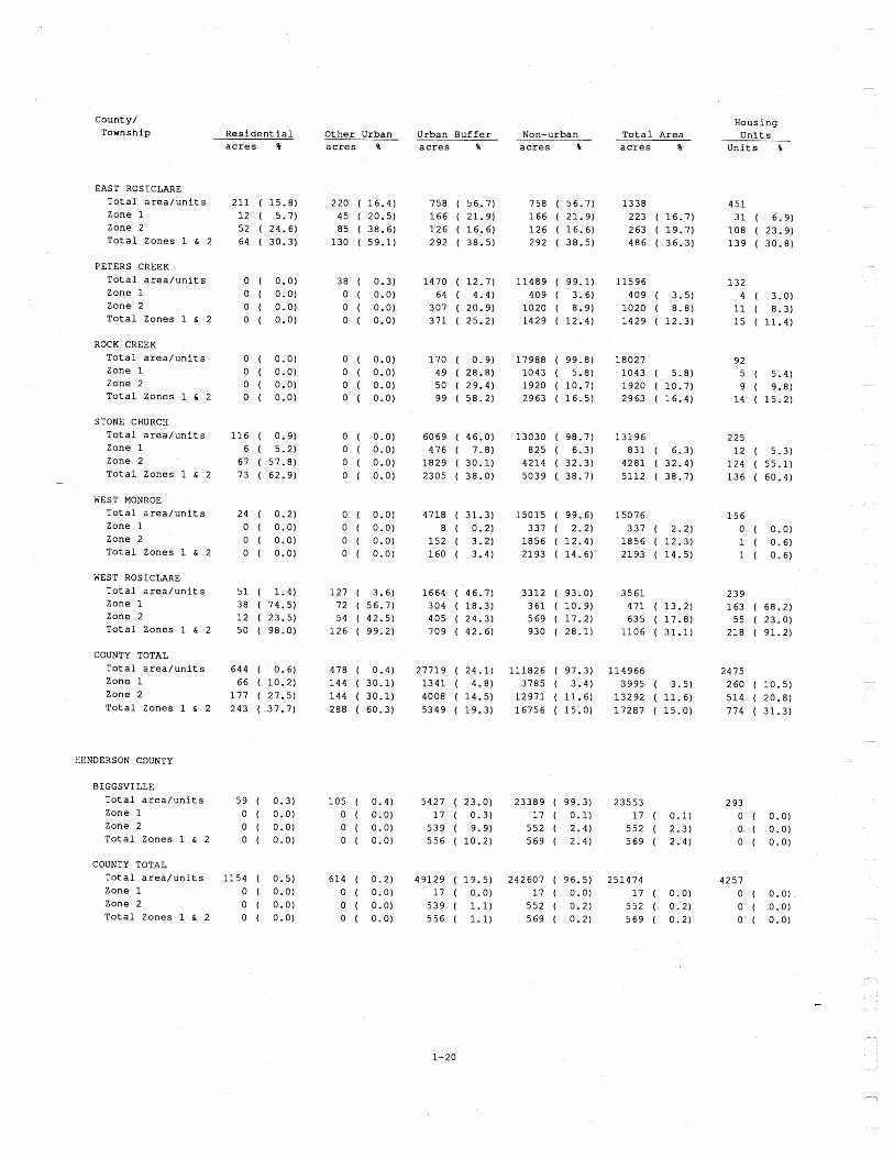
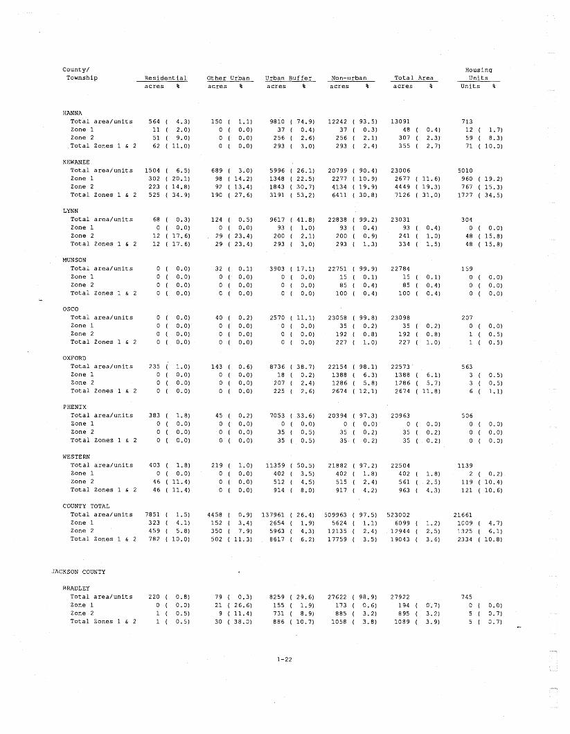
APPENDIX 1 Estimated Acreage and Housing Units in Zones 1 and 2 by Township, County,
and Land Use Category
APPENDIX 2 Maps and Charts Depicting the Distribution of Mines, Land Use and Housing Units
TABLES 1. County and commodity of non-coal underground mines compiled for this project. 2. Non-coal mine location-uncertainty codes and subsidence risk zones. 3. Original scale, data and source of digital data. 4. Date of land use from USGS digital files. 5. Ranking of the top 15 counties by total acreage in Zone 1 and the estimated
number of housing units in Zone 1. 6. Acreage and percentage of category in Zone 1 by county and land use category. 7. Counties with longwall mining.
FIGURE 1 Schematic map showing the relationship of Zones 1 and 2 to mined-out areas
and the urban buffer to urban land use.

EXECUTIVE SUMMARY
Mine subsidence, the sinking of the ground surface after the collapse of an underground mine, can
take place gradually over a large area, or can be quite sudden, opening as a pit at the surface. This ground movement can result in damage to overlying structures and loss of property value. In
Illinois, mine subsidence has occurred over all types of underground mines. Most subsidence
events are related to coal mines because of the large number and area underlain by coal mines.
The largest known subsidence event, however, was over a lead and zinc mine.
This study provides statistics on the proximity of underground-mined areas to urban development.
These statistics provide the most detailed view to date of the exposure of structures to the risk of
mine subsidence. Prior to this study maps of the non-coal underground mines had never been
compiled into a single map database and the proximity of underground-mined areas (both coal and
non-coal) to urban development had never been examined. The project was divided into two tasks:
1) to compile a map database of non-coal underground mines, and 2) to provide data on the
proximity of both coal and non-coal underground mines to urban development. -
Three zones of land area were defined in this study. Two zones were used to indicate the
proximity of an area to an underground mine. Zone 1 delineates areas that are over or immediately
adjacent to areas that are believed to be undermined. Zone 2 consists of the area adjacent to
Zone 1 which may also be affected by subsidence because of uncertainties in the location of the
mine. The third zone defined was a one-mile zone around urban areas. This zone, referred to as
the urban buffer, locates areas where underground mines (Zones 1 and 2) are near urban areas
and may affect future urban expansion.
The final report documents the procedures and assumptions used to complete these tasks and
provides an overview of some of the findings. The product of primary interest to the Illinois Mine
Subsidence Insurance Fund (IMSIF) is a tabulation by township showing acreage and number of
housing units in Zones 1 and 2 (Appendix 1). Maps showing the location of mines and urban areas
in each county are provided in Appendix 2. This appendix also includes bar charts depicting the
estimated number of housing units in Zone 1 in each township and the acreage of various land use
categories in Zone 1 in each county.
Results show that the exposure of urban areas to mine subsidence is not directly proportional to the
total acreage mined-out in a county. Of the 77 counties with underground mines, 53 had a higher
percentage of urban acreage exposed to mine subsidence than the percentage of mined-out acreage
in the whole county. Seven counties had more than 10,000 housing units in Zone 1. Sangamon
and St. Clair Counties had the largest number of units in Zone 1 with about 37,600 and 33,900
units respectively. Statewide it was estimated that Zone 1 contains about 229 thousand housing
units and Zone 2 contains about 91 thousand housing units.

Mine subsidence, the sinking of the ground surface after the collapse of an underground mine, can
take place gradually over a large area, or can be quite sudden, opening as a pit at the surface
(DuMontelle et al., 1981). This ground movement may result in damage to overlying structures and
loss of property value. In Illinois, mine subsidence has occurred over all types of underground
mines. Most subsidence events are related to coal mines because of the large number and area
underlain by coal mines. Two of the largest subsidence events to date, however, have been over
lead and zinc mines (Touseull, 1980). More than 2660 underground coal mines have operated in
Illinois since 1810; all but 30 are now abandoned. Another 356 underground mines have operated
to extract clay, fluorspar, lead, zinc, dolomite, limestone, ganister, and tripoli; all but 10 of these
mines are abandoned.
Damage caused by "ground movement" is not insured under conventional property insurance. With
the inception of the Mine Subsidence lnsurance Act in 1979, Illinois became the second state in the
country to pass legislation which assures the availability of insurance protection against mine - subsidence damage to structures (lllinois State Geological Survey, 1980). The Illinois Mine
Subsidence Insurance Fund (IMSIF) monitors subsidence claims and reimburses private insurance
companies for claims paid for mine subsidence damage.
The IMSIF needed information that could be used to evaluate their potential exposure to claims for
damage caused by mine subsidence. Initially, the only information available was the percentage of
each county undermined by coal mines. This information was of limited value because in some
areas mines are directly under urban development while in other areas mines underlie land having
no insurable structures, such as water bodies and cropland. This information was also limited
because it included only coal mines. No statewide map database of the location and extent of non-
coal mines had ever been compiled.
This study was designed to provide IMSIF with more complete data on the exposure of areas to
mine subsidence. A statewide map database on non-coal underground mines was compiled and
statistics were compiled on the proximity of both coal and non-coal underground mines to urban
development. The following sections document the data and methods used to complete these tasks
and then provide an overview of the findings. Detailed results of the study are presented in
Appendix 1. Maps showing the location of mines and urban areas in each county are provided in
Appendix 2. This appendix also includes charts depicting the estimated number of units undermined
in each township and the acreage of various land use categories undermined in each county.

STATEWIDE MAP DATABASE OF NON-COAL U
The goal of the first task of this study was to compile all available information on the location and
extent of non-coal underground mines. This information would then be used with an existing
database of coal mines in the second task of this project to investigate the proximity of mines to
urban areas. The resulting compilation consists of two parts; 1) a digital map database that
contains the mine boundaries andlor locations of mine openings and 2) documentation of the
sources of information for each mine. The maps and other mine data collected for this task are
available for inspection at the Illinois State Geological Survey (ISGS).
Sources of Data
Information was collected for 356 non-coal mines (Table 1). The database on non-coal mines is
drawn from maps and other information readily available to the Survey. Cook's 1979 inventory of
non-coal mines served as our guide to mines. Mine maps were obtained from a variety of sources
including ISGS files, U. S. Bureau of Mines, and mining companies. Because state and federal laws
have not required companies to file mine maps with the government maps that showed the extent of - mine workings were available for only about 20 percent of the mines. Furthermore, some of the
maps available were not final mine maps and may not show the complete extent of the mine
workings. Locations for the mines lacking maps were obtained from reports, field notes, and
topographic maps. The "Documentation of Uncertainties" section of this report explains how
incomplete mine information was handled.
Original mine maps were the preferred source for the compilation and digitizing of mine boundaries.
We found maps that varied from page-size to wall-size and were drawn on paper (sometimes
folded), linen, and tracing paper. Some maps had no scale or reference points. Other maps had
incomplete mine boundaries or boundaries that were drawn before mining operations ceased.
Mine maps and mine locations were also obtained from microfilm, publications and other maps.
Hard copy prints of original mine maps were made from microfilm of original mine maps acquired
through the Federal Office of Surface Mining. Large maps were divided onto two or more microfilm
frames and prints were taped together. Locations for mines with no available map were taken from
maps and legal descriptions in publications and from shaft and mine tunnel symbols on United
States Geological Survey (USGS) 7.5-minute quadrangles. Of all the maps used for compilation (29
different scales of maps, ranging from 1:120 to 1:63,360), the majority of maps were at the scales of
1 :2400, 1 :4800, and 1 :24,000.
Additional information on non-coal mines (beyond the scope of this study) might be obtained through
an exhaustive data collection effort involving searches of records in county court houses, libraries,
and historical societies, interviews with local citizens, field inspections, and attempts to trace

Table 1. County and commodity of non-coal underground mines compiled for this project.
County Clay Dolo- Fluor- Ganister Lead Lime- Tripoli Zinc County mite spar stone Total
Adams Alexander Calhoun Carroll DuPage Greene Hardin Henderson Jackson JoDaviess Johnson LaSalle Livingston McDonough Madison Marshall Monroe Pike Pope Randolph Rock Island Saline Scott Union
Total
*Two mines recovered clay and tripoli **The total for fluorspar includes 29 mines that also mined lead, 10 that mined zinc, and 4 that mined lead and zinc ***The total for lead mines includes 54 mines that also mined zinc #The total for fluorspar mines includes 25 mines that also mined lead, 3 that mined zinc, 2 that mined lead and zinc, and 1 that mined barite ##he total for fluorspar includes 1 mine that also mined lead.
company ownership. However, the expense of such an effort is probably only justifiable in areas
where there is conflict between current urban development and past mining activities.
Met hod of Compilation
The development of a map database on non-coal mines involved two problems: 1) compilation of
mine outlines and mine shaft locations from source maps having a variety of scales and degrees of
cartographic accuracy, and 2) documentation of uncertainties of mine location, orientation, and -

configuration to be tracked and properly considered in later modeling. To solve these difficulties and
produce a database that could be readily combined with the other data to be used for this project,
mine maps were converted (digitized) to a computer-readable form and stored in a computer-based
geographic information system (GIs).
Three methods were used to enter the mine locations or outlines into the database: 1) digitizing
directly from the mine map, 2) transferring the mine outline to a transparent overlay of a 7.5-minute
quadrangle and digitizing the transparency, and 3) using a computer program to convert legal
descriptions to map coordinates. Maps in good condition that had at least four reference points
(section corners or 1ICsection comers) were digitized directly into the database. About 30 percent
of the mines were entered in this manner.
Some mine maps had no section corners, or only one. These mines were digitized along with any
landmarks that could be used for orientation (north arrows, roads, railroad tracks, landforms,
streams, or mine shafts). The mine outlines and landmarks were plotted at 1 :24,000 and overlain
on the appropriate USGS 7.5-minute topographic quadrangle map. Using the reference points and A
features digitized from the original map, the mine outline was registered to the topographic map and
transferred by hand onto transparent overlays. Mines that were too narrow to digitize as polygons
were drawn onto transparencies as lines. Mine shaft and mine tunnel symbols found on
quadrangles or other maps were also transferred to the transparencies as point locations. The
transparencies were digitized after all mines for that quadrangle were compiled. About 50 percent of
the mines were entered in this manner.
When the only information available for a mine was its legal description (township, range, section,
quarter section or footages), map coordinates were calculated from the legal description using a
computer program and a database of section corner coordinates (Swann et al., 1970). The
computed coordinates were entered directly into the non-coal mine database.
Documentation of Uncertainties Documentation maintained for each mine includes date and source of the maps showing the mine
outline or point location, and other sources of information. Possible errors in the source map or
compilation process were also recorded. Every mine polygon, line and point entered into the
database was assigned a code to indicate the accuracy of the source map and the method used to
digitize or enter the data (Table 2). For example, polygons digitized from the original mine maps
received a code of 1. Mine locations calculated from a legal description that located the point to the
nearest quarter-quarter section were given a code of 8. These location-uncertainty codes were used
in the second task of this project to indicate the precision with which the mine was located and to
outline the area that could be affected by mine subsidence (Table 2).

Table 2. Non-coal mine location-uncertainty codes and subsidence risk zones.
Code Source of mine outline or location Subsidence Zone Width (ft).
Zone 1 Zone 2
Original mine map, four reference points
Original mine map, registered using landmarks
Topographic map
Map with topography OR with scale larger than 1 :24,000
Map without topography AND scale smaller than 1 :24,000
Legal description with footages or good landmark
Legal description; section 114 114 114 or CE114 or CE112 114 or CE112 or CE112 112
Legal description; section 1 I4 1 /4
Legal description; section 114 or 112 114
Legal description; section only
EVALUATION OF THE PROXIMITY OF MINES TO URBAN AREAS
The second task of this project was to evaluate the proximity of underground mines (both coal and
non-coal) to urban areas. This was accomplished by merging digital maps of the mined areas with
digital maps and data on land use and housing. The goal was to produce a tabulation by township
listing the estimated acreage of urban land and number of housing units that could be affected by
mine subsidence.
The ARCIINFO geographic information system software was used to process the data (Morehouse,
1985). Six spatial data sets and one tabular data set were merged to identify the type of land use
and number of housing units that were in areas over or adjacent to underground mines. The GIs
provided a mechanism to 1) manage the large volume of data, 2) define zones of risk around
mines, 3) adjust and register spatial features from small-scale maps to features from large-scale
maps, 4) merge spatial features and link them to the tabular data, and 5) summarize the results in
tabular and map form. Technical details of the GIs procedures are provided in Hindman and - Treworgy (1 989).

Source and Characteristics of Data An understanding of the source and characteristics of data used in this study is necessary to
properly interpret and use the results. The data used for this study came from government
agencies and private companies (Table 3) and were collected during the past 20 years. The scale
of these data sets makes them ideal for regional applications, but too generalized for site-specific
studies. Two important characteristics to be aware of are the minimum size and positional accuracy
of features. The minimum size of features depicted in the land use and coal mine data sets is
about 10 acres. Features smaller than this are omitted from the land use data set and represented
as a point in the coal mine data set. Minimum size was not a factor for the other data sets. The
accuracy with which features are located depends, among other factors, on the scale of the source
map. Features are generally within 25 feet of their correct location on 1 :24,000 scale maps. On
1:250,000 scale maps features may be offset by 250 to 300 feet.
Table 3. Original scale, date and source of digital data.
Scale of source Date of - Data set maps data Source of data
Coal mines 1 :I 200 - 1 :62,500 1987 ISGS
Non-coal mines 1 :I 28 - 1 :63,360 1988 ISGS
Land use 1 :258,000 1969-81 USGS
Census tracts 1 :62,500 1980 Geographic Data Technology
Block groups 1 :62,500 1988 DENR - county maps
Political 1 124,000 - 1 :500,000 1984 DENR towns hips
Census tabular data 1980 U. S. Bureau of statistics the Census, and
Donnelley Marketing
Coal Mine Data. Data on the location and extent of underground mines were obtained from a
digital database maintained by the ISGS (Treworgy et al, 1988). These data were originally
compiled in the early 1950's for use in updating estimates of remaining coal resources. The maps
are updated periodically to include newly-mined areas. The maps were converted to a digital format
in the late 1970's. The original data were compiled on base maps at a scale of 1 :62,500 and
consisted of a point at the location of the mine entrance and (if available) a polygon outlining the
extent of the mined area. All additions and corrections to the database since 1984 have been - made using the largest scale source map available (generally 1 :4000 to 1 :24,000). Unmined blocks

of coal within the mine perimeter are delineated if they cover an area of at least 400 x 400 feet.
The mine boundaries used in this project reflect all known mining to January 1987. In some areas
this database contains shallow underground mines that have been removed by subsequent surface
mining. In all cases these underground mines were small and in non-urban areas. This situation is
found in Fulton, Jackson, Knox, Peoria and Stark Counties.
Land Use Data. The land use data used for this study were derived from digital data distributed by
the U. S. Geological Survey (Loelkes et al, 1983; Fegeas et al, 1983). The data were compiled
from remotely sensed source materials and digitized at a scale of 1:250,000. The data were
categorized using the USGS Level I and Level II land classification system. The data for Illinois
were collected during the period from 1969 to 1981 and released in digital form in the early 1980's
(Table 4).
Table 4. Date of land use from USGS digital files. Map names refer to USGS 1 :250,000 series maps.
Map Name Date of Land Use Map Name
Date of Land Use
Aurora Belleville Burlington Chicago Danville Davenport Decatur Dubuque Dyersburg
Indianapolis Paducah Peoria Qu incy Racine Rockford Rolla St. Louis Vincennes
Census Data
The census data were obtained from the Office of Research and Planning, Illinois Department of
Energy and Natural Resources. The tracts, block groups and political townships are map data sets
depicting some of the basic geographic subdivisions used in the 1980 census. The census statistics
are the actual counts or projections produced by the 1980 census. The block groups and political
townships were digitized by or under the sponsorship of the Office of Research and Planning. The
tracts and some of the tabular data are proprietary data sets purchased from outside vendors.
Other census statistics were from the U.S. Bureau of the Census.
Zones of Mine Subsidence Risk
The risk of mine subsidence of an area is based in part on the proximity of the area' to underground
mines. The GIs was used to define two zones around mines (Figure 1). Zone 1 delineates the - land over or adjacent to mines that, based on the mapped extent of the mine, could be affected by


subsidence. Zone 2 rings Zone 1 and represents additional area that may be affected because of
uncertainty in the location of the mine and the extent of workings. Areas outside of these two
zones also have some risk of subsidence. Qld, undocumented mine openings have been
discovered in many parts of the state, even areas not known to contain minable deposits. In most
cases however, these undocumented mines were prospect pits or short-term operations that did not
undermine more than a few acres.
Zone 1 was defined as the area that is directly over the mapped extent of the mine, and adjacent
area extending 500 feet beyond the mine boundary. Land adjacent to a mine was included in this
zone because the subsidence from the collapse of an underground mine can spread sideways as it
moves upward to the land surface. This lateral ground movement is not highly predictable, but is a
function of the depth of the mine, the local geology, and other factors. The distance that
subsidence can propagate laterally from a mine is generally much less than the depth of the mine
(Bauer and Hunt, 1982). As a conservative measure, we used a distance of 500 feet for all mines.
For most mines the lateral propagation of subsidence will be less than 500 feet. Most mines in
Illinois and all mines near major urban areas are less than 500 feet deep. -
Zone 2 represents areas that were not known to be undermined, but could be affected by
subsidence because of uncertainties in the location of mine boundaries. Uncertainties in the
positions of mine boundaries come from two sources: 1) incomplete or imprecise maps of mine
workings and 2) errors in compilati~n and digitizing. We estimate that for all coal mines and many
non-coal mines the error from these two sources generally would not exceed 1000 feet. For most
mines, Zone 2 was defined as the area extending 1000 feet beyond Zone 1. Zone 2 was expanded
for non-coal mines located by small-scale maps and for mines with no map according to the size of
the area in which the mine might be located (Table 2).
Designation of an area as Zone 1 or Zone 2 cannot be directly translated into subsidence risk.
Though the risk of mine subsidence is generally higher in Zone 1 than in the adjacent Zone 2, the
risk of subsidence may be low in some areas designated Zone 1 and high in others. Many factors
in addition to proximity to a mine have some bearing on the potential for subsidence (e.g. the
mining method used, the age of mining, the geology of the overburden, the depth of the mine,
previous subsidence, and the depth of the water table). More precise estimates of the risk of
subsidence cannot be made until the interaction of these factors is better understood.
Categories of Land Use
Five categories of land use were examined in this study: residential, other urban, urban buffer,
non-urban, and water. All but the urban buffer category were based on the land use data set
obtained from the USGS. The urban buffer areas were created using the GIs.

The residential category was the same as the residential land use category in the USGS data set
and consisted of areas 10 acres or more in size that were predominantly residential. The "other
urban" category consisted of the land that the USGS classified as industrial, commercial, industrial
and commercial, mixed urban, transportation, and other urban. In some cases the "other urban"
category includes land that may not contain structures of concern to IMSIF. For example, a large
"other urban" area in Hamilton County is an oil field water flood operation. Some "other urban"
areas in Jefferson County are surface facilities of coal mines. Urban areas smaller than 10 acres
were not delineated in the USGS data set. The non-urban category consisted of all land that was
not urban or water. This included land used for cropland, forest, or pasture. Mines underlying
water bodies (rivers, lakes, reservoirs) were not considered a potential source of subsidence damage
and excluded from further study. The urban buffer category is a one-mile zone around all urban
land areas except the transportation category (Figure 1). This zone was used to identify areas
where mines adjacent to urban areas may pose a subsidence risk for future urban expansion.
Number of Housing Units Data on the number of housing units in a census division were obtained from the 1980 census.
Census divisions (tracts, block groups, or enumeration districts depending on the county) were
merged with the data on land use and mines to calculate the approximate number homes in Zones
1 and 2. Because the actual distribution of housing units within a census division was not known,
these calculations represent estimates, not actual counts of units. These estimates are influenced
by assumptions we made on the distribution of housing units and are intended only to provide a
general assessment of the exposure of housing units to risk of mine subsidence.
We assumed that within a census division, 90 percent of the housing units would be evenly
distributed across the areas classified as residential and the remaining 10 percent of the units would
be distributed among all other categories (except water). In divisions that had no areas classified as
residential, we assumed units were evenly distributed throughout the area. These assumptions
worked well for highly urbanized areas, rural areas with towns, and rural areas with no residential
land. In dominantly rural townships with only small areas of residential land this model assigned too
many units to the residential areas. For rural townships where the 90110 distribution of units
produced anomalous results, the number of units in Zones 1 and 2 were re-calculated using the
assumption that units were evenly distributed across the township.
All of the figures given for housing units in this report are based on the assumption that 90 percent
of the housing units in an area are in residential areas. This will obviously not be the case for all
townships. To test the sensitivity of our calculations to this assumption, we made a second
calculation using the assumption that 75 percent of the units were in residential areas. On a
statewide basis the 75/25 distribution calculated 16 percent fewer units in Zone 1 and 10 percent
fewer units in Zone 2 than the 90110 distribution. In 8 percent of the townships there was no
change and in 12 percent of the townships the 75/25 distribution produced an estimate that
averaged about 20 percent higher than the 90110 distribution.
Townships with major towns or cities are of most significance to the focus of this project. We
believe the 90/10 distribution produces the best estimate of housing units in these areas.
RESULTS
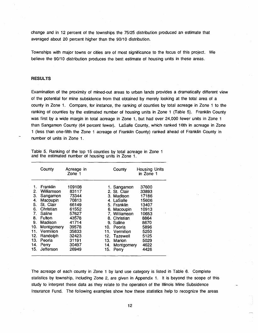
Examination of the proximity of mined-out areas to urban lands provides a dramatically different view
of the potential for mine subsidence from that obtained by merely looking at the total area of a
county in Zone 1. Compare, for instance, the ranking of counties by total acreage in Zone 1 to the
ranking of counties by the estimated number of housing units in Zone 1 (Table 5). Franklin County
was first by a wide margin in total acreage in Zone 1, but had over 24,000 fewer units in Zone 1
than Sangamon County (64 percent fewer). LaSalle County, which ranked 16th in acreage in Zone
1 (less than one-fifth the Zone 1 acreage of Franklin County) ranked ahead of Franklin County in -
number of units in Zone 1.
Table 5. Ranking of the top 15 counties by total acreage in Zone 1 and the estimated number of housing units in Zone 1.
County Acreage in County Housing Units Zone 1 in Zone 1
Franklin Williamson Sangamon Macoupin St. Clair Christian Saline Fulton Madison Montgomery Vermilion Randolph Peoria Perry Jefferson
1. Sangamon 2. St. Clair 3. Madison 4. LaSalle 5. Franklin 6. Macoupin 7. Williamson 8. Christian 9. Saline
10. Peoria 11. Vermilion 12. Tazewell 13. Marion 14. Montgomery 15. Perry
The acreage of each county in Zone 1 by land use category is listed in Table 6. Complete
statistics by township, including Zone 2, are given in Appendix 1. It is beyond the scope of this
study to interpret these data as they relate to the operation of the Illinois Mine Subsidence - Insurance Fund. The following examples show how these statistics help to recognize the areas

Table 6. Acreage and percentage of category in Zone 1 by county and land use category. 1E.g. in Bond County the 506 acres of residential land in Zone 1 represents 27% of the total residential land in the county.
County Residential Other Urban Buffer Non-urban Total Area Units acres % acres % acres % acres % acres % Units %
ADAMS ALEXANDER BOND BROWN BUREAU CALHOUN CARROLL CASS CHAMPAIGN CHRISTIAN CLINTON COLES CRAWFORD CUMBERLAND DOUGLAS DUPAGE EDGAR EDWARDS FRANKLIN FULTON GALLATIN GREENE GRUNDY HAMILTON HANCOCK HARDIN HENDERSON HENRY JACKSON JASPER JEFFERSON JERSEY JO-DAVIESS JOHNSON KANKAKEE KNOX LASALLE LAWRENCE LIVINGSTON LOGAN MCDONOUGH MCLEAN MACON MACOUP IN MADISON MARION MARSHALL MENARD MERCER MONROE MONTGOMERY MORGAN MOULTRIE PEORIA PERRY PIKE POPE PUTNAM RANDOLPH ROCK-I S LAND ST CLAIR SALINE SANGAMON SCHUYLER SCOTT SHELBY STARK TAZEWELL UNION VERMILION WABASH WARREN WASHINGTON WHITE WILL WILLIAMSON WOODFORD
TOTAL

where significant damage from mine subsidence may occur in the future or areas where risk of
damage to existing structures is low. In 53 of the 77 counties studied, the percentage of urban land
in Zones 1 and 2 was higher (often significantly) than the percentage of the total county area in
Zones 1 and 2. For example, less than one percent of Macon County is undermined, consequently
mine subsidence coverage is not automatically added to homeowners' insurance policies. However,
about 7 percent of the residential land in Macon County is in Zone 1. An additional 5 percent of
residential land is in Zone 2. Approximately 7000 housing units are over or adjacent to underground
mines and exposed to some subsidence risk.
Macon County also provides an example of the need to examine additional factors that contribute to
risk of subsidence. The two mines underlying Decatur used longwall methods in parts of the mines.
With this mining method, most subsidence occurs within a few years of mining. The actual risk of
subsidence over these mines is much lower than that for other types of mining methods. Table 7
lists counties mines used the longwall method.
Table 7. Counties with longwall mining (based on Guither et al, 1984).
Number of Total Number County Longwall Mines of Mines
Bureau Christian Franklin Grundy Hamilton Jefferson LaSalle Livingston Logan McLean Macon Macoupin Marshall Montgomery Peoria Putnam Will Williamson Woodford
*includes mines that used high-extraction-retreat room and pillar methods
In 24 of the 77 counties studied the percentage of the urban land in Zones 1 and 2 was less than -
the percentage of the total county area in Zones 1 and 2. For example, more than 5 percent of
Douglas County was in Zone 1 and 2, but less than 2 percent of the residential area in the county
14

was in these zones. In a number of these counties there was no urban land in Zones 1 and 2 and
the potential damage to existing structures from mine subsidence appeared to be relatively low.
Madison County is well-known for its mine subsidence problems. This study found that 23% of the
residential land was in Zone 1 (Table 6). However, examination of the map of mines shows that
potential mine subsidence is restricted to distinct areas in the county (Appendix 2). Most mines are
concentrated in the western half of the county; much of the eastern half has a low subsidence risk.
The urban buffer category helps to identify areas where mined-out area is adjacent to urban land,
an indication that subsidence could affect urban expansion. For example, almost 8 percent of
Peoria County (including 10 percent of the residential acreage) is in Zone 1. Additionally, 12
percent of the urban buffer land is in Zone 1, indicating that the overall exposure to subsidence risk
may increase as the urban areas in Peoria County expand. This statistic is even more dramatic
when individual townships are examined. For example, well under 1 percent of the city of Peoria is
in Zone 1, but almost 32 percent of the urban buffer in the 3 townships south and west of the city
is in Zone 1.
A
CONCLUSIONS AND RECOMMENDATIONS FOR
Examination of the proximity of mined-out areas to
the exposure of land to potential mine subsidence.
FURTHER STUDY
urban land has provided dramatic new views of
Although it is the IMSIF's role to determine the
appropriate applications of this information, the information could be useful for reviewing and
modifying the insurance rate structure and the geographic areas of and procedures for marketing
mine subsidence insurance.
This study identifies a number of areas where past mining activity poses a significant threat to
current and future urban development. Detailed mapping of the coal mines in these areas would be
beneficial to IMSlF as well as to local businesses, government, and landowners. The goal of this
effort should be to map as precisely as possible the extent of mine workings relative to surface
features (roads, railroads, houses, st reams). The maps or accompanying documentation should
indicate the nature of each mine map used (source, date, status, quality), the mining method used,
and basic geologic data. This information would streamline the task of investigating mine
subsidence insurance claims, alert property owners to the need for mine subsidence insurance
coverage, and encourage proper development of undermined lands.
The areas where detailed maps are most needed include the Springfield area in Sangamon County,
the Belleville/Collinsville area in St. Clair and Madison Counties, the counties of LaSalle, Macoupin,
and Franklin, and the area around the cities of Peoria, Danville and Centralia (Peoria, Vermilion and
Marion Counties). -

The application of a GIS to the problem of mine subsidence could be expanded in several
directions. As more is learned about the factors that contribute to subsidence, we can refine the
categories of risk by mapping the factors and adding them into the evaluation. The GIs could be
used to help identify these factors by finding spatial correlations between subsidence events and
other parameters. Insurance companies may even be interested in using the address matching
capabilities of the GIs to merge zone boundaries, street maps, and customer lists to identify the
homeowners who should be alerted to the need for mine subsidence insurance coverage.
ACKNOWLEDGEMENTS
Timothy Johnson and Will Hinsman of the Geographic lnformation Section, Office of Research and
Planning, lllinois Department of Energy and Natural Resources, provided the census data for this
project as well as advice and assistance on the use of these data.
Margaret Bargh of the Coal Section, ISGS, is responsible for the development and maintenance of -
the coal mine database and provided advice and assistance on its application to this project.
REFERENCES
Bauer, R.A., and S.R. Hunt, 1982, Profile, Strain, and Time Characteristics of Subsidence from Coal
Mining in Illinois: proceedings of Workshop on Surface Subsidence Due to Underground Mining, pp.
Cook, W. J., 1979, Non-Coal Subsurface Mines in Illinois, lllinois Institute of Natural Resources.
Donnelley Marketing lnformation Services, 1986, Demographic Methodology, 13p.
DuMontelle, P.B., S.C. Bradford, R.A. Bauer, M.M. Killey, 1981, Mine Subsidence in lllinois: Facts for
the Homeowner Considering Insurance: Environmental Geology Notes 99, lllinois State Geological
Survey, 24p.
Fegeas, R.G., R.W. Claire, S.C. Guptill, K.E. Anderson and C.A. Hallam, 1983, Land Use and Land
Cover Digital Data: U.S. Geological Survey Circular 895-E, 21p.
Geographic Data Technology, Inc., 1982, Tract-80, 1980 Census Tract Boundary Coordinate Files,
File Documentation, 8p.

Guither, H. D., J. Hines, and R. Bauer, 1984, The Economic Effects of Underground Mining Upon
Land Used for lllinois Agriculture: Final report to lllinois Department of Energy and Natural
Resources, Contract No. ER60.
Hindman, C. A. and C. G. Treworgy, 1989, Use of a Geographic Information System to Evaluate the
Potential for Damage form Subsidence of Underground Mines in lllinois: technical papers of the
Ninth International Symposium on Computer-Assisted Cartography, Baltimore, Maryland, April, 1989,
pp. 483-492.
lllinois Mine Subsidence Insurance Fund, 1 987, Annual Report 1 986, 1 2p.
lllinois State Geological Survey, 1980, Review of Underground Mining Practices in Illinois as Related
to Aspects of Mine Subsidence with Recommendations for Legislation, lllinois Institute of Natural
Resources Document No. 8011 0.
Keegan, H., and P. Aronson, 1985, Considerations in the Design of a Digital Geographic Library:,
Proceedings of Auto-Carto VII, ASPRS, pp. 313-321.
Loelkes Jr., G.L., G.E. Howard Jr., EL. Schwertz Jr., P.D. Lampert, and S.W. Miller, 1983, Land
UselLand Cover and Environmental Photointerpretation Keys: U.S. Geological Survey Bulletin 1600,
142p.
Morehouse, S., 1985, ARCIINFO: A Geo-relational Model for Spatial Information: Proceedings of
Auto-Carto Vll, ASPRS, pp. 388-397.
Swann, D.H., P.B. Dumontelle, R.F. Mast, L.H. Van Dyke, 1970, ILLIMAP-A Computer-Based
Mapping System for Illinois: lllinois State Geological Survey Circular 451, 21 p.
Touseull, J. and C. Rich Jr., Documentation and Analysis of a Massive Rock Failure at the Bautsch
Mine, Galena, Ill.: U.S. Bureau of Mines Report of Investigations 8453, 1980.
Treworgy, C.G., M.H. Bargh, C.A. Hindman, C.A. Morgan, 1988, Costs and Benefits of GIs Data
Management: A Case Study of a Database Managed by a State Agency: Technical Papers of
ACSM-ASPRS/1988, VOI. 2, pp. 1 86-1 95.
U.S. Department of Commerce, Bureau of the Census, 1980, Geographic Identification Code
Scheme: 1980 Census of Population and Housing, pp. 133-162.

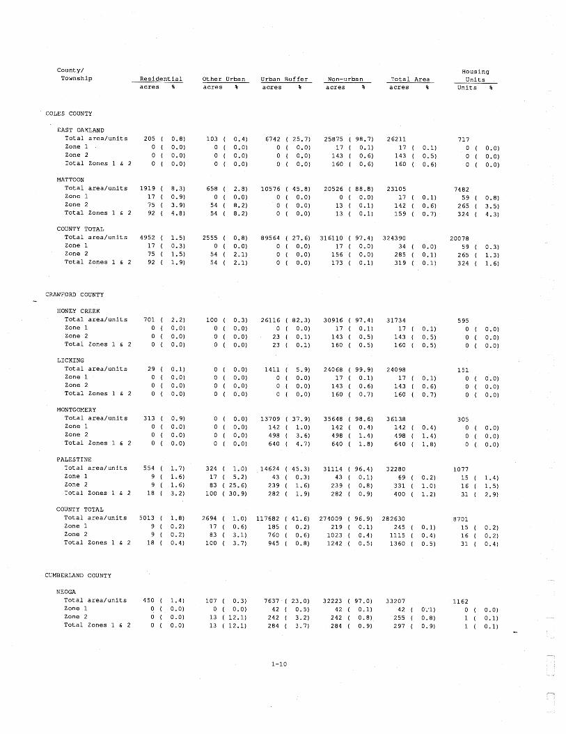
Appendix 1: Estimated Acreage and Housing Units in Zones 1
and 2 by Township, County, and Land Use Category
This appendix shows the estimated acreage and number of housing units in Zones 1 and 2 by
township, county, and land use category. The townships listed here are administrative townships,
not land survey townships. Only those townships that have some acreage in Zones 1 or 2 are
listed. The location of these townships is shown on the maps in Appendix 2. Though the acreages
are listed down to a single digit, this is not meant to imply precision. The estimates of acreages
were calculated by overlaying maps from several sources and are subject to the usual inaccuracies
inherent in this type of procedure. The figures are believed to accurately represent the relative
proportion of acreage in each land use category.
The total number of housing units in each township and county is from the 1980 census. The
number of housing units in Zones 1 and 2 was calculated by computer using the land use acreages
and the census data. The results of this computation are influenced by the accuracy of the land
use data and certain assumptions made about the distribution of housing units within a township.
These figures are believed to be reasonable estimates of the relative number of housing units in
each Zone.
The first line of data for each township shows the total acreage in that township for each land use
category and the total number of housing units in the township. The percentage listed after each
acreage in the first line is the percentage of the township represented by that land use category.
The next two lines of data for each township show the acreage in each land use category in Zones
1 and 2. The percentage listed after each acreage on these lines is the percentage of that land
use category in that zone. For example in Melrose Township, Adams County, the 24 acres of
residential in Zone 2 represents 2.2 of the total acreage of residential land in that township. The
last line is the sum of the acreage and housing units in Zones 1 and 2. The estimated number of
housing units in Zone 1 of each township of a county is represented graphically in Appendix 2. The
county totals follow the same format as the township totals. The total acreages for each land use
category in the county may be higher than the sum of the townships listed because they include the
acreage in townships that had no acreage in Zones 1 and 2. The Zone 1 acreage totals for each
county are represented graphically in Appendix 2.

County/ Township
Housing U n i t s
Uni t s %
R e s i d e n t i a l Other Urban a c r e s %
Urban B u f f e r a c r e s %
Non-urban a c r e s %
T o t a l Area a c r e s % a c r e s %
ADAMS COUNTY
CLAYTON T o t a l a r e a / u n i t s Zone 1 Zone 2 T o t a l Zones 1 & 2
FALL CREEK T o t a l a r e a / u n i t s
'Zone 1 Zone 2 T o t a l Zones 1 & 2
LIBERTY T o t a l a r e a / u n i t s Zone 1 Zone 2 T o t a l Zones 1 & 2
MELROSE T o t a l a r e a / u n i t s Zone 1 - Zone 2 T o t a l Zones 1 & 2
NORTHEAST T o t a l a r e a / u n i t s Zone 1
Zone 2 T o t a l Zones 1 & 2
QUINCY T o t a l a r e a / u n i t s Zone 1 Zone 2 T o t a l Zones 1 & 2
RIVERSIDE T o t a l a r e a / u n i t s Zone 1 Zone 2 T o t a l Zones 1 & 2
COUNTY TOTAL
T o t a l a r e a / u n i t s Zone 1 Zone 2 T o t a l Zones 1 & 2
ALEXANDER COUNTY
EAST CAPE T o t a l a r e a / u n i t s Zone 1 Zone 2 T o t a l Zones 1 & 2
ELCO
T o t a l a r e a / u n i t s Zone 1 Zone 2 T o t a l Zones 1 & 2

Housing U n i t s
U n i t s %
County/ Township R e s i d e n t i a l Other Urban
a c r e s % Urban B u f f e r a c r e s %
Non-urban a c r e s %
T o t a l Area a c r e s % a c r e s %
OLIVE BRANCH T o t a l a r e a / u n i t s Zone 1 Zone 2 T o t a l Zones 1 & 2
T AMMS T o t a l a r e a / u n i t s Zone 1 Zone 2 T o t a l Zones 1 & 2
THEBES T o t a l a r e a / u n i t s Zone 1 Zone 2 T o t a l Zones 1 & 2
COUNTY TOTAL T o t a l a r e a / u n i t s Zone 1 Zone 2
- T o t a l Zones 1 h 2
BOND COUNTY
BURGESS T o t a l a r e a / u n i t s Zone 1 Zone 2 T o t a l Zones 1 h 2
LAG RANGE T o t a l a r e a / u n i t s Zone 1 Zone 2 T o t a l Zones 1 & 2
OLD RIPLEY T o t a l a r e a / u n i t s Zone 1 Zone 2 T o t a l Zones 1 & 2
PLEASANT MOUND
T o t a l a r e a / u n i t s Zone 1
' Z o n e 2 T o t a l Zones 1 & 2
SHOAL CREEK T o t a l a r e a / u n i t s Zone 1 Zone 2 T o t a l Zones 1 h 2
COUNTY TOTAL T o t a l a r e a / u n i t s Zone 1 Zone 2 T o t a l Zones 1 & 2

County/ Township
Housing R e s i d e n t i a l Other Urban Urban Buffe r Non-urban T o t a l Area Uni t s a c r e s % a c r e s % a c r e s % a c r e s % a c r e s % Uni t s %
BROWN COUNTY
BUCKHORN T o t a l a r e a / u n i t s Zone 1 Zone 2 T o t a l Zones 1 & 2
COOPERSTOWN T o t a l a r e a / u n i t s Zone 1 Zone 2 T o t a l Zones 1 & 2
ELKHORN T o t a l a r e a / u n i t s Zone 1 Zone 2 T o t a l Zones 1 & 2
MISSOURI T o t a l a r e a / u n i t s Zone 1 Zone 2 T o t a l Zones 1 & 2
MOUNT STERLING T o t a l a r e a / u n i t s Zone 1 Zone 2 T o t a l Zones 1 & 2
PEA RIDGE T o t a l a r e a / u n i t s Zone 1 Zone 2 T o t a l Zones 1 & 2
RIPLEY T o t a l a r e a / u n i t s Zone 1 Zone 2 T o t a l Zones 1 & 2
COUNTY TOTAL T o t a l a r e a / u n i t s Zone 1 Zone 2 T o t a l Zones 1 & 2
BUREAU COUNTY
CONCORD T o t a l a r e a / u n i t s Zone 1 Zone 2 T o t a l Zones 1 & 2
HALL T o t a l a r e a / u n i t s Zone 1 Zone 2 T o t a l Zones 1 & 2 1266 ( 99.9)

County/ Township
Hous ing R e s i d e n t i a l O t h e r Urban Urban B u f f e r Non-urban T o t a l Area U n i t s
a c r e s % a c r e s % a c r e s % a c r e s % a c r e s % U n i t s %
IND IANTOWN T o t a l a r e a / u n i t s Zone 1 Zone 2 T o t a l Zones 1 & 2
MAC ON T o t a l a r e a / u n i t s Zone 1 Zone 2 T o t a l Zones 1 & 2
MINERAL T o t a l a r e a / u n i t s Zone 1 Zone 2 T o t a l Zones 1 & 2
NEPONSET T o t a l a r e a / u n i t s Zone 1 Zone 2
T o t a l Zones 1 & 2
PRINCETON T o t a l a r e a / u n i t s Zone 1 Zone 2 T o t a l Zones 1 & 2
S ELBY T o t a l a r e a / u n i t s Zone 1 Zone 2 T o t a l Zones 1 & 2
WESTFIELD T o t a l a r e a / u n i t s Zone 1 Zone 2 T o t a l Zones 1 & 2
COUNTY TOTAL T o t a l a r e a / u n i t s Zone 1
Zone 2 T o t a l Zones 1 & 2
CALHOUN COUNTY
BELLEVI EW
T o t a l a r e a / u n i t s 0 ( 0 .0 ) Zone 1 0 ( 0.0) Zone 2 0 ( 0.0) T o t a l Zones 1 & 2 0 ( 0 . 0 )
POINT
T o t a l a r e a / u n i t s 118 ( 0.3) Zone 1 0 ( 0.0) Zone 2 0 ( 0 .0 ) T o t a l Zones 1 & 2 0 ( 0 .0 )

County/ Township
Housing R e s i d e n t i a l Other Urban Urban B u f f e r Non-urban T o t a l Area -- U n i t s a c r e s % a c r e s % a c r e s % a c r e s % a c r e s % U n i t s %
COUNTY TOTAL
T o t a l a r e a / u n i t s Zone 1 Zone 2 T o t a l Zones 1 & 2
CARROLL COUNTY
MOUNT CARROLL T o t a l a r e a / u n i t s Zone 1 Zone 2 T o t a l Zones 1 & 2
WOODLAND T o t a l a r e a / u n i t s Zone 1 Zone 2 T o t a l Zones 1 & 2
" COUNTY TOTAL
T o t a l a r e a / u n i t s Zone 1 Zone 2 T o t a l Zones 1 & 2
CASS COUNTY
ARENZVILLE T o t a l a r e a / u n i t s Zone 1 Zone 2 T o t a l Zones 1 & 2
ASHLAND T o t a l a r e a / u n i t s Zone 1 Zone 2 T o t a l Zones 1 & 2
BLUFF SPRINGS T o t a l a r e a / u n i t s Zone 1 Zone 2 T o t a l Zones 1 & 2
HAGENER T o t a l a r e a / u n i t s Zone 1 Zone 2 T o t a l Zones 1 & 2
NEWMANSVILLE T o t a l a r e a / u n i t s Zone 1 Zone 2 T o t a l Zones 1 & 2

County/ Township
Housing U n i t s
U n i t s %
R e s i d e n t i a l Other Urban a c r e s %
Urban B u f f e r a c r e s %
Non-urban a c r e s %
T o t a l Area a c r e s % a c r e s %
PANTHER CREEK T o t a l a r e a / u n i t s Zone 1 Zone 2 T o t a l Zones 1 & 2
SANGAMON VALLEY T o t a l a r e a / u n i t s Zone 1 Zone 2 T o t a l Zones 1 & 2
VIRGINIA T o t a l a r e a / u n i t s Zone 1 Zone 2 T o t a l Zones 1 & 2
COUNTY TOTAL T o t a l a r e a / u n i t s Zone 1 Zone 2 T o t a l Zones 1 & 2
CHAMPAIGN COUNTY
CUNNINGHAM T o t a l a r e a / u n i t s Zone 1 Zone 2 T o t a l Zones 1 & 2
SIDNEY T o t a l a r e a / u n i t s Zone 1 Zone 2 T o t a l Zones 1 & 2
COUNTY TOTAL T o t a l a r e a / u n i t s 13510 Zone 1 Zone 2 T o t a l Zones 1 & 2
CHRISTIAN COUNTY
ASSUMPTION
T o t a l a r e a / u n i t s Zone 1 Zone 2
T o t a l Zones 1 & 2
BEAR CREEK T o t a l a r e a / u n i t s Zone 1 Zone 2 T o t a l Zones 1 & 2


County/ Township R e s i d e n t i a l
Housing U n i t s
U n i t s %
O t h e r Urban a c r e s %
Urban B u f f e r a c r e s %
T o t a l Area a c r e s % a c r e s % a c r e s %
COUNTY TOTAL T o t a l a r e a / u n i t s Zone 1 Zone 2 T o t a l Zones 1 & 2
CLINTON COUNTY
BREESE T o t a l a r e a / u n i t s Zone 1 Zone 2 T o t a l Zones 1 & 2
BROOKSIDE T o t a l a r e a / u n i t s Zone 1 Zone 2
T o t a l Zones 1 & 2
CARLYLE T o t a l a r e a / u n i t s Zone 1 Zone 2 T o t a l Zones 1 & 2
GERMANTOWN T o t a l a r e a / u n i t s Zone 1 Zone 2 T o t a l Zones 1 & 2
LOOKING GLASS T o t a l a r e a / u n i t s Zone 1 Zone 2 T o t a l Zones 1 & 2
MERIDIAN T o t a l a r e a / u n i t s Zone 1 Zone 2 T o t a l Zones 1 & 2
SUGAR CREEK T o t a l a r e a / u n i t s Zone 1 Zone 2 T o t a l Zones 1 & 2
WADE T o t a l a r e a / u n i t s Zone 1 Zone 2 T o t a l Zones 1 & 2
COUNTY TOTAL T o t a l a r e a / u n i t s Zone 1
Zone 2 T o t a l Zones 1 & 2
County/ Township
Housing R e s i d e n t i a l Other Urban Urban B u f f e r Non-urban T o t a l Area U n i t s a c r e s % a c r e s % a c r e s % a c r e s % a c r e s % U n i t s %
COLES COUNTY
EAST OAKLAND T o t a l a r e a / u n i t s Zone 1 Zone 2 T o t a l Zones 1 & 2
MATTOON
T o t a l a r e a / u n i t s Zone 1 Zone 2 T o t a l Zones 1 & 2
COUNTY TOTAL T o t a l a r e a / u n i t s Zone 1 Zone 2 T o t a l Zones 1 & 2
CRAWFORD COUNTY 4
HONEY CREEK T o t a l a r e a / u n i t s Zone 1 Zone 2 T o t a l Zones 1 & 2
LICKING T o t a l a r e a / u n i t s Zone 1 Zone 2 T o t a l Zones 1 & 2
MONTGOMERY T o t a l a r e a / u n i t s Zone 1 Zone 2 T o t a l Zones 1 & 2
PALESTINE T o t a l a r e a / u n i t s Zone 1 Zone 2 T o t a l Zones 1 & 2
COUNTY TOTAL
T o t a l a r e a / u n i t s Zone 1 Zone 2 T o t a l Zones 1 & 2
CUMBERLAND COUNTY
NEOGA T o t a l a r e a / u n i t s Zone 1 Zone 2 T o t a l Zones 1 & 2

Coun ty / Township
Hous ing U n i t s
U n i t s % R e s i d e n t i a l O t h e r Urban
a c r e s %
Urban B u f f e r a c r e s %
Non-urban a c r e s %
T o t a l A r e a a c r e s % a c r e s %
COUNTY TOTAL T o t a l a r e a / u n i t s Zone 1 Zone 2 T o t a l Zones 1 & 2
DOUGLAS COUNTY
MURDOCK T o t a l a r e a / u n i t s Zone 1 Zone 2 T o t a l Zones 1 & 2
N EWMAN T o t a l a r e a / u n i t s Zone 1 Zone 2 T o t a l Zones 1 & 2
SARGENT A
T o t a l a r e a / u n i t s Zone 1 Zone 2 T o t a l Zones 1 & 2
COUNTY TOTAL T o t a l a r e a / u n i t s Zone 1 Zone 2 T o t a l Zones 1 & 2
DUPAGE COUNTY
ADDISON T o t a l a r e a / u n i t s 7278 ( 35 .8 ) Zone 1 0 ( 0 .0 ) Zone 2 27 ( 0 .4 ) T o t a l Zones 1 & 2 27 ( 0 .4 )
Y ORK T o t a l a r e a / u n i t s 11625 ( 51.5) Zone 1 1 5 1 ( 1 . 3 ) Zone 2 243 ( 2 .1 ) T o t a l Zones 1 & 2 394 ( 3 .4 )
COUNTY TOTAL T o t a l a r e a / u n i t s 68577 ( 32 .1 ) Zone 1 1 5 1 ( 0 . 2 ) Zone 2 270 ( 0 .4 ) T o t a l Zones 1 & 2 421 ( 0 .6 )
EDGAR COUNTY
BROUILLETTS CREEK T o t a l a r e a / u n i t s 0 ( 0 . 0 ) Zone 1 0 ( 0 .0 ) Zone 2 0 ( 0 .0 ) T o t a l Zones 1 & 2 0 ( 0 .0 )

County/ Township
Housing U n i t s
U n i t s %
R e s i d e n t i a l a c r e s %
Other Urban a c r e s %
Urban Buffe r a c r e s %
Non-urban a c r e s %
T o t a l Area a c r e s %
HUNTER T o t a l a r e a / u n i t s Zone 1 Zone 2 T o t a l Zones 1 & 2
PRAIRIE T o t a l a r e a / u n i t s Zone 1 Zone 2 T o t a l Zones 1 & 2
STRATTON T o t a l a r e a / u n i t s Zone 1 Zone 2 T o t a l Zones 1 & 2
COUNTY TOTAL T o t a l a r e a / u n i t s Zone 1 Zone 2 T o t a l Zones 1 & 2
b
EDWARDS COUNTY
FRENCH CREEK T o t a l a r e a / u n i t s 3 2 5 ( 2.0) Zone 1 0 ( 0.0) Zone 2 0 ( 0.0) T o t a l Zones 1 & 2 0 ( 0.0)
COUNTY TOTAL T o t a l a r e a / u n i t s 1 7 3 0 ( 1.2) Zone 1 0 ( 0.0) Zone 2 0 ( 0.0) T o t a l Zones 1 & 2 0 ( 0.0)
FRANKLIN COUNTY
BARREN T o t a l a r e a / u n i t s 0 ( 0.0) Zone 1 0 ( 0.0) Zone 2 0 ( 0.0) T o t a l Zones 1 & 2 0 ( 0.0)
BENTON T o t a l a r e a / u n i t s 1 5 6 8 ( 6.7)
Zone 1 825 ( 52.6) Zone 2 423 ( 27.0) T o t a l Zones 1 & 2 1 2 4 8 ( 79.6)
BROWNING
T o t a l a r e a / u n i t s 394 ( 1 .7 ) Zone 1 3 7 6 ( 95.4) Zone 2 1 8 ( 4.6) T o t a l Zones 1 & 2 394 (100.0)

Coun ty / Township
Hous ing R e s i d e n t i a l O t h e r Urban
a c r e s % Urban B u f f e r T o t a l Area
a c r e s % U n i t s
U n i t s % a c r e s % a c r e s
6331 1
3 0 3 1
17166 16520
287 16807
a c r e s
22819 6 67 533
1200
21364 20622
3 68 20990
CAVE T o t a l a r e a / u n i t s Zone 1 Zone 2 T o t a l Zones 1 & 2
DENNING T o t a l a r e a / u n i t s Zone 1 Zone 2 T o t a l Zones 1 & 2
EASTERN T o t a l a r e a / u n i t s Zone 1 Zone 2 T o t a l Zones 1 & 2
FRANKFORT T o t a l a r e a / u n i t s Zone 1 Zone 2 T o t a l Zones 1 & 2
A
GOODE T o t a l a r e a / u n i t s Zone 1 Zone 2 T o t a l Zones 1 & 2
SIX MILE T o t a l a r e a / u n i t s Zone 1 Zone 2 T o t a l Zones 1 & 2
TYRONE T o t a l a r e a / u n i t s Zone 1 Zone 2 T o t a l Zones 1 & 2
COUNTY TOTAL T o t a l a r e a / u n i t s Zone 1 Zone 2 T o t a l Zones 1 & 2
FULTON COUNTY
ASTORIA T o t a l a r e a / u n i t s Zone 1 Zone 2 T o t a l Zones 1 & 2
BANNER T o t a l a r e a / u n i t s Zone 1 Zone 2 T o t a l Zones 1 & 2

County/ Township R e s i d e n t i a l Other Urban
a c r e s %
Housing U n i t s
U n i t s %
Urban Buffe r a c r e s %
Non-urban a c r e s %
T o t a l Area a c r e s % a c r e s %
BERNADOTTE T o t a l a r e a / u n i t s Zone 1 Zone 2 T o t a l Zones 1 & 2
BUCKHEART T o t a l a r e a / u n i t s Zone 1 Zone 2 T o t a l Zones 1 & 2
CANTON T o t a l a r e a / u n i t s Zone 1 Zone 2 T o t a l Zones 1 & 2
CAS S T o t a l a r e a / u n i t s Zone 1 Zone 2 T o t a l Zones 1 & 2 -
DEERFIELD T o t a l a r e a / u n i t s Zone 1 Zone 2 T o t a l Zones 1 & 2
ELLISVILLE T o t a l a r e a / u n i t s Zone 1 Zone 2 T o t a l Zones 1 & 2
FA1 RVIEW T o t a l a r e a / u n i t s Zone 1 Zone 2 T o t a l Zones 1 & 2
FARMERS T o t a l a r e a / u n i t s Zone 1 Zone 2 T o t a l Zones 1 & 2
FARMINGTON T o t a l a r e a / u n i t s Zone 1 Zone 2 T o t a l Zones 1 & 2
HARRIS T o t a l a r e a / u n i t s Zone 1 Zone 2 T o t a l Zones 1 & 2
ISABEL T o t a l a r e a / u n i t s Zone 1 Zone 2 T o t a l Zones 1 & 2

County/ Township
Housing Uni t s
U n i t s %
R e s i d e n t i a l Other Urban a c r e s %
Urban Buffe r a c r e s %
Non-urban a c r e s %
T o t a l Area a c r e s % a c r e s %
JOSHUA T o t a l a r e a / u n i t s Zone 1 Zone 2 T o t a l Zones 1 & 2
KERTON T o t a l a r e a / u n i t s Zone 1 Zone 2 T o t a l Zones 1 & 2
LEE T o t a l a r e a / u n i t s Zone 1 zone 2 T o t a l Zones 1 & 2
LEWISTOWN T o t a l a r e a / u n i t s Zone 1 Zone 2
T o t a l Zones 1 & 2 A
LIVERPOOL T o t a l a r e a / u n i t s Zone 1 Zone 2 T o t a l Zones 1 & 2
ORION T o t a l a r e a / u n i t s Zone 1 Zone 2 T o t a l Zones 1 & 2
PLEASANT T o t a l a r e a / u n i t s Zone 1 Zone 2 T o t a l Zones 1 & 2
PUTMAN T o t a l a r e a / u n i t s Zone 1 Zone 2 T o t a l Zones 1 & 2
U N I O N
T o t a l a r e a / u n i t s Zone 1 Zone 2 T o t a l Zones 1 & 2
VERMONT T o t a l a r e a / u n i t s Zone 1 Zone 2 T o t a l Zones 1 & 2
WATERFORD T o t a l a r e a / u n i t s Zone 1 Zone 2 T o t a l Zones 1 & 2

County/ Township
Housing U n i t s
U n i t s %
R e s i d e n t i a l
T o t a l Zones 1 & 2 360 ( 30.2)
Other Urban a c r e s %
Urban B u f f e r a c r e s %
Non-urban a c r e s %
T o t a l Area a c r e s % a c r e s %
WOODLAND T o t a l a r e a / u n i t s Zone 1 Zone 2 T o t a l Zones 1 & 2
YOUNG HICKORY T o t a l a r e a / u n i t s Zone 1 Zone 2 T o t a l Zones 1 & 2 1 . 3 )
23.0) 27.3) SO. 3)
COUNTY TOTAL T o t a l a r e a / u n i t s Zone 1 Zone 2 T o t a l Zones 1 & 2
GALLATIN COUNTY
BOWLESVILLE T o t a l a r e a / u n i t s Zone 1 Zone 2 T o t a l Zones 1 & 2
EAGLE CREEK T o t a l a r e a / u n i t s Zone 1 Zone 2 T o t a l Zones 1 & 2
EQUALITY T o t a l a r e a / u n i t s Zone 1 Zone 2 T o t a l Zones 1 & 2
GOLD HILL T o t a l a r e a / u n i t s Zone 1 Zone 2 T o t a l Zones 1 & 2
RIDGWAY T o t a l a r e a / u n i t s Zone 1 Zone 2 T o t a l Zones 1 & 2
COUNTY TOTAL T o t a l a r e a / u n i t s Zone 1 Zone 2
County / Township
Housing U n i t s
U n i t s %
R e s i d e n t i a l O the r Urban a c r e s %
Urban B u f f e r T o t a l Area a c r e s % a c r e s % a c r e s
0 0 0 0
6838 1
6 2 6 3
2658 0 0 0
6632
a c r e s
21568 2 2 1 750 9 7 1
31057 1
62 63
22194 4 1
238 2 7 9
2 93 65
%
L O O . 0 ) 1.0)
3.5) 4.5)
99.4) 0.0) 0.2) 0.2)
99.9) 0.2) 1 .1 ) 1 .3 )
98.4)
GREENE COUNTY
ATHENSVILLE T o t a l a r e a / u n i t s Zone 1 Zone 2 T o t a l Zones 1 & 2
KANE T o t a l a r e a / u n i t s Zone 1 Zone 2 T o t a l Zones 1 & 2
LINDER T o t a l a r e a / u n i t s Zone 1 Zone 2 T o t a l Zones 1 & 2
ROCKBRIDGE T o t a l a r e a / u n i t s Zone 1
- Zone 2 T o t a l Zones 1 h 2
ROODHOUSE T o t a l a r e a / u n i t s Zone 1 Zone 2 T o t a l Zones 1 & 2
RUBICON T o t a l a r e a / u n i t s Zone 1 Zone 2 T o t a l Zones 1 6 2
WALKERVILLE T o t a l a r e a / u n i t s Zone 1
Zone 2 T o t a l Zones 1 & 2
WHITE HALL T o t a l a r e a / u n i t s Zone 1 Zone 2 T o t a l Zones 1 & 2
COUNTY TOTAL T o t a l a r e a / u n i t s Zone 1 Zone 2 T o t a l Zones 1 & 2
GRUNDY COUNTY
AUX SABLE T o t a l a r e a / u n i t s Zone 1 Zone 2 T o t a l Zones 1 & 2

County/ Township
Housing U n i t s R e s i d e n t i a l T o t a l Area
a c r e s %
Other Urban a c r e s %
Urban Buffe r a c r e s %
Non-urban a c r e s % a c r e s % Uni t s %
HAM1 LTON COUNTY
CROOK T o t a l a r e a / u n i t s Zone 1 Zone 2 T o t a l Zones 1 & 2
MCLEANSBORO T o t a l a r e a / u n i t s Zone 1 Zone 2 T o t a l Zones 1 & 2
COUNTY TOTAL T o t a l a r e a / u n i t s Zone 1 Zone 2 T o t a l Zones 1 & 2
HANCOCK COUNTY
AUGUSTA T o t a l a r e a / u n i t s Zone 1 Zone 2 T o t a l Zones 1 & 2
ST. ALBANS T o t a l a r e a / u n i t s Zone 1 Zone 2 T o t a l Zones 1 & 2
COUNTY TOTAL T o t a l a r e a / u n i t s Zone 1 Zone 2 T o t a l Zones 1 & 2
HARDIN COUNTY
BATTERY ROCK T o t a l a r e a / u n i t s Zone 1 Zone 2 T o t a l Zones 1 & 2
CAVE-IN-ROCK T o t a l a r e a / u n i t s Zone 1 Zone 2 T o t a l Zones 1 & 2
EAST MONROE T o t a l a r e a / u n i t s Zone 1 Zone 2 T o t a l Zones 1 & 2
County/ Township
Housing U n i t s
U n i t s %
R e s i d e n t i a l Other Urban a c r e s %
Urban B u f f e r a c r e s %
T o t a l Area a c r e s % a c r e s % a c r e s %
EAST ROSICLARE T o t a l a r e a / u n i t s Zone 1 Zone 2 T o t a l Zones 1 & 2
PETERS CREEK T o t a l a r e a / u n i t s Zone 1 Zone 2 T o t a l Zones 1 & 2
ROCK CREEK T o t a l a r e a / u n i t s Zone 1 Zone 2 T o t a l Zones 1 & 2
STONE CHURCH T o t a l a r e a / u n i t s Zone 1 Zone 2 T o t a l Zones 1 & 2
A
WEST MONROE T o t a l a r e a / u n i t s Zone 1 Zone 2 T o t a l Zones 1 & 2
WEST ROSICLARE T o t a l a r e a / u n i t s Zone 1 Zone 2 T o t a l Zones 1 & 2
COUNTY TOTAL T o t a l a r e a / u n i t s Zone 1 Zone 2 T o t a l Zones 1 & 2
HENDERSON COUNTY
BIGGSVILLE T o t a l a r e a / u n i t s Zone 1 Zone 2 T o t a l Zones 1 & 2
COUNTY TOTAL T o t a l a r e a / u n i t s Zone 1 Zone 2 T o t a l Zones 1 & 2

County/ Township R e s i d e n t i a l
Housing Uni t s
Uni t s %
Urban Buffe r a c r e s %
T o t a l Area a c r e s %
Other Urban a c r e s %
Non-urban a c r e s % a c r e s %
HANNA T o t a l a r e a / u n i t s Zone 1 Zone 2 T o t a l Zones 1 h 2
KEWANEE T o t a l a r e a / u n i t s Zone 1 Zone 2 T o t a l Zones 1 & 2
LYNN T o t a l a r e a / u n i t s Zone 1 Zone 2 T o t a l Zones 1 & 2
MUNSON T o t a l a r e a / u n i t s Zone 1 Zone 2 T o t a l Zones E 6 2 -
OSCO T o t a l a r e a / u n i t s Zone 1 Zone 2 T o t a l Zones 1 & 2
OXFORD T o t a l a r e a / u n i t s Zone 1 Zone 2 T o t a l Zones 1 h 2
PHENIX T o t a l a r e a / u n i t s Zone 1 Zone 2 T o t a l Zones 1 & 2
WESTERN T o t a l a r e a / u n i t s Zone 1 Zone 2 T o t a l Zones 1 & 2
COUNTY TOTAL T o t a l a r e a / u n i t s Zone 1 Zone 2 T o t a l Zones 1 & 2
JACKSON COUNTY
BRADLEY T o t a l a r e a / u n i t s Zone 1 Zone 2 T o t a l Zones 1 & 2

County/ Township
Housing U n i t s
U n i t s %
R e s i d e n t i a l Other Urban a c r e s %
Urban Buffe r a c r e s %
Non-urban a c r e s %
T o t a l Area a c r e s % a c r e s %
CARBONDALE T o t a l a r e a / u n i t s Zone 1 Zone 2 T o t a l Zones 1 & 2
DE SOT0 T o t a l a r e a / u n i t s Zone 1 Zone 2 T o t a l Zones 1 & 2
ELK T o t a l a r e a / u n i t s Zone 1 Zone 2 T o t a l Zones 1 & 2
FOUNTAIN BLUFF T o t a l a r e a / u n i t s Zone 1 Zone 2 T o t a l Zones 1 ti 2 -
L EVAN T o t a l a r e a / u n i t s Zone 1 Zone 2
T o t a l Zones 1 & 2
MAKANDA T o t a l a r e a / u n i t s Zone 1 Zone 2 T o t a l Zones 1 & 2
MURPHYSBORO T o t a l a r e a / u n i t s Zone 1 Zone 2 T o t a l Zones 1 & 2
om T o t a l a r e a / u n i t s Zone 1 Zone 2 T o t a l Zones 1 & 2
SAND RIDGE T o t a l a r e a / u n i t s Zone 1 Zone 2 T o t a l Zones 1 & 2
SOMERSET T o t a l a r e a / u n i t s Zone 1 Zone 2 T o t a l Zones 1 & 2
VERGENNES T o t a l a r e a / u n i t s Zone 1 Zone 2 T o t a l Zones 1 & 2

Coun ty / Township
Hous ing U n i t s
U n i t s %
R e s i d e n t i a l O t h e r Urban a c r e s %
Urban B u f f e r a c r e s %
Non-urban a c r e s %
T o t a l A r e a % a c r e s %
6384 ( 1 .7 )
a c r e s
381729 18473 13677 32150
26169
COUNTY TOTAL T o t a l a r e a / u n i t s Zone 1 Zone 2 T o t a l Zones 1 & 2
JASPER COUNTY
FOX T o t a l a r e a / u n i t s Zone 1 Zone 2 T o t a l Zones 1 & 2
SMALLWOOD T o t a l a r e a / u n i t s Zone 1 Zone 2 T o t a l Zones 1 & 2
WADE T o t a l a r e a / u n i t s Zone 1 Zone 2 T o t a l Zones 1 & 2
COUNTY TOTAL T o t a l a r e a / u n i t s Zone 1 Zone 2 T o t a l Zones 1 & 2 0 ( 0 .0 )
JEFFERSON COUNTY
BALD HILL T o t a l a r e a / u n i t s Zone 1 Zone 2 T o t a l Zones 1 & 2
BLISSVILLE T o t a l a r e a / u n i t s Zone 1 Zone 2 T o t a l Zones 1 & 2
DODDS T o t a l a r e a / u n i t s Zone 1 Zone 2 T o t a l Zones 1 & 2
ELK P R A I R I E T o t a l a r e a / u n i t s Zone 1 Zone 2 T o t a l Zones 1 & 2

County/ Township
Housing U n i t s
U n i t s %
R e s i d e n t i a l Other Urban a c r e s %
Urban Buffe r a c r e s %
Non-urban a c r e s %
T o t a l Area a c r e s % a c r e s %
MCCLELLAN T o t a l a r e a / u n i t s Zone 1 Zone 2 T o t a l Zones 1 & 2
MOORES PRAIRIE T o t a l a r e a / u n i t s Zone 1 Zone 2 T o t a l Zones 1 & 2
MOUNT VERNON T o t a l a r e a / u n i t s Zone 1 Zone 2 T o t a l Zones 1 & 2
P ENDLETON T o t a l a r e a / u n i t s Zone 1 Zone 2 T o t a l Zones 1 & 2
COUNTY TOTAL T o t a l a r e a / u n i t s Zone 1 Zone 2 T o t a l Zones 1 & 2
JERSEY COUNTY
FIDELITY T o t a l a r e a / u n i t s Zone L Zone 2 T o t a l Zones 1 & 2
MISSISSIPPI T o t a l a r e a / u n i t s Zone 1 Zone 2 T o t a l Zones 1 & 2
P IASA T o t a l a r e a / u n i t s Zone 1 Zone 2 T o t a l Zones 1 & 2
COUNTY TOTAL T o t a l a r e a / u n i t s Zone 1 Zone 2 T o t a l Zones 1 & 2


County/ Township R e s i d e n t i a l
Housing Uni t s
U n i t s %
Other Urban a c r e s %
Urban Buffe r a c r e s %
Non-urban a c r e s %
T o t a l Area a c r e s % a c r e s %
SCALES MOUND T o t a l a r e a / u n i t s Zone 1 Zone 2 T o t a l Zones 1 & 2
VINEGAR HILL T o t a l a r e a / u n i t s Zone 1 Zone 2 T o t a l Zones 1 & 2
WARREN T o t a l a r e a / u n i t s Zone 1 Zone 2 T o t a l Zones 1 & 2
WEST GALENA T o t a l a r e a / u n i t s Zone 1 Zone 2 T o t a l Zones 1 & 2
A
WOODBINE T o t a l a r e a / u n i t s Zone 1 Zone 2 T o t a l Zones 1 & 2
COUNTY TOTAL T o t a l a r e a / u n i t s Zone 1 Zone 2 T o t a l Zones 1 6 2
JOHNSON COUNTY
BURNSIDE T o t a l a r e a / u n i t s Zone 1 Zone 2 T o t a l Zones 1 6 2
CACHE T o t a l a r e a / u n i t s Zone 1 Zone 2 T o t a l Zones 1 & 2
OZARK T o t a l a r e a / u n i t s Zone 1 Zone 2 T o t a l Zones 1 6 2
TUNNEL HILL T o t a l a r e a / u n i t s Zone 1 Zone 2 T o t a l Zones 1 6 2

County/ Township R e s i d e n t i a l
a c r e s %
Housing U n i t s
U n i t s % O t h e r Urban a c r e s %
Urban B u f f e r a c r e s %
Non-urban a c r e s %
T o t a l Area a c r e s %
COUNTY TOTAL T o t a l a r e a / u n i t s 1774 ( 0.8) Zone 1 0 ( 0.0) Zone 2 0 ( 0.0) T o t a l Zones 1 & 2 0 ( 0.0)
KANKAKEE COUNTY
ESSEX T o t a l a r e a / u n i t s 104 ( 0.5) Zone 1 0 ( 0.0) Zone 2 0 ( 0.0) T o t a l Zones 1 h 2 0 ( 0.0)
COUNTY TOTAL T o t a l a r e a / u n i t s 10067 ( 2.3) Zone 1 Zone 2 T o t a l Zones 1 & 2
- KNOX COUNTY
CEDAR T o t a l a r e a / u n i t s Zone 1 Zone 2 T o t a l Zones 1 & 2
CHESTNUT T o t a l a r e a / u n i t s Zone 1 Zone 2 T o t a l Zones 1 & 2
COPLEY T o t a l a r e a / u n i t s Zone 1 Zone 2 T o t a l Zones 1 & 2
E LBA T o t a l a r e a / u n i t s Zone 1 Zone 2 T o t a l Zones 1 & 2
GALESBURG CITY T o t a l a r e a / u n i t s Zone 1 Zone 2 T o t a l Zones 1 & 2
HENDERSON T o t a l a r e a / u n i t s Zone 1 Zone 2 T o t a l Zones 1 & 2 0 ( 0.0)

County/ Township
Housing U n i t s
U n i t s %
R e s i d e n t i a l Other Urban a c r e s %
Urban Buffe r a c r e s %
Non-urban a c r e s %
T o t a l Area a c r e s % a c r e s %
INDIAN POINT T o t a l a r e a / u n i t s Zone 1 Zone 2 T o t a l Zones 1 & 2
KNOX T o t a l a r e a / u n i t s Zone 1 Zone 2 T o t a l Zones 1 & 2
MAQUON T o t a l a r e a / u n i t s Zone 1 Zone 2 T o t a l Zones 1 & 2
ONTARIO T o t a l a r e a / u n i t s Zone 1 Zone 2 T o t a l Zones 1 & 2
L
ORANGE T o t a l a r e a / u n i t s Zone 1 Zone 2 T o t a l Zones 1 & 2
PERSIFER T o t a l a r e a / u n i t s Zone 1 Zone 2 T o t a l Zones 1 & 2
RIO T o t a l a r e a / u n i t s Zone 1 Zone 2 T o t a l Zones 1 & 2
SALEM T o t a l a r e a / u n i t s Zone 1 Zone 2 T o t a l Zones 1 & 2
S PARTA T o t a l a r e a / u n i t s Zone 1
Zone 2 T o t a l Zones 1 & 2
T RU RO T o t a l a r e a / u n i t s Zone 1 Zone 2 T o t a l Zones 1 & 2
VICTORIA T o t a l a r e a / u n i t s Zone 1 Zone 2 T o t a l Zones 1 & 2

County/ Township R e s i d e n t i a l
Housing Uni t s
U n i t s %
Other Urban a c r e s %
Urban Buffe r a c r e s %
T o t a l Area a c r e s %
Non-urban a c r e s % a c r e s %
COUNTY TOTAL T o t a l a r e a / u n i t s Zone 1 Zone 2
T o t a l Zones 1 & 2
LASALLE COUNTY
BROOKFIELD T o t a l a r e a / u n i t s Zone 1 Zone 2 T o t a l Zones 1 & 2
BRUCE T o t a l a r e a / u n i t s Zone 1 Zone 2 T o t a l Zones 1 & 2
DAYTON + T o t a l a r e a / u n i t s
Zone 1 Zone 2 T o t a l Zones 1 & 2
DEER PARK T o t a l a r e a / u n i t s Zone 1 Zone 2 T o t a l Zones 1 h 2
D IMMICK T o t a l a r e a / u n i t s Zone 1 Zone 2 T o t a l Zones 1 & 2
EAGLE T o t a l a r e a / u n i t s Zone 1 Zone 2 T o t a l Zones 1 h 2
EDEN T o t a l a r e a / u n i t s Zone 1 Zone 2 T o t a l Zones 1 & 2
FALL RIVER T o t a l a r e a / u n i t s Zone 1 Zone 2 T o t a l Zones 1 h 2
FARM RIDGE T o t a l a r e a / u n i t s Zone 1 Zone 2 T o t a l Zones 1 & 2

County/ Township
Housing U n i t s
U n i t s % R e s i d e n t i a l Other Urban
a c r e s %
Urban B u f f e r T o t a l Area a c r e s % a c r e s % a c r e s
4896 388 327 715
67 83 3101 1074
a c r e s
23091 446 4 50 8 96
7479 3101 1074 4175
GROVELAND T o t a l a r e a / u n i t s Zone 1 Zone 2 T o t a l Zones 1 & 2
LA SALLE T o t a l a r e a / u n i t s Zone 1 Zone 2 'Total Zones 1 & 2
MANLIUS T o t a l a r e a / u n i t s Zone 1 Zone 2 T o t a l Zones 1 & 2
0 SAGE T o t a l a r e a / u n i t s Zone 1 Zone 2 T o t a l Zones 1 & 2 -
OTTAWA T o t a l a r e a / u n i t s Zone 1 Zone 2 T o t a l Zones 1 & 2
OTTER CREEK T o t a l a r e a / u n i t s Zone 1 Zone 2 T o t a l Zones 1 & 2
PERU T o t a l a r e a / u n i t s Zone 1 Zone 2 T o t a l Zones 1 & 2
RICHLAND T o t a l a r e a / u n i t s Zone 1 Zone 2 T o t a l Zones 1 & 2
RUTLAND T o t a l a r e a / u n i t s Zone 1 Zone 2 T o t a l Zones 1 & 2
SOUTH OTTAWA T o t a l a r e a / u n i t s Zone 1 Zone 2 T o t a l Zones 1 & 2
UTICA T o t a l a r e a / u n i t s Zone 1 Zone 2 T o t a l Zones 1 & 2

County/ Township
Housing U n i t s
U n i t s %
R e s i d e n t i a l Other Urban a c r e s %
Urban Buffe r a c r e s %
Non-urban a c r e s %
T o t a l Area a c r e s % a c r e s %
VERMILLION T o t a l a r e a / u n i t s Zone 1
Zone 2 T o t a l Zones 1 & 2
COUNTY TOTAL T o t a l a r e a / u n i t s Zone 1 Zone 2 T o t a l Zones 1 & 2
LAWRENCE COUNTY
BRIDGEPORT T o t a l a r e a / u n i t s Zone 1 Zone 2 T o t a l Zones 1 & 2
LUKIN i- T o t a l a r e a / u n i t s
Zone 1 Zone 2 T o t a l Zones 1 & 2
COUNTY TOTAL T o t a l a r e a / u n i t s Zone 1 Zone 2 T o t a l Zones 1 & 2
LIVINGSTON COUNTY
AMITY T o t a l a r e a / u n i t s Zone 1 Zone 2 T o t a l Zones 1 & 2
INDIAN GROVE T o t a l a r e a / u n i t s Zone 1 Zone 2 T o t a l Zones 1 & 2
NEWTOWN T o t a l a r e a / u n i t s Zone 1 Zone 2 T o t a l Zones 1 & 2
P ONTIAC T o t a l a r e a / u n i t s Zone 1 Zone 2 T o t a l Zones 1 & 2

County/ Township
Housing U n i t s
U n i t s %
R e s i d e n t i a l Other Urban a c r e s %
Urban B u f f e r a c r e s %
Non-urban a c r e s %
T o t a l Area a c r e s % a c r e s %
READING T o t a l a r e a / u n i t s Zone 1 Zone 2 T o t a l Zones 1 & 2
ROUND GROVE T o t a l a r e a / u n i t s Zone 1 Zone 2 T o t a l Zones 1 & 2
COUNTY TOTAL T o t a l a r e a / u n i t s Zone 1 Zone 2 T o t a l Zones 1 & 2
LOGAN COUNTY
BROADWELL T o t a l a r e a / u n i t s Zone 1 Zone 2 T o t a l Zones 1 h 2
CHESTER T o t a l a r e a / u n i t s Zone 1 Zone 2 T o t a l Zones 1 & 2
CORWIN T o t a l a r e a / u n i t s Zone 1 Zone 2 T o t a l Zones 1 & 2
EAST LINCOLN T o t a l a r e a / u n i t s Zone 1 Zone 2 T o t a l Zones 1 & 2
ELKHART T o t a l a r e a / u n i t s Zone 1 Zone 2 T o t a l Zones 1 & 2
HURLBUT T o t a l a r e a / u n i t s Zone 1 Zone 2 T o t a l Zones 1 & 2
MOUNT P ULAS K I T o t a l a r e a / u n i t s Zone 1 Zone 2 T o t a l Zones 1 h 2

County/ Township R e s i d e n t i a l
Housing Uni t s
Uni t s %
T o t a l Area a c r e s %
Other Urban a c r e s %
Urban Buffe r a c r e s %
Non-urban a c r e s % a c r e s %
WEST LINCOLN T o t a l a r e a / u n i t s Zone 1 Zone 2 T o t a l Zones 1 & 2
COUNTY TOTAL T o t a l a r e a / u n i t s Zone 1 Zone 2 T o t a l Zones 1 & 2
McDONOUGH COUNTY
BETHEL T o t a l a r e a / u n i t s Zone 1 Zone 2 T o t a l Zones 1 & 2
BLANDINSVILLE k T o t a l a r e a / u n i t s
Zone 1 Zone 2 T o t a l Zones 1 & 2
COLCHESTER T o t a l a r e a / u n i t s Zone 1 Zone 2 T o t a l Zones 1 & 2
E LDORADO T o t a l a r e a / u n i t s Zone 1 Zone 2 T o t a l Zones 1 & 2
EMMET T o t a l a r e a / u n i t s Zone 1 Zone 2 T o t a l Zones 1 & 2
HIRE T o t a l a r e a / u n i t s Zone 1 Zone 2 T o t a l Zones 1 & 2
INDUSTRY T o t a l a r e a / u n i t s Zone 1 Zone 2 T o t a l Zones 1 & 2
MOUND T o t a l a r e a / u n i t s Zone 1 Zone 2 T o t a l Zones 1 & 2

Coun ty / Township O t h e r Urban
a c r e s %
Hous ing U n i t s
U n i t s %
R e s i d e n t i a l a c r e s %
Urban B u f f e r a c r e s %
Non-urban a c r e s %
T o t a l Area a c r e s %
TENNESSEE
T o t a l a r e a / u n i t s 58 ( 0 .3 ) Zone 1 0 ( 0 .0 ) Zone 2 0 ( 0.0) T o t a l Zones 1 h 2 0 ( 0.0)
COUNTY TOTAL T o t a l a r e a / u n i t s 3339 ( 0.9) Zone 1 25 ( 0.7) Zone 2 1 1 9 ( 3.6) T o t a l Zones 1 h 2 144 ( 4.3)
McLEAN COUNTY
BLOOMINGTON T o t a l a r e a / u n i t s 961 ( 5 .7 ) Zone 1 2 1 ( 2.2) Zone 2 3 3 T o t a l Zones 1 h 2 54
BLOOMINGTON CITY T o t a l a r e a / u n i t s 3709 Zone 1 1 8 6 Zone 2 230 T o t a l Zones 1 h 2 416
CHENOA T o t a l a r e a / u n i t s 3 3 9 ( 1 . 5 ) Zone 1 0 ( 0.0) Zone 2 47 ( 1 3 . 9 ) T o t a l Zones 1 & 2 47 ( 1 3 . 9 )
MARTIN T o t a l a r e a / u n i t s 1 6 9 ( 0 .7 ) Zone 1 92 ( 54.4) Zone 2 7 1 ( 42.0) T o t a l Zones 1 & 2 1 6 3 ( 96.4)
NORMAL T o t a l a r e a / u n i t s 2226 ( 1 0 . 6 ) Zone 1 0 ( 0 .0 ) Zone 2 0 ( 0 .0 ) T o t a l Z o n e s 1 & 2 0 ( 0 .0 )
COUNTY TOTAL T o t a l a r e a / u n i t s 11809 ( 1 . 6 ) Zone 1 299 ( 2 .5 ) Zone 2 3 8 1 ( 3 . 2 ) T o t a l Zones 1 h 2 680 ( 5 .8 )
MACON COUNTY
DECATUR T o t a l a r e a / u n i t s 7737 ( 39 .7 ) Zone 1 1032 ( 13 .3 ) Zone 2 7 6 1 ( 9.8) T o t a l Zones 1 h 2 1793 ( 23.2)

County/ Township
Housing U n i t s
U n i t s %
R e s i d e n t i a l Other Urban a c r e s %
Urban B u f f e r a c r e s %
Non-urban a c r e s %
T o t a l Area a c r e s % a c r e s %
NIANTIC T o t a l a r e a / u n i t s Zone 1 Zone 2 T o t a l Zones 1 & 2
PLEASANT VIEW T o t a l a r e a / u n i t s Zone 1 Zone 2 T o t a l Zones 1 & 2
SOUTH WHEATLAND T o t a l a r e a / u n i t s Zone 1 Zone 2 T o t a l Zones 1 & 2
COUNTY TOTAL T o t a l a r e a / u n i t s Zone 1 Zone 2 T o t a l Zones 1 & 2
MACOUPIN COUNTY
BRIGHTON T o t a l a r e a / u n i t s Zone 1 Zone 2 T o t a l Zones 1 & 2
BRUSHY MOUND T o t a l a r e a / u n i t s Zone 1 Zone 2 T o t a l Zones 1 & 2
BUNKER HILL
T o t a l a r e a / u n i t s Zone 1 Zone 2 T o t a l Zones 1 & 2
CAHOKIA T o t a l a r e a / u n i t s
Zone 1 Zone 2 T o t a l Zones 1 & 2
CARL1 NVILLE T o t a l a r e a / u n i t s Zone 1 Zone 2 T o t a l Zones 1 & 2
CHESTERFIELD T o t a l a r e a / u n i t s Zone 1 Zone 2 T o t a l Zones 1 & 2

County/ Township
Housing U n i t s
U n i t s % R e s i d e n t i a l Other Urban
a c r e s % Urban Buffe r a c r e s %
Non-urban a c r e s %
T o t a l Area a c r e s % a c r e s %
DORCHESTER T o t a l a r e a / u n i t s Zone 1 Zone 2 T o t a l Zones 1 & 2
GILLESPIE T o t a l a r e a / u n i t s Zone 1 Zone 2 T o t a l Zones 1 & 2
G I RARD T o t a l a r e a / u n i t s Zone 1 Zone 2 T o t a l Zones 1 & 2
MOUNT OLIVE T o t a l a r e a / u n i t s Zone 1 Zone 2
T o t a l Zones 1 & 2
NILWOOD T o t a l a r e a / u n i t s Zone 1 Zone 2 T o t a l Zones 1 6 2
NORTH OTTER T o t a l a r e a / u n i t s Zone 1 Zone 2 T o t a l Zones 1 & 2
SCOTTVI LLE T o t a l a r e a / u n i t s Zone 1 Zone 2 T o t a l Zones 1 & 2
SHAWS POINT T o t a l a r e a / u n i t s Zone 1 Zone 2 T o t a l Zones 1 h 2
SHIPMAN T o t a l a r e a / u n i t s Zone 1 Zone 2 T o t a l Zones 1 & 2
SOUTH OTTER T o t a l a r e a / u n i t s Zone 1 Zone 2 T o t a l Zones 1 h 2
STAUNTON T o t a l a r e a / u n i t s Zone 1
Zone 2 T o t a l Zones 1 & 2
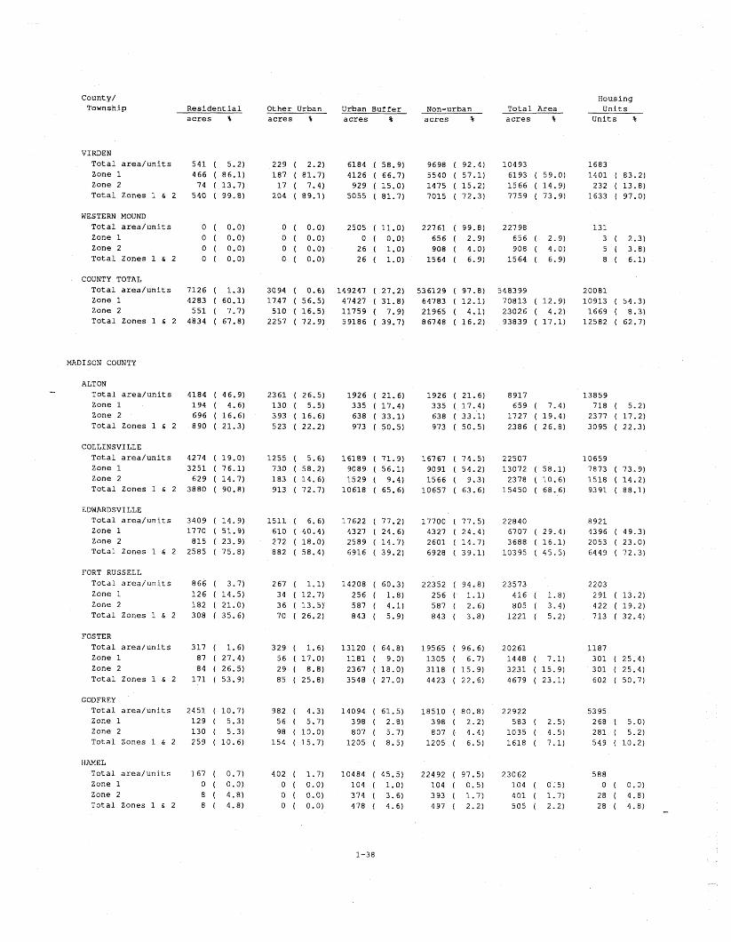
County/ Township R e s i d e n t i a l
a c r e s %
Housing U n i t s
U n i t s %
Other Urban a c r e s %
Urban Buffe r a c r e s %
Non-urban a c r e s %
T o t a l Area a c r e s %
VIRDEN T o t a l a r e a / u n i t s 5 4 1 ( 5.2) Zone 1 466 ( 86.1) Zone 2 74 ( 13.7) T o t a l Zones 1 & 2 540 ( 99.8)
WESTERN MOUND
T o t a l a r e a / u n i t s 0 ( 0.0) Zone 1 0 ( 0.0) Zone 2 0 ( 0.0) T o t a l Zones 1 h 2 0 ( 0.0)
COUNTY TOTAL T o t a l a r e a / u n i t s 7126 ( 1.3) Zone 1 4283 ( 60.1) Zone 2 5 5 1 ( 7.7) T o t a l Zones 1 h 2 4'834 ( 67.8)
MADISON COUNTY
ALTON - T o t a l a r e a / u n i t s 4184 Zone 1 194 Zone 2 6 96 T o t a l Zones 1 h 2 890
COLLINSVILLE T o t a l a r e a / u n i t s 4274 ( 19.0) Zone 1 3 2 5 1 ( 76.1) Zone 2 629 ( 14 .7) T o t a l Zones 1 & 2 3880 ( 90.8)
EDWARDSVILLE T o t a l a r e a / u n i t s 3409 ( 14 .9) Zone 1 1770 ( 51.9) Zone 2 815 ( 23.9) T o t a l Zones 1 h 2 2585 ( 75.8)
FORT RUSSELL T o t a l a r e a / u n i t s 866 ( 3.7) Zone 1 1 2 6 ( 14.5) Zone 2 182 ( 21.0) T o t a l Zones 1 & 2 308 ( 35.6)
FOSTER T o t a l a r e a / u n i t s 317 ( 1.6) Zone 1 87 ( 27.4) Zone 2 84 ( 26.5) T o t a l Zones 1 h 2 1 7 1 ( 53.9)
GODFREY T o t a l a r e a / u n i t s 2451 ( 10.7) Zone 1 1 2 9 ( 5.3) Zone 2 130 ( 5.3) T o t a l Zones 1 & 2 259 ( 10 .6)
HAMEL T o t a l a r e a / u n i t s 167 ( 0.7) Zone 1 0 ( 0.0) zone 2 8 ( 4.8) T o t a l Zones 1 & 2 8 ( 4.8)

Coun ty / Township R e s i d e n t i a l
Hous ing U n i t s
U n i t s %
O t h e r Urban a c r e s %
Urban B u f f e r a c r e s %
Non-urban a c r e s %
T o t a l Area a c r e s % a c r e s %
JARVI S
T o t a l a r e a / u n i t s Zone 1 Zone 2 T o t a l Zones 1 & 2
MORO T o t a l a r e a / u n i t s Zone 1 Zone 2 T o t a l Zones 1 & 2
NEW DOUGLAS T o t a l a r e a / u n i t s Zone 1 Zone 2 T o t a l Zones 1 & 2
OLIVE T o t a l a r e a / u n i t s Zone 1 Zone 2 T o t a l Zones 1 & 2
OMP HGHENT T o t a l a r e a / u n i t s Zone 1 Zone 2 T o t a l Zones 1 & 2
PIN OAK T o t a l a r e a / u n i t s Zone 1 Zone 2 T o t a l Zones 1 & 2
WOOD RIVER T o t a l a r e a / u n i t s Zone 1 Zone 2 T o t a l Zones 1 & 2
COUNTY TOTAL T o t a l a r e a / u n i t s 30541 ( 6 .5 ) Zone 1 7023 ( 23.0) Zone 2 3310 ( 1 0 . 8 ) T o t a l Zones 1 & 2 1 0 3 3 3 ( 33 .8 )
MARION COUNTY
CENTRALIA T o t a l a r e a / u n i t s 2572 ( 1 0 . 8 ) Zone 1 1 2 93 z o n e 2 312 T o t a l Zones 1 & 2 1605
KINMUNDY T o t a l a r e a / u n i t s 427 Zone 1 0 Zone 2 10
T o t a l Zones 1 & 2 1 0

County/ Township R e s i d e n t i a l
Housing U n i t s
U n i t s %
Other Urban a c r e s %
Urban Buffe r a c r e s %
Non-urban '
a c r e s %
T o t a l Area a c r e s % a c r e s %
ODIN T o t a l a r e a / u n i t s Zone 1 Zone 2 T o t a l Zones 1 & 2
SALEM T o t a l a r e a / u n i t s Zone 1 Zone 2 T o t a l Zones 1 & 2
SANDOVAL T o t a l a r e a / u n i t s Zone 1 Zone 2 T o t a l Zones 1 & 2
COUNTY TOTAL T o t a l a r e a / u n i t s Zone 1 Zone 2 T o t a l Zones 1 & 2
MARSHALL COUNTY
BENNINGTON T o t a l a r e a / u n i t s Zone 1 Zone 2 T o t a l Zones 1 & 2
EVANS T o t a l a r e a / u n i t s Zone 1 Zone 2 T o t a l Zones 1 & 2
3.9) 3.3) 7.2)
75.0) 0.0) 0.4) 0.5)
88.5) 6.1)
15.9) 22.0)
LOO. 0) 1.0) 4.5) 5.5)
95.3) 1.7) 2.4) 4.0)
HENRY T o t a l a r e a / u n i t s Zone 1 Zone 2 T o t a l Zones 1 & 2
STEUBEN T o t a l a r e a / u n i t s Zone 1 Zone 2 T o t a l Zones 1 & 2
WHITEFIELD T o t a l a r e a / u n i t s Zone 1 Zone 2 T o t a l Zones 1 & 2
COUNTY TOTAL T o t a l a r e a / u n i t s Zone 1 Zone 2 T o t a l Zones 1 & 2

Coun ty / Township
Hous ing U n i t s
U n i t s %
R e s i d e n t i a l O t h e r Urban a c r e s %
Urban B u f f e r T o t a l A r e a a c r e s % a c r e s % a c r e s
6238 1273
946 2219
2693 0
a c r e s
19638 1344 1228 2572
13566 1 3 8 1
MENARD COUNTY
ATHENS T o t a l a r e a / u n i t s Zone 1 Zone 2 T o t a l Zones 1 & 2
ATTERBERRY T o t a l a r e a / u n i t s Zone 1 Zone 2 T o t a l Zones 1 & 2
GREENVI EW T o t a l a r e a / u n i t s Zone 1 Zone 2 T o t a l Zones 1 & 2
INDIAN CREEK T o t a l a r e a / u n i t s Zone 1 - Zone 2 T o t a l Zones 1 & 2
IRISH GROVE T o t a l a r e a / u n i t s Zone 1 Zone 2 T o t a l Zones 1 & 2
PETERSBURG T o t a l a r e a / u n i t s Zone 1 Zone 2 T o t a l Zones 1 & 2
ROCK CREEK T o t a l a r e a / u n i t s Zone 1 Zone 2 T o t a l Zones 1 & 2
SUGAR GROVE T o t a l a r e a / u n i t s Zone 1 Zone 2 T o t a l Zones 1 & 2
TALLULA T o t a l a r e a / u n i t s Zone 1 Zone 2 T o t a l Zones 1 & 2
COUNTY TOTAL T o t a l a r e a / u n i t s Zone 1 Zone 2 T o t a l Zones 1 & 2

County/ Township
Housing R e s i d e n t i a l Other Urban Urban Buffe r Non-urban T o t a l Area Uni t s a c r e s % a c r e s % a c r e s % a c r e s % a c r e s 3 Uni t s 3
MERCER COUNTY
DUNCAN T o t a l a r e a / u n i t s Zone 1 Zone 2 T o t a l Zones 1 & 2
GREENE T o t a l a r e a / u n i t s Zone 1 Zone 2 T o t a l Zones 1 & 2
MERCER T o t a l a r e a / u n i t s Zone 1 Zone 2 T o t a l Zones 1 & 2
MILLERSBURG T o t a l a r e a / u n i t s Zone 1
Zone 2 T o t a l Zones 1 & 2
P ERRYTON
T o t a l a r e a / u n i t s Zone 1 Zone 2 T o t a l Zones 1 & 2
PREEMPTION T o t a l a r e a / u n i t s Zone 1 Zone 2 T o t a l Zones 1 & 2
RICHLAND GROVE T o t a l a r e a / u n i t s Zone 1 Zone 2 T o t a l Zones 1 h 2
RIVOLI T o t a l a r e a / u n i t s Zone 1 Zone 2 T o t a l Zones 1 & 2
SUEZ T o t a l a r e a / u n i t s Zone 1 Zone 2 T o t a l Zones 1 & 2
COUNTY TOTAL T o t a l a r e a / u n i t s Zone 1 Zone 2 T o t a l Zones 1 & 2

County/ Township R e s i d e n t i a l
Housing U n i t s
U n i t s % Other Urban a c r e s %
Urban Buffe r a c r e s %
Non-urban a c r e s %
T o t a l Area a c r e s % a c r e s %
MONROE COUNTY
PRECINCT 14 T o t a l a r e a / u n i t s Zone 1 Zone 2 T o t a l Zones 1 & 2
PRECINCT 1 5 T o t a l a r e a / u n i t s Zone 1 Zone 2 T o t a l Zones 1 & 2
PRECINCT 20 T o t a l a r e a / u n i t s Zone 1 Zone 2 T o t a l Zones 1 & 2
PRECINCT 21 T o t a l a r e a / u n i t s Zone 1 - Zone 2 T o t a l Zones 1 & 2
PRECINCT 9 T o t a l a r e a / u n i t s Zone 1 Zone 2 T o t a l Zones 1 & 2
COUNTY TOTAL T o t a l a r e a / u n i t s Zone 1 Zone 2 T o t a l Zones 1 & 2
MONTGOMERY COUNTY
AUDUBON T o t a l a r e a / u n i t s Zone 1 Zone 2 T o t a l Zones 1 & 2
BOIS D'ARC T o t a l a r e a / u n i t s Zone 1 Zone 2 T o t a l Zones 1 & 2
BUTLER GROVE T o t a l a r e a / u n i t s Zone 1 Zone 2 T o t a l Zones 1 & 2
EAST FORK
T o t a l a r e a / u n i t s Zone 1 Zone 2 T o t a l Zones 1 & 2

County/ Township
Housing U n i t s --
U n i t s %
Resident l a 1 Other Urban a c r e s %
Urban Buffe r a c r e s %
Non-urban a c r e s %
T o t a l Area a c r e s % a c r e s %
FILLMORE T o t a l a r e a / u n i t s Zone 1 Zone 2 T o t a l Zones 1 & 2
G R I SHAM T o t a l a r e a / u n i t s Zone 1 Zone 2 T o t a l Zones 1 & 2
HARVE L T o t a l a r e a / u n i t s Zone 1 Zone 2 T o t a l Zones 1 & 2
HILLSBORO T o t a l a r e a / u n i t s Zone 1 Zone 2 T o t a l Zones 1 & 2
IRVING T o t a l a r e a / u n i t s Zone 1 Zone 2 T o t a l Zones 1 & 2
NOKOMIS T o t a l a r e a / u n i t s Zone 1 Zone 2 T o t a l Zones 1 & 2
NORTH LITCHFIELD T o t a l a r e a / u n i t s Zone 1 Zone 2 T o t a l Zones 1 & 2
P ITMAN T o t a l a r e a / u n i t s Zone 1 Zone 2 T o t a l Zones 1 & 2
RAYMOND T o t a l a r e a / u n i t s Zone 1 Zone 2 T o t a l Zones 1 & 2
ROUNTREE T o t a l a r e a / u n i t s Zone 1 Zone 2 T o t a l Zones 1 & 2
SOUTH FILLMORE T o t a l a r e a / u n i t s Zone 1 Zone 2 T o t a l Zones 1 & 2

County/ Township R e s i d e n t i a l
Housing U n i t s
U n i t s %
Other Urban a c r e s %
Urban B u f f e r a c r e s %
Non-urban a c r e s %
T o t a l Area a c r e s % a c r e s %
SOUTH LITCHFIELD T o t a l a r e a / u n i t s Zone 1 Zone 2 T o t a l Zones 1 & 2
WALSHVI LLE T o t a l a r e a / u n i t s Zone 1 Zone 2 T o t a l Zones 1 & 2
WITT T o t a l a r e a / u n i t s Zone 1 Zone 2 T o t a l Zones 1 & 2
COUNTY TOTAL T o t a l a r e a / u n i t s Zone 1 Zone 2 T o t a l Zones 1 & 2
MORGAN COUNTY
ARCADIA T o t a l a r e a / u n i t s Zone 1 Zone 2 T o t a l Zones 1 & 2
CHAPIN T o t a l a r e a / u n i t s Zone 1 Zone 2 T o t a l Zones 1 & 2
CONCORD T o t a l a r e a / u n i t s Zone 1 Zone 2 T o t a l Zones 1 & 2
FRANKLIN T o t a l a r e a / u n i t s Zone 1 Zone 2 T o t a l Zones 1 & 2
JACKSONVILLE T o t a l a r e a / u n i t s Zone 1 Zone 2
T o t a l Zones 1 h 2
LITERBERRY T o t a l a r e a / u n i t s Zone 1 Zone 2 T o t a l Zones 1 & 2

Coun ty / Township
H ous ing U n i t s
U n i t s %
R e s i d e n t l a 1 O t h e r Urban a c r e s %
Urban B u f f e r a c r e s %
T o t a l A r e a a c r e s % a c r e s % a c r e s
25330 30
202 232
22396
MEREDOS IA T o t a l a r e a / u n i t s Zone 1 Zone 2 T o t a l Zones 1 & 2
MURRAWILLE T o t a l a r e a / u n l t s Zone 1 Zone 2 T o t a l Zones 1 & 2
NORTONVILLE T o t a l a r e a / u n i t s Zone 1 Zone 2 T o t a l Zones 1 & 2
PISGAH T o t a l a r e a / u n i t s Zone 1 Zone 2 T o t a l Zones 1 & 2
&
PRENTICE T o t a l a r e a / u n i t s Zone 1 Zone 2 T o t a l Zones 1 & 2
COUNTY TOTAL T o t a l a r e a / u n i t s Zone 1 Zone 2 T o t a l Zones 1 & 2
MOULTRIE COUNTY
LOVINGTON T o t a l a r e a / u n i t s Zone 1 Zone 2 T o t a l Zones 1 & 2
COUNTY TOTAL T o t a l a r e a / u n i t s Zone 1 Zone 2 T o t a l Zones 1 & 2
PEORIA COUNTY
BRIMFIELD T o t a l a r e a / u n i t s 180 ( 0 .8 ) Zone 1 1 ( 0 .6 ) Zone 2 26 ( 1 4 . 4 ) T o t a l Zones 1 & 2 27 ( 1 5 . 0 )

County/ Township
Housing U n i t s
U n i t s %
R e s i d e n t i a l Other Urban a c r e s %
Urban Buffe r a c r e s %
Non-urban a c r e s %
T o t a l Area a c r e s % a c r e s %
CHILLICOTHE T o t a l a r e a / u n i t s Zone 1 Zone 2 T o t a l Zones 1 & 2
ELMWOOD T o t a l a r e a / u n i t s Zone 1 Zone 2 T o t a l Zones 1 & 2
HOLLIS T o t a l a r e a / u n i t s Zone 1 Zone 2 T o t a l Zones 1 & 2
JUBILEE T o t a l a r e a / u n i t s Zone 1 Zone 2 T o t a l Zones 1 & 2
.".
KICKAPOO T o t a l a r e a / u n i t s Zone 1 Zone 2 T o t a l Zones 1 & 2
LIMESTONE T o t a l a r e a / u n i t s Zone 1 Zone 2 T o t a l Zones 1 & 2
LOGAN T o t a l a r e a / u n i t s Zone 1 Zone 2 T o t a l Zones 1 & 2
MILLBROOK T o t a l a r e a / u n i t s Zone 1 Zone 2 T o t a l Zones 1 & 2
PEORIA CITY T o t a l a r e a / u n i t s Zone 1 Zone 2 T o t a l Zones 1 & 2
PRINCEVILLE T o t a l a r e a / u n i t s Zone 1 Zone 2 T o t a l Zones 1 & 2
RADNOR T o t a l a r e a / u n i t s Zone 1 Zone 2 T o t a l Zones 1 & 2
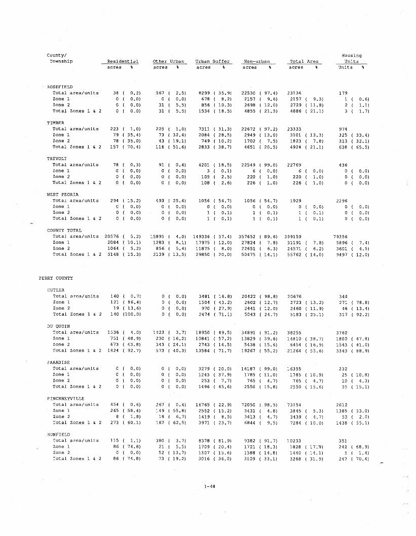
Coun ty / Township R e s i d e n t i a l
Hous ing U n i t s
U n i t s %
O t h e r Urban a c r e s %
Urban B u f f e r a c r e s %
Non-urban a c r e s %
T o t a l A r e a a c r e s % a c r e s %
ROSEFIELD T o t a l a r e a / u n i t s Zone 1 Zone 2 T o t a l Zones 1 & 2
TIMBER T o t a l a r e a / u n i t s Zone 1 Zone 2 T o t a l Zones 1 & 2
TRIVOLI T o t a l a r e a / u n i t s Zone 1 Zone 2 T o t a l Zones 1 & 2
WEST PEORIA T o t a l a r e a / u n i t s Zone 1 Zone 2 T o t a l Zones 1 & 2 -
COUNTY TOTAL T o t a l a r e a / u n i t s 20576 ( 5 .2 ) Zone 1 Zone 2 T o t a l Zones 1 & 2
PERRY COUNTY
CUTLER T o t a l a r e a / u n i t s Zone 1 Zone 2 T o t a l Zones 1 & 2
DU QUOIN T o t a l a r e a / u n i t s Zone 1 Zone 2 T o t a l Zones 1 & 2
PARADISE T o t a l a r e a / u n i t s Zone 1 Zone 2 T o t a l Zones 1 & 2
PINCKNEWILLE T o t a l a r e a / u n i t s Zone 1 Zone 2
T o t a l Zones 1 & 2
SUNFIELD T o t a l a r e a / u n i t s Zone 1 Zone 2 T o t a l Zones 1 & 2

County/ Township
Housing U n i t s
U n i t s %
R e s i d e n t i a l Other Urban a c r e s %
Urban B u f f e r a c r e s %
Non-urban a c r e s %
T o t a l Area a c r e s % a c r e s %
SWANWICK T o t a l a r e a / u n i t s Zone 1 Zone 2 T o t a l Zones 1 & 2
TAMAROA T o t a l a r e a / u n i t s Zone 1 Zone 2 T o t a l Zones 1 & 2
WILLISVILLE T o t a l a r e a / u n i t s Zone 1 Zone 2 T o t a l Zones 1 & 2
COUNTY TOTAL T o t a l a r e a / u n i t s Zone 1 Zone 2 T o t a l Zones 1 & 2
PIKE COUNTY
PEARL T o t a l a r e a / u n i t s Zone 1 Zone 2 T o t a l Zones 1 & 2
COUNTY TOTAL T o t a l a r e a / u n i t s Zone 1 Zone 2 T o t a l Zones 1 & 2
POPE COUNTY
EDDYVILLE NO. 6 T o t a l a r e a / u n i t s Zone 1 Zone 2 T o t a l Zones 1 & 2
GOLCONDA NO. 1 T o t a l a r e a / u n i t s Zone 1 Zone 2 T o t a l Zones 1 & 2
GOLCONDA NO. 2 T o t a l a r e a / u n i t s Zone 1 Zone 2 T o t a l Zones 1 & 2

County/ Township R e s i d e n t i a l
Housing U n i t s
Uni t s %
Other Urban a c r e s %
Urban Buffe r a c r e s %
Non-urban a c r e s %
T o t a l Area a c r e s % a c r e s %
GOLCONDA NO. 3 T o t a l a r e a / u n i t s Zone 1 Zone 2 T o t a l Zones 1 & 2
JEFFERSON NO. 4 T o t a l a r e a / u n i t s Zone 1 Zone 2 T o t a l Zones 1 & 2
WEBSTER NO. 5 T o t a l a r e a / u n i t s Zone 1 Zone 2
T o t a l Zones 1 & 2
COUNTY TOTAL T o t a l a r e a / u n i t s Zone 1 Zone 2 T o t a l Zones 1 & 2
PUTNAM COUNTY
GRANVILLE T o t a l a r e a / u n i t s Zone 1 Zone 2 T o t a l Zones 1 & 2
HENNEPIN T o t a l a r e a / u n i t s Zone 1 Zone 2 T o t a l Zones 1 & 2
COUNTY TOTAL
T o t a l a r e a / u n i t s Zone 1 Zone 2 T o t a l Zones 1 & 2
RANDOLPH COUNTY
BALDWIN T o t a l a r e a / u n i t s Zone 1 Zone 2 T o t a l Zones 1 & 2
BLAIR
T o t a l a r e a / u n i t s Zone 1 Zone 2 T o t a l Zones 1 & 2


County/ Township
Housing R e s i d e n t i a l Other Urban Urban Buffe r Non-urban T o t a l Area U n i t s a c r e s % a c r e s % a c r e s % a c r e s % a c r e s % U n i t s %
ROCK ISLAND COUNTY
ANDALUS IA T o t a l a r e a / u n i t s Zone 1 Zone 2 T o t a l Zones 1 & 2
BLACKHAWK T o t a l a r e a / u n i t s Zone 1 Zone 2 T o t a l Zones 1 & 2
COAL VALLEY T o t a l a r e a / u n i t s Zone 1 Zone 2 T o t a l Zones 1 & 2
D RU RY T o t a l a r e a / u n i t s Zone 1
A Zone 2 T o t a l Zones 1 & 2
EDGINGTON T o t a l a r e a / u n i t s Zone 1 Zone 2 T o t a l Zones 1 & 2
HAMPTON T o t a l a r e a / u n i t s Zone 1 Zone 2 T o t a l Zones 1 & 2
PORT BYRON T o t a l a r e a / u n i t s Zone 1 Zone 2 T o t a l Zones 1 & 2
RURAL T o t a l a r e a / u n i t s Zone 1 Zone 2 T o t a l Zones 1 & 2
SOUTH MOLINE T o t a l a r e a / u n i t s Zone 1 Zone 2 T o t a l Zones 1 & 2
ZUMA T o t a l a r e a / u n i t s Zone 1 Zone 2 T o t a l Zones 1 & 2


County/ Township
Housing U n i t s
U n i t s %
R e s i d e n t i a l Other Urban a c r e s %
Urban B u f f e r a c r e s %
Non-urban a c r e s %
T o t a l Area a c r e s % a c r e s %
LENZBURG T o t a l a r e a / u n i t s Zone 1 Zone 2 T o t a l Zones 1 6 2
MARISSA T o t a l a r e a / u n i t s Zone 1 Zone 2 T o t a l Zones 1 & 2
MASCOUTAH T o t a l a r e a / u n i t s Zone 1 Zone 2 T o t a l Zones 1 & 2
MILLSTADT T o t a l a r e a / u n i t s Zone 1 Zone 2 T o t a l Zones 1 & 2
NEW ATHENS T o t a l a r e a / u n i t s Zone 1 Zone 2 T o t a l Zones 1 & 2
O f FALLON T o t a l a r e a / u n i t s Zone 1 Zone 2 T o t a l Zones 1 & 2
PRAIRIE DU LONG T o t a l a r e a / u n i t s Zone 1 Zone 2 T o t a l Zones 1 & 2
SHILOH VALLEY T o t a l a r e a / u n i t s zone 1 Zone 2 T o t a l Zones 1 & 2
SMITHTON T o t a l a r e a / u n i t s Zone 1 Zone 2 T o t a l Zones 1 & 2
ST . CLAIR T o t a l a r e a / u n i t s Zone 1 Zone 2
T o t a l Zones 1 & 2
STOOKEY T o t a l a r e a / u n i t s Zone 1 Zone 2 T o t a l Zones 1 & 2

County/ Township R e s i d e n t i a l
Housing U n i t s
U n i t s %
Other Urban a c r e s %
Urban B u f f e r a c r e s %
Non-urban a c r e s %
T o t a l Area a c r e s % a c r e s %
COUNTY TOTAL T o t a l a r e a / u n i t s Zone 1 Zone 2 T o t a l Zones 1 & 2
SALINE COUNTY
BRUSHY T o t a l a r e a / u n i t s Zone 1 Zone 2 T o t a l Zones 1 & 2
CARRIER MILLS T o t a l a r e a / u n i t s Zone 1 Zone 2 T o t a l Zones 1 & 2
COTTAGE - T o t a l a r e a / u n i t s Zone 1 Zone 2 T o t a l Zones 1 & 2
EAST ELDORADO T o t a l a r e a / u n i t s Zone 1 Zone 2 T o t a l Zones 1 & 2
GALAT IA T o t a l a r e a / u n i t s Zone 1 Zone 2 T o t a l Zones 1 & 2
HARRISBURG T o t a l a r e a / u n i t s Zone 1 Zone 2 T o t a l Zones 1 & 2
INDEPENDENCE T o t a l a r e a / u n i t s Zone 1 Zone 2 T o t a l Zones 1 & 2
MOUNTAIN T o t a l a r e a / u n i t s Zone 1 Zone 2 T o t a l Zones 1 & 2
RALEIGH T o t a l a r e a / u n i t s Zone 1 Zone 2 T o t a l Zones 1 & 2

Coun ty / Townsh ip
H ous ing U n i t s
U n i t s %
R e s i d e n t i a l a c r e s %
O t h e r Urban a c r e s %
Urban B u f f e r a c r e s %
Non-urban a c r e s %
T o t a l A r e a a c r e s %
STONEFORT T o t a l a r e a / u n i t s 32 ( 0 .3 ) Zone 1 1 4 ( 43.8) Zone 2 1 8 ( 56.3) T o t a l Zones 1 & 2 32 (100 .0 )
COUNTY TOTAL T o t a l a r e a / u n i t s 4049 ( 1 .7 ) Zone 1 3132 ( 77.4) Zone 2 402 ( 9.9) T o t a l Zones 1 & 2 3534 ( 87 .3 )
SANGAMON COUNTY
AUBURN T o t a l a r e a / u n i t s 511 Zone 1 2 91 Zone 2 1 2 1 T o t a l Zones 1 & 2 412
BALL T o t a l a r e a / u n i t s 549 Zone 1 0 ( 0 .0 ) Zone 2 9 ( 1 . 6 ) T o t a l Zones 1 & 2 9 ( 1 . 6 )
CAP I TAL T o t a l a r e a / u n i t s 11113 ( 38 .7 ) Zone 1 6156 ( 55.4) Zone 2 1 6 7 7 ( 15 .1 ) T o t a l Zones 1 & 2 7833 ( 70.5)
CARTWRIGHT T o t a l a r e a / u n i t s 154 ( 0.3) Zone 1 11 ( 7.1) Zone 2 66 ( 42.9) T o t a l Zones 1 & 2 77 ( 50.0)
CHATHAM T o t a l a r e a / u n i t s 465 ( 2.0) Zone 1 47 ( 1 0 . 1 ) Zone 2 104 T o t a l Zones 1 & 2 1 5 1
CLEAR LAKE T o t a l a r e a / u n i t s 11 1 7 Z o n e 1 ' 946 Zone 2 1 9 T o t a l Zones 1 & 2 965
CURRAN T o t a l a r e a / u n i t s 62 Zone 1 47 ( 75 .8 ) Zone 2 1 3 ( 21.0) T o t a l Zones 1 & 2 60 ( 96.8)
DIVERNON T o t a l a r e a / u n i t s 1 8 9 ( 1.1) Zone 1 1 8 9 (100 .0 ) Zone 2 0 ( 0 .0 ) T o t a l Zones 1 & 2 1 8 9 (100 .0 )

County/ Township
Housing U n i t s
Uni t s %
R e s i d e n t i a l Other Urban a c r e s %
Urban Buffe r a c r e s %
Non-urban a c r e s %
T o t a l Area a c r e s % a c r e s %
FANCY CREEK T o t a l a r e a / u n i t s Zone 1 Zone 2 T o t a l Zones 1 & 2
GARDNER T o t a l a r e a / u n i t s Zone 1 Zone 2 T o t a l Zones 1 & 2
ISLAND GROVE T o t a l a r e a / u n i t s Zone 1 Zone 2 T o t a l Zones 1 & 2
LOAM1 T o t a l a r e a / u n i t s Zone 1 Zone 2 T o t a l Zones 1 & 2 -
MAXWELL T o t a l a r e a / u n i t s Zone 1 Zone 2 T o t a l Zones 1 & 2
MECHANICSBURG T o t a l a r e a / u n i t s Zone 1 Zone 2 T o t a l Zones 1 & 2
PAWNEE T o t a l a r e a / u n i t s Zone 1 Zone 2 T o t a l Zones 1 h 2
ROCHESTER T o t a l a r e a / u n i t s Zone 1 Zone 2 T o t a l Zones 1 & 2
SALISBURY T o t a l a r e a / u n i t s Zone 1 Zone 2 T o t a l Zones 1 & 2
SPRINGFIELD T o t a l a r e a / u n i t s Zone 1 Zone 2 T o t a l Zones 1 & 2
WILLIAMS T o t a l a r e a / u n i t s Zone 1 Zone 2
T o t a l Zones 1 & 2

County/ Township
Housing R e s i d e n t i a l Other Urban Urban Buffe r Non-urban T o t a l Area U n i t s a c r e s % a c r e s % a c r e s % a c r e s % a c r e s % U n i t s %
WOODSIDE T o t a l a r e a / u n i t s 1738 ( 15.5) 1090 ( 9.7) 7339 ( 65.5) 7895 ( 70.4) 11210 6778 Zone 1 1258 ( 72.4) 742 ( 68.1) 1890 ( 25.8) 1890 ( 23.9) 3890 ( 34.7) 4607 ( 68.0) Zone 2 1 5 1 ( 8.7) 68 ( 6.2) 520 ( 7.1) 520 ( 6.6) 739 ( 6.6) 572 ( 8.4) T o t a l Zones 1 & 2 1409 ( 81.1) 810 ( 74.3) 2410 ( 32.8) 2410 ( 30.5) 4629 ( 41.3) 5179 ( 76.4)
COUNTY TOTAL T o t a l a r e a / u n i t s 18789 ( 3.5) 14764 ( 2.8) 209624 ( 39.1) 497989 ( 92.9) 535763 72529 Zone 1 10016 ( 53.3) 6578 ( 44.6) 43114 ( 20.6) 56750 ( 11.4) 73344 ( 13.7) 37600 ( 51.8) Zone 2 2390 ( 12.7) 1553 ( 10.5) 14763 ( 7.0) 21582 ( 4.3) 25525 ( 4.8) 9198 ( 12.7)
T o t a l Zones 1 & 2 12406 ( 66.0) 8131 ( 55.1) 57877 ( 27.6) 78332 ( 15.7) 98869 ( 18.5) 46798 ( 64.5)
SCHUYLER COUNTY
BAINBRIDGE T o t a l a r e a / u n i t s Zone 1 Zone 2 T o t a l Zones 1 & 2
- BROOKLYN T o t a l a r e a / u n i t s Zone 1 Zone 2 T o t a l Zones 1 h 2
BROWNING T o t a l a r e a / u n i t s Zone 1 Zone 2 T o t a l Zones 1 & 2
BUENA VISTA T o t a l a r e a / u n i t s Zone 1 Zone 2 T o t a l Zones 1 & 2
CAMDEN T o t a l a r e a / u n i t s Zone 1 Zone 2 T o t a l Zones 1 & 2
FREDERICK T o t a l a r e a / u n i t s Zone 1 Zone 2 T o t a l Zones 1 & 2
HUNTSVILLE T o t a l a r e a / u n i t s Zone 1 Zone 2 T o t a l Zones 1 & 2
LITTLETON T o t a l a r e a / u n i t s Zone 1 Zone 2 T o t a l Zones 1 & 2

County/ Township
Housing U n i t s R e s i d e n t i a l O the r Urban
a c r e s %
Urban B u f f e r a c r e s %
Non-urban a c r e s %
T o t a l Area a c r e s % a c r e s % U n i t s %
OAKLAND T o t a l a r e a / u n i t s Zone 1 Zone 2 T o t a l Zones 1 & 2
RUSHVILLE T o t a l a r e a / u n i t s Zone 1 Zone 2 T o t a l Zones 1 & 2
WOODSTOCK T o t a l a r e a / u n i t s Zone 1 Zone 2 T o t a l Zones 1 & 2
COUNTY TOTAL T o t a l a r e a / u n i t s Zone 1 Zone 2 T o t a l Zones 1 & 2 -
SCOTT COUNTY
ALSEY T o t a l a r e a / u n i t s Zone 1 Zone 2 T o t a l Zones 1 & 2
EXETER-BLUFFS T o t a l a r e a / u n i t s Zone 1 Zone 2 T o t a l Zones 1 & 2
WINCHESTER NO. 1 T o t a l a r e a / u n i t s Zone 1 Zone 2 T o t a l Zones 1 & 2
WINCHESTER NO. 2 T o t a l a r e a / u n i t s Zone 1 Zone 2 T o t a l Zones 1 & 2
COUNTY TOTAL
T o t a l a r e a / u n i t s Zone 1 Zone 2 T o t a l Zones 1 & 2

County/ Township
Housing U n i t s
U n i t s %
R e s i d e n t i a l O t h e r Urban a c r e s %
Urban B u f f e r a c r e s %
Non-urban a c r e s %
T o t a l Area a c r e s % a c r e s %
SHELBY COUNTY
ASH GROVE T o t a l a r e a / u n i t s Zone 1 Zone 2 T o t a l Zones 1 & 2
BIG SPRING T o t a l a r e a / u n i t s Zone 1 Zone 2 T o t a l Zones 1 & 2
CLARKSBURG T o t a l a r e a / u n i t s Zone 1 Zone 2 T o t a l Zones 1 & 2
DRY POINT T o t a l a r e a / u n i t s Zone 1 - Zone 2 T o t a l Zones 1 & 2
FLAT BRANCH T o t a l a r e a / u n i t s Zone 1 Zone 2 T o t a l Zones 1 h 2
HOLLAND T o t a l a r e a / u n i t s Zone 1 Zone 2 T o t a l Zones 1 & 2
LAKEWOOD T o t a l a r e a / u n i t s Zone 1 Zone 2 T o t a l Zones 1 & 2
MOWEAQUA T o t a l a r e a / u n i t s Zone 1 Zone 2 T o t a l Zones 1 & 2
OCONEE T o t a l a r e a / u n i t s Zone 1 Zone 2 T o t a l Zones 1 & 2
OKAW T o t a l a r e a / u n i t s Zone 1 Zone 2 T o t a l Zones 1 & 2

County/ Township
Housing Uni t s
U n i t s %
R e s i d e n t i a l Other Urban a c r e s %
Urban Buffe r a c r e s %
Non-urban a c r e s %
T o t a l Area a c r e s % a c r e s %
RIDGE T o t a l a r e a / u n i t s Zone 1
Zone 2 T o t a l Zones 1 & 2
ROSE T o t a l a r e a / u n i t s Zone 1 Zone 2 T o t a l Zones 1 & 2
RURAL T o t a l a r e a / u n i t s Zone 1 Zone 2 T o t a l Zones 1 & 2
SHELBWILLE T o t a l a r e a / u n i t s Zone 1 Zone 2 T o t a l Zones 1 & 2
TOWER HILL T o t a l a r e a / u n i t s Zone 1 Zone 2 T o t a l Zones 1 & 2
COUNTY TOTAL T o t a l a r e a / u n i t s Zone 1 Zone 2 T o t a l Zones 1 & 2
STARK COUNTY
ELMIRA T o t a l a r e a / u n i t s Zone 1 Zone 2 T o t a l Zones 1 & 2
ESSEX T o t a l a r e a / u n i t s Zone 1 Zone 2 T o t a l Zones 1 & 2
GOSHEN T o t a l a r e a / u n i t s Zone 1 Zone 2 T o t a l Zones 1 & 2
P ENN T o t a l a r e a / u n i t s Zone 1 Zone 2 T o t a l Zones 1 h 2

Coun ty / Township
Hous ing U n i t s R e s i d e n t i a L
a c r e s %
O t h e r Urban a c r e s %
Urban B u f f e r a c r e s %
Non-urban a c r e s %
T o t a l A r e a a c r e s % U n i t s %
TOULON T o t a l a r e a / u n i t s 496 ( 2 .2 ) Zone 1 0 ( 0.0) Zone 2 9 ( 1 - 8 1 T o t a l Zones 1 h 2 9 ( 1 . 8 )
WEST JERSEY T o t a l a r e a / u n i t s 3 1 ( 0 .1 ) Zone 1 0 ( 0.0) Zone 2 0 ( 0.0) T o t a l Z o n e s l h 2 O ( 0 .0 )
COUNTY TOTAL T o t a l a r e a / u n i t s 1 1 0 6 ( 0.6) Zone 1 0 ( 0.0) Zone 2 9 ( 0.8) T o t a l Zones 1 & 2 9 ( 0 .8 )
TAZEWELL COUNTY
CINCINNATI - T o t a l a r e a / u n i t s 1007 Zone 1 184 Zone 2 9 0 T o t a l Zones 1 h 2 274
ELM GROVE T o t a l a r e a / u n i t s 590 Zone 1 1 0 2 Zone 2 3 8 T o t a l Zones 1 h 2 140
FONDULAC T o t a l a r e a / u n i t s 1293 Zone 1 0 Zone 2 1 T o t a l Zones 1 & 2 1
GROVE LAND T o t a l a r e a / u n i t s 3267 Zone 1 974 Zone 2 4 62 T o t a l Zones 1 h 2 1 4 3 6
PEKIN T o t a l a r e a / u n i t s 2779 ( 31 .4 ) Zone 1 535 ( 1 9 . 3 ) Zone 2 343 ( 12 .3 ) T o t a l Zones 1 & 2 878 ( 31 .6 )
COUNTY TOTAL T o t a l a r e a / u n i t s 15336 ( 3 .7 ) Zone 1 1795 ( 11 .7 ) Zone 2 934 ( 6.1) T o t a l Zones 1 h 2 2729 ( 17.8)

County/ Township
Housing R e s i d e n t i a l Other Urban Urban Buffe r Non-urban T o t a l Area U n i t s a c r e s % a c r e s % a c r e s % a c r e s % a c r e s % U n i t s %
U N I O N COUNTY
ALTO PASS T o t a l a r e a / u n i t s Zone 1 Zone 2 T o t a l Zones 1 & 2
COBDEN 2 T o t a l a r e a / u n i t s Zone 1 Zone 2 T o t a l Zones 1 & 2
JONESBORO 1 T o t a l a r e a / u n i t s Zone 1 Zone 2 T o t a l Zones 1 & 2
MILL CREEK T o t a l a r e a / u n i t s Zone 1 Zone 2 T o t a l Zones 1 & 2
COUNTY TOTAL T o t a l a r e a / u n i t s Zone 1 Zone 2 T o t a l Zones 1 & 2
VERMILION COUNTY
BLOUNT T o t a l a r e a / u n i t s Zone 1 Zone 2 T o t a l Zones 1 & 2
CARROLL T o t a l a r e a / u n i t s Zone 1 Zone 2 T o t a l Zones 1 & 2
CATLIN T o t a l a r e a / u n i t s Zone 1 Zone 2 T o t a l Zones 1 & 2
DANVILLE T o t a l a r e a / u n i t s Zone 1 Zone 2 T o t a l Zones 1 & 2
ELWOOD Tota l a r e a / u n i t s Zone 1 Zone 2 T o t a l Zones 1 h 2

County/ Township
Housing U n i t s
Uni t s %
R e s i d e n t i a l Other Urban a c r e s %
Urban Buffe r a c r e s %
Non-urban a c r e s %
T o t a l Area a c r e s % a c r e s %
GEORGETOWN T o t a l a r e a / u n i t s Zone 1 Zone 2 T o t a l Zones 1 & 2
JAMAICA T o t a l a r e a / u n i t s Zone 1 Zone 2 T o t a l Zones 1 & 2
LOVE T o t a l a r e a / u n i t s Zone 1 Zone 2 T o t a l Zones 1 & 2
MCKENDREE T o t a l a r e a / u n i t s Zone 1 Zone 2 T o t a l Zones 1 & 2
&
OAKWOOD T o t a l a r e a / u n i t s Zone 1
Zone 2 T o t a l Zones 1 & 2
PILOT T o t a l a r e a / u n i t s Zone 1 Zone 2 T o t a l Zones 1 & 2
VANCE
T o t a l a r e a / u n i t s Zone 1 Zone 2 T o t a l Zones 1 & 2
COUNTY TOTAL T o t a l a r e a / u n i t s Zone 1
Zone 2 T o t a l Zones 1 & 2
WABASH COUNTY
BELLMONT T o t a l a r e a / u n i t s Zone 1 Zone 2 T o t a l Zones 1 & 2
COFFEE T o t a l a r e a / u n i t s Zone 1 Zone 2 T o t a l Zones 1 & 2

County/ Township
Housing U n i t s
U n i t s %
R e s i d e n t i a l Ot.her Urban a c r e s %
Urban B u f f e r a c r e s %
Non-urban a c r e s %
T o t a l Area a c r e s % a c r e s %
COMPTON T o t a l a r e a / u n i t s Zone 1 Zone 2 T o t a l Zones 1 & 2
FRIENDSVILLE T o t a l a r e a / u n i t s Zone 1 Zone 2 T o t a l Zones 1 & 2
LICK PRAIRIE T o t a l a r e a / u n i t s Zone 1 Zone 2 T o t a l Zones 1 & 2
MOUNT CARMEL T o t a l a r e a / u n i t s Zone 1 Zone 2 T o t a l Zones 1 & 2
-
WABASH T o t a l a r e a / u n i t s Zone 1 Zone 2 T o t a l Zones 1 & 2
COUNTY TOTAL T o t a l a r e a / u n i t s Zone 1 Zone 2 T o t a l Zones 1 & 2
WARREN COUNTY
BERWICK T o t a l a r e a / u n i t s Zone 1 Zone 2 T o t a l Zones 1 & 2
ELLISON T o t a l a r e a / u n i t s Zone 1 Zone 2 T o t a l Zones 1 & 2
GREENBUSH T o t a l a r e a / u n i t s Zone 1 Zone 2 T o t a l Zones 1 & 2
KELLY T o t a l a r e a / u n i t s Zone 1 Zone 2 T o t a l Zones 1 & 2

County/ Township
Housing U n i t s
U n i t s %
R e s i d e n t i a l Other Urban a c r e s %
Urban Buffe r a c r e s %
Non-urban a c r e s %
T o t a l Area a c r e s % a c r e s %
MONMOUTH T o t a l a r e a / u n i t s Zone 1 Zone 2 T o t a l Zones 1 & 2
ROSEVILLE T o t a l a r e a / u n i t s Zone 1 Zone 2 T o t a l Zones 1 & 2
SPRING GROVE T o t a l a r e a / u n i t s Zone 1 Zone 2 T o t a l Zones 1 & 2
SWAN T o t a l a r e a / u n i t s Zone 1 Zone 2 T o t a l Zones 1 & 2 -
TOMPKINS T o t a l a r e a / u n i t s Zone 1 Zone 2 T o t a l Zones 1 & 2
COUNTY TOTAL T o t a l a r e a / u n i t s Zone 1 Zone 2 T o t a l Zones 1 & 2
WASHINGTON COUNTY
ASHLEY T o t a l a r e a / u n i t s Zone 1 Zone 2 T o t a l Zones 1 & 2
BEAUCOUP T o t a l a r e a / u n i t s Zone 1 Zone 2 T o t a l Zones 1 & 2
DU BOIS T o t a l a r e a / u n i t s Zone 1 Zone 2 T o t a l Zones 1 & 2
I RVINGTON T o t a l a r e a / u n i t s Zone 1 Zone 2 T o t a l Zones 1 & 2
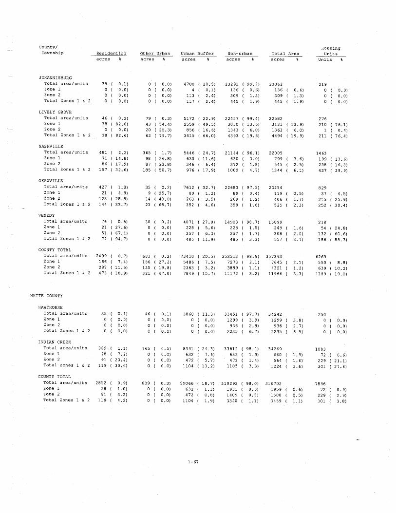
County/ Township
Housing U n i t s
U n i t s %
R e s i d e n t i a l O the r Urban a c r e s %
Urban B u f f e r a c r e s %
Non-urban a c r e s %
T o t a l Area a c r e s % a c r e s %
JOHANNISBURG T o t a l a r e a / u n i t s Zone 1 Zone 2 T o t a l Zones 1 & 2
LIVELY GROVE T o t a l a r e a / u n i t s Zone 1 Zone 2 T o t a l Zones 1 & 2
NASHVILLE T o t a l a r e a / u n i t s Zone 1 Zone 2 T o t a l Zones 1 & 2
OKAWVILLE T o t a l a r e a / u n i t s Zone 1 Zone 2 T o t a l Zones 1 & 2
- VENEDY
T o t a l a r e a / u n i t s Zone 1
Zone 2 T o t a l Zones 1 & 2
COUNTY TOTAL T o t a l a r e a / u r i i t s Zone 1 Zone 2 T o t a l Zones 1 h 2
WHITE COUNTY
HAWTHORNE T o t a l a r e a / u n i t s Zone 1 Zone 2 T o t a l Zones 1 & 2
INDIAN CREEK T o t a l a r e a / u n i t s Zone 1 Zone 2 T o t a l Zones 1 & 2
COUNTY TOTAL
T o t a l a r e a / u n i t s Zone 1 Zone 2 T o t a l Zones 1 & 2

Coun ty / Township R e s i d e n t i a l
Hous ing T o t a l Area U n i t s a c r e s % U n i t s %
O t h e r Urban a c r e s 3
Urban B u f f e r a c r e s %
Non-urban a c r e s % a c r e s 3
WILL COUNTY
CUSTER T o t a l a r e a / u n i t s Zone 1 Zone 2 T o t a l Zones 1 ti 2
REED T o t a l a r e a / u n i t s Zone 1 Zone 2 T o t a l Zones 1 & 2
WILMINGTON T o t a l a r e a / u n i t s Zone 1 Zone 2 T o t a l Zones 1 & 2
COUNTY TOTAL T o t a l a r e a / u n i t s 32336 ( 6.0) Zone 1 549 ( 1 .7 ) - Zone 2 245 ( 0 .8 ) T o t a l Zones 1 & 2 794 ( 2.5)
WILLIAMSON COUNTY
BLAIRSVILLE T o t a l a r e a / u n i t s Zone 1 Zone 2 T o t a l Zones 1 & 2
CARTERVILLE T o t a l a r e a / u n i t s Zone 1 Zone 2 T o t a l Zones 1 & 2
CORINTH T o t a l a r e a / u n i t s Zone 1 Zone 2 T o t a l Zones 1 & 2
CRAB ORCHARD T o t a l a r e a / u n i t s Zone 1 Zone 2 T o t a l Zones 1 & 2
EAST MARION T o t a l a r e a / u n i t s Zone 1 Zone 2 T o t a l Zones 1 & 2
GRASSY T o t a l a r e a / u n i t s Zone 1 Zone 2 T o t a l Zones 1 & 2

County/ Township
Housing Uni t s R e s i d e n t i a l Other Urban
a c r e s %
Urban Buffe r a c r e s %
Non-urban a c r e s %
T o t a l Area a c r e s % acres % U n i t s 8
HERRIN T o t a l a r e a / u n i t s Zone 1 Zone 2 T o t a l Zones 1 & 2
LAKE CREEK T o t a l a r e a / u n i t s Zone 1 Zone 2 T o t a l Zones 1 & 2
SOUTHERN T o t a l a r e a / u n i t s Zone 1 Zone 2 T o t a l Zones 1 & 2
STONEFORT T o t a l a r e a / u n i t s Zone 1 Zone 2 T o t a l Zones 1 & 2 -
WEST MARION
T o t a l a r e a / u n i t s Zone 1 Zone 2 T o t a l Zones 1 & 2
COUNTY TOTAL T o t a l a r e a / u n i t s Zone 1 Zone 2 T o t a l Zones 1 & 2
WOODFORD COUNTY
CLAYTON T o t a l a r e a / u n i t s Zone 1 Zone 2 T o t a l Zones 1 & 2
METAMORA T o t a l a r e a / u n i t s Zone 1 Zone 2 T o t a l Zones 1 & 2
MINONK T o t a l a r e a / u n i t s Zone 1 Zone 2
T o t a l Zones 1 & 2
ROANOKE T o t a l a r e a / u n i t s Zone 1 Zone 2 T o t a l Zones, 1 & 2

County/ Township R e s i d e n t i a l Other Urban
a c r e s % a c r e s %
WORTH T o t a l a r e a / u n i t s 982 ( 4.4) 409 ( 1.8) Zone 1 0 ( 0.0) 0 ( 0.0) Zone 2 0 ( 0.0) 0 ( 0.0) T o t a l Zones 1 & 2 0 ( 0.0) 0 ( 0.0)
COUNTY TOTAL T o t a l a r e a / u n i t s 4113 ( 1.2) 2689 ( 0.8) Zone 1 1 9 0 ( 4.6) 287 ( 10 .7) Zone 2 84 ( 2.0) 83 ( 3.1) T o t a l Zones 1 & 2 274 ( 6.7) 370 ( 13.8)
Urban Buffe r a c r e s %
Non-urban T o t a l Area a c r e s % a c r e s %
Housing U n i t s
U n i t s %

Appendix 2: Maps and Charts Depicting the Distribution of
Mines, Land Use and Housing Units
This appendix contains a map and two charts for each county studied in this project. The maps
depict the location of the residential and other urban land use, townships, Zones 1 and 2, and the
urban buffer zone. All maps are 1:250,000 scale and use the symbols shown below. Mine
boundaries are not delineated because at this map scale they coincide with the Zone 1 boundary.
The charts depict selected data from Appendix 1: the total county acreage in Zone 1 in the land
use categories and the estimated number of housing units for each township. To facilitate
comparisons of charts between counties we have used the same scale for most charts. Different
scales had to be used for some counties to accommodate unusually large acreage or housing unit
values. Most of the land use charts have a maximum y-axis of 10,000 acres; a few have a maximum of 50,000 acres and one has 100,000 acres. Most of the housing unit charts have a
maximum x-axis of 3,000 units; a few have a maximum of 10,000 or 25,000 units.
Residential mmnmD Other Urban
Transportation
Boundaries N Zones 1 and 2
Political Townships ' Urban Buffer
Mine Shaft

-
S COUNTY
0 5 miles C - - ,

one a
2
0 RESIDENTIAL OTHER URBAN NON-URBAN URBAN BUFFER
one nits/ ns Adams County
MELROSE
aUlNCY
Q unl ts
3 units 1 I I I I I
0 0.6 1 1.6 2 2.6 3 Houaing Units (Thousand$)

LEXANDER COUNTY

e creage e lexander
137 acres 3 4 acres 0 1 I I . 1
RESIDENTIAL OTHER URBAN NON-URBAN URBAN BUFFER
one its/ Alexander County
No Unlta In Zone 1
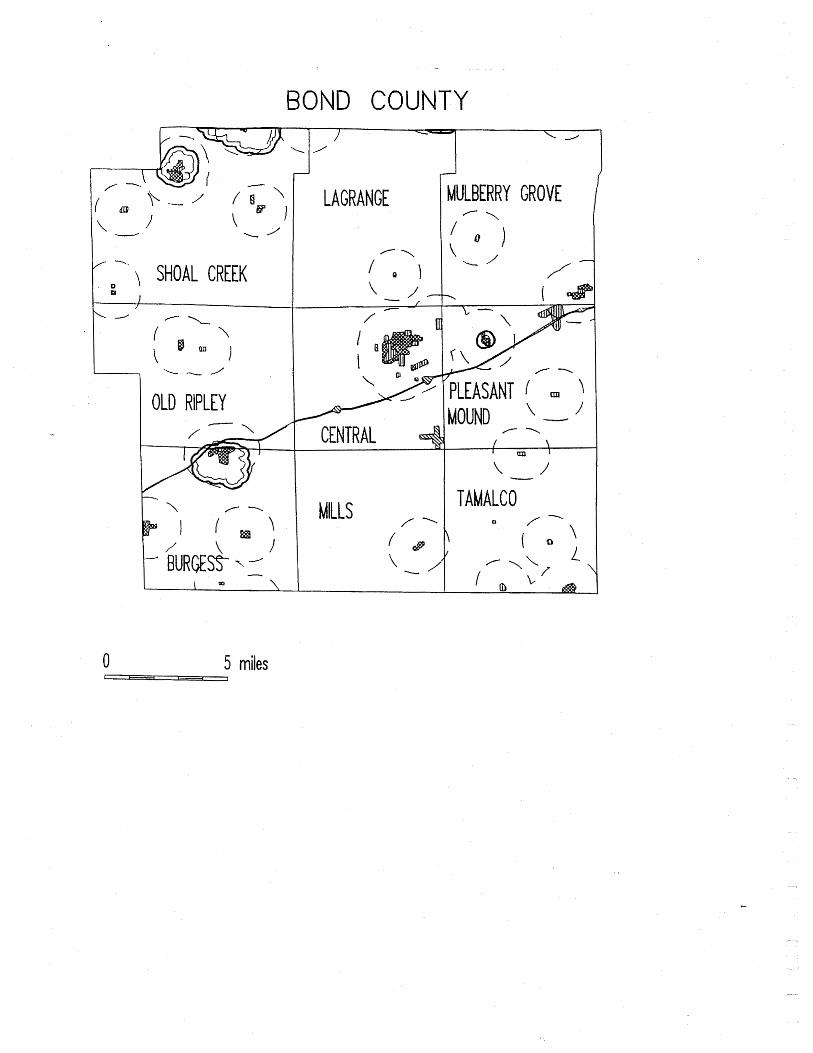
COUNTY
r. 1 SHOAL CREEK
OLD RIPLEY
0 5 miles I - -
LAGRANGE
--\
CENTRAL 4
ILLS f "
MULBERRY GROVE
PLEASANT , \ MOUND \ - 1
/-\
TAMALCO

2
0 RBAN URBANBUFFER
one ns
BURQES9
OLD RIPLEY
PLEASANT MOUND
SHOAL CREEK c 0 8.6 1 1.5 2 2.5 3
Houaing Unlts (Thousand.)

0 5 miles I - - ,
VERSAILLES - ' 1 7 - \

one reage a se rown C
1 380 acres 33 acres
0 t
RESIDENTIAL OTHER URBAN NON-URBAN URBAN BUFFER
one
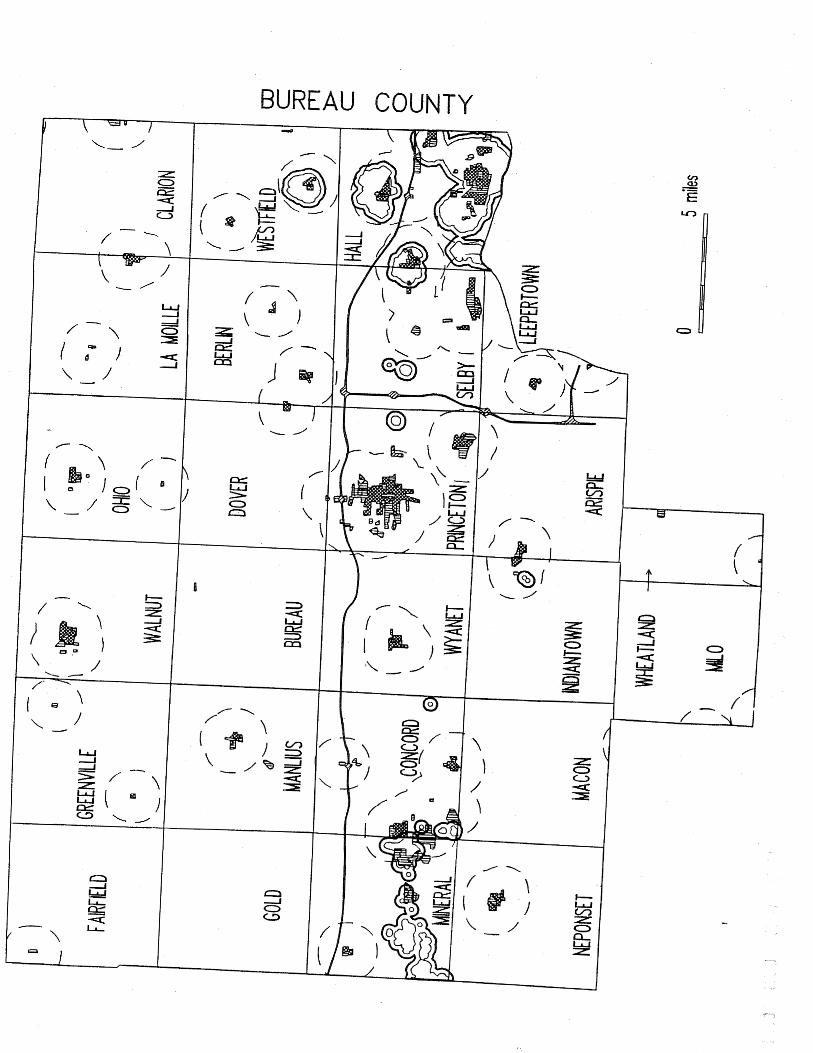

one a e
RESIDENTIAL OTHER URBAN NON-URBAN URBAN BUFFER
one
PRINCETON / 1 unit
SELBY
WESTFIELD 1 I 1 1 1 1
- -
0 0.6 1 1 .PI 2 2.6 3 Hou8lna Unltr (Thouund~)

CALHOU COUNTY
0 5 miles t ,

one a e
160 acres 27 sore8 0 1 1 I
RESlDENTlAL OTHER URBAN NON-URBAN URBAN BUFFER
one
No Unlta In Zone 1

CARROLL COUNTY

36 sores 17 ecres I
0 I I
RESIDENTIAL OTHER URBAN NON-URBAN URBAN BUFFER
one s
No Untts In Zone 1


creage a e
8 acres 214 acres 118 acrea 0 1 I
RESIDENTIAL OTHER URBAN NON-URBAN URBAN BUFFER
one
0 0.6 1 1.5 2 2.5 3 Wourlng Unltr (Thouundr)

PAlGN COUNTY
COLFAX
SADORUS
COMPROMISE tP
\ 1
/ SOMER
I / - ,
- 1
STANTON
f - \
RAYMOND /

I 1 I I
RESIDENTIAL OTHER URBAN NON-URBAN URBAN BUFFER

- MOUNT AUBURN / '
! " I
/ ' /-
a I / (-0 -
\ \
/ I 1, L - 1
-.
@ ; 0 f -
RICKS
JOHNSON
GREENWOOD
0 5 miles
PRAIRIETON
m
ASSUMPTIOT - f \
1 0 )
\ - PANA

- - Acror (Thourand.) 55830 aoree
RESIDENTIAL OTHER URBAN NON-URBAN URBAN BUFFER
one nits/ Christian County
ASSUMPTION
BUCKHART
JOHNSON
PANA
PRAIRIETON
SOUTH FORK
STONINGTON 1

- .-
CLINTON COUNTY
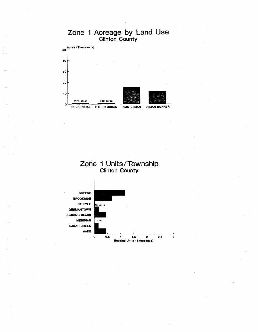
" RE81DENTIAL OTHER URBAN NON-URBAN URBAN BUFFER
QERMANTOWN
LOOKING GLASS
MERIDIAN I 1 unit
SUGAR CREEK
HUDE
0 0.6 1 1.6 2 2.5 9 Houainq Unltr (Thousands)

ES COU
- /' SEVEN HICKORY
0 5 miles I - ,

one
2
MATTOON
0 0.6 1 1.6 2 2.6 3 Houring Unltr (Thou8anda)
-
17 acres 17 acres 0 1 I I I
REBIDENTIAL OTHER URBAN NON-URBAN URBAN BUFFER

FORD COUNTY
1 1
LICKING
I OBLONG
PRAIRIE / - \ \
\ - 1 I -
0 5 miles I - . ]

Q ecrse 17 acrrr 218 acres 185 acres 0 0
RESIDENTIAL OTHER URBAN NON-URBAN URBAN BUFFER
one nits/ s Crawford County
PALESTINE 1s un~ra , I I 1 I
0 1
0.6 1 1.6 2 2.6 3 Hourlng Unltr (Thoueandd
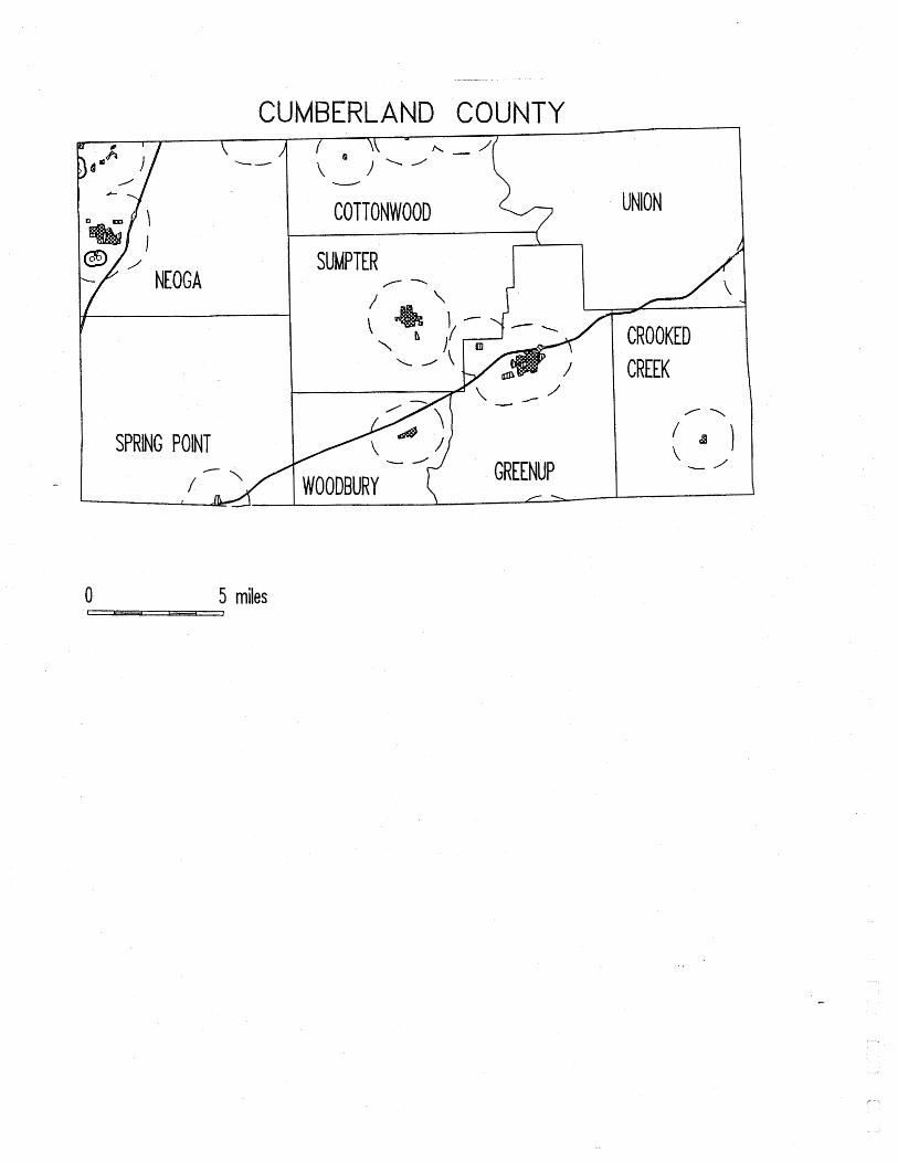
I I
NEOGA
- -
D COUNTY
SPRING POINT
0 5 miles
i W ).' - COTTONWOOD
SUMPTER /--
UNION
CROOKED

creage Cumberland
42 acres 4 2 ecrea
Aarer
0 I L
REBIDENTIAL OTHER URBAN NON-URBAN URBAN BUFFER
10
8
6
4
2
one wns Cumberland Count
- -
-
-
-
No Unlts In Zone 1

S COUNTY
BOURBON
0 5 miles I - ,
\
' ARCOLA
CAMARGO - /
L - '
BOWDRE - \
MURDOCK
SARGENT

U -
RESIDENTIAL OTHER URBAN NON-URBAN URBAN BUFFER
one nits/ s Douglas County
SARGENT 4 units , I I 1 I I
0 0.6 1 1.5 2 2.5 3 Housing Unlts (Thousands)

--- -
GE COUNTY
BLOOMINGDALE
WAYNE
WINFIELD
0 5 miles I - - ,

63 acres 60 sores 86 acres 0
RESIDENTIAL OTHER URBAN NON-URBAN URBAN BUFFER
one s

-
EDGAR COUNTY
I YOUNG AMERICA I ROSS
1 EDGAR
PRAIRIE
BROUILLETTS CREEK
0 5 miles I - , - - , ,

one creage a e Edgar Co
- RESIDENTIAL OTHER URBAN NON-URBAN URBAN BUFFER
one
HUNTER
STRATTON 7 units
2 unit, I 1 I 1 I
0 0.6 1 1.6 2 2.6 3 Houring Unit8 (Thou88ndd

RDS COUNTY
SHELBY I
30NE GAP, , \ m
ALBION 1 / - \
0 5 miles

creage a e Edwards County
17 ewes 0 1 1 I 1
RESIDENTIAL OTHER URBAN NON-URBAN URBAN BUFFER
one
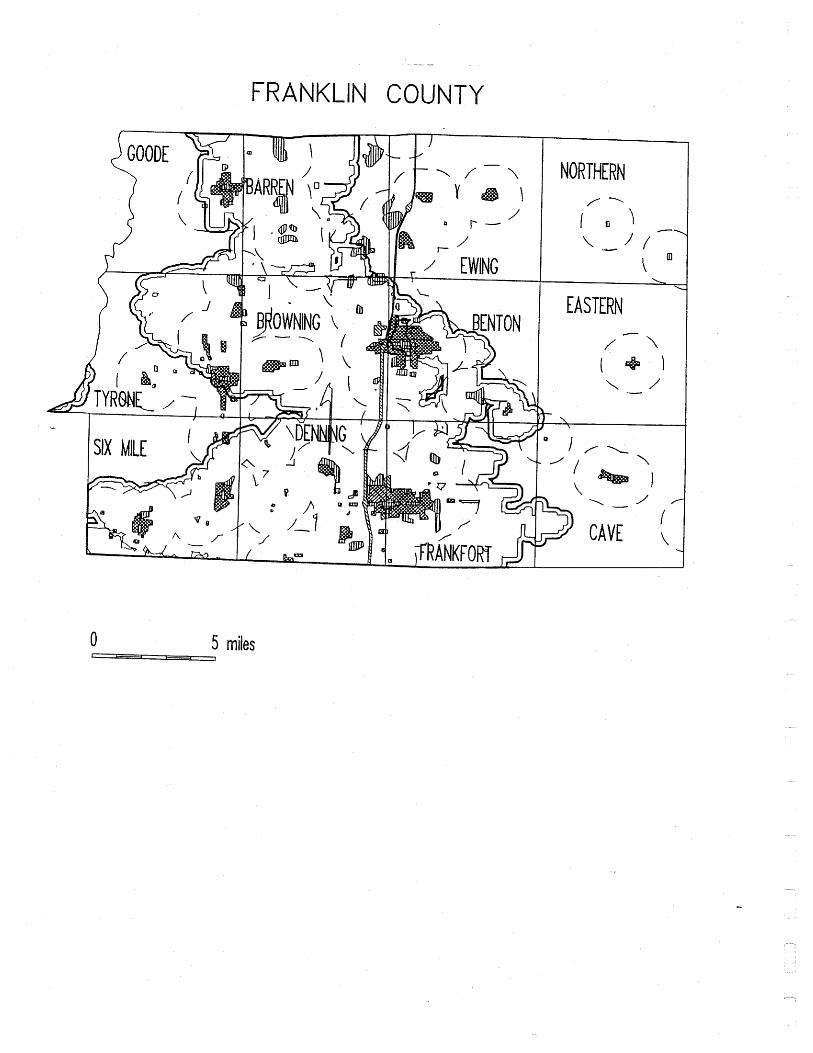
0 5 miles
NORTHERN / -
EASTERN
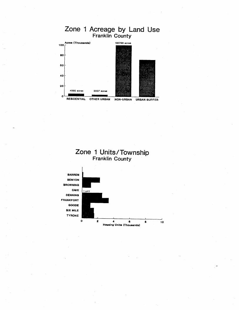
e creage a e
100786 aores
3337 aorss
0
one s
BARREN
BENTON
BROWNING
DENNING
FRANKFORT
QOODE
81X MILE
TYRONE
U 4 6 8 10 Hwaina Unite (Thoumnds)


one a e
- RESIDENTIAL OTHER URBAN NON-URBAN URBAN BUFFER
one s
ASTORIA BUCKHEART
CANTON DEERFIELD
FAIRVIEW FARMINQTON
ISABEL JOSHUA KERTON
ORION PLEASANT
PUTMAN UNION
WOODLAND YOUNQ HICKORY
0 0.6 1 1.6 2 2.6 3 Houein~ Unit8 (Thouaandr)

COUNTY
/ ~- \ \ I
\
I \ OMAHA L -I
/ NORTH FORK I RIDGWAY
0 5 miles 1 - 1
NEWHAVEN (
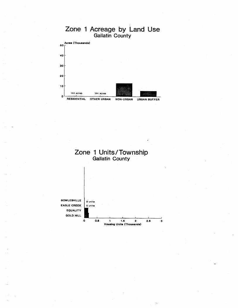
10
0 RESIDENTIAL OTHER URBAN NON-URBAN URBAN BUFFER
one Gallatin County
EQUALITY
QOLD HILL
BOWLESVILLE
EAQLE CREEK 8 unlta

GREENE COUNTY
) WALKERVILLE - 1 WHITE / I
BLUFFDALE &
I CARROLLTON
ATHENSVILLE
0 5 miles r - = = = = I ,
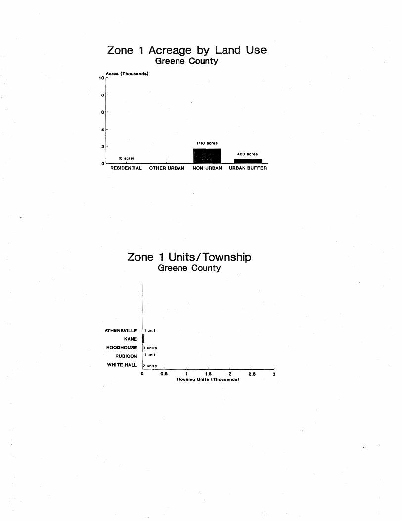
RESIDENTIAL OTHER URBAN NON-URBAN URBAN BUFFER
one nits/ Greene County
WHITE HALL 2 units 1 1 I 1
0 I
0.6 1 1.6 2 2.6 3 Houalng Unlta (Thousands)
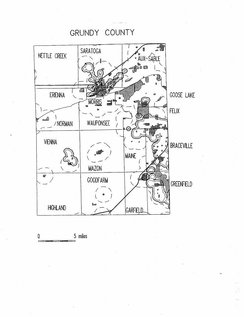
NETTLE CREEK
- ERIENNA
- - -
DY COUNTY
GOOSE LAKE
FELIX
GREENFIELD
0 5 miles

- RESIDENTIAL OTHER URBAN NON-URBAN URBAN BUFFER
one nits/ Grundy County
BRACEVILLE
FELIX
GARFIELD
QOOSE LAKE
GREENFIELD
MAINE
MORRIS
SARATOGA
0 0.6 1 1.6 2 2.6 3 Hourlng Units (Thouaanda)

ILTON COUNTY
\ KNIGHT PRAIRIE -
/ '
CROUCH
BEAVER CREEK
MAYBERRY / -
J @ I
i
' - ' / \
0 5 miles I - J

- -
RESIDENTIAL OTHER URBAN NON-URBAN URBAN BUFFER
one Hamilton County
Houaing Units (Thousands)
MCLEANSBORO 11 ,"1t, 1 1 I I 1
0 0.6 1 1.6 2 2.6 3

- -
CK COU

e creage a e
204 sores 241 ecres 0
RESIDENTIAL OTHER URBAN NON-URBAN URBAN BUFFER
one nits/ s ock C
No Unltm In Zone 1

WEST MONROE
STONE CHURCH
0 5 miles L - - ,

V
RESIDENTIAL OTHER URBAN NON-URBAN URBAN BUFFER
one nits/ s ardin County
CAVE-I N-ROCK
EAST ROSlCLARE
PETERS CREEK
ROCK CREEK
STONE CHURCH
WEST ROSlCLARE
4 units
6 unlts
12 unlts I 0 0.6 1 1.6 2 2.6 3
Houring Unltr (Thourandr)

HENDERSO COUNTY
' BALD BLUFF
GLADSTONE /--
LOMAX -Ld@!I I
TERRE HAUTE / -
\ '\ ,
ROZETTA
0 5 miles L - ,

17 acres 17 eoree
0 1 I I t
RE81DENTIAL OTHER URBAN NON-URBAN URBAN BUFFER

RY COUNTY
LOR AlNE
CORNWALL
/ - \ MUNSON I
1 0 '
-
5 miles
' - 4
CAMBRIDGE I
7
Y ORKTOWN I '.
ALBA
ANNA WAN

w
RESIDENTIAL OTHER URBAN NON-URBAN URBAN BUFFER
one nits Henry County
COLONA
OALVA
HANNA
KEWNEE
OXFORD
WESTERN
13 unl ts
18 unlts
12 unlla
0 0.6 1 1 .S 2 2.6 3 Houring Units (Thourends)

JACKS0 COUNTY
KINK AID
ORA
LEV AN L
1 ' SAND RIDGE
I
/'
SOMERSET -
5 miles

I
RESIDENTIAL OTHER URBAN NON-URBAN URBAN BUFFER
one nits/ s
CARBONDALE
DE SOT0
ELK
MAKANDA
MURPHYSBORO
SOMERSET
VERGENNES
60 unl t8 r I unit
1 I 1 1 J
0 0.6 1 1.6 2 2.6 3 Hourlnp Unltr (Thourandr)

SPER COUNTY
GROVE
CROOKED - CREEK / \ \ " I '-1
NORTH MUDDY WADE
0 5 miles 1 - f
/-'
I 1 L.4 / GRANDVILLE
HUNT CITY' ' WILLOW HI!,l, - \
FOX
I ] STE. MARIE , -

creage a
0 1 I
RE8IDENTIAL OTHER URBAN NON-URBAN URBAN BUFFER
its asper County
No Unltr In Zone 1

CASNER \
CCLELLAN f 1 /
, ELK PRAIRIE - DODDS I
WEBBER
/ MOORES PRAIRIE
0 5 miles I - ,

20
10
0 RBAN NON-URBAN URBAN BUFFER
its s
BALD HILL
BL188VILLE
DODOEL
ELK PRAIRIE
MCCLELLAN
MOUNT VERNON
- Houmlna Unltm (Thoumando)
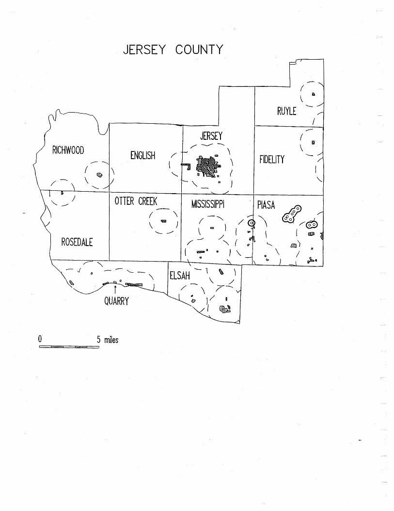
JERSEY COU
I JERSEY / - - .
ENGLISH \ I \
\ \
- MISSISSIPPI
FIDELITY -4
PI ASA \ 1
0 5 miles l 7

160 acraa 62 eoroa 0 t h
RESIDENTIAL OTHER URBAN NON-URBAN URBAN BUFFER
No Unlts In Zone 1

JODAVIESS COU

RESIDENTIAL OTHER URBAN NON-URBAN URBAN BUFFER
one nits/ JoDaviess County
ELIZABETH
VINEGAR HILL 1 ' ''Its WEST GALENA
0 0.6 1 1.6 2 2.6 3
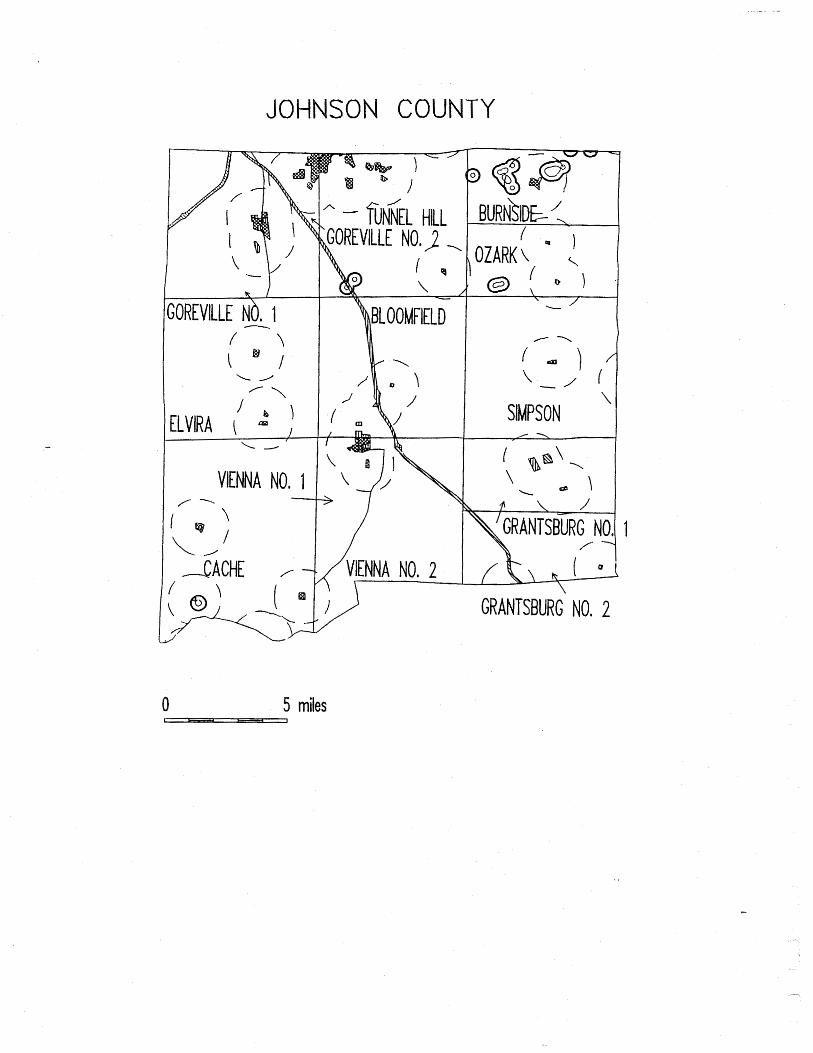
0 5 miles 1 - 7-, ,

e creage a
460 aore8 4 acres 200 scrsr
0 I I J
RESIDENTIAL OTHER URBAN NON-URBAN URBAN BUFFER
NO Unlta In Zone 1
0 0.6 1 3. 2.6 3 Hou~lna Unl ta(Thouund8)

KAKEE COU
I Gq = C/)
I " ' \ 1 t-l C- 0 \ -
/ /'

e ankakee
Acres (Thousands)
'"I
01 RESIDENTIAL OTHER URBAN NON-URBAN URBAN BUFFER

KNOX COUNTY
I RIO
HENDERSOK-, - - , \
ONTARIO 1 . 1 I \
7 - /
I -.
LYNN
@ @ VICTORIA
ELBA
0 5 miles r - 7 ,

8
8
4
2
0 RESIDENTIAL OTHER URBAN NON-URBAN URBAN BUFFER
one
KNOX
ONTARIO
CEDAR
QALESBURQ CITY
HENDERSON
7 unlta
""Its
' ' " I t
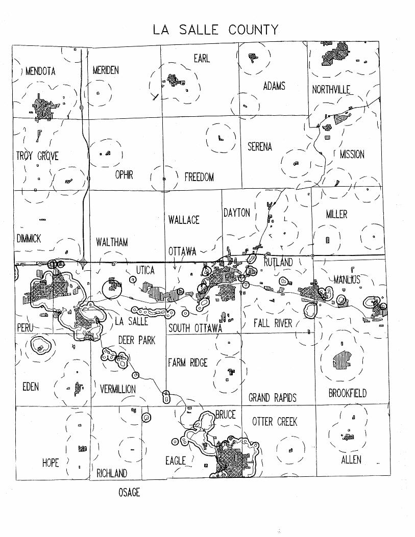
LA SALLE COUNTY
EDEN
HOPE L
ALLEN -
OSAGE

e a
Acres (Thousands)
RESIDENTIAL OTHER URBAN NON-URBAN URBAN BUFFER
e ship
/ , GROVELAND
EAQLE EDEN
OTTERCREEK PERU
SOUTH O T T M
0 5 miles 1 ,

.-.- - - -
CE COUNTY
CHRISTY -' \ / . 6
BRIDGEPORT 7
0 5 miles r ,

e creage a s Lawrence County
Acror (Thourandr) 10 r
0 1 1
RESIDENTIAL OTHER URBAN NON-URBAN URBAN BUFFER
No Unlts In Zone 1
I I I I I J
0 0.6 1 1.6 2 2. 3 Hou8inq Unl tr(Thou~nd8)

SUNBURY
LONG POINT - NEBRASKA
C--_
I \
WALDO
ROOKS CREEK
ESMEN
0 5 miles I - - ]
NEVADA I'\ /
AVOCA -
INDIAN GROVE
1 BELLE 1 PRAIRIE
( I
UNION
PLEASANT RIDGE - / \
I I
FORREST
I - 1 FAYETTE

70UND GROVE \
4 7 l a J
SULLIVAN
CHARLOTTE ,-\
I \
I
- -
CHATS W ORTH
GERM ANVIL LE
one se
RESIDENTIAL OTHER URBAN NON-URBAN URBAN BUFFER
ivingston Count
INDIAN GROVE
NEWTOWN
PONTIAC
READING
14 unlts
14 unl ts
Hourlng Units (Thoueande)

\ f
; 1 I /
PRAIRIE CREEK
/ - \ \
a I / -2.1 I
SHERID AN \
COUNTY
\ EMINENCE
f -4 I 1
WEST LINCOLN - . \ 1
-.
- EAST LINCOLN
0 5 miles I - ,
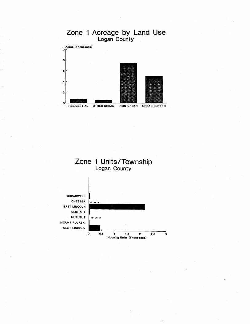
Acroa (Thouranda)
lor
one nits/
BROADWELL
CHESTER
EAST LINCOLN
ELKHART
HURLBUT
MOUNT PULASKI
WEST LINCOLN
a
ogan County
- Houalng Unite (Thourande)

COUNTY
\ LAMOINE i
- CHALMERS I / \ SCOTLAND '.
\ - /' NEW SALEM -
ELDORADO 4
0 5 miles ____Z==L_1

Acrer (Thourandr)
' O r
ne its / a
McDonough County
BETHEL
COLCHESTER
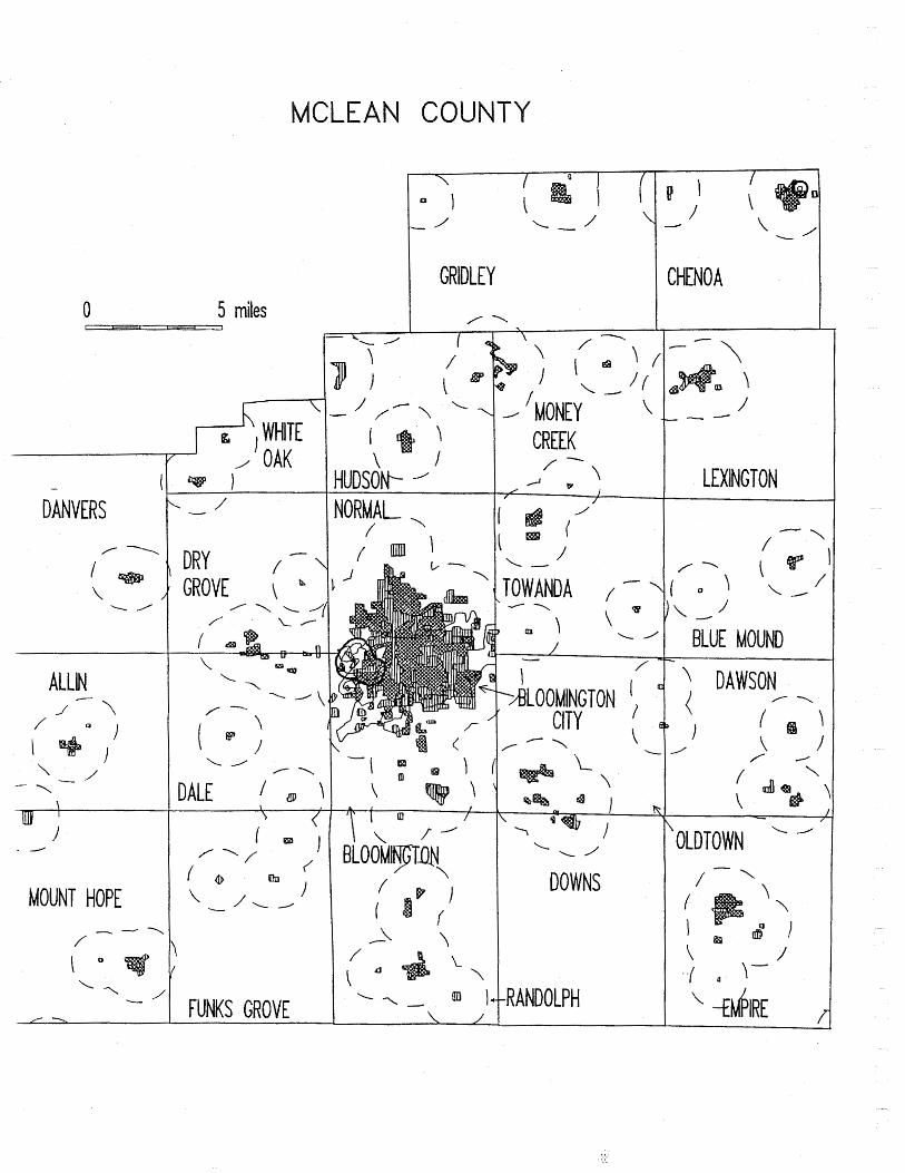
CLE
0 5 miles I - - ,
MOUNT HOPE
A ' OAK
DALE a \
FUNKS GROVE
COUNT
N O R M A L / -',
I
/ -
I " 1
\ . / I / - 'MONEY CREEK
TOWANDA / - \
---.
DOWNS
CHENO A
LEXINGTON
- / BLUE MOUND
DAWSON 1 0 - \
OLDTOWN \ /

YATES
LAWNDALE
f--\
MARTIN
ARRO WSMlTH
/ CROPSEY \
ANCHOR
;HENEY'S GROVE I
'-,/ \
0 1 BELLFLOWER ,
oL RESIDENTIAL OTHER URBAN NON-URBAN URBAN BUFFER
e s nship McLean County
BLOOMINQTON CITY
MARTIN
NORMAL 5 units , I I I I 1
0 0.5 1 1.6 2 2.6 3 Housing Unite (Thousande)

ACON COUNTY
1 - r2; SOUTH PLEASANTVIEW MACON
0 5 miles -

Acres (Thousands) l o r
one
DECATUR
NlANTlC
Housln~ Unlta (Thousands)

L 1
SCOTTVILLE
BARR d
i l
- WESTERN ' \ \ MOUND I
CHESTERFIELD -
/ \ " I
SOUTH PALMYRA 1 NIL W OOD
BRUSHY MOUND
POLK e
8 1
1 HILLY ARD / -
\
I
GlR ARD
MOUNT OLIVE
STAUNTON
0 5 miles 1 - -

a se Macoupin County
Acre8 (Thouranda)
60
4 0
20
0 RBANBUFFER
rn
Macoupin County
BRUSHY MOUND BUNKER HILL
CAHOKIA CARLINVILLE
CHESTERFIELD DORCHESTER
OlLLESPlE GIRARD
MOUNT OLIVE NILWOOD
S H W 8 POINT a SHIPMAN
SOUTH OTTER STAU NTON
VIRDEN WESTERN MOUND

ADISON COUNTY

RESIDENTIAL OTHER URBAN NON-URBAN URBAN BUFFER
one nits Madison County
ALTON COLLINSVILLE
EDHURDSVILLE
FORT RUSSELL
FOSTER
QODFREY
JARVIS
MORO
OLIVE
OMPHGHENT
PIN OAK
WOOD RIVER
0 2 4 6 8 10 Houalng Unit8 (Thourands)

SANDOVAL
ARlON COUNTY
I - 1
. 'SALEM 1 \
lACCOON
'ENTR A L IA
\ I ALMA OMEGA
\ - I ' STEVENSON
0 5 miles I - - ,

CENTRALIA
ODIN
SALEM
SANDOVAL
. - Hourlng Unit8 (Thoueand~)

ARSHALL COUNTY

Acrea (Thouaanda) 10
RESIDENTIAL OTHER URBAN NON-URBAN URBAN BUFFER
one ns Marshall County
BENNINQTON
EVAN8
STEUBEN
WHITEFIELD I unit ,I unit I I I I
0 0.6 1 1.6 2 2.6 3 Houaln~ Unit. (Thouaanda)

ENARD COUNTY
IRISH
CREEK / \{
ATTERBERRY I I FANCY ' PRAIRIE -
ROCK CREEK {ATHENS 1
TALLULA
0 5 miles C - ,

Acre8 (Thousands)
' O r
RESIDENTIAL OTHER URBAN NON-URBAN URBAN BUFFER
one its/ Menard County
PETERSBURQ
ROCK CREEK l2 Un"8
TALLULA) , , , , , , 0 0.6 1 1.6 2 2.6 3
Housing Unita (Thousands)

ERCER COUNTY

6
4
2
0 RESIDENTIAL OTHER URBAN NON-URBAN URBAN BUFFER
m
ercer County
DUNCAN
QREENE
PREEMPTION
RICHLAND GROVE
uelnq Units (Thourands)

ONROE COUNTY
0 5 miles I - , , , ,

0 RESIDENTIAL OTHER URBAN NON-URBAN URBAN BUFFER
one nits/ Monroe County
I I I I
0 1
0.6 1 1.6 2 2.6 3 Houalng Unita (Thouband81

/ \ HARVEL \ /
/
- - -
ERY COUNTY
s ) / GRISHA \
I 1 IRVING \ - / 1
I I
FILLMORE
/ EAST FORK
AUDUBON
0 5 miles I - -

e e
Acres (Thousands) 40 r
3 0
2 0
10
0 RESIDENTIAL OTHER URBAN NON-URBAN URBAN BUFFER
one Montgomery County
8018 DSARC
EAST FORK
QRISHAM
HILLSBORO
NOKOM18
NORTH LlTCHFlELD
PITMAN
SOUTH FILLMORE
SOUTH LlTCHFlELD
WlTT

COUNTY -

e creage a se
Acre8 (Thousands)
'"1
18 acres 4 .ore8 4 8 acres 0 I I
RESIDENTIAL OTHER URBAN NON-URBAN URBAN BUFFER
its/ s Morgan County
JACKSONVILLE 1 unit I 1 1 I I
0 0.6 1 1.5 2 2.5 3 Houring Unlts (Thousands)

OULTRlE COUNTY
DORA
\ - / \ MARROWBONE
\ SULLIVAN
0 5 miles
ION ATHAN CREEK
- EAST NELSON
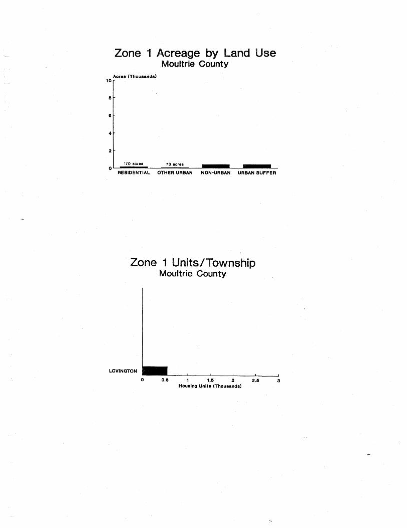
170 acres 73 acres 0
RESIDENTIAL OTHER URBAN NON-URBAN URBAN BUFFER
one Moultrie County
LOVINGTON
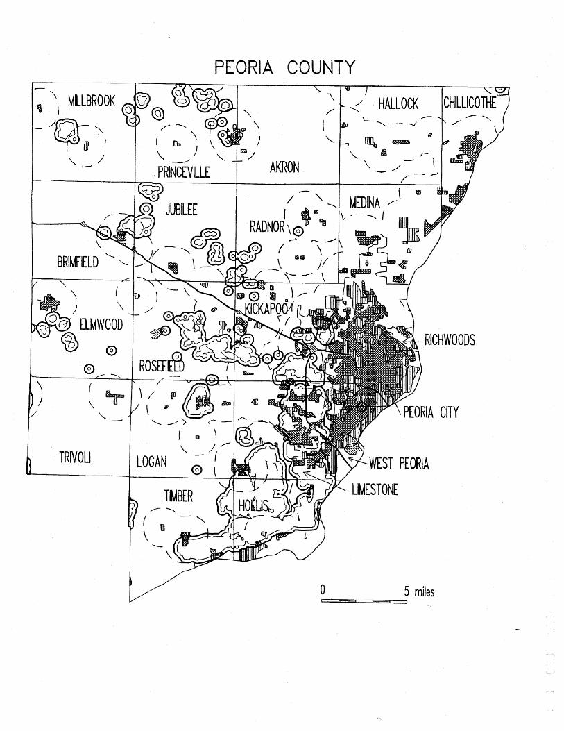
PEORIA COU
\ ' ' AKRON P R ~ ~ I L L E
w
1 HALLOCK CHILLICOTHE \
0 5 miles I - ,

Y
REBIDENTIAL OTHER URBAN NON-URBAN URBAN BUFFER
one its/ s eoria County
BRIMFIELD
ELMWOOD
HOLLIS
JUBILEE
KlCKAP00
LIMESTONE
L O m N
PEORIA CITY
PRINCEVILLE
ROSEFIELD
TIMBER
t3 unlts
2 units
2 unlte
0 2 4 6 8 10 Hourlnp Units (Thousands)

PERRY CO I
BEAUCOUP -7 .--
TAMAROA
0 5 miles I t - - - r )

u RESIDENTIAL OTHER URBAN NON-URBAN URBAN BUFFER
nits wns erry County
CUTLER
DU QUOIN
PARADISE
PINCKNEYVILLE
SUNFIELD
S'VIUNWICK
TAMAROA
WlLLlSVlLLE

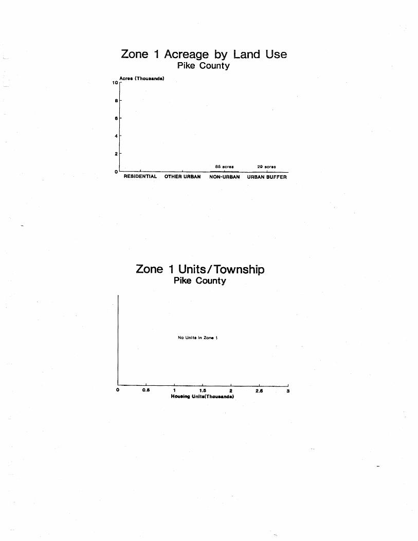
86 ecree 2Q acre8 0 I 1 I
RESIDENTIAL OTHER URBAN NON-URBAN URBAN BUFFER
one
No Unltr In Zone 1
I I I I 1
0 0.5 1 1.6 1
2 2.6 3 Houaiw Uni ta(Thouund8)

POPE COU
'. /
EDDYVILLE NO. 6
0 5 miles 1 - 1
NO. 3
1

208 acres 0
URBAN BUFFER
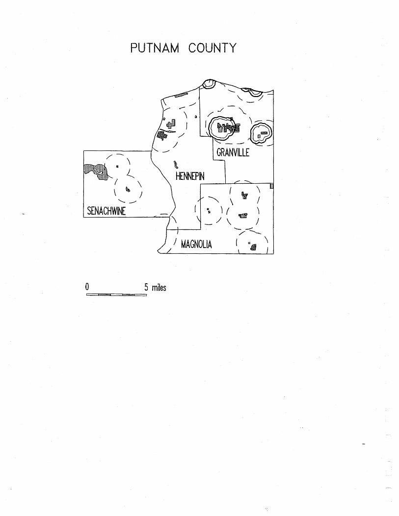
COUNTY
1 GRANVILLE - 1
0 5 miles

2
0 N NON-URBAN URBAN BUFFER
utnam County
GRANVILLE
Hourina Unltr (Thourandr)

ANDOLPH COUNTY

30
20
10
0 RESIDENTIAL OTHER URBAN NON-URBAN URBAN BUFFER
one
BLAIR
CENTRAL
CHEBTER
COULTERVILLE
PERCY
PRAIRIE DU ROCHER
SPARTA
STEELEVILLE
TILDEN
6 unlt8
8 units

ROCK ISLAND COU
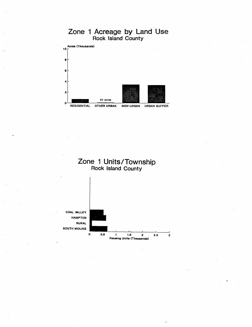
e
Aorer (Thousands)
2
0 RESIDENTIAL OTHER URBAN NON-URBAN URBAN BUFFER
ne nits/ Rock Island County
RURAL
SOUTH MOLlNE

ST. CLAlR COUNTY
L '
NEW ATHENS
0 5 miles r - ,-

REBIDENTIAL O f HER URBAN NON-URBAN URBAN BUFFER
BELLEVILLE CANTEEN
CASEY WILLE CENTREVILLE
0 5 10 15 20 25 Houaing Unltr (Thou8andr)

- - -
SALINE COU
f - TATE LONG ' ' BRANCH
RECTOR
BRUSHY
CARRIER MILLS
I STONEFORT MOUNTAIN I INDEPENDENCE
0 5 miles 1 - ,

creage a se Saline Co
RESIDENTIAL OTHER URBAN NON-URBAN URBAN BUFFER
BRUSHY
CARRIER MILLS
COTTAQE
EAST ELDORADO
QALATIA
HARCIISBURO
INDEPENDENCE
MOUNTAIN
RALEIGH
STONEFORT

ON COUNTY

Acres (Thourandr)
loo I
RESIDENTIAL OTHER URBAN NON-URBAN URBAN BUFFER
wns Sangamon County
AUBURN CAPITAL
CART WRIGHT CHATHAM
CLEAR LAKE CURRAN
DIVERNON FANCY CREEK
GARDNER MAXWELL
MECHANICSBURG PWNEE
ROCHESTER SPRINGFIELD
WILLIAMS WOODSIDE
1.4 ""It.
I I I 1 1
0 6 10 16 20 26 Housing Units (Thousands)

YLER COUNTY

Acror (Thouaandr)
Y
RESIDENTIAL OTHER URBAN NON-URBAN URBAN BUFFER
Schuyler County

SCOTT COUNTY
0 5 miles 1 - ,
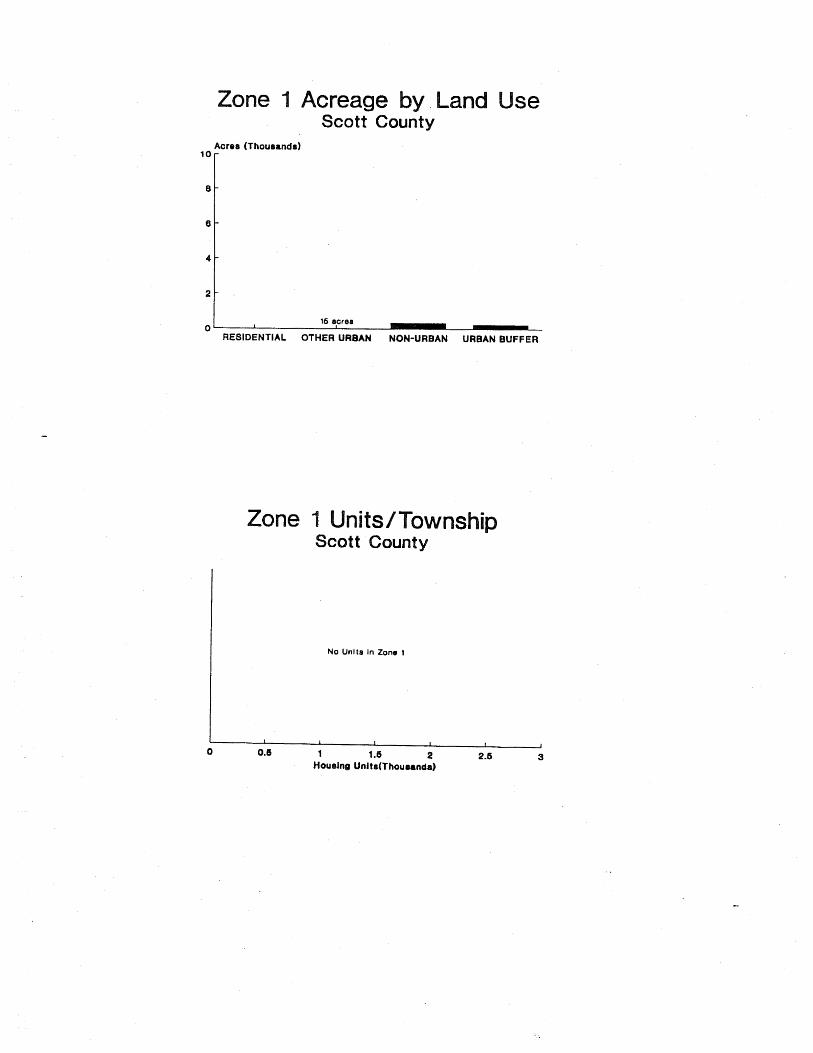
a se Scott County
16 screr 1
RESIDENTIAL O f HER URBAN NON-URBAN URBAN BUFFER
Acrer (Thouranda)
No Unlta In Zone 1
10
8
6
-
-
-

SHELBY C T

2
0 RESIDENTIAL OTHER URBAN NON-URBAN URBAN BUFFER
one
MOWEAQUA
OCONEE
ROSE
SHELBYVILLE
TOWER HILL
Shelby County
1 unl t
1 unit

STARK COU
'. / GOSHEN
I WEST JERSEY
ESSEX
\ OSCEOLA -
PENN 1
VALLEY I o
0 5 miles 1 - 1

272 ecrer 00 acres 0 I I
RESIDENTIAL OTHER URBAN NON-URBAN URBAN BUFFER
ne Stark County
No Unlt8 In Zone 1

-.
ZEWELL COU

RESIDENTIAL OTHER URBAN NON-URBAN URBAN BUFFER
one
CINCINNATI
ELM QROVE
GROVELAND
PEKiN
0 0.6 1 1.6 2 2.6 3 Housina Unlta (Thousandal

UNION COUNTY
0 5 miles I - - ,

222 acres
0 I I 1
REBIDENTIAL OTHER URBAN NON-URBAN URBAN BUFFER
one

BUTLER
MIDDLEFORK
\ y -
GRANT VERMILION
- \ /-I
\ I " I COUNTY
1 ROSS I
1- ' SIDELL \
miles

Aorer (Thousandr) ::I 1 1278 acres 1208 acres
a se County
RESIDENTIAL OTHER URBAN NON-URBAN URBAN BUFFER
CATLIN
DANVILLE
ELWOOD
GEORGETOWN
MCKENDREE
OAKWOOD
VANCE
errnillion County
0 0.6 1 1 .S 2 2.6 3 Hourlng Units (Thousandr)

WABASH COUNTY
0 5 miles 1 - - J

RESIDENTIAL OTHER URBAN NON-URBAN URBAN BUFFER
nits ns
BELLMONT
COFFEE
FRIENDSVILLE
MOUNT CARMEL
2 units
7 unlts
16 unl ta I I I I I
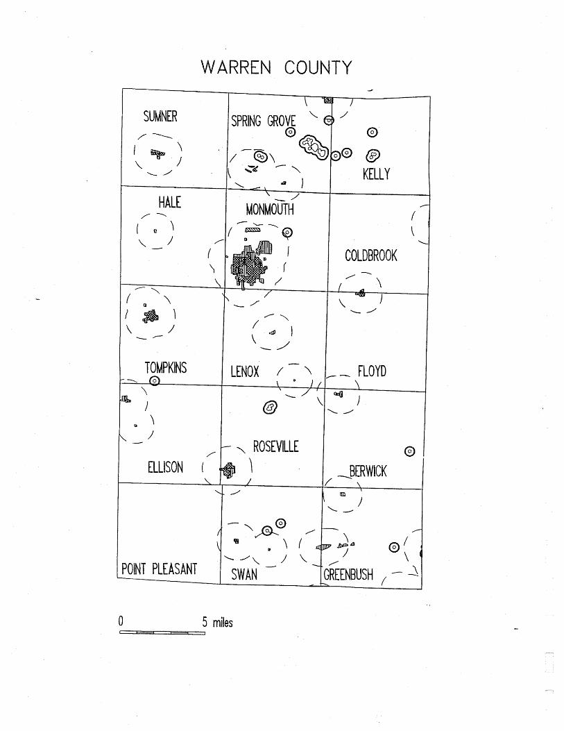
WARREN COUNTY
SUMNER
HALE / -
l a \
ELLISON / 1
SPRING GROVE \
G'
, 1 L
MONMOUTH
LENOX / \
- --, ROSEVILLE \
' @
D@ @ KELLY
COLDBROOK
- 1
-- FLOYD
0 5 miles L - - ,

38 sore8 0 1 1
RESIDENTIAL OTHER URBAN NON-URBAN URBAN BUFFER
SPRINQ GROVE I un~t I I 1 I 1
0 0.1 1 1.6 2 2.6 3 Hourinq Unitr (Thouranda)

WASHINGTON COUNTY
'. 1 fl VENEDY I c.
OAKDALE PILOT KNOB
5 miles
/
HOYLETON
BEAUCOUP
BOLO
I
/ ASHLEY >- ' f \
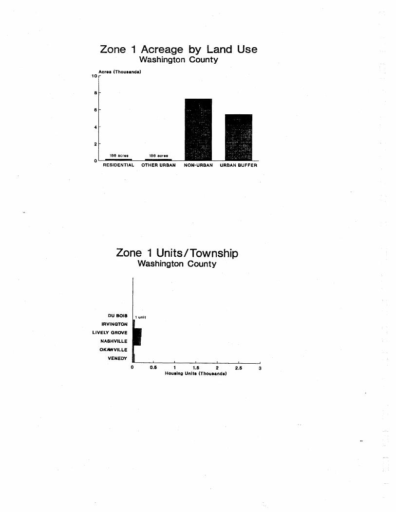
one se
Acrer (Thourandr)
lor
RESIDENTIAL OTHER URBAN NON-URBAN URBAN BUFFER
LIVELY GROVE
NASHVILLE
VENEDY
0 0.6 1 1.6 2 2.6 3 Houaing Unltr (Thousands)
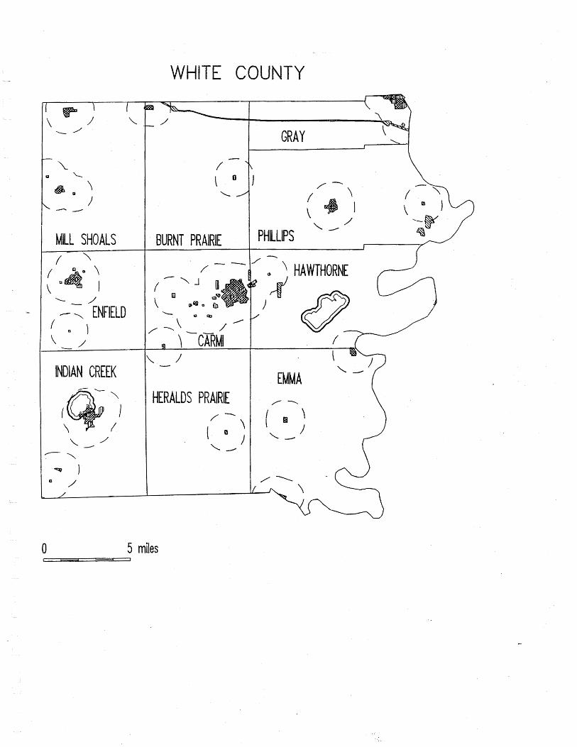
I MILL SHOALS
INDIAN CREEK
WHITE COU
BURNT PRAIRIE
HERALDS PRAIRIE
0 5 miles 1 - 1
EMMA -'('

Acres (Thourandr)
l o r
- RESIDENTIAL OTHER URBAN NON-URBAN URBAN BUFFER
INDIAN CREEK
0 0.8 1 1.6 2 2.6 3 Houalng Unit8 (Thouoandr)
qEA TL AND
PI. AINFIELD
-
TROY
'i ' \NNAHON
WJLMINGTON
WILL cou
DU PAGE
WIL TON PEOTONE 1
0 5 miles r -
CUSTER \

2
0 NON-URBAN URBAN BUFFER
WILL
Zon
REED
WlLMlNGTON
Houalno Unlts (Thousands)

SON - COUNTY
CRAB ORCHARD
SOUTHERN
0 5 miles
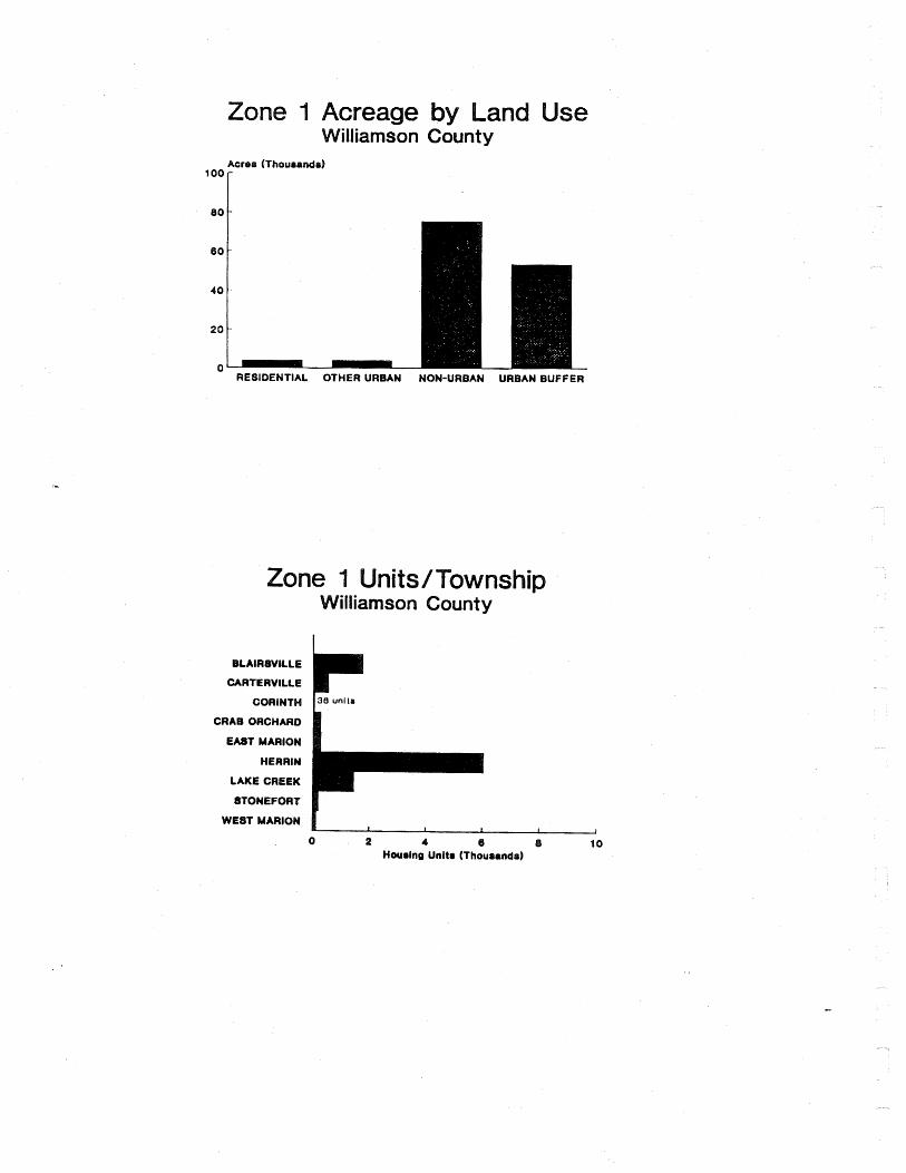
6 0
4 0
2 0
0 RESIDENTIAL OTHER URBAN NON-URBAN URBAN BUFFER
m
illiamson County
BLAIRSVILLE
CARTE RVlLLE
CORINTW
CRAB ORCHARD
EAST MARION
HERRIN
LAKE CREEK
8TONEFORT
WEST MARION

WOODFOR COUNTY
'I::':::::;

- RESIDENT lAL OTHER URBAN NON-URBAN URBAN BUFFER
MINONK Un"s
ROANOKE I I I t I
0 0.5 1 1.6 2 2.5 3 Houring Unit8 (Thourand81
CLAYTON 1 unlt