evaluation of the nepa process as an adequate regulatory ... · evaluation of the nepa process as...
TRANSCRIPT

Evaluation of the NEPA Process as an Adequate Regulatory Mechanism to Eliminate or Minimize Threats to Greater Sage-Grouse Associated with Oil and Natural Gas Development Activities
Prepared for
Western Energy Alliance
Prepared by
SWCA Environmental Consultants
July 2014

Evaluation of the NEPA Process as an Adequate Regulatory Mechanism to Eliminate or Minimize Threats to Greater Sage-Grouse Associated with Oil
and Natural Gas Development Activities
Prepared for
Western Energy Alliance 1775 Sherman, Suite 2700 Denver, Colorado 80203
Prepared by
SWCA Environmental Consultants 295 Interlocken Boulevard, Suite 300
Broomfield, Colorado 80021 Phone: 303.487.1183 / Fax: 303.487.1245
www.swca.com
July 2014

Evaluation of the NEPA Process as an Adequate Regulatory Mechanism to Eliminate or Minimize Threats to Greater Sage-Grouse Associated with Oil and Natural Gas Development Activities
ii
TABLE OF CONTENTS
Page Executive Summary ................................................................................................................... 1
Introduction ................................................................................................................................ 2
Summary of NEPA Review ....................................................................................................... 6
Seasonal Limitations ............................................................................................................ 8 Reclamation.......................................................................................................................... 9 Reduce Surface Disturbance / Multi-Well Pads................................................................. 11 Dust Suppression ................................................................................................................ 13 No Surface Occupancy (year-round) ................................................................................. 14 Noxious/Invasive Weed Management ............................................................................... 14 Reduce Traffic .................................................................................................................... 15 Reduce Noise and Visual Impacts ..................................................................................... 16 Reduce Perching Predators ................................................................................................ 17 Produced Water Management ............................................................................................ 18 Timing Limitations ............................................................................................................ 19 Vegetation Treatments ....................................................................................................... 20 Monitoring, Mitigation, and Adaptive Management ......................................................... 21
Monitoring Efforts Required Under NEPA ................................................................... 22 Mitigation Efforts Required Under NEPA .................................................................... 23 Adaptive Management Efforts Required Under NEPA ................................................ 24
Implementation Of COAs and Conservation Measures Required Under NEPA ............... 24 Adaptive Management Implementation ........................................................................ 25 Conservation Easement Purchase and Monitoring ........................................................ 26 Monitoring and Mitigation Efforts to Reduce Threats .................................................. 26
Conclusions/Discussion ........................................................................................................... 27
References ................................................................................................................................ 28
LIST OF TABLES
Table Page 1 ESA listing factors and threats for the greater sage-grouse. ............................................. 4 2 Occurrence of conservation measures and COAs in NEPA documents. .......................... 7
LIST OF FIGURES
Figure Page 1 BLM and USFS lands included in the NEPA review. ...................................................... 5

Evaluation of the NEPA Process as an Adequate Regulatory Mechanism to Eliminate or Minimize Threats to Greater Sage-Grouse Associated with Oil and Natural Gas Development Activities
iii
LIST OF APPENDICES
Appendix A NEPA Documents Reviewed B Seasonal Limitations and Year-Round Development C Reclamation D Reduce Surface Disturbance/Multi-well Pads E Dust Suppression F No Surface Occupancy G Noxious/Invasive Weed Management H Reduce Traffic I Reduce Noise and Visual Impacts J Reduce Perching Predators K Produced Water Management L Timing Limitations M Vegetation Treatments N Monitoring and Adaptive Management O Implemented Projects
LIST OF ACRONYMS
APD – Application for Permit to Drill BLM – Bureau of Land Management BMP – Best Management Practice COA – Condition of Approval EA – Environmental Assessment EIS – Environmental Impact Statement ESA – Endangered Species Act of 1973, as amended JIO – Jonah Interagency Office MOU – Memorandum of Understanding NEPA – National Environmental Policy Act of 1969 PAPO – Pinedale Anticline Project Office PECE - Policy for Evaluation of Conservation Efforts When Making Listing Decisions PGH – Preliminary General Habitat PPH – Preliminary Priority Habitat ROD – Record of Decision ROW – Right of Way USFS – United States Forest Service USFWS – United State Fish and Wildlife Service

Evaluation of the NEPA Process as an Adequate Regulatory Mechanism to Eliminate or Minimize Threats to Greater Sage-Grouse Associated with Oil and Natural Gas Development Activities
1
EXECUTIVE SUMMARY
Greater sage-grouse (Centrocercus urophasianus, hereafter sage-grouse) are large, ground-dwelling birds that reside primarily in sagebrush ecosystems which are ubiquitous across much of the intermountain regions of western North America. The U.S. Fish & Wildlife Service (USFWS) has until September 2015 to determine whether they will list the species under the Endangered Species Act (ESA).
For many years, oil and natural gas companies that operate within sage-grouse range have made significant efforts to avoid, minimize, mitigate, and reduce impacts to the species and its habitat. This report documents the specific conservation measures that companies commit to in Bureau of Land Management (BLM) and U.S. Forest Service (USFS) National Environmental Policy Act (NEPA) decisions on oil and natural gas project approvals. Project NEPA documents specify the terms by which a project is approved, and govern how companies must operate, thereby providing regulatory certainty that sage-grouse conservation measures will be implemented and enforced.
Of the 103 NEPA documents reviewed and summarized in this report, 773 conservation measures were catalogued and an average of 6.5 Conditions of Approval (COA) or conservation measures to protect sage-grouse per project were committed to in the NEPA decision records. For example, via the NEPA documents operators commit to reduce the footprint of development and associated traffic through clustered activity, pad drilling and remote monitoring of producing wells, as well as to implement specific measures to protect the species. Collectively, measures were implemented across 18 BLM Field Offices and National Forests that are responsible for managing 68,404 square miles of public lands with occupied sage-grouse habitat, representing 37 percent of the species’ current occupied range and the majority of the range in Wyoming, Colorado, Utah, Montana, and Nevada. These projects represent a sample of NEPA documents and are not exhaustive for all projects in the species’ range.
Because Operators commit to these conservation measures via BLM and USFS NEPA decisions, there is regulatory certainty that these conservation measures will be implemented. While there is variability in the measures due to site-specific conditions, project types, rate of development, and well density, the conservation measures that companies commit to result in the conservation and protection of sage-grouse populations or the avoidance and minimization of impacts to the species and its habitat. This demonstrates that oil and natural gas operators are committed to measures that conserve and mitigate impacts to sage-grouse through the NEPA process, which provides a robust regulatory mechanism to protect, conserve, and enhance the status of the species. Given the regulatory certainty that NEPA provides, USFWS should recognize and consider this information on these project commitments as it makes its listing determination for the species.

Evaluation of the NEPA Process as an Adequate Regulatory Mechanism to Eliminate or Minimize Threats to Greater Sage-Grouse Associated with Oil and Natural Gas Development Activities
2
INTRODUCTION
The sage-grouse is a candidate species for listing under the Endangered Species Act (ESA). Sage-grouse are large, ground-dwelling birds that reside primarily in sagebrush ecosystems which are ubiquitous across much of the intermountain regions of western North America. Sage-grouse population trends are variable across their distribution, and though some populations appear stable, population numbers show long-term declines collectively and in several regions (Connelly et al. 2004).
Much of its range in the western states is overlapped by energy development. The basins where most sagebrush ecosystems reside are also the center of major oil and natural gas reserves (e.g., Green River, Niobrara, Powder River, Uinta-Piceance, and Williston basins), and many of these are on public lands managed by the Bureau of Land Management (BLM) or the U.S. Forest Service (USFS).
On public and split-estate lands (i.e. lands with private or state surface and federal minerals), oil and natural gas operators (Operators) are required to comply with management prescriptions outlined in lease stipulations in BLM Resource Management Plans (RMPs) and USFS Land and Resource Management Plans (LRMPs), as well as Conditions of Approval (COAs) and mitigation measures for project-specific documents prepared in compliance with the National Environmental Policy Act (NEPA). Of the existing 92 BLM RMPs that include sage-grouse habitat, 82 RMPs currently contain specific measures or direction pertinent to management of sage-grouse or their habitats (BLM 2008:1). BLM is currently completing RMP amendments to ensure that measures for conservation and protection of sage-grouse are contained in all planning areas that overlap with the current occupied range of sage-grouse.
Combined, the BLM and USFS manage or have NEPA decision-making authority on more than 60% of the current occupied range of the sage-grouse. As a result of the NEPA decisions made by the BLM, required and consistent COAs, conservation efforts, and avoidance, minimization, and mitigation measures will be applied across the majority of the species’ occupied habitat.
BLM manages special status species and the ecosystems upon which they depend on BLM-administered lands in order to reduce threats and minimize the likelihood of listing these species under the ESA (BLM manual 6840). The BLM and USFS currently manage sage-grouse as a sensitive species and have used NEPA as a regulatory mechanism to minimize threats to sage-grouse due to oil and natural gas development within its range. Under Manual 6840 the BLM is instructed to:
• …conserve and/or recover ESA-listed species and the ecosystems on which they depend so that ESA protections are no longer needed for these species.
• initiate proactive conservation measures that reduce or eliminate threats to [BLM] sensitive species to minimize the likelihood of and need for listing of these species under the ESA.
As a result of the implementation of the guidance contained in BLM Manual 6840, the agency’s actions must be evaluated to ensure that decisions made do not lead to the eventual
Evaluation of the NEPA Process as an Adequate Regulatory Mechanism to Eliminate or Minimize Threats to Greater Sage-Grouse Associated with Oil and Natural Gas Development Activities
3
listing of a sensitive species or degradation of the status of a sensitive species. As a result, the decisions made as part of NEPA processes associated with oil and natural gas development activities as well as all other BLM NEPA decisions are required to comply with Manual 6840, and generally, should not contribute to the listing of a species.
In 2010, the U.S. Fish and Wildlife Service (USFWS) found that the sage-grouse warrants listing as threatened or endangered under the ESA based on anthropogenic habitat impacts and lack of regulatory mechanisms to protect against further losses, but immediate listing action was precluded due to higher priority listing actions. As part of a settlement agreement reached in 2011, the USFWS is now required to make a final listing decision for sage-grouse by September 2015.
Five listing factors provided in Section 4(a)(1) of the ESA are used to determine if a species should be listed as endangered or threatened (Factors A–E; Table 1). Under each listing factor, the USFWS 12-month finding (USFWS 2010) describes several threats to sage-grouse. Some of the primary factors linked to population declines are attributed to habitat loss, habitat fragmentation caused by energy development, invasive species, wildfire, agricultural use, and inadequate regulatory mechanisms.
In the 2010 listing decision, it appears that the USFWS did not review the adequacy of existing regulatory protections provided under NEPA as they relate to the avoidance, minimization, and mitigation of impacts associated with oil and natural gas development.
In preparation for the September 2015 listing decision for sage-grouse and to facilitate a better understanding of the adequacy of NEPA as a regulatory mechanism for protecting and conserving sage-grouse, NEPA documents related to oil and natural gas exploration, development, and production activities within the range of sage-grouse were reviewed. These included RMPs, environmental assessments (EAs), environmental impact statements (EISs), and their associated decision records from across the range of the species, including all BLM field offices and National Forests across Colorado, Montana, Nevada, Utah, and Wyoming (Figure 1). Each document was reviewed to identify operator commitments and COAs that were included in the decision records for each NEPA document to avoid, minimize, or mitigate impacts to sage-grouse and protect or conserve the species and its habitat during development and operations. A total of 103 NEPA documents for oil and natural gas documents within the current range of sage-grouse were reviewed (Appendix A). The NEPA documents included in this review were generally those finalized between 2008 and 2013 to demonstrate commitments under NEPA made by Operators. In addition to the 103 NEPA documents, numerous documents and reports demonstrating implementation and compliance with the COAs and Operator commitments were reviewed. Collectively, these documents describe the measures currently being implemented by oil and natural gas operators as required by BLM and USFS NEPA decisions.

Evaluation of the NEPA Process as an Adequate Regulatory Mechanism to Eliminate or Minimize Threats to Greater Sage-Grouse Associated with Oil and Natural Gas Development Activities
4
Table 1. ESA listing factors and threats for the greater sage-grouse.
Listing Factor - ESA Section 4(a)(1) Threats
Factor A: The Present or Threatened Destruction, Modification, or Curtailment of Habitat or Range
Habitat conversion for agriculture Urbanization Infrastructure in sagebrush habitats (powerlines, fences, roads, railroads, communication towers) Fire (wildfire, change in wildfire frequency) Invasive plants (annual grasses and other noxious weeds) Pinyon-juniper encroachment Grazing Energy development (nonrenewable and renewable) Climate change
Factor B: Overutilization for Commercial, Recreational, Scientific, or Educational Purposes
Commercial hunting Recreational hunting Recreational use (bird watching, lek visits, photography) Religious use Scientific and educational use
Factor C: Disease and Predation Disease (West Nile virus) Predation
Factor D: Inadequacy of Existing Regulatory Mechanisms
Local land use laws, processes, and ordinances State laws and regulations Federal laws and regulations Canadian federal and provincial laws and regulations Non-regulatory conservation measures
Factor E: Other Natural or Manmade Factors Affecting the Species’ Continued Existence
Pesticides Contaminants (e.g., oil in wastewater pits) Recreational activities Life history traits affecting population viability Drought
All NEPA documents and supporting information or reports were characterized, cataloged, and indexed in a relational database. Each COA or required conservation measure was characterized according to the threat and listing factor that it is meant to address as well as location in which the measure is or will be implemented. In some circumstances, these lease stipulations may be excepted, modified, or waived based on site-specific information and conditions. Nonetheless, BLM may only grant exceptions, modifications, and waivers where potential adverse effects are eliminated or notably reduced.
Each measure or group of similar measures was assessed using the USFWS Policy for Evaluation of Conservation Efforts When Making Listing Decisions (“PECE Policy”). The PECE Policy evaluates the certainty that each COA or conservation measure will be implemented (Certainty of Implementation) and the certainty that, when implemented, the COA or conservation measure will be effective (Certainty of Effectiveness).

Evaluation of the NEPA Process as an Adequate Regulatory Mechanism to Eliminate or Minimize Threats to Greater Sage-Grouse Associated with Oil and Natural Gas Development Activities
5
Figure 1. BLM Field Offices and National Forests Included in Review of Oil and Natural
Gas NEPA Documents and RMPs.

Evaluation of the NEPA Process as an Adequate Regulatory Mechanism to Eliminate or Minimize Threats to Greater Sage-Grouse Associated with Oil and Natural Gas Development Activities
6
SUMMARY OF NEPA REVIEW
Many Operators within sage-grouse range have been making great efforts to reduce their projects’ impacts on the environment, even prior to the NEPA process. They have designed their projects to reduce the footprint of their development, reduce traffic, and reduce human activity. These efforts are not always specific to sage-grouse, but rather aim to protect habitat at a landscape scale through decreased direct and indirect habitat loss and fragmentation. Protection at the landscape scale protects not only sage-grouse but also many other wildlife species and natural resources including big game, migratory birds, habitats, water quality, soils, etc. These measures are important in the conservation of sage-grouse, but are not always reflected in the COAs because they are already part of the plan of development or alternatives analyzed in NEPA documents.
In addition to implementation of best management practices, including the efforts described above, NEPA documents and decision records include additional Operator-committed conservation measures to protect wildlife, including sage-grouse, which will be implemented over the life of each project. These operator-committed measures and additional COAs become required elements of oil and natural gas development when they are contained in the decision records for BLM and USFS NEPA processes. When included in the decision records, these measures must be implemented to be in compliance with agency requirements.
To identify the COAs and conservation measures that are being implemented by oil and natural gas Operators and the federal land management agencies to conserve sage-grouse, NEPA documents and decision records related to development were reviewed from lands administered by BLM and USFS field offices across the range of greater sage-grouse. As a result of this review, 773 conservation measures were cataloged from 103 NEPA documents. Of the NEPA documents reviewed and summarized in this report, an average of 6.5 COAs or conservation measures that directly address threats to sage-grouse were required per decision record. These conservation measures were categorized into 14 general categories (Table 2).
Collectively, measures were implemented across 18 BLM Field Offices and National Forests responsible for managing 68,404 square miles of public land with occupied sage-grouse habitat representing 37 percent of the species’ current occupied range and the majority of the species range in Wyoming, Colorado, Utah, Montana, and Nevada. No oil and natural gas related NEPA decisions were identified for the other BLM Field Offices and National Forests within the range of greater sage-grouse. This is primarily a result of lower levels of oil and natural gas activity in the states of Idaho, Oregon, and portions of Nevada. However, it is likely that similar measures discussed in this document would be implemented in those field offices if oil and natural gas activities were to occur in these areas in the future. These public lands plus the split-estate lands with federal minerals and private ownership represent the area in which BLM and USFS required COAs, conservation measures, and avoidance, minimization and mitigation measures would be reasonably certain to occur as a result of NEPA decisions made for past, ongoing, and future oil and natural gas activities.

Evaluation of the NEPA Process as an Adequate Regulatory Mechanism to Eliminate or Minimize Threats to Greater Sage-Grouse Associated with Oil and Natural Gas Development Activities
7
Table 2. Occurrence of conservation measures and COAs in NEPA documents.
COA/Conservation Measure Category
Number of Field Offices (%)
Number of NEPA Documents (%)
Monitoring/adaptive management 15 (83%) 59 (57%) Seasonal limitations and year-round development
18 (100%) 87 (84%)
Reclamation 18 (100%) 93 (90%) Reduce surface disturbance/multi-well pads
13 (72%) 45 (44%)
Dust suppression 18 (100%) 59 (57%) No surface occupancy 16 (89%) 35 (34%) Noxious/invasive weed management
16 (89%) 51 (50%)
Reduce traffic 12 (67%) 30 (29%) Reduce noise/visual impacts 11 (61%) 33 (32%) Reduce perching predators 12 (67%) 27 (26%) Produced water management 13 (72%) 27 (26%) Timing limitation 13 (72%) 24 (23%) Vegetation treatments 3 (17%) 3 (3%)
Total 18 103 The inventory of required COAs and conservation measures under NEPA, included cataloging all measures specific to sage-grouse and any measure or development practice that was not specific to sage-grouse but would reasonably be expected to benefit sage-grouse due to overlap with sage-grouse habitat or sage-grouse sensitive seasons. Voluntary initiatives (surface disturbance reductions, timing restrictions, conservation easement purchase, etc.) implemented by the operators were also evaluated where these measures became part of the agency’s NEPA decision record.
The majority of the NEPA documents that were reviewed implement the following standard measures:
• Adaptive management and monitoring of the effectiveness of measures or the response of sage-grouse to those measures.
• Seasonal, timing, and spatial restrictions of activities to protect leks, nesting habitat, brood-rearing habitat, and winter habitat.
• Interim and final reclamation with monitoring to restore natural habitat.
• Noxious weed monitoring and control.
• Dust suppression on roads and operations areas that reduces impacts on adjacent vegetation/wildlife habitat.
• Speed limits to reduce dust, noise, and wildlife collisions.
• NSO buffers to protect wetlands and riparian areas (important for sage-grouse brood rearing).

Evaluation of the NEPA Process as an Adequate Regulatory Mechanism to Eliminate or Minimize Threats to Greater Sage-Grouse Associated with Oil and Natural Gas Development Activities
8
• Noise abatement requirements to reduce noise impacts on receptors including leks. A description of each of the conservation measure categories and examples of COAs/conservation measures in the categories are described in the following sections. All 773 conservation measures are provided as they appeared in the NEPA decision records in Appendices B through O. Demonstration of each measure’s compliance with the USFWS PECE process and maps showing federally administered lands where these measures are implemented are also provided in Appendices B through O. Collectively, these measures, when implemented, would result in the conservation and protection of sage-grouse populations or the avoidance and minimization of impacts to the species and its habitat and provide Certainty of Implementation and Certainty of Effectiveness under the PECE Policy.
SEASONAL LIMITATIONS
Seasonal limitations are intended to limit new surface disturbance and disruptive activities (construction, drilling, completion, reclamation, and other activities potentially disruptive to sage-grouse) in certain areas during breeding, nesting and brood-rearing, and/or winter seasons. These measures were applied in 100% of all BLM Field Offices and National Forests for which NEPA documents were reviewed (Table 2 and Appendix B). These activities may directly or indirectly impact sage-grouse and their nests due to increase traffic, noise, human presence, and dust. High traffic volumes may influence female behavior, nest-initiation, and nest success (Manier et al. 2013:50; Lyon and Anderson 2003).
Seasonal limitations are intended to minimize the potential for disturbing breeding, egg-laying, incubating, wintering, and brooding sage-grouse. The area protected is based on the concept that females nest and rear broods near leks and therefore seasonal limitations typically apply to the area within 2 miles of leks. However, BLM and USFS seasonal limitations are often applied to all nesting habitats across a project area. The proximity, configuration, and abundance of nesting habitat are key factors influencing lek locations and therefore leks are indicative of nesting habitat (USFWS 2010:13915). After breeding, females typically nest within 4 miles of leks, with most nests located within 2 miles of leks (Schroeder et al. 1999:12). Based on studies in Wyoming, hens rear their broods within 0.1 to 3.1 miles of the nest site for the first 2 to 3 weeks following hatching (Connelly et al. 2004:4–8).
Unless habitat studies have been completed in order to map nesting/brood-rearing habitat within a project area, the nesting/brood-rearing habitat is often assumed to be the area within a 2-mile buffer around leks (i.e., 8,043 acres per lek). The nesting/brood-rearing season is typically defined as March 15 to July 15, although this varies by field office.
To protect wintering birds, seasonal limitations on disruptive activities may be applied to winter concentration areas. These limitations typically apply from November 15 through March 14, although this may vary slightly. Winter seasonal limitations for other species (i.e., big game) may also benefit wintering sage-grouse where habitats overlap. Examples of commonly implemented seasonal limitations include the following.
• “Construction, drilling, reclamation and other potentially disruptive activities are prohibited during the period of March 1 to July 15 for the protection of strutting and

Evaluation of the NEPA Process as an Adequate Regulatory Mechanism to Eliminate or Minimize Threats to Greater Sage-Grouse Associated with Oil and Natural Gas Development Activities
9
nesting sage-grouse.” (Double Eagle Petroleum, Catalina Plans of Development [PODs] C and D in the Atlantic Rim)
• “No surface-disturbing activities shall occur within sage-grouse nesting habitat, from 15 March through 30 June, annually.” (Devon Energy Company, L.P., Grayling POD EA)
• “A 3-mile buffer zone would be established around known leks, and construction activity in this buffer zone would be restricted between March 15 and July 15 to minimize effects to breeding, egg-laying, incubating, and brooding sage-grouse.” (EnCana, Pappy Draw Exploratory Coal-bed Natural Gas Pilot Project EA)
• “No surface disturbing activities are permitted within 2 miles of sage grouse lek(s) between March 1 and June 15, prior to completion of a greater sage grouse lek survey. This condition will be implemented on an annual basis for the duration of surface disturbing activities” (Anadarko Petroleum Corporation, Dry Willow III POD EA)
BLM frequently requires operators to develop projects with seasonal stipulations which prohibit drilling and associated activities during winter, typically December to May, for various species. Seasonal stipulations, however, have significant consequences for operators because they limit the time available for construction, drilling, and reclamation, and double the number of rig moves and truck hauling. As a consequence, seasonal stipulations can extend development over multiple years, prolonging impacts to species. In contrast, year-round drilling in combination with multiple-well pads significantly benefits wildlife by reducing the duration of drilling and well pad density. Utilizing year-round drilling and multiple-well pads, Operators can plan phased development that confines activities to limited areas; reduce pad density and associated roads; reduce overall drilling duration; and promote efficient project execution. This leaves large areas of habitat undisturbed, which facilitates timely interim reclamation and allows sage-grouse and other wildlife species to better acclimate and avoid development activities.
The review of NEPA documents recorded five documents with five measures that discuss year-round drilling as a means to reduce the duration of a project (Appendix B). The following is an example of such measures.
• “Year round drilling would reduce drilling duration to 4-7 years compared to 21 years if no winter drilling from 11/1 to 5/15.” (BBC, EIS [UT-070-05-055] for West Tavaputs Plateau Natural Gas Full Field Development Plan)
RECLAMATION
Reclamation is required in all BLM Field Offices and National Forests. There are two phases of reclamation: interim and final reclamation. Interim reclamation occurs when disturbed areas such as construction, storage, and temporary work areas, and portions of well pads are no longer needed during the production phase. These areas are recontoured as much as possible to natural topography, have topsoil redistributed, and are revegetated with native and/or BLM recommended seed mixtures. Interim reclamation partially restores habitat function by stabilizing soils, reducing erosion, and facilitating vegetative regrowth during
Evaluation of the NEPA Process as an Adequate Regulatory Mechanism to Eliminate or Minimize Threats to Greater Sage-Grouse Associated with Oil and Natural Gas Development Activities
10
the production phase. Final reclamation involves recontouring, replacement and stabilization of topsoil, and revegetation of remaining disturbed areas upon abandonment. After wells are closed, the pads, roads, facility sites and other disturbed areas undergo final reclamation according to the specified methods and seed mixture. Successful reclamation may offset the negative effects of direct habitat disturbance from energy development (USFWS 2010:13948).
Reclamation ensures surface and subsurface stability and growth of a sustainable, naturally functioning permanent vegetation and habitat. NEPA documents typically describe goals for reclamation that include diverse, native vegetation similar in composition to adjoining vegetation (typically a minimum cover and composition of 80% of the desired plant community). Some NEPA documents specify using sagebrush seed in sage-grouse areas. COAs include annual monitoring and reporting to ensure successful reclamation. In some large developments, disturbance caps are used to encourage successful reclamation. With the exception of some seismic exploration projects, all oil and natural gas projects are required to reclaim areas of surface disturbance. A total of 93 documents with 112 measures related to reclamation were reviewed (Appendix C). Examples of such measures include the following.
• “Utilize native plant species for reclamation purposes (preferably local seeds and species that are preferred by sage grouse).” (Elk Petroleum, EA for the Grieve Unit CO2 Enhanced Recovery Project)
• “Sage-grouse oriented reclamation (e.g., specialized seed mix, lengthened cut and fill slopes) is expected to involve all pipeline acreage and about ¾ of pad acreage (about 18 acres). Depending on subsequent ungulate use, this reclaimed acreage would serve increasingly effective brood and summer habitat function prior to the redevelopment of a suitable sagebrush canopy (10-15 years).” (EnCana Oil and Gas, 28 Applications for Permit to Drill [APDs] on new well pad D36 496. DOI-BLM-CO-110-2011-0169-EA)
• “Reclamation will be considered successful if the following Interim Reclamation criteria are met… 80 percent of predisturbance ground cover, 90 percent dominant species, No noxious weeds present in the seeding, and Erosion features equal to or less than surrounding area. The vegetation will consist of species included in the seed mix, and/or occurring in the surrounding natural vegetation or as deemed desirable by the BLM in review and approval of the reclamation plan. The goal is no single species will account for more than 30 percent total vegetative composition. Vegetation canopy cover production and species diversity shall approximate the surrounding undisturbed area.” (ROD and EIS for the Atlantic Rim Natural Gas Field Development Project)
• “Within 2 miles of an active greater sage-grouse lek, interim reclamation seed mixes will be designed to provide habitat for greater sage-grouse.” (Kerr-McGee Oil & Gas Onshore LP [KMG], Greater Natural Buttes EIS)
• “Operators will be allowed no more than 250 acres of surface disturbance per-year, no more than 1,250 acres of new surface disturbance at any given time, and no more than 1,500 acres of cumulative surface disturbance (i.e., new surface disturbance added to past and present surface disturbance associated with oil and gas development.” (BBC,

Evaluation of the NEPA Process as an Adequate Regulatory Mechanism to Eliminate or Minimize Threats to Greater Sage-Grouse Associated with Oil and Natural Gas Development Activities
11
EIS [UT-070-05-055] for West Tavaputs Plateau Natural Gas Full Field Development Plan)
REDUCE SURFACE DISTURBANCE / MULTI-WELL PADS
Habitat loss from energy development was identified as a threat in the USFWS 12-month finding for greater sage-grouse. Efforts to reduce the surface disturbance and fragmentation from oil and natural gas projects decrease this threat. As part of best management practices and voluntary measures, Operators conserve key habitats for sage-grouse during project planning through use of existing disturbance (i.e., add new well(s) on existing pads), use of clustered development and facility planning (co-location of facilities), and multi-well pads.
The density and distribution of oil and natural gas infrastructure may also affect sage-grouse. Male sage-grouse lek attendance has been shown to decrease in natural gas fields with a density of five or more wells within approximately 2 miles of leks, and sage-grouse are less likely to occupy areas with wells at 80-acre spacing compared to 988-acre spacing (USFWS 2010). Well location and density is determined in large part by geology and reservoir conditions. In addition, on BLM-administered lands, locations are often based on the spacing decision of individual state oil and natural gas boards. Wyoming has developed the density disturbance calculation tool (DDCT) to limit development in core sage-grouse habitats and other states have followed this model (e.g., South Unit EIS in Utah).
Multi-well pads, clustered development, and facility planning dramatically reduce the direct and indirect impacts from increased infrastructure, noise, traffic, and human activity related to oil and natural gas development. Traditionally, one vertical well was drilled on individual well pads. However, with recent advances in technology (i.e., horizontal drilling, directional drilling, and multi-well pads), it is now common for Operators to locate multiple wells on a single pad. Multi-well pads are beneficial in many ways, including reduction of disturbance to sage-grouse from habitat destruction, fragmentation, and traffic. Surface disturbance is greatly reduced by eliminating additional well pads and associated access roads. Consolidating operations to one pad also reduces surface disturbance associated with storage tanks and liquid separators on pads. Traffic associated with moving drill rigs from one well to the next is greatly reduced when wells are only 12 to 30 feet apart. Decreased time and traffic involved with rig setup, breakdown, and movement minimizes the environmental impact of drill rigs. Truck traffic to service multiple wells is also reduced since they need to visit fewer pads.
As an example, traditional oil and natural gas developments such of those evaluated in the USFWS 12-month finding on sage-grouse require 16 wells at 40 acre spacing to effectively recover oil and natural gas resources. Assuming that each single well pad averages 8 acres, the total surface disturbance in a 640 acre section would be 128 acres (20 percent of the surface area). This estimate does not include individual roads and pipeline right-of-ways (ROWs) for each well which would further increase surface disturbance, habitat fragmentation, and operational disturbances associated with well visits. Through colocation efforts, if these 16 wells were drilled from one 12-acre pad (less than 2 percent of the surface area of a section), then a minimum of 116 acres of disturbance would be eliminated. If drilled from two 12-acre pads the surface disturbance is reduced by 104 acres. The actual decrease in

Evaluation of the NEPA Process as an Adequate Regulatory Mechanism to Eliminate or Minimize Threats to Greater Sage-Grouse Associated with Oil and Natural Gas Development Activities
12
surface disturbance would be greater than the 116 or 104 acres because only a single road and pipeline ROW is necessary for each multi-well pad. In both cases, the total disturbance per section would generally be less than 5%. In addition to surface disturbance reductions, this measure dramatically reduces habitat fragmentation, traffic, and other related disturbances.
Results of the NEPA review showed that the agencies and Operators made efforts to reduce surface disturbance of projects during the planning and NEPA process. Surface reduction measures were implemented in 72% of all BLM Field Offices and National Forests reviewed. These measures are also becoming more common with technological improvements and it is likely that more than 72% of Field Offices are currently implementing these measures. Ways to reduce overall surface disturbance from the project (in all habitats) and minimize fragmentation of sage-grouse habitat included collocating facilities, using existing disturbance, minimizing the size of well pads, and limiting the density of development. Some projects conserve habitat by locating project-related disturbance outside of sagebrush habitat. Disturbance caps were included in some COAs in order to incentivize decreased disturbance and increased reclamation.
A total of 45 documents were reviewed with 77 measures to reduce surface disturbance and conserve sage-grouse habitat, including 33 measures intended to reduce surface impacts by using multi-well pads, horizontal drilling, and directional drilling; and 14 measures intended to limit density of oil and natural gas development (Appendix D). Limitations for density varied from one to eight well pads per section and 5% to 6.25% disturbance per section. Examples of such measures include the following.
• “The proposal includes drilling 16 additional wells on the existing P28 496 well pad (for a total of 32 wells). No additional acreage is required to expand the existing well pad.” (EnCana Oil and Gas, 16 APDs on existing well pad P28-496)
• “28 wells on one new well pad. The well pad is proposed to have working surface dimensions of 778 feet long by 302 feet wide for total well pad surface disturbance of 9.7 acres. Following interim reclamation 2.2 acres will be needed for production.” (EnCana Oil and Gas, 28 APDs on new well pad D36 496)
• “The operator's development designs for multi-well pads and centralized production facilities were undertaken specifically as a means to reduce habitat loss and the scope of behavioral impacts imposed on sage-grouse.” (EnCana Oil and Gas, Master Development Plan for the SG E34 496, SG L27 796 and SG F22 496)
• “Operators would utilize directional drilling to access resources beneath the 0.25-mile active greater sage-grouse lek buffers if reserves beneath these locations are deemed economic. Operators would utilize directional drilling to access resources beneath the 600-foot wide (or tall sagebrush-dominated) buffer associated with the Sand Draw protection areas if deemed economic.” (ROD for the Jonah Infill Drilling Project EIS)
• “Production facilities will be consolidated when possible, to reduce disturbance from traffic, habitat fragmentation, and total surface area impacts.” (ROD, South Unit Oil and Gas Development Final EIS)

Evaluation of the NEPA Process as an Adequate Regulatory Mechanism to Eliminate or Minimize Threats to Greater Sage-Grouse Associated with Oil and Natural Gas Development Activities
13
• “Identify non-greater sage-grouse habitat, or the lowest quality greater sage-grouse habitat, to determine a surface development pattern that may be least impacting to greater sage-grouse and may allow a viable population of greater sage-grouse to continue to persist in the East Bench area until total reclamation has been achieved.” (KMG, Greater Natural Buttes EIS)
• “Well pad surface density will be no more than one pad per approximately 160 acres.” (Gasco Energy Inc., Uinta Basin Natural Gas Development Project, EIS)
• “In development area MA-5 a maximum of two well pads per section will be allowed. A maximum of 40 acres of surface disturbance per section will be allowed (6.25% disturbance).” (ROD and Final Supplemental EIS for the Pinedale Anticline Oil and Gas Exploration and Development Project)
DUST SUPPRESSION
Dust from unpaved road traffic accumulates on vegetation and may decrease the value of plants used by sage-grouse. Access roads and other exposed soils in oil and natural gas developments increase the amount of fugitive dust that spreads and lands on vegetation. Increased dust on vegetation could reduce the health and quality of habitat as well as decrease the forage potential for sage-grouse.
The 12-month finding describes how fugitive dust from road use and wind erosion may impact sage-grouse habitats. Heavy equipment operations and truck traffic on unpaved roads and other exposed areas produce dust that may interfere with plant photosynthesis and impact insect populations (USFWS 2010:13949). Indirect impacts to sage-grouse also include reduced air quality and changes in vegetation.
Dust suppression is commonly used in the industry due to air quality standards, but controlling dust is also recognized for the benefits to sage-grouse and its habitat. Dust abatement techniques discussed in the NEPA documents include application of water or chemical suppressant to roadways, enforcing speed limits, and seeding of all disturbed areas that are not used during the well production phase (e.g., borrow ditches and topsoil and spoil piles). The NEPA review found 59 documents with 59 measures intended to reduce impacts of fugitive dust (Appendix E). Examples of such measures include the following.
• “The operator shall implement dust abatement measures as needed to prevent fugitive dust from vehicular traffic, equipment operations, or wind events.” (EA of the Orchard Master Development Plan for Oil and Gas Development)
• “Operators on federal leases will be required to post and enforce speed limits to reduce fugitive dust emissions. Dust inhibitors will be used as necessary on unpaved collector, local and resource roads to reduce fugitive dust emissions to the air and resources adjacent to the road.” (ROD for the Final Statewide Oil and Gas EIS and Proposed Amendment of the Powder River and Billings RMPs)

Evaluation of the NEPA Process as an Adequate Regulatory Mechanism to Eliminate or Minimize Threats to Greater Sage-Grouse Associated with Oil and Natural Gas Development Activities
14
• “Emissions of particulate matter from well pad, road, and other facility construction, operation, and reclamation activities will be minimized by application of water or other dust suppressants.” (Samson, Endurance/Barricade Gas Infrastructure Project Sweetwater County, Wyoming, EA)
NO SURFACE OCCUPANCY (YEAR-ROUND)
In addition to seasonal and timing limitations, development is often precluded within buffers around sage-grouse leks year-round. Well pads, roads, and other structures must be located outside of these NSO buffers in order to protect leks that sage-grouse return to each breeding season. Hens move their broods to areas of more succulent vegetation in late summer and fall. Therefore, NSO/CSU buffers that are implemented near surface water and riparian areas to protect water quality and aquatic habitats also protect sage-grouse brood-rearing habitat within these buffers.
Based on the results of the NEPA review, the NSO restriction was typically applied to a 0.25- to 0.60-mile radius around occupied leks, regardless of season. Only projects with leks within the project boundary or immediate area would have the need for applying this NSO restriction. The NSO restriction for riparian areas and surface waters, which helps conserve brood-rearing habitat, was typically 100 to 500 feet.
Thirty-five documents with 53 instances of NSO/CSU restrictions around leks (41 NSO/CSU restrictions) and riparian areas and surface waters (12 NSO/CSU restrictions) were recorded (Appendix F). Examples of such measures include the following.
• “Numerous well pads, roads, and corridors were relocated so that all were located outside the established 0.25 mile Controlled Surface Use (CSU) area for the lek.” (Doty Mountain POD C in Atlantic Rim EA)
• “Surface occupancy and/or disruptive activities are prohibited on or within a six tenths (0.6) mile radius of the perimeter of occupied sage-grouse leks.” (Elk Petroleum, EA for the Grieve Unit CO2 Enhanced Recovery Project)
• “To reduce potential disturbance to strutting birds (and the likelihood of lek abandonment), nesting birds, and habitat, no well pads or permanent structures will be allowed within 0.6 mile of an occupied lek. This measure would distance structures away from leks that raptors may use for perching.” (ROD for South Unit Oil and Gas Development Final EIS)
• “Avoid activities within identified 100-year flood plain, within 500 feet of perennial waters, springs, wells, and wetlands, and areas within 100 feet of the inner gorge of ephemeral channels...” (Samson, Endurance/Barricade Gas Infrastructure Project)
NOXIOUS/INVASIVE WEED MANAGEMENT
Noxious weeds and other invasive plants have altered vegetation communities and caused declines in native plant diversity and populations throughout much of the western U.S.

Evaluation of the NEPA Process as an Adequate Regulatory Mechanism to Eliminate or Minimize Threats to Greater Sage-Grouse Associated with Oil and Natural Gas Development Activities
15
Noxious weeds are a threat to sage-grouse because they reduce the abundance of plants that sage-grouse use for food and cover. Noxious and invasive weeds may increase fragmentation in existing sage-grouse habitat and increase the potential for wildfires resulting in loss of sage-grouse habitat. Surface disturbance from oil and natural gas development may facilitate the spread of noxious and invasive weeds unless managed properly.
The NEPA documents reviewed included measures to prevent the introduction and reduce the spread of noxious and invasive weeds. Many projects develop Weed Management Plans that include pre-construction surveys and post-construction monitoring and control. Review of NEPA documents recorded 51 documents with 52 measures related to controlling the introduction and spread of weeds (Appendix G). Examples of such measures include the following
• “The operator has prepared a Weed Management Plan… Weeds would be controlled on all disturbed areas during the life of the project.” (Elk Petroleum, EA for the Grieve Unit CO2 Enhanced Recovery Project)
• “Invasive species/noxious weed monitoring forms would be completed and submitted to the BLM. A weed control plan would be prepared and implemented based on BLM’s approval.” (EnCana, Pappy Draw Exploratory Coal-bed Natural Gas Pilot Project EA)
• “All weed control programs in sage-grouse habitat will use integrated weed management techniques to reduce the area of treatment and minimize adverse side effects.” (Exxon, Piceance Development Project, Finding of No Significant Impact and DR)
• “Inventories for the presence of noxious weeds shall be conducted at least once early in the growing season for all areas disturbed by oil and gas exploration and development. Weeds shall be treated in an appropriate manner if found during inventories. Follow-up inventories and re-treatment during the same growing season may be necessary to provide additional control and/or eradication.” (EnCana, Story Gulch APDs [32] for 16 additional wells on F25 pad & B36 pad each)
REDUCE TRAFFIC
This category includes transportation planning and other ways to reduce the number of roads and volume of traffic in sage-grouse habitat through project planning by operators, use of pad drilling, use of remote well monitoring, liquid gathering pipelines, and other means. The 12-month finding discusses the negative effects of roads and traffic on sage-grouse under Factor A. Some literature suggests that sage-grouse tend to avoid roads because of the associated noise, visual disturbance, human activity, and predators that move along roads (USFWS 2010). Male sage-grouse lek attendance may decline near haul roads with traffic volumes that exceeded one vehicle per day and daily traffic along oil and natural gas roads may cause lek abandonment. However, as discussed in Ramey (2013), these studies were located in heavily developed fields where more invasive technologies were used and do not reflect the conditions of advanced reclamation, methods to limit surface disturbance, and other protective

Evaluation of the NEPA Process as an Adequate Regulatory Mechanism to Eliminate or Minimize Threats to Greater Sage-Grouse Associated with Oil and Natural Gas Development Activities
16
measures that are now mainstream in development that takes place in sage-grouse habitat. Ramey also points out that traffic effects to lek attendance are typically temporary and do not translate into a population decline.
Review of available NEPA documents found various measures that would reduce impacts to sage-grouse due to traffic. Some measures specifically address sage-grouse and others are general wildlife measures that also benefit grouse. For example, enforcing speed limits in order to reduce wildlife collisions benefits grouse by reducing direct wildlife-vehicle collisions which in turn decrease the number of predators attracted to the area due to available road kill. Other measures include minimizing traffic seasonally through measures such as carpooling. Road projects are designed to avoid habitat, using existing routes that are not within high-quality habitat or near occupied sites. Gathering system pipelines and remote monitoring are used to reduce truck traffic to well sites. For example, the Pinedale Anticline EIS estimated that the required liquids gathering system would eliminate approximately 165,000 truck trips annually during peak production. A total of 30 documents were identified with 48 measures to reduce traffic-related impacts in sage-grouse habitats (Appendix H). Examples of such measures include the following.
• “Reasonable efforts would be made to organize transportation and access routes that minimize traffic volumes and avoid suitable sagebrush habitats to the greatest extent practicable.” (EnCana Oil and Gas, Master Development Plan for the SG E34 496, SG L796 and SG F22 496, EA and Decision Record [DR])
• “Roads within 1/2 mile of sage grouse leks will be posted (with signs shorter than four feet) by the operator at 10 mph during daylight hours between March1-June 15.” (Yates Petroleum Corporation, Gauge POD EA)
• “The applicant chose access routes that minimize traverse lengths through higher quality or more consistently occupied habitats.” (EnCana Oil and Gas, Master Development Plan for the SG E34 496, SG L796 and SG F22 496, EA and DR)
• “Resource protection/mitigation design features associated with this project include using telemetry and remote monitoring equipment and techniques that reduce the number of physical visits to each well pad.” (EOG Resources, Inc., Ballista Flatbow Multi-Well Pad Project EA)
REDUCE NOISE AND VISUAL IMPACTS
Oil and natural gas development increases noise within sage-grouse habitat. As discussed in the 12-month finding (USFWS 2010:13947) if the noise reaches high enough levels in occupied habitat, sage-grouse may be affected due to increased stress and disruption of mating display. In the absence of stipulations to minimize the effects of noise, mechanical activities at well sites and traffic on access roads may disrupt sage-grouse breeding and nesting activities and lead to decreased lek attendance (Aldridge and Brigham 2003:32). By using noise-control mufflers and strategically locating noise sources, such as compressors, Operators could significantly reduce noise levels in sage-grouse habitat. Visual disturbances, such as lighting, may also disturb sage-grouse and can be mitigated to reduce these impacts.

Evaluation of the NEPA Process as an Adequate Regulatory Mechanism to Eliminate or Minimize Threats to Greater Sage-Grouse Associated with Oil and Natural Gas Development Activities
17
Oil and natural gas operators consider noise levels when siting compressor stations and other facilities and use the best available technology to reduce noise near leks. The goal is to reduce decibels to levels slightly higher than local background noise. In the NEPA documents reviewed for this project, the typical goal was to not exceed 49 decibels. Technology used to reduce noise levels include multi-cylinder pumps, high-efficiency mufflers, and exhaust systems. Topographic features can be used to shield leks from noise and visual impacts. Intense lighting could be minimized using shields and area-directing fixtures. These measures are typically applied in areas within 0.5 to 2.0 miles of leks; one EIS required noise mufflers within 3.1 miles of leks.
A total of 33 documents were identified with 41 measures intended to reduce impacts to sage-grouse due to noise or visual impacts (Appendix I). Examples of such measures include the following.
• “The Companies will locate facilities so that noise from the facilities at any nearby sage grouse or sharp-tailed grouse display grounds does not exceed 49 decibels (10 dBA above background noise) at the display ground.” (Anadarko Petroleum Corporation, Dry Willow III POD EA)
• “The applicant will make efforts to muffle and redirect noise emanating from on- site compression facilities (if used) in a manner that would substantially reduce noise-reception from occupied sage-grouse habitats on adjacent ridgelines (for example, using heavy side-slope vegetation and distance to attenuate noise and considering prevailing winds to align residual transmission down-canyon for F22, downwards NNE into canyon for E34/L27).” (EnCana Oil and Gas, Master Development Plan for the SG E34 496, SG L27 796 and SG F22 496)
• “To reduce noise levels down to an acceptable level so as not to disturb strutting birds or cause lek abandonment, all wells within 3.1 miles of a lek will be muffled with the latest technology to reduce noise levels from wells down to no more than 45dB at a lek. All wells within 3.1 miles of a lek will have mufflers oriented away from leks.” (ROD South Unit Oil and Gas Development Final EIS)
• “The applicant will use the lowest intensity lights that safety requirements will allow and make efforts to shield fixtures to reduce the intensity of light visible from adjacent ridgeline habitats.” (EnCana Oil and Gas, Master Development Plan for the SG E34 496, SG L27 796 and SG F22 496)
REDUCE PERCHING PREDATORS
Tall structures such as powerlines, tanks, and tank batteries, and other high-profile facilities may provide perches for raptors or ravens that prey on sage-grouse. The increased abundance of raptors and corvids within sage-grouse habitats may result in increased predation, which is a threat discussed in the 12-month finding (USFWS 2010) (see Table 1). Buried powerlines, restricting high-profile facilities, and the use of perch deterrents may reduce the threat of increased predation on sage-grouse due to perching predators. Additionally, reduction of
Evaluation of the NEPA Process as an Adequate Regulatory Mechanism to Eliminate or Minimize Threats to Greater Sage-Grouse Associated with Oil and Natural Gas Development Activities
18
surface disturbance as described earlier in this document also reduces perching, scavenging, and foraging opportunities for potential predators.
As detailed in the 12-month finding, raptors and corvids are attracted to power poles and other tall structures where natural perches are limited, including areas occupied by sage-grouse. The 12-month finding states that while sage-grouse are prey for numerous species, and that nest predation by ravens and other human-subsidized predators may be increasing and of potential concern in areas of human development, no information indicates that predation is having or is expected to have an overall adverse effect on the species (USFWS 2010:13987). Oil and natural gas developers can use various measures to prevent an increase in human-subsidized predators in sage-grouse habitat.
In oil and natural gas developments, new powerlines are either buried or fitted with raptor anti-perching devices. Tanks or other high-profile structures are often located outside of active sage-grouse habitat; squat tanks (low profile) are used near leks. The NEPA documents reviewed typically apply these measures within 0.25 to 2.00 miles of an occupied sage-grouse lek. Review of NEPA documents identified 27 documents with 40 measures intended to reduce predation due to perching predators (Appendix J). Examples of such measures include the following.
• “No powerlines or electrical transmission lines will be constructed that would provide perch sites for raptors within 2 miles of sage grouse habitat” (QEP, Greater Deadman Bench Oil and Gas Producing Region EIS and ROD)
• “Raptor deterrent perches would be used on powerlines structures within 0.5 miles of active sage-grouse leks to minimize raptors perching in the immediate area of the lek and reduce the potential for increased raptor predation during the sage-grouse breeding season.” (Encana, Pappy Draw Exploratory Coal-bed Natural Gas Pilot Project EA)
• “Construction of structures that could be used for raptor perches would be avoided or designed to prevent raptor perching.” (Luman Rim Natural Gas Development EA and DR)
• “Tanks for wells within 2 miles of an active greater sage-grouse lek will be located out of line-of-sight of the lek, or will be squat tanks.” (KMG, Greater Natural Buttes EIS)
PRODUCED WATER MANAGEMENT
Produced water from drilling and operations may be stored in reserve pits or tanks on-site, or trucked or piped off site to injection wells/storage ponds. Produced water management is an important tool for oil and natural gas producers to control mosquitos and to prevent sage-grouse contamination or drowning. As discussed in the 12-month finding, if the wastewater pits are not appropriately screened, sage-grouse may have access to them and could ingest water and/or become oiled while pursuing insects. Wastewater pits also provide potential breeding habitat for mosquitoes that could transmit WNv. The management of produced water addresses the threats of disease (WNv) and contamination (Factors C and E, Table 1).

Evaluation of the NEPA Process as an Adequate Regulatory Mechanism to Eliminate or Minimize Threats to Greater Sage-Grouse Associated with Oil and Natural Gas Development Activities
19
The NEPA review found 27 documents with 33 measures that would reduce the impacts of water storage (Appendix K). The measures fell into three main categories: closed-loop drilling, screening pits, and mosquito control. Examples of such measures include the following.
• “Closed-loop drilling will be used in sensitive areas such as locations proposed within or near 100-year floodplains or drainages, cultural resources or archaeological sites, and within important wildlife habitats.” (BBC, EIS [UT-070-05-055] for West Tavaputs Plateau Natural Gas Full Field Development Plan)
• “Use closed loop drilling to eliminate the need for reserve pits, reduce closure and waste management costs, and reduce potential for contamination from leaking.” (ROD, South Unit Oil and Gas Development Final EIS)
• “It will be the responsibility of the operator to effectively preclude migratory bird access to, or contact with, reserve pit contents that possess detrimental properties.” (Exxon, Piceance Development Project)
• “Reserve pits shall be fenced to prevent sage-grouse entry and potential mortality.” (Luman Rim Natural Gas Development EA)
• “When water quality may allow the propagation of mosquitoes, then fresh water storage pits would be treated with biological mosquito controls (from June through September).” (EnCana Oil and Gas, Master Development Plan for the SG E34 496, SG L796 and SG F22 496, EA)
• “Manage produced water to reduce the spread of West Nile virus within sage-grouse habitat areas. Implement the following impoundment construction techniques and measures to eliminate water sources that support breeding mosquitoes…” (Fidelity Exploration & Production Company, Bowdoin Natural Gas Development Project).
TIMING LIMITATIONS
Sage-grouse use audio and visual display behaviors to attract and select mates, and depend on audio communication between females and nestlings during brood rearing. As discussed in the 12-month finding, noise associated with human activity, such as noise from oil and natural gas development and production, may disrupt these behaviors or reduce lek attendance. Sage-grouse typically congregate at leks during dusk to sunset and dawn to sunrise. Increased traffic volumes on roads near leks may cause lek attendance to decrease. Vehicle activity during the early morning strutting period may decrease male lek attendance compared to roads with no vehicle activity during early morning. To prevent the disturbance of breeding sage-grouse and potential lek abandonment during the breeding season, timing limitations are used to restrict traffic and other activities during the evening and early morning hours.
Within the NEPA documents, typical timing limitations are from 5:00 p.m. to 9:00 a.m. during the breeding season (March 1–May 31), although specific times and the definition of breeding season varied. This stipulation is commonly applied to the area within 0.25 mile of occupied leks. However, some NEPA documents expand the timing limitation to 0.6 mile

Evaluation of the NEPA Process as an Adequate Regulatory Mechanism to Eliminate or Minimize Threats to Greater Sage-Grouse Associated with Oil and Natural Gas Development Activities
20
around leks, within “occupied sage-grouse habitat,” within “sage-grouse habitat,” or “within 0.6 mile of sage-grouse habitat.” Timing limitations specifically protect sage-grouse during strutting on identified leks. Only projects with leks within the project boundary or immediate area would have the need for applying timing restrictions.
The NEPA review recorded 24 documents with 27 measures to reduce impacts to lekking grounds by establishing timing limitations (Appendix L). Examples of such measures include the following.
• “Disruptive activity is restricted on or within six tenths (0.6) mile radius of the perimeter of occupied sage-grouse leks from 6 pm to 8 am from March 1 to May 15.” (Elk Petroleum, EA for the Grieve Unit CO2 Enhanced Recovery Project)
• “A 0.6 mile radius "No Disturbance" buffer would be applied around active lek sites (documented activity within the last 5 years) from 5:00 a.m. to 9:00 a.m., March 15th through May 15th.” (EnCana Oil and Gas, Master Development Plan for the SG E34 496, SG L796 and SG F22 496, EA)
• “Disruptive activity is restricted on or within one quarter (0.25) mile radius of the perimeter of occupied or undetermined sage-grouse leks from 6 pm to 8 am from March 15-May 15.” (Lance Oil & Gas Company, Inc., Bear Draw Gamma EA)
• “In order to prevent disturbing breeding greater sage-grouse during their breeding season, no nonemergency traffic should use JCR 23A road between 6pm and 9am during the peak lek attendance, March 1 to May 30.” (Wellstar, EA for APDs Bush Draw Federal 18-1 and 3-2 in Jackson County)
VEGETATION TREATMENTS
Vegetation treatments can be used to enhance sage-grouse habitat including sagebrush and wet meadow areas, such as when pinyon-juniper woodlands encroach upon sagebrush habitat. As discussed in the 12-month finding under Listing Factor A, pinyon-juniper encroachment may reduce or eliminate sage-grouse occupancy in these areas (USFWS 2010). Pinyon-juniper removal has been shown to increase the use of sagebrush habitat by Gunnison sage-grouse, and the same is assumed for sage-grouse. Also, fire in sage-brush habitats would impact sage-grouse by reducing available habitat. Operators can implement measures to prevent fires during project activities.
The NEPA review recorded one document with two measures for off-site vegetation treatments to improve sage-grouse habitat and two documents with two measures intended to reduce impacts of fire (Appendix M). These treatments are site-specific and project-specific and are not expected to be prevalent across all NEPA documents or Field Offices, however, where monitoring and mitigation plans are required in RODs (see next section) habitat treatments benefitting sage-grouse are often applied. Measures include the following.
• “Habitat improvement and connectivity projects designed to remove encroaching pinyon and juniper (e.g., lop and scatter) and increase the sagebrush park size to

Evaluation of the NEPA Process as an Adequate Regulatory Mechanism to Eliminate or Minimize Threats to Greater Sage-Grouse Associated with Oil and Natural Gas Development Activities
21
benefit sage grouse.” (BBC, EIS [UT-070-05-055] for West Tavaputs Plateau Natural Gas Full Field Development Plan)
• “Wet meadow/summer range enhancement projects designed to increase this type of habitat for sage-grouse brood survival. Up to six projects will be implemented. Acres enhanced will be counted under the habitat improvement tally at an equal or greater acreage value based on the qualitative benefits of the enhancement.” (BBC, EIS [UT-070-05-055] for West Tavaputs Plateau Natural Gas Full Field Development Plan)
• “Due to the sensitive nature of the sagebrush habitat in the project area and the past history of fire impacts to grazing and sage-grouse, Noble would prepare and implement a Fire Prevention Plan.” (Noble, EA Huntington Valley 3D Seismic Project; and Noble, Marys River 3D Seismic Project)
MONITORING, MITIGATION, AND ADAPTIVE MANAGEMENT
This category includes pre- and post-construction wildlife mitigation plans, sage-grouse surveys, planning/funding monitoring and mitigation projects, and adaptive management. Some state wildlife agencies encourage the use of wildlife mitigation plans to facilitate long-term mitigation strategies for species including sage-grouse. Wildlife mitigation plans identify particular development areas and the mitigation measures to be used, and may include BMPs and other measures such as wildlife surveys and habitat improvement projects. Monitoring is necessary to show long-term population trends (i.e., annual lek counts) and to quantify the effects of various threats such as vehicle collisions and WNv. Monitoring also determines the effectiveness of conservation measures such as reclamation and invasive species control. Adaptive management allows adjustments to a mitigation approach once information from monitoring shows improvements are necessary. Adaptive management has also led to improvements in future project planning.
Some possibility exists that a required COA or conservation measure could be excepted, waived, or modified by the BLM or Forest Service. Occasionally, the BLM may grant an exception, waiver, or modification of a COA. However, this can occur only if the authorized officer determines that the factors requiring the COA have changed sufficiently to make the protection provided by the stipulation no longer justified or if the proposed operations would not cause unacceptable impacts (BLM IM 2008-032). Additionally, exceptions, waivers, or modification may be granted if additional mitigation is applied to remove or reduce impacts such that the required COA or conservation measure is no longer needed. Exceptions, waivers, and modifications provide a viable and effective means of applying Adaptive Management techniques to oil and natural gas activities to meet changing circumstances. These decisions are made during the adaptive management process and are informed by monitoring and mitigation efforts that are implemented by the agencies and Operators. Exceptions do not get rid of requirements; rather they increase the level of documentation and protection needed to enable the exception of the requirement.
A total of 59 NEPA documents with 113 monitoring and adaptive management measures were recorded (Appendix N). All field offices identified some type of adaptive management,

Evaluation of the NEPA Process as an Adequate Regulatory Mechanism to Eliminate or Minimize Threats to Greater Sage-Grouse Associated with Oil and Natural Gas Development Activities
22
monitoring, or mitigation that would benefit sage-grouse. Types of monitoring included annual lek surveys, pre-construction clearance surveys, aerial and ground surveys, winter use surveys, and assisting state agencies with monitoring. In addition to those items identified in NEPA documents, multiple examples of voluntary, proactive monitoring and mitigation strategies have been developed by the Operators to benefit sage-grouse and other species. These documents are included in NEPA documents as operator committed measures or, in the cases of the plans with a Memorandum of Understanding (MOU) or other signed agreements, are included as required elements of all NEPA alternatives and decision records. Examples of these include:
• Noble Energy's Greater Sage-grouse Mitigation Plan and MOU for Mary's River Exploration Project, Elko County, Nevada. Noble Energy developed the Mary’s River mitigation plan in compliance with WO IM No. 2012-043 to reduce the level of impacts on sage-grouse to an insignificant level through the implementation of Design Features, BMP’s, and Mitigation Measures. In addition, compensation for impacts would be sought for temporary, long term and permanent impacts. Noble would agree to a maximum of $600 per disturbed acre at 3:1 ratio for PPH/ Category 1 & 2 and 2:1 ratio for PGH/Category 3 for mitigation off-sets to be put in an Impact Compensation Fund (escrow or similar account) for later use on offsite sage grouse habitat mitigation projects. Types of projects that would be considered include but are not limited to: Habitat enhancement projects; Invasive species treatments (as offsite mitigation only, onsite treatments would remain the responsibility of Noble); Sagebrush plantings; Conservation easements; Restoring or preserving habitat connectivity; Sage Grouse Research (maximum of 10% total funds)
• Exxon/XTO Piceance Basin Wildlife Mitigation Plan. In 2010, XTO and Colorado Parks and Wildlife signed a Wildlife Management Plan regarding future development plans on 150,000 acres in the Piceance Basin, potential mitigations to reduce environmental impacts to wildlife, and strategies to obtain approval of year-round and continuous activities. A Wildlife Management Plan is one method approved by the Colorado Oil and Gas Conservation Commission to facilitate APD approvals by avoiding the need for individual well or well pad consultations with CPW for development in sensitive wildlife areas, including for sage-grouse. The Plan requires annual meetings between XTO and Colorado Parks and Wildlife to review the effectiveness of applied mitigation measures, revise these measures as necessary to ensure their efficiency, consistent with the principles of adaptive management, and provide an updated three-year development plan.
Monitoring Efforts Required Under NEPA
• “The Operators will establish a fund for compensatory mitigation as part of their operation. This fund will be administered by the Jonah Interagency Monitoring and Mitigation Office (JIO) established by this ROD (see Appendix C). The JIO will evaluate monitoring and mitigation effectiveness and provide annual adaptive management recommendations as appropriate to the BLM for consideration. WGFD and the Governor of Wyoming have coordinated on these strategies.” (Record of Decision [ROD] for the Jonah Infill Drilling Project EIS)
Evaluation of the NEPA Process as an Adequate Regulatory Mechanism to Eliminate or Minimize Threats to Greater Sage-Grouse Associated with Oil and Natural Gas Development Activities
23
• “Establish a Pinedale Anticline Project Office to obtain, collect, store, and distribute monitoring information to support adaptive management and analyze mitigation projects.” (ROD, Final Supplemental EIS for the Pinedale Anticline Oil and Gas Exploration and Development Project)
• “The operators will contribute to UDWR for monitoring greater sage-grouse, whether the continued telemetry study or other, more aggressive means of monitoring, if necessary, including experimental designs.” (Bill Barrett Corporation [BBC], EIS [UT-070-05-055] for West Tavaputs Plateau Natural Gas Full Field Development Plan)
• “Sage-grouse surveys are required throughout the project area for the current breeding season and results reviewed by a BLM biologist. This condition will be implemented on an annual basis for the duration of surface disturbing activities.” (Anadarko Petroleum Corporation, Double Tank Phase II POD EA, WY-070-07 015)
• “XTO, BLM, and the Colorado Parks and Wildlife (CPW) initiated in discussions regarding future development plans in the Piceance Basin, potential mitigations to reduce environmental impacts to wildlife, and strategies to obtain approval of year-round and continuous activities. The objective of the discussions was to develop a Wildlife Mitigation Plan (WMP) for XTO's leases.” (Exxon, North Hatch Gulch Project, EA DOI-BLM-CO-110-2010-0200-EA)
Mitigation Efforts Required Under NEPA
• “The Operators will establish a fund for compensatory mitigation as part of their operation. This fund will be administered by the Jonah Interagency Monitoring and Mitigation Office (JIO) established by this ROD (see Appendix C). The JIO will evaluate monitoring and mitigation effectiveness and provide annual adaptive management recommendations as appropriate to the BLM for consideration. WGFD and the Governor of Wyoming have coordinated on these strategies.” (Record of Decision [ROD] for the Jonah Infill Drilling Project EIS)
• “Establish a Pinedale Anticline Project Office to obtain, collect, store, and distribute monitoring information to support adaptive management and analyze mitigation projects.” (ROD, Final Supplemental EIS for the Pinedale Anticline Oil and Gas Exploration and Development Project)
• “The operators will contribute to UDWR for monitoring greater sage-grouse, whether the continued telemetry study or other, more aggressive means of monitoring, if necessary, including experimental designs.” (Bill Barrett Corporation [BBC], EIS [UT-070-05-055] for West Tavaputs Plateau Natural Gas Full Field Development Plan)
• “XTO, BLM, and the Colorado Parks and Wildlife (CPW) initiated in discussions regarding future development plans in the Piceance Basin, potential mitigations to reduce environmental impacts to wildlife, and strategies to obtain approval of year-round and continuous activities. The objective of the discussions was to develop a Wildlife Mitigation Plan (WMP) for XTO's leases.” (Exxon, North Hatch Gulch Project, EA DOI-BLM-CO-110-2010-0200-EA)

Evaluation of the NEPA Process as an Adequate Regulatory Mechanism to Eliminate or Minimize Threats to Greater Sage-Grouse Associated with Oil and Natural Gas Development Activities
24
• “In order to mitigate the impacts of winter drilling, BBC has included a detailed Wildlife Mitigation Plan as part of their Proposed Action. The goal of BBC’s Wildlife Mitigation Plan is to improve habitats for sage-grouse, mule deer, elk, and raptors in an effort to offset the effects of winter drilling and other potential impacts of the project.” (BBC, EIS [UT-070-05-055] for West Tavaputs Plateau Natural Gas Full Field Development Plan)
Adaptive Management Efforts Required Under NEPA
• The Operators will establish a fund for compensatory mitigation as part of their operation. This fund will be administered by the Jonah Interagency Monitoring and Mitigation Office (JIO) established by this ROD (see Appendix C). The JIO will evaluate monitoring and mitigation effectiveness and provide annual adaptive management recommendations as appropriate to the BLM for consideration. WGFD and the Governor of Wyoming have coordinated on these strategies.” (Record of Decision [ROD] for the Jonah Infill Drilling Project EIS)
• “Establish a Pinedale Anticline Project Office to obtain, collect, store, and distribute monitoring information to support adaptive management and analyze mitigation projects.” (ROD, Final Supplemental EIS for the Pinedale Anticline Oil and Gas Exploration and Development Project)
• “Drilling development and reclamation activities in the ARPA will be managed through a performance-based, adaptive management process as described in appendix B. The process includes a requirement for Operators to submit an annual operating plan to the BLM RFO AO. The overall purpose of this process is to meet resource management objectives and ensure Performance Goals are achieved to the greatest extent possible. A monitoring and mitigation process will be required, and its development will begin within 30 days of the effective date of the ROD. This process will be developed by the Review Team (BLM, cooperating and interested agencies, and Operators) and will provide quantifiable criteria to identify trends associated with the Performance Goals. The process will include the types of mitigation responses that will be considered in the event that monitoring data indicate a downward trend relative to the Performance Goals. Throughout the life of the project, monitoring data will be reviewed to determine if mitigation measures are effective and leading to the achievement of reclamation and Performance Goals. The monitoring data will be evaluated on a regular basis (at least annually) and best management practices (BMPs), conditions of approval (COAs), protective measures, reclamation criteria, and mitigation measures may be modified, as appropriate, based on the monitoring results.” (ROD, Environmental Impact Statement for the Atlantic Rim Natural Gas Field Development Project)
IMPLEMENTATION OF COAS AND CONSERVATION MEASURES REQUIRED UNDER NEPA
Implementation of COAs and conservation measures required by NEPA decisions occurs as part of post-NEPA adaptive management and monitoring efforts. Implementation of required
Evaluation of the NEPA Process as an Adequate Regulatory Mechanism to Eliminate or Minimize Threats to Greater Sage-Grouse Associated with Oil and Natural Gas Development Activities
25
COAs and mitigation measures are generally identified and tracked by the lead federal agency and the Operators. In the case of those implemented under adaptive management, the COAs and conservation measures are not directly identified in the decision record but, nonetheless, result from the NEPA decision and the COAs that establish the adaptive management process.
Documentation was provided by the Operators to demonstrate implementation of sage-grouse conservation measures and COAs that were identified as part of adaptive management and monitoring efforts required by various NEPA decisions (Appendix O). As described above, monitoring and adaptive management are an important part of determining the effectiveness of sage-grouse COAs and conservation measures and for identifying new measures that can be used when others are ineffective or do not have the desired result. Monitoring and adaptive management are incorporated into these conservation projects, as described below.
Adaptive Management Implementation Adaptive management processes have been implemented on many of the large oil and natural gas development projects throughout the current occupied range of grater sage-grouse. BLM, the Forest Service, and most other federal and state agencies utilize an adaptive management process to monitor progress towards mitigation and conservation goals as well as to identify impacts occurring as a result of project operations and appropriate additional measures to reduce those impacts. As a result of NEPA requirements for adaptive management processes, additional required COAs, mitigation measures, and conservation objectives are identified and implemented cooperatively between the Operators and federal, state, and local stakeholder. Examples of adaptive management processes that are being implemented as required under BLM NEPA decision records include:
• The Jonah Interagency Mitigation and Reclamation Office (JIO). The JIO “was created by the Jonah Project Record of Decision (ROD) to provide overall management of on-site monitoring and off-site mitigation activities. To perform these functions, the JIO manages a $24.5 million monitoring and mitigation fund committed by EnCana Oil & Gas (USA), Inc. and BP America Production Company.” (http://www.wy.blm.gov/jio-papo/jio/index.htm)
• The Pinedale Anticline Project Office (PAPO). The PAPO “was created by the
Anticline Project Record of Decision (SEIS ROD) to provide overall management of on-site monitoring and off-site mitigation activities. The PAPO obtains, collects, stores and distributes monitoring information to support the adaptive management process and analyzes mitigation projects primarily focusing on mule deer, pronghorn and Greater sage-grouse.” (http://www.wy.blm.gov/jio-papo/papo/index.htm)
• The Atlantic Rim adaptive management process includes establishment of
performance standards required under the BLM’s ROD. Performance Standards have been established for surface disturbance thresholds, reclamation, and wildlife monitoring and management. Annual stakeholder meetings are held to review progress towards the performance standards and compliance with the Atlantic Rim ROD requirements.

Evaluation of the NEPA Process as an Adequate Regulatory Mechanism to Eliminate or Minimize Threats to Greater Sage-Grouse Associated with Oil and Natural Gas Development Activities
26
Conservation Easement Purchase and Monitoring Land conservation may include conservation easements for the benefit of sage-grouse and other affected species. Management plans for these areas incorporate monitoring and adaptive management as described above. Conservation easements may not be feasible or applicable in all development scenarios, but has proven to be useful in some areas across the species’ range. For the Jonah Infill project in Wyoming, Operators established a fund for compensatory mitigation as part of their operation. This fund is administered by the JIO that was established by the ROD. Conservation easements were purchased and conservation plans developed to preserve and enhance pristine habitat for sage-grouse and other wildlife. A comprehensive conservation plan for the Cottonwood Ranches I, II, III, and McNeel Trust conservation easements was developed to guide the management of a contiguous block of 50,000 acres of habitat to benefit sage-grouse and other wildlife. The JIO also contributed to the acquisition of over 22,000 acres of other conservation easements and associated monitoring and conservation/habitat management plans (Carney Ranch, Cross Lazy Two Ranch, Diamond H Ranch, Espenscheid Ranches, McNeel Ranch, and MJ Ranch).
Similarly, Pinedale Anticline Project Office (PAPO) was created by the Anticline Project ROD to provide overall management of on-site monitoring and off-site mitigation activities. The PAPO obtains, collects, stores and distributes monitoring information to support the adaptive management process and analyzes mitigation projects. For example, the PAPO contributed to the acquisition of the Sommers-Grindstone Conservation Easement and associated conservation plan (over 19,500 acres, including 4,988 acres of key sage-grouse habitat) to meet the goal of offsetting impacts from the oil and natural gas development project (Appendix P).
Monitoring and Mitigation Efforts to Reduce Threats As described under Listing Factor A, infrastructure, including fences and powerlines, and noise from energy development are threats to sage-grouse. Some Operators have implemented monitoring programs for fences in oil and natural gas development areas. Fences are monitored for sage-grouse strikes and if sage-grouse fence strike areas are identified, those problem fences are subsequently equipped with strike deterrents in accordance with the methods developed by Sutton Avian Research Center. These areas are then monitored to determine the effectiveness of markers. Some Operators have implemented projects to monitor predator densities near sage-grouse habitat to study predation risk. Information from monitoring could be used to determine where perch deterrents need to be installed. Monitoring noise levels in oil and natural gas fields is used by some Operators to determine where noise levels may be affecting sage-grouse so that modifications can be made to reduce this risk. Monitoring is also used to determine if adjustments for the threshold noise levels defined in RODs are warranted as part of adaptive management.
Numerous additional efforts have been required, implemented, and monitored under adaptive management processes. Examples of activities include reclamation monitoring and revegetation; habitat improvement and habitat monitoring; sage-grouse and wildlife research; and development of new strategies for managing and improving habitats to offset impacts associated with development and operations. Examples of the various measures that have

Evaluation of the NEPA Process as an Adequate Regulatory Mechanism to Eliminate or Minimize Threats to Greater Sage-Grouse Associated with Oil and Natural Gas Development Activities
27
been identified and implemented under adaptive management and the COAs and conservation measures contained in NEPA decisions are described in Appendix P.
CONCLUSIONS/DISCUSSION
BLM and USFS land management decisions are increasingly focused on improving or maintaining habitat for sage-grouse. This increased focus is reflected in the required COAs and conservation measures contained in the decision records of oil and natural gas projects reviewed and approved by BLM and USFS. Of the NEPA documents reviewed and summarized in this report, an average of 6.5 COAs or conservation measures that directly address threats to greater sage-grouse were required per decision record. Additionally, on average, there was more than one required COA or conservation measure per NEPA decision that required implementation of adaptive management and monitoring efforts.
This report documents the COAs and conservation measures that are required as part of BLM and USFS NEPA decisions and documents their compliance with the PECE Policy, as they relate to sage-grouse conservation. Each category of COA and conservation measure identified in this review has been evaluated under the PECE policy (see Appendices B through N). As required elements of the BLM and USFS NEPA decisions, there is reasonable certainty that these COAs and conservation measures will be implemented with the intent of benefiting and/or avoiding and minimizing impacts to sage-grouse. While there is often variability in the implementation of these measures due to site-specific issues, project type, rate of development, and well density, all COAs and conservation measures included in the decision records for BLM or USFS NEPA processes meet the first evaluation criteria under the PECE Policy (Certainty of Implementation). This demonstrates that when appropriate conservation and mitigation measures are used, NEPA is a valid regulatory mechanism to protect and conserve sage-grouse as there is certainty that each COA or conservation measure will be implemented. The effectiveness of the NEPA process is enhanced when coupled with monitoring performed by oil and natural gas operators as well as state and federal agencies.
The COAs and conservation measures implemented under NEPA and reviewed in this report were developed using the best available science for sage-grouse. Collectively, these measures, when implemented, would result in the conservation and protection of sage-grouse populations or the avoidance and minimization of impacts to the species and its habitat and provide Certainty of Effectiveness under the PECE Policy. Because the measures required under BLM and USFS NEPA decisions would be applied across the majority of the range of the sage-grouse and meet the PECE Policy standards for Certainty of Implementation and Certainty of Effectiveness, NEPA is an adequate regulatory mechanism to protect, conserve, and enhance the status of the species and should be seriously considered as such for the 2015 USFWS listing determination.

Evaluation of the NEPA Process as an Adequate Regulatory Mechanism to Eliminate or Minimize Threats to Greater Sage-Grouse Associated with Oil and Natural Gas Development Activities
28
REFERENCES
Aldridge, C.L., and R.M. Brigham. 2003. Distribution, abundance, and status of the greater sage-grouse, Centrocercus urophasianus, in Canada. Canadian Field-Naturalist 117:25–34.
Braun, C.E., O.O. Oedekoven, and C.L. Aldridge. 2002. Oil and gas development in western North America: Effects on sagebrush steppe avifauna with particular emphasis on sage-grouse. Transactions of the North American Wildlife Natural Resources Conference 67. 19 pp.
Bureau of Land Management. 2008. Responses to concerns about the 2008 status review for greater sage-grouse to Kendra Womack, Branch Chief – Conservation Planning, U.S. Fish and Wildlife Service, Boise, ID. 6 pp.
Connelly, J.W., S.T. Knick, M.A. Schroeder, and S. J. Stiver. 2004. Conservation assessment of greater sage-grouse and sagebrush habitats. Unpublished Report, Western Association of Fish and Wildlife Agencies. Cheyenne, WY. 610 pp.
Doherty, K.E., D.E. Naugle, B.L. Walker, and J.M. Graham. 2008. Greater sage-grouse winter habitat selection and energy development. Journal of Wildlife Management 72:187–195.
Ellis, K.L. 1985. Effects of a new transmission line on distribution and aerial predation of breeding male sage grouse. Final report, Deseret Generation and Transmission Cooperative, Sandy, UT. 28 pp.
Lyon, A.G., and S.H. Anderson. 2003. Potential gas development impacts on sage grouse nest initiation and movement. Wildlife Society Bulletin 31:486–491.
Manier, D.J., D.J.A. Wood, Z.H. Bowen, R.M. Donovan, M.J. Holloran, L.M. Juliusson, K.S. Mayne, S.J. Oyler-McCance, F.R. Quamen, D.J. Saher, and A.J. Titolo. 2013. Summary of science, activities, programs, and policies that influence the rangewide conservation of Greater Sage-Grouse (Centrocercus urophasianus). U.S. Geological Survey Open-File Report 2013–1098, 170 pp. Available at http://pubs.usgs.gov/of/2013/1098/.
Ramey, R.R. 2013. Review of Data Quality Issues in ‘A Report on National Greater Sage-Grouse Conservation Measures Produced by the BLM Sage-Grouse National Technical Team (NTT) Dated December 21, 2011’. Wildlife Science International, Inc. Prepared for Western Energy Alliance. September 19, 2013.
Schroeder, M.A., J.R. Young, and C.E. Braun. 1999. Sage grouse (Centrocercus urophasianus). 28 pages In Poole, A. and F. Gill, eds. The Birds of North America, No. 425. The Birds of North America, Inc., Philadelphia, Pennsylvania.
Walker, B.L., D.E. Naugle, and K.E. Doherty. 2007. Greater sage-grouse population response to energy development and habitat loss. Journal of Wildlife Management 71:2644–2654.

Evaluation of the NEPA Process as an Adequate Regulatory Mechanism to Eliminate or Minimize Threats to Greater Sage-Grouse Associated with Oil and Natural Gas Development Activities
29
U.S. Fish and Wildlife Service (USFWS). 2010. Endangered and Threatened Wildlife and Plants; 12-month Findings for Petitions to List the Greater Sage-grouse (Centrocercus urophasianus) as Threatened or Endangered; Proposed Rule. Federal Register 75:13909–14014. March 23, 2010.

Evaluation of the NEPA Process as an Adequate Regulatory Mechanism to Eliminate or Minimize Threats to Greater Sage-Grouse Associated with Oil and Natural Gas Development Activities
APPENDIX A NEPA Documents Reviewed

Evaluation of the NEPA Process as an Adequate Regulatory Mechanism to Eliminate or Minimize Threats to Greater Sage-Grouse Associated with Oil and Natural Gas Development Activities
A-1
State: Colorado Field Office: Grand Junction Field Office, BLM
RMP: BLM Grand Junction District. Grand Junction Resource Area, Resource Management Plan and Record of Decision, January 1987. NEPA:
1. EnCana. Environmental Assessment of the Orchard Master Development Plan for Oil and Gas Development. GJFO # DOI-BLM-CO-130-2009-0001-EA and GSFO # DOI-BLM-CO-140-2008-0032-EA. Grand Junction Field Office and Glenwood Springs Energy Office, October 2008.
Field Office: Kremmling Field Office, BLM RMP: BLM Kremmling Field Office. Kremmling Resource Area Resource Management Plan and Record of Decision. 1984. NEPA:
1. EOG. EA for 4 Applications for Permit to Drill (APDs & ROWs) in Jackson County. DOI-BLM-CO-120-2009-0003. Bureau of Land Management Kremmling Field Office. 2009.
2. EOG. Environmental Assessment for Spicer 3-32H and Surprise 2-05H Applications for Permits to Drill (APDs) in Jackson County. CO-120-08-42-EA. Bureau of Land Management Kremmling Field Office. 2008.
3. Wellstar. EA for Applications for Permits to Drill (APDs) Bush Draw Federal 18-1 and 3-2 in Jackson County. DOI-BLM-CO-120-2009-0057-EA. Bureau of Land Management Kremmling Field Office. 2009.
4. Wellstar. EA for Applications for Permits to Drill (APDs) Federal #9-1, Bush Draw Federal #10-2, and Bush Draw Federal #15-1 wells in Jackson County. OI-BLM-CO-120-2009-0002-EA. Bureau of Land Management Kremmling Field Office. 2009.
Field Office: Little Snake Field Office, BLM RMP: BLM Little Snake Field Office, Little Snake Record of Decision and Approved Resource Management Plan, October 2011. NEPA:
1. Gulfport Energy Corporation/Quicksilver Corporation. Craig Dome/Bell Rock 3D Seismic Survey. DOI-BLM-CO-N010-2011-0006 EA. Little Snake Field Office, 2011.
2. Quicksilver Resources. 9 Mile 3D Seismic Project. CO-100-2008-048 EA. BLM Little Snake Field Office, 2008.
Field Office: White River Field Office, BLM RMP: BLM White River Field Office, Record of Decision and Approved Resource Management Plan, July 1997.
Evaluation of the NEPA Process as an Adequate Regulatory Mechanism to Eliminate or Minimize Threats to Greater Sage-Grouse Associated with Oil and Natural Gas Development Activities
A-2
NEPA: 1. EnCana Oil and Gas. 28 APDs on new well pad D36 496. DOI-BLM-
CO-110-2011-0169-EA. Approved 9/23/11 by the White River Field Office.
2. EnCana Oil and Gas. APDs- N22-496 (16) & P28-496 (16). DOI-BLM-CO-110-2011-0006-EA. White River Field Office. Approved 5/24/11 by White River Field Office.
3. EnCana Oil and Gas. L24 496 New Well Pad - 28 APDs. DOI-BLM-CO-110-2012-0021-DNA. Approved 3/20/12 by White River Field Office.
4. EnCana Oil and Gas. Master Development Plan (MDP) for the SG E34 496, SG L27 796 and SG F22 496. DOI-BLM-CO-110-2013-0035-EA. Approved 6/7/13 by the White River Field Office.
5. EnCana Oil and Gas. Story Gulch Well Pads (2). DOI-BLM-CO-110-2009-0229-EA. Approved 2/3/10 by White River Field Office.
6. Exxon. Piceance Creek 3D Seismic Survey Project Environmental Assessment, CO-110-2008-036-EA, 2008.
7. Exxon. Piceance Development Project EA, Finding of No Significant Impact and Decision Record, CO-110-2005-219-EA, 2007.
8. EnCana Oil and Gas. 16 APDs on existing well pad P28-496. DOI-BLM-CO-110-2011-0153-CX. Approved 9/6/11 by White River Field Office.
9. EnCana Oil and Gas. 16 gas wells on existing well pad (N22 496). DOI-BLM-CO-110-2012-0004-CX. Approved 12/8/11 by White River Field Office.
10. EnCana Oil and Gas. Story Gulch Application for Permit to Drill (32) - 16 additional wells on F25 pad & B36 pad each. OI-BLM-CO-110-2010-0207-DNA. Approved 9/1/10 by White River Field Office.
11. Exxon. North Hatch Gulch Project Environmental Assessment, DOI-BLM-CO-110-2010-0200-EA, 2012.
State: Montana Field Office: Billings Field Office, BLM
RMP: BLM Billings Field Office. Record of Decision for the Billings Resource Management Plan. 1984. NEPA:

Evaluation of the NEPA Process as an Adequate Regulatory Mechanism to Eliminate or Minimize Threats to Greater Sage-Grouse Associated with Oil and Natural Gas Development Activities
A-3
1. BLM Montana. Record of Decision for the Final Statewide Oil and Gas Environmental Impact Statement and Proposed Amendment of the Powder River and Billings Resource Management Plans. 2003.
Field Office: Butte Field Office, BLM RMP: BLM Lewiston and Butte Field Office. Record of Decision for the Final Environmental Impact Statement Headwaters Resource Management Plan. 1984. NEPA: none
Field Office: Dillon Field Office, BLM
RMP: BLM Dillon Field Office. Record of Decision and Approved Dillon Resource Management Plan. 2006. NEPA: none
Field Office: Lewistown Field Office, BLM
RMP: BLM Lewiston and Butte Field Office. Record of Decision for the Final Environmental Impact Statement Headwaters Resource Management Plan. 1984. BLM Lewistown and Malta Field Office. West HiLine Resource Management Plan Environmental Impact Statement. 1988. NEPA: none
Field Office: Malta Field Office, BLM
RMP: BLM Lewistown and Malta Field Office. West HiLine Resource Management Plan Environmental Impact Statement. 1988. BLM Malta Field Office. Judith Valley Phillips Resource Management Plan (JVPRMP), September 1994. NEPA:
1. Fidelity Exploration & Production Company. Bowdoin Natural Gas Development Project Phillips and Valley Counties, Montana. Environmental Assessment MT-92234-07-59. December 2008.
Field Office: Miles City Field Office, BLM RMP: BLM Miles City Field Office. Big Dry Resource Management Plan and Final Environmental Impact Statement. 1996. BLM Miles City Field Office. Powder River Resource Management Plan and Environmental Impact Statement. 1985. NEPA:
1. BLM Montana. Record of Decision for the Final Statewide Oil and Gas Environmental Impact Statement and Proposed Amendment of the Powder River and Billings Resource Management Plans. 2003.
2. Greencore Pipeline Company. Environmental Assessment. Bureau of Land Management. EA No. WY-060-EA11-32. January 2011.

Evaluation of the NEPA Process as an Adequate Regulatory Mechanism to Eliminate or Minimize Threats to Greater Sage-Grouse Associated with Oil and Natural Gas Development Activities
A-4
3. Fidelity Exploration & Production Company. Coal Bed Natural Gas Tongue River - Deer Creek North Federal Project. Environmental Assessment MT-020-2008-310. Finding of No Significant Impact and Decision Record, 2008.
4. Fidelity Exploration and Production Company. Coal Bed Natural Gas Tongue River – Decker Mine East Federal Project. Finding of No Significant Impact and Decision Record. Environmental Assessment MT-020-2008-345. 2008.
5. Fidelity Exploration and Production Company. Tongue River - Badger Hills Project Plan of Development EA, Decision Record and Finding of No Significant Impact. 2004.
6. Fidelity Exploration and Production Company. Tongue River - Coal Creek Project Plan of Development. MT-020-2004-297. Decision Record and Finding of No significant Impact, 2005.
7. Fidelity Exploration and Production Company. Tongue River - Corral Creek, Plan of Development, Environmental Assessment, Montana Board of Oil and Gas Conservation. 2008.
State: Nevada Field Office: Egan Field Office, BLM
RMP: BLM Egan Field Office. Ely District Record of Decision and Approved Resource Management Plan. BLM/NV/PL-G109/25+1793. August 2008. NEPA: none
Field Office: Tonopah Field Office, BLM
RMP: BLM Tonopah Field Office. Approved Tonopah Resource Management Plan and Record of Decision, October 1997. NEPA: none
Field Office: Tuscarora Field Office, BLM
RMP: BLM Wells and Tuscarora Field Office. December 2005 Oil & Gas Lease Sale RMP Amendment, BLM/EK/PL-2005/030. September 2005. BLM Wells and Tuscarora Field Office. Elko Resource Management Plan Record of Decision, 1987. NEPA:
1. Noble. Environmental Assessment Huntington Valley 3D Seismic Project. DOI-BLM-NV-E020-2013-0008-EA. August 2013.
2. Noble. Huntington Valley Proposed Oil & Gas Development. DRAFT. In progress January 2014.

Evaluation of the NEPA Process as an Adequate Regulatory Mechanism to Eliminate or Minimize Threats to Greater Sage-Grouse Associated with Oil and Natural Gas Development Activities
A-5
Field Office: Wells Field Office, BLM RMP: BLM Wells and Tuscarora Field Office. Elko Resource Management Plan Record of Decision, 1987. BLM Wells and Tuscarora Field Office. December 2005 Oil & Gas Lease Sale RMP Amendment, BLM/EK/PL-2005/030. September 2005. NEPA:
1. Noble. Marys River 3D Seismic Project. DOI-BLM-NV-E030-2012-0518-EA. Elko District – Wells Field Office. August 2012.
2. Noble. Mary’s River Exploration Wells Project. BLM Elko District Office, Nevada. DRAFT. In progress January 2014.
State: Utah Field Office: Ashley National Forest, USFS
RMP: Forest Service, Ashley and Uinta National Forest. Record of Decision for Ashley National Forest Land and Resource Management Plan, 1986. NEPA:
1. Berry Petroleum Company. Record of Decision South Unit Oil and Gas Development Final Environmental Impact Statement Duchesne Ranger District, Ashley National Forest Duchesne County, Utah. 2012.
Field Office: Cedar City Field Office, BLM RMP: BLM Cedar City Field Office, Cedar/Beaver/Garfield/Antimony Record of Decision and Resource Management Plan, October 1986. NEPA: none
Field Office: Fillmore Field Office, BLM
RMP: BLM Fillmore Field Office. House Range Resource Area RMP & ROD Rangeland Program Summary, October 1987. BLM Fillmore Field Office. Warm Springs Resource Area RMP and ROD, Rangeland Program Summary, April 1987. NEPA: none
Field Office: Grand Staircase Escalante Nat Monument, BLM
RMP: BLM Grand Staircase-Escalante National Monument Management Plan, BLM/UT/PT-99/020+1610, February 2000. NEPA: none
Field Office: Kanab Field Office, BLM
RMP: BLM Kanab Field Office. Record of Decision and Approved Resource Management Plan, BLM-UT-PL-09-006-1610, UT-110-2007-022, October 2008. NEPA: none

Evaluation of the NEPA Process as an Adequate Regulatory Mechanism to Eliminate or Minimize Threats to Greater Sage-Grouse Associated with Oil and Natural Gas Development Activities
A-6
Field Office: Moab Field Office, BLM RMP: BLM Moab Field Office. Record of Decision and Approved Resource Management Plan, BLM-UT-PL-09-001-1610, UT-060-2007-04, October 2008. NEPA: none
Field Office: Price Field Office, BLM
RMP: BLM Price Field Office. Record of Decision and Approved Resource Management Plan, BLM-UT-PL-09-005-1610, UT-070-2002-11, October 2008. NEPA:
1. Bill Barrett Corporation. Environmental Impact Statement (UT-070-05-055) for West Tavaputs Plateau Natural Gas Full Field Development Plan and ROD. 2010.
Field Office: Richfield Field Office, BLM RMP: BLM Richfield Field Office. Record of Decision and Approved Resource Management Plan, BLM-UT-PL-09-002-1610, UT-050-2007-090 EIS, October 2008. NEPA: none
Field Office: Salt Lake Field Office, BLM
RMP: BLM Salt Lake Field Office. Record of Decision for the Pony Express Resource Management Plan and Rangeland Program Summary for Utah County. January 1990. NEPA: none
Field Office: Vernal Field Office, BLM
RMP: BLM Vernal Field Office, Record of Decision and Approved Resource Management Plan, BLM-UT-PL-09-003-1610, UT-080-2005-71. October 2008. NEPA:
1. Gasco Energy Inc. Uinta Basin Natural Gas Development Project, Environmental Impact Statement FES 12-5, Record of Decision, Bureau of Land Management Vernal Field Office, June 2012.
2. Kerr-McGee Oil & Gas Onshore LP (KMG), Greater Natural Buttes EIS UT-080-07-807, BLM Vernal Field Office, Record of Decision, May 2012.
3. QEP. EA to re-enter the existing WRB 16-17-10-17 EA, DOI-BLM-UT_G010-2012-0151, BLM Vernal Field Office. 2012.
4. QEP. Greater Deadman Bench Oil and Gas Producing Region EIS and ROD March 2008. UT 080-2003-0369V. BLM Vernal Field Office. 2008.

Evaluation of the NEPA Process as an Adequate Regulatory Mechanism to Eliminate or Minimize Threats to Greater Sage-Grouse Associated with Oil and Natural Gas Development Activities
A-7
5. XTO Energy. River Bend Unit Infill Development Environmental Assessment and Biological Assessment, UT-080-07-772, January 2013.
State: Wyoming Field Office: Buffalo Field Office, BLM
RMP: BLM Buffalo Field Office. Approved Buffalo Resource Management Plan. April 2001. NEPA:
1. Powder River Basin Oil and Gas Project, Record of Decision and Resource Management Plan Amendments. EIS WY–070–02–065. April 2003.
2. EOG Resources, Inc. Ballista Flatbow Multi-Well Pad Project, supported by Environmental Assessment (EA), WY-070-EA13-15, Buffalo Field Office. 2013.
3. Greencore Pipeline Company. Environmental Assessment. Bureau of Land Management. EA No. WY-060-EA11-32. January 2011.
4. Anadarko Petroleum Company, Powder River 2D Seismic Survey Environmental Assessment (EA), WY-070-EA11-343 Buffalo Field Office, Bureau of Land Management, 2011.
5. Anadarko Petroleum Corp. Big Corral Jewel Draw Unit Gamma EA # WY-070-EA08-168 Buffalo Field Office, Buffalo, Wyoming, 2008.
6. Anadarko Petroleum Corporation, Double Tank Phase II POD EA, WY-070-07 015, Buffalo Field Office Buffalo, Wyoming, 2009.
7. Anadarko Petroleum Corporation, Dry Willow III POD EA, WY-070-08-036, Buffalo Field Office, Buffalo, Wyoming, 2009.
8. Anadarko Petroleum Corporation, Dry Willow Phase V POD EA, WY-070-10-186, Buffalo Field Office, 2010.
9. Anadarko/Lance Oil & Gas. Rose Draw Unit Beta Environmental Assessment WY-070-EA08-186, 2008.
10. Ballard Petroleum. Nipple Butte 3-D Seismic Project, Categorical Exclusion WY-070-CX12-196. 2013.
11. Bill Barrett Corporation, Merganser 3-Dd Seismic Project. Categorical Exclusion WY-070-CX12-197. 2012.
12. Bill Barrett Corporation, Beaver Creek Add II, Beaver Creek Add II SGP PODs, Beaver Creek Little Buffalo 32-24 APD & Beaver Creek

Evaluation of the NEPA Process as an Adequate Regulatory Mechanism to Eliminate or Minimize Threats to Greater Sage-Grouse Associated with Oil and Natural Gas Development Activities
A-8
Little Buffalo 34-24 APD, EA # WY-070-09-065, Buffalo Field Office Buffalo, Wyoming, 2010.
13. Coleman Oil & Gas. Wilkinson POD. EA # WY-070-11-38. 2010.
14. Devon Energy Company, L.P., Grayling POD EA, WY-070-10-332, Buffalo Field Office, 2011.
15. Devon Energy Production Company L.P. Harrier Plan of Development Juniper Draw Unit Environmental Assessment WY-070-EA08-189. 2008.
16. Devon Energy Production Company, L.P., Golden Eagle- Juniper Draw CBNG Field POD EA, WY-070-EA07-111, Buffalo Field Office Buffalo, Wyoming, 2008.
17. Devon Energy Production Company. West Pine Tree Unit – Brook Trout POD Environmental Assessment WY-070-EA08-129, 2008.
18. Lance Oil & Gas Company. Kinney Divide Unit Epsilon Plan of Development Environmental Assessment, WY-070-12-148, 2012.
19. Lance Oil & Gas Company. Camp John Unit Epsilon POD WY-070-EA10-239, Bureau of Land Management, Buffalo Field Office, 2011.
20. Lance Oil & Gas Company. Highland Unit Delta Environmental Assessment WY-070-10-383, 2010.
21. Lance Oil & Gas Company. Bear Draw Gamma. WY-070-11-172. Bureau of Land Management, Buffalo Field Office. 2011.
22. Lance Oil & Gas Company. Quarter Circle 9 Beta Environmental Assessment, 2008.
23. Lance Oil & Gas Company. KDU Gamma Plan of Development Environmental Assessment WY-070-EA10-271, 2010.
24. Lance Oil & Gas Company. Powder Valley Unit Epsilon Environmental Assessment WY-070-EA10-232, 2010.
25. Lance Oil & Gas Company. Coulter 4 POD EA, WY-070-08-169, Buffalo Field Office Buffalo, Wyoming, 2008.
26. Lance Oil & Gas Company. Powder Valley Unit Delta Environmental Assessment WY-070-EA08-143, 2008.
27. Lance Oil & Gas Company. Camp John Unit SMA Phase 1, Year 1; WY-070-EA11-214 Buffalo Field Office, 2011.

Evaluation of the NEPA Process as an Adequate Regulatory Mechanism to Eliminate or Minimize Threats to Greater Sage-Grouse Associated with Oil and Natural Gas Development Activities
A-9
28. Lance Oil & Gas Company. Camp John Unit SMA Phase 1, Year 2; WY-070-EA12-084, Buffalo Field Office, 2013.
29. Lance Oil & Gas Company. Sahara POD Environmental Assessment WY-070-EA13-72, 2013.
30. Lance Oil & Gas Company. Coal Gulch Unit Gamma POD Categorical Exclusion WY-070-390CX3-11-64 through WY070-390CX3-11-128 Bureau of Land Management Buffalo Field Office, 2010.
31. Petro-Canada Resources. Mitchell Draw Unit 2 Environmental Assessment WY-070-07-139, 2008.
32. Summit Gas Resources, Inc. Cabin Creek VII Federal POD WY-070-EA12-183, Buffalo Field Office, 2012.
33. Williams Production RMT Company, Cedar Draw Unit 2 POD, EA WY-070-07-137, Buffalo Field Office Buffalo, Wyoming, 2010.
34. Williams Production RMT Company, Cedar Draw Unit 3, WY-070-EA11-236, Bureau of Land Management, Buffalo Field Office, 2011.
35. WPX Energy Rocky Mountain, LLC, Plans of Development North Butte 4, North Butte 3, J Christensen Federal 21-35 and Tex Draw Add 1, Environmental Assessment (EA), WY-070-EA12-123, 2013.
36. Yates Petroleum Company. NEO Coal Bed Natural Gas Environmental Assessment WY-070-10-331, 2010.
37. Yates Petroleum Corporation, Congaree POD EA, WY-070-10-195, Buffalo Field Office, 2010.
38. Yates Petroleum Corporation, Gauge POD EA, WY-070-EA09-75, Buffalo Field Office, 2009.
39. Yates Petroleum Corporation. All Day POD. EA # WY-070-08-026 and COAs. Buffalo Field Office, Buffalo, Wyoming, 2008.
40. Yates Petroleum Corporation. Lazurite POD Environmental Assessment WY-070-EA09-095, 2009.
41. Yates Petroleum Corporation. Napier Road POD Environmental Assessment WY-070-EA10-280, 2010.

Evaluation of the NEPA Process as an Adequate Regulatory Mechanism to Eliminate or Minimize Threats to Greater Sage-Grouse Associated with Oil and Natural Gas Development Activities
A-10
Field Office: Casper Field Office, BLM RMP: BLM Casper Field Office, Record of Decision and Approved Casper Resource Management Plan, BLM/WY/PL-08/005+1610. December 2007. NEPA:
1. Environmental Assessment for East Converse Exploratory Oil and Gas Development Project. WY-060-EA12-227. Approved 11/20/12 by BLM Casper Field Office.
2. Environmental Assessment for Highland Loop Road Exploratory Oil and Gas Development Project. WY-060-EA12-226. Approved 11/20/12 by BLM Casper Field Office.
3. Environmental Assessment for Spearhead Ranch Exploratory Oil and Gas Development Project. Y-060-EA12-225. Approved 11/20/12 by BLM Casper Field Office.
4. Greencore Pipeline Company. Environmental Assessment. Bureau of Land Management. EA No. WY-060-EA11-32. January 2011.
5. Samson Resources Company. Environmental Assessment for the Scott Field Development Project. WY-060-EA13-067. Approved 9/9/13 by the BLM Casper Field Office.
Field Office: Kemmerer Field Office, BLM RMP: BLM Kemmerer Field Office. Record of Decision and Approved Kemmerer Resource Management Plan, BLM/WY/PL-10/014+1610. May 2010. NEPA: none
Field Office: Lander Field Office, BLM
RMP: BLM Lander Field Office. ROD for the Lander Resource Management Plan. 1987. NEPA:
1. Greencore Pipeline Company. Environmental Assessment. Bureau of Land Management. EA No. WY-060-EA11-32. January 2011.
2. Elk Petroleum. Environmental Assessment for the Grieve Unit CO2 Enhanced Recovery Project. Natrona County, Wyoming. WY-050-EA11-108. Approved 7/26/12 by BLM Lander Field Office.
3. EnCana Oil and Gas. Pappy Draw Exploratory Coal-bed Natural Gas Pilot Project Environmental Assessment. WY-050-EA08-88. Approved 9/5/08 by the Lander BLM Field Office.
Field Office: Pinedale Field Office, BLM RMP: BLM Pinedale Field Office. Record of Decision and Approved Pinedale Resource Management Plan. November 2008.

Evaluation of the NEPA Process as an Adequate Regulatory Mechanism to Eliminate or Minimize Threats to Greater Sage-Grouse Associated with Oil and Natural Gas Development Activities
A-11
NEPA: 1. Cimarex. Rands Butte Gas Development Project Final Environmental
Assessment, Decision Record and Finding of No Significant Impact, WY-100-EA09-43. 2010.
2. Jonah Infill Drilling Project Environmental Impact Statement and Record of Decision, Sublette County, Wyoming. 2006.
3. Record of Decision, Final Supplemental Environmental Impact Statement for the Pinedale Anticline Oil and Gas Exploration and Development Project, Sublette County, Wyoming. 2008.
4. QEP. APD and COAs for QEP Stewart Point 14-32 pad. 2013.
5. QEP. APD with COAs for QEP Mesa 15-9 pad. 2012.
6. QEP. Drilling of 180 Wells and Constructing or Expanding 6 Pads. WY-100-EA13-72. Approved by BLM Pinedale July 2013.
Field Office: Rawlins Field Office, BLM RMP: BLM Rawlins Field Office. Record of Decision and Approved Rawlins Resource Management Plan. December 2008. NEPA:
1. Atlantic Rim Natural Gas Field Development Project Record of Decision and Environmental Impact Statement, Carbon County, Wyoming. March 2007.
2. Anadarko. Doty Mountain Plan of Development D in Atlantic Rim. DOI-BLM-WY-030-2012-0093-EA. 2012.
3. Anadarko. Doty Mountain POD C in Atlantic Rim EA. WY-030-07-EA-240. 2008.
4. Anadarko. Doty Mountain Unit B Plan of Development in Atlantic Rim EA. WY-030-08-EA-049. 2008.
5. Anadarko. Environmental Assessment for Jack Sparrow POD. WY-030-08-EA-238. 2008.
6. Double Eagle Petroleum. Catalina PODs C and D in the Atlantic Rim. WY-030-08-EA-115. 2008.
7. Double Eagle Petroleum. Catalina PODs G and I in the Atlantic Rim. DOI-BLM-WY-030-2009-0155-EA. 2011.
8. Double Eagle Petroleum. Catalina PODs E and F in the Atlantic Rim. WY-030-08-EA-222. 2008.

Evaluation of the NEPA Process as an Adequate Regulatory Mechanism to Eliminate or Minimize Threats to Greater Sage-Grouse Associated with Oil and Natural Gas Development Activities
A-12
9. Samson. Endurance/Barricade Gas Infrastructure Project Sweetwater County, Wyoming. Environmental Assessment. DOI-BLM-WY-030-2013-0151-EA. August 2013
10. Chevron. Table Rock Unit Oil and Gas Development EA and DR. WY-040-EA11-175. January 2012.
Field Office: Rock Springs Field Office, BLM
RMP: BLM Rock Springs Field Office. Green River RMP, 1997. NEPA:
1. Jonah Infill Drilling Project Environmental Impact Statement and Record of Decision, Sublette County, Wyoming. 2006.
2. Chevron. Table Rock Unit Oil and Gas Development EA and DR. WY-040-EA11-175. January 2012.
3. Geokinetics. Jim Bridger Power Plant 3-D Seismic and Electromagnetic Surveys EA and Decision Record. WYW167761. WY-040-EA10-111. September 2010.
4. Yates Petroleum and Pinnacle Gas Resources. Luman Rim Natural Gas Development EA and DR. WYW128688. WY-040-EA10-139. December 2010.

Evaluation of the NEPA Process as an Adequate Regulatory Mechanism to Eliminate or Minimize Threats to Greater Sage-Grouse Associated with Oil and Natural Gas Development Activities
APPENDIX B Seasonal Limitations and Year-Round Development

Evaluation of the NEPA Process as an Adequate Regulatory Mechanism to Eliminate or Minimize Threats to Greater Sage-Grouse Associated with Oil and Natural Gas Development Activities
B-1
Table B-1. PECE Policy Evaluation – Seasonal Limitations
Conservation Measure Seasonal Limitations
Certainty of Implementation The conservation effort, the party(ies) to the agreement or plan that will implement the effort, and the staffing, funding level, funding source, and other resources necessary to implement the effort are identified.
The BLM/USFS decision records require implementation as a condition of the agency authorization. Funding and implementation is generally identified as the responsibility of the operator(s).
The legal authority of the party(ies) to the agreement or plan to implement the formalized conservation effort, and the commitment to proceed with the conservation effort are described.
NEPA provides the legal and statutory authority to implement the conservation measures and COAs included in the agency decision records.
The legal procedural requirements (e.g. environmental review) necessary to implement the effort are described, and information is provided indicating that fulfillment of these requirements does not preclude commitment to the effort.
NEPA is the legal procedural requirement necessary to implement COAs and conservation measures included in the agency decision records.
Authorizations (e.g., permits, landowner permission) necessary to implement the conservation effort are identified, and a high level of certainty is provided that the party(ies) to the agreement or plan that will implement the effort will obtain these authorizations.
The NEPA decision record provides the necessary authorization to implement the COAs and conservation measures. As the measures are conditions of the agency approval and are required for project completion, there is a high level of certainty that they will be implemented and authorized.
The type and level of voluntary participation (e.g., number of landowners allowing entry to their land, or number of participants agreeing to change timber management practices and acreage involved) necessary to implement the conservation effort is identified, and a high level of certainty is provided that the party(ies) to the agreement or plan that will implement the conservation effort will obtain that level of voluntary participation (e.g., an explanation of how incentives to be provided will result in the necessary level of voluntary participation).
Participation in the implementation of the COAs and conservation measures is mandatory as a condition of the agency approval under NEPA. NEPA authorizations exceed these evaluation criteria by making the measures mandatory.
Regulatory mechanisms (e.g., laws, regulations, ordinances) necessary to implement the conservation effort are in place.
NEPA provides the regulatory mechanism for implementation. Where necessary, other federal or state authorizations or permits might be required prior to implementation (i.e., Clean Water Act permits). There is reasonable certainty that these permits will be obtained for each measure or COA.

Evaluation of the NEPA Process as an Adequate Regulatory Mechanism to Eliminate or Minimize Threats to Greater Sage-Grouse Associated with Oil and Natural Gas Development Activities
B-2
Conservation Measure Seasonal Limitations
A high level of certainty is provided that the party(ies) to the agreement or plan that will implement the conservation effort will obtain the necessary funding.
The agency decision requires that funding for the COAs and conservation measures be provided as a condition of the project approval. There is certainty that each measure will be funded.
An implementation schedule (including incremental completion dates) for the conservation effort is provided.
Each NEPA document and associated decision record analyzes and describes the schedule for project implementation. As conditions of agency approvals, COAs and conservation measures must be completed during or prior to project completion.
The conservation agreement or plan that includes the conservation effort is approved by all parties to the agreement or plan.
As a condition of the agency approval of each project, there is agreement between the operators and the agency that each COA or conservation measure will be implemented as part of project activities.
Certainty of Effectiveness The nature and extent of threats being addressed by the conservation effort are described, and how the conservation effort reduces the threats is described.
Seasonal limitation COAs and conservation measures address threats associated with Energy Development under Listing Factor A.
Explicit incremental objectives for the conservation effort and dates for achieving them are stated.
Timing for implementation of seasonal restrictions is explicitly stated in each NEPA document. These are implemented annually for the life of the project.
The steps necessary to implement the conservation effort are identified in detail.
Steps are identified and include avoidance of activities surrounding leks within given distance buffers.
Quantifiable, scientifically valid parameters that will demonstrate achievement of objectives, and standards for these parameters by which progress will be measured, are identified.
Lek attendance monitoring, monitoring of nesting and brood-rearing hens, etc. provide quantifiable parameters to measure success of the measure. Multiple sources identify that avoidance of activities surrounding leks during lekking, nesting, and early brood-rearing periods provide conservation benefit and protective measures for sage-grouse.
Provisions for monitoring and reporting progress on implementation (based on compliance with the implementation schedule) and effectiveness (based on evaluation of quantifiable parameters) of the conservation effort are provided.
Annual lek counts are tracked by state game and fish agencies and federal land management agencies for purposes of evaluating grouse populations. Monitoring and adaptive management practices discussed in detail in the report provide examples of additional monitoring and reporting provisions.
Principles of adaptive management are incorporated.
Monitoring and adaptive management practices discussed in detail in the report provide examples of additional monitoring and reporting provisions.

Evaluation of the NEPA Process as an Adequate Regulatory Mechanism to Eliminate or Minimize Threats to Greater Sage-Grouse Associated with Oil and Natural Gas Development Activities
B-3
Figure B-1. Map of FOs where Seasonal Limitations are applied.

Evaluation of the NEPA Process as an Adequate Regulatory Mechanism to Eliminate or Minimize Threats to Greater Sage-Grouse Associated with Oil and Natural Gas Development Activities
B-4
Table B-2. Seasonal Limitation COAs and Conservation Measures
Citation Field Office Description Anadarko Petroleum Company, Powder River 2D Seismic Survey Environmental Assessment (EA), WY-070-EA11-343 Buffalo Field Office, Bureau of Land Management, 2011.
Buffalo Field Office, BLM No surface disturbing activities are permitted within 2 miles of known sage-grouse leks, or within the boundaries of designated core/connectivity between March 1 and June 15, prior to completion of a greater sage-grouse lek survey.
Anadarko Petroleum Corp. Big Corral Jewel Draw Unit Gamma EA # WY-070-EA08-168 Buffalo Field Office, Buffalo, Wyoming, 2008.
Buffalo Field Office, BLM No surface disturbing activities are permitted within 2 miles of sage grouse lek(s) between March 1 and June 15, prior to completion of a greater sage grouse lek survey. This condition will be implemented on an annual basis for the duration of surface disturbing activities. If an active lek is identified during the survey, the 2 mile timing restriction (March 1-June 15) will be applied and surface disturbing activities will not be permitted until after the nesting season. If surveys indicate that the identified lek is inactive during the current breeding season, surface disturbing activities may be permitted within the 2 mile buffer until the following breeding season (March 1). The required sage grouse survey will be conducted by a biologist following the most current WGFD protocol. All survey results shall be submitted in writing to a Buffalo BLM biologist and approved prior to surface disturbing activities. Well metering, maintenance and other site visits within 2.0 miles of documented sage grouse lek sites should be minimized as much as possible during the breeding season (March 1– June 15).
Anadarko Petroleum Corporation, Double Tank Phase II POD EA, WY-070-07 015, Buffalo Field Office Buffalo, Wyoming, 2009.
Buffalo Field Office, BLM A sage-grouse timing restriction shall apply to the entire Double Tank phase 2 project area. No surface disturbing activities are permitted within 2 miles of the Cottonwood lek (March 1-June 15), until sage-grouse surveys have been completed and determine the lek to be inactive.
Anadarko Petroleum Corporation, Double Tank Phase II POD EA, WY-070-07 015, Buffalo Field Office Buffalo, Wyoming, 2009.
Buffalo Field Office, BLM If an active lek is identified during the survey, the 2 mile timing restriction (March 1-June 15) will be applied and surface disturbing activities will not be permitted until after the nesting season.
Anadarko Petroleum Corporation, Dry Willow III POD EA, WY-070-08-036, Buffalo Field Office Buffalo, Wyoming, 2009.
Buffalo Field Office, BLM No surface disturbing activities are permitted within 2 miles of sage grouse lek(s) between March 1 and June 15, prior to completion of a greater sage grouse lek survey. This condition will be implemented on an annual basis for the duration of surface disturbing activities. If an active lek is identified during the survey, the 2 mile timing restriction (March 1-June 15) will be applied and surface disturbing activities will not be permitted until after the nesting season. Well metering, maintenance and other site visits within 2.0 miles of documented sage grouse lek sites should be minimized as much as possible during the breeding season (March 1– June 15).
Anadarko Petroleum Corporation, Dry Willow Phase V POD EA, WY-070-10-186, Buffalo Field Office, 2010.
Buffalo Field Office, BLM Anadarko has prepared a wildlife conditions of approval map for the POD and will abide by the timing limitations and restrictions as laid out on the map. See MSUP Wildlife COA map dated 06/01/2010). The PRB FEIS programmatic document requires WL surveys for threatened and endangered or other special-concern species to be completed yearly. The WL COA map will be updated yearly to reflect the changes.
Anadarko. Doty Mountain Plan of Development D in Atlantic Rim. DOI-BLM-WY-030-2012-0093-EA. 2012.
Rawlins Field Office, BLM Construction, drilling, reclamation, and other potentially disruptive activities in suitable Greater Sage-Grouse identified nesting and early-brood rearing habitat within two (2) miles of the perimeter of an occupied Greater Sage-Grouse lek, or in identified Greater Sage-Grouse nesting and early brood rearing habitat, would be prohibited from March 1 to July 15 for all well pad locations.
Anadarko. Doty Mountain POD C in Atlantic Rim EA. WY-030-07-EA-240. 2008.
Rawlins Field Office, BLM Construction, drilling, reclamation and other potentially disruptive activities are prohibited during the period of March 1 to July 15 for the protection of strutting and nesting sage-grouse.
Anadarko. Doty Mountain Unit B Plan of Development in Atlantic Rim EA. WY-030-08-EA-049. 2008.
Rawlins Field Office, BLM Construction, drilling, reclamation and other potentially disruptive activities are prohibited during the period of March 1- July 15 for the protection of sage grouse.
Anadarko. Environmental Assessment for Jack Sparrow POD. WY-030-08-EA-238. 2008.
Rawlins Field Office, BLM Construction, drilling, reclamation and other activities potentially disruptive are prohibited during the period of March 1 to July 15 for the protection of strutting and nesting sage grouse.
Anadarko. Environmental Assessment for Jack Sparrow POD. WY-030-08-EA-238. 2008.
Rawlins Field Office, BLM Construction, drilling, reclamation and other activities potentially disruptive to wintering sage grouse are prohibited during the period of November 15 to March 14 for the protection of sage grouse winter concentration areas, delineated by BLM and WGFD for the project area.
Anadarko/Lance Oil & Gas. Rose Draw Unit Beta Environmental Assessment WY-070-EA08-186, 2008.
Buffalo Field Office, BLM No surface disturbing activities are permitted within 2 miles of the active sage-grouse lek(s) between March 1 and June 15, prior to completion of a greater sage grouse lek survey.
Anadarko/Lance Oil & Gas. Rose Draw Unit Beta Environmental Assessment WY-070-EA08-186, 2008.
Buffalo Field Office, BLM Well metering, maintenance and other site visits within 2.0 miles of documented sage grouse lek sites should be minimized as much as possible during the breeding season (March 1– June 15).

Evaluation of the NEPA Process as an Adequate Regulatory Mechanism to Eliminate or Minimize Threats to Greater Sage-Grouse Associated with Oil and Natural Gas Development Activities
B-5
Citation Field Office Description Atlantic Rim Natural Gas Field Development Project Record of Decision and Environmental Impact Statement, Carbon County, Wyoming. March 2007.
Rawlins Field Office, BLM Surface disturbing and disruptive activities will not be allowed between November 15 and March 14 in delineated winter concentration areas.
Atlantic Rim Natural Gas Field Development Project Record of Decision and Environmental Impact Statement, Carbon County, Wyoming. March 2007.
Rawlins Field Office, BLM Surface disturbing and disruptive activities will not be allowed within two miles of an occupied greater sage-grouse lek or in nesting and early brood-rearing habitat associated with individual leks (when identified and delineated) from March 1 to July 15.
Ballard Petroleum. Nipple Butte 3-D Seismic Project, Categorical Exclusion WY-070-CX12-196. 2013.
Buffalo Field Office, BLM Disruptive activities are prohibited or restricted on public surface in the project area from March 15th through June 30 in suitable sage-grouse nesting and early brood-rearing habitat.
Berry Petroleum Company. Record of Decision South Unit Oil and Gas Development Final Environmental Impact Statement Duchesne Ranger District, Ashley National Forest Duchesne County, Utah. 2012.
Ashley National Forest , USFS From March 1 through June 30, no surface-disturbing activities (including construction, drilling, and well flaring) will be allowed for wells located within sage-grouse habitat in order to protect nesting sage-grouse.
Berry Petroleum Company. Record of Decision South Unit Oil and Gas Development Final Environmental Impact Statement Duchesne Ranger District, Ashley National Forest Duchesne County, Utah. 2012.
Ashley National Forest , USFS To avoid disruption of sage-grouse migration activities, no well pad construction, road construction, drilling, or work-over rigs will be allowed on ridge tops from November 15 to March 1 within 4 miles of a lek.
Bill Barrett Corporation, Merganser 3-Dd Seismic Project. Categorical Exclusion WY-070-CX12-197. 2012.
Buffalo Field Office, BLM Disruptive activities are prohibited or restricted on public surface in the project area from March 15th through June 30 in suitable sage-grouse nesting and early brood-rearing habitat.
Bill Barrett Corporation, Beaver Creek Add II, Beaver Creek Add II SGP PODs, Beaver Creek Little Buffalo 32-24 APD & Beaver Creek Little Buffalo 34-24 APD, EA # WY-070-09-065, Buffalo Field Office Buffalo, Wyoming, 2010.
Buffalo Field Office, BLM No surface disturbing activities are permitted from March 1 to June 15 in the locations near sage-grouse for the life of the project
Bill Barrett Corporation. Environmental Impact Statement (UT-070-05-055) for West Tavaputs Plateau Natural Gas Full Field Development Plan and ROD. 2010.
Price Field Office, BLM No exceptions will be granted to seasonal restrictions in areas that the UDWR and the BLM have identified as the core winter-use sage grouse areas.
Bill Barrett Corporation. Environmental Impact Statement (UT-070-05-055) for West Tavaputs Plateau Natural Gas Full Field Development Plan and ROD. 2010.
Price Field Office, BLM No winter development (i.e., construction, drilling, or completion activities) will be allowed in core winter use areas on Prickly Pear Bench or in the Peters Point area between December 1 - March 14.
BLM Montana. Record of Decision for the Final Statewide Oil and Gas Environmental Impact Statement and Proposed Amendment of the Powder River and Billings Resource Management Plans. 2003.
Billings Field Office, BLM Miles City Field Office, BLM
Surface use is prohibited between March 1 – June 15 in grouse nesting habitat within 2 miles of a known lek. This measure does not apply to the operation and maintenance of production facilities. This measure will be implemented to protect sharptail and sage grouse nesting habitat from disturbance during spring and early summer in order to maximize annual production of young, and to minimize disturbance to nesting activities adjacent to nesting sites for the long-term maintenance of grouse populations in the area.
BLM Montana. Record of Decision for the Final Statewide Oil and Gas Environmental Impact Statement and Proposed Amendment of the Powder River and Billings Resource Management Plans. 2003.
Billings Field Office, BLM Miles City Field Office, BLM
Winter range- Surface use is prohibited from December 1 through March 31 within designated crucial winter range to protect sage grouse from disturbance during winter season use.
Chevron. Table Rock Unit Oil and Gas Development EA and DR. WY-040-EA11-175. January 2012.
Rawlins Field Office, BLM Rock Springs Field Office, BLM
In accordance with BLM Instruction Memorandum 2010-012 and the Green River and Rawlins RMPs, no surface disturbing and/or disruptive activities are allowed within 2 miles of any occupied or undetermined lek between March 1 and July 15 to protect nesting greater sage-grouse.
Coleman Oil & Gas. Wilkinson POD. EA # WY-070-11-38. 2010. Buffalo Field Office, BLM No surface disturbing activities are permitted within 2 miles of the Spring Creek lek (S06 T42N R72W) between March 15 and June 30, prior to completion of a sage-grouse lek survey. This condition will be implemented on an annual basis for the duration of surface disturbing activities. See attached map for affected wells and infrastructure.
Devon Energy Company, L.P., Grayling POD EA, WY-070-10-332, Buffalo Field Office, 2011.
Butte Field Office, BLM No surface-disturbing activities shall occur within sage-grouse nesting habitat, from 15 March through 30 June, annually.
Devon Energy Production Company L.P. Harrier Plan of Development Juniper Draw Unit Environmental Assessment WY-070-EA08-189. 2008.
Buffalo Field Office, BLM No surface disturbing activities are permitted within 2 miles of sage grouse lek(s) between March 1 and June 15, prior to completion of a greater sage grouse lek survey. This condition will be implemented on an annual basis for the duration of surface disturbing activities.
Devon Energy Production Company L.P. Harrier Plan of Development Juniper Draw Unit Environmental Assessment WY-070-EA08-189. 2008.
Buffalo Field Office, BLM Well metering, maintenance and other site visits within 2.0 miles of documented sage grouse lek sites should be minimized as much as possible during the breeding season (March 1– June 15)

Evaluation of the NEPA Process as an Adequate Regulatory Mechanism to Eliminate or Minimize Threats to Greater Sage-Grouse Associated with Oil and Natural Gas Development Activities
B-6
Citation Field Office Description Devon Energy Production Company, L.P., Golden Eagle- Juniper Draw CBNG Field POD EA, WY-070-EA07-111, Buffalo Field Office Buffalo, Wyoming, 2008.
Buffalo Field Office, BLM No surface disturbing activities are permitted within 2 miles of the Tear Drop lek (NESW Section 33, T50N, R79W) and the Tear Drop II lek (SWNE Section 32, T50N, R79W) between March 1 and June 15, prior to completion of a greater sage-grouse lek survey. This condition will be implemented on an annual basis for the duration of surface disturbing activities. If an active lek is identified during the survey, the 2 mile timing restriction (March 1-June 15) will be applied and surface disturbing activities will not be permitted until after the nesting season.
Devon Energy Production Company. West Pine Tree Unit – Brook Trout POD Environmental Assessment WY-070-EA08-129, 2008.
Buffalo Field Office, BLM If an active lek is identified during the survey, the 2 mile timing restriction (March 1-June 15) will be applied and surface disturbing activities will not be permitted until after the nesting season.
Devon Energy Production Company. West Pine Tree Unit – Brook Trout POD Environmental Assessment WY-070-EA08-129, 2008.
Buffalo Field Office, BLM Well metering, maintenance and other site visits within 2.0 miles of documented sage grouse lek sites should be minimized as much as possible during the breeding season (March 1– June 15).
Double Eagle Petroleum. Catalina PODs C and D in the Atlantic Rim. WY-030-08-EA-115. 2008.
Rawlins Field Office, BLM Construction, drilling, reclamation and other activities potentially disruptive to wintering sage-grouse are prohibited during the period of November 15 to March 14 for the protection of sage grouse winter concentration areas. Several years of data compiled by BLM and WGFD was used to identify wintering sage grouse locations and their associated wintering habitat.
Double Eagle Petroleum. Catalina PODs C and D in the Atlantic Rim. WY-030-08-EA-115. 2008.
Rawlins Field Office, BLM Construction, drilling, reclamation and other potentially disruptive activities are prohibited during the period of March 1 to July 15 for the protection of strutting and nesting sage-grouse.
Double Eagle Petroleum. Catalina PODs E and F in the Atlantic Rim. WY-030-08-EA-222. 2008.
Rawlins Field Office, BLM Construction, drilling, reclamation and other activities potentially disruptive to wintering sage-grouse are prohibited during the period of November 15 to March 14 for the protection of sage grouse winter concentration areas. Several years of data compiled by BLM and WGFD was used to identify wintering sage grouse locations and their associated wintering habitat.
Double Eagle Petroleum. Catalina PODs E and F in the Atlantic Rim. WY-030-08-EA-222. 2008.
Rawlins Field Office, BLM Construction, drilling, reclamation and other potentially disruptive activities are prohibited during the period of March 1 to July 15 for the protection of strutting and nesting sage-grouse.
Elk Petroleum. Environmental Assessment for the Grieve Unit CO2 Enhanced Recovery Project. Natrona County, Wyoming. WY-050-EA11-108. Approved 7/26/12 by BLM Lander Field Office.
Lander Field Office, BLM Surface disturbing and/or disruptive activities are prohibited from March 15 to June 30 in all nesting and early brood-rearing habitats inside core regardless of distance from the lek.
Elk Petroleum. Environmental Assessment for the Grieve Unit CO2 Enhanced Recovery Project. Natrona County, Wyoming. WY-050-EA11-108. Approved 7/26/12 by BLM Lander Field Office.
Lander Field Office, BLM Surface disturbing and/or disruptive activities are prohibited in winter concentration areas from December 1 to March 14.
EnCana Oil and Gas. Master Development Plan (MDP) for the SG E34 496, SG L27 796 and SG F22 496. DOI-BLM-CO-110-2013-0035-EA. Approved 6/7/13 by the White River Field Office.
White River Field Office, BLM Avoid disturbance to big game (American elk and mule deer) production areas (from April 15 to July 15) and winter range (January 1 to April 15) wherever possible; however, this will be a secondary consideration to preserving sage-grouse habitat.
EnCana Oil and Gas. Master Development Plan (MDP) for the SG E34 496, SG L27 796 and SG F22 496. DOI-BLM-CO-110-2013-0035-EA. Approved 6/7/13 by the White River Field Office.
White River Field Office, BLM Multiple rig moves would not occur simultaneous; however, EnCana would use reasonable efforts to schedule rig moves outside of the Critical Habitat Season.
EnCana Oil and Gas. Master Development Plan (MDP) for the SG E34 496, SG L27 796 and SG F22 496. DOI-BLM-CO-110-2013-0035-EA. Approved 6/7/13 by the White River Field Office.
White River Field Office, BLM New disturbance would be restricted within nesting and brood-rearing habitat as much as possible from April 15th to July 1st.
EnCana Oil and Gas. Master Development Plan (MDP) for the SG E34 496, SG L27 796 and SG F22 496. DOI-BLM-CO-110-2013-0035-EA. Approved 6/7/13 by the White River Field Office.
White River Field Office, BLM Pipeline construction and installation would be scheduled outside the Critical Habitat Season.
EnCana Oil and Gas. Master Development Plan (MDP) for the SG E34 496, SG L27 796 and SG F22 496. DOI-BLM-CO-110-2013-0035-EA. Approved 6/7/13 by the White River Field Office.
White River Field Office, BLM Upon completion of new disturbance, EnCana would leave the new disturbance area undisturbed for a minimum of two, and preferably three, full sage-grouse Critical Habitat Seasons (April 15 to August 1) during which no new disturbance would be conducted.
EnCana Oil and Gas. Master Development Plan (MDP) for the SG E34 496, SG L27 796 and SG F22 496. DOI-BLM-CO-110-2013-0035-EA. Approved 6/7/13 by the White River Field Office.
White River Field Office, BLM Well maintenance will not be considered new disturbance, but would be minimized to the extent practicable during the Critical Habitat Season. EnCana would provide the CPW and BLM notice of well maintenance and would maintain records of these operations.
EnCana Oil and Gas. Pappy Draw Exploratory Coal-bed Natural Gas Pilot Project Environmental Assessment. WY-050-EA08-88. Approved 9/5/08 by the Lander BLM Field Office.
Lander Field Office, BLM A 3-mile buffer zone would be established around known leks, and construction activity in this buffer zone would be restricted between March 15 and July 15 to minimize effects to breeding, egg-laying, incubating, and brooding sage-grouse. BLM may grant exceptions in the absence of suitable nesting and brooding habitats and is also in the process of evaluating whether to increase the buffer zone.

Evaluation of the NEPA Process as an Adequate Regulatory Mechanism to Eliminate or Minimize Threats to Greater Sage-Grouse Associated with Oil and Natural Gas Development Activities
B-7
Citation Field Office Description EnCana. Environmental Assessment of the Orchard Master Development Plan for Oil and Gas Development. GJFO # DOI-BLM-CO-130-2009-0001-EA and GSFO # DOI-BLM-CO-140-2008-0032-EA. Grand Junction Field Office and Glenwood Springs Energy Office, October 2008.
Grand Junction Field Office, BLM
New surface disturbance, especially vegetation removal, shall not be allowed between May 15 and July 15, to prevent potential taking of migratory birds and/or eggs, unless otherwise approved in writing by the BLM Authorized Officer.
Environmental Assessment for East Converse Exploratory Oil and Gas Development Project. WY-060-EA12-227. Approved 11/20/12 by BLM Casper Field Office.
Casper Field Office, BLM Avoid disturbance and disruptive activities in sage-grouse winter habitat from November 15 - March 14 (Newcastle FO).
Environmental Assessment for East Converse Exploratory Oil and Gas Development Project. WY-060-EA12-227. Approved 11/20/12 by BLM Casper Field Office.
Casper Field Office, BLM Surface disturbing and/or disruptive activities are prohibited or restricted from March 1 to July 15 in sage-grouse nesting and early brood-rearing habitat within 2 miles of any occupied age-grouse lek.
Environmental Assessment for Highland Loop Road Exploratory Oil and Gas Development Project. WY-060-EA12-226. Approved 11/20/12 by BLM Casper Field Office.
Casper Field Office, BLM Surface disturbing and/or disruptive activities are prohibited or restricted from March 1–July 15 in sage-grouse nesting and early brood-rearing habitat within 2 miles of any occupied Sage-grouse lek.
Environmental Assessment for Spearhead Ranch Exploratory Oil and Gas Development Project. Y-060-EA12-225. Approved 11/20/12 by BLM Casper Field Office.
Casper Field Office, BLM Surface disturbing and/or disruptive activities are prohibited or restricted from March 1– July 15 in sage-grouse nesting and early brood-rearing habitat within 2 miles of any occupied Sage-grouse lek.
EOG Resources, Inc. Ballista Flatbow Multi-Well Pad Project, supported by Environmental Assessment (EA), WY-070-EA13-15, Buffalo Field Office. 2013.
Buffalo Field Office, BLM No surface disturbing activities are permitted during Greater Sage-Grouse breeding and nesting period (March 15 – June 30), for the well pad #274.
EOG. Environmental Assessment for Spicer 3-32H and Surprise 2-05H Applications for Permits to Drill (APDs) in Jackson County. CO-120-08-42-EA. Bureau of Land Management Kremmling Field Office. 2008.
Kremmling Field Office, BLM If EOG’s drilling activity does not occur in the planned timeframe (July-October 2008), they would be required to consult with the BLM to discuss potential sage-grouse issues.
Exxon. Piceance Creek 3D Seismic Survey Project Environmental Assessment, CO-110-2008-036-EA, 2008.
White River Field Office, BLM Impacts to nesting sagebrush-obligate passerine birds would be avoided/minimized by keeping off-road vehicles out of sagebrush habitat in compliance with sage-grouse nesting habitat stipulations from April 15 through July 7.
Exxon. Piceance Creek 3D Seismic Survey Project Environmental Assessment, CO-110-2008-036-EA, 2008.
White River Field Office, BLM No buggy- or heli-drilling or shot hole explosives detonation on public lands would be permitted within BLM-designated greater sage grouse nesting habitat (suitable nesting cover) from April 1 through July 7.
Exxon. Piceance Creek 3D Seismic Survey Project Environmental Assessment, CO-110-2008-036-EA, 2008.
White River Field Office, BLM Timing restrictions would be imposed in areas of known sage-grouse activity or suitable habitat (i.e. all sagebrush or mountain shrub communities in the Magnolia area). Surface use, disturbance (staging areas and helicopter landing sites/zones) and overhead activities (less than 300 feet above ground level) would not be allowed between April 1 and August 1 in sage-grouse nesting and brood-rearing areas.
Exxon. Piceance Development Project EA, Finding of No Significant Impact and Decision Record, CO-110-2005-219-EA, 2007.
White River Field Office, BLM Surface-disturbing activities will not be allowed between March 1 and July 15 in sage-grouse nesting and brood-rearing areas.
Fidelity Exploration & Production Company. Bowdoin Natural Gas Development Project Phillips and Valley Counties, Montana. Environmental Assessment MT-92234-07-59. December, 2008.
Malta Field Office, BLM Prohibit surface disturbance within two miles of an active or known Greater sage-grouse lek between March 1 and June 30, unless excepted.
Fidelity Exploration & Production Company. Coal Bed Natural Gas Tongue River - Deer Creek North Federal Project. Environmental Assessment MT-020-2008-310. Finding of No Significant Impact and Decision Record, 2008.
Miles City Field Office, BLM Surface use is prohibited from March 1 to June 15 in grouse nesting habitat within 2 miles of a lek. This lease stipulation does not apply to the operation and maintenance of production facilities.
Fidelity Exploration and Production Company. Coal Bed Natural Gas Tongue River – Decker Mine East Federal Project. Finding of No Significant Impact and Decision Record. Environmental Assessment MT-020-2008-345. 2008.
Miles City Field Office, BLM Surface use is prohibited from March 1 to June 15 in grouse nesting habitat within 2 miles of a lek. This lease stipulation does not apply to the operation and maintenance of production facilities.
Fidelity Exploration and Production Company. Tongue River - Coal Creek Project Plan of Development. MT-020-2004-297. Decision Record and Finding of No significant Impact, 2005.
Miles City Field Office, BLM Federal lease stipulation prohibits construction and drilling activities from March 1 to June 15 for protection of grouse nesting habitat within two miles of an active lek.

Evaluation of the NEPA Process as an Adequate Regulatory Mechanism to Eliminate or Minimize Threats to Greater Sage-Grouse Associated with Oil and Natural Gas Development Activities
B-8
Citation Field Office Description Gasco Energy Inc. Uinta Basin Natural Gas Development Project, Environmental Impact Statement FES 12-5, Record of Decision, Bureau of Land Management Vernal Field Office, June 2012.
Vernal Field Office, BLM No new construction or surface-disturbing activities will be conducted between March 1 and June 30 each year within greater sage-grouse nesting areas (a 2-mile radius of strutting grounds in areas of sagebrush vegetation) until an activity survey was completed. The survey will be conducted by a qualified biologist to determine the presence or absence of nesting greater sage-grouse. The activity survey will be conducted each year between April 1 and April 15, or as determined in coordination with the AO to account for annual climate fluctuations, and the results will be reported to the AO. If active nesting areas are documented during the annual survey, no new construction and surface-disturbing activities will take place within 0.5 mile of those nesting areas during the nesting period identified by the AO.
Geokinetics. Jim Bridger Power Plant 3-D Seismic and Electromagnetic Surveys EA and Decision Record. WYW167761. WY-040-EA10-111. September 2010.
Rock Springs Field Office, BLM Project activities are scheduled to avoid wildlife conflicts; however, if the schedule changes, the following seasonal restrictions would be enforced: Avoid greater sage-grouse nesting areas March 15 through July 15.
Greencore Pipeline Company. Environmental Assessment. Bureau of Land Management. EA No. WY-060-EA11-32. January 2011.
Buffalo Field Office, BLM Casper Field Office, BLM Lander Field Office, BLM Miles City Field Office, BLM
Greencore has committed to not constructing during the greater sage-grouse breeding season (March 15 – June 30).
Gulfport Energy Corporation/Quicksilver Corporation. Craig Dome/Bell Rock 3D Seismic Survey. DOI-BLM-CO-N010-2011-0006 EA. Little Snake Field Office, 2011.
Little Snake Field Office, BLM To minimize the potential for disturbing grouse during the nesting season and preventing accidental destruction of nests, no seismic activities (including driving vibroseis trucks or OHVs) would be allowed within mapped nesting habitat from March 1 through June 30. This mitigation does not apply to casual use, such as hiking in to an area to lay down receiving lines. This timing limitation would apply to BLM lands located in T6N, R91W, Sections 29 and 30 and T6N, R92W, Sections 19, 20, 23, 25, 29, 31, 34, 35 and 36.
Jonah Infill Drilling Project Environmental Impact Statement and Record of Decision, Sublette County, Wyoming. 2006.
Pinedale Field Office, BLM Rock Springs Field Office, BLM
Surface-disturbing and disruptive activities in greater sage-grouse nesting and early brood-rearing habitat within 2.0 miles of an occupied lek, or in identified greater sage-grouse nesting and early brood-rearing habitat outside the 2.0-mile buffer will be prohibited from March 15 through July 15.
Jonah Infill Drilling Project Environmental Impact Statement and Record of Decision, Sublette County, Wyoming. 2006.
Pinedale Field Office, BLM Rock Springs Field Office, BLM
Surface-disturbing and disruptive activities in greater sage-grouse winter habitat will be avoided from November 15 through March 14.
Kerr-McGee Oil & Gas Onshore LP (KMG), Greater Natural Buttes EIS UT-080-07-807, BLM Vernal Field Office, Record of Decision, May 2012.
Vernal Field Office, BLM No surface disturbing activities will occur within 2 miles of an active greater sage-grouse lek during the breeding season (February 15 through June 15). Outside of the breeding season, existing roads and facilities will be utilized to the extent possible, and any new development will be located as far away from the lek as possible.
Kerr-McGee Oil & Gas Onshore LP (KMG), Greater Natural Buttes EIS UT-080-07-807, BLM Vernal Field Office, Record of Decision, May 2012.
Vernal Field Office, BLM No surface disturbing activities will occur within identified greater sage-grouse crucial winter habitat in the southern portion of the GNBPA from November 15 to March 14.
Lance Oil & Gas Co. Kinney Divide Unit Epsilon Plan of Development Environmental Assessment, WY-070-12-148, 2012.
Buffalo Field Office, BLM No surface disturbing activities are permitted during sage-grouse breeding and nesting period (March 15 –June 30)
Lance Oil & Gas Company Inc. Camp John Unit Epsilon POD WY-070-EA10-239, Bureau of Land Management, Buffalo Field Office, 2011.
Buffalo Field Office, BLM No surface-disturbing activities are permitted from March 15 to June 30. This condition will be implemented on an annual basis.
Lance Oil & Gas Company Inc. Highland Unit Delta Environmental Assessment WY-070-10-383, 2010.
Buffalo Field Office, BLM No surface disturbing activities are permitted from March 15 to June 30. This condition will be implemented on an annual basis for the life of the project.
Lance Oil & Gas Company, Inc. Bear Draw Gamma. WY-070-11-172. Bureau of Land Management, Buffalo Field Office. 2011.
Buffalo Field Office, BLM No surface disturbing activities are permitted during sage-grouse breeding and nesting periods (March 15 – June 30), for the entire Bear Draw Gamma POD project. This condition will be implemented on an annual basis for the duration of surface disturbing activities.
Lance Oil & Gas Company, Inc. Quarter Circle 9 Beta Environmental Assessment, 2008.
Buffalo Field Office, BLM No surface disturbing activities are permitted within 2 miles of the Fleetwood Draw, Double Cross, Frank and Alvaro sage- grouse lek(s) between March 1 and June 15, prior to completion of a greater sage grouse lek survey. This condition will be implemented on an annual basis for the duration of surface disturbing activities.
Lance Oil & Gas Company, Inc. Quarter Circle 9 Beta Environmental Assessment, 2008.
Buffalo Field Office, BLM Well metering, maintenance and other site visits within 2.0 miles of documented sage grouse lek sites should be minimized as much as possible during the breeding season (March 1– June 15).
Lance Oil & Gas Company, KDU Gamma Plan of Development Environmental Assessment WY-070-EA10-271, 2010.
Buffalo Field Office, BLM No surface-disturbing activities shall occur within sage-grouse habitat, from 1 March through 15 June, annually.
Lance Oil & Gas Company. Powder Valley Unit Epsilon Environmental Assessment WY-070-EA10-232, 2010.
Buffalo Field Office, BLM No surface disturbing activities are permitted from March 1 to June 15 (may change to March 15-June 30 to meet Wyoming Game and Fish, BLM IM). This condition will be implemented on an annual basis for the life of the project.

Evaluation of the NEPA Process as an Adequate Regulatory Mechanism to Eliminate or Minimize Threats to Greater Sage-Grouse Associated with Oil and Natural Gas Development Activities
B-9
Citation Field Office Description Lance Oil & Gas Inc., Coulter 4 POD EA, WY-070-08-169, Buffalo Field Office Buffalo, Wyoming, 2008.
Buffalo Field Office, BLM If an active lek is identified during the survey, the 2 mile timing restriction (March 1-June 15) will be applied and surface disturbing activities will not be permitted until after the nesting season. If surveys indicate that the identified lek is inactive during the current breeding season, surface disturbing activities may be permitted within the 2 mile buffer until the following breeding season (March 1). The required sage grouse survey will be conducted by a biologist following the most current WGFD protocol. All survey results shall be submitted in writing to a Buffalo BLM biologist and approved prior to surface disturbing activities. Well metering, maintenance and other site visits within 2.0 miles of documented sage grouse lek sites should be minimized as much as possible during the breeding season (March 1– June 15).
Lance Oil & Gas Inc., Coulter 4 POD EA, WY-070-08-169, Buffalo Field Office Buffalo, Wyoming, 2008.
Buffalo Field Office, BLM No surface disturbing activities are permitted within 2 miles of Ploessers Dry Lake, Indian Creek II, III, IV, and Cat Creek 1 sage-grouse leks between March 1 and June 15, prior to completion of a greater sage-grouse lek survey. This condition will be implemented on an annual basis for the duration of surface disturbing activities.
Lance Oil & Gas, Powder Valley Unit Delta Environmental Assessment WY-070-EA08-143, 2008.
Buffalo Field Office, BLM No surface disturbing activities are permitted within 2 miles of sage grouse lek(s) between March 1 and June 15, prior to completion of a greater sage grouse lek survey. This condition will be implemented on an annual basis for the duration of surface disturbing activities.
Lance Oil and Gas Company, Inc. Camp John Unit SMA Phase 1, Year 1; WY-070-EA11-214 Buffalo Field Office, 2011.
Buffalo Field Office, BLM In order to protect the nesting area around the strutting ground, exploration, drilling, and other development activity will be allowed within a 1 3/4 –mile distance from the ¼-mile lek protection zone only during the period June 15 to March 1.
Lance Oil and Gas Company, Inc. Camp John Unit SMA Phase 1, Year 1; WY-070-EA11-214 Buffalo Field Office, 2011.
Buffalo Field Office, BLM Surface disturbing activities are prohibited from March 15 to June 30 in suitable sage-grouse nesting and early brood-rearing habitat within mapped habitat. This condition will be implemented on an annual basis for the life of the project.
Lance Oil and Gas Company, Inc. Camp John Unit SMA Phase 1, Year 2; WY-070-EA12-084, Buffalo Field Office, 2013.
Buffalo Field Office, BLM Surface disturbing activities are prohibited from March 15 to June 30 in suitable Greater Sage-Grouse nesting and early brood-rearing habitat within mapped habitat. This condition will be implemented on an annual basis for the life of the project.
Lance Oil and Gas Company, Inc., Sahara Plan of Development (POD) Environmental Assessment WY-070-EA13-72, 2013.
Buffalo Field Office, BLM No surface disturbing activities are permitted during the Greater Sage-Grouse breeding and nesting period (March 15 – June 30).
Lance Oil and Gas Company. Coal Gulch Unit Gamma POD Categorical Exclusion WY-070-390CX3-11-64 through WY070-390CX3-11-128 Bureau of Land Management Buffalo Field Office, 2010.
Buffalo Field Office, BLM No surface disturbing activities are permitted for the locations, access roads, and impoundments listed below between March 15-June 30. This condition will be implemented on an annual basis for the duration of surface disturbing activities.
Noble. Environmental Assessment Huntington Valley 3D Seismic Project. DOI-BLM-NV-E020-2013-0008-EA. August 2013.
Tuscarora Field Office, BLM Project activities would occur outside the breeding season for sage-grouse (March 15 to May 30), outside the breeding seasons for raptor species (March 15 to July 31), and would maintain a 50-foot buffer from active pygmy rabbit burrows.
Noble Energy. Huntington Valley Proposed Oil & Gas Development. DRAFT. In progress January 2014.
Tuscarora Field Office, BLM This lease contains lands which have been identified as sage grouse crucial winter habitat that are subject to seasonal protection from disturbance. Seasonal restrictions from disturbance in sage grouse crucial winter habitat apply during the period November 1 to March 15. This stipulation does not apply to operating facilities.
Noble Energy. Huntington Valley Proposed Oil & Gas Development. DRAFT. In progress January 2014.
Tuscarora Field Office, BLM This lease contains lands which have been identified as sage grouse brood rearing areas that are subject to seasonal protection from disturbance. Seasonal restrictions from disturbance in sage grouse brood rearing areas apply within 0.5 miles or other appropriate distance based on site-specific conditions from 5/15 to 8/15, inclusive. This restriction does not apply to operating facilities.
Noble Energy. Mary’s River Exploration Wells Project. BLM Elko District Office, Nevada. DRAFT. In progress January 2014.
Wells Field Office, BLM This lease contains lands which have been identified as sage grouse brood rearing areas that are subject to seasonal protection from disturbance. Seasonal restrictions from disturbance in sage grouse brood rearing areas apply within 0.5 miles or other appropriate distance based on site-specific conditions from 5/15 to 8/15, inclusive. This restriction does not apply to operating facilities.
QEP. APD and COAs for QEP Stewart Point 14-32 pad. 2013. Pinedale Field Office, BLM Disturbance and disruptive activities are prohibited in sage grouse winter concentration areas November 15 through March 14.1
QEP. APD and COAs for QEP Stewart Point 14-32 pad. 2013. Pinedale Field Office, BLM Surface disturbing and disruptive activities are prohibited in suitable sage grouse nesting and early brood rearing habitat within 2 miles of an occupied lek or in identified sage grouse nesting and early brood rearing habitat outside the 2 mile buffer March 15 to July 15.1
QEP. APD with COAs for QEP Mesa 15-9 pad. 2012. Pinedale Field Office, BLM Disturbance and disruptive activities are prohibited in sage grouse winter concentration areas November 15 through March 14.1
QEP. APD with COAs for QEP Mesa 15-9 pad. 2012. Pinedale Field Office, BLM Surface disturbing and disruptive activities are prohibited in suitable sage grouse nesting and early brood rearing habitat within 2 miles of an occupied lek or in identified sage grouse nesting and early brood rearing habitat outside the 2 mile buffer March 15 to July 15.1

Evaluation of the NEPA Process as an Adequate Regulatory Mechanism to Eliminate or Minimize Threats to Greater Sage-Grouse Associated with Oil and Natural Gas Development Activities
B-10
Citation Field Office Description QEP. Drilling of 180 Wells and Constructing or Expanding 6 Pads. WY-100-EA13-72. Approved by BLM Pinedale July 2013.
Pinedale Field Office, BLM Disturbance and disruptive activities are prohibited in sage-grouse winter concentration areas November 15 to March 15.1
QEP. Drilling of 180 Wells and Constructing or Expanding 6 Pads. WY-100-EA13-72. Approved by BLM Pinedale July 2013.
Pinedale Field Office, BLM Surface disturbing and disruptive activities are prohibited in suitable sage-grouse nesting and early brood-rearing habitat within 2 miles of an occupied lek, or in identified sage-grouse nesting and early brood-rearing habitat outside the 2 mile buffer March 15-July 15.1
QEP. EA to re-enter the existing WRB 16-17-10-17 EA, DOI-BLM-UT_G010-2012-0151, BLM Vernal Field Office. 2012.
Vernal Field Office, BLM No surface disturbing activities allowed within 2 miles of active lek from March 1 - June 15.
QEP. Greater Deadman Bench Oil and Gas Producing Region EIS and ROD March 2008. UT 080-2003-0369V. BLM Vernal Field Office. 2008.
Vernal Field Office, BLM No surface disturbance will be allowed within greater sage grouse strutting and nesting habitat between March 1 and June 30.
Quicksilver Resources. 9 Mile 3D Seismic Project. CO-100-2008-048 EA. BLM Little Snake Field Office, 2008.
Little Snake Field Office, BLM No surface disturbing activities will occur between March 1 and June 30 within a 2 mile radius of leks within suitable nesting habitat (projected timeframe for seismic exploration is late summer and fall). No exceptions will be granted for this restriction.
Samson Resources Company. Environmental Assessment for the Scott Field Development Project. WY-060-EA13-067. Approved 9/9/13 by the BLM Casper Field Office.
Casper Field Office, BLM Surface disturbing and disruptive activities will be avoided from March 15 to July 15 in suitable greater sage-grouse nesting and brood-rearing habitats within 2 miles of an occupied lek.
Samson. Endurance/Barricade Gas Infrastructure Project Sweetwater County, Wyoming. Environmental Assessment. DOI-BLM-WY-030-2013-0151-EA. August 2013
Rawlins Field Office, BLM Avoid surface disturbing and disruptive activities, geophysical surveys, and organized recreational activities (events) that require a special use permit within identified Greater Sage-Grouse nesting and early brood rearing habitat of a sharp-tailed grouse lek, or in Greater Sage-Grouse and sharptailed grouse nesting and early brood rearing habitat from March 1 to July 15.
Summit Gas Resources, Inc. Cabin Creek VII Federal POD WY-070-EA12-183, Buffalo Field Office, 2012.
Buffalo Field Office, BLM No surface disturbing activities are permitted during sage-grouse breeding and nesting periods (March 15 – June 30), for all federal wells and all associated infrastructure wells in the portions of the Cabin Creek 7 POD within T58N, R77W Sections 20, 21, 27, 28, 29, 31, 32, and 33.
Wellstar. EA for Applications for Permits to Drill (APDs) Bush Draw Federal 18-1 and 3-2 in Jackson County. DOI-BLM-CO-120-2009-0057-EA. Bureau of Land Management Kremmling Field Office. 2009.
Kremmling Field Office, BLM CO-30: No surface disturbing activities between March 1 and June 30 in order to protect nesting greater sage-grouse.
Wellstar. EA for Applications for Permits to Drill (APDs) Federal #9-1, Bush Draw Federal #10-2, and Bush Draw Federal #15-1 wells in Jackson County. OI-BLM-CO-120-2009-0002-EA. Bureau of Land Management Kremmling Field Office. 2009.
Kremmling Field Office, BLM If Wellstar’s drilling activity does not occur in the planned timeframe (winter 2008 or prior to March 1, 2009) on Federal 9-1, they would be required to consult with the BLM to discuss a potential closure period where no construction activities (i.e. road construction and drilling) could occur during the sage grouse breeding season (March 1 –June 30).
Williams Production RMT Company, Cedar Draw Unit 2 POD, EA WY-070-07-137, Buffalo Field Office Buffalo, Wyoming, 2010.
Buffalo Field Office, BLM No surface disturbing activities are permitted within 2 miles of a sage grouse lek between March 1 and June 15, prior to completion of a greater sage grouse lek survey. This condition will be implemented on an annual basis for the duration of surface disturbing activities. If an active lek is identified during the survey, the 2 mile timing restriction (March 1-June 15) will be applied and surface disturbing activities will not be permitted until after the nesting season.
Williams Production RMT Company, Cedar Draw Unit 3, WY-070-EA11-236, Bureau of Land Management, Buffalo Field Office, 2011.
Buffalo Field Office, BLM No surface-disturbing activities shall occur within 2 miles of the Laramore lek (Section 26, T53N R75W), from March 15 through June 30 (Buffalo RMP Maintenance Action September 17, 2010), annually.
WPX Energy Rocky Mountain, LLC, Plans of Development North Butte 4, North Butte 3, J Christensen Federal 21-35 and Tex Draw Add 1, Environmental Assessment (EA), WY-070-EA12-123, 2013.
Buffalo Field Office, BLM No surface disturbing activities are permitted during sage-grouse breeding and nesting periods (March 15-June 30), for the following federal wells and all associated infrastructure.
Yates Petroleum and Pinnacle Gas Resources. Luman Rim Natural Gas Development EA and DR. WYW128688. WY-040-EA10-139. December 2010.
Rock Springs Field Office, BLM No disruptive activity within 2 miles of a lek from March 1 to July 15 to protect breeding, nesting and brood rearing greater sage-grouse.
Yates Petroleum Company. NEO Coal Bed Natural Gas Environmental Assessment WY-070-10-331, 2010.
Buffalo Field Office, BLM No surface-disturbing activities are permitted in suitable nesting and brood-rearing habitat within the NEO POD boundary between March 15 and June 30.
Yates Petroleum Corporation, Congaree POD EA, WY-070-10-195, Buffalo Field Office, 2010.
Buffalo Field Office, BLM No surface disturbing activities are permitted from March 1 to June 15. This condition will be implemented on an annual basis for the life of the project. This condition affects the entire POD.
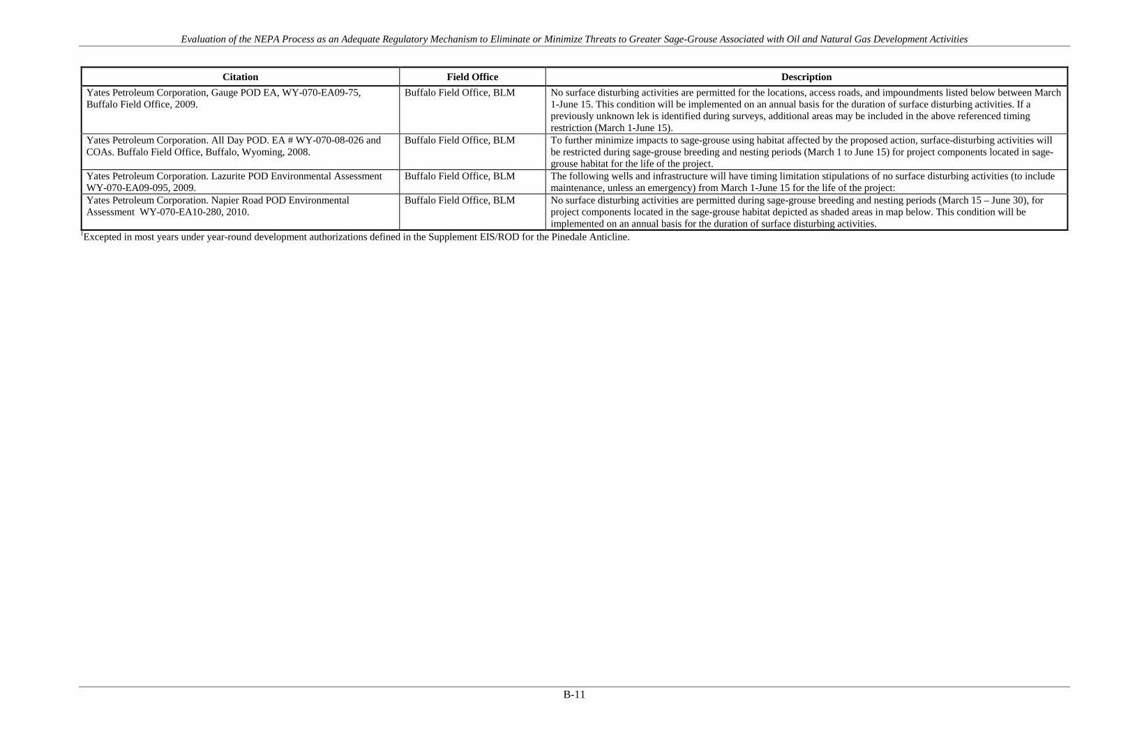
Evaluation of the NEPA Process as an Adequate Regulatory Mechanism to Eliminate or Minimize Threats to Greater Sage-Grouse Associated with Oil and Natural Gas Development Activities
B-11
Citation Field Office Description Yates Petroleum Corporation, Gauge POD EA, WY-070-EA09-75, Buffalo Field Office, 2009.
Buffalo Field Office, BLM No surface disturbing activities are permitted for the locations, access roads, and impoundments listed below between March 1-June 15. This condition will be implemented on an annual basis for the duration of surface disturbing activities. If a previously unknown lek is identified during surveys, additional areas may be included in the above referenced timing restriction (March 1-June 15).
Yates Petroleum Corporation. All Day POD. EA # WY-070-08-026 and COAs. Buffalo Field Office, Buffalo, Wyoming, 2008.
Buffalo Field Office, BLM To further minimize impacts to sage-grouse using habitat affected by the proposed action, surface-disturbing activities will be restricted during sage-grouse breeding and nesting periods (March 1 to June 15) for project components located in sage-grouse habitat for the life of the project.
Yates Petroleum Corporation. Lazurite POD Environmental Assessment WY-070-EA09-095, 2009.
Buffalo Field Office, BLM The following wells and infrastructure will have timing limitation stipulations of no surface disturbing activities (to include maintenance, unless an emergency) from March 1-June 15 for the life of the project:
Yates Petroleum Corporation. Napier Road POD Environmental Assessment WY-070-EA10-280, 2010.
Buffalo Field Office, BLM No surface disturbing activities are permitted during sage-grouse breeding and nesting periods (March 15 – June 30), for project components located in the sage-grouse habitat depicted as shaded areas in map below. This condition will be implemented on an annual basis for the duration of surface disturbing activities.
1Excepted in most years under year-round development authorizations defined in the Supplement EIS/ROD for the Pinedale Anticline.

Evaluation of the NEPA Process as an Adequate Regulatory Mechanism to Eliminate or Minimize Threats to Greater Sage-Grouse Associated with Oil and Natural Gas Development Activities
B-12
Table B-3. PECE Policy Evaluation – Year-Round Development
Conservation Measure Year-Round Development
Certainty of Implementation The conservation effort, the party(ies) to the agreement or plan that will implement the effort, and the staffing, funding level, funding source, and other resources necessary to implement the effort are identified.
The BLM/USFS decision records require implementation as a condition of the agency authorization. Funding and implementation is generally identified as the responsibility of the operator(s).
The legal authority of the party(ies) to the agreement or plan to implement the formalized conservation effort, and the commitment to proceed with the conservation effort are described.
NEPA provides the legal and statutory authority to implement the conservation measures and COAs included in the agency decision records.
The legal procedural requirements (e.g. environmental review) necessary to implement the effort are described, and information is provided indicating that fulfillment of these requirements does not preclude commitment to the effort.
NEPA is the legal procedural requirement necessary to implement COAs and conservation measures included in the agency decision records.
Authorizations (e.g., permits, landowner permission) necessary to implement the conservation effort are identified, and a high level of certainty is provided that the party(ies) to the agreement or plan that will implement the effort will obtain these authorizations.
The NEPA decision record provides the necessary authorization to implement the COAs and conservation measures. As the measures are conditions of the agency approval and are required for project completion, there is a high level of certainty that they will be implemented and authorized.
The type and level of voluntary participation (e.g., number of landowners allowing entry to their land, or number of participants agreeing to change timber management practices and acreage involved) necessary to implement the conservation effort is identified, and a high level of certainty is provided that the party(ies) to the agreement or plan that will implement the conservation effort will obtain that level of voluntary participation (e.g., an explanation of how incentives to be provided will result in the necessary level of voluntary participation).
Participation in the implementation of the COAs and conservation measures is mandatory as a condition of the agency approval under NEPA. NEPA authorizations exceed this evaluation criteria by making the measures mandatory.
Regulatory mechanisms (e.g., laws, regulations, ordinances) necessary to implement the conservation effort are in place.
NEPA provides the regulatory mechanism for implementation. Where necessary, other federal or state authorizations or permits might be required prior to implementation (i.e., Clean Water Act permits). There is reasonable certainty that these permits will be obtained for each measure or COA.
A high level of certainty is provided that the party(ies) to the agreement or plan that will implement the conservation effort will obtain the necessary funding.
The agency decision requires that funding for the COAs and conservation measures be provided as a condition of the project approval. There is certainty that each measure will be funded.

Evaluation of the NEPA Process as an Adequate Regulatory Mechanism to Eliminate or Minimize Threats to Greater Sage-Grouse Associated with Oil and Natural Gas Development Activities
B-13
Conservation Measure Year-Round Development
An implementation schedule (including incremental completion dates) for the conservation effort is provided.
Each NEPA document and associated decision record analyzes and describes the schedule for project implementation. As conditions of agency approvals, COAs and conservation measures must be completed during or prior to project completion.
The conservation agreement or plan that includes the conservation effort is approved by all parties to the agreement or plan.
As a condition of the agency approval of each project, there is agreement between the operators and the agency that each COA or conservation measure will be implemented as part of project activities.
Certainty of Effectiveness The nature and extent of threats being addressed by the conservation effort are described, and how the conservation effort reduces the threats is described.
Year-round drilling COAs and conservation measures address threats associated with Energy Development under Listing Factor A.
Explicit incremental objectives for the conservation effort and dates for achieving them are stated.
The objectives for year-round drilling are stated in NEPA documents and include making the drilling process more efficient, reducing the overall number of active drilling years, concentrating development into selected areas while other areas remain less disturbed, and accelerating reclamation operations.
The steps necessary to implement the conservation effort are identified in detail.
Steps necessary to implement year-round drilling are generally stated and analyzed in the NEPA documents.
Quantifiable, scientifically valid parameters that will demonstrate achievement of objectives, and standards for these parameters by which progress will be measured, are identified.
Year-round drilling is used to reduce project footprints, overall duration of the drilling phase of development, and to focus development activities in localized areas for longer durations rather than spreading the impact across the landscape for short durations. This decreases traffic, noise, and other impacts and accelerates reclamation operations in areas away from where year-round drilling is occurring.
Provisions for monitoring and reporting progress on implementation (based on compliance with the implementation schedule) and effectiveness (based on evaluation of quantifiable parameters) of the conservation effort are provided.
Monitoring and adaptive management practices discussed in detail in the report provide examples of additional monitoring and reporting provisions. In Colorado, Wildlife Conservation Plans prepared in coordination with Colorado Parks and Wildlife often require monitoring of sage-grouse and other species in areas where year-round drilling is used.
Principles of adaptive management are incorporated.
Monitoring and adaptive management practices discussed in detail in the report provide examples of additional monitoring and reporting provisions.

Evaluation of the NEPA Process as an Adequate Regulatory Mechanism to Eliminate or Minimize Threats to Greater Sage-Grouse Associated with Oil and Natural Gas Development Activities
B-14
Figure B-2. Map of FOs where Year-Round Development COAs are applied.

Evaluation of the NEPA Process as an Adequate Regulatory Mechanism to Eliminate or Minimize Threats to Greater Sage-Grouse Associated with Oil and Natural Gas Development Activities
B-15
Table B-4. Year-Round Development COAs and Conservation Measures
Citation Field Office Description
Bill Barrett Corporation. Environmental Impact Statement (UT-070-05-055) for West Tavaputs Plateau Natural Gas Full Field Development Plan and ROD. 2010.
Price Field Office, BLM Year round drilling would reduce drilling duration to 4-7 years compared to 21 years if no winter drilling from 11/1 to 5/15. Approval of winter drilling would be subject to annual review requirements.
EnCana Oil and Gas. 28 APDs on new well pad D36 496. DOI-BLM-CO-110-2011-0169-EA. Approved 9/23/11 by the White River Field Office.
White River Field Office, BLM Based on this analysis, this circumstance warrants an exception to BLM White River ROD/RMP TL-06-Timing Limitation for Sage Grouse Nest Habitat. With input by the BLM WRFO, all sage-grouse oriented best management practices and mitigation strategies have been integrated into the Proposed Action via a formal agreement between CPAW and EnCana.
EnCana Oil and Gas. Master Development Plan (MDP) for the SG E34 496, SG L27 796 and SG F22 496. DOI-BLM-CO-110-2013-0035-EA. Approved 6/7/13 by the White River Field Office.
White River Field Office, BLM The project area represents suitable and occupied nest habitat that is subject to White River ROD/RMP-approved timing limitations designed to reduce disruption of nest and early brood activities of sage-grouse. These measures, which cannot be practically applied to year-round drilling practices, can be 'excepted' by the WRFO Manager pending coordination with the CPW. Based on this analysis, this circumstance warrants an exception to BLM White River ROD/RMP TL-06-Timing Limitation for Sage Grouse Nest Habitat.
EnCana Oil and Gas. Story Gulch Well Pads (2). DOI-BLM-CO-110-2009-0229-EA. Approved 2/3/10 by White River Field Office.
White River Field Office, BLM These measures, which cannot be practically applied to year-round drilling practices, can be ‘excepted’ by the WRFO Manager pending consultation with the CDOW. Based on this analysis, this circumstance warrants an exception to BLM White River ROD/RMP TL-06-Timing Limitation for Sage Grouse Nest Habitat. With input by the BLM WRFO, all sage-grouse oriented best management practices and mitigation strategies have been integrated into the proposed action via a formal agreement between the Colorado Division of Wildlife and EnCana.
Exxon. North Hatch Gulch Project Environmental Assessment, DOI-BLM-CO-110-2010-0200-EA, 2012.
White River Field Office, BLM For a development scenario restricting development to one surface pad for every 400 acres to be economically viable, the use of clustered drilling for the NHGP requires that operations be conducted continuously, without interruptions, until all of the development activities on a pad are completed. A critical component of the Proposed Action is XTO's request for the granting of a modification to big game seasonal stipulation TL-08 within a buffer area of 50 meters around all proposed surface disturbance. XTO’s proposed year-round and continuous drilling and operations program offers significant environmental and efficiency benefits over seasonal operations. Authorization of year-round and continuous drilling and construction would minimize the duration of operations. Assuming each well takes an average of 30 days to drill, each proposed 20-well pad can be drilled and completed in approximately 20 months using year-round and continuous operations; compared to 36 months for seasonal drilling. With 3 rigs and year-round drilling, the 120 wells could be completed within 4 years, compared to 6 years with seasonal shut downs. Year round drilling also requires less surface disturbance and interim reclamation can begin sooner. For seasonal drilling, each move and rig-up or rig-down will require more cranes and truck hauling which means increased vehicular traffic, noise and manpower compared to year-round drilling. Year-round drilling reduces rig moves and truck hauling by 75-80% depending on the number of rigs used.
Record of Decision, Final Supplemental Environmental Impact Statement for the Pinedale Anticline Oil and Gas Exploration and Development Project, Sublette County, Wyoming. 2008.
Pinedale Field Office, BLM This ROD allows for year-round development and delineation activity within big game (pronghorn and mule deer) and greater sage-grouse seasonal use areas by granting exceptions to the big game and greater sage-grouse seasonal restrictions. The extent, location, and duration of relief from seasonal habitat restrictions will be determined at the annual planning meeting. No surface occupancy (NSO) restrictions for all species will remain in effect.

Evaluation of the NEPA Process as an Adequate Regulatory Mechanism to Eliminate or Minimize Threats to Greater Sage-Grouse Associated with Oil and Natural Gas Development Activities
APPENDIX C Reclamation

Evaluation of the NEPA Process as an Adequate Regulatory Mechanism to Eliminate or Minimize Threats to Greater Sage-Grouse Associated with Oil and Natural Gas Development Activities
C-1
Table C-1. PECE Policy Evaluation – Reclamation
Conservation Measure Reclamation
Certainty of Implementation The conservation effort, the party(ies) to the agreement or plan that will implement the effort, and the staffing, funding level, funding source, and other resources necessary to implement the effort are identified.
The BLM/USFS decision records require implementation as a condition of the agency authorization. Funding and implementation is generally identified as the responsibility of the operator(s).
The legal authority of the party(ies) to the agreement or plan to implement the formalized conservation effort, and the commitment to proceed with the conservation effort are described.
NEPA provides the legal and statutory authority to implement the conservation measures and COAs included in the agency decision records.
The legal procedural requirements (e.g. environmental review) necessary to implement the effort are described, and information is provided indicating that fulfillment of these requirements does not preclude commitment to the effort.
NEPA is the legal procedural requirement necessary to implement COAs and conservation measures included in the agency decision records.
Authorizations (e.g., permits, landowner permission) necessary to implement the conservation effort are identified, and a high level of certainty is provided that the party(ies) to the agreement or plan that will implement the effort will obtain these authorizations.
The NEPA decision record provides the necessary authorization to implement the COAs and conservation measures. As the measures are conditions of the agency approval and are required for project completion, there is a high level of certainty that they will be implemented and authorized.
The type and level of voluntary participation (e.g., number of landowners allowing entry to their land, or number of participants agreeing to change timber management practices and acreage involved) necessary to implement the conservation effort is identified, and a high level of certainty is provided that the party(ies) to the agreement or plan that will implement the conservation effort will obtain that level of voluntary participation (e.g., an explanation of how incentives to be provided will result in the necessary level of voluntary participation).
Participation in the implementation of the COAs and conservation measures is mandatory as a condition of the agency approval under NEPA. NEPA authorizations exceed this evaluation criteria by making the measures mandatory.
Regulatory mechanisms (e.g., laws, regulations, ordinances) necessary to implement the conservation effort are in place.
NEPA provides the regulatory mechanism for implementation. Where necessary, other federal or state authorizations or permits might be required prior to implementation (i.e., Clean Water Act permits). There is reasonable certainty that these permits will be obtained for each measure or COA.

Evaluation of the NEPA Process as an Adequate Regulatory Mechanism to Eliminate or Minimize Threats to Greater Sage-Grouse Associated with Oil and Natural Gas Development Activities
C-2
Conservation Measure Reclamation
A high level of certainty is provided that the party(ies) to the agreement or plan that will implement the conservation effort will obtain the necessary funding.
The agency decision requires that funding for the COAs and conservation measures be provided as a condition of the project approval. There is certainty that each measure will be funded.
An implementation schedule (including incremental completion dates) for the conservation effort is provided.
Each NEPA document and associated decision record analyzes and describes the schedule for project implementation. As conditions of agency approvals, COAs and conservation measures must be completed during or prior to project completion.
The conservation agreement or plan that includes the conservation effort is approved by all parties to the agreement or plan.
As a condition of the agency approval of each project, there is agreement between the operators and the agency that each COA or conservation measure will be implemented as part of project activities.
Certainty of Effectiveness The nature and extent of threats being addressed by the conservation effort are described, and how the conservation effort reduces the threats is described.
Reclamation COAs and conservation measures address threats associated with Energy Development and Invasive Plants under Listing Factor A.
Explicit incremental objectives for the conservation effort and dates for achieving them are stated.
Reclamation Plans contain incremental objectives, such as reaching a certain percent cover of native vegetation after a set number of growing seasons.
The steps necessary to implement the conservation effort are identified in detail.
Steps are identified in COAs and Reclamation Plans, including implementation measures that describe soil preparation and seed mixes to use during reclamation.
Quantifiable, scientifically valid parameters that will demonstrate achievement of objectives, and standards for these parameters by which progress will be measured, are identified.
Reclamation must meet quantifiable standards to be considered successful, typically a minimum cover and composition of 60-80% of the desired plant community.
Provisions for monitoring and reporting progress on implementation (based on compliance with the implementation schedule) and effectiveness (based on evaluation of quantifiable parameters) of the conservation effort are provided.
Annual monitoring and reporting are a part of reclamation COAs. If reclamation is determined to be unsuccessful, adaptive management allows the reclamation approach to be re-evaluated.
Principles of adaptive management are incorporated.
Monitoring and adaptive management practices discussed in detail in the report provide examples of additional monitoring and reporting provisions.

Evaluation of the NEPA Process as an Adequate Regulatory Mechanism to Eliminate or Minimize Threats to Greater Sage-Grouse Associated with Oil and Natural Gas Development Activities
C-3
Figure C-1. Map of FOs where Reclamation COAs are applied.

Evaluation of the NEPA Process as an Adequate Regulatory Mechanism to Eliminate or Minimize Threats to Greater Sage-Grouse Associated with Oil and Natural Gas Development Activities
C-4
Table C-2. Reclamation COAs and Conservation Measures
Citation Field Office Description
Anadarko Petroleum Corporation, Dry Willow Phase V POD EA, WY-070-10-186, Buffalo Field Office, 2010.
Buffalo Field Office, BLM Construction up to and including interim reclamation and seeding will be completed by the start of the TLS to mitigate undue impacts to wildlife (sage grouse, raptors), as well as provide for interim and final reclamation success.
Anadarko Petroleum Company, Powder River 2D Seismic Survey Environmental Assessment (EA), WY-070-EA11-343 Buffalo Field Office, Bureau of Land Management, 2011.
Buffalo Field Office, BLM Establish species composition, diversity, structure, and total ground cover appropriate for the desired plant community. Enhance critical resource values (e.g. wildlife, range, recreation, etc.), where appropriate, by augmenting plant community composition, diversity, and/or structure.
Anadarko Petroleum Corp. Big Corral Jewel Draw Unit Gamma EA # WY-070-EA08-168 Buffalo Field Office, Buffalo, Wyoming, 2008.
Buffalo Field Office, BLM Vegetation canopy cover (on unforested sites), production and species diversity (including shrubs) shall approximate the surrounding undisturbed area. The vegetation shall stabilize the site and support the planned post disturbance land use, provide for natural plant community succession and development, and be capable of renewing itself.
Anadarko Petroleum Corporation, Double Tank Phase II POD EA, WY-070-07 015, Buffalo Field Office Buffalo, Wyoming, 2009.
Buffalo Field Office, BLM BLM will not release the performance bond until the area has been successfully revegetated (evaluation will be made after the second complete growing season) and has met all other reclamation goals of the surface owner and surface management agency.
Anadarko Petroleum Corporation, Dry Willow III POD EA, WY-070-08-036, Buffalo Field Office
Buffalo Field Office, BLM BLM will not release the performance bond until the area has been successfully revegetated (evaluation will be made after the second complete growing season) and has met all other reclamation goals of the surface owner and surface management agency.
Anadarko/Lance Oil & Gas. Rose Draw Unit Beta Environmental Assessment WY-070-EA08-186, 2008.
Buffalo Field Office, BLM BLM will not release the performance bond until the area has been successfully revegetated (evaluation will be made after the second complete growing season) and has met all other reclamation goals of the surface owner and surface management agency.
Anadarko. Doty Mountain Plan of Development D in Atlantic Rim. DOI-BLM-WY-030-2012-0093-EA. 2012.
Rawlins Field Office, BLM The Operator shall select and use a seed mix most applicable to each disturbed location with the goal of restoring individual sites to closely resemble the predisturbance native plant communities, as provided in Appendix A of the ROD "Project Reclamation Plan"
Anadarko. Doty Mountain POD C in Atlantic Rim EA. WY-030-07-EA-240. 2008.
Rawlins Field Office, BLM The Operator shall select and use a seed mix most applicable to each disturbed location with the goal of restoring individual sites to closely resemble the predisturbance native plant communities, as provided in Appendix A of the ROD "Project Reclamation Plan"
Anadarko. Doty Mountain Unit B Plan of Development in Atlantic Rim EA. WY-030-08-EA-049. 2008.
Rawlins Field Office, BLM The Operator shall select and use a seed mix most applicable to each disturbed location with the goal of restoring individual sites to closely resemble the predisturbance native plant communities, as provided in Appendix A of the ROD "Project Reclamation Plan"
Anadarko. Environmental Assessment for Jack Sparrow POD. WY-030-08-EA-238. 2008.
Rawlins Field Office, BLM The Operator shall select and use a seed mix most applicable to each disturbed location with the goal of restoring individual sites to closely resemble the predisturbance native plant communities, as provided in Appendix A of the ROD "Project Reclamation Plan"
Atlantic Rim Natural Gas Field Development Project Record of Decision and Environmental Impact Statement, Carbon County, Wyoming. March 2007.
Rawlins Field Office, BLM Reclamation will be considered successful if the following Interim Reclamation criteria are met (appendix A): 80 percent of predisturbance ground cover, 90 percent dominant species, No noxious weeds present in the seeding, and Erosion features equal to or less than surrounding area. The vegetation will consist of species included in the seed mix, and/or occurring in the surrounding natural vegetation or as deemed desirable by the BLM in review and approval of the reclamation plan. The goal is no single species will account for more than 30 percent total vegetative composition. Vegetation canopy cover production and species diversity shall approximate the surrounding undisturbed area.
Berry Petroleum Company. Record of Decision South Unit Oil and Gas Development Final Environmental Impact Statement Duchesne Ranger District, Ashley National Forest Duchesne County, Utah. 2012.
Ashley National Forest , USFS For all locations and access roads, the Operator will promptly revegetate all disturbed areas not necessary for future operations with a Forest Service-approved seed mixture. Revegetation would commence immediately after construction, or immediately after the disturbed area is no longer needed for future operations. Reclamation achievement will be evaluated using the standards described in the Reclamation Plan (FEIS Appendix B). Rehabilitation efforts must be repeated if it is concluded that the success rate is below an acceptable level as determined by the Forest Service.

Evaluation of the NEPA Process as an Adequate Regulatory Mechanism to Eliminate or Minimize Threats to Greater Sage-Grouse Associated with Oil and Natural Gas Development Activities
C-5
Citation Field Office Description
Bill Barrett Corporation. Environmental Impact Statement (UT-070-05-055) for West Tavaputs Plateau Natural Gas Full Field Development Plan and ROD. 2010.
Price Field Office, BLM As previously discussed under the Selected Alternative, BBC and other operators will be required to track the amount of annual and cumulative surface disturbance associated with past (since 2004), present, and proposed oil and gas development activities in the WTP Project Area. In order to minimize impacts to resources of concern and ensure reclamation on Federal lands, BBC and other operators will be allowed no more than 250 acres of surface disturbance per-year, no more than 1,250 acres of new surface disturbance at any given time, and no more than 1,500 acres of cumulative surface disturbance (i.e., new surface disturbance added to past and present surface disturbance associated with oil and gas development in the WTP Project Area since 2004).
Bill Barrett Corporation. Environmental Impact Statement (UT-070-05-055) for West Tavaputs Plateau Natural Gas Full Field Development Plan and ROD. 2010.
Price Field Office, BLM BBC and other operators will be required to monitor reclamation using an approved BLM method and submit monitoring reports on an annual basis.
Bill Barrett Corporation, Beaver Creek Add II, Beaver Creek Add II SGP PODs, Beaver Creek Little Buffalo 32-24 APD & Beaver Creek Little Buffalo 34-24 APD, EA # WY-070-09-065, Buffalo Field Office Buffalo, Wyoming, 2010.
Buffalo Field Office, BLM BLM will not release the performance bond until the area has been successfully revegetated (evaluation will be made after the second complete growing season) and has met all other reclamation goals of the surface owner and surface management agency.
BLM Montana. Record of Decision for the Final Statewide Oil and Gas Environmental Impact Statement and Proposed Amendment of the Powder River and Billings Resource Management Plans. 2003.
Billings Field Office, BLM Miles City Field Office, BLM
PODs will include A Reclamation Plan for surface disturbance
BLM Montana. Record of Decision for the Final Statewide Oil and Gas Environmental Impact Statement and Proposed Amendment of the Powder River and Billings Resource Management Plans. 2003.
Billings Field Office, BLM Miles City Field Office, BLM
The planting of grasses, forbs, trees, or shrubs beneficial to wildlife will follow the BLM seeding policy.
Chevron. Table Rock Unit Oil and Gas Development EA and DR. WY-040-EA11-175. January 2012.
Rawlins Field Office, BLM Reclamation of initial surface disturbance areas and upon Project completion subsequent reclamation of long-term surface disturbance areas, would be completed pursuant to site-specific reclamation plans in compliance with BLM policy.
Chevron. Table Rock Unit Oil and Gas Development EA and DR. WY-040-EA11-175. January 2012.
Rock Springs Field Office, BLM Reclamation of initial surface disturbance areas and upon Project completion subsequent reclamation of long-term surface disturbance areas, would be completed pursuant to site-specific reclamation plans in compliance with BLM policy.
Cimarex. Rands Butte Gas Development Project Final Environmental Assessment, Decision Record and Finding of No Significant Impact, WY-100-EA09-43. 2010.
Pinedale Field Office, BLM Reclamation success will be monitored on an annual basis. Reclamation achievement will be evaluated using the standards agreed upon with the BLM PFO. Rehabilitation efforts will be repeated if it is concluded that the success rate is below an acceptable level as determined by the BLM PFO. The Operator will collect reclamation monitoring data in an electronic format and submit the spatial data and all associated attributes to the BLM along with their annual reclamation monitoring report.
Coleman Oil & Gas. Wilkinson POD. EA # WY-070-11-38. 2010. Buffalo Field Office, BLM BLM will not release the performance bond until the area has been successfully revegetated (evaluation will be made after the second complete growing season) and has met all other reclamation goals of the surface owner and surface management agency.
Devon Energy Company, L.P., Grayling POD EA, WY-070-10-332, Buffalo Field Office, 2011.
Buffalo Field Office, BLM BLM will not release the performance bond until the area has been successfully revegetated (evaluation will be made after the second complete growing season) and has met all other reclamation goals of the surface owner and surface management agency.
Devon Energy Production Company L.P. Harrier Plan of Development Juniper Draw Unit Environmental Assessment WY-070-EA08-189. 2008.
Buffalo Field Office, BLM BLM will not release the performance bond until the area has been successfully revegetated (evaluation will be made after the second complete growing season) and has met all other reclamation goals of the surface owner and surface management agency.
Devon Energy Production Company, L.P., Golden Eagle- Juniper Draw CBNG Field POD EA, WY-070-EA07-111, Buffalo Field Office Buffalo, Wyoming, 2008.
Buffalo Field Office, BLM BLM will not release the performance bond until the area has been successfully revegetated (evaluation will be made after the second complete growing season) and has met all other reclamation goals of the surface owner and surface management agency.
Devon Energy Production Company. West Pine Tree Unit – Brook Trout POD Environmental Assessment WY-070-EA08-129, 2008.
Buffalo Field Office, BLM BLM will not release the performance bond until the area has been successfully revegetated (evaluation will be made after the second complete growing season) and has met all other reclamation goals of the surface owner and surface management agency.

Evaluation of the NEPA Process as an Adequate Regulatory Mechanism to Eliminate or Minimize Threats to Greater Sage-Grouse Associated with Oil and Natural Gas Development Activities
C-6
Citation Field Office Description
Double Eagle Petroleum. Catalina PODs C and D in the Atlantic Rim. WY-030-08-EA-115. 2008.
Rawlins Field Office, BLM The Operator shall select and use a seed mix most applicable to each disturbed location with the goal of restoring individual sites to closely resemble the predisturbance native plant communities, as provided in Appendix A of the ROD "Project Reclamation Plan"
Double Eagle Petroleum. Catalina PODs E and F in the Atlantic Rim. WY-030-08-EA-222. 2008.
Rawlins Field Office, BLM The Operator shall select and use a seed mix most applicable to each disturbed location with the goal of restoring individual sites to closely resemble the predisturbance native plant communities, as provided in Appendix A of the ROD "Project Reclamation Plan"
Double Eagle Petroleum. Catalina PODs G and I in the Atlantic Rim. DOI-BLM-WY-030-2009-0155-EA. 2011.
Rawlins Field Office, BLM Additional site specific vegetation inventory data would be collected by the company and submitted as part of any approved Reclamation Plan as per the Wyoming Reclamation Policy (March 2009), the Rawlins Resource Management Plan (RMP) Appendix 36 (Dec. 2008) and the ROD (March 2007) (p. A-3, Section 1.3.1) prior to any surface disturbance.
Elk Petroleum. Environmental Assessment for the Grieve Unit CO2 Enhanced Recovery Project. Natrona County, Wyoming. WY-050-EA11-108. Approved 7/26/12 by BLM Lander Field Office.
Lander Field Office, BLM Utilize native plant species for reclamation purposes (preferably local seeds and species that are preferred by sage grouse).
EnCana Oil and Gas. 28 APDs on new well pad D36 496. DOI-BLM-CO-110-2011-0169-EA. Approved 9/23/11 by the White River Field Office.
White River Field Office, BLM Sage-grouse oriented reclamation (e.g., specialized seed mix, lengthened cut and fill slopes) is expected to involve all pipeline acreage and about ¾ of pad acreage (about 18 acres). Depending on subsequent ungulate use, this reclaimed acreage would serve increasingly effective brood and summer habitat function prior to the redevelopment of a suitable sagebrush canopy (10-15 years).
EnCana Oil and Gas. APDs- N22-496 (16)& P28-496 (16). DOI-BLM-CO-110-2011-0006-EA. White River Field Office. Approved 5/24/11 by White River Field Office.
White River Field Office, BLM All disturbed surfaces shall be promptly revegetated with certified weed-free seed per agency policy. BLM policy is to use native species for revegetation. Exceptions may be granted under certain conditions, such as the use of noninvasive non-native forbs when native forbs are unavailable or unlikely to succeed due to adverse conditions.
EnCana Oil and Gas. L24 496 New Well Pad - 28 APDs. DOI-BLM-CO-110-2012-0021-DNA. Approved 3/20/12 by White River Field Office.
White River Field Office, BLM Re-vegetate with the native seed mix number six (listed below) prior to the first full growing season following completion of drilling (unless a different seed mix is recommended in any of the wildlife sections or the surface owner requests a different seed mix).
EnCana Oil and Gas. L24 496 New Well Pad - 28 APDs. DOI-BLM-CO-110-2012-0021-DNA. Approved 3/20/12 by White River Field Office.
White River Field Office, BLM Successful re-vegetation should be achieved within three years. Successful reclamation and re-vegetation is defined by the following: A functioning vegetation community will present a minimum cover and composition of 80 percent of the Desired Plant Community as defined by the ecological site description or in relation to the seed mix applied. In cases where wildlife objectives are dependent upon presence of forbs within the community BLM will require their presence at the 80 percent calculation. The functioning vegetation community established on the reclaimed site is capable of persisting on the site without continued intervention and will allow plant community successional processes to develop to the climax community.
EnCana Oil and Gas. Master Development Plan (MDP) for the SG E34 496, SG L27 796 and SG F22 496. DOI-BLM-CO-110-2013-0035-EA. Approved 6/7/13 by the White River Field Office.
White River Field Office, BLM BLM recommends that the interim and final reclamation seed mix for this project refrain from the use of deciduous shrubs (i.e., Utah serviceberry, Wood's rose, and snowberry). Optional forb components that best meet the nutritional demands of grouse broods should be considered a priority, including sulphur flower, Utah sweetvetch, and yarrow. Due to general absence or tendency to naturally recolonize disturbed sites in the project locale, the use of lupine and, especially, white sage should be avoided.
EnCana Oil and Gas. Master Development Plan (MDP) for the SG E34 496, SG L27 796 and SG F22 496. DOI-BLM-CO-110-2013-0035-EA. Approved 6/7/13 by the White River Field Office.
White River Field Office, BLM Interim reclamation would be completed as quickly as possible to redevelop ground cover that provides for secure ground movements of sage-grouse and is an effective precursor to the reestablishment of appropriate sagebrush cover. Disturbances exceeding 15 feet in width in mapped sage-grouse priority occupied habitat would be reseeded with local sagebrush seed, where topography and weather conditions allow safe access to do so. Detailed guidelines and practices for interim and final reclamation are outlined in EnCana's NPR Integrated Vegetation Management Guidance (WWE 2009).
EnCana Oil and Gas. Master Development Plan (MDP) for the SG E34 496, SG L27 796 and SG F22 496. DOI-BLM-CO-110-2013-0035-EA. Approved 6/7/13 by the White River Field Office.
White River Field Office, BLM The applicant voluntarily uses enhanced interim reclamation procedures and seed mixes that offer improved herbaceous forage and cover redevelopment opportunities for grouse.

Evaluation of the NEPA Process as an Adequate Regulatory Mechanism to Eliminate or Minimize Threats to Greater Sage-Grouse Associated with Oil and Natural Gas Development Activities
C-7
Citation Field Office Description
EnCana Oil and Gas. Master Development Plan (MDP) for the SG E34 496, SG L27 796 and SG F22 496. DOI-BLM-CO-110-2013-0035-EA. Approved 6/7/13 by the White River Field Office.
White River Field Office, BLM The reclamation success criteria should result in a minimum cover and composition of 80 percent of the Desired Plant Community (as defined by the ecological site, in an early seral state) or in relation to the seed mix applied within three growing seasons after the application of seed. This community should be capable of persisting on the site without intervention and allow for successional processes consistent with achieving the seral stage on the site prior to surface disturbance. Reclamation achievement should be evaluated using the Public Land Health Standards that include Indicators of Rangeland Health.
EnCana Oil and Gas. Pappy Draw Exploratory Coal-bed Natural Gas Pilot Project Environmental Assessment. WY-050-EA08-88. Approved 9/5/08 by the Lander BLM Field Office.
Lander Field Office, BLM Disturbed areas would be seeded and stabilized in accordance with BLM-approved reclamation guidelines. During reclamation, a variety of native forage species would be used to return disturbed areas to conditions similar to those that existed before the proposed project.
EnCana Oil and Gas. Story Gulch Well Pads (2). DOI-BLM-CO-110-2009-0229-EA. Approved 2/3/10 by White River Field Office.
White River Field Office, BLM All areas of the well pads not used during any production phase, including cut and fill slopes, should be re-contoured as much as possible to natural topography, and have topsoil redistributed where likely to revegetate successfully (e.g., along appropriate cut and fill slopes or at the top edge of the borrow ditches), where it will not be disturbed during regular road maintenance activities. Re-vegetated with the native seed mix #6 (listed below) prior to the first full growing season following completion of drilling (unless a different seed mix is recommended in any of the wildlife sections or the surface owner requests a different seed mix). Seeding rates listed in the table below are shown as pounds of Pure Live Seed (PLS) per acre and apply to drill seeding. When drill seeding is not feasible (e.g. steep slopes, etc.), then broadcast seed using double the seeding rate followed by harrowing to ensure seed coverage. Applied seed should be certified and free of noxious weeds.
EnCana Oil and Gas. Story Gulch Well Pads (2). DOI-BLM-CO-110-2009-0229-EA. Approved 2/3/10 by White River Field Office.
White River Field Office, BLM Successful re-vegetation should be achieved within three years. Successful reclamation and re-vegetation is defined by the following: A functioning vegetation community will present a minimum cover and composition of 80% of the Desired Plant Community as defined by the ecological site description or in relation to the seed mix applied. In cases where wildlife objectives are dependent upon presence of forbs within the community BLM will require their presence at the 80% calculation. The functioning vegetation community established on the reclaimed site is capable of persisting on the site without continued intervention and will allow plant community successional processes to develop to the climax community
EnCana. Environmental Assessment of the Orchard Master Development Plan for Oil and Gas Development. GJFO # DOI-BLM-CO-130-2009-0001-EA and GSFO # DOI-BLM-CO-140-2008-0032-EA. Grand Junction Field Office and Glenwood Springs Energy Office, October 2008.
Grand Junction Field Office, BLM Seeding: Perennial vegetation must be established and additional work shall be required in cases of failure. A. Interim Reclamation: Seed all disturbed areas outside the production area, according to specified methods and seed mixture. B. Final Reclamation: Seed all recontoured and disturbed areas, according to specified methods and seed mixture. C. Hydroseeding and hydro-mulching may be used in areas of temporary seeding or in areas where drill-seeding or broadcast-seeding/raking are impractical. Hydro-seeding and hydro-mulching must be conducted in two separate applications to ensure adequate seed-to-soil contact. The seeded species will be considered firmly established when at least 50 percent of the new plants are producing seed. Reclaimed areas shall be monitored annually. The annual report shall document whether attainment of reclamation objectives appears likely. If one or more objectives appear unlikely to be achieved, the report shall identify appropriate corrective actions. Upon review and approval of the report by the BLM, the operator shall be responsible for implementing the corrective actions or other measures specified by the authorized officer.
EnCana Oil and Gas. 16 gas wells on existing well pad (N22 496). DOI-BLM-CO-110-2012-0004-CX. Approved 12/8/11 by White River Field Office.
White River Field Office, BLM Reclamation activities may include, but are not limited to, seed bed preparation that requires disturbance of surface soils, seeding, or constructing exclosures (e.g., fences) to exclude livestock from reclaimed areas.
EnCana Oil and Gas. 16 APDs on existing well pad P28-496. DOI-BLM-CO-110-2011-0153-CX. Approved 9/6/11 by White River Field Office.
White River Field Office, BLM Reclamation activities may include, but are not limited to, seed bed preparation that requires disturbance of surface soils, seeding, or constructing exclosures (e.g., fences) to exclude livestock from reclaimed areas.
EnCana Oil and Gas. Story Gulch Well Pads (2). DOI-BLM-CO-110-2009-0229-EA. Approved 2/3/10 by White River Field Office.
White River Field Office, BLM Reclamation activities may include, but are not limited to, seed bed preparation that requires disturbance of surface soils, seeding, or constructing exclosures (e.g., fences) to exclude livestock from reclaimed areas.
EOG Resources, Inc. Ballista Flatbow Multi-Well Pad Project, supported by Environmental Assessment (EA), WY-070-EA13-15, Buffalo Field Office. 2013.
Buffalo Field Office, BLM BLM will not release the performance bond until the area has been successfully revegetated (evaluation will be made after the second complete growing season) and has met all other reclamation goals of the surface owner and surface management agency

Evaluation of the NEPA Process as an Adequate Regulatory Mechanism to Eliminate or Minimize Threats to Greater Sage-Grouse Associated with Oil and Natural Gas Development Activities
C-8
Citation Field Office Description
EOG. EA for 4 Applications for Permit to Drill (APDs & ROWs) in Jackson County. DOI-BLM-CO-120-2009-0003. Bureau of Land Management Kremmling Field Office. 2009.
Kremmling Field Office, BLM The lessee is required to use the reclamation practices necessary to reclaim all disturbed areas. Reclamation will ensure surface and subsurface stability, growth of a self-regenerating permanent vegetative cover and compatibility with post land use. The vegetation will be diverse and of the same seasonal growth as adjoining vegetation.
EOG. Environmental Assessment for Spicer 3-32H and Surprise 2-05H Applications for Permits to Drill (APDs) in Jackson County. CO-120-08-42-EA. Bureau of Land Management Kremmling Field Office. 2008.
Kremmling Field Office, BLM Reclamation will ensure surface and subsurface stability, growth of a self-regenerating permanent vegetative cover and compatibility with post land use. The vegetation will be diverse and of the same seasonal growth as adjoining vegetation.
Exxon. North Hatch Gulch Project Environmental Assessment, DOI-BLM-CO-110-2010-0200-EA, 2012.
White River Field Office, BLM Contouring, soil stabilization and preparation , and reseeding would proceed according to site-specific conditions and in compliance with XTO-committed reclamation measures in the applicant-committed design features and with BLM requirements for interim reclamation and for final reclamation of pipelines...
Exxon. Piceance Development Project EA, Finding of No Significant Impact and Decision Record, CO-110-2005-219-EA, 2007.
White River Field Office, BLM A Reclamation Status Report will be submitted to the WRFO biannually for all actions that require disturbance of surface soils on BLM-administered lands as a result of Alternative B. Actions may include, but are not limited to, well pad and road construction, construction of ancillary facilities, or power line and pipeline construction. The Reclamation Status Report will be submitted by 15 April and 15 August of each calendar year, and will include the well number, legal description, project description (e.g., well pad or pipeline), reclamation status (e.g., interim or final), whether the well pad or pipeline has been re-vegetated and/or recontoured, date seeded, photos of the reclaimed site, estimate of acres seeded and seeding method (e.g., disk-plowed, drilled, or both). Internal and external review of this plan and the process used to acquire the necessary information will be conducted annually, and new information or changes in the reporting process will be incorporated into the plan.
Exxon. Piceance Development Project EA, Finding of No Significant Impact and Decision Record, CO-110-2005-219-EA, 2007.
White River Field Office, BLM Disturbed areas will be seeded with a mix designed to reestablish sagebrush and forb species.
Exxon. Piceance Development Project EA, Finding of No Significant Impact and Decision Record, CO-110-2005-219-EA, 2007.
White River Field Office, BLM Sagebrush seed will be collected from local populations of appropriate species. Distribution will be dependent upon range site (i.e., Artemisia tridentata spp. Vaseyana and spp. Wyomingensis). A mosaic of sagebrush seeded and unseeded areas is recommended. Reclamation on these sites should use seed mixes and seeding methods that include and promote successful establishment of a full complement of grasses and favored native forbs. The following forbs will be included in reclamation seed mixes as appropriate throughout sage-grouse range on lands administered by the BLM WRFO and it is recommended that these components be applied to fee-lands under ExxonMobil’s control or lease: 1) scarlet globemallow, 2) Utah sweetvetch, 3) arrowleaf balsamroot, 4) Lewis flax, and 5) Rocky Mountain penstemon. (See sage-grouse seed mixes in Vegetation.)
Exxon. Piceance Development Project EA, Finding of No Significant Impact and Decision Record, CO-110-2005-219-EA, 2007.
White River Field Office, BLM The operator will be responsible for achieving a reclamation success rate for interim reclamation and final abandonment of sufficient vegetative ground cover from reclaimed plant species within three growing seasons after the application of seed. Additional reclamation efforts will be undertaken at the operator’s expense if after the first growing season there are no positive indicators of successful establishment of seeded species (e.g. Germination); after the second year seeded species are not yet established (e.g. producing seed); and after the third growing season seeded vegetative communities lack persistence (e.g. reproductively capable of enduring drought conditions and sustaining the seeded community). Following the third growing season, ground cover of reclaimed seed species shall be at a Desired Plant Community (DPC) in relation to the seed mix as deemed appropriate by the BLM. Reclamation achievement will be evaluated using the Public Land Health Standards that include indicators of rangeland health. Rehabilitation efforts must be repeated if it is concluded that the success rate is below an acceptable level as determined by the BLM.
Fidelity Exploration & Production Company. Bowdoin Natural Gas Development Project Phillips and Valley Counties, Montana. Environmental Assessment MT-92234-07-59. December, 2008.
Malta Field Office, BLM Reclamation success will be evaluated using defined performance standards. Reclamation should be monitored to evaluate the success of both interim and final reclamation efforts and determine if the techniques used are effective or if additional measures are needed.
Fidelity Exploration and Production Company. Tongue River - Badger Hills Project Plan of Development EA, Decision Record and Finding of No Significant Impact. 2004.
Miles City Field Office, BLM The reclamation effort will be evaluated as successful if the previously disturbed area is stabilized, all potential water erosion is effectively controlled and the vegetative stand is established with at least a 70% cover when compared to similar adjacent undisturbed areas.
Fidelity Exploration and Production Company. Tongue River - Coal Creek Project Plan of Development. MT-020-2004-297. Decision Record and Finding of No significant Impact, 2005.
Miles City Field Office, BLM Reclamation will be determined successful when the disturbed area and any areas of subsidence are stabilized, potential water erosion is effectively controlled, the area is free of debris and the vegetative stand is established with at least a 70% ground cover and is composed of at least 60% of the required species.

Evaluation of the NEPA Process as an Adequate Regulatory Mechanism to Eliminate or Minimize Threats to Greater Sage-Grouse Associated with Oil and Natural Gas Development Activities
C-9
Citation Field Office Description
Fidelity Exploration and Production Company. Tongue River - Corral Creek, Plan of Development, Environmental Assessment, Montana Board of Oil and Gas Conservation. 2008.
Miles City Field Office, BLM The disturbed surfaces will be reclaimed in accordance with the agreements made with surface owners. The disturbed areas would be seeded with a certified seed mix agreed to by the NRCS and surface owner
Fidelity Exploration and Production Company. Coal Bed Natural Gas Tongue River – Decker Mine East Federal Project. Finding of No Significant Impact and Decision Record. Environmental Assessment MT-020-2008-345. 2008.
Miles City Field Office, BLM Reclamation will be determined successful when the disturbed area and any areas of subsidence are stabilized, potential water erosion is effectively controlled, the area is free of debris and the vegetative stand is established with at least a 70% ground cover and is composed of at least 60% of the required species.
Fidelity Exploration & Production Company. Coal Bed Natural Gas Tongue River - Deer Creek North Federal Project. Environmental Assessment MT-020-2008-310. Finding of No Significant Impact and Decision Record, 2008.
Miles City Field Office, BLM Reclamation will be determined successful when the disturbed area and any areas of subsidence are stabilized, potential water erosion is effectively controlled, the area is free of debris and the vegetative stand is established with at least a 70% ground cover and is composed of at least 60% of the required species.
Gasco Energy Inc. Uinta Basin Natural Gas Development Project, Environmental Impact Statement FES 12-5, Record of Decision, Bureau of Land Management Vernal Field Office, June 2012.
Vernal Field Office, BLM All reclamation will be accomplished as soon as practical after the disturbance occurs, with efforts continuing until a satisfactory revegetation cover is established. Reseeding will be accomplished by planting native species as much as practical; however, non-native species may also be used where site-specific conditions require them, or native species indigenous to the site are not commercially available, or as directed by the AO. Post-construction seeding applications will continue until determined successful by the AO.
Geokinetics. Jim Bridger Power Plant 3-D Seismic and Electromagnetic Surveys EA and Decision Record. WYW167761. WY-040-EA10-111. September 2010.
Rock Springs Field Office, BLM Reclaim all surface disturbances using a BLM-approved seed mixture.
Greencore Pipeline Company. Environmental Assessment. Bureau of Land Management. EA No. WY-060-EA11-32. January 2011.
Casper Field Office, BLM Buffalo Field Office, BLM Miles City Field Office, BLM Lander Field Office, BLM
Construction of the Project would require approximately 3,228.1 acres; an estimated 3,178.3 acres would be reclaimed immediately following construction.
Jonah Infill Drilling Project Environmental Impact Statement and Record of Decision, Sublette County, Wyoming. 2006.
Pinedale Field Office, BLM Rock Springs Field Office, BLM
To return habitat function as soon as possible, this decision implements a management approach that provides an incentive for rapid on-site interim and final reclamation while simultaneously allowing maximum flexibility in field development.
Kerr-McGee Oil & Gas Onshore LP (KMG), Greater Natural Buttes EIS UT-080-07-807, BLM Vernal Field Office, Record of Decision, May 2012.
Vernal Field Office, BLM Within 2 miles of an active greater sage-grouse lek, interim reclamation seed mixes will be designed to provide habitat for greater sage-grouse.
Lance Oil & Gas Company. Bear Draw Gamma. WY-070-11-172. Bureau of Land Management, Buffalo Field Office. 2011.
Buffalo Field Office, BLM BLM will not release the performance bond until the area has been successfully revegetated (evaluation will be made after the second complete growing season) and has met all other reclamation goals of the surface owner and surface management agency.
Lance Oil & Gas Company. Camp John Unit Epsilon POD WY-070-EA10-239, Bureau of Land Management, Buffalo Field Office, 2011.
Buffalo Field Office, BLM BLM will not release the performance bond until the area has been successfully revegetated (evaluation will be made after the second complete growing season) and has met all other reclamation goals of the surface owner and surface management agency.
Lance Oil & Gas Company. Camp John Unit SMA Phase 1, Year 1; WY-070-EA11-214 Buffalo Field Office, 2011.
Buffalo Field Office, BLM BLM will not release the performance bond until the area has been successfully revegetated (evaluation will be made after the second complete growing season) and has met all other reclamation goals of the surface owner and surface management agency.
Lance Oil & Gas Company. Camp John Unit SMA Phase 1, Year 2; WY-070-EA12-084, Buffalo Field Office, 2013.
Buffalo Field Office, BLM BLM will not release the performance bond until the area has been successfully revegetated (evaluation will be made after the second complete growing season) and has met all other reclamation goals of the surface owner and surface management agency.
Lance Oil & Gas Company. Coal Gulch Unit Gamma POD Categorical Exclusion WY-070-390CX3-11-64 through WY070-390CX3-11-128 Bureau of Land Management Buffalo Field Office, 2010.
Buffalo Field Office, BLM BLM reclamation goals emphasize eventual ecosystem reconstruction, which means returning the land to a condition approximate to an approved “Reference Site” or Natural Resources Conservation Service Ecological Site Transition State. Final reclamation measures are used to achieve this goal.
Lance Oil & Gas Company. Coulter 4 POD EA, WY-070-08-169, Buffalo Field Office Buffalo, Wyoming, 2008.
Buffalo Field Office, BLM BLM will not release the performance bond until the area has been successfully revegetated (evaluation will be made after the second complete growing season) and has met all other reclamation goals of the surface owner and surface management agency.

Evaluation of the NEPA Process as an Adequate Regulatory Mechanism to Eliminate or Minimize Threats to Greater Sage-Grouse Associated with Oil and Natural Gas Development Activities
C-10
Citation Field Office Description
Lance Oil & Gas Company. Highland Unit Delta Environmental Assessment WY-070-10-383, 2010.
Buffalo Field Office, BLM BLM will not release the performance bond until the area has been successfully revegetated (evaluation will be made after the second complete growing season) and has met all other reclamation goals of the surface owner and surface management agency.
Lance Oil & Gas Company. KDU Gamma Plan of Development Environmental Assessment WY-070-EA10-271, 2010.
Buffalo Field Office, BLM BLM will not release the performance bond until the area has been successfully revegetated (evaluation will be made after the second complete growing season) and has met all other reclamation goals of the surface owner and surface management agency.
Lance Oil & Gas Company. Kinney Divide Unit Epsilon Plan of Development Environmental Assessment, WY-070-12-148, 2012.
Buffalo Field Office, BLM BLM will not release the performance bond until the area has been successfully revegetated (evaluation will be made after the second complete growing season) and has met all other reclamation goals of the surface owner and surface management agency.
Lance Oil & Gas Company. Powder Valley Unit Delta Environmental Assessment WY-070-EA08-143, 2008.
Buffalo Field Office, BLM BLM will not release the performance bond until the area has been successfully revegetated (evaluation will be made after the second complete growing season) and has met all other reclamation goals of the surface owner and surface management agency.
Lance Oil & Gas Company. Powder Valley Unit Epsilon Environmental Assessment WY-070-EA10-232, 2010.
Buffalo Field Office, BLM BLM will not release the performance bond until the area has been successfully revegetated (evaluation will be made after the second complete growing season) and has met all other reclamation goals of the surface owner and surface management agency.
Lance Oil & Gas Company. Quarter Circle 9 Beta Environmental Assessment, 2008.
Buffalo Field Office, BLM BLM will not release the performance bond until the area has been successfully revegetated (evaluation will be made after the second complete growing season) and has met all other reclamation goals of the surface owner and surface management agency.
Lance Oil & Gas Company. Sahara POD Environmental Assessment WY-070-EA13-72, 2013.
Buffalo Field Office, BLM BLM will not release the performance bond until the area has been successfully revegetated (evaluation will be made after the second complete growing season) and has met all other reclamation goals of the surface owner and surface management agency.
Noble. Environmental Assessment Huntington Valley 3D Seismic Project. DOI-BLM-NV-E020-2013-0008-EA. August 2013.
Tuscarora Field Office, BLM Should increased vehicle use occur along source lines, the BLM will require reseeding with a BLM approved seed mix and/or signage for reclamation areas.
Noble. Marys River 3D Seismic Project. DOI-BLM-NV-E030-2012-0518-EA. Elko District – Wells Field Office. August 2012.
Wells Field Office If operations cause unplanned surface rutting or have otherwise removed all surface vegetation, the areas will be reclaimed and reseeded as directed by the landowner.
Powder River Basin Oil and Gas Project, Record of Decision and Resource Management Plan Amendments. EIS WY–070–02–065. April 2003.
Buffalo Field Office, BLM Loss of sagebrush shrublands and their reclamation success would be documented in a database.
Powder River Basin Oil and Gas Project, Record of Decision and Resource Management Plan Amendments. EIS WY–070–02–065. April 2003.
Buffalo Field Office, BLM Requires a surface disturbance, revegetation , noxious weed plan to be developed by technical agency group
QEP. Drilling of 180 Wells and Constructing or Expanding 6 Pads. WY-100-EA13-72. Approved by BLM Pinedale July 2013.
Pinedale Field Office, BLM Reclamation practices will utilize dispersed cluster plantings, at a rate of approximately 10 clusters per acres, of container raised plantings of native shrubs not more than gallon sized germinated from a local seed source. Plant clusters should include a minimum of 30 plants per cluster. It may take additional moisture for plantings to be successful.
QEP. APD with COAs for QEP Mesa 15-9 pad. 2012. Pinedale Field Office, BLM Seed all disturbed areas using a drill equipped with a depth regulator; Wyoming big sage seed is to be broadcast on top of the reclamation area after any drill seeding is completed.
QEP. APD and COAs for QEP Stewart Point 14-32 pad. 2013. Pinedale Field Office, BLM Seed all disturbed areas using a drill equipped with a depth regulator; Wyoming big sage seed is to be broadcast on top of the reclamation area after any drill seeding is completed.
QEP. EA to re-enter the existing WRB 16-17-10-17 EA, DOI-BLM-UT_G010-2012-0151, BLM Vernal Field Office. 2012.
Vernal Field Office, BLM Reclamation will be completed in accordance with the QEP, UBD Reclamation Plan on file with the Vernal Field Office of the BLM.
QEP. Greater Deadman Bench Oil and Gas Producing Region EIS and ROD March 2008. UT 080-2003-0369V. BLM Vernal Field Office. 2008.
Vernal Field Office, BLM Over the construction, drilling and completion season, QEP will implement an intensive interim reclamation and weed control program beginning the first growing season after each segment of project completion
Quicksilver Resources. 9 Mile 3D Seismic Project. CO-100-2008-048 EA. BLM Little Snake Field Office, 2008.
Little Snake Field Office, BLM Proper reclamation and compliance with wildlife timing stipulations and other mitigation should help to continue meeting this standard for wildlife.

Evaluation of the NEPA Process as an Adequate Regulatory Mechanism to Eliminate or Minimize Threats to Greater Sage-Grouse Associated with Oil and Natural Gas Development Activities
C-11
Citation Field Office Description
Record of Decision, Final Supplemental Environmental Impact Statement for the Pinedale Anticline Oil and Gas Exploration and Development Project, Sublette County, Wyoming. 2008.
Pinedale Field Office, BLM The operators will monitor and evaluate reclamation success and shall prepare an annual monitoring and evaluation report to be submitted to BLM and the cooperating agencies... An interagency review team will annually review and analyze the annual monitoring results and methods.
Record of Decision, Final Supplemental Environmental Impact Statement for the Pinedale Anticline Oil and Gas Exploration and Development Project, Sublette County, Wyoming. 2008.
Pinedale Field Office, BLM On all areas to be reclaimed, seed mixtures will be required to be site-specific, composed of native species, and will be required to include species promoting soil stability. A predisturbance species composition list must be developed for each site if the project encompasses an area where there are several different plant communities present. Livestock palatability and wildlife habitat needs will be given consideration in seed mix formulation.
Record of Decision, Final Supplemental Environmental Impact Statement for the Pinedale Anticline Oil and Gas Exploration and Development Project, Sublette County, Wyoming. 2008.
Pinedale Field Office, BLM Streams, wetlands, and riparian areas disturbed during project construction will be restored to as near pre-project conditions as practical, and if impermeable soils contributed to wetland formation, soils will be compacted to reestablish impermeability.
Samson Resources Company. Environmental Assessment for the Scott Field Development Project. WY-060-EA13-067. Approved 9/9/13 by the BLM Casper Field Office.
Casper Field Office, BLM Approximately 26% of the well pad disturbance, 30% of new road disturbance, and 100% of pipeline disturbance will be reclaimed in accordance with BLM interim reclamation policy
Samson. Endurance/Barricade Gas Infrastructure Project Sweetwater County, Wyoming. Environmental Assessment. DOI-BLM-WY-030-2013-0151-EA. August 2013
Rawlins Field Office, BLM Re- vegetation would consist of species occurring in the surrounding natural vegetation and/or included in the approved seed mix, as deemed desirable by the BLM or private surface owner in review and approval of the reclamation plan. Inter-seeding, secondary seeding, or staggered seeding may be required to accomplish re-vegetation objectives.
Summit Gas Resources, Inc. Cabin Creek VII Federal POD WY-070-EA12-183, Buffalo Field Office, 2012.
Buffalo Field Office, BLM BLM will not release the performance bond until the area has been successfully revegetated (evaluation will be made after the second complete growing season) and has met all other reclamation goals of the surface owner and surface management agency.
Wellstar. EA for Applications for Permits to Drill (APDs) Bush Draw Federal 18-1 and 3-2 in Jackson County. DOI-BLM-CO-120-2009-0057-EA. Bureau of Land Management Kremmling Field Office. 2009.
Kremmling Field Office, BLM The lessee is required to use the reclamation practices necessary to reclaim all disturbed areas. Reclamation will ensure surface and subsurface stability, growth of a self-regenerating permanent vegetative cover and compatibility with post land use. The vegetation will be diverse and of the same seasonal growth as adjoining vegetation.
Wellstar. EA for Applications for Permits to Drill (APDs) Federal #9-1, Bush Draw Federal #10-2, and Bush Draw Federal #15-1 wells in Jackson County. OI-BLM-CO-120-2009-0002-EA. Bureau of Land Management Kremmling Field Office. 2009.
Kremmling Field Office, BLM The lessee is required to use the reclamation practices necessary to reclaim all disturbed areas. Reclamation will ensure surface and subsurface stability, growth of a self-regenerating permanent vegetative cover and compatibility with post land use. The vegetation will be diverse and of the same seasonal growth as adjoining vegetation.
Williams Production RMT Company, Cedar Draw Unit 2 POD, EA WY-070-07-137, Buffalo Field Office Buffalo, Wyoming, 2010. Buffalo Field Office, BLM
BLM will not release the performance bond until the area has been successfully revegetated (evaluation will be made after the second complete growing season) and has met all other reclamation goals of the surface owner and surface management agency.
Williams Production RMT Company, Cedar Draw Unit 3, WY-070-EA11-236, Bureau of Land Management, Buffalo Field Office, 2011. Buffalo Field Office, BLM
BLM will not release the performance bond until the area has been successfully revegetated (evaluation will be made after the second complete growing season) and has met all other reclamation goals of the surface owner and surface management agency.
WPX Energy Rocky Mountain, LLC, Plans of Development North Butte 4, North Butte 3, J Christensen Federal 21-35 and Tex Draw Add 1, Environmental Assessment (EA), WY-070-EA12-123, 2013. Buffalo Field Office, BLM
BLM will not release the performance bond until the area has been successfully revegetated (evaluation will be made after the second complete growing season) and has met all other reclamation goals of the surface owner and surface management agency.
XTO Energy. River Bend Unit Infill Development Environmental Assessment and Biological Assessment, UT-080-07-772, January 2013.
Vernal Field Office, BLM Site preparation and reclamation activities on BLM lands would follow the Green River District Reclamation Guidelines for Reclamation Plans (BLM 2009a) and XTO Energy’s Reclamation Plan for Roosevelt and Orangeville, Utah (2010).
Yates Petroleum Corporation, Congaree POD EA, WY-070-10-195, Buffalo Field Office, 2010. Buffalo Field Office, BLM
BLM will not release the performance bond until the area has been successfully revegetated (evaluation will be made after the second complete growing season) and has met all other reclamation goals of the surface owner and surface management agency.
Yates Petroleum Corporation. All Day POD. EA # WY-070-08-026 and COAs. Buffalo Field Office Buffalo, Wyoming, 2008. Buffalo Field Office, BLM
Vegetation canopy cover (on unforested sites), production and species diversity (including shrubs) shall approximate the surrounding undisturbed area. The vegetation shall stabilize the site and support the planned post disturbance land use, provide for natural plant community succession and development, and be capable of renewing itself.
Yates Petroleum Corporation. Lazurite POD Environmental Assessment WY-070-EA09-095, 2009. Buffalo Field Office, BLM
BLM will not release the performance bond until the area has been successfully revegetated (evaluation will be made after the second complete growing season) and has met all other reclamation goals of the surface owner and surface management agency.

Evaluation of the NEPA Process as an Adequate Regulatory Mechanism to Eliminate or Minimize Threats to Greater Sage-Grouse Associated with Oil and Natural Gas Development Activities
C-12
Citation Field Office Description
Yates Petroleum Corporation. Napier Road POD Environmental Assessment WY-070-EA10-280, 2010.
Buffalo Field Office, BLM BLM will not release the performance bond until the area has been successfully revegetated (evaluation will be made after the second complete growing season) and has met all other reclamation goals of the surface owner and surface management agency.
Yates Petroleum and Pinnacle Gas Resources. Luman Rim Natural Gas Development EA and DR. WYW128688. WY-040-EA10-139. December 2010.
Rock Springs Field Office, BLM To avoid permanent loss of species diversity and vegetative cover, topsoil would be stockpiled, and reclaimed areas would be seeded with site-specific mixes during appropriate planting periods, according to the committed practices detailed in Chapter 2 and the Reclamation Plan found in Appendix B
Yates Petroleum Company. NEO Coal Bed Natural Gas Environmental Assessment WY-070-10-331, 2010.
Buffalo Field Office, BLM Minimizing disturbance areas and developing a reclamation plan that speeds recovery of habitat function
Yates Petroleum Corporation, Gauge POD EA, WY-070-EA09-75, Buffalo Field Office, 2009.
Buffalo Field Office, BLM Reclamation activities (other than locations having a 30 day interim reclamation COA), including seeding, will take place in the fall.
Environmental Assessment for East Converse Exploratory Oil and Gas Development Project. WY-060-EA12-227. Approved 11/20/12 by BLM Casper Field Office.
Casper Field Office, BLM This alternative assumes that 33% of the well pad/location, 50% of well pad excess, 0% of access roads, and 100% of the pipelines and utilities would be reclaimed.
Environmental Assessment for Highland Loop Road Exploratory Oil and Gas Development Project. WY-060-EA12-226. Approved 11/20/12 by BLM Casper Field Office.
Casper Field Office, BLM This alternative assumes that 33% of the well pad/location, 50% of well pad excess, 0% of access roads, and 100% of the pipelines and utilities would be reclaimed.
Environmental Assessment for Spearhead Ranch Exploratory Oil and Gas Development Project. Y-060-EA12-225. Approved 11/20/12 by BLM Casper Field Office.
Casper Field Office, BLM Reclamation assumption is 33% of the each well pad/location; 50% of well pad excess; 0% of access roads and 100% of the pipelines and utilities.

Evaluation of the NEPA Process as an Adequate Regulatory Mechanism to Eliminate or Minimize Threats to Greater Sage-Grouse Associated with Oil and Natural Gas Development Activities
APPENDIX D Reduce Surface Disturbance /
Multi-well Pads

Evaluation of the NEPA Process as an Adequate Regulatory Mechanism to Eliminate or Minimize Threats to Greater Sage-Grouse Associated with Oil and Natural Gas Development Activities
D-1
Table D-1. PECE Policy Evaluation – Reduce Surface Disturbance/Multi-well Pads
Conservation Measure Reduce Surface Disturbance/Multi-well Pads
Certainty of Implementation The conservation effort, the party(ies) to the agreement or plan that will implement the effort, and the staffing, funding level, funding source, and other resources necessary to implement the effort are identified.
The BLM/USFS decision records require implementation as a condition of the agency authorization. Funding and implementation is generally identified as the responsibility of the operator(s).
The legal authority of the party(ies) to the agreement or plan to implement the formalized conservation effort, and the commitment to proceed with the conservation effort are described.
NEPA provides the legal and statutory authority to implement the conservation measures and COAs included in the agency decision records.
The legal procedural requirements (e.g. environmental review) necessary to implement the effort are described, and information is provided indicating that fulfillment of these requirements does not preclude commitment to the effort.
NEPA is the legal procedural requirement necessary to implement COAs and conservation measures included in the agency decision records.
Authorizations (e.g., permits, landowner permission) necessary to implement the conservation effort are identified, and a high level of certainty is provided that the party(ies) to the agreement or plan that will implement the effort will obtain these authorizations.
The NEPA decision record provides the necessary authorization to implement the COAs and conservation measures. As the measures are conditions of the agency approval and are required for project completion, there is a high level of certainty that they will be implemented and authorized.
The type and level of voluntary participation (e.g., number of landowners allowing entry to their land, or number of participants agreeing to change timber management practices and acreage involved) necessary to implement the conservation effort is identified, and a high level of certainty is provided that the party(ies) to the agreement or plan that will implement the conservation effort will obtain that level of voluntary participation (e.g., an explanation of how incentives to be provided will result in the necessary level of voluntary participation).
Participation in the implementation of the COAs and conservation measures is mandatory as a condition of the agency approval under NEPA. NEPA authorizations exceed this evaluation criteria by making the measures mandatory.
Regulatory mechanisms (e.g., laws, regulations, ordinances) necessary to implement the conservation effort are in place.
NEPA provides the regulatory mechanism for implementation. Where necessary, other federal or state authorizations or permits might be required prior to implementation (i.e., Clean Water Act permits). There is reasonable certainty that these permits will be obtained for each measure or COA.

Evaluation of the NEPA Process as an Adequate Regulatory Mechanism to Eliminate or Minimize Threats to Greater Sage-Grouse Associated with Oil and Natural Gas Development Activities
D-2
Conservation Measure Reduce Surface Disturbance/Multi-well Pads
A high level of certainty is provided that the party(ies) to the agreement or plan that will implement the conservation effort will obtain the necessary funding.
The agency decision requires that funding for the COAs and conservation measures be provided as a condition of the project approval. There is certainty that each measure will be funded.
An implementation schedule (including incremental completion dates) for the conservation effort is provided.
Each NEPA document and associated decision record analyzes and describes the schedule for project implementation. As conditions of agency approvals, COAs and conservation measures must be completed during or prior to project completion.
The conservation agreement or plan that includes the conservation effort is approved by all parties to the agreement or plan.
As a condition of the agency approval of each project, there is agreement between the operators and the agency that each COA or conservation measure will be implemented as part of project activities.
Certainty of Effectiveness The nature and extent of threats being addressed by the conservation effort are described, and how the conservation effort reduces the threats is described.
Reduced surface disturbance and multi-well pad COAs and conservation measures address threats associated with Energy Development and Infrastructure under Listing Factor A.
Explicit incremental objectives for the conservation effort and dates for achieving them are stated.
Many documents specify surface disturbance and/or well density thresholds above which additional development is not authorized without further approval or additional mitigations. Limiting the number of wells or disturbances per section is often identified by state or federal agencies. Multi-well pads reduce total surface disturbance and fragmentation as well as noise and traffic.
The steps necessary to implement the conservation effort are identified in detail.
Steps are identified and include collocating facilities, using existing disturbance, and minimizing the size of well pads.
Quantifiable, scientifically valid parameters that will demonstrate achievement of objectives, and standards for these parameters by which progress will be measured, are identified.
Many documents specify surface disturbance and/or well pad density thresholds above which additional development is not authorized without further approval or additional mitigations. The density of surface disturbance is commonly used as an indicator of potential impacts including in Wyoming's core area policy and BLM's RMP updates.
Provisions for monitoring and reporting progress on implementation (based on compliance with the implementation schedule) and effectiveness (based on evaluation of quantifiable parameters) of the conservation effort are provided.
Monitoring and adaptive management practices discussed in detail in the report provide examples of additional monitoring and reporting provisions.

Evaluation of the NEPA Process as an Adequate Regulatory Mechanism to Eliminate or Minimize Threats to Greater Sage-Grouse Associated with Oil and Natural Gas Development Activities
D-3
Conservation Measure Reduce Surface Disturbance/Multi-well Pads
Principles of adaptive management are incorporated.
Monitoring and adaptive management practices discussed in detail in the report provide examples of additional monitoring and reporting provisions.

Evaluation of the NEPA Process as an Adequate Regulatory Mechanism to Eliminate or Minimize Threats to Greater Sage-Grouse Associated with Oil and Natural Gas Development Activities
D-4
Figure D-1. Map of FOs where Reduce Surface Disturbance / Multi-well Pad COAs are
applied.
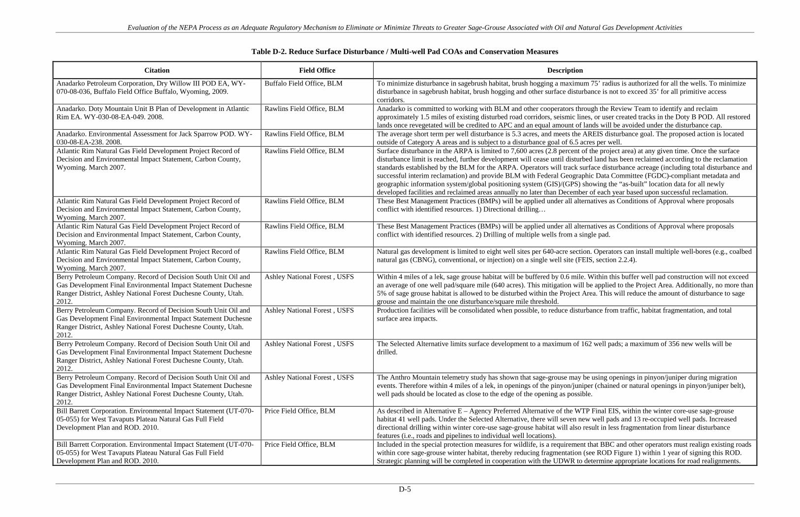
Evaluation of the NEPA Process as an Adequate Regulatory Mechanism to Eliminate or Minimize Threats to Greater Sage-Grouse Associated with Oil and Natural Gas Development Activities
D-5
Table D-2. Reduce Surface Disturbance / Multi-well Pad COAs and Conservation Measures
Citation Field Office Description
Anadarko Petroleum Corporation, Dry Willow III POD EA, WY-070-08-036, Buffalo Field Office Buffalo, Wyoming, 2009.
Buffalo Field Office, BLM To minimize disturbance in sagebrush habitat, brush hogging a maximum 75’ radius is authorized for all the wells. To minimize disturbance in sagebrush habitat, brush hogging and other surface disturbance is not to exceed 35’ for all primitive access corridors.
Anadarko. Doty Mountain Unit B Plan of Development in Atlantic Rim EA. WY-030-08-EA-049. 2008.
Rawlins Field Office, BLM Anadarko is committed to working with BLM and other cooperators through the Review Team to identify and reclaim approximately 1.5 miles of existing disturbed road corridors, seismic lines, or user created tracks in the Doty B POD. All restored lands once revegetated will be credited to APC and an equal amount of lands will be avoided under the disturbance cap.
Anadarko. Environmental Assessment for Jack Sparrow POD. WY-030-08-EA-238. 2008.
Rawlins Field Office, BLM The average short term per well disturbance is 5.3 acres, and meets the AREIS disturbance goal. The proposed action is located outside of Category A areas and is subject to a disturbance goal of 6.5 acres per well.
Atlantic Rim Natural Gas Field Development Project Record of Decision and Environmental Impact Statement, Carbon County, Wyoming. March 2007.
Rawlins Field Office, BLM Surface disturbance in the ARPA is limited to 7,600 acres (2.8 percent of the project area) at any given time. Once the surface disturbance limit is reached, further development will cease until disturbed land has been reclaimed according to the reclamation standards established by the BLM for the ARPA. Operators will track surface disturbance acreage (including total disturbance and successful interim reclamation) and provide BLM with Federal Geographic Data Committee (FGDC)-compliant metadata and geographic information system/global positioning system (GIS)/(GPS) showing the “as-built” location data for all newly developed facilities and reclaimed areas annually no later than December of each year based upon successful reclamation.
Atlantic Rim Natural Gas Field Development Project Record of Decision and Environmental Impact Statement, Carbon County, Wyoming. March 2007.
Rawlins Field Office, BLM These Best Management Practices (BMPs) will be applied under all alternatives as Conditions of Approval where proposals conflict with identified resources. 1) Directional drilling…
Atlantic Rim Natural Gas Field Development Project Record of Decision and Environmental Impact Statement, Carbon County, Wyoming. March 2007.
Rawlins Field Office, BLM These Best Management Practices (BMPs) will be applied under all alternatives as Conditions of Approval where proposals conflict with identified resources. 2) Drilling of multiple wells from a single pad.
Atlantic Rim Natural Gas Field Development Project Record of Decision and Environmental Impact Statement, Carbon County, Wyoming. March 2007.
Rawlins Field Office, BLM Natural gas development is limited to eight well sites per 640-acre section. Operators can install multiple well-bores (e.g., coalbed natural gas (CBNG), conventional, or injection) on a single well site (FEIS, section 2.2.4).
Berry Petroleum Company. Record of Decision South Unit Oil and Gas Development Final Environmental Impact Statement Duchesne Ranger District, Ashley National Forest Duchesne County, Utah. 2012.
Ashley National Forest , USFS Within 4 miles of a lek, sage grouse habitat will be buffered by 0.6 mile. Within this buffer well pad construction will not exceed an average of one well pad/square mile (640 acres). This mitigation will be applied to the Project Area. Additionally, no more than 5% of sage grouse habitat is allowed to be disturbed within the Project Area. This will reduce the amount of disturbance to sage grouse and maintain the one disturbance/square mile threshold.
Berry Petroleum Company. Record of Decision South Unit Oil and Gas Development Final Environmental Impact Statement Duchesne Ranger District, Ashley National Forest Duchesne County, Utah. 2012.
Ashley National Forest , USFS Production facilities will be consolidated when possible, to reduce disturbance from traffic, habitat fragmentation, and total surface area impacts.
Berry Petroleum Company. Record of Decision South Unit Oil and Gas Development Final Environmental Impact Statement Duchesne Ranger District, Ashley National Forest Duchesne County, Utah. 2012.
Ashley National Forest , USFS The Selected Alternative limits surface development to a maximum of 162 well pads; a maximum of 356 new wells will be drilled.
Berry Petroleum Company. Record of Decision South Unit Oil and Gas Development Final Environmental Impact Statement Duchesne Ranger District, Ashley National Forest Duchesne County, Utah. 2012.
Ashley National Forest , USFS The Anthro Mountain telemetry study has shown that sage-grouse may be using openings in pinyon/juniper during migration events. Therefore within 4 miles of a lek, in openings of the pinyon/juniper (chained or natural openings in pinyon/juniper belt), well pads should be located as close to the edge of the opening as possible.
Bill Barrett Corporation. Environmental Impact Statement (UT-070-05-055) for West Tavaputs Plateau Natural Gas Full Field Development Plan and ROD. 2010.
Price Field Office, BLM As described in Alternative E – Agency Preferred Alternative of the WTP Final EIS, within the winter core-use sage-grouse habitat 41 well pads. Under the Selected Alternative, there will seven new well pads and 13 re-occupied well pads. Increased directional drilling within winter core-use sage-grouse habitat will also result in less fragmentation from linear disturbance features (i.e., roads and pipelines to individual well locations).
Bill Barrett Corporation. Environmental Impact Statement (UT-070-05-055) for West Tavaputs Plateau Natural Gas Full Field Development Plan and ROD. 2010.
Price Field Office, BLM Included in the special protection measures for wildlife, is a requirement that BBC and other operators must realign existing roads within core sage-grouse winter habitat, thereby reducing fragmentation (see ROD Figure 1) within 1 year of signing this ROD. Strategic planning will be completed in cooperation with the UDWR to determine appropriate locations for road realignments.

Evaluation of the NEPA Process as an Adequate Regulatory Mechanism to Eliminate or Minimize Threats to Greater Sage-Grouse Associated with Oil and Natural Gas Development Activities
D-6
Citation Field Office Description
Bill Barrett Corporation. Environmental Impact Statement (UT-070-05-055) for West Tavaputs Plateau Natural Gas Full Field Development Plan and ROD. 2010.
Price Field Office, BLM 626 wells and 120 well pads (63 new pads and 57 re-occupied).
BLM Montana. Record of Decision for the Final Statewide Oil and Gas Environmental Impact Statement and Proposed Amendment of the Powder River and Billings Resource Management Plans. 2003.
Billings Field Office, BLM Miles City Field Office, BLM
Develop offsite mitigation strategies in situations where fragmentation or degradation of Special Status Species habitat is unavoidable.
Chevron. Table Rock Unit Oil and Gas Development EA and DR. WY-040-EA11-175. January 2012.
Rawlins Field Office, BLM Rock Springs Field Office, BLM
Chevron proposes to minimize surface disturbance by utilizing existing well pads by co-locating new wells with existing wells or by establishing multi-well pads throughout the project area to the greatest extent possible.
Devon Energy Production Company, L.P., Golden Eagle- Juniper Draw CBNG Field POD EA, WY-070-EA07-111, Buffalo Field Office Buffalo, Wyoming, 2008.
Buffalo Field Office, BLM Due to sagebrush habitat and reclamation concerns mowing for the access/utility corridor will not exceed 15 feet in width.
Double Eagle Petroleum. Catalina PODs E and F in the Atlantic Rim. DOI-BLM-WY-030-2009-0155-EA. 2011.
Rawlins Field Office, BLM The construction of Catalina POD G&I wells in combination with other approved or existing wells within the analysis area would result in 3.32 wells per square mile.
Elk Petroleum. Environmental Assessment for the Grieve Unit CO2 Enhanced Recovery Project. Natrona County, Wyoming. WY-050-EA11-108. Approved 7/26/12 by BLM Lander Field Office.
Lander Field Office, BLM The Wyoming Sage-grouse Core Area concept (WGFD 2011a) and the Wyoming BLM Instructional Memorandum for Greater Sage-grouse Habitat Management Policy (WY-2012-019) provides habitat protection to leks within the identified Core Areas and increased mitigation flexibility relative to non-Core Area leks and associated seasonal habitats. This BLM IM generally mirrors, and expands on, the protections provided by the Wyoming Core Area concept. The Lander Field Office GIS staff ran the required project specific Density Disturbance Calculation Tool (DDCT, WGFD 2012) exercise. As discussed above, the DDCT analysis demonstrates that the existing density of oil and gas wells and the disturbance of habitat from the existing and proposed projects are within the limits provided in the DDCT and BLM IM WY-2102-019 and will not cause declines in Greater Sage-Grouse populations.
Elk Petroleum. Environmental Assessment for the Grieve Unit CO2 Enhanced Recovery Project. Natrona County, Wyoming. WY-050-EA11-108. Approved 7/26/12 by BLM Lander Field Office.
Lander Field Office, BLM One centralized production, separation and CO2 re-pressurization facility is anticipated. This will be constructed at the site of the existing Grieve Unit central facility in an effort to minimize surface disturbance.
Elk Petroleum. Environmental Assessment for the Grieve Unit CO2 Enhanced Recovery Project. Natrona County, Wyoming. WY-050-EA11-108. Approved 7/26/12 by BLM Lander Field Office.
Lander Field Office, BLM Multi-well pads will be prepared by clearing an area approximately 325 feet by 200 feet; an average pad disturbance is estimated at 3.3 acres, including cut-and-fill, per pad. Single well pads will measure 325 X 175 feet, resulting in approximately 3.0 acres per site.
EnCana Oil and Gas. 16 APDs on existing well pad P28-496. DOI-BLM-CO-110-2011-0153-CX. Approved 9/6/11 by White River Field Office.
White River Field Office, BLM The proposal includes drilling 16 additional wells on the existing P28 496 well pad (for a total of 32 wells). No additional acreage is required to expand the existing well pad.
EnCana Oil and Gas. 16 gas wells on existing well pad (N22 496). DOI-BLM-CO-110-2012-0004-CX. Approved 12/8/11 by White River Field Office.
White River Field Office, BLM The proposal includes drilling 16 additional wells on the existing SG N22 496 well pad (for a total of 32 wells). No additional acreage is required to expand the existing well pad.
EnCana Oil and Gas. 28 APDs on new well pad D36 496. DOI-BLM-CO-110-2011-0169-EA. Approved 9/23/11 by the White River Field Office.
White River Field Office, BLM 28 wells on one new well pad. The well pad is proposed to have working surface dimensions of 778 feet long by 302 feet wide for total well pad surface disturbance of 9.7 acres. Following interim reclamation 2.2 acres will be needed for production.
EnCana Oil and Gas. APDs- N22-496 (16)& P28-496 (16). DOI-BLM-CO-110-2011-0006-EA. White River Field Office. Approved 5/24/11 by White River Field Office.
White River Field Office, BLM 2 new well pads (20.4 acres initial disturbance total) with 16 wells each. An EnCana initiative, and one endorsed by CDOW and WRFO, the development designs for multi-well pads and centralized production facilities in the valley bottoms were undertaken specifically as a means to avoid habitat and behavioral impacts to sage-grouse.
EnCana Oil and Gas. Master Development Plan (MDP) for the SG E34 496, SG L27 796 and SG F22 496. DOI-BLM-CO-110-2013-0035-EA. Approved 6/7/13 by the White River Field Office.
White River Field Office, BLM The applicant is using modern fracing and drilling technologies that reduce surface density of development features.
EnCana Oil and Gas. Master Development Plan (MDP) for the SG E34 496, SG L27 796 and SG F22 496. DOI-BLM-CO-110-2013-0035-EA. Approved 6/7/13 by the White River Field Office.
White River Field Office, BLM The applicant volunteered to a wholesale redesign of original drilling patterns that used existing pads (E34/L27) or pads in non-habitat (F22) that allowed for retention of the largest remaining parcel of sagebrush habitat in the immediate project area and eliminated the need to develop additional pad locations on two adjacent, occupied ridgelines (including Barnes Ridge itself); the applicant's development redesign confined the behavioral influences of human activity to areas of pre-existing disturbance and dramatically reduced the need for initiating surface disturbance in largely undisturbed suitable and occupied habitat.

Evaluation of the NEPA Process as an Adequate Regulatory Mechanism to Eliminate or Minimize Threats to Greater Sage-Grouse Associated with Oil and Natural Gas Development Activities
D-7
Citation Field Office Description
EnCana Oil and Gas. Master Development Plan (MDP) for the SG E34 496, SG L27 796 and SG F22 496. DOI-BLM-CO-110-2013-0035-EA. Approved 6/7/13 by the White River Field Office.
White River Field Office, BLM The operator's development designs for multi-well pads and centralized production facilities were undertaken specifically as a means to reduce habitat loss and the scope of behavioral impacts imposed on sage-grouse. This development plant was formulated in part from a series of prior discussions and on-sites and its implementation was endorsed by CPW and WRFO staff.
EnCana Oil and Gas. L24 496 New Well Pad - 28 APDs. DOI-BLM-CO-110-2012-0021-DNA. Approved 3/20/12 by White River Field Office.
White River Field Office, BLM 16 to 28 wells on one well pad that is 8.7 acres
EnCana Oil and Gas. Story Gulch Well Pads (2). DOI-BLM-CO-110-2009-0229-EA. Approved 2/3/10 by White River Field Office.
White River Field Office, BLM 16 additional wells on 2 existing well pads each
EnCana. Environmental Assessment of the Orchard Master Development Plan for Oil and Gas Development. GJFO # DOI-BLM-CO-130-2009-0001-EA and GSFO # DOI-BLM-CO-140-2008-0032-EA. Grand Junction Field Office and Glenwood Springs Energy Office, October 2008.
Grand Junction Field Office Up to 93 new wells from up to 24 new well pads and one existing well pad.
Environmental Assessment for East Converse Exploratory Oil and Gas Development Project. WY-060-EA12-227. Approved 11/20/12 by BLM Casper Field Office.
Casper Field Office, BLM 18 well pads with a range of 18 to 72 wells, assuming one to four wells per well pad/location. Average disturbance per well (assuming one to four wells per pad/ location) would be a range of 4.21 to 1.05 acres, respectively.
Environmental Assessment for East Converse Exploratory Oil and Gas Development Project. WY-060-EA12-227. Approved 11/20/12 by BLM Casper Field Office.
Casper Field Office, BLM If an APD were submitted within the north Glenrock Thunderbasin core area, a density disturbance calculation tool (DDCT) would be prepared and submitted to the WGFD for review, in compliance with BLM Wyoming Instruction Memorandum (WY-IM-2012-019).
Environmental Assessment for Highland Loop Road Exploratory Oil and Gas Development Project. WY-060-EA12-226. Approved 11/20/12 by BLM Casper Field Office.
Casper Field Office, BLM 37 well pads with a range of 37 to 148 wells, assuming 1 to 4 wells per pad/location. Average disturbance per well pad/location (assuming 1 to 4 wells per well pad/location) is 4.21 acres.
Environmental Assessment for Spearhead Ranch Exploratory Oil and Gas Development Project. Y-060-EA12-225. Approved 11/20/12 by BLM Casper Field Office.
Casper Field Office, BLM 56 well pads/ locations with a range of 56 to 224 wells, assuming one to four wells per well pad/location. Average disturbance per well (assuming one to four wells per well pad/location) is a range of 4.21 - 1.05 acres.
Environmental Assessment for Spearhead Ranch Exploratory Oil and Gas Development Project. Y-060-EA12-225. Approved 11/20/12 by BLM Casper Field Office.
Casper Field Office, BLM If an APD is submitted within the North Glenrock Core Area, a density disturbance calculation tool (DDCT) will be prepared and submitted to the Wyoming Game and Fish Department for review, for compliance with BLM Wyoming Instruction Memorandum (WY-IM-2012-019).
EOG Resources, Inc. Ballista Flatbow Multi-Well Pad Project, supported by Environmental Assessment (EA), WY-070-EA13-15, Buffalo Field Office. 2013.
Buffalo Field Office, BLM Reduce the number of well pads required in a section by drilling multi-lateral, multi-formation wells from a single well pad. Project proposed 40 wells on 13 pads, with 2 to 4 wells per pad.
Exxon. North Hatch Gulch Project Environmental Assessment, DOI-BLM-CO-110-2010-0200-EA, 2012.
White River Field Office, BLM 120 natural gas wells on 6 well pads resulting in an initial 192.5 acres of surface disturbance including pipelines and roads.
Exxon. Piceance Development Project EA, Finding of No Significant Impact and Decision Record, CO-110-2005-219-EA, 2007.
White River Field Office, BLM up to 1,080 wells—as many as 120 well pads with up to nine well bores each
Fidelity Exploration and Production Company. Tongue River - Coal Creek Project Plan of Development. MT-020-2004-297. Decision Record and Finding of No significant Impact, 2005.
Miles City Field Office, BLM There are several sage grouse and sharp-tail leks within the project area boundary; however, the project has been designed to avoid the leks with surfacing disturbing activities. In addition, the entire POD is considered grouse nesting habitat.
Fidelity Exploration and Production Company. Tongue River - Corral Creek, Plan of Development, Environmental Assessment, Montana Board of Oil and Gas Conservation. 2008.
Miles City Field Office, BLM Wells, roads, and batteries will be located to avoid disturbing sage grouse, sharp-tailed grouse, and mountain plover nesting sites in the project.
Fidelity Exploration and Production Company. Tongue River - Badger Hills Project Plan of Development EA, Decision Record and Finding of No Significant Impact. 2004.
Miles City Field Office, BLM up to 85 federal coal bed natural gas wells on 18 locations and one linear right-of-way for buried flowlines and power line
Fidelity Exploration and Production Company. Tongue River - Coal Creek Project Plan of Development. MT-020-2004-297. Decision Record and Finding of No significant Impact, 2005.
Miles City Field Office, BLM up to 132 federal coal bed natural gas wells on 27 well sites

Evaluation of the NEPA Process as an Adequate Regulatory Mechanism to Eliminate or Minimize Threats to Greater Sage-Grouse Associated with Oil and Natural Gas Development Activities
D-8
Citation Field Office Description
Gasco Energy Inc. Uinta Basin Natural Gas Development Project, Environmental Impact Statement FES 12-5, Record of Decision, Bureau of Land Management Vernal Field Office, June 2012.
Vernal Field Office, BLM Proposal for up to 1,298 new gas production wells from up to 575 pads.
Gasco Energy Inc. Uinta Basin Natural Gas Development Project, Environmental Impact Statement FES 12-5, Record of Decision, Bureau of Land Management Vernal Field Office, June 2012.
Vernal Field Office, BLM No surface disturbance will be permitted in riparian or wetland areas.
Gasco Energy Inc. Uinta Basin Natural Gas Development Project, Environmental Impact Statement FES 12-5, Record of Decision, Bureau of Land Management Vernal Field Office, June 2012.
Vernal Field Office, BLM Well pad surface density will be no more than one pad per approximately 160 acres.
Greencore Pipeline Company. Environmental Assessment. Bureau of Land Management. EA No. WY-060-EA11-32. January 2011.
Buffalo Field Office, BLM Casper Field Office, BLM Lander Field Office, BLM Miles City Field Office, BLM
Maximum Allowed Disturbance in Greater Sage-grouse Habitat is 5%, but projected cumulative disturbance within Core Areas is 2.66%. Meets WY IM 2010-012 Requirements.
Jonah Infill Drilling Project Environmental Impact Statement and Record of Decision, Sublette County, Wyoming. 2006.
Pinedale Field Office, BLM Rock Springs Field Office, BLM
Operators would avoid optimal greater sage-grouse nesting habitats, where practical. Optimal nesting habitat is defined as areas with sagebrush heights of 20–31 inches and cover of 15–25% and an understory (grasses and forbs) cover of >15%.
Jonah Infill Drilling Project Environmental Impact Statement and Record of Decision, Sublette County, Wyoming. 2006.
Pinedale Field Office, BLM Rock Springs Field Office, BLM
Operators would utilize directional drilling to access resources beneath the 0.25-mile active greater sage-grouse lek buffers if reserves beneath these locations are deemed economic. Operators would utilize directional drilling to access resources beneath the 600-foot wide (or tall sagebrush-dominated) buffer associated with the Sand Draw protection areas if deemed economic.
Kerr-McGee Oil & Gas Onshore LP (KMG), Greater Natural Buttes EIS UT-080-07-807, BLM Vernal Field Office, Record of Decision, May 2012.
Vernal Field Office, BLM Of the 3,675 new wellbores, approximately 1,484 will be vertically drilled on new well pads and approximately 634 Mesaverde-only completions will be drilled as deepened recompletions or twinned wells on existing well pads. The remaining 1,557 wellbores will be directionally drilled from new and existing well pads.
Kerr-McGee Oil & Gas Onshore LP (KMG), Greater Natural Buttes EIS UT-080-07-807, BLM Vernal Field Office, Record of Decision, May 2012.
Vernal Field Office, BLM The Selected Alternative was designed to utilize directional drilling within the GNBPA to reduce surface impacts relative to the Proposed Action to a maximum of 1 pad per 40 acres (maximum of 16 well pads per section).
Kerr-McGee Oil & Gas Onshore LP (KMG), Greater Natural Buttes EIS UT-080-07-807, BLM Vernal Field Office, Record of Decision, May 2012.
Vernal Field Office, BLM As directed by the AO, mats will be used during drilling and other development activities to reduce disturbance impacts to underlying soils.
Kerr-McGee Oil & Gas Onshore LP (KMG), Greater Natural Buttes EIS UT-080-07-807, BLM Vernal Field Office, Record of Decision, May 2012.
Vernal Field Office, BLM KMG will utilize shared well pads to the extent possible, in consideration of technical, environmental, and economic viability, to minimize the amount of total surface disturbance in the Greater Natural Buttes Project Area (GNBPA). Each new produced water disposal well will be located on existing production locations. KMG will evaluate deepening existing wells to accomplish Mesaverde-only completions before twinning an existing well. KMG will strive to continually improve the development processes in order in minimize the surface impact where practical. KMG will carefully evaluate drilling multiple wells from a single pad on an ongoing basis and has included the potential to use multiple wells from a shared pad in the GNBPA to the extent that KMG determines technically and economically viable.
Kerr-McGee Oil & Gas Onshore LP (KMG), Greater Natural Buttes EIS UT-080-07-807, BLM Vernal Field Office, Record of Decision, May 2012.
Vernal Field Office, BLM Mats will be utilized where feasible, instead of traditional pad construction, to minimize the disturbance to greater sage-grouse habitat.
Kerr-McGee Oil & Gas Onshore LP (KMG), Greater Natural Buttes EIS UT-080-07-807, BLM Vernal Field Office, Record of Decision, May 2012.
Vernal Field Office, BLM Prior to siting new well pads or locating new access roads between 0.5 and 2.0 miles of a greater sage-grouse lek, habitat mapping (using available soils and vegetation data, 2009 National Agriculture Imagery Program imagery, and field verification) to determine areas of suitable greater sage-grouse habitat will be conducted with coordination between KMG, the BLM, and the Utah Division of Wildlife Resources. Once these data are available, they will be used to identify non-greater sage-grouse habitat, or the lowest quality greater sage-grouse habitat, to determine a surface development pattern that may be least impacting to greater sage-grouse and may allow a viable population of greater sage-grouse to continue to persist in the East Bench area until total reclamation has been achieved.

Evaluation of the NEPA Process as an Adequate Regulatory Mechanism to Eliminate or Minimize Threats to Greater Sage-Grouse Associated with Oil and Natural Gas Development Activities
D-9
Citation Field Office Description
Lance Oil and Gas Company. Coal Gulch Unit Gamma POD Categorical Exclusion WY-070-390CX3-11-64 through WY070-390CX3-11-128 Bureau of Land Management Buffalo Field Office, 2010.
Buffalo Field Office, BLM LOG proposed slot location where safe and feasible to reduce acres of disturbance
Lance Oil and Gas Company. Coal Gulch Unit Gamma POD Categorical Exclusion WY-070-390CX3-11-64 through WY070-390CX3-11-128 Bureau of Land Management Buffalo Field Office, 2010.
Buffalo Field Office, BLM Most of the proposed wells are located near or within existing roads to reduce fragmentation to sage brush patch size
Powder River Basin Oil and Gas Project, Record of Decision and Resource Management Plan Amendments. EIS WY–070–02–065. April 2003.
Buffalo Field Office, BLM The Companies will locate impoundments to avoid sagebrush shrublands, where practical.
Powder River Basin Oil and Gas Project, Record of Decision and Resource Management Plan Amendments. EIS WY–070–02–065. April 2003.
Buffalo Field Office, BLM The Companies will locate impoundments to avoid sagebrush shrublands, where practical.
Powder River Basin Oil and Gas Project, Record of Decision and Resource Management Plan Amendments. EIS WY–070–02–065. April 2003.
Buffalo Field Office, BLM The operator will limit vegetation removal and the degree of surface disturbance wherever possible. Where surface disturbance cannot be avoided, all practicable measures will be utilized to minimize erosion and stabilize disturbed soils.
QEP. Drilling of 180 Wells and Constructing or Expanding 6 Pads. WY-100-EA13-72. Approved by BLM Pinedale July 2013.
Pinedale Field Office, BLM 24-40 wells per pad with proposed extension of existing pads.
QEP. APD and COAs for QEP Stewart Point 14-32 pad. 2013. Pinedale Field Office, BLM 20 wells on one pad QEP. APD with COAs for QEP Mesa 15-9 pad. 2012. Pinedale Field Office, BLM 13 wells on one pad QEP. Greater Deadman Bench Oil and Gas Producing Region EIS and ROD March 2008. UT 080-2003-0369V. BLM Vernal Field Office. 2008.
Vernal Field Office, BLM QEP has committed to twin 216 wells and directionally drill 132 wells on/from other well pads.
Record of Decision, Final Supplemental Environmental Impact Statement for the Pinedale Anticline Oil and Gas Exploration and Development Project, Sublette County, Wyoming. 2008.
Pinedale Field Office, BLM 4,399 wells from no more than 600 well pads
Record of Decision, Final Supplemental Environmental Impact Statement for the Pinedale Anticline Oil and Gas Exploration and Development Project, Sublette County, Wyoming. 2008.
Pinedale Field Office, BLM In development area MA-5 A maximum of two well pads per section will be allowed. A maximum of 40 acres of surface disturbance per section will be allowed (6.25% disturbance). Similar protections to sage-grouse core area.
Record of Decision, Final Supplemental Environmental Impact Statement for the Pinedale Anticline Oil and Gas Exploration and Development Project, Sublette County, Wyoming. 2008.
Pinedale Field Office, BLM In development area MA-6 A maximum of one well pad per section will be allowed. A maximum of 40 acres of surface disturbance per section will be allowed. Similar to protection afforded by core areas.
Record of Decision, Final Supplemental Environmental Impact Statement for the Pinedale Anticline Oil and Gas Exploration and Development Project, Sublette County, Wyoming. 2008.
Pinedale Field Office, BLM Development of 37,019 acres within 2 miles of greater sage-grouse leks was suspended for 5 years. After the 5-year period, an individual lease or Multiple leases under federal suspension and/or term NSO will be considered for conversion to “available for development” when a comparable acreage in the core area (not needed for production operations) has been returned to functioning habitat through the completion of all development operations and successful reclamation of all portions of the well pads within the comparable area.
Record of Decision, Final Supplemental Environmental Impact Statement for the Pinedale Anticline Oil and Gas Exploration and Development Project, Sublette County, Wyoming. 2008.
Pinedale Field Office, BLM The entire PAPA will be developed with no more than 600 well pads on all lands in the PAPA. Throughout the PAPA no more than one well pad per quarter section (160 acres) is authorized, per Operator. Where existing development already exceeds this limit, no additional pads will be authorized.
Samson Resources Company. Environmental Assessment for the Scott Field Development Project. WY-060-EA13-067. Approved 9/9/13 by the BLM Casper Field Office.
Casper Field Office, BLM 40 well pads with 2 to 6 wells and a maximum of 150 wells. The average per well disturbance would initially be 4.6 acres, including roads and pipelines, assuming 150 wells are drilled.
Samson Resources Company. Environmental Assessment for the Scott Field Development Project. WY-060-EA13-067. Approved 9/9/13 by the BLM Casper Field Office.
Casper Field Office, BLM In order to protect potential greater sage-grouse habitat, disturbance in sagebrush vegetation types will be minimized.

Evaluation of the NEPA Process as an Adequate Regulatory Mechanism to Eliminate or Minimize Threats to Greater Sage-Grouse Associated with Oil and Natural Gas Development Activities
D-10
Citation Field Office Description
Summit Gas Resources, Inc. Cabin Creek VII Federal POD WY-070-EA12-183, Buffalo Field Office, 2012.
Buffalo Field Office, BLM During onsite visits, the SGR and BLM adjusted the location of 9 wells and one section of overhead power lines to reduce direct loss and fragmentation of sage-grouse habitat
Williams Production RMT Company, Cedar Draw Unit 2 POD, EA WY-070-07-137, Buffalo Field Office Buffalo, Wyoming, 2010.
Buffalo Field Office, BLM Due to dense sagebrush habitat at the 41-22 and 42-28 locations, the working area around the well site will be mowed no greater than 120 x 180 feet.
XTO Energy. River Bend Unit Infill Development Environmental Assessment and Biological Assessment, UT-080-07-772, January 2013.
Vernal Field Office, BLM 484 additional wells, of which, 410 would be directionally drilled from new and existing well pads
Yates Petroleum Corporation. All Day POD. EA # WY-070-08-026 and COAs. Buffalo Field Office Buffalo, Wyoming, 2008.
Buffalo Field Office, BLM At the onsite BLM required minimization of disturbance corridors through sagebrush. Brush hogging/mowing will be limited to a 35' radius around wells and 30' width on the access roads and corridors
Yates Petroleum Corporation. All Day POD. EA # WY-070-08-026 and COAs. Buffalo Field Office Buffalo, Wyoming, 2008.
Buffalo Field Office, BLM The operator will limit vegetation removal and the degree of surface disturbance wherever possible. Where surface disturbance cannot be avoided, all practicable measures will be utilized to minimize erosion and stabilize disturbed soils.
Yates Petroleum Corporation. Lazurite POD Environmental Assessment WY-070-EA09-095, 2009.
Buffalo Field Office, BLM The selected alternative incorporates components of the Wyoming Governor's Sage Grouse Implementation Team’s “core population area” strategy and executive order and local research to provide appropriate protections for sage-grouse, while meeting the purpose and need for the Lazurite Project.

Evaluation of the NEPA Process as an Adequate Regulatory Mechanism to Eliminate or Minimize Threats to Greater Sage-Grouse Associated with Oil and Natural Gas Development Activities
APPENDIX E
Dust Suppression

Evaluation of the NEPA Process as an Adequate Regulatory Mechanism to Eliminate or Minimize Threats to Greater Sage-Grouse Associated with Oil and Natural Gas Development Activities
E-1
Table E-1. PECE Policy Evaluation – Dust Suppression
Conservation Measure Dust Suppression
Certainty of Implementation The conservation effort, the party(ies) to the agreement or plan that will implement the effort, and the staffing, funding level, funding source, and other resources necessary to implement the effort are identified.
The BLM/USFS decision records require implementation as a condition of the agency authorization. Funding and implementation is generally identified as the responsibility of the operator(s).
The legal authority of the party(ies) to the agreement or plan to implement the formalized conservation effort, and the commitment to proceed with the conservation effort are described.
NEPA provides the legal and statutory authority to implement the conservation measures and COAs included in the agency decision records.
The legal procedural requirements (e.g. environmental review) necessary to implement the effort are described, and information is provided indicating that fulfillment of these requirements does not preclude commitment to the effort.
NEPA is the legal procedural requirement necessary to implement COAs and conservation measures included in the agency decision records.
Authorizations (e.g., permits, landowner permission) necessary to implement the conservation effort are identified, and a high level of certainty is provided that the party(ies) to the agreement or plan that will implement the effort will obtain these authorizations.
The NEPA decision record provides the necessary authorization to implement the COAs and conservation measures. As the measures are conditions of the agency approval and are required for project completion, there is a high level of certainty that they will be implemented and authorized.
The type and level of voluntary participation (e.g., number of landowners allowing entry to their land, or number of participants agreeing to change timber management practices and acreage involved) necessary to implement the conservation effort is identified, and a high level of certainty is provided that the party(ies) to the agreement or plan that will implement the conservation effort will obtain that level of voluntary participation (e.g., an explanation of how incentives to be provided will result in the necessary level of voluntary participation).
Participation in the implementation of the COAs and conservation measures is mandatory as a condition of the agency approval under NEPA. NEPA authorizations exceed this evaluation criteria by making the measures mandatory.
Regulatory mechanisms (e.g., laws, regulations, ordinances) necessary to implement the conservation effort are in place.
NEPA provides the regulatory mechanism for implementation. Where necessary, other federal or state authorizations or permits might be required prior to implementation (i.e., Clean Water Act permits). There is reasonable certainty that these permits will be obtained for each measure or COA.
A high level of certainty is provided that the party(ies) to the agreement or plan that will implement the conservation effort will obtain the necessary funding.
The agency decision requires that funding for the COAs and conservation measures be provided as a condition of the project approval. There is certainty that each measure will be funded.

Evaluation of the NEPA Process as an Adequate Regulatory Mechanism to Eliminate or Minimize Threats to Greater Sage-Grouse Associated with Oil and Natural Gas Development Activities
E-2
Conservation Measure Dust Suppression
An implementation schedule (including incremental completion dates) for the conservation effort is provided.
Each NEPA document and associated decision record analyzes and describes the schedule for project implementation. As conditions of agency approvals, COAs and conservation measures must be completed during or prior to project completion.
The conservation agreement or plan that includes the conservation effort is approved by all parties to the agreement or plan.
As a condition of the agency approval of each project, there is agreement between the operators and the agency that each COA or conservation measure will be implemented as part of project activities.
Certainty of Effectiveness The nature and extent of threats being addressed by the conservation effort are described, and how the conservation effort reduces the threats is described.
Dust suppression COAs and conservation measures address threats associated with Energy Development under Listing Factor A.
Explicit incremental objectives for the conservation effort and dates for achieving them are stated.
Dust suppression is tracked as part of air quality monitoring efforts for each project.
The steps necessary to implement the conservation effort are identified in detail.
NEPA documents identify steps to take to reduce or eliminate fugitive dust emissions.
Quantifiable, scientifically valid parameters that will demonstrate achievement of objectives, and standards for these parameters by which progress will be measured, are identified.
State and federal standards for dust emissions are generally present and enforced and can be reliably measured.
Provisions for monitoring and reporting progress on implementation (based on compliance with the implementation schedule) and effectiveness (based on evaluation of quantifiable parameters) of the conservation effort are provided.
Monitoring and adaptive management practices discussed in detail in the report provide examples of additional monitoring and reporting provisions.
Principles of adaptive management are incorporated. Monitoring and adaptive management practices discussed in detail in the report provide examples of additional monitoring and reporting provisions.
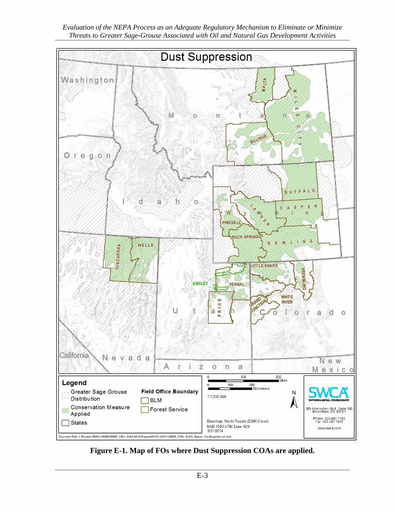
Evaluation of the NEPA Process as an Adequate Regulatory Mechanism to Eliminate or Minimize Threats to Greater Sage-Grouse Associated with Oil and Natural Gas Development Activities
E-3
Figure E-1. Map of FOs where Dust Suppression COAs are applied.

Evaluation of the NEPA Process as an Adequate Regulatory Mechanism to Eliminate or Minimize Threats to Greater Sage-Grouse Associated with Oil and Natural Gas Development Activities
E-4
Table M-2. Dust Suppression COAs and Conservation Measures
Citation Field Office Description
Atlantic Rim Natural Gas Field Development Project Record of Decision and Environmental Impact Statement, Carbon County, Wyoming. March 2007.
Rawlins Field Office, BLM Operators may use water for dust abatement on a case-by-case basis. The water should meet state standards for this use and be permitted by the state of Wyoming.
Berry Petroleum Company. Record of Decision South Unit Oil and Gas Development Final Environmental Impact Statement Duchesne Ranger District, Ashley National Forest Duchesne County, Utah. 2012.
Ashley National Forest , USFS Reduce fugitive dust from roads by observing speed limits and applying water as needed.
Bill Barrett Corporation. Environmental Impact Statement (UT-070-05-055) for West Tavaputs Plateau Natural Gas Full Field Development Plan and ROD. 2010.
Price Field Office, BLM As part of the monitoring plan, a third-party contractor will collect dust samples to determine if dust, generated by industrial traffic, is still being deposited on sites. If the BLM determines that dust is continuing to accumulate on sites, the BLM will mitigate the impacts
BLM Montana. Record of Decision for the Final Statewide Oil and Gas Environmental Impact Statement and Proposed Amendment of the Powder River and Billings Resource Management Plans. 2003.
Billings Field Office, BLM Miles City Field Office, BLM
Operators on federal leases will be required to post and enforce speed limits to reduce fugitive dust emissions. Dust inhibitors will be used as necessary on unpaved collector, local and resource roads to reduce fugitive dust emissions to the air and resources adjacent to the road.
Chevron. Table Rock Unit Oil and Gas Development EA and DR. WY-040-EA11-175. January 2012.
Rawlins Field Office, BLM Rock Springs Field Office, BLM
Other environmental protection measures required by the BLM include the following: Dust abatement to minimize potential adverse effects from increased road use.
Elk Petroleum. Environmental Assessment for the Grieve Unit CO2 Enhanced Recovery Project. Natrona County, Wyoming. WY-050-EA11-108. Approved 7/26/12 by BLM Lander Field Office.
Lander Field Office, BLM The production of dust will be significantly reduced through accepted dust abatement techniques. Techniques include, but are not limited to, the seeding of all disturbed areas that are not utilized during the well production phase (i.e. borrow ditches and topsoil and spoil piles) and the application of water to roadways during dry periods.
EnCana Oil and Gas. 28 APDs on new well pad D36 496. DOI-BLM-CO-110-2011-0169-EA. Approved 9/23/11 by the White River Field Office.
White River Field Office, BLM Dust will be controlled on the roads and locations during construction and drilling by periodic watering of the roads and locations.
EnCana Oil and Gas. Master Development Plan for the SG E34 496, SG L796 and SG F22 496, Environmental Assessment and Decision Record, DOI-BLM-CO-2013-0035-EA, 2013.
White River Field Office, BLM EnCana will treat all access roads with water and/or a chemical dust suppressant during construction and drilling activities so that there is not a visible dust trail behind vehicles. Any technique other than the use of freshwater as a dust suppressant on BLM lands will require prior written approval from BLM.
EnCana. Environmental Assessment of the Orchard Master Development Plan for Oil and Gas Development. GJFO # DOI-BLM-CO-130-2009-0001-EA and GSFO # DOI-BLM-CO-140-2008-0032-EA. Grand Junction Field Office and Glenwood Springs Energy Office, October 2008.
Grand Junction Field Office, BLM The operator shall implement dust abatement measures as needed to prevent fugitive dust from vehicular traffic, equipment operations, or wind events.
EnCana Oil and Gas. Pappy Draw Exploratory Coal-bed Natural Gas Pilot Project Environmental Assessment. WY-050-EA08-88. Approved 9/5/08 by the Lander BLM Field Office.
Lander Field Office, BLM Fugitive dust would be abated immediately by applying water, chemical dust suppressants, or other means when air quality is impaired, soil is lost, or the BLM, WDEQ-AQD, or EnCana identifies safety concerns.
Environmental Assessment for Spearhead Ranch Exploratory Oil and Gas Development Project. Y-060-EA12-225. Approved 11/20/12 by BLM Casper Field Office.
Casper Field Office, BLM Watering dirt roads during periods of high use to reduce fugitive dust emissions;
Fidelity Exploration & Production Company. Bowdoin Natural Gas Development Project Phillips and Valley Counties, Montana. Environmental Assessment MT-92234-07-59. December, 2008.
Malta Field Office, BLM The BLM would approve the procedure (e.g., application of water and magnesium chloride) for dust abatement at facility construction sites as well as locations for use and application rates.
Fidelity Exploration & Production Company. Coal Bed Natural Gas Tongue River - Deer Creek North Federal Project. Environmental Assessment MT-020-2008-310. Finding of No Significant Impact and Decision Record, 2008.
Miles City Field Office, BLM Water or other non-saline dust suppressants with at least 50 percent control efficiency must be applied during well site, battery site and road construction. Dust inhibitors (surfacing materials, non-saline dust suppressants and water) must be used as necessary on unpaved roads that present a fugitive dust problem. The use of chemical dust suppressants on public surface will require prior approval from the BLM Authorized Officer.

Evaluation of the NEPA Process as an Adequate Regulatory Mechanism to Eliminate or Minimize Threats to Greater Sage-Grouse Associated with Oil and Natural Gas Development Activities
E-5
Citation Field Office Description
Fidelity Exploration and Production Company. Coal Bed Natural Gas Tongue River – Decker Mine East Federal Project. Finding of No Significant Impact and Decision Record. Environmental Assessment MT-020-2008-345. 2008.
Miles City Field Office, BLM Water or other non-saline dust suppressants with at least 50 percent control efficiency must be applied during well site, battery site and road construction. Dust inhibitors (surfacing materials, non-saline dust suppressants and water) must be used as necessary on unpaved roads that present a fugitive dust problem. The use of chemical dust suppressants on public surface will require prior approval from the BLM Authorized Officer.
Fidelity Exploration and Production Company. Tongue River - Badger Hills Project Plan of Development EA, Decision Record and Finding of No Significant Impact. 2004.
Miles City Field Office, BLM Water or other non-saline dust suppressants with at least 50 percent control efficiency must be applied during well site, battery site and road construction. Dust inhibitors (surfacing materials, non-saline dust suppressants and water) must be used as necessary on unpaved roads that present a fugitive dust problem. The use of chemical dust suppressants on public surface will require prior approval from the BLM Authorized Officer.
Fidelity Exploration and Production Company. Tongue River - Coal Creek Project Plan of Development. MT-020-2004-297. Decision Record and Finding of No significant Impact, 2005.
Miles City Field Office, BLM Water or other non-saline dust suppressants with at least 50 percent control efficiency must be applied during well site, battery site and road construction. Dust inhibitors (surfacing materials, non-saline dust suppressants and water) must be used as necessary on unpaved roads that present a fugitive dust problem. The use of chemical dust suppressants on public surface will require prior approval from the BLM Authorized Officer.
Fidelity Exploration and Production Company. Tongue River - Corral Creek, Plan of Development, Environmental Assessment, Montana Board of Oil and Gas Conservation. 2008.
Miles City Field Office, BLM Mitigation proposed by the operator includes implementation of speed limits on unpaved roads to reduce dust emissions
Gulfport Energy Corporation/Quicksilver Corporation. Craig Dome/Bell Rock 3D Seismic Survey. DOI-BLM-CO-N010-2011-0006 EA. Little Snake Field Office, 2011.
Little Snake Field Office, BLM BLM-approved dust control measures would be applied as necessary on BLM roads.
Jonah Infill Drilling Project Environmental Impact Statement and Record of Decision, Sublette County, Wyoming. 2006.
Pinedale Field Office, BLM Rock Springs Field Office, BLM
Operators will continue to encourage limiting the speed of all vehicles operated by the leaseholder, Operator, or Operator agents in the JIDPA, and will implement voluntary fugitive dust control measures on primary access roads and heavily used resource roads.
Noble. Environmental Assessment Huntington Valley 3D Seismic Project. DOI-BLM-NV-E020-2013-0008-EA. August 2013.
Tuscarora Field Office, BLM In order to reduce fugitive dust, posted speed limits will be obeyed and Noble will instruct personnel not to exceed 30 miles per hour on all dirt roads with no posted speed limits. Noble will use water trucks, where necessary, to control fugitive dust.
Noble. Marys River 3D Seismic Project. DOI-BLM-NV-E030-2012-0518-EA. Elko District – Wells Field Office. August 2012.
Wells Field Office, BLM Noble shall use water trucks, where necessary, to control fugitive dust.
Powder River Basin Oil and Gas Project, Record of Decision and Resource Management Plan Amendments. EIS WY–070–02–065. April 2003.
Buffalo Field Office, BLM The Companies will use gravel, water, or other dust suppressors, as needed, to reduce dust associated with facility access roads. Companies will contact the counties to ascertain the procedures to be followed.
QEP. EA to re-enter the existing WRB 16-17-10-17 EA, DOI-BLM-UT_G010-2012-0151, BLM Vernal Field Office. 2012.
Vernal Field Office, BLM Water or other approved dust suppressants would be used at construction sites along roads, as determined appropriate by the AO.
Record of Decision, Final Supplemental Environmental Impact Statement for the Pinedale Anticline Oil and Gas Exploration and Development Project, Sublette County, Wyoming. 2008.
Pinedale Field Office, BLM In accordance with Wyoming Air Quality Standards and Regulations Chapter 3, Section 2(f), the emission of fugitive dust will be limited by all persons handling, transporting, or storing any material to prevent unnecessary amounts of particulate matter from becoming airborne to the extent that ambient air standards described in these regulations are exceeded.
Samson Resources Company. Environmental Assessment for the Scott Field Development Project. WY-060-EA13-067. Approved 9/9/13 by the BLM Casper Field Office.
Casper Field Office, BLM If a fugitive dust problem is identified as a result of the increased traffic related to the Proposed Action, immediate abatement measures (e.g., applications of water or chemical dust suppressants to disturbed surfaces) would be initiated in consultation with the BLM and WDEQ to avoid excessive dust on gravel roads.
Samson. Endurance/Barricade Gas Infrastructure Project Sweetwater County, Wyoming. Environmental Assessment. DOI-BLM-WY-030-2013-0151-EA. August 2013
Rawlins Field Office, BLM Emissions of particulate matter from well pad, road, and other facility construction, operation, and reclamation activities will be minimized by application of water or other dust suppressants.
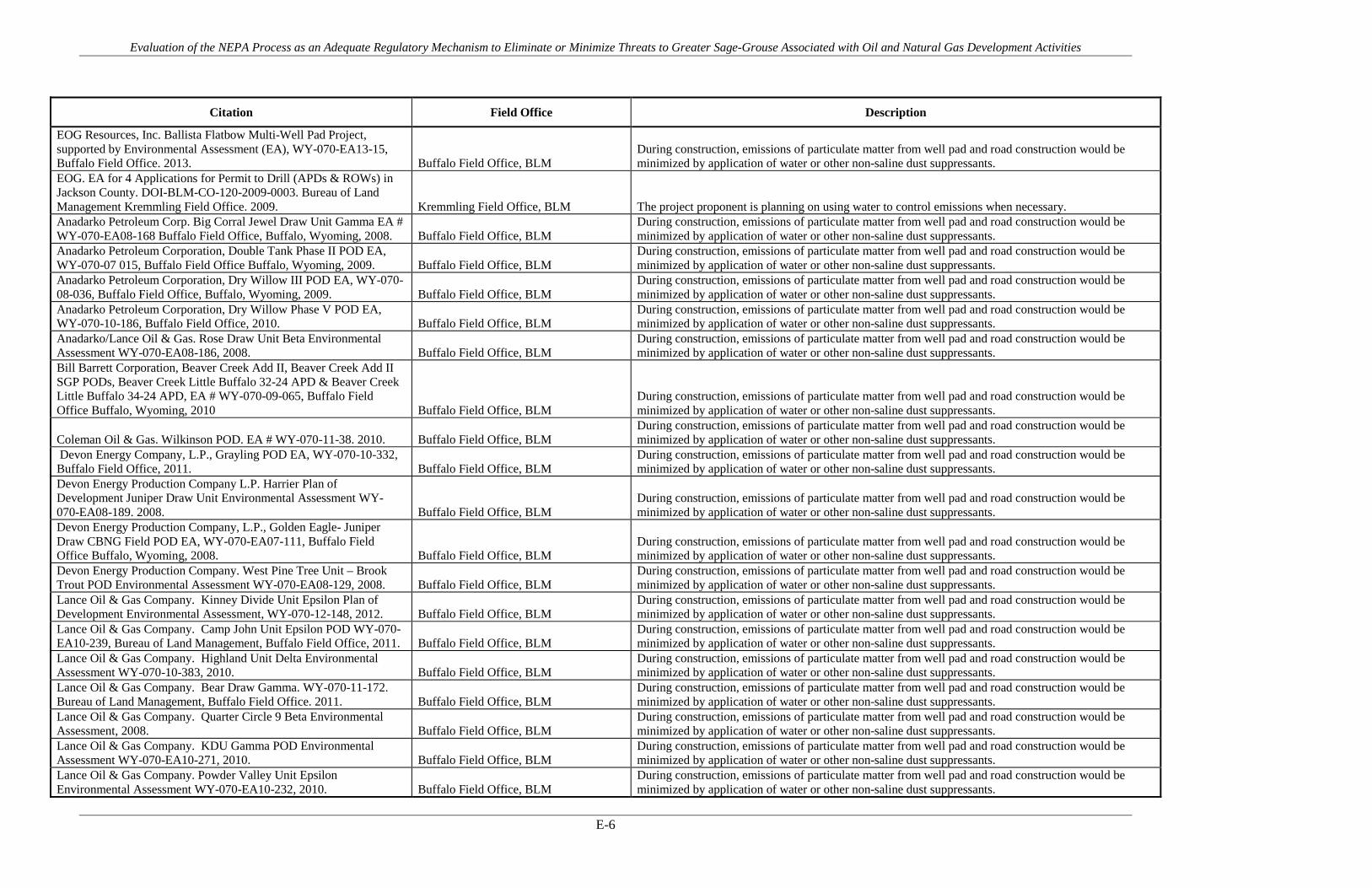
Evaluation of the NEPA Process as an Adequate Regulatory Mechanism to Eliminate or Minimize Threats to Greater Sage-Grouse Associated with Oil and Natural Gas Development Activities
E-6
Citation Field Office Description
EOG Resources, Inc. Ballista Flatbow Multi-Well Pad Project, supported by Environmental Assessment (EA), WY-070-EA13-15, Buffalo Field Office. 2013. Buffalo Field Office, BLM
During construction, emissions of particulate matter from well pad and road construction would be minimized by application of water or other non-saline dust suppressants.
EOG. EA for 4 Applications for Permit to Drill (APDs & ROWs) in Jackson County. DOI-BLM-CO-120-2009-0003. Bureau of Land Management Kremmling Field Office. 2009. Kremmling Field Office, BLM The project proponent is planning on using water to control emissions when necessary. Anadarko Petroleum Corp. Big Corral Jewel Draw Unit Gamma EA # WY-070-EA08-168 Buffalo Field Office, Buffalo, Wyoming, 2008. Buffalo Field Office, BLM
During construction, emissions of particulate matter from well pad and road construction would be minimized by application of water or other non-saline dust suppressants.
Anadarko Petroleum Corporation, Double Tank Phase II POD EA, WY-070-07 015, Buffalo Field Office Buffalo, Wyoming, 2009. Buffalo Field Office, BLM
During construction, emissions of particulate matter from well pad and road construction would be minimized by application of water or other non-saline dust suppressants.
Anadarko Petroleum Corporation, Dry Willow III POD EA, WY-070-08-036, Buffalo Field Office, Buffalo, Wyoming, 2009. Buffalo Field Office, BLM
During construction, emissions of particulate matter from well pad and road construction would be minimized by application of water or other non-saline dust suppressants.
Anadarko Petroleum Corporation, Dry Willow Phase V POD EA, WY-070-10-186, Buffalo Field Office, 2010. Buffalo Field Office, BLM
During construction, emissions of particulate matter from well pad and road construction would be minimized by application of water or other non-saline dust suppressants.
Anadarko/Lance Oil & Gas. Rose Draw Unit Beta Environmental Assessment WY-070-EA08-186, 2008. Buffalo Field Office, BLM
During construction, emissions of particulate matter from well pad and road construction would be minimized by application of water or other non-saline dust suppressants.
Bill Barrett Corporation, Beaver Creek Add II, Beaver Creek Add II SGP PODs, Beaver Creek Little Buffalo 32-24 APD & Beaver Creek Little Buffalo 34-24 APD, EA # WY-070-09-065, Buffalo Field Office Buffalo, Wyoming, 2010 Buffalo Field Office, BLM
During construction, emissions of particulate matter from well pad and road construction would be minimized by application of water or other non-saline dust suppressants.
Coleman Oil & Gas. Wilkinson POD. EA # WY-070-11-38. 2010. Buffalo Field Office, BLM During construction, emissions of particulate matter from well pad and road construction would be minimized by application of water or other non-saline dust suppressants.
Devon Energy Company, L.P., Grayling POD EA, WY-070-10-332, Buffalo Field Office, 2011. Buffalo Field Office, BLM
During construction, emissions of particulate matter from well pad and road construction would be minimized by application of water or other non-saline dust suppressants.
Devon Energy Production Company L.P. Harrier Plan of Development Juniper Draw Unit Environmental Assessment WY-070-EA08-189. 2008. Buffalo Field Office, BLM
During construction, emissions of particulate matter from well pad and road construction would be minimized by application of water or other non-saline dust suppressants.
Devon Energy Production Company, L.P., Golden Eagle- Juniper Draw CBNG Field POD EA, WY-070-EA07-111, Buffalo Field Office Buffalo, Wyoming, 2008. Buffalo Field Office, BLM
During construction, emissions of particulate matter from well pad and road construction would be minimized by application of water or other non-saline dust suppressants.
Devon Energy Production Company. West Pine Tree Unit – Brook Trout POD Environmental Assessment WY-070-EA08-129, 2008. Buffalo Field Office, BLM
During construction, emissions of particulate matter from well pad and road construction would be minimized by application of water or other non-saline dust suppressants.
Lance Oil & Gas Company. Kinney Divide Unit Epsilon Plan of Development Environmental Assessment, WY-070-12-148, 2012. Buffalo Field Office, BLM
During construction, emissions of particulate matter from well pad and road construction would be minimized by application of water or other non-saline dust suppressants.
Lance Oil & Gas Company. Camp John Unit Epsilon POD WY-070-EA10-239, Bureau of Land Management, Buffalo Field Office, 2011. Buffalo Field Office, BLM
During construction, emissions of particulate matter from well pad and road construction would be minimized by application of water or other non-saline dust suppressants.
Lance Oil & Gas Company. Highland Unit Delta Environmental Assessment WY-070-10-383, 2010. Buffalo Field Office, BLM
During construction, emissions of particulate matter from well pad and road construction would be minimized by application of water or other non-saline dust suppressants.
Lance Oil & Gas Company. Bear Draw Gamma. WY-070-11-172. Bureau of Land Management, Buffalo Field Office. 2011. Buffalo Field Office, BLM
During construction, emissions of particulate matter from well pad and road construction would be minimized by application of water or other non-saline dust suppressants.
Lance Oil & Gas Company. Quarter Circle 9 Beta Environmental Assessment, 2008. Buffalo Field Office, BLM
During construction, emissions of particulate matter from well pad and road construction would be minimized by application of water or other non-saline dust suppressants.
Lance Oil & Gas Company. KDU Gamma POD Environmental Assessment WY-070-EA10-271, 2010. Buffalo Field Office, BLM
During construction, emissions of particulate matter from well pad and road construction would be minimized by application of water or other non-saline dust suppressants.
Lance Oil & Gas Company. Powder Valley Unit Epsilon Environmental Assessment WY-070-EA10-232, 2010. Buffalo Field Office, BLM
During construction, emissions of particulate matter from well pad and road construction would be minimized by application of water or other non-saline dust suppressants.

Evaluation of the NEPA Process as an Adequate Regulatory Mechanism to Eliminate or Minimize Threats to Greater Sage-Grouse Associated with Oil and Natural Gas Development Activities
E-7
Citation Field Office Description
Lance Oil & Gas Company. Coulter 4 POD EA, WY-070-08-169, Buffalo Field Office Buffalo, Wyoming, 2008. Buffalo Field Office, BLM
During construction, emissions of particulate matter from well pad and road construction would be minimized by application of water or other non-saline dust suppressants.
Lance Oil & Gas Company. Camp John Unit SMA Phase 1, Year 1; WY-070-EA11-214 Buffalo Field Office, 2011. Buffalo Field Office, BLM
During construction, emissions of particulate matter from well pad and road construction would be minimized by application of water or other non-saline dust suppressants.
Lance Oil & Gas Company. Camp John Unit SMA Phase 1, Year 2; WY-070-EA12-084, Buffalo Field Office, 2013. Buffalo Field Office, BLM
During construction, emissions of particulate matter from well pad and road construction would be minimized by application of water or other non-saline dust suppressants.
Lance Oil & Gas Company. Sahara POD Environmental Assessment WY-070-EA13-72 Buffalo Field Office, BLM
During construction, emissions of particulate matter from well pad and road construction would be minimized by application of water or other non-saline dust suppressants.
Summit Gas Resources, Inc. Cabin Creek VII Federal POD WY-070-EA12-183, Buffalo Field Office, 2012. Buffalo Field Office, BLM
During construction, emissions of particulate matter from well pad and road construction would be minimized by application of water or other non-saline dust suppressants.
Williams Production RMT Company, Cedar Draw Unit 2 POD, EA WY-070-07-137, Buffalo Field Office Buffalo, Wyoming, 2010. Buffalo Field Office, BLM
During construction, emissions of particulate matter from well pad and road construction would be minimized by application of water or other non-saline dust suppressants.
Williams Production RMT Company, Cedar Draw Unit 3, WY-070-EA11-236, Bureau of Land Management, Buffalo Field Office, 2011. Buffalo Field Office, BLM
During construction, emissions of particulate matter from well pad and road construction would be minimized by application of water or other non-saline dust suppressants.
WPX Energy Rocky Mountain, LLC, POD North Butte 4, North Butte 3, J Christensen Federal 21-35 and Tex Draw Add 1, Environmental Assessment (EA), WY-070-EA12-123, 2013. Buffalo Field Office, BLM
During construction, emissions of particulate matter from well pad and road construction would be minimized by application of water or other non-saline dust suppressants.
Yates Petroleum Company. NEO Coal Bed Natural Gas Environmental Assessment WY-070-10-331, 2010. Buffalo Field Office, BLM
During construction, emissions of particulate matter from well pad and road construction would be minimized by application of water or other non-saline dust suppressants.
Yates Petroleum Corporation, Gauge POD EA, WY-070-EA09-75, Buffalo Field Office, 2009. Buffalo Field Office, BLM
During construction, emissions of particulate matter from well pad and road construction would be minimized by application of water or other non-saline dust suppressants.
Yates Petroleum Corporation. All Day POD. EA # WY-070-08-026 and COAs. Buffalo Field Office, Buffalo, Wyoming, 2008. Buffalo Field Office, BLM
During construction, emissions of particulate matter from well pad and road construction would be minimized by application of water or other non-saline dust suppressants.
Yates Petroleum Corporation. Lazurite POD Environmental Assessment WY-070-EA09-095, 2009. Buffalo Field Office, BLM
During construction, emissions of particulate matter from well pad and road construction would be minimized by application of water or other non-saline dust suppressants.
Yates Petroleum Corporation. Napier Road POD Environmental Assessment WY-070-EA10-280, 2010. Buffalo Field Office, BLM
During construction, emissions of particulate matter from well pad and road construction would be minimized by application of water or other non-saline dust suppressants.

APPENDIX F
No Surface Occupancy

Evaluation of the NEPA Process as an Adequate Regulatory Mechanism to Eliminate or Minimize Threats to Greater Sage-Grouse Associated with Oil and Natural Gas Development Activities
F-1
Table F-1. PECE Policy Evaluation – No Surface Occupancy
Conservation Measure No Surface Occupancy
Certainty of Implementation The conservation effort, the party(ies) to the agreement or plan that will implement the effort, and the staffing, funding level, funding source, and other resources necessary to implement the effort are identified.
The BLM/USFS decision records require implementation as a condition of the agency authorization. Funding and implementation is generally identified as the responsibility of the operator(s).
The legal authority of the party(ies) to the agreement or plan to implement the formalized conservation effort, and the commitment to proceed with the conservation effort are described.
NEPA provides the legal and statutory authority to implement the conservation measures and COAs included in the agency decision records.
The legal procedural requirements (e.g. environmental review) necessary to implement the effort are described, and information is provided indicating that fulfillment of these requirements does not preclude commitment to the effort.
NEPA is the legal procedural requirement necessary to implement COAs and conservation measures included in the agency decision records.
Authorizations (e.g., permits, landowner permission) necessary to implement the conservation effort are identified, and a high level of certainty is provided that the party(ies) to the agreement or plan that will implement the effort will obtain these authorizations.
The NEPA decision record provides the necessary authorization to implement the COAs and conservation measures. As the measures are conditions of the agency approval and are required for project completion, there is a high level of certainty that they will be implemented and authorized.
The type and level of voluntary participation (e.g., number of landowners allowing entry to their land, or number of participants agreeing to change timber management practices and acreage involved) necessary to implement the conservation effort is identified, and a high level of certainty is provided that the party(ies) to the agreement or plan that will implement the conservation effort will obtain that level of voluntary participation (e.g., an explanation of how incentives to be provided will result in the necessary level of voluntary participation).
Participation in the implementation of the COAs and conservation measures is mandatory as a condition of the agency approval under NEPA. NEPA authorizations exceed this evaluation criteria by making the measures mandatory.
Regulatory mechanisms (e.g., laws, regulations, ordinances) necessary to implement the conservation effort are in place.
NEPA provides the regulatory mechanism for implementation. Where necessary, other federal or state authorizations or permits might be required prior to implementation (i.e., Clean Water Act permits). There is reasonable certainty that these permits will be obtained for each measure or COA.

Evaluation of the NEPA Process as an Adequate Regulatory Mechanism to Eliminate or Minimize Threats to Greater Sage-Grouse Associated with Oil and Natural Gas Development Activities
F-2
Conservation Measure No Surface Occupancy
A high level of certainty is provided that the party(ies) to the agreement or plan that will implement the conservation effort will obtain the necessary funding.
The agency decision requires that funding for the COAs and conservation measures be provided as a condition of the project approval. There is certainty that each measure will be funded.
An implementation schedule (including incremental completion dates) for the conservation effort is provided.
Each NEPA document and associated decision record analyzes and describes the schedule for project implementation. As conditions of agency approvals, COAs and conservation measures must be completed during or prior to project completion.
The conservation agreement or plan that includes the conservation effort is approved by all parties to the agreement or plan.
As a condition of the agency approval of each project, there is agreement between the operators and the agency that each COA or conservation measure will be implemented as part of project activities.
Certainty of Effectiveness The nature and extent of threats being addressed by the conservation effort are described, and how the conservation effort reduces the threats is described.
No Surface Occupancy COAs and conservation measures address threats associated with Energy Development and Infrastructure under Listing Factor A.
Explicit incremental objectives for the conservation effort and dates for achieving them are stated.
No Surface Occupancy restrictions are implemented year-round for the life of the project.
The steps necessary to implement the conservation effort are identified in detail.
Steps are identified and include avoidance of activities and new infrastructure surrounding leks within given distance buffers.
Quantifiable, scientifically valid parameters that will demonstrate achievement of objectives, and standards for these parameters by which progress will be measured, are identified.
Lek attendance monitoring, monitoring of nesting and brood-rearing hens, etc. provide quantifiable parameters to measure success of the measure. Multiple sources identify that avoidance of activities surrounding leks during lekking, nesting, and early brood-rearing periods provide conservation benefit and protective measures for sage-grouse.
Provisions for monitoring and reporting progress on implementation (based on compliance with the implementation schedule) and effectiveness (based on evaluation of quantifiable parameters) of the conservation effort are provided.
Annual lek counts are tracked by state game and fish agencies and federal land management agencies for purposes of evaluating grouse populations. Monitoring and adaptive management practices discussed in detail in the report provide examples of additional monitoring and reporting provisions.
Principles of adaptive management are incorporated.
Monitoring and adaptive management practices discussed in detail in the report provide examples of additional monitoring and reporting provisions.

Evaluation of the NEPA Process as an Adequate Regulatory Mechanism to Eliminate or Minimize Threats to Greater Sage-Grouse Associated with Oil and Natural Gas Development Activities
F-3
Figure F-1. Map of FOs where No Surface Occupancy COAs are applied.

Evaluation of the NEPA Process as an Adequate Regulatory Mechanism to Eliminate or Minimize Threats to Greater Sage-Grouse Associated with Oil and Natural Gas Development Activities
F-4
Table F-2. No Surface Occupancy COAs and Conservation Measures
Citation Field Office Description
Anadarko. Doty Mountain Plan of Development D in Atlantic Rim. DOI-BLM-WY-030-2012-0093-EA. 2012.
Rawlins Field Office, BLM 0.25 mile lek no surface occupancy restriction.
Anadarko. Doty Mountain POD C in Atlantic Rim EA. WY-030-07-EA-240. 2008.
Rawlins Field Office, BLM Numerous well pads, roads, and corridors were relocated so that all were located outside the established 0.25 mile Controlled Surface Use (CSU) area for the lek.
Atlantic Rim Natural Gas Field Development Project Record of Decision and Environmental Impact Statement, Carbon County, Wyoming. March 2007.
Rawlins Field Office, BLM Avoidance areas for surface-disturbing and disruptive activities and linear crossings include the following (FEIS appendix H): Identified 100-year floodplains; Areas within 500 feet from perennial waters, springs, water wells, and wetland riparian areas, and Areas 100 feet from the inner gorge of ephemeral channels.
Atlantic Rim Natural Gas Field Development Project Record of Decision and Environmental Impact Statement, Carbon County, Wyoming. March 2007.
Rawlins Field Office, BLM Surface disturbance or occupancy will be prohibited within one-quarter mile of the perimeter of occupied leks.
Berry Petroleum Company. Record of Decision South Unit Oil and Gas Development Final Environmental Impact Statement Duchesne Ranger District, Ashley National Forest Duchesne County, Utah. 2012.
Ashley National Forest , USFS A minimum distance of 100 feet will be maintained between surface disturbing activity and springs or seeps, as measured from the outer edge of their associated wetland/riparian vegetation.
Berry Petroleum Company. Record of Decision South Unit Oil and Gas Development Final Environmental Impact Statement Duchesne Ranger District, Ashley National Forest Duchesne County, Utah. 2012.
Ashley National Forest , USFS In the case of intermittent and ephemeral drainages, a minimum distance of 50 feet will be maintained between facilities (such as well pads, tank batteries, and compressor stations) and the active channel and cutbanks of adjacent vertical terraces. For priority watersheds, classified as impaired by the Utah Division of Water Quality, siting of facilities within 100 feet of intermittent/ephemeral channels will be avoided where feasible; and where it occurs, would be subject to more rigorous monitoring and implementation of erosion control measures.
Berry Petroleum Company. Record of Decision South Unit Oil and Gas Development Final Environmental Impact Statement Duchesne Ranger District, Ashley National Forest Duchesne County, Utah. 2012.
Ashley National Forest , USFS In the case of perennial streams (i.e. Sowers Creek), facilities such as well pads, tank batteries, and compressor stations will be located outside the 100-year floodplain or a distance of 150 feet from the high water line, whichever is greater (as per INFISH recommendations for non-fish-bearing perennial streams).
Berry Petroleum Company. Record of Decision South Unit Oil and Gas Development Final Environmental Impact Statement Duchesne Ranger District, Ashley National Forest Duchesne County, Utah. 2012.
Ashley National Forest , USFS To reduce potential disturbance to strutting birds (and the likelihood of lek abandonment), nesting birds, and habitat, no well pads or permanent structures will be allowed within 0.6 mile of an occupied lek. This measure would distance structures away from leks that raptors may use for perching.
Bill Barrett Corporation. Environmental Impact Statement (UT-070-05-055) for West Tavaputs Plateau Natural Gas Full Field Development Plan and ROD. 2010.
Price Field Office, BLM In accordance with the Price Field Office Record of Decision and Approved Resource Management Plan (Approved RMP) construction, drilling, or completion activities will be precluded within two miles of known leks (or new leks which may be located during the life of the project (LOP)) between March 15 and July 15. In addition, regardless of season, development will be precluded from within ½ mile of known leks.
Bill Barrett Corporation. Environmental Impact Statement (UT-070-05-055) for West Tavaputs Plateau Natural Gas Full Field Development Plan and ROD. 2010.
Price Field Office, BLM No surface disturbance will be authorized in core winter use areas (during any time of the year) until the operator submits a site-specific plan of development for proposed roads, wells, pipelines, and/or other project features that will be constructed within those areas.
BLM Montana. Record of Decision for the Final Statewide Oil and Gas Environmental Impact Statement and Proposed Amendment of the Powder River and Billings Resource Management Plans. 2003.
Billings Field Office, BLM Miles City Field Office, BLM
In order to minimize impacts to sharptail and sage grouse leks, surface occupancy within ¼ mile of known leks is prohibited. The measure may be waived if the AO, in coordination with MFWP, determines that the entire leasehold can be occupied without adversely affecting grouse lek sites, or if all lek sites within ¼ mile of the leasehold have not been attended for 5 consecutive years.
Cimarex. Rands Butte Gas Development Project Final Environmental Assessment, Decision Record and Finding of No Significant Impact, WY-100-EA09-43. 2010.
Pinedale Field Office, BLM Natural gas and helium pipelines shall be re-located outside of the ¼-mile radius around the perimeter of an occupied Greater sage-grouse lek.
Cimarex. Rands Butte Gas Development Project Final Environmental Assessment, Decision Record and Finding of No Significant Impact, WY-100-EA09-43. 2010.
Pinedale Field Office, BLM No Surface Occupancy is allowed within the ¼-mile radius around the perimeter of an occupied Greater sage-grouse lek.
Double Eagle Petroleum. Catalina PODs E and F in the Atlantic Rim. DOI-BLM-WY-030-2009-0155-EA. 2011.
Rawlins Field Office, BLM 0.25 mile lek no surface occupancy restriction.
Elk Petroleum. Environmental Assessment for the Grieve Unit CO2 Enhanced Recovery Project. Natrona County, Wyoming. WY-050-EA11-108. Approved 7/26/12 by BLM Lander Field Office.
Lander Field Office, BLM Construction of well sites and other non-linear features within 500 feet of surface water and/or riparian areas or within 100 feet of the inner gorge of ephemeral channels will be prohibited.

Evaluation of the NEPA Process as an Adequate Regulatory Mechanism to Eliminate or Minimize Threats to Greater Sage-Grouse Associated with Oil and Natural Gas Development Activities
F-5
Citation Field Office Description
Elk Petroleum. Environmental Assessment for the Grieve Unit CO2 Enhanced Recovery Project. Natrona County, Wyoming. WY-050-EA11-108. Approved 7/26/12 by BLM Lander Field Office.
Lander Field Office, BLM Surface occupancy and/or disruptive activities are prohibited on or within a six tenths (0.6) mile radius of the perimeter of occupied sage-grouse leks.
EnCana. Environmental Assessment of the Orchard Master Development Plan for Oil and Gas Development. GJFO # DOI-BLM-CO-130-2009-0001-EA and GSFO # DOI-BLM-CO-140-2008-0032-EA. Grand Junction Field Office and Glenwood Springs Energy Office, October 2008.
Grand Junction Field Office, BLM This lease has both NSO and CSU stipulations for riparian and wetland zones… activities may require special design, construction, and implementation measures within 500 feet of the outer edge of riparian or wetland vegetation.
EnCana Oil and Gas. Master Development Plan (MDP) for the SG E34 496, SG L27 796 and SG F22 496. DOI-BLM-CO-110-2013-0035-EA. Approved 6/7/13 by the White River Field Office.
White River Field Office, BLM A "Restricted Surface Occupancy" buffer would be applied to all forms of new disturbance that would alter the vegetative structure or topography or would result in the addition of surface structures.
EnCana Oil and Gas. Master Development Plan (MDP) for the SG E34 496, SG L27 796 and SG F22 496. DOI-BLM-CO-110-2013-0035-EA. Approved 6/7/13 by the White River Field Office.
White River Field Office, BLM A 0.6 mile "Restricted Surface Occupancy" buffer would be applied for active lek sites. A "Restricted Surface Occupancy" buffer would be applied to all forms of new disturbance that would alter the vegetative structure or topography or would result in the addition of surface structures. The BLM would be notified of any new disturbance within the "Restricted Surface Occupancy" buffer.
EnCana Oil and Gas. Pappy Draw Exploratory Coal-bed Natural Gas Pilot Project Environmental Assessment. WY-050-EA08-88. Approved 9/5/08 by the Lander BLM Field Office.
Lander Field Office, BLM A 0.6-mile buffer zone would be established around known leks, and all construction and surface occupancy not be allowed within this buffer zone.
EnCana Oil and Gas. Pappy Draw Exploratory Coal-bed Natural Gas Pilot Project Environmental Assessment. WY-050-EA08-88. Approved 9/5/08 by the Lander BLM Field Office.
Lander Field Office, BLM Project sites would be evaluated for the occurrence and distribution of special aquatic sites, including riparian areas and playas. Project facilities would not be allowed within 500 feet of these wetland areas. As of July, 2008 project sites have been evaluated and one well site was moved out of a riparian area.
Environmental Assessment for East Converse Exploratory Oil and Gas Development Project. WY-060-EA12-227. Approved 11/20/12 by BLM Casper Field Office.
Casper Field Office, BLM Surface-disturbing activities are prohibited within one ¼- mile radius of occupied sage-grouse leks.
Environmental Assessment for Highland Loop Road Exploratory Oil and Gas Development Project. WY-060-EA12-226. Approved 11/20/12 by BLM Casper Field Office.
Casper Field Office, BLM Surface disturbing activities are prohibited within one quarter (0.25) mile radius of occupied sage-grouse leks.
Environmental Assessment for Spearhead Ranch Exploratory Oil and Gas Development Project. Y-060-EA12-225. Approved 11/20/12 by BLM Casper Field Office.
Casper Field Office, BLM Surface disturbing activities are prohibited within one quarter (0.25) mile radius of occupied sage-grouse leks.
Exxon. Piceance Creek 3D Seismic Survey Project Environmental Assessment, CO-110-2008-036-EA, 2008.
White River Field Office, BLM The proposed schedule commences in May with survey activities. If the schedule were to change for some reason, timing restrictions would be imposed within 0.6 mi of active and inactive (i.e. leks used within the last 5 years) sage-grouse leks from March 15 through May 7 in order to minimize disturbance to breeding grouse.
Fidelity Exploration & Production Company. Bowdoin Natural Gas Development Project Phillips and Valley Counties, Montana. Environmental Assessment MT-92234-07-59. December, 2008.
Malta Field Office, BLM Prohibit surface disturbance within 1/4 mile of Greater sage-grouse leks unless they are considered historic (have not been used in the past 7–10 years).
Fidelity Exploration & Production Company. Bowdoin Natural Gas Development Project Phillips and Valley Counties, Montana. Environmental Assessment MT-92234-07-59. December, 2008.
Malta Field Office, BLM Prohibit surface disturbance within identified patches of Greater sage-grouse severe winter habitat.
Fidelity Exploration and Production Company. Tongue River - Corral Creek, Plan of Development, Environmental Assessment, Montana Board of Oil and Gas Conservation. 2008.
Miles City Field Office, BLM The operator also agrees to avoid construction or drilling activities within a quarter-mile of sage grouse or sharp tail grouse leks during the nesting season to protect these species from noise disturbance during this critical period. It is understood that new information regarding grouse set back distances maybe come available in the near future and recommendation from the applicable grouse working groups will be reviewed and considered during development.
Gasco Energy Inc. Uinta Basin Natural Gas Development Project, Environmental Impact Statement FES 12-5, Record of Decision, Bureau of Land Management Vernal Field Office, June 2012.
Vernal Field Office, BLM New surface-disturbing activities within public water reserves, or within 330 feet of riparian areas, will be avoided unless 1) there are no practical alternatives; 2) impacts could be fully mitigated; or 3) the action is designed to enhance the riparian resources. A buffer strip of vegetation will be maintained between areas of surface disturbance and riparian vegetation. Silt fencing or other erosion control measures will be installed and maintained between areas of surface disturbance and riparian vegetation to protect against erosion or contamination.

Evaluation of the NEPA Process as an Adequate Regulatory Mechanism to Eliminate or Minimize Threats to Greater Sage-Grouse Associated with Oil and Natural Gas Development Activities
F-6
Citation Field Office Description
Gasco Energy Inc. Uinta Basin Natural Gas Development Project, Environmental Impact Statement FES 12-5, Record of Decision, Bureau of Land Management Vernal Field Office, June 2012.
Vernal Field Office, BLM No permanent facilities will be constructed within 2 miles of active strutting grounds, when possible.
Gasco Energy Inc. Uinta Basin Natural Gas Development Project, Environmental Impact Statement FES 12-5, Record of Decision, Bureau of Land Management Vernal Field Office, June 2012.
Vernal Field Office, BLM On BLM land, new construction and surface-disturbing activities will be avoided year-round within 0.25 mile of active or historic greater sage-grouse strutting grounds (leks).
Greencore Pipeline Company. Environmental Assessment. Bureau of Land Management. EA No. WY-060-EA11-32. January 2011.
Buffalo Field Office, BLM Casper Field Office, BLM Lander Field Office, BLM Miles City Field Office, BLM
To avoid potential impacts to breeding greater sage-grouse, Greencore would implement a permanent 0.6 mile No Surface Occupancy (NSO) buffer around occupied leks in Core Areas and a 0.25 mile NSO lek buffer in Non-core Areas. Any site specific modifications to NSO buffers would require authorization by the BLM.
Jonah Infill Drilling Project Environmental Impact Statement and Record of Decision, Sublette County, Wyoming. 2006.
Pinedale Field Office, BLM Rock Springs Field Office, BLM
Compressor stations will be sited at least 2.0 miles away from greater sage-grouse leks and no closer than 0.5 mile to an active raptor nest.
Jonah Infill Drilling Project Environmental Impact Statement and Record of Decision, Sublette County, Wyoming. 2006.
Pinedale Field Office, BLM Rock Springs Field Office, BLM
Surface disturbance and occupancy will be prohibited within 0.25 mile of the perimeter of greater sage-grouse leks, and human activity in these areas will be avoided between 8 p.m. and 8 a.m. from March 1 through May 15.
Jonah Infill Drilling Project Environmental Impact Statement and Record of Decision, Sublette County, Wyoming. 2006.
Pinedale Field Office, BLM Rock Springs Field Office, BLM
To further mitigate potential adverse effects to breeding and nesting greater sage-grouse on the JIDPA, 0.5-mile facility-free buffers would be applied to greater sage-grouse lek 7 south of the JIDPA for as long as Operators continue to hold the leases for these areas. No features requiring repeated human presence would be built within this area.
Kerr-McGee Oil & Gas Onshore LP (KMG), Greater Natural Buttes EIS UT-080-07-807, BLM Vernal Field Office, Record of Decision, May 2012.
Vernal Field Office, BLM No surface disturbing activities will be allowed within 0.5 mile of active greater sage-grouse leks year round.
Lance Oil & Gas Company Inc. Highland Unit Delta Environmental Assessment WY-070-10-383, 2010.
Buffalo Field Office, BLM The Operator, in their POD, has committed to remove one well and a water impoundment from the project proposal which were located within a 0.25 mile buffer of a sage-grouse lek
Lance Oil & Gas Company, Inc. Bear Draw Gamma. WY-070-11-172. Bureau of Land Management, Buffalo Field Office. 2011.
Buffalo Field Office, BLM Surface disturbing activities or surface occupancy is prohibited or restricted on or within one quarter (0.25) mile radius of the perimeter of occupied or undetermined sage-grouse lek.
Lance Oil and Gas Company, Inc. Camp John Unit SMA Phase 1, Year 1; WY-070-EA11-214 Buffalo Field Office, 2011.
Buffalo Field Office, BLM No occupancy or other surface disturbance will be allowed within a 1,320-foot radius of the center of a sage grouse strutting ground (lek). No exceptions will be granted.
Lance Oil and Gas Company. Coal Gulch Unit Gamma POD Categorical Exclusion WY-070-390CX3-11-64 through WY070-390CX3-11-128 Bureau of Land Management Buffalo Field Office, 2010.
Buffalo Field Office, BLM If an active lek is identified and construction has not been completed, surface disturbance and occupancy within 0.25 miles of the center of the lek will be prohibited.
Noble Energy. Huntington Valley Proposed Oil & Gas Development. DRAFT. In progress January 2014.
Tuscarora Field Office, BLM This lease contains lands which have been identified as sage grouse strutting grounds (leks) that are subject to seasonal protection from disturbance. No Surface Occupancy is permitted within 0.5 miles, or other, lesser, appropriate distance based on site-specific conditions, of sage grouse leks.
QEP. Greater Deadman Bench Oil and Gas Producing Region EIS and ROD March 2008. UT 080-2003-0369V. BLM Vernal Field Office. 2008.
Vernal Field Office, BLM No permanent facilities will be allowed within 1,000 feet of any identified greater sage grouse strutting ground.
QEP. Greater Deadman Bench Oil and Gas Producing Region EIS and ROD March 2008. UT 080-2003-0369V. BLM Vernal Field Office. 2008.
Vernal Field Office, BLM QEP would avoid placement of roads, pipelines, well pads, and ancillary facilities within 100 meters of riparian habitats. If avoidance is not feasible, then effects to riparian habitats would be minimized where possible.
Quicksilver Resources. 9 Mile 3D Seismic Project. CO-100-2008-048 EA. BLM Little Snake Field Office, 2008.
Little Snake Field Office, BLM A buffer of 330 feet shall be maintained between vehicles and wetlands, springs, and riparian zones unless on existing roads.
Quicksilver Resources. 9 Mile 3D Seismic Project. CO-100-2008-048 EA. BLM Little Snake Field Office, 2008.
Little Snake Field Office, BLM No surface occupancy will occur within ¼ mile radius of leks. The NSO area may be modified by a BLM biologist depending on activity status and presence of topographical or vegetative barriers.
Record of Decision, Final Supplemental Environmental Impact Statement for the Pinedale Anticline Oil and Gas Exploration and Development Project, Sublette County, Wyoming. 2008.
Pinedale Field Office, BLM All surface disturbance, permanent facilities, etc., will remain a minimum of 500 feet away from the edge of surface waters, riparian areas, wetlands, and 100-year floodplains unless it is determined through site specific analysis…
Record of Decision, Final Supplemental Environmental Impact Statement for the Pinedale Anticline Oil and Gas Exploration and Development Project, Sublette County, Wyoming. 2008.
Pinedale Field Office, BLM Surface disturbance within 0.25 mile of an occupied greater sage-grouse lek will be avoided.

Evaluation of the NEPA Process as an Adequate Regulatory Mechanism to Eliminate or Minimize Threats to Greater Sage-Grouse Associated with Oil and Natural Gas Development Activities
F-7
Citation Field Office Description
Samson Resources Company. Environmental Assessment for the Scott Field Development Project. WY-060-EA13-067. Approved 9/9/13 by the BLM Casper Field Office.
Casper Field Office, BLM Ensure that construction, drilling, and completion activities are minimized in riparian corridors, and ensure that well pads are located at least 500 feet from any riparian area. Any roads or pipelines that cannot be re-routed should cross riparian zones in a manner that would minimize disturbance.
Samson Resources Company. Environmental Assessment for the Scott Field Development Project. WY-060-EA13-067. Approved 9/9/13 by the BLM Casper Field Office.
Casper Field Office, BLM In the event that a new lek is discovered, surface disturbance and/or occupancy will be avoided within 0.25 mile of the perimeter of an occupied lek to protect breeding habitat.
Samson. Endurance/Barricade Gas Infrastructure Project Sweetwater County, Wyoming. Environmental Assessment. DOI-BLM-WY-030-2013-0151-EA. August 2013
Rawlins Field Office, BLM Avoid activities within identified 100-year flood plain, within 500 feet of perennial waters, springs, wells, and wetlands, and areas within 100 feet of the inner gorge of ephemeral channels where amphibians may be present.
Yates Petroleum and Pinnacle Gas Resources. Luman Rim Natural Gas Development EA and DR. WYW128688. WY-040-EA10-139. December 2010.
Rock Springs Field Office, BLM No surface occupancy within one-quarter mile of active sage-grouse leks, although the GRRMP also provides that some activities may be granted exceptions to this restriction, under certain circumstances.
Yates Petroleum Company. NEO Coal Bed Natural Gas Environmental Assessment WY-070-10-331, 2010.
Buffalo Field Office, BLM Surface disturbing activity is restricted on or within a 0.25 mile radius of the perimeter of occupied or undetermined sage-grouse leks.
Yates Petroleum Corporation, Gauge POD EA, WY-070-EA09-75, Buffalo Field Office, 2009.
Buffalo Field Office, BLM If an active lek is identified and construction has not been completed, surface disturbance and occupancy within 0.25 miles of the center of the lek will be prohibited.

Evaluation of the NEPA Process as an Adequate Regulatory Mechanism to Eliminate or Minimize Threats to Greater Sage-Grouse Associated with Oil and Natural Gas Development Activities
APPENDIX G Noxious/Invasive Weed Management
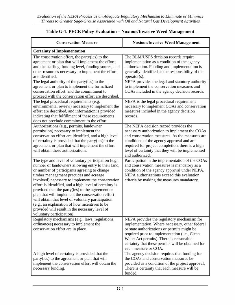
Evaluation of the NEPA Process as an Adequate Regulatory Mechanism to Eliminate or Minimize Threats to Greater Sage-Grouse Associated with Oil and Natural Gas Development Activities
G-1
Table G-1. PECE Policy Evaluation – Noxious/Invasive Weed Management
Conservation Measure Noxious/Invasive Weed Management
Certainty of Implementation The conservation effort, the party(ies) to the agreement or plan that will implement the effort, and the staffing, funding level, funding source, and other resources necessary to implement the effort are identified.
The BLM/USFS decision records require implementation as a condition of the agency authorization. Funding and implementation is generally identified as the responsibility of the operator(s).
The legal authority of the party(ies) to the agreement or plan to implement the formalized conservation effort, and the commitment to proceed with the conservation effort are described.
NEPA provides the legal and statutory authority to implement the conservation measures and COAs included in the agency decision records.
The legal procedural requirements (e.g. environmental review) necessary to implement the effort are described, and information is provided indicating that fulfillment of these requirements does not preclude commitment to the effort.
NEPA is the legal procedural requirement necessary to implement COAs and conservation measures included in the agency decision records.
Authorizations (e.g., permits, landowner permission) necessary to implement the conservation effort are identified, and a high level of certainty is provided that the party(ies) to the agreement or plan that will implement the effort will obtain these authorizations.
The NEPA decision record provides the necessary authorization to implement the COAs and conservation measures. As the measures are conditions of the agency approval and are required for project completion, there is a high level of certainty that they will be implemented and authorized.
The type and level of voluntary participation (e.g., number of landowners allowing entry to their land, or number of participants agreeing to change timber management practices and acreage involved) necessary to implement the conservation effort is identified, and a high level of certainty is provided that the party(ies) to the agreement or plan that will implement the conservation effort will obtain that level of voluntary participation (e.g., an explanation of how incentives to be provided will result in the necessary level of voluntary participation).
Participation in the implementation of the COAs and conservation measures is mandatory as a condition of the agency approval under NEPA. NEPA authorizations exceed this evaluation criteria by making the measures mandatory.
Regulatory mechanisms (e.g., laws, regulations, ordinances) necessary to implement the conservation effort are in place.
NEPA provides the regulatory mechanism for implementation. Where necessary, other federal or state authorizations or permits might be required prior to implementation (i.e., Clean Water Act permits). There is reasonable certainty that these permits will be obtained for each measure or COA.
A high level of certainty is provided that the party(ies) to the agreement or plan that will implement the conservation effort will obtain the necessary funding.
The agency decision requires that funding for the COAs and conservation measures be provided as a condition of the project approval. There is certainty that each measure will be funded.

Evaluation of the NEPA Process as an Adequate Regulatory Mechanism to Eliminate or Minimize Threats to Greater Sage-Grouse Associated with Oil and Natural Gas Development Activities
G-2
Conservation Measure Noxious/Invasive Weed Management
An implementation schedule (including incremental completion dates) for the conservation effort is provided.
Each NEPA document and associated decision record analyzes and describes the schedule for project implementation. As conditions of agency approvals, COAs and conservation measures must be completed during or prior to project completion.
The conservation agreement or plan that includes the conservation effort is approved by all parties to the agreement or plan.
As a condition of the agency approval of each project, there is agreement between the operators and the agency that each COA or conservation measure will be implemented as part of project activities.
Certainty of Effectiveness The nature and extent of threats being addressed by the conservation effort are described, and how the conservation effort reduces the threats is described.
Noxious weed COAs and conservation measures address threats associated with Energy Development and Invasive Plants under Listing Factor A.
Explicit incremental objectives for the conservation effort and dates for achieving them are stated.
Weed Management Plans and Reclamation Plans contain incremental objectives, such as staying below a certain percent cover of weeds after a set number of growing seasons.
The steps necessary to implement the conservation effort are identified in detail.
Steps are identified in COAs and Weed Management/Reclamation Plans, including implementation measures that describe soil preparation and seed mixes to use during reclamation, and weed control methods.
Quantifiable, scientifically valid parameters that will demonstrate achievement of objectives, and standards for these parameters by which progress will be measured, are identified.
Reclamation must meet quantifiable standards to be considered successful, including maintaining weeds below a set percent coverage.
Provisions for monitoring and reporting progress on implementation (based on compliance with the implementation schedule) and effectiveness (based on evaluation of quantifiable parameters) of the conservation effort are provided.
Annual monitoring and reporting are a part of weed management COAs. If weeds are not reaching the set success criteria, adaptive management allows the weed control approach to be re-evaluated.
Principles of adaptive management are incorporated.
Monitoring and adaptive management practices discussed in detail in the report provide examples of additional monitoring and reporting provisions.

Evaluation of the NEPA Process as an Adequate Regulatory Mechanism to Eliminate or Minimize Threats to Greater Sage-Grouse Associated with Oil and Natural Gas Development Activities
G-3
Figure G-1. Map of FOs where Noxious/Invasive Weed Management COAs are applied.

Evaluation of the NEPA Process as an Adequate Regulatory Mechanism to Eliminate or Minimize Threats to Greater Sage-Grouse Associated with Oil and Natural Gas Development Activities
G-4
Table G-2. Noxious/Invasive Weed Management COAs and Conservation Measures
Citation Field Office Description
Anadarko. Doty Mountain POD C in Atlantic Rim EA. WY-030-07-EA-240. 2008. Rawlins Field Office, BLM The Anadarko Reclamation Plan includes a weed management plan to address weed control.
Anadarko. Doty Mountain Plan of Development D in Atlantic Rim. DOI-BLM-WY-030-2012-0093-EA. 2012. Rawlins Field Office, BLM The Anadarko Reclamation Plan includes a weed management plan to address weed control.
Anadarko Petroleum Corp. Big Corral Jewel Draw Unit Gamma EA # WY-070-EA08-168 Buffalo Field Office, Buffalo, Wyoming, 2008. Buffalo Field Office, BLM The operator will be responsible for prevention and control of noxious weeds and weeds of concern on all areas of
surface disturbance associated with this project (well locations, roads, water management facilities, etc.)
Atlantic Rim Natural Gas Field Development Project Record of Decision and Environmental Impact Statement, Carbon County, Wyoming. March 2007.
Rawlins Field Office, BLM
Annual monitoring and control of invasive and noxious weeds beginning the first season of disturbance; Monitoring and management of reclamation sites to evaluate weed populations, reclamation success, and to plan and report on the program annually; and Affirmative efforts to resist the spread of weeds including refraining from cleaning out equipment including filters on the site, and power washing machinery and equipment between work sites consistent with the Rawlins Weed Prevention Plan (USDI-BLM 1999).
Berry Petroleum Company. Record of Decision South Unit Oil and Gas Development Final Environmental Impact Statement Duchesne Ranger District, Ashley National Forest Duchesne County, Utah. 2012.
Ashley National Forest , USFS Conduct pre-construction surveys in the spring for weed infestations within the site boundaries and along access roads. Consult Duchesne County Weeds Department to determine treatment for noxious weeds, if identified. Construction vehicles and equipment will be cleaned, power-washed, and free of soil and vegetation debris prior to entry and use of access roads to prevent transporting weed seeds. All seed mixtures, erosion control materials, and reclamation materials will be certified weed free. Revegetated areas will be monitored following seeding to evaluate the need for supplemental seeding and noxious weed control. The ROW and other disturbed areas will be monitored for weed infestations, and new or expanding populations will be controlled or eradicated for the duration of the construction, operation, and reclamation phases. The presence of designated weeds in the Project Area requires that the Operator develop and implement management measures to prevent the spread of noxious weeds and install a monitoring system. During the construction phase of the project, the Operator will implement an intensive reclamation and weed control program after each segment of project completion.
Bill Barrett Corporation, Beaver Creek Add II, Beaver Creek Add II SGP PODs, Beaver Creek Little Buffalo 32-24 APD & Beaver Creek Little Buffalo 34-24 APD, EA # WY-070-09-065, Buffalo Field Office Buffalo, Wyoming, 2010.
Buffalo Field Office, BLM The operator will be responsible for prevention and control of noxious weeds and weeds of concern on all areas of surface disturbance associated with this project (well locations, roads, water management facilities, etc.)
BLM Montana. Record of Decision for the Final Statewide Oil and Gas Environmental Impact Statement and Proposed Amendment of the Powder River and Billings Resource Management Plans. 2003.
Billings Field Office, BLM Miles City Field Office, BLM
It is the responsibility of the operator to control noxious weeds on lands disturbed in association with oil and gas lease operations. Lease associated weed control strategies are to be coordinated with any involved surface owners and local weed control boards.
Chevron. Table Rock Unit Oil and Gas Development EA and DR. WY-040-EA11-175. January 2012.
Rock Springs Field Office, BLM Rawlins Field Office, BLM
Implementation of environmental protection measures (including the use of a native, weed-free reclamation seed mixture) and the development and implementation of a site-specific reclamation plan and noxious weed management plan, would minimize the potential for the establishment of noxious weeds and invasive species. These plans would be developed during the APD process.
Cimarex. Rands Butte Gas Development Project Final Environmental Assessment, Decision Record and Finding of No Significant Impact, WY-100-EA09-43. 2010.
Pinedale Field Office, BLM The ROW and other disturbed areas will be monitored for weed infestations, and new or expanding populations will be controlled or eradicated for the duration of the construction, operation, and reclamation phases.
Double Eagle Petroleum. Catalina PODs G and I in the Atlantic Rim. DOI-BLM-WY-030-2009-0155-EA. 2011.
Rawlins Field Office, BLM The DEPC Reclamation Plan would include a weed management plan to address weed control.
Double Eagle Petroleum. Catalina PODs E and F in the Atlantic Rim. WY-030-08-EA-222. 2008.
Rawlins Field Office, BLM COAs have been added to control the spread, establishment, and plant community changes associated with weed infestation.
Elk Petroleum. Environmental Assessment for the Grieve Unit CO2 Enhanced Recovery Project. Natrona County, Wyoming. WY-050-EA11-108. Approved 7/26/12 by BLM Lander Field Office.
Lander Field Office, BLM The operator has prepared a Weed Management Plan (Appendix E). Weeds would be controlled on all disturbed areas during the life of the project.
EnCana Oil and Gas. 28 APDs on new well pad D36 496. DOI-BLM-CO-110-2011-0169-EA. Approved 9/23/11 by the White River Field Office.
White River Field Office, BLM Clean all construction equipment to remove seed and soil prior to bringing equipment into the project area.

Evaluation of the NEPA Process as an Adequate Regulatory Mechanism to Eliminate or Minimize Threats to Greater Sage-Grouse Associated with Oil and Natural Gas Development Activities
G-5
Citation Field Office Description
EnCana Oil and Gas. APDs- N22-496 (16)& P28-496 (16). DOI-BLM-CO-110-2011-0006-EA. White River Field Office. Approved 5/24/11 by White River Field Office.
White River Field Office, BLM Before entering BLM lands, all construction, heavy or off-road equipment and transport (backhoes, trackhoes, dozers, blades, rollers, lowboys, equipment trailers, etc.), pickup trucks, SUVs, vans, water trucks, pipe trucks, etc., shall be power washed to remove seeds, soil, and vegetative matter. If noxious weeds are found, they shall be treated (if timing is appropriate) or removed (if plants have formed seeds) prior to ground-disturbing activities to limit weed seed production and dispersal. If the treatment timing is not appropriate for the weed species, ground-disturbing activities may proceed.
EnCana Oil and Gas. APDs- N22-496 (16)& P28-496 (16). DOI-BLM-CO-110-2011-0006-EA. White River Field Office. Approved 5/24/11 by White River Field Office.
White River Field Office, BLM Noxious Weed Inventory record shall be completed each time a List A or B weed infestation is inventoried (with the exception of redstem filaree and quackgrass)… c. Inventories for the presence of noxious weeds shall be conducted at least once early in the growing season for all areas disturbed by oil and gas exploration and development. Weeds shall be treated in an appropriate manner if found.
EnCana Oil and Gas. L24 496 New Well Pad - 28 APDs. DOI-BLM-CO-110-2012-0021-DNA. Approved 3/20/12 by White River Field Office.
White River Field Office, BLM The operator should monitor the project site for a minimum of three years after construction to detect the presence of noxious/invasive species. Any such species that occur will be eradicated.
EnCana Oil and Gas. Master Development Plan for the SG E34 496, SG L796 and SG F22 496, Environmental Assessment and Decision Record, DOI-BLM-CO-2013-0035-EA, 2013.
White River Field Office, BLM The operator should eliminate any noxious plants before seed production occurs. The operator should clean all off-road equipment to remove seed and soil prior to commencing operations within the project area. In order to minimize the potential for invasion of noxious and invasive species, the operator should attain sufficient cover of native reclamation species (similar to that of nearby undisturbed native plant, communities in a healthy early-seral state).
EnCana Oil and Gas. Pappy Draw Exploratory Coal-bed Natural Gas Pilot Project Environmental Assessment. WY-050-EA08-88. Approved 9/5/08 by the Lander BLM Field Office.
Lander Field Office, BLM Invasive species/noxious weed monitoring forms would be completed and submitted to the BLM. A weed control plan would be prepared and implemented based on BLM’s approval. On BLM lands, an approved Pesticide Use Proposal would be obtained before the application of herbicides or other pesticides for the control of noxious weeds.
EnCana Oil and Gas. Story Gulch Application for Permit to Drill (32) - 16 additional wells on F25 pad & B36 pad each. OI-BLM-CO-110-2010-0207-DNA. Approved 9/1/10 by White River Field Office.
White River Field Office, BLM Before entering BLM lands, all construction, heavy or off-road equipment and transport (backhoes, trackhoes, dozers, blades, rollers, lowboys, equipment trailers, etc.), pickup trucks, SUVs, vans, water trucks, pipe trucks, etc., shall be power washed to remove seeds, soil, and vegetative matter. If noxious weeds are found, they shall be treated (if timing is appropriate) or removed (if plants have formed seeds) prior to ground-disturbing activities to limit weed seed production and dispersal. If the treatment timing is not appropriate for the weed species, ground-disturbing activities may proceed. The center points of List A and B weed infestations (with the exception of redstem filaree and quackgrass) shall be marked with a GPS unit, or, GPS lines or polygons along or around weed infestations. b. A Noxious Weed Inventory record shall be completed each time a List A or B weed infestation is inventoried (with the exception of redstem filaree and quackgrass). c. Inventories for the presence of noxious weeds shall be conducted at least once early in the growing season for all areas disturbed by oil and gas exploration and development. Weeds shall be treated in an appropriate manner if found during inventories. Follow-up inventories and re-treatment during the same growing season may be necessary to provide additional control and/or eradication.
EnCana Oil and Gas. Story Gulch Well Pads (2). DOI-BLM-CO-110-2009-0229-EA. Approved 2/3/10 by White River Field Office.
White River Field Office, BLM The operator should monitor the project site for a minimum of three years after construction to detect the presence of noxious/invasive species. Any such species that occur will be eradicated.
EnCana. Environmental Assessment of the Orchard Master Development Plan for Oil and Gas Development. GJFO # DOI-BLM-CO-130-2009-0001-EA and GSFO # DOI-BLM-CO-140-2008-0032-EA. Grand Junction Field Office and Glenwood Springs Energy Office, October 2008.
Grand Junction Field Office, BLM Reports regarding invasive species and weed management and reclamation success shall be submitted to the Grand Junction Field no later than December 1 of each year, in compliance with the joint BLM/Forest Service Noxious and Invasive Weed Management Plan for Oil and Gas Operators.
Environmental Assessment for East Converse Exploratory Oil and Gas Development Project. WY-060-EA12-227. Approved 11/20/12 by BLM Casper Field Office.
Casper Field Office, BLM Noxious and invasive weed species shall be controlled on all surface disturbance areas in the project area by the use of mechanical and/or chemical treatments designed to best control weed species at a specific site.
Environmental Assessment for Highland Loop Road Exploratory Oil and Gas Development Project. WY-060-EA12-226. Approved 11/20/12 by BLM Casper Field Office.
Casper Field Office, BLM Noxious and invasive weed species shall be controlled on all surface disturbance areas in the project area by the use of mechanical and/or chemical treatments designed to best control weed species at a specific site.
Environmental Assessment for Spearhead Ranch Exploratory Oil and Gas Development Project. Y-060-EA12-225. Approved 11/20/12 by BLM Casper Field Office.
Casper Field Office, BLM Noxious and invasive weed species shall be controlled on all surface disturbance areas in the project area by the use of mechanical and/or chemical treatments designed to best control weed species at a specific site.
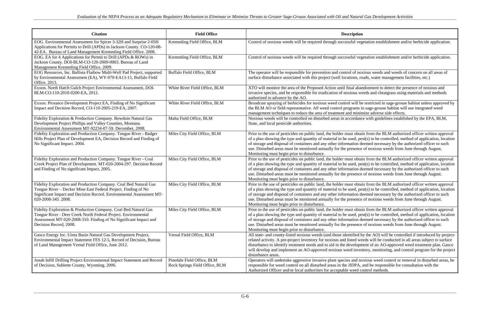
Evaluation of the NEPA Process as an Adequate Regulatory Mechanism to Eliminate or Minimize Threats to Greater Sage-Grouse Associated with Oil and Natural Gas Development Activities
G-6
Citation Field Office Description
EOG. Environmental Assessment for Spicer 3-32H and Surprise 2-05H Applications for Permits to Drill (APDs) in Jackson County. CO-120-08-42-EA. Bureau of Land Management Kremmling Field Office. 2008.
Kremmling Field Office, BLM Control of noxious weeds will be required through successful vegetation establishment and/or herbicide application.
EOG. EA for 4 Applications for Permit to Drill (APDs & ROWs) in Jackson County. DOI-BLM-CO-120-2009-0003. Bureau of Land Management Kremmling Field Office. 2009.
Kremmling Field Office, BLM Control of noxious weeds will be required through successful vegetation establishment and/or herbicide application.
EOG Resources, Inc. Ballista Flatbow Multi-Well Pad Project, supported by Environmental Assessment (EA), WY-070-EA13-15, Buffalo Field Office. 2013.
Buffalo Field Office, BLM The operator will be responsible for prevention and control of noxious weeds and weeds of concern on all areas of surface disturbance associated with this project (well locations, roads, water management facilities, etc.)
Exxon. North Hatch Gulch Project Environmental Assessment, DOI-BLM-CO-110-2010-0200-EA, 2012.
White River Field Office, BLM XTO will monitor the area of the Proposed Action until final abandonment to detect the presence of noxious and invasive species, and be responsible for eradication of noxious weeds and cheatgrass using materials and methods authorized in advance by the AO.
Exxon. Piceance Development Project EA, Finding of No Significant Impact and Decision Record, CO-110-2005-219-EA, 2007.
White River Field Office, BLM Broadcast spraying of herbicides for noxious weed control will be restricted in sage-grouse habitat unless approved by the BLM AO or field representative. All weed control programs in sage-grouse habitat will use integrated weed management techniques to reduce the area of treatment and minimize adverse side effects.
Fidelity Exploration & Production Company. Bowdoin Natural Gas Development Project Phillips and Valley Counties, Montana. Environmental Assessment MT-92234-07-59. December, 2008.
Malta Field Office, BLM Noxious weeds will be controlled on disturbed areas in accordance with guidelines established by the EPA, BLM, State, and local pesticide authorities.
Fidelity Exploration and Production Company. Tongue River - Badger Hills Project Plan of Development EA, Decision Record and Finding of No Significant Impact. 2004.
Miles City Field Office, BLM Prior to the use of pesticides on public land, the holder must obtain from the BLM authorized officer written approval of a plan showing the type and quantity of material to be used, pest(s) to be controlled, method of application, location of storage and disposal of containers and any other information deemed necessary by the authorized officer to such use. Disturbed areas must be monitored annually for the presence of noxious weeds from June through August. Monitoring must begin prior to disturbance.
Fidelity Exploration and Production Company. Tongue River - Coal Creek Project Plan of Development. MT-020-2004-297. Decision Record and Finding of No significant Impact, 2005.
Miles City Field Office, BLM Prior to the use of pesticides on public land, the holder must obtain from the BLM authorized officer written approval of a plan showing the type and quantity of material to be used, pest(s) to be controlled, method of application, location of storage and disposal of containers and any other information deemed necessary by the authorized officer to such use. Disturbed areas must be monitored annually for the presence of noxious weeds from June through August. Monitoring must begin prior to disturbance.
Fidelity Exploration and Production Company. Coal Bed Natural Gas Tongue River – Decker Mine East Federal Project. Finding of No Significant Impact and Decision Record. Environmental Assessment MT-020-2008-345. 2008.
Miles City Field Office, BLM Prior to the use of pesticides on public land, the holder must obtain from the BLM authorized officer written approval of a plan showing the type and quantity of material to be used, pest(s) to be controlled, method of application, location of storage and disposal of containers and any other information deemed necessary by the authorized officer to such use. Disturbed areas must be monitored annually for the presence of noxious weeds from June through August. Monitoring must begin prior to disturbance.
Fidelity Exploration & Production Company. Coal Bed Natural Gas Tongue River - Deer Creek North Federal Project. Environmental Assessment MT-020-2008-310. Finding of No Significant Impact and Decision Record, 2008.
Miles City Field Office, BLM Prior to the use of pesticides on public land, the holder must obtain from the BLM authorized officer written approval of a plan showing the type and quantity of material to be used, pest(s) to be controlled, method of application, location of storage and disposal of containers and any other information deemed necessary by the authorized officer to such use. Disturbed areas must be monitored annually for the presence of noxious weeds from June through August. Monitoring must begin prior to disturbance.
Gasco Energy Inc. Uinta Basin Natural Gas Development Project, Environmental Impact Statement FES 12-5, Record of Decision, Bureau of Land Management Vernal Field Office, June 2012.
Vernal Field Office, BLM All state- and county-listed noxious weeds (and those identified by the AO) will be controlled if introduced by project-related activity. A pre-project inventory for noxious and listed weeds will be conducted in all areas subject to surface disturbance to identify treatment needs and to aid in the development of an AO-approved weed treatment plan. Gasco will develop and implement an AO-approved noxious weed inventory, monitoring, and control program for the project disturbance areas.
Jonah Infill Drilling Project Environmental Impact Statement and Record of Decision, Sublette County, Wyoming. 2006.
Pinedale Field Office, BLM Rock Springs Field Office, BLM
Operators will undertake aggressive invasive plant species and noxious weed control or removal in disturbed areas, be responsible for weed control on all disturbed areas in the JIDPA, and be responsible for consultation with the Authorized Officer and/or local authorities for acceptable weed control methods.

Evaluation of the NEPA Process as an Adequate Regulatory Mechanism to Eliminate or Minimize Threats to Greater Sage-Grouse Associated with Oil and Natural Gas Development Activities
G-7
Citation Field Office Description
Record of Decision, Final Supplemental Environmental Impact Statement for the Pinedale Anticline Oil and Gas Exploration and Development Project, Sublette County, Wyoming. 2008.
Pinedale Field Office, BLM Sites must be free from all species listed on the Wyoming and Federal noxious weed list. All state and federal laws regarding noxious weeds must be followed. Other highly competitive invasive species such as cheatgrass and other weedy brome grasses are also prohibited.
Kerr-McGee Oil & Gas Onshore LP (KMG), Greater Natural Buttes EIS UT-080-07-807, BLM Vernal Field Office, Record of Decision, May 2012.
Vernal Field Office, BLM In accordance with the procedures described in its Pesticide/ Herbicide Use Plan, KMG will monitor for the growth of invasive species resulting from surface disturbance caused by Project activities and will control weeds caused by Project activities.
Lance Oil & Gas Company. Bear Draw Gamma. WY-070-11-172. Bureau of Land Management, Buffalo Field Office. 2011.
Buffalo Field Office, BLM The operator will be responsible for prevention and control of noxious weeds and weeds of concern on all areas of surface disturbance associated with this project (well locations, roads, water management facilities, etc.)
Lance Oil & Gas Company. Camp John Unit SMA Phase 1, Year 1; WY-070-EA11-214 Buffalo Field Office, 2011.
Buffalo Field Office, BLM The operator will be responsible for prevention and control of noxious weeds and weeds of concern on all areas of surface disturbance associated with this project (well locations, roads, water management facilities, etc.)
Lance Oil & Gas Company. Camp John Unit SMA Phase 1, Year 2; WY-070-EA12-084, Buffalo Field Office, 2013.
Buffalo Field Office, BLM The operator will be responsible for prevention and control of noxious weeds and weeds of concern on all areas of surface disturbance associated with this project (well locations, roads, water management facilities, etc.)
Lance Oil & Gas Company. Camp John Unit Epsilon POD WY-070-EA10-239, Bureau of Land Management, Buffalo Field Office, 2011.
Buffalo Field Office, BLM The operator will be responsible for prevention and control of noxious weeds and weeds of concern on all areas of surface disturbance associated with this project (well locations, roads, water management facilities, etc.)
Noble. Environmental Assessment Huntington Valley 3D Seismic Project. DOI-BLM-NV-E020-2013-0008-EA. August 2013.
Tuscarora Field Office, BLM Wells Field Office, BLM
Noble would clean all equipment and vehicles prior to each entry into public lands in the project area to prevent the spread of noxious weeds. This process would be presented to the BLM for approval prior to commencement of operations. Early detection would be encouraged through the reporting and prompt treatment of weed infestations, particularly Category A species. Weed identification pamphlets, available from the Nevada Department of Agriculture, would be made available to Noble employees in the field. If weeds are located in an area proposed for vibroseis truck traffic, they would be treated prior to ground-disturbing activities. This may involve herbicide, or mechanical removal. Herbicide use on BLM-administered lands would be approved by the BLM prior to use.
Powder River Basin Oil and Gas Project, Record of Decision and Resource Management Plan Amendments. EIS WY–070–02–065. April 2003.
Buffalo Field Office, BLM Weed infestation would also be documented so appropriate treatment can occur.
QEP. EA to re-enter the existing WRB 16-17-10-17 EA, DOI-BLM-UT_G010-2012-0151, BLM Vernal Field Office. 2012.
Vernal Field Office, BLM All disturbances shall be monitored for noxious weeds annually, for a minimum of 3 growing seasons following completion of project or until desirable vegetation is established.
QEP. Greater Deadman Bench Oil and Gas Producing Region EIS and ROD March 2008. UT 080-2003-0369V. BLM Vernal Field Office. 2008.
Vernal Field Office, BLM QEP would monitor and control noxious and invasive weeds along access road use authorizations, pipeline route authorizations, well sites, or other applicable facilities by spraying or mechanical removal.
Record of Decision, Final Supplemental Environmental Impact Statement for the Pinedale Anticline Oil and Gas Exploration and Development Project, Sublette County, Wyoming. 2008.
Pinedale Field Office, BLM Sites must be free from all species listed on the Wyoming and federal noxious weed lists. All state and federal laws regarding noxious weeds must be followed. Other highly competitive invasive species such as cheatgrass and other weedy brome will be actively treated if found in the reclaimed areas,
Summit Gas Resources, Inc. Cabin Creek VII Federal POD WY-070-EA12-183, Buffalo Field Office, 2012.
Buffalo Field Office, BLM The operator will be responsible for prevention and control of noxious weeds and weeds of concern on all areas of surface disturbance associated with this project (well locations, roads, water management facilities, etc.)
Wellstar. EA for Applications for Permits to Drill (APDs) Federal #9-1, Bush Draw Federal #10-2, and Bush Draw Federal #15-1 wells in Jackson County. OI-BLM-CO-120-2009-0002-EA. Bureau of Land Management Kremmling Field Office. 2009.
Kremmling Field Office, BLM Control of noxious weeds will be required through successful vegetation establishment and/or herbicide application
Wellstar. EA for Applications for Permits to Drill (APDs) Bush Draw Federal 18-1 and 3-2 in Jackson County. DOI-BLM-CO-120-2009-0057-EA. Bureau of Land Management Kremmling Field Office. 2009.
Kremmling Field Office, BLM Control of noxious weeds will be required through successful vegetation establishment and/or herbicide application.
Williams Production RMT Company, Cedar Draw Unit 3, WY-070-EA11-236, Bureau of Land Management, Buffalo Field Office, 2011.
Buffalo Field Office, BLM The operator will be responsible for prevention and control of noxious weeds and weeds of concern on all areas of surface disturbance associated with this project (well locations, roads, water management facilities, etc.)
Yates Petroleum Corporation. All Day POD. EA # WY-070-08-026 and COAs. Buffalo Field Office Buffalo, Wyoming, 2008.
Buffalo Field Office, BLM The operator will be responsible for prevention and control of noxious weeds and weeds of concern on all areas of surface disturbance associated with this project (well locations, roads, water management facilities, etc.)

Evaluation of the NEPA Process as an Adequate Regulatory Mechanism to Eliminate or Minimize Threats to Greater Sage-Grouse Associated with Oil and Natural Gas Development Activities
G-8
Citation Field Office Description
Yates Petroleum and Pinnacle Gas Resources. Luman Rim Natural Gas Development EA and DR. WYW128688. WY-040-EA10-139. December 2010.
Rock Springs Field Office, BLM Weed control is integral to the success of project reclamation; the RSFO Weed Management Plan found in Appendix E will be followed. Forbs and shrubs may be seeded after grasses have become established and weedy species are under control.

Evaluation of the NEPA Process as an Adequate Regulatory Mechanism to Eliminate or Minimize Threats to Greater Sage-Grouse Associated with Oil and Natural Gas Development Activities
APPENDIX H Reduce Traffic

Evaluation of the NEPA Process as an Adequate Regulatory Mechanism to Eliminate or Minimize Threats to Greater Sage-Grouse Associated with Oil and Natural Gas Development Activities
H-1
Table H-1. PECE Policy Evaluation – Reduce Traffic
Conservation Measure Reduce Traffic
Certainty of Implementation The conservation effort, the party(ies) to the agreement or plan that will implement the effort, and the staffing, funding level, funding source, and other resources necessary to implement the effort are identified.
The BLM/USFS decision records require implementation as a condition of the agency authorization. Funding and implementation is generally identified as the responsibility of the operator(s).
The legal authority of the party(ies) to the agreement or plan to implement the formalized conservation effort, and the commitment to proceed with the conservation effort are described.
NEPA provides the legal and statutory authority to implement the conservation measures and COAs included in the agency decision records.
The legal procedural requirements (e.g. environmental review) necessary to implement the effort are described, and information is provided indicating that fulfillment of these requirements does not preclude commitment to the effort.
NEPA is the legal procedural requirement necessary to implement COAs and conservation measures included in the agency decision records.
Authorizations (e.g., permits, landowner permission) necessary to implement the conservation effort are identified, and a high level of certainty is provided that the party(ies) to the agreement or plan that will implement the effort will obtain these authorizations.
The NEPA decision record provides the necessary authorization to implement the COAs and conservation measures. As the measures are conditions of the agency approval and are required for project completion, there is a high level of certainty that they will be implemented and authorized.
The type and level of voluntary participation (e.g., number of landowners allowing entry to their land, or number of participants agreeing to change timber management practices and acreage involved) necessary to implement the conservation effort is identified, and a high level of certainty is provided that the party(ies) to the agreement or plan that will implement the conservation effort will obtain that level of voluntary participation (e.g., an explanation of how incentives to be provided will result in the necessary level of voluntary participation).
Participation in the implementation of the COAs and conservation measures is mandatory as a condition of the agency approval under NEPA. NEPA authorizations exceed this evaluation criteria by making the measures mandatory.
Regulatory mechanisms (e.g., laws, regulations, ordinances) necessary to implement the conservation effort are in place.
NEPA provides the regulatory mechanism for implementation. Where necessary, other federal or state authorizations or permits might be required prior to implementation (i.e., Clean Water Act permits). There is reasonable certainty that these permits will be obtained for each measure or COA.

Evaluation of the NEPA Process as an Adequate Regulatory Mechanism to Eliminate or Minimize Threats to Greater Sage-Grouse Associated with Oil and Natural Gas Development Activities
H-2
Conservation Measure Reduce Traffic
A high level of certainty is provided that the party(ies) to the agreement or plan that will implement the conservation effort will obtain the necessary funding.
The agency decision requires that funding for the COAs and conservation measures be provided as a condition of the project approval. There is certainty that each measure will be funded.
An implementation schedule (including incremental completion dates) for the conservation effort is provided.
Each NEPA document and associated decision record analyzes and describes the schedule for project implementation. As conditions of agency approvals, COAs and conservation measures must be completed during or prior to project completion.
The conservation agreement or plan that includes the conservation effort is approved by all parties to the agreement or plan.
As a condition of the agency approval of each project, there is agreement between the operators and the agency that each COA or conservation measure will be implemented as part of project activities.
Certainty of Effectiveness The nature and extent of threats being addressed by the conservation effort are described, and how the conservation effort reduces the threats is described.
Reduced traffic COAs and conservation measures address threats associated with Energy Development under Listing Factor A.
Explicit incremental objectives for the conservation effort and dates for achieving them are stated.
NEPA processes generally identify dates and times for implementation of all measures and COAs.
The steps necessary to implement the conservation effort are identified in detail.
Steps are identified and include implementing speed limits, carpooling to reduce traffic, and remote monitoring. These are detailed within the COAs and conservation measures.
Quantifiable, scientifically valid parameters that will demonstrate achievement of objectives, and standards for these parameters by which progress will be measured, are identified.
Parameters can be measured through documentation of animal-vehicle collisions and lek attendance to determine if the standards set in the COAs and conservation measures are met.
Provisions for monitoring and reporting progress on implementation (based on compliance with the implementation schedule) and effectiveness (based on evaluation of quantifiable parameters) of the conservation effort are provided.
Monitoring and adaptive management practices discussed in detail in the report provide examples of additional monitoring and reporting provisions.
Principles of adaptive management are incorporated.
Monitoring and adaptive management practices discussed in detail in the report provide examples of additional monitoring and reporting provisions.

Evaluation of the NEPA Process as an Adequate Regulatory Mechanism to Eliminate or Minimize Threats to Greater Sage-Grouse Associated with Oil and Natural Gas Development Activities
H-3
Figure H-1. Map of FOs where Reduce Traffic COAs are applied.

Evaluation of the NEPA Process as an Adequate Regulatory Mechanism to Eliminate or Minimize Threats to Greater Sage-Grouse Associated with Oil and Natural Gas Development Activities
H-4
Table H-2. Reduce Traffic COAs and Conservation Measures
Citation Field Office Description
Atlantic Rim Natural Gas Field Development Project Record of Decision and Environmental Impact Statement, Carbon County, Wyoming. March 2007.
Rawlins Field Office, BLM Operators and their contractors will observe and promote adherence to speed limits in the project area, and erect signs in lambing/calving areas, shipping pastures, or adjacent to working corrals to warn vehicle Operators (FEIS, section 4.6.5.4).
Atlantic Rim Natural Gas Field Development Project Record of Decision and Environmental Impact Statement, Carbon County, Wyoming. March 2007.
Rawlins Field Office, BLM Remote monitoring of well locations would be required where feasible.
Atlantic Rim Natural Gas Field Development Project Record of Decision and Environmental Impact Statement, Carbon County, Wyoming. March 2007.
Rawlins Field Office, BLM These Best Management Practices (BMPs) will be applied under all alternatives as Conditions of Approval where proposals conflict with identified resources. 7) Transportation planning to align roads out of sight and sound of leks, and to schedule traffic to avoid greater sage-grouse and Columbian sharptailed grouse activity periods.
Berry Petroleum Company. Record of Decision South Unit Oil and Gas Development Final Environmental Impact Statement Duchesne Ranger District, Ashley National Forest Duchesne County, Utah. 2012.
Ashley National Forest , USFS Project-related activities and vehicle access will not be allowed on the Nutters Ridge Road (FSR 333) or the Wire Fence Ridge Road (FSR 332), south of the Operator’s current lease area. This will prevent disturbance to breeding, nesting, brood rearing, and wintering sage grouse that might otherwise occur if project-related access along these roads were permitted.
Bill Barrett Corporation, Beaver Creek Add II, Beaver Creek Add II SGP PODs, Beaver Creek Little Buffalo 32-24 APD & Beaver Creek Little Buffalo 34-24 APD, EA # WY-070-09-065, Buffalo Field Office Buffalo, Wyoming, 2010.
Buffalo Field Office, BLM Maximum design speed on all operator-constructed and maintained roads (except county roads) will not exceed 25 miles per hour.
Bill Barrett Corporation. Environmental Impact Statement (UT-070-05-055) for West Tavaputs Plateau Natural Gas Full Field Development Plan and ROD. 2010.
Price Field Office, BLM Under the Selected Alternative, BBC and other operators may construct/improve an airstrip on each of the mesas. Use of airstrips has the potential to reduce the amount of vehicle traffic. No upgrades will be allowed to the Interplanetary Airstrip to minimize impacts to sage-grouse.
Bill Barrett Corporation. Environmental Impact Statement (UT-070-05-055) for West Tavaputs Plateau Natural Gas Full Field Development Plan and ROD. 2010.
Price Field Office, BLM Under the Selected Alternative, BBC and other operators will use a combination of pipelines and trucking to transport water and condensate from well pads, pump stations and CTBs to the water management facilities on each mesa. Water/condensate lines will not be required in areas where development is considered exploratory, remote, or where topography prohibits.
BLM Montana. Record of Decision for the Final Statewide Oil and Gas Environmental Impact Statement and Proposed Amendment of the Powder River and Billings Resource Management Plans. 2003.
Billings Field Office, BLM Miles City Field Office, BLM
Apply mitigation measures to reduce mountain plover, swift fox or sage grouse mortality caused by increased vehicle traffic. Construct speed bumps, use signing or post speed limits as necessary to reduce vehicle speeds near sage grouse leks, mountain plover habitat, or other important wildlife habitats.
BLM Montana. Record of Decision for the Final Statewide Oil and Gas Environmental Impact Statement and Proposed Amendment of the Powder River and Billings Resource Management Plans. 2003.
Billings Field Office, BLM Miles City Field Office, BLM
Avoid, where possible, locating roads in crucial sage grouse breeding, nesting and wintering areas and mountain plover habitats. Develop a route utilizing topography, vegetative cover, site distance, etc. to effectively protect identified wildlife habitats in a cost efficient manner.
BLM Montana. Record of Decision for the Final Statewide Oil and Gas Environmental Impact Statement and Proposed Amendment of the Powder River and Billings Resource Management Plans. 2003.
Billings Field Office, BLM Miles City Field Office, BLM
Develop a comprehensive Project Plan prior to POD or full field development activities to minimize road densities.
BLM Montana. Record of Decision for the Final Statewide Oil and Gas Environmental Impact Statement and Proposed Amendment of the Powder River and Billings Resource Management Plans. 2003.
Billings Field Office, BLM Miles City Field Office, BLM
Utilize remote monitoring technologies whenever possible to reduce site visits thereby reducing wildlife disturbance and mortalities.
BLM Montana. Record of Decision for the Final Statewide Oil and Gas Environmental Impact Statement and Proposed Amendment of the Powder River and Billings Resource Management Plans. 2003.
Billings Field Office, BLM Miles City Field Office, BLM
Well field access roads and other roads with project-related traffic increases will be monitored for wildlife mortality so that specific mitigation can be designed and implemented as deemed necessary by BLM, in consultation with MFWP, for areas with high traffic volume and/or increased wildlife/vehicle collisions and mortality.
Double Eagle Petroleum. Catalina PODs E and F in the Atlantic Rim. DOI-BLM-WY-030-2009-0155-EA. 2011.
Rawlins Field Office, BLM The use of remote sensing, where technically feasible, would be encouraged.
Elk Petroleum. Environmental Assessment for the Grieve Unit CO2 Enhanced Recovery Project. Natrona County, Wyoming. WY-050-EA11-108. Approved 7/26/12 by BLM Lander Field Office.
Lander Field Office, BLM Remote monitoring of wells and pipelines to reduce field visits during operations and reduce stress on raptors and other wildlife.
EnCana Oil and Gas. APDs- N22-496 (16)& P28-496 (16). DOI-BLM-CO-110-2011-0006-EA. White River Field Office. Approved 5/24/11 by White River Field Office.
White River Field Office, BLM 3-Phase Gas gathering system with 6 pipelines to be located within the same trench.

Evaluation of the NEPA Process as an Adequate Regulatory Mechanism to Eliminate or Minimize Threats to Greater Sage-Grouse Associated with Oil and Natural Gas Development Activities
H-5
Citation Field Office Description
EnCana Oil and Gas. Master Development Plan (MDP) for the SG E34 496, SG L27 796 and SG F22 496. DOI-BLM-CO-110-2013-0035-EA. Approved 6/7/13 by the White River Field Office.
White River Field Office, BLM Reasonable efforts would be made to organize transportation and access routes that minimize traffic volumes and avoid suitable sagebrush habitats to the greatest extent practicable.
EnCana Oil and Gas. Master Development Plan (MDP) for the SG E34 496, SG L27 796 and SG F22 496. DOI-BLM-CO-110-2013-0035-EA. Approved 6/7/13 by the White River Field Office.
White River Field Office, BLM Reduced vehicle speeds through occupied habitats… reduced frequency of vehicle traffic during well development through vehicle pooling…
EnCana Oil and Gas. Master Development Plan (MDP) for the SG E34 496, SG L27 796 and SG F22 496. DOI-BLM-CO-110-2013-0035-EA. Approved 6/7/13 by the White River Field Office.
White River Field Office, BLM The applicant has independently identified primary access to these locations from the east via 4.2 miles of improved Divide Road (established private access from Parachute Creek). This route bisects about 235 acres of occupied or suitable sage-grouse habitat, but relative to alternative access (Barnes Ridge and Sprague Gulch) these narrow ridgeline positions on the eastern margin of the PPR population area are sparsely populated and thought to serve a small proportion of the Barnes Ridge subpopulation. This alternative access route involves the smallest intersect of occupied sage-grouse habitat realistically available (including Sprague Gulch). The applicant agreed to accept a BLM Condition of Approval that will establish the applicant's intent to avoid the use of Bame's Ridge for development-related access.
EnCana Oil and Gas. Master Development Plan (MDP) for the SG E34 496, SG L27 796 and SG F22 496. DOI-BLM-CO-110-2013-0035-EA. Approved 6/7/13 by the White River Field Office.
White River Field Office, BLM …and through the decades long production phase through remote well monitoring.
EnCana Oil and Gas. Master Development Plan (MDP) for the SG E34 496, SG L27 796 and SG F22 496. DOI-BLM-CO-110-2013-0035-EA. Approved 6/7/13 by the White River Field Office
White River Field Office, BLM The applicant chose access routes that minimize traverse lengths through higher quality or more consistently occupied habitats.
EnCana Oil and Gas. Master Development Plan (MDP) for the SG E34 496, SG L27 796 and SG F22 496. DOI-BLM-CO-110-2013-0035-EA. Approved 6/7/13 by the White River Field Office
White River Field Office, BLM Well maintenance will not be considered new disturbance, but would be minimized to the extent practicable during the Critical Habitat Season. EnCana would provide the CPW and BLM notice of well maintenance and would maintain records of these operations. Multiple rig moves would not occur simultaneous; however, EnCana would use reasonable efforts to schedule rig moves outside of the Critical Habitat Season.
EnCana. Environmental Assessment of the Orchard Master Development Plan for Oil and Gas Development. GJFO # DOI-BLM-CO-130-2009-0001-EA and GSFO # DOI-BLM-CO-140-2008-0032-EA. Grand Junction Field Office and Glenwood Springs Energy Office, October 2008.
Grand Junction Field Office, BLM Big Game Winter Range Timing Limitation: Where lease stipulations do not apply to areas identified as winter range, a Timing Limitation (TL) period from January 1 to March 1 shall apply. To minimize impacts to wintering big game, no construction drilling, completion, or other intensive activities shall occur. Further, from December 1 to May 1, remote sensing should be used for production monitoring, and unavoidable monitoring or maintenance activities should be conducted between 9am and 3pm. Requests for exceptions shall be submitted in writing, by letter or sundry notice, to the Grand Junction Field Office Manager. Where lease stipulations do apply to areas identified as winter range, a Timing Limitation (TL) period from December 1 to May 1 shall apply. To minimize impacts to wintering big game, no construction, drilling, completion, or other intensive activities shall occur. Further, during this TL, remote telemetry shall be used to monitor production. Unavoidable monitoring or maintenance activities shall be conducted between 9am and 3pm to the extent possible. Requests for exceptions shall be submitted in writing, by letter or sundry notice, to the Grand Junction Field Manager.
EOG Resources, Inc. Ballista Flatbow Multi-Well Pad Project, supported by Environmental Assessment (EA), WY-070-EA13-15, Buffalo Field Office. 2013.
Buffalo Field Office, BLM Using telemetry and remote monitoring equipment and techniques that reduce the number of physical visits to each well pad.
Exxon. North Hatch Gulch Project Environmental Assessment, DOI-BLM-CO-110-2010-0200-EA, 2012.
White River Field Office, BLM XTO will provide all drivers with information and possibly training with regard to the types of wildlife species in the area that are susceptible to vehicular collisions, in order to reduce the risk to raptors feeding on road-killed carrion. Vehicle collisions with raptors, sage-grouse, and all other wildlife species will be reported to the BLM-White River Field Office, the local CPW Manager, and the USFWS Grand Junction office.
Exxon. Piceance Creek 3D Seismic Survey Project Environmental Assessment, CO-110-2008-036-EA, 2008.
White River Field Office, BLM All vehicle operators would be provided training, with regard to the types of wildlife species in the area that are susceptible to vehicular collisions, in order to reduce the risk to bald eagles, other raptors, and other wildlife feeding on road-killed carrion. The circumstances under which such collisions could occur, and measures, including reduced speeds, that could be employed to minimize them, would be discussed. Vehicle collisions with bald eagles, raptors, sage grouse, and all other wildlife species would be reported to the BLM-White River Field Office and the local Colorado Division of Wildlife District Wildlife Manager.
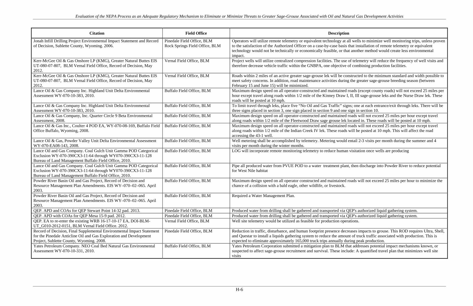
Evaluation of the NEPA Process as an Adequate Regulatory Mechanism to Eliminate or Minimize Threats to Greater Sage-Grouse Associated with Oil and Natural Gas Development Activities
H-6
Citation Field Office Description
Jonah Infill Drilling Project Environmental Impact Statement and Record of Decision, Sublette County, Wyoming. 2006.
Pinedale Field Office, BLM Rock Springs Field Office, BLM
Operators will utilize remote telemetry or equivalent technology at all wells to minimize well monitoring trips, unless proven to the satisfaction of the Authorized Officer on a case-by-case basis that installation of remote telemetry or equivalent technology would not be technically or economically feasible, or that another method would create less environmental impact.
Kerr-McGee Oil & Gas Onshore LP (KMG), Greater Natural Buttes EIS UT-080-07-807, BLM Vernal Field Office, Record of Decision, May 2012.
Vernal Field Office, BLM Project wells will utilize centralized compression facilities. The use of telemetry will reduce the frequency of well visits and therefore decrease vehicle traffic within the GNBPA, one objective of combining production facilities.
Kerr-McGee Oil & Gas Onshore LP (KMG), Greater Natural Buttes EIS UT-080-07-807, BLM Vernal Field Office, Record of Decision, May 2012.
Vernal Field Office, BLM Roads within 2 miles of an active greater sage-grouse lek will be constructed to the minimum standard and width possible to meet safety concerns. In addition, road maintenance activities during the greater sage-grouse breeding season (between February 15 and June 15) will be minimized.
Lance Oil & Gas Company Inc. Highland Unit Delta Environmental Assessment WY-070-10-383, 2010.
Buffalo Field Office, BLM Maximum design speed on all operator-constructed and maintained roads (except county roads) will not exceed 25 miles per hour except travel along roads within 1/2 mile of the Kinney Draw I, II, III sage-grouse leks and the Nurse Draw lek. These roads will be posted at 10 mph.
Lance Oil & Gas Company Inc. Highland Unit Delta Environmental Assessment WY-070-10-383, 2010.
Buffalo Field Office, BLM To limit travel through leks, place five “No Oil and Gas Traffic” signs; one at each entrance/exit through leks. There will be three signs placed in section 3, one sign placed in section 9 and one sign in section 10.
Lance Oil & Gas Company, Inc. Quarter Circle 9 Beta Environmental Assessment, 2008.
Buffalo Field Office, BLM Maximum design speed on all operator-constructed and maintained roads will not exceed 25 miles per hour except travel along roads within 1/2 mile of the Fleetwood Draw sage grouse lek located in. These roads will be posted at 10 mph.
Lance Oil & Gas Inc., Coulter 4 POD EA, WY-070-08-169, Buffalo Field Office Buffalo, Wyoming, 2008.
Buffalo Field Office, BLM Maximum design speed on all operator-constructed and maintained roads will not exceed 25 miles per hour except travel along roads within 1/2 mile of the Indian Creek IV lek. These roads will be posted at 10 mph. This will affect the road accessing the 43-1 well.
Lance Oil & Gas, Powder Valley Unit Delta Environmental Assessment WY-070-EA08-143, 2008.
Buffalo Field Office, BLM Well metering shall be accomplished by telemetry. Metering would entail 2-3 visits per month during the summer and 4 visits per month during the winter months.
Lance Oil and Gas Company. Coal Gulch Unit Gamma POD Categorical Exclusion WY-070-390CX3-11-64 through WY070-390CX3-11-128 Bureau of Land Management Buffalo Field Office, 2010.
Buffalo Field Office, BLM LOG will incorporate remote monitoring telemetry to reduce human visitation once wells are producing
Lance Oil and Gas Company. Coal Gulch Unit Gamma POD Categorical Exclusion WY-070-390CX3-11-64 through WY070-390CX3-11-128 Bureau of Land Management Buffalo Field Office, 2010.
Buffalo Field Office, BLM Pipe all produced water from PVUE POD to a water treatment plant, then discharge into Powder River to reduce potential for West Nile habitat
Powder River Basin Oil and Gas Project, Record of Decision and Resource Management Plan Amendments. EIS WY–070–02–065. April 2003.
Buffalo Field Office, BLM Maximum design speed on all operator constructed and maintained roads will not exceed 25 miles per hour to minimize the chance of a collision with a bald eagle, other wildlife, or livestock.
Powder River Basin Oil and Gas Project, Record of Decision and Resource Management Plan Amendments. EIS WY–070–02–065. April 2003.
Buffalo Field Office, BLM Required a Water Management Plan.
QEP. APD and COAs for QEP Stewart Point 14-32 pad. 2013. Pinedale Field Office, BLM Produced water from drilling shall be gathered and transported via QEP's authorized liquid gathering system. QEP. APD with COAs for QEP Mesa 15-9 pad. 2012. Pinedale Field Office, BLM Produced water from drilling shall be gathered and transported via QEP's authorized liquid gathering system. QEP. EA to re-enter the existing WRB 16-17-10-17 EA, DOI-BLM-UT_G010-2012-0151, BLM Vernal Field Office. 2012.
Vernal Field Office, BLM Well site telemetry would be utilized as feasible for production operations.
Record of Decision, Final Supplemental Environmental Impact Statement for the Pinedale Anticline Oil and Gas Exploration and Development Project, Sublette County, Wyoming. 2008.
Pinedale Field Office, BLM Reduction in traffic, disturbance, and human footprint presence decreases impacts to grouse. This ROD requires Ultra, Shell, and Questar to install a liquids gathering system to reduce the amount of truck traffic associated with production. This is expected to eliminate approximately 165,000 truck trips annually during peak production.
Yates Petroleum Company. NEO Coal Bed Natural Gas Environmental Assessment WY-070-10-331, 2010.
Buffalo Field Office, BLM Yates Petroleum Corporation submitted a mitigation plan to BLM that addresses potential impact mechanisms known, or suspected to affect sage-grouse recruitment and survival. These include: A quantified travel plan that minimizes well site visits

Evaluation of the NEPA Process as an Adequate Regulatory Mechanism to Eliminate or Minimize Threats to Greater Sage-Grouse Associated with Oil and Natural Gas Development Activities
H-7
Citation Field Office Description
Yates Petroleum Corporation, Gauge POD EA, WY-070-EA09-75, Buffalo Field Office, 2009.
Buffalo Field Office, BLM After the wells are complete, well metering, maintenance and other site visits will be limited to an average of 3 visits to each well location per week (up to 12 visits per well/month for the first six months). The company will be required to report frequency of site visits, after the wells are complete, along with repairs made and problems identified resulting from the visits. The company will submit these reports to BLM at the end of every month. The BLM will use site visit data in order to determine the necessary frequency of site visits.
Yates Petroleum Corporation, Gauge POD EA, WY-070-EA09-75, Buffalo Field Office, 2009.
Buffalo Field Office, BLM Roads within 1/2 mile of sage grouse leks will be posted (with signs shorter than four feet) by the operator at 10 mph during daylight hours between March1-June 15.
Yates Petroleum Corporation, Gauge POD EA, WY-070-EA09-75, Buffalo Field Office, 2009.
Buffalo Field Office, BLM Throughout production, human presence will be limited with the deployment of the most recent technology (For example, cameras and remote sensing )
Yates Petroleum Corporation. All Day POD. EA # WY-070-08-026 and COAs. Buffalo Field Office, Buffalo, Wyoming, 2008.
Buffalo Field Office, BLM Maximum design speed on all operator-constructed and maintained roads (except county roads) will not exceed 25 miles per hour except travel along roads within 1/2 mile of sage grouse leks will be posted (with signs shorter than four feet) by the operator at 10 mph during daylight hours between March1-June 15.
Yates Petroleum Corporation. All Day POD. EA # WY-070-08-026 and COAs. Buffalo Field Office, Buffalo, Wyoming, 2008.
Buffalo Field Office, BLM Well metering, maintenance and other site visits will be allowed monthly, 3 per week for the first six months after the wells are completed. The company will be required to monitor frequency of site visits along with repairs made and problems identified resulting from the visits. Reports containing results of this monitoring will be submitted to BLM at the end of every month. The BLM will use this data to determine the necessity of multiple monthly site visits during the sage-grouse breeding and nesting periods (March 1 to June 15).
Yates Petroleum Corporation. Lazurite POD Environmental Assessment WY-070-EA09-095, 2009.
Buffalo Field Office, BLM Maximum design speed on all operator-constructed and maintained roads (except county roads) will not exceed 25 miles per hour except travel along roads within 1/2 mile of any known leks.
Evaluation of the NEPA Process as an Adequate Regulatory Mechanism to Eliminate or Minimize Threats to Greater Sage-Grouse Associated with Oil and Natural Gas Development Activities
APPENDIX I Reduce Noise and Visual Impacts

Evaluation of the NEPA Process as an Adequate Regulatory Mechanism to Eliminate or Minimize Threats to Greater Sage-Grouse Associated with Oil and Natural Gas Development Activities
I-1
Table I-1. PECE Policy Evaluation – Reduce Noise and Visual Impacts
Conservation Measure Reduce Noise and Visual Impacts
Certainty of Implementation The conservation effort, the party(ies) to the agreement or plan that will implement the effort, and the staffing, funding level, funding source, and other resources necessary to implement the effort are identified.
The BLM/USFS decision records require implementation as a condition of the agency authorization. Funding and implementation is generally identified as the responsibility of the operator(s).
The legal authority of the party(ies) to the agreement or plan to implement the formalized conservation effort, and the commitment to proceed with the conservation effort are described.
NEPA provides the legal and statutory authority to implement the conservation measures and COAs included in the agency decision records.
The legal procedural requirements (e.g. environmental review) necessary to implement the effort are described, and information is provided indicating that fulfillment of these requirements does not preclude commitment to the effort.
NEPA is the legal procedural requirement necessary to implement COAs and conservation measures included in the agency decision records.
Authorizations (e.g., permits, landowner permission) necessary to implement the conservation effort are identified, and a high level of certainty is provided that the party(ies) to the agreement or plan that will implement the effort will obtain these authorizations.
The NEPA decision record provides the necessary authorization to implement the COAs and conservation measures. As the measures are conditions of the agency approval and are required for project completion, there is a high level of certainty that they will be implemented and authorized.
The type and level of voluntary participation (e.g., number of landowners allowing entry to their land, or number of participants agreeing to change timber management practices and acreage involved) necessary to implement the conservation effort is identified, and a high level of certainty is provided that the party(ies) to the agreement or plan that will implement the conservation effort will obtain that level of voluntary participation (e.g., an explanation of how incentives to be provided will result in the necessary level of voluntary participation).
Participation in the implementation of the COAs and conservation measures is mandatory as a condition of the agency approval under NEPA. NEPA authorizations exceed this evaluation criteria by making the measures mandatory.
Regulatory mechanisms (e.g., laws, regulations, ordinances) necessary to implement the conservation effort are in place.
NEPA provides the regulatory mechanism for implementation. Where necessary, other federal or state authorizations or permits might be required prior to implementation (i.e., Clean Water Act permits). There is reasonable certainty that these permits will be obtained for each measure or COA.
A high level of certainty is provided that the party(ies) to the agreement or plan that will implement the conservation effort will obtain the necessary funding.
The agency decision requires that funding for the COAs and conservation measures be provided as a condition of the project approval. There is certainty that each measure will be funded.

Evaluation of the NEPA Process as an Adequate Regulatory Mechanism to Eliminate or Minimize Threats to Greater Sage-Grouse Associated with Oil and Natural Gas Development Activities
I-2
Conservation Measure Reduce Noise and Visual Impacts
An implementation schedule (including incremental completion dates) for the conservation effort is provided.
Each NEPA document and associated decision record analyzes and describes the schedule for project implementation. As conditions of agency approvals, COAs and conservation measures must be completed during or prior to project completion.
The conservation agreement or plan that includes the conservation effort is approved by all parties to the agreement or plan.
As a condition of the agency approval of each project, there is agreement between the operators and the agency that each COA or conservation measure will be implemented as part of project activities.
Certainty of Effectiveness The nature and extent of threats being addressed by the conservation effort are described, and how the conservation effort reduces the threats is described.
Reduced noise and visual impact COAs and conservation measures address threats associated with Energy Development under Listing Factor A.
Explicit incremental objectives for the conservation effort and dates for achieving them are stated.
In many cases, specific decibel level thresholds are identified or desired.
The steps necessary to implement the conservation effort are identified in detail.
Steps are identified and include installing noise mufflers and shields, siting compressors and other facilities outside of given buffers around leks
Quantifiable, scientifically valid parameters that will demonstrate achievement of objectives, and standards for these parameters by which progress will be measured, are identified.
Parameters can be measured by decibels, with a typical goal not to exceed 49 decibels as provided by state wildlife agencies.
Provisions for monitoring and reporting progress on implementation (based on compliance with the implementation schedule) and effectiveness (based on evaluation of quantifiable parameters) of the conservation effort are provided.
Monitoring and adaptive management practices discussed in detail in the report provide examples of additional monitoring and reporting provisions.
Principles of adaptive management are incorporated.
Monitoring and adaptive management practices discussed in detail in the report provide examples of additional monitoring and reporting provisions.

Evaluation of the NEPA Process as an Adequate Regulatory Mechanism to Eliminate or Minimize Threats to Greater Sage-Grouse Associated with Oil and Natural Gas Development Activities
I-3
Figure I-1. Map of FOs where Reduce Noise and Visual Impacts COAs are applied.
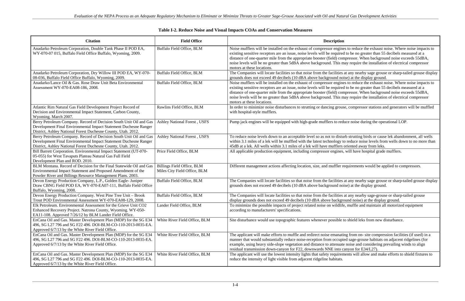
Evaluation of the NEPA Process as an Adequate Regulatory Mechanism to Eliminate or Minimize Threats to Greater Sage-Grouse Associated with Oil and Natural Gas Development Activities
I-4
Table I-2. Reduce Noise and Visual Impacts COAs and Conservation Measures
Citation Field Office Description
Anadarko Petroleum Corporation, Double Tank Phase II POD EA, WY-070-07 015, Buffalo Field Office Buffalo, Wyoming, 2009.
Buffalo Field Office, BLM Noise mufflers will be installed on the exhaust of compressor engines to reduce the exhaust noise. Where noise impacts to existing sensitive receptors are an issue, noise levels will be required to be no greater than 55 decibels measured at a distance of one-quarter mile from the appropriate booster (field) compressor. When background noise exceeds 55dBA, noise levels will be no greater than 5dBA above background. This may require the installation of electrical compressor motors at these locations.
Anadarko Petroleum Corporation, Dry Willow III POD EA, WY-070-08-036, Buffalo Field Office Buffalo, Wyoming, 2009.
Buffalo Field Office, BLM The Companies will locate facilities so that noise from the facilities at any nearby sage grouse or sharp-tailed grouse display grounds does not exceed 49 decibels (10 dBA above background noise) at the display ground.
Anadarko/Lance Oil & Gas. Rose Draw Unit Beta Environmental Assessment WY-070-EA08-186, 2008.
Buffalo Field Office, BLM Noise mufflers will be installed on the exhaust of compressor engines to reduce the exhaust noise. Where noise impacts to existing sensitive receptors are an issue, noise levels will be required to be no greater than 55 decibels measured at a distance of one-quarter mile from the appropriate booster (field) compressor. When background noise exceeds 55dBA, noise levels will be no greater than 5dBA above background. This may require the installation of electrical compressor motors at these locations.
Atlantic Rim Natural Gas Field Development Project Record of Decision and Environmental Impact Statement, Carbon County, Wyoming. March 2007.
Rawlins Field Office, BLM In order to minimize noise disturbances to strutting or dancing grouse, compressor stations and generators will be muffled with hospital-style mufflers.
Berry Petroleum Company. Record of Decision South Unit Oil and Gas Development Final Environmental Impact Statement Duchesne Ranger District, Ashley National Forest Duchesne County, Utah. 2012.
Ashley National Forest , USFS Pump jack engines will be equipped with high-grade mufflers to reduce noise during the operational LOP.
Berry Petroleum Company. Record of Decision South Unit Oil and Gas Development Final Environmental Impact Statement Duchesne Ranger District, Ashley National Forest Duchesne County, Utah. 2012.
Ashley National Forest , USFS To reduce noise levels down to an acceptable level so as not to disturb strutting birds or cause lek abandonment, all wells within 3.1 miles of a lek will be muffled with the latest technology to reduce noise levels from wells down to no more than 45dB at a lek. All wells within 3.1 miles of a lek will have mufflers oriented away from leks.
Bill Barrett Corporation. Environmental Impact Statement (UT-070-05-055) for West Tavaputs Plateau Natural Gas Full Field Development Plan and ROD. 2010.
Price Field Office, BLM All applicable production equipment, including compressor engines, will have hospital grade mufflers.
BLM Montana. Record of Decision for the Final Statewide Oil and Gas Environmental Impact Statement and Proposed Amendment of the Powder River and Billings Resource Management Plans. 2003.
Billings Field Office, BLM Miles City Field Office, BLM
Different management actions affecting location, size, and muffler requirements would be applied to compressors.
Devon Energy Production Company, L.P., Golden Eagle- Juniper Draw CBNG Field POD EA, WY-070-EA07-111, Buffalo Field Office Buffalo, Wyoming, 2008.
Buffalo Field Office, BLM The Companies will locate facilities so that noise from the facilities at any nearby sage grouse or sharp-tailed grouse display grounds does not exceed 49 decibels (10 dBA above background noise) at the display ground.
Devon Energy Production Company. West Pine Tree Unit – Brook Trout POD Environmental Assessment WY-070-EA08-129, 2008.
Buffalo Field Office, BLM The Companies will locate facilities so that noise from the facilities at any nearby sage-grouse or sharp-tailed grouse display grounds does not exceed 49 decibels (10 dBA above background noise) at the display ground.
Elk Petroleum. Environmental Assessment for the Grieve Unit CO2 Enhanced Recovery Project. Natrona County, Wyoming. WY-050-EA11-108. Approved 7/26/12 by BLM Lander Field Office.
Lander Field Office, BLM To minimize the possible impacts of project related noise on wildlife, muffle and maintain all motorized equipment according to manufacturers' specifications.
EnCana Oil and Gas. Master Development Plan (MDP) for the SG E34 496, SG L27 796 and SG F22 496. DOI-BLM-CO-110-2013-0035-EA. Approved 6/7/13 by the White River Field Office.
White River Field Office, BLM Site disturbance would use topographic features whenever possible to shield leks from new disturbance.
EnCana Oil and Gas. Master Development Plan (MDP) for the SG E34 496, SG L27 796 and SG F22 496. DOI-BLM-CO-110-2013-0035-EA. Approved 6/7/13 by the White River Field Office.
White River Field Office, BLM The applicant will make efforts to muffle and redirect noise emanating from on- site compression facilities (if used) in a manner that would substantially reduce noise-reception from occupied sage-grouse habitats on adjacent ridgelines (for example, using heavy side-slope vegetation and distance to attenuate noise and considering prevailing winds to align residual transmission down-canyon for F22, downwards NNE into canyon for E34/L27).
EnCana Oil and Gas. Master Development Plan (MDP) for the SG E34 496, SG L27 796 and SG F22 496. DOI-BLM-CO-110-2013-0035-EA. Approved 6/7/13 by the White River Field Office.
White River Field Office, BLM The applicant will use the lowest intensity lights that safety requirements will allow and make efforts to shield fixtures to reduce the intensity of light visible from adjacent ridgeline habitats.
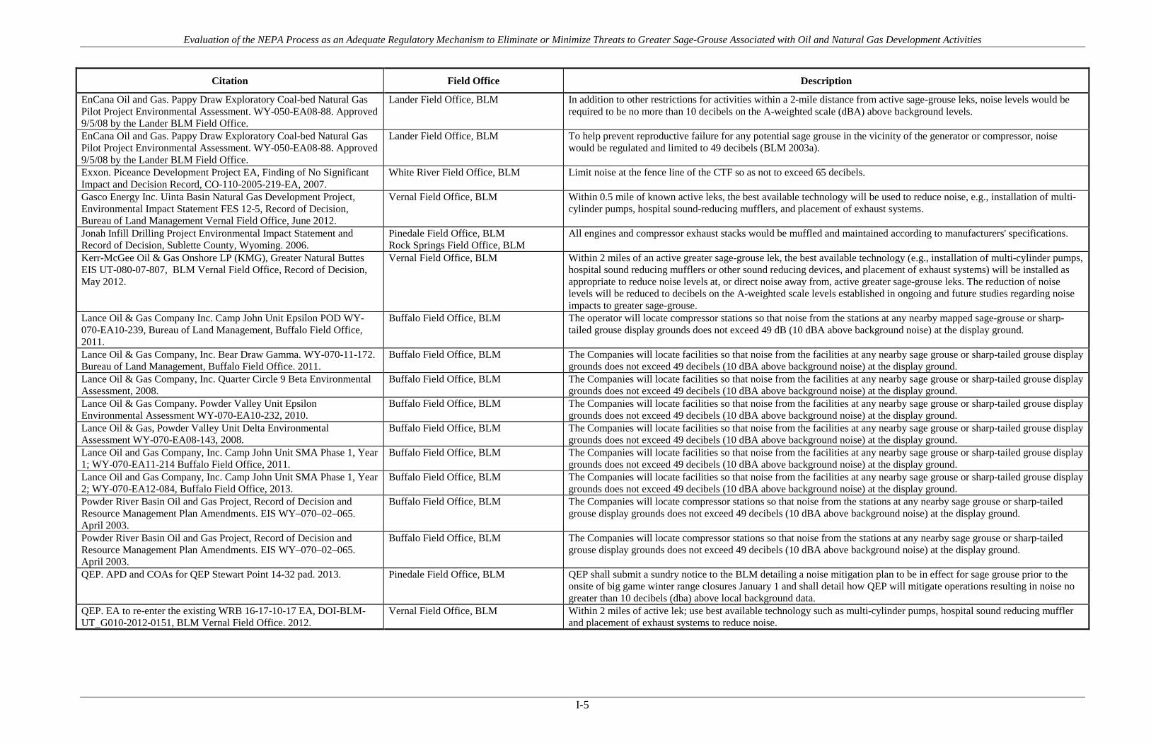
Evaluation of the NEPA Process as an Adequate Regulatory Mechanism to Eliminate or Minimize Threats to Greater Sage-Grouse Associated with Oil and Natural Gas Development Activities
I-5
Citation Field Office Description
EnCana Oil and Gas. Pappy Draw Exploratory Coal-bed Natural Gas Pilot Project Environmental Assessment. WY-050-EA08-88. Approved 9/5/08 by the Lander BLM Field Office.
Lander Field Office, BLM In addition to other restrictions for activities within a 2-mile distance from active sage-grouse leks, noise levels would be required to be no more than 10 decibels on the A-weighted scale (dBA) above background levels.
EnCana Oil and Gas. Pappy Draw Exploratory Coal-bed Natural Gas Pilot Project Environmental Assessment. WY-050-EA08-88. Approved 9/5/08 by the Lander BLM Field Office.
Lander Field Office, BLM To help prevent reproductive failure for any potential sage grouse in the vicinity of the generator or compressor, noise would be regulated and limited to 49 decibels (BLM 2003a).
Exxon. Piceance Development Project EA, Finding of No Significant Impact and Decision Record, CO-110-2005-219-EA, 2007.
White River Field Office, BLM Limit noise at the fence line of the CTF so as not to exceed 65 decibels.
Gasco Energy Inc. Uinta Basin Natural Gas Development Project, Environmental Impact Statement FES 12-5, Record of Decision, Bureau of Land Management Vernal Field Office, June 2012.
Vernal Field Office, BLM Within 0.5 mile of known active leks, the best available technology will be used to reduce noise, e.g., installation of multi-cylinder pumps, hospital sound-reducing mufflers, and placement of exhaust systems.
Jonah Infill Drilling Project Environmental Impact Statement and Record of Decision, Sublette County, Wyoming. 2006.
Pinedale Field Office, BLM Rock Springs Field Office, BLM
All engines and compressor exhaust stacks would be muffled and maintained according to manufacturers' specifications.
Kerr-McGee Oil & Gas Onshore LP (KMG), Greater Natural Buttes EIS UT-080-07-807, BLM Vernal Field Office, Record of Decision, May 2012.
Vernal Field Office, BLM Within 2 miles of an active greater sage-grouse lek, the best available technology (e.g., installation of multi-cylinder pumps, hospital sound reducing mufflers or other sound reducing devices, and placement of exhaust systems) will be installed as appropriate to reduce noise levels at, or direct noise away from, active greater sage-grouse leks. The reduction of noise levels will be reduced to decibels on the A-weighted scale levels established in ongoing and future studies regarding noise impacts to greater sage-grouse.
Lance Oil & Gas Company Inc. Camp John Unit Epsilon POD WY-070-EA10-239, Bureau of Land Management, Buffalo Field Office, 2011.
Buffalo Field Office, BLM The operator will locate compressor stations so that noise from the stations at any nearby mapped sage-grouse or sharp-tailed grouse display grounds does not exceed 49 dB (10 dBA above background noise) at the display ground.
Lance Oil & Gas Company, Inc. Bear Draw Gamma. WY-070-11-172. Bureau of Land Management, Buffalo Field Office. 2011.
Buffalo Field Office, BLM The Companies will locate facilities so that noise from the facilities at any nearby sage grouse or sharp-tailed grouse display grounds does not exceed 49 decibels (10 dBA above background noise) at the display ground.
Lance Oil & Gas Company, Inc. Quarter Circle 9 Beta Environmental Assessment, 2008.
Buffalo Field Office, BLM The Companies will locate facilities so that noise from the facilities at any nearby sage grouse or sharp-tailed grouse display grounds does not exceed 49 decibels (10 dBA above background noise) at the display ground.
Lance Oil & Gas Company. Powder Valley Unit Epsilon Environmental Assessment WY-070-EA10-232, 2010.
Buffalo Field Office, BLM The Companies will locate facilities so that noise from the facilities at any nearby sage grouse or sharp-tailed grouse display grounds does not exceed 49 decibels (10 dBA above background noise) at the display ground.
Lance Oil & Gas, Powder Valley Unit Delta Environmental Assessment WY-070-EA08-143, 2008.
Buffalo Field Office, BLM The Companies will locate facilities so that noise from the facilities at any nearby sage grouse or sharp-tailed grouse display grounds does not exceed 49 decibels (10 dBA above background noise) at the display ground.
Lance Oil and Gas Company, Inc. Camp John Unit SMA Phase 1, Year 1; WY-070-EA11-214 Buffalo Field Office, 2011.
Buffalo Field Office, BLM The Companies will locate facilities so that noise from the facilities at any nearby sage grouse or sharp-tailed grouse display grounds does not exceed 49 decibels (10 dBA above background noise) at the display ground.
Lance Oil and Gas Company, Inc. Camp John Unit SMA Phase 1, Year 2; WY-070-EA12-084, Buffalo Field Office, 2013.
Buffalo Field Office, BLM The Companies will locate facilities so that noise from the facilities at any nearby sage grouse or sharp-tailed grouse display grounds does not exceed 49 decibels (10 dBA above background noise) at the display ground.
Powder River Basin Oil and Gas Project, Record of Decision and Resource Management Plan Amendments. EIS WY–070–02–065. April 2003.
Buffalo Field Office, BLM The Companies will locate compressor stations so that noise from the stations at any nearby sage grouse or sharp-tailed grouse display grounds does not exceed 49 decibels (10 dBA above background noise) at the display ground.
QEP. APD and COAs for QEP Stewart Point 14-32 pad. 2013. Pinedale Field Office, BLM QEP shall submit a sundry notice to the BLM detailing a noise mitigation plan to be in effect for sage grouse prior to the onsite of big game winter range closures January 1 and shall detail how QEP will mitigate operations resulting in noise no greater than 10 decibels (dba) above local background data.
QEP. EA to re-enter the existing WRB 16-17-10-17 EA, DOI-BLM-UT_G010-2012-0151, BLM Vernal Field Office. 2012.
Vernal Field Office, BLM Within 2 miles of active lek; use best available technology such as multi-cylinder pumps, hospital sound reducing muffler and placement of exhaust systems to reduce noise.

Evaluation of the NEPA Process as an Adequate Regulatory Mechanism to Eliminate or Minimize Threats to Greater Sage-Grouse Associated with Oil and Natural Gas Development Activities
I-6
Citation Field Office Description
Record of Decision, Final Supplemental Environmental Impact Statement for the Pinedale Anticline Oil and Gas Exploration and Development Project, Sublette County, Wyoming. 2008.
Pinedale Field Office, BLM In selecting a site for a compressor facility, a well pad or other permanent facility, the distance from the edge of a an occupied greater sage-grouse lek will be sufficient to result in a noise level increase from operating facilities no greater than 10 decibels (dBA) above background (i.e., 39 dBA background + 10 dBA = 49 dBA). Further restrictions may be required if the species is determined by the USFWS to be eligible for listing as either threatened or endangered pursuant to the Endangered Species Act. Monitoring will be required by BLM to determine which leks in the PAPA are occupied and which have been abandoned.
Record of Decision, Final Supplemental Environmental Impact Statement for the Pinedale Anticline Oil and Gas Exploration and Development Project, Sublette County, Wyoming. 2008.
Pinedale Field Office, BLM Operators may be required to apply noise mitigation at well locations, as determined necessary by the BLM AO, on a case-by-case basis.
Record of Decision, Final Supplemental Environmental Impact Statement for the Pinedale Anticline Oil and Gas Exploration and Development Project, Sublette County, Wyoming. 2008.
Pinedale Field Office, BLM Table B.1 Standard 5: Decibel levels at the lek more than 10 dBA above background measured from the edge of the lek (2000 ROD, p.27), and a concurrent average of 30% decline in peak numbers of male birds over 2 years vs. reference area, additional mitigation responses are applied.
Record of Decision, Final Supplemental Environmental Impact Statement for the Pinedale Anticline Oil and Gas Exploration and Development Project, Sublette County, Wyoming. 2008.
Pinedale Field Office, BLM To avoid potentially significant noise impacts, compressor engines will be located 2,500 feet or more from a dwelling or residence and from sage-grouse leks.
Williams Production RMT Company, Cedar Draw Unit 2 POD, EA WY-070-07-137, Buffalo Field Office Buffalo, Wyoming, 2010.
Buffalo Field Office, BLM The Companies will locate facilities so that noise from the facilities at any nearby sage grouse or sharp-tailed grouse display grounds does not exceed 49 decibels (10 dBA above background noise) at the display ground.
Yates Petroleum Company. NEO Coal Bed Natural Gas Environmental Assessment WY-070-10-331, 2010.
Buffalo Field Office, BLM Noise from infrastructure within the POD is not to exceed 49 decibels (10 dBA above background noise) at any nearby sage grouse or sharp-tailed grouse display grounds. The Companies will locate compressor stations so that noise from the stations at any nearby sage grouse or sharp-tailed grouse display grounds does not exceed 49 decibels (10 dBA above background noise) at the display ground.
Yates Petroleum Corporation, Congaree POD EA, WY-070-10-195, Buffalo Field Office, 2010.
Buffalo Field Office, BLM The Companies will locate facilities so that noise from the facilities at any nearby sage grouse or sharp-tailed grouse display grounds does not exceed 49 decibels (10 dBA above background noise) at the display ground.
Yates Petroleum Corporation, Gauge POD EA, WY-070-EA09-75, Buffalo Field Office, 2009.
Buffalo Field Office, BLM The Companies will locate facilities so that noise from the facilities at any nearby sage grouse or sharp-tailed grouse display grounds does not exceed 49 decibels (10 dBA above background noise) at the display ground.
Yates Petroleum Corporation. All Day POD. EA # WY-070-08-026 and COAs. Buffalo Field Office Buffalo, Wyoming, 2008.
Buffalo Field Office, BLM The Companies will locate facilities so that noise from the facilities at any nearby sage grouse or sharp-tailed grouse display grounds does not exceed 49 decibels (10 dBA above background noise) at the display ground.
Yates Petroleum Corporation. Napier Road POD Environmental Assessment WY-070-EA10-280, 2010.
Buffalo Field Office, BLM The Companies will locate facilities so that noise from the facilities at any nearby sage grouse or sharp-tailed grouse display grounds does not exceed 49 decibels (10 dBA above background noise) at the display ground.

Evaluation of the NEPA Process as an Adequate Regulatory Mechanism to Eliminate or Minimize Threats to Greater Sage-Grouse Associated with Oil and Natural Gas Development Activities
APPENDIX J Reduce Perching Predators

Evaluation of the NEPA Process as an Adequate Regulatory Mechanism to Eliminate or Minimize Threats to Greater Sage-Grouse Associated with Oil and Natural Gas Development Activities
J-1
Table J-1. PECE Policy Evaluation – Reduce Perching Predators
Conservation Measure Reduce Perching Predators
Certainty of Implementation The conservation effort, the party(ies) to the agreement or plan that will implement the effort, and the staffing, funding level, funding source, and other resources necessary to implement the effort are identified.
The BLM/USFS decision records require implementation as a condition of the agency authorization. Funding and implementation is generally identified as the responsibility of the operator(s).
The legal authority of the party(ies) to the agreement or plan to implement the formalized conservation effort, and the commitment to proceed with the conservation effort are described.
NEPA provides the legal and statutory authority to implement the conservation measures and COAs included in the agency decision records.
The legal procedural requirements (e.g. environmental review) necessary to implement the effort are described, and information is provided indicating that fulfillment of these requirements does not preclude commitment to the effort.
NEPA is the legal procedural requirement necessary to implement COAs and conservation measures included in the agency decision records.
Authorizations (e.g., permits, landowner permission) necessary to implement the conservation effort are identified, and a high level of certainty is provided that the party(ies) to the agreement or plan that will implement the effort will obtain these authorizations.
The NEPA decision record provides the necessary authorization to implement the COAs and conservation measures. As the measures are conditions of the agency approval and are required for project completion, there is a high level of certainty that they will be implemented and authorized.
The type and level of voluntary participation (e.g., number of landowners allowing entry to their land, or number of participants agreeing to change timber management practices and acreage involved) necessary to implement the conservation effort is identified, and a high level of certainty is provided that the party(ies) to the agreement or plan that will implement the conservation effort will obtain that level of voluntary participation (e.g., an explanation of how incentives to be provided will result in the necessary level of voluntary participation).
Participation in the implementation of the COAs and conservation measures is mandatory as a condition of the agency approval under NEPA. NEPA authorizations exceed this evaluation criteria by making the measures mandatory.
Regulatory mechanisms (e.g., laws, regulations, ordinances) necessary to implement the conservation effort are in place.
NEPA provides the regulatory mechanism for implementation. Where necessary, other federal or state authorizations or permits might be required prior to implementation (i.e., Clean Water Act permits). There is reasonable certainty that these permits will be obtained for each measure or COA.

Evaluation of the NEPA Process as an Adequate Regulatory Mechanism to Eliminate or Minimize Threats to Greater Sage-Grouse Associated with Oil and Natural Gas Development Activities
J-2
Conservation Measure Reduce Perching Predators
A high level of certainty is provided that the party(ies) to the agreement or plan that will implement the conservation effort will obtain the necessary funding.
The agency decision requires that funding for the COAs and conservation measures be provided as a condition of the project approval. There is certainty that each measure will be funded.
An implementation schedule (including incremental completion dates) for the conservation effort is provided.
Each NEPA document and associated decision record analyzes and describes the schedule for project implementation. As conditions of agency approvals, COAs and conservation measures must be completed during or prior to project completion.
The conservation agreement or plan that includes the conservation effort is approved by all parties to the agreement or plan.
As a condition of the agency approval of each project, there is agreement between the operators and the agency that each COA or conservation measure will be implemented as part of project activities.
Certainty of Effectiveness The nature and extent of threats being addressed by the conservation effort are described, and how the conservation effort reduces the threats is described.
COAs and conservation measures that reduce perching predators address threats associated with Energy Development and Infrastructure under Listing Factor A; and Predation under Factor C.
Explicit incremental objectives for the conservation effort and dates for achieving them are stated.
NEPA processes generally identify dates and times for implementation of all measures and COAs.
The steps necessary to implement the conservation effort are identified in detail.
COAs and conservation measures to reduce predation potential are generally known and include anti-perching devices and other methods or technologies. Steps to implement these measures are well documented and presented in publications and other industry information including materials prepared by the Avian Power Line Interaction Committee.
Quantifiable, scientifically valid parameters that will demonstrate achievement of objectives, and standards for these parameters by which progress will be measured, are identified.
Measures lend themselves to before-after comparisons to evaluate success of the measure as measured by decreased perching or use by potential predators.
Provisions for monitoring and reporting progress on implementation (based on compliance with the implementation schedule) and effectiveness (based on evaluation of quantifiable parameters) of the conservation effort are provided.
Monitoring and adaptive management practices discussed in detail in the report provide examples of additional monitoring and reporting provisions.
Principles of adaptive management are incorporated.
Monitoring and adaptive management practices discussed in detail in the report provide examples of additional monitoring and reporting provisions.

Evaluation of the NEPA Process as an Adequate Regulatory Mechanism to Eliminate or Minimize Threats to Greater Sage-Grouse Associated with Oil and Natural Gas Development Activities
J-3
Figure J-1. Map of FOs where Reduce Perching Predators COAs are applied.

Evaluation of the NEPA Process as an Adequate Regulatory Mechanism to Eliminate or Minimize Threats to Greater Sage-Grouse Associated with Oil and Natural Gas Development Activities
J-4
Table J-2. Reduce Perching Predators COAs and Conservation Measures
Citation Field Office Description
Atlantic Rim Natural Gas Field Development Project Record of Decision and Environmental Impact Statement, Carbon County, Wyoming. March 2007.
Rawlins Field Office, BLM Surface disturbance and other actions that create permanent and high-profile structures, such as buildings, storage tanks, and overhead power lines, will not be constructed within 0.25 to 1.0 mile of the perimeter of leks, as determined on a case-by-case basis.
Atlantic Rim Natural Gas Field Development Project Record of Decision and Environmental Impact Statement, Carbon County, Wyoming. March 2007.
Rawlins Field Office, BLM These Best Management Practices (BMPs) will be applied under all alternatives as Conditions of Approval where proposals conflict with identified resources. 6) Burying of power lines to avoid use of poles and other tall structures…
Berry Petroleum Company. Record of Decision South Unit Oil and Gas Development Final Environmental Impact Statement Duchesne Ranger District, Ashley National Forest Duchesne County, Utah. 2012.
Ashley National Forest , USFS Raptor perch avoidance devices will be installed on existing and proposed power poles and tank batteries to reduce potential predation where sage-grouse concerns exist.
Berry Petroleum Company. Record of Decision South Unit Oil and Gas Development Final Environmental Impact Statement Duchesne Ranger District, Ashley National Forest Duchesne County, Utah. 2012.
Ashley National Forest , USFS To reduce the vantage point that raptors might have by perching on new structures, low-profile tanks will be required for all well pads within sage-grouse habitat.
BLM Montana. Record of Decision for the Final Statewide Oil and Gas Environmental Impact Statement and Proposed Amendment of the Powder River and Billings Resource Management Plans. 2003.
Billings Field Office, BLM Miles City Field Office, BLM
Lines should avoid high avian use areas such as wetlands, prairie dog towns, and grouse leks. If not avoidable, use anti-perching devices to discourage perching in sensitive habitats such as grouse leks, prairie dog towns and wetlands to decrease predation and decrease loss of avian predators to electrocution.
BLM Montana. Record of Decision for the Final Statewide Oil and Gas Environmental Impact Statement and Proposed Amendment of the Powder River and Billings Resource Management Plans. 2003.
Billings Field Office, BLM Miles City Field Office, BLM
Minimize the number of new power lines in sage grouse or mountain plover habitat. Bury lines near sage grouse leks and mountain plover nesting habitat when feasible.
Chevron. Table Rock Unit Oil and Gas Development EA and DR. WY-040-EA11-175. January 2012.
Rawlins Field Office, BLM Rock Springs Field Office, BLM
To minimize raptor perching and nesting, BLM approved raptor deterring devices would be installed on horizontal cross bars.
Chevron. Table Rock Unit Oil and Gas Development EA and DR. WY-040-EA11-175. January 2012.
Rawlins Field Office, BLM Rock Springs Field Office, BLM
WAR-1 New power lines within 2 miles of an occupied greater sage-grouse lek will either be buried or outfitted with raptor anti-perching devices based on guidance from the BLM wildlife biologist during the APD process. If burying new power lines is not feasible, new power line segments would be designed and constructed in accordance with applicable guidelines to minimize raptor perching, nesting, electrocution, and collision potential.
Cimarex. Rands Butte Gas Development Project Final Environmental Assessment, Decision Record and Finding of No Significant Impact, WY-100-EA09-43. 2010.
Pinedale Field Office, BLM Power poles within the ½ -mile visual buffer around the lek near the center of the southwest quarter of Section 13, T29N, R114W, shall not extend higher than 80 feet above natural ground level.
Cimarex. Rands Butte Gas Development Project Final Environmental Assessment, Decision Record and Finding of No Significant Impact, WY-100-EA09-43. 2010.
Pinedale Field Office, BLM The power line shall be relocated from the ridgeline in the north half of Section 14, T29N, R114W south approximately 900 feet to the north side of the of the road/two-track traverse the Spring Creek drainage.
Devon Energy Production Company, L.P., Golden Eagle- Juniper Draw CBNG Field POD EA, WY-070-EA07-111, Buffalo Field Office Buffalo, Wyoming, 2008.
Buffalo Field Office, BLM Creation of raptor hunting perches will be avoided within 0.5-mile of documented sage-grouse lek sites. Perch inhibitors will be installed to deter avian predators from preying on sage grouse.
Devon Energy Production Company. West Pine Tree Unit – Brook Trout POD Environmental Assessment WY-070-EA08-129, 2008.
Buffalo Field Office, BLM Raptor perch inhibitors will be installed along powerlines that are adjacent to areas with documented sage-grouse use.
Devon Energy Production Company. West Pine Tree Unit – Brook Trout POD Environmental Assessment WY-070-EA08-129, 2008.
Buffalo Field Office, BLM The Companies will locate aboveground power lines, where practical, at least 0.5 mile from any sage-grouse breeding or nesting grounds to prevent raptor predation and sage-grouse collision with the conductors. Power poles within 0.5 mile of any sage-grouse breeding ground will be raptor-proofed to prevent raptors from perching on the poles.
Elk Petroleum. Environmental Assessment for the Grieve Unit CO2 Enhanced Recovery Project. Natrona County, Wyoming. WY-050-EA11-108. Approved 7/26/12 by BLM Lander Field Office.
Lander Field Office, BLM Anti-perching devices will be required on all above ground power structures, including the 230 kV power line, associated with the proposed action.
Elk Petroleum. Environmental Assessment for the Grieve Unit CO2 Enhanced Recovery Project. Natrona County, Wyoming. WY-050-EA11-108. Approved 7/26/12 by BLM Lander Field Office.
Lander Field Office, BLM The 25 kV electric distribution line to the Meter Station, and any enlargement of service in the field, will be installed underground to minimize disruptions to sage-grouse Core habitat areas.
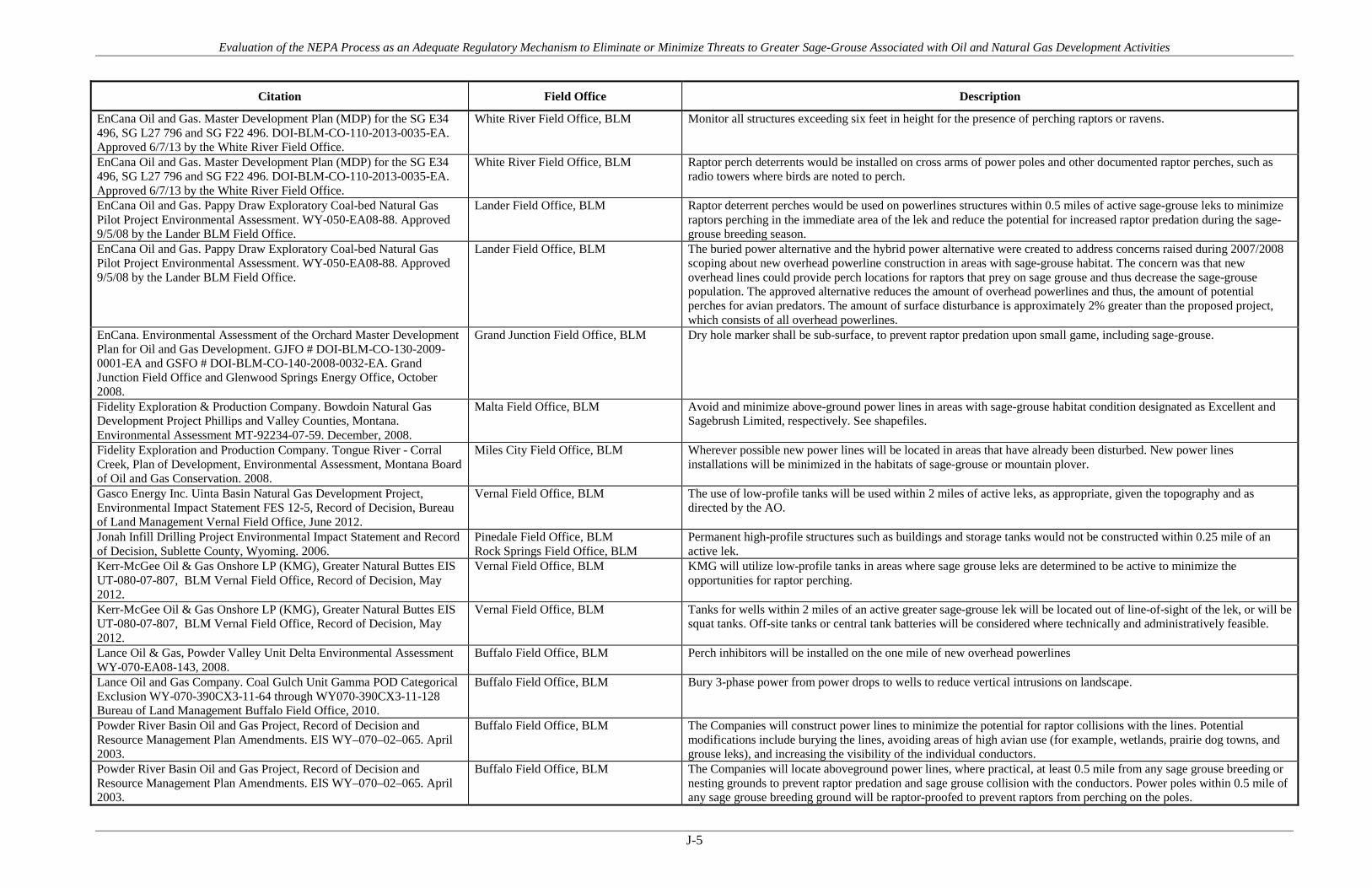
Evaluation of the NEPA Process as an Adequate Regulatory Mechanism to Eliminate or Minimize Threats to Greater Sage-Grouse Associated with Oil and Natural Gas Development Activities
J-5
Citation Field Office Description
EnCana Oil and Gas. Master Development Plan (MDP) for the SG E34 496, SG L27 796 and SG F22 496. DOI-BLM-CO-110-2013-0035-EA. Approved 6/7/13 by the White River Field Office.
White River Field Office, BLM Monitor all structures exceeding six feet in height for the presence of perching raptors or ravens.
EnCana Oil and Gas. Master Development Plan (MDP) for the SG E34 496, SG L27 796 and SG F22 496. DOI-BLM-CO-110-2013-0035-EA. Approved 6/7/13 by the White River Field Office.
White River Field Office, BLM Raptor perch deterrents would be installed on cross arms of power poles and other documented raptor perches, such as radio towers where birds are noted to perch.
EnCana Oil and Gas. Pappy Draw Exploratory Coal-bed Natural Gas Pilot Project Environmental Assessment. WY-050-EA08-88. Approved 9/5/08 by the Lander BLM Field Office.
Lander Field Office, BLM Raptor deterrent perches would be used on powerlines structures within 0.5 miles of active sage-grouse leks to minimize raptors perching in the immediate area of the lek and reduce the potential for increased raptor predation during the sage-grouse breeding season.
EnCana Oil and Gas. Pappy Draw Exploratory Coal-bed Natural Gas Pilot Project Environmental Assessment. WY-050-EA08-88. Approved 9/5/08 by the Lander BLM Field Office.
Lander Field Office, BLM The buried power alternative and the hybrid power alternative were created to address concerns raised during 2007/2008 scoping about new overhead powerline construction in areas with sage-grouse habitat. The concern was that new overhead lines could provide perch locations for raptors that prey on sage grouse and thus decrease the sage-grouse population. The approved alternative reduces the amount of overhead powerlines and thus, the amount of potential perches for avian predators. The amount of surface disturbance is approximately 2% greater than the proposed project, which consists of all overhead powerlines.
EnCana. Environmental Assessment of the Orchard Master Development Plan for Oil and Gas Development. GJFO # DOI-BLM-CO-130-2009-0001-EA and GSFO # DOI-BLM-CO-140-2008-0032-EA. Grand Junction Field Office and Glenwood Springs Energy Office, October 2008.
Grand Junction Field Office, BLM Dry hole marker shall be sub-surface, to prevent raptor predation upon small game, including sage-grouse.
Fidelity Exploration & Production Company. Bowdoin Natural Gas Development Project Phillips and Valley Counties, Montana. Environmental Assessment MT-92234-07-59. December, 2008.
Malta Field Office, BLM Avoid and minimize above-ground power lines in areas with sage-grouse habitat condition designated as Excellent and Sagebrush Limited, respectively. See shapefiles.
Fidelity Exploration and Production Company. Tongue River - Corral Creek, Plan of Development, Environmental Assessment, Montana Board of Oil and Gas Conservation. 2008.
Miles City Field Office, BLM Wherever possible new power lines will be located in areas that have already been disturbed. New power lines installations will be minimized in the habitats of sage-grouse or mountain plover.
Gasco Energy Inc. Uinta Basin Natural Gas Development Project, Environmental Impact Statement FES 12-5, Record of Decision, Bureau of Land Management Vernal Field Office, June 2012.
Vernal Field Office, BLM The use of low-profile tanks will be used within 2 miles of active leks, as appropriate, given the topography and as directed by the AO.
Jonah Infill Drilling Project Environmental Impact Statement and Record of Decision, Sublette County, Wyoming. 2006.
Pinedale Field Office, BLM Rock Springs Field Office, BLM
Permanent high-profile structures such as buildings and storage tanks would not be constructed within 0.25 mile of an active lek.
Kerr-McGee Oil & Gas Onshore LP (KMG), Greater Natural Buttes EIS UT-080-07-807, BLM Vernal Field Office, Record of Decision, May 2012.
Vernal Field Office, BLM KMG will utilize low-profile tanks in areas where sage grouse leks are determined to be active to minimize the opportunities for raptor perching.
Kerr-McGee Oil & Gas Onshore LP (KMG), Greater Natural Buttes EIS UT-080-07-807, BLM Vernal Field Office, Record of Decision, May 2012.
Vernal Field Office, BLM Tanks for wells within 2 miles of an active greater sage-grouse lek will be located out of line-of-sight of the lek, or will be squat tanks. Off-site tanks or central tank batteries will be considered where technically and administratively feasible.
Lance Oil & Gas, Powder Valley Unit Delta Environmental Assessment WY-070-EA08-143, 2008.
Buffalo Field Office, BLM Perch inhibitors will be installed on the one mile of new overhead powerlines
Lance Oil and Gas Company. Coal Gulch Unit Gamma POD Categorical Exclusion WY-070-390CX3-11-64 through WY070-390CX3-11-128 Bureau of Land Management Buffalo Field Office, 2010.
Buffalo Field Office, BLM Bury 3-phase power from power drops to wells to reduce vertical intrusions on landscape.
Powder River Basin Oil and Gas Project, Record of Decision and Resource Management Plan Amendments. EIS WY–070–02–065. April 2003.
Buffalo Field Office, BLM The Companies will construct power lines to minimize the potential for raptor collisions with the lines. Potential modifications include burying the lines, avoiding areas of high avian use (for example, wetlands, prairie dog towns, and grouse leks), and increasing the visibility of the individual conductors.
Powder River Basin Oil and Gas Project, Record of Decision and Resource Management Plan Amendments. EIS WY–070–02–065. April 2003.
Buffalo Field Office, BLM The Companies will locate aboveground power lines, where practical, at least 0.5 mile from any sage grouse breeding or nesting grounds to prevent raptor predation and sage grouse collision with the conductors. Power poles within 0.5 mile of any sage grouse breeding ground will be raptor-proofed to prevent raptors from perching on the poles.

Evaluation of the NEPA Process as an Adequate Regulatory Mechanism to Eliminate or Minimize Threats to Greater Sage-Grouse Associated with Oil and Natural Gas Development Activities
J-6
Citation Field Office Description
QEP. Greater Deadman Bench Oil and Gas Producing Region EIS and ROD March 2008. UT 080-2003-0369V. BLM Vernal Field Office. 2008.
Vernal Field Office, BLM As directed by the AO, QEP would place raptor perch guards on power line poles in areas near sensitive wildlife habitat areas such as sage grouse leks and prairie doe towns.
QEP. Greater Deadman Bench Oil and Gas Producing Region EIS and ROD March 2008. UT 080-2003-0369V. BLM Vernal Field Office. 2008.
Vernal Field Office, BLM No powerlines or electrical transmission lines will be constructed that would provide perch sites for raptors within 2 miles of sage grouse habitat.
Record of Decision, Final Supplemental Environmental Impact Statement for the Pinedale Anticline Oil and Gas Exploration and Development Project, Sublette County, Wyoming. 2008.
Pinedale Field Office, BLM Permanent (life of the project), high profile structures such as buildings and storage tanks will not be constructed within 0.25 mile of an occupied greater sage-grouse lek.
Williams Production RMT Company, Cedar Draw Unit 2 POD, EA WY-070-07-137, Buffalo Field Office Buffalo, Wyoming, 2010.
Buffalo Field Office, BLM The Companies will locate aboveground power lines, where practical, at least 0.5 mile from any sage grouse breeding or nesting grounds to prevent raptor predation and sage grouse collision with the conductors. Creation of raptor hunting perches will be avoided within 0.5-mile of documented sage grouse lek sites. Perch inhibitors will be installed to deter avian predators from preying on sage grouse.
Yates Petroleum and Pinnacle Gas Resources. Luman Rim Natural Gas Development EA and DR. WYW128688. WY-040-EA10-139. December 2010.
Rock Springs Field Office, BLM Construction of structures that could be used for raptor perches would be avoided or designed to prevent raptor perching. Exceptions may be granted if the activity would occur in unsuitable sage-grouse nesting habitat.
Yates Petroleum Company. NEO Coal Bed Natural Gas Environmental Assessment WY-070-10-331, 2010.
Buffalo Field Office, BLM Yates Petroleum Corporation submitted a mitigation plan to BLM that addresses potential impact mechanisms known, or suspected to affect sage-grouse recruitment and survival. These include: Burying power
Yates Petroleum Corporation, Congaree POD EA, WY-070-10-195, Buffalo Field Office, 2010.
Buffalo Field Office, BLM All new overhead power structures will be equipped with raptor perch deterrent devices.
Yates Petroleum Corporation, Gauge POD EA, WY-070-EA09-75, Buffalo Field Office, 2009.
Buffalo Field Office, BLM All proposed power that will service the Federal action in the Gauge POD will be buried.
Yates Petroleum Corporation, Gauge POD EA, WY-070-EA09-75, Buffalo Field Office, 2009.
Buffalo Field Office, BLM The Companies will construct power lines to minimize the potential for raptor collisions with the lines. Potential modifications include burying the lines, avoiding areas of high avian use (for example, wetlands, prairie dog towns, and grouse leks), and increasing the visibility of the individual conductors.
Yates Petroleum Corporation. Lazurite POD Environmental Assessment WY-070-EA09-095, 2009.
Buffalo Field Office, BLM All proposed power will be buried in the approved corridor.
Evaluation of the NEPA Process as an Adequate Regulatory Mechanism to Eliminate or Minimize Threats to Greater Sage-Grouse Associated with Oil and Natural Gas Development Activities
APPENDIX K Produced Water Management

Evaluation of the NEPA Process as an Adequate Regulatory Mechanism to Eliminate or Minimize Threats to Greater Sage-Grouse Associated with Oil and Natural Gas Development Activities
K-1
Table K-1. PECE Policy Evaluation – Produced Water Management
Conservation Measure Produced Water Management
Certainty of Implementation The conservation effort, the party(ies) to the agreement or plan that will implement the effort, and the staffing, funding level, funding source, and other resources necessary to implement the effort are identified.
The BLM/USFS decision records require implementation as a condition of the agency authorization. Funding and implementation is generally identified as the responsibility of the operator(s).
The legal authority of the party(ies) to the agreement or plan to implement the formalized conservation effort, and the commitment to proceed with the conservation effort are described.
NEPA provides the legal and statutory authority to implement the conservation measures and COAs included in the agency decision records.
The legal procedural requirements (e.g. environmental review) necessary to implement the effort are described, and information is provided indicating that fulfillment of these requirements does not preclude commitment to the effort.
NEPA is the legal procedural requirement necessary to implement COAs and conservation measures included in the agency decision records.
Authorizations (e.g., permits, landowner permission) necessary to implement the conservation effort are identified, and a high level of certainty is provided that the party(ies) to the agreement or plan that will implement the effort will obtain these authorizations.
The NEPA decision record provides the necessary authorization to implement the COAs and conservation measures. As the measures are conditions of the agency approval and are required for project completion, there is a high level of certainty that they will be implemented and authorized.
The type and level of voluntary participation (e.g., number of landowners allowing entry to their land, or number of participants agreeing to change timber management practices and acreage involved) necessary to implement the conservation effort is identified, and a high level of certainty is provided that the party(ies) to the agreement or plan that will implement the conservation effort will obtain that level of voluntary participation (e.g., an explanation of how incentives to be provided will result in the necessary level of voluntary participation).
Participation in the implementation of the COAs and conservation measures is mandatory as a condition of the agency approval under NEPA. NEPA authorizations exceed this evaluation criteria by making the measures mandatory.
Regulatory mechanisms (e.g., laws, regulations, ordinances) necessary to implement the conservation effort are in place.
NEPA provides the regulatory mechanism for implementation. Where necessary, other federal or state authorizations or permits might be required prior to implementation (i.e., Clean Water Act permits). There is reasonable certainty that these permits will be obtained for each measure or COA.
A high level of certainty is provided that the party(ies) to the agreement or plan that will implement the conservation effort will obtain the necessary funding.
The agency decision requires that funding for the COAs and conservation measures be provided as a condition of the project approval. There is certainty that each measure will be funded.

Evaluation of the NEPA Process as an Adequate Regulatory Mechanism to Eliminate or Minimize Threats to Greater Sage-Grouse Associated with Oil and Natural Gas Development Activities
K-2
Conservation Measure Produced Water Management
An implementation schedule (including incremental completion dates) for the conservation effort is provided.
Each NEPA document and associated decision record analyzes and describes the schedule for project implementation. As conditions of agency approvals, COAs and conservation measures must be completed during or prior to project completion.
The conservation agreement or plan that includes the conservation effort is approved by all parties to the agreement or plan.
As a condition of the agency approval of each project, there is agreement between the operators and the agency that each COA or conservation measure will be implemented as part of project activities.
Certainty of Effectiveness The nature and extent of threats being addressed by the conservation effort are described, and how the conservation effort reduces the threats is described.
Produced water management COAs and conservation measures address threats associated with Energy Development under Listing Factor A; Disease under Factor C; and Contamination under Factor E.
Explicit incremental objectives for the conservation effort and dates for achieving them are stated.
Many documents prohibit or discourage disposal or storage on the surface.
The steps necessary to implement the conservation effort are identified in detail.
Steps are identified and include installing closed-loop drilling systems, screening water pits and using mosquito control methods.
Quantifiable, scientifically valid parameters that will demonstrate achievement of objectives, and standards for these parameters by which progress will be measured, are identified.
The spread and distribution of West Nile Virus including around oil and gas fields can be measured. Decreases in water storage or disposal to the surface are tracked under many of the NEPA documents or by each state's water management agencies.
Provisions for monitoring and reporting progress on implementation (based on compliance with the implementation schedule) and effectiveness (based on evaluation of quantifiable parameters) of the conservation effort are provided.
Annual lek counts are tracked by state game and fish agencies and federal land management agencies for purposes of evaluating grouse populations and health. State game and fish agencies commonly track the spread and distribution of West Nile Virus including around oil and gas fields. Monitoring and adaptive management practices discussed in detail in the report provide examples of additional monitoring and reporting provisions.
Principles of adaptive management are incorporated.
Monitoring and adaptive management practices discussed in detail in the report provide examples of additional monitoring and reporting provisions.

Evaluation of the NEPA Process as an Adequate Regulatory Mechanism to Eliminate or Minimize Threats to Greater Sage-Grouse Associated with Oil and Natural Gas Development Activities
K-3
Figure K-1. Map of FOs where Produced Water Management COAs are applied.

Evaluation of the NEPA Process as an Adequate Regulatory Mechanism to Eliminate or Minimize Threats to Greater Sage-Grouse Associated with Oil and Natural Gas Development Activities
K-4
Table K-2. Produced Water Management COAs and Conservation Measures
Citation Field Office Description
Anadarko Petroleum Corporation, Double Tank Phase II POD EA, WY-070-07 015, Buffalo Field Office Buffalo, Wyoming, 2009.
Buffalo Field Office, BLM All stock tanks shall include a ramp to enable trapped small birds and mammals to escape. See Idaho BLM Technical Bulletin 89-4 entitled Wildlife Watering and Escape Ramps on Livestock Water Developments: Suggestions and Recommendations.
Anadarko Petroleum Corporation, Dry Willow Phase V POD EA, WY-070-10-186, Buffalo Field Office, 2010.
Buffalo Field Office, BLM Local control of mosquitoes may keep a viral outbreak from impacting local sage-grouse populations. Anadarko will monitor mosquito vectors and treat the SDI fields if the mosquito population warrants treatment.
Anadarko. Environmental Assessment for Jack Sparrow POD. WY-030-08-EA-238. 2008.
Rawlins Field Office, BLM Use of injection wells reduces surface water.
Berry Petroleum Company. Record of Decision South Unit Oil and Gas Development Final Environmental Impact Statement Duchesne Ranger District, Ashley National Forest Duchesne County, Utah. 2012.
Ashley National Forest , USFS Use closed loop drilling to eliminate the need for reserve pits, reduce closure and waste management costs, and reduce potential for contamination from leaking.
Bill Barrett Corporation. Environmental Impact Statement (UT-070-05-055) for West Tavaputs Plateau Natural Gas Full Field Development Plan and ROD. 2010.
Price Field Office, BLM Closed-loop drilling will be used in sensitive areas such as locations proposed within or near 100-year floodplains or drainages, cultural resources or archaeological sites, and within important wildlife habitats. The designation of a proposed location as a sensitive location requiring closed-loop drilling will be determined on a site-specific basis during the APD process
BLM Montana. Record of Decision for the Final Statewide Oil and Gas Environmental Impact Statement and Proposed Amendment of the Powder River and Billings Resource Management Plans. 2003.
Billings Field Office, BLM Miles City Field Office, BLM
Any avian mortality observed in pits will be documented, reported to the BLM and USFWS, and measures will be taken to prevent future mortality at the pit(s).
BLM Montana. Record of Decision for the Final Statewide Oil and Gas Environmental Impact Statement and Proposed Amendment of the Powder River and Billings Resource Management Plans. 2003.
Billings Field Office, BLM Miles City Field Office, BLM
Design and manage produced water storage impoundments so as not to degrade or inundate sage grouse leks, nesting sites and wintering sites, prairie dog towns or other Special Status Species habitats.
BLM Montana. Record of Decision for the Final Statewide Oil and Gas Environmental Impact Statement and Proposed Amendment of the Powder River and Billings Resource Management Plans. 2003.
Billings Field Office, BLM Miles City Field Office, BLM
Protected reserve, workover, and production pits potentially hazardous to wildlife by netting and/or fencing as directed by the BLM to prevent wildlife access and minimize the potential for migratory bird mortality.
Devon Energy Production Company, L.P., Golden Eagle- Juniper Draw CBNG Field POD EA, WY-070-EA07-111, Buffalo Field Office Buffalo, Wyoming, 2008.
Buffalo Field Office, BLM All stock tanks shall include a ramp to enable trapped small birds and mammals to escape. See Idaho BLM Technical Bulletin 89-4 entitled Wildlife Watering and Escape Ramps on Livestock Water Developments: Suggestions and Recommendations.
Devon Energy Production Company. West Pine Tree Unit – Brook Trout POD Environmental Assessment WY-070-EA08-129, 2008.
Buffalo Field Office, BLM All stock tanks shall include a ramp to enable trapped small birds and mammals to escape.
EnCana Oil and Gas. APDs- N22-496 (16)& P28-496 (16). DOI-BLM-CO-110-2011-0006-EA. White River Field Office. Approved 5/24/11 by White River Field Office.
White River Field Office, BLM Drilling fluids including salts and chemicals will be contained in a closed loop system. When drilling on a location is finished, the fluids are dewatered and transferred by truck to another location.
EnCana Oil and Gas. Master Development Plan for the SG E34 496, SG L796 and SG F22 496, Environmental Assessment and Decision Record, DOI-BLM-CO-2013-0035-EA, 2013.
White River Field Office, BLM Appropriate fencing and netting on temporary fluid pits for the purpose of excluding wildlife.
EnCana Oil and Gas. Master Development Plan for the SG E34 496, SG L796 and SG F22 496, Environmental Assessment and Decision Record, DOI-BLM-CO-2013-0035-EA, 2013.
White River Field Office, BLM When water quality may allow the propagation of mosquitoes, then fresh water storage pits would be treated with biological mosquito controls (from June through September).
Environmental Assessment for East Converse Exploratory Oil and Gas Development Project. WY-060-EA12-227. Approved 11/20/12 by BLM Casper Field Office.
Casper Field Office, BLM Produced water and completion flowback water is separated from the oil and gas and stored in tanks. The water is then either trucked (if no pipeline is present) or piped to private underground injection wells, commercial underground injection wells, or commercial evaporation pond facilities.
EOG. EA for 4 Applications for Permit to Drill (APDs & ROWs) in Jackson County. DOI-BLM-CO-120-2009-0003. Bureau of Land Management Kremmling Field Office. 2009.
Kremmling Field Office, BLM Two of the four wells would use a closed loop system.
EOG. Environmental Assessment for Spicer 3-32H and Surprise 2-05H Applications for Permits to Drill (APDs) in Jackson County. CO-120-08-42-EA. Bureau of Land Management Kremmling Field Office. 2008.
Kremmling Field Office, BLM The Surprise Well (02-05H) would not have a reserve pit, but be a closed system.
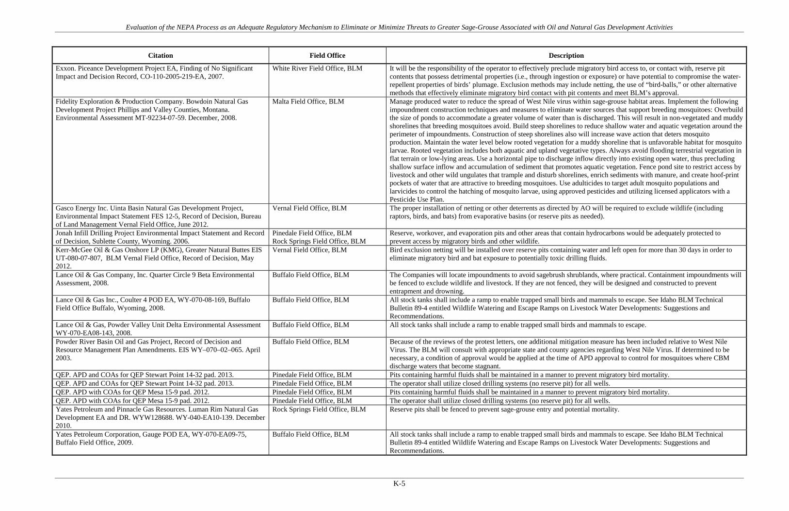
Evaluation of the NEPA Process as an Adequate Regulatory Mechanism to Eliminate or Minimize Threats to Greater Sage-Grouse Associated with Oil and Natural Gas Development Activities
K-5
Citation Field Office Description
Exxon. Piceance Development Project EA, Finding of No Significant Impact and Decision Record, CO-110-2005-219-EA, 2007.
White River Field Office, BLM It will be the responsibility of the operator to effectively preclude migratory bird access to, or contact with, reserve pit contents that possess detrimental properties (i.e., through ingestion or exposure) or have potential to compromise the water-repellent properties of birds’ plumage. Exclusion methods may include netting, the use of “bird-balls,” or other alternative methods that effectively eliminate migratory bird contact with pit contents and meet BLM’s approval.
Fidelity Exploration & Production Company. Bowdoin Natural Gas Development Project Phillips and Valley Counties, Montana. Environmental Assessment MT-92234-07-59. December, 2008.
Malta Field Office, BLM Manage produced water to reduce the spread of West Nile virus within sage-grouse habitat areas. Implement the following impoundment construction techniques and measures to eliminate water sources that support breeding mosquitoes: Overbuild the size of ponds to accommodate a greater volume of water than is discharged. This will result in non-vegetated and muddy shorelines that breeding mosquitoes avoid. Build steep shorelines to reduce shallow water and aquatic vegetation around the perimeter of impoundments. Construction of steep shorelines also will increase wave action that deters mosquito production. Maintain the water level below rooted vegetation for a muddy shoreline that is unfavorable habitat for mosquito larvae. Rooted vegetation includes both aquatic and upland vegetative types. Always avoid flooding terrestrial vegetation in flat terrain or low-lying areas. Use a horizontal pipe to discharge inflow directly into existing open water, thus precluding shallow surface inflow and accumulation of sediment that promotes aquatic vegetation. Fence pond site to restrict access by livestock and other wild ungulates that trample and disturb shorelines, enrich sediments with manure, and create hoof-print pockets of water that are attractive to breeding mosquitoes. Use adulticides to target adult mosquito populations and larvicides to control the hatching of mosquito larvae, using approved pesticides and utilizing licensed applicators with a Pesticide Use Plan.
Gasco Energy Inc. Uinta Basin Natural Gas Development Project, Environmental Impact Statement FES 12-5, Record of Decision, Bureau of Land Management Vernal Field Office, June 2012.
Vernal Field Office, BLM The proper installation of netting or other deterrents as directed by AO will be required to exclude wildlife (including raptors, birds, and bats) from evaporative basins (or reserve pits as needed).
Jonah Infill Drilling Project Environmental Impact Statement and Record of Decision, Sublette County, Wyoming. 2006.
Pinedale Field Office, BLM Rock Springs Field Office, BLM
Reserve, workover, and evaporation pits and other areas that contain hydrocarbons would be adequately protected to prevent access by migratory birds and other wildlife.
Kerr-McGee Oil & Gas Onshore LP (KMG), Greater Natural Buttes EIS UT-080-07-807, BLM Vernal Field Office, Record of Decision, May 2012.
Vernal Field Office, BLM Bird exclusion netting will be installed over reserve pits containing water and left open for more than 30 days in order to eliminate migratory bird and bat exposure to potentially toxic drilling fluids.
Lance Oil & Gas Company, Inc. Quarter Circle 9 Beta Environmental Assessment, 2008.
Buffalo Field Office, BLM The Companies will locate impoundments to avoid sagebrush shrublands, where practical. Containment impoundments will be fenced to exclude wildlife and livestock. If they are not fenced, they will be designed and constructed to prevent entrapment and drowning.
Lance Oil & Gas Inc., Coulter 4 POD EA, WY-070-08-169, Buffalo Field Office Buffalo, Wyoming, 2008.
Buffalo Field Office, BLM All stock tanks shall include a ramp to enable trapped small birds and mammals to escape. See Idaho BLM Technical Bulletin 89-4 entitled Wildlife Watering and Escape Ramps on Livestock Water Developments: Suggestions and Recommendations.
Lance Oil & Gas, Powder Valley Unit Delta Environmental Assessment WY-070-EA08-143, 2008.
Buffalo Field Office, BLM All stock tanks shall include a ramp to enable trapped small birds and mammals to escape.
Powder River Basin Oil and Gas Project, Record of Decision and Resource Management Plan Amendments. EIS WY–070–02–065. April 2003.
Buffalo Field Office, BLM Because of the reviews of the protest letters, one additional mitigation measure has been included relative to West Nile Virus. The BLM will consult with appropriate state and county agencies regarding West Nile Virus. If determined to be necessary, a condition of approval would be applied at the time of APD approval to control for mosquitoes where CBM discharge waters that become stagnant.
QEP. APD and COAs for QEP Stewart Point 14-32 pad. 2013. Pinedale Field Office, BLM Pits containing harmful fluids shall be maintained in a manner to prevent migratory bird mortality. QEP. APD and COAs for QEP Stewart Point 14-32 pad. 2013. Pinedale Field Office, BLM The operator shall utilize closed drilling systems (no reserve pit) for all wells. QEP. APD with COAs for QEP Mesa 15-9 pad. 2012. Pinedale Field Office, BLM Pits containing harmful fluids shall be maintained in a manner to prevent migratory bird mortality. QEP. APD with COAs for QEP Mesa 15-9 pad. 2012. Pinedale Field Office, BLM The operator shall utilize closed drilling systems (no reserve pit) for all wells. Yates Petroleum and Pinnacle Gas Resources. Luman Rim Natural Gas Development EA and DR. WYW128688. WY-040-EA10-139. December 2010.
Rock Springs Field Office, BLM Reserve pits shall be fenced to prevent sage-grouse entry and potential mortality.
Yates Petroleum Corporation, Gauge POD EA, WY-070-EA09-75, Buffalo Field Office, 2009.
Buffalo Field Office, BLM All stock tanks shall include a ramp to enable trapped small birds and mammals to escape. See Idaho BLM Technical Bulletin 89-4 entitled Wildlife Watering and Escape Ramps on Livestock Water Developments: Suggestions and Recommendations.

Evaluation of the NEPA Process as an Adequate Regulatory Mechanism to Eliminate or Minimize Threats to Greater Sage-Grouse Associated with Oil and Natural Gas Development Activities
K-6
Citation Field Office Description
Yates Petroleum Corporation. Lazurite POD Environmental Assessment WY-070-EA09-095, 2009.
Buffalo Field Office, BLM All impoundments approved in this authorization will be treated each year to kill mosquito larvae.
Yates Petroleum Corporation. Lazurite POD Environmental Assessment WY-070-EA09-095, 2009.
Buffalo Field Office, BLM All stock tanks shall include a ramp to enable trapped small birds and mammals to escape.

Evaluation of the NEPA Process as an Adequate Regulatory Mechanism to Eliminate or Minimize Threats to Greater Sage-Grouse Associated with Oil and Natural Gas Development Activities
APPENDIX L Timing Limitations

Evaluation of the NEPA Process as an Adequate Regulatory Mechanism to Eliminate or Minimize Threats to Greater Sage-Grouse Associated with Oil and Natural Gas Development Activities
L-1
Table L-1. PECE Policy Evaluation – Timing Limitations
Conservation Measure Timing Limitations
Certainty of Implementation The conservation effort, the party(ies) to the agreement or plan that will implement the effort, and the staffing, funding level, funding source, and other resources necessary to implement the effort are identified.
The BLM/USFS decision records require implementation as a condition of the agency authorization. Funding and implementation is generally identified as the responsibility of the operator(s).
The legal authority of the party(ies) to the agreement or plan to implement the formalized conservation effort, and the commitment to proceed with the conservation effort are described.
NEPA provides the legal and statutory authority to implement the conservation measures and COAs included in the agency decision records.
The legal procedural requirements (e.g. environmental review) necessary to implement the effort are described, and information is provided indicating that fulfillment of these requirements does not preclude commitment to the effort.
NEPA is the legal procedural requirement necessary to implement COAs and conservation measures included in the agency decision records.
Authorizations (e.g., permits, landowner permission) necessary to implement the conservation effort are identified, and a high level of certainty is provided that the party(ies) to the agreement or plan that will implement the effort will obtain these authorizations.
The NEPA decision record provides the necessary authorization to implement the COAs and conservation measures. As the measures are conditions of the agency approval and are required for project completion, there is a high level of certainty that they will be implemented and authorized.
The type and level of voluntary participation (e.g., number of landowners allowing entry to their land, or number of participants agreeing to change timber management practices and acreage involved) necessary to implement the conservation effort is identified, and a high level of certainty is provided that the party(ies) to the agreement or plan that will implement the conservation effort will obtain that level of voluntary participation (e.g., an explanation of how incentives to be provided will result in the necessary level of voluntary participation).
Participation in the implementation of the COAs and conservation measures is mandatory as a condition of the agency approval under NEPA. NEPA authorizations exceed this evaluation criteria by making the measures mandatory.
Regulatory mechanisms (e.g., laws, regulations, ordinances) necessary to implement the conservation effort are in place.
NEPA provides the regulatory mechanism for implementation. Where necessary, other federal or state authorizations or permits might be required prior to implementation (i.e., Clean Water Act permits). There is reasonable certainty that these permits will be obtained for each measure or COA.
A high level of certainty is provided that the party(ies) to the agreement or plan that will implement the conservation effort will obtain the necessary funding.
The agency decision requires that funding for the COAs and conservation measures be provided as a condition of the project approval. There is certainty that each measure will be funded.

Evaluation of the NEPA Process as an Adequate Regulatory Mechanism to Eliminate or Minimize Threats to Greater Sage-Grouse Associated with Oil and Natural Gas Development Activities
L-2
Conservation Measure Timing Limitations
An implementation schedule (including incremental completion dates) for the conservation effort is provided.
Each NEPA document and associated decision record analyzes and describes the schedule for project implementation. As conditions of agency approvals, COAs and conservation measures must be completed during or prior to project completion.
The conservation agreement or plan that includes the conservation effort is approved by all parties to the agreement or plan.
As a condition of the agency approval of each project, there is agreement between the operators and the agency that each COA or conservation measure will be implemented as part of project activities.
Certainty of Effectiveness The nature and extent of threats being addressed by the conservation effort are described, and how the conservation effort reduces the threats is described.
Timing limitation COAs and conservation measures address threats associated with Energy Development under Listing Factor A.
Explicit incremental objectives for the conservation effort and dates for achieving them are stated.
Timing for implementation of restrictions is explicitly stated in each NEPA document. These are implemented annually for the life of the project.
The steps necessary to implement the conservation effort are identified in detail.
Steps are identified and include avoidance of activities surrounding leks within given distance buffers during certain times of the day.
Quantifiable, scientifically valid parameters that will demonstrate achievement of objectives, and standards for these parameters by which progress will be measured, are identified.
Lek attendance monitoring, monitoring of nesting and brood-rearing hens, etc. provide quantifiable parameters to measure success of the measure. Multiple sources identify that avoidance of activities surrounding leks during lekking, nesting, and early brood-rearing periods provide conservation benefit and protective measures for sage-grouse.
Provisions for monitoring and reporting progress on implementation (based on compliance with the implementation schedule) and effectiveness (based on evaluation of quantifiable parameters) of the conservation effort are provided.
Annual lek counts are tracked by state game and fish agencies and federal land management agencies for purposes of evaluating grouse populations. Monitoring and adaptive management practices discussed in detail in the report provide examples of additional monitoring and reporting provisions.
Principles of adaptive management are incorporated.
Monitoring and adaptive management practices discussed in detail in the report provide examples of additional monitoring and reporting provisions.

Evaluation of the NEPA Process as an Adequate Regulatory Mechanism to Eliminate or Minimize Threats to Greater Sage-Grouse Associated with Oil and Natural Gas Development Activities
L-3
Figure L-1. Map of FOs where Timing Limitation COAs are applied.

Evaluation of the NEPA Process as an Adequate Regulatory Mechanism to Eliminate or Minimize Threats to Greater Sage-Grouse Associated with Oil and Natural Gas Development Activities
L-4
Table L-2. Timing Limitation COAs and Conservation Measures
Citation Field Office Description
Anadarko Petroleum Company, Powder River 2D Seismic Survey Environmental Assessment (EA), WY-070-EA11-343 Buffalo Field Office, Bureau of Land Management, 2011.
Buffalo Field Office, BLM Should geo-exploration activities extend into sage-grouse breeding season (March 1 – June 15), timing restrictions will be placed on activities within 2 miles of identified leks and in core/connectivity areas.
Atlantic Rim Natural Gas Field Development Project Record of Decision and Environmental Impact Statement, Carbon County, Wyoming. March 2007.
Rawlins Field Office, BLM Human activity will be avoided between 6:00 p.m. and 9:00 a.m. from March 1 to May 20 within one-quarter mile of the perimeter of occupied leks.
Berry Petroleum Company. Record of Decision South Unit Oil and Gas Development Final Environmental Impact Statement Duchesne Ranger District, Ashley National Forest Duchesne County, Utah. 2012.
Ashley National Forest , USFS To reduce potential disturbance to strutting birds (and the likelihood of lek abandonment), timing restrictions will be required during the breeding season (March 1–May 31) within sage-grouse habitat, and within 0.6 mile of sage-grouse habitat. No project-related vehicles or activities (including routine maintenance, production vehicles, or work-over rigs) will be allowed, from 1 hour before sunrise to 3 hours after sunrise, and from 2 hours before sunset to 1 hour after sunset.
Bill Barrett Corporation, Merganser 3-Dd Seismic Project. Categorical Exclusion WY-070-CX12-197. 2012.
Buffalo Field Office, BLM In greater sage grouse lek areas, crew will only work within 0.25 mile of such lek between 10am and 3pm with foot traffic only off of existing roads and trails
BLM Montana. Record of Decision for the Final Statewide Oil and Gas Environmental Impact Statement and Proposed Amendment of the Powder River and Billings Resource Management Plans. 2003.
Billings Field Office, BLM Miles City Field Office, BLM
If possible, minimize maintenance and related activities in sage grouse breeding/nesting complexes; 15 March -15 June, between the hours of 4:00-8:00 am and 7:00-10:00 pm.
Elk Petroleum. Environmental Assessment for the Grieve Unit CO2 Enhanced Recovery Project. Natrona County, Wyoming. WY-050-EA11-108. Approved 7/26/12 by BLM Lander Field Office.
Lander Field Office, BLM Disruptive activity is restricted on or within six tenths (0.6) mile radius of the perimeter of occupied sage-grouse leks from 6 pm to 8 am from March 1 to May 15.
Elk Petroleum. Environmental Assessment for the Grieve Unit CO2 Enhanced Recovery Project. Natrona County, Wyoming. WY-050-EA11-108. Approved 7/26/12 by BLM Lander Field Office.
Lander Field Office, BLM New noise level, at the perimeter of a lek, should not exceed 10dBA above ambient levels from 6pm to 8am during the initiation of breeding (March 1 to May 15).
EnCana Oil and Gas. Master Development Plan (MDP) for the SG E34 496, SG L27 796 and SG F22 496. DOI-BLM-CO-110-2013-0035-EA. Approved 6/7/13 by the White River Field Office.
White River Field Office, BLM A 0.6 mile radius "No Disturbance" buffer would be applied around active lek sites (documented activity within the last 5 years) from 5:00 a.m. to 9:00 a.m., March 15th through May 15th.
EnCana Oil and Gas. Master Development Plan (MDP) for the SG E34 496, SG L27 796 and SG F22 496. DOI-BLM-CO-110-2013-0035-EA. Approved 6/7/13 by the White River Field Office.
White River Field Office, BLM In occupied sage-grouse habitat well site visitation would be restricted to occur between the hours of 9:00 a.m. and 4:00 p.m. during the lekking season (March 15th to May 15th).
EnCana Oil and Gas. Master Development Plan (MDP) for the SG E34 496, SG L27 796 and SG F22 496. DOI-BLM-CO-110-2013-0035-EA. Approved 6/7/13 by the White River Field Office.
White River Field Office, BLM Where practicable, traffic and other disturbances would be restricted after sunset when sage-grouse are congregating around the lek until 9:00 a.m. the following morning when birds depart the lek site.
Environmental Assessment for East Converse Exploratory Oil and Gas Development Project. WY-060-EA12-227. Approved 11/20/12 by BLM Casper Field Office.
Casper Field Office, BLM Disruptive activities are restricted within ¼-mile radius of occupied or undetermined sage-grouse leks from 6 pm to 8 am from March 1 to May 15.
Environmental Assessment for Highland Loop Road Exploratory Oil and Gas Development Project. WY-060-EA12-226. Approved 11/20/12 by BLM Casper Field Office.
Casper Field Office, BLM Disruptive activities are restricted within one quarter (0.25) mile radius of occupied or undetermined sage-grouse leks from 6 pm to 8 am from March 1 – May 15.
Environmental Assessment for Spearhead Ranch Exploratory Oil and Gas Development Project. Y-060-EA12-225. Approved 11/20/12 by BLM Casper Field Office.
Casper Field Office, BLM Disruptive activities are restricted within one quarter (0.25) mile radius of occupied or undetermined sage-grouse leks from 6 pm to 8 am from March 1 – May 15.
Exxon. Piceance Development Project EA, Finding of No Significant Impact and Decision Record, CO-110-2005-219-EA, 2007.
White River Field Office, BLM Daily timing restrictions will include no activity before 9:00 am or after 4:00 pm in sage-grouse nesting and brood-rearing areas. Additional timing restrictions could be imposed based on results of pre-construction surveys.
Fidelity Exploration & Production Company. Bowdoin Natural Gas Development Project Phillips and Valley Counties, Montana. Environmental Assessment MT-92234-07-59. December, 2008.
Malta Field Office, BLM Limit vehicular traffic and human visitation to well sites and facilities within ¼ mile of lek sites until after 9:00 a.m. daily during the production phase.
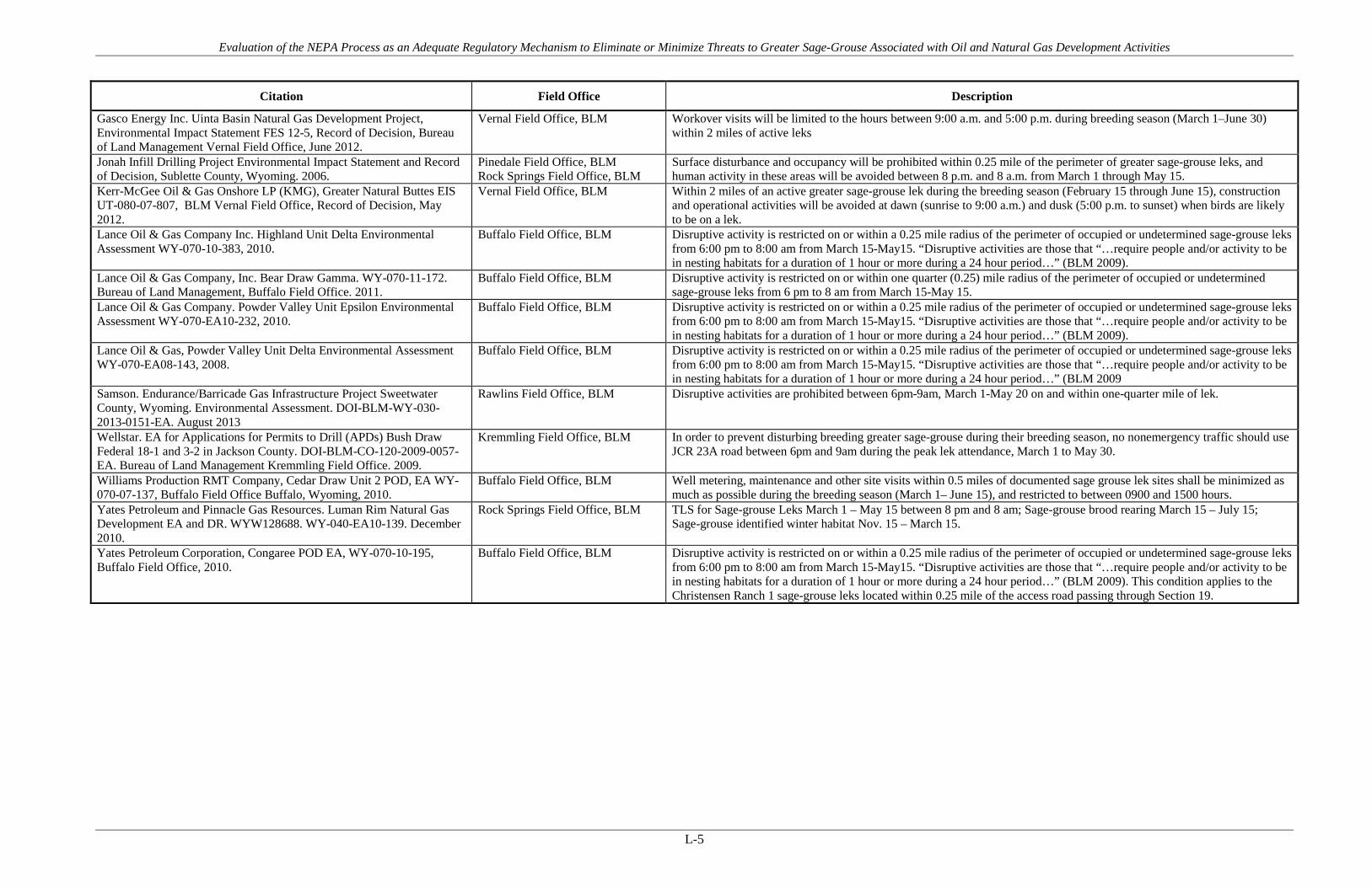
Evaluation of the NEPA Process as an Adequate Regulatory Mechanism to Eliminate or Minimize Threats to Greater Sage-Grouse Associated with Oil and Natural Gas Development Activities
L-5
Citation Field Office Description
Gasco Energy Inc. Uinta Basin Natural Gas Development Project, Environmental Impact Statement FES 12-5, Record of Decision, Bureau of Land Management Vernal Field Office, June 2012.
Vernal Field Office, BLM Workover visits will be limited to the hours between 9:00 a.m. and 5:00 p.m. during breeding season (March 1–June 30) within 2 miles of active leks
Jonah Infill Drilling Project Environmental Impact Statement and Record of Decision, Sublette County, Wyoming. 2006.
Pinedale Field Office, BLM Rock Springs Field Office, BLM
Surface disturbance and occupancy will be prohibited within 0.25 mile of the perimeter of greater sage-grouse leks, and human activity in these areas will be avoided between 8 p.m. and 8 a.m. from March 1 through May 15.
Kerr-McGee Oil & Gas Onshore LP (KMG), Greater Natural Buttes EIS UT-080-07-807, BLM Vernal Field Office, Record of Decision, May 2012.
Vernal Field Office, BLM Within 2 miles of an active greater sage-grouse lek during the breeding season (February 15 through June 15), construction and operational activities will be avoided at dawn (sunrise to 9:00 a.m.) and dusk (5:00 p.m. to sunset) when birds are likely to be on a lek.
Lance Oil & Gas Company Inc. Highland Unit Delta Environmental Assessment WY-070-10-383, 2010.
Buffalo Field Office, BLM Disruptive activity is restricted on or within a 0.25 mile radius of the perimeter of occupied or undetermined sage-grouse leks from 6:00 pm to 8:00 am from March 15-May15. “Disruptive activities are those that “…require people and/or activity to be in nesting habitats for a duration of 1 hour or more during a 24 hour period…” (BLM 2009).
Lance Oil & Gas Company, Inc. Bear Draw Gamma. WY-070-11-172. Bureau of Land Management, Buffalo Field Office. 2011.
Buffalo Field Office, BLM Disruptive activity is restricted on or within one quarter (0.25) mile radius of the perimeter of occupied or undetermined sage-grouse leks from 6 pm to 8 am from March 15-May 15.
Lance Oil & Gas Company. Powder Valley Unit Epsilon Environmental Assessment WY-070-EA10-232, 2010.
Buffalo Field Office, BLM Disruptive activity is restricted on or within a 0.25 mile radius of the perimeter of occupied or undetermined sage-grouse leks from 6:00 pm to 8:00 am from March 15-May15. “Disruptive activities are those that “…require people and/or activity to be in nesting habitats for a duration of 1 hour or more during a 24 hour period…” (BLM 2009).
Lance Oil & Gas, Powder Valley Unit Delta Environmental Assessment WY-070-EA08-143, 2008.
Buffalo Field Office, BLM Disruptive activity is restricted on or within a 0.25 mile radius of the perimeter of occupied or undetermined sage-grouse leks from 6:00 pm to 8:00 am from March 15-May15. “Disruptive activities are those that “…require people and/or activity to be in nesting habitats for a duration of 1 hour or more during a 24 hour period…” (BLM 2009
Samson. Endurance/Barricade Gas Infrastructure Project Sweetwater County, Wyoming. Environmental Assessment. DOI-BLM-WY-030-2013-0151-EA. August 2013
Rawlins Field Office, BLM Disruptive activities are prohibited between 6pm-9am, March 1-May 20 on and within one-quarter mile of lek.
Wellstar. EA for Applications for Permits to Drill (APDs) Bush Draw Federal 18-1 and 3-2 in Jackson County. DOI-BLM-CO-120-2009-0057-EA. Bureau of Land Management Kremmling Field Office. 2009.
Kremmling Field Office, BLM In order to prevent disturbing breeding greater sage-grouse during their breeding season, no nonemergency traffic should use JCR 23A road between 6pm and 9am during the peak lek attendance, March 1 to May 30.
Williams Production RMT Company, Cedar Draw Unit 2 POD, EA WY-070-07-137, Buffalo Field Office Buffalo, Wyoming, 2010.
Buffalo Field Office, BLM Well metering, maintenance and other site visits within 0.5 miles of documented sage grouse lek sites shall be minimized as much as possible during the breeding season (March 1– June 15), and restricted to between 0900 and 1500 hours.
Yates Petroleum and Pinnacle Gas Resources. Luman Rim Natural Gas Development EA and DR. WYW128688. WY-040-EA10-139. December 2010.
Rock Springs Field Office, BLM TLS for Sage-grouse Leks March 1 – May 15 between 8 pm and 8 am; Sage-grouse brood rearing March 15 – July 15; Sage-grouse identified winter habitat Nov. 15 – March 15.
Yates Petroleum Corporation, Congaree POD EA, WY-070-10-195, Buffalo Field Office, 2010.
Buffalo Field Office, BLM Disruptive activity is restricted on or within a 0.25 mile radius of the perimeter of occupied or undetermined sage-grouse leks from 6:00 pm to 8:00 am from March 15-May15. “Disruptive activities are those that “…require people and/or activity to be in nesting habitats for a duration of 1 hour or more during a 24 hour period…” (BLM 2009). This condition applies to the Christensen Ranch 1 sage-grouse leks located within 0.25 mile of the access road passing through Section 19.

Evaluation of the NEPA Process as an Adequate Regulatory Mechanism to Eliminate or Minimize Threats to Greater Sage-Grouse Associated with Oil and Natural Gas Development Activities
APPENDIX M Vegetation Treatments

Evaluation of the NEPA Process as an Adequate Regulatory Mechanism to Eliminate or Minimize Threats to Greater Sage-Grouse Associated with Oil and Natural Gas Development Activities
M-1
Table M-1. PECE Policy Evaluation – Vegetation Treatments
Conservation Measure Vegetation Treatments
Certainty of Implementation The conservation effort, the party(ies) to the agreement or plan that will implement the effort, and the staffing, funding level, funding source, and other resources necessary to implement the effort are identified.
The BLM/USFS decision records require implementation as a condition of the agency authorization. Funding and implementation is generally identified as the responsibility of the operator(s).
The legal authority of the party(ies) to the agreement or plan to implement the formalized conservation effort, and the commitment to proceed with the conservation effort are described.
NEPA provides the legal and statutory authority to implement the conservation measures and COAs included in the agency decision records.
The legal procedural requirements (e.g. environmental review) necessary to implement the effort are described, and information is provided indicating that fulfillment of these requirements does not preclude commitment to the effort.
NEPA is the legal procedural requirement necessary to implement COAs and conservation measures included in the agency decision records.
Authorizations (e.g., permits, landowner permission) necessary to implement the conservation effort are identified, and a high level of certainty is provided that the party(ies) to the agreement or plan that will implement the effort will obtain these authorizations.
The NEPA decision record provides the necessary authorization to implement the COAs and conservation measures. As the measures are conditions of the agency approval and are required for project completion, there is a high level of certainty that they will be implemented and authorized.
The type and level of voluntary participation (e.g., number of landowners allowing entry to their land, or number of participants agreeing to change timber management practices and acreage involved) necessary to implement the conservation effort is identified, and a high level of certainty is provided that the party(ies) to the agreement or plan that will implement the conservation effort will obtain that level of voluntary participation (e.g., an explanation of how incentives to be provided will result in the necessary level of voluntary participation).
Participation in the implementation of the COAs and conservation measures is mandatory as a condition of the agency approval under NEPA. NEPA authorizations exceed this evaluation criteria by making the measures mandatory.
Regulatory mechanisms (e.g., laws, regulations, ordinances) necessary to implement the conservation effort are in place.
NEPA provides the regulatory mechanism for implementation. Where necessary, other federal or state authorizations or permits might be required prior to implementation (i.e., Clean Water Act permits). There is reasonable certainty that these permits will be obtained for each measure or COA.
A high level of certainty is provided that the party(ies) to the agreement or plan that will implement the conservation effort will obtain the necessary funding.
The agency decision requires that funding for the COAs and conservation measures be provided as a condition of the project approval. There is certainty that each measure will be funded.

Evaluation of the NEPA Process as an Adequate Regulatory Mechanism to Eliminate or Minimize Threats to Greater Sage-Grouse Associated with Oil and Natural Gas Development Activities
M-2
Conservation Measure Vegetation Treatments
An implementation schedule (including incremental completion dates) for the conservation effort is provided.
Each NEPA document and associated decision record analyzes and describes the schedule for project implementation. As conditions of agency approvals, COAs and conservation measures must be completed during or prior to project completion.
The conservation agreement or plan that includes the conservation effort is approved by all parties to the agreement or plan.
As a condition of the agency approval of each project, there is agreement between the operators and the agency that each COA or conservation measure will be implemented as part of project activities.
Certainty of Effectiveness The nature and extent of threats being addressed by the conservation effort are described, and how the conservation effort reduces the threats is described.
Vegetation treatment and fire management COAs and conservation measures address threats associated with pinyon-juniper encroachment, invasive plants, and fire under Listing Factor A.
Explicit incremental objectives for the conservation effort and dates for achieving them are stated.
The objectives and timing are explicitly stated in each NEPA document and associated habitat improvement plans.
The steps necessary to implement the conservation effort are identified in detail.
Steps are identified and include removal of encroaching pinyon and juniper and steps to enhance sage-grouse habitats. Fire Prevention and Management Plans detail the steps necessary for implementation.
Quantifiable, scientifically valid parameters that will demonstrate achievement of objectives, and standards for these parameters by which progress will be measured, are identified.
Success is quantified by the number of acres pinyon juniper is reduced, and the number of acres sagebrush and other habitats are enhanced. Decreased or stable fire frequency can be easily measured.
Provisions for monitoring and reporting progress on implementation (based on compliance with the implementation schedule) and effectiveness (based on evaluation of quantifiable parameters) of the conservation effort are provided.
Project monitoring includes lek attendance monitoring, monitoring for use in treated areas, and monitoring for re-encroachment of undesirable vegetation. State and Federal agencies track fire frequency.
Principles of adaptive management are incorporated.
Monitoring and adaptive management practices discussed in detail in the report provide examples of additional monitoring and reporting provisions.
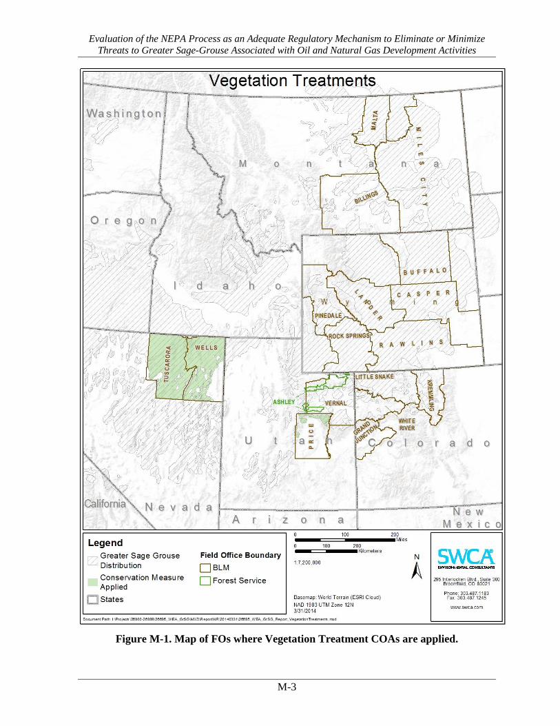
Evaluation of the NEPA Process as an Adequate Regulatory Mechanism to Eliminate or Minimize Threats to Greater Sage-Grouse Associated with Oil and Natural Gas Development Activities
M-3
Figure M-1. Map of FOs where Vegetation Treatment COAs are applied.

Evaluation of the NEPA Process as an Adequate Regulatory Mechanism to Eliminate or Minimize Threats to Greater Sage-Grouse Associated with Oil and Natural Gas Development Activities
M-4
Table M-2. Vegetation Treatment COAs and Conservation Measures
Citation Field Office Description
Bill Barrett Corporation. Environmental Impact Statement (UT-070-05-055) for West Tavaputs Plateau Natural Gas Full Field Development Plan and ROD. 2010.
Price Field Office, BLM Habitat improvement and connectivity projects designed to remove encroaching pinyon and juniper (e.g., lop and scatter) and increase the sagebrush park size to benefit sage grouse (This will be implemented at a 4:1 ratio as indicated above.)
Bill Barrett Corporation. Environmental Impact Statement (UT-070-05-055) for West Tavaputs Plateau Natural Gas Full Field Development Plan and ROD. 2010.
Price Field Office, BLM Wet meadow/summer range enhancement projects designed to increase this type of habitat for sage-grouse brood survival. Up to six projects will be implemented. Acres enhanced will be counted under the habitat improvement tally at an equal or greater acreage value based on the qualitative benefits of the enhancement.
Noble. Environmental Assessment Huntington Valley 3D Seismic Project. DOI-BLM-NV-E020-2013-0008-EA. August 2013.
Tuscarora Field Office, BLM Due to the sensitive nature of the sagebrush habitat in the project area and the past history of fire impacts to grazing and sage-grouse, Noble would prepare and implement a Fire Prevention Plan.
Noble. Marys River 3D Seismic Project. DOI-BLM-NV-E030-2012-0518-EA. Elko District – Wells Field Office. August 2012.
Wells Field Office, BLM Due to the sensitive nature of the sagebrush habitat in the project area and the past history of fire impacts to grazing and sage-grouse, Noble will prepare and implement a Fire Prevention Plan.

Evaluation of the NEPA Process as an Adequate Regulatory Mechanism to Eliminate or Minimize Threats to Greater Sage-Grouse Associated with Oil and Natural Gas Development Activities
APPENDIX N Monitoring and Adaptive Management

Evaluation of the NEPA Process as an Adequate Regulatory Mechanism to Eliminate or Minimize Threats to Greater Sage-Grouse Associated with Oil and Natural Gas Development Activities
N-1
Table N-1. PECE Policy Evaluation – Monitoring and Adaptive Management
Conservation Measure Monitoring and Adaptive Management
Certainty of Implementation The conservation effort, the party(ies) to the agreement or plan that will implement the effort, and the staffing, funding level, funding source, and other resources necessary to implement the effort are identified.
The BLM/USFS decision records require implementation as a condition of the agency authorization. Funding and implementation is generally identified as the responsibility of the operator(s).
The legal authority of the party(ies) to the agreement or plan to implement the formalized conservation effort, and the commitment to proceed with the conservation effort are described.
NEPA provides the legal and statutory authority to implement the conservation measures and COAs included in the agency decision records.
The legal procedural requirements (e.g. environmental review) necessary to implement the effort are described, and information is provided indicating that fulfillment of these requirements does not preclude commitment to the effort.
NEPA is the legal procedural requirement necessary to implement COAs and conservation measures included in the agency decision records.
Authorizations (e.g., permits, landowner permission) necessary to implement the conservation effort are identified, and a high level of certainty is provided that the party(ies) to the agreement or plan that will implement the effort will obtain these authorizations.
The NEPA decision record provides the necessary authorization to implement the COAs and conservation measures. As the measures are conditions of the agency approval and are required for project completion, there is a high level of certainty that they will be implemented and authorized.
The type and level of voluntary participation (e.g., number of landowners allowing entry to their land, or number of participants agreeing to change timber management practices and acreage involved) necessary to implement the conservation effort is identified, and a high level of certainty is provided that the party(ies) to the agreement or plan that will implement the conservation effort will obtain that level of voluntary participation (e.g., an explanation of how incentives to be provided will result in the necessary level of voluntary participation).
Participation in the implementation of the COAs and conservation measures is mandatory as a condition of the agency approval under NEPA. NEPA authorizations exceed this evaluation criteria by making the measures mandatory.
Regulatory mechanisms (e.g., laws, regulations, ordinances) necessary to implement the conservation effort are in place.
NEPA provides the regulatory mechanism for implementation. Where necessary, other federal or state authorizations or permits might be required prior to implementation (i.e., Clean Water Act permits). There is reasonable certainty that these permits will be obtained for each measure or COA.

Evaluation of the NEPA Process as an Adequate Regulatory Mechanism to Eliminate or Minimize Threats to Greater Sage-Grouse Associated with Oil and Natural Gas Development Activities
N-2
Conservation Measure Monitoring and Adaptive Management
A high level of certainty is provided that the party(ies) to the agreement or plan that will implement the conservation effort will obtain the necessary funding.
The agency decision requires that funding for the COAs and conservation measures be provided as a condition of the project approval. There is certainty that each measure will be funded.
An implementation schedule (including incremental completion dates) for the conservation effort is provided.
Each NEPA document and associated decision record analyzes and describes the schedule for project implementation. As conditions of agency approvals, COAs and conservation measures must be completed during or prior to project completion.
The conservation agreement or plan that includes the conservation effort is approved by all parties to the agreement or plan.
As a condition of the agency approval of each project, there is agreement between the operators and the agency that each COA or conservation measure will be implemented as part of project activities.
Certainty of Effectiveness The nature and extent of threats being addressed by the conservation effort are described, and how the conservation effort reduces the threats is described.
Monitoring and Adaptive Management COAs and conservation measures address threats associated with Energy Development and Infrastructure under Listing Factor A; Disease and Predation under Factor C; and Contaminants under Factor E.
Explicit incremental objectives for the conservation effort and dates for achieving them are stated.
Implementation of Monitoring and Adaptive management typically occurs annually for the life of the project. Objectives are to document the success of mitigation measure and to adjust the approach if mitigation is not successful.
The steps necessary to implement the conservation effort are identified in detail.
Adaptive management plans generally outline steps to be taken including regular meetings of Technical Advisory Committees or other similar stakeholder groups to review progress and identify additional actions
Quantifiable, scientifically valid parameters that will demonstrate achievement of objectives, and standards for these parameters by which progress will be measured, are identified.
Monitoring quantifies various parameters in order to determine if the objectives of mitigation measures have been achieved based on standards described in a monitoring plan (number of grouse on leks, % cover of vegetation, etc.)
Provisions for monitoring and reporting progress on implementation (based on compliance with the implementation schedule) and effectiveness (based on evaluation of quantifiable parameters) of the conservation effort are provided.
Monitoring and adaptive management practices discussed in detail in the report provide examples of additional monitoring and reporting provisions.
Principles of adaptive management are incorporated.
Monitoring and adaptive management practices discussed in detail in the report provide examples of additional monitoring and reporting provisions.

Evaluation of the NEPA Process as an Adequate Regulatory Mechanism to Eliminate or Minimize Threats to Greater Sage-Grouse Associated with Oil and Natural Gas Development Activities
N-3
Figure N-1. Map of FOs where Monitoring and Adaptive Management COAs are
applied.

Evaluation of the NEPA Process as an Adequate Regulatory Mechanism to Eliminate or Minimize Threats to Greater Sage-Grouse Associated with Oil and Natural Gas Development Activities
N-4
Table N-2. Monitoring and Adaptive Management COAs and Conservation Measures
Citation Field Office Description
Anadarko Petroleum Corp. Big Corral Jewel Draw Unit Gamma EA # WY-070-EA08-168 Buffalo Field Office, Buffalo, Wyoming, 2008.
Buffalo Field Office, BLM For any surface-disturbing activities proposed in sagebrush shrublands, the Companies will conduct clearance surveys for sage grouse breeding activity during the sage grouse’s breeding season before initiating the activities. The surveys must encompass all sagebrush shrublands within 0.5 mile of the proposed activities.
Anadarko Petroleum Corporation, Double Tank Phase II POD EA, WY-070-07 015, Buffalo Field Office Buffalo, Wyoming, 2009.
Buffalo Field Office, BLM For any surface-disturbing activities proposed in sagebrush shrublands, the Companies will conduct clearance surveys for sage-grouse breeding activity during the sage-grouse’s breeding season before initiating the activities. The surveys must encompass all sagebrush shrublands within 0.5 mile of the proposed activities.
Anadarko Petroleum Corporation, Double Tank Phase II POD EA, WY-070-07 015, Buffalo Field Office Buffalo, Wyoming, 2009.
Buffalo Field Office, BLM Sage-grouse surveys are required throughout the project area for the current breeding season and results reviewed by a BLM biologist. This condition will be implemented on an annual basis for the duration of surface disturbing activities.
Anadarko Petroleum Corporation, Dry Willow III POD EA, WY-070-08-036, Buffalo Field Office Buffalo, Wyoming, 2009.
Buffalo Field Office, BLM For any surface-disturbing activities proposed in sagebrush shrublands, the Companies will conduct clearance surveys for sage grouse breeding activity during the sage grouse’s breeding season before initiating the activities. The surveys must encompass all sagebrush shrublands within 0.5 mile of the proposed activities.
Anadarko/Lance Oil & Gas. Rose Draw Unit Beta Environmental Assessment WY-070-EA08-186, 2008.
Buffalo Field Office, BLM For any surface-disturbing activities proposed in sagebrush shrublands, the Companies will conduct clearance surveys for sage grouse breeding activity during the sage grouse’s breeding season before initiating the activities. The surveys must encompass all sagebrush shrublands within 0.5 mile of the proposed activities.
Atlantic Rim Natural Gas Field Development Project Record of Decision and Environmental Impact Statement, Carbon County, Wyoming. March 2007.
Rawlins Field Office, BLM WILDLIFE MONITORING AND PROTECTION PLAN. The goal of the plan is to avoid and/or minimize adverse impacts to wildlife present on project-affected areas by monitoring wildlife population trends on the ARNG during the course of project development and operations and by developing appropriate mitigation actions.
Atlantic Rim Natural Gas Field Development Project Record of Decision and Environmental Impact Statement, Carbon County, Wyoming. March 2007.
Rawlins Field Office, BLM Greater sage-grouse/Columbian sharp-tailed grouse lek inventories will be conducted by the BLM and Wyoming Game and Fish Department (WGFD) or by a BLM-approved operator-financed biologist on the project area and a two mile/one mile buffer to determine lek locations every 5 years, or as deemed appropriate by the BLM.
Atlantic Rim Natural Gas Field Development Project Record of Decision and Environmental Impact Statement, Carbon County, Wyoming. March 2007.
Rawlins Field Office, BLM Operators will complete draft annual reports for submittal to the Review Team by November 15 of each year. Annual reports will summarize annual wildlife inventory and monitoring results, note any trends across years, identify and assess protection measures implemented during past years, specify monitoring and protection measures proposed for the upcoming year, recommend modifications to the existing wildlife monitoring/protection plan based on the successes and/or failures of past years, and identify additional species/categories to be monitored.
Atlantic Rim Natural Gas Field Development Project Record of Decision and Environmental Impact Statement, Carbon County, Wyoming. March 2007.
Rawlins Field Office, BLM The BLM will use a performance-based management approach as part of the adaptive management process. The BLM will attempt to achieve the following Performance Goals in collaboration with other state and other federal agencies: provide well-dispersed sage-grouse breeding, nesting, brood rearing, and winter habitat. As part of the annual planning process, a monitoring and mitigation process will be required, and its development will begin within 30 days of the effective date of the ROD. This information should be reviewed at least annually with development plans modified based on trends.
Atlantic Rim Natural Gas Field Development Project Record of Decision and Environmental Impact Statement, Carbon County, Wyoming. March 2007.
Rawlins Field Office, BLM The planning, review, and approval process for project implementation is described below. This process will typically be initiated by the Operators through an annual planning meeting with the Rawlins Field Office Manager, where they will outline detailed development plans for the upcoming year and a conceptual multi-year plan. The BLM (including interdisciplinary team members), cooperating and interested agencies, and the Operators will make up a Review Team to evaluate annual and site-specific development proposals and monitoring reports. The review and approval process will include a site-specific visit by the Review Team, applicable environmental review and establishing required BMPs, conditions of approval, or other protective measures to mitigate potential environmental impacts.
Berry Petroleum Company. Record of Decision South Unit Oil and Gas Development Final Environmental Impact Statement Duchesne Ranger District, Ashley National Forest Duchesne County, Utah. 2012.
Ashley National Forest, USFS Develop a Wildlife Monitoring Plan
Bill Barrett Corporation, Beaver Creek Add II, Beaver Creek Add II SGP PODs, Beaver Creek Little Buffalo 32-24 APD & Beaver Creek Little Buffalo 34-24 APD, EA # WY-070-09-065, Buffalo Field Office Buffalo, Wyoming, 2010.
Buffalo Field Office, BLM A sage-grouse lek survey of the area within four miles of the project will be conducted by a biologist following the most current WGFD protocol to determine status of known leks and locations of new leks. All survey results shall be submitted in writing to a BLM biologist.

Evaluation of the NEPA Process as an Adequate Regulatory Mechanism to Eliminate or Minimize Threats to Greater Sage-Grouse Associated with Oil and Natural Gas Development Activities
N-5
Citation Field Office Description
Bill Barrett Corporation. Environmental Impact Statement (UT-070-05-055) for West Tavaputs Plateau Natural Gas Full Field Development Plan and ROD. 2010.
Price Field Office, BLM BLM will apply wildlife mitigation measures consistent with adaptive management practices as necessary to achieve its resource objectives. Annual report on sage-grouse winter use monitoring to determine the effectiveness of sage-grouse mitigation and to provide useful information for potentially modifying the winter drilling exceptions through the adaptive management process.
Bill Barrett Corporation. Environmental Impact Statement (UT-070-05-055) for West Tavaputs Plateau Natural Gas Full Field Development Plan and ROD. 2010.
Price Field Office, BLM The agency mitigation plan will also establish a mitigation oversight committee (MOC) to be led by the BLM, in coordination with UDWR, SITLA, other agencies, and the operators. The WTP MOC will include, or at least invite to participate, a representative from a local sage-grouse working group, any potential affected private landowners, and representatives from Carbon and Duchesne Counties. The WTP MOC will complete evaluations and make determinations on on-going and planned mitigation activities on an annual basis, in advance of considerations for winter activities (as is outlined in the ROD), and prepare a report on its findings.
Bill Barrett Corporation. Environmental Impact Statement (UT-070-05-055) for West Tavaputs Plateau Natural Gas Full Field Development Plan and ROD. 2010.
Price Field Office, BLM As part of this plan, BBC and other operators will be required to mitigate impacts to wildlife on a 4:1 acre ratio based on total potential long-term surface disturbance. Under the plan, 30 percent of the total potential long-term surface disturbance (estimated to be approximately 685 acres) will be mitigated during the first 3 years of the development phase.
Bill Barrett Corporation. Environmental Impact Statement (UT-070-05-055) for West Tavaputs Plateau Natural Gas Full Field Development Plan and ROD. 2010.
Price Field Office, BLM In order to mitigate the impacts of winter drilling, BBC has included a detailed Wildlife Mitigation Plan as part of their Proposed Action. The goal of BBC’s Wildlife Mitigation Plan is to improve habitats for sage-grouse, mule deer, elk, and raptors in an effort to offset the effects of winter drilling and other potential impacts of the project. The BLM and UDWR have also included an Agency Wildlife Mitigation Plan. The agencies’ alternative mitigation plan emphasizes the importance of offsetting, to the extent reasonable, the effects of the full field development in its entirety. The agencies’ plan gives priority to compensating for potential impacts to greater sage grouse, deer, elk, and raptors.
Bill Barrett Corporation. Environmental Impact Statement (UT-070-05-055) for West Tavaputs Plateau Natural Gas Full Field Development Plan and ROD. 2010.
Price Field Office, BLM The operators will contribute to UDWR for monitoring greater sage-grouse, whether the continued telemetry study or other, more aggressive means of monitoring, if necessary, including experimental designs.
BLM Montana. Record of Decision for the Final Statewide Oil and Gas Environmental Impact Statement and Proposed Amendment of the Powder River and Billings Resource Management Plans. 2003.
Billings Field Office, BLM Miles City Field Office, BLM
Aerial surveys will be used for determining lek locations. BLM, MFWP or BLM-approved Operator-financed biologist will monitor sage grouse lek attendance within 2 miles of areas having < 4 locations per section such that all leks on these areas are surveyed at least once every 3 years. Data collected during these surveys will be recorded on BLM and MFWP approved data sheets and entered into the BLM GIS database. An effort should also be made to compare trends of the number of males/lek to reference leks.
BLM Montana. Record of Decision for the Final Statewide Oil and Gas Environmental Impact Statement and Proposed Amendment of the Powder River and Billings Resource Management Plans. 2003.
Billings Field Office, BLM Miles City Field Office, BLM
BLM and MFWP will conduct sage grouse lek inventories over the BLM planning area every 5 years to determine lek locations. Surveys of different areas may occur during different years with the intent that the entire area will be covered at least once every 5 years. If BLM notes a downward trend, mitigation, such as extension of timing restrictions, could occur.
BLM Montana. Record of Decision for the Final Statewide Oil and Gas Environmental Impact Statement and Proposed Amendment of the Powder River and Billings Resource Management Plans. 2003.
Billings Field Office, BLM Miles City Field Office, BLM
BLM and MFWP will conduct sage grouse lek inventories over the entire CBM project area every 5 years to determine lek locations. Surveys of different areas may occur during different years with the intent that the entire CBM project area will be covered at least once every 5 years.
BLM Montana. Record of Decision for the Final Statewide Oil and Gas Environmental Impact Statement and Proposed Amendment of the Powder River and Billings Resource Management Plans. 2003.
Billings Field Office, BLM Miles City Field Office, BLM
Downward trend in habitat occupancy would trigger management such as extension of timing and/or increase in distance from lek; stipulations or conditions of approval; off-site habitat management/mitigation…
BLM Montana. Record of Decision for the Final Statewide Oil and Gas Environmental Impact Statement and Proposed Amendment of the Powder River and Billings Resource Management Plans. 2003.
Billings Field Office, BLM Miles City Field Office, BLM
Downward trend in lek attendance would trigger management such as extension of timing and/or increase in distance from lek; stipulations or conditions of approval; off-site habitat management/mitigation…
BLM Montana. Record of Decision for the Final Statewide Oil and Gas Environmental Impact Statement and Proposed Amendment of the Powder River and Billings Resource Management Plans. 2003.
Billings Field Office, BLM Miles City Field Office, BLM
Downward trend in winter habitat occupancy or quality caused by oil and gas activities would trigger management such as extension of timing and/or increase in distance from lek; stipulations or conditions of approval; off-site habitat management/mitigation…
BLM Montana. Record of Decision for the Final Statewide Oil and Gas Environmental Impact Statement and Proposed Amendment of the Powder River and Billings Resource Management Plans. 2003.
Billings Field Office, BLM Miles City Field Office, BLM
Region 7 trend blocks will be monitored annually. There are 4 trend blocks in FWP Region 7; one located in the Decker area and 3 others across the Region. Inventories and protocol will be consistent with the Montana Sage Grouse Conservation Plan coordinated by the BLM and MFWP. In areas with > 4 well locations per section, aerial inventories will be conducted annually on affected sections, 2 mile buffers, and selected undeveloped reference areas. Surveys may be conducted aerially or on the ground, as deemed appropriate by the BLM and MFWP. Operator may provide financial assistance.
BLM Montana. Record of Decision for the Final Statewide Oil and Gas Environmental Impact Statement and Proposed Amendment of the Powder River and Billings Resource Management Plans. 2003.
Billings Field Office, BLM Miles City Field Office, BLM
Sage grouse lek attendance monitoring on and within 2 miles of the RMU, annually. BLM with MFWP & operator assistance will visit selected leks each year so that all leks will be visited at least once over a 3 year period.

Evaluation of the NEPA Process as an Adequate Regulatory Mechanism to Eliminate or Minimize Threats to Greater Sage-Grouse Associated with Oil and Natural Gas Development Activities
N-6
Citation Field Office Description
BLM Montana. Record of Decision for the Final Statewide Oil and Gas Environmental Impact Statement and Proposed Amendment of the Powder River and Billings Resource Management Plans. 2003.
Billings Field Office, BLM Miles City Field Office, BLM
Sage grouse winter use surveys of suitable winter habitat within 2 miles of a project area will be coordinated by the BLM and implemented by the BLM and/or MFWP during November through February as deemed appropriate by these management agencies, and results will be provided in interim and/or annual reports. These surveys will be conducted to identify sage grouse wintering concentration areas. Historical information of winter sage grouse locations will be useful in focusing efforts in areas suspected of providing winter habitat. Sage grouse winter habitat use surveys will be conducted subsequent to snowfall events to identify crucial winter habitat.
Cimarex. Rands Butte Gas Development Project Final Environmental Assessment, Decision Record and Finding of No Significant Impact, WY-100-EA09-43. 2010.
Pinedale Field Office, BLM Pre-construction surveys to verify locations of occupied leks and to identify the presence of other leks within 0.5 mile of proposed pipeline and transmission line alignments.
Coleman Oil & Gas. Wilkinson POD. EA # WY-070-11-38. 2010. Buffalo Field Office, BLM For any surface-disturbing activities proposed in sagebrush shrublands, the Companies will conduct clearance surveys for sage grouse breeding activity during the sage grouse’s breeding season before initiating the activities. The surveys must encompass all sagebrush shrublands within 0.5 mile of the proposed activities. The Companies will locate compressor stations so that noise from the stations at any nearby sage grouse or sharp-tailed grouse display grounds does not exceed 49 decibels (10 dBA above background noise) at the display ground.
Coleman Oil & Gas. Wilkinson POD. EA # WY-070-11-38. 2010. Buffalo Field Office, BLM If an active lek is identified during the survey, the 2 mile timing restriction (March 15-June 30) will be applied, and surface disturbing activities will not be permitted until after the nesting season. The required sage-grouse survey will be conducted by a biologist following the most current WGFD protocol. All survey results shall be submitted in writing to a Buffalo BLM biologist and approved prior to surface disturbing activities.
Devon Energy Production Company L.P. Harrier Plan of Development Juniper Draw Unit Environmental Assessment WY-070-EA08-189. 2008.
Buffalo Field Office, BLM For any surface-disturbing activities proposed in sagebrush shrublands, the Companies will conduct clearance surveys for sage grouse breeding activity during the sage grouse’s breeding season before initiating the activities. The surveys must encompass all sagebrush shrublands within 0.5 mile of the proposed activities.
Devon Energy Production Company, L.P., Golden Eagle- Juniper Draw CBNG Field POD EA, WY-070-EA07-111, Buffalo Field Office Buffalo, Wyoming, 2008.
Buffalo Field Office, BLM For any surface-disturbing activities proposed in sagebrush shrublands, the Companies will conduct clearance surveys for sage grouse breeding activity during the sage grouse’s breeding season before initiating the activities. The surveys must encompass all sagebrush shrublands within 0.5 mile of the proposed activities.
Devon Energy Production Company. West Pine Tree Unit – Brook Trout POD Environmental Assessment WY-070-EA08-129, 2008.
Buffalo Field Office, BLM For any surface-disturbing activities proposed in sagebrush shrublands, the Companies will conduct clearance surveys for sage-grouse breeding activity during the sage-grouse’s breeding season before initiating the activities. The surveys must encompass all sagebrush shrublands within 0.5 mile of the proposed activities.
Double Eagle Petroleum. Catalina PODs E and F in the Atlantic Rim. DOI-BLM-WY-030-2009-0155-EA. 2011.
Rawlins Field Office, BLM Monitoring within the project area includes shrub dependent song birds, reclamation, Muddy Creek and its sensitive fish, Greater Sage-grouse and mule deer. Monitoring activities are prioritized and implemented as the need and funding allow. Monitoring results are evaluated and used by BLM and its cooperators to determine if adaptive management activities are necessary to reduce or mitigate adverse effects. This process is envisioned to continue for the life of the project including final reclamation.
Elk Petroleum. Environmental Assessment for the Grieve Unit CO2 Enhanced Recovery Project. Natrona County, Wyoming. WY-050-EA11-108. Approved 7/26/12 by BLM Lander Field Office.
Lander Field Office, BLM Be willing to use adaptive management if declines on affected leks are observed and are attributed to the proposed project.
Elk Petroleum. Environmental Assessment for the Grieve Unit CO2 Enhanced Recovery Project. Natrona County, Wyoming. WY-050-EA11-108. Approved 7/26/12 by BLM Lander Field Office.
Lander Field Office, BLM Coordinate with the WGFD to determine lek monitoring needs and what data should be reported.
Elk Petroleum. Environmental Assessment for the Grieve Unit CO2 Enhanced Recovery Project. Natrona County, Wyoming. WY-050-EA11-108. Approved 7/26/12 by BLM Lander Field Office.
Lander Field Office, BLM Greater sage-grouse aerial surveys were conducted over the project area in April and May 2011 in an effort to determine use of the area by the species.

Evaluation of the NEPA Process as an Adequate Regulatory Mechanism to Eliminate or Minimize Threats to Greater Sage-Grouse Associated with Oil and Natural Gas Development Activities
N-7
Citation Field Office Description
EnCana Oil and Gas. 28 APDs on new well pad D36 496. DOI-BLM-CO-110-2011-0169-EA. Approved 9/23/11 by the White River Field Office.
White River Field Office, BLM In an effort to accommodate existing lease rights and maintain viable populations of sage-grouse in development areas, a cooperatively developed pilot strategy is being employed that attempts to exploit the strong fidelity of adult sage-grouse to previously used reproductive habitats, tempered by considerations for the average 4-5 year life-span of sage-grouse and the propensity of yearling grouse to abandon areas disturbed by natural gas development. By allowing concentrated development pressure in pre-defined subunits of a subpopulation for a period not to exceed three consecutive breeding seasons, and then vacating that subunit of all possible activity for no less than two consecutive breeding seasons, it is hoped that one or two years’ recruitment associated with resident adult birds would allow those broods to develop sufficient site fidelity to perpetuate occupation and reproductive use of that subunit. The proposed location is thought to carry few birds and represents relatively low risk in testing the efficacy of this development strategy. This strategy, as applied to the applicant’s leases in the PPR population area, is addressed in an existing agreement between EnCana and CPAW. The agreement also incorporates a number of applicant-committed grouse management measures that constrains construction and maintenance/operation activities to less critical timeframes and, where possible, uses extraordinary means to avoid grouse habitat altogether.
EnCana Oil and Gas. Story Gulch Well Pads (2). DOI-BLM-CO-110-2009-0229-EA. Approved 2/3/10 by White River Field Office.
White River Field Office, BLM In an effort to accommodate existing lease rights and maintain viable populations of sage-grouse in development areas, a cooperatively developed pilot strategy is being employed that attempts to exploit the strong fidelity of adult sage-grouse to previously used reproductive habitats, tempered by considerations for the average 4-5 year life-span of sage-grouse and the propensity of yearling grouse to abandon areas disturbed by natural gas development. By allowing concentrated development pressure in pre-defined subunits of a subpopulation for a period not to exceed 3 consecutive breeding seasons, and then vacating that subunit of all possible activity for no less than 2 consecutive breeding seasons, it is hoped that 1 or 2 years’ recruitment associated with resident adult birds would allow those broods to develop sufficient site fidelity to perpetuate occupation and reproductive use of that subunit. The subunit now being considered (Story 2) consists of approximately 4,000 acres in the upper watershed of West and Middle Forks of Story Gulch extending south from the Garfield County line. As alluded to above, this subunit is thought to carry few birds and represents relatively low risk in testing the efficacy of this development strategy. This strategy, as applied to the applicant’s leases in the PPR population area, is addressed in an existing agreement between EnCana and the CDOW. During on-site inspections and a subsequent meeting with the applicant, certain recommendations offered by BLM and CDOW biologists were incorporated as amendments to this agreement (i.e., activity timing and feature design and location).
EnCana Oil and Gas. APDs- N22-496 (16)& P28-496 (16). DOI-BLM-CO-110-2011-0006-EA. White River Field Office. Approved 5/24/11 by White River Field Office.
White River Field Office, BLM An EnCana initiative, and one endorsed by CDOW and WRFO, the development designs for multi-well pads and centralized production facilities in the valley bottoms were undertaken specifically as a means to avoid habitat and behavioral impacts to sage-grouse. Although not avoiding the potential for adverse grouse response altogether, under these circumstances, these development patterns and timeframes effectively balance a number of desirable sage-grouse oriented objectives, including avoiding short and long term modification and occupation of suitable sage-grouse habitat, reduced disruption of sage-grouse reproductive activities, reduced surface density of development features, and reduced frequency of vehicle traffic during the decades-long production phase. This development strategy is consistent with wildlife management agreements arranged between EnCana and the CDOW.
EnCana Oil and Gas. L24 496 New Well Pad - 28 APDs. DOI-BLM-CO-110-2012-0021-DNA. Approved 3/20/12 by White River Field Office.
White River Field Office, BLM Consistent with EnCana-Colorado Parks and Wildlife (CPW) wildlife mitigation plan and in coordination with the WRFO the applicant has confined operations to this range fringe for the last several years and has incorporated design features and BMPs that minimize short and long-term declines in habitat availability and reduces the frequency and intensity of behavioral impacts on birds that continue to use this ridgeline.
EnCana Oil and Gas. Pappy Draw Exploratory Coal-bed Natural Gas Pilot Project Environmental Assessment. WY-050-EA08-88. Approved 9/5/08 by the Lander BLM Field Office.
Lander Field Office, BLM Appropriate clearance surveys would be conducted for special status species before construction activities begin. If threatened, endangered, candidate, or proposed species are discovered at any time during construction, all construction activities would be stopped and the BLM would be immediately notified. Work would not resume until a Notice to Proceed is issued by the BLM.
Exxon. North Hatch Gulch Project Environmental Assessment, DOI-BLM-CO-110-2010-0200-EA, 2012.
White River Field Office, BLM Wildlife Research Cooperative Agreement: Effective May 1, 2010, a cooperative agreement among CPW, Colorado State University, and XTO was executed to jointly research: 1. The potential effects of hydrocarbon development and extraction on wildlife and their supporting habitat, and 2. The most efficient mitigation measures to reduce identified impacts on wildlife and associated habitat. XTO’s sponsorship of ongoing and future studies under this cooperative agreement will produce a better understanding of oil and gas production potential effects on wildlife, particularly big game, and the development of effective mitigation measures that can minimize the effects of oil and gas activity on wildlife and their habitats in Piceance Basin.

Evaluation of the NEPA Process as an Adequate Regulatory Mechanism to Eliminate or Minimize Threats to Greater Sage-Grouse Associated with Oil and Natural Gas Development Activities
N-8
Citation Field Office Description
Exxon. North Hatch Gulch Project Environmental Assessment, DOI-BLM-CO-110-2010-0200-EA, 2012.
White River Field Office, BLM Wildlife Mitigation Plan: In May 2008, XTO, BLM, and the Colorado Parks and Wildlife (CPW) initiated in discussions regarding future development plans in the Piceance Basin, potential mitigations to reduce environmental impacts to wildlife, and strategies to obtain approval of year-round and continuous activities. The objective of the discussions was to develop a Wildlife Mitigation Plan (WMP) for XTO's leases. A WMP is one method approved by the Colorado Oil and Gas Conservation Commission (COGCC), under recent rule changes, to facilitate APD approvals by avoiding the need for individual well or well pad consultations with CPW for development in sensitive wildlife areas. The proposed WMP was intended to apply to CPW's administration of wildlife on approximately 150,000 acres of XTO leases, largely on federal surface, within the Piceance Basin. A final WMP was approved and signed by representatives of XTO and CPW in August 2010, but is effective as of July 1, 2010. A copy of the Plan has been included as Appendix A to this EA. The Plan indicates specific mitigations and Best Management Practices (BMPs) which XTO will use in its development activities within the covered leasehold. An important feature of the Plan is CPW's present support of XTO's year-round and continuous activities within XTO's 150,000-acre leasehold. XTO will meet with CPW on at least an annual basis to review the effectiveness of applied mitigation measures, revise these measures as necessary to ensure their efficiency, consistent with the principles of adaptive management, and provide an updated three-year development plan to CPW.
Exxon. Piceance Creek 3D Seismic Survey Project Environmental Assessment, CO-110-2008-036-EA, 2008.
White River Field Office, BLM BLM biologists will be notified prior to beginning use of vibe trucks in the Magnolia area. BLM biologists will monitor initial use of vibe trucks and determine whether there is less impact to suitable habitat if the vibes travel in a single file line rather than staggered. A final decision on whether to stagger the vehicles in this area or to have them travel single file will be made after the initial demonstration.
Exxon. Piceance Development Project EA, Finding of No Significant Impact and Decision Record, CO-110-2005-219-EA, 2007.
White River Field Office, BLM ExxonMobil will consider assisting BLM with sage-grouse presence surveys and habitat assessment in the sagebrush community adjacent to and surrounding the proposed locations of the CTF.
Exxon. Piceance Development Project EA, Finding of No Significant Impact and Decision Record, CO-110-2005-219-EA, 2007.
White River Field Office, BLM Sage-grouse presence surveys and habitat assessment will be completed each spring prior to construction in areas of known sage-grouse activity or suitable habitat. BLM-approved biologists will be required to meet with BLM biologists prior to initiating surveys, and will conduct the surveys using BLM survey protocols.
Fidelity Exploration & Production Company. Bowdoin Natural Gas Development Project Phillips and Valley Counties, Montana. Environmental Assessment MT-92234-07-59. December, 2008.
Malta Field Office, BLM Cooperation with Montana Fish, Wildlife and Parks and BLM biologists in their monitoring of greater sage-grouse and sharp-tailed grouse activity.
Fidelity Exploration & Production Company. Coal Bed Natural Gas Tongue River - Deer Creek North Federal Project. Environmental Assessment MT-020-2008-310. Finding of No Significant Impact and Decision Record, 2008.
Miles City Field Office, BLM Fidelity Exploration & Production Company has committed to monitoring activity in their proposal; including: Sage and sharp-tailed grouse activity within two miles of development. See Monitoring Appendix of the 2003 MT EIS.
Fidelity Exploration and Production Company. Coal Bed Natural Gas Tongue River – Decker Mine East Federal Project. Finding of No Significant Impact and Decision Record. Environmental Assessment MT-020-2008-345. 2008.
Miles City Field Office, BLM Fidelity Exploration & Production Company has committed to monitoring activity in their proposal; including: Sage and sharp-tailed grouse activity within two miles of development. See the Monitoring appendix of the 2003 MT EIS.
Fidelity Exploration and Production Company. Tongue River - Badger Hills Project Plan of Development EA, Decision Record and Finding of No Significant Impact. 2004.
Miles City Field Office, BLM Fidelity has committed to monitoring activity in their proposal; including: Sage grouse leks within two miles of development. See Monitoring appendix of the 2003 MT EIS.
Fidelity Exploration and Production Company. Tongue River - Coal Creek Project Plan of Development. MT-020-2004-297. Decision Record and Finding of No significant Impact, 2005.
Miles City Field Office, BLM Fidelity Exploration & Production Company has committed to monitoring activity in their proposal; including: Sage and sharp-tailed grouse activity within two miles of development. See Monitoring appendix of the 2003 MT EIS.
Greencore Pipeline Company. Environmental Assessment. Bureau of Land Management. EA No. WY-060-EA11-32. January 2011.
Buffalo Field Office, BLM Casper Field Office, BLM Lander Field Office, BLM Miles City Field Office, BLM
Greencore has committed to conducting two additional aerial surveys during the winter of 2010/2011 to determine greater sage-grouse winter concentration areas. Appropriate protection measures (i.e., buffers and timing constraints from November 15 – March 14) would be implemented on a site specific basis.
Jonah Infill Drilling Project Environmental Impact Statement and Record of Decision, Sublette County, Wyoming. 2006.
Pinedale Field Office, BLM Rock Springs Field Office, BLM
Wildlife habitat evaluations using Habitat Evaluation Procedures (HEP) and Habitat Suitability Indices (HSI) for appropriate species will be developed within 1 year of the ROD and will be used to evaluate impacts to habitat and the effectiveness of reclamation and mitigation.

Evaluation of the NEPA Process as an Adequate Regulatory Mechanism to Eliminate or Minimize Threats to Greater Sage-Grouse Associated with Oil and Natural Gas Development Activities
N-9
Citation Field Office Description
Jonah Infill Drilling Project Environmental Impact Statement and Record of Decision, Sublette County, Wyoming. 2006.
Pinedale Field Office, BLM Rock Springs Field Office, BLM
Operators will inventory greater sage-grouse seasonal habitats within the JIDPA not already inventoried by BLM or WGFD within 1 year after signing of the ROD for this project; GIS data would be provided to the Authorized Officer with FGDC-compliant metadata. Operators would initiate coordination with the Authorized Officer and JIO prior to implementing this action.
Jonah Infill Drilling Project Environmental Impact Statement and Record of Decision, Sublette County, Wyoming. 2006.
Pinedale Field Office, BLM Rock Springs Field Office, BLM
Operators will monitor nesting of raptors, including ferruginous hawk, bald eagle, and burrowing owl; greater sage-grouse lek attendance; and occurrence of other sagebrush-obligate species within the JIDPA in coordination with Authorized Officer and the JIO.
Jonah Infill Drilling Project Environmental Impact Statement and Record of Decision, Sublette County, Wyoming. 2006.
Pinedale Field Office, BLM Rock Springs Field Office, BLM
Operators would cooperate in ongoing greater sage-grouse studies in the area.
Jonah Infill Drilling Project Environmental Impact Statement and Record of Decision, Sublette County, Wyoming. 2006.
Pinedale Field Office, BLM Rock Springs Field Office, BLM
Operators would cooperate with the WGFD on existing/new greater sage-grouse habitat improvement efforts within Upland Game Bird Management Area 7 (e.g., water developments).
Jonah Infill Drilling Project Environmental Impact Statement and Record of Decision, Sublette County, Wyoming. 2006.
Pinedale Field Office, BLM Rock Springs Field Office, BLM
Substantial off-site compensatory mitigation directed at sage-grouse habitat improvements will be employed to further mitigate impacts.
Jonah Infill Drilling Project Environmental Impact Statement and Record of Decision, Sublette County, Wyoming. 2006.
Pinedale Field Office, BLM Rock Springs Field Office, BLM
The Operators will establish a fund for compensatory mitigation as part of their operation. This fund will be administered by the Jonah Interagency Monitoring and Mitigation Office (JIO) established by this ROD (see Appendix C). The JIO will evaluate monitoring and mitigation effectiveness and provide annual adaptive management recommendations as appropriate to the BLM for consideration. WGFD and the Governor of Wyoming have coordinated on these strategies.
Kerr-McGee Oil & Gas Onshore LP (KMG), Greater Natural Buttes EIS UT-080-07-807, BLM Vernal Field Office, Record of Decision, May 2012.
Vernal Field Office, BLM KMG will enter into discussions with the BLM to mutually investigate possibilities for voluntary offsite mitigation measures for wildlife habitat enhancement after evaluation of the effectiveness of onsite mitigation, including BMPs.
Kerr-McGee Oil & Gas Onshore LP (KMG), Greater Natural Buttes EIS UT-080-07-807, BLM Vernal Field Office, Record of Decision, May 2012.
Vernal Field Office, BLM KMG will participate in industry groups and projects to support efforts to reduce impacts to wildlife that may result from oil and gas activities in the GNBPA.
Lance Oil & Gas Co. Kinney Divide Unit Epsilon Plan of Development Environmental Assessment, WY-070-12-148, 2012.
Buffalo Field Office, BLM For any surface-disturbing activities proposed in sagebrush shrublands, the operator will conduct clearance surveys for sage-grouse breeding activity during the sage-grouse’s breeding season before initiating the activities. The surveys must encompass all sagebrush shrublands within 0.5 miles of the proposed activities.
Lance Oil & Gas Company Inc. Camp John Unit Epsilon POD WY-070-EA10-239, Bureau of Land Management, Buffalo Field Office, 2011.
Buffalo Field Office, BLM A sage-grouse survey will be conducted by a biologist following the most current WGFD protocol. All survey results shall be submitted in writing to a Buffalo BLM biologist and approved prior to surface-disturbing activities.
Lance Oil & Gas Company Inc. Camp John Unit Epsilon POD WY-070-EA10-239, Bureau of Land Management, Buffalo Field Office, 2011.
Buffalo Field Office, BLM For any surface-disturbing activities proposed in sagebrush shrublands, the operator will conduct clearance surveys for sage-grouse breeding activity during the sage-grouse’s breeding season before initiating the activities. The surveys must encompass all sagebrush shrublands within 0.5 mile of the proposed activities
Lance Oil & Gas Company Inc. Highland Unit Delta Environmental Assessment WY-070-10-383, 2010.
Buffalo Field Office, BLM A sage-grouse survey will be conducted by a biologist following the most current WGFD protocol. All survey results shall be submitted in writing to a Buffalo BLM biologist and approved prior to surface disturbing activities.
Lance Oil & Gas Company, Inc. Bear Draw Gamma. WY-070-11-172. Bureau of Land Management, Buffalo Field Office. 2011.
Buffalo Field Office, BLM A sage-grouse survey will be conducted by a biologist following the most current WGFD protocol. All survey results shall be submitted in writing to a Buffalo BLM biologist no later than July 31of the current year. This condition will be implemented on an annual basis for the duration of surface disturbing activities.
Lance Oil & Gas Company, Inc. Bear Draw Gamma. WY-070-11-172. Bureau of Land Management, Buffalo Field Office. 2011.
Buffalo Field Office, BLM For any surface-disturbing activities proposed in sagebrush shrublands, the Companies will conduct clearance surveys for sage grouse breeding activity during the sage grouse’s breeding season before initiating the activities. The surveys must encompass all sagebrush shrublands within 0.5 mile of the proposed activities.
Lance Oil & Gas Company, Inc. Quarter Circle 9 Beta Environmental Assessment, 2008.
Buffalo Field Office, BLM For any surface-disturbing activities proposed in sagebrush shrublands, the Companies will conduct clearance surveys for sage grouse breeding activity during the sage grouse’s breeding season before initiating the activities. The surveys must encompass all sagebrush shrublands within 0.5 mile of the proposed activities.
Lance Oil & Gas Company, KDU Gamma Plan of Development Environmental Assessment WY-070-EA10-271, 2010.
Buffalo Field Office, BLM For any surface-disturbing activities proposed in sagebrush shrublands, the Companies will conduct clearance surveys for sage grouse breeding activity during the sage grouse’s breeding season before initiating the activities. The surveys must encompass all sagebrush shrublands within 0.5 mile of the proposed activities.
Lance Oil & Gas Company. Powder Valley Unit Epsilon Environmental Assessment WY-070-EA10-232, 2010.
Buffalo Field Office, BLM A sage-grouse survey will be conducted by a biologist following the most current WGFD protocol. All survey results shall be submitted in writing to a Buffalo BLM biologist and approved prior to surface disturbing activities.
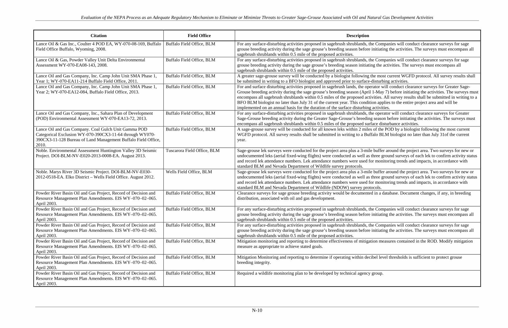
Evaluation of the NEPA Process as an Adequate Regulatory Mechanism to Eliminate or Minimize Threats to Greater Sage-Grouse Associated with Oil and Natural Gas Development Activities
N-10
Citation Field Office Description
Lance Oil & Gas Inc., Coulter 4 POD EA, WY-070-08-169, Buffalo Field Office Buffalo, Wyoming, 2008.
Buffalo Field Office, BLM For any surface-disturbing activities proposed in sagebrush shrublands, the Companies will conduct clearance surveys for sage grouse breeding activity during the sage grouse’s breeding season before initiating the activities. The surveys must encompass all sagebrush shrublands within 0.5 mile of the proposed activities.
Lance Oil & Gas, Powder Valley Unit Delta Environmental Assessment WY-070-EA08-143, 2008.
Buffalo Field Office, BLM For any surface-disturbing activities proposed in sagebrush shrublands, the Companies will conduct clearance surveys for sage grouse breeding activity during the sage grouse’s breeding season initiating the activities. The surveys must encompass all sagebrush shrublands within 0.5 mile of the proposed activities.
Lance Oil and Gas Company, Inc. Camp John Unit SMA Phase 1, Year 1; WY-070-EA11-214 Buffalo Field Office, 2011.
Buffalo Field Office, BLM A greater sage-grouse survey will be conducted by a biologist following the most current WGFD protocol. All survey results shall be submitted in writing to a BFO biologist and approved prior to surface-disturbing activities.
Lance Oil and Gas Company, Inc. Camp John Unit SMA Phase 1, Year 2; WY-070-EA12-084, Buffalo Field Office, 2013.
Buffalo Field Office, BLM For and surface disturbing activities proposed in sagebrush lands, the operator will conduct clearance surveys for Greater Sage-Grouse breeding activity during the sage grouse’s breeding season (April 1-May 7) before initiating the activities. The surveys must encompass all sagebrush shrublands within 0.5 miles of the proposed activities. All survey results shall be submitted in writing to a BFO BLM biologist no later than July 31 of the current year. This condition applies to the entire project area and will be implemented on an annual basis for the duration of the surface disturbing activities.
Lance Oil and Gas Company, Inc., Sahara Plan of Development (POD) Environmental Assessment WY-070-EA13-72, 2013.
Buffalo Field Office, BLM For any surface-disturbing activities proposed in sagebrush shrublands, the operator will conduct clearance surveys for Greater Sage-Grouse breeding activity during the Greater Sage-Grouse’s breeding season before initiating the activities. The surveys must encompass all sagebrush shrublands within 0.5 miles of the proposed surface disturbance activities.
Lance Oil and Gas Company. Coal Gulch Unit Gamma POD Categorical Exclusion WY-070-390CX3-11-64 through WY070-390CX3-11-128 Bureau of Land Management Buffalo Field Office, 2010.
Buffalo Field Office, BLM A sage-grouse survey will be conducted for all known leks within 2 miles of the POD by a biologist following the most current WGFD protocol. All survey results shall be submitted in writing to a Buffalo BLM biologist no later than July 31of the current year.
Noble. Environmental Assessment Huntington Valley 3D Seismic Project. DOI-BLM-NV-E020-2013-0008-EA. August 2013.
Tuscarora Field Office, BLM Sage-grouse lek surveys were conducted for the project area plus a 3-mile buffer around the project area. Two surveys for new or undocumented leks (aerial fixed-wing flights) were conducted as well as three ground surveys of each lek to confirm activity status and record lek attendance numbers. Lek attendance numbers were used for monitoring trends and impacts, in accordance with standard BLM and Nevada Department of Wildlife survey protocols.
Noble. Marys River 3D Seismic Project. DOI-BLM-NV-E030-2012-0518-EA. Elko District – Wells Field Office. August 2012.
Wells Field Office, BLM Sage-grouse lek surveys were conducted for the project area plus a 3-mile buffer around the project area. Two surveys for new or undocumented leks (aerial fixed-wing flights) were conducted as well as three ground surveys of each lek to confirm activity status and record lek attendance numbers. Lek attendance numbers were used for monitoring trends and impacts, in accordance with standard BLM and Nevada Department of Wildlife (NDOW) survey protocols.
Powder River Basin Oil and Gas Project, Record of Decision and Resource Management Plan Amendments. EIS WY–070–02–065. April 2003.
Buffalo Field Office, BLM Clearance surveys for sage grouse breeding activity would be documented in a database. Document changes, if any, in breeding distribution, associated with oil and gas development.
Powder River Basin Oil and Gas Project, Record of Decision and Resource Management Plan Amendments. EIS WY–070–02–065. April 2003.
Buffalo Field Office, BLM For any surface-disturbing activities proposed in sagebrush shrublands, the Companies will conduct clearance surveys for sage grouse breeding activity during the sage grouse’s breeding season before initiating the activities. The surveys must encompass all sagebrush shrublands within 0.5 mile of the proposed activities.
Powder River Basin Oil and Gas Project, Record of Decision and Resource Management Plan Amendments. EIS WY–070–02–065. April 2003.
Buffalo Field Office, BLM Mitigation monitoring and reporting to determine effectiveness of mitigation measures contained in the ROD. Modify mitigation measure as appropriate to achieve stated goals.
Powder River Basin Oil and Gas Project, Record of Decision and Resource Management Plan Amendments. EIS WY–070–02–065. April 2003.
Buffalo Field Office, BLM Mitigation Monitoring and reporting to determine if operating within decibel level thresholds is sufficient to protect grouse breeding integrity.
Powder River Basin Oil and Gas Project, Record of Decision and Resource Management Plan Amendments. EIS WY–070–02–065. April 2003.
Buffalo Field Office, BLM Required a wildlife monitoring plan to be developed by technical agency group.

Evaluation of the NEPA Process as an Adequate Regulatory Mechanism to Eliminate or Minimize Threats to Greater Sage-Grouse Associated with Oil and Natural Gas Development Activities
N-11
Citation Field Office Description
Powder River Basin Oil and Gas Project, Record of Decision and Resource Management Plan Amendments. EIS WY–070–02–065. April 2003.
Buffalo Field Office, BLM The BLM Buffalo Field Manager will implement the Mitigation Monitoring and Reporting Plan by establishing the Powder River Basin Working Group (PRBWG). The PRBWG will function as a resource working group consisting of BLM, cooperating agencies and other agencies who have expertise and regulatory authority in the area. The primary function of the PRBWG will be to: Review the development and implementation of monitoring plans for the PRB oil and gas development; Meet at a minimum once a year or more often as needed; Keep written record of meetings and disseminate to members and interested public; Conduct field inspections as needed to review the implementation of construction and rehabilitation operations; Review status quo and any new information since last meeting (e.g., monitoring results of impact mitigation effectiveness); Synthesize monitoring plan activities/expectations for the coming year, based upon operator input and new information; Review recommendations from the Task Groups and submit a recommendation to BLM (e.g., management practices and monitoring needs for upcoming field season); Oversee implementation of monitoring.
Powder River Basin Oil and Gas Project, Record of Decision and Resource Management Plan Amendments. EIS WY–070–02–065. April 2003.
Buffalo Field Office, BLM The Companies will conduct clearance surveys for threatened, endangered or other special-concern species at the optimum time. Inventory for special concern species is contingent upon landowner concurrence. This will require coordination with the BLM before November 1 annually to review the potential for disturbance and to agree on inventory parameters.
Powder River Basin Oil and Gas Project, Record of Decision and Resource Management Plan Amendments. EIS WY–070–02–065. April 2003.
Buffalo Field Office, BLM The Companies will conduct clearance surveys for threatened, endangered or other special-concern species at the optimum time. Inventory for special concern species, other than federally listed species below, is contingent upon landowner concurrence. This will require coordination with the BLM before November 1 annually to review the potential for disturbance and to agree on inventory parameters.
Powder River Basin Oil and Gas Project, Record of Decision and Resource Management Plan Amendments. EIS WY–070–02–065. April 2003.
Buffalo Field Office, BLM The semi-annual report will include field survey reports for endangered, threatened, proposed and candidate species for all actions covered under the Environmental Impact Statement (EIS) for the Powder River Basin Oil and Gas Project and ROD. The semi-annual reports will include all actions completed up to 30 days prior to the reporting dates. The first report will be due 6 months after the signing of the ROD and on the anniversary date of the signing of the ROD. Reporting will continue for the life of the project.
Record of Decision, Final Supplemental Environmental Impact Statement for the Pinedale Anticline Oil and Gas Exploration and Development Project, Sublette County, Wyoming. 2008.
Pinedale Field Office, BLM This ROD includes a Wildlife Monitoring and Mitigation Matrix (Appendix B) that will trigger mitigation responses based upon monitoring information (e.g. Average of 30% decline in sage grouse male lek attendance over 2 years compared to reference area would trigger mitigation)
Record of Decision, Final Supplemental Environmental Impact Statement for the Pinedale Anticline Oil and Gas Exploration and Development Project, Sublette County, Wyoming. 2008.
Pinedale Field Office, BLM Adaptive management - The Operators will provide information on existing development and results of relevant monitoring studies at the annual meeting of the Review Team….When monitoring indicates a change requiring mitigation, serious mitigation efforts will be developed…
Record of Decision, Final Supplemental Environmental Impact Statement for the Pinedale Anticline Oil and Gas Exploration and Development Project, Sublette County, Wyoming. 2008.
Pinedale Field Office, BLM Decibel monitoring from March 1-May 15 at lek sites.
Record of Decision, Final Supplemental Environmental Impact Statement for the Pinedale Anticline Oil and Gas Exploration and Development Project, Sublette County, Wyoming. 2008.
Pinedale Field Office, BLM Establish a Pinedale Anticline Project Office to obtain, collect, store, and distribute monitoring information to support adaptive management and analyze mitigation projects.
Record of Decision, Final Supplemental Environmental Impact Statement for the Pinedale Anticline Oil and Gas Exploration and Development Project, Sublette County, Wyoming. 2008.
Pinedale Field Office, BLM If existing information is not current, field evaluations for greater sage-grouse leks and/or nests will be conducted by a qualified biologist prior to the start of activities in potential greater sage grouse habitat. These field evaluations for leks and/or nests will be conducted if project activities are planned in potential greater sage-grouse habitat between March 15 and July 15. BLM wildlife biologists will ensure that such surveys are conducted using proper survey methods.
Record of Decision, Final Supplemental Environmental Impact Statement for the Pinedale Anticline Oil and Gas Exploration and Development Project, Sublette County, Wyoming. 2008.
Pinedale Field Office, BLM Monitor winter concentration area use.
Record of Decision, Final Supplemental Environmental Impact Statement for the Pinedale Anticline Oil and Gas Exploration and Development Project, Sublette County, Wyoming. 2008.
Pinedale Field Office, BLM Nesting success and habitat selection study.
Record of Decision, Final Supplemental Environmental Impact Statement for the Pinedale Anticline Oil and Gas Exploration and Development Project, Sublette County, Wyoming. 2008.
Pinedale Field Office, BLM Operators pay into a Fund used for additional air quality monitoring, additional wildlife, livestock, vegetation and reclamation research, analysis, monitoring, and mitigation.
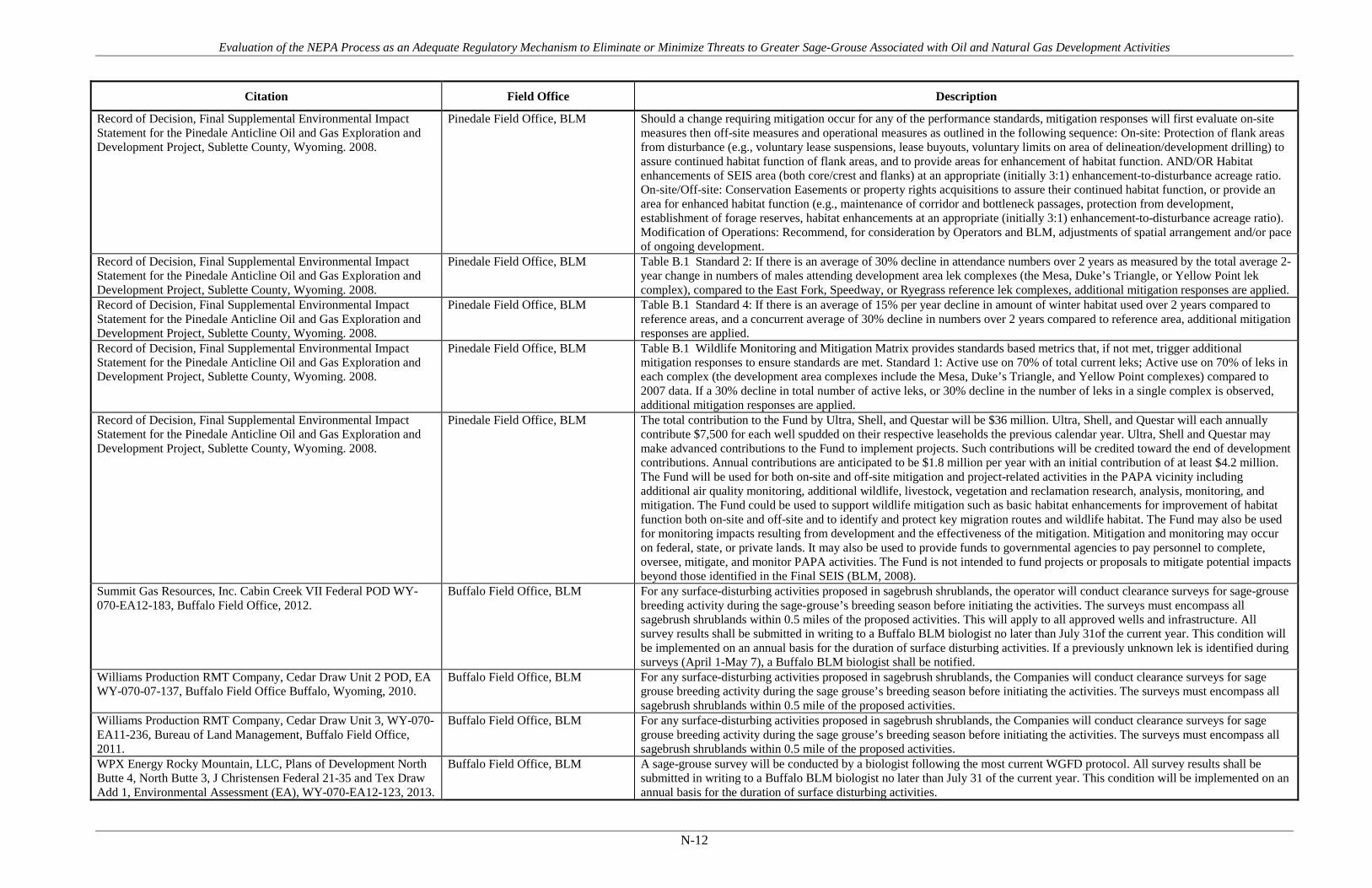
Evaluation of the NEPA Process as an Adequate Regulatory Mechanism to Eliminate or Minimize Threats to Greater Sage-Grouse Associated with Oil and Natural Gas Development Activities
N-12
Citation Field Office Description
Record of Decision, Final Supplemental Environmental Impact Statement for the Pinedale Anticline Oil and Gas Exploration and Development Project, Sublette County, Wyoming. 2008.
Pinedale Field Office, BLM Should a change requiring mitigation occur for any of the performance standards, mitigation responses will first evaluate on-site measures then off-site measures and operational measures as outlined in the following sequence: On-site: Protection of flank areas from disturbance (e.g., voluntary lease suspensions, lease buyouts, voluntary limits on area of delineation/development drilling) to assure continued habitat function of flank areas, and to provide areas for enhancement of habitat function. AND/OR Habitat enhancements of SEIS area (both core/crest and flanks) at an appropriate (initially 3:1) enhancement-to-disturbance acreage ratio. On-site/Off-site: Conservation Easements or property rights acquisitions to assure their continued habitat function, or provide an area for enhanced habitat function (e.g., maintenance of corridor and bottleneck passages, protection from development, establishment of forage reserves, habitat enhancements at an appropriate (initially 3:1) enhancement-to-disturbance acreage ratio). Modification of Operations: Recommend, for consideration by Operators and BLM, adjustments of spatial arrangement and/or pace of ongoing development.
Record of Decision, Final Supplemental Environmental Impact Statement for the Pinedale Anticline Oil and Gas Exploration and Development Project, Sublette County, Wyoming. 2008.
Pinedale Field Office, BLM Table B.1 Standard 2: If there is an average of 30% decline in attendance numbers over 2 years as measured by the total average 2-year change in numbers of males attending development area lek complexes (the Mesa, Duke’s Triangle, or Yellow Point lek complex), compared to the East Fork, Speedway, or Ryegrass reference lek complexes, additional mitigation responses are applied.
Record of Decision, Final Supplemental Environmental Impact Statement for the Pinedale Anticline Oil and Gas Exploration and Development Project, Sublette County, Wyoming. 2008.
Pinedale Field Office, BLM Table B.1 Standard 4: If there is an average of 15% per year decline in amount of winter habitat used over 2 years compared to reference areas, and a concurrent average of 30% decline in numbers over 2 years compared to reference area, additional mitigation responses are applied.
Record of Decision, Final Supplemental Environmental Impact Statement for the Pinedale Anticline Oil and Gas Exploration and Development Project, Sublette County, Wyoming. 2008.
Pinedale Field Office, BLM Table B.1 Wildlife Monitoring and Mitigation Matrix provides standards based metrics that, if not met, trigger additional mitigation responses to ensure standards are met. Standard 1: Active use on 70% of total current leks; Active use on 70% of leks in each complex (the development area complexes include the Mesa, Duke’s Triangle, and Yellow Point complexes) compared to 2007 data. If a 30% decline in total number of active leks, or 30% decline in the number of leks in a single complex is observed, additional mitigation responses are applied.
Record of Decision, Final Supplemental Environmental Impact Statement for the Pinedale Anticline Oil and Gas Exploration and Development Project, Sublette County, Wyoming. 2008.
Pinedale Field Office, BLM The total contribution to the Fund by Ultra, Shell, and Questar will be $36 million. Ultra, Shell, and Questar will each annually contribute $7,500 for each well spudded on their respective leaseholds the previous calendar year. Ultra, Shell and Questar may make advanced contributions to the Fund to implement projects. Such contributions will be credited toward the end of development contributions. Annual contributions are anticipated to be $1.8 million per year with an initial contribution of at least $4.2 million. The Fund will be used for both on-site and off-site mitigation and project-related activities in the PAPA vicinity including additional air quality monitoring, additional wildlife, livestock, vegetation and reclamation research, analysis, monitoring, and mitigation. The Fund could be used to support wildlife mitigation such as basic habitat enhancements for improvement of habitat function both on-site and off-site and to identify and protect key migration routes and wildlife habitat. The Fund may also be used for monitoring impacts resulting from development and the effectiveness of the mitigation. Mitigation and monitoring may occur on federal, state, or private lands. It may also be used to provide funds to governmental agencies to pay personnel to complete, oversee, mitigate, and monitor PAPA activities. The Fund is not intended to fund projects or proposals to mitigate potential impacts beyond those identified in the Final SEIS (BLM, 2008).
Summit Gas Resources, Inc. Cabin Creek VII Federal POD WY-070-EA12-183, Buffalo Field Office, 2012.
Buffalo Field Office, BLM For any surface-disturbing activities proposed in sagebrush shrublands, the operator will conduct clearance surveys for sage-grouse breeding activity during the sage-grouse’s breeding season before initiating the activities. The surveys must encompass all sagebrush shrublands within 0.5 miles of the proposed activities. This will apply to all approved wells and infrastructure. All survey results shall be submitted in writing to a Buffalo BLM biologist no later than July 31of the current year. This condition will be implemented on an annual basis for the duration of surface disturbing activities. If a previously unknown lek is identified during surveys (April 1-May 7), a Buffalo BLM biologist shall be notified.
Williams Production RMT Company, Cedar Draw Unit 2 POD, EA WY-070-07-137, Buffalo Field Office Buffalo, Wyoming, 2010.
Buffalo Field Office, BLM For any surface-disturbing activities proposed in sagebrush shrublands, the Companies will conduct clearance surveys for sage grouse breeding activity during the sage grouse’s breeding season before initiating the activities. The surveys must encompass all sagebrush shrublands within 0.5 mile of the proposed activities.
Williams Production RMT Company, Cedar Draw Unit 3, WY-070-EA11-236, Bureau of Land Management, Buffalo Field Office, 2011.
Buffalo Field Office, BLM For any surface-disturbing activities proposed in sagebrush shrublands, the Companies will conduct clearance surveys for sage grouse breeding activity during the sage grouse’s breeding season before initiating the activities. The surveys must encompass all sagebrush shrublands within 0.5 mile of the proposed activities.
WPX Energy Rocky Mountain, LLC, Plans of Development North Butte 4, North Butte 3, J Christensen Federal 21-35 and Tex Draw Add 1, Environmental Assessment (EA), WY-070-EA12-123, 2013.
Buffalo Field Office, BLM A sage-grouse survey will be conducted by a biologist following the most current WGFD protocol. All survey results shall be submitted in writing to a Buffalo BLM biologist no later than July 31 of the current year. This condition will be implemented on an annual basis for the duration of surface disturbing activities.
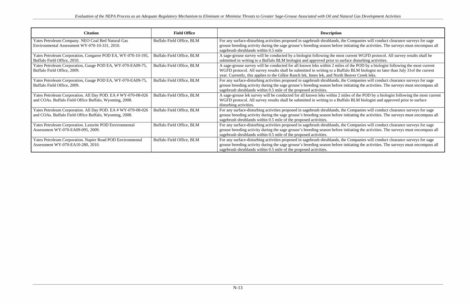
Evaluation of the NEPA Process as an Adequate Regulatory Mechanism to Eliminate or Minimize Threats to Greater Sage-Grouse Associated with Oil and Natural Gas Development Activities
N-13
Citation Field Office Description
Yates Petroleum Company. NEO Coal Bed Natural Gas Environmental Assessment WY-070-10-331, 2010.
Buffalo Field Office, BLM For any surface-disturbing activities proposed in sagebrush shrublands, the Companies will conduct clearance surveys for sage grouse breeding activity during the sage grouse’s breeding season before initiating the activities. The surveys must encompass all sagebrush shrublands within 0.5 mile
Yates Petroleum Corporation, Congaree POD EA, WY-070-10-195, Buffalo Field Office, 2010.
Buffalo Field Office, BLM A sage-grouse survey will be conducted by a biologist following the most current WGFD protocol. All survey results shall be submitted in writing to a Buffalo BLM biologist and approved prior to surface disturbing activities.
Yates Petroleum Corporation, Gauge POD EA, WY-070-EA09-75, Buffalo Field Office, 2009.
Buffalo Field Office, BLM A sage-grouse survey will be conducted for all known leks within 2 miles of the POD by a biologist following the most current WGFD protocol. All survey results shall be submitted in writing to a Buffalo BLM biologist no later than July 31of the current year. Currently, this applies to the Gilkie Ranch lek, Innes lek, and North Beaver Creek leks.
Yates Petroleum Corporation, Gauge POD EA, WY-070-EA09-75, Buffalo Field Office, 2009.
Buffalo Field Office, BLM For any surface-disturbing activities proposed in sagebrush shrublands, the Companies will conduct clearance surveys for sage grouse breeding activity during the sage grouse’s breeding season before initiating the activities. The surveys must encompass all sagebrush shrublands within 0.5 mile of the proposed activities.
Yates Petroleum Corporation. All Day POD. EA # WY-070-08-026 and COAs. Buffalo Field Office Buffalo, Wyoming, 2008.
Buffalo Field Office, BLM A sage-grouse lek survey will be conducted for all known leks within 2 miles of the POD by a biologist following the most current WGFD protocol. All survey results shall be submitted in writing to a Buffalo BLM biologist and approved prior to surface disturbing activities.
Yates Petroleum Corporation. All Day POD. EA # WY-070-08-026 and COAs. Buffalo Field Office Buffalo, Wyoming, 2008.
Buffalo Field Office, BLM For any surface-disturbing activities proposed in sagebrush shrublands, the Companies will conduct clearance surveys for sage grouse breeding activity during the sage grouse’s breeding season before initiating the activities. The surveys must encompass all sagebrush shrublands within 0.5 mile of the proposed activities.
Yates Petroleum Corporation. Lazurite POD Environmental Assessment WY-070-EA09-095, 2009.
Buffalo Field Office, BLM For any surface-disturbing activities proposed in sagebrush shrublands, the Companies will conduct clearance surveys for sage grouse breeding activity during the sage grouse’s breeding season before initiating the activities. The surveys must encompass all sagebrush shrublands within 0.5 mile of the proposed activities.
Yates Petroleum Corporation. Napier Road POD Environmental Assessment WY-070-EA10-280, 2010.
Buffalo Field Office, BLM For any surface-disturbing activities proposed in sagebrush shrublands, the Companies will conduct clearance surveys for sage grouse breeding activity during the sage grouse’s breeding season before initiating the activities. The surveys must encompass all sagebrush shrublands within 0.5 mile of the proposed activities.

Evaluation of the NEPA Process as an Adequate Regulatory Mechanism to Eliminate or Minimize Threats to Greater Sage-Grouse Associated with Oil and Natural Gas Development Activities
APPENDIX O Implemented Projects

Evaluation of the NEPA Process as an Adequate Regulatory Mechanism to Eliminate or Minimize Threats to Greater Sage-Grouse Associated with Oil and Natural Gas Development Activities
O-1
Table O-1. Description of Implemented Sage-grouse Mitigation Projects.
Project Name Project Description
BLM. Piceance Basin Greater Sage-Grouse Habitat Inventory, 2006
ExxonMobil, and EnCana allowed BLM to use their land to access public land and/or to conduct the habitat inventory on their land. EnCana provided $17,000 to help fund this project. Developed a computer model of potential sage-grouse habitat within the Parachute Creek – Piceance Basin – Roan Plateau area (PPR). The next step was to ground-truth the vegetation types within the computer model. We are using this information to improve our estimate of the acreage of sage-grouse habitat. We have also used this information to identify several potential areas for habitat restoration work based on dense shrub cover, low understory cover, tall serviceberry shrubs, or the encroachment of pinyon/juniper. EnCana has provided $10,000 towards sage-grouse habitat restoration and we plan to begin work next summer.
BLM. PPR Greater Sage-Grouse Habitat Mapping, 2008
Vegetation mapping of 29,205 acres 2007 field season. We are using this information to improve our estimate of the acreage of sage-grouse habitat. We have also used this information to identify several potential areas for habitat restoration work based on dense shrub cover, low understory cover, tall serviceberry shrubs, or the encroachment of pinyon/juniper. ConocoPhillips, EnCana, ExxonMobil, Orion Energy Partners, Shell, and landowners provided access to their land. EnCana provided $34,000 to help fund this project in 2006 and 2007.
Mesa Sagebrush Fertilization Project Prepared by Bureau of Land Management Pinedale Field Office. WY-100-EA11-186.
Decision approves fertilization of 30,958 acres of BLM administered lands to improve sagebrush habitat conditions. In 2010, the mule deer monitoring data indicated the mule deer numbers on the Mesa decreased more than 15% triggering a mitigation response as outlined in the ROD. This project was developed as a mitigation response to exceeding the threshold in change of mule deer abundance as outlined in the WMMM. Habitat enhancement is one of the first options available in the Mitigation Responses to population decline. The project is designed to enhance available winter forage for mule deer by increasing sagebrush production, and potentially increasing palatability and nutrient quality on identified mule deer crucial winter range. The proposed project has been reviewed and is in conformance with BLM IM. No. WY-2010-012 and is consistent with guidelines provided in the Governor’s Sage-grouse Implementation Team’s Core Population Area strategy and the Governor’s Executive Order 2011-5. The project would maintain and/or potentially increase the current sagebrush canopy cover and should therefore maintain the functionality and quality of the habitat for sage-grouse in winter. The shift in plant community dynamics that would be expected to occur with the fertilizer treatments could increase the amount of cover and forage available for sage-grouse on the Mesa year round. To date approximately 1,600 acres have been fertilized (2 separate projects) and efforts are underway to determine whether actions have resulted in increased vegetation productivity and/or nutrient content.

Evaluation of the NEPA Process as an Adequate Regulatory Mechanism to Eliminate or Minimize Threats to Greater Sage-Grouse Associated with Oil and Natural Gas Development Activities
O-2
Project Name Project Description
Arambel Reservoir Habitat Improvement
Treatment of 5-acre test plots using Lawson Aerator. Snow fence construction to add moisture for increased reclamation success, test of weed control methods, and repair of dam on Arambel Reservoir. Develop 2 water wells and build an exclosure around Sublette Springs to improve the riparian area. Project funded $499,000. 1830 acres. Status (2011): in progress, monitoring on-going.
Cottonwood Ranches Bench Corral Conservation Project
This project has three parts including: 1) Conservation easement and conservation plan to preserve and enhance pristine wildlife habitat on 1,110 acres; 2) Water efficiency project that will allow improved irrigation and grazing management on 25,000 acres, and 3) Funding for intensive grazing management on a large scale (25,000 acres) that will address BMPs for sagebrush obligates. Project meets JIO wildlife mitigation goals for preserving and enhancing wildlife habitats. Project funded $559,900.00. 27,000 acres. Status (2011): Conservation easement complete.
Cottonwood Ranches II Conservation Easement
This is the second Cottonwood Ranches project. This project includes a conservation easement with a conservation plan on approximately 1,600 acres of private land; implementation of improved grazing management on adjacent BLM allotments, state leases and private lands; and implementation of a water efficiency project designed to enhance grazing management implementation, increase forage production (for wildlife and livestock), and improve stream and riparian health over a two-mile stretch of Cottonwood Creek. Project meets JIO wildlife mitigation goals for preserving and enhancing valuable wildlife habitats. Acres: 5,172; Status (2011): Conservation easement complete; Project funded $910,417.00.
Cottonwood Ranches III Easement Conservation easement acquisition coupled with long-term land management planning and habitat improvement projects. Project funded $988,350.00. 2,571 acres. Status (2011): Conservation easement complete.
Cottonwood Ranches Conservation Plan
Plan for Cottonwood I, II, and III projects. The general location of the Cottonwood site was selected by the Jonah Interagency Office staff in 2007 for its outstanding wildlife values that mimic those found in the Jonah Field. The overall goal of the Cottonwood Ranches Initiative is to conserve and enhance the contiguous 90,000 acres of deeded and public lands controlled by the Cottonwood Ranches. Three progressive management plans are incorporated into a comprehensive plan that adds an additional contiguous 5,034 acres to the management planning area, and connects the Cottonwood Ranches site to the McNeel Trust JIO project site, providing a contiguous block of 50,000 acres being managed for benefits to sage-grouse and other affected species. This project includes the implementation of various practices to improve wildlife habitat including sagebrush treatments, watering facilities, irrigation practices, and monitoring. Project funded $625,000.00. Status (2011): In progress

Evaluation of the NEPA Process as an Adequate Regulatory Mechanism to Eliminate or Minimize Threats to Greater Sage-Grouse Associated with Oil and Natural Gas Development Activities
O-3
Project Name Project Description
Carney Ranch Conservation Easement
Conservation easement, with a conservation plan on 2,571 acres of extremely valuable wildlife habitat in the Upper Green River Valley that is at high risk for development. This property includes portions of the pronghorn antelope migratory bottleneck (the Funnel Bottleneck) at the head of the Upper Green River, sage-grouse nesting and brood rearing habitat, approximately one mile of Green River frontage, elk winter range, moose crucial winter range, and other wildlife habitat values. This project meets the JIO wildlife mitigation goals by permanently protecting the "Funnel Bottleneck" portion of the pronghorn antelope migratory corridor. The conservation plan demonstrates how this property will be managed in a way that improves/maintains/protects these valuable habitats. Project funded $2,093,800.00. Acres: 51,156; Status (2011): In progress.
Cross Lazy Two Ranch Project Project involves (1) purchasing a conservation easement on the ±4,410-acre Cross Lazy Two Ranch and (2) implementing a mutually-agreeable conservation/habitat management plan includes annual monitoring and a communication plan to ensure regular review and adaptation as necessary. Project meets JIO wildlife mitigation goals for preserving and enhancing wildlife habitats. Project funded $2,000,000.00; Acres: 4,598; Status (2011): Conservation easement complete; conservation plan implementation in progress
Diamond H Ranch Conservation Project
Conservation easement and conservation plan on approximately 3,000 acres of high quality wildlife habitat around small-tract home-site developments. Habitat fragmentation resulting from development activities are considered to be among the State's greatest threats to wildlife habitat and to traditional agricultural operations. Project meets JIO wildlife mitigation goals for preserving and enhancing wildlife habitats. Project funded $479,430.00. Status (2011): Complete.
Elk Mountain/Red Canyon Prescribed Burn
Project includes the improvement of upland plant communities for various wildlife species, including sage-grouse, with prescribed burning of 20,000 acres in a mosaic pattern in the Elk Mountain area. This action is the most environmentally acceptable method of stimulating regeneration of desired plant communities (aspen, mountain shrubs and grasses). Project meets JIO wildlife mitigation goals for preserving and enhancing wildlife habitats. Project funded $72,000.00. Status (2011): complete
Espenscheid Ranches Conservation Easement
Project is designed to meet JIO wildlife and livestock mitigation goals through acquisition of a conservation easement on 10,000 acres of private land and a grazing management plan for 10,700 acres of associated BLM allotments. Conservation easement and plan must be completed by May 31, 2011. Project funded for $575,000. 10,000 acres. Status (2011): funded
McNeel Conservation Plan Project involves: 1) purchasing a conservation easement on the 620 acres of McNeel Ranch and 2) implementing and monitoring a conservation/habitat management plan on 2,500 acres. Project meets JIO wildlife mitigation goals for preserving and enhancing wildlife habitats. Project funded $320,000.00. 2,052 acres. Status (2011): Conservation easement complete; conservation plan implementation in progress.

Evaluation of the NEPA Process as an Adequate Regulatory Mechanism to Eliminate or Minimize Threats to Greater Sage-Grouse Associated with Oil and Natural Gas Development Activities
O-4
Project Name Project Description
MJ Ranch Conservation Project Conservation easement and conservation plan on 2,052 acres to preserve valuable wildlife habitat. Project meets JIO wildlife mitigation goals for preserving and enhancing wildlife habitats. Project funded $536,821.00. Status (2011): Conservation easement complete; conservation plan implementation in progress.
Noble Cora Peak Wildlife Project Project includes 3 separate components: 1) Upgrade an existing spring and install a diversion to divert sediments away from the spring. Spring will provide essential vegetation for sage-grouse brood rearing, and drinking water for wildlife. 2) Drill and install a new water well with facilities for wildlife and livestock. This well will allow water to run-off down into the draw and into an old reservoir potentially creating vegetation essential for sage-grouse brood rearing. This watering facility will also create clean drinking water for pronghorn, as this is in the migratory area. Potential exists to install a wildlife friendly fence around the spring and reservoir for wildlife use. 3) Drill and install 2nd water well in northeast area of allotment. This well will provide drinking water for pronghorn and mule deer, especially during migrations, as well as livestock. Potential exists to develop plans for vegetation improvements if warranted. Project proponent will use the watering systems to implement a rotational grazing pattern throughout the allotment. Project funded $64,640.00. Status (2011): in progress
Ryegrass Allotment Mowing Project
Project consists of mowing sagebrush on the Ryegrass Individual and James Ryegrass allotments. Project meets JIO wildlife mitigation goals by enhancing wildlife habitats through creating a mosaic landscape improving diversity and age classes of vegetation. Project funded $13,000.00. Project status (2011): Completed
Water Trough Bird Ramps Install wildlife escape ramps in all BLM range improvement water tanks. Project meets JIO wildlife mitigation goals by reducing sage-grouse and other animal drowning in livestock watering facilities. These escape ramps will allow for easy access out of the tank should animals fall in. Eighty ramps installed in 2009. Project funded $36,500.00. Status (2011): in progress.

Evaluation of the NEPA Process as an Adequate Regulatory Mechanism to Eliminate or Minimize Threats to Greater Sage-Grouse Associated with Oil and Natural Gas Development Activities
O-5
Project Name Project Description
Fence monitoring for sage grouse strikes, 2012 Monitoring Report, Aster Canyon Consulting.
11.9 miles of fence were monitored 8 times during greater sage-grouse lekking season (March, April, and May). 4 simple strikes and 4 mortality strikes of greater sage-grouse were recorded during lekking season monitoring. 78.2 miles of fence were monitored twice outside of greater sage-grouse lekking season (July and August). 3 simple strikes (2 greater sage-grouse, 1 common nighthawk) and 6 mortality strikes (3 greater sage-grouse, 3 horned lark) were recorded during summer monitoring. In the spring of 2011, fence markers were placed along the northern border of the JIDPA in places where sage-grouse strikes had been recorded in 2010. The same was done in the spring of 2012 for all sage-grouse strikes recorded in 2011. The objectives of 2012 fence monitoring were to: (1) provide locations of fence strikes on 11.9 miles of fence monitored during sage-grouse lekking season and 78.2 miles of fence monitored during the summer; and (2) provide information on the effectiveness of previously-placed fence markers. In 2013, monitoring surveys to document fence strikes will be conducted on 9.3 miles of designated fence line in the northern portion of the JIDPA. If sage-grouse fence strike areas are identified, those problem areas of fence will be subsequently equipped with strike deterrents in accordance with the methods developed by Sutton Avian Research Center in Oklahoma.
Greater sage-grouse lek surveys, 2012 Monitoring Report, Aster Canyon Consulting
In 2012, the BLM and WGFD conducted annual sage-grouse lek surveys and inventories in the JIDPA and 3-mile buffer. In 2013, Annual lek counts and inventories will be conducted by WGFD and BLM personnel on existing known lek locations within the JIDPA and a 3-mile buffer.
Atlantic Rim Sage Grouse Winter Concentration Habitat Mapping Study
1. Generate winter probability-of-occurrence maps across the Atlantic Rim based on data collected in winter 2007–2010. 2. Identify source winter habitats through seasonal risk-assessment modeling (i.e., determine which habitats identified as having a high probability-of-occurrence also have high probabilities of adult female survival during winter. 3. Generate maps depicting areas of winter conservation concern across the Atlantic Rim based on winter occurrence of grouse and risk of adult female survival
Avian Predator Densities associated with Sage Grouse Nests in SW Wyoming. Jonathon Dinkins, et al.
Study of predation risk, compared avian predator densities at sage-grouse nest and brood locations to random locations.
Identifying habitats for Greater Sage-grouse Population Persistence in a Developing Coalbed Methane Field in South-Central Wyoming
1. Generate probability-of-occurrence maps specific to the reproductive period of female sage-grouse; 2. Quantify habitat value as related to reproduction and survival through risk-assessment modeling; 3. Combine these models to identify critical and/or limiting reproductive habitats across the project area (i.e., sink and source habitats)

Evaluation of the NEPA Process as an Adequate Regulatory Mechanism to Eliminate or Minimize Threats to Greater Sage-Grouse Associated with Oil and Natural Gas Development Activities
O-6
Project Name Project Description
Sage-grouse Inventory and Monitoring in the Atlantic Rim 2007-2009 (BLM / WyG&F / APC)
2007 -Collaring Study –track and monitor sage grouse locations –aerial 2008 -Collaring Study –identify important nesting and brood rearing habitat –air and ground 2009 -Collaring Study –identify important nesting and brood rearing habitat –air and ground
Peters Point Road Re-route Reclamation Monitoring.
On July 30, 2013 EIS personnel conducted an ocular estimate of vegetation growth on the reclaimed road west of the Peters Point airstrip. This project is part of the Reclamation and Wildlife Enhancement Plan.
Prickly Pear SE 12 Pad and Road Reroute
This project is part of the Reclamation and Wildlife Enhancement Plan. The 2011 report was a preconstruction evaluation of the pad and new road and gives suggested reclamation and monitoring information. The 2011 report does not discuss the reclaimed roads.
Cottonwood Ridge Pinyon-Juniper Treatment Project
To further the required mitigation needs for the WTNG project, the BLM and DWR are proposing to mechanically/hand treat approx. 2,070 acres. The proposed action is to use a hand crew as well as a bull hog to cut and limb/shred and grind pinyon pine and juniper (P/J) within the areas shown in the attached map. The project would be mostly on BLM-administered lands with the rest on State of Utah lands. The project would be funded by the Bill Barrett Corporation. The current proposal would include a small portion that is located within the Jack Canyon WSA and lands with wilderness characteristics. The proposed action would benefit sage grouse by removing P/J that is encroaching into existing sagebrush parks, which has reduced the grouses’ natural habitat of only sagebrush and grass, and in addition provided perching trees for raptors that prey upon sage grouse. It
QEP WRB 16-17-10-17 well COA implementation
All of the EA COAs were implemented. Documentation would include invoices showing when the location was built, invoices for the equipment that was used, weed spray invoices, reclamation invoices, water truck invoices and telemetry invoices.
UDWR Sage grouse study (3 year project)
QEP contribution of $27,450 (voluntary, not required by NEPA)
South Unit Habitat Improvement Project
The project will improve wildlife habitat by deterring the encroachment of pinyon, juniper, and Douglas-fir trees into shrub communities, which are critical for wildlife. Approximately 7,820 acres will be mechanically treated under this proposal. Treatments will occur from mid-summer to fall over a 7-year period. Existing roads will be used to access the project area. A portion of the project was completed in 2006, with additional treatments scheduled during the next few years. Document shows the 2006 and 2007 work was funded. The National Forest Foundation requested that Berry Petroleum, as a participant in the IPAMS “Conservation in Action” program, consider a tax-deductible contribution of $15,000 in cash and in-kind support (possible labor and equipment use donation). This was prior to the South Unit EIS.
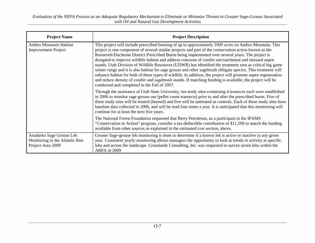
Evaluation of the NEPA Process as an Adequate Regulatory Mechanism to Eliminate or Minimize Threats to Greater Sage-Grouse Associated with Oil and Natural Gas Development Activities
O-7
Project Name Project Description
Anthro Mountain Habitat Improvement Project
This project will include prescribed burning of up to approximately 1000 acres on Anthro Mountain. This project is one component of several similar projects and part of the conservation action known as the Roosevelt/Duchesne District Prescribed Burns being implemented over several years. The project is designed to improve wildlife habitat and address concerns of conifer encroachment and stressed aspen stands. Utah Division of Wildlife Resources (UDWR) has identified the treatment area as critical big game winter range and it is also habitat for sage grouse and other sagebrush obligate species. This treatment will enhance habitat for both of these types of wildlife. In addition, the project will promote aspen regeneration and reduce density of conifer and sagebrush stands. If matching funding is available, the project will be conducted and completed in the Fall of 2007. Through the assistance of Utah State University, ten study sites containing 4 transects each were established in 2006 to monitor sage grouse use (pellet count transects) prior to and after the prescribed burns. Five of these study sites will be treated (burned) and five will be untreated as controls. Each of these study sites have baseline data collected in 2006, and will be read four times a year. It is anticipated that this monitoring will continue for at least the next five years. The National Forest Foundation requested that Berry Petroleum, as a participant in the IPAMS “Conservation in Action” program, consider a tax-deductible contribution of $11,500 to match the funding available from other sources as explained in the estimated cost section, above.
Anadarko Sage Grouse Lek Monitoring in the Atlantic Rim Project Area 2009
Greater Sage-grouse lek monitoring is done to determine if a known lek is active or inactive in any given year. Consistent yearly monitoring allows managers the opportunity to look at trends in activity at specific leks and across the landscape. Grasslands Consulting, Inc. was requested to survey seven leks within the ARPA in 2009
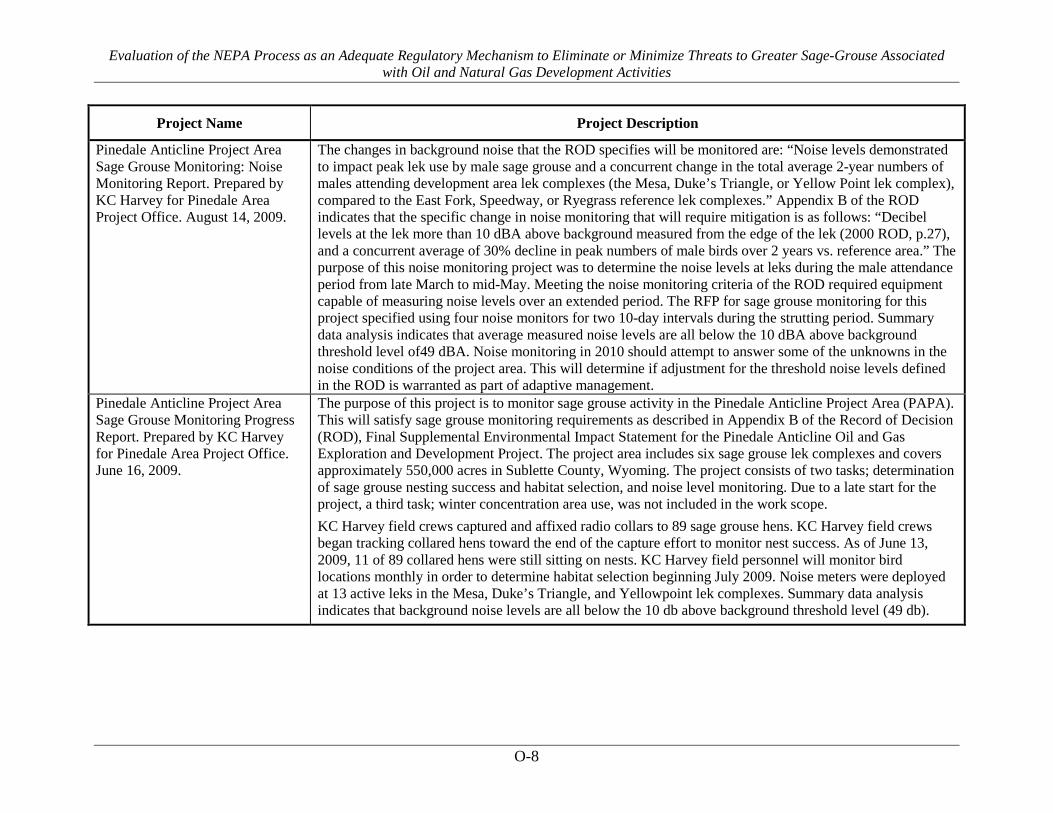
Evaluation of the NEPA Process as an Adequate Regulatory Mechanism to Eliminate or Minimize Threats to Greater Sage-Grouse Associated with Oil and Natural Gas Development Activities
O-8
Project Name Project Description
Pinedale Anticline Project Area Sage Grouse Monitoring: Noise Monitoring Report. Prepared by KC Harvey for Pinedale Area Project Office. August 14, 2009.
The changes in background noise that the ROD specifies will be monitored are: “Noise levels demonstrated to impact peak lek use by male sage grouse and a concurrent change in the total average 2-year numbers of males attending development area lek complexes (the Mesa, Duke’s Triangle, or Yellow Point lek complex), compared to the East Fork, Speedway, or Ryegrass reference lek complexes.” Appendix B of the ROD indicates that the specific change in noise monitoring that will require mitigation is as follows: “Decibel levels at the lek more than 10 dBA above background measured from the edge of the lek (2000 ROD, p.27), and a concurrent average of 30% decline in peak numbers of male birds over 2 years vs. reference area.” The purpose of this noise monitoring project was to determine the noise levels at leks during the male attendance period from late March to mid-May. Meeting the noise monitoring criteria of the ROD required equipment capable of measuring noise levels over an extended period. The RFP for sage grouse monitoring for this project specified using four noise monitors for two 10-day intervals during the strutting period. Summary data analysis indicates that average measured noise levels are all below the 10 dBA above background threshold level of49 dBA. Noise monitoring in 2010 should attempt to answer some of the unknowns in the noise conditions of the project area. This will determine if adjustment for the threshold noise levels defined in the ROD is warranted as part of adaptive management.
Pinedale Anticline Project Area Sage Grouse Monitoring Progress Report. Prepared by KC Harvey for Pinedale Area Project Office. June 16, 2009.
The purpose of this project is to monitor sage grouse activity in the Pinedale Anticline Project Area (PAPA). This will satisfy sage grouse monitoring requirements as described in Appendix B of the Record of Decision (ROD), Final Supplemental Environmental Impact Statement for the Pinedale Anticline Oil and Gas Exploration and Development Project. The project area includes six sage grouse lek complexes and covers approximately 550,000 acres in Sublette County, Wyoming. The project consists of two tasks; determination of sage grouse nesting success and habitat selection, and noise level monitoring. Due to a late start for the project, a third task; winter concentration area use, was not included in the work scope. KC Harvey field crews captured and affixed radio collars to 89 sage grouse hens. KC Harvey field crews began tracking collared hens toward the end of the capture effort to monitor nest success. As of June 13, 2009, 11 of 89 collared hens were still sitting on nests. KC Harvey field personnel will monitor bird locations monthly in order to determine habitat selection beginning July 2009. Noise meters were deployed at 13 active leks in the Mesa, Duke’s Triangle, and Yellowpoint lek complexes. Summary data analysis indicates that background noise levels are all below the 10 db above background threshold level (49 db).

Evaluation of the NEPA Process as an Adequate Regulatory Mechanism to Eliminate or Minimize Threats to Greater Sage-Grouse Associated with Oil and Natural Gas Development Activities
O-9
Project Name Project Description
Sommers-Grindstone Ranch Rapid Assessment of Mitigation Value. Holly E. Copeland and Joe Kiesecker. February 3, 2011.
In 2009, the PAPO provided project funds for three conservation easements on 19,546 acres of the Sommers-Grindstone Ranch in Sublette County. Our objective here is to provide a rapid quantitative assessment of the contribution of the Sommers-Grindstone Ranch to the mitigation goals determined by the 2010 assessment. Overall, one-third (6412 acres) of the Sommers-Grindstone easement lies within a Priority Mitigation Area as defined by TNC analysis. There are 752,435 acres of Priority Mitigation Areas overall within the study area, but only 12% (91,634 acres) are privately owned and available for conservation easements. The Sommers-Grindstone easement contributes significantly to many conservation goals with the PAPO (Table 1). The easement exceeds the minimum 2010 analysis goal for four conservation targets: mule deer migration corridor, bald eagle nesting habitat, wetlands, and montane sagebrush steppe. The easement also contributes significantly towards meeting goals of many other conservation targets (Table 1). Project areas will be monitored for easement compliance at least once each year. Habitat and wildlife conditions will be monitored or studied as time and funding allow.
Ten Year Sublette Mule Deer Mitigation Plan. Pinedale Anticline. October 12, 2012.
The focus areas for this 10-year Plan includes lands associated with the Mesa, Soapholes, and Ryegrass (Refer to Maps, Appendices B and G and Figure 1), and other adjacent areas identified by mule deer collaring information as important for either deer transitional ranges or winter ranges. Generally, winter ranges are located at relatively lower elevations associated with the Mesa, Soapholes, and eastern portions of the Ryegrass. Transitional ranges, including migration corridors and stopover habitat areas, have been identified by Sawyer and Nielson (2011) through the collaring and tracking of mule deer that winter on the Mesa. The importance of the Ryegrass, Soapholes, and Mesa areas to mule deer, sage-grouse (Centrocercus urophasianus) and other sagebrush- related wildlife species cannot be overstated, in particular in the face of development and the loss of some of the traditional areas/ranges of importance. Most of these areas are not only important crucial winter range, but also have great importance from a mule deer transitional/migration standpoint. In addition, the majority of the areas evaluated in 2011 lay within the designated Sage-Grouse Core Habitat Area (State of Wyoming Executive Order 2011).

Evaluation of the NEPA Process as an Adequate Regulatory Mechanism to Eliminate or Minimize Threats to Greater Sage-Grouse Associated with Oil and Natural Gas Development Activities
O-10
Project Name Project Description
2012-13 Greater Sage-grouse Annual Report Pinedale Anticline Project Area. Prepared by The Pinedale Anticline Project Office. September 4, 2013.
The 2008 Final Supplemental Environmental Impact Statement Record of Decision for the Pinedale Anticline Oil and Gas Exploration and Development Project (BLM 2008) includes a Wildlife Monitoring and Mitigation Matrix (WMMM) that identifies key wildlife species to be monitored and specific changes that require mitigation (Appendix A, Table 1). For greater sage-grouse, the WMMM is designed to quantitatively identify changes in greater sage-grouse populations within the Pinedale Anticline Project Area (PAPA). The WMMM defines criteria for monitoring greater sage-grouse and outlines mitigation responses if specified thresholds or triggers are met. Six lek complexes are monitored annually for changes specified in the WMMM (Appendix A, Figure 1). Lek attendance by male greater sage-grouse, number of active leks, winter concentration area use and noise are all monitored. Monitoring results indicate a threshold was met in 2012 and 2013. In 2012 and 2013, the Duke’s Triangle complex saw a 50% decline in active leks, exceeding the threshold of a 30% decline in number of active leks in a single development area complex compared to 2007 baseline data.
Greater Sage-grouse Lek Counts (2000-2007) in and Around Fidelity Exploration & Production Company’s Coalbed Natural Gas Development Areas in Big Horn County, Montana and Sheridan County, Wyoming
Since 2002, Hayden-Wing Associates (HWA) has been contracted to conduct wildlife surveys, including greater sage-grouse lek counts, in and around Fidelity’s proposed drilling areas in Big Horn County and Sheridan County (HWA 2002, 2003a, 2003b, 2004a, 2004b, 2005a, 2005b, 2006a, 2006b, 2007a, 2007b). HWA biologists have conducted annual lek counts from 2003 through 2007. In addition, HWA has compiled relevant count data from other sources for leks in and around Fidelity’s Plan of Development (POD) areas. From 2003 to 2007, aerial and ground surveys for greater sage-grouse leks were conducted by HWA in and within two miles of Fidelity’s PODs during the strutting season (i.e., April through early May) to search for new or undocumented leks and to check the activity status of known leks. In addition, HWA has compiled sage-grouse lek data collected before and during drilling operations (i.e., 2000-2007) from the BLM-Miles City Field Office (FO) and BLM-Buffalo FO, Wyoming Game and Fish Department (WGFD), Decker Coal Company (DCC), Spring Creek Coal Company (SCC), and the University of Montana (UMT). BLM biologists have conducted sage-grouse lek counts in the area on an irregular basis and have gathered data from a number of other sources. Thirty-seven greater sage-grouse leks have been documented in and around Fidelity’s drilling areas in Big Horn County, Montana and Sheridan County, Wyoming (Table 1, Figure 1). Although lek counts were conducted differently between leks and years, the total number of grouse counted at each lek provides a general, albeit unreliable, estimate of lek attendance. Survey effort varied from leks having been checked only four of eight years to leks having been checked all eight years. To date, lek activity status in and around Fidelity’s drilling areas does not seem to have been affected by drilling activities from 1999 through 2007.

Evaluation of the NEPA Process as an Adequate Regulatory Mechanism to Eliminate or Minimize Threats to Greater Sage-Grouse Associated with Oil and Natural Gas Development Activities
O-11
Project Name Project Description
Greater Sage-grouse Nesting Habitat within Fidelity Exploration & Production Company’s Badger Hills, Coal Creek, Corral Creek, Decker Mine East, and Deer Creek North Plans of Development in Big Horn County, Montana - 2006.
Fidelity Exploration and Production Company (Fidelity) is developing coalbed natural gas wells within the Badger Hills, Coal Creek, Corral Creek, Decker Mine East, and Deer Creek North Plans of Development (PODs), located in Big Horn County, Montana (Map 1). In order to proactively identify habitats important for greater sage-grouse (Centrocercus urophasianus) conservation, and to plan development in a manner that minimizes impact to sage-grouse populations in the region, Fidelity requested that Hayden-Wing Associates (HWA) provide an inventory of the potential nesting habitat within these PODs that is located within three miles of occupied sage-grouse leks. Approximately 6,218 acres of potential nesting habitat were identified and delineated within the PODs, comprising 24.8% of the survey area. Based on the average stand characteristics, approximately 5,729 acres of the potential nesting habitat were designated suitable quality and 489 acres were designated marginal quality.
Market-based Approach for Restoring Rangelands and Critical Wildlife Habitat in the Sagebrush Biome. Cooperative Sagebrush Initiative. 2011.
CSI members were interested in such a credit trading system, but required a reproducible and defensible tracking system based on appropriate ecosystem service metrics in order for it to be potentially implemented. This project was initiated to develop and evaluate a metric system for mitigation in sagebrush ecosystems and to further evaluate the potential for development of a mitigation credit trading system based on the metrics. The proposed metric system relied on the use of ecological sites as classified and described by the Natural Resource Conservation Service as a basis for assuring equivalency of sagebrush ecosystems and ecosystem services. The system also used an assessment of wildlife habitats to evaluate equivalency of benefits and impacts at landscape scales. Seven project areas were studies, including the Seven Brothers East Ranch is a 3105 acre property owned by Fidelity Exploration & Production Company (Fidelity) in Sheridan County, Wyoming. For the Fidelity Project there were six wildlife species modeled for the landscape analysis: pronghorn antelope, sagebrush lizard, sage sparrow, sage thrasher, sagebrush vole, and sage grouse.
Management Plan and Conservation Strategies of Sage Grouse in Montana, revised 2-1-2005
Fidelity participated in several meetings in Miles City, Montana during the drafting of the Management Plan and Conservation Strategies of Sage Grouse in Montana, revised 2-1-2005 (“Management Plan”). Fidelity provided input during these meetings, and therefore, became aware of the conservation actions for Mining and Energy Development as discussed on pages 59 - 62 in the Management Plan. Prior to the final adoption of the Management Plan, Fidelity started implementing several of the conservation actions in its Coal Bed Natural Gas (“CBNG”) operations in Big Horn County, Montana and Sheridan County, Wyoming.

Evaluation of the NEPA Process as an Adequate Regulatory Mechanism to Eliminate or Minimize Threats to Greater Sage-Grouse Associated with Oil and Natural Gas Development Activities
O-12
Project Name Project Description
Fidelity Exploration & Production Company Comprehensive Sage-Grouse Strategy. November 2008.
Due to the multitude of sensitivities associated with exploring, drilling and operating of oil and gas properties in sage-grouse habitat, Fidelity has been very proactive in its application of sage-grouse stipulations, collection of data, and interaction with various agencies and nongovernmental organizations since 2002. This pro activity has been recognized by the Wyoming Game and Fish Department, the Bureau of Land Management as well as internally by MDU Resources Group, Inc. The current sage-grouse research being conducted in Sheridan County, Wyoming was initiated in 2006 and was originally designed to identify tools that we could use to operate in sensitive sage-grouse habitat. This research has also identified a significant opportunity to leverage off-site mitigation on Fidelity's 7 Brothers East Ranch to offset potential impacts in the future development of Fidelity's Deer Creek South Plan of Development.
Greater Sage-Grouse Nesting Habitat within Fidelity Exploration & Production Company's Joint Venture North Pilot Project Area in Sheridan County, Wyoming. 2007.
Fidelity is developing CBNG wells within the Joint Venture North Pilot project area, Sheridan County, Wyoming. In March 2007, HWA evaluated potential sage-grouse nesting habitat at and around proposed well locations and proposed compressor station within the project boundary. Sage grouse nesting habitat was described using the characteristics given in the Wyoming Greater Sage Grouse Conservation Plan (2003) and the Management Plan and Conservation Strategies for Sage Grouse in Montana (2005). The purpose of the evaluation was to minimize impacts to sage-grouse suitable nesting habitat during the planning stage.
Occurrence and Success of Greater Sage Grouse Broods in Relation to Insect-Vegetation Community Gradients in Northeastern Wyoming. HWA 2011.
In 2008, we conducted research aimed at identifying important brood habitat (specifically, insect-vegetation communities) in northeastern Wyoming, USA. Specifically, we used statistical approaches to combine insect and vegetation components and to link these components with brood occurrence and survival. Managing for a particular species of insect or plant is generally impracticable. However, the information we provide on how the larger plant/insect community is related to brood success more effectively lends itself to application because such information is better aligned with the tools that are available to managers (e.g., fire management, rotational grazing, vegetation manipulation, etc.). Funding for this study was provided by Fidelity Exploration & Production Company.

Evaluation of the NEPA Process as an Adequate Regulatory Mechanism to Eliminate or Minimize Threats to Greater Sage-Grouse Associated with Oil and Natural Gas Development Activities
O-13
Project Name Project Description
Noble Energy's Greater Sage-grouse Mitigation Plan for Mary's River Exploration Project, Elko County, Nevada. 2014.
It is the intention of this document to illustrate compliance with WO IM No. 2012-043 and reduce the level of impacts by the proposed action on sage-grouse to an insignificant level through the implementation of Design Features, BMP’s, and Mitigation Measures. This mitigation plan will lead to an MOU with the BLM. The NTT has suggested BMP’s to be used for fluid mineral extraction. Many of these BMP’s are addressed in Noble’s proposed BMP’s and would be adhered to. In addition to the BMP’s and Design Features these Mitigation Measures have been developed and are agreed to by Noble, NDOW, and the BLM to reduce impacts on sage-grouse and sage-grouse habitat to a level that is below significance as defined in the NEPA Handbook H-1790-1 Section 7.3. In addition, compensation for impacts would be sought for temporary, long term and permanent impacts. The Proponents would agree to a maximum of $600 per disturbed acre at 3:1 ratio for PPH/ Category 1 & 2 and 2:1 ratio for PGH/Category 3 for mitigation off-sets to be put in an Impact Compensation Fund (escrow or similar account) for later use on offsite sage grouse habitat mitigation projects. Further details like how disturbed acres will be calculated and specifics about escrow accounts will be spelled out in the MOU. Types of projects that would be considered include but are not limited to: Habitat enhancement projects; Invasive species treatments (as offsite mitigation only, onsite treatments would remain the responsibility of the proponent); Sagebrush plantings; Conservation easements; Restoring or preserving habitat connectivity; Sage Grouse Research (maximum of 10% total funds)
Wildlife Monitoring for Exploration Activity in the Noble Marys River Project Area, Elko County, Nevada 2012
The Marys River Project Area includes approximately 39,366 acres that includes 52% federal (BLM) and 48% private lands. Four known greater sage-grouse leks and one historic lek are known to occur in or within three miles of the Marys River Exploration Project Area. Aerial surveys were conducted on March 27-28 and April 4-5, 2012 to search for new or undocumented leks. One new or previously undocumented sage-grouse lek was discovered approximately two miles outside of the Project Area. Three ground count surveys were conducted at each lek location within three miles of the Marys River Exploration Project Area to determine grouse occupancy and the maximum number of birds attending the lek.
Greater Sage-grouse Winter Concentration Surveys in the Noble Marys River Project Area, Elko County, Nevada, 2013.
The Project Area includes approximately 39,366 acres that includes 52% federal (BLM) and 48% private lands. Four greater sage-grouse leks and one historic lek are known to occur in or within three miles of the Marys River Exploration Project Area. Three aerial surveys were conducted during February 2013 to locate wintering sage-grouse and identify winter concentration areas in and within three miles of the Marys River Exploration Project Area. On two of the three surveys, a group of birds was found near the possible new sage-grouse lek that was found in 2012.

Evaluation of the NEPA Process as an Adequate Regulatory Mechanism to Eliminate or Minimize Threats to Greater Sage-Grouse Associated with Oil and Natural Gas Development Activities
O-14
Project Name Project Description
Greater Sage-grouse Lek Surveys in the Noble Marys River Exploration Project Area, Elko County, Nevada during 2013.
Greater sage-grouse lek count surveys conducted by HWA for the Marys River Exploration Project Area in Elko County, Nevada during spring 2013. See 2012 survey description.
Greater Sage-grouse Noise Monitoring in the Noble Marys River Project Area, Elko County, Nevada, 2013.
Noble Energy, Inc. will be implementing an exploration project within the Marys River Exploration Project Area in Elko County, Nevada. Because three active greater sage-grouse leks are known to occur in or within three miles of the Marys River Exploration Project Area, baseline noise monitoring was conducted at these three leks prior to construction activities. Noise monitoring surveys were conducted for seven consecutive days (24 hours per day) to collect full spectrum of natural and human-caused noise.
Noble, Mary’s River Drill Rig Noise Levels/Noise Contours, Elko County, Nevada, October 8, 2013.
j.c. brennan & associates, Inc. conducted an analysis of noise levels associated with the Noble Energy drilling at the Mary's River project site within Elko County. To establish the noise levels associated with the proposed well drilling operations, Noise measurements were conducted for the well drilling rig to be used at the Mary's River site. An additional analysis was conducted to determine the effects of snow on sound propagation.
Greater Sage-Grouse Monitoring for Exploration Activity in the Noble Jiggs Project Area, Elko County, Nevada 2012
The Jiggs Project Area includes approximately 33,785 acres that includes approximately 60% federal (BLM Elko District Field Office) and 40% private lands. HWA surveyed known sage-grouse leks and searched for new or undocumented leks in and within three miles of the Jiggs Exploration Project Area. Surveys for new leks consisted of two flights, weather permitting, over suitable habitat. No new or previously undocumented leks were found in or within three miles of the Project Area. Three ground count surveys were conducted at each known, and possible lek locations within three miles of the Jiggs Exploration Project Area to determine grouse occupancy and the maximum number of birds attending the lek.
Wildlife Surveys in the Huntington Valley Exploration Project Area, Noble Energy, Inc., Elko County, Nevada 2013.
The Huntington Valley Project Area is approximately 63,548 acres. Approximately 55% (34,882 acres) of the Project Area is within lands managed by the Bureau of Land Management (BLM) – Tuscarora Field Office; Elko District Field Office. HWA surveyed all BLM and private lands with landowner permission within the Project Area. HWA surveyed the known sage-grouse leks and searched for new or undocumented leks in and within three miles of the Huntington Valley Exploration Project Area. Aerial surveys were conducted on March 27-29 and May 1-3, 2013 to search for new or undocumented leks. Three ground count surveys were conducted at each lek location in and within three miles of the Huntington Valley Exploration Project Area to determine grouse occupancy and the maximum number of birds attending the lek.

Evaluation of the NEPA Process as an Adequate Regulatory Mechanism to Eliminate or Minimize Threats to Greater Sage-Grouse Associated with Oil and Natural Gas Development Activities
O-15
Project Name Project Description
Summary of Noise Measurements Conducted for the Flex Drill in the Lamoille Valley, prepared for Noble Energy, September 2013.
j,. c. brennan& associates conducted noise measurements and frequency analysis of a drill rig located in the Lamoille Valley are of Elko County. The intent of the noise measurements is to supplement the nose section of the [Huntington Valley] EA and to provide input data for future noise modeling of drill rig noise impacts.
Noble, Huntington Valley Drill Rig Noise Levels/Noise Contours, Elko County, Nevada, October 22, 2013.
j.c. brennan & associates, Inc. conducted an analysis of noise levels associated with the Noble Energy drilling at the Huntington Valley project site. This analysis supplements the EA noise section, and develops noise contours down to 25 dBA for each of the forty-one well sites. An additional analysis was conducted to determine the effects of snow on sound propagation.
Petro-Canada Resources, Red Draw POD, Wildlife and Plant Surveys 2008. Hayden Wing Associates, 2008.
The Red Draw POD is located in the BLM Buffalo Field Office. Aerial surveys for grouse leks were conducted in and within 2 miles of the project area to search for new or undocumented leks and to check the activity status of known leks.
Petro-Canada Resources, Mooney Draw POD Wildlife and Plant Surveys - Hayden Wing 2009
Petro-Canada Resources, Inc. is developing coalbed methane (CBM) resources within the Mooney Draw Plan of Development (POD) located in Campbell County, Wyoming. Hayden- Wing Associates, LLC (HWA) conducted surveys for wildlife and plant species of management concern to the Bureau of Land Management (BLM) - Buffalo Field Office in and around the Mooney Draw POD in 2003, 2004, 2005, 2006, 2007, and 2008 (HWA 2003, 2004a,b, 2005, 2006, 2007, 2008). HWA conducted aerial and ground surveys for greater sage-grouse leks in and within two miles of the POD..
Petro Canada Resources, Twentymile Creek POD Wildlife Surveys, Hayden Wing, 2008.
HWA conducted surveys in and around the Twentymile Creek POD from 2005-2007. In 2008, surveys included aerial and ground surveys to search for new or preciously undocumented sage grouse leks in and within 3 miles of the POD.
Noble Energy, Inc. Mooney Draw POD Wildlife Surveys - Hayden Wing, 2010.
Petro-Canada Resources, Inc. (now Noble Energy, Inc.) is developing coalbed methane (CBM) resources within the Mooney Draw Plan of Development (POD) located in Campbell County, Wyoming. Hayden-Wing Associates, LLC (HWA) conducted surveys for wildlife and plant species of management concern to the Bureau of Land Management (BLM) - Buffalo Field in and around the Mooney Draw POD, including aerial surveys for greater sage-grouse leks in and within two miles of the POD.
Noble Energy, Inc. Mooney Draw POD Wildlife Surveys - Hayden Wing 2011.
Noble Energy, Inc. is developing coalbed methane (CBM) resources within the Mooney Draw Plan of Development (POD) located in Campbell County, Wyoming. Hayden-Wing Associates, LLC (HWA) conducted surveys for wildlife and plant species of management concern to the Bureau of Land Management (BLM) - Buffalo Field in and around the Mooney Draw POD, including aerial surveys for greater sage-grouse leks in and within two miles of the POD.

Evaluation of the NEPA Process as an Adequate Regulatory Mechanism to Eliminate or Minimize Threats to Greater Sage-Grouse Associated with Oil and Natural Gas Development Activities
O-16
Project Name Project Description
Noble Energy, Inc. Mitchell Draw Amended Phase III POD Wildlife Surveys - Hayden Wing, 2005-2011.
Noble Energy, Inc. is developing coalbed methane resources within the Mitchell Draw Amended Phase III Plan of Development (POD) located in Johnson County, Wyoming. Hayden-Wing Associates, LLC (HWA) conducted preliminary surveys for wildlife and plant species of management concern to the Bureau of Land Management (BLM) - Buffalo Field Office in and around the original Mitchell Draw Phase III POD during 2004 and full surveys during 2005, 2006, 2007, 2008, 2009, and 2010. Surveys included aerial surveys for new or previously undocumented greater sage-grouse leks in and within two miles of the POD.
Noble Energy, Inc. Gator POD Wildlife Surveys - Hayden Wing 2010.
Noble Energy, Inc. proposes to develop coalbed methane resources within the Gator Plan of Development located in Campbell County, Wyoming. The POD covers approximately 2,687 acres and is located in upland habitats west of Wild Horse Creek. HWA conducted surveys for wildlife and plant species of management concern to BLM - Buffalo Field Office in and around the Gator POD. During 2010, surveys for wildlife species conducted by HWA in and around the Gator POD included aerial and ground surveys of known greater sage-grouse leks and aerial surveys to search for new or previously undocumented greater sage-grouse leks in and within two miles of the southern 1/3 of the POD.
Petro Canada Resources, Montgomery Draw POD. Raptor and Greater Sage-grouse Surveys, Hayden Wing 2008.
HWA conducted sage grouse surveys in and around the Montgomerty Draw POD 2003-2007. In 2008, sage-grouse lek ground count surveys were conducted to determine the actual number of male and female sage grouse using the Montgomery Lek. Behavior of the birds and the time birds left the lek were recorded.
Petro Canada Resources SS Draw POD, Wildlife Surveys, Hayden Wing, 2008.
HWA conducted surveys in and around the SS Draw POD from 2004-2007. In 2008, surveys included aerial surveys of known sage grouse leks and aerial surveys to search for new or preciously undocumented sage grouse leks in and within 2 miles of the POD.
Temporal and hierarchical spatial components of animal occurrence: conserving seasonal habitat for greater sage-grouse. M.R. Dzialak, C.V. Olson, S.M. Harju, S.L. Webb, and J.B., Winstead, Hayden-Wing Associates LLC. Ecosphere Volume 3(4).
Developing strategies for sustainable management of landscapes requires research that bridges regionally important ecological and socioeconomic issues, and that aims to provide solutions to sustainability problems. We integrated Global Positioning Systems (GPS) telemetry and statistical modeling to quantify hierarchical spatial and temporal components of occurrence among greater sage-grouse (Centrocercus urophasianus; n=87), a species of conservation concern, with the larger goal of developing spatially-explicit guidance for conservation of important winter habitat in a Wyoming, USA landscape undergoing development for energy resources. This study was funded by ConocoPhillips Company, EnCana Corporation, and Noble Energy in the Gun Barrel, Iron Horse, and Madden Deep units in central Wyoming.
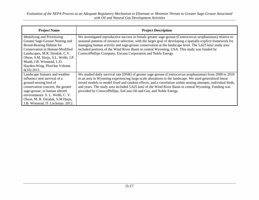
Evaluation of the NEPA Process as an Adequate Regulatory Mechanism to Eliminate or Minimize Threats to Greater Sage-Grouse Associated with Oil and Natural Gas Development Activities
O-17
Project Name Project Description
Identifying and Prioritizing Greater Sage-Grouse Nesting and Brood-Rearing Habitat for Conservation in Human-Modified Landscapes, M.R. Dzialak, C.V. Olson, S.M. Harju, S.L. Webb, J.P. Mudd, J.B. Winstead, L.D. Hayden-Wing. PlosOne Volume 6(10) 2011.
We investigated reproductive success in female greater sage-grouse (Centrocercus urophasianus) relative to seasonal patterns of resource selection, with the larger goal of developing a spatially-explicit framework for managing human activity and sage-grouse conservation at the landscape level. The 5,625 km2 study area included portions of the Wind River Basin in central Wyoming, USA. This study was funded by ConocoPhillips Company, Encana Corporation and Noble Energy.
Landscape features and weather influence nest survival of a ground-nesting bird of conservation concern, the greater sage-grouse, in human altered environments. S. L. Webb, C. V. Olson, M. R. Dzialak, S.M Harju, J.B. Winstead, D. Lockman. 2012.
We studied daily survival rate [DSR] of greater sage-grouse (Centrocercus urophasianus) from 2008 to 2010 in an area in Wyoming experiencing large-scale alterations to the landscape. We used generalized linear mixed models to model fixed and random effects, and a correlation within nesting attempts, individual birds, and years. The study area included 5,625 km2 of the Wind River Basin in central Wyoming. Funding was provided by ConocoPhillips, EnCana Oil and Gas, and Noble Energy.