evaluation and appraisal report · updated september 23, 2008 . ear stormwater management...
TRANSCRIPT
EVALUATION AND APPRAISAL REPORT OF THE
INDIAN RIVER CO COMPREHENSIVE
-,;'
STO~~ ',;~~J!~NT "'/, ;v";'
'"-"'
INDIAN R!VE~ COUNTY COMMUNITY DEVELOPMENT DEPARTMENT
I84(f25THSTREET···· ........ .
VERO·BEACH FLE>RIDA32960 ' . . . ' . .
Updated September 23, 2008
EAR Stormwater Management Sub-Element
TABLE OF CONTENTS
INTRODUCTION ........................................................................................................................... 4
CONDITIONS AT THE TIME OF THE LAST MAJOR PLAN (1998) ....................... 5 Stormwater Management Needs ...................................... . ........................................ 5 Local Regulations.......................................................... - . ........................................ 9 Level of Service Standards ......................................... ,",, __ ,._,_,-.. . .................................... 9 Water Quality ..................................................... .
EXISTING CONDITIONS (2008) .................... . Stormwater Management Improvements Local Regulations ........................................ .
Level of Service Standards ········~·~>:····················· . _ Water Quality .......................... ,,G.J,;,.~·c······ ............ / -- • Tropical Storm Fay .................... ::.;.;:;:;;([~;;~················-
. ............................. 10
. ................. 11 • •••••••.............. 11
.............................................. 13 . ................................................... 13 ................................................... 14
.............................................. 14
ANALYSIS .................... . .... :::: :>:{;;;;~~~';i_: ;:::i;,;'f'': :::::::::::::::::::::::::::::::::::::::::::::: : ~
A
Water Quality .. Storm water Stn"Mmu;r<>tPr'i
u.•.u•u.urs\ .• _•.•+· •••••••••••• Xi't'L ....................................................................... 18 ......... :.;;;;, .................................................................... 19
....................................................................... 20
AND POLICIES ................................................. 34
·· . HIC SECTION THROUGH INDIAN RIVER '/>:/· ...................................................................................................... 42
ATTACHMENT 3- .LJ.L"U""":u _ _, SOILS MAP ............................................................................. 43
ATTACHMENT 4- GENERALIZED WETLAND DENSITIES IN INDIAN RIVER COUNTY ........................................................................................................................... 44
ATTACHMENT 5- FLOOD PRONE AREAS IN INDIAN RIVER COUNTY ........................ .45
INDIAN RIVER COUNTY 2
EAR Stormwater Management Sub-Element
ATTACHMENT 6- INDIAN RIVER LAGOON ....................................................................... .46
ATTACHMENT 7- INDIAN RIVER COUNTY DRAINAGE BASINS .................................. .47
ATTACHMENT 8- SJRWMD WATER CONTROL STRUCTURES .................................... .48
ATTACHMENT 9- EXISTING AND POTENTIAL SOURCE POLLUTANT LOADING ....................................... . . .................................. 49
ATTACHMENT 10- SURF ACE WATER ...................... 50
INDIAN RIVER COUNTY 3

EAR Stormwater Management Sub-Element
INTRODUCTION
The purpose of this component of the Evaluation and Appraisal Report is to assess the success or failure of the Stormwater Management Sub-Element of the Comprehensive Plan. As such, this assessment must examine changes in conditions related to stormwater management facilities; must evaluate the achievement of the Stormwater Management objectives; and must identify changes in state requirements affecting the Stormwater Sub-Element.
Based on this evaluation and appraisal, the Stormwater updated and revised. In performing this assessment, the
• Assembled baseline data.
• Identified stormwater management facihTH"C""-'"'r"' the last major plan update (1998).
• Identified existing stormwater
• Analyzed stormwater ~uuuut:;"'u~"'u
• Evaluated the aclll,§"Y;~~tgfthe obJ
• Assessed t4§•.14~~~ent~:~~li~tatus of Element. }[>
·····s ~~fidns···· vt···•·············· •
INDIAN RNER COUNTY
the time of
Management Sub-Element.
4

EAR Stormwater Management Sub-Element
CONDITIONS IT THE TIME OF THE LAST MAJOR PLAN UPDATE (1998)
The storm water management conditions in the county at the time of the last major plan update are addressed in Indian River County's 1998 Comprehensive Plan. These baseline data will enable the county to compare changes in conditions within the county between the time that the plan was adopted and the present. ,,d~~'f; >
/ ---~:,::;:::::;::-·
When the Indian River County Comprehensive Plan was lJRa~~~a in 1998, the Stormwater Management Sub-Element described conditions that existeQ.~~;;'ijt~·corporated county at that time. These data must be compared to more recent data ~$$ess ch~g@~jn conditions that have occurred within the county since the time that plan was
ilie conilition ofv::~$;" mwmgement For the municipalities in the county, data facilities were acquired from the following City Beach Compt~hensive Plan,
Comprehensive Plan, and the the City of Sebastian Comprehensive Plan, the Town of Indian River Shores · Plan.
drainage basins:
two major watersheds located in development in previous
drainage sub-basins in the county exhibited quality. Areas which were in need of
needs" in the 1998 Comprehensive Plan. to be resolved within a 7 -year time period.
were addressed under "projected needs" in the 1998 were to be met within a 20-year, long range (2020)
of 1998 "existing" and "projected" needs by sub-basin.
o Sebastian Water Control District (SRWCD) Basin. o St. Sebastian River Basin. o Barrier Island Basin. o Mainland Basin. o Indian River Farms Water Control District (IRFWCD) Basin. o Fellsmere Water Control District (FWCD) Basin.
In addition, the Barrier Island Basin, Mainland Basin, and the IRFWCD Basin were further divided into sub-basins.
INDIAN RNER COUNTY 5
EAR Stormwater Management Sub-Element
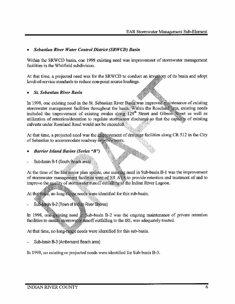
• Sebastian River Water Control District (SRWCD) Basin
Within the SRWCD basin, one 1998 existing need was improvement of stormwater management facilities in the Whitfield subdivision.
At that time, a projected need was for the SRWCD to conduct an level-of-service standards to reduce non-point source loadings.
• St. Sebastian River Basin
In 1998, one existing need in the St. Sebastian River B~in:was ,· ... .,...,..,.,,., ;u:ntenar1ce of existing stormwater management facilities throughout the ba§m~ Within the ~ ... " . .,...,~.-.... existing needs included the improvement of existing swales aJgiJ'g i28th Street and Gt as well as utilization of retention/detention to regulate stortfi\Y~ter discharg~ §O that the of existing culverts under Roseland Road would not be exceeded( ·· .· ..... · .·.·
At that time, a projected need was the of Sebastian to accommodate roadway
• Barrier Island Basins (Series "B")
Sub-basin B-1
At
o;~:acilities along CR 512 in the City
need in Sub-basin B-1 was the improvement to provide retention and treatment of and to
duttal,Jljp~~to the Indian River Lagoon.
In 1998, facilities to
uu-·ua..,HH B-2 was the ongoing maintenance of private retention outfalling to the IRL was adequately treated.
At that time, no needs were identified for this sub-basin.
Sub-basin B-3 (Ambersand Beach area)
In 1998, no existing or projected needs were identified for Sub-basin B-3.
INDIAN RNER COUNTY 6

EAR Stormwater Management Sub-Element
• Mainland IRL Basins (Series "R'?
Sub-basin R-1 (south county)
In 1998, one existing need in Sub-basin R-1 was the improvement of drainage facilities in the Old Dixie Highway corridor to provide storage and positive drainage for a 25-year/24-hour storm event. Also, drainage improvements were needed in the vicinity of 19th north of 37th Street. Besides those needs, stormwater management facilities in the following subdivisions: Midway Estates Mobile Home Park, Vero Shores, Rockridge, and Country Club Pointe.
For Sub-basin R-1, the 1998 projected needs included th.,gfdllowing:
o Improvement of Channel "H" to drain Jh~i'~~~~~ portion of this
o Improvements along 8th Street and l;~;l~~~¢tto dr~m~ area between Florida East Coast (FEC) railroad and the sub-basin's ~6$t[}?p~~d~. At that time, this area was not served by an adequate manageni.~t $ystem. The projected improvements were to be designed to · > tetention/detention for treatment of stormwater runoff from a
•••••••••••••••••••••••••• the Indian River Lagoon from
runoff to mosquito control
Sub-basin R-2
~tr!:~~~:-f~/iJ)\ v ·.·· maRin.•av~e~ermBLelnvtd~a:!~~e:Ui~x~~i~~~:~ :e~u~-~::~~2~~~ thattiffi~; these drainag~f~Bf!ities upgraded.
For Sub:B~~ia R-2, stormJ:~t~ management improvements at the US Highway 1/42nd Place intersectionwtl'~fl projectedg@~d in 1998.
Sub-basin R:~ ~~b~§!en~·~~~~; In 1998, an existing~~~~n Sub-basin R-3 was the replacement of outfall culverts beneath Indian River Drive.
At the time of the last major plan update, the improvement of storm water management facilities in the Roseland vicinity were a projected need. Those facilities were to be incorporated into a regional storm water management facility planned by the City of Sebastian.
INDIAN RIVER COUNTY 7

EAR Stormwater Management Sub-Element
• Indian River Farms Water Control District (IRFWCD) Basins (Series "C'')
Sub-basin C-1 (North Relief Canal) existing needs
Within Sub-basin C-1, the 1998 existing needs included stormwater improvements in the following single-family subdivisions: Ponderosa Estates, King's Lakes Estates, and King's Musicland. The improvement of the following drainage problems was also . . an existing need: 19th Avenue (north of 37th Street), 45th Street to the Main Relief Canal the FEC railroad), and the US Highway 1142nd Place intersection.
Sub-basin C-2 (Main Relief Canal) existing needs
In 1998, Sub-basin C-2 existing needs subdivisions: Laurelwood, Pine Tree Park, Estates.
For Sub-basin C-3, 1998 existing u\.>\;iu.:>:c::J.:,~+'"'n"!~~~~:,,}u"a .. ..,F."
family subdivisions: Oslo Park (south Stevens Park, and Vero Beach Highway/5th Street SW
;§),vtmit:mrs in the following singleIndian River Heights,
provenaents at the Old Dixie
cdttt~aed the following recommendations, which .... ,...A~·T,~ Plan:
which would increase flow to the laterals and cause as well as additional runoff.
.~~'''~,+;o;,,,',,.."' .. "'J~u·i"J... .... ,~ ..... vu with road construction on right-of-way adjacent to canals. side slopes will be too steep from a safety, as well as aesthetic,
standpoint.
o Increase the amount of storage area within the IRFWCD to improve water quality treatment in the canals and to provide storage for quantity abatement. Additional storage area could be located on private development sites.
o Prohibit floodplain encroachment below elevations shown on the 100 year stage/contour map. Any fill added under this elevation should be cut at a different location to provide
INDIAN RIVER COUNTY 8
EAR Stormwater Management Sub-Element
the same storage for flood protection.
o Improve secondary drainage systems that convey site runoff to the IRFWCD system. Also, storage within critical flood prone areas should be provided so that future development does not adversely impact the ability of the system to store flood waters. Finally, the IRFWCD must reduce flow and nonpoint source discharge from the North, Main and South Relief Canals.
• Fellsmere Water Control District Basin
At the time of the last major plan update, unincorporated areas experienced drainage problems. drainage improvements in the vicinity of Mc:tss<Jtcmll&~tt&: Street.
Within the FWCD basin, one 1998 projected """"'rf··,,x,,,.., plan for the City of Fellsmere.
local Regulations
In 1998, the county's Stormwater H.L"' ... "''""'"
25-year/24-hour storm · ·· stormwater retention established tnllnm.um.•••~ parcels, based on
and the adjacent needs included Street, and 89th
......... ,.., .... ,,,'f'"'".LF'.J..L standards based on the to provide on-site
.......... rn,.,,,. Regulations (LDRs) surface area requirements for all
the exception of projects in the Indian River Lagoon uv• .... u.t-•UUJ~;J.i;
maintain balance
p~i~~!~~··~~~~~~~~~l~,t;:a1~00-year floodplain were also required to ;: to pre-development conditions (i.e.
all new update.
1990, the county established Level-of-Service (LOS) standards for these LOS standards were updated during the last major plan
For all new drainage systems in the unincorporated County, Policy 1.1 under Objective 1 of the Storm water Management Sub-Element sets the level of service standard as follows:
New development requiring major site plan approval or subdivision platting shall construct a complete drainage system to mitigate the impacts of a 25 year/24 hour design rainfall event using the Soil Conservation Service Type 2 modified rainfall curves. Post development runoff shall not exceed pre-development runoff unless a maximum
INDIAN RIVER COUNTY 9
EAR Stormwater Management Sub-Element
discharge rate has been adopted for the applicable drainage basin and the discharge does not exceed that rate. If a maximum discharge rate has not been adopted for the applicable basin, post development discharge may not exceed pre-development discharge.
• Water Quality LOS
In 1998, the county had no water quality LOS standards.
Water Duality
Within the Aquatic Preserves in Indian River County in by the Florida Department of Environmental Shellfish Propagation or Harvesting, or Class III -
nr<~1rPr" were designated either Class II -
Fish and Wildlife. For Class II waters, mana)~ep:J,@PJ>" .... uu•uu.:>
standards for Class III waters. While Class II bacteriological and chemical pollution, Class III .. ,,, • .,.,. .... _,t.,, ... ~ .. ~"""'-""u .. u.u
suitability for sports and recreation, and
At the time of the last major plan approximately Grand Harbor south to (ICW) channel north of Wabasso better quality than Class east of the ICW Refuge). The harvesting. artificial canals, had
INDIAN RIVER COUNTY
~+\.IcY"• River Lagoon extending from the Intracoastal Waterway FDEP. Class II waters (of
to the Wabasso Causeway, and · Island National Wildlife
10

EAR Stormwater Management Sub-Element
EXISTING CONDITIONS (2008)
Stormwater Management Improvements Since 1998
As in 1998, the county recognizes the following Indian River Lagoon watershed drainage basins: o Sebastian River Water Control District (SRWCD) Basin. o St. Sebastian River Basin. o Barrier Island Basin. o Mainland Basin. o Indian River Farms Water Control District o Fellsmere Water Control District (FWCD)
In addition, the Barrier Island Basin, Mainland into sub-basins.
• St. Sebastian
of the FEC railroad.
conjunction with roadway improvements.
drainage system are planned as a three-phase project. As of
•
Since 1998, FDOT stormwater management facilities west of SR AlA to provide retention and treatment of runoff outfalling to the Indian River Lagoon.
• Mainland IRL Basins (Series "R'')
Sub-basin R-1 (south county)
Drainage improvements to Old Dixie Highway are currently under construction.
INDIAN RNER COUNTY 11
EAR Stormwater Management Sub-Element
Drainage improvements were undertaken in River Shores and Country Club Pointe subdivisions.
In Rockridge, drainage swales were upgraded, and a storm surge protection system was installed.
Channel "H" was improved in conjunction with the 4th Street widening project.
FDOT is now constructing drainage improvements to US Highway 1 ·
Sub-basin R-3 (Roseland area)
Replacement of outfall culverts beneath Indian River Drive. ·
In Roseland, east of the FEC railroad, watershed impi~~~~ents have · existing swales and the construction of a new stol1}'l;W;~t~Fdetention pond adj
the upgrading of 35tli Avenue.
• Indian River Farms Water Control Distric:il!:f!!J£l::DJ,;~~1f:s (Series "C'?
At four locations, radial gates were within the canal, instead of allowing
constructed along
with tilt~=~ ~i~~;: The tilting gates better retain silt into the rii&1!m.River Lagoon.
stormwater detention pond was
Estates, King's Lakes Estates, and King's
in the Main Relief Canal to treat 200 million gallons of water the Indian River Lagoon.
The county is now bids for the Egret Marsh project, and construction will commence in the near future. The Marsh project consists of an algal turf scrubber that will treat agricultural run-off in the Lateral "D" Canal.
Stormwater improvements were completed in Pine Tree Park.
Sub-basin C-3 (South Relief Canal) existing needs
Secondary drainage improvements were completed in portions of Oslo Park, Grovenor Estates,
INDIAN RIVER COUNTY 12
EAR Stormwater Management Sub-Element
Indian River Heights, Steven's Park, and Vero Beach Highlands.
Stormwater improvements are currently under construction at the Old Dixie Highway/5th Street SW intersection.
Local Regulations
In 2008, the county's Stormwater Management ordinance .Lu...., ........... ...
25-year/24-hour storm event. At that time, all developments storm water retention ponds. In addition, the county's established minimum open space and maximum 1·r nnP•nT1t
parcels, based on the parcel's zoning classification. River Lagoon floodplain, all projects located VHLtJ.J.u,,,_,
maintain an equal volume of storage capacity balance cut and fill).
Level of Service Standards >:-,
to provide on-site Regulations (LDRs) requirements for all
ects in the Indian
At the time of plan adoption in 1990, all new drainage systems. Those LOS
11¢{¢ot@bb~~;tablliSJ1ed <> .-.. -of-Service (LOS) standards for
• Flood Protection
As in 1998, the
New
We(i'@lgp~tat(:d .......... """'~'.s-P•"" last major plan update.
approval or subdivision platting shall ~,yu~"'""''"" the impacts of a 25 year/24 hour design
cons(:rv;a.tlc>fi Service Type 2 modified rainfall curves. Post exceed pre-development runoff unless a maximum
for the applicable drainage basin and the discharge does <;;ii~~l;~xceed that rat~si~f a discharge rate has not been adopted for the applicable hlisl~post developmint discharge may not exceed pre-development discharge.
• --:::;:~, -:,:~h
Water Q;:~'--q;ps ;;;;;;;i:;;;;~i
);::?:>}::·
All new or redevel~pl§i6rmwater management systems are required to comply with the water quality LOS establishedby the SJRWMD. At this time, these LOS standards are based on Pollutant Load Reduction Goals (PLRGs) that were developed by SJRWMD in coordination with the U.S. Environmental Protection Agency (EPA).
INDIAN RIVER COUNTY 13
EAR Stormwater Management Sub-Element
Water Duality
All surface waters within the Aquatic Preserves in Indian River County are designated by the FDEP as being either Class II - Shellfish Propagation or Harvesting, or Class III - Recreation/ Propagation and Management of Fish and Wildlife. For Class II waters, management standards a"·e much more restrictive than standards for Class III waters. While Class II water standards place more stringent limitations on bacteriological and chemical Class III water quality standards are intended to maintain suitability for sports and production of diverse fish and wildlife communities.
Currently, the portion of the IRL extending from apr:1tmtt@1atel)
"'.9-J.J'~""'v Causeway HHH~>~·H!'-' refuge are
county line, and west of the Intracoastal Waterway rated Class III by the FDEP. Class II waters (of Grand Harbor to the Wabasso Causeway, and (within the Pelican Island National Wildlife conditionally approved for shellfish harvesting. unincorporated County, excluding artificial
waters of the within the an FDEP-designated status of
"Outstanding Florida Waters" (OFW)
Tropical Storm Fay
In August, 2008, Tropical . · .. '·.· Florida. As a result of Tropical 'U'"'J'~"'"'''"'" "'~~""'.u"' ..... H ~ ...... ,u. ... u·.,· over a period of several days. In
amt~l]t~s:tmmtt~s exceeded 18 inches, an amount which Storm Fay, Indian portions of Indian exceeds the t-hr'"'"h'"1 1 00-year/72-hour storm events.
Despite the storm event, no major flooding occurred within ~+~~~w,+,, . ..,,. there was no flooding in Indian River County as a result of roads were closed due to localized flooding. According to the
affected roads included:
· venue SW intersection. o . 20th A venue SW and Highland Drive.
intersection. Jet:SM:ee:n 35th A venue and 37th A venue.
o 45th . :,' 'of Indian River Blvd. o 18th Avenu~:~outh of 8th Street (northbound lane only). o 66th A venue, south of Oslo Road. o Blue Cypress Road, north of SR 60. o Old Dixie Highway, between 11th Street SW and 13th Street SW. o 49th Street I Industrial Blvd. intersection. o 49th Street, at High Ridge Mobile Home Park. o 41st A venue, between 1Oth Street and 12th Street. o Village Green Mobile Home Park (internal streets).
INDIAN RIVER COUNTY 14

EAR Stormwater Management Sub-Element
o SR 60, near 82nd Avenue (partial lane closures).
All flooded streets were reopened within a couple of days after Tropical Storm Fay.
INDIAN RIVER COUNTY 15
EAR Stormwater Management Sub-Element
ANALYSIS
Nearly a century ago, construction of the drainage network of canals and ditches in the county began with the purpose of draining marshlands so that the newly "dry" land could be used for the cultivation of citrus and vegetable crops. These original drainage networks now comprise the various water control districts in the county. The three oldest districts are the Fellsmere Water Control District (FWCD), the Indian River Water Control District (IRFWCD), and the Sebastian River Water Control District those drainage networks, much of the county between the Ridge was marshlands. In addition to draining flood protection by allowing carrying away excess .,t .............. "'
With the construction of the Indian River F was added to the Indian River Lagoon's "''"~"" .. " the Main Relief Canal, the North Relief Canal, River Lagoon's watershed consisted ofland east areas between the Atlantic Coastal K.l(Jg~) EJ<I!~tlme the St. Sebastian River, while areas headwaters of the St. Johns River.
of the county canals are
, the Indian Coastal Ridge. At that time,
drained into the South Prong of flowed eventually into the
of Indian River County. In recent decades, urban As the county began strategy, known as natural systems to ·. strategy of "ditch it particularly,jp, th~ Jndian
Jrbamlza1t!Q~J;:'1the county and private developers adopted a development from flooding by modifying
Sinc~ .•• t~~f(~i~:,'·~~d~i~f; ~t~te, ~~~~,~~;~~:~~r~/:~~~~er
developed sites more rapidly. The past detrimental effects on water quality,
stormwater management regulations have become more ~"'u''"'u• facilities are required to control the quantity and
Within In~f~':gjver Cound~~~the various drainage networks have been mostly successful in providing flood.Pt9t~ctioni~tfi;ng a recent 100-year storm event (Tropical Storm Fay), no major flooding occurredWftbintlJ.~county. As a result of this storm, only localized street flooding was experienced in some p&ffions of the county. While there has been some success in addressing the detrimental aspects of stormwater runoff flowing into the Indian River Lagoon, further improvement is needed to bring the entire portion of the lagoon within the county up to Class II water standards. As discussed below, additional measures are needed to both improve the quality of and reduce the quantity of storm water runoff that flows into the lagoon.
INDIAN RNER COUNTY 16

EAR Stormwater Management Sub-Element
Water Duality
Between 1996 and 2008, Indian River Lagoon water quality remained fairly constant. Within the lagoon, water quality is measured at various points. At each point, water quality generally fluctuates within established ranges. Recently, water quality at several water monitoring stations showed improvement. This improvement may be the result of several recent water quality projects, including: muck dredging in the St. Sebastian River, the creation of marshes to purify polluted water, and improved sedimentation and erosion control
While the majority of the lagoon's water within Indian Department of Environmental Protection (DEP) · ·· · lagoon water quality is poorer in the southern portion Surface Water Quality standards report, Class II Indian River Lagoon and within the extreme Indian River County. From the North Relief Indian River Lagoon is designated as Class III.
• Improving the Quality of
To improve the construction on a Main ......... u...,.~··"""""'·""'"')\+~. Egret M;f,l;~$iOl1§~s:eJli4:p,Jt~d
'-'U.~J?-H!\Jo+U.u~5 Florida Waters", I..CC~itQ,ylg to the 2008 DEP
nO)t:J:Al~m section of the
~''"'"'"-'+-'' .. o"'''"'H within ~---..... l~g"' Island, the
~u ... uu~._,., will be needed to improve the quality of stormwater J-J"-~~vvJu. That could involve filtration systems similar to the one
Relief Canal also being constructed for the North Relief Canal "':WiW~''''f~,l~n that reason, the county should adopt a new policy to explore the
feasibility of .. , .• _ •. , .•••.. · · facilities to treat storm water runoff that flows into the lagoon similar to the Main Relief Canal filtration system and the Egret Marsh project.
• Reducing the Quantity of Stormwater Flowing into the Lagoon
In the past, excessive discharges of freshwater into the Indian River Lagoon had an adverse impact on the lagoon's salinity. By diverting some runoff into water bodies or wetlands that allow storm water filtration into the surficial aquifer, the amount of storm water runoff that flows into the Indian River Lagoon can be reduced. One project that accomplishes this is the Sebastian
INDIAN RNER COUNTY 17

EAR Stormwater Management Sub-Element
Stormwater Park that was recently developed by the City of Sebastian, in coordination with the SJRWMD. The 166-acre Sebastian stormwater park utilizes pumps to divert water from the Collier Canal into the park's system of interconnected ponds and wetlands. In addition to removing pollutants from stormwater runoff, these ponds and wetlands also recharge the groundwater aquifer. Stormwater parks such as that not only improve water quality, but also provide passive recreation opportunities for local residents. ·
In the unincorporated portions of the county, similar parks adjacent to canals. Potential sites include the Oslo transfer Canal and land along the north side of the North Relief locations, water that is diverted from the canal could be
constructed at locations acent to the South Relief
of Bent Pine. At both management BMPs
the quantity of a new policy to
prior to filtration into the surficial aquifer. Because/§I~QUilWctter storm water runoff that flows into the Indian River explore the feasibility of developing storm water
• Water Quality Level of Service (LOS)
Objective 7 of the Storm water nHLUa . .o:,v~ LOS standards based on Pollutant
... u-·.La,..,U.vUL 't'i>n•ur'3 " the county to adopt water quality __,_,,,,.,,.-r At the time of the last major
ver Lagoon. In 2005, the county 930 to incorporate SJRWMD's
new or redeveloped stormwater management standards established by the SJRWMD.
i!i~:~f51ijuncti6n':W:il!tlle Environmental Protection Agency (EPA), is ) standard for the Indian River Lagoon.
a calculation of the maximum amount of a pollutant that a "'"'"-~"'.:r"''~u,..,,..,. water quality standards. Once TMDLs for the Indian
, the county should incorporate those TMDLs into For this reason, Objective 7 should be modified state the county established by the SJRWMD for the Indian River Lagoon.
Policy 2.5 Sub-Element states that "By 2002, the county will adopt a Stormwater Master Plan. In developing the Stormwater Master Plan, the county will analyze each basin in the unincorporated county, identify existing conditions and problems in each basin, and identify projected growth in each basin. As a result of that analysis, the county will identify a design storm parameter, discharge rate, land use allowance, and structural improvement plan for each basin."
In order to develop a stormwater master plan, an inventory documenting the location and
INDIAN RIVER COUNTY 18
EAR Stormwater Management Sub-Element
condition of all storm water facilities under the county's jurisdiction should be conducted. This inventory could be used to identify existing and potential problem areas and to evaluate the effectiveness of existing drainage systems. Once completed, the comprehensive inventory could be used to form the basis for establishing a 20-year drainage improvement program, as mentioned in Objective 3. Also, the inventory of stormwater facilities could be stored on a Geographic Information System (GIS). The benefits of GIS include improved record keeping and the ability to analyze various scenarios.
By having an adopted stormwater master plan, the county successful in securing dedicated funding sources, such as EPA Section 319 Gr;a.IJ,t.~m~ijid•::~~(}P::ace Water Improvement Management (SWIM) funds from the SJRWMD. to obtain funding sources from state and federal agencies will be funds would be applied towards to improving water quality by
The most important aspect of stormwater •uu.J""'"" Therefore, the county should adopt a policy to grants and Surface Water Improvement Management stormwater master plan.
Stormwater Management Funding
Policy 3.4 of the St-n..-..... H:ra
consider establishing implemented.
·.. ':.,,'
igt:Jmt:J:u :>:liUO·-.tle. ··t·•·n' ·. •e·••••l•··lt ~ti)~,~a~ "By 2002, the county shall
this'Hme, Policy 3.4 has not been
Municipal Service Taxing Unit (MSTU) management program, the county should
exclusi to stormwater management, instead of relying general revenue could be replaced with dedicated funding
new developments, and a stormwater utility.
ws::;;e;;::s~;e;;~~ ul::scr fee based upon the storm water runoff characteristics (i.e. size ""·u•;t"-''"' area) of a particular parcel. Credits can be given for the use of
·... s). While a stormwater utility would be sufficient to fund minor projects ·. > •. • ....... ·.· .. ·.· maintenance, large-scale projects, such as building a regional stormwater facility, /.·· ···· be funded by bonds, development impact fees, cost-share grants, and other sources.
INDIAN RIVER COUNTY 19
EAR Stormwater Management Sub-Element
EVALUATION OF OBJECTIVES
Following is an evaluation of the achievement of the Stormwater Management Sub-Element objectives. As indicated below, four of the Stormwater Management Sub-Element's objectives were achieved (Objectives 5, 6, 7, and 8), while the remaining four objectives were partially achieved. The goals, objectives, and policies of the Solid W Element are attached (Attachment #1).
Under each objective, those policies associated with the o a;:>o:l>l;;;:>1>vu to identify those
that were implemented and those that were not determine if it directly or indirectly contributed to
was assessed to coJrre~~Pd!j):qlJlg objective. Then,
each policy was assessed to determine if it needs deleted and the
reason for revision or deletion.
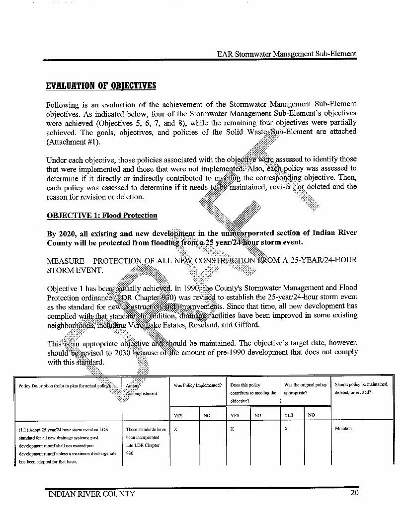
OBJECTIVE 1: Flood Protection
By 2020, all existing and new ted section of Indian River County will be protected from tl04[)<1lttgJr
Policy Description (refer to plan for actual
County's Stormwater Management and Flood .. · .. to establish the 25-year/24-hour storm event
rerr1,~11ts. Since that time, all new development has have been improved in some existing
.1.'-V""·''"'.~..~., .. , and Gifford.
be maintained. The objective's target date, however, amount of pre-1990 development that does not comply
Was Policy Implemented? Does this policy Was the original policy Should policy be maintained,
contribute to meeting the appropriate? deleted, or revised?
objective?
YES NO YES NO YES NO
( 1.1) Adopt 25 year/24 hour storm event as LOS These standards have X X X Maintain
standard for all new drainage systems; post been incorporated
development runoff shall not exceed pre- into LOR Chapter
development runoff unless a maximum discharge rate 930.
has been adopted for that basin.
INDIAN RIVER COUNTY 20

Policy Description (refer to plan for aetna! policy)
(1.2) The floor elevation of all new buildings must be
no lower than 6" above the I 00 year flood elevation
in AE zones, 18" above the crown of road in A zones,
and 6" above base flood elevation (including the
lowest horizontal structural member of the lowest
floor) in VE zones.
(1.3) Adequate stormwater management facilities are
constructed and maintained to prevent major flooding
of the road network during storm events.
(1.4) All new storm sewers discharging into any
receiving water shall be designed to convey the
discharge after tailwater conditions are considered.
(1.5) All major bridges will be designed to pass the
I 00 year/3 day storm event.
(1.6) All culverts within all F.S. Section 298
Districts' R.O.W.s or easements shall be sized
approved prior to issuance of LDP.
front yard drainage
retention/detention
canals be completed prior to
of completion.
Action/
Accomplishment
These standards have
been incorporated
into LDR Chapter
930.
County policy. No
major flooding has
occurred, but
localized flooding
occurred during
Tropical Storm Fay
in2008.
County policy; LDR
Sec. 930.07(1)(h)(8)
EAR Stormwater Management Sub-Element
Was Policy Implemented? Does this policy Was the original policy Should policy be maintained,
contribute to meeting the appropriate? deleted, or revised?
objective?
YES NO YES NO YES NO
X X X Maintain
X Maintain
X Maintain
X Maintain
X X Maintain
X X Maintain
X X Maintain
All policies under 1 were implemented and contributed to meeting the objective. All policies should be maintained as structured.
Overall Assessment of Policies
The policies under Objective 1, with the proposed revisions, are sufficient to achieve this objective. No additional policies are needed.
OBJECTIVE 2: Stormwater Management Facilities
INDIAN RNER COUNTY 21
EAR Stormwater Management Sub-Element
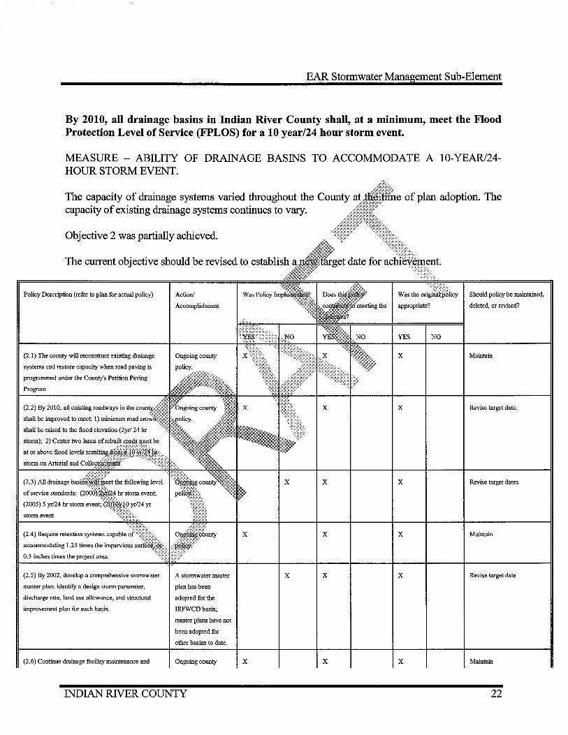
By 2010, all drainage basins in Indian River County shall, at a minimum, meet the Flood Protection Level of Service (FPLOS) for a 10 year/24 hour storm event.
MEASURE- ABILITY OF DRAINAGE BASINS TO ACCOMMODATE A 10-YEAR/24-HOUR STORM EVENT.
The capacity of drainage systems varied throughout the County at capacity of existing drainage systems continues to vary.
Objective 2 was partially achieved.
The current objective should be revised to establish
Policy Description (refer to plan for actual policy)
(2.1) The county will reconstruct existing drainage
systems and restore capacity when road paving is
progranuned under the County's Petition Paving
Program
(2.2) By 2010, all existing roadways in the
shall be improved to meet: I) minimum road
storm on Arterial and
(2.3) All drainage
storm event
(2.4) Require retention systems capable
accommodating 1.25 times the impervious
0.5 inches times the project area.
(2.5) By 2002, develop a comprehensive stormwater
master plan; identifY a design storm parameter,
discharge rate, land use allowance, and structural
improvement plan for each basin.
(2.6) Continue drainage facility maintenance and
Action!
Accomplishment
Ongoing county
A stormwater master
plan has been
adopted for the
IRFWCD basin;
master plans have not
been adopted for
other basins to date.
Ongoing county
INDIAN RIVER COUNTY
X
X
X
X
X
X
X
X
X
of plan adoption. The
YES NO
X
X
X
X
X
X
Should policy be maintained,
deleted, or revised?
Maintain
Revise target date.
Revise target dates.
Maintain
Revise target date
Maintain
22
Policy Description (refer to plan for actual policy)
enforce maintenance of on-site facilities.
Action/
Accomplislnnent
policy.
(2. 7) Require existing uses undergoing redevelopment Ongoing county
to meet new stormwater requirements. policy.
(2.8) Continue activities to retrofit the Vera Lake Ongoing county
Estates drainage system. policy.
(2.9) By 2002, conduct a comprehensive inventory of Not completed.
all stormwater management facilities in all drainage
sub-basins.
(2.1 0) By 2002, establish a GJS-based inventory of all Not completed.
stormwater management facilities.
EAR Stormwater Management Sub-Element
Was Policy Implemented? Does this policy Was the original policy Should policy be maintained,
contribute to meeting the appropriate? deleted, or revised?
objective?
YES NO YES NO YES NO
X X Maintain
X X Maintain
X Revise target date.
Revise target date.
Policies 2.1, 2.2, 2.4, 2.6, 2.7, and 2.8 ~¢f¢:implemented to meeting the objective. · Policy 2.2's target date should be extend~4to 2Q~Q •.
a stormwater master not been implemented different agencies ·
. 9, and 2~~ijt~lat:tJ~tbfrtiW'.tt~r planning. As of this time, fdt~PlMt~e IRFW~if;£basin. To date, master plans have bi~m~iocated within the county. Due to the number of m~~gement within the county, additional time is
.., ... ..,,~;.,. ... ,., ' ~~ target dates for each of these policies should
will have an adopted Stormwater Master Plan, which will stormwater management facilities in Indian River County over a
MEASURE- ADOPTION OF A STORMW ATER MASTER PLAN.
Objective 3 has been partially achieved. In 2002, the county adopted the East Indian River County Stormwater Master Plan. That plan covers the IRFWCD drainage basin. Stormwater master plans have not been adopted for the other drainage basins in the county.
INDIAN RIVER COUNTY 23
EAR Stormwater Management Sub-Element
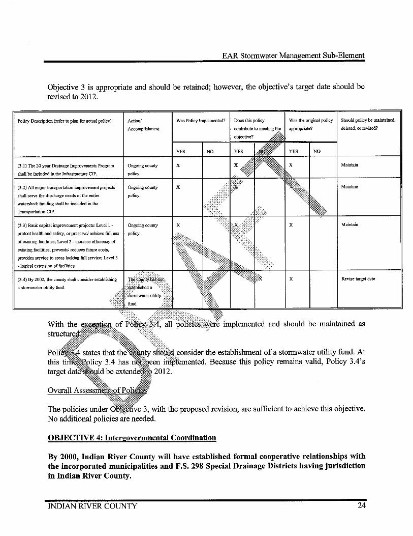
Objective 3 is appropriate and should be retained; however, the objective's target date should be revised to 2012.
Policy Description (refer to plan for actual policy)
(3.1) The 20 year Drainage Improvements Program
shall be included in the Infrastructure ClP.
(3.2) All major transportation improvement projects
Action/
Accomplishment
Ongoing county
policy.
Ongoing county
shall serve the discharge needs of the entire policy.
watershed; funding shall be included in the
Transportation ClP.
(3.3) Rank capital improvement projects: Levell - Ongoing county
protect health and safety, or preserve/ achieve full use policy.
of existing facilities; Level2 - increase efficiency of
existing facilities, prevents/ reduces future costs,
provides service to areas lacking full service; Level 3
-logical extension of facilities.
(3.4) By 2002, the county shall consider establishing
a stormwater utility fund.
Was Policy Implemented? Does this policy Was the original policy Should policy be maintained,
deleted, or revised?
YES NO NO
X Maintain
X Maintain
X X Maintain
X Revise target date
implemented and should be maintained as
"~"J¥1c~"l'-,.'-'v"'"._.,..,~ the establishment of a stormwater utility fund. At -"'~"-"'~"·"' ...... Because this policy remains valid, Policy 3.4's
Overall
The policies under 3, with the proposed revision, are sufficient to achieve this objective. No additional policies are needed.
OBJECTIVE 4: Intergovernmental Coordination
By 2000, Indian River County will have established formal cooperative relationships with the incorporated municipalities and F.S. 298 Special Drainage Districts having jurisdiction in Indian River County.
INDIAN RIVER COUNTY 24
EAR Stormwater Management Sub-Element
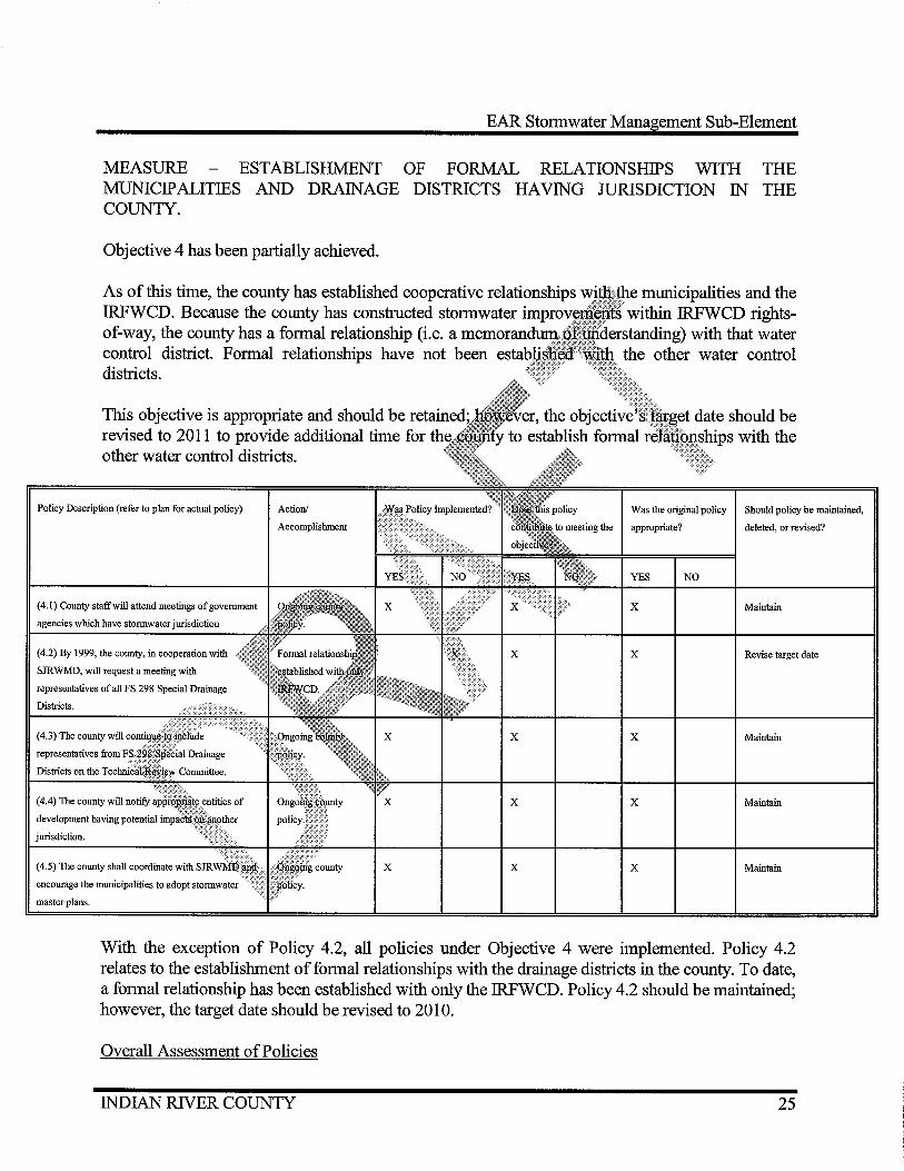
MEASURE ESTABLISHMENT OF FORMAL RELATIONSHIPS WITH THE MUNICIPALITIES AND DRAINAGE DISTRICTS HAVING JURISDICTION IN THE COUNTY.
Objective 4 has been partially achieved.
As of this time, the county has established cooperative relationships IRFWCD. Because the county has constructed stormwater · of-way, the county has a formal relationship (i.e. a memoranctutl!;~ control district. Formal relationships have not been districts.
This objective is appropriate and should be ret:amect; revised to 2011 to provide additional time for other water control districts.
Policy Description (refer to plan for actual policy)
(4.1) County staff will attend meetings of government
agencies which have stormwater jurisdiction
(4.2) By 1999, the county, in cooperation with
SJRWMD, will request a meeting with
development having potential
jurisdiction.
Action/
Accomplishment
X
X
X
X
X
municipalities and the within IRFWCD rights-
.... .., .• .., ............... 151 with that water
Was the original policy Should policy be maintained,
appropriate? deleted, or revised?
YES NO
X Maintain
X Revise target date
X Maintain
X Maintain
X Maintain
With the exception of Policy 4.2, all policies under Objective 4 were implemented. Policy 4.2 relates to the establishment of formal relationships with the drainage districts in the county. To date, a formal relationship has been established with only the IRFWCD. Policy 4.2 should be maintained; however, the target date should be revised to 2010.
Overall Assessment of Policies
INDIAN RIVER COUNTY 25
EAR Stormwater Management Sub-Element
Through the implementation of these policies, with the proposed revision, Objective 4 will be achieved. No additional policies are needed.
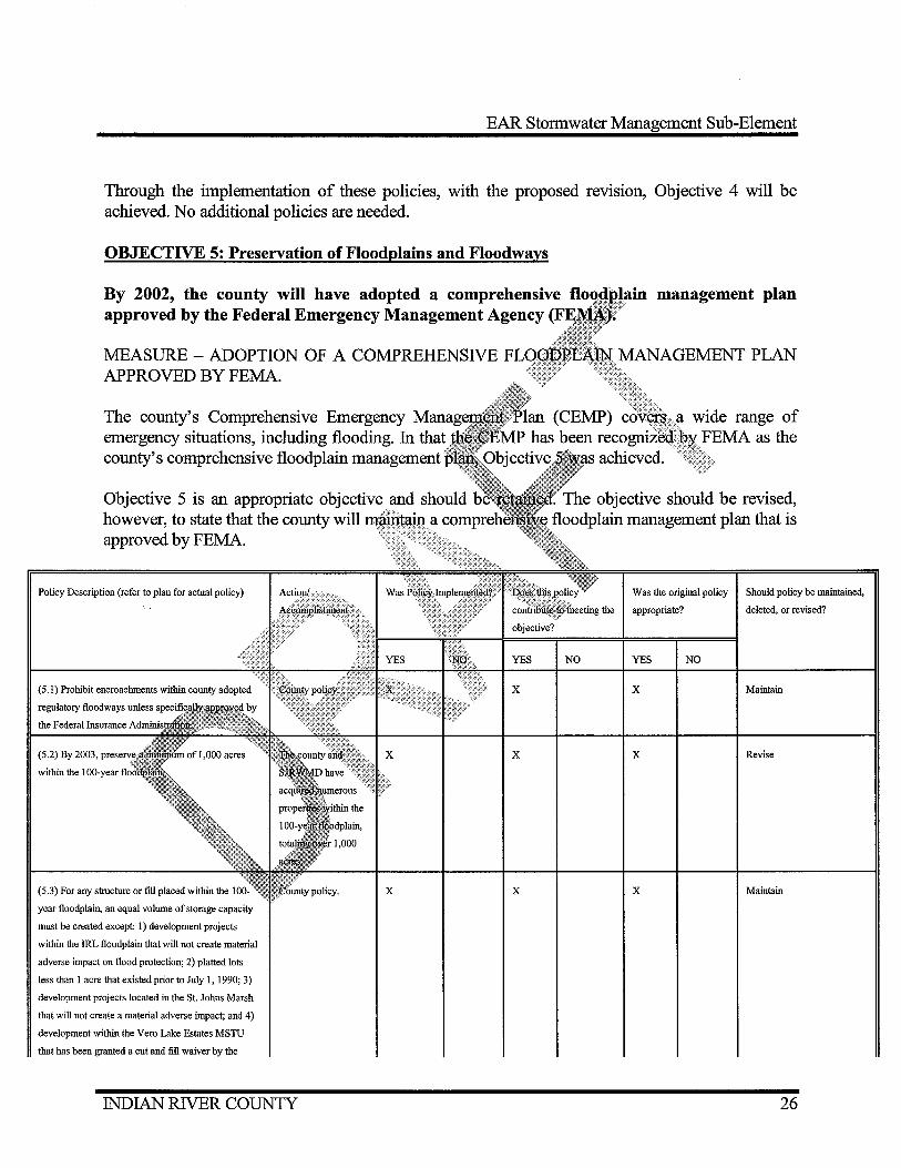
OBJECTIVE 5: Preservation of Floodplains and Floodways
By 2002, the county will have adopted a comprehensive approved by the Federal Emergency Management Agency
MEASURE - ADOPTION OF A COMPREHENSIVE APPROVED BY FEMA.
The county's Comprehensive Emergency H~· .... ·~·ts"' emergency situations, including flooding. In that county's comprehensive floodplain management
Objective 5 is an appropriate objective and should however, to state that the county will m~~mtmu approved by FEMA.
Policy Description (refer to plan for actual policy)
the Federal Insurance
(5.2) By 2003,
year floodplain, an equal volume of storage capacity
must be created except: I) development projects
within the IRL floodplain that will not create material
adverse impact on flood protection; 2) platted lots
less than I acre that existed prior to July I, 1990; 3)
development projects located in the St. Johns Marsh
that will not create a material adverse impact; and 4)
development within the Vero Lake Estates MSTU
that has been granted a cut and fill waiver by the
INDIAN RIVER COUNTY
X
X
X
X
management plan
The objective should be revised, oodplain management plan that is
Was the original policy Should policy be maintained,
appropriate? deleted, or revised?
NO YES NO
X Maintain
X Revise
X Maintain
26
EAR Stormwater Management Sub-Element
Policy Description (refer to plan for actual policy) Action/
Accomplishment
Was Policy Implemented? Does this policy Was the original policy Should policy be maintained,
contribute to meeting the appropriate? deleted, or revised?
objective?
YES NO YES NO YES NO
county.
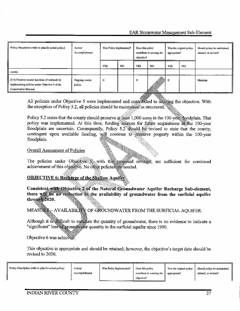
(5.4) Preserve natural functions ofwetlands by
implementing policies under Objective 5 of the
Conservation Element
Ongoing county
policy.
X X Maintain
All policies under Objective 5 were implemented and the exception of Policy 5.2, all policies should be mamJ.~rm~
Policy 5.2 states that the county should preserve ./>>
policy was implemented. At this time, funding <
floodplain are uncertain. Consequently, Policy contingent upon available funding, continue floodplain.
Overall Assessment of Policies
The policies under achievement of this
.HVU.!J.'""·'• That acquisitions 1 00-year
to state that the county, property within the 1 00-year
are sufficient for continued
ATER FROM THE SURFICIAL AQUIFER.
the quantity of groundwater, there is no evidence to indicate a quantity in the surficial aquifer since 1990.
This objective is appropriate and should be retained; however, the objective's target date should be revised to 2030.
Policy Description (refer to plan for actual policy) Action/ Was Policy Implemented? Does this policy Was the original policy Should policy be maintained,
Accomplishment contribute to meeting the appropriate? deleted, or revised?
objective?
INDIAN RIVER COUNTY 27

( 6.1) The county will continue to require onsite
retention/ detention in accordance with FDEP and
SJRWMD performance standards
(6.2) The county will continue to require reuse of
stormwater runoff for irrigation of golf courses and
other developments with wet retention/detention
ponds with a surface area over 1 acre.
New Policy
Ongoing county
policy.
Ongoing county
policy.
YES
X
X
NO
EAR Stormwater Management Sub-Element
YES NO YES NO
X X Maintain
X X Maintain
Although Objective 6 was achieved, additional mailli~J~tlle integrity of the surficial aquifer. Because storm water parks, in the City
of that treated runoff into the the feasibility of developing of
aquifer.
of Sebastian, divert runoff from drainage canals and surficial aquifer, the county should policy storm water parks in the unincorporated cotJfit'V:tctre:ch;:u:
prc,po:sed revision and the proposed new additional policies are needed.
county will adopt Water Quality Level of . WQLOS standards will be based on Pollutant Load
developed by the SJRWMD.
QUALITY LEVEL OF SERVICE STANDARDS .
..,., ..... u ... au-.,u. PLRGs for the Indian River Lagoon. In 2005, the county
~~l~f~l~~lf~~~~ent regulations in LDR Chapter 930 to incorporate SJRWMD's PLRGs. As a result LDR amendments, all new or redeveloped stormwater management systems are required to comply with the water quality LOS standards established by the SJRWMD. Therefore, Objective 7 was achieved.
At this time, the SJRWMD, in conjunction with the Environmental Protection Agency (EPA), is developing a Total Maximum Daily Load (TMDL) standard for the Indian River Lagoon. According to the EPA, a TMDL is a calculation of the maximum amount of a pollutant that a waterbody can receive and still safely meet water quality standards. Once TMDLs for the Indian River Lagoon are established by the SJRWMD, the county should incorporate those TMDLs into
INDIAN RIVER COUNTY 28

EAR Stormwater Management Sub-Element
its water quality LOS standards.
Objective 7 is an appropriate objective and should be retained. The objective, however, should be revised to state that the county should maintain water quality LOS standards based on PLRGs and that the county will adopt TMDLs when established by the SJR WMD for the Indian River Lagoon.
Policy Description (refer to plan for actual policy)
(7.1) Assist the MRC in inventorying pollutant
loadings to the IRL.
(7.2) Reduce suspended solids loadings by paving
roads within developed areas which discharge to the
IRL.
(7.3) Continue to require an erosion control plan for
all new construction.
(7.4) Continue to operate a street sweeping program
for county roads.
(7.5) Continue to require sodding of slopes
constructed for Transportation Improvement Projects ... <
(7.6) Reduce amount of non-point source pollutiori: ?I entering the IRL by applying for SWIM funds/~:ran!S
(7.10) Adopt water quality level-of-service standards:
1) retention of the first 1" of rainfall; 2) Additional
50% treatment is required for all direct discharge into
the IRL.
(7.11) All existing uses shall meet the water quality
level-of-service at the time of redevelopment.
Action!
Accomplishment
Ongoing county
policy.
Ongoing county
policy.
Ongoing county
policy.
Ongoing county
policy. The county
should also
incorporate TMDL
standards once
established by the
SJRWMD.
Ongoing county
policy. Revise to
INDIAN RIVER COUNTY
Was Policy Implemented?
YES NO
X
X
X
X
X
X X
X X
X X
Was the original policy Should policy be maintained,
NO
X
X
X
X
X
X
X
X
X
deleted, or revised?
Maintain
Maintain
Maintain
Maintain
Maintain
Maintain
Maintain
Maintain
Maintain
Revise to incorporate TMDL
standards once established by
theSJRWMD.
Revise to incorporate TMDL
standards once established by
29

Policy Description (refer to plan for actual policy)
(7. 12) Require all new surface water bodies greater
than Y:i acre to include littoral zones.
Action!
Accomplishment
incmporate TMDL
standards once
available.
In 2007, the county
re-established littoral
zone requirements
(applies to all
development sites
over 10 acres in
size).
EAR Stormwater Management Sub-Element
Was Policy Implemented? Does this policy Was the original policy Should policy be maintained,
contribute to meeting the appropriate?
objective?
YES NO YES NO YES
X X
NO
deleted, or revised?
theSJRWMD.
Revise to state that all new
development projects over I 0
acres in area are required to
include littoral zones in their
wet retention/detention
ponds.
All policies under Objective 7 were implemented 7.10, 7.11, and 7.12 need to be upclated.
standards for the ........... u. ....
pollutant that a nr<>T"" .. '",..."
for the Indian Ri
;urr·enttv, the water quality LOS were established by the
Vlaximum Daily Load (TMDL) of the maximum amount of a
meet water quality standards. Once TMDLs WMD, the county should incorporate those
.·. . than Yz acre to include littoral zones. In 2007,
=n~u~···"-····"···•'•~.•······ to require that all new developments over 10 acres in area to ······ · retention/detention ponds. For that reason, the wording of u"'"'""''-'J<•.H+~ existing language in the LDRs.
One new policy to this objective. That new policy should promote the treatment of stormwater runoff into the lagoon from the major outfall canals in the county. Such treatment could be by filtration systems similar to the one recently constructed for the Main Relief Canal. Similar systems could be constructed for the North Relief Canal and South Relief Canal.
Overall Assessment of Policies
The policies under Objective 7, with the proposed revisions and the proposed new policy, are sufficient for continued achievement of this objective.
INDIAN RIVER COUNTY 30

EAR Stormwater Management Sub-Element
OBJECTIVE 8: Land Use
Through 2020, all land uses and land use densities within Indian River County will be in compliance with the Future Land Use Plan map.
MEASURE - COMPLIANCE OF ALL LAND USE DENSITIES USE PLAN MAP.
With the exception of a few existing nonconforming uses, all compliance with the Future Land Use Plan map. Nonc:;orttQJ:m1.11 the Future Land Use Element.
Objective 8 was achieved.
Objective 8 is appropriate and should be retained; extended to 2030.
Policy Description (refer to plan for actual policy)
(8.1) Allow only low density uses in areas
Action!
Accomplishment
X
X
X
THE FUTURE LAND
,..,y<,,~_,_ ... land use densities are in <lrflili-"'"""'rt in Objective 10 of
should be
Was the original policy Should policy be maintained,
appropriate? deleted, or revised?
YES NO
X Maintain
X Maintain
X Maintain
implemented and contributed to meeting the objective.
Through the implementation of these policies, Objective 8 will continue to be achieved. No additional policies are needed.
OVERALL ASSESSMENT OF OBJECTIVES
The objectives of the Stormwater Management Sub-Element with the revisions as proposed are
INDIAN RNER COUNTY 31

EAR Stormwater Management Sub-Element
sufficient to meet the overall intent of the element.
FUTURE ACTIONS
The County must adopt EAR based amendments which update the tables, figures, and text of the Stormwater Management Sub-Element. The Stormwater Management Sub-Element also should be revised to make the changes referenced to this element's Goal, Policies.
ANTICIPATED AMENDMENTS
Tables
All tables must be updated to reflect the most recent
Figures
Text
Major portions of the text of the -..:t-,-,.rrn"'"'t-"
data including existing ·
Objectives and
the Stormwater Management Sub-
2
2 Revise target date.
2 Revise target dates.
2 2.5 Revise target date.
2 2.9 Revise target date.
2 2.10 Revise target date.
3 Revise target date to 2012.
3 3.4 Revise target date to 2012.
INDIAN RIVER COUNTY 32
OBJECTIVE POLICY
4
4 4.2
5
5 5.2
6
6 New
7
7 7.10
7
7
7
INDIAN RIVER COUNTY
EAR Stormwater Management Sub-Element
REVISION
Revise target date to 2011.
Revise target date to 2010.
Revise to state that the county comprehensive floodplain approved by FEMA.
Revise to state that the funding, will con1t1mJe year floodplain. < ••· ••....
33

EAR Stormwater Management Sub-Element
ATTACHMENT 1 - GOALS, OBJECTIVES, AND POLICIES
GOAL
Provide a drainage system for Indian River· County which the risk of property ·nn<N~,r .... recharge of the damage and inconvenience from long term flooding,
shallow aquifer, reduces stormwater pollutant loading receiving waters and provides proper floodplain uuou"'e'!"H.~~'.Y"•
~ .................. River Lagoon and
OBJECTIVE 1 Flood Protection
By 2020, all existing and new development County will be protected from flooding from a
-of-service standard for all new development requiring major
drainage system capable of au:FJ.aa event using the Natural
rainfall curves. Post runoff unless a maximum
.. ·... drainage basin and the discharge does dis:chffj······r·~····.~~ ...•.. rate has not been adopted for the applicable
··eX:iCee:a pre-development discharge.
must be elevated a minimum of six ( 6) inches above the
- structures must be elevated a minimum of 18 inches above the crown of the road or at the elevation required by the DHRS, whichever is higher; if no base flood data are available, the structure must be elevated at least three (3) feet above the highest natural elevation or the ground surface prior to construction next to the proposed walls of the structure;
INDIAN RIVER COUNTY 34

EAR Stormwater Management Sub-Element
"VE" zone - structures must be elevated so that the bottom of the lowest horizontal structural member of the lowest floor is elevated one-half (1/2) foot or more above the base flood level.
Policy 1.3: The county shall ensure that adequate storm water management facilities are constructed and maintained to prevent major flooding of the road network of Indian River County during storm events.
Policy 1.4: All new storm sewers discharging into or receiving water body tailwater conditions are shall be designed to convey the permitted
considered.
Policy 1.5: All major bridges shall be ae~)Jgt~~a day storm event.
sized and approved by the
Policy 1.7: Within all new as well as side lot swales to
"''"""·-''.,.''""T yard drainage easements, tf1rollttin2: will be required where
new stormwater management facilities that canal be completed prior to the issuance of
JJll~Jaln River County shall, at a minimum, meet the Flood a 10 year/24 hour storm event.
developments, the county will reconstruct existing drainage capacity when road paving is programmed under the county's
Policy 2.2: By 10, all existing roadways in the county shall be improved to meet the following level-of-service standard:
1. Minimum road crown elevation for existing roads shall be raised during resurfacing/rebuilding to the flood elevation resulting from the 2 year/24 hour storm event on local streets.
INDIAN RIVER COUNTY 35

EAR Stormwater Management Sub-Element
2. The center two lanes of rebuilt roads must be at or above flood levels resulting from a 1 0 year/24 hour storm event on Arterial and Collector roads.
Policy 2.3: All drainage basins will meet the following level-of-service standards:
~ By 2000 - 2 year/24 hour storm event; ~ By 2005 - 5 year/24 hour storm event; ~ By 201 0 - 1 0 year/24 hour storm event
Policy 2.4: The county shall require all new retention systems capable of accommodating 1.22 0.5 inches times the project area. ·m;
to be designed with · surface area, or
Policy 2.5: By 2002, the county will adont~St6rmwater Master Plan. the Stormwater Master Plan, the county will~~lyze each g~§ip. in the uHJ.ll'-''Jl
identify existing conditions and problems iif~~@:P. b;:l:§m~ fuld identify ............. ,.,.,.i-""rl growth in each basin. As a result of that the coifiit~;~11fi.dentify a design storm parameter, discharge rate, land use structurafllprovement plan for each basin. The county will coordinate with · artd!}yiH prioritize analysis of the areas within and adjacent to the St. · .. · .... ·.·.·.·.
rl'lH'"'"'-''H properly, the county will public private stormwater management
basis.
development regulations, require existing the new development requirements for
county will conduct a comprehensive inventory of all stormwater all of the drainage sub-basins under the county's jurisdiction.
Policy 2.10: the county shall establish a Geographic Information System (G.I.S.) -based inventory of all stormwater management facilities under the county's jurisdiction.
OBJECTIVE3 Capital Improvements
By 2002, Indian River County will have an adopted Stormwater Master Plan, which will guide all improvements to stormwater management facilities in Indian River County over a 20 year time frame.
INDIAN RIVER COUNTY 36
EAR Stormwater Management Sub-Element
Policy 3.1: Stormwater Management Facility Improvements shall be included within the Indian River County Infrastructure CIP, as outlined in Table 3.E.1 of the Stormwater Management Sub-Element and Table 6.22 of the Capital Improvements Element. A 20 Year Improvement Program for storm water management facilities will be included as part of the Indian River County Storm water Master Plan, once adopted.
Policy 3.2: In all major transportation improvement proj stormwater management facilities to serve the discharge at the time of the improvement project within the um;tream be included in the Transportation CIP.
Policy 3.3: Proposed capital improvement according to the following priority level
Level One- whether the project fulfill the county's legal cormnument to preserve or achieve fu!l use of
prevents or reduces lacking full service or
county shall include developments existing
area. Funding shall
safety, to services, or
of use of existing facilities, service to developed areas
coJO:S:t,<ter establishing a stormwater utility to fund ~st~omiwc:tter management facilities.
established formal cooperative relationships with im:ortiwta.t:ed mumu:Ip:a.Q.J;J.es and F.S. 298 Special Drainage Districts having jurisdiction
will attend meetings of federal, state, regional, and local agencies ;;:,;~~:~"'"·+~¥jurisdiction within the county.
Policy 4.2: By 1999, the county, in cooperation with the SJRWMD, shall request a formal meeting with representatives from all of the F.S. 298 Special Drainage Districts in the county to discuss the following issues: conducting comprehensive basin inventories, adopting maximum discharge limitations, and setting level-of-service standards for water quality and flood protection.
INDIAN RIVER COUNTY 37

EAR Stormwater Management Sub-Element
Policy 4.3: The county will continue to include representatives from F.S. 298 Drainage Districts on its Technical Review Committee.
Policy 4.4: The county will coordinate with applicable local governments and F.S. 298 Drainage Districts to provide notification to appropriate entities of development having potential impacts on another jurisdiction.
Policy 4.5: The county shall coordinate municipalities within the county to adopt stormwater
, and encourage the
OBJECTIVES
By 2002, the county will have adopted a plan approved by the Federal Emergency lVl:!n:lgE~D!!~AJiA:geilC)
~n\\:::(:>: H'hllrAC'
>:;::-:~::>:::::: ..
,..~ ..... , ........... Uf"> fill, new construction, .. u .• uu a county adopted regulatory
~~~~~~~~~' that would result in any "'"'"'.T'·"'"'n discharge, unless specifically
Administration under the
within the 100 year floodplain, an equal teqp@~!~~(f'for any volume of the base flood that would
the following instances as more specifically
· ects · the floodplain along the Indian River Lagoon granted county upon showing the development will not create material
flood protection;
.> development projects located in the St. Johns Marsh, when granted a cut and fill waiver by the county based on lack of material adverse impact; or
development within the V ero Lake Estates Municipal Services Taxing Unit (MSTU) for which a cut and fill waiver has been granted by the county.
Policy 5.4: The county will preserve the natural functions and values of wetlands by implementing the policies listed under Objective 5 of the Conservation Element.
INDIAN RIVER COUNTY 38

EAR Stormwater Management Sub-Element
OBJECTIVE6 Recharge of the Surficial Aquifer
Consistent with Objective 2 of the Natural Groundwater Aquifer Recharge Sub-element, there will be no reduction in the availability of groundwater from the surficial aquifer through 2020.
Policy 6.1: The county will continue to require on-site with SJRWMD and FDEP performance standards, Management and Flood Protection ordinance.
Policy 6.2: The county will continue to require of golf courses and other developments with w.~<tQ~te:ntiolli area greater than one ( 1) acre.
OBJECTIVE7 Stormwater Quality
Consistent with DCA Rule 9J-5.011 Service (WQLOS) standards by 2 Reduction Goals (PLRGs) currently
Policy 7.1: Marine pollutant ~vuuu1csg::
adopt Water Quality Level of uau:~"f,!':M~ will be based on Pollutant Load
SJRWMD, FDEP, DHRS, in conducting an inventory
of suspended solids within stormwater developed areas where the roads' drainage
will continue to operate a street sweeping program for county
County will continue to require sodding or grassing of steep conjunction with all Transportation Improvement Projects.
Policy 7.6: In accordance with Program Goal I of the Indian River Lagoon Comprehensive Conservation and Management Plan (1996) and Goal I of the Surface Water Improvement Management (SWIM) Plan (1991), the county shall reduce the amount of non-point source pollution entering the Indian River Lagoon by applying for SWIM funds and Section 319 Grants to improve the pollutant removal of efficiency of existing stormwater management facilities and, where feasible, to construct new regional stormwater management facilities.
INDIAN RIVER COUNTY 39

EAR Stormwater Management Sub-Element
Policy 7.7: The county shall eliminate all point sources of pollution from private sewer plants and septic tanks contributing to water quality problems and nutrient enrichment of the Indian River Lagoon and the Upper St. Johns River Basin (as indicated in the Sanitary Sewer Sub-Element policies) by:
>-- Continuing to expand sanitary sewer service within
>-- Requiring annual evaluation of private sewer
>-- Requiring monitoring of septic tanks;
>-- Reusing irrigation quality
Requiring new facility; and
treatment
of 1990, the county shall "'tanrat.,. .. treatment plants
L· .......... ~.,.., all new groves and replanted groves to best management practices (BMPs).
Resource Conservation Service (NRCS), preservation of wetlands and floodplains, education, and
are adopted, the county will continue to require as the first one (1) inch of rainfall prior to off-site discharge.
17-25.025(9), F.A.C., an additional 50 percent treatment (1.5 all direct discharge into the Indian River Lagoon due to its
• .,.,u~u.lu~Florida Water (OFW).
Policy 7.11: All existing uses shall meet the adopted WQLOS at time of redevelopment.
Policy 7.12: The county will require all new surface water bodies to include littoral zones for created surface waterbodies greater than one-half (1/2) acre.
OBJECTIVES Land Use
INDIAN RNER COUNTY 40

EAR Stormwater Management Sub-Element
Through 2020, all land uses and land use densities within Indian River County will be in compliance with the Future Land Use Plan map.
Policy 8.1: The county will allow only low density land uses in areas designated as flood prone (within the 100 year floodplain) as depicted on the Future Land Use Map. The only exception is where platted subdivisions were developed prior to existing regulations.
Policy 8.2: The county will assess the drainage '"'""~'"'vu. change in land use designation and not approve land levels will not be met. Policy 8.3: The county shall promote infill the existing drainage facilities in the
INDIAN RIVER COUNTY
all lands proposed for a where drainage service
41

EAR Stormwater Management Sub-Element
ATTACHMENT 2 - STRATIGRAPHIC SECTION THROUGH INDIAN RIVER COUNTY
OSCEOLA COUNTY
•
BLUE CYPRESS LAKE
Be Brown and CatdweR Consultants
~ ORLANDO, FLORIDA
INDIAN RIVER COUNTY
..... ..
FIGURE 3.E.2
A ii..AN11C COASTAL RIDGE
•
ST. JOHNS MARSH
TEN MILE RIDGE
INDIAN RIVER LAGOON An.AN11C
Aii..AN11C OCEAN COASTAL BARRIER
RIDGE ISLAND
STRATIGRAPHIC SECTION THROUGH INDIAN RIVER COUNTY
42
~ ~
~ (")
~
..j:>. (j.)
' .. s
N
t R l'S[
~--••• 1-lto.o•o J 0 J 2 J Mtl•\
I u ~....!.-.L.....I
6 Ken
~ 36E BREVARD
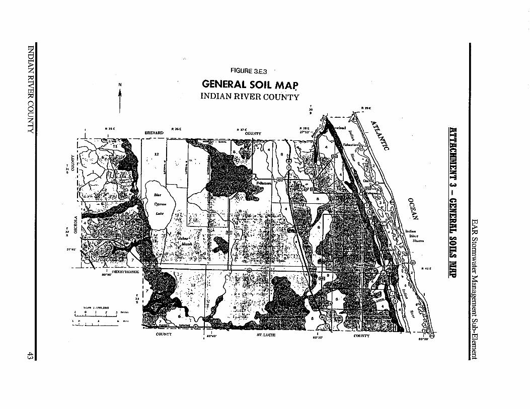
FIGURE 3.E.3
GENERAL SOIL MAF! INDIAN RIVER COUNTY
T lO
• RJ!tE
= 11-!1 1:1:1 ~ = == t":: 2 11-!1 w I
0 ~ (") t":: t"i 2 .~ t":: = ~ 1:1:1
1:"1 ~ (/) e g ....
~ 1:"1 ~
I; !a R 40£
~ ~ § ~ JCI
~ g ...... (/)
§. I
ti:1 ,_.
~ (!) a
EAR Stormwater Management Sub-Element
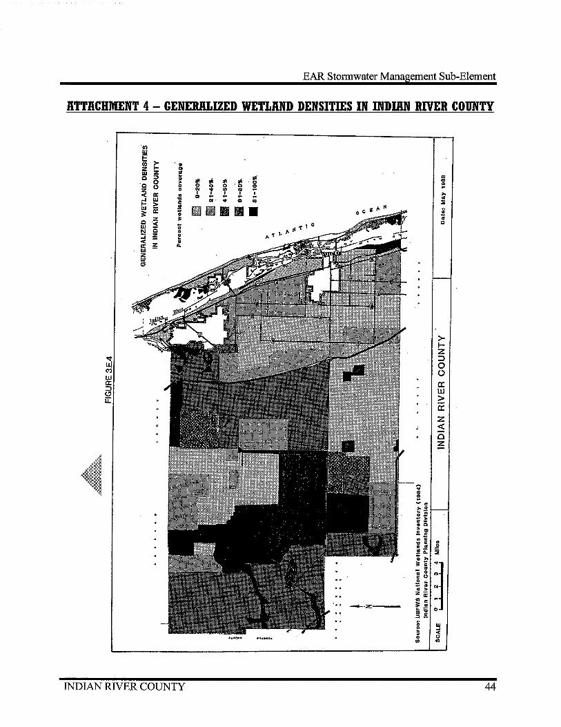
ATTACHMENT 4 - GENERALIZED WETLAND DENSITIES IN INDIAN RIVER COUNTY
(/) w E >-(/) ·o z 1- Q
w z as c :;:) ..
~· "' 0 0
~ -$ ~ ~ CD .. ·0 Cll c (.) 0 0 0 ·o 0 ~ z ... ~ ! CD "' ~
< a: .. I .J. I ... 0 .. .. ..
i:! w , til· ... CD Cll =: > c
w a: .!! m m II II • ~ :: ; z ~ ;
c "< ~ 0
w 0 c ~ .. .... ~ I! <.
~ ..
a: a. w z w (!!
>-1-z
~ :::> w 0 (Yj 0 w 0:: a: ::J w " u:: >
a: z <(
c z -
.... ... "' Cll ~
- c .. 0
t:! -.. c-GIO .. .. .5 c .. ;; ., , c c .. .. .!!ii: ~ ; ... :=1:
~) " - 0 :go
.2 .. -; 0 .. za:; 0) c
--·:Z: == .. u.-0) ... ::).5 ~ w f _, " < 0 0 0) 0)
INDIAN RIVER COUNTY 44

EAR Stormwater Management Sub-Element
ATTACHMENT 5 - FLOOD PRONE AREAS IN INDIAN RIVER COUNTY
FIGURE 3.E.5
Flood Prone Areas in Indian River County (Resource: Flood Insurance Rate Map #12061 COOOO, dated May 4, 1989)
INDIAN RIVER COUNTY 45

EAR Stonnwater Management Sub-Element
ATTACHMENT 6 - INDIAN RIVER LAGOON
BOL/le
INDIAN RNER COUNTY
NPRIHtED &'f PERMsS:siON OF moT. FINAI«CIM. ASSIS1'AHCI 1CR liN 'f!EP.IAAJICJH PAOVUD IY nCRCAOI!PT.CI CCMMUHm' .., .....
FIGURE 3.E.6
INDIAN RIVER LAGOON
Aquatic Preserve <•n
0 l!
SCALE
3 Miles
Vero Beach - Ft. Pierce
I l•pt. 11, 1817
INDIAN RIVER COUNTY FLORIDA
46

~ §
~ (1
~
..j:>. -....)
Source: LRC. Planning Dept. Date: ;June1997
~.lltFWCD
mJ SRWCD
~ MAINLAND iRl
fll BARRIER ISLAND
FIGURE 3.E.7
INDIAN RIVER COUNTY DRAINAGE BASINS
~ TAlBOT TERRACE
IJll DFWCD
~
1 NOT TO SCALE
E'LJ FWCD LSEJ SJWCD
[i} BlUE CYPRESS fill ST.SEB.(\STIAN RIVER
= = C"2 = == 1:":1 :a: ... ...:I
I ...... :a: = ...... 51 = :a 1:":1 = C"2
[Ij = ~ = :a: ... Cl.l loCI
I = e a :a: ~ == ~ ~ 1:":1 ~ = ~
== § C'-1 ...... g :a: C'-1 .....
Cl.l g. I [Ij -§ (1)
a
~ ~
~ n
~
+>-00
/\/ County boundary
N Road
N District boundary
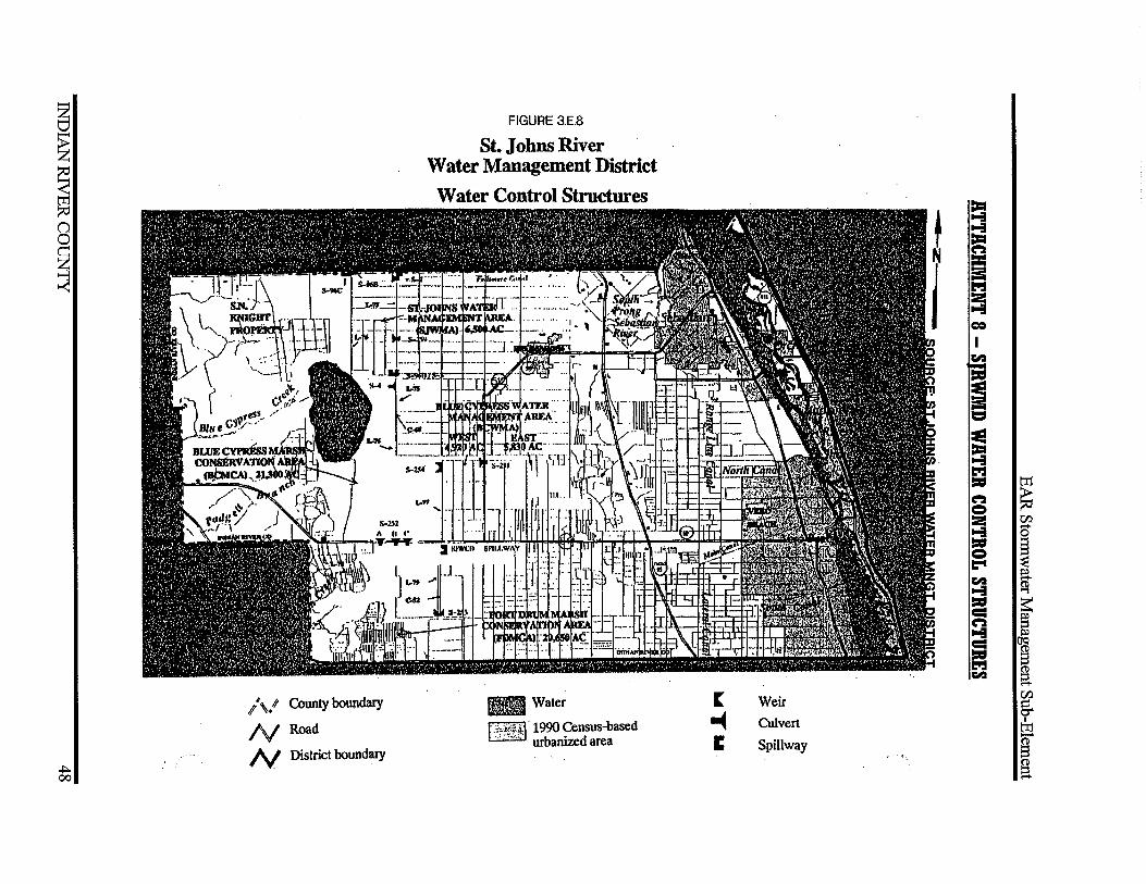
FIGURE 3.E.8
St. Johns River Water Management District
Water Control Structures
Ifill Water
f -~cf!.'P+) · 1990 Census-based · ., .. ,.. urbanized area
[
-c 1:
Weir
Culvert
Spillway
a = == 1:":1 2 ... = I ~ -i = ! 1:":1 = ("2 = 2 ;6 = l:"t ~ ... = ::; = = 1:":1 ~
~ (ll
s ~ r:; ~
f 1 a (ll
5-I
t:1
~ a

EAR Storm water Management Sub-Element
ATTACHMENT 9 - EXISTING AND POTENTIAL FUTURE NONPOINT SOURCE POLLUTANT LOADING
INDIAN RIVER COUNTY 49

EAR Stormwater Management Sub-Element
ATTACHMENT 10- SURFACE WATER CLASSIFICATIONS
FIGURE 3.E.11
SURFACE WATER CLASSIFICATIONS
ll::::::m::l Class 11 Waters
BJ Class Ill Waters
~Conditionally Approved 1:§3 Shellfish Harve~ting Area
0 3
MILES
(I
0 (I
.,..
Sept. ta. 1817
INDIAN RIVER COUNTY FLORIDA
F:\Community Development\Users\LONG RANGE\EAR\EAR 2006\lnfrastructnre Element\Stormwater Sub Element\2008 EAR Stormwater.doc
INDIAN RNER COUNTY 50