evaluating sage grouse conservation efforts formatted
TRANSCRIPT

A Report from
AUGUST 2015
Sage Grouse Conservation Efforts and Population Trends A Wyoming Case Study
Erik M. Molvar, Sagebrush Sea Campaign Director, WildEarth Guardians

Cover photo: Sage grouse near Ferris Mountains, Wyoming, WildEarth Guardians photo. Inset photos: Main haul road, Pinedale Anticline Gas Field, Wyoming, WildEarth Guardians photo. Drilling in the Lost Creek Uranium Project, Wyoming, Erik Molvar photo. Gas drilling in the Pinedale Anticline Field, WildEarth Guardians photo.
Sage Grouse Conservation Efforts and Population Trends A Wyoming Case Study
Erik Molvar, Wildlife Biologist, WildEarth Guardians, Laramie, Wyoming EXECUTIVE SUMMARY State and federal protections for greater sage grouse are currently being developed, and the performance of these conservation measures will be a key factor in deciding whether or not to list this bird under the Endangered Species Act. While sage grouse populations have declined over the long term, a recent uptick in sage grouse populations has raised the question of whether federal and/or state sage grouse conservation plans are working. An analysis of Wyoming, where state sage grouse conservation measures have been in effect since 2008, provides an informative case study. In Wyoming, federal agencies withheld approval of virtually all industrial projects intersecting sage grouse “Core Areas” (known elsewhere as “Priority Habitats” and designated for elevated sage grouse protections) –– which delayed the approval of 27,203 oil and gas wells between 2009 and 2015. Only one major industrial project, the Lost Creek uranium mine, was approved in a Core Area and constructed under the terms of Wyoming’s state policy. In this case, the state’s conservation measures failed to protect sage grouse because protections were waived by state officials based on their expert judgment that population declines would not occur, and because state protection levels allowed an intensity of development that resulted in the extirpation, or decline, of all sage grouse lek populations in the Lost Creek project vicinity. These population declines continued in 2014 and 2015 despite favorable conditions that allowed sage grouse populations to rebound elsewhere in the state. State efforts to direct wind energy development away from Core Areas was successful in most cases, and the de facto federal moratorium on the approval of new industrial projects has thus far prevented new industrial impacts and habitat degradation in Core Areas. These factors have allowed sage grouse populations to rebound in 2014 and 2015. State and federal Core Area protection measures as tested in the Lost Creek project were insufficient to prevent population declines. When federal sage grouse plan amendments are completed, federal agencies will likely lift the moratorium on industrial project approvals. When this occurs, the insufficiency of state and federal protections in Wyoming is expected to result in further declines in sage grouse Core Area populations as a result of industrial projects permitted under the terms of the new plans. INTRODUCTION Across the Intermountain West, state and federal agencies drafted a variety of sage grouse conservation plans with the goal of halting sage grouse population declines and providing adequate regulatory mechanisms to recover the bird in
advance of an expected September 2015 decision on whether the greater sage grouse deserves to be listed under the Endangered Species Act (“ESA”). In 2008, the State of Wyoming became the first state to adopt a sage grouse conservation strategy based on identifying “Core Areas” for heightened conservation protections.

2
While the effectiveness of the conservation measures prescribed has been a hotly debated topic, the concept of identifying large tracts of high-quality habitat supporting the most dense remaining sage grouse populations has become the basis for sage grouse plan amendments and revisions for federal lands in ten of the eleven sage grouse states. In Wyoming, sage grouse protections in proposed federal plans closely mirror the Wyoming state policy, so it is instructive to consider how this state policy has performed thus far as a yardstick for measuring the potential success or failure of future federal plans.
According to Wyoming Game and Fish Department counts of males present on active lek sites, the maximum male count in 2007 ––(the last year of population data that informed the U.S. Fish and Wildlife Service’s “‘warranted, but precluded”’ finding for greater sage grouse under the ESA––) was 43,571 males (see Figure 1).1 This number declined to a low point in 2013 of 18,115 males.2 The population then rebounded to 34,518 males in 2015–
1 Christiansen, T. 2013. Statewide sage-grouse job completion report, 2013. Cheyenne, WY: Wyoming Game and Fish Dept., 267 pp. Online at https://wgfd.wyo.gov/WGFD/media/content/PDF/Hunting/JCRS/JCR_SAGEGROUSE_2013.pdf. 2 Id.
0
5000
10000
15000
20000
25000
30000
35000
40000
45000
50000
2006 2007 2008 2009 2010 2011 2012 2013 2014 2015
Wyoming Maximum Male Lek Counts
Male Lek Count
Figure 1. Statewide maximum counts of sage grouse males at leks by year, data from Wyoming Game and Fish Department and Western Association of Fish and Wildlife Agencies.

3
–a number that is likely inflated due to the significantly greater number of leks counted in 2015 compared to 2007.3 Thus, since the Wyoming population today remains down by 21% overall, despite the uptick in population counts in 2014 and 2015. Average numbers of males per lek has declined in Wyoming over the long term, both in peak years and trough years.4 This report examines the factors behind the population decline from 2006 to 2013, the factors that may have affected the population rebound in 2014 and 2015, and the overall influence of various conservation efforts on these population trends. WIND POWER PROJECTS: SUCCESSES AND FAILURES FOR SAGE GROUSE CONSERVATION The Wyoming state policy correctly identified wind farms as having potentially major impacts to sage grouse populations, and initially placed Core Areas off-limits to new wind farms. However, a University of Wyoming study modeled the probable build-out of wind power projects in different scenarios and projected that wind projects would impact a maximum of 2% of the state’s sage grouse population under the high-intensity scenario.5 The study concluded that wind
3 Western Association of Fish and Wildlife Agencies. 2015. Greater sage-grouse population trends: An analysis of lek count databases, 1965-2015. Cheyenne, WY, 54 pp. Available at http://www.wafwa.org/Documents%20and%20Settings/37/Site%20Documents/News/Lek%20Trend%20Analysis%20final%208-14-15.pdf, last visited 8/17/15. 4 Id, 5 Macsalka, Natalie, Assessing the conflict between wind energy development and sage-grouse conservation in Wyoming: An application using a
power development could be accomplished on a large scale without major impacts to key sage grouse habitats.6 The original outright moratorium on building wind projects in Core Areas in Wyoming’s state policy was later adjusted to allow for new wind farms if science demonstrates that wind farms can be built in important sage grouse habitats without significant impacts to the birds. To date, no wind farms have been built inside designated Core Areas. But, in several instances, state officials have changed the boundaries of designated Core Areas to purposefully exclude proposed wind farm areas. This gerrymandering has exposed Core Area sage grouse populations to the impacts of wind farm development. The Wyoming policy has a mixed track record of success and failure at shifting wind farms away from Core Area habitats. For example: Shell WindEnergy: Shell WindEnergy initially proposed to construct a major wind power project atop the Kinney Rim in the southern Red Desert.7 Parts of the proposed project were located inside a designated Core Area. Conservation groups successfully lobbied Shell to shift its project away from this sensitive area. The state’s Core Area designation likely also discouraged Shell WindEnergy from pursuing this project. In the end, the project was moved to a location south of
spatial explicit wind development model, M.S., Department of Agricultural and Applied Economics, September 6, 2011. 6 Id. 7 Southwest Wyoming becomes hotbed of wind energy development, by Jeff Gearino. Casper Star-Tribune, July 31, 2008. Online at http://trib.com/energy/southwest-wyoming-becomes-hotbed-of-wind-energy-development/article_828e681a-575c-53c3-87fb-8f7fa3b501f5.html.

4
Laramie, to an area far removed from sage grouse Core Areas, resulting in a net benefit to sage grouse populations.8 Pathfinder Wind: In 2005, wind power generators purchased the Pathfinder Ranch along the Sweetwater River to provide land for a planned wind farm. Most of the ranch fell within a designated sage grouse Core Area, leaving insufficient space outside the protected area for a wind power project of sufficient size to be attractive. In 2014, Pathfinder Renewable Wind Energy announced an $8 billion wind farm, slated to produce up to 2,100
8 Western Area Power Administration. 2012. Draft Environmental Impact Statement, Hermosa West Wind Energy Project. 606 pp. Online at http://energy.gov/sites/prod/files/EIS-0438-DEIS-Vol1-2012_2.pdf.
megawatts, to be built near Chugwater, Wyoming, east of the Laramie Range, in an area where sage grouse do not occur.9 The original Pathfinder Ranch became the basis for a proposed conservation bank, where developers will purchase shares to offset industrial projects that negatively impact sage grouse elsewhere. While the benefit of a conservation bank that allows offsetting impacts to sensitive sage grouse habitats when these impacts might otherwise be prevented or minimized is debatable, the shifting of this major wind farm to an area well outside the range of the sage grouse is an undeniable benefit to these birds. Dunlap Ranch: The Dunlap Ranch wind power project was built by Rocky
9 The new ‘Hoover Dam:’ Companies announce $8B wind farm outside Chugwater, by Benjamin Storrow. Casper Star-Tribune, September 23, 2014.
The Dunlap Ranch wind energy project, shown here, was located to avoid sage grouse Core Area habitats. WildEarth Guardians photo.

5
Mountain Power in a gap in sage grouse Core Area lands in the Shirley Basin. While surrounded by sage grouse Core Area habitats, this project was sited to avoid Core Area habitats, and is located 5 miles away from Core Area habitats at its closest point.10 As such, it offers an example of how wind farms can be sited at a local scale to avoid im pacts to Core Areas. Whirlwind LLC: In 2010, the State of Wyoming altered the boundaries of a designated Core Area north of Rock Springs to accommodate a wind farm proposed by Whirlwind, LLC atop White Mountain, to the north of U.S. Highway 191. The project was ultimately abandoned at this site by the developer, which shifted its area of focus to an alternate location about 100 miles to the east. While this key habitat, originally designated as a Core Area on the basis of dense sage grouse populations, will not immediately be degraded through wind farm construction, these sensitive lands remain open to industrial use as a result of the 2010 boundary change. During the course of boundary alterations in 2015, Governor Mead rejected efforts by conservationists and the Sweetwater County Commission to return this land to Core Area status. Chokecherry – Sierra Madre: This wind farm––the largest in the history of the United States with 1,000 planned turbines––occupies two separate units,
10 CH2M Hill. 2009. Wyoming Industrial Development Information and Siting Act Section 109 Permit Application, Dunlap Wind Energy Project. Final Report prepared for PacifiCorp Energy, June 15, 2009, 457 pp. Online at http://deq.wyoming.gov/media/attachments/Industrial%20Siting/Application%20and%20Permits/Dunlap%20Wind%20Energy%20Project/2009-0617_ISD_Application-for-Permit_Pacificorp-Energy_Dunlap-Wind-Energy_09-01.pdf.
more than half of which fall within the original 2008 boundaries of sage grouse Core Areas.11 In 2010, representatives of the Anschutz Corporation strong-armed the South-Central Wyoming Local Working Group, and later the State of Wyoming, into carving out the wind farm project area from Core Area, so that sage grouse protections would not apply.12 Thus, this project will move forward despite being proposed on lands that were designated sage grouse Core Area lands at the time of the original proposal. The construction of this project risks a large-scale elimination of resident and migratory sage grouse populations that inhabit this area. Summary of Wind Policy Impacts: In sum, the Wyoming Core Area strategy has performed better with regard to wind power development than it has for any other land use, encouraging wind energy corporations to site their operations away from Core Areas. The exceptions occur in cases where the State of Wyoming redraws Core Area boundaries to allow wind farms to be sited inside habitats that have been designated as Core Areas. This is readily apparent in the case of the Chokecherry – Sierra Madre wind farm, which has yet to be constructed but will likely have catastrophic effects on resident and migratory sage grouse populations. To the extent that the Core Area policy has been successful, the State of Wyoming
11 Anschutz wind project advances amid grouse doubt, by Matt Joyce. AP, August 30, 2009. Online at http://www.denverpost.com/colorado/ci_13235691. 12 Christiansen, T. 2011. Statewide sage-grouse job completion report, 2013. Cheyenne, WY: Wyoming Game and Fish Dept., 296 pp. Online at https://wgfd.wyo.gov/WGFD/media/content/PDF/Hunting/JCRS/JCR_SAGEGROUSE_2011.pdf.

6
deserves the lion’s share of the credit for shifting this type of industrial use away from key sage grouse habitats. MINERAL PROJECTS IN CORE AREAS WildEarth Guardians has undertaken an analysis of large industrial projects approved, or proposed but still awaiting approval, under the Core Area policy.13 In regard to oil and gas drilling projects, a total of seven large oil and gas projects at least partially overlapping with sage grouse Core Areas––totaling 27,209 oil and gas wells––were proposed between 2009 and August 2015, but are still awaiting approval. These projects have been 13 See Appendix A.
delayed pending completion of rangewide sage grouse plan amendments and revisions by federal agencies that manage the public lands and minerals where these projects would occur. Mining operations had a much higher rate of project approval, with two uranium mines (totaling 12,877 acres) and two coal leases (totaling 18,344 acres) having been approved that are either entirely or partially located inside Core Area boundaries between 2009 and August 2015. Of the two uranium mining projects, one (Lost Creek In Situ project) began construction in 2012, while the other (Gas Hills In Situ Project) has yet to begin development. Geophysical and seismic exploration projects to locate oil and gas reserves have a mixed record of approval. However, such exploration projects do
Some 3,500 natural gas wells have been proposed for the Normally Pressured Lance project area, shown here, but the environmental review process for this project has been delayed and in the meanwhile these sage grouse habitats—including key grouse winter concentration areas— have remained pristine.
7
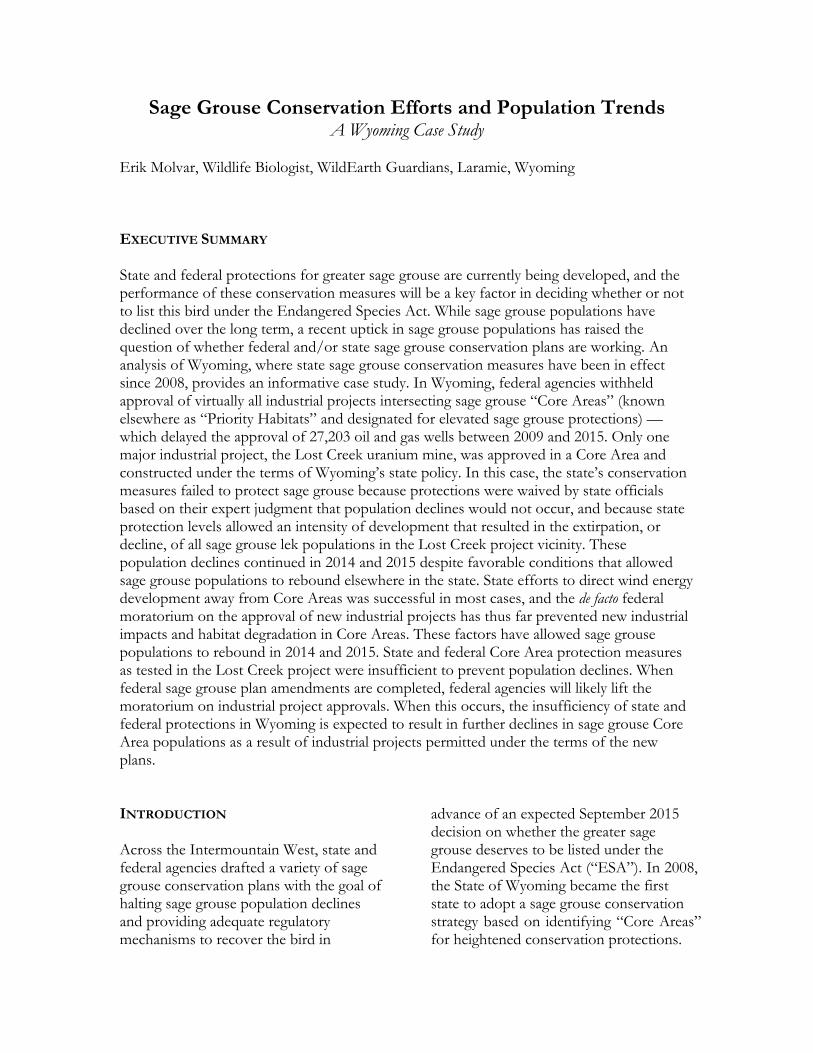
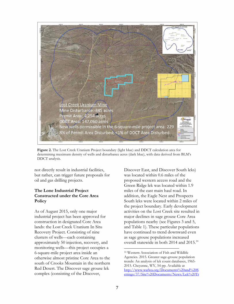
not directly result in industrial facilities, but rather, can trigger future proposals for oil and gas drilling projects. The Lone Industrial Project Constructed under the Core Area Policy As of August 2015, only one major industrial project has been approved for construction in designated Core Area lands: the Lost Creek Uranium In Situ Recovery Project. Consisting of nine clusters of wells––each containing approximately 50 injection, recovery, and monitoring wells––this project occupies a 6-square-mile project area inside an otherwise almost pristine Core Area to the south of Crooks Mountain in the northern Red Desert. The Discover sage grouse lek complex (consisting of the Discover,
Discover East, and Discover South leks) was located within 0.6 miles of the proposed western access road and the Green Ridge lek was located within 1.9 miles of the east main haul road. In addition, the Eagle Nest and Prospects South leks were located within 2 miles of the project boundary. Early development activities on the Lost Creek site resulted in major declines in sage grouse Core Area populations nearby (see Figures 3 and 5, and Table 1). These particular populations have continued to trend downward even as sage grouse populations increased overall statewide in both 2014 and 2015.14 14 Western Association of Fish and Wildlife Agencies. 2015. Greater sage-grouse population trends: An analysis of lek count databases, 1965-2015. Cheyenne, WY, 54 pp. Available at http://www.wafwa.org/Documents%20and%20Settings/37/Site%20Documents/News/Lek%20Tr
Figure 2. The Lost Creek Uranium Project boundary (light blue) and DDCT calculation area for determining maximum density of wells and disturbance acres (dark blue), with data derived from BLM’s DDCT analysis.
8
This project was subjected to the State of Wyoming’s Core Area screening process, under which a Disturbance Density Calculation Tool (“DDCT”) mapping effort was undertaken to test compliance with the one-wellpad-per-square-mile and 5% surface disturbance requirements of the state plan. The DDCT area was calculated by buffering the project area by 4 miles and adding the 4-mile buffers of all intersected sage grouse leks, resulting in a calculation area of 229 square miles (for a 6-square-mile project) that became the denominator for wellsite density and disturbance density calculations.15 Given that approximately 450 wells would
end%20Analysis%20final%208-14-15.pdf, last visited 8/17/15. 15 BLM Lost Creek Uranium In Situ Recovery Project Final EIS, Appendix D – PIAA/DDCT Analysis and WGFD Review.
be drilled to complete the uranium project––wells to inject the acid-based lixiviant fluids into the uranium-bearing formation to liberate the uranium, other wells to pump the uranium-laden “pregnant lixiviant” to the surface, and a ring of monitoring wells to record “excursions” of uranium-laden fluids out of the project area16––the project would not be allowed if each well was considered its own site under the site density criteria. The Wyoming Game and Fish Department made a decision to consider the entire project as a single wellsite in order to allow it to go forward, even though it appeared to exceed the well density limits in the Core Area policy.
This creative interpretation was later
16 BLM Lost Creek Uranium In Situ Recovery Project Final EIS.
Haul road construction and drilling underway at the Lost Creek project site, October 2012. Erik Molvar photo.

9
Figure 3 (above). Leks in the vicinity of the Lost Creek Uranium in situ leaching project area, excerpted from the Bureau of Land Management’s Lost Creek Uranium In Situ Recovery Project Final Environmental Impact Statement. Figure 4 (below). Lost Creek project layout including uranium recovery area and main haul-roads, excerpted from the Bureau of Land Management’s Lost Creek Uranium In Situ Recovery Project Record of Decision.

10
formally incorporated into state Executive Order 2011-5 in the form of a decision to treat all clusters of wells on “tight centers” (100 feet apart or less) as a single wellsite. This change fundamentally violates the original purpose of the Core Area strategy, which was to prevent industrial activities that would harm sage grouse populations based on the best available science. The proposed surface disturbance of the Lost Creek project exceeded 8% of the project area––which is greater than the 5% threshold prescribed by state policy and greater than the 3% per square-mile section threshold recommended by scientists.17 As a result of the inflated 229-square-mile DDCT calculation area, the surface disturbance of the project resulted in an average disturbance percentage of less than one percent, allowing the project to comply with state restrictions. The density of the project, averaging 8% surface disturbance and 75 wells per square mile when calculated based on the project area alone, is far greater than the 3% surface disturbance threshold and the one wellsite per square mile recommended in the scientific literature to prevent sage grouse population declines. Excessive density of industrial facilities likely was a key factor in the decline of surrounding sage grouse populations. But a different lapse in Core Area protections would also have dire consequences. During the state Industrial Siting Council hearings for the Lost Creek project, conservationists challenged plans to construct the main haul roads for the
17 BLM Sage-grouse National Technical Team. 2011. A Report on National Greater Sage-grouse Conservation Measures. Available at www.blm.gov/pgdata/etc/medialib/blm/co/programs/wildlife.Par.73607.File.dat/GrSG%20Tech%20Team%20Report.pdf.
facility––which under the Core Area policy must be sited more than 2 miles away from active sage grouse leks––within 0.6 miles of three active leks or lek complexes. On August 1, 2011, Deputy Director John Emmerich conveyed the expert opinion of the Wyoming Game and Fish Department staff regarding this violation of the state’s Core Area policy:
As these existing roads are blocked from view to the leks by topography, we are not concerned with the plans to upgrade [two-track roads within 0.6 miles of leks] in lieu of creating new roads. We have concerns that the creation of new roads would result in a greater negative impact to sage grouse by fragmenting existing unfragmented nesting and brood rearing habitat.18
Furthermore, as a result of this project, Emmerich stated that “no decline in sage grouse is expected.”19 In comments on the subsequent Bureau of Land Management Environmental Impact Statement for the project, conservationists pointed out that the scientific study that was the basis for the Core Area policy’s 1.9-mile exclusion area around leks for main haul roads20 explicitly stated that significant population declines of leks within 1.9 miles of such roads would occur, regardless of whether or not intervening topography blocked line-of-sight between roads and leks. Conservationists also expressed concerns that the Lost Creek project would result in
18 Letter from John Emmerich, Wyoming Game and Fish Department to Melissa Bautz, Wyoming Department of Environmental Quality, regarding the Lost Creek Uranium proposal, August 1, 2011. 19 Ibid. 20 Holloran, M. J. 2005. Greater sage-grouse (Centrocercus urophasianus) population response to natural gas field development in western Wyoming. PhD Dissertation. University of Wyoming, Laramie, Wyoming.

11
serious population declines for Core Area sage grouse populations and recommended specific alternate alignments for both haul roads that would keep the roads more than 2 miles away from active leks. These recommended alternative road alignments were ultimately rejected by the BLM.21 During the summer of 2012, construction began on the Lost Creek project, and heavy equipment and truck traffic began using both main haul roads. Now, three years later, construction and production activities continue. A substantial in situ uranium leaching facility appears complete. Plans have been announced to expand on-site processing of uranium ore from neighboring uranium mines as well, which will further increase the amount of truck traffic on the main haul roads passing near sage grouse leks beyond the level contemplated in the 2011 federal impact
21 Lost Creek In Situ Uranium Project Record of Decision, Appendix B.
analysis. Meanwhile, for the Discovery lek complex––which contains three leks within 0.5 miles of the west haul road––two of the leks have declined to zero males as of 2015, with the overall cumulative maximum lek attendance declining from 29 strutting males in the spring of 2012, to just seven males in the spring of 2015. For the Green Ridge lek––located within 1.9 miles of the east main haul road–– maximum male lek counts dropped from 55 in 2012 (before commencement of construction), to 27 in 2015. As the population crash has unfolded, conservationists have been sadly proven right about the need to properly site the haul roads, and the “expert opinion” of John Emmerich and the Wyoming Game and Fish Department has proved to be clearly wrong. In addition, the populations of leks within 2 miles of the project area boundary, but farther than 2 miles from main haul roads (i.e., the Eagles Nest and Prospects South leks), also declined following initial development of the project. The Eagles
0
50
100
150
200
250
2006 2007 2008 2009 2010 2011 2012 2013 2014 2015
Discover East
Discover South
Discover
Crooked Well
Green Ridge
Eagles Nest Draw
Prospects South
Totals
Figure 5. Male sage grouse counts at leks within 2 miles of the Lost Creek project area; construction began in summer 2012. See also Table 1, p. 15.

12
Nest lek’s maximum count dropped from 64 males in spring of 2012 (prior to initiation of construction activities), to six males in 2015. While, on the Prospects South lek, male sage grouse were last spotted strutting in 2011, and have not returned to the lek ever since. Overall, sage grouse lek counts in the Lost Creek area have declined from 148 males in spring of 2012 (just before the uranium project commenced construction), to only 40 males in 2015. The decline continued throughout 2014 and 2015––years when favorable conditions have supported a population rebound across other areas of Wyoming as a whole. Industrial Projects Delayed in Core Areas In contrast to the 27,203 wells involved in Core Area oil and gas projects still awaiting approval, 223 oil and gas wells have been approved in project areas that at least partially overlap with Core Areas (see Appendix A). This represents a 0.8% approval rate for oil and gas wells in Wyoming for projects that intersect with sage grouse Core Areas. Two wind projects totaling 360 turbines were proposed within Core Areas between 2009 and 2015, but neither has been approved. Although the Gateway West transmission line (stretching 950 miles across Wyoming) was approved by the Bureau of Land Management in late 2013, the alignment of the line’s Idaho portions still awaits approval, and so construction has not yet begun. Three other transmission lines traversing sage grouse Core Areas (Gateway South, TransWest Express, and Paradise––totaling 1,180 miles) still await approval. By imposing a de facto moratorium on industrial project approvals in Core Areas, the Obama administration has effectively prevented almost all new industrial impacts in Core Areas between 2009 and 2015, thereby
allowing sage grouse populations in Core Areas to recover when favorable climactic conditions arrived. Implications of Conservation Efforts for Sage Grouse Population Trends Sage grouse populations in Wyoming peaked in 2006, declined steeply between 2006 and 2013, and have since rebounded significantly in 2014 and 2015. The birds have yet to recover all of the losses their populations incurred in the state since 2007. Declines between 2006 and 2013 were partially attributable to population cycles, and were exacerbated by the increase in habitat loss, habitat fragmentation, and disturbance and displacement of sage grouse by the flood of oil and gas projects approved between 2000 and 2008 under the Bush administration. Construction and drilling activities for these projects has continued in sage grouse habitats, even as new project approvals have been delayed. It is important to note that impacts to sage grouse populations take between two and ten years to express themselves as population losses.22 This explains why population declines between 2007 and 2013 were steeper in Wyoming than in other states (such as Oregon, Idaho, or Nevada) with little or no oil and gas development, even though the federal government withheld permitting of new oil and gas projects across Wyoming during most of this period. Likewise, the population rebound in 2014 and 2015 is partially attributable to population cycles, but is also partially attributable to an easing of industrial
22 Harju, S.M., M.R. Dzialak, R.C. Taylor, L.D. Hayden-Wing, and J.B. Winstead. 2010. Thresholds and time lags in the effects of energy development on greater sage-grouse populations. Journal of Wildlife Management 74: 437–448.

13
activity in key sage grouse habitats. Outside of Core Areas, where oil and gas drilling is allowed with minimal restrictions, the intensity of drilling activity has decreased radically due to a bust in both the natural gas and oil commodity markets. In 2006, the average monthly count of drilling rigs in Wyoming peaked at 99 active drilling rigs. However, by August of 2015 this number had dropped to near-record lows, with only 24 rigs actively drilling.23 The reduction in new construction and drilling––located almost entirely outside sage grouse Core Areas, but often in non-Core sage grouse habitats––has eased the additional downward pressure on sage grouse populations that inhabit non-Core Area habitats. Within Wyoming Core Areas, the credit for the industrial slowdown goes mostly to federal agencies––which have withheld approval of the vast majority of industrial projects proposed in sage grouse habitats–– and not to Core Area protections that have been applied when industrial projects are approved in Core Areas. Only one major mineral project (the Lost Creek uranium mine) has been allowed to move forward to test the efficacy of conservation measures proposed in state and federal plans. And, the population declines associated with this project demonstrate two major flaws in the Core Area sage grouse protections incorporated into both state and federal plans in Wyoming that have led to sage grouse Core Area population crashes:
1) Failures in judgment by state and federal officials in granting exceptions to the moratorium on
23 Rig count data as reported by Baker-Hughes, http://phx.corporate-ir.net/phoenix.zhtml?c=79687&p=irol-reportsother.
locating main haul roads within 1.9 miles of leks, as evidenced by the extirpation of the Discover lek and major population declines associated with the Green Ridge and Discover South leks.
2) Excessive well density and/or
disturbance percentage within the mine site, as evidenced by the decline of the Eagle Nest Draw and Prospects South leks that are far from the main haul roads but are within 2 miles of the mine project boundary.
The failure of state and federal officials to enforce Core Area protections in the case of the Lost Creek project through the granting of waivers and exceptions based on their expert judgment resulted in the extirpation or decline of all sage grouse lek populations in the Lost Creek area. This example illustrates why Priority Habitat conservation measures that are subject to exceptions or modifications, rather than being mandatory in all cases, are insufficient to protect sage grouse in the face of industrial development. For wind power projects, there has been no new construction inside sage grouse Core Areas as of this date. This absence of additional loss and fragmentation of habitats and disturbance of resident sage grouse has allowed populations to rebound in the presence of favorable weather and habitat conditions. A significant amount of the credit for this goes to state Core Area prohibitions on new wind farms in Core Areas. However, the largest wind farm in North America (the Chokecherry – Sierra Madre wind farm consisting of 1,000 turbines) has been approved for lands originally designated for Core Area protection. When this project reaches the construction stage, impacts to sage grouse

14
and their habitats will commence on a massive geographic scale. This illustrates a third major flaw in the Wyoming Core Area policy:
3) The ability to change Core Area boundaries to exclude industrial projects calls into question whether Core Area protection will actually apply to projects that are built on lands that fall within Core Areas.
Population cycles in sage grouse may (or may not) be tied to cyclical weather patterns favorable (or unfavorable) to grouse chick production and survival. But it is apparent that human impacts impose downward pressure on sage grouse population cycles to a greater or lesser extent according to the level of protection that is granted to sage grouse habitats. Human-caused habitat destruction or degradation, as well as disturbance and displacement of sage grouse from preferred habitats, has the potential to impose additional downward pressure on sage grouse populations. This results in increasing decline during downward portions of the population cycle and reducing or eliminating altogether population rebounds during upward parts of the population cycle. It is important to note that regulations alone do not have the power to increase sage grouse populations because they can only reduce human-caused impacts toward zero. This report is limited in its scope to the impacts of industrial projects. It does not take into account livestock grazing, which occurs throughout sage grouse habitats both inside and outside Core Areas. To the extent that livestock grazing reduces grass height below 7 inches, depriving sage grouse of hiding cover needed to
escape detection by predators, nest success is reduced.24 Because livestock stocking rates are relatively constant from year to year on federal lands, this negative impact would intuitively be greater during drought years and have less of an impact during years of abundant grass production. This is a potential relationship worthy of further scientific study. Additionally, this report does not address the potential effects of voluntary sage grouse mitigation projects on sage grouse population trends, which can potentially be positive, neutral, or negative for sage grouse populations and must be evaluated on a case-by-case basis. The efficacy of these projects, and which ones are most (and least) beneficial as measured by sage grouse population changes on affected areas versus control areas, is likewise a significant gap in our overall scientific understanding of sage grouse population dynamics that remains to be addressed. Since 2009, permitting for industrial projects inside sage grouse Core Areas has virtually ground to a halt. With the exception of wind farm permitting (for which the State of Wyoming deserves the majority of the credit), this outcome is the result of federal decisions not to move forward with permitting of most major industrial projects in sage grouse Core Areas while sage grouse plan amendments and revisions are underway for federal lands. This outcome is not the result of the state’s Core Area policy and its protections. By withholding approval of the vast majority of industrial projects intersecting Wyoming Core Areas, federal 24 Gregg, M.A., J.A. Crawford, M.S. Drut, and A.K. DeLong. 1994. Vegetational cover and predation of sage grouse nests in Oregon. J. Wildl. Manage. 58:162-166; Hagen, C.A., J.W. Connelly, and M.A. Schroeder. 2007. A meta-analysis of greater sage-grouse Centrocercus urophasianus nesting and brood-rearing habitats. Wildlife Biology 13:42–50.

15
agencies allowed the sage grouse population rebound to occur, rather than suppressing it by permitting further disturbance and habitat destruction to occur. In the one case where industrial project permitting occurred under the twin state and federal sage grouse Core Area protection packages, Core Area protections were a resounding failure, resulting in the decline or extirpation of six sage grouse lek populations. Importantly, federal agencies will soon complete a series of rangewide sage grouse plan amendments and revisions that will impose a new suite of protections for sage grouse “Priority Habitats,” as “Core Areas” are known in the federal context for most states. These Priority Habitats harbor the densest remaining sage grouse populations,25 and their conservation offers the last best chance to
25 Doherty, K.E., J.D. Tack, J.S. Evans, and D.E. Naugle. 2010. Mapping breeding densities of greater sage-grouse: A tool for range-wide conservation planning. BLM Completion Report: Interagency Agreement #L10PG00911, 30 pp.
prevent the extinction of sage grouse across its native range. With the adoption of new plans, a backlog of industrial projects that have been on hold in these Priority Habitats throughout the Western range of the greater sage grouse (for many years in some cases) will presumably move forward to approval. If the federal sage grouse plans include the crippling flaws that led to the sage grouse declines and extirpations in the Lost Creek area, these project approvals will result in further sage grouse declines and extirpations elsewhere in Priority Habitats. Although few projects have yet moved forward in Core Areas in Wyoming, their poor record of success at preventing sage grouse declines gives little confidence that they will prevent the extinction of the species if and when industrial activity becomes widespread in Core Areas or Priority Habitats.
Lek Name 2006 2007 2008 2009 2010 2011 2012 2013 2014 2015
Discover East 22 12 5 0 0 0 1 0 0 0
Discover South 19 19 22 8 3 7
Discover 69 37 104 22 15 11 6 2 0 0
Crooked Well 0 4 0 0 0 0 0 0 0 0
Green Ridge 63 87 58 56 46 44 55 32 26 27
Eagles Nest Draw 57 22 52 47 19 59 64 29 13 6
Prospects South 10 9 2 0 3 0 0 0 0
Totals 211 172 228 127 99 136 148 71 42 40
Table 1. Maximum sage grouse lek counts (males only) at leks in the Lost Creek uranium mine vicinity, from Wyoming Game and Fish Department lek count data.

Appendix A
Projects within Core Areas
Field Office Project Scale/Scope
If stalled, status
Approval Date
Wyoming State Office
Gateway West Transmission Line
950.3 miles of transmission line
Idaho portions awaiting decision
ROD Nov 2013
Rawlins Washakie 3D Geophysical 154 square miles scoping 10/14
Continental Divide Creston Nat Gas project 8,950 wells DEIS 12/12
Gateway South transmission 400 miles DEIS 2/14
Lost Creek Uranium 450 wells, 4,377 acre project area ROD 10/2/12
TransWest Express Transmission 725 miles DEIS 7/13
Jonathan Limestone Quarry Quarry outside core, lime plant inside DR 8/11
Casper Moneta Divide project 4,250 oil and gas wells scoping 2/13
Converse County O&G project 5,000 wells Scoping 5/14
East Converse Exploratory Project 21 wells DR 11/12
Highland Loop Road Project 40 wells DR 11/12 Spearhead Ranch Project 79 wells DR 11/12
Wright Area Coal LBA 18,024 acres coal leasing RODs 8/11-2/12
UTEP Bighorn Deep Seismic Project
13 widely scattered shot points scoping 4/10
Rock Springs Bridger Coal Lease 320 acres (underground only) DR 2/13
Riley Ridge to Natrona Pipeline
31 miles and sweetening plant Scoping 6/14
Hiawatha Gas Project 4,208 wells Scoping 9/06
Normally Pressured Lance project 3,500 wells Scoping 6/11
White Mtn Wind Project 240 turbines EA 2/10
Kemmerer Yellowspur Well 1 well, road crosses core DR 7/14 Uinta 3D Geophysical 151 square miles scoping 1/12
Bridger Butte Wind Project 120 turbines scoping 5/09
Gary Williams exploratory well 1 well scoping 6/09
Pinedale Jonah 3D Geophysical 170 square miles EA 7/09
Paradise 230 kV transmission 55 miles EA 4/09
Lander Beaver Creek CBNG Project 228 wells Scoping 7/2008
Big Sand Draw Geophysical 32.5 square miles
Scoping 5/2014
Bison Basin 3D Geophysical 15.5 square miles Scoping 3/13
Gas Hills Uranium Project 8,500 acre In Situ Leaching ROD 2/14

17
project
Gunbarrel/Madden Deep/Iron Horse 1,300 wells
Scoping 10/08
Worland
Koch Exploration Bud, Kimball, and Tensleep Anticline 3D 33.27 sq. mi. seismic completed
Cody West Oregon Basin 3D Seismic
4.7 sq. mi. seismic DR 8/11
North Oregon Basin 3D Seismic 22.4 sq. mi. seismic DR 10/09
Buffalo Powder River 2D Seismic 89 linear miles seismic DR 9/11
Ponderosa Deep 34-34 1 well CX 12/14 Ethyl Draw 44-17 1 well DR 7/14
Robinson Draw 36 wells DR 9/11
EOG Pontiac Wells 4 wells DR 2009
Slawson Federal Whitetail A-1 2 wells DR 12/12
Daube Jireh Federal 35-13 1 well DR 3/14
True Oil Gleason 41-15 1 well DR 9/09
Anadarko Powder River 2D Seismic 89-mile long seismic line DR 9/11
Hepp Sand/Gravel Mine 8.1-acres sand and gravel mine CX 6/14
Camino Sand/Gravel pit 10.1-acre expansion of gravel pit CX 3/13
Hakert Sand/Gravel Pit expansion 10-acre expansion of gravel pit DR 4/12
Huber Meadow Draw POD 31 wells DR 8/11
Reno Seismic Project 28,897 acres geophysical exploration CX 8/11
Hilcorp Tisdale North 5 wells DR 2009
Newcastle None