eurocontrol ivan de lépinay
TRANSCRIPT

EUROCONTROL Experimental Centre
EUROCONTROL
EGNOS Flight Trials at Nice Airport
Noise Impact Study
EEC/ENV/2002/007
Ivan de Lépina y

ii
EGNOS Flight Trials at Nice Airport
Noise Impact Study
Ivan de Lépinay Environmental Studies Business Area, EUROCONTROL Experimental Centre EEC/ENV/2002/007
REPORT DOCUMENTATION PAGE
Reference: EEC Note No. EEC/ENV/2002/007
Security Classification: Unclassified
Originator: Environmental Studies Business Area
Originator (Corporate Author) Name/Location: EUROCONTROL Experimental Centre Centre de Bois des Bordes B.P.15 91222 BRETIGNY SUR ORGE CEDEX France Telephone: +33 1 69 88 75 00
Sponsor: EUROCONTROL EATMP
Sponsor (Contract Authority) Name/Location: EUROCONTROL Agency Rue de la Fusée, 96 B –1130 BRUXELLES Telephone: +32 2 729 90 11
TITLE: EGNOS Flight Trials at Nice Airport – Noise Impact Study Author: Ivan de Lépinay
Date 07/02
Pages 26
Figures 12
Tables 4
Appendix
References
EATMP Task Specification -
Project EGNOS validation
Task No. Sponsor -
Period 2002
Distribution Statement: (a) Controlled by: Ted Elliff, Peter Hullah, Laurent Cavadini, Santiago Soley (b) Special Limitations: None (c) Copy to NTIS: YES / NO Descriptors (keywords): SABAS – EGNOS – ESTB – satellite – noise – Nice – cap d’Antibes – Riviera – INM – ENHANCE
Abstract: The aim of the study is to give an estimation of the noise benefit of an SBAS-guided Riviera approach at Nice airport, using results of an ESTB experimentation by the ESA and the French DGAC.


v
TTaabbllee ooff CCoonntteennttss
REPORT DOCUMENTATION PAGE................................................................. III
TABLE OF CONTENTS .....................................................................................V
INTRODUCTION ................................................................................................ 7
ENHANCE – INM GENERAL POINTS ............................................................... 9
PROCESSING THE ESTB DATA..................................................................... 11
PROCESSING THE RADAR DATA.................................................................. 13
COMPUTING THE NOISE CONTOURS........................................................... 15
RESULTS......................................................................................................... 17
INTERPRETING THE NOISE CONTOURS ...................................................... 25

vi
7
IInnttrroodduuccttiioonn
As a part of its commitment to the European Tripartite Agreement with the Commission of the European Union and the European Space Agency (ESA), EUROCONTROL is responsible for the co-ordination of the operational validation of EGNOS for civil aviation. EGNOS is the European component of a Satellite-Based Augmentation System (SBAS), which is currently under development and is expected to be in operation in 2004. Among other things, it is believed that SBAS can bring major improvements to horizontal and vertical guidance during the approach phase of a flight, compared with the standard ILS or MLS, especially when part of the final approach segment is not aligned with the runway centre line (curved approach).
Using the EGNOS System Test Bed (ESTB), which has been broadcasting over Europe since February 2000, EUROCONTROL, the ESA and the French DGAC have performed an experimentation of approaches to Nice airport in eastward configuration, where two main procedures currently exist:
l a conventional ILS Cat-I approach straight over the Cap d’Antibes peninsula, always used under low-visibility conditions, but raising complaints from local inhabitants due to noise annoyance;
l a so-called Riviera visual approach along (bypassing) the Cap d’Antibes peninsula and followed by a sharp unguided turn towards runway 04L. This procedure aims at minimising the noise impact on the peninsula but can only be used under good visibility conditions.
The main benefit of SBAS would be to make the curved approach flyable even in more demanding meteorological conditions. It is also expected that a general use of SBAS (with way-points) would particularly reduce the wide ground dispersion resulting from the current visually-performed curved approach, modifying significantly the area where the noise is produced (and also perceived).
The overall objective of this study was to give an estimation of the noise benefit due to the use of an SBAS navigation system at Nice airport, using the FAA’s Integrated Noise Model (INM) along with the European Harmonised Aircraft Noise Contour Modelling Environment (ENHANCE) developed at the EUROCONTROL Experimental Centre (EEC).
The study compared calculated noise contours based on the ESTB data recorded during the experimentation with calculated contours based on radar data for the current standard approach.
The main steps of the study consisted of:
l collecting and pre-processing the 3D trajectories of the ESTB experimentation; l collecting and pre-processing the radar data of standard approaches for two specific
days at Nice airport: one with ILS approaches mainly and the other with Riviera approaches;
l computing thrust profiles using ENHANCE; l computing noise contours (for Lden and LAmax noise metrics) using the same daily
commercial fleet for three scenarios: current ILS approach, current Riviera approach and experimented SBAS Riviera approach.

8

9
EENNHHAANNCCEE –– IINNMM ggeenneerraall ppooiinnttss
To calculate noise contours resulting from a given traffic, INM needs successive values of five basic parameters specifying “how” the aircraft fly: (x, y) ground position, height, speed and thrust. INM usually takes the (x, y) values from nominal ground tracks. All the aircraft of a given studied fleet mix are assumed to follow these nominal tracks, with possibly a ground Gaussian (symmetric) dispersion around the backbone tracks to integrate more realism. Values for height, speed and thrust along the ground tracks are usually taken from the INM standard database (standard flight profiles pre-defined as a function of aircraft types). ENHANCE is a tool that aims at improving the quality of the input data used by a noise model such as INM. It allows direct and easy importation into INM of full 4-D trajectories (3-D position + speed) taken from radar or ATC/ATM simulator data, each flight being modelled individually. In particular, through this approach, it is possible to better account for the “real” dispersion of trajectories resulting from a given procedure under operational conditions. Since thrust is not generally provided by simulators (or in radar data), one key feature of ENHANCE is to calculate it (in a “reverse-engineering” way) for each flight/trajectory.

10

11
PPrroocceessssiinngg tthhee EESSTTBB ddaattaa
Both the DRAMO and LERIN curved approaches were carried out with a Cessna Citation II aircraft from the Dutch National Aerospace Laboratory (NLR) – an ILS-like straight-in approach was also flown but it was not really relevant for the purpose of this study. The aircraft was equipped with a dedicated EGNOS receiver for guidance and data collection.
The data files contained the aircraft latitude, longitude and height with a 1 second data rate, except for a few gaps. The speed, which is also required to perform noise calculations, was computed using the INM map projection formulas (INM User’s Guide, Appendix K) to convert Latitude-Longitude co-ordinates into Cartesian (X,Y) co-ordinates (metres or nautical miles). The projection is based on the WGS-84 spheroid model for the earth and does not take aircraft height, which remains negligible compared to the earth radius, into account.
Sample
Time (s) Lat (deg) Long (deg) Height (feet)
1 310969 43.6566329 7.20301305 228.86811 2 310970 43.6566328 7.20301308 228.874672
Table 1. Sample of the ESTB plots file
ESTB data are also based on the WGS-84 spheroid model (instead of the geoid), so that the recorded altitude values were about 60 m higher than the actual ones. A constant correction was added to all values so that the altitude on the runway was approximately 0, as required for noise calculations.
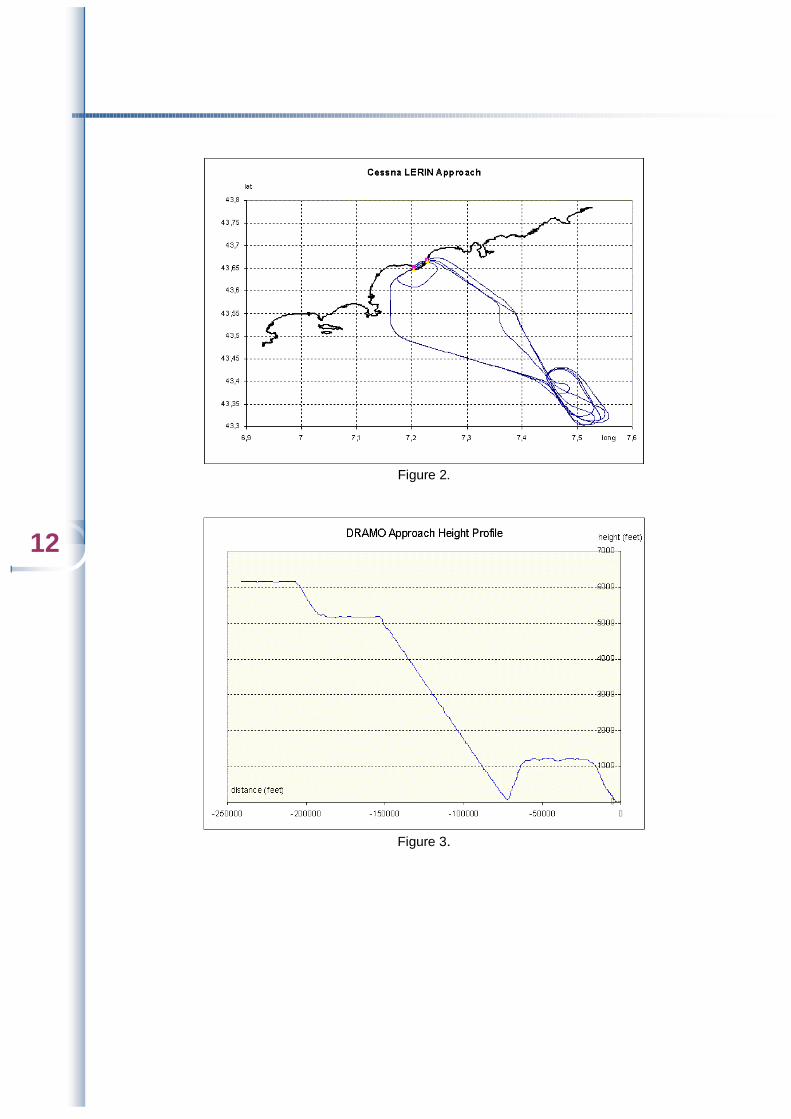
As can be seen on the ground-track plots (figures 1 and 2), the departure/approach operation was repeated three times, plus a small final loop, for both the DRAMO and ILS-like trajectories. Actually the Cessna only landed at the end of the whole circuit. The first three approaches were only overflights (at about 100 feet). Once it was checked that the three ESTB approaches were sufficiently superimposed, only the last one was kept for the ground noise calculation. The final loop was removed and the height profile was extrapolated to the ground (see figure 3). Furthermore, the Cessna speed profile was significantly different from that of a standard commercial aircraft, so that it could not be used for calculations. Radar-derived speed profiles were used instead.
Figure 1.
12
Figure 2.
Figure 3.

13
PPrroocceessssiinngg tthhee rraaddaarr ddaattaa
In order to compare the SBAS scenario with the current eastward approach configuration, the French DGAC provided radar data of two days for such approaches: 13th May 2001, when all aircraft followed the Riviera approach (225 records), and 14th May 2001, when almost all of them had to use the ILS approach (206 records).
The fleets of the two days were basically identical. Aircraft whose type was not present in both were removed to create a single fleet to be applied to the different scenarios. For aircraft types common to both fleets the number of such an aircraft in the smaller fleet was adjusted to that in the larger by adding identical aircraft on the same 3D trajectory. As a result, a 210-aircraft fleet was applied to each scenario, the composition of which is detailed in table 2. In comparison, the average number of daily approaches at Nice airport is about 230.
Aircraft Type Day Evening Night Total
737 5 1 0 6 737300 14 6 2 22 737400 2 0 0 2 737500 4 0 0 4 737700 3 0 0 3 757RR 3 1 0 4 767300 4 1 0 5
A320 25 8 0 33 A330 1 0 0 1
CL600 1 0 0 1 CL601 32 8 3 43 DHC6 1 0 1 2 DHC8 11 3 0 14
DHC830 0 1 0 1 EMB145 6 1 0 7 F10062 18 3 1 22
HS748A 13 3 1 17 LEAR35 3 2 1 6
MD81 1 0 0 1 MD82 2 0 0 2 MD83 7 4 0 11
MU3001 2 1 0 3 Total 158 43 9 210
Table 2. Daily approaches fleet composition (Day : 6 am – 6 pm ; Evening : 6 pm – 10 pm ; Night : 10 pm – 6 am).
NB: the aircraft types are those of INM 6.0b, hence Airbus A319 has been substituted to A320 for the calculations.
The second step consisted of pre-processing the corresponding radar data which included latitude, longitude, mode C and speed with a step of about ten seconds (between 8 s and 12 s). The ground tracks showed a few bad points that were removed ‘manually’.
14
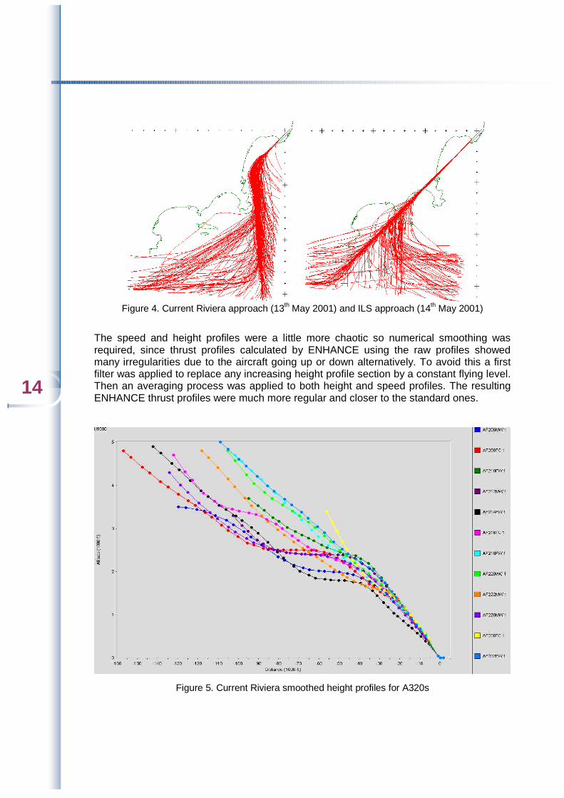
Figure 4. Current Riviera approach (13th May 2001) and ILS approach (14th May 2001)
The speed and height profiles were a little more chaotic so numerical smoothing was required, since thrust profiles calculated by ENHANCE using the raw profiles showed many irregularities due to the aircraft going up or down alternatively. To avoid this a first filter was applied to replace any increasing height profile section by a constant flying level. Then an averaging process was applied to both height and speed profiles. The resulting ENHANCE thrust profiles were much more regular and closer to the standard ones.
Figure 5. Current Riviera smoothed height profiles for A320s
15
CCoommppuuttiinngg tthhee nnooiissee ccoonnttoouurrss
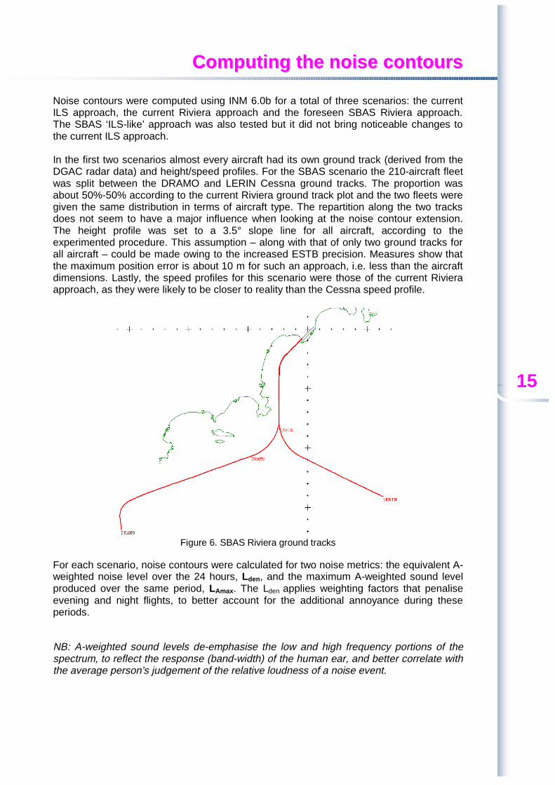
Noise contours were computed using INM 6.0b for a total of three scenarios: the current ILS approach, the current Riviera approach and the foreseen SBAS Riviera approach. The SBAS ‘ILS-like’ approach was also tested but it did not bring noticeable changes to the current ILS approach. In the first two scenarios almost every aircraft had its own ground track (derived from the DGAC radar data) and height/speed profiles. For the SBAS scenario the 210-aircraft fleet was split between the DRAMO and LERIN Cessna ground tracks. The proportion was about 50%-50% according to the current Riviera ground track plot and the two fleets were given the same distribution in terms of aircraft type. The repartition along the two tracks does not seem to have a major influence when looking at the noise contour extension. The height profile was set to a 3.5° slope line for all aircraft, according to the experimented procedure. This assumption – along with that of only two ground tracks for all aircraft – could be made owing to the increased ESTB precision. Measures show that the maximum position error is about 10 m for such an approach, i.e. less than the aircraft dimensions. Lastly, the speed profiles for this scenario were those of the current Riviera approach, as they were likely to be closer to reality than the Cessna speed profile.
Figure 6. SBAS Riviera ground tracks
For each scenario, noise contours were calculated for two noise metrics: the equivalent A-weighted noise level over the 24 hours, Lden, and the maximum A-weighted sound level produced over the same period, LAmax. The Lden applies weighting factors that penalise evening and night flights, to better account for the additional annoyance during these periods.
NB: A-weighted sound levels de-emphasise the low and high frequency portions of the spectrum, to reflect the response (band-width) of the human ear, and better correlate with the average person’s judgement of the relative loudness of a noise event.

16

17
RReessuullttss
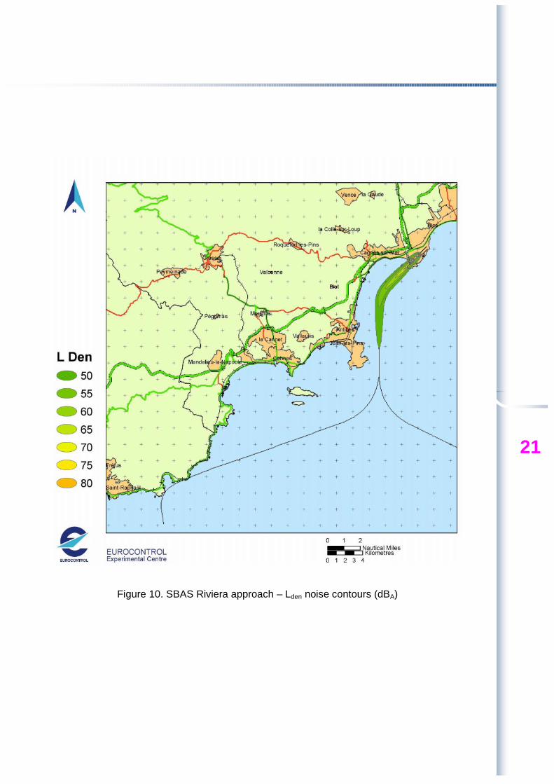
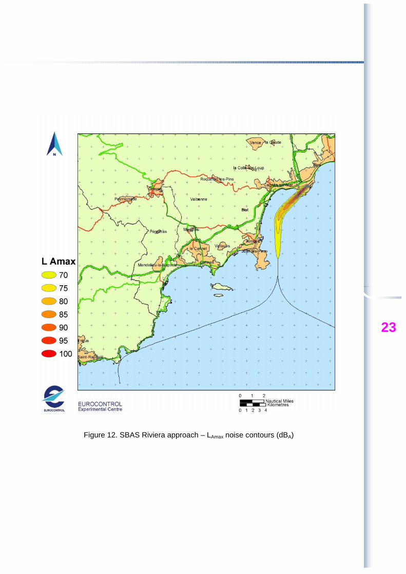
INM noise outputs were imported into the ArcView GIS software to create the maps of figures 7 to 12. Increased graphical accuracy was obtained by computing noise at refined grid points, instead of using the default INM contour grid. Contours appear above 50 dBA for the Lden metric and 70 dBA for the LAmax, with a step of 5 dBA.

18
Figure 7. Current ILS approach – Lden noise contours (dBA)

19
Figure 8. Current ILS approach – LAmax noise contours (dBA)

20
Figure 9. Current Riviera approach – Lden noise contours (dBA)
21
Figure 10. SBAS Riviera approach – Lden noise contours (dBA)

22
Figure 11. Current Riviera approach – LAmax noise contours (dBA)
23
Figure 12. SBAS Riviera approach – LAmax noise contours (dBA)

24

25
IInntteerrpprreettiinngg tthhee nnooiissee ccoonnttoouurrss
The first conclusion derived from the graphs is that the Antibes/Juan-les-Pins sector is currently the most exposed to noise during standard ILS approaches, as it is located right below the aircraft trajectory. The south end of the cap should not be affected much during standard approaches. The inhabited ground surface covered by the contours may look not very large but the fleet used for the calculations is almost 10% smaller than that of a normal day, as explained in the radar data pre-processing section.
The noise contours for the current Riviera approach show that inhabited zones should not be exposed to noticeable noise when the Riviera procedure is applied. However the contours end close to the east coast of the cap, so that this area may be slightly more affected by Riviera approaches than by ILS ones. Logically the extension of the Riviera contours is larger than that of ILS due to the increased trajectory dispersion. Yet these contours cover only the sea, so complaints are less likely to be raised.
Lastly, the ESTB contours show characteristics of the two previous ones: they only affect sea areas and have rather small ground surfaces, due to the assumed ‘zero dispersion’ of the ESTB navigation system. This is likely to benefit the south-east area of the cap which may sometimes be exposed during current Riviera approaches. The following tables give a comparison of the noise contour surfaces for both the current and simulated Riviera scenarios:
Current Riviera SBAS Riviera 50 dB 13.619 11.739 55 dB 5.470 5.067 60 dB 2.345 2.240 65 dB 0.864 0.936 70 dB 0.335 0.353 Table 3. Noise contours areas (km²) for noise metric Lden
Current Riviera SBAS Riviera
70 dB 48.470 13.706 75 dB 18.887 7.019 80 dB 6.716 3.843 85 dB 2.428 2.020 90 dB 1.124 1.107 Table 4. Noise contours areas (km²) for noise metric LAmax
Conclusion
This noise impact study confirmed that the Riviera approach reduces annoyance for Cap d’Antibes residents, especially at the north end of the Cap which is located right below the ILS eastward approach trajectory.
The study also revealed that the use of an SBAS navigation system may bring further improvements around the south east area of the Cap by considerably reducing the dispersion of aircraft trajectories. However for the SBAS scenario all aircraft were assumed to have the same 3D trajectory, which is a strong assumption. The benefits of an SBAS guidance in terms of noise will strongly depend on the way it is implemented and how pilots and controllers respect theoretical procedures.

For more information about the EEC Environmental Studies Business Area
please contact:
Ted Elliff Environmental Studies Business Area Manager,
EUROCONTROL Experimental Centre BP15, Centre de Bois des Bordes
91222 BRETIGNY SUR ORGE CEDEX France
Tel: +33 1 69 88 73 36 Fax: +33 1 69 88 72 11
E-Mail: [email protected]
or visit
http://www.eurocontrol.fr/ba_env/