estuaries and barrier islands
TRANSCRIPT

Estuaries and Barrier Islands

What is an estuary?An estuary is where fresh river water and salt ocean water mix.

Estuary
Estuaries’ unique environment makes them a great place for humans and animals. Humans benefit from the beauty of estuaries and the food and resources they provide. Estuaries make great tourism attractions or harbors and ports. (EPA).

Estuaries have a unique environment .
• The mix of fresh and saltwater makes a great feeding ground and habitat for many types of wildlife (EPA).
• This water mixture also results in a mixture of types of sediment. Though estuaries have sediment from both upstream rivers and from the ocean, most of the sediment is relatively fine grained (McNally, pg. 3). The type of sediment, and the abundance of it, affects human and animal involvement with estuaries. Too much sediment makes it hard for plants to photosynthesis and limits human use of the estuary since sediment can be deposited, making the estuary unsuitable for ship traffic. If there is too little sediment in the estuary then the land bordering it may be eroded away and increase predation rates in some species (McNally, pg. 2)

Estuaries are among the most productive ecosystems in the world. Many animals rely on estuaries for food, places to breed, and migration stopovers.
• Estuaries are delicate ecosystems. Congress created the National Estuarine Research Reserve System to protect more than one million acres of estuarine land and water. These estuarine reserves provide essential habitat for wildlife, offer educational opportunities for students, and serve as living laboratories for scientists. (http://oceanservice.noaa.gov/facts/estuary.html)

Estuaries are coastal bodies of water that have mixed fresh and salty water. The water in estuaries is mixed because they are fed by rivers but also have a connection with oceans. Estuaries have a barrier to the sea, similar to lagoons, that protects them from ocean energy, but, unlike lagoons, estuaries still connect with the sea. Because of this connection with the sea, estuaries are strongly influenced by tides (NOAA).Barrier Islands Protect Estuaries
Photo : http://barrierjumpsgalleries.blogspot.com/2013/09/barrier-islands.html

Estuaries and their surrounding wetlands are bodies of water usually found where rivers meet the sea. Photo courtesy of http://geo.libretexts.org/Core/Oceanography/09%3A_Coastal_Processes/9.1_Estuaries

Always changing
This water mixture also results in a mixture of types of sediment. Though estuaries have sediment from both upstream rivers and from the ocean, most of the sediment is relatively fine grained (McNally, pg. 3). The type of sediment, and the abundance of it, affects human and animal involvement with estuaries. Too much sediment makes it hard for plants to photosynthesis and limits human use of the estuary since sediment can be deposited, making the estuary unsuitable for ship traffic. If there is too little sediment in the estuary then the land bordering it may be eroded away and increase predation rates in some species (McNally, pg. 2)

Northern Outer Banks Resort Beaches

Barrier islands are highly vulnerable to relative sea-level rise, erosion, and tropical stormshttp://barrierjumpsgalleries.blogspot.com/2013/09/barrier-islands.html

http://www.fishing-nc.com/outer-banks-maps.php
Copy this url and paste it into your search bar to see these links.
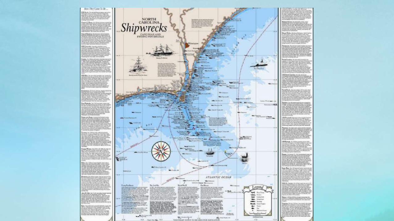
One new tool we recently found is NOAA'a Online Nautical Chart Viewer. It's very easy to use, highly accurate and just what you'd hope it would be. Below are the links for the North Carolina coast and Outer Banks: Cape Hatteras to CharlestonApproaches to Cape Fear River Cape Fear River Cape Fear to WilmingtonNew River Inlet to Cape FearIntracoastal Waterway Neuse River to Myrtle Grove SoundNew River;JacksonvilleCape Lookout to New RiverPortsmouth Island to Beaufort, Including Cape Lookout ShoalsBeaufort Inlet and Part of Core Sound;Lookout BightMorehead City HarborPamlico Sound Western PartOcracoke lnlet and Part of Core SoundNeuse River and Upper Part of Bay RiverIntracoastal Waterway Albermarle Sound to Neuse River;Alligator River;Second CreekPamlico RiverCape Hatteras-Wimble Shoals to Ocracoke InletCape May to Cape Hatteras

Barrier Islands (NOAA)

Maps of North Carolina Outer Banks Inletshttp://www.fishing-nc.com/outer-banks-maps.php
Great maps of all the NC coastal and Outer Banks inlets including COLREGS Demarcation Lines that clearly show where inland waters end and the Atlantic ocean begins. These maps are pretty large, so be carefull if you are on a slower connection.
Bardens Inlet (Cape Lookout) Bear Inlet Beaufort Inlet Bogue Inlet Browns Inlet Cape Fear River Inlet Carolina Beach Inlet Drum Inlet Hatteras Inlet Lockwoods Folly Inlet
Masonboro Inlet Mason Inlet New River Inlet Ocracoke Inlet Oregon Inlet Rich Inlet Shallotte Inlet Topsail Inlets Tubbs Inlet

This southeastern coastal plain region is best known by the name given to it by sea captains in days of sail --Cape Fear.http://barrierjumpsgalleries.blogspot.com/20
13/09/barrier-islands.html
Barrier Islands

References
• EPA. Retrieved from http://water.epa.gov/type/oceb/nep/about.cfm.
• McNally, W. H., Mehta, A. J. Retrieved from http://www.eolss.net/Sample-Chapters/C09/E2-06-01-04.pdf.
• NOAA. Retrieved from http://oceanservice.noaa.gov/education/tutorial_estuaries/welcome.html.
• ONA Retrieved from http://www.onr.navy.mil/focus/ocean/habitats/estuaries1.htm.