estimation of instantaneous net surface longwave radiation from modis cloud-free data
TRANSCRIPT
Remote Sensing of Environment 112 (2008) 3482–3492
Contents lists available at ScienceDirect
Remote Sensing of Environment
j ourna l homepage: www.e lsev ie r.com/ locate / rse
Estimation of instantaneous net surface longwave radiation from MODIScloud-free data
Bohui Tang a,b, Zhao-Liang Li a,c,⁎a Key Laboratory of Water Cycle and Related Land Surface Processes, Institute of Geographical Sciences and Natural Resources Research, Chinese Academy of Sciences, Beijing, 100101, Chinab Graduate University of Chinese Academy of Sciences, Chinac TRIO/LSIIT (UMR7005 CNRS)/ENSPS, Bld Sebastien Brant, BP10413, 67412 Illkirch, France
⁎ Corresponding author. Key Laboratory of Water CyProcesses, Institute of Geographical Sciences and NaturAcademy of Sciences, Beijing, 100101, China.
E-mail address: [email protected] (Z.-L. Li).
0034-4257/$ – see front matter © 2008 Elsevier Inc. Aldoi:10.1016/j.rse.2008.04.004
A B S T R A C T
A R T I C L E I N F OArticle history:
This paper develops a stat Received 5 November 2007Received in revised form 31 March 2008Accepted 1 April 2008Keywords:Net surface longwave radiationDownwelling surface longwave radiationMODISCloud-free conditions
istical regression method to estimate the instantaneous Downwelling SurfaceLongwave Radiation (DSLR) for cloud-free skies using only the satellite-based radiances measured at the TopOf the Atmosphere (TOA), and subsequently combines the DSLR with the MODIS land surface temperature/emissivity products (MOD11_L2) to estimate the instantaneous Net Surface Longwave Radiation (NSLR). Theproposed method relates the DSLR directly to the TOA radiances in the MODIS Thermal InfraRed (TIR)channels provided that the terrain altitude and the satellite Viewing Zenith Angle (VZA) are known. Thesimulation analysis shows that the instantaneous DSLR could be estimated by the proposed method with theRoot Mean Square Error (RMSE) of 12.4 W/m2 for VZA=0 and terrain altitude z=0 km. Similar results areobtained for the other VZAs and altitudes. Considering the MODIS instrumental errors of 0.25 K for the TOAbrightness temperatures in channels 28, 33 and 34, and of 0.05 K for channels 29 and 31, and of 0.35 K forchannel 36, the overall retrieval accuracy in terms of the RMSE is decreased to 13.1 W/m2 for theinstantaneous DSLR. Moreover, a comparison of MODIS derived DSLR and NSLR are done with the fieldmeasurements made at six sites of the Surface Radiation Budget Network (SURFRAD) in the United States fordays with cloud-free conditions at the moment of MODIS overpass in 2006. The results show that the bias,RMSE and the square of the correlation coefficient (R2) between the MODIS derived DSLR with the proposedmethod and the field measured DSLR are 20.3 W/m2, 30.1 W/m2 and 0.91 respectively, and bias=11.7 W/m2,RMSE=26.1 W/m2 and R2=0.94 for NSLR. In addition, the scheme proposed by Bisht et al. [Bisht, G.,Venturini, V., Islam, S., & Jiang, L. (2005). Estimation of the net radiation using MODIS (Moderate ResolutionImaging Spectroradiometer) data for clear-sky days. Remote Sensing of Environment, 97, 52–67], whichrequires the MODIS atmospheric profile product (MOD07) and also the MODIS land surface temperature/emissivity products (MOD11_L2) as inputs, is used to estimate the instantaneous DSLR and NSLR forcomparison with the field measurements as well as the MODIS derived DSLR and NSLR using our proposedmethod. The results of the comparisons show that, at least for our cases, our proposed method for estimatingDSLR from the MODIS radiances at the TOA and the resultant NSLR gives results comparable to thoseestimated with Bisht et al.'s scheme [Bisht, G., Venturini, V., Islam, S., & Jiang, L. (2005). Estimation of the netradiation using MODIS (Moderate Resolution Imaging Spectroradiometer) data for clear-sky days. RemoteSensing of Environment, 97, 52–67].
© 2008 Elsevier Inc. All rights reserved.
1. Introduction
The net surface longwave radiation (NSLR, 4.0–100 μm), represent-ing the energy sink lost to the atmosphere through radiativeprocesses, is one of the main components of the Net Surface Radiation(NSR) which is the driving force for the surface energy balance andvitally important for various applications, including climate studies
cle and Related Land Surfaceal Resources Research, Chinese
l rights reserved.
and agricultural meteorology (Suttles & Ohring, 1986; Ramannathan,1987). The NSLR is defined as the difference between the DownwellingSurface Longwave Radiation (DSLR) resulting from atmosphericabsorption, emission and scattering within the entire atmosphericcolumn, and the upwelling surface longwave radiation emitted andreflected by the earth's surface. It is generally believed that theupwelling surface longwave radiation emitted by the earth's surfacemay be accurately calculated using the surface temperature andemissivity, although the estimation of surface temperature andemissivity from satellite over land surfaces is still problematic,whereas the DSLR is more difficult to estimate directly from theradiances measured by satellite instrument because the DSLR is

3483B. Tang, Z.-L. Li / Remote Sensing of Environment 112 (2008) 3482–3492
largely decoupled from the radiation measured at the Top Of theAtmosphere (TOA) and the DSLR comes mainly from the near-surfacelayers of atmosphere. Consequently, on the basis of the empiricalrelationships derived from observed radiation fluxes, the clear-skyDSLR is basically determined by the near-surface temperature andhumidity fields (Ångström, 1918; Brunt's, 1932; Swinbank, 1963;Brutsaert, 1975; Idso, 1981; Prata, 1996; Dilley & O'Brien, 1998), andthe NSLR is then estimated by combining remote sensing observationswith surface and atmospheric data (Diak & Gautier, 1983; Gautieret al., 1980; Gratton et al., 1993; Ma et al., 2002; Nishida et al., 2003). Areview of earlier parameterization schemes for the DSLR was given byEllingson (1995). Niemelä et al. (2001) performed a comparisonof several downwelling longwave radiation parameterizations withhourly averaged pointwise surface radiation observations made atSodankylä, Finland, in 1997 and 1999, and pointed out that almost allschemes underestimated the downwelling clear-sky flux, particularlyin cold conditions where there existed very strong surface inversions.Duarte et al. (2006) tested several well-known parameterizations ofthe DSLR for clear-sky days for an experimental site at Ponta Grossaduring 279 days in spring, summer, fall and winter (2003/2004), andpointed out that the existing clear-sky parameterizations usuallyoverestimated the measured values. These contradictory findingsshow that the coefficients of the existing downwelling longwaveradiation parameterizations are likely site-specific and need localcalibrations. Zhou and Cess (2001), and Zhou et al. (2007) determinedthe DSLR by using surface upwelling longwave flux and columnprecipitable water vapor. The surface upwelling longwave flux in theirpapers, however, was computed from the 2-m air temperature usingStefan–Boltzmann's law, assuming an emissivity equal to unity. It iswell known that almost all of the current parameterization schemes ofthe DSLR need screen level information such as air temperature orwater vapor pressure as model input, which are not suitable for theareas where there exists no ancillary information at the screen level.To this end, Bisht et al. (2005) used air and dew point temperatures atvertical pressure level of 1000 hPa, provided by the MODerateresolution Imaging Spectroradiometer (MODIS) atmospheric productMOD07, as surrogate for the temperatures at screen level height toestimate the DSLR and NSLR. However, this scheme needs to furtherinterpolate the MOD07 level data to obtain the screen level tem-peratures, assuming a hydrostatic atmosphere.
The objective of the present work is to estimate the DSLR directlyfrom the radiancesmeasured byMODIS TIR channels at the TOA and tosubsequently combine the DSLR with the MODIS land surfacetemperature/emissivity products (MOD11_L2) to estimate the NSLR.MODIS provides comprehensive and frequent global earth imaging in36 spectral channels and at the spatial resolutionwith nadir footprintsof 1 km for its TIR channels. Although the MODIS instrument is not anatmospheric sounding instrument, it does havemany thermal spectralchannels to detect the radiances mainly leaving from the atmosphere
Table 1Specifications of MODIS infrared channels: bandwidth (μm), spectral radiance values(W m−2 sr−1 μm−1), reference temperature (K), and the noise-equivalent temperaturedifference NEΔT (K)
Primary use Band Bandwidth (μm) Spectral radiance(and referencetemperature) (K)
RequiredNEΔT (K)
Cirrus clouds/water vapor 27 6.535–6.895 1.16 (240) 0.2528 7.175–7.475 2.18 (250) 0.2529 8.400–8.700 9.58 (300) 0.05
Ozone 30 9.580–9.880 3.69 (250) 0.25Surface temperature 31 10.780–11.280 9.55 (300) 0.05
32 11.770–12.270 8.94 (300) 0.05Temperature profile 33 13.185–13.485 4.52 (260) 0.25
34 13.485–13.785 3.76 (250) 0.2535 13.785–14.085 3.11 (240) 0.2536 14.085–14.385 2.08 (220) 0.35
and the land surface. Taking advantage of the characteristics of the TIRchannels in MODIS sensor, this paper aims to develop a statisticalsynthetic regression method to estimate the instantaneous DSLRdirectly from the TOA clear-sky radiances in the MODIS TIR channels.
Section 2 presents the methodology and rationale to derive theinstantaneous DSLR directly from the radiances at the TOA and sub-sequently to estimate the instantaneous NSLR. The retrieval errorsand other issues related to the proposed method are discussed inSection 3. Section 4 describes the study region and data used in thepresent study and gives a preliminary validation with the field mea-surements. Finally, the conclusion is given in Section 5.
2. Methodology
2.1. Radiance measured by TIR channels at the TOA
On the basis of the radiative transfer theory and neglecting thescattering of thermal infrared radiation, in cloud-free skies, the chan-nel radiance Bi(Ti) received at the TOA in a TIR channel i of the sensoronboard the satellite, is approximately the sum of the radiance con-tributions from the earth's surface and from all levels in the atmo-sphere as follows,
Bi Tið Þ ¼ eiBi Tsð Þsi h;u; PsY0ð Þ þZ 0
PsBi TPð Þdsi h;u; PY0ð Þ
dlnPdlnP
þ 1� eið Þp
Z 2p
0
Z p=2
0
Z Ps
0Bi TPð Þdsi hV;uV; PYPsð Þ
dlnPcoshVsinhVdlnPdhVduV
� si h;u; PsY0ð Þ
ð1Þ
where Ti represents the channel brightness temperature observed inchannel i at TOA, εi is the surface emissivity in channel i, Ts is thesurface temperature, si(θ,φ,Ps→0) is the total atmospheric transmit-tance along the target to sensor path in channel i, θ and φ arerespectively the viewing zenith angle and azimuth angle, Ps denotesthe atmospheric pressure at ground level, TP is the air temperatureat the level of atmospheric pressure P, si(θ,φ,P→0) is the channelstransmittance of the atmosphere from the level of atmosphericpressure P to the TOA (pressure 0), and si(θ,φ,P→Ps) is the channelstransmittance of the atmosphere from the level of atmosphericpressure P to the ground level (Ps). The second term on the right-handside of Eq. (1) denotes the sum of the radiance contributions from allthe atmospheric levels to the measured radiance, and the third termrepresents the hemispheric atmospheric downwelling longwave ra-diation reflected by the surface and then attenuated by the atmo-
sphere along the path from the surface to the sensor. dsi Pð ÞdlnP
is the
channel weighting function which depicts the magnitude of radiancecontribution from different atmospheric vertical layer. For a givenchannel i, the atmospheric layer corresponding to the channelmaximum weighting function, contributes the maximum magnitudeof radiance to the sensor onboard the satellite.
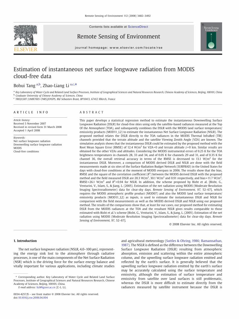
MODIS is a scanning spectroradiometer with 36 spectral channelsbetween 0.405 and 14.385 μm (King et al., 1992) where the TIRchannels 28–36 are capable of observing the earth's atmosphere andsurface. Table 1 lists the MODIS TIR channels. Channel 28 is a watervapor absorption channel and also provides information about theatmospheric temperature if there is enough moisture in the atmo-sphere. Channels 33–36 are CO2 absorption channels providing at-mospheric temperature information, and the window channels 29, 31,and 32 also provide some moisture information due to weak watervapor absorption (Seemann et al., 2003). Fig. 1 shows the weightingfunctions of theMODIS TIR channels 27–36 for amid-latitude summeratmosphere with horizontal visibility of 23 km. As shown in Fig. 1,each MODIS TIR channel has a different weighting function, whichimplies that the MODIS thermal infrared channels can detect theinformation at different altitudes in a vertical atmospheric column.The satellite-based radiance for channel 28 is mainly from the
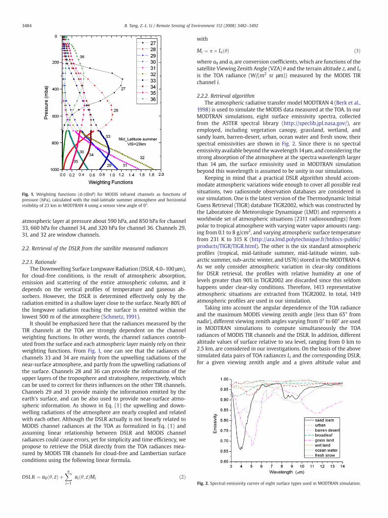
Fig. 1. Weighting functions (ds/dlnP) for MODIS infrared channels as functions ofpressure (hPa), calculated with the mid-latitude summer atmosphere and horizontalvisibility of 23 km in MODTRAN 4 using a sensor view angle of 0°.
Fig. 2. Spectral emissivity curves of eight surface types used in MODTRAN simulation.
3484 B. Tang, Z.-L. Li / Remote Sensing of Environment 112 (2008) 3482–3492
atmospheric layer at pressure about 590 hPa, and 850 hPa for channel33, 660 hPa for channel 34, and 320 hPa for channel 36. Channels 29,31, and 32 are window channels.
2.2. Retrieval of the DSLR from the satellite measured radiances
2.2.1. RationaleThe Downwelling Surface Longwave Radiation (DSLR, 4.0–100 μm),
for cloud-free conditions, is the result of atmospheric absorption,emission and scattering of the entire atmospheric column, and itdepends on the vertical profiles of temperature and gaseous ab-sorbers. However, the DSLR is determined effectively only by theradiation emitted in a shallow layer close to the surface. Nearly 80% ofthe longwave radiation reaching the surface is emitted within thelowest 500 m of the atmosphere (Schmetz, 1991).
It should be emphasized here that the radiances measured by theTIR channels at the TOA are strongly dependent on the channelweighting functions. In other words, the channel radiances contrib-uted from the surface and each atmospheric layer mainly rely on theirweighting functions. From Fig. 1, one can see that the radiances ofchannels 33 and 34 are mainly from the upwelling radiations of thenear-surface atmosphere, and partly from the upwelling radiations ofthe surface. Channels 28 and 36 can provide the information of theupper layers of the troposphere and stratosphere, respectively, whichcan be used to correct for theirs influences on the other TIR channels.Channels 29 and 31 provide mainly the information emitted by theearth's surface, and can be also used to provide near-surface atmo-spheric information. As shown in Eq. (1) the upwelling and down-welling radiations of the atmosphere are nearly coupled and relatedwith each other. Although the DSLR actually is not linearly related toMODIS channel radiances at the TOA as formulized in Eq. (1) andassuming linear relationship between DSLR and MODIS channelradiances could cause errors, yet for simplicity and time efficiency, wepropose to retrieve the DSLR directly from the TOA radiances mea-sured by MODIS TIR channels for cloud-free and Lambertian surfaceconditions using the following linear formula.
DSLR ¼ a0 h; zð Þ þXni¼1
ai h; zð ÞMi ð2Þ
with
Mi ¼ p� Li hð Þ ð3Þwhere a0 and ai are conversion coefficients, which are functions of thesatellite Viewing Zenith Angle (VZA) θ and the terrain altitude z, and Liis the TOA radiance (W/(m2 sr μm)) measured by the MODIS TIRchannel i.
2.2.2. Retrieval algorithmThe atmospheric radiative transfer model MODTRAN 4 (Berk et al.,
1998) is used to simulate the MODIS data measured at the TOA. In ourMODTRAN simulations, eight surface emissivity spectra, collectedfrom the ASTER spectral library (http://speclib.jpl.nasa.gov/), areemployed, including vegetation canopy, grassland, wetland, andsandy loam, barren-desert, urban, ocean water and fresh snow, theirspectral emissivities are shown in Fig. 2. Since there is no spectralemissivity available beyond thewavelength 14 μm, and considering thestrong absorption of the atmosphere at the spectra wavelength largerthan 14 μm, the surface emissivity used in MODTRAN simulationbeyond this wavelength is assumed to be unity in our simulations.
Keeping in mind that a practical DSLR algorithm should accom-modate atmospheric variations wide enough to cover all possible realsituations, two radiosonde observation databases are considered inour simulation. One is the latest version of the Thermodynamic InitialGuess Retrieval (TIGR) database TIGR2002, which was constructed bythe Laboratoire de Meteorologie Dynamique (LMD) and represents aworldwide set of atmospheric situations (2311 radiosoundings) frompolar to tropical atmosphere with varying water vapor amounts rang-ing from 0.1 to 8 g/cm2, and varying atmospheric surface temperaturefrom 231 K to 315 K (http://ara.lmd.polytechnique.fr/htdocs-public/products/TIGR/TIGR.html). The other is the six standard atmosphericprofiles (tropical, mid-latitude summer, mid-latitude winter, sub-arctic summer, sub-arctic winter, and US76) stored in theMODTRAN 4.As we only consider atmospheric variation in clear-sky conditionsfor DSLR retrieval, the profiles with relative humidity at one oflevels greater than 90% in TIGR2002 are discarded since this seldomhappens under clear-sky conditions. Therefore, 1413 representativeatmospheric situations are extracted from TIGR2002. In total, 1419atmospheric profiles are used in our simulation.
Taking into account the angular dependence of the TOA radianceand the maximum MODIS viewing zenith angle (less than 65° fromnadir), different viewing zenith angles varying from 0° to 60° are usedin MODTRAN simulations to compute simultaneously the TOAradiances of MODIS TIR channels and the DSLR. In addition, differentaltitude values of surface relative to sea level, ranging from 0 km to2.5 km, are considered in our investigations. On the basis of the abovesimulated data pairs of TOA radiances Li and the corresponding DSLR,for a given viewing zenith angle and a given altitude value and
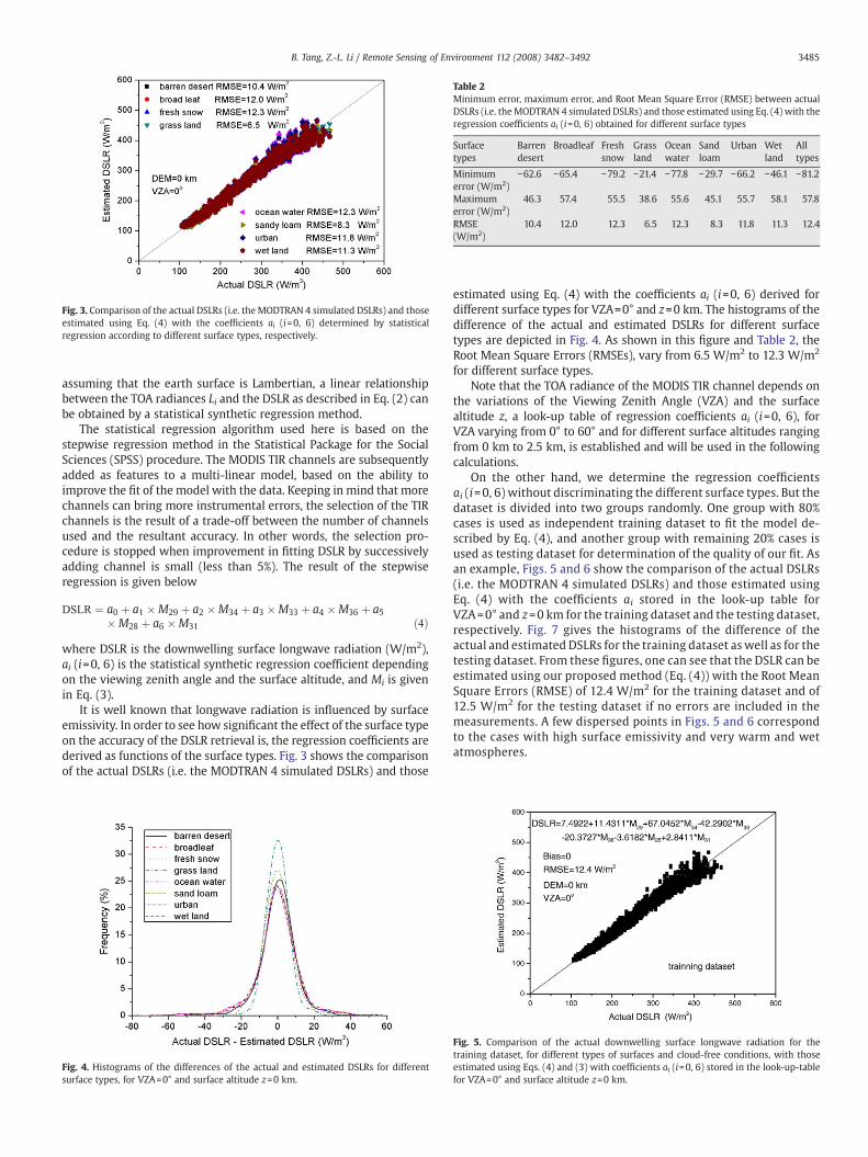
Table 2Minimum error, maximum error, and Root Mean Square Error (RMSE) between actualDSLRs (i.e. theMODTRAN 4 simulated DSLRs) and those estimated using Eq. (4) with theregression coefficients ai (i=0, 6) obtained for different surface types
Surfacetypes
Barrendesert
Broadleaf Freshsnow
Grassland
Oceanwater
Sandloam
Urban Wetland
Alltypes
Minimumerror (W/m2)
−62.6 −65.4 −79.2 −21.4 −77.8 −29.7 −66.2 −46.1 −81.2
Maximumerror (W/m2)
46.3 57.4 55.5 38.6 55.6 45.1 55.7 58.1 57.8
RMSE(W/m2)
10.4 12.0 12.3 6.5 12.3 8.3 11.8 11.3 12.4
Fig. 3. Comparison of the actual DSLRs (i.e. the MODTRAN 4 simulated DSLRs) and thoseestimated using Eq. (4) with the coefficients ai (i=0, 6) determined by statisticalregression according to different surface types, respectively.
3485B. Tang, Z.-L. Li / Remote Sensing of Environment 112 (2008) 3482–3492
assuming that the earth surface is Lambertian, a linear relationshipbetween the TOA radiances Li and the DSLR as described in Eq. (2) canbe obtained by a statistical synthetic regression method.
The statistical regression algorithm used here is based on thestepwise regression method in the Statistical Package for the SocialSciences (SPSS) procedure. The MODIS TIR channels are subsequentlyadded as features to a multi-linear model, based on the ability toimprove the fit of the model with the data. Keeping in mind that morechannels can bring more instrumental errors, the selection of the TIRchannels is the result of a trade-off between the number of channelsused and the resultant accuracy. In other words, the selection pro-cedure is stopped when improvement in fitting DSLR by successivelyadding channel is small (less than 5%). The result of the stepwiseregression is given below
DSLR ¼ a0 þ a1 �M29 þ a2 �M34 þ a3 �M33 þ a4 �M36 þ a5�M28 þ a6 �M31 ð4Þ
where DSLR is the downwelling surface longwave radiation (W/m2),ai (i=0, 6) is the statistical synthetic regression coefficient dependingon the viewing zenith angle and the surface altitude, and Mi is givenin Eq. (3).
It is well known that longwave radiation is influenced by surfaceemissivity. In order to see how significant the effect of the surface typeon the accuracy of the DSLR retrieval is, the regression coefficients arederived as functions of the surface types. Fig. 3 shows the comparisonof the actual DSLRs (i.e. the MODTRAN 4 simulated DSLRs) and those
Fig. 4. Histograms of the differences of the actual and estimated DSLRs for differentsurface types, for VZA=0° and surface altitude z=0 km.
estimated using Eq. (4) with the coefficients ai (i=0, 6) derived fordifferent surface types for VZA=0° and z=0 km. The histograms of thedifference of the actual and estimated DSLRs for different surfacetypes are depicted in Fig. 4. As shown in this figure and Table 2, theRoot Mean Square Errors (RMSEs), vary from 6.5 W/m2 to 12.3 W/m2
for different surface types.Note that the TOA radiance of the MODIS TIR channel depends on
the variations of the Viewing Zenith Angle (VZA) and the surfacealtitude z, a look-up table of regression coefficients ai (i=0, 6), forVZA varying from 0° to 60° and for different surface altitudes rangingfrom 0 km to 2.5 km, is established and will be used in the followingcalculations.
On the other hand, we determine the regression coefficientsai (i=0, 6) without discriminating the different surface types. But thedataset is divided into two groups randomly. One group with 80%cases is used as independent training dataset to fit the model de-scribed by Eq. (4), and another group with remaining 20% cases isused as testing dataset for determination of the quality of our fit. Asan example, Figs. 5 and 6 show the comparison of the actual DSLRs(i.e. the MODTRAN 4 simulated DSLRs) and those estimated usingEq. (4) with the coefficients ai stored in the look-up table forVZA=0° and z=0 km for the training dataset and the testing dataset,respectively. Fig. 7 gives the histograms of the difference of theactual and estimated DSLRs for the training dataset as well as for thetesting dataset. From these figures, one can see that the DSLR can beestimated using our proposed method (Eq. (4)) with the Root MeanSquare Errors (RMSE) of 12.4 W/m2 for the training dataset and of12.5 W/m2 for the testing dataset if no errors are included in themeasurements. A few dispersed points in Figs. 5 and 6 correspondto the cases with high surface emissivity and very warm and wetatmospheres.
Fig. 5. Comparison of the actual downwelling surface longwave radiation for thetraining dataset, for different types of surfaces and cloud-free conditions, with thoseestimated using Eqs. (4) and (3) with coefficients ai (i=0, 6) stored in the look-up-tablefor VZA=0° and surface altitude z=0 km.
Fig. 8. RMSE between the actual and estimated DSLRs, versus the surface altitude z fordifferent VZAs (VZA=0°, 44.42° and 60°).
Fig. 6. Comparison of the actual downwelling surface longwave radiation for the testingdataset, for different types of surfaces and cloud-free conditions, with those estimatedusing Eqs. (4) and (3) with coefficients ai (i=0, 6) stored in the look-up-table for VZA=0°and surface altitude z=0 km.
3486 B. Tang, Z.-L. Li / Remote Sensing of Environment 112 (2008) 3482–3492
In order to demonstrate how the proposed method (Eq. (4)) workswell with other conditions (other VZAs and altitude z), Fig. 8 displaysthe RMSE versus the surface altitude z for different VZAs (VZA=0°,44.42° and 60°). From this figure, one can see that
1) the RMSE increases with the increase of the VZA;2) the RMSE increases with the increase of the surface altitude z if the
surface altitude is below about 1 km and the opposite is found forthe surface altitude above 1 km, which may be caused by theturning points around 1 km found in most of the atmospherictemperature profiles in the TIGR2002 and the MODTRAN standardatmospheres;
3) the maximum (16.8 W/m2) and the minimum (11.2 W/m2) of theRMSE are found respectively at VZA=60°, z=1.0 km and VZA=0°,z=2.5 km.
It should be pointed out here that due to the coarser spatialresolution of MODIS sensors and other factors, accurate classifica-tion of surface types is still problematic, and considering the factthat the DSLR could be retrieved with RMSE about 12 W/m2
for VZA=0° and z=0 km without discriminating the surface types,and the improvement in the accuracy of DSLR retrieval is notsignificant if the surface types are taken into account in the re-trieval (see Table 2 and Figs. 3 and 4), the coefficients in Eq. (4)corresponding to all the surface types will be used in the followingcalculations.
Fig. 7. Histograms of the differences of the actual and estimated DSLRs for the trainingdataset and testing dataset, respectively, for VZA=0° and surface altitude z=0 km.
2.3. Retrieval of NSLR
The Net Surface Longwave Radiation (NSLR) is defined as the dif-ference between the DSLR and the upwelling surface longwave ra-diation emitted and reflected by the earth's surface, i.e.
NSLR ¼ DSLR� resT4s � 1� esð ÞDSLR ð5Þ
where σ is the Stefan–Boltzmann constant (5.67×10⁻⁸ W m−2 K−4), εsis surface emissivity, and Ts is surface skin temperature (Kelvin). Thethird term on the right-hand side of Eq. (5) accounts for the reflectedradiation by the surface.
From the MODTRAN simulations in Section 2.2.2, we can alsoobtain the data pairs of TOA radiances and the corresponding NSLR fora given viewing zenith angle and a given altitude value in cloud-freeconditions. With the same rationale given in Section 2.2.1, we initiallytry to estimate the NSLR also directly from the radiances measured atthe TOA by the MODIS TIR channels. But unfortunately we have notobtained a good regression model. Consequently, we turn to useEq. (5) to estimate the NSLR with the DSLR retrieved using our pro-posed algorithm developed in Section 2.2.2 and Ts, εs extracted fromthe MODIS land surface temperature/emissivity products.
3. Sensitivity analysis
Note that the accuracy of the DSLR retrieval depends also on theinstrument calibration, navigation, and co-registration in the infraredchannels. Several sources of errors must be taken into account. TheMODIS instrument detector noise and calibration error can have animpact on the retrieval accuracy. Detector-to-detector differences inthe spectral response functions within a channel have been shown toproduce 0.5%–1.0% difference in radiance measurements in the TIRchannel (Seemann et al., 2003). This is seen as detector striping withina scene.
Note that the DSLR is not actually linear to MODIS channel radi-ances at the TOA as formulized in Eq. (1). The proposed method ofretrieval DSLR using Eq. (4) is just for simplicity and time efficiency.Consequently, we calculate the retrieval error transferred by ourproposed model. Calculating the partial derivative of Eq. (4) leads to
dDSLR ¼ffiffiffiffiffiffiffiffiffiffiffiffiffiffiffiffiffiffiffiffiffiffiffiXni¼1
a2i dM2i
vuut ð6Þ
Considering the MODIS instrument error of 0.25 K for the TOAbrightness temperatures in channels 28, 33 and 34, and of 0.05 K forchannels 29 and 31, and of 0.35 K for channel 36 (see the last columnin Table 1), the corresponding radiation error δM at the TOA forchannels 28, 33 and 34 are 0.05, 0.06, 0.05, and for channels 29 and 31
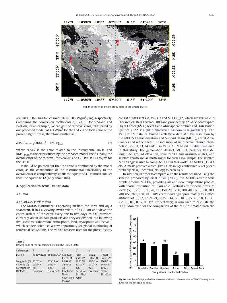
Fig. 9. Location of the six study sites in the United States.
3487B. Tang, Z.-L. Li / Remote Sensing of Environment 112 (2008) 3482–3492
are 0.03, 0.02, and for channel 36 is 0.05 W/(m2 μm), respectively.Combining the conversion coefficients ai (i=1, 6) for VZA=0° andz=0 km, for an example, we can get the retrieval error, transferred byour proposed model, of 4.3 W/m2 for the DSLR. The total error of thepresent algorithm is, therefore, written as
dDSLRtot ¼ffiffiffiffiffiffiffiffiffiffiffiffiffiffiffiffiffiffiffiffiffiffiffiffiffiffiffiffiffiffiffiffiffiffiffiffiffiffiffiffiffiffiffiffidDSLR2 þ RMSE2
DSLR
qð7Þ
where δDSLR is the error related to the instrumental noise, andRMSEDSLR is the error caused by the proposed model itself. Finally, theoverall error of the retrieval, for VZA=0° and z=0 km, is 13.1 W/m2 forthe DSLR.
It should be pointed out that the error is dominated by the modelerror, as the contribution of the instrumental uncertainty to theoverall error is comparatively small: the square of 4.3 is much smallerthan the square of 12 (only about 10%).
4. Application to actual MODIS data
4.1. Data
4.1.1. MODIS satellite dataThe MODIS instrument is operating on both the Terra and Aqua
spacecraft. It has a viewing swath width of 2330 km and views theentire surface of the earth every one to two days. MODIS provides,currently, about 44 data products and they are divided into followingfive sections—calibration, atmosphere, land, cryosphere and ocean—which renders scientists a new opportunity for global monitoring ofterrestrial ecosystems. The MODIS datasets used for the present study
Table 3Descriptions of the six selected sites in the United States
References A B C D E F
Station Bondville, IL Boulder, CO GoodwinCreek, MS
PennState, PA
SiouxFalls, SD
DesertRock, NV
Longitude (°) 88.37 W 105.24 W 89.87 W 77.93 W 96.62 W 116.02 WLatitude (°) 40.06 N 40.13 N 34.25 N 40.72 N 43.73 N 36.63 NElevation (m) 213 1689 98 376 473 1007IGBP class CropLand GrassLand CropLand/
NaturalVegetationMosaic
DeciduousBroadleafForest
CropLand OpenShrubland
consist of MOD021KM, MOD03 and MOD35_L2, which are available inHierarchical Data Format (HDF) and provided by NASA Goddard SpaceFlight Center (GSFC) Level 1 and Atmosphere Archive and DistributionSystem (LAADS) (http://ladsweb.nascom.nasa.gov/data/). TheMOD021KM data, calibrated Earth View data at 1 km resolution bythe MODIS Characterization and Support Team (MCST), are TOA ra-diances and reflectances. The radiances of six thermal infrared chan-nels 28, 29, 31, 33, 34 and 36 in MOD021KM listed in Table 1 are usedin this study. The geolocation dataset, MOD03, provides latitude,longitude, ground elevation, solar zenith and azimuth angles, andsatellite zenith and azimuth angles for each 1 km sample. The satellitezenith angle is used to compute DSLR in this work. The MOD35_L2 is acloud mask product which gives a clear-sky confidence level (clear,probably clear, uncertain, cloudy) to each IFOV.
In addition, in order to comparewith the results obtained using thescheme proposed by Bisht et al. (2005), the MODIS atmosphericprofile product MOD07, providing air and dew temperature profileswith spatial resolution of 5 km at 20 vertical atmospheric pressurelevels (5, 10, 20, 30, 50, 70, 100, 150, 200, 250, 300, 400, 500, 620, 700,780, 850, 920, 950, 1000 hPa corresponding approximately to surfacealtitudes of 36, 32, 27, 24, 21, 19, 15.8, 14, 12.1, 10.8, 9.5, 7.5, 5.8, 3.9, 3.1,2.2, 1.5, 0.8, 0.55, 0.1 km, respectively), is also used to calculate theDSLR. Moreover, for the comparison of the NSLR estimated with the
Fig. 10.Number of days with cloud-free conditions at the moment of MODIS overpass in2006 for the six studied sites.

3488 B. Tang, Z.-L. Li / Remote Sensing of Environment 112 (2008) 3482–3492
method (Eq. (5)), the MODIS Land Surface Temperature (LST) andemissivity data,MOD11_L2, providing LST retrieved by the generalizedsplit-window algorithm (Wan and Dozier, 1996) and emissivities inbands 31 and 32 estimated by the classification-based emissivitymethod (Snyder andWan,1998), at 1 km spatial resolution, are used toestimate the upwelling surface longwave radiation in our study.
4.1.2. The Surface Radiation Budget Network (SURFRAD) dataThe Surface Radiation Budget Network (SURFRAD) was established
in 1993 through the support of NOAA's Office of Global Programs.Its primary mission is to support climate research with accurate,continuous, long-term measurements of the surface radiation budgetover the United States. The primary measurements of SURFRAD areupwelling and downwelling solar and infrared radiations, direct anddiffuse solar radiations, photosynthetically active radiation, ultravioletradiation (UV-B, 290 nm–320 nm), and meteorological parameters.SURFRAD data are available in daily files of three-minute data (http://
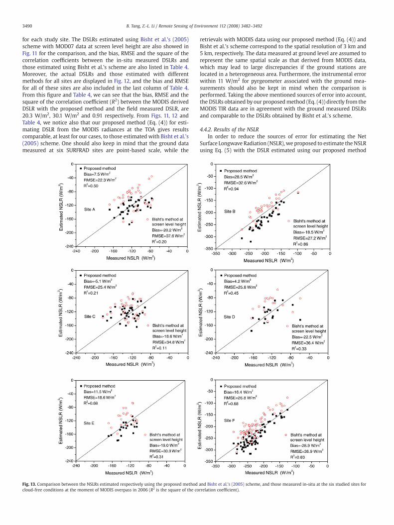
Fig. 11. Comparison between the DSLRs estimated respectively using the proposed methodcloud-free conditions at the moment of MODIS overpass in 2006 (R2 is the square of the co
www.srrb.noaa.gov/surfrad/surfpage0.html). The outgoing andincoming longwave radiations are measured with the PrecisionInfrared Radiometer (PIR) that is sensitive to the spectra range from3.0 to 50 μm and has the instrumental error within 11 W/m2 (http://www.srrb.noaa.gov/surfrad/surfpage4.html). The downwelling ther-mal infrared radiation and net infrared radiation are used to pre-liminarily validate the retrievals of the DSLR and the NSLR fromMODIS TIR data using our proposed methods (Eqs. (4) and (5)).
4.2. Study regions of the United States
The SURFRAD sites include Bondille, Illinois; Boulder, Colorado;Desert Rock, Nevada; Fort Peck, Montana; Goodwin Creek, Missis-sippi; Penn State, Pennsylvania; and Sioux Falls, South Dakota (http://www.srrb.noaa.gov/surfrad/sitepage.html). The radiation data pro-vided by Bondille, Boulder, Desert Rock, Goodwin Creek, Penn State,and Sioux Falls, whose locations are illustrated in Fig. 9, are used in the
and Bisht et al.'s (2005) scheme, and those measured in-situ at the six studied sites forrrelation coefficient).
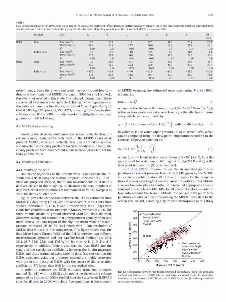
Fig. 12. Comparison between the DSLRs estimated respectively using the proposedmethod and Bisht et al.'s (2005) scheme, and those measured in-situ for cloud-freeconditions at the moment of MODIS overpass in 2006 for all sites (R2 is the square of thecorrelation coefficient).
Table 4Bias, Root Mean Square Error (RMSE) and the square of the correlation coefficient (R2) for DSLR and NSLR respectively, between the in-situ measurements and those estimated usingsatellite data with different methods at the six sites for the days with cloud-free conditions at the moment of MODIS overpass in 2006
Method Sites A B C D E F Allsites
DSLR Ours Bias (W/m2) 7.0 36.3 11.1 27.5 17.8 23.4 20.3RMSE (W/m2) 29.4 39.3 25.7 36.6 23.6 27.6 30.1R2 0.90 0.93 0.96 0.90 0.97 0.94 0.91
Bisht et al.'s Bias (W/m2) −4.4 −19.1 13.9 14.5 −1.5 −21.2 −2.3RMSE (W/m2) 35.5 24.7 34.6 33.8 18.9 24.8 30.6R2 0.94 0.92 0.96 0.90 0.95 0.96 0.84
NSLR Ours Bias (W/m2) 7.5 28.5 −5.1 4.2 11.5 16.4 11.7RMSE (W/m2) 22.3 32.6 25.4 25.8 18.6 26.8 26.1R2 0.50 0.94 0.21 0.45 0.68 0.88 0.94
Bisht et al.'s Bias (W/m2) −20.2 −18.5 −18.6 −22.5 −19.0 −28.9 −20.6RMSE (W/m2) 37.6 27.2 34.8 36.4 30.9 36.9 36.5R2 0.20 0.86 0.11 0.33 0.31 0.83 0.87
3489B. Tang, Z.-L. Li / Remote Sensing of Environment 112 (2008) 3482–3492
present study. Since there were not many days with cloud-free con-ditions at the moment of MODIS overpass in 2006 for site Fort Peck,this site is not selected in this study. The detailed information of thesesix selected locations is given in Table 3. The land cover types given inthis table are based on the MODIS/Terra Land Cover Types Yearly L3Global 0.05Deg CMG product, MOD12C1, providing IGBP classificationschemes at a 0.05° (~5600 m) spatial resolution (http://edcdaac.usgs.gov/modis/mod12c1v4.asp).
4.3. MODIS data processing
Based on the clear-sky confidence level (clear, probably clear, un-certain, cloudy) assigned to each pixel in the MODIS cloud maskproduct, MOD35, clear and probably clear pixels are taken as clear,and uncertain and cloudy pixels are taken as cloudy in our study. Thecloudy pixels are then screened out in our retrieval procedures of theDSLR and the NSLR.
4.4. Results and validations
4.4.1. Results of the DSLROne of the objectives of the present work is to estimate the in-
stantaneous DSLR using the method proposed in Section 2.2. To val-idate our proposed method, the in-situ measurements of SURFRADdata are chosen in this study. Fig. 10 illustrates the total numbers ofdays with cloud-free conditions at the moment of MODIS overpass in2006 for the six studied sites.
Fig. 11 gives the comparison between the DSLRs estimated fromMODIS TIR data using Eq. (4) and the observed SURFRAD data fromstudied locations A, B, C, D, E and F respectively, for all days withcloud-free conditions at the moment of MODIS overpass in 2006. Thethree-minute means of ground observed SURFRAD data are used.Moreover, taking into account that a pyrgeometer actually often seesmore than a 1×1 km region of the sky, the mean value of instan-taneous estimated DSLRs for 3×3 pixels with 1 km resolution ofMODIS data is used in this comparison. This figure shows that theRoot Mean Square Errors (RMSE) of the DSLRs between two differentmeasurements (ground and our satellite-based method) are 29.4,39.3, 25.7, 36.6, 23.6, and 27.6 W/m2 for sites A, B, C, D, E and F,respectively. In addition, Table 4 also lists the bias, RMSE and thesquare of the correlation coefficients between the in-situ measuredDSLRs and those estimated using satellite data. One can see that theDSLRs estimated using our proposed method are highly correlatedwith the in-situ measured DSLRs with the square of the correlationcoefficients (R2) larger than 0.90 for the six studied sites.
In order to compare the DSLR estimated using our proposedmethod (Eq. (4)) with the DSLR estimated using the existing schemeproposed by Bisht et al. (2005), the DSLRs of the six selected SURFRADsites for all days in 2006 with cloud-free conditions at the moment
of MODIS overpass, are estimated once again using Prata's (1996)scheme. i.e.
DSLR ¼ reaT4a ð8Þ
where σ is the Stefan–Boltzmann constant (5.67×10⁻⁸ W m−2 K−4), Tais the air temperature (K) at screen level, εa is the effective air emis-sivity which can be estimated by
ea ¼ 1� 1þ nð Þexp � 1:2þ 3:0nð Þ1=2n oh i
; with n ¼ 46:5 e0=Tað Þ ð9Þ
in which e0 is the water vapor pressure (hPa) at screen level, whichcan be computed using the dew point temperature according to theClausius–Clapeyron equation as:
e0 ¼ 6:11expLvRv
1T0
� 1Td
� �� �ð10Þ
where Lv is the latent heat of vaporization (2.5×10⁶ J kg−1), Rv is thegas constant for water vapor (461 J kg−1 K−1), T0=273 K and Td is thedew point temperature (K) at screen level.
Bisht et al. (2005) proposed to use the air and dew point tem-peratures at vertical pressure level of 1000 hPa given by the MODISatmospheric profile product MOD07 as surrogates for the tempera-tures at screen level height. However, since the earth's terrain altitudechanges from one place to another, it may be not appropriate to use aconstant pressure level (1000 hPa) for all pixels. Therefore, in order totake into account the terrain altitude, the air and dew point tem-peratures are obtained by interpolating the MOD07 level data to thescreen level height, assuming a hydrostatic atmosphere in this study
3490 B. Tang, Z.-L. Li / Remote Sensing of Environment 112 (2008) 3482–3492
for each study site. The DSLRs estimated using Bisht et al.'s (2005)scheme with MOD07 data at screen level height are also showed inFig. 11 for the comparison, and the bias, RMSE and the square of thecorrelation coefficients between the in-situ measured DSLRs andthose estimated using Bisht et al.'s scheme are also listed in Table 4.Moreover, the actual DSLRs and those estimated with differentmethods for all sites are displayed in Fig. 12, and the bias and RMSEfor all of these sites are also included in the last column of Table 4.From this figure and Table 4, we can see that the bias, RMSE and thesquare of the correlation coefficient (R2) between the MODIS derivedDSLR with the proposed method and the field measured DSLR, are20.3 W/m2, 30.1 W/m2 and 0.91 respectively. From Figs. 11, 12 andTable 4, we notice also that our proposed method (Eq. (4)) for esti-mating DSLR from the MODIS radiances at the TOA gives resultscomparable, at least for our cases, to those estimated with Bisht et al.'s(2005) scheme. One should also keep in mind that the ground datameasured at six SURFRAD sites are point-based scale, while the
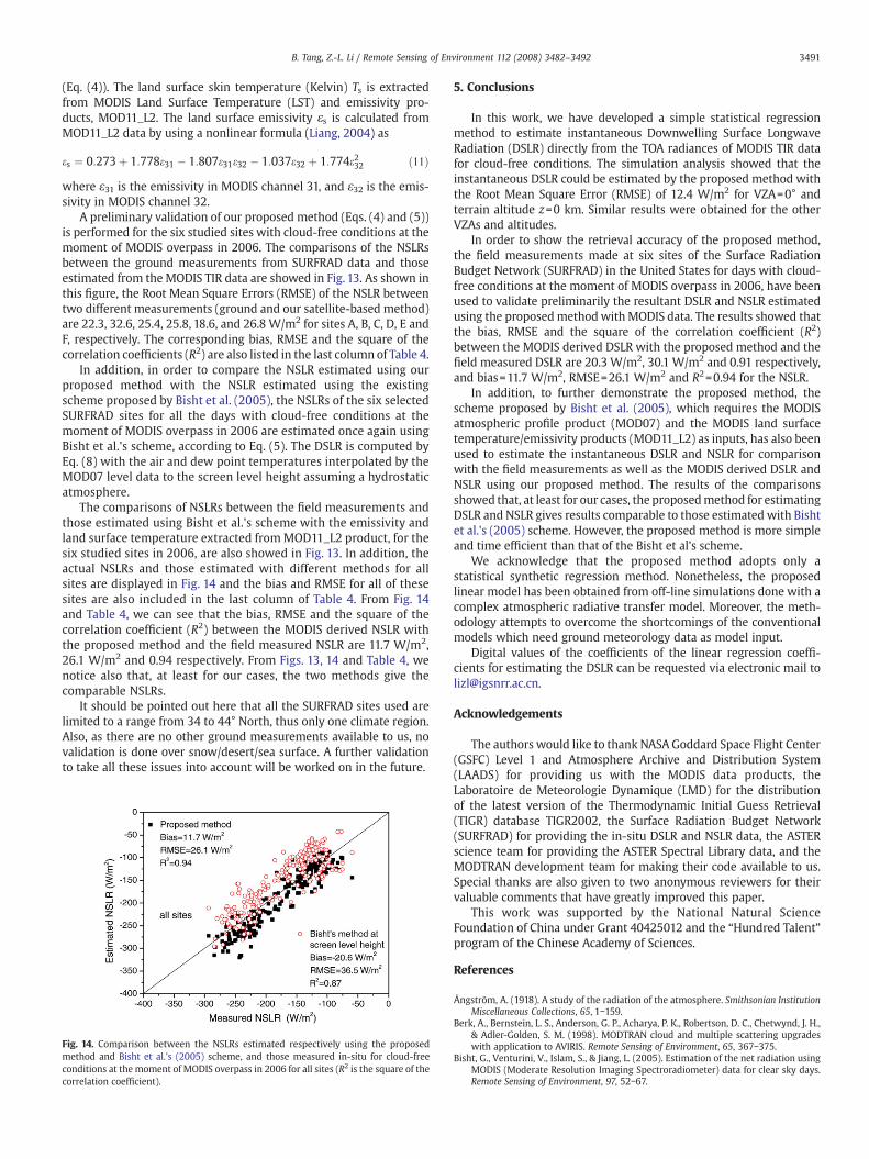
Fig. 13. Comparison between the NSLRs estimated respectively using the proposed methodcloud-free conditions at the moment of MODIS overpass in 2006 (R2 is the square of the co
retrievals with MODIS data using our proposed method (Eq. (4)) andBisht et al.'s scheme correspond to the spatial resolution of 3 km and5 km, respectively. The data measured at ground level are assumed torepresent the same spatial scale as that derived from MODIS data,which may lead to large discrepancies if the ground stations arelocated in a heterogeneous area. Furthermore, the instrumental errorwithin 11 W/m2 for pyrgeometer associated with the ground mea-surements should also be kept in mind when the comparison isperformed. Taking the above mentioned sources of error into account,the DSLRs obtained by our proposedmethod (Eq. (4)) directly from theMODIS TIR data are in agreement with the ground measured DSLRsand comparable to the DSLRs obtained by Bisht et al.'s scheme.
4.4.2. Results of the NSLRIn order to reduce the sources of error for estimating the Net
Surface Longwave Radiation (NSLR), we proposed to estimate the NSLRusing Eq. (5) with the DSLR estimated using our proposed method
and Bisht et al.'s (2005) scheme, and those measured in-situ at the six studied sites forrrelation coefficient).
3491B. Tang, Z.-L. Li / Remote Sensing of Environment 112 (2008) 3482–3492
(Eq. (4)). The land surface skin temperature (Kelvin) Ts is extractedfrom MODIS Land Surface Temperature (LST) and emissivity pro-ducts, MOD11_L2. The land surface emissivity εs is calculated fromMOD11_L2 data by using a nonlinear formula (Liang, 2004) as
es ¼ 0:273þ 1:778e31 � 1:807e31e32 � 1:037e32 þ 1:774e232 ð11Þwhere ε31 is the emissivity in MODIS channel 31, and ε32 is the emis-sivity in MODIS channel 32.
A preliminary validation of our proposed method (Eqs. (4) and (5))is performed for the six studied sites with cloud-free conditions at themoment of MODIS overpass in 2006. The comparisons of the NSLRsbetween the ground measurements from SURFRAD data and thoseestimated from the MODIS TIR data are showed in Fig. 13. As shown inthis figure, the Root Mean Square Errors (RMSE) of the NSLR betweentwo different measurements (ground and our satellite-based method)are 22.3, 32.6, 25.4, 25.8, 18.6, and 26.8 W/m2 for sites A, B, C, D, E andF, respectively. The corresponding bias, RMSE and the square of thecorrelation coefficients (R2) are also listed in the last column of Table 4.
In addition, in order to compare the NSLR estimated using ourproposed method with the NSLR estimated using the existingscheme proposed by Bisht et al. (2005), the NSLRs of the six selectedSURFRAD sites for all the days with cloud-free conditions at themoment of MODIS overpass in 2006 are estimated once again usingBisht et al.'s scheme, according to Eq. (5). The DSLR is computed byEq. (8) with the air and dew point temperatures interpolated by theMOD07 level data to the screen level height assuming a hydrostaticatmosphere.
The comparisons of NSLRs between the field measurements andthose estimated using Bisht et al.'s scheme with the emissivity andland surface temperature extracted fromMOD11_L2 product, for thesix studied sites in 2006, are also showed in Fig. 13. In addition, theactual NSLRs and those estimated with different methods for allsites are displayed in Fig. 14 and the bias and RMSE for all of thesesites are also included in the last column of Table 4. From Fig. 14and Table 4, we can see that the bias, RMSE and the square of thecorrelation coefficient (R2) between the MODIS derived NSLR withthe proposed method and the field measured NSLR are 11.7 W/m2,26.1 W/m2 and 0.94 respectively. From Figs. 13, 14 and Table 4, wenotice also that, at least for our cases, the two methods give thecomparable NSLRs.
It should be pointed out here that all the SURFRAD sites used arelimited to a range from 34 to 44° North, thus only one climate region.Also, as there are no other ground measurements available to us, novalidation is done over snow/desert/sea surface. A further validationto take all these issues into account will be worked on in the future.
Fig. 14. Comparison between the NSLRs estimated respectively using the proposedmethod and Bisht et al.'s (2005) scheme, and those measured in-situ for cloud-freeconditions at the moment of MODIS overpass in 2006 for all sites (R2 is the square of thecorrelation coefficient).
5. Conclusions
In this work, we have developed a simple statistical regressionmethod to estimate instantaneous Downwelling Surface LongwaveRadiation (DSLR) directly from the TOA radiances of MODIS TIR datafor cloud-free conditions. The simulation analysis showed that theinstantaneous DSLR could be estimated by the proposed method withthe Root Mean Square Error (RMSE) of 12.4 W/m2 for VZA=0° andterrain altitude z=0 km. Similar results were obtained for the otherVZAs and altitudes.
In order to show the retrieval accuracy of the proposed method,the field measurements made at six sites of the Surface RadiationBudget Network (SURFRAD) in the United States for days with cloud-free conditions at the moment of MODIS overpass in 2006, have beenused to validate preliminarily the resultant DSLR and NSLR estimatedusing the proposedmethodwithMODIS data. The results showed thatthe bias, RMSE and the square of the correlation coefficient (R2)between the MODIS derived DSLR with the proposed method and thefield measured DSLR are 20.3 W/m2, 30.1 W/m2 and 0.91 respectively,and bias=11.7 W/m2, RMSE=26.1 W/m2 and R2=0.94 for the NSLR.
In addition, to further demonstrate the proposed method, thescheme proposed by Bisht et al. (2005), which requires the MODISatmospheric profile product (MOD07) and the MODIS land surfacetemperature/emissivity products (MOD11_L2) as inputs, has also beenused to estimate the instantaneous DSLR and NSLR for comparisonwith the field measurements as well as the MODIS derived DSLR andNSLR using our proposed method. The results of the comparisonsshowed that, at least for our cases, the proposedmethod for estimatingDSLR and NSLR gives results comparable to those estimated with Bishtet al.'s (2005) scheme. However, the proposed method is more simpleand time efficient than that of the Bisht et al's scheme.
We acknowledge that the proposed method adopts only astatistical synthetic regression method. Nonetheless, the proposedlinear model has been obtained from off-line simulations done with acomplex atmospheric radiative transfer model. Moreover, the meth-odology attempts to overcome the shortcomings of the conventionalmodels which need ground meteorology data as model input.
Digital values of the coefficients of the linear regression coeffi-cients for estimating the DSLR can be requested via electronic mail [email protected].
Acknowledgements
The authors would like to thank NASA Goddard Space Flight Center(GSFC) Level 1 and Atmosphere Archive and Distribution System(LAADS) for providing us with the MODIS data products, theLaboratoire de Meteorologie Dynamique (LMD) for the distributionof the latest version of the Thermodynamic Initial Guess Retrieval(TIGR) database TIGR2002, the Surface Radiation Budget Network(SURFRAD) for providing the in-situ DSLR and NSLR data, the ASTERscience team for providing the ASTER Spectral Library data, and theMODTRAN development team for making their code available to us.Special thanks are also given to two anonymous reviewers for theirvaluable comments that have greatly improved this paper.
This work was supported by the National Natural ScienceFoundation of China under Grant 40425012 and the “Hundred Talent”program of the Chinese Academy of Sciences.
References
Ångström, A. (1918). A study of the radiation of the atmosphere. Smithsonian InstitutionMiscellaneous Collections, 65, 1−159.
Berk, A., Bernstein, L. S., Anderson, G. P., Acharya, P. K., Robertson, D. C., Chetwynd, J. H.,& Adler-Golden, S. M. (1998). MODTRAN cloud and multiple scattering upgradeswith application to AVIRIS. Remote Sensing of Environment, 65, 367−375.
Bisht, G., Venturini, V., Islam, S., & Jiang, L. (2005). Estimation of the net radiation usingMODIS (Moderate Resolution Imaging Spectroradiometer) data for clear sky days.Remote Sensing of Environment, 97, 52−67.
3492 B. Tang, Z.-L. Li / Remote Sensing of Environment 112 (2008) 3482–3492
Brunt, D. (1932). Notes on radiation in the atmosphere. Quarterly Journal of the RoyalMeteorological Society, 58, 389−420.
Brutsaert, W. (1975). On a derivable formula for long-wave radiation from clear skies.Water Resources Research, 11, 742−744.
Diak, G. R., & Gautier, C. (1983). Improvements to a simple physical model for estimatinginsolation from GOES data. Journal of Climate and Applied Meteorology, 22, 505−508.
Dilley, A. C., & O’Brien, D. M. (1998). Estimating downward clear sky long-waveirradiance at the surface from screen temperature and precipitable water. QuarterlyJournal of the Royal Meteorological Society, 124, 1391−1401.
Duarte, H. F., Dias, N. L., & Maggiotto, S. R. (2006). Assessing daytime downwardlongwave radiation estimates for clear and cloudy skies in Southern Brazil. Agri-culture and Forest Meteorology, 139, 171−181.
Ellingson, R. G. (1995). Surface longwave fluxes from satellite observations: A criticalreview. Remote Sensing of Environment, 51, 89−97.
Gautier, C., Diak, G., & Masse, S. (1980). A simple physical model to estimate incidentsolar radiation at the surface from GOES satellite data. Journal of AppliedMeteorology, 19, 1005−1012.
Gratton, D. J., Howarth, P. J., & Marceau, D. J. (1993). Using Landsat-5 thematic mapperand digital elevation data to determine the net radiation field of a Mountain Glacier.Remote Sensing of Environment, 43, 315−331.
Idso, S. B. (1981). A set of equations for full spectrum and 8- to 14-mm and 10.5- to 12.5-mm thermal radiation from cloudless skies. Water Resources Research, 17, 295−304.
King, M. D., Kaufman, Y. J., Menzel, W. P., & Tanré, D. (1992). Remote sensing of cloud,aerosol, and water vapor properties from the Moderate Resolution ImagingSpectrometer (MODIS). IEEE Transactions on Geoscience and Remote Sensing, 30,2−27.
Liang, S. L. (2004). Quantitative remote sensing of land surfaces.New Jersey: JohnWiley &Sons.
Ma, Y., Su, Z., Li, Z. -L., Koike, T., & Menenti, M. (2002). Determination of regional netradiation and soil heat flux over a heterogeneous landscape of the Tibetan Plateau.Hydrological Processes, 16, 2963−2971.
Niemelä, S., Räisänen, P., & Savijärvi, H. (2001). Comparison of surface radiative fluxparameterizations: Part I. Longwave radiation. Atmospheric Research, 58, 1−18.
Nishida, K., Nemani, R. R., Running, S. W., & Glassy, J. M. (2003). An operational remotesensing algorithm of land evaporation. Journal of Geophyscial Research, 108(D9),4270.
Prata, A. J. (1996). A new long-wave formula for estimating downward clear-skyradiations at the surface. Quarterly Journal of the Royal Meteorological Society, 122,1127−1151.
Ramannathan, V. (1987). The role of Earth radiation budget studies in climate andgeneral circulation research. Journal of Geophyscial Research, 92, 4075−4095.
Schmetz, J. (1991). Retrieval of surface radiation fluxes from satellite data. Dynamics ofAtmospheres and Oceans, 16, 61−72.
Seemann, S. W., Li, J., Menzel, W. P., & Gumley, L. E. (2003). Operational retrieval ofatmospheric temperature, moisture, and ozone from MODIS infrared radiances.Journal of Applied Meteorology, 42, 1072−1091.
Snyder, W. C., & Wan, Z. M. (1998). BRDF models to predict spectral reflectance andemissivity in the thermal infrared. IEEE Transactions on Geoscience and RemoteSensing, 36, 214−225.
Suttles, J. T., & Ohring, G. (1986). Report of the workshop on surface radiation budget forclimate application. WCP-115 (pp. 144). World Meteorological Organization.
Swinbank, W. C. (1963). Long-wave radiation from clear skies. Quarterly Journal of theRoyal Meteorological Society, 89, 339−348.
Wan, Z. M., & Dozier, J. (1996). A generalized split-window algorithm for retrievingland-surface temperature from space. IEEE Transactions on Geoscience and RemoteSensing, 34, 892−905.
Zhou, Y. P., & Cess, R. D. (2001). Algorithm development strategies for retrieving thedownwelling longwave flux at the Earth's surface. Journal of Geophysical Research,106, 12,477−12,488.
Zhou, Y. P., Kratz, D. P., Wilber, A. C., Gupta, S. K., & Cess, R. D. (2007). An improvedalgorithm for retrieving surface downwelling longwave radiation from satellitemeasurements. Journal of Geophysical Research, 112, D15102. doi:10.1029/2006JD008159