establishing a secure data center with remote … a secure data center with remote access jeffrey...
TRANSCRIPT
NREL is a national laboratory of the US Department of Energy Office of Energy Efficiency amp Renewable Energy operated by the Alliance for Sustainable Energy LLC
Contract No DE-AC36-08GO28308
Establishing a Secure Data Center with Remote Access Preprint Jeffrey Gonder and Evan Burton National Renewable Energy Laboratory
Elaine Murakami US Department of Transportation
Presented at the 2012 Federal Committee on Statistical Methodology (FCSM) Research Conference Washington DC January 10ndash12 2012
Conference Paper NRELCP-5400-54835 April 2012
NOTICE
The submitted manuscript has been offered by an employee of the Alliance for Sustainable Energy LLC (Alliance) a contractor of the US Government under Contract No DE-AC36-08GO28308 Accordingly the US Government and Alliance retain a nonexclusive royalty-free license to publish or reproduce the published form of this contribution or allow others to do so for US Government purposes
This report was prepared as an account of work sponsored by an agency of the United States government Neither the United States government nor any agency thereof nor any of their employees makes any warranty express or implied or assumes any legal liability or responsibility for the accuracy completeness or usefulness of any information apparatus product or process disclosed or represents that its use would not infringe privately owned rights Reference herein to any specific commercial product process or service by trade name trademark manufacturer or otherwise does not necessarily constitute or imply its endorsement recommendation or favoring by the United States government or any agency thereof The views and opinions of authors expressed herein do not necessarily state or reflect those of the United States government or any agency thereof
Available electronically at httpwwwostigovbridge
Available for a processing fee to US Department of Energy and its contractors in paper from
US Department of Energy Office of Scientific and Technical Information PO Box 62 Oak Ridge TN 37831-0062 phone 8655768401 fax 8655765728 email mailtoreportsadonisostigov
Available for sale to the public in paper from
US Department of Commerce National Technical Information Service 5285 Port Royal Road Springfield VA 22161 phone 8005536847 fax 7036056900 email ordersntisfedworldgov online ordering httpwwwntisgovhelpordermethodsaspx
Cover Photos (left to right) PIX 16416 PIX 17423 PIX 16560 PIX 17613 PIX 17436 PIX 17721
Printed on paper containing at least 50 wastepaper including 10 post consumer waste
1
Establishing a Secure Data Center with Remote Access
Jeffrey Gonder1 Evan Burton1 and Elaine Murakami2
1 ndash National Renewable Energy Laboratory (NREL) Center for Transportation Technologies and Systems (CTTS) 2 ndash US Department of Transportation (DOT) Federal Highway Administration (FHWA)
JeffGondernrelgov EvanBurtonnrelgov ElaineMurakamifhwadotgov
Abstract
Access to existing travel data is critical for many analysis efforts that lack the time or resources to support detailed data collection High-resolution data sets provide particular value but also present a challenge for preserving the anonymity of the original survey participants To address the dilemma of providing data access while preserving privacy the National Renewable Energy Laboratory and the US Department of Transportation have launched the Transportation Secure Data Center (TSDC) TSDC data sets include those from regional travel surveys and studies that increasingly use global positioning system devices Data provided by different collecting agencies vary with respect to formatting elements included and level of processing conducted in support of the original purpose The TSDC relies on a number of geospatial and other analysis tools to ensure data quality and to generate useful information outputs TSDC users can access the processed data in two different ways The first is by downloading summary results and second-by-second vehicle speed profiles (with latitudelongitude information removed) from a publicly accessible website The second method involves applying for a remote connection account to a controlled-access environment where spatial analysis can be conducted but raw data cannot be removed The TSDC website is httpwwwnrelgovvehiclesandfuelssecure_transportation_datahtml
Background
Travel behavior surveys have been conducted for many decades and have been a critical component for long-range transportation planning Historically these surveys used self-reported paper diaries with telephone retrieval but global positioning system (GPS) technology has been used starting in 1996 [1] Since 1995 lowered costs of GPS equipment and the incorporation of GPS into smartphones have made a GPS component nearly standard practice for travel behavior surveys Even if a specific address is not provided on a survey record a GPS data logger available for less than $30 can provide sufficient spatial resolution to identify a specific house or store location The resulting data enhancements such as improved trip reporting rates and increased temporal and spatial resolution associated with GPS surveys have made the collected information even more valuable for traditional uses and have also created an opportunity for expanded uses of the data beyond its original purpose [2ndash5] However researchers collecting this kind of information need to assure respondents that anyone accessing the survey results will not disclose information about a specific person or otherwise use it nefariously
The costs to collect this type of data can be significant For value pricing studies using in-vehicle equipment to track hundreds of vehicles over several months (such as those completed recently in Seattle Atlanta and Portland Oregon) the data costs can total one to two million dollars for a single study There have also been a number of recent instances where a metropolitan planning organization (MPO) augmented its regular paper survey with a GPS component (such as in St Louis Los Angeles Kansas City Chicago Washington DC San Antonio Austin and Houston to name a few) In these cases the GPS add-on covered from a few hundred to one or two thousand vehicles driving anywhere from one day to a couple of weeks Such add-on GPS survey components still cost several hundred thousand dollars each to collect In spite of the significant resources spent to collect this high-resolution data concerns over potential misuse have made most organizations reluctant to share it As a result although valuable and costly to collect the data are being underutilized and in some cases becoming ldquomothballedrdquo or scheduled for destruction
Traditional household travel behavior survey data have been collected and stored in the Metropolitan Travel Survey Archive (MTSA) at the University of Minnesota [6] The MTSA has received intermittent funding from the US Department of Transportation (DOT) through the Federal Highway Administration (FHWA) and start-up funding
2
from the Bureau of Transportation Statistics (BTS) However transportation agencies that had incorporated GPS into their travel behavior studies were reluctant to provide a copy of the GPS data even if only for archival purposes and not for data access
After considering how best to resolve the conflict between data utilization and confidentiality protection a 2007 report by the National Research Council recommended a data enclave solution [7] The National Renewable Energy Laboratory (NREL) has implemented a similar approach with the Hydrogen Secure Data Center (HSDC) since 2003 The HSDC provides access to data on prototype fuel cell vehicle and hydrogen fueling station deployments while protecting individual details on each automakerrsquos vehicles [8] NREL has also worked extensively with GPS travel data and received numerous data requests following publication and presentation of associated research [2]
Recognizing the value for their own analysis efforts and for the greater research community NREL and FHWA began partnering in late 2009 to develop a data center that allows access to highly detailed records of travel in time and space in a way that maintains respondent anonymity NREL leveraged existing security infrastructure and staff from the HSDC and contributed internal funding to purchase equipment for the new data center The FHWA Offices of Planning and Operations jointly contributed funding to support startup and initial operation of the Transportation Secure Data Center (TSDC) that has now been established The remainder of this paper provides further details on the approach structure and contents of the TSDC
Approach
In addition to building off of NRELrsquos experience with data centers such as the HSDC and the Alternative Fuels and Advanced Vehicles Data Center (AFDC) [9] FHWA and NREL considered other secure data centers while formulating the approach for the TSDC For instance the Census Bureaursquos Research Data Center (RDC) program has a long-established system of providing researcher access to highly confidential data [10] One way that the RDC program manages data security is by requiring users to travel to specific locations to access the data Although the Census Bureau has continued to add new RDC sites this travel requirement presents an inconvenience to many researchers The NORC Data Enclave provides one example of a repository that permits restricted remote access for researchers [11] The NORC Data Enclave stores social science micro-data records such as from the Annie E Casey Foundationrsquos Making Connections Survey on topics such as economic hardship in families and from a National Science Foundation Survey of Earned Doctorates
While designing the TSDC it was decided that having secure remote access to a single data center would give the greatest benefit to both data providers and users On the provider side this relieves the burden on each MPO or transportation agency of having to store and protect data respond to data sharing requests andor set up their own secure data center (some agencies have in the past provided their data to others on a case-by-case basis) Users also benefit from not needing to travel from finding data in a single location and from working with data they would not otherwise be able to access As described later accomplishing this vision required implementing technical controls to prevent removal of data through the remote connection and providing appropriate tools on the remote site for use in conducting analyses
An important step in the TSDC development process was establishing an advisory group to help provide oversight to give technical input and to represent the interests of various stakeholders This group includes data providers and users who work in industry academia and government Input from the advisory group helped drive the TSDC development philosophy to first of all implement security measures for protecting data and minimizing or eliminating the potential for privacy violation The users represented on the advisory committee helped make sure these protections were implemented while still allowing researchers to access critical data elements in a user-friendly manner
To help strike the balance between protection and usability NREL organized the TSDC into three distinct sections (1) a secure enclave for raw data (2) a downloadable area for cleansed data and (3) a controlled-access area for detailed data Spatial details have been removed from the cleansed data in the downloadable area preventing identification of individual participants This approach offers strong data protection while satisfying the needs of many users who simply require aggregated driving information or individual vehicle speed profiles The downloadable area allows these users quick and easy access to the data they need without requiring them to go through the more involved approval and connection procedure for the controlled-access area Data security is also
3
enhanced by not providing access to more data details than these users actually require Additional details are provided later in this paper on the three TSDC sections and how each furthers the dual goals of data protection and usability
Example Datasets and Uses
Some of the TSDCrsquos datasets were collected as add-on samples to traditional diary-based regional travel surveys for assessing issues such as trip underreporting These GPS samples typically include second-by-second data for several hundred vehicles recorded over one or more daysmdashup to a week or two at most The Texas Department of Transportation provided such travel datasets for Houston Galveston San Antonio and Austin (variously collected from 2005 to 2009)
The Southern California Association of Governments (SCAG) provided a similar travel dataset for a study conducted in the Los Angeles area from 2001 and 2002 SCAG analyzed raw GPS points to approximate participant home work and trip startend locations by using the center of the US Census tract in which these points fell (the Census Transportation Planning Package uses a similar approach to aggregate data) SCAG then provided a dataset to the TSDC that includes tract-level summaries and corresponding data files as well as full GPS travel profiles
The Puget Sound Regional Council (PSRC) in Washington provided another large dataset from a FHWA-sponsored research project on pricing The Traffic Choices Study collected data from 2004 through 2006 to evaluate travel behavior changes in response to time- and location-variable road tolling The particular value of this dataset is that it contains GPS data from over 400 vehicles over a period of 18 months including baseline data collected prior to the seven-month experimental tolling period
A research group from the University of Texas at Austin was one of the first to publish about an analysis using data accessed from the TSDC [12] Khan and Kockelman used data on daily travel variability from the Traffic Choices Study to estimate how well a battery electric vehicle with a 100-mile range could serve high shares of American households with minimal adjustments (eg borrowing a car every 100 days) They found that 50 of single-vehicle households and 80 of multiple vehicle households would be satisfied under these conditions
The battery electric vehicle analysis is just one example of the many potential applications (both traditional and non-traditional) that can benefit from using this type of detailed travel data Table 1 provides a partial list of users and use cases that can take advantage of past and future GPS surveys as the TSDC effort continues Figure 1 shows an example geographic information system (GIS) analysis made possible by TSDC data
Table 1 Example Users and Use Cases for GPS Travel Data
Example Data Uses bull Transit planning bull Travel demand modeling bull Congestion mitigation bull Vehicle energy and power requirement analysis bull Air quality and emissions modeling bull Disasterevacuation planning bull SpatialGIS analysis (for alternative fuel station
planning accessibility assessment etc) bull Climate change impact studies
bull DOT (FHWA Federal Transit Administration etc)
Example Data Stakeholders
bull DOE and National Laboratories bull US Environmental Protection Agency
(EPA) bull Air Resources Board bull Cities MPOs amp State DOTs bull Universities bull Auto Manufacturers bull Department of Homeland Security
4
Figure 1 3D Rendering of an example accessibility analysis using TSDC data
TSDC Section 1 Secure Enclave for Raw Data
As mentioned in the Approach discussion the TSDC is organized in three sections The first section is a secure area where raw datasets from providers are archived and backed up This area incorporates the significant data protection measures established by the HSDC
bull Located in a building with an on-site security force and accessible only by badge access bull Server room requires separate badge and personal identification number (PIN) access for authorized users
only and possesses its own motion detector and alarm system bull Equipment uses an isolated network with no connection to the internet or NRELrsquos site-wide network bull Data mirrored on multiple terabyte storage array bull Weekly tape back-ups stored in server room fire-proof safe and monthly back-ups stored in another building
Processing performed on workstations in this area checks data for quality corrects errors and prepares versions of each dataset for posting in the other two sections of the TSDC To prepare externally accessible versions the first step is to locate and remove any explicitly identifying participant information (such as respondent names and addresses that may have been included in the dataset sent to NREL) NREL takes several additional privacy protection measures to prepare data for posting in the TSDCrsquos downloadable area for cleansed data These steps include removing latitude-longitude details from the data as well as other information (such as vehicle model) that could potentially be used in combination with other details to identify a participant
Data quality control steps include identifying and correcting GPS measurement errors which can result from equipment cold-start (where recording does not begin until after a vehicleperson has already started moving) signal dropout and measurement drift If uncorrected these errors can lead to unreasonable calculations of driving distances speeds and accelerations in second-by-second GPS data The data are also scrutinized to identify outlying values and recording errors that may or may not have been flagged in the original study For instance in one study about two percent of trips were inadvertently assigned duplicate identification numbers resulting in huge jumps in the GPS point recordings (actually made by two different vehicles driving across town from one another) In another study 5ndash10 of the GPS data collection devices were inadvertently set to record speed data in kilometers per hour rather than miles per hour When the data was interpreted in the expected unit of miles per hour some of the vehicle speeds appeared high The error was identified and corrected by making point-to-point distance calculations to compare against the speed readings
5
TSDC Section 2 Downloadable Area for Cleansed Data
Figure 2 shows a screen shot of the TSDC website from which users can download the cleansed data As described above the cleansed data includes aggregated statistics trip driving distances and second-by-second vehicle speed profiles The cleansed data does not include detailed location and other information that could be used to violate the anonymity of an individual participant In addition users are required to register and accept a point-and-click legal disclaimer and use agreement (also pictured in Figure 2) stating that heshe will not attempt to identify individual or personal information from the data
Figure 2 TSDC website and downloadable cleansed data registration form
After completing the simple registration form and logging in users can view a more detailed summary description of the studies from which data has been made available Several files are also readily available to download for each study These typically consist of
bull The final report ndash Providing extensive details on the original study and the context of the collected data bull Multiple data files ndash Typically in comma-separated variable (csv) format and generally including
o Detailed point-by-point travel data for each trip by each vehicleparticipant over the entire study period both in ldquorawrdquo form and in a processed form with known errors corrected
o Demographic data on participants (age income number of vehicles in household etc) and their vehicles (year make EPA functional class and fuel economy)
bull A data dictionary ndash Providing a general overview of the study and data any issues of which to be aware definitions of each variable in the downloadable data files and summary statistics (on driving distances speeds etc)
Though the data elements removed for privacy protection cannot be accessed from this area NREL has tried to add other useful details into the data to accommodate common use cases For instance while vehicle model information has been left out of the data as an additional privacy precaution information on the EPA vehicle classification (car truck etc) and fuel economy rating has been added to help support efforts such as air quality analyses and emissions modeling Other research efforts supported by the type of data available for download include analyzing real-world
6
fuel economy and powertrain demands on advanced technology vehicles and carbon dioxide emissions impacts of traffic congestion [2ndash5]
NREL FHWA and the TSDC advisory group also considered processing options to generate other types of cleansed data One considered approach was to code trip ends to the centroid of a geographic region such as a traffic analysis zone (TAZ) This would make some spatial data available for download simply with obfuscated trip ends However this option was ultimately turned aside for failing to strike the desired balance between privacy protection and usability Even partially obfuscated spatial data could present an added privacy concern when placed alongside other details such as driving speeddistance householdvehicle demographics and trip purpose Usability of the obfuscated spatial data would also be limited by the inability to link actual trip ends back to land use information from sources such as parcel data and Google Maps It was instead decided to only provide spatial data through the controlled-access area described belowmdashrelying on rigorous user screening technical controls and a legal agreement for privacy protection and providing numerous GIS tools and reference data to support user analyses
TSDC Section 3 Controlled-Access Area for Detailed Data
To help flesh out the details for developing the controlled-access area NREL FHWA and the TSDC advisory group again considered related best practice examples The process used by the National Household Travel Survey (NHTS) for researchers to request the ldquoNHTS DOT filerdquo presented the most similar situation to the TSDC goalsmdashpermitting restricted access to enhanced geographic and demographic details (that could be abused to identify a participant) in order to permit legitimate researchanalyses that could not otherwise be accomplished without the enhanced data The NHTS procedure requires users to describe the analysis they wish to conduct and sign a confidentiality agreement before receiving the detailed data The TSDC adopted these as well as additional privacy protection steps as summarized below
bull Applicants must complete an analysis description form describing o The analysis to be conducted o Other data sources considered to support the analysis and why they are insufficient o The output results the user anticipates wanting to extract from the secure environment
bull Applicants must sign a data use and disclaimer agreement including o Confidential data protection legal language o An explicit pledge not to attempt identifying individual participants o An additional signature required from hisher University Advisor or Line Manager
bull Users must also complete a Condition of Use for Cyber Resources form before they may establish a connection account to the NREL virtual machines hosting the controlled-access data
bull After users complete the paperwork the advisory group reviews the application and provides an access recommendation DOT and NREL then make the final approval or denial decision
bull Once approved users may only interface with the data through the controlled-access environment o The environment prohibits data transfer (clipboard sharing local drive access and internet
connection are all disabled) o NREL reviews any externally-developed user code or base files before loading it into the
environment for use and similarly audits aggregated results a user wishes to extract before providing them to the user
NREL has again tried to balance operating within the constraints of these security measures with inclusion of features and functions to support usability of the controlled-access area for researchers These efforts have included providing a variety of software tools to support a range of user preferences and abilities The available software includes free and open source (FOSS) tools for database query programming and analysis such as PostgreSQLPostGISQGIS uDig GRASS Python(xy) and R The database-integrated FOSS tools help provide computational efficiency for large GIS analyses (important when a dataset contains millions of GPS data points) but require some programming expertise Users are therefore also given access to the commercial ArcGIS software from ESRI which provides a user-friendly integrated system for working with GIS data through a graphical user interface
To further support an assortment of spatial analyses NREL has included a variety of additional GIS reference information in the controlled-access area These data include US Census Topologically Integrated Geographic
7
Encoding and Referencing (TIGER) system files showing water bodies roads landmarks and political boundaries (such as county census tract and block group) To accompany the Traffic Choices Study data the TSDC also includes archived road speed and UrbanSIM data for the Puget Sound Region (grid-based information on demographic economic and land use characteristics) As mentioned earlier users can ask NREL to load additional tools or reference files into the controlled-access environment in order to support a particular analysis Figures 3 and 4 illustrate a few examples of the available tools and reference information
Figure 3 uDig and ArcGIS desktop applications with reference information on water bodies roads and
county boundaries
Figure 4 Example of demographic processed trip and regional data available in the TSDC
8
Additional efforts to improve the usability of the controlled-access environment include creation of a detailed user manual (navigable by xml within the environment as shown in Figure 5) developed in conjunction with pilot testing of the processes to apply for access grant approval remotely connect and conduct analysis As summarized in a Federal Committee on Statistical Methodology research conference publication such usability testing can help find problems and identify solutions in an initial system prototype before it begins serving a larger number of end users [13] Testing conducted by external researchers as well as NREL employees remotely connecting to the environment has helped ensure that
bull Users can connect to the controlled-access site without interruption (users were initially asked to provide the IP address from which they would connect but this created an issue for users with internet service providers that use non-static IP address assignment NREL resolved this issue by enhancing the firewall for the secure site and removing the IP address restriction)
bull Connections between the tools and data are configured for analysis bull GPS data is spatially interpreted accurately (road map matching routines enhanced during the environment
testing process were used to improve spatial-correction of erroneous GPS points) bull The data structure is appropriately documented (through the user manual) bull The data is set up to minimize required user data management to perform custom processing
The user manual and environment have been structured to permit simple addition of capabilities and descriptionsinstructions based on on-going input from new users and analysis efforts
Figure 5 Navigable user manual in the controlled-access environment
Summary and Future Plans
Increasing numbers of organizations and planning agencies are collecting high-resolution GPS travel data In spite of the significant effort and expense to collect it privacy concerns often lead to underutilization of the data Through the effort described here NREL and FHWA have partnered to address these concerns support the needs of numerous data-starved applications and increase research returns from the original data collection investment To this end NREL and FHWA have collaborated with several data providers and users to launch the Transportation Secure Data Center (TSDC)
As described in this paper the TSDC has been developed and organized with the intent to first and foremost preserve privacy but to do so in a way that balances security with accessibility and usability of the data for legitimate research needs The TSDC structure helps support this goal by providing a highly secure enclave for backing up and processing raw data an easily accessible area for downloading cleansed data and a controlled-access environment in which approved users can conduct spatial analyses using a variety of tools and reference data
Future plans for the TSDC include incorporating a process to integrate consistent road grade information into each dataset by using digital elevation models NREL is currently evaluating how accurately this can be accomplished along with refining a map-matching and data processing routine to better standardize point-derived calculations (of distance speed etc) across all TSDC datasets (Figure 6 illustrates an example map-matching result) Other future plans include expanding the number of datasets hosted in the TSDC incorporating commercial vehicle data and
9
responding to additional feature requests from the growing user base One addition may be to create a user-friendly interface for FOSS tools to leverage their speed and cost benefits for users to perform common analyses
Figure 6 Example map matching output with road reduction filtering and grade adjustment
References
[1] Murakami E Wagner D ldquoCan using Global Positioning System (GPS) Improve Trip Reportingrdquo Transportation Research C 7(1999) 149ndash165
[2] Gonder J Markel T Thornton M Simpson A ldquoUsing Global Positioning System Travel Data to Assess Real-World Energy Use of Plug-In Hybrid Electric Vehiclesrdquo Transportation Research Record (TRR) Journal of the Transportation Research Board (TRB) No 2017 Sustainability Energy and Alternative Fuels 2007 p 26
[3] Barth M Boriboonsomsin K ldquoReal-World CO2 Impacts of Traffic Congestionrdquo Paper 08-2860 Proceedings of the TRB 87th Annual Meeting January 2008 Washington DC
[4] Tate E Harpster M Savagian P ldquoThe Electrification of the Automobile From Conventional Hybrid to Plug-in Hybrids to Extended-Range Electric Vehiclesrdquo SAE Publication 2008-01-1315 Proceedings of SAE Congress 2008 April 2008 Detroit MI
[5] Earleywine M Gonder J Markel T Thornton M ldquoSimulated Fuel Economy and Performance of Advanced Hybrid Electric and Plug-in Hybrid Electric Vehicles Using In-Use Travel Profilesrdquo Proceedings of the 6th IEEE Vehicle Power and Propulsion Conference (VPPC) September 1ndash3 2010 Lille France
[6] University of Minnesota Metropolitan Travel Survey Archive website httpwwwsurveyarchiveorg Accessed December 5 2011
10
[7] National Research Council (2007) Putting People on the Map Protecting Confidentiality with Linked Social-Spatial Data Panel on Confidentiality Issues Arising from the Integration of Remotely Sensed and Self-Identifying Data MP Gutmann and PC Stern Eds Committee on the Human Dimensions of Global Change Division of Behavioral and Social Sciences and Education Washington DC The National Academies Press httpbooksnapeduopenbookphprecord_id=11865
[8] National Renewable Energy Laboratory Fuel Cell Vehicle Learning Demonstration website httpwwwnrelgovhydrogenproj_learning_demohtml Accessed December 5 2011
[9] National Renewable Energy Laboratory Alternative Fuels and Advanced Vehicles Data Center (AFDC) website httpwwweereenergygovafdc
[10] US Census Bureau Center for Economic Studies Research Data Center Program website
Accessed December 5 2011
httpwwwcescensusgovindexphpcesresearchprogram Accessed December 5 2011
[11] NORC data enclave website httpwwwdataenclaveorgindexphphomewelcome Accessed December 5 2011
[12]Khan M Kockelman K ldquoPredicting the Market Potential of Plug-In Electric Vehicles Using Multiday GPS Datardquo Submitted for presentation at the 91st Annual Meeting of the Transportation Research Board in Washington DC January 2012
[13] Bosley J Eltinge J Fox J Fricker S ldquoConceptual and Practical Issues in the Statistical Design and Analysis of Usability Testsrdquo Proceedings of the 2003 Federal Committee on Statistical Methodology (FCSM) Research Conference httpwwwfcsmgov03papersBosleypdf
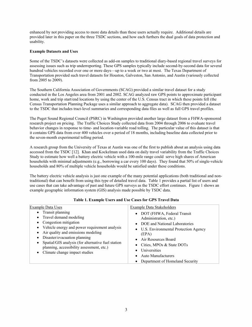
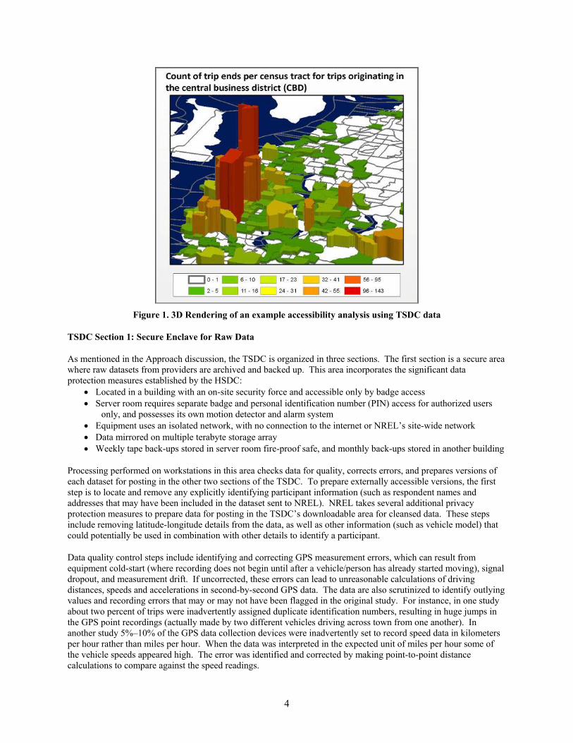
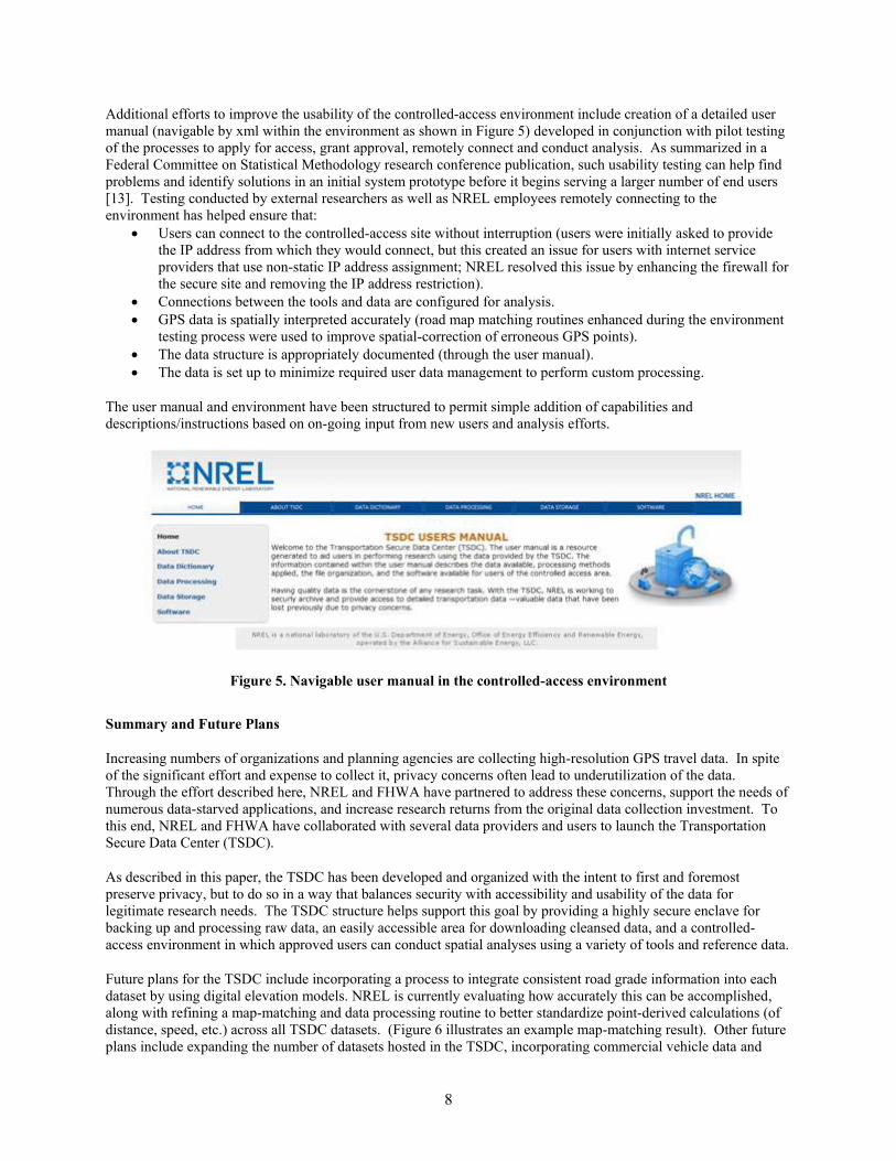
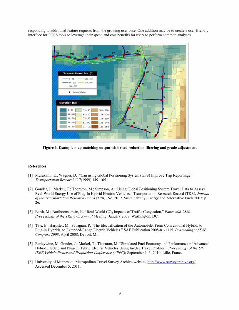