esil · 2019-09-20 · ba ck to catalog item pa ge ba ck to catalog item pa ge oce of response and...
TRANSCRIPT

PrintPrintBack to Catalog Item PageBack to Catalog Item Page
O�ce of Response and RestorationEntity (ENT) | ID: 47482 | Draft
Created: 2017-09-25 | Last Modi�ed: 2019-09-10
Parent: [REGION NAME] [YEAR] ESI Polygons, LinesData Set (DS) | ID: 47481
ID: 47482Entity (ENT)
* Discovery• First Pass
» Metadata Rubric
ESIL
Item Identification
* » Title ESIL
Short Name ESIL
* Status Completed
Creation Date
Revision Date
• PublicationDate
0000-01
* » Abstract The ESIL table contains attribute information for the vector lines representing linear shoreline features withESI classi�cation.
* Purpose
Notes Loaded by FGDC Metadata Uploader, batch 10039, 09-25-2017 12:58
Other CitationDetails
• SupplementalInformation
DOI (DigitalObject Identi�er)
DOI RegistrationAuthority
DOI Issue Date
KeywordsTheme Keywords
Thesaurus Keyword
Temporal Keywords
Thesaurus Keyword
* Spatial Keywords
Thesaurus Keyword
Stratum Keywords
Thesaurus Keyword
Instrument Keywords
Thesaurus Keyword
Platform Keywords
Thesaurus Keyword
Physical Location

• » Organization
• » City
• »State/Province
• Country
• » LocationDescription
Data Entity Information
Entity Type
Active Version?
Alias
Schema Name
» Description
Change Summary
Data AttributesAttribute Summary
Score Req'd? PKey? » Name DataStorageType
Description
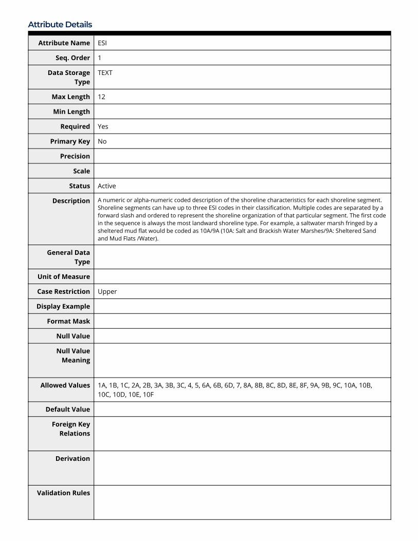
100 Yes No ESI TEXT A numeric or alpha-numeric coded description ofthe shoreline characteristics for each shorelinesegment. Shoreline segments can have up tothree ESI codes in their classi�cation. Multiplecodes are separated by a forward slash andordered to represent the shoreline organizationof that particular segment. The �rst code in thesequence is always the most landward shorelinetype. For example, a saltwater marsh fringed by asheltered mud �at would be coded as 10A/9A(10A: Salt and Brackish Water Marshes/9A:Sheltered Sand and Mud Flats /Water).
100 Yes No LINE TEXT Abbreviation describing the type of water/landinterface. All line segments that serve as ashoreline boundary between open water and landare attributed a value of S. All shorelinehydrography not associated with seawater (lakes,

ponds, reservoirs, some rivers and streams, etc.)are attributed with a value of H. Man-madestructures that are not mapped as a part of thecontiguous water/land interface are attributedwith one of the following values: B D, FN, G, GR, J,or P.
100 Yes No ENVIR TEXT Abbreviation describing the type of environmentwhere the classi�ed shoreline segment is located.Acceptable values are E-estuarine, R-riverine, L-lacustrine, and P-palustrine.
100 Yes No MOST_SENSITIVE TEXT If multiple shoreline types appear in ESIclassi�cation, this �eld represents the highestvalue (most sensitive type); otherwise it is thesame value as the ESI �eld.
100 Yes No LANDWARD_SHORETYPE TEXT The numeric representation and physicaldescription of the �rst (or only) ESI type found inthe ESI �eld.
100 No No SEAWARD_SHORETYPE1 TEXT The numeric representation and physicaldescription of the second ESI type in the ESI �eld(blank if not applicable).
100 No No SEAWARD_SHORETYPE2 TEXT The numeric representation and physicaldescription of the third ESI type in the ESI �eld(blank if not applicable).
100 Yes No GENERAL_SYMBOL NUMBER This �eld is used for symbolizing the ESI shorelinebased on a generalized classi�cation scheme; ifmultiple generalized types occur, this will re�ectthe highest value.
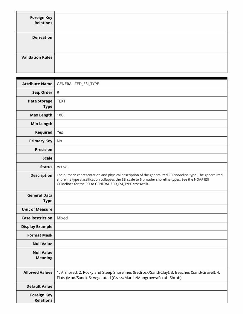
100 Yes No GENERALIZED_ESI_TYPE TEXT The numeric representation and physicaldescription of the generalized ESI shoreline type.The generalized shoreline type classi�cationcollapses the ESI scale to 5 broader shorelinetypes. See the NOAA ESI Guidelines for the ESI toGENERALIZED_ESI_TYPE crosswalk.
100 Yes No SOURCE_ID NUMBER The SOURCE_ID links to SOURCE in the SOURCESdata table, where the source for the underlyingshoreline segment is listed. This number shouldbe the same as the SOURCE_ID in theHYDRO_LINES layer for the same segment. TheSOURCE_ID begins in the range of 1-100, then isadded to the Atlas ID number * 10,000 togenerate a number that is unique across atlases.
100 Yes No ESI_SOURCE NUMBER ESI_SOURCE links to SOURCE in the SOURCES datatable, where the source used for classifying theshoreline segment is listed. The SOURCE_IDbegins in the range of 1-100, then is added to theAtlas ID number * 10,000 to generate a numberthat is unique across atlases.
Attribute Details
Attribute Name ESI
Seq. Order 1
Data StorageType
TEXT
Max Length 12
Min Length
Required Yes
Primary Key No
Precision
Scale
Status Active
Description A numeric or alpha-numeric coded description of the shoreline characteristics for each shoreline segment.Shoreline segments can have up to three ESI codes in their classi�cation. Multiple codes are separated by aforward slash and ordered to represent the shoreline organization of that particular segment. The �rst codein the sequence is always the most landward shoreline type. For example, a saltwater marsh fringed by asheltered mud �at would be coded as 10A/9A (10A: Salt and Brackish Water Marshes/9A: Sheltered Sandand Mud Flats /Water).
General DataType
Unit of Measure
Case Restriction Upper
Display Example
Format Mask
Null Value
Null ValueMeaning
Allowed Values 1A, 1B, 1C, 2A, 2B, 3A, 3B, 3C, 4, 5, 6A, 6B, 6D, 7, 8A, 8B, 8C, 8D, 8E, 8F, 9A, 9B, 9C, 10A, 10B,10C, 10D, 10E, 10F
Default Value
Foreign KeyRelations
Derivation
Validation Rules

Attribute Name LINE
Seq. Order 2
Data StorageType
TEXT
Max Length 2
Min Length
Required Yes
Primary Key No
Precision
Scale
Status Active
Description Abbreviation describing the type of water/land interface. All line segments that serve as a shorelineboundary between open water and land are attributed a value of S. All shoreline hydrography notassociated with seawater (lakes, ponds, reservoirs, some rivers and streams, etc.) are attributed with a valueof H. Man-made structures that are not mapped as a part of the contiguous water/land interface areattributed with one of the following values: B D, FN, G, GR, J, or P.
General DataType
Unit of Measure
Case Restriction
Display Example
Format Mask
Null Value
Null ValueMeaning
Allowed Values B = Breakwater | D = Dock | FN = Fender | G = Glacier | GR = Groin |H = Hydrography | J =Jetty |P = Pier | S = Shoreline
Default Value
Foreign KeyRelations
Derivation
Validation Rules

Attribute Name ENVIR
Seq. Order 3
Data StorageType
TEXT
Max Length 1
Min Length
Required Yes
Primary Key No
Precision
Scale
Status Active
Description Abbreviation describing the type of environment where the classi�ed shoreline segment is located.Acceptable values are E-estuarine, R-riverine, L-lacustrine, and P-palustrine.
General DataType
Unit of Measure
Case Restriction Upper
Display Example
Format Mask
Null Value
Null ValueMeaning
Allowed Values E (estuarine) | L (lacustrine) | P (palustrine) | R (riverine)
Default Value
Foreign KeyRelations
Derivation
Validation Rules
Attribute Name MOST_SENSITIVE
Seq. Order 4

Data StorageType
TEXT
Max Length 4
Min Length
Required Yes
Primary Key No
Precision
Scale
Status Active
Description If multiple shoreline types appear in ESI classi�cation, this �eld represents the highest value (most sensitivetype); otherwise it is the same value as the ESI �eld.
General DataType
Unit of Measure
Case Restriction
Display Example
Format Mask
Null Value
Null ValueMeaning
Allowed Values 1A, 1B, 1C, 2A, 2B, 3A, 3B, 3C, 4, 5, 6A, 6B, 6D, 7, 8A, 8B, 8C, 8D, 8E, 8F, 9A, 9B, 9C, 10A, 10B,10C, 10D, 10E, 10F
Default Value
Foreign KeyRelations
Derivation
Validation Rules
Attribute Name LANDWARD_SHORETYPE
Seq. Order 5
Data StorageType
TEXT

Max Length 60
Min Length
Required Yes
Primary Key No
Precision
Scale
Status Active
Description The numeric representation and physical description of the �rst (or only) ESI type found in the ESI �eld.
General DataType
Unit of Measure
Case Restriction Mixed
Display Example
Format Mask
Null Value
Null ValueMeaning
Allowed Values 1A: Exposed, Rocky Shores, 1B: Exposed, Solid Man-Made Structures, 1C: Exposed, Rocky Cli�sw/Boulder Talus Base, 2A: Exposed, Wave-Cut Platforms (Bedrock/Mud/Clay), 2B: ExposedScarps and Steep Slopes (Clay), 3A: Fine to Medium Grained Sand Beaches, 3B: Scarps andSteep Slopes (Sand), 3C: Tundra Cli�s, 4: Coarse Grained Sand Beaches, 5: Mixed Sand andGravel Beaches, 6A: Gravel Beaches [(Granules/Pebbles)], 6B: Riprap [OR Gravel Beaches(Cobbles/Boulders)], 6D: Boulder Rubble, 7: Exposed Tidal Flats, 8A: Sheltered Scarps(Bedrock/Mud/Clay) [OR Sheltered, Impermeable, Rocky Shores], 8B: Sheltered, Solid Man-Made Structures [OR Sheltered, Permeable, Rocky Shores], 8C: Sheltered Riprap, 8D:Sheltered, Rocky, Rubble Shores, 8E: Peat Shorelines, 9A: Sheltered Tidal Flats, 9B: VegetatedLow Banks, 9C: Hyper-Saline Tidal Flats, 10A: Salt and Brackish Water Marshes, 10B:Freshwater Marshes, 10C: Swamps, 10D: Scrub and Shrub Wetlands, 10E: Inundated Low LyingTundra, 10F: Mangroves
Default Value
Foreign KeyRelations
Derivation
Validation Rules

Attribute Name SEAWARD_SHORETYPE1
Seq. Order 6
Data StorageType
TEXT
Max Length 60
Min Length
Required No
Primary Key No
Precision
Scale
Status Active
Description The numeric representation and physical description of the second ESI type in the ESI �eld (blank if notapplicable).
General DataType
Unit of Measure
Case Restriction
Display Example
Format Mask
Null Value
Null ValueMeaning
Allowed Values 1A: Exposed, Rocky Shores, 1B: Exposed, Solid Man-Made Structures, 1C: Exposed, Rocky Cli�sw/Boulder Talus Base, 2A: Exposed, Wave-Cut Platforms (Bedrock/Mud/Clay), 2B: ExposedScarps and Steep Slopes (Clay), 3A: Fine to Medium Grained Sand Beaches, 3B: Scarps andSteep Slopes (Sand), 3C: Tundra Cli�s, 4: Coarse Grained Sand Beaches, 5: Mixed Sand andGravel Beaches, 6A: Gravel Beaches [(Granules/Pebbles)], 6B: Riprap [OR Gravel Beaches(Cobbles/Boulders)], 6D: Boulder Rubble, 7: Exposed Tidal Flats, 8A: Sheltered Scarps(Bedrock/Mud/Clay) [OR Sheltered, Impermeable, Rocky Shores], 8B: Sheltered, Solid Man-Made Structures [OR Sheltered, Permeable, Rocky Shores], 8C: Sheltered Riprap, 8D:Sheltered, Rocky, Rubble Shores, 8E: Peat Shorelines, 9A: Sheltered Tidal Flats, 9B: VegetatedLow Banks, 9C: Hyper-Saline Tidal Flats, 10A: Salt and Brackish Water Marshes, 10B:Freshwater Marshes, 10C: Swamps, 10D: Scrub and Shrub Wetlands, 10E: Inundated Low LyingTundra, 10F: Mangroves
Default Value
Foreign KeyRelations

Derivation
Validation Rules
Attribute Name SEAWARD_SHORETYPE2
Seq. Order 7
Data StorageType
TEXT
Max Length 60
Min Length
Required No
Primary Key No
Precision
Scale
Status Active
Description The numeric representation and physical description of the third ESI type in the ESI �eld (blank if notapplicable).
General DataType
Unit of Measure
Case Restriction
Display Example
Format Mask
Null Value
Null ValueMeaning
Allowed Values 1A: Exposed, Rocky Shores, 1B: Exposed, Solid Man-Made Structures, 1C: Exposed, Rocky Cli�sw/Boulder Talus Base, 2A: Exposed, Wave-Cut Platforms (Bedrock/Mud/Clay), 2B: ExposedScarps and Steep Slopes (Clay), 3A: Fine to Medium Grained Sand Beaches, 3B: Scarps andSteep Slopes (Sand), 3C: Tundra Cli�s, 4: Coarse Grained Sand Beaches, 5: Mixed Sand andGravel Beaches, 6A: Gravel Beaches [(Granules/Pebbles)], 6B: Riprap [OR Gravel Beaches(Cobbles/Boulders)], 6D: Boulder Rubble, 7: Exposed Tidal Flats, 8A: Sheltered Scarps(Bedrock/Mud/Clay) [OR Sheltered, Impermeable, Rocky Shores], 8B: Sheltered, Solid Man-Made Structures [OR Sheltered, Permeable, Rocky Shores], 8C: Sheltered Riprap, 8D:Sheltered, Rocky, Rubble Shores, 8E: Peat Shorelines, 9A: Sheltered Tidal Flats, 9B: VegetatedLow Banks, 9C: Hyper-Saline Tidal Flats, 10A: Salt and Brackish Water Marshes, 10B:

Freshwater Marshes, 10C: Swamps, 10D: Scrub and Shrub Wetlands, 10E: Inundated Low LyingTundra, 10F: Mangroves
Default Value
Foreign KeyRelations
Derivation
Validation Rules
Attribute Name GENERAL_SYMBOL
Seq. Order 8
Data StorageType
NUMBER
Max Length
Min Length
Required Yes
Primary Key No
Precision
Scale
Status Active
Description This �eld is used for symbolizing the ESI shoreline based on a generalized classi�cation scheme; if multiplegeneralized types occur, this will re�ect the highest value.
General DataType
Unit of Measure
Case Restriction
Display Example
Format Mask
Null Value
Null ValueMeaning
Allowed Values 1 - 5
Default Value
Foreign KeyRelations
Derivation
Validation Rules
Attribute Name GENERALIZED_ESI_TYPE
Seq. Order 9
Data StorageType
TEXT
Max Length 180
Min Length
Required Yes
Primary Key No
Precision
Scale
Status Active
Description The numeric representation and physical description of the generalized ESI shoreline type. The generalizedshoreline type classi�cation collapses the ESI scale to 5 broader shoreline types. See the NOAA ESIGuidelines for the ESI to GENERALIZED_ESI_TYPE crosswalk.
General DataType
Unit of Measure
Case Restriction Mixed
Display Example
Format Mask
Null Value
Null ValueMeaning
Allowed Values 1: Armored, 2: Rocky and Steep Shorelines (Bedrock/Sand/Clay), 3: Beaches (Sand/Gravel), 4:Flats (Mud/Sand), 5: Vegetated (Grass/Marsh/Mangroves/Scrub-Shrub)
Default Value
Foreign KeyRelations

Derivation
Validation Rules
Attribute Name SOURCE_ID
Seq. Order 10
Data StorageType
NUMBER
Max Length
Min Length
Required Yes
Primary Key No
Precision
Scale
Status Active
Description The SOURCE_ID links to SOURCE in the SOURCES data table, where the source for the underlying shorelinesegment is listed. This number should be the same as the SOURCE_ID in the HYDRO_LINES layer for thesame segment. The SOURCE_ID begins in the range of 1-100, then is added to the Atlas ID number * 10,000to generate a number that is unique across atlases.
General DataType
Unit of Measure
Case Restriction
Display Example
Format Mask
Null Value
Null ValueMeaning
Allowed Values [ALLOWED VALUES ADDED AS A RANGE AFTER FINAL ESI GEODATABASE IS CREATED, e.g.335000012 - 335000016]
Default Value
Foreign KeyRelations

Derivation
Validation Rules
Attribute Name ESI_SOURCE
Seq. Order 11
Data StorageType
NUMBER
Max Length
Min Length
Required Yes
Primary Key No
Precision
Scale
Status Active
Description ESI_SOURCE links to SOURCE in the SOURCES data table, where the source used for classifying the shorelinesegment is listed. The SOURCE_ID begins in the range of 1-100, then is added to the Atlas ID number *10,000 to generate a number that is unique across atlases.
General DataType
Unit of Measure
Case Restriction
Display Example
Format Mask
Null Value
Null ValueMeaning
Allowed Values [ALLOWED VALUES ADDED AS A RANGE AFTER FINAL ESI GEODATABASE IS CREATED, e.g.335000012 - 335000016]
Default Value
Foreign KeyRelations
Derivation

Validation Rules
Attribute Name
Seq. Order
Data StorageType
Max Length
Precision
Scale
Required
Primary Key
Status
Description
General DataType
Case Restriction
Format Mask
Null Value
Null ValueMeaning
Min Length
Unit of Measure
Display Example
Allowed Values
Default Value
Foreign KeyRelations
Derivation
Validation Rules
Attribute Name

Seq. Order
Data StorageType
Max Length
Precision
Scale
Required
Primary Key
Status
Description
General DataType
Case Restriction
Format Mask
Null Value
Null ValueMeaning
Min Length
Unit of Measure
Display Example
Allowed Values
Default Value
Foreign KeyRelations
Derivation
Validation Rules
Support Roles» At least one Distributor Org, one Metadata Contact, one Point of Contact, and one Data Steward should be listed.
* » Support Role
* » Date E�ective
From
Date E�ective To
* » Contact
* ContactInstructions
* » Support Role
* » Date E�ectiveFrom
Date E�ective To
* » Contact
* ContactInstructions
* » Support Role
* » Date E�ectiveFrom
Date E�ective To
* » Contact
* ContactInstructions
Extents
CurrentnessReference
Extent Group 1
ExtentDescription
Extent Group 1 / Geographic Area
* » W° Bound
* » E° Bound
* » N° Bound
* » S° Bound
* » Description
Extent Group 1 / Vertical Extent
EPSG Code
VerticalMinimum
VerticalMaximum
Extent Group 1 / Time Frame
* » Time FrameType
* » Start
End
Alternate Startas of Info
Alternate End asof Info
Description
Access Information
* » Security Class
* SecurityClassi�cation
System
Security HandlingDescription
• Data AccessPolicy
» Data AccessProcedure
• » Data AccessConstraints
• Data UseConstraints

Metadata AccessConstraints
Metadata UseConstraints
Distribution Information
Start Date
End Date
» Download URL
Distributor
File Name
Description
File Date/Time
File Type
FGDC ContentType
File Size
ApplicationVersion
Compression
Review Status
Start Date
End Date
» Download URL
Distributor
File Name
Description
File Date/Time
File Type
FGDC Content
Type
File Size
ApplicationVersion
Compression
Review Status
Start Date
End Date
» Download URL
Distributor
File Name
Description
File Date/Time
File Type
FGDC ContentType
File Size
ApplicationVersion
Compression
Review Status
Activity Log
Activity Time
Activity Type
ResponsibleParty
Description
Activity Time
Activity Type
ResponsibleParty

Description
Activity Time
Activity Type
ResponsibleParty
Description
Issues
Issue Date
Author
Issue
Issue Date
Author
Issue
Issue Date
Author
Issue
FAQs
Date
Author
Question
Answer

Child ItemsRubric scores updated every 15m
Score Type Title
Related Items
Item Type RelationshipType
Title
Catalog Details
Catalog Item ID 47482
Metadata RecordCreated By
David Moe Nelson
Metadata RecordCreated
2017-09-25 12:58+0000
Metadata RecordLast Modi�ed By
Jill Petersen
» MetadataRecord Last
Modi�ed
2019-09-10 16:24+0000
Metadata RecordPublished
Owner Org ORR
MetadataPublication
Status
Never Published
Do Not Publish? N
MetadataWork�ow State
Draft
Metadata NextReview Date