epic book: photographic study
TRANSCRIPT

,.
II I ;1
I
I &EPA I :1 :1 :1 'I
:,1 ,I I I I :1 11 ;1 II
.:~.. .. ~.--- .l
United States Environmental Protection Agency
Research and Development
Environmental Monitoring Systems Laboratory P.O. Box 15027· Las Vegas NV 89114
TS-PIC-83046 January 1984
Photographic Study of Salem Acres Disposal Site Salem, Massachusetts . "',,cdKc'
EPA Region 1 and OERR
---- - -- - -- -----
11111111111111111111111111111111111
SDMS DocID 25826
I i , , I ,

I I I I I I I I I I I I I I I I I I
Photographic Study of Salem Acres Disposal Site Salem, Massachusetts
by E. Terrence Slonecker and William A. Chapman, Imagery Analysts The Bionetics Corporation Warrenton, Virginia 22186
Contract No. 68-03-3161
Project Offi cer Thomas R. Osberg Environmental ~otographic Interpretation Center Environmental Monitoring Systems Laboratory Warrenton, Virginia 22186, FTS 557-3110
ENVIRONMENTAL MONITORING SYSTEMS LABORATORY OFFICE OF RESEARCH AND DEVELOPMENT U.S. J:NVIRONMENTAL PROTECTION AGENCY LAS VEGAS, NEVADA 89114
TS- PIC-83046 January 1984

I I I I I I I I I I I I II I I I I I I
NOTICE
This document has not been peer and administratively reviewed within EPA and is for internal Agency use and distribution only.
; i

I I I I I I I I I I I
I I I I I I
ABSTRACT
This report presents an analysis of historical aerial photography of the Salem Acres disposal site in Salem, Massachusetts to document disposal activities at the site. The site is believed to have received various waste products since 1945 and has been identified as a potential source of water pollution in the area. Two to eight pits were identified on the imagery. Activity indicating possible and probable disposal of waste materials was detected from 1952-1965. Confirmed disposal activity, in the form of sludge dumping in the pits, was detected in 1969. The site itsel f di,d not appear to be active in 1976 and 1978, but a significant amount of ground scarring and grading was evident immediately north of the site.
A drainage analysis was performed for the year 1969.
The Environmental Protection Agency's (EPA) Environmental Photographic Interpretation Cente~ in Warrenton, Virginia, a field station of the Environmental Monitoring Systems Laboratory in Las Vegas, Nevada, performed this study at the request of the EPA Region 1 office. This analysis covers the period between 1952 and 1978, and was completed in January 1984.
iii

----------
I I
CONTENTS
I Page
I Abstract iii Introduct ion 1 Summary 3
I Methodo logy 5 Drainage 6 nigital Elevation Model and
Isometric Profile. 8
I Aeri al Photo Site Analysis: August 26, 1952 10 December 1, 1955 • 12
I May 26, 1960 • 14 August 24, 1965 16 April 9, 1969 18
I August 19, 1976 20 June 30, 1978 22
References 24
I FIGURES
I Page
I 1. Location Map 2
Table 1 4 2. Drainage Patterns 7 3. Isometric Profil e 9
I Aer i a 1 Photos: 4. August 26, 1952 11 5. December 1, 1955 13
I 6. May 26, 1960 • 15 7. August 24, 1965 17 8. Apr il 9, 1969 19
I 9. August 19, 1976 21 10. June 30, 1978 23
I I I I I iv
I l_

I I I I I I I I I I I I I I I I I I I
INTRODUCTION
The Salem Acres disposal site, located in Salem, Massachusetts, is believed to have received tannery wastes, sewage sludges and grease into pits, starting around 1945. Local drainage is complex and, during heavy rains, overflow and flooding of neighborhood wetland areas occur. The data in this report is needed to provide baseline information in planning a full-scale analysis of the site.
In February 1983, a two-phase study was undertaken to determine: (1) the historical profile of the site and its immediate vicinity; and (2) a mapping of the current land use practices in the area, including a point source inventory within a 5-km (3-mile) radius of the site. The land use and point source inventories were released in October 1983.
Aerial photography of the Salem Acres disposal site was obtained to represent the period from 1952 to 1980.1 Historical black and white photography (from 1952, 1955, 1960, 1965, 1969, 1976 and 1978) used in .this study was acquired from the imagery libraries of several government agencies around the United States. Additional black and white photography (from 1970, 1977 and 1980) was obtained and analyzed, but was not reproduced for this report due to poor quality or lack of significant detail.
The Salem Acres site is located approximately 579 meters (1,900 ft) west-northwest of the intersection of Highland Avenue and Sutton Street. Figure 1 depicts the site's location, keyed to U.S. Geological Survey 1:25,000 scale topographic maps. Site boundaries or areas used in the analysis were determined by observations made from the aerial photography and do not denote legal property lines or ownership.
The Environmental Protection Agency's (EPA) Environmental Photographic Interpretation Center in Warrenton, Virginia, a field station of the Environmental Monitoring Systems Laboratory in Las Vegas, Nevada, performed this· study at the request of the EPA Region 1 office. This analysis was completed in January 1984.
1A complete listing of all maps and photography used in this report can be found in the References section.
1

FIGU RE I LOCATION MAP SALEM CRES LYNN AND SALEM I MA ACHUSETTS QUADS
SCALE 1',20,000
I I I I I I I I I I I I I I I I I I I

I I I I I I I I I I
I I I I I I
---~----------------~-~---------- ---
SUMMARY
The Salem Acres site comprises approximately 0.6 to 0.8 hectare (1.5 to 2 acres) throughout the study period. A sign ificant amount of act i vity was detected north of the immediate site area in 1976 and 1978; however, the relationship between this activity and actual site operations could not be determined from the photography.
A network of dirt roads leading from Highland Avenue to the south and Sutton Street to the northeast provides access to the site. No confirmed security measures were detected on any of the photography. Several fences are visible in the vicinity of Salem Acres, but none appear to be related to site boundaries or security.
The site is situated in an elevation varies from 67 meters Reservo i r to 1 ess than 30 meters immediately west of the site.
area characterized by drumloidal hills. The (220 feet) above sea level near the Peabody (100 feet) above sea level in the swampy area
According to a surficial geology map, the hills and ridges in and around the study area are composed of ground moraine, which consi sts of poorly sorted deposits of clay, silt, sand and gravel." The low swampy areas consist of muck and peat containing variable amounts of clay, silt and sand, generally varying in thickness from 0.3 to 0.9 meters (1 to 3 feet). The areas along Strongwater Brook and other major drainage channels consist of late glacial and post-glacial stream deposits of coarse to fine sand. and fine gravel)
Vegetation stress was not addressed, since it cannot be detected on black and white photography. The 1965 infrared imagery revealed no significant vegetation stress.
Peabody Reservoir is located approximately 400 meters (1,300 feet) northwest of Salem Acres, and Strongwater Brook is immediately west of the site. The nearest residences are located approximately 183 meters (600 feet) south of the site.
No evidence of salvage activity was detected on any of and there were no observable obstacles to ground inspection on the site.
the photography, parti es detected
Table 1 presents a summary of the disposal activitie~ that are visible on each year of imagery.
1See References, page 24, for a complete description of all maps used in this report.
3

Number of Pi ts I
I Year Five
1952 I
1955 Eight '/
1960 Two
1965 Five
1969 Six I I
1976 Four I I
1978 Four
TABLE 1. SUMMARY OF ACTIVITY
Signs of Disposal I Other Act i vity Vehicles on Site I Comments
Extraction; I
I --------N-o-n-e----------I--pr-o-b-a-b·-'e--d-i-s-po-s-a-l-
Possible ground stains Ground scars activity Possible standing 1 i qui d
I I Possible standing Mounded materi al I None
I Po s sib 1 e d; s po sal
liquid appears in SW I activity sec t ion 0 f site I
Probable standing Cover and/or fill; Two I Probabl e di sposa 1 liquid EarthMoving I activity Dark-toned material I Possible dark-toned New pi t None Pos sib 1 e dis po sal materia 1
Probable sl udge None I One truck I Confirmed disposal
I activity
I cleared ridge, ~lM;
Standing liquid Disturbed a~eas and None Site status
I construction of new un known facility north of site
I Possible standi ng
I Cleared ridge, MM; None Site status
liquid disturbed areas and un known
I construction of new facility north of
I
site
4
I I I I I I I I I I I I I I I I
I I I I I I I I I I I I I I I I I I I
---- ~ --~--~-------~~~--~~-------~~ ~----~-----,~
METHODOLOGY
Aerial photography was obtained for a chronological analysis of the report site. 1 The analysis was performed by stereoscopically viewing pairs of transparencies, backlit on a standard Richards light table. By observing the site three-dimensionally, and at various magnifications, the analyst could
'search for objects, features, or "signatures" associated with different envi ronmental conditions. The term "sign,ature" refers to a combination of characteristics (such as color, tone, shadow, texture and size) which indicate a specific object pr condition, even though the object itself is not identifiable from the photography.
Prints were made from coverages which reveal significant changes jn the study area. Findings are annotated on overlays to these prints, or to maps of the study area, and full descriptions are provided in the accompanying text. The reso 1 ution qual i tyof the original, transparent photography used by the analyst is degraded on the prints due to factors inherent in the printing , process. Therefore, some objects or features identified from the original film and described in the text may not be clearly discernible, or even visible, on the photographic prints presented in this report.
It should be noted that site boundaries or areas used in this analysis were determined by observations made from the aerial photography and do not denote legal property lines or ownership.
In this report, a distinction is made between probable and possible identifications. Probable is used when a limited number of discernible signatures allows the analyst to' be reasonably sure of a particular identification. Fbssible is used when few signatures are discernible, and the analyst ca~ only infer an identification.
lA complete'listing of all maps and photography used for this report can be found in the References section.
5

DRAINAGE
Thedrumloidal hills in the Salem Acres area result in complex drainage patterns around the site. Numerous small swampy areas are located between the hills and ridges. These swampy areas drain slowly because of subtle changes in elevation, and periods of heavy rain or flooding could significantly alter the overall drainage pattern.
The primary drainage channel in the area is Strongwater Brook, which flows north and east into the North River and Beverly Harbor. Strongwater Brook runs through a swampy area located immediately west of the Salem Acres site and would catch the majority of surface drainage from the site (see Figure 2). Drainage from the northeastern border of the site would also flow into Strongwater Brook via a secondary drainage channel. The southeastern border of the site drains to the southeast into a wetland area known as Thompsons Meadow which, in turn, drains into the Forest River and Salem Harbor.
Figure 2 depicts the drainage patterns on the Salem Acres site in April 1969.
DTM -EXT
GS ~1~·1 SL
LEGEND
Dark-Toned Material Extracti on' Ground Scar ~'lounded ~la ted a 1 Standing Liquid
V - Vehicle
6
)( - Culvert 'III - I'Jetl ands
-.-- - Ora i nage 111111111111 - Excavated Area -------- -Historical Boundary
---- ---,
I II
I I I I I I I I I I I I I I I I I

I I I I I I I I I I I I I I I
II I I
II FIGURE 2 DRAINAGE PATTERNS SALEM ACRES APPROX SCALE I: 11,900
7
DIGITAL ELEVATION MODEL AND ISOMETRIC PROFILE (FIGURE 3)
The digital elevation model and isometric profile of a 5.8 square kilometer (2.2 sq mile) area around the Salem Acres disposal site were produced for the EPA by the Eastern Mapping Center of the U.S. Geological Survey under Interagency Agreement Number 5110-29212. The following is a brief summary of the processes involved.
PRED I GITAL PRE PARATION
A color proof of the contour separate is prepared on white scribecoat. Because the study area falls on two 7.5-minute quadrangles, a film positive of each contour plate is prepared, the contour positives are mosaicked, and a film negative of the contour composite is produced. The color proof of the contours is produced from the negative composite.
DATA COLLECTION
The contour data on the color proof are scanned on the Scitex automatic digitizing system.
EDITING
The raster formatted contour data are edited using the Scitex interactive editing system. The contour lines are thinned to their one-point center lines, contour numbers are removed, hreaks in the lines are closed, and coalescing contours are separated. Scitex raster-to-vector software is used to vectorize the edited raster file.
CONTOUR TAGGING '-
After vectorization, the contour Intergraph interactive editing system. elevation values.
GRIDDING
data file is The contours
transferred to the are tagged with their
The edited and tagged contour data are processed through the Digital Cartographic Software System (DCASS) to convert from the vector format to the final matrix form •.
GRAPH ICS
The digital elevation model was processed through the Contour Plotting System (CPS) to produce an. isometric profile of the surface.
/
8
I I I '
I I I I I I I I I I I I I I I

I I I I I I I I I I I I I I I I I I I
L
SALEM ACRES
ELEVATION (ASL)
LOCATION OF SALEM ACRES SITE
.ooo+? r ISBMETRIC GRAPHIC - VIEWED FRBM SE WITH B T0 1 VERT. EXAGGERATI0N. 45 DEGREES
FIGURE 3 SALEM ACRES SITE ISOMETRIC PROFILE
VIEW FROM SE AT 45 DEGREE ELEVATION
9
8:1 VERTICAL EXAGGERATION
AERIAL PHOTO SITE ANAL YSIS
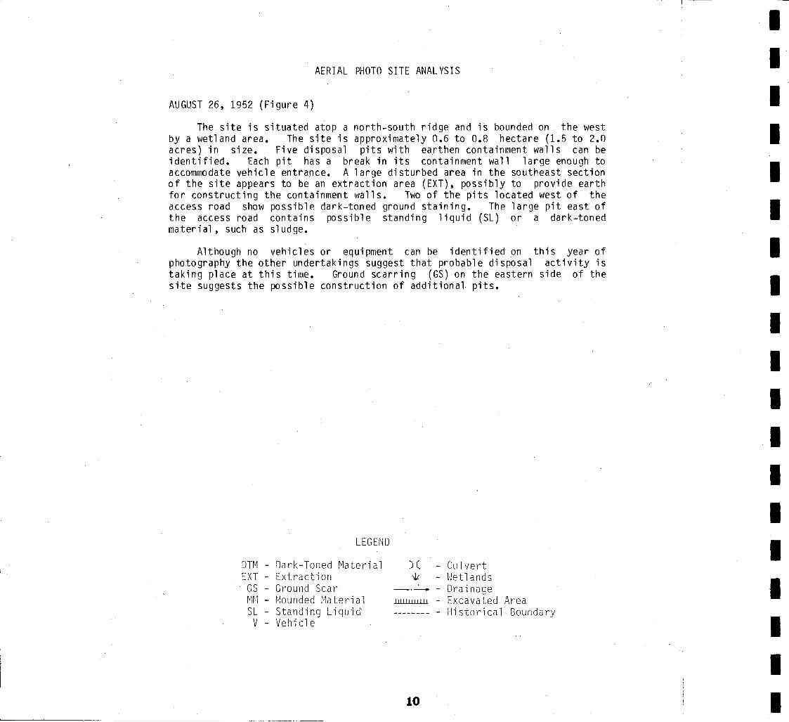
AUGUST 26, 1952 (Figure 4)
The site is situated atop a north-south ridge and is bounded on the west by a wetland area. The site is approximately 0.6 to 0.8 hectare (1.5 to 2.0 acres) in size. Five disposal pits with earthen containment walls can be identified. Each pit has a break in its containment wall large enough to accommodate vehicle entrance. A large disturbed area in the southeast section of the site appears to be an extraction area (EXT), possibly to provide earth for constructing the containment walls. Two of the pits located west of the access road show possible dark-toned ground staining. The large pit east of the access road contains possible standing liquid (SL) or a dark-toned materi al, such as sl udge.
Although no vehicles or equipment can be identified on this year of photography the other undertakings suggest that probable disposal activity is taking place at this time. Ground scarring (GS) on the eastern side of the site suggests the possible construction of additional. pits.
LEGEND
DTM - Dark-Toned Material EXT - Extraction
GS Ground Scar MM - Mounded Material SL - Standing Liquid V - Vehicle
) ( - Cul vert 'Ill I'Jetl ands
_.-- - Drainage 111111111111 - Excavated Area -------- -Historical Boundary
10
I I I I I I I I I I I I I I I I I I

I I I I I I I I I
·1 I I I I I I I I I 11
-APPROX SCALE I: 4,000

DECEMBER 1, 1955 (Figure 5)
By this time, three new pits have been constructed on the ea~tern side of the site. The extraction area noted in 1952 now appears to be dormant. A large pile of mounded material (MM), probably earth, appears in the southwest corner of the site. f{)ssible standing liquid or sludge is located in the pit in the northwest corner of the "s,ite. No vehicles or equipment can be identified onsite at this time.
An active landfill with probable burning trash is located approximately 610 meters (2,000 feet) northeast of the site. Thi s 1 andfi 11 is not associated with the Salem Acres site.
LEGEND
DTM - Dark-Toned Material EXT - Extraction
GS - Ground Scar MM - Mounded Material SL - Standing Liquid V - Vehicle
) ( Cul vert 'lit Wetlands _0- -Drainage
11I!l1I11il! - Excavated Area -------- - Historical Boundary
12
I I I I I I I I I I I I I I I I I I I

I I I I I I I I I I I I I I I I I I I
FIGURE 5 SALEM ACRES DECEMBER I, 1955
13
APPROX SCALE 1:5,900

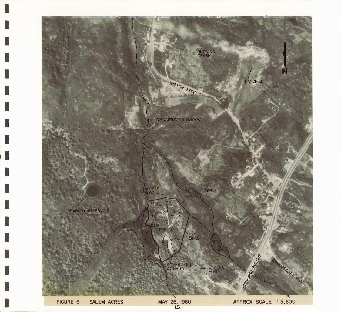
MAY 26, 1960 (Figure 6)
Only two of the eight pits that appeared in 1955 can be clearly identified on this year of photography. The other pits are shrouded by. low-level vegetation and cannot be clearly identified. The large pit in the northwest section of the site contains dark-toned material (DTM) and probable standing liquid. Although no break'is evident in the containment wall of the other pit, the presence of these features indicates that limited disposal activity is probably still taking place. Cover and/or fill activity is evident in the southern section of the site. The mounded material that appeared in 1955 is apparently being graded out over a larger area. The former extraction area appears to hav'e been graded and 1 evel ed. There are two vehicles (V) on the site.
The landfill to the northeast is still active, and burning trash is visible.
LEGEND
DTM - Dark-Toned Material E'XT - Extracti on
GS - Ground Scar MM - Mounded Material SL - Standing Liquid V - Vehicle
) ( Cul vert 'Ill Wetlands
-'- - Ora i nage llllWW~ Excavated Area -------- -' Historical Boundary
•
14
---- -- - ---
I I I I I I I I I I I I I I I I I I I
I I I I I I I I I I I I I I I I I I I FIGURE 6 SALEM ACRES

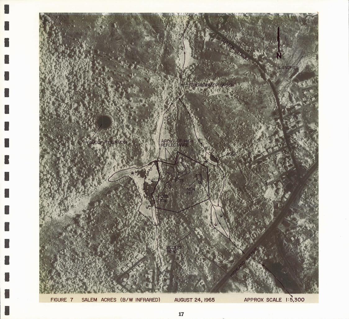
AUGUST 24, 1965 (Figure 7)
This photograph was taken with black and white infrared film which is sensitive to the reflective portion of the near infrared spectrum. It differs from conventional photography in that healthy vegetation appears lighter in tone, while water, streams and moist soil appear darker in tone.
Five pits can be identified. The two large pits in the northern part of the site show areas of high reflectance within them, possibly indicating the growth of low-level vegetation or algae on or in standing water in the pits. One small pit contains possible dark-toned material, and a new pit has been excavated on the eastern portion of the site. The cover and fill activity evident in 1960 has apparently ceased; no vehicles or equipment are apparent on the site.
No ongoing disposal activity has been noted within the landfill situated northeast of the site. The burning activity noted in previous years of photo coverage is no longer apparent.
LEGEND
DTM - Dark-Toned Material EXT - Extraction
GS - Ground Scar MM - Mounded Material SL - Standing Liquid V - Vehicle
)( Culvert \It Wetlands
-.___oo - Ora i nage 1!llIlIlllll Excavated Area -------- Hi stori ca 1 Boundary
16
I I I I I I I I I I~
I I I I I I I I I
I I I I I I I I I I I I I I I I I I I
FIGURE 7 SALEM ACRES (B/W INFRARED) AUGUST 24, 1965
17

APRIL 9,1969 (Figure 8)
Disposal activity at the site has increased significantly. There are now six pits, all containing a substance that appears to be composed of both light- and dark -toned material and have a viscous consistency (probably sludge) . There is one confirmed vehicle onsite .
The white areas on the photograph are ice or snow .
LEGEND
DTM - Dark-Toned Mater i al EXT - Ex tract -i on
GS - Ground Sca r MM - Mounded Ma t er i al SL - Standing Liquid V - Veh -i c-I e
) C Cu 'l vert W. ~J e t 1 and s
-'-- - Ora -i nage 11111111 1111 - Excavated Area -------- I-li sto r -i ca l Boundary
18
I I I I I I I I I I I I I I I I I I I

I I I I I I I I
I I
I I I I I I
I I I I I
00......-..-____________ ~~~~ __ ~ __ _ 19

AUGUST 19, 1976 (Figure 9)
Activity within the site appears to have decreased significantly. The general outlines of four pits are still identifiable, although low-level vegetation now covers much of the site. Standing liquid is visible in two of the pits. There are no vehicles or other signs of activity at this time.
A significant amount of activity is now occurring to the north, between the site and Sutton Street. The relationship between this new activity and disposal operations at the site cannot be determined from the photography. Adjacent to the northern site boundary, the ridge between the drainageways has been cleared of vegetation and contains two large piles of mounded material. Farther north are three large disturbed areas, showing signs of ground scarring and grading. Two of these areas contain mounded material, probably earth. Approximately 183 meters (600 feet) northeast of t.he site, a new facility with a rectangular, hard-surface pad has been constructed. The pad is approximately 67 x 47 meters (220 x 155 feet) in size. This new facility contains one small st.ructure and other unidentifiable objects and is probably still under construction. Adjacent to this facility are two small ditches and three small disturbed areas, probably related to construction activity.
A small ditch and a pile of mounded material are located on the former landfill northeast of Sutton Street.
DTM -EXT -
GS -M~1 -SL -V -
LEGEND
Dark-Toned Material Extraction Ground Scar' Mounded Material Standing Liquid Vehicle
)( -.It _.-- -
111111111111 -
20
Culvert Wetlands Drainage Excavated Area Historical Boundary
I I I I I I I I I I I I I I I I I I I


JUNE 30, 1978 (Figure lOY
Four pits are still identifiable. Fossible standing liquid is visible in the same two pits as in 1976. Dark-toned material is visible in one of the pits. There are no vehicles or other signs of activity at this time.
The cleared ridge north of the site shows no new signs of activity, and the mounded material is no longer present. The disturbed areas north of the cleared ridge appear relatively unchanged. Most of the activity around the new facility has ceased; only one of the three disturbed areas is still present and the ditches are gone. The ditch and mounded material previously seen on the former landfill northeast of Sutton Street are no longer evident.
LEGEND
DTM - Dark-Toned Material EXT - Extraction
GS - Ground Scar MM - Mounded Material SL - Standing Liquid V - Vehicle
) ( Cul vert \It - Wetlands
_.-- - Ora i nage IJlIIIIIIIU - Excavated Area -------- - Historical Boundary
22
--------------~ ----,
I I I I I I I I I I I I I I I I I I I

I I I I I I I I I I I I I I I I I I
~ FIGURE 10 SALEM .ACRES JUNE 30, 1978
23 APPROX SCALE I: 5,700

REFERENCES
AERIAL PHOTOGRAPH Y Mission
Date Agency Code
August 26, 1952 ASCS1 opp
December 1, 1955 USGS2 VKF
May 26, 1960 NOS3 60S
August 24, 1965 NOS 65S
April 9,1969 USGS VCEM
April 29, 1969* USGS VCEM
October 29, 1970* ASCS DPP
August 19, 1976 NOS 76E
April 1, 1977* USGS VECR
June 30, 1978 NOS 78BP
September 28, 1980* ASCS 25-009
*Not reproduced in thi s report
MAPS
Source Name Scale
Orig. Imagery
Fram~# Scale
9K41-9K43 1: 20,000
1/111, 1/112 1:24,000 1/131-1/133
4413-4414 1:36,000
6919R, 6920R 1:30,000
1/60, 1/61 1:24,000
4/22 1:24,000
5LL 125/126 1:40,000
7038, 70391:30,000
1-55, 1-56 1:80,000
4911-4913 1:36,000
780-36/37 1:40,000
Date
USGS Lynn, Massachusetts 1:25,000 1970
USGS
USGS
Salem, Massachusetts 1:25,000
Surficial Geology of 1:24,000 the Sal em (Uadrangl e, Massachusetts
1970 (photorevised 1979)
1964
EPIC frame #
5731-5733
5469, 5470 5780-5782
5923-5924
4679,4680
4681
5574-003/ 004
5927, 5928
4682-4683
5929-5931
5574-001/ 002
1Agricultural Stabilization and Conservation Service, United States Department of Agriculture
2United States Geological Survey, United States Department of the Interior
3National Ocean Survey, United States Department of Commerce
24
- --~ ----------,
l II I I I I I I I I I I I I I I I I I
•