epht metadata content guidance v1 - missouri · metadata content guidance document ....
TRANSCRIPT

ENVIRONMENTAL PUBLIC HEALTH TRACKING Metadata Content Guidance Document Version 1.1
Metadata Content Guidance Document

S T A N D A R D S A N D N E T W O R K D E V E L O P M E N T
Metadata Content Guidance Document

Acknowledgments We would like to thank the following people for their contributions to this document. Name Title Organization Role
Metadata Subgroup LeadershipKochukoshy Cheruvettolil
Associate Ross & Associates Consulting Facilitator
Gonza Namulanda Public Health Informatics Fellow
Centers for Disease Control ChairAuthor
Jeff Patridge GIS Analyst Missouri Office of Administration ChairAuthor
Document Development TeamRodney Garland Research Analyst Oregon Public Health Division Team Leader
Author, Editor
Kim Kennedy Consultant Scientific Technologies Corporation ContributorSanjaya Kumar Research Scientist New York State Dept. of Health AuthorRene LeBlanc Systems Analyst Maine Dept. of Health and Human Services ContributorSam LeFevre Program Manager Utah Dept. of Health Team Leader
Author Lisa Parker Database Analyst Maine Dept. of Health and Human Services ContributorChuck Shorter Field Epidemiologist Tulane University AuthorJeanne Zborowski Principle Investigator University of Pittsburgh Author
Metadata Subgroup MembersCarol Bingaman IT Consultant Pennsylvania Dept. of Health Contributor
Chris Duclos GIS Manager Florida Dept. of Health ContributorJohn Folsom Database Administrator Florida Dept. of Health ContributorSara Kustron GIS Coordinator Massachusetts Dept. of Public Health ContributorRobert Levey Computer Systems
Manager New York City Dept. of Health and Mental Hygiene
Contributor
Rashid Malik DP Program Analyst Maryland Dept. of Health and Mental Hygiene ContributorRichard Opiekun Research Scientist New Jersey Dept. of Health and Senior Services ContributorJudy Rager Epidemiologist University of Pittsburgh Contributor Misty Richard Epidemiologist New Hampshire Dept. of Health and Human
Services Contributor
Juley Rycheck Epidemiologist University of Pittsburgh ContributorParveeza Shaikh Database Specialist Maryland Dept. of Health and Mental Hygiene ContributorMegan Tehan Epidemiologist New Hampshire Dept. of Health and Human
Services Contributor
Contractor Support
Madhu Chaganthi Network Architecture Northrop Grumman SupportRhonda A. Martin Project Manager Northrop Grumman SupportCrystal Spellman Business Analyst Northrop Grumman Support

This page left intentionally blank

T a b l e o f C o n t e n t s
Table of Contents Chapter 1: How to Use This Guide ..................................................... 1
1.1 What is the Purpose of This Guide? .................................. 1 1.2 Using This Guide ............................................................... 1
Chapter 2: Introduction ....................................................................... 2 2.1 What is Metadata? ............................................................. 2 2.2 Why is Metadata Important to EPHT? ............................... 3 2.3 Who Creates Metadata Standards? .................................. 3 2.4 What is the FGDC Metadata Standard? ............................ 4 2.5 What is the Tracking Network Profile? ............................... 4
Chapter 3: Structure ........................................................................... 5 3.1 Metadata Sections ............................................................. 6 Section 1: Identification Information.......................................... 6 Section 2: Data Quality ............................................................. 6 Section 3: Spatial Data Organization ........................................ 6 Section 4: Spatial Reference .................................................... 6 Section 5: Entity and Attribute .................................................. 6 Section 6: Distribution ............................................................... 6 Section 7: Metadata Reference ................................................ 7 Section 8: Citation .................................................................... 7 Section 9: Time Period ............................................................. 7 Section 10: Contact .................................................................. 7
Chapter 4: Exceptions ........................................................................ 8 4.1 What if I have latitudes and longitudes in my dataset? ........ 8
Chapter 5: Elements ........................................................................... 9 5.1 Element Guidance Tables .................................................... 9 5.2 Section 1: Identification Information .................................... 9
Originator ..................................................................................... 9 Publication Date ......................................................................... 10 Title ............................................................................................. 11 URL ............................................................................................ 12 Abstract ....................................................................................... 14 Purpose ....................................................................................... 15 Supplemental Info ...................................................................... 16 Currentness ................................................................................. 17 Progress ...................................................................................... 18 Maintenance and Update Frequency .......................................... 19 Spatial Domain (Composite Element) ........................................ 20 Theme Keyword Thesaurus ........................................................ 23 Theme Keyword ......................................................................... 24 Place Keyword Thesaurus .......................................................... 25 Place Keyword ............................................................................ 27

T a b l e o f C o n t e n t s
Access Constraints ...................................................................... 28 Use Constraints ........................................................................... 30 Point of Contact (Composite Element) ....................................... 32 Security Classification System ................................................... 33 Security Classification ................................................................ 34 Security Handling Description ................................................... 36 Native Data Set Environment ..................................................... 37
5.3 Section 2: Data Quality ..................................................... 38 Logical Consistency Report ....................................................... 38 Completeness Report .................................................................. 40 Process Description .................................................................... 41 Process Date ............................................................................... 43
5.4 Section 5: Entity and Attribute ........................................... 44 Entity and Attribute Overview ................................................... 44 Entity and Attribute Detail Citation ........................................... 46
5.5 Section 6: Distribution ....................................................... 48 Distributor (Composite Element) ............................................... 48 Resource Description .................................................................. 49 Distribution Liability .................................................................. 50 Custom Order Process ................................................................ 52
5.6 Section 7: Metadata Reference ......................................... 53 Metadata Date ............................................................................. 53 Metadata Contact (Composite Element) .................................... 54 Metadata Standard Name ........................................................... 55 Metadata Standard Version ........................................................ 56 Metadata Access Constraints ...................................................... 57 Metadata Use Constraints ........................................................... 58
5.7 Section 9: Time Period ...................................................... 59 Calendar Date ............................................................................. 59 Time of Day ................................................................................ 60 Beginning Date ........................................................................... 62 Beginning Time .......................................................................... 63 Ending Date ................................................................................ 65 Ending Time ............................................................................... 66
Section 10: Contact ................................................................ 68 Contact Organization .................................................................. 68 Contact Person ............................................................................ 69 Contact Position .......................................................................... 70 Address Type .............................................................................. 71 Address ....................................................................................... 72 City ............................................................................................. 73 State or Province ......................................................................... 74 Postal Code ................................................................................. 75 Country ....................................................................................... 76 Contact Telephone Number ........................................................ 77 Contact TDD/TTY Telephone .................................................... 78

T a b l e o f C o n t e n t s
Contact FAX Number ................................................................. 79 Contact E-mail Address .............................................................. 80 Hours of Service ......................................................................... 81 Contact Instructions .................................................................... 82
Chapter 6: Examples of Metadata Records ...................................... 83 6.1 Cancer Dataset .................................................................. 83
EPHT Metadata: .......................................................................... 83 6.2 Air Pollution Data ............................................................... 92
EPHT Metadata: .......................................................................... 92 6.3 Asthma Hospitalizations Data ............................................ 96
EPHT Metadata: .......................................................................... 96 6.4 Drinking Water Data System ............................................ 100
EPHT Metadata: ........................................................................ 100 Chapter 7: Terms and Acronyms .................................................... 106 Chapter 8: Citations and References .............................................. 112 Appendix A: Tracking Network Metadata Profile ............................ 113 Appendix B: Keywords from ISO 19115 Topic Categories ............. 116

H o w t o U s e T h i s G u i d e
1
Chapter 1: How to Use This Guide
1.1 What is the Purpose of This Guide?
he purpose of this guide is to provide a user friendly manual that provides a brief introduction to metadata, the structure of metadata, and guidance for entering information required to create a metadata record for use in the Environmental Public
Health Tracking Network (Tracking Network).
This document consists of seven chapters and one appendix. Chapters 1 through 3 provide basic information about metadata and Tracking Network concepts of metadata. Chapter 4 provides specific guidance with respect to entering content into a metadata record. Chapter 6 provides completed metadata records to illustrate what a final metadata entry should look like. Finally, chapters 7 and 8, as well as appendix A, provide background information about metadata and this guidance document.
1.2 Using This Guide Although this guide contains basic information on metadata and the structure of metadata, its primary purpose is to provide detailed help on filling out the content of a metadata record. Therefore, the most relevant information is in Chapter 5. For specific guidance, use the Table of Contents to find the information needed.
Chapter
1
T

I n t r o d u c t i o n
Chapter
2 Chapter 2: Introduction
2.1 What is Metadata?
simple and often used definition of metadata is “data about data.” A commonly understood example of a type of metadata is the information one might use to search a computer catalog at your local library to find a book. In this catalog, a library patron might find information on the title, author, and abstract for the individual books found
during a library search. These summaries would help determine which of the books contain the information of interest to the library patron conducting the search. Another way to define metadata is structured information that describes and makes it easier to retrieve or manage an information resource (NISO 2004).
A
These definitions, although useful, allow for variability in what type of information is collected to describe “data” or “information” and how metadata is gathered and presented. Therefore, the term “metadata” has different meanings to different organizations and professions. For example, the Open Management Group uses metadata to refer to computer-to-computer exchanges of information such as in the eXtended Markup Language (XML) Metadata Interchange (XMI). In the library environment, metadata commonly refers to a formal scheme to describe any type of object (NISO 2004).
These different needs and uses have resulted in several defined types of metadata. Dr. William Y. Arms, a recognized expert on digital library development from Cornell University, defined three types of metadata: descriptive, structural, and administrative (Arms, 2000). The National Information Standards Organization (NISO) also recognized these three types of metadata, but added the subtypes of rights management and preservation under administrative metadata (NISO 2004). The Getty Institute defined five types of metadata: administrative; descriptive; preservation; technical and use (Baca ed. 2000). Given all these types, needs, and definitions, it is no wonder there is confusion about what constitutes metadata.
For purposes of this document, metadata will be defined using the term “descriptive”. This is the most common type and use of metadata. The NISO (2004) definition of descriptive metadata is:
2

I n t r o d u c t i o n
“Descriptive metadata describes a resource for purposes such as discovery and identification. It can include elements such as title, abstract, author, and keyword.”
This definition contains two key terms “describes” and “discovery”. These two key terms provide a framework for the form and use of descriptive metadata and places it in the context of a computer to human interaction. A metadata document that describes an object or resource can be searched and then discovered so that information can be found and evaluated.
With metadata defined and the type of metadata chosen (descriptive), a standard way to describe an object or resource is needed so that a systematic search can be conducted. To meet the particular needs for metadata by professionals, several organizations have developed “standards”. One simple definition of a standard within the context of metadata is a set of criteria, guidelines, and best practices for collecting information to describe an object or resource. A standard helps provide a framework so the information gathered and provided as metadata is similar, interoperable (able to be exchange between systems), and searchable.
2.2 Why is Metadata Important to EPHT?
Descriptive metadata is the “Backbone” of the Environmental Public Health Tracking Network. Its creation and maintenance is essential for the success of the Network. As a result, many of the early grant efforts have focused on its development. Metadata is important to the Tracking Network for two reasons.
It allows Network users to locate resources through a variety of means including keywords, geographic boundaries, and date and time.
A Network user can determine the content of a resource, why created, how it was
created, any limitations, access and use restrictions, data quality, and contact information. It helps a user to decide if a resource found on the Network is appropriate for the proposed use.
Data will be available through the Network only if it contains FGDC and Tracking Network-compliant metadata.
2.3 Who Creates Metadata Standards?
So who creates standards? Professional organizations and governmental institutions create standards. These different standards organizations create standards that meet the needs of their constituents. For descriptive metadata there are several organizations setting standards to meet their individual needs. Three such organizations that have created descriptive metadata standards are listed below.
3

I n t r o d u c t i o n
4
Dublin Core Metadata Initiative (Dublin Core; http://dublincore.org/) – Dublin Core’s mission statement states “The Dublin Core Metadata Initiative provides simple standards to facilitate the finding, sharing and management of information.” This is a widely used standard, particularly within the communities of library resources.
International Organization for Standardization (ISO; http://www.iso.org/iso/home.htm– ISO is an organization that works on standardizing many processes worldwide that benefits almost every sector of business, industry, and technology. ISO has also worked on standards for descriptive metadata for the general information documentation.
Federal Geographic Data Committee (FGDC; http://www.fgdc.gov/) – FGDC is an organization devoted to promoting the coordinated development, use, sharing, and dissemination of geospatial (geographic) data. The FGDC standard for descriptive metadata is primarily focused for geospatial data and information, but can easily be adapted to more generic types of data and information.
2.4 What is the FGDC Metadata Standard? The Tracking Network has adopted the FGDC metadata standard because it could capture both spatial and non-spatial information that may be present in EPHT data sets. In addition, federal agencies or any organization funded by those agencies is required under Executive Order 12906 to use this standard to capture information about geospatial datasets (www.archives.gov/federal-register/executive-orders/pdf/12906.pdf) Currently the standard name is the Content Standard for Digital Geospatial Metadata (CSDGM), Version 2, (or FGDC-STD-001-1998). Eventually the FGDC standard will become the North American Profile (NAP), a profile compatible with ISO metadata standard 19115:2003. This work is being lead by the FGDC.
2.5 What is the EPHT Metadata Profile?
The EPHT Metadata Profile is a subset of the full FGDC Content Standard. It represents the minimum set of descriptive metadata elements that are required for making data resources available on the Environmental Public Health Tracking Network. EPHT Metadata Subgroup members, data stewards, and partners developed the profile. It contains all of the minimum elements required by FGDC and several optional elements that the group believed essential for documenting EPHT data.

S t r u c t u r e
Chapter
3 Chapter 3: Structure Metadata (metadata from this point forward means metadata based on the FGDC Standard) consists of ten sections. All these sections have a hierarchy of parts called elements. Elements are the individual portions of the metadata standard that either form subsections or hold information entered by a user. A subsection is a compound element. Compound elements are placeholders within a section hierarchy that holds no information. All other elements contain information entered by a user. The figure below shows the names of the ten sections.
5

S t r u c t u r e
3.1 Metadata Sections Each section of a metadata record has elements that will describe unique information on a data set. To describe any given data set not all of these sections are required. However, the totality of the sections and elements with those sections we cover almost all potential information needs for describing the majority of potential data sets. What follows are brief descriptions of the metadata sections.
Section 1: Identification Information The Identification Information section is a central part of a metadata record. This section contains the basic information about a data set that will help a consumer of metadata determine the how, why, what, and when of a data set.
Section 2: Data Quality The Data Quality section provides basic information about the quality of a dataset and helps the consumer of metadata determine if the dataset meets their basic quality requirements.
Section 3: Spatial Data Organization The Spatial Data Organization section is the mechanism used to describe spatial (generally a Geographic Information System or GIS) data set. This section is not part of the EPHT Metadata Profile.
Section 4: Spatial Reference The Spatial Reference section describes the coordinate system and other spatial information that is generally only applicable to a spatial (generally a GIS) data set. This section is not part of the EPHT Metadata Profile.
Section 5: Entity and Attribute The Entity and Attribute section is likely the second most important part of a metadata record. It provides more detail on data set content or a link to other documents such as an existing data dictionary that provides information on the columns with a data set.
Section 6: Distribution The Distribution section provides information on the organization and/or person to contact to obtain a data set, determine what the liability of distribution is, and how to order a dataset. Sometimes the distributor of a data set is not the same as the contact for the data set itself. The Tracking Network will only use the organization (corporate) contact because personal contact information within federal systems is Information in Identifiable Form (IIF) and is subject to additional security procedures.
6
S t r u c t u r e
7
Section 7: Metadata Reference The Metadata Reference section provides information on the standard used for the metadata record itself, the record creation date, and who created the metadata record.
Section 8: Citation The Citation section provides the recommended reference for a data set. This section does not stand-alone but is part of other sections.
Section 9: Time Period The Time Period section has information about the date and time of coverage of a data set.
Section 10: Contact
• The Contact section provides the basic contact information such as an organization name, phone number, and other information needed for a metadata consumer to contact an organization and/or individual to ask questions about the data set. The Contact section is used in multiple sections of a metadata record to provide contact information on the data owner, the creator of the metadata record, and the distributor of the data set itself, if these are different contact organizations and/or persons. The Tracking Network will only use the organization (corporate) contact because personal contact information within federal systems is Information in Identifiable Form (IIF) and is subject to additional security procedures.
E x c e p t i o n s
Chapter
4
Chapter 4: Exceptions
4.1 What if I have latitudes and longitudes in my data set?
There will be data sets with latitudes and longitudes as columns in the data set. This situation does not make the data a GIS layer, but does require that when the data is distributed, the data users know what datum the latitude and longitude is in. The most common datum’s are: North American Datum of 1927 (NAD27), NAD83, and World Geodetic System of 1984 (WGS84). This scenario, assumes that the latitudes and longitudes are in correctly formatted decimal degrees. For the above scenario there needs to be a method to inform the data users on the latitudes and longitudes datum. To do this, it is currently recommended that in the metadata element “Entity and Attribute Overview”, the fact that latitudes and longitudes are columns in the data set be provided and the datum defined. This recommendation may change in the future as the Tracking Network Profile matures.
8

E l e m e n t s
Chapter 5: Elements 5.1 Element Guidance Tables The tables below provide details on each individual element and guidance on entering content into each element
5.2 Section 1: Identification Information Originator Element Name Originator Definition The name(s) of the organization(s) that developed that data set.Purpose and Meaning Identify the developer of this dataset. Development means to
create a new dataset using new or existing data, to edit an existing dataset or to compile a new dataset from existing data.
Obligation Mandatory Occurrence Single Date Type Text Domain (Controlled Terms)
Free Text: the complete name of the organization(s) responsible for developing the dataset. Unknown: the developer of this dataset is unknown
Recommendations for Filling in the Entry
Should be the complete name of the organization that actually developed (built) this dataset, rather than the organization(s) that provided any source data used to create it.
If the names of editors or compilers are provided, the name must be followed by “(ed.)” or “(comp.”) respectively.
Examples Environmental Public Health Tracking Network, Misoretah Department of Health. U.S. Environmental Protection Agency (comp.).
Additional Resources None Other Comments None Things to Note None
Chapter
5
9

E l e m e n t s
Publication Date Element Name Publication Date Definition The date when this dataset was published or otherwise made
available for release. Purpose and Meaning Publication or release reference date. This date can be a
version date as well. Obligation Mandatory Occurrence Single Date Type Date Domain (Controlled Terms)
Free Date: as complete a date as is available formatted as: YYYYMMDD, where YYYY is the four-digit year, MM is
the numeric value (1 – 12) for the month, and DD is the numeric value (01 – 31) for the day. Leave off the DD or MMDD if the month or day is unknown.
Unpublished Material: use this value for planned or pending datasets. Change this value to the actual publication date when the dataset is completed. Unknown: the developer and publication date of this dataset is unknown
Recommendations for Filling in the Entry
Use the date of creation, modification, compilation of the dataset or the date of implementation onto the Tracking Network for this date. The date range (time domain) covered by the dataset should not be used. The FGDC specifies that the date format is YYYMMDD
Examples Only year is known: 2007 Year and month (January) are known: 200701 Year month and day are known (January 10): 20070110
Additional Resources None Other Comments None Things to Note None
10

E l e m e n t s
Title Element Name Title Definition The logical name by which the dataset is known. Purpose and Meaning Provides the name of the dataset. Obligation Mandatory Occurrence Single Date Type Text Domain (Controlled Terms)
Free Text: the complete name of the dataset. A dataset must have a name; therefore, no other options are available.
Recommendations for Filling in the Entry
This should be the complete logical name of the dataset. Provide the physical name of the dataset in the Native Data Set Environment element.
Examples Health Data: Case Counts of Liver Cancers by County for Misoretah Environmental Data: Arsenic Levels in Drinking Water for Misoretah
Additional Resources None Other Comments None Things to Note As a minimum, the name should include a theme (data subject).
11

E l e m e n t s
URL Element Name URL Definition The name of an online computer resource that contains the
dataset or application. Entries should follow the Uniform Resource Locator (URL) convention of the Internet.
Purpose and Meaning The URL element is important for providing Tracking Network users with direct access to an online dataset or data resource described by the metadata record. URLs can provide access to a variety of data download, data clearinghouse and web-mapping services. Often web-based applications use this element as a means to directly link to a service or data layer. Complete this element if the dataset or resource is accessible via the Internet.
Obligation Optional (Complete if applicable) Occurrence Single Data Type Text Domain (Controlled Terms)
Free text: There are no controlled terms for this element.
Recommendations for Filling in the Entry
The URL should contain documentation of online linkage using the nomenclature that reflects the specifics of the resource (data, service, application). The use of a URL is encouraged within the Tracking Network to promote direct access to publicly available data sets and services. Providing online linkage for datasets that are not live services (static data) is straightforward. The user is only required to provide the URL link to the location of the file. Providing online linkage for live data and maps requires additional detail for correct consumption within other applications. ArcIMS Image Services, ArcIMS Feature Services, and WMS Image Services are classified as live mapping services. Each of these services may be consumed directly from a metadata record by web-based mapping applications if they are documented correctly. See examples below.
Examples Static data: (Health Data Example). The Pennsylvania Health Care Cost Containment Council (PHC4) provides inpatient hospitalization reports from 1998-2006 by county online. The URL for access is http://www.phc4.org/countyprofiles/. Live mapping services: (Environmental Data Example) US EPA EnviroMapper Services For a service with the following parameters: Server: http://www.epa.gov/enviro Service: em The appropriate URL for the element would be: http://www.epa.gov/enviro/html/em/
12
E l e m e n t s
13
To link directly to a map of regulated sites in Eighty Four, Pennsylvania within EnviroMapper, the complete link is: http://134.67.99.122/enviro/emef.asp?xl=-80.161079&yt=40.252019&xr=-80.027712&yb=40.096294
Additional Resources None Other Comments None Things to Note None

E l e m e n t s
Abstract Element Name Abstract Definition A brief narrative summary of the dataset. Purpose and Meaning This information provides a user with a brief description of the
source and contents of the dataset Obligation Mandatory Occurrence Single Date Type Text Domain (Controlled Terms)
Free Text: There are no controlled terms for this element.
Recommendations for Filling in the Entry
The abstract should contain information about: subject, topic or theme of the dataset the population included in or covered by the dataset; the spatial domain (largest spatial unit; for example
state) and scale (smallest spatial unit; for example county) of the dataset; and
temporal domain (range) and scale (time unit) of the dataset.
The abstract may also contain a brief description of the processes used to create or compile this dataset. Provide detailed description of the processes used in one or more Process Description elements.
Examples Health Data: This data set contains the annual case counts and standardized rates of liver cancers (ICDO-3 C220) among Misoretah residents for each county of the state of Misoretah from 1970 through 2007. Dataset compiled from Misoretah Cancer Registry data. Environmental Data: Distribution point monitoring data from the Misoretah Division of Safe Drinking Water (MDSDW) used to compile average municipal water system arsenic concentration levels for all municipalities in the state of Misoretah. The dataset provide the number of samples, the earliest and latest sampling dates, and the minimum maximum, mean, median and standard deviation of the arsenic concentration.
Additional Resources None Other Comments None Things to Note As a minimum, the name should include a theme (data subject).
14
E l e m e n t s
Purpose Element Name Purpose Definition A summary of the intentions with which the dataset was
developed. Purpose and Meaning This section should address why the data set was developed
and/or published. Generally, this will contain a reference to one or more state and/or national Tracking Network objectives.
Obligation Mandatory Occurrence Single Data Type Text Domain (Controlled Terms)
Free Text: There are no controlled terms for this element.
Recommendations for Filling in the Entry
The purpose should be clear and concise. Information might include what were the objectives of the activities or research that resulted in this dataset; what objectives are served by presenting the data in digital (electronic) form; how should the data be used.
Examples Purpose: To provide EPHT grantees, researchers, other public health professionals and the public with summary information on hospitalizations for asthma and myocardial infarction in the State of Mordana. Purpose: To provide access to and enhance the use of information worldwide, advancing understanding of human interactions in the environment, and serving the needs of science, and public and private decision-making. Purpose: To provide consultants, planners, and resource managers with information on wetland location and type. Data collected to meet U.S. Fish and Wildlife Service's mandate to map the wetland and deep-water habitats of the United States.
Additional Resources None Other Comments None Things to Note None
15

E l e m e n t s
Supplemental Info Element Name Supplemental Information Definition Other descriptive information about the dataset. Purpose and Meaning This element is a text comment field in which to supply
additional information about the dataset/resource not covered elsewhere. This includes related studies, dataset limitations, and notifications.
Obligation Optional (Complete if applicable.) Occurrence Single Date Type Text Domain (Controlled Terms)
Free Text: There are no controlled terms for this element.
Recommendations for Filling in the Entry
Use this element to provide a more in depth discussion of the dataset or location. It might also be useful for a more in depth discussion of software tools made available to the Tracking Network by state or local health departments.
Examples Population/Health Example: The data and documentation are visible through the United States-Mexico Demographic Data Viewer (US-MEX DDViewer) application at http://plue.sedac.ciesin.columbia.edu/plue/ddviewer/ddv30-USMEX/ Environmental Resource Example: (USGS Mineral Resources Data System) This file contains the software GSSEARCH, used to search, retrieve, and print the MRDS records. GSSEARCH is software developed at the U.S. Geological Survey as an outgrowth of a system to manage geologic bibliographic information. It supports fixed- or variable-length data and allows for full-text searching of specific indexed fields. It presents the selected records back to the user for perusal in both browse and detail formats. The records may also be printed or written to a disk file in four different formats: ASCII, fixed, comma delimited, and DBASE compatible.
Additional Resources None Other Comments None Things to Note None
16

E l e m e n t s
Currentness Element Name Currentness Definition The basis on which the time period of content
information is determined. Purpose and Meaning This element provides information on how “up-to-date”
the dataset or data resource is. Obligation Mandatory Occurrence Single Data Type Free Text Domain (Controlled Terms)
Publication Date: used if the data is secondary or has been processed. As of Time Period End Date: use this if the currentness as it applies to the source data.
Recommendations for Filling in the Entry
Information about the currentness of the dataset (how "up-to-date" is the dataset) is important to potential users. Most users are interested in the currentness of a dataset related to the "ground condition" (when the "real world" looked the way as described by the dataset). The Currentness element requires the producer to identify if the Time Period of Content dates and times refer to the ground condition or some other later time when the information was recorded, published, etc. If the data is secondary or been processed, then the phrase “Publication Date” should be used. Publication Data is reflective of processed data. “As of Time Period End Date” reflects the fact this is source data.
Examples Publication Date As of Time Period End Date
Additional Resources None Other Comments None Things to Note None
17
E l e m e n t s
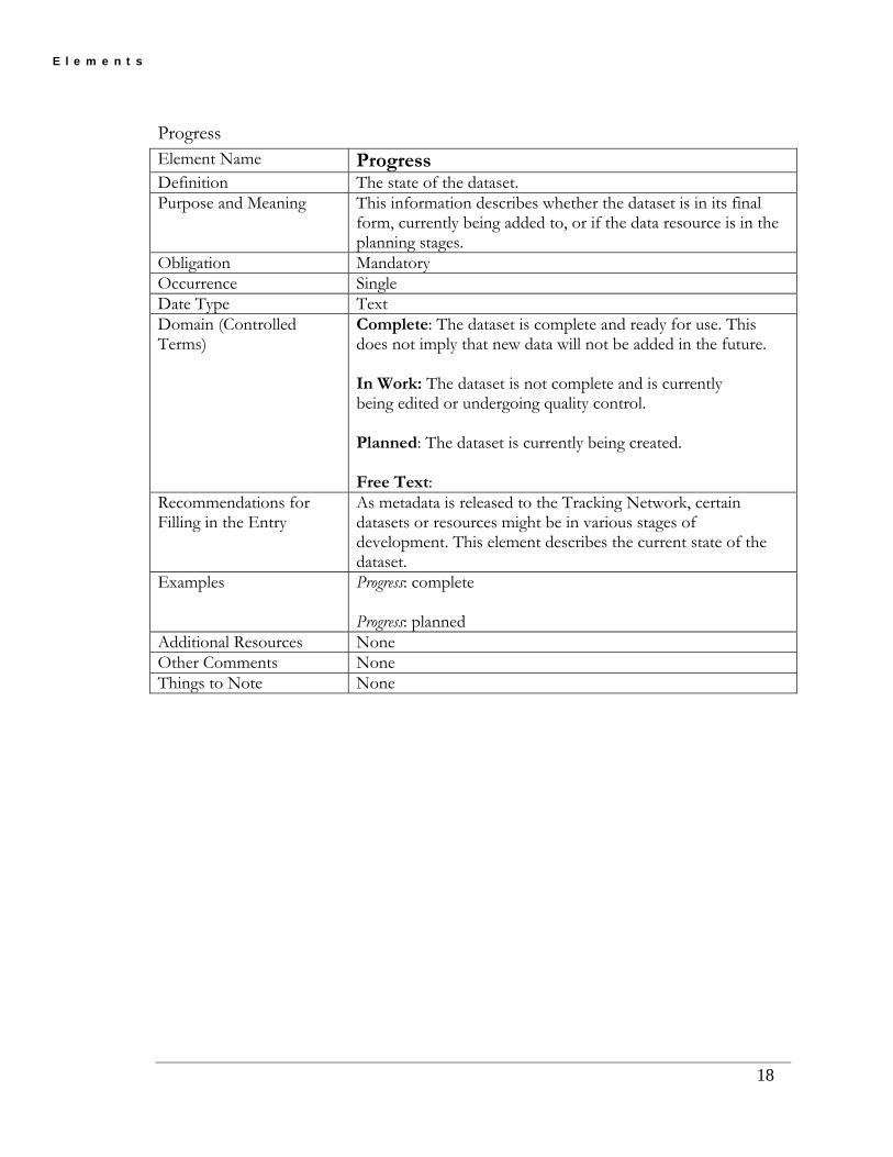
Progress Element Name Progress Definition The state of the dataset. Purpose and Meaning This information describes whether the dataset is in its final
form, currently being added to, or if the data resource is in the planning stages.
Obligation Mandatory Occurrence Single Date Type Text Domain (Controlled Terms)
Complete: The dataset is complete and ready for use. This does not imply that new data will not be added in the future. In Work: The dataset is not complete and is currently being edited or undergoing quality control. Planned: The dataset is currently being created. Free Text:
Recommendations for Filling in the Entry
As metadata is released to the Tracking Network, certain datasets or resources might be in various stages of development. This element describes the current state of the dataset.
Examples Progress: complete Progress: planned
Additional Resources None Other Comments None Things to Note None
18

E l e m e n t s
Maintenance and Update Frequency Element Name Maintenance And Update Frequency Definition The frequency that changes are made to the dataset after
the initial dataset is complete. Purpose and Meaning Use this element to provide information for Tracking
Network users as to the frequency of planned and expected updates to the described dataset.
Obligation Mandatory Occurrence Single Date Type Text Domain (Controlled Terms)
Continually Daily Weekly Monthly Quarterly Annually Unknown As needed Irregular None planned Free text
Recommendations for Filling in the Entry
The update frequency will most likely depend on the type of data. For example, air quality data might be updated daily or weekly; hospitalizations for asthma might be updated quarterly. For some final datasets, perhaps no update is planned (e.g. mortality data for 2004)
Examples See controlled terms. Additional Resources None Other Comments No definitions provided for the controlled terms, as they
were considered self-evident. Things to Note None
19

E l e m e n t s
Spatial Domain (Composite Element) Element Name West Bounding Coordinate
East Bounding Coordinate North Bounding Coordinate South Bounding Coordinate
Definition The geographic area covered by the data set. For each of the individual coordinates it is either a latitude or longitude expressed in decimal degrees. West and East Bounding Coordinates are longitude and are negative for the United States. North and South Bounding Coordinates are positive latitudes for the United States.
Purpose and Meaning The purpose of the spatial domain and its four elements is to “draw a box” around an area where data for the dataset is relevant. If a dataset is for an entire state, then a box is draw around the entire state. If a dataset contains only one county in a state, then a box is draw around only that county. For areas where there may be multiple, and potential widely dispersed, states that are part of a single dataset, a bounding box is drawn around the entire region. This may include state not included in the dataset.
The purpose of spatial domain in the Tracking Network is that that it provides a basic spatial context to a dataset. The ultimate purpose is to provide a way in later version of the Network to search and discover metadata by using a service that allows for the inactive searching for metadata using a map tool.
Obligation Mandatory Occurrence Single Date Type Numeric in decimal degrees using the North American Datum
of 1983. Domain (Controlled Terms)
-180.0 < = West Bounding Coordinate <= 180.0 -180.0 < = East Bounding Coordinate < = 180.0 -90.0 < = North Bounding Coordinate < = 90.0 -90.0 < = South Bounding Coordinate < = 90.0
Recommendations for Filling in the Entry
Without the consultation or use of GIS software, gathering-bounding coordinates can be difficult. It is recommended to initial seek help from a person familiar with geographic coordinates or have a table of bounding coordinates that will be repeatedly used for your area of interest. There is at least one freely available tool on the internet for determining basic boundary box coordinates. The additional resource section of this table provides a URL to the tool.
Use decimal degrees. Use the minimum rectangular area that completely encloses the spatial domain of the dataset (i.e., a state, county, sub-county, or multi-state area). Recommend at least 2 and no more than 4 significant digits.
20

E l e m e n t s
Examples Regional Dataset: West Bounding Coordinate: -124.9 East Bounding Coordinate: -108.79 North Bounding Coordinate: 49.35 South Bounding Coordinate: 32.02
State Dataset: West Bounding Coordinate: -117.59 East Bounding Coordinate: -110.70 North Bounding Coordinate: 49.35 South Bounding Coordinate: 41.64
Additional Resources To determine basic bounding box coordinates use the FGDC tool: http://clearinghouse1.fgdc.gov/servlet/FGDCWizard. To convert Universal Transverse Mercator (UTM) coordinates to decimal degrees use the National Geodetic Survey conversion tool: http://www.ngs.noaa.gov/cgi-bin/utm_getgp.prl. To convert local State Plane coordinates to decimal degrees use the National Geodetic Survey conversion tool: http://www.ngs.noaa.gov/cgi-bin/spc_getgp.prl.
21

E l e m e n t s
To convert latitude and longitude from degrees, minutes, and seconds format to decimal degrees use the FCC tool: http://www.fcc.gov/mb/audio/bickel/DDDMMSS-decimal.html.
Other Comments Spatial domain does not relate to the underlying geographic system of the data itself (if any) or any function of a Geographic Information System. It is always expressed in latitude and longitude using the North American Datum of 1983, and is always expressed in decimal degrees.
Things to Note None
22

E l e m e n t s
Theme Keyword Thesaurus Element Name Theme Keyword Thesaurus Definition Reference to a formally registered thesaurus or a similar
authoritative source of theme keywords. Purpose and Meaning This source of a set of keywords and phrases is used to select
the keywords that describe the content of a dataset. Obligation Mandatory Occurrence Multiple Date Type Text Domain (Controlled Terms)
Free Text: There are no controlled terms for this element
Recommendations for Filling in the Entry
Use at least, ISO 19115 Topic Category. Use other standard vocabularies/thesauri.
Examples For public health data: ISO 19115. Public Health Information Network (PHIN) Vocabulary Standards and Specifications. For environmental data: Consortium for International Earth Science Information Network (CIESIN) Indexing Vocabulary. Chemical Abstracts Service (CAS) CA Lexicon.
Additional Resources None Other Comments None Things to Note Adding at least one keyword from ISO 19115 is in compliance
with FGDC Version 3 Thesaurus work in Public Health Information Network (PHIN), Vocabulary Access and Distribution System (VADS) may provide additional information in the future. See http://www.cdc.gov/PhinVSBrowser/StrutsController.do for more information of PHIN VADS.
23

E l e m e n t s
Theme Keyword Element Name Theme Keyword Definition Topic of the content of the dataset Purpose and Meaning This is a common–use word or phrase used to describe the
general subject area of the dataset. Use a standardized set of key words and phrases to allow identification of dataset resources in any search. When users are searching for datasets, theme key words help eliminate resources that are of no interest.
Obligation Mandatory Occurrence Multiple Date Type Text Domain (Controlled Terms)
Free Text: There are no controlled terms for this element.
Recommendations for Filling in the Entry
Select terms covering the content of the dataset. Include broad and specific terms, and use controlled vocabularies/thesauri when possible. Include at least one ISO topic category referencing the ISO 19115 Thesaurus.
Examples For public health data: Cancer Birth defects Lead poisoning For environmental data: Natural Resources Toxics Ecology
Additional Resources None Other Comments None Things to Note Adding at least one keyword from ISO 19115 complies with
FGDC Version 3. See Appendix B of this Guidance Document for the ISO 19115 controlled terms. Thesaurus work in Public Health Information Network (PHIN), Vocabulary Access and Distribution System (VADS) may provide additional information in the future. See http://www.cdc.gov/PhinVSBrowser/StrutsController.do for more information of PHIN VADS.
24
E l e m e n t s
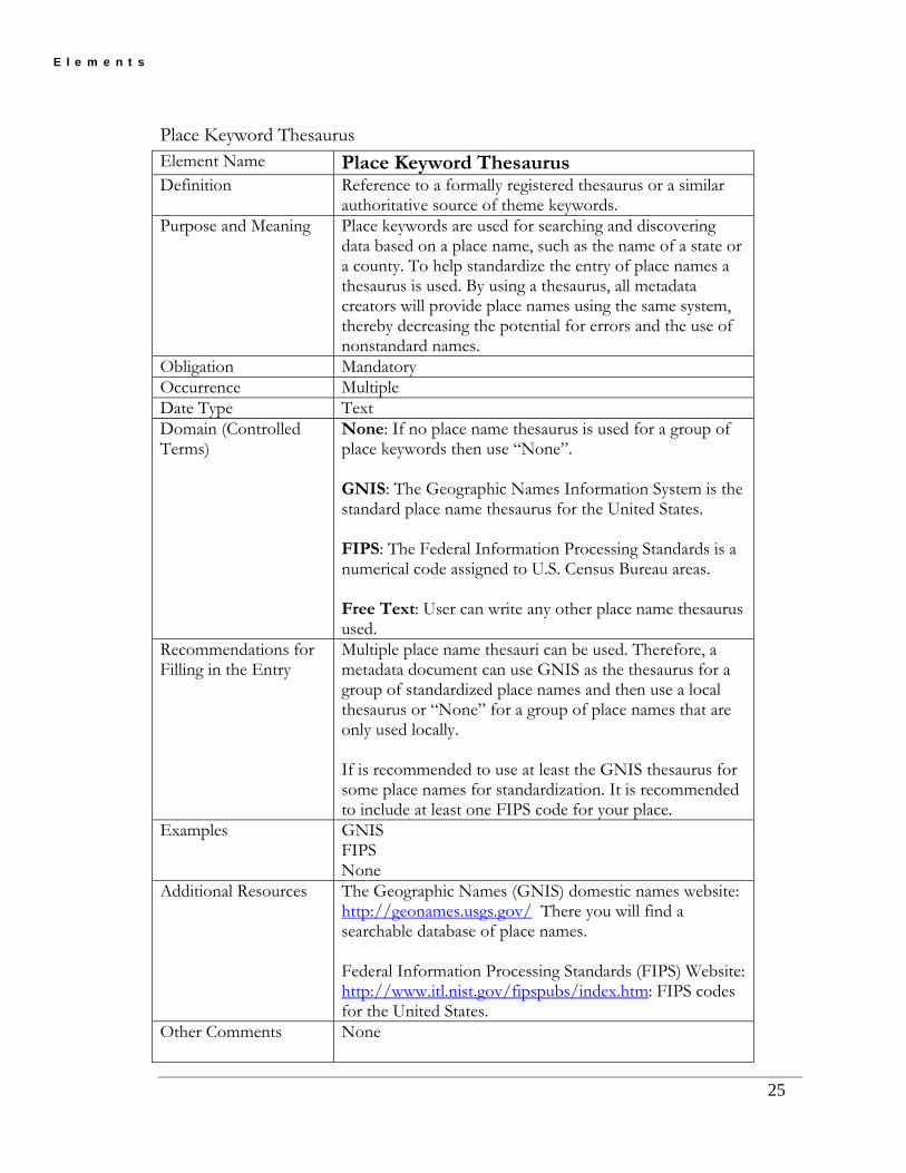
Place Keyword Thesaurus Element Name Place Keyword Thesaurus Definition Reference to a formally registered thesaurus or a similar
authoritative source of theme keywords. Purpose and Meaning Place keywords are used for searching and discovering
data based on a place name, such as the name of a state or a county. To help standardize the entry of place names a thesaurus is used. By using a thesaurus, all metadata creators will provide place names using the same system, thereby decreasing the potential for errors and the use of nonstandard names.
Obligation Mandatory Occurrence Multiple Date Type Text Domain (Controlled Terms)
None: If no place name thesaurus is used for a group of place keywords then use “None”. GNIS: The Geographic Names Information System is the standard place name thesaurus for the United States. FIPS: The Federal Information Processing Standards is a numerical code assigned to U.S. Census Bureau areas. Free Text: User can write any other place name thesaurus used.
Recommendations for Filling in the Entry
Multiple place name thesauri can be used. Therefore, a metadata document can use GNIS as the thesaurus for a group of standardized place names and then use a local thesaurus or “None” for a group of place names that are only used locally. If is recommended to use at least the GNIS thesaurus for some place names for standardization. It is recommended to include at least one FIPS code for your place.
Examples GNIS FIPS None
Additional Resources The Geographic Names (GNIS) domestic names website: http://geonames.usgs.gov/ There you will find a searchable database of place names. Federal Information Processing Standards (FIPS) Website: http://www.itl.nist.gov/fipspubs/index.htm: FIPS codes for the United States.
Other Comments None
25

E l e m e n t s
Things to Note Thesaurus work in Public Health Information Network (PHIN), Vocabulary Access and Distribution System (VADS) may provide additional information in the future. See http://www.cdc.gov/PhinVSBrowser/StrutsController.do for more information of PHIN VADS.
26

E l e m e n t s
Place Keyword Element Name Place Keyword Definition The geographic name of a location covered by a dataset
(Includes city, county, state, state acronym, regional descriptions and references.)
Purpose and Meaning Place keywords are used for searching and discovering data based on a place name, such as the name of a state or a county. These keywords can come from thesauri or from the metadata creator. Place keywords are critical to finding resources for a particular area based on searching place names. Multiple place keywords can be entered. Therefore, if this were a dataset covering a region, all the states in that region are entered as individual keyword entries.
Obligation Mandatory Occurrence Multiple Date Type Text Domain (Controlled Terms)
Free Text: There are no controlled terms for this element.
Recommendations for Filling in the Entry
Provide full geographic name, acronyms, and FIPS codes. When entering state names, enter the full state name and the two-letter acronym.
Examples Misoretah MH 59
Additional Resources None Other Comments None Things to Note None
27

E l e m e n t s
Access Constraints Element Name Access Constraints Definition Legal restrictions prerequisites for accessing the dataset. These
include any access constraints applied to assure the protection of privacy or intellectual property, and any special restrictions or limitations on obtaining the dataset.
Purpose and Meaning Used to identify any external restrictions on the access to the dataset. This usually applies to datasets that are exempt from public records laws such as endangered species, personal health, and intellectual properties. This element also provides an explanation for the security level applied to the dataset by describing the decision made for applying security restrictions.
Obligation Optional Occurrence Single Date Type Text Domain (Controlled Terms)
Free text: There are no controlled terms for this element
Recommendations for Filling in the Entry
Identify the most common access restriction. Some datasets may be restricted due to sensitivity, whereas others might be considered draft and are not ready for distribution. For any single dataset, multiple access constraints may apply. Multiple constraints are shown as separate paragraphs within the Access Constraints narrative. Multiple constraints could include state or local standard access constraint language in combination with dataset specific constraints. Include any agency approval requirements (IRB, MOA, TPA, etc.). If agency approval is required, refer the user to the application process. Also, include any technology requirements (certification download, registration into a LDAP, etc.) for access. Direct the user to the protocols for completing those requirements. If local organization that governs a dataset has published access constraints, add a URL to those document(s) to the narrative.
Examples For public health data: Data have been restricted due to the sensitive nature of the location information presented. Formal permission is required for access to this dataset. A formal IRB approval process is requirement to access this dataset. To inquire about getting IRB approval, contact the data steward listed in the Data contact section of this metadata. Additional information provided at: www.fakeurl.com/fake_instructions.html.
28
E l e m e n t s
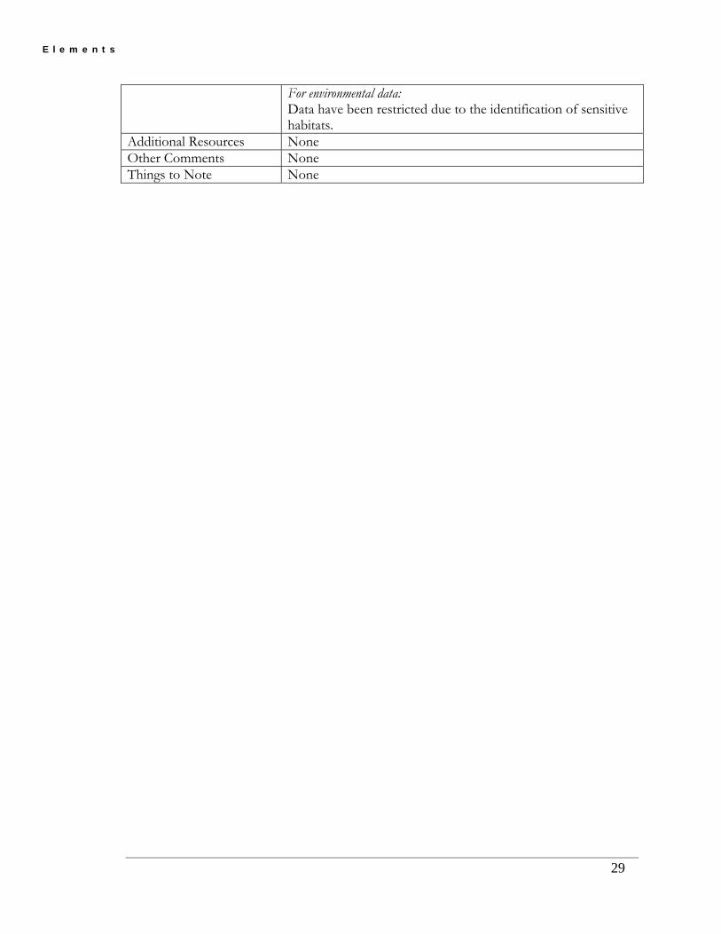
For environmental data: Data have been restricted due to the identification of sensitive habitats.
Additional Resources None Other Comments None Things to Note None
29

E l e m e n t s
Use Constraints Element Name Use Constraints Definition Restrictions and legal prerequisites for using the dataset after
access is granted. These include any use constraints applied to assure the protection of privacy or intellectual property, and any special restrictions or limitations on using the data set.
Purpose and Meaning To describe any restrictions to the usage of the data. Obligation Optional Occurrence Single Date Type Text Domain (Controlled Terms)
Free text: There are no controlled terms for this element
Recommendations for Filling in the Entry
Identify the most common use restriction. Like Access Constraints, more than one restriction may apply. Multiple use constraints can be separate documents that have information clarifying the use constraints or an URL to a document on use constraints. In some cases, the source data steward may have restrictions. For example, the source data steward may not allow their data be linked with other data that may result in identity of an individual. There may also be restrictions on using data in analysis and release of data to public. If the restriction standard is published in a public reference, then it should be mentioned here. Any licensing issues associated with use described. Add statements about inappropriate use.
Examples For public health data: Must read and fully comprehend metadata prior to data use. Acknowledgement of the Originator must be included when using the dataset as a source. Methods for collecting this data changed in 1990; therefore, data collected prior to 1990 should not be comparable to data collected after 1990. For environmental data: Data only considered accurate to 5 meters. Data should not be used at scales greater than 1:24, 000. Other: This data should not be used for any commercial gain or in support of commercial products (no implied endorsements), to direct or plan targeted advertising, etc. This data cannot be used to refute, contradict, or interfere with public health policy, programs, investigations, intervention actions, or health promotion activities.
30

E l e m e n t s
This dataset should not be linked with ___ data due to (privacy/national security/etc) concerns. This dataset links cancer data with drinking water data. It is inappropriate to use this data without understanding the limitations of the linkages made. Please consult the documentation at www.fake_website.com/fake_constraints.
Additional Resources None Other Comments None Things to Note None
31

E l e m e n t s
Point of Contact (Composite Element) Element Name Point of Contact Definition Contact information for the organization that is knowledgeable
about the dataset. Purpose and Meaning
This is the contact information for the dataset owner. The actual information entered is described in the Contact section.
Obligation Mandatory Occurrence Single Date Type Composite Element Domain (Controlled Terms?)
None
Recommendations for Filling in the Entry
Refer to the Contact section elements.
Examples None Additional Resources
None
Other Comments None Things to Note None
32

E l e m e n t s
33
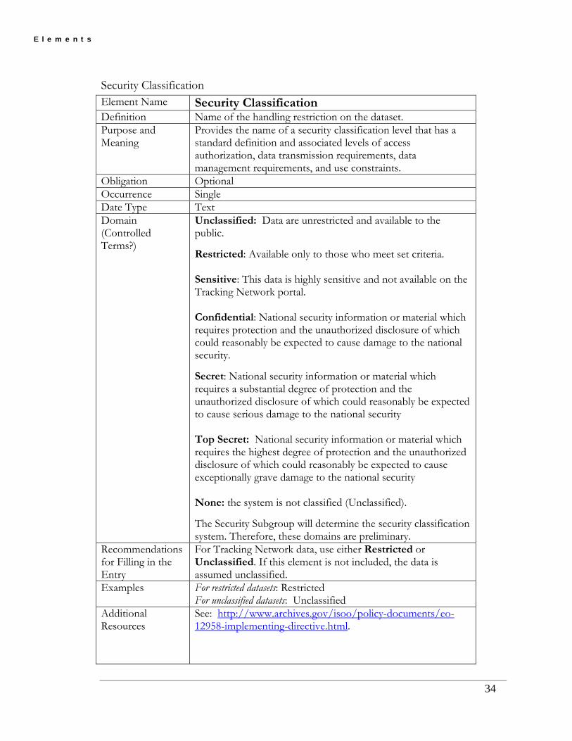
Security Classification System Element Name Security Classification System Definition Name of the security classification system used to classify this
dataset. Purpose and Meaning
Classified information is information that is sensitive in nature and is restricted for access purposes by law or regulation to classes of individuals who meet security clearance criteria. For the purposes of the Tracking Network, sensitive information is information that if misused could cause harm to subject individuals (the cases) or disrupt, hinder and prevent public health programs and activities.
Obligation Optional Occurrence Single Date Type Text Domain (Controlled Terms?)
Free Text: name of the Security Classification System. None: the system is not classified (Unclassified). Unknown: the system used is unknown The Security Subgroup will determine the security classification system. Therefore, these domains are preliminary.
Recommendations for Filling in the Entry
Only datasets that contain information that can be used to identify the subject individuals (the cases) or could be used to contradict, disrupt, hinder or prevent public health actions or programs should be classified. If the dataset does not contain sensitive information, the dataset should not be classified. If the dataset does contain this information, the classification should use the Federal Information Security Oversight Office (ISOO)’s Classified National Security Information Directive Number 1, September 22, 2003.
Examples Classified National Security Information Directive No 1. (32 CFR Parts 2001 and 2004, RIN 3095-AB18), September, 2003.
Additional Resources
See: http://www.archives.gov/isoo/policy-documents/eo-12958-implementing-directive.html. see also: CIESIN’s Guide to FGDC Compliant Metadata: 7.10 Metadata Security Information; http://sedac.ciesin.columbia.edu/metadata/guide/metadref.html see also: Dublin Core Metadata Initiative; http://dublincore.org/usage/meetings/2002/10/securityClassification.shtml
Other Comments None Things to Note None
E l e m e n t s
Security Classification Element Name Security Classification Definition Name of the handling restriction on the dataset. Purpose and Meaning
Provides the name of a security classification level that has a standard definition and associated levels of access authorization, data transmission requirements, data management requirements, and use constraints.
Obligation Optional Occurrence Single Date Type Text Domain (Controlled Terms?)
Unclassified: Data are unrestricted and available to the public. Restricted: Available only to those who meet set criteria. Sensitive: This data is highly sensitive and not available on the Tracking Network portal. Confidential: National security information or material which requires protection and the unauthorized disclosure of which could reasonably be expected to cause damage to the national security. Secret: National security information or material which requires a substantial degree of protection and the unauthorized disclosure of which could reasonably be expected to cause serious damage to the national security Top Secret: National security information or material which requires the highest degree of protection and the unauthorized disclosure of which could reasonably be expected to cause exceptionally grave damage to the national security None: the system is not classified (Unclassified). The Security Subgroup will determine the security classification system. Therefore, these domains are preliminary.
Recommendations for Filling in the Entry
For Tracking Network data, use either Restricted or Unclassified. If this element is not included, the data is assumed unclassified.
Examples For restricted datasets: Restricted For unclassified datasets: Unclassified
Additional Resources
See: http://www.archives.gov/isoo/policy-documents/eo-12958-implementing-directive.html.
34

E l e m e n t s
35
See also: CIESIN’s Guide to FGDC Compliant Metadata: 7.10 Metadata Security Information; http://sedac.ciesin.columbia.edu/metadata/guide/metadref.html See also: Dublin Core Metadata Initiative; http://dublincore.org/usage/meetings/2002/10/securityClassification.shtml
Other Comments If the dataset is classified Restricted, the Security Handling Description element will need to be completed. Access and use constraints will need to be specified in the Access Constraints element and the Use Constraints element to describe the criteria and requirements for the Restricted classification. Data not classified are assumed to be Unclassified.
Things to Note None
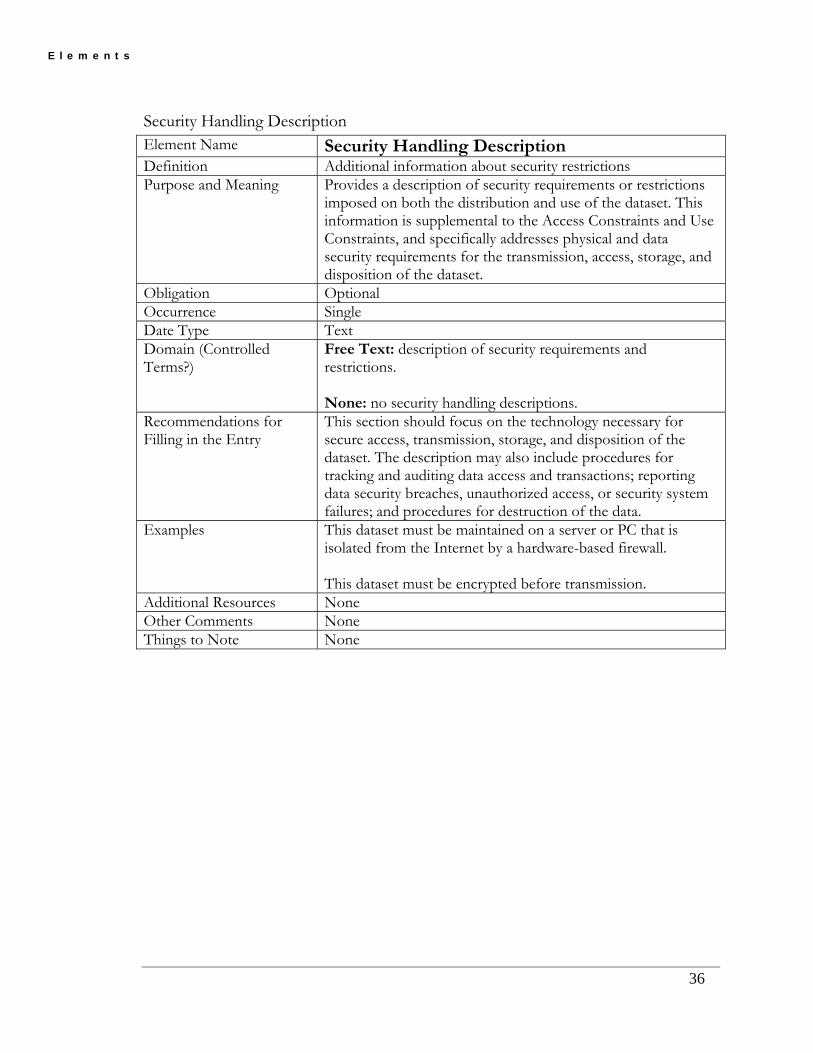
E l e m e n t s
Security Handling Description Element Name Security Handling Description Definition Additional information about security restrictions Purpose and Meaning Provides a description of security requirements or restrictions
imposed on both the distribution and use of the dataset. This information is supplemental to the Access Constraints and Use Constraints, and specifically addresses physical and data security requirements for the transmission, access, storage, and disposition of the dataset.
Obligation Optional Occurrence Single Date Type Text Domain (Controlled Terms?)
Free Text: description of security requirements and restrictions. None: no security handling descriptions.
Recommendations for Filling in the Entry
This section should focus on the technology necessary for secure access, transmission, storage, and disposition of the dataset. The description may also include procedures for tracking and auditing data access and transactions; reporting data security breaches, unauthorized access, or security system failures; and procedures for destruction of the data.
Examples This dataset must be maintained on a server or PC that is isolated from the Internet by a hardware-based firewall. This dataset must be encrypted before transmission.
Additional Resources None Other Comments None Things to Note None
36

E l e m e n t s
Native Data Set Environment Element Name Native Data Set Environment Definition Descriptions of the data set, including the name of the
software, computer operating system, file name, and data set size.
Purpose and Meaning The purpose of Native Data Set Environment is to provide basic information about a dataset’s computer environment so a user can determine if they have the software and operating system to accommodate the dataset. This information can be useful to a metadata consumer for evaluating their computer capacity.
Obligation Mandatory Occurrence Single Date Type Text Domain (Controlled Terms)
None: native data set environment known. Free Text
Recommendations for Filling in the Entry
Operating System and Version; Software and Version; File Name
Examples Microsoft Windows 2000; Microsoft Access 2003 Microsoft Windows XP; Delimited Text UNIX 03; Oracle 10g
Additional Resources None Other Comments Record the physical name of a dataset in the Resource
Description element. Things to Note None
37

E l e m e n t s
5.3 Section 2: Data Quality
Logical Consistency Report Element Name Logical Consistency Report Definition An explanation of the fidelity of relationships in the dataset and
tests used. Purpose and Meaning This element was developed to refer mostly to the geography
of the data (i.e., polygons are closed and neat line-simplified, no duplicate features exist). The FGDC also states to use it for quality assurance, quality control information such as are the X values always between ‘0’ and ‘100’? Are all ‘Y’ values text format? Does value Z always equal the sum of values ‘R’ and ‘S’?
Obligation Mandatory Occurrence Single Date Type Text Domain (Controlled Terms)
None: no logical consistency report needed.
Free Text Recommendations for Filling in the Entry
For the purposes of the Tracking Network, this should refer to a logical consistency report for the reference database(s) used to geo-reference a data set.
This may also be the place to include any measures or tests of the sensitivity/specificity/accuracy of the geo-referencing process used and how those measures were determined. Example might include percentage of missing features, percentage of feature with missing feature values, percentage of mislabeled features or feature values, etc.
NON-GEOGRAPHIC data (note: geo-referenced is not geographic) in the Network, measures of completeness and consistence should be in the “Completeness Report” element. This would apply to all health-outcome, bio-monitoring, environmental hazards, environmental monitoring, and population-based data.
Examples This single precision coverage was built for points. There have been no edits to this coverage since the last build or clean.
Point station locations verified using the 2002 Aerial Photography (1 ft).
The data set was checked for topological consistency using the Arc/INFO commands BUILD and LABELERRORS. The NAWQA polygon attribute is no longer consecutive because of study units that have merged and study units deleted.
38

E l e m e n t s
Beginning with the 2005 data release, the spatial data are built according to the following logic: All geographic identifiers are assumed to be year 1990, if they match a year 1990 county FIPS code and the year 1990 Census tract identifier. Any identifiers that do not match year 1990 data are assumed to be year 2000 identifiers if they match a year 2000 designation for the corresponding type of geographic unit (Census tract). Any identifiers that do not match either year 2000 or 1990 identifiers are assumed to predate the 1990 data, or to be erroneous. The geographic components that are associated with these identifiers are not included in the spatial data. Some polygons overlap due to inconsistencies in the source geographic data; others overlap due to errors in the source data causing a given area to be included in multiple designations simultaneously.
Additional Resources None Other Comments Logical consistency can be performed by WAMS verification
software (USGWS-NWI). Things to Note None
39

E l e m e n t s
Completeness Report Element Name Completeness Report Definition Information about omissions, selection criteria, generalization,
definitions used, and other rules used to derive the data set. Purpose and Meaning This element provides a location to describe the non-spatial
aspects of data quality. Obligation Mandatory Occurrence Single Date Type Text Domain (Controlled Terms)
None: no completeness report needed. Free Text
Recommendations for Filling in the Entry
NOTE the actual descriptions of processes are in the Process Description element. Use this section to provide measures of the process performance. Include a description of any data filtering applied (e.g., data only contains first diagnosis, first-admission, etc.) Include a description of source data incompleteness (e.g. percentage of records lacking a valid sex code). Include a description of geo-referencing accuracy. This is different that the completeness of the reference data set and should include a percentage of non-reference-able addresses and a description and ratio of data that was geo-referenced using less specific methods (e.g., to centroid). If descriptive statistics computed, describe the process used to compute those statistics. If unit conversions (e.g., Dx code to ICD10) applied, describe the capacity of the method used to compute the conversion.)
Examples Data is available for sites in the ___ and ___ area. Missing data are indicated by the code “999” in the appropriate fields. All wells measured in 1999, 2000, and 2001 are included. Public health providers located in the county of BIGCOUNTY in the state of Misoretah are not included in this dataset because the underlying site location data do not include these areas.
Additional Resources None Other Comments None Things to Note None
40

E l e m e n t s
Process Description Element Name Process Description Definition An explanation of the event and related parameters or
tolerances. Purpose and Meaning The purpose of process description is to give an indication of
how the dataset was created. It is useful in determining its fitness for purpose.
Obligation Mandatory Occurrence Multiple Date Type Text Domain (Controlled Terms)
None: no process description provided.
Free Text Recommendations for Filling in the Entry
This is a repeating element. There should be at least one process description for a metadata record. More than one process step can be added to show the history of process changes as a data set is updated. This element is closely tied to the Process Date element, which indicates the date of additional process step changes.
Processes to consider for entry into this element are: • Source material to describe where the data came from
(source media type, domains, scales, acquisition, and quality control process) – Analytical Metadata
• Process used to create the data including resolution of measurement, which includes information on:
o Translation (data transaction from source to EPHTN; conversion units to standard units)
o Geocoding and Geo-referencing (reference data, exception handling)
o Aggregation o Computation (statistical summarization)
• Methods for updating • Any quality assurance techniques
Examples Health Data: Manually entered location of Rural Health Clinics from field collected data. The Misoretah Department of Health performed address geocoding. Points edited to the database by reference to digital color infrared photography, road, and street layer. Rural Health Clinics were then provided to staff for field verification and edits were made as needed.
The county, State, and national spreadsheets containing preterm infant delivery rates were loaded into Microsoft Excel. Values for "No Population" changed to -77777, values for "No events" changed to -88888, and values for "Insufficient data" changed to -99999. The FIPS code 12025 changed to 12086. Extra blank spaces that preceded the numbers deleted. The resulting files, one for counties, one for States, and one for the
41

E l e m e n t s
nation saved to dBase IV files. Demographic group transposed the national statistics to list rates.
Environmental Data: The annual number of days that ozone levels exceeded EPA standards was summarized from the original database provided by the EPA. The original data source was for all monitoring station ozone data available in the State of Misoretah from 1996 to 2006. Each monitoring station had latitude and longitude assigned using EPA guidelines on spatial accuracy. The number of days that ozone levels exceeded EPA standards was summed for each station for each full year of data. For information on EPA ozone and ozone standards, please review the documents on the website: http://www.epa.gov/air/ozonepollution/.
For additional information on how this dataset was created, view the document at the following website: http://example.fake.wesite.com/fakereport.pdf.
Additional Resources None Other Comments None Things to Note None
42

E l e m e n t s
Process Date Element Name Process Date Definition The date when the event was completed. Purpose and Meaning The purpose of process date is to provide the date of a process
step. This date ties directly to the Process Description element. Obligation Mandatory Occurrence Multiple Date Type Date Domain (Controlled Terms)
Free Date: as complete a date as is available formatted as: YYYYMMDD, where YYYY is the four-digit year, MM is
the numeric value (1 – 12) for the month, and DD is the numeric value (01 – 31) for the day. Leave off the DD or MMDD if the month or day not known.
Unknown: the process date of this dataset is unknown
Recommendations for Filling in the Entry
Use the date of creation or modification of a process step. The first process date and its companion process description should be the date of the process if known, or the date of the creation of the metadata record that recorded the process. Subsequent process dates should reflect the date of changes to the process. The FGDC specifies that the date format is YYYMMDD
Examples Only year is known: 2007 Year and month (January) are known: 200701 Year month and day are known (January 10): 20070110
Additional Resources None Other Comments None Things to Note None
43
E l e m e n t s
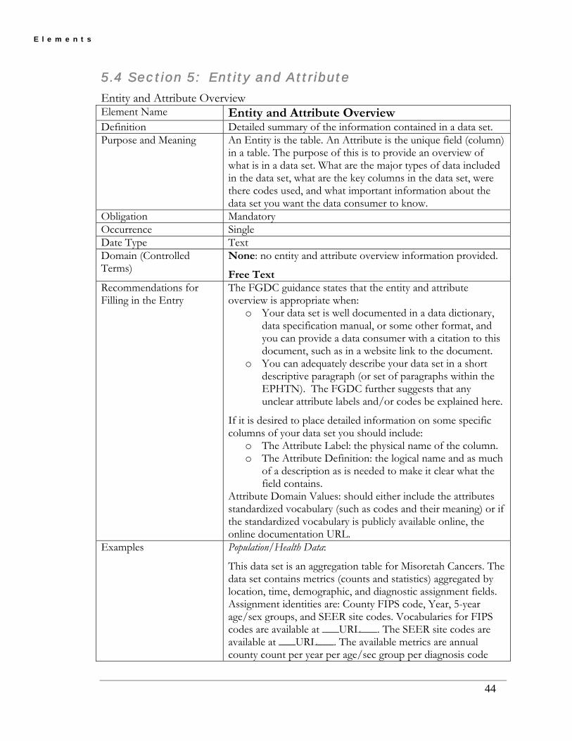
5.4 Section 5: Entity and Attribute
Entity and Attribute Overview Element Name Entity and Attribute Overview Definition Detailed summary of the information contained in a data set. Purpose and Meaning An Entity is the table. An Attribute is the unique field (column)
in a table. The purpose of this is to provide an overview of what is in a data set. What are the major types of data included in the data set, what are the key columns in the data set, were there codes used, and what important information about the data set you want the data consumer to know.
Obligation Mandatory Occurrence Single Date Type Text Domain (Controlled Terms)
None: no entity and attribute overview information provided.
Free Text Recommendations for Filling in the Entry
The FGDC guidance states that the entity and attribute overview is appropriate when:
o Your data set is well documented in a data dictionary, data specification manual, or some other format, and you can provide a data consumer with a citation to this document, such as in a website link to the document.
o You can adequately describe your data set in a short descriptive paragraph (or set of paragraphs within the EPHTN). The FGDC further suggests that any unclear attribute labels and/or codes be explained here.
If it is desired to place detailed information on some specific columns of your data set you should include:
o The Attribute Label: the physical name of the column. o The Attribute Definition: the logical name and as much
of a description as is needed to make it clear what the field contains.
Attribute Domain Values: should either include the attributes standardized vocabulary (such as codes and their meaning) or if the standardized vocabulary is publicly available online, the online documentation URL.
Examples Population/Health Data:
This data set is an aggregation table for Misoretah Cancers. The data set contains metrics (counts and statistics) aggregated by location, time, demographic, and diagnostic assignment fields. Assignment identities are: County FIPS code, Year, 5-year age/sex groups, and SEER site codes. Vocabularies for FIPS codes are available at ___URL___. The SEER site codes are available at ___URL___. The available metrics are annual county count per year per age/sec group per diagnosis code
44

E l e m e n t s
and the standard error on the count. The computational methods for those metrics are available at ___URL___.
Environmental Data: This data set portrays Air monitoring sites that showed data exceeding a national standard, with information on location, land use of location, monitor type, monitor I.D., and what monitored.
Additional Resources None Other Comments This element is closely tied to the Entity and Attribute Detail
Citation. Things to Note In the future, it may be possible to enter all information for
each column of data in a data set. Within the FGDC standard there are the elements for going column by column and include definitions, code sets, and data types. For simplicity, the current version of the EPHTN profile does not included these options. Future versions may expand to include this option.
45

E l e m e n t s
Entity and Attribute Detail Citation Element Name Entity and Attribute Detail Citation Definition Reference used to the complete description of the entity types,
attributes, and attribute values for the data set. Purpose and Meaning
The purpose of this is to provide a means to provide a web site to a document with a detailed description of the data set, including column descriptions, data types, codes used, or a formal citation that would provide a means to access such a document. Therefore, if a publicly available online data dictionary or other descriptive document exists for this dataset, reference that document’s URL here.
Obligation Mandatory Occurrence Single Date Type Text Domain (Controlled Terms)
None: no entity and attribute detail citation provided. Free Text
Recommendations for Filling in the Entry
If a URL, please include the entire URL including the http or https section of the web address. In addition, some context should be provided on what the URL covers.
Examples Health Data: The State of Misoretah’s cancer registry uses the data standards described in the data dictionary of the North American Association of Central Cancer Registries. This data dictionary, as well as other support documents describing data quality and data standards can be found at: http://www.naaccr.org/index.asp?Col_SectionKey=7&Col_ContentID=122
Environmental Data: The tables, columns, codes, and descriptions used by Misoretah Drinking Water Program are documented in the EPA, SDWIS/State data dictionary found at: https://iaspub.epa.gov/reports/rwservlet?edrreportpdf&19996
Others:
U.S. Department of Agriculture. 1975. Soil Taxonomy: A basic system of soil classification for making and interpreting soil surveys. Soil Conserv. Serv., U.S. Dep. Agric. Handb. 436.
U.S. Department of Agriculture. 1992. Keys to Soil Taxonomy. SMSS Technical Monograph No. 19. Soil Surv. Staff, Soil Conserv. Serv.
U.S. Department of Agriculture. 1993. National Soil Survey Handbook, title 430-VI. Soil Surv. Staff, Soil Conserv. Serv.
46

E l e m e n t s
Additional Resources
None
Other Comments None Things to Note This is the location for providing citations to the structure and
content of each column of data within a data set.
47

E l e m e n t s
5.5 Section 6: Distribution (The distribution section is optional can be repeating as many times as needed)
Distributor (Composite Element) Element Name Distributor Definition The party from whom the dataset may be obtained Purpose and Meaning
This is the contact information for the organization(s) to contact to obtain the dataset. This may or may not be the same as the Point of Contact. The actual information entered is described in the Contact section.
Obligation Optional (Enter if Applicable) Occurrence Single Date Type Composite Element Domain (Controlled Terms?)
None
Recommendations for Filling in the Entry
Refer to the Contact section elements.
Examples None Additional Resources
None
Other Comments None Things to Note None
48

E l e m e n t s
Resource Description Element Name Resource Description Definition The identifier by which the distributor knows the dataset. Purpose and Meaning Typically, a dataset may have a logical name and physical name.
The complete logical name is given as the dataset title in the Title element. The physical name is recorded here.
Obligation Optional Occurrence Single Date Type Text Domain (Controlled Terms?)
Free Text: The complete physical name of the dataset.
Recommendations for Filling in the Entry
This is the physical name and possible additional information such as the size of the file (for example: 32 Mb), and the file format (XML, SAS dataset, etc.). If this is a dynamically linked set of tables or files, you can provide the physical names of these tables and files as individual entries within the narrative. For an aggregation table of annual cancer case counts by SEER Site code by 5 year age/sex groups at the Census Block Group level, the physical table name might be
Examples HO_CANCER_SITE_CBG_5AS FileOne.dbf; FileTwo.dbf; total size 32 Mb. XML file; 32 Mb.
Additional Resources None Other Comments None Things to Note None
49

E l e m e n t s
Distribution Liability Element Name Distribution Liability Definition Statement of liability assumed by the distributor. Purpose and Meaning This is the distributor’s disclaimer statement. Obligation Optional Occurrence Single Date Type Text Domain (Controlled Terms?)
Free Text: Description of the distribution liability. None: no Distribution Liability
Recommendations for Filling in the Entry
The distribution liability statement is a disclaimer for liability, reliability, damages and endorsements. Persons completing this element of metadata should check with their legal services to determine if the organization has a standard statement that meets the intent of this element.
Examples “In preparation of this data, every effort has been made to offer the most current, correct, complete and clearly expressed information possible. Nevertheless, some errors in the data may exist. In particular, but without limiting anything here, the ___ (agency) ___ disclaims any responsibility for source data, compilation and typographical errors and accuracy of the information that may be contained in this data. This data does not represent the official legal version of source documents or data used to compile this data. The ___ (agency) ___ further reserves the right to make changes to this data at any time without notice.
Data compiled by the staff of the ___ (agency) ___ from a variety of source data, and are subject to change without notice. The ___ (agency) ___ makes no warranties or representations whatsoever regarding the quality, content, condition, functionality, performance, completeness, accuracy, compilation, fitness, or adequacy of the data.
By using the data, you assume all risk associated with the acquisition, use, management, and disposition of data in your information system, including any risks to your computers, software or data being damaged by any virus, software, or any other file that might be transmitted or activated during the data exchange of this data. The ___(agency)___ shall not be liable, without limitation, for any direct, indirect, special, incidental, compensatory, or consequential damages, or third-party claims, resulting from the use or misuse of the acquired data, even if the ___(agency)___ has been advised of the possibility of such potential damages or loss. Format compatibility is the user’s responsibility.
50
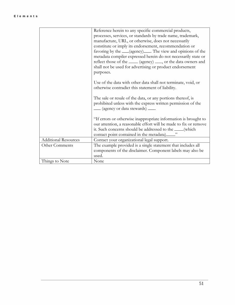
E l e m e n t s
Reference herein to any specific commercial products, processes, services, or standards by trade name, trademark, manufacture, URL, or otherwise, does not necessarily constitute or imply its endorsement, recommendation or favoring by the ___(agency)___. The view and opinions of the metadata compiler expressed herein do not necessarily state or reflect those of the ____ (agency) ___, or the data owners and shall not be used for advertising or product endorsement purposes.
Use of the data with other data shall not terminate, void, or otherwise contradict this statement of liability.
The sale or resale of the data, or any portions thereof, is prohibited unless with the express written permission of the ___ (agency or data stewards) ___.
“If errors or otherwise inappropriate information is brought to our attention, a reasonable effort will be made to fix or remove it. Such concerns should be addressed to the ____(which contact point contained in the metadata)____”
Additional Resources Contact your organizational legal support. Other Comments The example provided is a single statement that includes all
components of the disclaimer. Component labels may also be used.
Things to Note None
51

E l e m e n t s
Custom Order Process Element Name Custom Order Process Definition Description of custom distribution services, and the terms and
conditions for obtaining those services. Purpose and Meaning Use this element to provide users with instructions for ordering
datasets that may not be directly available online (for example, datasets that require approval prior to access). This element describes the process for enrolling or setting up an account on the distributors secure data access module, completing a request for data, completing the review and approval process for that data request, and accessing the data through the process.
Obligation Optional Occurrence Single Date Type Text Domain (Controlled Terms?)
None: no custom ordering process. Free Text: completely describe the custom order process.
Recommendations for Filling in the Entry
Pay close attention to needs like IRB approval and Trading Partner Agreements for ordering data.
Examples This dataset requires prior approval by the national scientific advisory board. Please access the application and guidelines at ___.
Additional Resources None Other Comments None Things to Note None
52

E l e m e n t s
5.6 Section 7: Metadata Reference
Metadata Date Element Name Metadata Date Definition The date that the metadata were created or last updated. Purpose and Meaning The date that the metadata was created or last edited. Obligation Mandatory Occurrence Single Date Type Date Domain (Controlled Terms)
Free Date: as complete a date as is available formatted as: YYYYMMDD, where YYYY is the four-digit year, MM is
the numeric value (1 – 12) for the month, and DD is the numeric value (01 – 31) for the day. Leave off the DD or MMDD if the month or day not known.
Unpublished Material: use this value for planned or pending datasets. Change this value to the actual publication date when the dataset is completed. Unknown: the developer of this dataset is unknown
Recommendations for Filling in the Entry
Use the date of creation, modification, compilation of the dataset or the date of implementation onto the Tracking Network for this date. The date range (time domain) covered by the dataset should not be used. The FGDC specifies that the date format is YYYMMDD
Examples Only year is known: 2007 Year and month (January) are known: 200701 Year month and day are known (January 10): 20070110
Additional Resources None Other Comments None Things to Note None
53
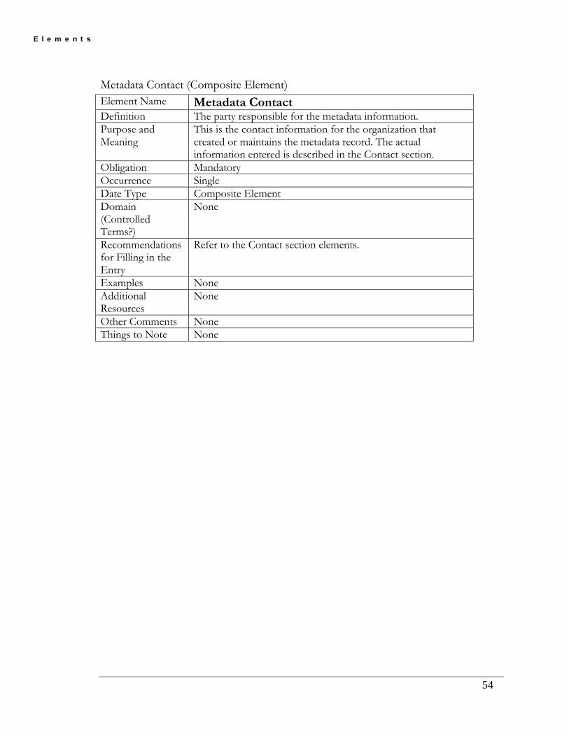
E l e m e n t s
Metadata Contact (Composite Element) Element Name Metadata Contact Definition The party responsible for the metadata information. Purpose and Meaning
This is the contact information for the organization that created or maintains the metadata record. The actual information entered is described in the Contact section.
Obligation Mandatory Occurrence Single Date Type Composite Element Domain (Controlled Terms?)
None
Recommendations for Filling in the Entry
Refer to the Contact section elements.
Examples None Additional Resources
None
Other Comments None Things to Note None
54

E l e m e n t s
55
Metadata Standard Name Element Name Metadata Standard Name Definition The name of the metadata standard used to document the data
set. Purpose and Meaning The purpose of this is to provide the name of the standard
used to create the metadata record. The user needs to know the standard to assess the information contained within.
Obligation Mandatory Occurrence Single Date Type Text Domain (Controlled Terms)
FGDC Content Standards for Digital Geospatial Metadata Free Text
Recommendations for Filling in the Entry
Recommend using “FGDC Content Standards for Digital Geospatial Metadata.”
Examples FGDC Content Standards for Digital Geospatial Metadata Additional Resources The FGDC Content Standards can be found at the following
website: http://www.fgdc.gov/standards/standards_publications/index_html
Other Comments None Things to Note None

E l e m e n t s
Metadata Standard Version Element Name Metadata Standard Version Definition Identification of the version of the metadata standard used to
document the data set. Purpose and Meaning The purpose of this is to provide the name of the standard
version used to create the metadata record. Obligation Mandatory Occurrence Single Date Type Text Domain (Controlled Terms)
EPHT Metadata Profile Version 1.2 Free Text
Recommendations for Filling in the Entry
Recommend using “EPHT Metadata Profile Version 1.2”
Examples EPHT Metadata Profile Version 1.2 Additional Resources None Other Comments None Things to Note This element was inadvertently left out of the EPHT Metadata
Creation Tool (MCT) and the EPHT Metadata Profile. Future releases will include this element. Until then, use Metadata Standard Name in the MCT.
56

E l e m e n t s
Metadata Access Constraints Element Name Metadata Access Constraints Definition Restrictions and legal prerequisites for accessing the metadata.
These include any access constraints applied to assure the protection of privacy or intellectual property, and any special restrictions or limitations on obtaining the metadata.
Purpose and Meaning Provides information on restrictions and legal prerequisites for accessing the metadata (not the data).
Obligation Mandatory Occurrence Single Date Type Text Domain (Controlled Terms)
None: There are no restrictions on the viewing of a metadata document. Authorized User: For very specific reasons, the metadata record is restricted for viewing only by persons authorized via role-based security. Restricted: For very specific reasons, the metadata record is restricted to only internal viewing of the data owners only. The metadata access constraints will be determined in the future by the Metadata and Security subgroups. Therefore, these domains are preliminary.
Recommendations for Filling in the Entry
The FGDC guidance states that with the exception of classified information and intellectual properties, the response is almost always ‘none’. Even if a data set is exempted from public record laws (endangered species locations, personal health data, etc.) the metadata is typically fully accessible.
Examples None Authorized User Restricted
Additional Resources None Other Comments The Metadata Subgroup would like to reiterate their
continued support for open and unrestricted access to metadata provided to the Tracking Network.
Things to Note None
57

E l e m e n t s
Metadata Use Constraints Element Name Metadata Use Constraints Definition Restrictions and legal prerequisites for using the metadata after
access are granted. These include any metadata use constraints applied to assure the protection of privacy or intellectual property, and any special restrictions or limitations on using the metadata.
Purpose and Meaning Restrictions and legal prerequisites for using the metadata (not the data) after access granted.
Obligation Mandatory Occurrence Single Date Type Text Domain (Controlled Terms)
None: no metadata use constraints Free Text
Recommendations for Filling in the Entry
The FGDC states that this may be applicable for the protection of privacy or intellectual properties. Note that although a dataset may be exempt from public access, the metadata seldom contains any protected information such as the location of an endangered species nesting site or the address of an AIDS patient. If there are no metadata use constraints, then this element should use “None”. If there are use constraints, these use constraints should be explicitly stated. This statement should include the reason why the metadata document use is constrained and the actual constraint on the metadata record.
Examples This metadata document is restricted to internal partners only due to … None
Additional Resources None Other Comments The Metadata Subgroup would like to reiterate their
continued support for open and unrestricted access to metadata provided to the Tracking Network.
Things to Note None
58

E l e m e n t s
5.7 Section 9: Time Period
Calendar Date Element Name Calendar Date Definition The year (optionally month or month and day). Purpose and Meaning
Provides a means of entering a single date that communicates a single date for a pertinent characteristic of the dataset (e.g. the time period represented by the data in the dataset).
Obligation Mandatory Occurrence Single Date Type Date Domain (Controlled Terms)
Unknown: the beginning date for the date range is unknown at this time Unpublished Material: the metadata references a dataset that is pending or in progress – dates in the metadata represent a time in the future – when the data referenced by the metadata is published or otherwise available, the actual beginning date should replace “unpublished material”. Free Date
Recommendations for Filling in the Entry
Dates can be filled in for year, month of year, or day of year. The recommended formats for filling in dates are: YYYY for years; YYYYMM for month of year; YYYYMMDD for day of the year
Examples The time period of coverage for a statewide childhood blood lead surveillance system that operated from 1990 to 2005: If only year is known - 1990 If only month and year are known - 199006 If day, month and year are known – 19900601
Additional Resources
FGDC Graphical Representation – Beginning Date http://www.fgdc.gov/csdgmgraphical/ideninfo/timepd/timeinfo/rnge/begind.htm
Other Comments The Calendar Date is one component of the Time Period metadata element. The Time Period element provides information on how to fill out dates and times in the sections of the metadata where this information is required. As such, the Time Period element (including Calendar Date) is not a stand-alone element, but rather a guideline for sections requiring a specific temporal reference.
Things to Note If this is a range of date and not a single date, then use Beginning Date and Ending Date elements.
59

E l e m e n t s
Time of Day Element Name Time of Day Definition The hour (and optionally minute, or minute and second) of day. Purpose and Meaning
Provides a means of entering starting time information that communicates a single time for a pertinent characteristic of the dataset (e.g. the time of day that an air-monitor takes samples at a single time of day).
Obligation Optional Occurrence Single Date Type Time Domain (Controlled Terms)
Unknown: the beginning date for the date range is unknown at this time Free time
Recommendations for Filling in the Entry
Local Time: values shall follow the 24-hour timekeeping system for local time of day in the hours, minutes, seconds, and decimal fractions of a second (to the precision desired) without separators convention: HHMMSSSS Local Time with Time Differential Factor: recording time in local time and the relationship to Universal Time (Greenwich Mean Time), values shall follow the 24-hour timekeeping system for local time of day in hours, minutes, seconds, and decimal fractions of a second (to the resolution desired) without separators convention. This value shall be followed, without separators, by the time differential factor. The time differential factor expresses the difference in hours and minutes between local time and Universal Time. It is represented by a four-digit number preceded by a plus sign (+) or minus sign (-), indicating the hours and minutes the local time is ahead of or behind Universal Time, respectively. The general form is HHMMSSSSshhmm, where HHMMSSSS is the local time using 24-hour timekeeping (expressed to the precision desired), 's' is the plus or minus sign for the time differential factor, and hhmm is the time differential factor. This option allows producers to record local time and time zone information. Universal Time (Greenwich Mean Time): recording time in Universal Time (Greenwich Mean Time), values shall follow the 24-hour timekeeping system for Universal Time of day in hours, minutes, seconds, and decimal fractions of a second (expressed to the precision desired) without separators convention, with the upper case letter "Z" directly following the low-order (or extreme right hand) time element of the 24-hour clock time expression. The general form is HHMMSSSSZ, where HHMMSSSS is Universal Time using 24-hour timekeeping, and Z is the letter "Z".
60

E l e m e n t s
61
Examples Intermittent air monitor takes a single sample at 4:12:34 am EST (shown in local time): Hours only: 04 Hours and minutes: 0412 Hours and minutes and seconds: 041234
Additional Resources
FGDC Graphical Representation – Beginning Time http://www.fgdc.gov/csdgmgraphical/ideninfo/timepd/timeinfo/rnge/begint.htm
Other Comments The Time of Day is one component of the Time Period metadata element. The Time Period element provides information on how to fill out dates and times in the sections of the metadata where this information is required. As such, the Time Period element (including Time of Day) is not a stand-alone element, but rather a guideline for sections requiring a specific temporal reference.
Things to Note If this is a range of date and not a single date, then use Beginning Time and Ending Time elements that are part of the Beginning Date and Ending Date elements.

E l e m e n t s
62
Beginning Date Element Name Beginning Date Definition The first year (optionally month or month and day) of the
event. Purpose and Meaning
Provides a means of entering starting date information that communicates a date range (starting and ending dates) for a pertinent characteristic of the dataset (e.g. the time period represented by the data in the dataset). Used in conjunction with Ending Date to specify the time period of the characteristic specified.
Obligation Mandatory Occurrence Single Date Type Date Domain (Controlled Terms)
Unknown: the beginning date for the date range is unknown at this time Unpublished Material: the metadata references a dataset that is pending or in progress – dates in the metadata represent a time in the future – when the data referenced by the metadata is published or otherwise available, the actual beginning date should replace “unpublished material”. Free Date
Recommendations for Filling in the Entry
Dates can be filled in for year, month of year, or day of year. The recommended formats for filling in dates are: YYYY for years; YYYYMM for month of year; YYYYMMDD for day of the year
Examples The time period of coverage for a statewide childhood blood lead surveillance system that operated from 1990 to 2005: If only year is known: 1990 If only month and year are known: - 199006 If day, month and year are known: 19900601
Additional Resources
FGDC Graphical Representation – Beginning Date http://www.fgdc.gov/csdgmgraphical/ideninfo/timepd/timeinfo/rnge/begind.htm
Other Comments The Beginning Date is one component of the Time Period metadata element. The Time Period element provides information on how to fill out dates and times in the sections of the metadata where this information is required. As such, the Time Period element (including Beginning Date) is not a stand-alone element, but rather a guideline for sections requiring a specific temporal reference.
Things to Note If this is for a single date then use the Calendar Date element.

E l e m e n t s
Beginning Time Element Name Beginning Time Definition The first hour (and optionally minute, or minute and second) of
the day for the event. Purpose and Meaning
Provides a means of entering starting time information that communicates a time range (starting and ending times) for a pertinent characteristic of the dataset (e.g. the time of day that an air-monitor taking intermittent samples took its first sample). Used in conjunction with Ending Time to specify the time period of the characteristic specified.
Obligation Optional Occurrence Single Date Type Time Domain (Controlled Terms)
Unknown: the beginning date for the date range is unknown at this time
Free time Recommendations for Filling in the Entry
Local Time: values shall follow the 24-hour timekeeping system for local time of day in the hours, minutes, seconds, and decimal fractions of a second (to the precision desired) without separators convention: HHMMSSSS
Local Time with Time Differential Factor: recording time in local time and the relationship to Universal Time (Greenwich Mean Time), values shall follow the 24-hour timekeeping system for local time of day in hours, minutes, seconds, and decimal fractions of a second (to the resolution desired) without separators convention. This value shall be followed, without separators, by the time differential factor. The time differential factor expresses the difference in hours and minutes between local time and Universal Time. It is represented by a four-digit number preceded by a plus sign (+) or minus sign (-), indicating the hours and minutes the local time is ahead of or behind Universal Time, respectively. The general form is HHMMSSSSshhmm, where HHMMSSSS is the local time using 24-hour timekeeping (expressed to the precision desired), 's' is the plus or minus sign for the time differential factor, and hhmm is the time differential factor. This option allows producers to record local time and time zone information.
Universal Time (Greenwich Mean Time): recording time in Universal Time (Greenwich Mean Time), values shall follow the 24-hour timekeeping system for Universal Time of day in hours, minutes, seconds, and decimal fractions of a second (expressed to the precision desired) without separators convention, with the upper case letter "Z" directly following the low-order (or extreme right hand) time element of the 24-hour clock time expression. The general form is HHMMSSSSZ, where HHMMSSSS is Universal Time using 24-hour timekeeping, and Z is the letter "Z".
63

E l e m e n t s
64
Examples Intermittent air monitor took its first sample of the day at 4:12:34 am EST (shown in local time): Hours only: 04 Hours and minutes: 0412 Hours and minutes and seconds: 041234
Additional Resources
FGDC Graphical Representation – Beginning Time http://www.fgdc.gov/csdgmgraphical/ideninfo/timepd/timeinfo/rnge/begint.htm
Other Comments The Beginning Time is one component of the Time Period metadata element. The Time Period element provides information on how to fill out dates and times in the sections of the metadata where this information is required. As such, the Time Period element (including Beginning Time) is not a stand-alone element, but rather a guideline for sections requiring a specific temporal reference.
Things to Note If this is for a single date then use the Time of Day element that is part of the Calendar Date element.

E l e m e n t s
65
Ending Date Element Name Ending Date Definition The last year (and optionally month, or month and day) for the
event. Purpose and Meaning
Provides a means of entering ending date information that communicates a date range (starting and ending dates) for a pertinent characteristic of the dataset (e.g. the time period represented by the data in the dataset). Used in conjunction with Beginning Date to specify the time period of the characteristic specified.
Obligation Mandatory Occurrence Single Date Type Date Domain (Controlled Terms)
Unknown: the ending date for the date range is unknown at this time Present: indicates that the ending date of the dataset has not yet been reached, and the data is currently being compiled. This should be replaced by an actual date in the event that on-going data collection is terminated. Free date
Recommendations for Filling in the Entry
Dates can be filled in for year, month of year, or day of year. The recommended formats for filling in dates are: YYYY for years; YYYYMM for month of year; YYYYMMDD for day of the year
Examples The time period of coverage for a statewide childhood blood lead surveillance system that continues to operate: Present The time period of coverage for a statewide childhood blood lead surveillance system that operated from 1990 to 2005 and has discontinued on-going data collection: If only year is known: 2005 If only month and year are known: 200506 If day, month and year are known: 20050601
Additional Resources
FGDC Graphical Representation – Ending Date http://www.fgdc.gov/csdgmgraphical/ideninfo/timepd/timeinfo/rnge/endingd.htm
Other Comments The Ending Date is one component of the Time Period metadata element. The Time Period element provides information on how to fill out dates and times in the sections of the metadata where this type of information is required. As such, the Time Period element (including Ending Date) is not a stand-alone element, but rather a guideline for sections requiring a specific temporal reference.
Things to Note If this is for a single date then use the Calendar Date element.

E l e m e n t s
Ending Time Metadata Element Name
Ending Time
Definition The last hour (and optionally minute, or minute and second) of the day for the event.
Purpose and Meaning
Provides a means of entering ending time information for a data element that communicates a time range (starting and ending times) for a pertinent characteristic of the dataset (e.g. the time of day that an air-monitor taking intermittent samples took its last sample). Used in conjunction with Beginning Time to specify the time period of the characteristic specified.
Obligation Optional Occurrence Multiple Date Type Time Domain (Controlled Terms?)
Unknown – the beginning date for the date range is unknown at this time Free time
Recommendations for Filling in the Entry
-Local Time - values shall follow the 24-hour timekeeping system for local time of day in the hours, minutes, seconds, and decimal fractions of a second (to the precision desired) without separators convention: HHMMSSSS -Local Time with Time Differential Factor. Recording time in local time and the relationship to Universal Time (Greenwich Mean Time), values shall follow the 24-hour timekeeping system for local time of day in hours, minutes, seconds, and decimal fractions of a second (to the resolution desired) without separators convention. This value shall be followed, without separators, by the time differential factor. The time differential factor expresses the difference in hours and minutes between local time and Universal Time. It is represented by a four-digit number preceded by a plus sign (+) or minus sign (-), indicating the hours and minutes the local time is ahead of or behind Universal Time, respectively. The general form is HHMMSSSSshhmm, where HHMMSSSS is the local time using 24-hour timekeeping (expressed to the precision desired), 's' is the plus or minus sign for the time differential factor, and hhmm is the time differential factor. This option allows producers to record local time and time zone information. -Universal Time (Greenwich Mean Time). Recording time in Universal Time (Greenwich Mean Time), values shall follow the 24-hour timekeeping system for Universal Time of day in hours, minutes, seconds, and decimal fractions of a second (expressed to the precision desired) without separators convention, with the upper case letter "Z" directly following the low-order (or extreme right hand) time element of the 24-hour clock time expression. The general form is HHMMSSSSZ, where HHMMSSSS is Universal Time using 24-hour timekeeping, and Z is the letter "Z".
66

E l e m e n t s
67
Examples Intermittent air monitor took its last sample of the day at 11:48:02 pm EST (shown in local time): Hours only: 23 Hours and minutes: 2348 Hours and minutes and seconds: 234802
Additional Resources
FGDC Graphical Representation – Ending Time http://www.fgdc.gov/csdgmgraphical/ideninfo/timepd/timeinfo/rnge/endingt.htm
Other Comments The Ending Time is one component of the Time Period metadata element. The Time Period element provides information on how to fill out dates and times in the sections of the metadata where this information is required. As such, the Time Period element (including Ending Time) is not a stand-alone element, but rather a guideline for sections requiring a specific temporal reference.
Things to Note None

E l e m e n t s
Section 10: Contact
Contact Organization Element Name Contact Organization Definition The name of the organization(s) that developed the data set. Purpose and Meaning Provides the full name of the organization that is associated
with the development of the dataset. It is used in cases where the association of the organization to the dataset is more significant than the association of the person to the dataset. In the case of organizations where there is clearly a hierarchy present, list the parts of the hierarchy from largest to smallest, separated by full stops and a space.
Obligation Mandatory Occurrence Single Date Type Text Domain (Controlled Terms)
Free Text: there are no controlled terms for this element. User can write any information that is in accordance to their organization’s naming policy.
Recommendations for Filling in the Entry
Recommend including the complete name of the organization.
Examples New York State Department of Health. Bureau of Environmental and Occupational Epidemiology
Additional Resources None Other Comments None Things to Note None
68

E l e m e n t s
Contact Person Element Name Contact Person Definition The name of the individual to which the contact applies. Purpose and Meaning Provides the full name of the individual that is associated
with the development of the dataset. Obligation Optional Occurrence Single Date Type Text Domain (Controlled Terms)
Free Text: there are no controlled terms for this element. User can write any information that is in accordance to their organization’s naming policy.
Recommendations for Filling in the Entry
While included as part of the EPHT Metadata Profile, the Tracking Network will only use the Organization (corporate) contact because personal contact information within federal systems is Information in Identifiable Form (IIF) and is subject to additional security procedures.
Examples Firstname Lastname Additional Resources None Other Comments None Things to Note None
69

E l e m e n t s
Contact Position Element Name Contact Position Definition The title of the individual (if applicable) who is the
reprehensive of the organization(s) that developed the dataset. Purpose and Meaning Provides the full position title of the individual who represents
the organization that developed the dataset. Obligation Optional Occurrence Single Date Type Text Domain (Controlled Terms)
Free Text: there are no controlled terms for this element. User can write any information that is in accordance to their organization’s position title policy.
Recommendations for Filling in the Entry
Recommend including the complete position title of the individual named as contact person for the dataset.
Examples Program Research Specialist –III GIS Analyst
Additional Resources None Other Comments None Things to Note None
70

E l e m e n t s
Address Type Element Name Address Type Definition Type of address of the organization(s) that developed the
dataset. Purpose and Meaning To identify if the address provided in the “contact address”
section is mailing or physical or mailing and physical address of the organization(s) that developed the dataset.
Obligation Mandatory Occurrence Single Date Type Text Domain (Controlled Terms)
Mailing: the address is only used for mail delivery such as PO Box addresses. Physical: The address is of actual office location of the organization(s) that developed the dataset and there is a separate/different address for receiving the mail. Mailing and Physical: the address is used both for receiving the mail and is actual office location of the organization(s) that developed the dataset. Free Text: user can write any other information if the prior three domains do not describe their address type adequately.
Recommendations for Filling in the Entry
None
Examples If the address provided in metadata is State Department of Health, PO Box 100, Albany, NY 12345; then select “mailing” If the address provided in metadata is State Department of Health, Room 99, 100 State Street, Albany, NY 12345 and mailing address is not the same, then select “physical”. If the same address receives mail (State Department of Health, Room 99, 100 State Street, Albany, NY 12345) then select “mailing and physical”.
Additional Resources None Other Comments None Things to Note None
71

E l e m e n t s
Address Element Name Address Definition Contact address for organization that developed the dataset. Purpose and Meaning
To provide the physical and/or mailing address of a contact.
Obligation Mandatory Occurrence Single. Date Type Text Domain (Controlled Terms)
Free Text: there are no controlled terms for this element. User can write any information that is in accordance to their address type mentioned in “address type” field.
Recommendations for Filling in the Entry
It is recommended to include the street number and name (pre-directional, suffix, and post-directional as appropriate), post office box number, rural or highway contract route and box number), and secondary descriptor and number (e.g., suite or room number, floor) if needed.
Examples 90 State St. W. has four address components -- the street number “90”; the street name “State”; the street type “St.”; and the street direction “W.”
Additional Resources
http://www.usps.com/ncsc/lookups/usps_abbreviations.html#suffix Official United States Postal Service street suffixes http://www.usps.com/ncsc/lookups/usps_abbreviations.html#secunitdesig Official United States Postal Service secondary unit designators
Other Comments None Things to Note None
72

E l e m e n t s
City Element Name City Definition City name for contact address of the organization(s) that
developed the dataset. Purpose and Meaning Provides the name of city where the organization that
developed the dataset wants to accept physical mail. Obligation Mandatory Occurrence Single Date Type Text Domain (Controlled Terms)
Free Text: there are no controlled terms for this element. User can write any information that is in accordance to their address type mentioned in “address type” field.
Recommendations for Filling in the Entry
Recommend including the complete city name.
Examples New York City Additional Resources None Other Comments None Things to Note None
73

E l e m e n t s
State or Province Element Name State or Province Definition State or province for contact address of the organization(s) that
developed the dataset. Purpose and Meaning
Provides the name of state/province where the organization that developed the dataset wants to accept physical mail.
Obligation Mandatory Occurrence Single. Date Type Text Domain (Controlled Terms)
Free Text: there are no controlled terms for this element. User can write any information that is in accordance to their address type mentioned in “address type” field. Use the full state name or abbreviated name of state/province.
Recommendations for Filling in the Entry
Recommend including the complete state/province name.
Examples New York or NY; Ontario or ON Additional Resources
http://www.usps.com/ncsc/lookups/usps_abbreviations.html#states Official United Sates Postal Service abbreviations
Other Comments None Things to Note None
74
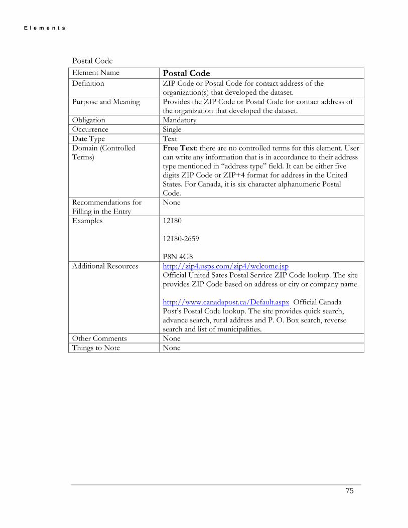
E l e m e n t s
Postal Code Element Name Postal Code Definition ZIP Code or Postal Code for contact address of the
organization(s) that developed the dataset. Purpose and Meaning Provides the ZIP Code or Postal Code for contact address of
the organization that developed the dataset. Obligation Mandatory Occurrence Single Date Type Text Domain (Controlled Terms)
Free Text: there are no controlled terms for this element. User can write any information that is in accordance to their address type mentioned in “address type” field. It can be either five digits ZIP Code or ZIP+4 format for address in the United States. For Canada, it is six character alphanumeric Postal Code.
Recommendations for Filling in the Entry
None
Examples 12180 12180-2659 P8N 4G8
Additional Resources http://zip4.usps.com/zip4/welcome.jsp Official United Sates Postal Service ZIP Code lookup. The site provides ZIP Code based on address or city or company name. http://www.canadapost.ca/Default.aspx Official Canada Post’s Postal Code lookup. The site provides quick search, advance search, rural address and P. O. Box search, reverse search and list of municipalities.
Other Comments None Things to Note None
75

E l e m e n t s
Country Element Name Country Definition Name of Country for contact address of the organization(s)
that developed the dataset. Purpose and Meaning Provides the name of Country where the organization that
developed the dataset wants to accept physical mail. Obligation Mandatory Occurrence Single Date Type Text Domain (Controlled Terms)
Free Text: there are no controlled terms for this element. User can write any information that is in accordance to their address type mentioned in “address type” field.
Recommendations for Filling in the Entry
None
Examples USA Canada
Additional Resources None Other Comments None Things to Note None
76

E l e m e n t s
Contact Telephone Number Element Name Contact Telephone Number Definition Contact voice telephone number of the organization(s) that
developed the dataset. Purpose and Meaning Provides the contact telephone number by which dataset user
can speak to an individual to find more information or answer to any question related to the dataset.
Obligation Mandatory Occurrence Single Date Type Text Domain (Controlled Terms)
Free Text: there are no controlled terms for this element.
Recommendations for Filling in the Entry
Recommend including the country code, area code, and telephone number.
Examples 1 518 402 7990 Additional Resources None Other Comments None Things to Note None
77

E l e m e n t s
Contact TDD/TTY Telephone Element Name Contact TDD/TTY Telephone Definition Contact telephone number by which hearing-impaired
individuals can contact the organization(s) that developed the dataset.
Purpose and Meaning Provides the contact telephone number by which hearing-impaired dataset user can communicate with an individual to find more information or answer to any question related to the dataset.
Obligation Optional Occurrence Single Date Type Text Domain (Controlled Terms)
Free Text: there are no controlled terms for this element.
Recommendations for Filling in the Entry
Recommend including the complete country code, area code, and telephone number.
Examples 1 518 402 7960 Additional Resources None Other Comments None Things to Note None
78

E l e m e n t s
Contact FAX Number Element Name Contact FAX Number Definition Contact telephone number of a facsimile machine of the
organization. Purpose and Meaning Provides the contact telephone number of a facsimile machine
by which data user can contact the organization(s) that developed the dataset.
Obligation Optional Occurrence Single Date Type Text Domain (Controlled Terms)
Free Text: there are no controlled terms for this element.
Recommendations for Filling in the Entry
Recommend including the complete country code, area code, and telephone number.
Examples 1 518 402 7959 Additional Resources None Other Comments None Things to Note None
79

E l e m e n t s
80
Contact E-mail Address Element Name Contact E-mail Address Definition Contact electronic mailbox address of the organization. Purpose and Meaning Provides the contact electronic mailbox address that data user
can contact the organization(s) that developed the dataset. Obligation Optional Occurrence Single Date Type Text Domain (Controlled Terms)
Free Text: there are no controlled terms for this element.
Recommendations for Filling in the Entry
None
Examples [email protected]
Additional Resources None Other Comments None Things to Note None

E l e m e n t s
Hours of Service Element Name Hours of Service Definition Time period when individuals can speak to the organization. Purpose and Meaning Provides the information about days and time period when
data user can speak to the organization(s) that developed the dataset.
Obligation Optional Occurrence Single Date Type Text Domain (Controlled Terms)
Free Text: there are no controlled terms for this element.
Recommendations for Filling in the Entry
Recommend including the days, time, and time zone information.
Examples Monday to Friday between 1:00 PM to 3:00 PM (Eastern Standard Time) Monday and Wednesday Between 9:00 AM to 11:00 AM EST
Additional Resources None Other Comments None Things to Note None
81

E l e m e n t s
82
Contact Instructions Element Name Contact Instructions Definition Supplemental instructions on how or when to contact the
organization listed under the contact address. Purpose and Meaning Provides the information about how or when the data users
can contact the organization(s) that developed the dataset. Obligation Optional Occurrence Single Date Type Text Domain (Controlled Terms)
Free Text: there are no controlled terms for this element.
Recommendations for Filling in the Entry
Recommend including the detailed instructions, if any, for the users to follow before contacting the organization that developed the dataset.
Examples Contact data center Send any request to the agency by e-mail at the address listed under contact e-mail. For questions related to the data set access please contact the data center by e-mail at the address listed under contact e-mail and for all other data quality related questions please contact the Data Center by calling the number listed under contact telephone number between the service hours listed above. You can also send your questions /comments by fax at the number listed under contact fax number.
Additional Resources None Other Comments None Things to Note None

E X A M P L E S
Chapter
6 Chapter 6: Examples of Metadata Records
6.1 Cancer Dataset
Misoretah Cancer Counts by Site, Year, County, and Age-Sex Group
Theme keywords: Human, Health, Cancer
Abstract: This data set contains annual cancer case counts for primary cancers occurring among Misoretah residents aggregated by major cancer sites, by five year age-sex groupings, for each county in the State of Misoretah from 1973 through 2004. The cancer data was obtained from the Misoretah Cancer Registry and aggregated by the Misoretah Environmental Public Health Tracking Network. Population data were obtained from commercially available census data and estimated by linear regression for intercensal years.
EPHT Metadata:
• Identification Information
• Data Quality Information
• Entity and Attribute Information
• Distribution Information
• Metadata Reference Information
Identification Information:
Citation: Citation information: Originators: The Misoretah Environmental Public Health Tracking Program (comp.), Environmental Epidemiology Program, Bureau of Epidemiology, Misoretah Department of Health
83

E X A M P L E S
Title: Misoretah Cancer Counts by Site, Year, County, and Age-Sex Group
Publication date: 200612
Online linkage:
Description: Abstract: This data set contains annual cancer case counts for primary cancers occurring among Misoretah residents aggregated by major cancer sites, by five year age-sex groupings, for each county in the State of Misoretah from 1973 through 2004. The cancer data was obtained from the Misoretah Cancer Registry and aggregated by the Misoretah Environmental Public Health Tracking Network. Population data were obtained from commercially available census data and estimated by linear regression for intercensal years. Purpose: This data provides public health researchers, professionals, and the pubic with summary information about the rates of cancer by major site classifications. Supplemental information: The Misoretah Cancer Registry (MCR) site codes were used as the major site aggregation code. Those codes are a modification of the National Cancer Institute (NCI): Surveillance, Epidemiology and End Results (SEER) program codes. Further information about the MCR can be found at: http://uuhsc.Misoretah.edu/MCR/. Only primary diagnosis cases are included. Cases of secondary or subsequent cancers have been excluded. The MCR provide the Misoretah EPHTN with annual updates after the MCR has validated the quality of the data and submitted to the SEER. The Misoretah EPHTN processes the data for geo-referencing and aggregation codes, before publishing a new cumulative aggregation data set. Records with counts less than 10 have been masked. The MCR serves as the official repository for statewide cancer data per the Misoretah Cancer Reporting Rule, R384-100, and a memorandum of Agreement between the Misoretah Department of Health and the University of Misoretah. The MCR operates as one of several population-based cancer registries under contract to the Surveillance, Epidemiology, and End Results (SEER) Program of the National Cancer Institute. The MCR follows the SEER data standards to provide high quality information on time trends in cancer incidence and survival rates for the nation. The MCR collects complete, timely and accurate cancer incidence, treatment and survival data for all SEER-reportable cancer cases in Misoretah. The Misoretah Environmental Public Health Tracking Network (MEPHTN) obtains data from the MCR. The MEPHTN processed MCR data to create this dataset. In creating this dataset, the MEPHTN implemented MCR aggregation and data use requirements. Time period of content: Time period information: Range of dates/times: Beginning date: 197301 Ending date: 200412 Currentness reference: Publication Date Status: Progress: Complete
84

E X A M P L E S
Maintenance and update frequency: Annually Spatial domain: Bounding coordinates: West bounding coordinate: -114.042925 East bounding coordinate: -109.041501 North bounding coordinate: 42.001718 South bounding coordinate: 36.997693 Keywords: Theme: Theme keywords: Human, Health, Cancer Theme keyword thesaurus: ISO 19115 Topic Category Thesaurus Place: Place keywords: Misoretah, MZ, 49 Place keyword thesaurus: Geographic Names Information (GNIS) http://geonames.usgs.gov/domestic/index.html Place keyword thesaurus: Federal Information Processing Standards (FIPS) http://www.itl.nist.gov/fipspubs/by-num.htm FIPS PUB 5-2 Codes for the Identification of the States, The District of Columbia and the Outlying Areas of the United States, and Associated Areas. http://www.itl.nist.gov/fipspubs/fip5-2.htm Access constraints: This data is publicly available. Use constraints: NO-USE: This data may not be used in any way to imply MCR or Misoretah Department of Health (MDOH) endorsement of any research objective, commercial or for-profit venture or to advertise or support a commercial product, or to direct or plan targeted advertising. This data may not be used to refute, contradict or interfere with public health policy, programs, investigations, intervention actions or health promotion activities conducted by the MCR or its agencies or any Misoretah State government agency or any local government public health agency in Misoretah. This data may not be used to identify subjects of cancer case information or the individual or organization who reported the cancer case information. PUBLICATION: The data user will comply with Misoretah Cancer Registry (MCR) rules for publication or presentation of this data or any results derived from this data. Publication approval of any manuscript or document must be accomplished prior to submission for publication. Data users will provide a copy of any publication draft or public presentation of this data or results derived from this data to the Misoretah Environmental Public Health Tracking Network (MEPHTN) that will coordinate MEPHTN and MCR approval to publish or present. See contact information in this metadata. The MCR requires 30 days to approve draft publications. The MCR will provide a response in writing to the data user. RIGHT TO REFUSAL: The MCR and/or the MEPHTN retain the right to refusal for any publication or public presentation of the data or results derived from the data. ACKNOWLEDGEMENT: Use of this data requires acknowledgement of the Misoretah Cancer Registry (MCR) and the Misoretah Environmental Public Health Tracking Network (MEPHTN) in any publications or public presentations of the data or results derived from the data. Acknowledgement must be made that the research was supported by the Misoretah Cancer Registry, which is funded by Contract Number N01-PC-35141 form the National Cancer Institute with additional support from the Misoretah Department of Health and the University of Misoretah. Acknowledgement must be made that the research was supported by the Misoretah Environmental
85

E X A M P L E S
Public Health Tracking Network, which is partially funded by the Centers for Disease Control and Prevention. AUTHORSHIP: Authorship is required when either the MCR or the MEPHTN makes substantial contribution to the data. AUDITS: The MCR and/or the MEPHTN retain the right to conduct on-site audits of the researcher with or without cause. Audits will be conducted after notification and during normal business hours by representatives of the MCR or MEPHTN. The audit will observe research practices for protecting data. REPORTS: Data users must submit annual and final reports regarding the progress and or completion of research projects to the MCR. This will be done through the MEPHTN. Point of contact: Contact information: Contact organization primary: Contact organization: The Misoretah Environmental Public Health Tracking Program Contact position: Manager, Environmental Epidemiology Program Contact address: Address type: mailing and physical address Address: 1234 Anyplace Street City: Somewhere City State or province: Misoretah Postal code: 97531 Country: USA Contact voice telephone: 123.456-7890 Contact TDD/TTY telephone: Contact facsimile telephone: 123.456-0987
Contact electronic mail address: [email protected]
Hours of service: 9:00 AM - 4:00 PM, Pacific Mountain Time Contact instructions: Security information: Security classification system: None Security classification: Unclassified Security handling description: This data may be freely distributed. However, the use constraints apply to all recipients of this data. Native data set environment: LINUX; Oracle 10e
Back to Top
Data Quality Information:
Logical consistency report:
86
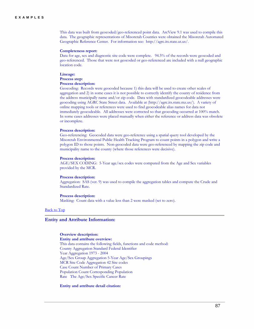
E X A M P L E S
This data was built from geocoded/geo-referenced point data. ArcView 9.1 was used to compile this data. The geographic representations of Misoretah Counties were obtained the Misoretah Automated Geographic Reference Center. For information see: http://agrc.its.state.ut.us/. Completeness report: Data for age, sex and diagnostic site code were complete. 94.5% of the records were geocoded and geo-referenced. Those that were not geocoded or geo-referenced are included with a null geographic location code. Lineage: Process step: Process description: Geocoding: Records were geocoded because 1) this data will be used to create other scales of aggregation and 2) in some cases it is not possible to correctly identify the county of residence from the address municipally name and/or zip code. Data with standardized geocodeable addresses were geocoding using AGRC State Street data. Available at (http://agrc.its.state.mz.us/). A variety of online mapping tools or references were used to find geocodeable alias names for data not immediately geocodeable. All addresses were corrected so that geocoding occurred at 100% match. In some cases addresses were placed manually when either the reference or address data was obsolete or incomplete. Process description: Geo-referencing: Geocoded data were geo-reference using a spatial query tool developed by the Misoretah Environmental Public Health Tracking Program to count points in a polygon and write a polygon ID to those points. Non-geocoded data were geo-referenced by mapping the zip code and municipality name to the county (where those references were decisive). Process description: AGE/SEX CODING: 5-Year age/sex codes were computed from the Age and Sex variables provided by the MCR. Process description: Aggregation: SAS (ver. 9) was used to compile the aggregation tables and compute the Crude and Standardized Rate. Process description: Masking: Count data with a value less than 2 were masked (set to zero).
Back to Top
Entity and Attribute Information:
Overview description: Entity and attribute overview: This data contains the following fields, functions and code method: County Aggregation Standard Federal Identifier Year Aggregation 1973 - 2004 Age/Sex Group Aggregation 5-Year Age/Sex Groupings MCR Site Code Aggregation 42 Site codes Case Count Number of Primary Cases Population Count Corresponding Population Rate The Age/Sex Specific Cancer Rate Entity and attribute detail citation:
87

E X A M P L E S
AGR_LOC_COUNTY_CD: String. Length = 5. The Standard Federal Identifier (FIPS) code for Counties in Misoretah. This value is derived from the geocoding and geo-referencing processes. VALUES: null State of Misoretah, County unknown; 49001 State of Misoretah, Beaver County; 49003 State of Misoretah, Box Elder County; 49005 State of Misoretah, Cache County; 49007 State of Misoretah, Carbon County; 49009 State of Misoretah, Daggett County; 49011 State of Misoretah, Davis County; 49013 State of Misoretah, Duchesne County; 49015 State of Misoretah, Emery County; 49017 State of Misoretah, Garfield County; 49019 State of Misoretah, Grand County; 49021 State of Misoretah, Iron County; 49023 State of Misoretah, Juab County; 49025 State of Misoretah, Kane County; 49027 State of Misoretah, Millard County; 49029 State of Misoretah, Morgan County; 49031 State of Misoretah, Piute County; 49033 State of Misoretah, Rich County; 49035 State of Misoretah, Salt Lake County; 49037 State of Misoretah, San Juan County; 49039 State of Misoretah, Sanpete County; 49041 State of Misoretah, Sevier County; 49043 State of Misoretah, Summit County; 49045 State of Misoretah, Tooele County; 49047 State of Misoretah, Uintah County; 49049 State of Misoretah, Misoretah County; 49051 State of Misoretah, Wasatch County; 49053 State of Misoretah, Washington County; 49055 State of Misoretah, Wayne County; 49057 State of Misoretah, Weber County. Entity and attribute detail citation: AGR_YEAR: String, Length = 4. The string value of the year. This value is derived from the source data diagnosis date. VALUE: "1973" through "2004" No null values. Entity and attribute detail citation: AGR_PG_5AS_CD: String, Length = 2: The 5-Year Age/Sex Group Code. This value is derived from the source data age and sex codes. VALUE: 01 Male 00 - 04 Years of Age; 02 Male 05 - 09 Years of Age; 03 Male 10 - 14 Years of Age; 04 Male 15 - 19 Years of Age; 05 Male 20 - 24 Years of Age; 06 Male 25 - 29 Years of Age; 07 Male 30 - 34 Years of Age; 08 Male 35 - 39 Years of Age; 09 Male 40 - 44 Years of Age; 10 Male 45 - 49 Years of Age; 11 Male 50 - 54 Years of Age; 12 Male 55 - 59 Years of Age; 13 Male 60 - 64 Years of Age; 14 Male 65 - 69 Years of Age; 15 Male 70 - 74 Years of Age; 16 Male 75 - 79 Years of Age;
88
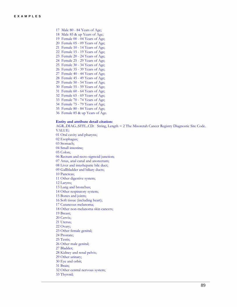
E X A M P L E S
17 Male 80 - 84 Years of Age; 18 Male 85 & up Years of Age; 19 Female 00 - 04 Years of Age; 20 Female 05 - 09 Years of Age; 21 Female 10 - 14 Years of Age; 22 Female 15 - 19 Years of Age; 23 Female 20 - 24 Years of Age; 24 Female 25 - 29 Years of Age; 25 Female 30 - 34 Years of Age; 26 Female 35 - 39 Years of Age; 27 Female 40 - 44 Years of Age; 28 Female 45 - 49 Years of Age; 29 Female 50 - 54 Years of Age; 30 Female 55 - 59 Years of Age; 31 Female 60 - 64 Years of Age; 32 Female 65 - 69 Years of Age; 33 Female 70 - 74 Years of Age; 34 Female 75 - 79 Years of Age; 35 Female 80 - 84 Years of Age; 36 Female 85 & up Years of Age. Entity and attribute detail citation: AGR_DIAG_SITE_CD: String, Length = 2 The Misoretah Cancer Registry Diagnostic Site Code. VALUE: 01 Oral cavity and pharynx; 02 Esophagus; 03 Stomach; 04 Small intestine; 05 Colon; 06 Rectum and recto-sigmoid junction; 07 Anus, anal canal and anorectum; 08 Liver and interhepatic bile duct; 09 Gallbladder and biliary ducts; 10 Pancreas; 11 Other digestive system; 12 Larynx; 13 Lung and bronchus; 14 Other respiratory system; 15 Bones and joints; 16 Soft tissue (including heart); 17 Cutaneous melanoma; 18 Other non-melanoma skin cancers; 19 Breast; 20 Cervix; 21 Uterus; 22 Ovary; 23 Other female genital; 24 Prostate; 25 Testis; 26 Other male genital; 27 Bladder; 28 Kidney and renal pelvis; 29 Other urinary; 30 Eye and orbit; 31 Brain; 32 Other central nervous system; 33 Thyroid;
89

E X A M P L E S
34 Other endocrine; 35 Hodgkin's lymphoma; 36 Non-Hodgkin's lymphoma; 37 Multiple myeloma; 38 Lymphocytic leukemia; 39 Myeloid leukemia; 40 Monocytic leukemia; 41 Other leukemia; 42 Other sites/types not otherwise specified. Entity and attribute detail citation: COUNT_CASES: Long Integer, Length = 5 The case count for primary cases of cancer by location, year, age/sex group and site. Entity and attribute detail citation: COUNT_POPULATION: Long Integer, Length = 5 The corresponding population count by location, year, and age/sex group. This data is linked from a master population table maintained by the Misoretah Environmental Public Health Tracking Program. Entity and attribute detail citation: RATE_RAW: Single Float, Length = 8, Precision = 2 The age/sex specific cancer rate per 100,000. This value is computed as: 100000 * COUNT_CASES / COUNT_POPULATION
Back to Top
Distribution Information:
Resource description: HO_CANCER_CNTY_YR_5AS_SITE
Distribution liability: DISCLAIMER OF LIABILITY, RELIABILITY, DAMAGES AND ENDORSEMENT. The Misoretah Public Health Tracking Network (U-EPHTN) is maintained, managed and operated by the Environmental Epidemiology Program (EEP) within the Misoretah Department of Health (MDOH). In preparation of this data, every effort has been made to offer the most current, correct, complete and clearly expressed information possible. Nevertheless, some errors in the data may exist. In particular, but without limiting anything here, the Misoretah Department of Health disclaims any responsibility for source data, compilation and typographical errors and accuracy of the information that may be contained in this data. This data does not represent the official legal version of source documents or data used to compile this data. The MDOH further reserves the right to make changes to this data at any time without notice. This data compiled by the staff of the EEP from a variety of source data, and are subject to change without notice. The MDOH makes no warranties or representations whatsoever regarding the quality, content, condition, functionality, performance, completeness, accuracy, compilation, fitness or adequacy of the data. By using this data, you assume all risk associated with the acquisition, use, management, and disposition of this data in your information system, including any risks to your computers, software or data being damaged by any virus, software, or any other file that might be transmitted or activated during the data exchange of this data. The MDOH shall not be liable, without limitation, for any direct, indirect, special, incidental, compensatory, or consequential damages, or third-party claims,
90

E X A M P L E S
resulting from the use or misuse of the acquired data, even if the MDOH or its agency has been advised of the possibility of such potential damages or loss. Format compatibility is the user’s responsibility. Reference herein to any specific commercial products, processes, services, or standards by trade name, trademark, manufacture, URL, or otherwise, does not necessarily constitute or imply its endorsement, recommendation or favoring by the MDOH. The view and opinions of the metadata compiler expressed herein do not necessarily state or reflect those of the MDOH, or the data owners and shall not be used for advertising or product endorsement purposes. Use of this data with other data shall not terminate, void or otherwise contradict this statement of liability. The sale or resale of this data, or any portions thereof, is prohibited unless with the express written permission of the MDOH. If errors or otherwise inappropriate information is brought to our attention, a reasonable effort will be made to fix or remove it. Such concerns should be addressed to the EEP program manager (See Point of Contact contained in this metadata file)
Back to Top
Metadata Reference Information:
Metadata date: 20070320
Metadata contact: Contact information: Contact organization primary: Contact organization: The Misoretah Environmental Public Health Tracking Program Contact position: Metadata Administrator Contact address: Address type: mailing and physical address Address: Misoretah State Health Building 1234 Anyplace Street City: Somewhere City State or province: Misoretah Postal code: 97531 Country: USA Contact voice telephone: 123.456-7890 Contact TDD/TTY telephone: Contact facsimile telephone: 123.456-0987
Contact electronic mail address: [email protected]
Hours of service: Contact instructions:
91

E X A M P L E S
Metadata standard name: FGDC Content Standard for Digital Geospatial Metadata http://www.fgdc.gov/standards/projects/FGDC-standards-projects/metadata/base-metadata/v2_0698.pdf Metadata standard version: Version 2.0 FGDC-STD-001-1998
Metadata access constraints: None
Back to Top
6.2 Air Pollution Data
Misoretah Air Pollution Data
Theme keywords: Air Quality Monitoring, Air Pollution, Ozone, Nitrogen Oxide, Nitrogen Dioxide, Hydrogen Sulfide, Sulfur Dioxide, Carbon Monoxide, Ammonia Gas
Abstract: File contains raw hourly average air quality data for Misoretah on November 5, 2006. The data was obtained from 100 automated, continuous instruments at 33 locations around the state.
EPHT Metadata:
• Identification Information
• Entity and Attribute Information
• Metadata Reference Information
Identification Information:
Citation: Citation information: Originators: Misoretah Department of Natural Resources
Title: Misoretah Air Pollution Data
Publication date: 20061105
Online linkage: http://www.somewebsite.gov/env/esp/aqm/ALLREP.txt
Description: Abstract: File contains raw hourly average air quality data for Misoretah on November 5, 2006. The data was obtained from 100 automated, continuous instruments at 33 locations around the state.
92

E X A M P L E S
Purpose: Data collected for use in determining whether an area meets the National Ambient Air Quality Standard, whether the public is being exposed to unhealthy conditions, to identify air pollution trends, and to determine the source of air pollution problems. Supplemental information: This data has only been subject to preliminary automated quality assurance procedures. Special conditions such as power outages and equipment malfunction can produce invalid data. Quality assured data is available by contacting the Misoretah Department of Natural Resources Air Pollution Program. Time period of content: Time period information: Single date/time: Calendar date: 20061105 Currentness reference: Publication Date Status: Progress: Complete Maintenance and update frequency: Air quality data collected continuously and updated on an hourly basis. This data file is for a single date and considered complete. Spatial domain: Bounding coordinates: West bounding coordinate: -96.1 East bounding coordinate: -88.77 North bounding coordinate: 40.94 South bounding coordinate: 35.66 Keywords: Theme: Theme keywords: Air Quality Monitoring Theme keyword thesaurus: General Multilingual Thesaurus (GEMET) Theme: Theme keywords: Air Pollution Theme keyword thesaurus: General Multilingual Thesaurus (GEMET) Theme: Theme keywords: Ozone Theme keyword thesaurus: General Multilingual Thesaurus (GEMET) Theme: Theme keywords: Nitrogen Oxide Theme keyword thesaurus: General Multilingual Thesaurus (GEMET) Theme: Theme keywords: Nitrogen Dioxide Theme keyword thesaurus: General Multilingual Thesaurus (GEMET) Theme: Theme keywords: Hydrogen Sulfide Theme keyword thesaurus: General Multilingual Thesaurus (GEMET)
93

E X A M P L E S
Theme: Theme keywords: Sulfur Dioxide Theme keyword thesaurus: General Multilingual Thesaurus (GEMET) Theme: Theme keywords: Carbon Monoxide Theme keyword thesaurus: General Multilingual Thesaurus (GEMET) Theme: Theme keywords: Ammonia Gas Theme keyword thesaurus: General Multilingual Thesaurus (GEMET) Place: Place keywords: Misoretah Place keyword thesaurus: Geographic Names Information System (GNIS) Access constraints: None. Use constraints: Data made available for the purpose of public awareness and should not be used in any medical study. Point of contact: Contact information: Contact organization primary: Contact organization: Misoretah Department of Natural Resources Air Pollution Program Contact position: Air Quality Program Director Contact address: Address type: Mailing Address Address: PO Box 176 City: Some City State or province: Misoretah Postal code: 69999 Country: USA Contact voice telephone: 1-999-999-9999 Contact TDD/TTY telephone: Contact facsimile telephone:
Contact electronic mail address: [email protected]
Hours of service: 8:00 am - 5:00 pm Monday - Friday Contact instructions: Native data set environment: ASCII
Back to Top
Entity and Attribute Information:
Overview description:
94

E X A M P L E S
Entity and attribute overview: Data is organized by Logger Id and Logger Name. Each parameter measured at the site is a separate attribute. These are identified by common chemical symbols: NO - Nitrogen Oxide, NO2 - Nitrogen Dioxide, NOX - Total Nitrogen Oxides, NH3 - Ammonia Gas, NT - Total Nitrogen Compounds, H2S - Hydrogen Sulfide, SO2 - Sulfur Dioxide (1 PPM Limit), SO2S - Secondary SO2 (5 PPM Limit), O3 - Ozone, O3S - Back up Ozone measurement, CO - Carbon Monoxide. Hourly averages are displayed under each attributes name. They are recorded in the most common units used for each parameter type: parts per million (PPM), microgram per cubic meter (uG/M3), degrees centigrade (DEG C), parts per billion (PPB), miles per hour (MPH) and compass degrees (DEG). Data from all loggers includes wind direction, wind speed and temperature. Several loggers also contain data for relative humidity. An hourly average can be replaced with a status flag. These flags are used to indicate various problems. The most common flags are "D" (instrument disabled, usually used during weekly checks of instrument performance), "B" (bad status, usually because of instrument malfunction), "R" (a suspicious rate of change in the data from one hour to the next), or "P" (indicates a power outage during the reporting period). Entity and attribute detail citation: http://www.dnr.mo.gov/env/esp/aqm/allguide.htm
Back to Top
Metadata Reference Information:
Metadata date: 20061107
Metadata contact: Contact information: Contact organization primary: Contact organization: Misoretah Department of Health And Senior Services Contact person: Metadata Administrator Contact address: Address type: Mailing and Physical Address Address: 920 Some Dr. PO Box 570 City: Some City State or province: Misoretah Postal code: 6999-0570 Country: USA Contact voice telephone: 999-999-9999 Contact TDD/TTY telephone: The telephone number by which hearing-impaired individuals can contact the organization or individual. Contact facsimile telephone: 999-888-888
Contact electronic mail address: [email protected]
95

E X A M P L E S
Hours of service: 8:00 am - 4:00 pm Monday - Friday. Contact instructions: Contact_Instructions Metadata standard name: FGDC Content Standards for Digital Geospatial Metadata Metadata standard version: FGDC-STD-001-1998
Metadata access constraints: None.
Back to Top
6.3 Asthma Hospitalizations Data
Misoretah Asthma Hospitalization
Theme keywords: Hospitalization, Asthma, Environmental Public Health Tracking (surveillance) Initiative, PHASE Project
Abstract: Misoretah asthma hospitalization data for the years 2001-2004.
EPHT Metadata:
• Identification Information
• Entity and Attribute Information
• Metadata Reference Information
Identification Information:
Citation: Citation information: Originators: Misoretah Department of Health and Senior Services
Title: Misoretah Asthma Hospitalization
Publication date: Unpublished
Online linkage: None
Description: Abstract: Misoretah asthma hospitalization data for the years 2001-2004.
96
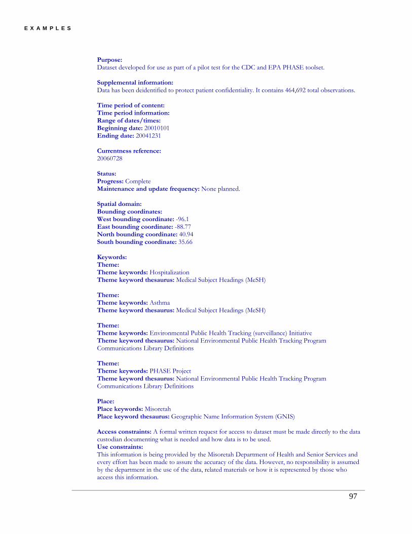
E X A M P L E S
Purpose: Dataset developed for use as part of a pilot test for the CDC and EPA PHASE toolset. Supplemental information: Data has been deidentified to protect patient confidentiality. It contains 464,692 total observations. Time period of content: Time period information: Range of dates/times: Beginning date: 20010101 Ending date: 20041231 Currentness reference: 20060728 Status: Progress: Complete Maintenance and update frequency: None planned. Spatial domain: Bounding coordinates: West bounding coordinate: -96.1 East bounding coordinate: -88.77 North bounding coordinate: 40.94 South bounding coordinate: 35.66 Keywords: Theme: Theme keywords: Hospitalization Theme keyword thesaurus: Medical Subject Headings (MeSH) Theme: Theme keywords: Asthma Theme keyword thesaurus: Medical Subject Headings (MeSH) Theme: Theme keywords: Environmental Public Health Tracking (surveillance) Initiative Theme keyword thesaurus: National Environmental Public Health Tracking Program Communications Library Definitions Theme: Theme keywords: PHASE Project Theme keyword thesaurus: National Environmental Public Health Tracking Program Communications Library Definitions Place: Place keywords: Misoretah Place keyword thesaurus: Geographic Name Information System (GNIS) Access constraints: A formal written request for access to dataset must be made directly to the data custodian documenting what is needed and how data is to be used. Use constraints: This information is being provided by the Misoretah Department of Health and Senior Services and every effort has been made to assure the accuracy of the data. However, no responsibility is assumed by the department in the use of the data, related materials or how it is represented by those who access this information.
97

E X A M P L E S
Point of contact: Contact information: Contact organization primary: Contact organization: Misoretah Department of Health and Senior Services Contact position: Director of Asthma Unit Contact address: Address type: Mailing and Physical Address: Some Drive, PO Box 570 City: Some City State or province: Misoretah Postal code: 6999-0570 Country: USA Contact voice telephone: 999-999-9999 Contact TDD/TTY telephone: Contact facsimile telephone:
Contact electronic mail address: [email protected]
Hours of service: 8:00am - 4:30pm Monday-Friday Contact instructions: Contact_Instructions Native data set environment: SAS v9.0. /u6/SAS_worke5ff000043AA_holmes/one.sas7bdat
Back to Top
Entity and Attribute Information:
Overview description: Entity and attribute overview: Dataset contains several attributes relating with hospitalization for asthma. These include the following: * Admission date MMDDYY * Admission hour * Age at admission * The number of asthma records the person has * The number of records a person has * Asthma diagnosis code if person had asthma * Asthma ICD9 Code that is on the record * Earliest asthma record date * Birth Date MMDDYYYY * Charge for service * County of residence * Discharge date MMDDYYYY * Discharge hour * Disposition spelled out
98
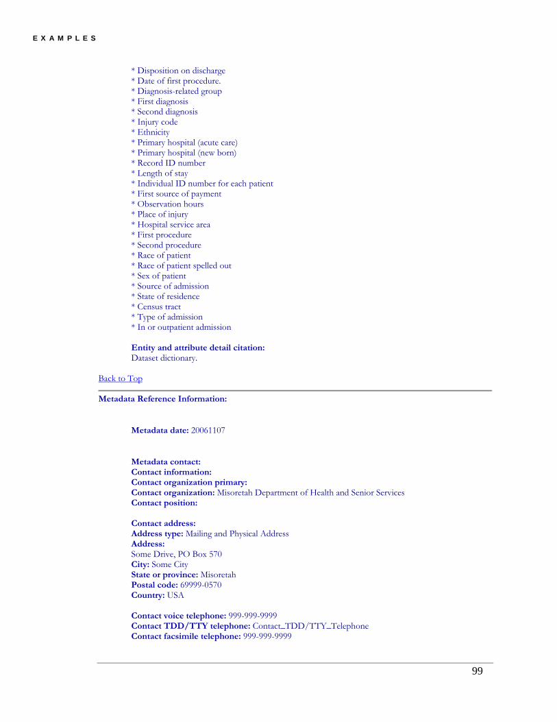
E X A M P L E S
* Disposition on discharge * Date of first procedure. * Diagnosis-related group * First diagnosis * Second diagnosis * Injury code * Ethnicity * Primary hospital (acute care) * Primary hospital (new born) * Record ID number * Length of stay * Individual ID number for each patient * First source of payment * Observation hours * Place of injury * Hospital service area * First procedure * Second procedure * Race of patient * Race of patient spelled out * Sex of patient * Source of admission * State of residence * Census tract * Type of admission * In or outpatient admission Entity and attribute detail citation: Dataset dictionary.
Back to Top
Metadata Reference Information:
Metadata date: 20061107
Metadata contact: Contact information: Contact organization primary: Contact organization: Misoretah Department of Health and Senior Services Contact position: Contact address: Address type: Mailing and Physical Address Address: Some Drive, PO Box 570 City: Some City State or province: Misoretah Postal code: 69999-0570 Country: USA Contact voice telephone: 999-999-9999 Contact TDD/TTY telephone: Contact_TDD/TTY_Telephone Contact facsimile telephone: 999-999-9999
99

E X A M P L E S
Contact electronic mail address: [email protected]
Hours of service: 8:00am - 4:00pm Monday - Friday Contact instructions: Contact_Instructions Metadata standard name: FGDC Content Standards for Digital Geospatial Metadata Metadata standard version: FGDC-STD-001-1998
Metadata access constraints: None
Back to Top
6.4 Drinking Water Data System
Misoretah Safe Drinking Water Information System (SDWIS)
Theme keywords: SDWIS, Drinking Water, water, Safe Drinking Water Information System, Drinking water quality
Abstract: This database contains information on the public water systems in Misoretah. Basic system information is maintained and includes information on population, contact person's name and phone number, county served, number of connections, sources of water used and Consumer Confidence reports. Data also include coliform testing, chemical testing, nitrate results, and lead and copper testing. Contact reports, rule violations, and public notices are also included in the system.
EPHT Metadata:
• Identification Information
• Data Quality Information
• Entity and Attribute Information
• Distribution Information
• Metadata Reference Information Metadata elements shown with blue text are defined in the Federal Geographic Data Committee's (FGDC) Content Standard for Digital Geospatial Metadata (CSDGM). Elements shown with green text are defined in the ESRI Profile of the CSDGM. Elements shown with a green asterisk (*) will be automatically updated by ArcCatalog. ArcCatalog adds hints indicating which FGDC elements are mandatory; these are shown with gray text.
Identification Information:
Citation: Citation information:
100

E X A M P L E S
Originators: Drinking Water Program, Misoretah Department of Human Services, Public Health Division
Title: Misoretah Safe Drinking Water Information System (SDWIS)
Publication date: 20070417
Online linkage: http://170.104.158.45/
Description: Abstract: This database contains information on the public water systems in Misoretah. Basic system information is maintained and includes information on population, contact person's name and phone number, county served, number of connections, sources of water used and Consumer Confidence reports. Data also include coliform testing, chemical testing, nitrate results, and lead and copper testing. Contact reports, rule violations, and public notices are also included in the system. Purpose: To assure Misoretahians safe drinking water. The program focuses resources on the areas of highest public health benefit and promotes voluntary compliance with drinking water standards. It emphasizes prevention of contamination through source protection, technical assistance to water systems, and training of water system operators. Supplemental information: The Drinking Water Program administers and enforces drinking water quality standards for public water systems in the State of Misoretah. What the Misoretah Drinking Water Program is doing: - Reducing or preventing contamination of public drinking water supplies - Improving water system operation and management through training and technical assistance programs for water system operators, managers, engineers, and lab staff - Improving adequacy, reliability, and viability of public water systems - Increasing public knowledge, participation, and support for safe drinking water - Conducting an efficient and effective regulatory program that implements federal Environmental Protection Agency safe drinking water standards and state drinking water regulations. Time period of content: Time period information: Range of dates/times: Beginning date: 1988 Ending date: Present Currentness reference: Publication Date Status: Progress: Complete Maintenance and update frequency: Monthly Spatial domain: Bounding coordinates:
101

E X A M P L E S
West bounding coordinate: -124.961735 East bounding coordinate: -116.415546 North bounding coordinate: 46.344729 South bounding coordinate: 41.914842 Keywords: Theme: Theme keywords: SDWIS, Drinking Water, water, Safe Drinking Water Information System Theme keyword thesaurus: none Theme: Theme keywords: Drinking water quality Theme keyword thesaurus: CHT Place: Place keywords: Misoretah, MS Place keyword thesaurus: GNIS Access constraints: None Use constraints: None Point of contact: Contact information: Contact organization primary: Contact organization: Misoretah Department of Human Services, Drinking Water Program Contact position: Data Management & Compliance Assurance
Contact address: Address type: Mailing and Physical Address: 800 NE Misoretah Street City: Anycity State or province: Misoretah Postal code: 97000 Country: USA Contact voice telephone: 999-999-9999 Contact facsimile telephone: 999-999-9999
Contact electronic mail address: [email protected]
Hours of service: Monday-Friday; 8:00-5:00 Contact instructions: Email or Call Security information: Security classification system: None Security classification: Unclassified Security handling description: None Native data set environment: Microsoft Windows 2000; SQL Server
102
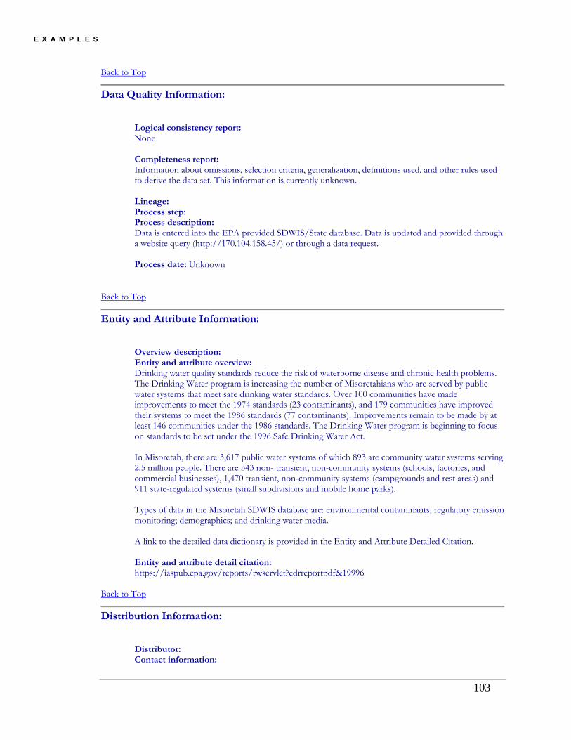
E X A M P L E S
Back to Top
Data Quality Information:
Logical consistency report: None Completeness report: Information about omissions, selection criteria, generalization, definitions used, and other rules used to derive the data set. This information is currently unknown. Lineage: Process step: Process description: Data is entered into the EPA provided SDWIS/State database. Data is updated and provided through a website query (http://170.104.158.45/) or through a data request. Process date: Unknown
Back to Top
Entity and Attribute Information:
Overview description: Entity and attribute overview: Drinking water quality standards reduce the risk of waterborne disease and chronic health problems. The Drinking Water program is increasing the number of Misoretahians who are served by public water systems that meet safe drinking water standards. Over 100 communities have made improvements to meet the 1974 standards (23 contaminants), and 179 communities have improved their systems to meet the 1986 standards (77 contaminants). Improvements remain to be made by at least 146 communities under the 1986 standards. The Drinking Water program is beginning to focus on standards to be set under the 1996 Safe Drinking Water Act. In Misoretah, there are 3,617 public water systems of which 893 are community water systems serving 2.5 million people. There are 343 non- transient, non-community systems (schools, factories, and commercial businesses), 1,470 transient, non-community systems (campgrounds and rest areas) and 911 state-regulated systems (small subdivisions and mobile home parks). Types of data in the Misoretah SDWIS database are: environmental contaminants; regulatory emission monitoring; demographics; and drinking water media. A link to the detailed data dictionary is provided in the Entity and Attribute Detailed Citation. Entity and attribute detail citation: https://iaspub.epa.gov/reports/rwservlet?edrreportpdf&19996
Back to Top
Distribution Information:
Distributor: Contact information:
103
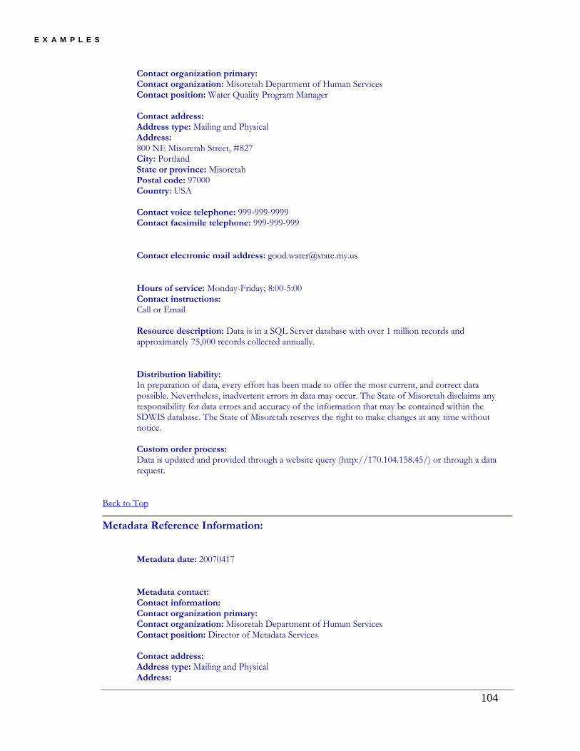
E X A M P L E S
Contact organization primary: Contact organization: Misoretah Department of Human Services Contact position: Water Quality Program Manager Contact address: Address type: Mailing and Physical Address: 800 NE Misoretah Street, #827 City: Portland State or province: Misoretah Postal code: 97000 Country: USA Contact voice telephone: 999-999-9999 Contact facsimile telephone: 999-999-999
Contact electronic mail address: [email protected]
Hours of service: Monday-Friday; 8:00-5:00 Contact instructions: Call or Email Resource description: Data is in a SQL Server database with over 1 million records and approximately 75,000 records collected annually.
Distribution liability: In preparation of data, every effort has been made to offer the most current, and correct data possible. Nevertheless, inadvertent errors in data may occur. The State of Misoretah disclaims any responsibility for data errors and accuracy of the information that may be contained within the SDWIS database. The State of Misoretah reserves the right to make changes at any time without notice. Custom order process: Data is updated and provided through a website query (http://170.104.158.45/) or through a data request.
Back to Top
Metadata Reference Information:
Metadata date: 20070417
Metadata contact: Contact information: Contact organization primary: Contact organization: Misoretah Department of Human Services Contact position: Director of Metadata Services Contact address: Address type: Mailing and Physical Address:
104

E X A M P L E S
105
800 NE Misoretah Street, #827 City: Portland State or province: Misoretah Postal code: 97000 Country: USA Contact voice telephone: 999-999-9999 Contact facsimile telephone: 999-999-9999
Contact electronic mail address: [email protected]
Hours of service: Monday-Friday; 8:00-5:00 Contact instructions: Call or Email Metadata standard name: FGDC Content Standards for Digital Geospatial Metadata Metadata standard version: FGDC-STD-001-1998
Metadata access constraints: None Metadata use constraints: None
Back to Top

K e y T e r m s a n d A c r o n y m s
Chapter
7 Chapter 7: Terms and Acronyms Attribute: A field within a database table. A single complete fact of data. See also Entity. CDC: The Centers for Disease Control and Prevention (www.cdc.gov). The CDC is an agency of the U.S. Department of Health and Human Services, based in Atlanta Georgia. The CDC is the federal government agency responsible for developing and applying disease prevention and control measures. The CDC comprises a number of coordinating centers. The Coordinating Center for Environmental Health and Injury Prevention includes the National Center for Environmental Health (www.cdc.gov/nceh). The Environmental Public Health Tracking Program (www.cdc.gov/nceh/tracking) is a program within the National Center for Environmental Health. See also EPHT and Tracking Network. Certification download: See Certificate. Certificate (digital certificate, identity certificate, or public key certificate): A small file installed on a computer to link a digital signature (a personal identification number) and a public encryption key (a form of encrypting data sent over the internet) issued by a certificate authority (e.g., VeriSign). The certificate is useful for authenticating user identity and for establishing a means of secure exchange of data. Because a certificate is a file installed on a computer, the certificate also binds the user to a specific computer. An alternative is the use of security tokens (hardware token, authentication token or cryptographic token) or Computer Access Cards (CAC, smart card or integrated circuits card) that are devises issued to the user but can only be used on any computer with hardware to accept those devises. CIESIN: Center for International Earth Science Information Network. The CIESIN is a center within the Earth Institute at Columbia University. The CIESIN specializes in online data and information management, spatial data integration and training, and the interdisciplinary aspects of social, environmental and information sciences. The CIESIN is a resource for standardizing metadata. (www.ciesin.columbia.edu) Composite Element: See Element.
106

K e y T e r m s a n d A c r o n y m s
Content: The content within the EPHTN includes indicator data stores, metadata describing those data stores, tools for linking, analyzing, modeling, visualizing and reporting on those data stores; and products for training network partners. Dataset: One or more data tables that are related or referenced to each other and generally pertain to a specific data subject. The term data set used synonymous with data table or with data files. Datum: See Spatial Projection DBMS: Database Management System is a computer software application (e.g., Oracle, SAS, MS Access) designed for the purposes of managing databases using a standardized schema for organizing data, applying queries to the data, enforcing value rules on the data and providing security to the data. A DBMS complies with a general set of standards that allow different systems to interact with its data and vice-versa. Descriptive: The presentation of facts and/or observations about data to convey information about the nature, quality, structure, source, use, and processes of that data. Descriptive data are also useful for historical reference and for comparison. Discovery: Discovery is the interactive process of disclosure of information through documentation by a data provider and the critical examination of that documentation by a potential user to determine its usefulness for a particular enquiry or application. DSA: Data Sharing Agreement (also Trading Partner Agreement). A formal agreement that describes the roles, responsibilities, and liabilities of data owners or stewards and data sharing partners. This agreement may also describe the content of the data to be shared, limitations placed on the use and disclosure of the data, and the processes to accomplishing data sharing. Dublin Core: The Dublin Core is a metadata element standard for describing information resources in many domains. This standard was developed by the Dublin Core Metadata Initiative (dublincore.org) within the Online Computer Library Center at Dublin Ohio. The Dublin Core is a generalized set of elements that describe ownership and structure of information that can be applied as a minimum standard for datasets. The Dublin Core also establishes a standardized syntax for organizing its elements and completing entry information within the elements. Information Technologies is a reference model that other encoding guidelines can be compared. Dx: Formally, the diagnosis, but for the purpose of this manuscript, the diagnostic code. There are a number of diagnostic encoding systems. Codes may be from an national or international standard or proprietary to the disease tracking organization. The International Classification of Diseases (ICD) is published by the World Health Organization (www.who.int). Two versions; ICD-9-CM (www.cdc.gov/nchs/icd9.htm) and ICD-10 (www.who.int/classifications/icd/en/) are commonly used. However, other codes may be used for specific diseases (e.g., ICD-O-3 or SEER site codes for cancer).
107

K e y T e r m s a n d A c r o n y m s
Element: A component of metadata. If one considers a metadata document to be a record in a dataset table, the metadata element is synonymous with an attribute (i.e., a field in the table). There are three kinds of elements; simple, compound or composite. Simple elements consist of a single field on any type (e.g., a string, a number, a date, etc.). A compound element consists of multiple simple fields related to each other (e.g., a date field and a time field to make a date/time). A composite element is a higher level of organization and consists of a collection of simple or compound fields all related to a particular subject (e.g., contact point). Entity: A table within a dataset. A table consists of an organized collection and structure of data elements in rows (records) and columns (fields). See also attribute. EPA: The (U.S.) Environmental Protection Agency (sometimes USEPA) is an agency of the federal government (www.epa.gov). The EPA is charged with protecting human health and with safeguarding the quality o f the natural environment. EPHT: Environmental Public Health Tracking is the ongoing collection, integration, analysis, interpretation, and dissemination of environmental hazard monitoring and human exposure and health effects surveillance. See www.cdc.gov/nceh/tracking/network.htm. EPHTN: See Tracking Network. FIPS: Federal Information Processing Standards (www.itl.nist.gov/fipspubs/) are publicly announced standards developed by the federal government for use by all government agencies and contractors. FIPS codes include standards for encoding data and some encryption standards. FIPS codes for places, counties, states, and countries are frequently used in geospatial data. These codes are comparable to the ISO 3166 standards. FGDC: Federal Geographic Data Committee (www.fgdc.gov). An interagency committee housed by the National Geospatial Program Office (www.usgs.gov/ngpo/) working to publish the National Spatial Data Infrastructure. As part of that infrastructure, the FGDC developed standards for metadata on geospatial data that can be applied to a broad range of data constructs. The EPHT adopted the FGDC metadata standards. Geospatial: The integration and interactive functionality of spatial (multi-dimensional) referencing and analytical methods applied to geographic datasets. Geospatial is often used in conjunction with geographic information systems (GIS). GIS: Geographic Information Systems: A computer application system, protocols and standards used to capture, store, edit, layer, analyze, manage, and share geographic data and applying spatial methods on those data. GNIS: Geographic Names Information System contains registered named and locational information about physical and cultural features located throughout the United States and its territories. The US Geological Survey developed the GNIS (www.usgs.gov) in cooperation with the US Board on Geographic Names (www.geonames.usgs.gov) to promote the
108

K e y T e r m s a n d A c r o n y m s
standardization of feature names. The GNIS database is a registry of official federal names for features cross-referenced with variant and alternative names. IRB: Institutional Review Board (also known as the Independent Ethics Committee or Ethical Review Board). The IRB is mandated by Title 45 CFR Part 46 (Research Act of 1974) for research involving human subjects. See the Office of Human Research Protection website (http://www.hhs.gov/ohrp/) for more information. ISO: International Organization for Standardization (http://www.iso.org/). The ISO is an international standard-setting body composed from the 158 member national standard bodies. ISO standards are widely recognized and often become law through adoption or by treaty law. ISO standards are published as Technical Report (when complete), Technical Specification (when still under development) or as ISO Guides (general guides related to international standards). LDAP: Lightweight Directory Access Protocol is a network protocol for querying and modifying directory services. The LDAP provides a means for secure, role-based access and authentication of users accessing a network system. Metadata: Metadata is a data record that describes a unique dataset (a set of one or more related data tables). Metadata describes ownership, content, structure, mutability, use, and function of the dataset. See Chapter 2 for a detailed discussion of metadata with respect to the EPHT. MOA: Memorandum of Agreement (also Memorandum of Understanding). See also DSA. NAWQA: The National Water-Quality Assessment Program (NAWQA) provides an understanding of water-quality conditions and how those conditions may vary locally, regionally, and nationally; whether conditions are getting better or worse over time; and how natural features and human activities affect those conditions. PHIN: Public Health Information Network (www.cdc.gov/phin/) is a collaborative CDC sponsored forum for advancing interoperable public health information systems in the many organizations that participate in public health. The goal of this national initiative is to implement a multi-organizational standards-based business and technical architecture for public health information systems. The CDC Information Council governs the PHIN with membership from ASTHO, NACCHO, and CDC. SEER site codes: See Dx. A schema developed by the National Cancer Institute, Surveillance Epidemiology, and End Results (SEER, seer.cancer.gov) program. The SEER site codes group cancers by forty-two anatomical or system sites. Spatial Domain: The window or envelope within which spatially referenced data is maintained. The minimum limits of spatial scale values in all coordinates that completely include spatially referenced data.
109

K e y T e r m s a n d A c r o n y m s
Spatial Projection: The technology, methodology and scaling values used to present three dimensional geospatial data on a two dimensional plane. There are a number of standardized projections. Scaling values can use standard geographic measures (latitude and longitude) or metric measures (meters, feet, etc.). Periodic geographic surveys usually set scaling values. The names of spatial projections may reference those surveys (i.e., North American Datum 1983). Standard: An established, authoritative, and accepted set of criteria to guide development, implementation, and evaluation. State Plane: See also Spatial Projection. The State Plane is a modification of a national spatial projection applicable for a specific state domain. State planes reduce scale values by a set amount (false northing and false easting) for easier manipulation. Thesaurus: A compilation and organization of a set of words, phrases references and other information about a particular field or set of concepts. See also Vocabulary TPA: Trading Partner Agreement. See also DSA. Tracking Network: The network integrates data from environmental hazards monitoring, human exposure monitoring and health effects surveillance into a network of standardized and consistent data. The network will also include metadata and applications for the discovery, access, query, and analysis of the data. URL: Uniform Resource Locator. A standardized and uniform syntax for global identifiers of network retrievable documents. For example: http://en.wikipedia.org/wiki/URL is the locator for the Wikipedia document from which this definition was derived. The term URL is also used for Uniform Resource Identifier (URI) and Name (URN) although those terms are not strictly synonymous. UTM: Universal Transverse Mercator is a coordinate system based on a grid overlaid on the Earth’s surface. UTM are distinctive from latitude and longitude in the use of a UTM grid zone identifier and a large metric x and y coordinate (generally in the order of 105 to 106). Often the grid coordinate has an offset; therefore, it is important to know the datum and plane used. An advantage of the UTM is the ability to derive measures of distance between two points in a small scale. A disadvantage is the distortion that occurs. VADS: Vocabulary Access and Distribution System (http://www.cdc.gov/phin/vocabulary/index.html). The PHIN VADS is a web-based vocabulary server. See also Vocabulary. Vocabulary: A standardized and limited list or collection of words or word phrases (allowed entries) used for entry into a data attribute (field). For example, the vocabulary allowed for the data field “sex” might include “male,” “female,” and “unknown.” WAMS: Wide Area Measurement System.
110

K e y T e r m s a n d A c r o n y m s
111
XMI: XML Metadata Interchange is a standard for exchanging metadata information via XML. XMI standards are found in the ISO/IEC 19503:2005 Information Technology. See also XML. XML: Extensible Markup Language is a general-purpose markup language that supports a wide variety of data transactions. A key feature of XML is the tags and hierarchy that surround data elements. The advantage of using XML to conduct data transactions are that the sender and recipient of the data do need to be informed about the others data structures. A disadvantage to XML is the increased size of the data transaction.

A P P E N D I X A
Chapter
8 Chapter 8: Citations and References Arms, William Y. 2000. Digital Libraries. Cambridge, MA: Massachusetts Institute of
Technology Press. Association for Geographic Information. 2004. UK Gemini Standard Version 1.0.
Association for Geographic Information. London. Baca, Murtha ed. 2000. Introduction to Metadata: Pathways to Digital Information, version
2. Getty Information Institute. URL: http://www.getty.edu/research/ conducting_research/standards/intrometadata/index.html Federal Geographic Data Committee. 1997. Geospatial Metadata Factsheet. Federal Geographic Data Committee. Washington, D.C.
Federal Geographic Data Committee. 1998. Content Standard for Digital Geospatial
Metadata. Federal Geographic Data Committee. Washington, D.C. National Information Standards Organization. 2004. Understanding Metadata. Bethesda,
MD: NISO Press. URL: http://www.niso.org/standards/resources/ UnderstandingMetadata.pdf
112

A P P E N D I X A
Appendix A: EPHTN Metadata Profile Element Field Definition Short
NameElement
Type Domain Format
Citation Citation (1.1) Information to be used to reference the data set. citation Compound
Originator Originator (8.1) The name of an organization or individual that developed the data set. If the name of editors or compilers are provided, the name must be followed by "(ed.)" or "(comp.)" respectively. origin Text "Unknown"; Free Text
Publication Date Publication_Date (8.2) The date when the data set is published or otherwise made available for release. pubdate Date "Unknown"; "Unpublished Material"; Free Date
YYYY for years; YYYYMM for month of year; YYYYMMDD for day of the year
Title Title (8.4) The name by which the data set is known. title Text Free Text
URL On-line_Linkage (URL) (8.10) The name of an online computer resource that contains the data set. Entries should follow the Uniform Resource Locator convention of the Internet. (Complete if applicable). online Text Free Text
Description Description (1.2) A characterization of the data set, including its intended use and limitations. descript Compound
Abstract Abstract (1.2.1) A brief narrative summary of the data set. abstract Text Free Text
Purpose Purpose (1.2.2) A summary of the intentions with which the data set was developed. purpose Text Free Text
Supplemental Info Supplemental_Info (1.2.3) Other descriptive information about the data set. (Complete if applicable). supplinf Text Free Text
Time Period of Content Time_period_of_content (1.3) Time period for which the data set corresponds to the currentness reference. timeperd Compound
Currentness Currentness_Reference (1.3.1) The basis on which the time period of content information is determined. current Text"Ground Condition"; "Publication Date"; Free Text
YYYY for years; YYYYMM for month of year; YYYYMMDD for day of the year
Time Period Information Time_Period_Information (9.0) Information about the date of an event (Use Single or Multiple or Range of Dates). timeinfo Compound See Section 9
Status Status (1.4) The state of and maintenance information for the data set. status Compound
Progress Progress (1.4.1) The state of a data set. progress Text "Complete, "In Work"; "Planned"
Maintenance and Update Frequency
Maintenance_and_Update_Frequency (1.4.2) The frequency that changes are made to the data set after the initial data set is completed. update Text
"Continually"; "Daily"; "Weekly"; "Monthly"; "Annually"; "Unknown"; "As needed"; "Irregular"; "None planned"; Free Text
Spatial Domain Spatial_Domain (1.5) The geographic area covered by the data set. spdom Compound
West Bounding Coordinate West_Bounding_Coordinate (1.5.1.1) Western-most coordinate of the limit of coverage expressed in longitude. westbc Real -180.0 < = West Bounding
Coordinate < 180.0
Longitudes east of the prime meridian shall be specified by a plus (+) sign preceding the three digit designating degrees of longitude. Longitudes west of the prime meridian shall be designated by a minus (-) sign.
East Bounding Coordinate East_Bounding_Coordinate (1.5.1.2) Eastern-most coordinate of the limit of coverage expressed in longitude. eastbc Real -180.0 < = East Bounding
Coordinate < = 180.0
Longitudes east of the prime meridian shall be specified by a plus (+) sign preceding the three digit designating degrees of longitude. Longitudes west of the prime meridian shall be designated by a minus (-) sign.
North Bounding Coordinate North_Bounding_Coordinate (1.5.1.3) Northern-most coordinate of the limit of coverage expressed in latitude. northbc Real -90.0 < = North Bounding
Coordinate < = 90.0
Latitudes North of the Equator shall be specified by a plus (+) sign, preceding the two digits designating degrees. Latitudes south of the Equator shall be designated by a minus (-) sign .
South Bounding Coordinate South_Bounding_Coordinate (1.5.1.4) Southern-most coordinate of the limit of coverage expressed in latitude. southbc Real -90.0 < = South Bounding
Coordinate < = 90.0
Latitudes North of the Equator shall be specified by a plus (+) sign, preceding the two digits designating degrees. Latitudes south of the Equator shall be designated by a minus (-) sign .
Section 1: IDENTIFICATION
113
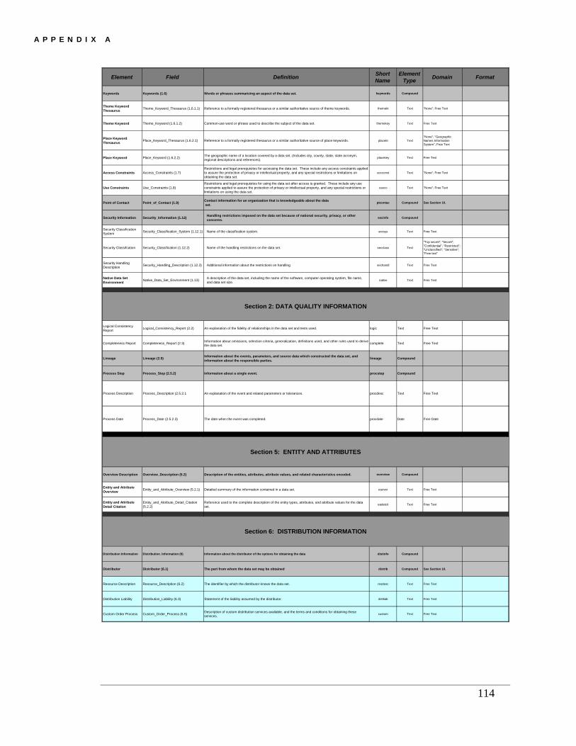
A P P E N D I X A
Element Field Definition Short Name
Element Type Domain Format
Keywords Keywords (1.6) Words or phrases summarizing an aspect of the data set. keywords Compound
Theme Keyword Thesaurus Theme_Keyword_Thesaurus (1.6.1.1) Reference to a formally registered thesaurus or a similar authoritative source of theme keywords. themekt Text "None"; Free Text
Theme Keyword Theme_Keyword (1.6.1.2) Common-use word or phrase used to describe the subject of the data set. themekey Text Free Text
Place Keyword Thesaurus Place_Keyword_Thesaurus (1.6.2.1) Reference to a formally registered thesaurus or a similar authoritative source of place keywords. placekt Text
"None"; "Geographic Names Information System"; Free Text
Place Keyword Place_Keyword (1.6.2.2) The geographic name of a location covered by a data set. (Includes city, county, state, state acronym, regional descriptions and references). placekey Text Free Text
Access Constraints Access_Constraints (1.7)Restrictions and legal prerequisites for accessing the data set. These include any access constraints applied to assure the protection of privacy or intellectual property, and any special restrictions or limitations on obtaining the data set.
accconst Text "None"; Free Text
Use Constraints Use_Constraints (1.8)Restrictions and legal prerequisites for using the data set after access is granted. These include any use constraints applied to assure the protection of privacy or intellectual property, and any special restrictions or limitations on using the data set.
useco Text "None"; Free Text
Point of Contact Point_of_Contact (1.9) Contact information for an organization that is knowledgeable about the data set. ptcontac Compound See Section 10.
Security Information Security_Information (1.12) Handling restrictions imposed on the data set because of national security, privacy, or other concerns. secinfo Compound
Security Classification System Security_Classification_System (1.12.1) Name of the classification system. secsys Text Free Text
Security Classifcation Security_Classification (1.12.2) Name of the handling restrictions on the data set. secclass Text
"Top secret"; "Secret"; "Confidential"; "Restricted"; "Unclassified"; "Sensitive"; "Free text"
Security Handling Description Security_Handling_Description (1.12.3) Additional information about the restrictions on handling sechandl Text Free Text
Native Data Set Environment Native_Data_Set_Environment (1.13) A description of the data set, including the name of the software, computer operating system, file name,
and data set size. native Text Free Text
Logical Consistency Report Logical_Consistency_Report (2.2) An explanation of the fidelity of relationships in the data set and tests used. logic Text Free Text
Completeness Report Completeness_Report (2.3) Information about omissions, selection criteria, generalization, definitions used, and other rules used to derive the data set. complete Text Free Text
Lineage Lineage (2.5) Information about the events, parameters, and source data which constructed the data set, and information about the responsible parties. lineage Compound
Process Step Process_Step (2.5.2) Information about a single event. procstep Compound
Process Description Process_Description (2.5.2.1 An explanation of the event and related parameters or tolerances. procdesc Text Free Text
Process Date Process_Date (2.5.2.3) The date when the event was completed. procdate Date Free Date
Overview Description Overview_Description (5.2) Description of the entities, attributes, attribute values, and related characteristics encoded. overview Compound
Entity and Attribute Overview Entity_and_Attribute_Overview (5.2.1) Detailed summary of the information contained in a data set. eaover Text Free Text
Entity and Attribute Detail Citation
Entity_and_Attribute_Detail_Citation (5.2.2)
Reference used to the complete description of the entity types, attributes, and attribute values for the data set. eadetcit Text Free Text
Distribution Information Distribution_Information (6) Information about the distributor of the options for obtaining the data distinfo Compound
Distributor Distributor (6.1) The part from whom the data set may be obtained distrib Compound See Section 10.
Resource Description Resource_Description (6.2) The identifier by which the distributor knows the data set. resdesc Text Free Text
Distribution Liability Distribution_Liability (6.3) Statement of the liability assumed by the distributor. distliab Text Free Text
Custom Order Process Custom_Order_Process (6.5) Description of custom distribution services available, and the terms and conditions for obtaining these services. custom Text Free Text
Section 2: DATA QUALITY INFORMATION
Section 5: ENTITY AND ATTRIBUTES
Section 6: DISTRIBUTION INFORMATION
114

A P P E N D I X A
115
Element Field Definition Short Name
Element Type Domain Format
Metadata Date Metadata_Date (7.1) The date that the metadata were created or last updated. metd Date Free DateYYYY for years; YYYYMM for month of year; YYYYMMDD for day of the year
Metadata Contact Metadata_Contact (7.4) The party responsible for the metadata information. metc Compound See Section 10
Metadata Standard Name Metadata_Standard_Name (7.5) The name of the metadata standard used to document the data set. metstdn Text
"FGDC Content Standards for Digital Geospatial Metadata"; Free Text
Metadata Access Constraints Metadata_Access_Constraints (7.8)
Restrictions and legal prerequisites for accessing the metadata. These include any access constraints applied to assure the protection of privacy or intellectual property, and any special restrictions or limitations on obtaining the metadata.
metac Text Free Text
Metadata Use Constraints Metadata_Use_Constraints (7.9)
Restrictions and legal prerequisites for using the metadata after access is granted. These include any metadata use constraints applied to assure the protection of privacy or intellectual property, and any special restrictions or limitations on using the metadata.
metuc Text "None"; Free Text
Single Date Single_Date (9.1) Means of encoding a single date and time. sngdate Compound
Calendar Date Calendar_Date (9.1.1) The year (optionally month or month and day). caldate Date "Unknown"; Free DateYYYY for years; YYYYMM for month of year; YYYYMMDD for day of the year
Time of Day Single_Time (9.1.2) The hour (and optionally minute, or minute and second) of day. time Time
Multiple Dates Multiple_Dates (9.2) Means of encoding multiple individual dates. (Complete if applicable). mdattim Compound
Range of Dates Range_of_Dates (9.3) Means of encoding a range of dates. (Complete if applicable). rngdates Compound
Beginning Date Beginning_Date (9.3.1) The first year (optionally month or month and day) of the event. begdate Date "Unknown"; Free DateYYYY for years; YYYYMM for month of year; YYYYMMDD for day of the year
Beginning Time Beginning_Time (9.3.2) The first hour (and optionally minute, or minute and second) of the day for the event. begtime Time
Ending Date End_Date (9.3.3) The last year (and optionally month or month and day) for the event. enddate Date "Unknown"; "Present"; Free Date
YYYY for years; YYYYMM for month of year; YYYYMMDD for day of the year
Ending Time End_Time (9.3.4) The last hour (and optionally minute, or minute and second) of the day for the event. endtime Time
Contact Information Contact_Information (10.0) This section provides a means of identifying individuals and organizations, and is used by other sections of the metadata standard. This section is never used alone. cntinfo Compound
Contact Organization Contact_Organization (10.2) The name of the organization. cntorg Text Free Text
Contact Position Contact_Position (10.3) Title of the individual. (Complete if applicable). cntpos Text Free Text
Contact Address Contact_Address (10.4) The address for the organization. cntaddr Compound
Address Type Address_Type (10.4.1) Address type. addrtype Text"Mailing"; "Physical"; "Mailing and Physical"; Free Text
Address Address (10.4.2) Contact address for organization. address Text Free Text
City City (10.4.3) Contact address city. city Text Free Text
State or Province State_or_Province (10.4.4) Contact address state or province. state Text Free Text
Postal Code Postal_Code (10.4.5) Contact address Zip or postal code. postal Text Free Text
Country Country (10.4.6) Contact address country. country Text Free Text
Contact Telephone Number Contact_Voice_Telephone (10.5) The telephone number by which individuals can speak to the organization. cntvoice Text Free Text
Contact TDD/TTY Telephone Contact_TDD/TTY_Telephone (10.6) The telephone number by which hearing-impaired individuals can contact the organization. (Complete if
applicable). cnttdd Text Free Text
Contact Fax Number Contact_Facsimile_Telephone (10.7) The telephone number of a facsimile machine of the organization. (Complete if applicable). cntfax Text Free Text
Contact E-mail Address Contact_Electronic_Mail_Address (10.8) The address of the electronic mailbox of the organization. (Complete if applicable). cntemail Text Free Text
Hours of Service Hours_of_Service (10.9) Time period when individuals can speak to the organization. (Complete if applicable). hours Text Free Text
Contact Instructions Contact_Instructions (10.10) Supplemental instructions on how or when to contact the organization. (Complete if applicable). cntinst Text Free Text
Section 10: CONTACT INFORMATION
Template is based on a subset of the Federal Geographic Data Committee's "Content Standard for Digital Geospatial Metadata" Version 2 - 1998. (FGDC-STD-001 June 1998) . The complete FGDC standard can be viewed at www.fgdc.gov/metadata/contstan.html *Areas in gray are descriptive headings. Data entry elements are in white.
OR
Section 7: METADATA REFERENCE
Section 9: TIME PERIOD INFORMATION(Enter EITHER a single Date OR multiple dates)

A P P E N D I X B
Appendix B: Keywords from ISO 19115 Topic Categories Code Number Topic Description 001 farming rearing of animals and/or
cultivation of plants 002 biota flora and/or fauna in natural
environments 003
boundaries legal land descriptions
004 Climatology, Meteorology, Atmosphere processes and phenomena of the atmosphere
005 economy economic activities, conditions, and employment
006 elevation height above or below the earth’s surface
007 environment environmental resources, protection, and conservation
008 geoscientific information information pertaining to the earth sciences
009 health health, health services, human ecology, and safety
010
imagery, base maps, earth cover base maps
011 intelligence, military
military bases, structures, activities
012 inland waters inland water features, drainage systems and characteristics
013 location positional information and services
014 oceans
features and characteristics of salt water bodies
015 planning, cadastre information used for future use of the land
016 society
characteristics of society and culture
017
structure man-made construction
018 transportation
means and aids for conveying persons and/or goods
019 utilities, communication energy, water and waste systems, and communications infrastructure
116

CHANGE REQUEST AND TRACKING FORM
Use this form to identify and describe a problem encountered when using the metadata user guide, or to describe a requested change to the user guide. If you have encountered multiple problems or have multiple change requests, use a separate form for each problem or reque t. s YOUR NAME
YOUR EMAIL
YOUR PHONE
YOUR OPERATING ENVIRONMENT
DATE
PLEASE DESCRIBE PROBLEM OR REQUESTED CHANGE (Give as much detail as possible, use additional pages as necessary. If this request is for the application, please describe your actions that
sulted in the problem. Include other software you had open at the time): re
EMAIL COMPLETED FORM TO: METADATA USER GUIDE CHANGE MANAGER Email: [email protected].
CHANGE MANAGER (only) RECEIVED
REVIEWED
ACTION
COMPLETED