environmental satellite processing center · pdf fileenvironmental satellite processing...
TRANSCRIPT

Environmental Satellite Processing Center
GCOM-W1 AMSR2 Algorithm Software Package
(GAASP) External User’s Manual
March, 2016, Version 2.0 Prepared by: Letitia Soulliard (IMSG) Stephen Quinn (SSAI/EMCS) Limin Zhao (OSPO) U.S. Department of Commerce National Oceanic and Atmospheric Administration (NOAA) National Environmental Satellite, Data, and Information Service (NESDIS) Satellite Mission Operations and Maintenance Support (SMOMS)
NOAA GCOM-W1 AMSR2 Algorithm Software Package
External User’s Manual Version 2.0
Date: 5/7/2017 Page 2 of 50
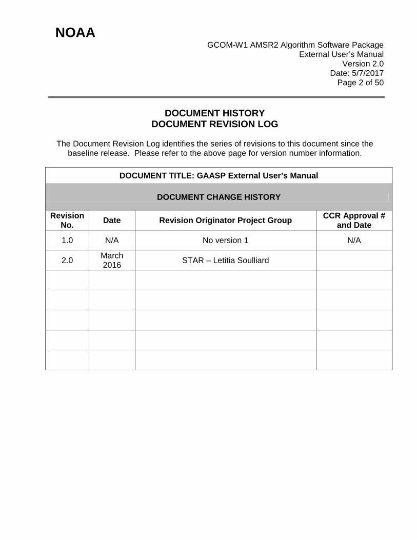
DOCUMENT HISTORY DOCUMENT REVISION LOG
The Document Revision Log identifies the series of revisions to this document since the
baseline release. Please refer to the above page for version number information.
DOCUMENT TITLE: GAASP External User’s Manual
DOCUMENT CHANGE HISTORY
Revision No. Date Revision Originator Project Group CCR Approval #
and Date
1.0 N/A No version 1 N/A
2.0 March 2016 STAR – Letitia Soulliard
NOAA GCOM-W1 AMSR2 Algorithm Software Package
External User’s Manual Version 2.0
Date: 5/7/2017 Page 3 of 50
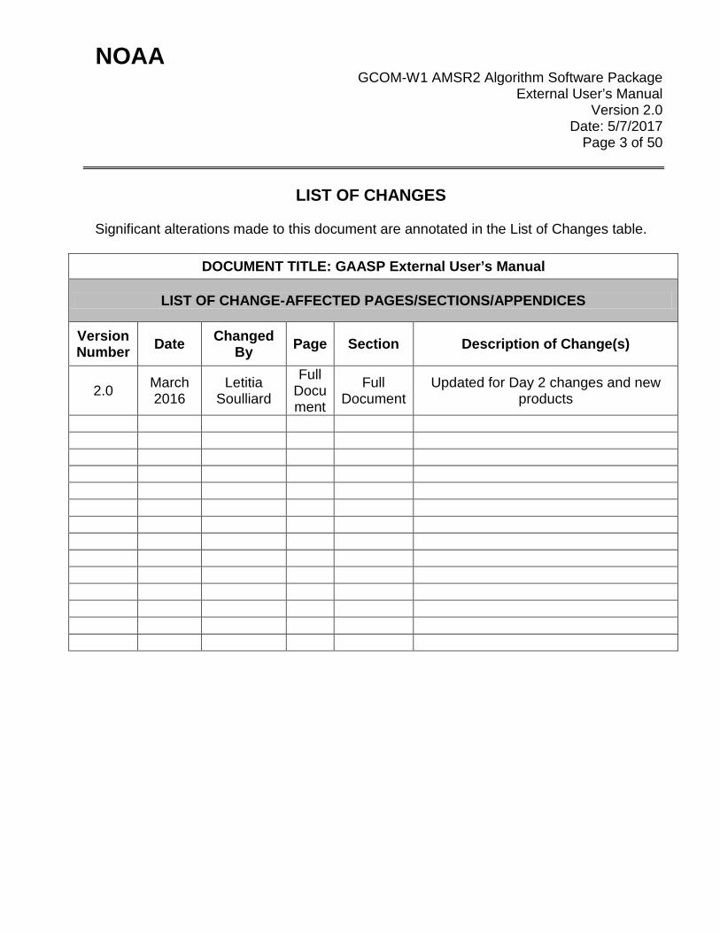
LIST OF CHANGES
Significant alterations made to this document are annotated in the List of Changes table.
DOCUMENT TITLE: GAASP External User’s Manual
LIST OF CHANGE-AFFECTED PAGES/SECTIONS/APPENDICES
Version Number Date Changed
By Page Section Description of Change(s)
2.0 March 2016
Letitia Soulliard
Full Document
Full Document
Updated for Day 2 changes and new products
NOAA GCOM-W1 AMSR2 Algorithm Software Package
External User’s Manual Version 2.0
Date: 5/7/2017 Page 4 of 50
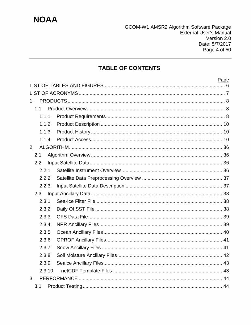
TABLE OF CONTENTS
Page LIST OF TABLES AND FIGURES ....................................................................................... 6
LIST OF ACRONYMS .......................................................................................................... 7
1. PRODUCTS .................................................................................................................. 8
1.1 Product Overview .................................................................................................... 8
1.1.1 Product Requirements ...................................................................................... 8
1.1.2 Product Description ........................................................................................ 10
1.1.3 Product History ............................................................................................... 10
1.1.4 Product Access ............................................................................................... 10
2. ALGORITHM ............................................................................................................... 36
2.1 Algorithm Overview ............................................................................................... 36
2.2 Input Satellite Data ................................................................................................ 36
2.2.1 Satellite Instrument Overview ......................................................................... 36
2.2.2 Satellite Data Preprocessing Overview .......................................................... 37
2.2.3 Input Satellite Data Description ...................................................................... 37
2.3 Input Ancillary Data ............................................................................................... 38
2.3.1 Sea-Ice Filter File ........................................................................................... 38
2.3.2 Daily OI SST File ............................................................................................ 38
2.3.3 GFS Data File ................................................................................................. 39
2.3.4 NPR Ancillary Files ......................................................................................... 39
2.3.5 Ocean Ancillary Files ...................................................................................... 40
2.3.6 GPROF Ancillary Files .................................................................................... 41
2.3.7 Snow Ancillary Files ....................................................................................... 41
2.3.8 Soil Moisture Ancillary Files ............................................................................ 42
2.3.9 Seaice Ancillary Files...................................................................................... 43
2.3.10 netCDF Template Files ............................................................................... 43
3. PERFORMANCE ........................................................................................................ 44
3.1 Product Testing ..................................................................................................... 44

NOAA GCOM-W1 AMSR2 Algorithm Software Package
External User’s Manual Version 2.0
Date: 5/7/2017 Page 5 of 50
3.1.1 Test Data Description ..................................................................................... 44
3.1.2 Unit Test Plans ............................................................................................... 44
3.2 Product Accuracy .................................................................................................. 45
3.2.1 Test Results .................................................................................................... 45
3.2.2 Product Accuracy ........................................................................................... 45
3.3 Product Quality Output .......................................................................................... 46
3.4 External Product Tools .......................................................................................... 49
4. PRODUCT STATUS ................................................................................................... 50
4.1 Operations Documentation ................................................................................... 50
4.2 Maintenance History ............................................................................................. 50

NOAA GCOM-W1 AMSR2 Algorithm Software Package
External User’s Manual Version 2.0
Date: 5/7/2017 Page 6 of 50
LIST OF TABLES AND FIGURES Page
Table 1-1 – Product Team Information ................................................................................. 8 Table 1-2 – GAASP Output Files ....................................................................................... 11 Table 1-3 – GAASP MBT netCDF4 EDR File Content Description .................................... 13 Table 1-4 – GAASP OCEAN netCDF4 EDR File Content Description ............................... 19 Table 1-5 – GAASP PRECIP netCDF4 EDR File Content Description .............................. 22 Table 1-6 – GAASP SNOW netCDF4 EDR File Content Description ................................. 24 Table 1-7 – GAASP SOIL NetCDF4 EDR File Content Description ................................... 26 Table 1-8 – GAASP SEAICE-NH netCDF4 EDR File Content Description ........................ 28 Table 1-9 – GAASP SEAICE-SH netCDF4 EDR File Content Description......................... 29 Table 1-10 – GAASP SOIL Binary EDR File Content Description ...................................... 30 Table 1-11 – AMSR2 1B BUFR User Definitions (Table-A) ................................................ 31 Table 1-12 – AMSR2 1B BUFR User Definitions (Table-B) ................................................ 32 Table 1-13 – AMSR2 1B BUFR User Definitions (Table D) ................................................ 32 Table 1-14 – AMSR2 SST BUFR User Definitions (Table-A) ............................................. 33 Table 1-15 – AMSR2 SST BUFR User Definitions (Table-B) ............................................. 34 Table 1-16 – AMSR2 SST BUFR User Definitions (Table D) ............................................. 34 Table 2-1 – NPR Ancillary Files ......................................................................................... 40 Table 2-2 – Ocean Ancillary Files ...................................................................................... 40 Table 2-3 – GPROF Ancillary Files .................................................................................... 41 Table 2-4 – Snow Ancillary Files ........................................................................................ 41 Table 2-5 – Soil Moisture Ancillary Files ............................................................................ 42 Table 2-6 – Seaice Ancillary Files ...................................................................................... 43 Table 2-7 – netCDF Template Ancillary Files ..................................................................... 44 Table 3-1 – Summary of GAASP Product Performance ..................................................... 45 Table 3-2 – Ocean EDR Quality Flags ............................................................................... 46 Table 3-3 – Sea Surface Temperature Quality Flags ......................................................... 46 Table 3-4 – Precipitation Quality Flags............................................................................... 47 Table 3-5 – Snow Depth Index ........................................................................................... 47 Table 3-6 – Soil Moisture QA ............................................................................................. 47 Table 3-7 – Seaice Flags ................................................................................................... 48

NOAA GCOM-W1 AMSR2 Algorithm Software Package
External User’s Manual Version 2.0
Date: 5/7/2017 Page 7 of 50
LIST OF ACRONYMS AMSR2 Advanced Microwave Scanning Radiometer 2 APID Application Packet ID ASD APID Sorted Data ATBD Algorithm Theoretical Basis Document CDL network Common data format Description Language CLW Cloud Liquid Water DDS Data Distribution Server EDR Environmental Data Record GAASP GCOM-W1 AMSR2 Algorithm Software Package GCOM-W1 Global Change Observation Mission – Water 1 GFS Global Forecast System GPROF Goddard PROfiling algorithm GRIB2 GRIdded Binary format (version 2) IDPS Interface Data Processing Segment JAXA Japan Aerospace Exploration Agency KSAT Kongsberg Satellite Services MBT Microwave Brightness Temperatures NCEI National Centers for Environmental Information netCDF4 Network Common Data Format version 4 NOAA National Oceanic and Atmospheric Administration OSPO Office of Satellite and Product Operations PAL Product Area Lead PDA Product Distribution Area RFI Radio Frequency Interference SDR Sensor Data Record SIC Sea Ice Cover SMM System Maintenance Manual SMOPS Soil Moisture Operational Products System SPSRB Satellite Product and Services Review Board SST Sea Surface Temperature SSW Sea Surface Winds STAR Center for SaTellite Applications and Research SWE Snow Water Equivalent TPW Total Precipitable Water WSPD Wind Speed (sea surface)

NOAA GCOM-W1 AMSR2 Algorithm Software Package
External User’s Manual Version 2.0
Date: 5/7/2017 Page 8 of 50
1. PRODUCTS This is an external user’s manual document describing the Global Change Observation Mission – Water 1 (GCOM-W1) Advanced Microwave Scanning Radiometer 2 (AMSR2) Algorithm Software Package (GAASP) products and output files. The GAASP system was developed at the Center for Satellite Applications and Research (STAR). It will be delivered to the NPOESS Data Exploitation (NDE) team and run in a pre-operational manner. After a preliminary testing period, the NDE will, in turn, be delivered to the Office of Systems Development (OSD) to be run operationally. The intended users of the External User’s Manual (EUM) are end users of the output products and files, and the product verification and validation (V&V) teams. The purpose of the EUM is to provide product users and product testers with information that will enable them to acquire the product, understand its features, and use the data. External users are defined as those users who do not have direct access to the processing system (those outside of OSD). The output files are defined as those leaving the NDE as opposed to those that are output by the GAASP processing, but available only internally within the NDE.
1.1 Product Overview
1.1.1 Product Requirements All GAASP basic and derived requirements are available in the GAASP Requirements Allocation Document (RAD). These requirements identify the users and their needs with respect to file content, format, latency, and quality. This document is available upon request from the STAR Project Lead.Product Team. The GAASP product team consists of the following individuals from STAR, OSD and OSPO.
Table 1-1 – Product Team Information
Team Member Organization Role Contact Information Walter Wolf STAR STAR Project Lead 5830 University Research
Court Riverdale, MD. 20740 Phone: 301-683-1314 Email: [email protected]

NOAA GCOM-W1 AMSR2 Algorithm Software Package
External User’s Manual Version 2.0
Date: 5/7/2017 Page 9 of 50
Paul Chang STAR STAR Algorithm Lead
5830 University Research Court Riverdale, MD. 20740 Phone: 301-683-3355 x 167 Email: [email protected]
Thomas King STAR Development Lead 5830 University Research Court Riverdale, MD. 20740 Phone: 301-683-3547 Email: [email protected]
Letitia Soulliard STAR Developer 5830 University Research Court Riverdale, MD. 20740 Phone: 301-683-3538 Email: [email protected]
Mike Wilson STAR Developer 5830 University Research Court Riverdale, MD. 20740 Phone: 301-683-3560 Email: [email protected]
Peter Keehn STAR Developer 5830 University Research Court Riverdale, MD. 20740 Phone: 301-683-3548 Email: [email protected]
Limin Zhao OSPO OSPO Product Area Lead
5830 University Research Court Riverdale, MD. 20740 Email: [email protected]
Steve Quinn OSPO Operations Programmer
5830 University Research Court Riverdale, MD. 20740 Phone:301-683-3285 Email: [email protected]

NOAA GCOM-W1 AMSR2 Algorithm Software Package
External User’s Manual Version 2.0
Date: 5/7/2017 Page 10 of 50
Paul Haggerty OSPO ESPC Operations Team Lead
4231 Suitland Rd Suitland, MD 20746 Phone:301-817-3876 Email: [email protected]
1.1.2 Product Description The GAASP products set described in this document are generated entirely from GCOM-W1 SDR data. The GAASP is run operationally at the Office of Satellite and Product Operations (OSPO). The products include calibrated Microwave Brightness Temperatures (MBT), Precipitation Rate (PR), Sea Surface Temperature (SST), Sea Surface Winds (SSW), Total Precipitable Water (TPW), Cloud Liquid Water (CLW), Soil Moisture (SM), Surface Type (ST), Snow Cover (SC), Snow Depth (SD), Snow Water Equivalent (SWE), and Sea Ice Cover (SIC). All products are output in netCDF4. In addition, the non-bias corrected MBT and SST products are available in BUFR, Sea Ice is available in GRIB2, and Soil Moisture is available in binary format (for SMOPS). The BUFR and GRIB tailoring is performed by the BUFR/GRIB Toolkit within NDE, but outside of the GAASP package. For information on the science algorithms, see the GAASP Algorithm Theoretical Basis Document (ATBD). This document can be provided on request from the GAASP OSPO Product Area Lead (PAL) identified in the Product Team table in section 1.1.2.
1.1.3 Product History The GAASP is being delivered in two phases defined by Day 1 and Day 2 product sets. Day 1 products were available in late 2015 and will consist of (1) Microwave Brightness Temperatures, (2) Precipitation (land and ocean rain rates), and (3) the following Ocean EDRs: Sea Surface Temperature, Sea Surface Winds, Total Precipitable Water, and Cloud Liquid Water. Day 2 products will be available in mid-2016 and will consist of the following land/ocean surface EDRs: Soil Moisture, Surface Type, Snow Cover, Snow Depth, Snow Water Equivalent, and Sea Ice. Two more additional enhancements to these products will be delivered and implemented in the following years.
1.1.4 Product Access GAASP operational products are generated in near-real time from GCOM-W1 AMSR-2 data, and made available to users on the data distribution server at ESPC for real-time use. For access to this server, information about data files, and associated documentation, the GCOM PAL should be contacted (see Table 1-1). In general, users are required to fill out

NOAA GCOM-W1 AMSR2 Algorithm Software Package
External User’s Manual Version 2.0
Date: 5/7/2017 Page 11 of 50
the Data Access Request Form located on http://www.ospo.noaa.gov/Organization/About/access.html, and submit to [email protected] with a copy to the PAL. The plan is to make historical products for external users through the NOAA Comprehensive Large Array-data Stewardship System (CLASS) archive at the National Centers for Environmental Information (NCEI). Data should be queried and ordered from CLASS at the following web URL: http://www.class.noaa.gov after the archive starts. Currently, discussion between NJO and CLASS is still ongoing. GAASP products are mainly distributed as netCDF4 files; however, BUFR and binary files also exist on the DDS. The GAASP files are generated as the GCOM-W1 AMSR-2 data comes in as orbital dump files and stored on the ESPC DDS system after being produced for FTP access. These data files will be maintained on the DDS for a max of 3 days. If the files are not available at the normal time, notification by email will automatically be sent to the following authorized personnel (contact info can be found in Table 1-1):
• Limin Zhao • Steve Quinn • Paul Haggerty
If users have issues to get data from the DDS, the DDS administrator/manager Donna McNamara ([email protected]) should be contacted. After users submit the Data Access Request, the NESDIS Data Access Review Board will evaluate it, and give its approval or rejection. Users will be contacted after the Board makes the decision. For an approved DAR, the user will be assigned an ID on the DDS. The user will have to follow detailed procedures on how to pull the data. Table 1-2 lists all external distributed GAASP files and their formats. Table 1-3, Table 1-4, Table 1-5, Table 1-6, Table 1-7, Table 1-8, and Table 1-9 show the detailed contents of each netCDF4 output files listed in Table 1-2. Table 1-10 shows the detailed contest of the soil Binary file. Table 1-11, Table 1-12, Table 1-13, Table 1-14, Table 1-15, and Table 1-16 show the BUFR User Definition tables for each of the BUFR output files listed in Table 1-2.
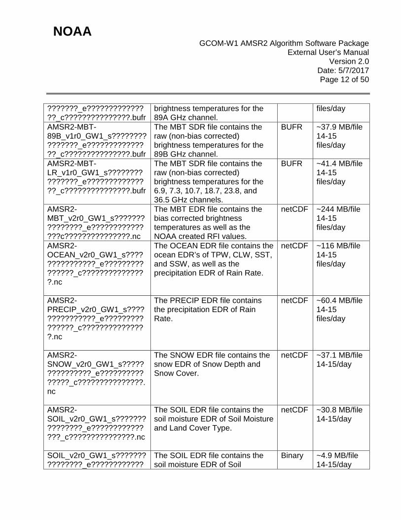
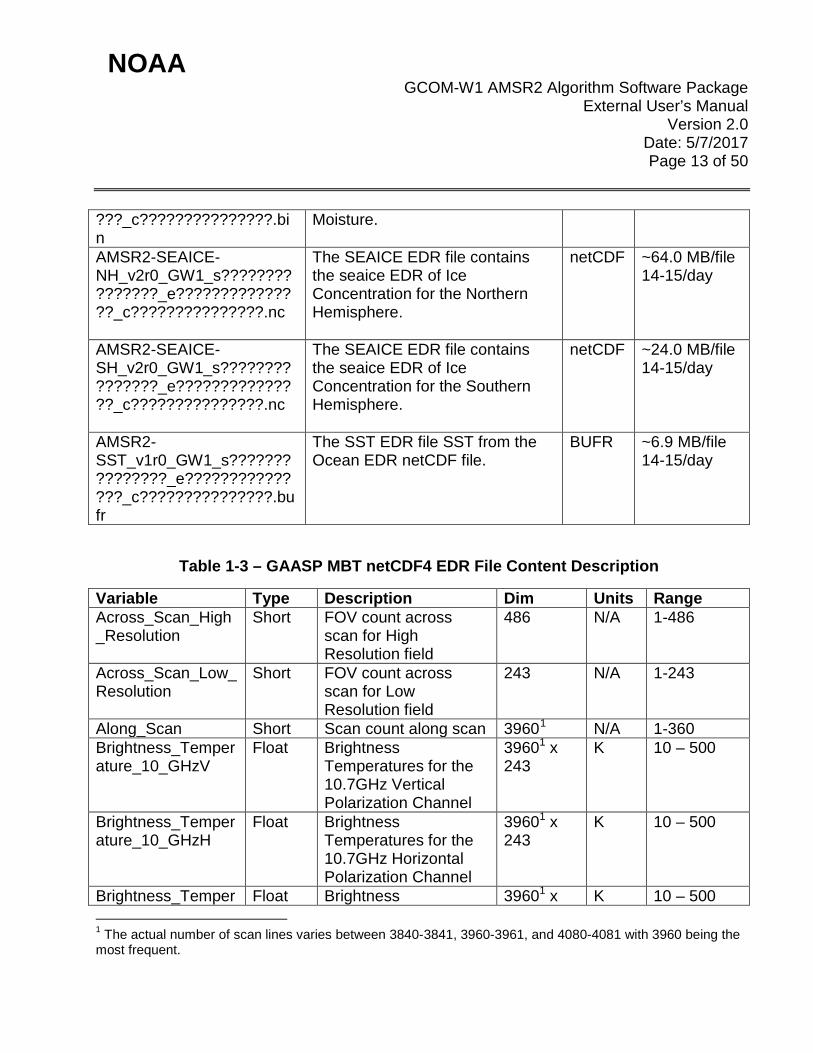
Table 1-2 – GAASP Output Files
File Description Format Size/file AMSR2-MBT-89A_v1r0_GW1_s????????
The MBT SDR file contains the raw (non-bias corrected)
BUFR ~37.9 MB/file 14-15
NOAA GCOM-W1 AMSR2 Algorithm Software Package
External User’s Manual Version 2.0
Date: 5/7/2017 Page 12 of 50
???????_e???????????????_c???????????????.bufr
brightness temperatures for the 89A GHz channel.
files/day
AMSR2-MBT-89B_v1r0_GW1_s???????????????_e???????????????_c???????????????.bufr
The MBT SDR file contains the raw (non-bias corrected) brightness temperatures for the 89B GHz channel.
BUFR ~37.9 MB/file 14-15 files/day
AMSR2-MBT-LR_v1r0_GW1_s???????????????_e???????????????_c???????????????.bufr
The MBT SDR file contains the raw (non-bias corrected) brightness temperatures for the 6.9, 7.3, 10.7, 18.7, 23.8, and 36.5 GHz channels.
BUFR ~41.4 MB/file 14-15 files/day
AMSR2-MBT_v2r0_GW1_s???????????????_e???????????????c???????????????.nc
The MBT EDR file contains the bias corrected brightness temperatures as well as the NOAA created RFI values.
netCDF ~244 MB/file 14-15 files/day
AMSR2-OCEAN_v2r0_GW1_s???????????????_e???????????????_c???????????????.nc
The OCEAN EDR file contains the ocean EDR’s of TPW, CLW, SST, and SSW, as well as the precipitation EDR of Rain Rate.
netCDF ~116 MB/file 14-15 files/day
AMSR2-PRECIP_v2r0_GW1_s???????????????_e???????????????_c???????????????.nc
The PRECIP EDR file contains the precipitation EDR of Rain Rate.
netCDF ~60.4 MB/file 14-15 files/day
AMSR2-SNOW_v2r0_GW1_s???????????????_e???????????????_c???????????????.nc
The SNOW EDR file contains the snow EDR of Snow Depth and Snow Cover.
netCDF ~37.1 MB/file 14-15/day
AMSR2-SOIL_v2r0_GW1_s???????????????_e???????????????_c???????????????.nc
The SOIL EDR file contains the soil moisture EDR of Soil Moisture and Land Cover Type.
netCDF ~30.8 MB/file 14-15/day
SOIL_v2r0_GW1_s???????????????_e????????????
The SOIL EDR file contains the soil moisture EDR of Soil
Binary ~4.9 MB/file 14-15/day
NOAA GCOM-W1 AMSR2 Algorithm Software Package
External User’s Manual Version 2.0
Date: 5/7/2017 Page 13 of 50
???_c???????????????.bin
Moisture.
AMSR2-SEAICE-NH_v2r0_GW1_s???????????????_e???????????????_c???????????????.nc
The SEAICE EDR file contains the seaice EDR of Ice Concentration for the Northern Hemisphere.
netCDF ~64.0 MB/file 14-15/day
AMSR2-SEAICE-SH_v2r0_GW1_s???????????????_e???????????????_c???????????????.nc
The SEAICE EDR file contains the seaice EDR of Ice Concentration for the Southern Hemisphere.
netCDF ~24.0 MB/file 14-15/day
AMSR2-SST_v1r0_GW1_s???????????????_e???????????????_c???????????????.bufr
The SST EDR file SST from the Ocean EDR netCDF file.
BUFR ~6.9 MB/file 14-15/day
Table 1-3 – GAASP MBT netCDF4 EDR File Content Description
Variable Type Description Dim Units Range Across_Scan_High_Resolution
Short FOV count across scan for High Resolution field
486 N/A 1-486
Across_Scan_Low_Resolution
Short FOV count across scan for Low Resolution field
243 N/A 1-243
Along_Scan Short Scan count along scan 39601 N/A 1-360 Brightness_Temperature_10_GHzV
Float Brightness Temperatures for the 10.7GHz Vertical Polarization Channel
39601 x 243
K 10 – 500
Brightness_Temperature_10_GHzH
Float Brightness Temperatures for the 10.7GHz Horizontal Polarization Channel
39601 x 243
K 10 – 500
Brightness_Temper Float Brightness 39601 x K 10 – 500 1 The actual number of scan lines varies between 3840-3841, 3960-3961, and 4080-4081 with 3960 being the most frequent.
NOAA GCOM-W1 AMSR2 Algorithm Software Package
External User’s Manual Version 2.0
Date: 5/7/2017 Page 14 of 50
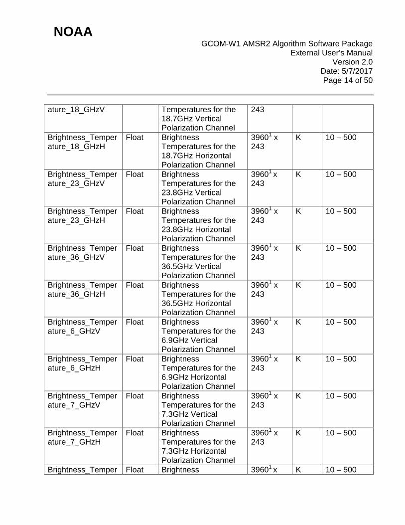
ature_18_GHzV Temperatures for the 18.7GHz Vertical Polarization Channel
243
Brightness_Temperature_18_GHzH
Float Brightness Temperatures for the 18.7GHz Horizontal Polarization Channel
39601 x 243
K 10 – 500
Brightness_Temperature_23_GHzV
Float Brightness Temperatures for the 23.8GHz Vertical Polarization Channel
39601 x 243
K 10 – 500
Brightness_Temperature_23_GHzH
Float Brightness Temperatures for the 23.8GHz Horizontal Polarization Channel
39601 x 243
K 10 – 500
Brightness_Temperature_36_GHzV
Float Brightness Temperatures for the 36.5GHz Vertical Polarization Channel
39601 x 243
K 10 – 500
Brightness_Temperature_36_GHzH
Float Brightness Temperatures for the 36.5GHz Horizontal Polarization Channel
39601 x 243
K 10 – 500
Brightness_Temperature_6_GHzV
Float Brightness Temperatures for the 6.9GHz Vertical Polarization Channel
39601 x 243
K 10 – 500
Brightness_Temperature_6_GHzH
Float Brightness Temperatures for the 6.9GHz Horizontal Polarization Channel
39601 x 243
K 10 – 500
Brightness_Temperature_7_GHzV
Float Brightness Temperatures for the 7.3GHz Vertical Polarization Channel
39601 x 243
K 10 – 500
Brightness_Temperature_7_GHzH
Float Brightness Temperatures for the 7.3GHz Horizontal Polarization Channel
39601 x 243
K 10 – 500
Brightness_Temper Float Brightness 39601 x K 10 – 500
NOAA GCOM-W1 AMSR2 Algorithm Software Package
External User’s Manual Version 2.0
Date: 5/7/2017 Page 15 of 50
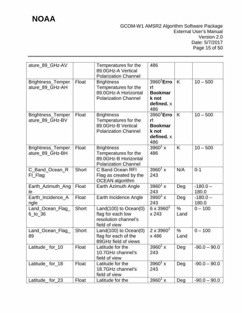
ature_89_GHz-AV Temperatures for the 89.0GHz-A Vertical Polarization Channel
486
Brightness_Temperature_89_GHz-AH
Float Brightness Temperatures for the 89.0GHz-A Horizontal Polarization Channel
39601Error! Bookmark not defined. x 486
K 10 – 500
Brightness_Temperature_89_GHz-BV
Float Brightness Temperatures for the 89.0GHz-B Vertical Polarization Channel
39601Error! Bookmark not defined. x 486
K 10 – 500
Brightness_Temperature_89_GHz-BH
Float Brightness Temperatures for the 89.0GHz-B Horizontal Polarization Channel
39601 x 486
K 10 – 500
C_Band_Ocean_RFI_Flag
Short C Band Ocean RFI Flag as created by the OCEAN algorithm
39601 x 243
N/A 0-1
Earth_Azimuth_Angle
Float Earth Azimuth Angle 39601 x 243
Deg -180.0 – 180.0
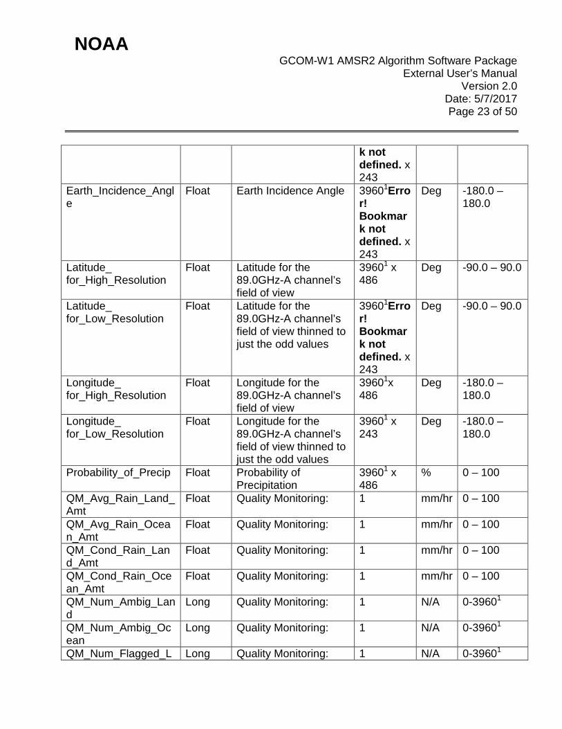
Earth_Incidence_Angle
Float Earth Incidence Angle 39601 x 243
Deg -180.0 – 180.0
Land_Ocean_Flag_6_to_36
Short Land(100) to Ocean(0) flag for each low resolution channel’s field of view
6 x 39601 x 243
% Land
0 – 100
Land_Ocean_Flag_89
Short Land(100) to Ocean(0) flag for each of the 89GHz field of views
2 x 39601 x 486
% Land
0 – 100
Latitude_ for_10 Float Latitude for the 10.7GHz channel’s field of view
39601 x 243
Deg -90.0 – 90.0
Latitude_ for_18 Float Latitude for the 18.7GHz channel’s field of view
39601 x 243
Deg -90.0 – 90.0
Latitude_ for_23 Float Latitude for the 39601 x Deg -90.0 – 90.0

NOAA GCOM-W1 AMSR2 Algorithm Software Package
External User’s Manual Version 2.0
Date: 5/7/2017 Page 16 of 50
23.8GHz channel’s field of view
243
Latitude_ for_36 Float Latitude for the 36.5GHz channel’s field of view
39601 x 243
Deg -90.0 – 90.0
Latitude_ for_6 Float Latitude for the 6.9GHz channel’s field of view
39601 x 243
Deg -90.0 – 90.0
Latitude_ for_7 Float Latitude for the 7.3GHz channel’s field of view
39601 x 243
Deg -90.0 – 90.0
Latitude_ for_89A Float Latitude for the 89.0GHz-A channel’s field of view
39601 x 486
Deg -90.0 – 90.0
Latitude_ for_89B Float Latitude for the 89.0GHz-B channel’s field of view
39601 x 486
Deg -90.0 – 90.0
Latitude_ for_High_Resolution
Float Latitude for the 89.0GHz-A channel’s field of view
39601 x 486
Deg -90.0 – 90.0
Latitude_ for_Low_Resolution
Float Latitude for the 89.0GHz-A channel’s field of view thinned to just the odd values
39601 x 243
Deg -90.0 – 90.0
Longitude_ for_10 Float Longitude for the 10.7GHz channel’s field of view
39601 x 243
Deg -180.0 – 180.0
Longitude_ for_18 Float Longitude for the 18.7GHz channel’s field of view
39601 x 243
Deg -180.0 – 180.0
Longitude_ for_23 Float Longitude for the 23.8GHz channel’s field of view
39601 x 243
Deg -180.0 – 180.0
Longitude_ for_36 Float Longitude for the 36.5GHz channel’s field of view
39601 x 243
Deg -180.0 – 180.0
Longitude_ for_6 Float Longitude for the 6.9GHz channel’s field of view
39601 x 243
Deg -180.0 – 180.0
Longitude_ for_7 Float Longitude for the 7.3GHz channel’s field of view
39601 x 243
Deg -180.0 – 180.0

NOAA GCOM-W1 AMSR2 Algorithm Software Package
External User’s Manual Version 2.0
Date: 5/7/2017 Page 17 of 50
Longitude_ for_89A Float Longitude for the 89.0GHz-A channel’s field of view
39601 x 486
Deg -180.0 – 180.0
Longitude_ for_89B Float Longitude for the 89.0GHz-B channel’s field of view
39601 x 486
Deg -180.0 – 180.0
Longitude_ for_High_Resolution
Float Longitude for the 89.0GHz-A channel’s field of view
39601 x 486
Deg -180.0 – 180.0
Longitude_ for_Low_Resolution
Float Longitude for the 89.0GHz-A channel’s field of view thinned to just the odd values
39601 x 243
Deg -180.0 – 180.0
Pixel_Data_Quality_6_to_36
Short The flag that shows the data include RFI is stored for each frequency and polarization except 89.0GHz.
39601 x 486
N/A See AMSR2 L1 Format Guide section (JAXA 2013)
Pixel_Data_Quality_89
Short The flag that shows the data include RFI is stored for each frequency and polarization for 89.0GHz.
39601 x 486
N/A See AMSR2 L1 Format Guide section (JAXA 2013)
RFI_NOAA_LAND_06v
Float The NOAA created RFI value over land for the 6.9GHz Vertical Polarization channel
39601 x 243
N/A -10 – 20
RFI_NOAA_LAND_06h
Float The NOAA created RFI value over land for the 6.9GHz Horizontal Polarization channel
39601 x 243
N/A -10 – 20
RFI_NOAA_LAND_07v
Float The NOAA created RFI value over land for the 7.3GHz Vertical Polarization channel
39601 x 243
N/A -10 – 20
RFI_NOAA_LAND_ Float The NOAA created RFI 39601 x N/A -10 – 20

NOAA GCOM-W1 AMSR2 Algorithm Software Package
External User’s Manual Version 2.0
Date: 5/7/2017 Page 18 of 50
07h value over land for the 7.3GHz Horizontal Polarization channel
243
RFI_NOAA_LAND_10v
Float The NOAA created RFI value over land for the 10.7GHz Vertical Polarization channel
39601 x 243
N/A -10 – 20
RFI_NOAA_LAND_10h
Float The NOAA created RFI value over land for the 10.7GHz Horizontal Polarization channel
39601 x 243
N/A -10 – 20
RFI_NOAA_OCEAN_10v
Float The NOAA created RFI value over land for the 10.7GHz Vertical Polarization channel
39601 x 243
N/A -10 – 20
RFI_NOAA_OCEAN_10h
Float The NOAA created RFI value over land for the 10.7GHz Horizontal Polarization channel
39601 x 243
N/A -10 – 20
RFI_NOAA_OCEAN_18v
Float The NOAA created RFI value over land for the 18.7GHz Vertical Polarization channel
39601 x 243
N/A -10 – 20
RFI_NOAA_OCEAN_18h
Float The NOAA created RFI value over land for the 18.7GHz Horizontal Polarization channel
39601 x 243
N/A -10 – 20
Scan_Angle Float Scan Angle 39601 x 243
Deg 46.5 – 48.5
Scan_Time Float Scan line Start Time 6-D for (YYYY, MM, DD, HH, MM, SS.SSS)
39601 x 6 GMT YYYY = 2012 – 2032 MM = 1-12 DD = 1-31 HH = 0-23 MM = 0-59 SS = 0-59 .SSS=000-999
Sun_Azimuth_Angl Float Sun Azimuth Angle 39601 x Deg -180.0 –

NOAA GCOM-W1 AMSR2 Algorithm Software Package
External User’s Manual Version 2.0
Date: 5/7/2017 Page 19 of 50
e 243 180.0 Sun_Elevation Float Sun Elevation 39601 x
243 Deg -180.0 –
180.0 Sun_Glint_Flag Short Sun Glint Flag as
created by the OCEAN algorithm
39601 x 243
N/A 0-1
Table 1-4 – GAASP OCEAN netCDF4 EDR File Content Description
Variable Type Description Dim Units Range Across_Scan_High_Resolution
Short FOV count across scan for High Resolution field
486 N/A 1-486
Across_Scan_Low_Resolution
Short FOV count across scan for Low Resolution field
243 N/A 1-243
Aggressive_Land_mask
Float Aggressive Land and Seaice Mask
39601 x 243
N/A 0-1
Along_Scan Short Scan count along scan 39601 N/A 1-360 CLW Double Cloud Liquid Water 39601 x
243 mm 0 – 1
Descending_Flag Short Descending Flag 39601 N/A 0-1 EDR_QC_Flag Float Quality Control Flag
for the entire Ocean Algorithm
39601 x 243
N/A N/A
Earth_Azimuth_Angle
Float Earth Azimuth Angle 39601 x 243
Deg -180.0 – 180.0
Earth_Incidence_Angle
Float Earth Incidence Angle 39601 x 243
Deg -180.0 – 180.0
GFS_Model_SST Float The sea surface temperature from the GFS model
39601 x 243
Kelvin 269 – 309
GFS_Model_WDIR Float The derived wind direction from the GFS model
39601 x 243
Degrees
0 – 360
GFS_Model_WSPD Float The derived wind speed from the GFS model
39601 x 243
m/s 0-30
Land_mask Float The derived land-sea 39601 x N/A N/A

NOAA GCOM-W1 AMSR2 Algorithm Software Package
External User’s Manual Version 2.0
Date: 5/7/2017 Page 20 of 50
mask from the GFS model
243
Latitude_ for_High_Resolution
Float Latitude for the 89.0GHz-A channel’s field of view
39601 x 486
Deg -90.0 – 90.0
Latitude_ for_Low_Resolution
Float Latitude for the 89.0GHz-A channel’s field of view thinned to just the odd values
39601 x 243
Deg -90.0 – 90.0
Longitude_ for_High_Resolution
Float Longitude for the 89.0GHz-A channel’s field of view
39601 x 486
Deg -180.0 – 180.0
Longitude_ for_Low_Resolution
Float Longitude for the 89.0GHz-A channel’s field of view thinned to just the odd values
39601 x 243
Deg -180.0 – 180.0
Pixel_Data_Quality_6_to_36
Float The flag that shows the data include RFI is stored for each frequency and polarization except 89.0GHz.
39601Error! Bookmark not defined. x 486
N/A N/A
Prelim_Reynolds_SST
Float Preliminary analysis of Reynolds-OI SeaSurface Temperature
39601 x 243
Kelvin 269 – 309
QM_max_EIA Float Quality Monitoring: Maximum Earth Incident Angle
1 Deg -180.0 – 180.0
QM_max_SST_diff Float Quality Monitoring: Max SST difference between model and algorithm
1 Celsius
-2.5 – 35
QM_max_WSPD_diff
Float Quality Monitoring: Max Wind Speed difference between model and algorithm
1 m/s 0 – 30
QM_mean_EIA Float Quality Monitoring: Mean Earth Incident Angle
1 Deg -180.0 – 180.0

NOAA GCOM-W1 AMSR2 Algorithm Software Package
External User’s Manual Version 2.0
Date: 5/7/2017 Page 21 of 50
QM_mean_SST_diff
Float Quality Monitoring: Mean SST difference between model and algorithm
1 Celsius
-2.5 – 35
QM_mean_WSPD_diff
Float Quality Monitoring: Mean Wind Speed difference between model and algorithm
1 m/s 0 – 30
QM_min_EIA Float Quality Monitoring: Minimum Earth Incident Angle
1 Deg -180.0 – 180.0
QM_min_SST_diff Float Quality Monitoring: Minimum SST difference between model and alogrithm
1 Celsius
-2.5 – 35
QM_min_WSPD_diff
Float Quality Monitoring: Minimum Wind Speed difference between model and algorithm
1 m/s 0 – 30
Rain_Rate Float Surface Rain Rate 39601 x 486
mm/hr 0 – 100
Rain_Rate_QC_Flag
Byte Rain Rate Error Flag 39601 x 486
N/A 0 – 2
SST Double Sea Surface Temperature
39601 x 243
Celsius
-2.5 – 35
SST_QC Float Sea Surface Quality Control Flag
39601 x 243
N/A 0-1
Scan_Angle Float Scan Angle 39601 x 243
Deg 46.5 – 48.5
Scan_Time Float Scan line Start Time 6-D for (YYYY, MM, DD, HH, MM, SS.SSS)
39601 x 6 GMT YYYY = 2012 – 2032 MM = 1-12 DD = 1-31 HH = 0-23 MM = 0-59 SS = 0-59 .SSS = 000-999
Sun_Azimuth_Angl Float Sun Azimuth Angle 39601 x Deg -180.0 –

NOAA GCOM-W1 AMSR2 Algorithm Software Package
External User’s Manual Version 2.0
Date: 5/7/2017 Page 22 of 50
e 243 180.0 Sun_Elevation Float Sun Elevation 39601 x
243 Deg -180.0 –
180.0 Sun_Glint_Flag Short Sun Glint Flag 39601Erro
r! Bookmark not defined. x 243
N/A 0-1
TPW Double Total Precipitable Water
39601Error! Bookmark not defined. x 243
mm 0 – 75
WSPD Double Wind Speed 39601Error! Bookmark not defined. x 243
m/s 0 – 30
Table 1-5 – GAASP PRECIP netCDF4 EDR File Content Description
Variable Type Description Dim Units Range Across_Scan_High_Resolution
Short FOV count across scan for High Resolution field
486 N/A 1-486
Across_Scan_Low_Resolution
Short FOV count across scan for Low Resolution field
243 N/A 1-243
Along_Scan Short Scan count along scan 39601Error! Bookmark not defined.
N/A 1-360
Earth_Azimuth_Angle Float Earth Azimuth Angle 39601Error! Bookmar
Deg -180.0 – 180.0
NOAA GCOM-W1 AMSR2 Algorithm Software Package
External User’s Manual Version 2.0
Date: 5/7/2017 Page 23 of 50
k not defined. x 243
Earth_Incidence_Angle
Float Earth Incidence Angle 39601Error! Bookmark not defined. x 243
Deg -180.0 – 180.0
Latitude_ for_High_Resolution
Float Latitude for the 89.0GHz-A channel’s field of view
39601 x 486
Deg -90.0 – 90.0
Latitude_ for_Low_Resolution
Float Latitude for the 89.0GHz-A channel’s field of view thinned to just the odd values
39601Error! Bookmark not defined. x 243
Deg -90.0 – 90.0
Longitude_ for_High_Resolution
Float Longitude for the 89.0GHz-A channel’s field of view
39601x 486
Deg -180.0 – 180.0
Longitude_ for_Low_Resolution
Float Longitude for the 89.0GHz-A channel’s field of view thinned to just the odd values
39601 x 243
Deg -180.0 – 180.0
Probability_of_Precip Float Probability of Precipitation
39601 x 486
% 0 – 100
QM_Avg_Rain_Land_Amt
Float Quality Monitoring: 1 mm/hr 0 – 100
QM_Avg_Rain_Ocean_Amt
Float Quality Monitoring: 1 mm/hr 0 – 100
QM_Cond_Rain_Land_Amt
Float Quality Monitoring: 1 mm/hr 0 – 100
QM_Cond_Rain_Ocean_Amt
Float Quality Monitoring: 1 mm/hr 0 – 100
QM_Num_Ambig_Land
Long Quality Monitoring: 1 N/A 0-39601
QM_Num_Ambig_Ocean
Long Quality Monitoring: 1 N/A 0-39601
QM_Num_Flagged_L Long Quality Monitoring: 1 N/A 0-39601
NOAA GCOM-W1 AMSR2 Algorithm Software Package
External User’s Manual Version 2.0
Date: 5/7/2017 Page 24 of 50
and QM_Num_Flagged_Ocean
Long Quality Monitoring: 1 N/A 0-39601
QM_Num_Good_Land
Long Quality Monitoring: 1 N/A 0-39601
QM_Num_Good_Ocean
Long Quality Monitoring: 1 N/A 0-39601
QM_Num_Land_Pixels
Long Quality Monitoring: 1 N/A 0-39601
QM_Num_Missing Long Quality Monitoring: 1 N/A 0-39601 QM_Num_Ocean_Pixels
Long Quality Monitoring: 1 N/A 0-39601
QM_Num_Rain_Land_Pixels
Long Quality Monitoring: 1 N/A 0-39601
QM_Num_Rain_Ocean_Pixels
Long Quality Monitoring: 1 N/A 0-39601
QM_Sum_Rain_Land_Pixels
Float Quality Monitoring: 1 mm/hr 0 – 1000000
QM_Sum_Rain_Ocean_Pixels
Float Quality Monitoring: 1 mm/hr 0 – 1000000
Rain_Rate Float Surface rain rate 39601 x 486
mm/hr 0 – 100
Rain_Rate_QC_Flag Byte Flag denoting precipitation quality flag
39601x 486
N/A 0 – 2
Scan_Angle Float Scan Angle 39601x 243
Deg 46.5 – 48.5
Scan_Time Float Scan line Start Time 6-D for (YYYY, MM, DD, HH, MM, SS.SSS)
39601x 6 GMT YYYY = 2012 – 2032 MM = 1-12 DD = 1-31 HH = 0-23 MM = 0-59 SS = 0-59 .SSS = 000-999
convectPrecipitation Float Rain rate of convective clouds
39601 x 486
mm/hr 0 – 100
surfaceType Byte Surface Type (Land, 39601 x N/A 10 – 42
NOAA GCOM-W1 AMSR2 Algorithm Software Package
External User’s Manual Version 2.0
Date: 5/7/2017 Page 25 of 50
Coast, Ocean) 486
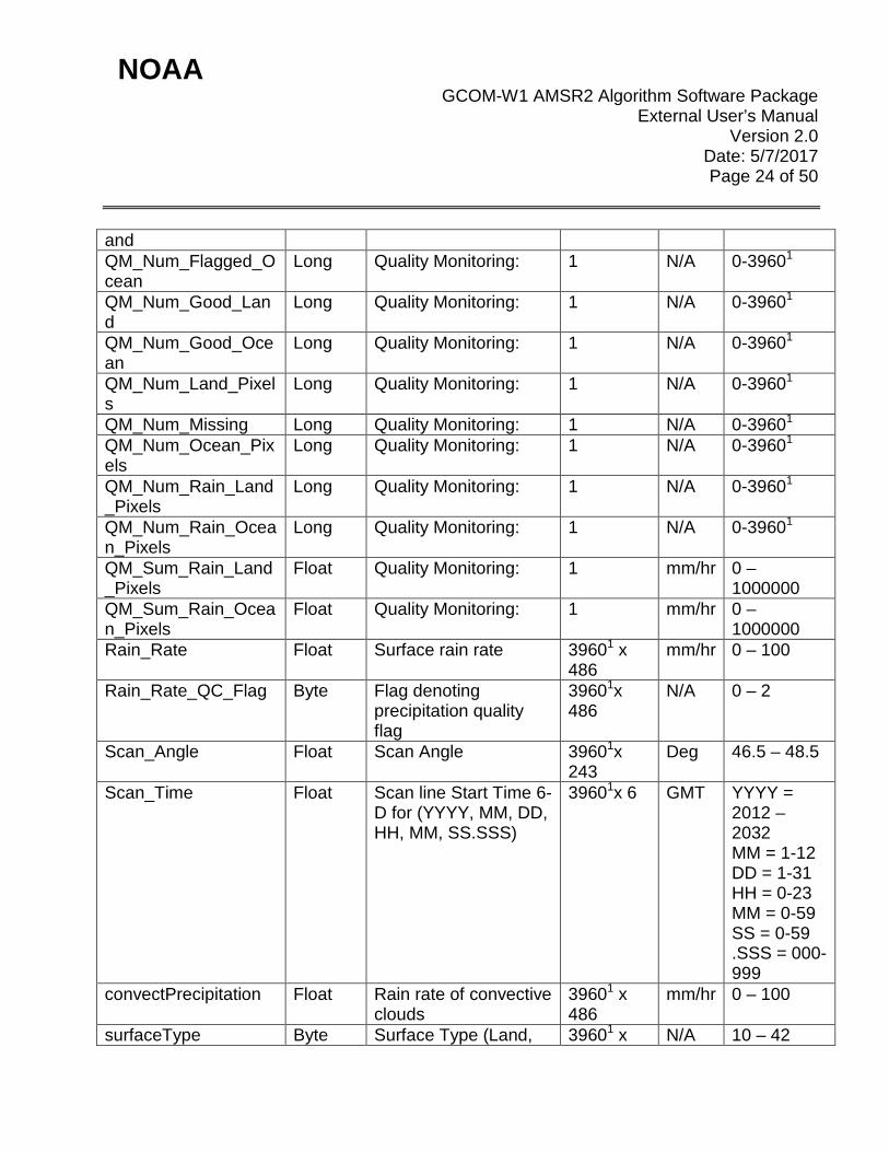
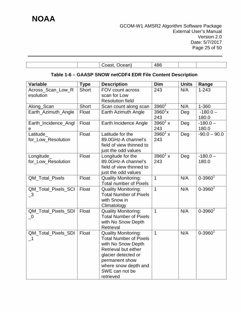
Table 1-6 – GAASP SNOW netCDF4 EDR File Content Description
Variable Type Description Dim Units Range Across_Scan_Low_Resolution
Short FOV count across scan for Low Resolution field
243 N/A 1-243
Along_Scan Short Scan count along scan 39601 N/A 1-360 Earth_Azimuth_Angle Float Earth Azimuth Angle 39601x
243 Deg -180.0 –
180.0 Earth_Incidence_Angle
Float Earth Incidence Angle 39601 x 243
Deg -180.0 – 180.0
Latitude_ for_Low_Resolution
Float Latitude for the 89.0GHz-A channel’s field of view thinned to just the odd values
39601 x 243
Deg -90.0 – 90.0
Longitude_ for_Low_Resolution
Float Longitude for the 89.0GHz-A channel’s field of view thinned to just the odd values
39601 x 243
Deg -180.0 – 180.0
QM_Total_Pixels Float Quality Monitoring: Total number of Pixels
1 N/A 0-39601
QM_Total_Pixels_SCI_3
Float Quality Monitoring: Total Number of Pixels with Snow in Climatology
1 N/A 0-39601
QM_Total_Pixels_SDI_0
Float Quality Monitoring: Total Number of Pixels with No Snow Depth Retrieval
1 N/A 0-39601
QM_Total_Pixels_SDI_1
Float Quality Monitoring: Total Number of Pixels with No Snow Depth Retrieval but either glacier detected or permanent show where snow depth and SWE can not be retrieved
1 N/A 0-39601
NOAA GCOM-W1 AMSR2 Algorithm Software Package
External User’s Manual Version 2.0
Date: 5/7/2017 Page 26 of 50
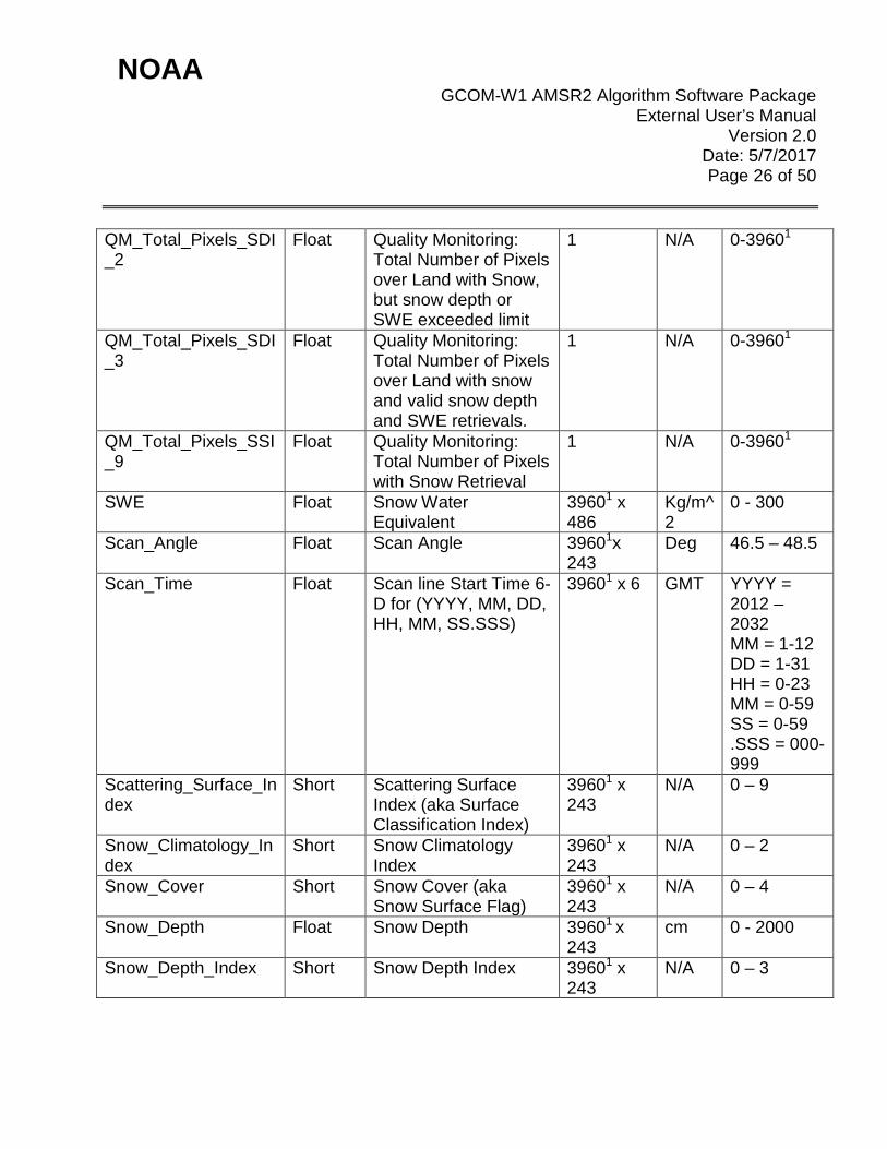
QM_Total_Pixels_SDI_2
Float Quality Monitoring: Total Number of Pixels over Land with Snow, but snow depth or SWE exceeded limit
1 N/A 0-39601
QM_Total_Pixels_SDI_3
Float Quality Monitoring: Total Number of Pixels over Land with snow and valid snow depth and SWE retrievals.
1 N/A 0-39601
QM_Total_Pixels_SSI_9
Float Quality Monitoring: Total Number of Pixels with Snow Retrieval
1 N/A 0-39601
SWE Float Snow Water Equivalent
39601 x 486
Kg/m^2
0 - 300
Scan_Angle Float Scan Angle 39601x 243
Deg 46.5 – 48.5
Scan_Time Float Scan line Start Time 6-D for (YYYY, MM, DD, HH, MM, SS.SSS)
39601 x 6 GMT YYYY = 2012 – 2032 MM = 1-12 DD = 1-31 HH = 0-23 MM = 0-59 SS = 0-59 .SSS = 000-999
Scattering_Surface_Index
Short Scattering Surface Index (aka Surface Classification Index)
39601 x 243
N/A 0 – 9
Snow_Climatology_Index
Short Snow Climatology Index
39601 x 243
N/A 0 – 2
Snow_Cover Short Snow Cover (aka Snow Surface Flag)
39601 x 243
N/A 0 – 4
Snow_Depth Float Snow Depth 39601 x 243
cm 0 - 2000
Snow_Depth_Index Short Snow Depth Index 39601 x 243
N/A 0 – 3

NOAA GCOM-W1 AMSR2 Algorithm Software Package
External User’s Manual Version 2.0
Date: 5/7/2017 Page 27 of 50
Table 1-7 – GAASP SOIL NetCDF4 EDR File Content Description
Variable Type Description Dim Units Range Across_Scan_Low_Resolution
Short FOV count across scan for Low Resolution field
243 N/A 1-243
Along_Scan Short Scan count along scan 39601 N/A 1-360 Earth_Azimuth_Angle Float Earth Azimuth Angle 39601 x
243 Deg -180.0 –
180.0 Earth_Incidence_Angle
Float Earth Incidence Angle 39601 x 243
Deg -180.0 – 180.0
Land_Cover_Type Short Land Cover Type 39601 x 243
N/A 0 – 14
Latitude_ for_Low_Resolution
Float Latitude for the 89.0GHz-A channel’s field of view thinned to just the odd values
39601 x 243
Deg -90.0 – 90.0
Longitude_ for_Low_Resolution
Float Longitude for the 89.0GHz-A channel’s field of view thinned to just the odd values
39601 x 243
Deg -180.0 – 180.0
QM_Total_BT_Problems
Float Quality Monitoring: Total Pixels with brightness temperature problems
1 N/A 0-39601
QM_Total_Bad_Retrievals
Float Quality Monitoring: Total Pixels with a bad retrieval
1 N/A 0-39601
QM_Total_Cold_Desert
Float Quality Monitoring: Total Pixels with Cold Desert
1 N/A 0-39601
QM_Total_Frozen_Ground
Float Quality Monitoring: Total Pixels with Frozen Ground
1 N/A 0-39601
QM_Total_Good_Quality
Float Quality Monitoring: Total Pixels with Soil Moisture Quality is Good
1 N/A 0-39601
QM_Total_No_Retrieval
Float Quality Monitoring: Total Pixels where a
1 N/A 0-39601
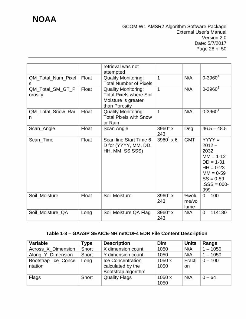
NOAA GCOM-W1 AMSR2 Algorithm Software Package
External User’s Manual Version 2.0
Date: 5/7/2017 Page 28 of 50
retrieval was not attempted
QM_Total_Num_Pixels
Float Quality Monitoring: Total Number of Pixels
1 N/A 0-39601
QM_Total_SM_GT_Porosity
Float Quality Monitoring: Total Pixels where Soil Moisture is greater than Porosity
1 N/A 0-39601
QM_Total_Snow_Rain
Float Quality Monitoring: Total Pixels with Snow or Rain
1 N/A 0-39601
Scan_Angle Float Scan Angle 39601 x 243
Deg 46.5 – 48.5
Scan_Time Float Scan line Start Time 6-D for (YYYY, MM, DD, HH, MM, SS.SSS)
39601 x 6 GMT YYYY = 2012 – 2032 MM = 1-12 DD = 1-31 HH = 0-23 MM = 0-59 SS = 0-59 .SSS = 000-999
Soil_Moisture Float Soil Moisture 39601 x 243
%volume/volume
0 – 100
Soil_Moisture_QA Long Soil Moisture QA Flag 39601 x 243
N/A 0 – 114180
Table 1-8 – GAASP SEAICE-NH netCDF4 EDR File Content Description
Variable Type Description Dim Units Range Across_X_Dimension Short X dimension count 1050 N/A 1 – 1050 Along_Y_Dimension Short Y dimension count 1050 N/A 1 – 1050 Bootstrap_Ice_Concentation
Long Ice Concentration calculated by the Bootstrap algorithm
1050 x 1050
Fraction
0 – 100
Flags Short Quality Flags 1050 x 1050
N/A 0 – 64

NOAA GCOM-W1 AMSR2 Algorithm Software Package
External User’s Manual Version 2.0
Date: 5/7/2017 Page 29 of 50
Latency Long Time in seconds from most current time
1050 x 1050
Seconds
0 – 2,147,483,647
Latitude Float Latitude for EASE-2 grid
1050 x 1050
Deg -90.0 – 90.0
Longitude Float Longitude for EASE-2 grid
1050 x 1050
Deg -180.0 – 180.0
NASA_Team_2_Ice_Concentration
Long Ice Concentration calculated by the NASA Team 2 algorithm
1050 x 1050
Fraction
0 – 100
NASA_Team_2_Multiyear_Ice
Long Multi-year Ice Concentation calculated by the NASA Team 2 algorithm
1050 x 1050
Fraction
0 – 100
NT2_minus_Bootstrap
Long Difference between NASA Team 2 and Bootstrap Methods
1050 x 1050
Fraction
0 – 100
QM_Num_Grid_Range_25
Float Quality Monitoring: Number of Grid Boxes with Range > 25%
1 N/A 0-1102500
QM_Num_Grid_Range_50
Float Quality Monitoring: Num ber of Grid Boxes with Range > 50%
1 N/A 0-1102500
QM_Total_Ice Float Quality Monitoring: Total Ice Extent
1 N/A 0-1102500
QM_Total_Pixels Float Quality Monitoring: Toatal Number of Grid Boxes
1 N/A 0-1102500
Range_of_Ice_Concentation
Long Range of Ice Concentration
1050 x 1050
Fraction
0 – 100
Scan_Time Float Scan line Start Time 6-D for (YYYY, MM, DD, HH, MM, SS.SSS)
1050 x 1050 x 6
GMT YYYY = 2012 – 2032 MM = 1-12 DD = 1-31 HH = 0-23 MM = 0-59 SS = 0-59
NOAA GCOM-W1 AMSR2 Algorithm Software Package
External User’s Manual Version 2.0
Date: 5/7/2017 Page 30 of 50
.SSS = 000-999
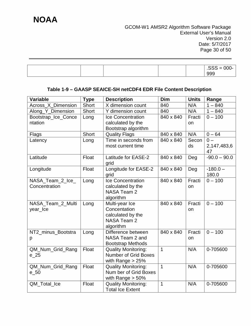
Table 1-9 – GAASP SEAICE-SH netCDF4 EDR File Content Description
Variable Type Description Dim Units Range Across_X_Dimension Short X dimension count 840 N/A 1 – 840 Along_Y_Dimension Short Y dimension count 840 N/A 1 – 840 Bootstrap_Ice_Concentation
Long Ice Concentration calculated by the Bootstrap algorithm
840 x 840 Fraction
0 – 100
Flags Short Quality Flags 840 x 840 N/A 0 – 64 Latency Long Time in seconds from
most current time 840 x 840 Secon
ds 0 – 2,147,483,647
Latitude Float Latitude for EASE-2 grid
840 x 840 Deg -90.0 – 90.0
Longitude Float Longitude for EASE-2 grid
840 x 840 Deg -180.0 – 180.0
NASA_Team_2_Ice_Concentration
Long Ice Concentration calculated by the NASA Team 2 algorithm
840 x 840 Fraction
0 – 100
NASA_Team_2_Multiyear_Ice
Long Multi-year Ice Concentation calculated by the NASA Team 2 algorithm
840 x 840 Fraction
0 – 100
NT2_minus_Bootstrap
Long Difference between NASA Team 2 and Bootstrap Methods
840 x 840 Fraction
0 – 100
QM_Num_Grid_Range_25
Float Quality Monitoring: Number of Grid Boxes with Range > 25%
1 N/A 0-705600
QM_Num_Grid_Range_50
Float Quality Monitoring: Num ber of Grid Boxes with Range > 50%
1 N/A 0-705600
QM_Total_Ice Float Quality Monitoring: Total Ice Extent
1 N/A 0-705600

NOAA GCOM-W1 AMSR2 Algorithm Software Package
External User’s Manual Version 2.0
Date: 5/7/2017 Page 31 of 50
QM_Total_Pixels Float Quality Monitoring: Toatal Number of Grid Boxes
1 N/A 0-705600
Range_of_Ice_Concentation
Long Range of Ice Concentration
840 x 840 Fraction
0 – 100
Scan_Time Float Scan line Start Time 6-D for (YYYY, MM, DD, HH, MM, SS.SSS)
840 x 840 x 6
GMT YYYY = 2012 – 2032 MM = 1-12 DD = 1-31 HH = 0-23 MM = 0-59 SS = 0-59 .SSS = 000-999
Table 1-10 – GAASP SOIL Binary EDR File Content Description
Variable Type Description Units Range Column Short indices to reproject GCOM pixels to
a 0.25 degree grid. N/A 1 [180 W-
179.75 W) to 1440 [179.75 E-180 W)
Row Short indices to reproject GCOM pixels to a 0.25 degree grid.
N/A 1 [90 N-89.75 N) to 720 [89.75 S-90 S]
Year Short Year from the Scan Time UTC for the row
N/A 2012 – 2032
Month Short Month from the Scan Time UTC for the row
N/A 1 – 12
Day Short Day from the Scan Time UTC for the row
N/A 1 – 31
Hour Short Hour from the Scan Time UTC for the row
N/A 0 – 23
Minute Short Minute from the Scan Time UTC for the row
N/A 0 – 59

NOAA GCOM-W1 AMSR2 Algorithm Software Package
External User’s Manual Version 2.0
Date: 5/7/2017 Page 32 of 50
Soil_Moisture Short percentage of soil moisture in the profile that was measured for that pixel with a scale factor of 0.01
% 1 – 9999
QA Short Quality Flag, see Table 3-6 N/A 0 – 114180
Table 1-11 – AMSR2 1B BUFR User Definitions (Table-A)
Mnemonic Number Description NC021248 A50249 MSG TYPE 021-248 Advanced Microwave Scanning
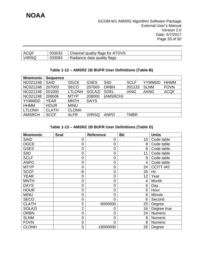
Radiometer 2 (AMSR2) 1B brightness temperature data YYMMDD 301011 Date -- year, month, day HHMM 301012 Time -- hour, minute LTLONH 301021 High accuracy latitude/longitude position AMSRCH 310193 AMSR2 channels and brightness temperatures set SAID 001007 Satellite identifier OGCE 001033 Identification of originating/generating center GSES 001034 Identification of originating/generating sub-center SIID 002019 Satellite instruments SCLF 002020 Satellite classification ANPO 002104 Antenna polarization MTYP 002141 Measurement type SCCF 002153 Satellite channel center frequency YEAR 004001 Year MNTH 004002 Month DAYS 004003 Day HOUR 004004 Hour MINU 004005 Minute SECO 004006 Second CLATH 005001 Latitude (high accuracy) SOLAZI 005022 Solar azimuth ORBN 005040 Orbit number SLNM 005041 Scan line number FOVN 005043 Field of view number CLONH 006001 Longitude (high accuracy) SOEL 007022 Solar elevation TMBR 012163 Brightness temperature (high accuracy) ALFR 021166 Land fraction IANG 025081 Incidence angle AANG 025082 Azimuth angle
NOAA GCOM-W1 AMSR2 Algorithm Software Package
External User’s Manual Version 2.0
Date: 5/7/2017 Page 33 of 50
ACQF 033032 Channel quality flags for ATOVS VIIRSQ 033083 Radiance data quality flags
Table 1-12 – AMSR2 1B BUFR User Definitions (Table-B)
Mnemonic Sequence NC021248 SAID OGCE GSES SIID SCLF YYMMDD HHMM NC021248 207003 SECO 207000 ORBN 201133 SLNM FOVN NC021248 201000 LTLONH SOLAZI SOEL IANG AANG ACQF NC021248 208006 MTYP 208000 {AMSRCH} YYMMDD YEAR MNTH DAYS HHMM HOUR MINU LTLONH CLATH CLONH AMSRCH SCCF ALFR VIIRSQ ANPO TMBR
Table 1-13 – AMSR2 1B BUFR User Definitions (Table D)
Mnemonic Scal Reference Bit Units SAID 0 0 10 Code table OGCE 0 0 8 Code table GSES 0 0 8 Code table SIID 0 0 11 Code table SCLF 0 0 9 Code table ANPO 0 0 4 Code table MTYP 0 0 24 CCITT IA5 SCCF -8 0 26 Hz YEAR 0 0 12 Year MNTH 0 0 4 Month DAYS 0 0 6 Day HOUR 0 0 5 Hour MINU 0 0 6 Minute SECO 0 0 6 Second CLATH 5 -9000000 25 Degree SOLAZI 2 0 16 Degree true ORBN 0 0 24 Numeric SLNM 0 0 8 Numeric FOVN 0 0 8 Numeric CLONH 5 -18000000 26 Degree
NOAA GCOM-W1 AMSR2 Algorithm Software Package
External User’s Manual Version 2.0
Date: 5/7/2017 Page 34 of 50
SOEL 2 -9000 15 Degree TMBR 2 0 16 K ALFR 3 0 10 Numeric IANG 3 0 17 Degree AANG 3 0 19 Degree ACQF 0 0 24 Flag table VIIRSQ 0 0 16 Flag table
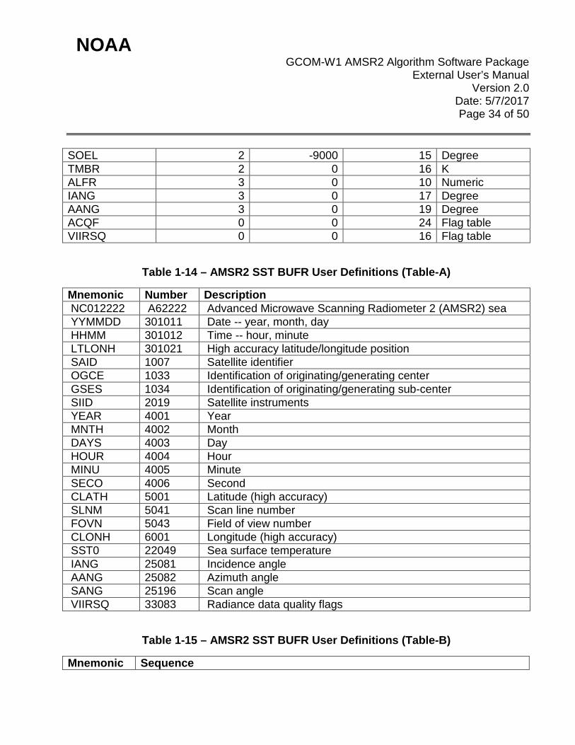
Table 1-14 – AMSR2 SST BUFR User Definitions (Table-A)
Mnemonic Number Description NC012222 A62222 Advanced Microwave Scanning Radiometer 2 (AMSR2) sea YYMMDD 301011 Date -- year, month, day HHMM 301012 Time -- hour, minute LTLONH 301021 High accuracy latitude/longitude position SAID 1007 Satellite identifier OGCE 1033 Identification of originating/generating center GSES 1034 Identification of originating/generating sub-center SIID 2019 Satellite instruments YEAR 4001 Year MNTH 4002 Month DAYS 4003 Day HOUR 4004 Hour MINU 4005 Minute SECO 4006 Second CLATH 5001 Latitude (high accuracy) SLNM 5041 Scan line number FOVN 5043 Field of view number CLONH 6001 Longitude (high accuracy) SST0 22049 Sea surface temperature IANG 25081 Incidence angle AANG 25082 Azimuth angle SANG 25196 Scan angle VIIRSQ 33083 Radiance data quality flags
Table 1-15 – AMSR2 SST BUFR User Definitions (Table-B)
Mnemonic Sequence
NOAA GCOM-W1 AMSR2 Algorithm Software Package
External User’s Manual Version 2.0
Date: 5/7/2017 Page 35 of 50
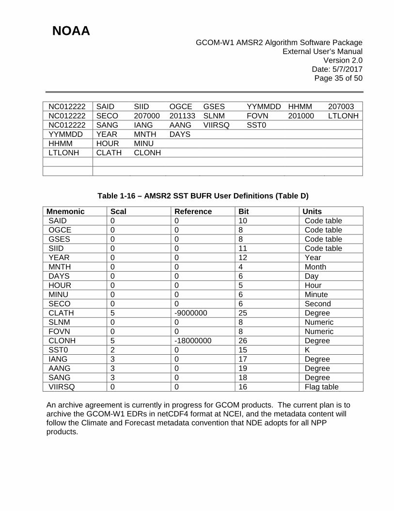
NC012222 SAID SIID OGCE GSES YYMMDD HHMM 207003 NC012222 SECO 207000 201133 SLNM FOVN 201000 LTLONH NC012222 SANG IANG AANG VIIRSQ SST0 YYMMDD YEAR MNTH DAYS HHMM HOUR MINU LTLONH CLATH CLONH
Table 1-16 – AMSR2 SST BUFR User Definitions (Table D)
Mnemonic Scal Reference Bit Units SAID 0 0 10 Code table OGCE 0 0 8 Code table GSES 0 0 8 Code table SIID 0 0 11 Code table YEAR 0 0 12 Year MNTH 0 0 4 Month DAYS 0 0 6 Day HOUR 0 0 5 Hour MINU 0 0 6 Minute SECO 0 0 6 Second CLATH 5 -9000000 25 Degree SLNM 0 0 8 Numeric FOVN 0 0 8 Numeric CLONH 5 -18000000 26 Degree SST0 2 0 15 K IANG 3 0 17 Degree AANG 3 0 19 Degree SANG 3 0 18 Degree VIIRSQ 0 0 16 Flag table An archive agreement is currently in progress for GCOM products. The current plan is to archive the GCOM-W1 EDRs in netCDF4 format at NCEI, and the metadata content will follow the Climate and Forecast metadata convention that NDE adopts for all NPP products.
NOAA GCOM-W1 AMSR2 Algorithm Software Package
External User’s Manual Version 2.0
Date: 5/7/2017 Page 36 of 50
2. ALGORITHM
2.1 Algorithm Overview The GAASP products are generated by a set of fast operationally oriented regression-based algorithms based partly on AMSR-E product heritage. The details of all GAASP algorithms are described in the GAASP Algorithm Theoretical Basis Document (ATBD). This document can be made available by either the GAASP Product Area Lead (PAL) or STAR Algorithm Lead. The input science data to GAASP are the orbital-dump HDF5 SDR (L1B and L1R) output of the JAXA RDR-to-SDR code. These data are preprocessed before being used in the GAASP EDR codes. A preprocessor code applies brightness temperature bias corrections, assigns an RFI flag, and performs internal reformatting. The ocean EDR algorithms are regression-based approaches of AMSR-E heritage. The precipitation product is generated by the Goddard PROFiling algorithm (GPROF). Soil moisture uses a hybrid of the Single Channel Retrieval (SCR) and Land Parameter Retrieval Model (LPRM). Snow uses the Enhanced Grody Special Sensor Microwave Imager (SSMI) algorithm. Sea Ice uses the NASA Team 2 and Bootstrap algorithm.
2.2 Input Satellite Data
2.2.1 Satellite Instrument Overview GCOM is a series of JAXA Earth observation missions lasting 10-15 years. GCOM is part of Japan’s contribution to GEOSS (Global Earth Observation System of Systems). The GCOM mission is two series of three satellites each. GCOM-W is for water cycle observations and GCOM-C is for climate observations. The GCOM-W1 platform launched May 18, 2012 and is the first satellite for the GCOM-W series. GCOM-W1 is part of the “A-Train” in a sun-synchronus orbit (~700 km altitude) with an ascending node equator crossing time of 13:30 UTC. The AMSR2 instrument onboard the GCOM-W1 satellite continues Aqua/AMSR-E observations of water vapor, cloud liquid water, precipitation, SST, sea surface wind speed, sea ice concentration, snow depth, and soil moisture. The AMSR2 instrument passively observes Earth-emitted microwave frequencies over six horizontally and vertically polarized channels (6.9, 10.65, 18.7, 23.8, 36.5, and 89.0 GHz). The instrument has a conical scanning mirror that rotates every 1.5 seconds measuring a 1450 km swath. It observes 99% of the Earth every 2 days. Additional information about the instrument and the mission goals can be found in this document on the JAXA website:

NOAA GCOM-W1 AMSR2 Algorithm Software Package
External User’s Manual Version 2.0
Date: 5/7/2017 Page 37 of 50
global.jaxa.jp/projects/sat/gcom_w/
2.2.2 Satellite Data Preprocessing Overview The raw AMSR2 data packets are dumped every orbit (~101 minutes) at Svalbard, Norway. These raw data are separated by APID and placed into separate files called APID Sorted Data (ASD) files by Kongsberg Satellite Services (KSAT). Beyond this point, the data processing will follow different pathways depending upon the version of the IPDS. IDPS block 1.0 is currently running and is expected to switch to block 2.0 in the summer of 2016. For IDPS block 1.0, the ASD files will be sent to JAXA, processed into SDR files and sent to NASA. From NASA, the files will be transferred to NOAA and made available to the NDE system on the DDS. The GAASP input data will be full orbital dump SDR files. The last 3 days of input data will reside on DDS and be pulled by the NDE system for operational processing by the GAASP algorithms. For IDPS block 2.0, the NDE data ingest process will change. ASD data will be sent directly to IDPS. IDPS will package the ASD files into an HDF5 wrapper and make them available to the NDE system. These files will contain two full orbits of data (the current and the previous). The NDE system will extract only the current orbit, convert them into APID Sorted Data (ASD) files, and then pass the ASD files into the JAXA RDR-to-SDR code. The JAXA SDR full-orbit files will then be made available to the GAASP code. The rest of the downstream processing will remain the same except that the current DDS distribution will be replaced by the Product Distribution Area (PDA). The GAASP software produces the EDRs described within this document. They are produced at the same granularity, except for the Sea Ice product which is produced on a EASE-2 grid separated into Northern and Southern Hemisphere sections, but it is updated at the same temporary granularity. The NDE system distributes the EDRs to the DDS where near real time users may access them. More details about the processing sequence can be found within the GAASP System Maintenance Manual (SMM).
2.2.3 Input Satellite Data Description The only instrument providing data to the processing is the AMSR2 instrument. The input data is the L1B HDF5 files that are retrieved from the JAXA software. Each file contains all the sensor, geolocation, and quality assessment information needed by the algorithm code. Details about this input file can be found in this document on the JAXA website:
NOAA GCOM-W1 AMSR2 Algorithm Software Package
External User’s Manual Version 2.0
Date: 5/7/2017 Page 38 of 50
ftp://suzaku.eorc.jaxa.jp/pub/AMSR2/public/Format/AMSR2_Level1_Product_Format_EN.pdf If the above link does not work, please request the file.
2.3 Input Ancillary Data
2.3.1 Sea-Ice Filter File The L1B_Correction code, L1R_Correction code, RFI_detection code and the ocean algorithm need a daily sea-ice mask file. The L1B_Correction code, L1R_Correction code, and RFI_detection code cannot run without it, while the ocean algorithm can run in a diminished way without it. The file can be found on the DDS in a grib2 format and has the following naming convention: seaice.t00z.5min.grb.grib2.${Year}${Month}${Day} Where: ${Year} = the 4-digit year of the file ${Month} = the 2-digit month of the file ${Day} = the 2-digit day of the file This file arrives from the DDS in a grib2 format, but it must be converted to a netCDF format prior to being passed to the GAASP system via the PCF file. This can be done using the wgrib2 command. wgrib2 $filename -netcdf $filename.nc -nc4 Where: ${filename} is the filename as given above. The GAASP system will be expecting the file using this naming convention, as it will test the date string in the name to verify that the file is not too old to be used.
2.3.2 Daily OI SST File The GPROF algorithm needs a daily OI SST file. The GPROF cannot run without it. The file can be found on the DDS in a binary format, and has the following naming convention:
NOAA GCOM-W1 AMSR2 Algorithm Software Package
External User’s Manual Version 2.0
Date: 5/7/2017 Page 39 of 50
avhrr-only-v2.${Year}${Month}${Day}_preliminary Where: ${Year} = the 4-digit year of the file ${Month} = the 2-digit month of the file ${Day} = the 2-digit day of the file The GAASP system will be expecting the file using this naming convention, as it will test the date string in the name to verify that the file is not too old to be used.
2.3.3 GFS Data File These are 0.5 degree Global Forecast System (GFS) forecast files generated by NCEP and pushed (by NCEP) to the ESPC/DDS. These files are needed for the Ocean EDR product generation. The files have the following name structure: gfs.t${Hour}z.pgrb2.0p50.f0${Forecast}.${YYYYMMDD} Where: ${Hour} = the time for which the forecast is run (00Z, 06Z, 12Z, and 18Z) ${Forecast} = the forecast projection time (in hours = 00, 03, 06, 09, and 12) $YYYYMMDD = the date string in 4-digit year, 2-digit month, and 2-digit day format for the date of the forecast file. The 00, 03, 06, 09, and 12 hour forecasts are run every six hours. Note that this file name pattern is the name pattern for these file on DDS. In other locations (servers) this name pattern is different for this same file type. The files are GRIB2 format files and are read with the wgrib2 reader which is freely available from NCEP. The variables that will be used are the ice concentration (icec), land ocean mask (land), sea surface temperature (tmp), ugrd wind component (ugrd), and vgrd wind component (vgrd). The GAASP system will be expecting to find these files in the GFS_FILE_DIR with this naming pattern, so that it can calculate and use the closest file available.
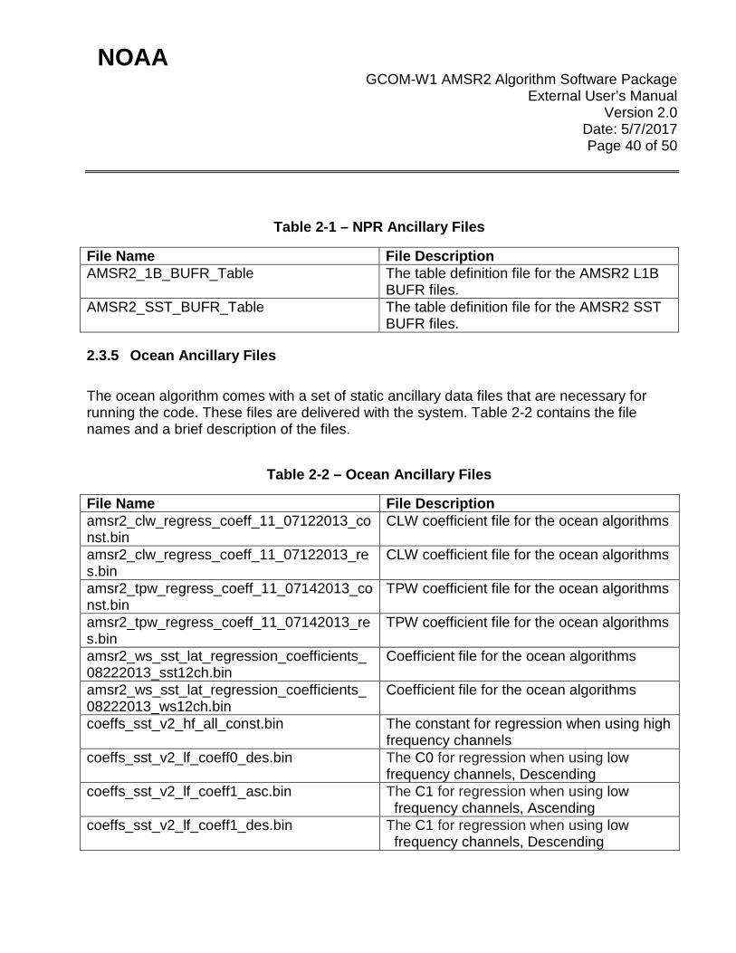
2.3.4 NPR Ancillary Files The NPR code comes with a static ancillary data file this is necessary for running the code. This file is delivered with the system. Table 2-1 contains the file name and a brief description of the file.
NOAA GCOM-W1 AMSR2 Algorithm Software Package
External User’s Manual Version 2.0
Date: 5/7/2017 Page 40 of 50
Table 2-1 – NPR Ancillary Files
File Name File Description AMSR2_1B_BUFR_Table The table definition file for the AMSR2 L1B
BUFR files. AMSR2_SST_BUFR_Table The table definition file for the AMSR2 SST
BUFR files.
2.3.5 Ocean Ancillary Files The ocean algorithm comes with a set of static ancillary data files that are necessary for running the code. These files are delivered with the system. Table 2-2 contains the file names and a brief description of the files.
Table 2-2 – Ocean Ancillary Files
File Name File Description amsr2_clw_regress_coeff_11_07122013_const.bin
CLW coefficient file for the ocean algorithms
amsr2_clw_regress_coeff_11_07122013_res.bin
CLW coefficient file for the ocean algorithms
amsr2_tpw_regress_coeff_11_07142013_const.bin
TPW coefficient file for the ocean algorithms
amsr2_tpw_regress_coeff_11_07142013_res.bin
TPW coefficient file for the ocean algorithms
amsr2_ws_sst_lat_regression_coefficients_08222013_sst12ch.bin
Coefficient file for the ocean algorithms
amsr2_ws_sst_lat_regression_coefficients_08222013_ws12ch.bin
Coefficient file for the ocean algorithms
coeffs_sst_v2_hf_all_const.bin The constant for regression when using high frequency channels
coeffs_sst_v2_lf_coeff0_des.bin The C0 for regression when using low frequency channels, Descending
coeffs_sst_v2_lf_coeff1_asc.bin The C1 for regression when using low frequency channels, Ascending
coeffs_sst_v2_lf_coeff1_des.bin The C1 for regression when using low frequency channels, Descending

NOAA GCOM-W1 AMSR2 Algorithm Software Package
External User’s Manual Version 2.0
Date: 5/7/2017 Page 41 of 50
hich_coeff_asc4.bin High Channel Coefficient, Ascending hich_coeff_des4.bin High Channel Coefficient, Descending lowch_coeff_asc4.bin Low Channel Coefficient, Ascending lowch_coeff_des2.bin Low Channel Coefficient, Descending
2.3.6 GPROF Ancillary Files The GPROF algorithm comes with a set of static ancillary data files that are necessary for running the code. These files are delivered with the system. Table 2-3 contains the file names and a brief description of the files.
Table 2-3 – GPROF Ancillary Files
File Name File Description seaice_amsre_csea_0.25.dat Sea-ice file for the gprof algorithm elev.dbase.asc Elevation database file for the gprof
algorithm global_snow_cover.bin Snow cover for the gprof algorithm global_desert_cover.bin Desert cover file for the gprof algorithm TMI_correction.txt TMI correction file for the gprof algorithm TMI_correction_rain.txt TMI rain correction file for the gprof
algorithm landmask56-32_16.bin Land mask file for the gprof algorithm kext_amsre_3freq.tbl Forward model coefficient file for the gprof
algorithm AMSR2_V2.dtb AMSR2 Bayesian profile database for gprof
algorithm
2.3.7 Snow Ancillary Files The snow algorithm comes with a set of static ancillary data files that are necessary for running the code. These files are delivered with the system. Table 2-4 contains the file names and a brief description of the files.
Table 2-4 – Snow Ancillary Files
File Name File Description new_sclass.txt A file containing a snow climatology used in
the calculation of snow water equivalent
NOAA GCOM-W1 AMSR2 Algorithm Software Package
External User’s Manual Version 2.0
Date: 5/7/2017 Page 42 of 50
sn_freq_latlon_wk_??.dat 53 files for typical snow climatologies for the northern hemisphere (one file per week)
snow_freq_sh_week-??_24km 53 files for typical snow climatologies for the southern hemisphere (one file per week)
max_min_lat_lon_h??v??_qkm.dat 289 files which are tile used for vegetation max_min_lat_lon_qkm_merge.list A list of all of the
max_min_lat_lon_h??v??_qkm.dat files averaged_7km_vcf_h??v??.bin 289 files of vegetation continuous field data averaged_7km_veg_h??v??.bin 289 files of vegetation field data
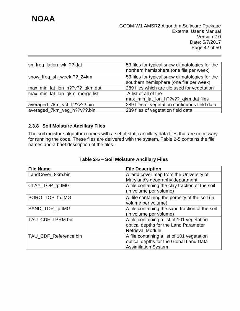
2.3.8 Soil Moisture Ancillary Files The soil moisture algorithm comes with a set of static ancillary data files that are necessary for running the code. These files are delivered with the system. Table 2-5 contains the file names and a brief description of the files.
Table 2-5 – Soil Moisture Ancillary Files
File Name File Description LandCover_8km.bin A land cover map from the University of
Maryland's geography department CLAY_TOP_fp.IMG A file containing the clay fraction of the soil
(in volume per volume) PORO_TOP_fp.IMG A file containing the porosity of the soil (in
volume per volume) SAND_TOP_fp.IMG A file containing the sand fraction of the soil
(in volume per volume) TAU_CDF_LPRM.bin A file containing a list of 101 vegetation
optical depths for the Land Parameter Retrieval Module
TAU_CDF_Reference.bin A file containing a list of 101 vegetation optical depths for the Global Land Data Assimilation System

NOAA GCOM-W1 AMSR2 Algorithm Software Package
External User’s Manual Version 2.0
Date: 5/7/2017 Page 43 of 50
2.3.9 Seaice Ancillary Files The Seaice algorithm comes with a set of static ancillary data files that are necessary for running the code. These files are delivered with the system. Table 2-6 contains the file names and a brief description of the files.
Table 2-6 – Seaice Ancillary Files
File Name File Description e2_mask_north.dat This is the northern hemisphere EASE-2
land mask e2_mask_south.dat This is the southern hemisphere EASE-2
land mask e2_sst_n_??.dat 12 northern hemisphere sea surface
temperature mask files, one for each month e2_sst_s_??.dat 12 southern hemisphere sea surface
temperature mask files, one for each month EASE2_NPolar.gpd This is a file used to recreate the northern
hemisphere EASE-2 grid in the Map-X software.
EASE2_NPolar_lat.bin This is a binary file that stores all of the latitudes for each grid box on the northern hemisphere EASE-2 grid.
EASE2_NPolar_lon.bin This is a binary file that stores all of the longitudes for each grid box on the northern hemisphere EASE-2 grid.
EASE2_SPolar.gpd This is a file used to recreate the southern hemisphere EASE-2 grid in the Map-X software.
EASE2_SPolar_lat.bin This is a binary file that stores all of the latitudes for each grid box on the southern hemisphere EASE-2 grid.
EASE2_SPolar_lon.bin This is a binary file that stores all of the longitudes for each grid box on the southern hemisphere EASE-2 grid.
2.3.10 netCDF Template Files

NOAA GCOM-W1 AMSR2 Algorithm Software Package
External User’s Manual Version 2.0
Date: 5/7/2017 Page 44 of 50
The system also comes with a set of CDL and netCDF template files. These files are necessary for the creation of the final netCDF output files. These files are delivered with the system. Table 2-7 contains the file names and a brief description of each file.
Table 2-7 – netCDF Template Ancillary Files
File Name File Description gcom_mbt.cdl The CDL template for the MBT netCDF file.
This is human readable and is used by ncgen to create the netCDF template file.
gcom_mbt.nc The netCDF template file for the MBT product.
gcom_ocean.cdl The CDL template for the OCEAN netCDF file. This is human readable and is used by ncgen to create the netCDF template file.
gcom_ocean.nc The netCDF template file for the OCEAN product.
gcom_precip.cdl The CDL template for the PRECIP netCDF file. This is human readable and is used by ncgen to create the netCDF template file.
gcom_precip.nc The netCDF template file for the PRECIP product.
3. PERFORMANCE
3.1 Product Testing
3.1.1 Test Data Description Description of all GAASP test data (input, output, and intermediate) used in unit and system tests is provided in the GAASP Code Test Review document (NOAA/NESDIS/STAR, 2013), located in the GAASP project artifact repository at: http://www.star.nesdis.noaa.gov/smcd/spb/iosspdt/qadocs/GCOM_CTR/GAASP_CTR.pptx If the above link does not work, please request the file.
3.1.2 Unit Test Plans
NOAA GCOM-W1 AMSR2 Algorithm Software Package
External User’s Manual Version 2.0
Date: 5/7/2017 Page 45 of 50
Description of all GAASP test plans used in unit and system tests is provided in the GAASP Code Test Review document (NOAA/NESDIS/STAR, 2013), located in the GAASP project artifact repository at: http://www.star.nesdis.noaa.gov/smcd/spb/iosspdt/qadocs/GCOM_CTR/GAASP_CTR.pptx If the above link does not work, please request the file.
3.2 Product Accuracy
3.2.1 Test Results Description of all GAASP test plans used in unit and system tests is provided in the GAASP Code Test Review document (NOAA/NESDIS/STAR, 2013), located in the GAASP project artifact repository at: http://www.star.nesdis.noaa.gov/smcd/spb/iosspdt/qadocs/GCOM_CTR/GAASP_CTR.pptx If the above link does not work, please request the file.
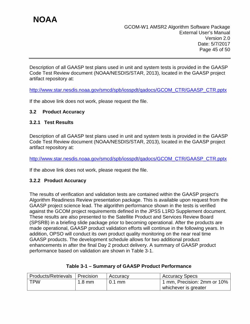
3.2.2 Product Accuracy The results of verification and validation tests are contained within the GAASP project’s Algorithm Readiness Review presentation package. This is available upon request from the GAASP project science lead. The algorithm performance shown in the tests is verified against the GCOM project requirements defined in the JPSS L1RD Supplement document. These results are also presented to the Satellite Product and Services Review Board (SPSRB) in a briefing slide package prior to becoming operational. After the products are made operational, GAASP product validation efforts will continue in the following years. In addition, OPSO will conduct its own product quality monitoring on the near real time GAASP products. The development schedule allows for two additional product enhancements in after the final Day 2 product delivery. A summary of GAASP product performance based on validation are shown in Table 3-1.
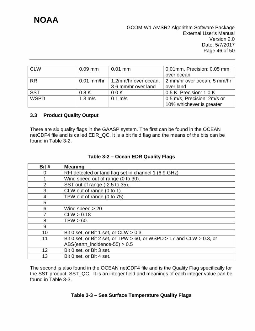
Table 3-1 – Summary of GAASP Product Performance
Products/Retrievals Precision Accuracy Accuracy Specs TPW 1.8 mm 0.1 mm 1 mm, Precision: 2mm or 10%
whichever is greater
NOAA GCOM-W1 AMSR2 Algorithm Software Package
External User’s Manual Version 2.0
Date: 5/7/2017 Page 46 of 50
CLW 0,09 mm 0.01 mm 0.01mm, Precision: 0.05 mm over ocean
RR 0.01 mm/hr 1.2mm/hr over ocean, 3.6 mm/hr over land
2 mm/hr over ocean, 5 mm/hr over land
SST 0.8 K 0.0 K 0.5 K, Precision: 1.0 K WSPD 1.3 m/s 0.1 m/s 0.5 m/s, Precision: 2m/s or
10% whichever is greater
3.3 Product Quality Output There are six quality flags in the GAASP system. The first can be found in the OCEAN netCDF4 file and is called EDR_QC. It is a bit field flag and the means of the bits can be found in Table 3-2.
Table 3-2 – Ocean EDR Quality Flags
Bit # Meaning 0 RFI detected or land flag set in channel 1 (6.9 GHz) 1 Wind speed out of range (0 to 30). 2 SST out of range (-2.5 to 35). 3 CLW out of range (0 to 1). 4 TPW out of range (0 to 75). 5 6 Wind speed > 20. 7 CLW > 0.18 8 TPW > 60. 9 10 Bit 0 set, or Bit 1 set, or CLW > 0.3 11 Bit 0 set, or Bit 2 set, or TPW > 60, or WSPD > 17 and CLW > 0.3, or
ABS(earth_incidence-55) > 0.5 12 Bit 0 set, or Bit 3 set. 13 Bit 0 set, or Bit 4 set.
The second is also found in the OCEAN netCDF4 file and is the Quality Flag specifically for the SST product, SST_QC. It is an integer field and meanings of each integer value can be found in Table 3-3.
Table 3-3 – Sea Surface Temperature Quality Flags
NOAA GCOM-W1 AMSR2 Algorithm Software Package
External User’s Manual Version 2.0
Date: 5/7/2017 Page 47 of 50
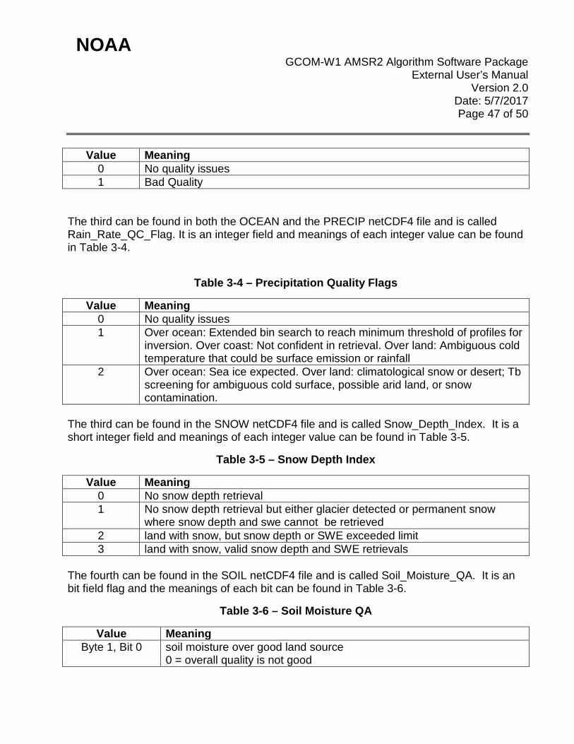
Value Meaning 0 No quality issues 1 Bad Quality
The third can be found in both the OCEAN and the PRECIP netCDF4 file and is called Rain_Rate_QC_Flag. It is an integer field and meanings of each integer value can be found in Table 3-4.
Table 3-4 – Precipitation Quality Flags
Value Meaning 0 No quality issues 1 Over ocean: Extended bin search to reach minimum threshold of profiles for
inversion. Over coast: Not confident in retrieval. Over land: Ambiguous cold temperature that could be surface emission or rainfall
2 Over ocean: Sea ice expected. Over land: climatological snow or desert; Tb screening for ambiguous cold surface, possible arid land, or snow contamination.
The third can be found in the SNOW netCDF4 file and is called Snow_Depth_Index. It is a short integer field and meanings of each integer value can be found in Table 3-5.
Table 3-5 – Snow Depth Index
Value Meaning 0 No snow depth retrieval 1 No snow depth retrieval but either glacier detected or permanent snow
where snow depth and swe cannot be retrieved 2 land with snow, but snow depth or SWE exceeded limit 3 land with snow, valid snow depth and SWE retrievals
The fourth can be found in the SOIL netCDF4 file and is called Soil_Moisture_QA. It is an bit field flag and the meanings of each bit can be found in Table 3-6.
Table 3-6 – Soil Moisture QA
Value Meaning Byte 1, Bit 0 soil moisture over good land source
0 = overall quality is not good

NOAA GCOM-W1 AMSR2 Algorithm Software Package
External User’s Manual Version 2.0
Date: 5/7/2017 Page 48 of 50
1 = overall quality is good Byte 1, Bit 1 soil moisture > porosity
0 = ok 1 = retrieval attempted but quality not good
Byte 1, Bit 2 not determined in this algorithm Byte 1, Bit 3 other input quality
0 = ok 1 = retrieval attempted but quality not good
Byte 1, Bit 4 retrieval attempted? 0 = retrieval attempted 1 = retrieval not attempted
Byte 1, Bit 5 cold desert 0 = not cold desert 1 = cold desert
Byte 1, Bit 6 snow or rain 0 = not snow or rain 1 = snow or rain
Byte 1, Bit 7 frozen ground 0 = not frozen ground 1 = frozen ground
Byte 2, Bits 0 – 5 not determined in this algorithm Byte 2, Bit 6 overall brightness temperature quality (0=good) Byte 2, Bit 7 not determined in this algorithm
The fifth can be found in each of the SEAICE netCDF4 files and is called Flags. It is a short integer and the meanings of each value can be found in Table 3-7.
Table 3-7 – Seaice Flags
Value Meaning 0 Good 4 SST missing 8 Weather 16 Spillover 32 Filled 64 NT2 Missing
NOAA GCOM-W1 AMSR2 Algorithm Software Package
External User’s Manual Version 2.0
Date: 5/7/2017 Page 49 of 50
3.4 External Product Tools No external product tools are supplied. The GAASP output files are in netCDF4 and BUFR formats. External users can choose their own tools to display and analyze these output files with any public available netCDF tools.

NOAA GCOM-W1 AMSR2 Algorithm Software Package
External User’s Manual Version 2.0
Date: 5/7/2017 Page 50 of 50
4. PRODUCT STATUS
4.1 Operations Documentation Please see the GCOM-W1 AMSR2 Algorithm Software Package (GAASP) System Maintenance Manual, Section 4 “Normal Operations” for detailed information about operational procedures. A set of SPSRB required documentation is available for GCOM-W1, which includes the External User manual (this document), the Algorithm Theoretical Basis Document, the System Maintenance Manual, and the Environmental Satellite Processing and Distribution System (ESPDS) Development Global Change Observation Mission – Water (GCOM) Processing and Distribution System (GPDS) Software User Manual. Other useful documents available include: JAXA (2013), AMSR2 Level 1 Product Format Specification. Available online at: ftp://suzaku.eorc.jaxa.jp/pub/AMSR2/public/Format/AMSR2_Level1_Product_Format_EN.pdf NOAA/NESDIS/STAR (2013), The GCOM-W1 AMSR2 Algorithm Software Package (GAASP) Code Test Review. Available online at: http://www.star.nesdis.noaa.gov/smcd/spb/iosspdt/qadocs/GCOM_CTR/GAASP_CTR.pptx If the above links do not work, please request the files.
4.2 Maintenance History Please see the GCOM-W1 AMSR2 Algorithm Software Package (GAASP) System Maintenance Manual, Section 5 “Monitoring and Maintenance” for detailed information about monitoring and maintenance support. The Environmental Satellite Processing and Distribution System (ESPDS) Development Global Change Observation Mission – Water (GCOM) Processing and Distribution System (GPDS) Software User Manual may also be helpful. END OF DOCUMENT