environmental risk assessment for shale gas development doe research.pdf · environmental risk...
TRANSCRIPT

Environmental Risk Assessment for Shale Gas Development
Daniel J. Soeder, NETL, Morgantown, WV
Presentation for Chesapeake Bay Program STAC
State College, PA, April 11, 2012

2
Concepts of Risk
Risk = probability x consequences

3
Risk in Engineered Geologic Systems
• Threat: external events that cause risk
– Threats can exploit vulnerabilities
– Threats are assessed in terms of probability (Precautionary Principle)
• Vulnerability: internal weakness that invites risk
– Vulnerability only exists in the face of a threat
– Vulnerability is assessed in terms of likely threats (Calculated Risk)
• Both threats and vulnerabilities must be assessed to
properly understand risk.
Risk can vary over time >>
(CO2 injection example)
4
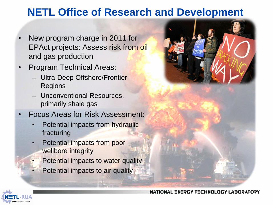
NETL Office of Research and Development
• New program charge in 2011 for
EPAct projects: Assess risk from oil
and gas production
• Program Technical Areas:
– Ultra-Deep Offshore/Frontier
Regions
– Unconventional Resources,
primarily shale gas
• Focus Areas for Risk Assessment:
• Potential impacts from hydraulic
fracturing
• Potential impacts from poor
wellbore integrity
• Potential impacts to water quality
• Potential impacts to air quality

5
Potential Shale Gas Risks
• Engineering Risk Assessment:
– What is the probability of a contaminant release?
– What is the probability of an induced seismic event?
– What risks are short term versus long term?
• What are the receptors?
– Air, water, landscapes, ecosystems/habitat
• The major unknown risk is cumulative effects
– How will multiple wells make an impact?
– What is threshold for impacts? (i.e. impervious surfaces)
• Risk reduction through regulations and enforcement
– Not all known environmental impacts are regulated
– Not all regulations are fully enforced

6
Risk Assessment in Engineered Systems
• DOE National Risk Assessment Partnership (NRAP) – Cooperative effort among NETL, LBNL, LLNL, LANL, and PNNL
– Scenario-based, site modeling for carbon storage in engineered
geologic systems
• Sometimes called site performance assessment
• Uses FEP-based scenarios and probabilities – Feature: property of a geologic system that may affect risk
– Event: an action that introduces higher risk conditions into a system
– Process: a method or procedure that increases risk
• Predict performance of components using high fidelity
models
• Run scenarios to validate models/reduce uncertainty
• Provide quantitative basis for geologic storage security

7
Integrated Risk Assessment Models
• Integrated Assessment Models (IAM) – Probabalistic assessment of system risk (multi-site)
– Interaction of sites can increase or decrease risk
• Divide system into components, develop detailed,
validated models, reduce uncertainty
• Develop reduced order models (ROM) to reproduce
detailed model predictions of components
• Integrate ROMs through IAM to predict total system
performance, interactions and risk
• Calibrate using field data and databases
• Quantify potential long-term liability
Risk Profile Risk Management Validation
(Quantify) (Strategy) (Field Data)
8
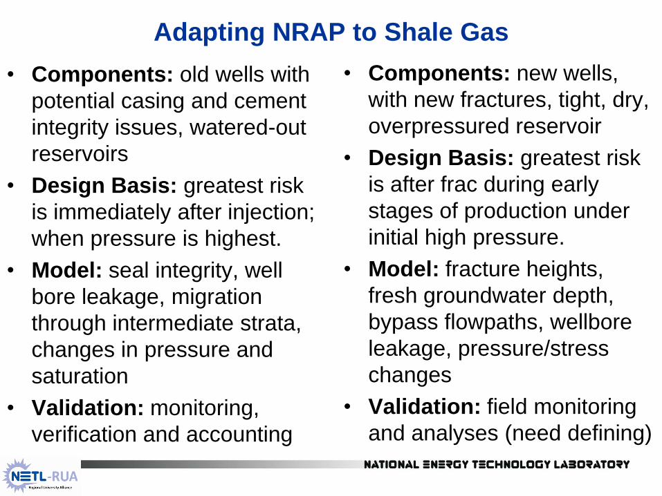
Adapting NRAP to Shale Gas
• Components: old wells with
potential casing and cement
integrity issues, watered-out
reservoirs
• Design Basis: greatest risk
is immediately after injection;
when pressure is highest.
• Model: seal integrity, well
bore leakage, migration
through intermediate strata,
changes in pressure and
saturation
• Validation: monitoring,
verification and accounting
• Components: new wells,
with new fractures, tight, dry,
overpressured reservoir
• Design Basis: greatest risk
is after frac during early
stages of production under
initial high pressure.
• Model: fracture heights,
fresh groundwater depth,
bypass flowpaths, wellbore
leakage, pressure/stress
changes
• Validation: field monitoring
and analyses (need defining)
9
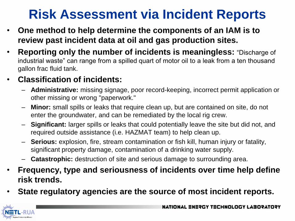
Risk Assessment via Incident Reports • One method to help determine the components of an IAM is to
review past incident data at oil and gas production sites.
• Reporting only the number of incidents is meaningless: “Discharge of
industrial waste” can range from a spilled quart of motor oil to a leak from a ten thousand
gallon frac fluid tank.
• Classification of incidents:
– Administrative: missing signage, poor record-keeping, incorrect permit application or
other missing or wrong "paperwork."
– Minor: small spills or leaks that require clean up, but are contained on site, do not
enter the groundwater, and can be remediated by the local rig crew.
– Significant: larger spills or leaks that could potentially leave the site but did not, and
required outside assistance (i.e. HAZMAT team) to help clean up.
– Serious: explosion, fire, stream contamination or fish kill, human injury or fatality,
significant property damage, contamination of a drinking water supply.
– Catastrophic: destruction of site and serious damage to surrounding area.
• Frequency, type and seriousness of incidents over time help define
risk trends.
• State regulatory agencies are the source of most incident reports.

10
Water Contamination Incidents • Kell, Scott, 2011, State Oil and Gas Agency Groundwater
Investigations and their Role in Advancing Regulatory Reforms: A Two-
State Review: Ohio and Texas, Groundwater Protection Council, 165
p., August 2011, Oklahoma City, OK:
– Incident: "any detected contamination of groundwater or disrupted water
supply due to development of oil and gas or management of wastes."
• Ohio reported 144 incidents in 33,304 wells between 1983 and 2007
(rate = 0.432%); no significant shale gas production at the time.
– Most Ohio incidents occurred during drilling/production operations
– 85 of the 144 incidents (60%) occurred between 1983 and 1988 (boom).
• Texas reported 211 incidents in 187,788 wells between 1993 and
2008 (rate = 0.112%); Barnett Shale play began in 1997.
– Most Texas incidents occurred during waste disposal
– Texas RR Commission "witnesses" drilling and completion operations on
about 1/3 of wellsites
• Both states reported zero incidents over the time periods studied
associated with well stimulation (hydraulic fracturing)
11
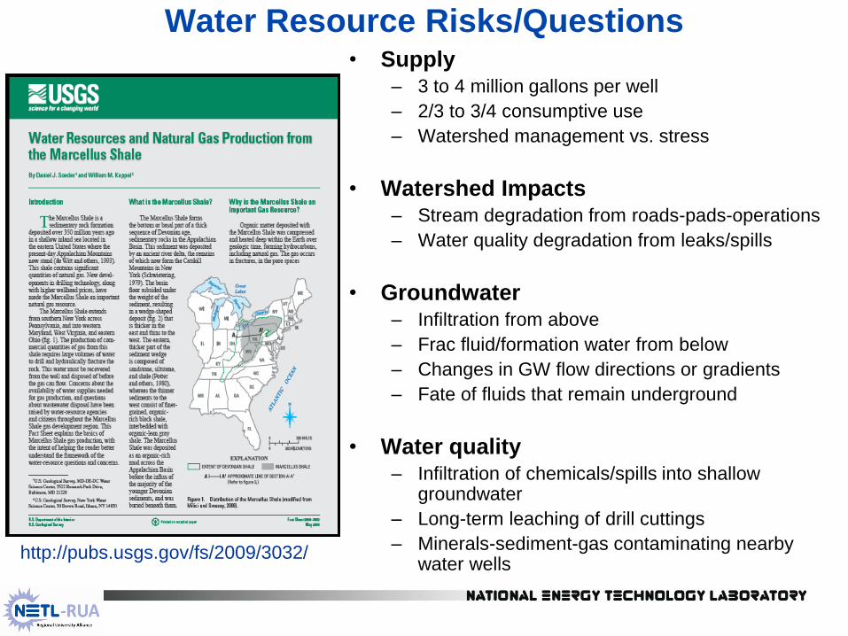
Water Resource Risks/Questions • Supply
– 3 to 4 million gallons per well
– 2/3 to 3/4 consumptive use
– Watershed management vs. stress
• Watershed Impacts – Stream degradation from roads-pads-operations
– Water quality degradation from leaks/spills
• Groundwater – Infiltration from above
– Frac fluid/formation water from below
– Changes in GW flow directions or gradients
– Fate of fluids that remain underground
• Water quality – Infiltration of chemicals/spills into shallow
groundwater
– Long-term leaching of drill cuttings
– Minerals-sediment-gas contaminating nearby water wells
http://pubs.usgs.gov/fs/2009/3032/
12
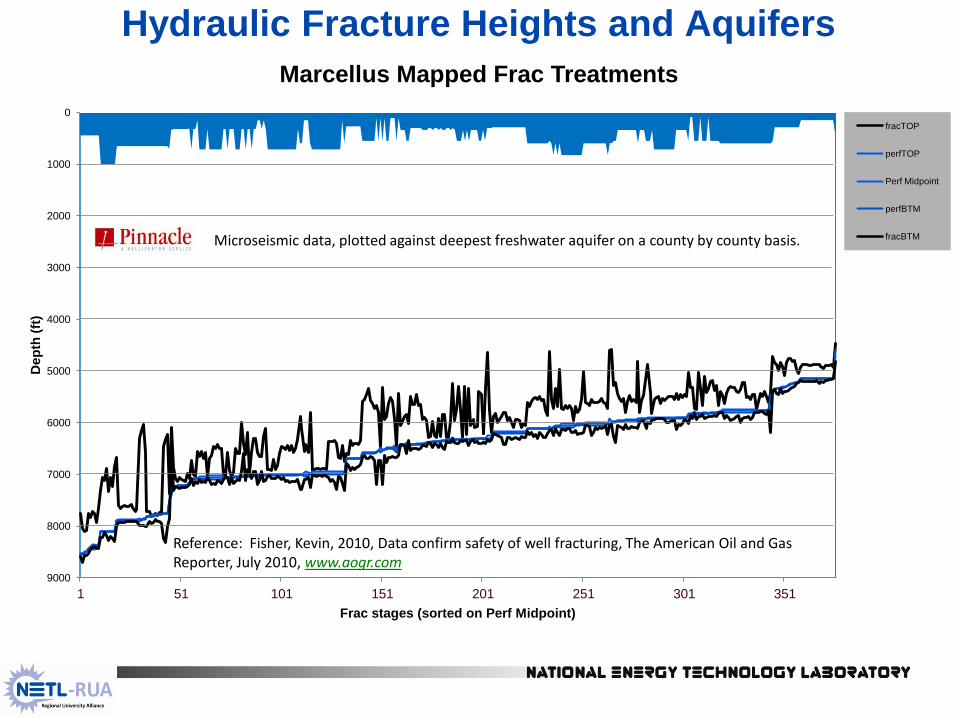
Hydraulic Fracture Heights and Aquifers
0
1000
2000
3000
4000
5000
6000
7000
8000
9000
1 51 101 151 201 251 301 351
Dep
th (
ft)
Frac stages (sorted on Perf Midpoint)
Marcellus Mapped Frac Treatments
fracTOP
perfTOP
Perf Midpoint
perfBTM
fracBTM Microseismic data, plotted against deepest freshwater aquifer on a county by county basis.
Reference: Fisher, Kevin, 2010, Data confirm safety of well fracturing, The American Oil and Gas Reporter, July 2010, www.aogr.com

13
Surface Leaks and Spills
• Higher risk to groundwater and surface
water than frac fluid underground (Groat,
UT Austin study, 2012)
• Baseline data on existing contaminants are
required to assess drilling impacts.
• Studies underway in 2012:
• Retrospective investigation of impacted
streams; large and small watersheds
• Comparison of stream reaches: affected
and unaffected; also compare two similar
small watersheds (WVU)
• Comparison of impacts versus watershed
management practices (Pitt)
• Assessment of impacts, damage, costs
• Forensics of what caused the leak
• Better leak detection and warning, including
field-deployable instruments to monitor
surrogates (pH, conductance, turbidity)
• Prospective data from Marcellus Test Site
Photo by Doug Mazer, used with permission.
14
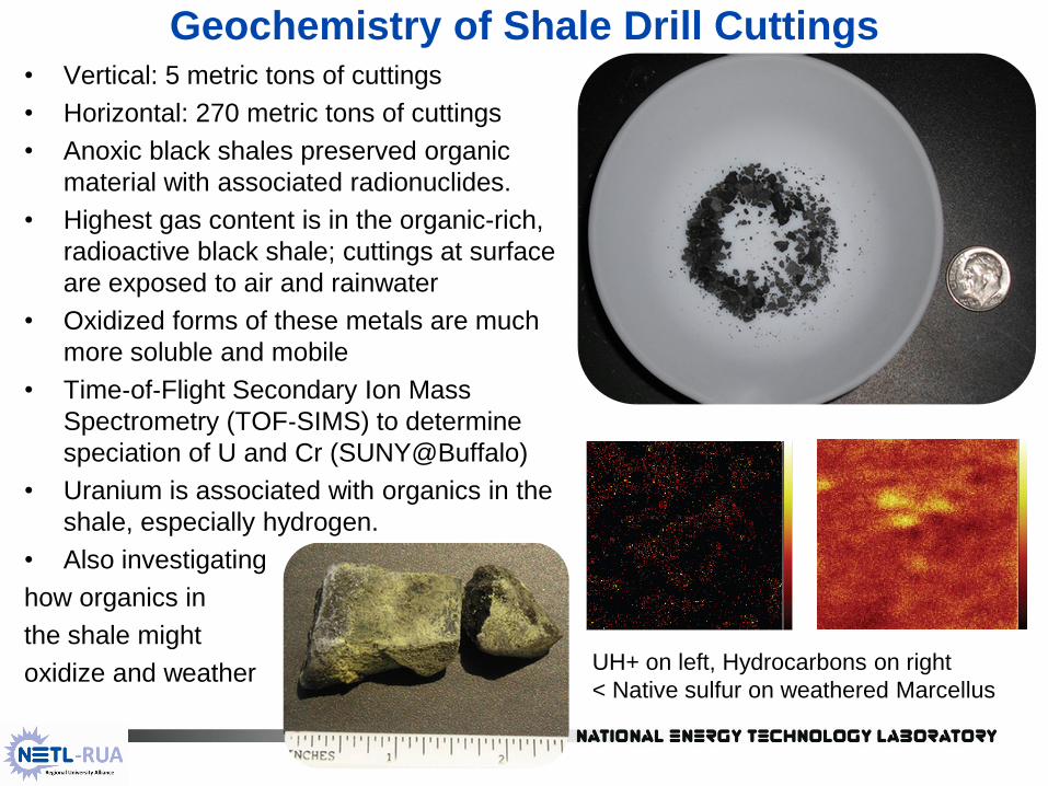
Geochemistry of Shale Drill Cuttings • Vertical: 5 metric tons of cuttings
• Horizontal: 270 metric tons of cuttings
• Anoxic black shales preserved organic
material with associated radionuclides.
• Highest gas content is in the organic-rich,
radioactive black shale; cuttings at surface
are exposed to air and rainwater
• Oxidized forms of these metals are much
more soluble and mobile
• Time‐of‐Flight Secondary Ion Mass
Spectrometry (TOF‐SIMS) to determine
speciation of U and Cr (SUNY@Buffalo)
• Uranium is associated with organics in the
shale, especially hydrogen.
• Also investigating
how organics in
the shale might
oxidize and weather
UH+ on left, Hydrocarbons on right
< Native sulfur on weathered Marcellus

15
NE PA: Methane in Groundwater
Duke University study on 68 wells shows
methane in groundwater in NE PA occurs
in much higher concentrations near gas
wells, and concludes it is related to wells. (Osborn, Stephen G., Avner Vengosh, Nathaniel R. Warner, and
Robert B. Jackson, 2011, Methane contamination of drinking
water accompanying gas-well drilling and hydraulic fracturing:
PNAS Early Edition Direct Submission article, available on-line
only; Proceedings of the National Academy of Sciences, 5 p)
Baseline data on 1700 water wells prior to
gas drilling shows methane is common in
NE PA groundwater, and related to
topography (highest in stream valleys). (Molofsky, L. J., J.A. Connor, S.K. Farhat, A.S. Wylie, Jr., and
Tom Wagner, 2011, Methane in Pennsylvania water wells
unrelated to Marcellus shale fracturing: Oil & Gas Journal, Vol.
109, no. 49, December 5, 2011, p. 54-67)
The proper question might be: how does
drilling affect domestic water wells when
methane is present in the aquifer?
Norma Fiorentino's exploded well vault

16
Trapped, high pressure drilling air in fractured aquifer causes
groundwater surge, entraining and mobilizing pre-existing methane.
Surge is stronger closer to well, entraining more gas. Surge also
entrains minerals and sediment.
NETL is collaborating with Temple University and Duke University to
field test this conceptual model, and numerically model GW flow near
drill sites in Susquehanna Co.

17
Range Resources Site for Baseline Monitoring

18
Marcellus Test Site Monitoring Team
1. U.S. Dept. of Energy-NETL: Air emissions, soil gas surveys,
electromagnetic surveys for abandoned wells, avian surveys
2. U.S. Environmental Protection Agency: prospective site in USDW –
hydrofrac investigation (no longer involved in fieldwork)
3. U.S. Geological Survey: Groundwater monitoring
4. U.S. Fish and Wildlife Service: Rare and endangered species
5. U.S.D.A. NRCS: soil surveys, erosion
6. U.S. Army Corps of Engineers: Stream water quality, sedimentation
7. PA DCNR (Geological Survey): Drill site monitoring and completion
8. Pennsylvania DEP: Fish and macroinvertebrate surveys
19
Second Test Site Study
• Energy Corp. America (ECA) drill site in Greene Co., PA
• Old, vertical Upper Devonian well present on site,
located between two, parallel Marcellus laterals.
• Vertical well used for microseismic geophone string
• ECA allowed a volatile tracer to be placed in frac fluid.
• Upper Devonian well will be monitored and sampled to
determine if volatile tracer moved into shallower gas
sands from Marcellus after the frac.
• Test hypothesis that the greatest risk of upward gas
migration occurs when an overpressured reservoir is
hydraulically fractured and just starting to be produced
• Once pressure drops to hydrostatic or less, all flow is
into the wellbore.

20
DOE Shale Gas Environmental Risk Assessment Goals
Assess short/long term and cumulative
environmental impacts.
Define engineering risks.
Data-based, scientific investigations of
impacts and processes.
Outcomes
Rigorous study with conclusions supported
by well-documented data
Benefits
Information-based regulations and
indicators for regulatory monitoring
Improved management practices for shale
gas production to mitigate problems
Create a more informed environmental
debate
Utica Shale, New York