environmental impact assessment report for the proposed ... · university of moratuwa sri lanka ....
TRANSCRIPT

i
Environmental Impact Assessment Report for
the Proposed National High Altitude Sports Complex Project in Nuwara Eliya
FINAL REPORT - March 2019
Prepared by Faculty of Architecture Project Consultancy Unit University of Moratuwa Sri Lanka

ii
Table of Contents
List of Figures vi
List of Tables viii
Abbreviations x
EXECUTIVE SUMMARY xi
CHAPTER 1: INTRODUCTION ......................................................................................................................... 1
1.1 Project background ....................................................................................................................... 1
1.2 Objectives and justification of the project .................................................................................... 2
1.2.1 Proposed National High Altitude Sports Complex in Nuwara Eliya: Project Details ............. 2
1.2.2 Requirements for High Altitude Sports Training ................................................................... 2
1.2.3 Design Concepts .................................................................................................................... 3
1.3 Applicable laws, regulation standards and requirements covering the proposed project .......... 6
1.3.1 Environmental Regulations in Sri Lanka ................................................................................ 6
1.4 Objective of the EIA Report ........................................................................................................ 12
1.5 The Extent and Scope of work for Conducting the EIA ............................................................... 12
1.5.1 Scope of work ...................................................................................................................... 12
1.5.2 Methodology to conduct the EIA ........................................................................................ 13
1.6 Conformity with existing policies and development plans in the area ....................................... 23
1.7 Approvals needed for the proposed development from state agencies .................................... 23
1.7.1 Approvals and Consents needed for the Project Implementation ..................................... 23
1.7.2 Any conditions laid down by state agencies in granting preliminary clearance ................ 26
CHAPTER 2: DESCRIPTION OF THE PROPOSED PROJECT AND REASONABLE ALTERNATIVES ..................... 27
2.1 Project Site .................................................................................................................................. 27
2.1.1 Location of the Proposed Site ............................................................................................. 27
2.1.2 A location map .................................................................................................................... 28
2.1.3 Extent of the project area .................................................................................................. 28
2.1.4 Ownership of the project site ............................................................................................. 28
2.2 Project layout plan including all major components .................................................................. 28
2.3 Major Components of the project .............................................................................................. 28
2.3.1 Sports facilities .................................................................................................................... 28
2.3.2 Accommodation and related facilities ................................................................................ 28

iii
2.3.3 Landscaping ......................................................................................................................... 31
2.3.4 Water Supply ....................................................................................................................... 32
2.3.5 Solid waste disposal ............................................................................................................ 33
2.3.6 Wastewater disposal ........................................................................................................... 34
2.3.7 Air emission control ............................................................................................................ 43
2.3.8 Relocation Plan ................................................................................................................... 43
2.4 Other Infrastructure facilities required / provided ..................................................................... 50
2.5 Work Force .................................................................................................................................. 52
2.6 Maintenance and operational activities ..................................................................................... 52
2.7 Future Expansions ....................................................................................................................... 53
2.8 Evaluation of alternatives ........................................................................................................... 53
CHAPTER 3: DESCRIPTION OF THE EXISTING ENVIRONMENT OF THE STUDY AREA................................... 54
3.1 Topography ................................................................................................................................. 54
3.2 Geology and soil characteristic ................................................................................................... 60
3.2.1 Geologic characteristics at all project structure locations of the study area ..................... 60
3.2.2 Type of soil and its main characteristics ............................................................................. 61
3.2.3 Susceptibility to erosion ...................................................................................................... 61
3.2.4 Landslide potential and other geo-hazard of the area ....................................................... 62
3.3 Meteorology ............................................................................................................................... 63
3.3.1 Average Monthly Rainfall of Nuwara Eliya Area ................................................................. 63
3.3.2 Annual Average Rainfall of Nuwara Eliya Area ................................................................... 64
3.4 Hydrology & Drainage ................................................................................................................. 65
3.4.1 Surface water bodies in the study area & Surface drainage pattern .................................. 65
3.4.2 Floods experienced within the area during recent past and Areas inundated ................. 67
3.4.3 Surface water quality and present uses of surface water .................................................. 68
3.4.4 Ground water availability, quality and present uses of ground water ............................... 71
3.4.5 Noise Levels ......................................................................................................................... 72
3.4.6 Ambient air quality.............................................................................................................. 73
3.5 Land use ...................................................................................................................................... 73
3.5.1 Present land use of the study area ..................................................................................... 73
3.5.2 Land use potential of the site ............................................................................................. 74
3.5.3 Zoning .................................................................................................................................. 74

iv
3.6 Visual amenities .......................................................................................................................... 74
3.7 Ecological Resources (both terrestrial and aquatic) ................................................................... 75
3.7.1 Existing environment of the area ........................................................................................ 75
3.8 Historical & Archaeological importance ..................................................................................... 85
3.9 Socio- economic Environment .................................................................................................... 85
3.9.1 No. of families living within the proposed project site and their socio, economic status .. 87
3.9.2 Availability of Infrastructure facilities ................................................................................. 91
3.9.3 Existing Infrastructure ......................................................................................................... 91
CHAPTER 4: ASSESSMENT OF THE ANTICIPATED ENVIRONMENTAL IMPACTS ......................................... 93
4.1 Physical impacts .......................................................................................................................... 93
4.1.1 Erosion, siltation and sediment runoff ............................................................................... 93
4.1.2 Land stability ....................................................................................................................... 94
4.1.3 Hydrology ............................................................................................................................ 95
4.1.4 Wastewater ......................................................................................................................... 96
4.1.5 Solid waste .......................................................................................................................... 98
4.1.6 Air Quality/ Noise / vibration impacts ................................................................................ 99
4.1.7 Traffic Impacts ................................................................................................................... 105
4.1.8 Impacts on Visual Environment ........................................................................................ 105
4.2 Ecological resources .................................................................................................................. 105
4.2.1 Loss, disruption of natural habitats .................................................................................. 105
4.2.2 Loss of forest land / biodiversity due to resettlement ..................................................... 106
4.2.3 Impacts on aquatic ecosystems due to waste disposal, siltation, etc. ............................. 106
4.3 Socio economic / cultural aspects............................................................................................. 107
4.3.1 Potential Impacts of the HASTC project ............................................................................ 107
4.4 Any other impacts .................................................................................................................... 108
CHAPTER 5: PROPOSED MITIGATORY MEASURES .................................................................................... 110
5.1 Mitigation of Physical Impacts .................................................................................................. 110
5.1.1 Mitigatory Measures for Suppressing Erosion, siltation and sediment runoff ................. 110
5.1.2 Mitigatory Measures for Suppressing Adverse Impacts to Hydrology and Drainage ....... 111
5.1.3 Waste management techniques ....................................................................................... 113
5.1.4 Mitigation of Dust and Air Quality impacts during Construction ..................................... 117
5.1.5 Mitigation of impacts due to noise ................................................................................... 118

v
5.1.6 Mitigation of impacts due to vibration ............................................................................. 119
5.1.7 Noise and vibration due to transportation activities ........................................................ 119
5.2 Mitigation of Ecological Impacts ............................................................................................... 120
5.2.1 Marshy area: Loss, disruption of natural habitats ............................................................ 120
5.2.2 Nanu Oya and Lake Gregory: Loss, disruption of natural habitats ................................... 120
5.3 Mitigation of Social Impacts ...................................................................................................... 122
5.3.1 Better Housing for Relocated Community ........................................................................ 122
5.3.2 Healthy and Safe Environment ......................................................................................... 122
5.3.3 Improved social environment in relocated housing scheme ............................................ 122
5.3.4 Special Additional Allowances and Benefits Given by the Ministry of Sports .................. 122
5.4 Health and Safety Plan (H&SP) ................................................................................................. 124
CHAPTER 6: ENVIRONMENTAL MONITORING PROGRAMME ................................................................... 126
6.1 Environmental Management Plan (EMP) ................................................................................. 126
6.2 Environmental Monitoring Plan (EMoP) ................................................................................... 126
6.3 Institutional arrangements for Implementation of the EMP and EMoP .................................. 126
6.4 Implementation of the EMoP and Reporting Procedure .......................................................... 127
6.5 Capital and recurrent costs to implement mitigation and monitoring measures .................... 128
CHAPTER 7: CONCLUSIONS AND RECOMMENDATIONS ........................................................................... 166
References: .................................................................................................... Error! Bookmark not defined.
Annexes: ......................................................................................................... Error! Bookmark not defined.

vi
List of Figures
Figure 1.1: Zoning of the land for preferred activities 4
Figure 1.2: Examples of Tudor Style British Architecture 5
Figure 1.3: Lake Gregory Protection Area 9
Figure 1.4: General Guideline Categories included in the EHS Standards 15
Figure 2.1: Location of the Project Site within Nuwara Eliya City 31
Figure 2.2: Layout Plan Showing all the Project Component 33
Figure 2.3: Proposed wastewater Treatment System 41
Figure 2.4a: Location of the point of effluent discharge 42
Figure 2.4b: Location of the point of discharge to the Nanu Oya 43
Figure 2.5: Perception of relocates towards HASTC 46
Figure 1.6: Racial distribution of the community to be relocated 47
Figure 2.7: Racial distribution of the community to be relocated 47
Figure 2.8: Sources of income 48
Figure 2.9: Families receiving/not receiving the Samurdhi benefit 49
Figure 2.10: Location of the resettlement sites 50
Figure 2.11: Layout of the proposed resettlement site 51
Figure 2.12: layout of the proposed resettlement site 53
Figure 3.1: Location Map of the Study Site 57
Figure 3.2: Waterway features in Study Site Area and Lake Gregory Catchments 58
Figure 3.3: Project Layout of the Proposed Development Activities 59
Figure 3.4: Contour Map of the Project Area 60
Figure 3.5: Land features and other significant Landscapes in the Study Site Area 61
Figure 3.6: A geological map of Nuwara Eliya 62
Figure 3.7: Soil erosion map of Nuwara Eliya 63
Figure 3.8: Landslide hazard zone – Nuwara Eliya district 64
Figure 3.9: Average Monthly Rainfall variation in the Study Area 65
Figure 3.10: Fitted Log-Normal Distribution to Annual Maximum Daily Rainfall Series 66
Figure 3.11: Surface Waterbodies and Surface Drainage Pattern in the Area 67
Figure 3.12 Surface Water drainage features in the Study site area 69

vii
Figure 3.13: Locations for monitoring noise levels 74
Figure 3.14: Visual Amenities 77
Figure 3.15: Existing boundary of the racecourse 80
Figure 3.16: Naturalized (introduced) plant species 81
Figure 3.17: Invasive plant species (a) Ulex sp. (b) Lantana sp. 82
Figure 3.18: Existing condition of the Nanu Oya 83
Figure 3.19: Existing condition of the marshy land 86
Figure 3.20: Boundary of the Lake Gregory SPA 88
Figure 3.21: Racial distribution of the community to be relocated 89
Figure 3.22: Racial distribution of the community to be relocated 89
Figure 3.23: Sources of income 90
Figure 3.24: Families receiving/not receiving the Samurdhi benefit 91
Figure 3.25: Status of ownership of housing units 91
Figure 3.26: Materials used for wall construction 92
Figure 3.27: Availability of infrastructure facilities 93

viii
List of Tables
Table 1.1: Approvals and consents needed for the proposed development 27
Table 2.1: Criteria considered for the site selection 50
Table 2.2: Work Force Requirement for the project 54
Table 3.1: Water quality of the Nanu Oya 70
Table 3.2: Some physic-chemical water quality parameters at selected sites in Lake Gregory 70
Table 3.3: Measured noise levels in dB(A) at locations within the proposed premises 74
Table 3.4: Average ambient air quality levels in the Kandy City in 7th to 13th July 2010 75
Table 3.5: Overall summary of flora recorded within the study site 79
Table 3.6: Detailed information of flora observed during the study 80
Table 3.7: Summary of recorded faunal species 85
Table 4.1: The maximum allowable noise levels 102
Table 4.2: Relative range of noise levels for heavy construction machinery 103
Table 4.3: Typical noise levels of construction equipment 103
Table 4.5: Exposure levels and time limit in UK 104
Table 5.1: Soil Conservation and Erosion Prevention Methods 114
Table 6.5: Estimated costs of EMP implementation 130
Table 6.1: Pre-construction EMP Table 131
Table 6.2: Construction EMP Table 140
Table 6.3: Operation Phase EMP Table 159
Table 6.4: Proposed Environmental Monitoring Plan 163

ix
Abbreviations
AMSL - Above Mean Sea Level BIQ - Basic Information Questionnaire BOD - Biochemical Oxygen Demand BOI - Board of Investments CCD - Coast Conservation Department CEA - Central Environmental Authority CEB - Ceylon Electricity Board COD - Chemical Oxygen Demand DBO - Design-Build-Operate DC - Design Contractor GPS - Global Positioning System DS - Divisional Secretary EA - Environmental Assessment EIA - Environmental Impact Assessment EMP - Environmental Management Plan EMoP - Environmental Monitoring Plan EMU - Environmental Monitoring Unit EPA - Environmental Protection Area EPL - Environmental Protection License FFPO - Fauna and Flora Protection Ordinance FS - Feasibility Study GN - Grama Niladhari GoSL - Government of Sri Lanka GPS - Global Positioning System GRC - Grievance Redress Committee GRM - Grievance Redress Mechanism GSMB - Geological Survey and Mines Bureau HASTC - High Altitude Sports Training Centre H&S - Health and Safety H&SP - Health and Safety Plan IEE - Initial Environmental Examination IFC - International Finance Corporation LKR - Sri Lankan Rupees MC - Municipal Council MENR - Ministry of Environment and Natural Resources MoU - Memorandum of Understanding MSL - Mean Sea Level MSW - Municipal Solid Waste NBRO - National Buildings Research Organization NEA - National Environmental Act

x
NEP - National Environment Policy NGO - Non-Governmental Organization NMC - Nuwara Eliya Municipal Council NWSDB - National Water Supply and Drainage Board O&M - Operation and Maintenance PMIU - Project Management, and Implementation Unit PPE - Personal Protective Equipment REA - Rapid Environmental Assessment RoW - Right of Way Rs. - Sri Lankan Rupees SLLRDC - Sri Lanka Land Reclamation and Drainage Corporation SPS - Safeguard Policy Statement TEC - Technical Evaluation Committee TIA - Traffic Impact Assessment TOR - Terms of Reference TSS - Total Suspended Solids UDA - Urban Development Authority WWTP - Wastewater Treatment Plant

xi
EXECUTIVE SUMMARY
Background
Athletes from many sports have used altitude training to prepare for international competitions or events, and not just when the event will be at a high altitude. By training at high altitudes, athletes aim to allow their bodies to produce extra red blood cells. Then, while they head to competitions at lower elevations to take advantage of their changed physiology, which should last for 10 to 20 days. In Sri Lanka, there are no such proper facilities to train sportspersons at high altitudes, and the proposed HASTC serves the purpose of establishing one at Nuwara Eliya.
The main objective of the development is to develop a high altitude training infrastructure of international standards, for national sportsmen and sportswomen engaged in some selected sports within the selected land in harmony with the other activities within the area. The development also intends to attract international sportsmen to Sri Lanka for training and to promote tourism in Nuwara Eliya as a byproduct. The proposed site is a land in extent of approximately 85 acres (34.564 Ha.) acquired by the Sri Lanka Government. This land has been utilized mainly as a race course ground for over one hundred years. The existing road surrounding the site is also used as a motor car and motor bicycle racing track. The main land area proposed to be used for the High Altitude Sports Training Complex is mainly low lying flat land areas.
Environmental Impact Assessment
This document is the Environmental Impact Assessment Report (EIAR) for the proposed High Altitude Sports Training Centre (HASTC). The EIAR has been prepared in order to obtain environmental clearance fulfilling the procedures and requirements set down by the National Environmental Act No. 47 of 1980 and subsequent amendments of National Environmental (Amendment) Act No. 56 of 1988 and section 23 Z of the Act as declared in the Gazette Extra Ordinary No. 772/22 dated 24th June 1993. The decision to prepare an EIAR for the proposed project has been determined by the Central Environmental Authority as the Project Approving Agency after submission of the preliminary project details by the Project Proponent: Department of Sports Development, Ministry of Sports.
The aim of the EIA Report for the proposed High Altitude Sports Training Centre is to comprehensively evaluate the anticipated positive and negative environmental impacts that are expected to occur during project construction and operational phases. It is important to identify any potential adverse impacts from the project on all aspects of theenvironment (physical, biological/ecological and socioeconomic aspects) at an initial stage to decide on the environmental viability of the project and to take necessary preventive measures to minimise such impacts.
Project Description
The training facility is meant for fourteen sports, namely: Athletics, Badminton, Baseball, Basketball, Cricket, Football, Gymnastics, Handball, Hockey, Netball, Rugby, Swimming, Tennis and Volleyball. It will consist of:
(i) Indoor Stadium that can accommodate a sports hall - a Makeshift facility for 04 Badminton Courts, 01 Basketball Court, 01 Handball Court, 01 Netball Court, 01 Volleyball Court, and facilities for Gymnastics,

xii
04 Cricket nets and Space for 04 Table Tennis courts; (ii) Physical Fitness Training Center; (iii) Indoor Tennis Court ; (iv) Heated Indoor Swimming Pool provided with changing rooms, toilets, trainers’ rooms, classroom and lobby space; (v) Synthetic Athletic Track – 06-lane and 400 meters that will facilitate full track and field events and warm up facilities; (vi) Grass Athletic Track - 06 lanes and 400 meters that will facilitate full track and field events and warm up facilities; (vii) Cricket Ground with six pitches; (viii) Grass Ground with facilities for Rugby, Hockey and Football; (ix) Medical Center with standard facilities and a physiotherapy unit; (x) Administration Unit with ancillary facilities; (xi) Auditorium for 100 and Minimum 02 Class Rooms; (xii) Accommodation for 100 sportsmen and sportswomen, and for trainers; (xiii) Accommodation for senior staff and working staff; and (xvi) Reinstallation of the horse racing track, grandstand, pavilions, paddock and the related facilities.
The proposed facility is exclusive for specialised ‘high altitude training’ and therefore, will not accommodate either large-scale sports events or general training of sportsmen. Therefore, the minimum conditions ‘necessary and sufficient’ for the envisaged training in each sport are the ‘Club level’ standards, specified in relevant sources of information.
The existing planning and building regulations, design standards, and development guidelines, stipulated by competent authorities and the prevalent geographic conditions of Nuwara Eliya will remain unchanged for a reasonable period throughout the development and the operations of the facility.
The water requirement for construction activities (at the peak of construction activities) is around 40,000 litres per day. During operation, the maximum demand of water would be approximately 120 m3 per day. The NWS&DB has agreed to supply this. A rainwater harvesting system is proposed for the development. There will be 12,000 litres of the storage capacity for rainwater harvesting (6 tanks of 2,000 litres).
The quantity of wastewater that would be generated will be assumed to be 75 m3 per day. Conventional Primary treatment, combined with an anaerobic followed by an aerobic treatment plant has been proposed for wastewater treatment. The system will have acontinuous operation for 24 hours a day with thesemi-automatic control system. Treated wastewater will be distributed throughout the landscaped areas and the garden for irrigation purposes (20 m3), vehicle washing (5 m3) and another part of toilet flushing (2 m3), especially in staff toilets. The rest will be discharged into the Nanu Oya.
The total solid waste generation of the proposed development is estimated to be 277 kg/day (biodegradable) and 319 kg/day (non-biodegradable, after separation of recyclable material). Waste will be separated at the source, and separate compartments in different colours will be established at the collection point. Thus, two separate collection rooms will be allocated, of which one will accommodate 3 separate sets of bins for Paper, Glass and Plastic, which will be collected separately and delivered to recycling agents nearest to the facility. The other will be an air conditioned wet garbage room for collection of wet and biodegradable waste which will be removed by facilities provided by the Local Authority. Arrangements will be made with the Nuwara Eliya MC to remove organic waste daily and other waste weekly.
The total energy demand of the project (2,000 KVA) will be obtained from the Ceylon Electricity Board.
Existing Environment

xiii
The high altitude in Nuwara Eliya (~1,860 m AMSL) gives rise to a Sub Tropical Highland climate with the average annual temperature varying between 11° C ~ 20° C. Monthly rainfall varies between 70 ~ 225 mm and has an average annual rainfall figure or precipitation of 1900 mm (Meteorological Department, Sri Lanka; 1968~2014 data). This leads to a unique hydrogeological character in this part of the central highlands of Sri Lanka, where the incidence of rainfall from both the northeast and southwest monsoons provides a plentiful supply of moisture in most months, and average rainfall exceeds potential transpiration to give a water surplus throughout the year. This eventually causes the existence of natural wetlands in the form of swamps, marshes, bogs, and fens.
The main water body features in the area are the Nanu Oya which flows across the North and North-eastern edges of the Study Site and Lake Gregory located mere 300 m to North-east. These waterfronts have added natural splendour and aesthetics to this hill country terrain city which is famous as a recreational and tourist destination equally among both locals and foreigners since British colonial times. Considering the historical and the environmental importance of the area, the Lake Gregory including its immediate environs was declared as an Environmental Protection Area by the Extra Ordinary Gazette No. 1487/ 10 dated 05.03.2007 by the Central Environmental Authority (CEA).
The terrain in the Study Site area is relatively flat, and the elevations vary from 1,880 m ~ 1,890 m MSL, mildly sloping and draining in aSouth-eastern direction towards the Lake Gregory. The uppermost part of the eastern boundary is the most low-lying part of this elevated plateau and it still remains as a fen/bog characterized by upland marshy vegetation while providing a natural filtration (natural bio-swale) and retention-detention zone for accumulated runoff from suburbs in the upstream in between Uda Pussellawa Road and Havelock Drive (flow path via Central Bus Terminal area).
The land use characteristics around the proposed site area exhibitmix use. The site area (within 100m radius) comprises the commercial land uses (retail shops, small restaurants, and convenient stores such as bakeries. These activities occupy small land lots and vary in size (6-20 perches). The site area consists of medium size hotels too. The Gregory Lake is located within 100m of the site area. Although the predominant land use types area commercial, lake, and recreation, a few residential uses found in the surrounding area. A small percentage of land is also used for open space in the site area. Further, a Buddhist temple (modern, not historical) is located within 100m distance.
The Nanu Oya and Lake Gregory were identified as two main aquatic ecosystems in the area. Most of the plants/trees present in the area are introduced species, which are now naturalized in the area. Most of the floral species found within the study site are small shrubs and herbs A few larger trees observed along the edges and roadside. The nearby area is used for vegetable cultivation. Of the 74 recorded flora species in the area, 52 were introduced and naturalized in Sri Lanka. There is no natural vegetation within the study site. Out of the identified fauna species, there 5 Butterfly species (1 endemic, 1 near-threatened), 3 Freshwater Fish, 6 Amphibians (3 endemic, 2 near-threatened, 3 endangered), 1 Reptile (endemic, threatened), 76 Birds (2 endemic, 1 near-threatened)and 12 Mammals (1 endemic, 2 near-threatened, 2 endangered).
Race course premises itself holds a historical and cultural significant due to its establishment by the British. Adjoin natural land mark Lake Gregory and unique typology of building such as Grand Stand in the premises augments the importance of such. The only building which is of religious importance in the
xiv
considered locality is the newly built temple adjoining the land, and these premisesdo not hold any evidence of Archaeological importance.
There are 54 families that are currently living within the premises of the Race Course ground who will be relocated as a result of the proposed High Altitude Training Centre project.
Anticipated Environmental Impacts
The impacts and mitigation related to therelocation of the 54 families are described in the Resettlement Action Plan (RAP), and will not be discussed in this report.
The existing land use will be altered due to the proposed development activities, and especially the only few presently existing isolated patches of vegetation and boggy marshes within the site area (in North and South peripheral edges), will have to be removed, significantly affecting the existing land use of the area. In addition, site clearing, cut-fill operations, debris removal and reclamation, etc., are envisaged during the proposed construction activities. The planned construction activities in this area will cause significant blockage to the stream flow conditions if no proper diversion and stream training are provided.
Generally, Noise, Air and Soil pollution are possible during the construction phase.Noise during civil works, movement of construction vehicles and behaviours of workers can potentially interfere with normal day-to-day activities of the neighbourhood.The high levels of noise and vibration from the machinery, construction processes, and heavy vehicles during transportation of equipment and haulage of materials could sometimes exceed permissible levels which will cause discomfort to persons living in the immediate vicinity and damage property. Labour gangs having conflicts with villagers, activities of the site (pollution such as noise, dust, waste, etc.) and increased traffic-related impacts are possible social impacts of the project.
During construction, water quality of the marshy area and the Lake Gregory can be affected when pollutants resulting from, therelease of nutrients, oil and grease, organic pollutants, noxious substance and oxygen consuming substance, etc. are released to the Nanu Oya, which will be washed away to the Lake. The impact of effluent disposal been identified as one of the negative impacts both during construction and operational stages. Water pollution, both groundwater (during construction phase) and surface water (during operational phase) is inevitable if wastewater and solid waste is not properly treated before discharging to the nearby Nanu Oya. In addition, the wastewater of the proposed project during construction may have an impact on the general groundwater quality, especially under shallow conditions.
Improper disposal of solid waste by the labour gangs during construction , and during operations might pollute the roadside environment. This creates nuisance among the neighbouring communities as well as users of the Sports Training Facility.
The clearing and removal of trees and vegetation during construction of entrance road and resort development will result in the loss of natural and human modified habitats. Negligence during construction activities can cause permanent destructions to those habitats. As a secondary impact of clearing the native vegetation, the spread of invasive flora species may increase as they have a greater

xv
capacity to establish on disturbed sites. Accelerated soil erosion of the area may cause land instability and canal siltation if necessary precautions are not adopted. Siltation in thecanal may not adversely affect flora and fauna in thenearby water body (marshy area and the Gregory's Lake). However, siltation may affect the productivity of water bodies in the downstream. Microhabitat available for animals may change due to land clearance. This may lead to loss of food and other resources available for animals, and as a result, animals may leave the area.
The HASTC project will lead to displacement of 54 households. The social assessments and consultations conducted with these 54 households pointed a number of direct and indirect impacts on their lives. Those impacts include disruptions to their livelihood activities, loss of their consumer networks, loosening of their familiar kinship and neighbourhoodties, etc.
Proposed Mitigatory Measures
The possibility of flow of waste material to the stream should be avoided by ensuring proper disposal of waste material (including construction material, debris and spoil material) and also avoiding disposal of waste material in places where it can be carried away by runoff. The debris and spoil shall be disposed of in such a manner that (i) waterways and drainage paths are not blocked; (ii) the disposed of material should not be washed away by floods and (iii) should not be a nuisance to the public. Cover the stockpiles adequately before heavy rains, and they should not be located close to watercourses. Locate stockpiles where intervening vegetated buffers, are available to control any unexpected runoff.
Wastewater will be treated properly (using a wastewater treatment facility) before onsite disposal. Landscaping and replanting of trees shall be carried out to enhance the ecological balance and appearance of the site. During construction period proposed mitigatory measures are recommended to be implemented to minimise construction related impacts. Solid waste is expected (both domestic and garden waste) to be disposed of through the local authority. Possible waste is to be recycled accordingly.
The resettlement site will be planned, and affected households will be compensated appropriately (See RAP for detailed action plan).
In order to minimize/ eliminate the social impacts the project is to establish boundary walls during construction in such a way to avoid negative feelings in the minds of the neighbours, appoint committees to develop social capital between the Ministry and the neighbourhood in the long run, increase awareness of the villagers and other stakeholders of the areas to make them aware of the project activities and increased presence of foreign and local visitors.
Proper traffic management practices have to be implemented along with maintenance of access roads during transport of materials and other construction material, in order to reduce traffic noise. Noise during construction of the project facility and construction of foundations for buildings can be mitigated without difficulty by maintaining good construction practices, restricting work to daytime only and maintaining the construction equipment in good condition so that noise generation from equipment is kept to a minimum.
Monitoring Plan

xvi
A monitoring committee needs to be appointed to supervise the implementation of the mitigatory measures and monitoring plan. The monitoring committee should have representation from the CEA, Ministry of Sports, Nuwara Eliya MC, and a few community leaders. Any public complaints regarding environmental (including social impacts) of the projects should be reviewed by the Committee.
Conclusion
From the Environmental Impact Assessment, it can be concluded that the proposed project would result in considerable positive impacts on the local economy and on tourism in general. The negative impacts discussed in the report can be easily mitigated with the proposed mitigatory measures and thus are outweighed by positive impacts.

1
CHAPTER 1: INTRODUCTION
1.1 Project background
The Government of Sri Lanka is expecting to elevate the quality of sportsmen in Sri Lanka to perform high in international events by providing the needy support through various means, including the development of necessary infrastructure. Training provided at a higher altitude closer to 2,000 meters from mean sea level is regarded as a scientific method of improving breathing and lung capacity of sportsmen. In that light, a high altitude sports training facility is part of such sports infrastructure that will tremendously benefit athletes and other sportsmen to elevate their performance and to be more competitive in international games and sports in events such as Olympics, Asian Games, etc. In addition to this, such facility will offer high altitude training opportunities for sportsmen from neighbouring countries of the South Asian region.
Since the nature of the facility requires a high level of specialisation for its establishment, the Ministry intends to commission this task upon an organisation that has international experience in executing similar projects. The project also needs a high-levelinvestment, and therefore, the Government of Sri Lanka has decided to fund the project through a loan facility, which the developer is expected arrange with reasonable conditions, as an integrated part of the development proposal.
Nuwara Eliya is identified as the most appropriate place to establish this facility, owing to its high altitude above 1,800 meters from mean sea level and the supportive climatic conditions available in the area. However, no other alternatives have been considered mainly due to the difficulty in finding lands that would readily provide physical and environmental conditions suitable for a similar project.
Nuwara Eliya, which is situated in the middle of the country's highest peneplain, consists of a complex of massifs, mountain ranges, plateaus and basins. Its high altitude (~1,800 m AMSL) gives rise to a Sub-Tropical Highland climate with the average annual temperature varying between 11° C - 20° C. Monthly rainfall ranges from 70 - 225 mm and has an average annual rainfall Figure or precipitation of 1,900 mm (Meteorological Department, Sri Lanka; 1968 - 2010 data). This leads to a unique hydro-geological character in this part of the central highlands of Sri Lanka, where the incidence of rainfall from both the northeast and south-west monsoons provides a plentiful supply of moisture in most months, and average rainfall exceeds potential transpiration to give a water surplus throughout the year. This eventually causes the existence of natural wetlands in the form of swamps, marshes, bogs, and fens in its valleys.
The Ministry has acquired the land that has been occupied by the historic Race Course of Nuwara Eliya for this purpose. The entire land is approximately 35 ha in extent, and a large portion of the land is presently used for horse racing during festival times and for occasional festival activities, while a small fragment towards northern end is occupied by the Nuwara Eliya Municipal Council for its work yard, fire brigade, worker’s quarters, small commercial space and the public toilets. There is a Buddhist temple at the Northwestern corner of the land, and a building that was rarely used for public purposes is at the

2
eastern edge abutting Badulla road. At a glance, the land can be seen as highly underutilised, except for seasonal festivals.
The land and its surroundings are highly environmentally sensitive, and its location in the centre of the town that is statutorily declared for the conservation of its 19th-century British architecturalcharacteristics poses the developments of this site with a few challenges.
1.2 Objectives and justification of the project
The main objective of the development is to develop a high altitude training infrastructure of international standards, for national sportsmen and sportswomen engaged in some selected sports within the selected land in harmony with the other activities within the area. The development also intends to attract international sportsmen to Sri Lanka for training and to promote tourism in Nuwara Eliya as a byproduct. An initial project brief was developed by the Ministry, but the developer was requested to improve it to evolve a design brief suitable for the proposed infrastructure.
1.2.1 Proposed National High Altitude Sports Complex in Nuwara Eliya: Project Details
a. The training facility is meant for fourteen sports, namely: Athletics, Badminton, Baseball, Basketball, Cricket, Football, Gymnastics, Handball, Hockey, Netball, Rugby, Swimming, Tennis and Volleyball. Training facilities for any other sport that will be introduced after the proposed development may not be considered in this proposal.
b. The proposed facility is exclusive for specialised ‘high altitude training’ and therefore, will not accommodate either large-scale sports events or general training of sportsmen. Therefore, the minimum conditions ‘necessary and sufficient’ for the envisaged training in each sport are the ‘Club level’ standards, specified in relevant sources of information.
c. The existing planning and building regulations, design standards, and development guidelines, stipulated by competent authorities and the prevalent geographic conditions of Nuwara Eliya will remain unchanged for a reasonable period throughout the development and the operations of the facility.
1.2.2 Requirements for High Altitude Sports Training
Having considered the nature of the development, the type of investment and the required standards to be maintained, the following items were identified as the minimum components of the project brief:
1. Indoor Stadium that can accommodate the following
a. A sports hall - 34.5 m x 40.0 m clear space and x 9.0 m clear height - a Makeshift facility for 04 Badminton Courts, 01 Basketball Court, 01 Handball Court, 01 Netball Court, 01 Volleyball Court, and facilities for Gymnastics. (Overall 60 x 40)
b. 04 Cricket nets
c. Space for 04 Table Tennis courts

3
2. Physical Fitness Training Center - 34.5 x 40.0 x 8.3 m
3. Indoor Tennis Court - 23.77 m x 10.97 m with minimum runoff per end 5.49 m per side court to fence 3.05 m between courts 3.66 m ( 36.57 x 18.29 m minimum)
4. Heated Indoor Swimming Pool - 25 m x (2.5 m x 8 lanes) with tolerances, and a minimum depth of 2 m provided with changing rooms, toilets, trainers’ rooms, classroom and lobby space.
5. Synthetic Athletic Track – 06-lane and 400 meters that will facilitate full track and field events and warm up facilities.
6. Grass Athletic Track - 06 lanes and 400 meters that will facilitate full track and field events and warm up facilities.
7. Cricket Ground - 93 m x 85 m with six pitches.
8. Grass Ground – 110 m x 75 m with facilities for Rugby, Hockey and Football.
9. Medical Center with standard facilities and a physiotherapy unit.
10. Administration Unit with ancillary facilities.
11. Auditorium for 100 and Minimum 02 Class Rooms – 10 m x 10 m
12. Accommodation for 100 sportsmen and sportswomen, and for trainers.
13. Accommodation for senior staff and working staff.
14. In addition to the said minimum requirements, the following items are included in the brief by the Ministry to optimise the utility of the land and the investment:
15. Reinstallation of the horse racing track, grandstand, pavilions, paddock and the related facilities.
1.2.3 Design Concepts
1.2.3.1 Compliance with Standards
British Standards, as specified by BSI and in Sports England (previously known as the English Sports Council - https://www.sportengland.org), which is widely adopted in Sri Lanka, were identified as the minimum level that needed to be provided for each of the selected sports. The proposal will meet two levels of compliance. First, as stated earlier, ‘Club level’ is the ‘necessary and sufficient’, and second, the ‘International level’ is the ‘complementary’.
1.2.3.2 The Effective Use of the Land
One of the prime considerations in formulating the proposal was based on the productive use of the land available for the proposed sports complex. Three main parameters were considered, viz.,
a. The compatibility of different project items in their locations in the overall layout with the surrounding land uses activities, built form and the vistas of the town.

4
b. The impact of the proposed arrangement of structures on the existing environmental systems within site and its immediate surroundings.
c. The impact of theoverall development of prevailing pedestrian and vehicular flow patterns in the town.
The racecourse land is an open space at the centre of the city and has been a site commonly known to all as part of the image of Nuwara Eliya. Most of the developments in and around the town centre have been oriented making use of the openness of this space. Therefore, any structure constructed in this area has to respect the surrounding developments. In this light, the efficient use of the land has been ensured by the way the buildings are placed within the given area with least disturbance to the openness of the existing space and massing with the surrounding built-up areas.
Figure 1.1: Zoning of the land for preferred activities (Source: Ellipse SAS)
1.2.3.3 Planning and Design
Planning and Design of the overall facility havebeen done in compliance with the followings:

5
a. The orientation and the location of individual sports facilities and other activities to have the best use of the setting and the climatic features of the area.
b. The Architectural Character implied through the planning and building regulations, specified in Nuwara Eliya Development Plan 2003, prepared by Urban Development Authority and enacted by special Gazette notification No 1337/16 of 23rd April 2004, along with the accepted architectural norms and practices adopted for the developments in areas with heritage conservation.
d. Integration of Green Building concepts regarding energy conservation, use of natural light and ventilation, sustainable use of materials and provision of building services.
e. The envisaged quality of internal spaces regarding the use of appropriate finishing materials, types of installations, lighting levels and acoustics.
f. The use of appropriate building materials for structures and the employment of effective methods of construction.
Figure1.2: Examples of Tudor Style British Architecture (Source: http://srilanka.for91days.com)
1.2.3.4 Services and Physical Infrastructure
Services and infrastructureplay a significant role in the successful operations of the facility. Therefore, the following have been considered as essential elements of the project:

6
a. Access and parking facilities provided as per the requirements specified in Nuwara Eliya City Development Plan (2003) prepared by UDA.
b. Provision of ancillary facilities such as the public lobbies, dressing rooms, toilets, washing areas, etc, as specified in Nuwara Eliya City Development Plan (2003) prepared by UDA, and further details were referred from Metric Handbook Planning and Design Data (Ed David Littlefield, 2008) and Neufert Architects Data (Ed by Wiley-Blackwell, 2012).
c. Provision Water and drainage, by National Water Supply and Drainage Board specifications for similar facilities
d. The HVAC systems provided as per the ANSI/ASHRAE/IESNA Standards
e. Electricity supply as a combination of on-site generation of 10-15% of facility’s total electricity use and the balance by employing the Green Tariff facility requested through the Public Utilities Commission where a dedicated renewable energy based electricity supplier will be contractually engaged for the purpose.
f. Fire Safety installations provided as per the guidelines of Fire Services Department of the Nuwara Eliya Municipal Council.
g. Solid Waste Disposal as per the guidelines specified by Central Environmental Authority.
h. Safety and Health standards as specified by Occupational Health and Safety Administration (OSHA), USA
The overall plan (proposed) of the project is attached (Annex 6j).
1.3 Applicable laws, regulation standards and requirements covering the proposed project
1.3.1 Environmental Regulations in Sri Lanka
1.3.1.1 EIA Requirements under the National Environmental Act No. 47 of 1980 and subsequent amendments
The requirement for Environmental Assessment in Sri Lanka is established by the National Environmental Act No. 47 of 1980, and the procedures are defined in the EIA Regulations (1993). It is a statutory requirement under the National Environmental Act No.47 (1980) and subsequent amendments (Act No.56 of 1988 and Act No.53 of 2000) with the Gazette Extraordinary No. 772/22 of 18 June 1993 (National Environmental (Procedure for approval of projects) Regulations, No.1 of 1993) requiring formal approval for projects listed under Prescribed Projects based on the magnitude of the operation and the impacts.
The regulations specify activities for which environmental assessment is mandatory, and those that could occur within this project are as follows:
• Reclamation of Land, wetland area exceeding 4 hectares.

7
• Integrated multi-development activities consisting of housing, industry, commercial infrastructure covering a land area exceeding 10 hectares.
• Projects that fall within sensitive area(s) – See below
Sensitive areas are defined in the National Environmental (Procedure for approval of projects) Regulations, No.1 of 1993 as:
i. Any erodible area declared under the Soil Conservation Act (1951, 1953)
ii. Any Flood Area declared under the Flood Protection Ordinance (1924, 1955) and any Flood Protection Area declared under the Sri Lanka Land Reclamation and Development Corporation Act (1968, 1982)
iii. Any reservation beyond the Full Supply Level of a reservoir
iv. Any archaeological reserve, ancient or protected monument as defined or declared under the Antiquities Ordinance (1965) and Antiquities (Amendment) Act No. 25 of 1998 – see Section 2.4.4
v. Any area declared under the Botanic Gardens Ordinance (1928, 1973)
vi. Areas within or less than 100 m from the boundaries of, any area declared under the National Heritage and Wilderness Act (1988): the Forest Ordinance No. 16 of 1907.
vii. Areas within, or less than 100 m from the boundaries of, any area declared as a Sanctuary under the Fauna and Flora Protection Ordinance (1937)
viii. Areas within, or less than 100 m from the high flood level contour of, a public lake as defined by the Crown Lands Ordinance (1947, 1949, 1956) including those declared under Section 71 of the Ordinance; and,
ix. Areas 60 m or less from the bank of a public stream as defined in the Crown Lands Ordinance, with a width of more than 25 m at any point.
The proposed project interventions fall within ii, iv, v, vii and viii of the above-mentioned sensitive areas.
The regulations specified above clearly indicate that an environmental assessment is mandatory for the proposed project and its related activities, and accordingly the Central Environmental Authority has issued the Terms of Reference (TOR) for conducting the required EIA.

8
1.3.1.2 Order declaring the Lake Gregory Environmental Protection Area
The proposed land is located within the watershed of the Gregory Lake within the Nuwara Eliya Municipal Council Area. The following have to be ascertained during the EIA stage to make certain that the proposed activities comply and conform to the existing regulatory structure.
- Order declaring the Lake Gregory Environmental Protection Area The Gazette of the Democratic Socialist Republic of Sri Lanka Extraordinary No. 1,487/10 – Monday, March 05, 2007, which declared (See Annex 6a-2)
This Order states that the limits of the area of land described in Schedule I shall be an environmental protection area for the National Environmental Act, 1980. The Order defines functions and powers of the Central Environmental Authority, in relation to the Lake Gregory Environmental Protection Area, which shall be limited to the ones specified in Schedule II and shall be exercised and discharged in accordance with the conditions set out in Schedule III (See Annex 6a-2).
Schedule 1: Part I: Defines the limits of the Environmental Protection Area
Schedule 1: Part II: Defines the limits of the Reservation of the Environmental Protection Area
Schedule II: Defines the Permitted Uses
Schedule III: Defines the conditions subject to which permitted uses are to be carried out
- Order under Section 3(1) of the UDA Law No. 41 of 1978: Declaration of Urban Areas and Approved Development Plans Order published in Gazette Extraordinary No. 1337/16 of April 23, 2004, specifying the Development Plan for the Nuwara Eliya Municipal Council area, which established the area as a Declared Urban Area.
1.3.1.3 Other National Regulations
National Environmental Act no. 47 of 1980 will be adhered to together with the amendments:
• National Environment Act. No. 47 of 1980 • National Environment ( Amendment ) Act No: 56 of 1988 • National Environment ( Amendment ) Act No: 53 of 2000
Gazette Notifications related to the National Environmental Act
(i) National Environmental (Protection and Quality) Regulation
• Gazette extraordinary 1534/18 date 01.02.2008
(ii) Project Approving Agencies EIA/LEE
• Gazette Extraordinary No: 772/22 dated 24/06/1993; No: 859/14 dated 23/02/1995; No: 1373/6 dated 29/12/ 2004; No: 1104/22 dated 05/11/1999

9
Figure 1.3: Lake Gregory Protection Area (Source: Central Environmental Authority)
(See Figure 3.20 for a map in with the Project Area superimposed)

10
(iii) Ozone Depleting Materials & Ambient Air Quality
• Gazette Extraordinary No: 850/4 dated 20/12/1994 as amended by No: 1562/22 dated 15/08/2008 Ambient Air Quality Regulations
• Gazette Extraordinary No: 1309/20 dated 10.10.2003 Ozone depleting Materials order.
(iv) Noise Control Regulation
• Gazette Extraordinary No:924/12 dated 23/05/1996 • Gazette Extraordinary No: 973/7 dated 30/04/1997
(v) The Activities for which an Environmental Protection License is required
• The Activities for which an Environmental Protection License is required: Gazette Extraordinary No: 1533/16 dated 25/01/2008
(vi) Air Emission Standards and Air Quality Regulations; Stationary source air emission (Interim Standard) stipulated by CEA
• Gazette No: 1295/11 dated 30/06/2003 Air Emission. Fuel and Vehicle importation • Gazette Extraordinary No: 1557/14 dated 09.07.2008 Air Emission. Fuel and Vehicle Importation
Standards • Ambient Air Quality Regulation, Gazette Extraordinary No.850/4 dated 20/12/1994 as amended
by Extraordinary No.1562/22 dated 15/08/2008
Local Authorities Acts
Local Authorities are empowered to formulate by-laws for governance of the areas under their jurisdiction on the subjects devolved to them under the Municipal Council Ordinance No. 29 of 1947, Urban Councils Ordinance No. 61 of 1939, Pradeshiya Sabha Act No. 15 of 1987 and Local Authorities (Amendment) Act Nos. 10 and 24 of 1987. Some activities are falling under this Project such as building planning, waste disposal,etc. fall under the purview of the Nuwara Eliya Municipal Council and as such need its approval. The approvals required from Nuwara Eliya Municipal Council may be one time as in the case of building permits or in the form of annual renewals for carrying out day to day activities such as waste disposal.
The Urban Development Authority Act No. 41 of 1978 and amendments
This Act has provided provisions to establish the Urban Development Authority (UDA), declaration of areas as an urban development area. Projects proposed in UDA declared areas need to be assessed and cleared by the UDA for consistency with the UDA regulations. This will provide more accurate planning and avoid ad-hoc development activities which have led to most of the current issues in these urban areas.

11
UDA Planning Guidelines and Standards:
(i) The Urban Development Authority Planning and Building Regulations, 1986 as amended from time to time; Regulations under the UDA Act (Gazette Extraordinary No. 1597/08 published on 17/04/2009)
(ii) City of Colombo Development Plan: Part III Planning Regulations; Part IV Building Regulations; Space inside Buildings; Light and Ventilation; Part V Mechanical Ventilation and Air-conditioning; Part VI Sanitation (ii) Public Outdoor Recreation Space (PORS) Standards, (iii) Spatial and Design Standards for Urban Development
Schedule II: Safety standards for building accessible and usable for disabled - (Regulation 59)
Schedule III Parking & Traffic Control - (Regulation 34)
• Annexure 1 of Schedule III (Access and Internal Roads and intersections) • Annexure II of Schedule III (Parking Requirements)
Schedule IV Standard provision of sanitary facilities - (Regulation 65)
(iii) Rainwater Harvesting
Urban Development Authority (Amendment) Act No. 36 of 2007 and Regulations under the UDA Act (Gazette Extraordinary No. 1597/08 published on 17/04/2009).
Archaeological Impact Assessment Survey
In Sri Lanka, an Archaeological Impact Assessment Survey should primarily be carried out in respect of every proposed development project to be carried out in every land extent of which exceeds 0.25 hectare. The law in force in Sri Lanka in relation to Archaeological Impact Assessment Survey Process can be found in the orders made by the Minister of Cultural and Religious Affairs under the Section 47 read with Section 43(b) of the Antiquities (Amendment) Act No. 24 of 1998 and published in the Gazette No. 1152/14 dated 04.10.2000. These orders are cited as Project Procedure Orders No. 01 of 2000.
The Race Course and related structures are obviously antiquities that are in the project area and development of these locations is part of the sub-projects. Therefore, the presence of such antiquities in the project land necessitates the project proponent to find the impacts of the proposed project on the antiquities and to report alternative measures to be taken; these are the steps to be taken in the archaeological impact assessment survey. Accordingly, written permission should be obtained from the Department of Archaeology before implementation of the proposed Projects (if needed).

12
1.4 Objective of the EIA Report
The purpose of this report is to summarize the project interventions proposed under the Project mentioned above, to identify, (i) the need for conducting an Environmental Assessment to comply with National Regulatory Framework, (ii) to present the detailed methodology to be adopted in conducting the environmental assessment study, prepare the Reports, and (iii) to set a time frame for the environmental assessment study.
1.5 The Extent and Scope of work for Conducting the EIA
The Environmental Impact Assessment Report (EIA Report) will be prepared as per the TOR issued on 25.08.2015 to Department of Sports Development (the Project Proponent) by the Central Environmental Authority (the Project Approving Agency).
1.5.1 Scope of work
1. All the items in the TOR (Annex 1)will be reviewed and addressed in appropriate detail.
2. Initially, a reconnaissance survey will be carried out with all team members, together with the Project Proponent, to demarcate the study area and identify the issues pertaining to the proposed work. A review of the existing conditions will be done at this stage.
3. An assessment of existing land use in the context of proposed development and the problems encountered by the users will be carried out.
4. A collection of necessary information about preparation of the EIA report: All relevant data and information about the project required to complete the Chapter 2 on Description of the Project have to be furnished by the client. Once the information related to this Chapter is obtained by the Consultants, individual data acquisition and field surveys for primary data collection will be undertakenin order to get an insight into the baseline conditions and physical, biological and social impacts in and around the proposed site.
5. Review of the proposed project regarding technical feasibility will be carried out as part of the EIA.
6. Preparation of the EIA reports and submission as per the criteria mentioned in the TOR: As the first step, information collection and data acquisition by the Consultants and field surveys for primary data collection will be undertaken in order to get an insight into the baseline conditions and to identify physical, biological and social impacts in and around the proposed site. The quantification of impacts (including modelling studies) will be done after that so that the severity and extent of anticipated impacts due to the project activities will be assessed.
Having identified the significant impacts thus, the team will propose mitigation measures to be taken to avoid/minimise them. The Consultants will commence the study with the premise that there will be no irreversible commitments of resources or irrevocable processes that are anticipated, and mitigation of impacts will be feasible. However, in an unlikely case, if the study

13
proves otherwise, this will be highlighted, and further mitigation measures such as alternatives for such project activities will be proposed.
A monitoring plan will be developed for checking the environmental parameters that may be affected, in order to ensure that the proposed project with mitigation will not damage the physical, biological and social environment in any significant manner, and if by any chance there are any unforeseen negative impacts on the environment, further corrective action can be taken immediately.
7. Presentation of the EIA to relevant agencies at Technical Evaluations: The Consultants will represent the Project Proponent at TEC meetings and present the findings of the EIA.
8. Necessary amendments and revisions to the EIA after Technical Evaluation meetings until final approvals are obtained.
1.5.2 Methodology to conduct the EIA
An environmental assessment has to be carried out as per the national regulatory framework as described above with the aim of studying the environmental and social implications associated with the proposed interventions as outlined in Section 2.2. The Terms of Reference (TOR) issued by the Central Environmental Authority specifically required the following description and to adopt general guidelines provided for projects of similar nature. The exact methodology may slightly change from what has been reported in this report to reflect the requirements of each Consultant working on the Project, individually and collectively.
Therefore, the environmental assessment study will be carried out by the Terms of Reference that has been issued by the Central Environmental Authority (Annex 1).
1.5.2.1 Objectives of the Environmental Assessment
The aim of the environmental assessment is to:
(i) Gather baseline data and information related to natural and social environments in and around the Race Course, Nuwara Eliya, particularly for individual project elements;
(ii) Have a series of dialogues with the line agencies, local communities/households (especially neighbouring communities) whose houses are located within the project area and/or livelihoods are connected with area and those who live in and around the project site as well as other stakeholders to deepen the understanding of the project;
(iii) Identify and evaluate the potential environmental impacts that will arise as a result of the implementation of proposed interventions as listed in Section 2.2 and elsewhere.
(iv) Recommend appropriate mitigation measures to avoid, minimise, remedy or compensate for the predicted adverse impacts; and
(v) Provide a site-specific Environmental Management Plan (excavation and disposal of material, construction areas, residential development zones, provision of services, walkway areas, road

14
and parking bay construction, etc.) that will give adequate project options in terms of mitigation measures, project alternatives and a monitoring program to achieve overall environmental sustainability of the project.
(vi) Prepare an EIA report, which should adequately address all the items specified in the TOR (to be issued by the Central Environmental Authority).
A properly conducted environmental assessment will ensure the following:
• Evaluation and management of environmental and social impacts and risks
• Resource efficiency and pollution prevention and management
• Proper labour and working conditions are provided based on standard practices
• Community health and safety is ensured at all times
• Land acquisition, restrictions on land use and equitable sharing of limited resources
• Biodiversity conservation and sustainable management of living natural resources with particular focus on the marshy area and Lake Gregory and its riparian areas
• Interests of local peoples/underserved local communities are safeguarded
• Cultural Heritage, diversity and identities are adequatelyprotected
• Financial intermediaries and stakeholder engagement is streamlined in a transparent manner, and proper information disclosure procedures are followed
• An acceptable grievances redress mechanisms are identified, formulated and implemented
1.5.2.2 Sequence of the Environmental Assessment
i. Liaising with the Officers: The officers and divisions which are relevant to the proposed development activity from government organisations such as the Ministry of Sports, Nuwara Eliya MC, Urban Development Authority, Sri Lanka Tourism Development Authority and Sri Lanka Land Reclamation and Development Corporation.
ii. Recommendations of the designers and planners who are connected with the project: This is needed to develop the understanding of the scope of project activities that are proposed and area of impact by discussing physical interventions offered to be carried out, construction methodologies and equipment to be used, operations and related activities, excavations, filling, haulage of construction material, construction of sports complex and infrastructure, provision of services etc.
iii. Establishing the general baseline conditions of the environment: Physical, biological and social environment will be set.
Study area: This will include the areas where construction work will be carried out (including areas where accommodation units are built), main road haulage routes, effluent discharge zones

15
and at least a 500 m impact area from the boundary of the location (or as specified in the TOR to be issued by the Central Environmental Authority). The exact impact area for each impact will be determined during the detailed field visits depending on the nature of intervention and impact.
This will also include a survey of invasive species to identify the potential flora species that can be introduced by the use of fill material.
iv. Carrying out of a scoping of environmental issues that may arise as a result of project activities: physical, biological/ecological and social impacts. This scoping will also focus on the primary stakeholders, especially local communities (especially those who will be relocated), Nuwara Eliya MC, key stakeholders, community leaders and key informants,etc.
v. Preparation of a comprehensive Environmental Management Plans (EMP): This will describe the proposed mitigation measure for each impact identified and the phase in which it should be carried out, appropriate institutional arrangement to implement the proposed action, reporting procedures and estimated costs for implementing mitigation measures to manage the onsite as well as off-site environmental impacts.
vi. Preparation of a comprehensive Environmental Monitoring Plan (EMoP): This will specify monitoring indicators to measure the performance of each mitigation measure, monitoring mechanisms and frequency to support EMP. Environmental Monitoring Plan will be therefore separately prepared.
vii. Identification of clearances/approvals needed by the project before its implementation: Implementation of the interventions may requirepermissionsand/orapproval based on the Regulations of Sri Lanka (e.g., National Environmental Act of 1980 and any other approvals and clearances as stated in Section 3).
viii. Conclusions and Recommendations: The adequacy of the assignment will be commented. Final findings of the environmental assessment together with Recommendation will be included in the Final Report so that the Project Proponent, which is the Ministry of Sports, would have a clear picture on the environmental viability of the project based on the findings.
1.5.2.3 Main Components and the Sequence of the Study
1. Description of the overall project, each subproject as described in previous Sections. The phases of development and the respective development interventions included in each phase will be described with conceptual drawings which would include magnitude and scale of each activity. A proper need analysis will also be provided here with proper justification for selecting each sub-project.
2. Establishment of baseline conditions: this includes establishment of present and future state of the environment (with particular focus on the marshy area and Lake Gregory), in the absence of the project (this should include areas of the Racecourse and canals where drbris removal will be carried out, locations of the sports complex and related infrastructure, main road haulage routes for transportation of excavated material and construction material, equipment and machinery yards,

16
effluent discharge area and at least a 500 m impact area from the boundary of each project area – or any other area as specified in the TOR)
3. Impact identification: The impacts will be identified and predicted based on existing and intended services of the treatment facility.
i. Direct and indirect: e.g., Excavation and filling works, disposal of debris and material haulage routes, construction work of the sports facilities and its infrastructure, and operations of the newly built infrastructure, pollution due to solid waste and wastewater will be the primary focus here.
ii. Adverse (negative) and beneficial (positive): most of the physical interventions aims at proper maintenance of sports complex and related infrastructure with the objective of sustainable management of its physical resources, natural resources and cultural resources which can be seen as positive interventions to prevent pollution (marshy area and Lake Gregory and associated natural resources, land contamination, to prevent nuisance, to avoid spread of diseases and safeguard public health, etc.).
iii. Quantitative and qualitative: e.g., water pollution, erosion control and seepage control, siltation, dust and smoke, loss of ecological resources, including lake flora and fauna
iv. Minor or no-impact activities: e.g., obstruction to day-to-day operations of the sports complex, road networks in the vicinity, temporary provision of employment, etc.
4. The evaluation and assessment of significance of environmental impacts
i. Water environment: water quality and quantity, including surface and ground water pollution, erosion, siltation and seepage control.
ii. Soil and Geology: classification; risks (e.g. sedimentation, erosion, contamination etc.): this concern is more on activities such as construction of the sports complex and infrastructure within the Racecourse, interventions aimed at final disposal of treated effluents and solid waste generated at the sports complex and the impact on the land and peripheral areas.
iii. Energy: noise, vibration,etc. during construction and operations (there are sensitive receptors such as temples/churches, courthouse, schools, etc.)
iv. Cultural heritage: conservation, built heritage; historical and archaeological sites (especially the buildings which were built during the British Era, places of worship and religious value)
v. Land use, landscape and visual quality (this is also connected with ecological impacts)
vi. Interrelations between impacts (this will be identified after identification of socio-economic and ecological impact identification)
5. Proposing mitigation and preparation of the EMP and EoMP
6. Identification of the need for detailed studies
7. Conclusions and Recommendations based on the findings of the study

17
1.5.2.4 Technical Approach
An effective Environmental Assessment should have a multi-disciplinary approach. Integration of an environmental and social assessment of a project at a very initial stage will assist the project to be completed with many beneficial impacts to the environment while minimising adverse impacts on the environment. Such an approach will also help the project proponent to finalise strategies (e.g., optimal use of resources, safe disposal of waste, prevention of pollution, safeguard public interests, improve socioeconomic conditions, etc.) that will ensure environmental sustainability and social acceptability.
The technical scope of the study will apparently follow the provisions defined in terms of Reference (TOR) of the study and details such aspects as the Physical, Ecological and socioeconomic environment. Relevant data, information and material, have to be gathered, collected, collated, organised and synthesised after comprehensive and systematic studies as described below.
Pre-project site visit to observe the current issues and gather information to draft the proposal
The Consultants have visited the project area to observe the present condition of the proposed land to understand the nature of baseline conditions. Initial discussions were held with the officers of the Ministry of Sports and Nuwara Eliya MC to gain a clearer understanding of the present circumstances prevalent in the area and to gather related information and relevant details that are available at present.
Approach
Step 1: Mobilisation and review of available information
Further in-depth discussions will be held with the officials of the Ministry of Sports, Nuwara Eliya MC, Urban Development Authority and the Design Team to gain a detailed understanding of the current issues and scenarios present at the site and to gather information on the data, information and design details that had been carried out up to now. A detailed literature review of available data will be done by the team of consultants at the project initiation.
At the outset of the project, consultation with the project technical personnel will be undertaken to get a clear understanding of nature and scale of the proposed physical interventions:
a. Proposed physical intervention – scale and nature of the intervention: Identification of physical interventions including site visits to the area, where new infrastructure facilities are constructed, with the officers to assess the issues and magnitude of the interventions.
b. Review of the work plan and Implementation schedule, including the time frame; Discussion with relevant officers of Ministry of Sports, Sri Lanka Land Reclamation and Development Corporation, and other relevant stakeholders (Nuwara Eliya Municipal Council, community leaders, etc.) at the site to familiarize with the critical issues that are affecting the project area and peripheral areas.
Step 2: Reconnaissance field visits and scoping of environmental issues
Reconnaissance on-site visits will be made to all the project locations, and scoping sessions will be conducted to identify the environmental issues and subsequently an inception report will be submitted.

18
Step 3: Preparation of Detailed Methodology and Scoping of environmental issues
Based on the findings of the preliminary studies and reconnaissance survey, the methodology will be developed for conducting a well-planned study aiming at preparing the EMP.
Step 4: Establishment of the baseline conditions
This deals with the collection of background data through primary and secondary sources. However, where appropriate, surveys, investigations both in-situ and ex-situ will be undertaken. The study area for the assessment will include the subproject areas, peripheral area (e.g., 500 m or the areas specifies in the TOR), haulage routes, work site and any area beyond the project site where there is potential for environmental impacts and off-site locations affected by proposed project and transportation activities.
Establishment of baseline conditions will include the establishment of present and future state of the environment, after the construction of infrastructure facilities and its subsequent operation.
An ecological survey will be carried out to describe the existing baseline conditions to evaluate and illustrate the magnitude of issues. This will identify majorhabitats/flora and fauna including communities in and around the marshy area and Lake Gregory and assess possible ecological impacts, existing environmental problems within the proposed project areas. The study area would be confined to the specific locations and immediate surroundings directly affected by the activities. These will cover the Lake environment including the riparian areas, canal network and terrestrial habitats within the catchment).
Fauna and flora found in all habitats of the project area will be recorded by walking along transects to get a rapid assessment of the species diversity. The conservation status of the species will be determined according to IUCN list of threatened fauna and flora (2012) and Global Red List 2012.
Social surveys and related studies will be carried out covering all the stakeholders, especially the neighbouring communities in addition to other inhabitants. Grama Niladharis, Economic Development Officers, Samurdhi Niyamakas, officials of the trade and agricultural organisations, and any other governmental officers who are directly or indirectly involved with the local administration of adjoining villages and its natural resources (such as the Divisional Secretariat, Provincial Council officials, Local authorities,etc.). Data and information gathered from such social surveys will be based to identify and assess social impacts. Mitigation measures will also be proposed with clear justifications based on the expectations of the stakeholders.
Step 5: Collection of detailed information on proposed interventions
• Discussion with relevant officers (Ministry and other relevant stakeholders) at the site to familiarise with the critical issues that are affecting the project areas
• Identification of physical interventions including field inspections with the officers to assess the problems and magnitude of the interventions.
Data collection
1. The preliminary and foremost first step would be to have a consultation with the project technical personnel to understand the proposed physical interventions:

19
a. The physical intervention – areas of excavation, the magnitude of the project activities, nature of transportation activities, etc.
b. Implementation process, including the time frame (construction of infrastructure facilities, machinery and equipment yards, material storage, transportation,) operational sequence
2. Relevant data to identify impacts will be collected through field visits, and desk studies. Information needed to analyseimpacts to determine the magnitude will be gathered mainly through desk research.
Step 6: Identification and assessment of impacts
The EIA will cover physical, social and ecological issues that are likely to arise during construction and operation of the newly built facilities. The impacts and impairments can again be classifiedinto several categories based on the magnitude of the implications of the proposed interventions. This step is similar to the identification and evaluation of potential impacts due to the proposed interventions in a traditional EIA.
The EIA will identify environmental issues that may arise as a result of project activities especially considering impacts that can arise affecting natural habitats, natural resources and also on the social environment. Impacts can be classified into several categories depending on the nature of impacts. For example:
a. Interventions that will cause moderate to significant impacts (if not mitigated)
e.g., impacts due to construction and operation of the sports complex and related infrastructure, transportation of material and disposal of waste, debris material, siltation and erosion, etc.
b. Interventions that will cause impacts that are direct, while some other may have indirect impacts.
e.g., Repairs and construction of access roads will have a notable impact on the flow of traffic and can have social impacts of a different magnitude, and the focus will be different during construction period only
c. Interventions that will cause impacts in the longer term rather than immediately following the intervention:
e.g., particular interventions such as erosion and siltation of the lake, streams and canals, obstruction of drainage paths. Spread of invasive species also will show no immediate impact, but only during the longer term once the species are established
d. Activities of particular interventions will yield only minor impacts that are short term and easily mitigated;
e.g., impacts due to modification of habitats and removal of aquatic vegetation which can lead to habitat losses, impacts due to re-planting, impacts on land use due to transportation and disposal of debris etc., traffic interruptions due to, haulage of material, temporary closure of access roads,etc.
e. Interventions might not lead to any significant impacts.

20
In addition to direct environmental impacts, common environmental issues that arise in projects such as those proposed here are not limited to the adjoining areas which could be as far down as other regions, and also extends to the neighbouring communities.
All the interventions mentioned above and their implementation will be carefully studied and will be compared with environmental elements to find out the impact caused by every activity on the every environmental element. Physical, biological and social including socio-economic parameters will be considered for environmental elements.
Impacts on land, water and soil will be estimated by Environmental Engineers/Civil Engineers and impacts on natural resources will also be covered in adequate detail. Transportation-related impacts regarding congestion created, elevated noise levels, air quality deterioration, vibration to be caused due to vehicular movement and other nuisance to be due to the public will be estimated using experienceand direct measurements done elsewhere by Environmental Engineers. Impacts due to waste disposal on surface water and groundwater contamination will be evaluated, and its possible percolation will be predicted. Ecological and social surveys will be carried out to find out the impacts on flora and fauna including habitats and the social environment by the Ecologists and the Sociologists. A qualitative study will be undertakento foresee any socio-economic impacts due to said project.
Step 7: Mitigation and preparation of a comprehensive Environmental Management Plan (EMP)
The objective of preparing the EMP is:
i. To propose appropriate mitigation measures to reduce or minimise any adverse impacts that have been identified, taking into account any associated constraints or consequential environmental or social implications of such actions;
ii. To identify, predict and evaluate the acceptability of the residual impact of the project after the implementation of selected mitigation actions and to estimate and assess any cumulative environmental impacts to which the project may contribute;
iii. To identify, develop and specify methods, measures and standards to be included in the operational phases of the project to reduce environmental impacts to acceptable levels;
Appropriate mitigation will be proposed to ensure the identification of potential environmental issues and social concerns early in the implementation of a proposed project to incorporate necessary safeguards in project design to prevent potential adverse impacts by determining appropriate mitigation.
A site-specific EMP that will provide mitigation strategies, project alternatives and a plan for monitoring programme will be prepared. Proper management of the natural resources and the biological environment is essential for ensuring continued natural functioning of the marshy area and Lake Gregory, and the immediate environment surrounding the Racecourse. These will also be considered in the EMP.
21
Step 8: Preparation of the Environmental Monitoring Plan (EoMP)
The Project Proponent needs to implement a comprehensive environmental monitoring programme soon after implementation of proposed interventions. This is very crucial to assess the performance or success of the implemented mitigatory measures. There are three basic environmental monitoring tasks to evaluate the success of mitigation and identifying residual impacts. They are;
• Pre-construction monitoring to determine the baseline conditions in detail to determine impacts and mitigation measures and costs
• Construction compliance monitoring, and
• Post-construction monitoring of maintenance and operational project activities.
It should be noted that during the construction phase both the contractors and the Project Proponent should accept a significant responsibility in undertaking the monitoring aspects with assistance from competent authorities. With reference toundertaking environmental management issues, monitoring aspects and implementation of mitigatory measures to prevent environmental impacts and Environmental Monitoring Unit (EMU) should be established. This study will identify the composition of this unit, its role and responsibilities,etc.
Also, for each significant impact, the environmental monitoring plan (EoMP) will propose:
- Mitigation measure
- Indicators/parameters to be monitored
- Frequency of monitoring – Time bounded monitoring
- Responsible entity for monitoring – institutional arrangements
- Responsible body for supervising – institutional arrangements
Step 9: Preparation of the cost estimate for implementation of the EMP and EMoP
Cost estimates for implementing the EMP and the EoMP will be prepared.
Step 10: Recommendations and Conclusions and Public Consultation and Information Disclosure
Findings and suggestions of the Environmental Assessment Report will assist the Project Proponent into formulate an environmentally friendly and a socially acceptable project and to achieve the broader objectives of the proposed project.
Step 11: Drafting and Submission of Reports
Draft final reports Environmental Management Plan will be submitted summarising the findings of the study and will be finalised after incorporating the comments.

22
Establishment of the baseline:
(i) Physical Environment (Topography, Geology and Soil, Meteorology, Hydrology, Land use and surface and ground water and air quality etc.)
(ii) Social surveys including resettlement, livelihoods
(iii) Ecological Surveys
Collection of data and information; Clarification sessions with the Client; Meetings with other Stakeholders including the Ministry, Local Authority and the project Design Team
Identification of proposed interventions/Activities as outlined in the TOR (already obtained from the CEA)
Identification of potential impacts during:(i) Project Preparation, (ii) Implementation of individual interventions, both identified and proposed (iii) resource consumption, (iv) handling and disposal of waste, (iv) implementation schedule
Assessment of magnitudes of impacts and interventions and evaluation of the impact significance
Identification and development of mitigation measures and preparation of the Environmental Management Plan (EMP) plan
Preparation of (i) Contingency Management Plan and, (ii) Environmental Monitoring Plan (EMoP)
Preparation of Cost estimates for implementation of the EMP and EMoP
Conclusions and Recommendations
Figure 3. Summary of the Proposed Approach and Methodology for the Study

23
1.6 Conformity with existing policies and development plans in the area
The proposed development is in conformity with the UDA Zoning Plans (See Annex 6a)
1.7 Approvals needed for the proposed development from state agencies
1.7.1 Approvals and Consents needed for the Project Implementation
All the proposed development activities should have its integrated management plan for soil conservation, storm water drainage, waste management and landscape works. The development plan should be prepared in consultation with the following and necessary approvals, consents, guidance, agreements, conditions, etc., should be obtained, and the plan should after that be implemented and maintained accordingly.
Table 1.1: Approvals and consents needed for the proposed development
Mandate Regulatory Requirement Responsible Agency
Acquisition of lands for development projects and programme
Land Acquisition Act No. 9 of 1979; Land Development Ordinance Chapter 464;
State Lands Ordinance (Chapter 269) No. 8 of 1947;
Urban Development Authority Act No. 41 of 1978 as amended from time to time.
Land Commissioners Department
District & Divisional Secretary
Urban Development Authority
Urban Development
Development of urban areas in a planned manner under Declared Development Plans
Urban Development Authority Act No. 41 of 1978 as amended from time to time.
Urban Development Authority
Environmental Clearance
The protection, management & enhancement of the environment for the regulation, maintenance and control of the quality of the environment for the preservation, abatement & control of pollution
Regulation: National Environmental Act No. 47 of 1980 as amended by Act No. 56 of 1988, Act No. 53 of 2000 and Act No. 53 of 2000
Central Environmental Authority
Planning/Development permit
Provide the institutional opportunity for mobilising all sections of the local
Local Authorities Act (Municipal Councils Act No. 19 of 1987, Urban Councils Act No. 18 of 1987)
Nuwara Eliya Municipal Council

24
community to address issues of environment affecting them directly.
- Obtaining the approval of Building Plans; Obtaining the consent/ approval of Waste Management Plans (solid waste & wastewater); Approval for Fire Protection
Investment in industries and tourism promotion
Tourism Act (No. 38 of 2005) Sri Lanka Tourism Development Authority
BOI Law No.4 of 1978 and amendments introduced in 1980, 1983 and 1992 and Regulations made under the Act
Board of Investments of Sri Lanka
To conduct Traffic Impact Assessments on new developments
Urban Development Authority Nuwara Eliya MC; Sri Lanka Police Dept.
Develop riparian areas adjacent to a public lake
Provision of a reservation area/high flood line on the water body (Gregory Lake); Regulation for the use of water of lakes and public streams
Irrigation Ordinance Chapter 453
State Lands Ordinance (Chapter 269) No. 8 of 1947
Canal reservations Circular (Departmental Circular No 10 of 1986)
River Reservations Circular (Clause No 228 of Lands Ordinance)
Department of Irrigation
Divisional Secretariat
Land Reclamation and filling of low-lying land
Reclamation & Development Board Act No. 15 of 1968 as amended by Law No. 27 of 1976, Act No. 52 of 1982 and Act. No. 35 of 2006
Sri Lanka Land Reclamation & Development Corporation
Responsible for the assessment, protection & development of water resources
Water Resources Board Act No. 29 of 1964 (amended in 1999)
Water ResourcesBoard approval
Supply of Water for Drinking & commercial use
National Water Supply & Drainage Board Act No. 02 of 1974
National Water Supply & Drainage Board
Archaeological Impact Assessment Antiquities Ordinance, No. 9 of Clearance of the

25
Preservation of historically and archaeologically important sites
1940 and its Amendment No. 24 of 1998
Cultural property Act of 1988
Department of Archaeology
Landslide risk management,
Guidance for construction in landslide-prone areas; Guidance for development in low-lying areas; Disaster Management Plans
Disaster Management Act No.13 of 2005
National Building Research Organization
Disaster Management Centre (DMC)
Control of erosion to ensure soil conservation and prevent sediment loads to lakes
Soil Conservation (Amendment) Act No. 24 of1996
National Resource Management Centre (NRMC), Department of Agriculture
Transport of soil and gravel for development purposes
Environmental Circular 02/2015 (Dated: 2015.09.29, Ministry of Mahaweli Development and Environment): Mining, and subsequent transportation of soil and gravel for development projects
District Development Committee
The list of approvals and permits that are required for the project approval and the relevant agency are given below. Copies of the approvals and permits with the conditions will be attached to the EIA report.
1. Environmental clearance from the Central Environmental Authority 2. Approved Survey Plans, Building Permits – Nuwara Eliya MC (In progress) 3. Preliminary Planning Clearance from the Urban Development Authority (Annex 6a-1) 4. Subdivision Approval (if needed) – Nuwara Eliya MC, Urban Development Authority 5. Recommendations for construction work – UDA Regulations (incorporated in the designs) 6. Written permission to be obtained from Department of Archaeology after conducting an
Archaeological Impact Assessment Survey (if needed) for conservation and adaptive reuse of the antiquities along with improvements to surrounding area (Requirements for an Archaeological Impact Assessment is being explored)
7. Soil Investigation Report and Land Suitability Investigation Report - National Building Research Organization (Annex 6c)
8. Storm Water Drainage Management Plan – Nuwara Eliya MC (Completed) – Annex 6k 9. Recommendations of the Disaster Management Centre (Request has been made – Annex 6f) 10. Solid Waste Management Plan – Nuwara Eliya MC (Management Plan has been submitted
for approval) – (See Appendix 2) 11. Clearance for discharging treated effluent – Nuwara Eliya MC; Central Environmental
Authority (Consent has been obtained – Annex 6b)

26
12. Traffic Planning Clearance – Sri Lanka Police Department, UDA and Nuwara Eliya MC (to be obtained) – Traffic Management Plan (See Appendix 1)
13. Approval for electricity supply from Ceylon Electricity Board (Request has been made – Annex 6e)
14. Approval for supply of water from the Nuwara Eliya MC (Approval Letter – Annex 6d) 15. Fire Protection Requirements from the Fire Service Department (to be obtained once the
designs are finalized) 16. Preliminary Clearance (if needed) – Sri Lanka Tourism Development Board (No need) 17. Height Clearance from the Civil Aviation Authority (if needed) (Request has been made –
Annex 6f) 18. Approval from the Department of Irrigation for Rehabilitation of the Nanu Oya - to be
obtained as a pre-condition prior to construction
1.7.2 Any conditions laid down by state agencies in granting preliminary clearance for the project
1. Conditions laid down by the Preliminary Planning Clearance by the UDA (See Annex 6a-1)
2. Conditions laid down by the Nuwara Eliya MC for providing Water Supply (See Annex 6d)
3. Conditions of the NBRO (See Annex 6c)

27
CHAPTER 2: DESCRIPTION OF THE PROPOSED PROJECT AND REASONABLE ALTERNATIVES
2.1 Project Site
2.1.1 Location of the Proposed Site
The proposed site for the new High Altitude Sports Training Centre is located on the site of the Old Race Course in the Nuwara Eliya City. This land is located in the village of Mahagastota, Kalukele Grama Niladhari Division (535 B) within the Nuwara Eliya DS division in Nuwara Eliya District, Central Province. The address of the location is No. 48, Abhayapura Road, Nuwara Eliya.
- Local Authority: Nuwara Eliya Municipal Council
- Divisional Secretariat: Nuwara Eliya DS
- District: Nuwara Eliya; Province: Central
Figure 2.1: Location of the Project Site within Nuwara Eliya City (Source: Google Earth)

28
2.1.2 A location map
See Figure 2.1.
2.1.3 Extent of the project area
The proposed site area comprises approximately 34.5 Hectares (85 Acres). The Old Race Course land is located adjacent to Lake Gregory. The racing track is still functional and will be retained and used for the development. The race course grounds are easily accessible from all sides. The majority of the buildings around the site are residential and hotels.
2.1.4 Ownership of the project site
The land is owned by the Ministry of Sports (See Figure 2.2).
2.2 Project layout plan including all major components
See Figure 2.4.
2.3 Major Components of the project
2.3.1 Sports facilities
1) Indoor Sports Complex 2) Indoor Swimming Pool & Medical Center 3) Tennis Courts 4) 400m – 8-lane Synthetic track 5) 400m – 8-lane Grass track 6) Multi sports ground with (Rugby, football and hockey) 7) Cricket ground
2.3.2 Accommodation and related facilities
1) Administration block with auditorium and control centre 2) Dining and kitchen building to cater for 200 pax. 3) 4 hostel blocks that accommodate 50 athletes each 4) Local senior staff apartment block (3 floors with 10 apartments) 5) Visiting staff apartment block (3 floors with 10 apartments) 6) Local workers apartment block (3 floors with 10 apartments)

29
Figure 2.2a. Land Ownership

30
Figure 2.2b. Layout Plan Showing all the Project Component (Source: Ellipse Projects) See Annex 6j for a larger-sized drawings

31
Figure 2.2c. Plan Showing all the Project Component (Source: Ellipse Projects) See Annex 6j for a larger-sized drawings
32
2.3.3 Landscaping
The following information and details are not available at present, which will be elaborated once the designs and construction methodologies are completed. Some of the details will only be available once the contracts are awarded for certain interventions and construction activities.
- Site preparation activities, land clearing and cutting, land filling (areas to be filled, sources of filling materials and amount required, mode of transport, type of machinery to be used), areas to be excavated.
Drainage Management Plan – The Master Plan has been prepared by the Sri Lanka Land Reclamation & Development Corporation. The site-specific Drainage Management Plan for the project area has been developed (See Annex 6k)
Vegetation:
Proposed landscape plan (use of native plants or other measures to preserve or enhance vegetation on the site) in consultation with aqualified person.
Due to the low lying nature of the existing site, paved foot pathways, indigenous plantsand trees will be used to landscape the surrounding areas.
The existing canal flowing into Lake Gregory will be used to accentuate the natural feel ofthe site. The final layout design requires realignment of the canal to accommodate all the buildings in a suitable functional space.
Flood detention ponds will be created to help control flooding on site and will also be used as storage for water used in watering plants and general ground maintenance.
The ponds overflow will drain through the canal to Lake Gregory.
2.3.4 Water Supply
Water will be supplied through the network of the National Water Supply and Drainage Board. Currently, it is expected that the local water supply will be enough during construction and operation of the complex. Further studies are in progress, and if necessary, water will be extracted from the ground as well as the surface.
Storage tanks will be built for fresh water and treated water at different strategic locations in close proximity to the facilities.
Consumption is expected to be around 120m3/day for various uses primarily for human consumption, washing and bathing, recreational uses such as swimming pools, washing areas. Recycled water will be generated for the use of gardening, turf management, cleaning and washing of vehicles and maintenance.

33
2.3.5 Solid waste disposal
2.3.5.1 Types and quantities of solid wastes generated
Two distinct waste generation streams can be broadly identified during construction stage:
1. Municipal Solid Waste during construction:
a. From labour camps, dining areas and kitchens, which has been estimated at 80 - 100 l/day.
b. Project Management activities – Project Proponent’s representatives at the site premises, which has been estimated at Paper and newspaper : 8-10 kg; Plastics: 2-3 kg and Glass, metal, etc.: Negligible
2. Waste arising from Demolition and Construction activities
Possible waste material arising during thedemolition of existing structures and low-cost houses, and subsequent construction of the HASTC will include construction and demolition material, hazardous waste, and general municipal solid waste (described above for labour force). There are two categories of waste, other than municipal solid waste, that needs particular attention during construction:
a. Excavated earth material and debris material
The Project work involves excavation and debris removal. The quantities are not available until the construction methods are finalized.All excavated material will be disposed of together with demolition waste.
b. Demolition waste
Large amount of demolition waste is expected during the removal of low-cost houses, which can probably be around 5,000 – 7,500 m3, depending on the compaction.
c. Construction waste
The amount depends on construction methods, and not possible to estimate at present.
3. During Operations
A maximum total daily collection of waste (with a factor of 20% to account for peak waste generation) has been used for design and planning purposes as follows:
a. Biodegradable waste: 277 kg/day (approximately 1.00 m3) (with a factor of approx. 20% to account for variation)
(7-day collection for sizing of storage facilities: 1.939 kg)
b. Non-biodegradable waste: 319 kg/day (with a factor of approx. 20% to account for variation and considering part of the waste is being recycled)
(7-day collection for sizing of storage facilities: 2,233 kg)
Above are estimates for the maximum daily generation of waste that would occur on a day with themaximum occupation of persons.

34
2.3.5.2 On site waste management system including waste separation and storage
The waste likely to be generated will be classified into following main types:
During Construction:
a. Municipal Solid Waste b. Construction and demolition waste c. Debris Material
During operations:
a. Food waste generated by the kitchens, restaurants, cafeteria, bar, lounges and other dining areas
b. Paper waste such as used sheets, cardboards, packing materials, disposed from functional spaces, food wrapping materials, paper plates, serviettes, thrown off from the kitchens, restaurants, accommodationrooms, etc.
c. Non-biodegradable polythene and plastic waste, generated in the office spaces, in the form of packing materials, discarded office items, etc., and the kitchens, restaurants in the form of plastic bottles, food wrappers and bags
d. Metal waste such as cans, discarded office stationery items e. Glass, mainly from the kitchen, restaurants, etc. f. Hazardous waste and E-waste
2.3.5.3 Solid Waste Management Plan approved by the Nuwara Eliya MC
The Solid Waste Management Plan has been submitted to the Nuwara Eliya Municipal Council for their approval (See Appendix 2).
2.3.5.4 Proposed method of disposal of solid waste
The strategies for disposal are described in Section 5.1.3.
2.3.5.5 Disposal of debris/excavated material
The strategies for disposal are described in Section 5.1.3.2.
2.3.6 Wastewater disposal
2.3.6.1 Quantity & quality of wastewater to be generated daily
Quantity of wastewater generated during construction
It is expected that due to the magnitude of the construction project, a labour force of about 100 - 200 persons (50 on-site and 100 - 150 off-site) will stay within the premises in a labour camp for about 12-15 months. Therefore, the volume of black water generated would be around 4 m3 per day and grey water will be around 15 m3 per day.

35
Wastewater treatment and disposal during operations of the HASTC
It has been estimated that the daily generation of wastewater is about 75 m3/day during the operations of the HASTC.
2.3.6.2 Arrangements for treatment and disposal of all waste water including Sewage
Proposed Wastewater Treatment Systemduring construction
Temporary pit latrines will be constructed during the land development and construction stage. On-site sewage disposal using protected pit latrines is possible without causing negative environmental impacts. Contamination of groundwater will not be an issue as there are no shallow ground water extraction points located nearby. Proper sanitary conditions will be maintained within the labour camps together with the proposed disposal of kitchen waste. Temporary washing and bathing facilities will be provided to workers and can be allowed to drain into the river without allowing construction material to be washed away with the water.
• Gray water: Soakage pit
• Black water: Temporary pit latrines
Disposal of wastewater using an appropriate treatment plant, which consists of Effluent collection (and equalization), followed by anaerobic, anoxic, aerobic reactors and filtration followed by disinfection and sludge digestion as shown in Figure 2.3. The effluent will be disinfected before disposal.
Proposed Wastewater Treatment Systemduring operations of the HASTC
Disposal of wastewater using an appropriate treatment plant, which consists of an effluent collection (and equalization), anaerobic followed by aerobic treatment and filtration followed by disinfection and sludge digestion as shown below in Figure 2.3.
Oil and grease trap for wastewater from kitchen and restaurants
Grease and oil will be separated first from the wastewater from the kitchen and the restaurants. Wastewater from all the facilities will undergo pretreatment (screening and grit removal) followed by anaerobic and aerobic treatment.
Wastewater from the kitchen and restaurants will be pretreated for removal of food residue and grease and oil, before conveying to the treatment facility.Kitchen and restaurant wastewater contains significant amounts of fat, oil and grease (FOG), which need removal before the wastewater enters the biological treatment unit processes. Fat, oil and grease impart an extremely high Biochemical Oxygen Demand (BOD) if allowed to enter the biological unit processes. The grease and oil will be removed using a trap designed according to standard manuals. The three-chamber oil and grease trap will be designed to handle the wastewater volumes that have been calculated in the previous section. The oil and grease collected in the trap will be removed manually. This oil and grease will be taken together with the primary and secondary sludge to the sludge digester for further treatment.

36
(a) Screening of wastewater and grit chamber
The design of the sewer network connecting the toilets (black water) and washrooms (grey water) will involve, apart from conventional sewer connections will have provisions for regular cleaning and maintenance. All the wastewater will be screened and will be passed through a grit chamber and then to an equalization tank using appropriately-designed sewer networks.
Screening is the first unit operation used at wastewater treatment plant. Screening removes objects such as tissues, paper, sanitary napkins, plastics, and metals to prevent damage and clogging of downstream equipment, piping, and appurtenances.
Primary sludge collected at the screens, approach chamber and sedimentation channel and grit chamber will be manually removed. This material will be collected and treated at the sludge digester after sorting and removal of non-degradable parts such as plastics, metals, etc.
(b) Equalization Tank
Wastewater does not flow into the wastewater treatment plant at a constant rate. The flow rate varies from hour to hour, reflecting the behavioural patterns of the persons using the facilities at the HASTC, visitors to the HASTC, the staff at administration offices, and maintenance staff and the activities of the market, etc. Above-average sewage flows and strength occur in early and mid-morning. Low flows occur late in the evening and night. These changes result in a surge in flow rate and dramatic changes in the concentration of suspended solids and biochemical oxygen demand (BOD). The constantly changing amount and strength of wastewater to be treated make it difficult to operate the processes efficiently.
Therefore, the purpose of flow equalization is to dampen these hourly variations, so that the wastewater can be treated at a nearly constant flow rate. Flow equalization can significantly improve the performance of the plant and increase its useful capacity. The equalization tank will be located near the head end of the treatment works, downstream of pre-treatment facilities such as bar screens and grit chambers. Considerable damping of constituent mass loadings, as well as flow rate, may be achieved with inlineequalization.
(c) Anaerobic and Anoxic Reactors
This is an up-flow anaerobic three-chambered reactor. The first chamber shall not be filled with any media and hence serves as a settling unit for any settling solids, which shall be removed with a sludge pump. The second and third chambers of the anaerobic reactor shall be filled with a suitable attached growth medium for which the details shall be furnished with the design. However, any patented details shall not be required, but the design shall take into account the configuration and physical properties of the attached medium (For e.g. Surface area to which the biofilm is formed, etc.) hence proving a high surface area to volume ratio for bacterial biofilm development to occur. The important mechanism behind the anaerobic reactor shall be the bacterial biofilm induced biodegradation of organic matter into biogas and simpler soluble substances. At the same time, nitrogen removal shall also be achieved through denitrification. The anaerobic and anoxic reactors shall be designed with proper HRTs and SRTs of reasonable days, and the Consultant shall provide such data in the design respectively only at the time of design.

37
(d) Aerobic Reactor
This shall be a reactor comprising of aerobic bacteria (with suspended growth or attached growth) involved in the removal of the remaining biodegradable organics and nutrients present in the wastewater.
The aerobic reactor may involve:
- wastewater aeration in the presence of microbes (in suspension or attached)
- solid-liquid separation following aeration
- discharge of (clarified) effluent (to be transferred to tertiary treatment - sand filtration)
- wasting of excess biomass (sludge) which will be transferred to sludge drying beds, if needed, and
- return of remaining biomass to the aeration tank (if needed, e.g. in suspended growth reactors)
In activated sludge process wastewater containing organic matter is aerated in a reactor in which microorganisms (suspended or attached microbial biomass) metabolize the suspended and soluble organic matter. Part of organic matter is synthesized into new cells, and part is oxidized to CO2 and water to derive energy. Depending on the systems the new cells formed in the reaction are removed from the liquid stream in the form of a flocculent sludge in the clarifier (settling tanks). A part of this settled biomass is returned to the aeration tank and the remaining forms waste or excess sludge. In attached growth systems, the process may differ depending on the technology adopted.
(e) Sedimentation Tank
Aerobic bacteria found in the aeration tank are known to produce extracellular biopolymers that result in the formation of flocs. These flocks shall be separated under gravity and then excess be pumped out to sludge drying beds and the remaining (if needed) be recycled to the aeration in order to maintain the relevant higher MLSS content in the reactor.
(f) Filter Unit and tertiary treatment
The filter unit to be constructed shall be made of reinforced concrete containing suitable materials as the filter media. Essentially, this unit tends to serve as a tertiary treatment unit (i.e. as a slow gravity filter) designed to filter out any remaining TSS including MLSS that may have escaped sedimentation. In this reactor too, it is anticipated that microbial biofilm formation shall occur in the media, hence resulting in further biodegradation of soluble organics and removal of nutrients.
Alternatively, the design may adopt a pressure sand filter for tertiary treatment.
The details of the tertiary treatment may depend on the effluent quality standards. Tertiary treatment may include constructed wetlands, or any nutrient removal processes as well if the treated effluent has to meet very stringent standards.

38
(g) Disinfection Unit
A chlorination unit as the most suitable disinfection system is proposed. The final treated wastewater could be safely disposed of or used for gardening purposes. The final treated wastewater could be safely disposed of.
(h) Sludge digestion
The sludge treatment after primary operations involves thickening and dewatering, which is used to separate water from the solids to reduce the size of subsequent facilities and to improve their efficiency, followed by anaerobic digestion.
A schematic diagram of the proposed wastewater treatment system is shown in Figure 2.3.

39
Figure 2.3. Proposed wastewater Treatment System

40
Figure 2.4a. Location of the proposed treatment plant, and the point of discharge of Nanu Oya to which the treated effluent is disposed (Modified from Ellipse Projects – See Figure 2.2)

41
Figure 2.4b: Location of the proposed treatment plant, and the point of discharge of the Nanu Oya to which the treated effluent is disposed of (Source: Google Maps)
Existing Culvert and the point of discharge of treated effluent
Lake Gregory
Location of WWTP

42
2.3.6.3 Final point of discharge of treated waste waterduring Operations
The final discharge point will be Nanu Oya running through the project site (See Figure 2.4 a, b). As at present, the water flow of Nanu Oya is slow. However, there are plans to remove debris materials and construct a proper canal network in the areas, which will allow continuous flow of water. In such an instance, treated wastewater may be discharged into this stream, as there exist flow volumes that are sufficient for proper dilution of effluent. The average flow of Nanu Oya is estimated to be more than 1,000 m3/day, which allows more than 1:8 times dilution of treated effluent discharge (maximum discharge of 75 m3/day).
There is a culvert, which is constructed across the racecourse to convey storm water across the race track (See the photographs on Page 70). A pipeline will convey the wastewater for a distance of about 30 m from the treatment plant and to this location of the culvert. The culvert directly discharges water into the Nanu Oya, where the stream runs across the Racecourse Road, where the water flow is fast, and a hydraulic jump mixes the water rapidly. There is a bridge across the Race Course Road, and the stream meanders to the Gregory’s Lake, which is located about 100 m from this bridge (See Figure 2.4a, b).
By the letter dated 21.08.2017 (Ref. 07/LM/EPC/2017) the Central Environmental Authority (See Anne 6b) has granted approval for discharge of treated effluent conformingtothe following effluent standard which are more stringent than the limits stipulated in Regulations:
BOD520: 15 mg/l (max.)
COD: 100 mg/l (max.)
TSS: 15 mg/l (max.)
Total Kjeldahl Nitrogen: 2.5 mg/l
Ammonical Nitrogen: 2.5 mg/l
Soluble Phosphate: 2 mg/l
Total Phosphate: 3 mg/l
All other parameters will conform to the National Environmental (Protection and Quality) Regulations, No. 1 of 2008 (Gazette Extraordinary of the Democratic Socialist Republic of Sri Lanka – No. 1534/18, 01.02.2008): Schedule 1: Tolerance limits for the discharge of industrial waste to inland surface waters.
2.3.6.4 Operational and maintenance of proposed disposal system
The treatment plant has to be designed and built by a reputed specialized contractor, selected by standard procurement procedures. The design methodologies and subsequent approval by the technically competent consultant (appointed by Ellipse Projects SAS) will ensure a properly installed the treatment system based on the conceptual design as presented above. Proper treatment of wastewater will ensure that surface and ground water is not polluted. There will be strict monitoring of any overflow of sewage and wastewater, if any, during the operational stage of the HASTC. Whenever, there is a need

43
to clean manholes or collection tanks, in the case of treatment system failures, the Local Authority or any commercial entity will be contacted immediately, who are capable of emptying the tank by way of a gulley suction bowsers, and proper disposal.
2.3.7 Air emission control
Use of generators:
Generators will be used as the backup system whenever there is a power outage to sustain power supply to the complex. The generators will havein-built low emissions technology and noise reduction features such as sound proofing lining.
- During Construction: 500 kVA
- During Operations: 2,500 kVA
Emission / noise management / control facilities:
The generators fall into Tier 4, for which the emission limits are as follows:
NOx /HC/CO/PM:0.4/0.19/3.5/0.02 (Units - g/kW-hr)
The EPA-certified Tier 4 generator sets provide end-users with the latest low-emissions diesel technology while delivering low fuel consumption, superior electrical performance and low maintenance.The emission levels of the above flue gases will be below the limits as specified in National Environmental (Ambient Air Quality) Regulations of Sri Lanka (Gazette No. 1562/22, 2008).
2.3.8 Relocation Plan
2.3.8.1 Number of families to be resettled
The proposed High Altitude Training Centre project will lead to relocating 54 families that are currently living within the premises of the Race Course ground. (Annex5b).
When considering the perception the potential relocatees have towards the implementation of the HASTC as well as the relocation, 41 families out of the total of 54 are taking a supportive stance. This amounts to 75.93%. While 2 families (3.7%) take an unsupportive stance to the implementation of the project, 6 families remain in a neutral position, and 7 families chose not torespond.
In addition, following reasons were provided by the potential relocatees as to how their lives would change after they have been relocated and as to why they are in favour for the implementation of this project.
- Getting permanent better houses and it will improve quality of life; thus, living conditions will drasticallyimprove;
- More demand for their businesses and more job opportunities will generate more income - Moving out of the flood plain; thus, less exposed to health hazards. Though they are content

44
about moving to a new area in the city, it is important to consider the possibility of the site being flooded during and after construction, as the public, including potential relocatees, are concerned about the damage that could be caused to the environment (e.g. due to land filling)
(Source: Summarized and compiled by authors based on results of the questionnaire)
Figure2.5: Perception of relocates towards HASTC(Source: Compiled by the team)
Reasons for potential relocatees to be against the implementation of the HASTC project are as follows:
- If relocated, significant negative changes in their income will happen, and at the same time their expenses wouldincrease
- Not willing to be relocated to flats or apartments because they think it will limit their freedom - Though they are to be relocated, their current employment will not change after relocation.
Hence, there will not be any positive changes to theirincome
Source: Summarized and compiled by authors based on results of the questionnaire
2.3.8.2 Socio economic status of the affected population
Population Dynamics
With regard to the population dynamics of this community, the following holds:

45
Figure2.6: Racial distribution of the community to be relocated
(Source: Compiled by the team)
Based on the responses received during the secondary survey, it was identified that 94% of the 54 families to be relocated were Sri Lankan Tamils, 4% were Sinhalese, and 2% were Burghers.
Figure2.7: Racial distribution of the community to be relocated
(Source: Compiled by the team)

46
Upon considering the distribution of religions among the community, it was identified that out of the 54 families 81% were Hindus, 15% were Christians, and 4% were Buddhists (Figure2.7). There were no families representing the religion of Islam.
It was also identified that one family within the community consisted of a member who was in need of special attention due to physical impairments which hindered their ability to walk.
Income and Wealth
Based on the secondary survey, it was identified that a majority of the earners of the households were labourers whose livelihoods heavily depended on the Race Course ground and its activities.
On average, each household was found to be earning a monthly income of Rs 21,020. This monthly income was secured by the 54 families from a range of sources (Figure2.9). On average only 55% of the monthly income was found to be secured from the salary received as a result of engaging in their main livelihood, while the rest of the income was secured from sources such as retirement pension (24%), additional jobs (12%) and various other sources of income (9%) such as the Samurdi benefit. However, what is especially noteworthy is that for 25 families out of the total of 54, the sole source of income was their main livelihood.
Figure2.8: Sources of income
(Source: Compiled by the team)
Additionally, it was identified that 60% of the families of the community were receiving the Samurdhi benefit, while 40% were deemed ineligible (Figure2.8).

47
Figure2.9: Families receiving/not receiving the Samurdhi benefit
(Source: Compiled by the team)
2.3.8.3 Compensation packages
A compensation mechanism was not included in this resettlement project as it was identified during the inception that the 54 families to be relocated are unauthorized settlers.
2.3.8.4 Resettlement Sites
At the proposal stage, one of the major matters of concern was the scarcity of buildable land in the proposed Race Course premises despite the fact that it holds the ideal locality for the HASTC development .Thus, Ministry of Sports together with local authority decided to relocate the unauthorized settlers residing in the same premises to make available the land for this proposed development of national importance. These identified unauthorized settlers included 54 families.
At the inception, two sites were considered in the process of identifying the available lands for the relocation.
Pedro Estate Land adjoining the Inter Fashion Co.
To determine the suitability of these lands following criteria were taken into consideration.

48
Table 2.1: Criteria considered for the site selection
Considering the above criteria, theprocess of land acquisition and the strong opposition raised by the stakeholder group of the private land, land adjoining the Inter Fashion Co. in Hawa Eliya was chosen as the land for the relocation. Selected land and its surroundings depict in Figure 7
Figure3 : Selected Land and its surrounding
Figure 2.10. Location of the resettlement sites (Source: Google Earth)
Criteria Pedro estate
Land adjoining the Inter Fashion Co.
Ownership Private Municipal Council
Willing to sell / lease / donate Lease Donation
Area 170P 208.8 P ( 5230 Sq.m)
Within 5 km distance from the current location Do Do
Least damage to the livelihoods Do Do
Free from flooding and other natural disasters Do Do
Minimum Travel Cost Do Do
Availability of the infrastructure and other services. Do Do

49
This land is located in close proximity to the Hawa Eliya city centre which makes available the basic amenities and infrastructure. Further to that, its immediate surrounding is a residential area that includes a playground (Figure 6). It was evident through stakeholder meetings that this site was accepted by the people who are to be resettled.
Figure4 : Site and its immediate surroundings
Figure 2.11: Layout of the proposed resettlement site(Source: Google Earth)
Instead of the currently used temporary structures that are evident in the existing housing on race course site, materials of permanent nature (concrete / brick, etc.) will be used for the construction of new relocation housing (Figure2.12– Proposed Layout).
Six Perch detach housing units and walk up apartment types were discussed as alternative designs for the proposed developments during the discussions. However, due to thescarcity of land and considering the government standards present layout was finalized. Proposed each unit considered to be of minimum 500 sq.ft. (50 sqm). Based on the size of the available land, the proposal is to have 7 blocks with 8 - 2 bedroom apartments in each block. The blocks will have a footprint that fits the allocated area with an access road running between them. They will be 8 units on the Ground and First Floor each which will accommodate the following:
• Living & Dining room
• Pantry/Kitchen
• 2 Bed rooms
• 1 Bathroom
• Verandah / Balcony
• Passage
• Playground
• Residential Area

50
2.3.8.5 Other facilities provided
1. Priority will be given to the affected persons in employing for project construction activities.
2. Each main family will be provided with necessary goods transport facilities (lorry) to the proposed relocation site.
3. Food rations will be given to new settlers for a period of 2 weeks.
4. Special facilities will be provided for elderly, handicapped and female heads of households.
5. Special training programmes will be conducted for the affected persons.
6. Affected public utilities will be re-established as necessary.
2.4 Other Infrastructure facilities required / provided
- Construction / improvement of access roads and Internal Roads - Parking facilities - The energy required during and after construction will be provided by CEB and is
expected to be around 2500 KVA. CEB will advise on transformer requirements. - Energy requirement during construction and operation stages will
beprovidedseparately. - Alternative sources of energy will be considered, such as solar water heaters and PV
Solar panels for electricity generation. Use of solar water heaters to heat water will reduce the use of electricity in the complex.
- As per the layout diagram provided, parking space is available at the administration block and at the visiting staff building. They are both accessed through the main gate off Uda Pussallawa road.

51
Figure 2.12: layout of the proposed resettlement site (Source: Ellipse Projects)

52
2.5 Work Force
i. Requirement of labour during construction and operation
About 100 to 200 labour depending on construction stage requirements.
Table 2.2: Work Force Requirement for the project(both skilled and non-skilled )
Item Position No.
1 Concrete Workers 20
2 Carpenters 20
3 Bar Benders/Welders 20
4 Scaffold Workers 10
5 MEP Workers 35
6 Finishes Workers 35
7 Machine Operators 10
8 Laborers 50
Requirements of labour will be determined in a progressive manner as detailed studies are carried out on the structural designs of the elements in the complex. Skilled and unskilled labour will be sourced from Nuwara Eliya and the surrounding regions.
ii. Availability of skilled labour The proposed project will need different categories of employees during its construction and post construction periods. The local community members and other stakeholders interviewed are much concern about the benefits to the local economy from the proposed project. The employment opportunities will be the most apparent benefit, and the project developer may explore all the possibilities to provide priority in employments of the project during its construction and post construction phases to the local community members.
2.6 Maintenance and operational activities
- Details of maintenance and operation activities - Responsible agency / agencies envisaged for such activities
The Ministry of Sports will be responsible for the maintenance and operation of the facility. Training will be provided to ensure that the complex is maintained by competent personnel.

53
2.7 Future Expansions
No expansion is currently being considered.
2.8 Evaluation of alternatives
Due to the limited size of the site, zoning of the site to allow horse racing to continue uninterrupted and to comply with Nuwara Eliya architectural style, other alternatives could not be evaluated to provide the required facilities.

54
CHAPTER 3: DESCRIPTION OF THE EXISTING ENVIRONMENT OF THE STUDY AREA
3.1 Topography
The selected Nuwara Eliya Race Course site for the proposed HASTC is located in the uppermost hill capital Nuwara Eliya, which is situated in the middle of the country's highest Peneplain and consists of a complex of massifs, mountain ranges, plateaus and basins.
The City of Nuwara Eliya is located in a mountain valley which consists of a plateau that is elliptically shaped. The isolated hillocks and mountains on this plateau rise up to ~600 m making some ridges on both sides of the plateau. The plateau is ~1,900 m AMSL (above mean sea level) and the highest mountain peak Piduruthalagala is located 4 km to the North of the Study Site.
The high altitude in Nuwara Eliya (~1,860 m AMSL) gives rise to a Sub Tropical Highland climate with the average annual temperature varying between 11° C ~ 20° C. Monthly rainfall varies between 70 ~ 225 mm and has an average annual rainfall figure or precipitation of 1,900 mm (Meteorological Department, Sri Lanka; 1968~2014 data). This leads to a unique hydrogeological character in this part of the central highlands of Sri Lanka, where the incidence of rainfall from both the northeast and southwest monsoons provides a plentiful supply of moisture in most months, and average rainfall exceeds potential transpiration to give a water surplus throughout the year. This eventually causes the existence of natural wetlands in the form of swamps, marshes, bogs, and fens.
The main waterbody features in the area are the Nanu Oya which flows across the North and North-eastern edges of the Study Site and Lake Gregory located mere 300 m to North-east. These waterfronts have added natural splendour and aesthetics to this hill country terrain city which is famous as a recreational and tourist destination equally among both locals and foreigners since British colonial times.
Nanu Oya is a 27 km long stream which originates from Pidurutalagala mountain range to the North and at an elevation of over 2,000 m and it drains into Nanu Oya in the extreme upstream of Kotmale Oya which is a tributary of the Mahaweli River.

55
Figure3.1: Location Map of the Study Site (Base Map: 1:50,000 Topographic Map; Survey Department of Sri Lanka)
Lake Gregory was formed by constructing a weir across the course of Thalagala Oya which is one of the uppermost streams of the Nanu Oya during the period of governor Sri William Gregory (1872-1877). The Lake extends over an area of 30 hectares, and its catchment consists of several natural streams that originate from the Piduruthalagala mountain range in North-western, Kandapola area in North-eastern and Magatota area in South-eastern. In addition, the lake gets water from several inflow culverts from Nuwara Eliya municipal area. From South-western side, the lake connects to the Nanu Oya which encounters several other perennial streams flow through natural forest stretches as well as from plantation areas. The hydrological setup, drainage flow paths and flow accumulation in the area Gregory Lake are depicted in Figure3.2).
Considering the historical and the environmental importance of the area, the Lake Gregory including its immediate environs was declared as an Environmental Protection Area by the Extra Ordinary Gazette No. 1487/ 10 dated 05.03.2007 by the Central Environmental Authority (CEA).

56
Figure3.2: Waterway features in Study Site Area and Lake Gregory Catchments (Base Map: Google Inc.)
The terrain in the Study Site area is relatively flat, and the elevations vary from 1,880 m ~ 1,890 m MSL (Figure3.4), mildly sloping and draining in aSouth-eastern direction towards the Lake Gregory. The uppermost part of the eastern boundary is the most low-lying part of this elevated plateau and it still remains as a fen/bog characterized by upland marshy vegetation while providing a natural filtration (natural bio-swale) and retention-detention zone for accumulated runoff from suburbs in the upstream in between Uda Pussellawa Road and Havelock Drive (flow path via Central Bus Terminal area). The land features and administrative offices and other buildings/structures located within 100 m and 500 m buffer periphery of the Study Site are elaborated in Figure3.5.

57
Figure3.3: Project Layout of the Proposed Development Activities (Base Map: Google Inc.)

58
Figure3.4: Contour Map of the Project Area (Base map: Google Inc. & SRTM Terrain DEM)

59
Figure3.5: Land features and other significant Structures/Landscapes in the Study Site Area
(Source: Modified from Google Earth)

60
3.2 Geology and soil characteristic
3.2.1 Geologic characteristics at all project structure locations of the study area
The proposed site is located in the heart of Nuwara Eliya district. Nuwara Eliya District belongs to the Highland series of the Precambrian Complex of Sri Lanka. The major rock types found being chanockites, quartzites, marble, granites, granulitic quartzites and quartz-feldspar:hornblende-gneisses and charnockitic gneisses. The project area is nearly flat. No exposed rock could be observed within the project premises. A geological map of the Nuwara Eliya district is presented below (Figure 3.6).
Figure 3.6: A geological map of Nuwara Eliya (Source: National Buildings Research Organization, Sri Lanka)

61
3.2.2 Type of soil and its main characteristics
In general, red yellow podzolic soils are commonly available in Nuwara Eliya district. Red yellow podzolic soils are mainly residual or formed in colluviums with varying engineering characteristics. A detailed site specific geotechnical and geological investigation shall be carried out to assess the engineering characteristics of the site subsurface.
The proposed investigations will be used to characterize subsurface conditions, evaluate relevant parameters for thedesign of structures and fills, identify appropriate soft ground treatment and to assess the stability of slopes around the proposed project location if required.
3.2.3 Susceptibility to erosion
It was observed during the site visit that the erosion potential of the proposed location is low. An erosion map of Nuwara Eliya and surrounding districts is presented below to further elaborate on the above (Figure 3.7).
Figure 3.7: Soil erosion map of Nuwara Eliya (Source: Journal of Environmental Professionals Sri Lanka: 2015, Vol. 4, No. 1, 29-48)

62
3.2.4 Landslide potential and other geo-hazard of the area
Based on the information available in the landslide hazard zoning map produced by NBRO as presented below, it can be stated that the landslide potential of the project location is low (Figure 3.8).
Figure 3.8: Landslide hazard zone – Nuwara Eliya district (Source: NBRO)

63
3.3 Meteorology
3.3.1 Average Monthly Rainfall of Nuwara Eliya Area
The Study Area is located on the Eastern slopes of the central hills in Central Province, falling within Upcountry Wet Zone (WU3) with an annual average rainfall of 1,500~2,000 mm yet closer to the boundary of WU2 (with 2,000~2,500 mm annual rainfall) according to the Hydro/Agro Ecological Regions of the Country.
The Average Monthly Rainfall variation in the Study Area, based on data from 2000~2016 is shown in Figure 3.9 (Source: Department of Meteorology, Sri Lanka; Nuwara Eliya; Gauging station). According to Figure 3.9, about 40% to 50% of the annual rainfall is contributed by the rainfall received during October ~ January, mainly from Second Inter-monsoon Season (October ~ November) and Northeast-monsoon Season (December ~ February). Among the other 8 months, contribution during February to March is only about 10% in most of the years, while the contribution from May to September is about 25% - 40% in average.
The monthly rainfall varies between 60 to 192 mm and has an average annual rainfall of 1602 mm (Meteorological Department, Sri Lanka; 2000~2016 data). The existence of montane cloud forests in the upstream part of the catchment (including Pidurutalagala Mountain Range area) shows a unique hydrogeological character in this part of the central highlands of Sri Lanka due to the plentiful supply of moisture in most months because of the area receiving rainfall from both the northeast and southwest monsoons. The average rainfall exceeds potential transpiration to give a water surplus throughout the year. This eventually causes the existence of natural streams and wetlands in the form of swamps, marshes, bogs, and fens with mostly saturated soil conditions in most part of the year.
Figure 3.9: Average Monthly Rainfall variation in the Study Area, based on data from 2000-2014

64
3.3.2 Annual Average Rainfall of Nuwara Eliya Area
The historical daily rainfall data (from 2000 - 2016) and daily annual maximum series (from 1964~2015) for the Nuwara Eliya gauging station (Station ID: 43473) were obtained from the Meteorological Department, Sri Lanka. The long-term data (1983~2002) shows an annual average rainfall of 1,628 mm (with a minimum of 916.0 mm in 1986 and maximum of 2,846.7 mm in 1993), while more recent data (1993~2002) shows a slight increase in rainfall with a mean annual value of 1,688.3 mm (Source: Meteorological Department of Sri Lanka).
The daily annual maximum series over the past 50 years from 1964 to 2016 was used to establish N-year return period daily rainfall intensity in the catchment (where N = 5, 10, 25, 50 and 100). Based on the analysis, it was established that February 2015 rainfall event with a cumulative daily rainfall of 120 mm was in the order of a 6-year ARI (Average Recurrence Interval) event while the extreme storm event with 343.2 mm in 1978 was the highest daily rainfall experienced in the Basin in the past 50 years (Figure 3.10).
Figure 3.10: Fitted Log-Normal Distribution to Annual Maximum Daily Rainfall Series (Nuwara Eliya Station)

65
3.4 Hydrology & Drainage
3.4.1 Surface water bodies in the study area & Surface drainage pattern
Figure 3.7 shows the surface water bodies in the study area and the associated surface drainage pattern. Thalagala Oya (Rivulet), the uppermost tributary of Mahaweli Ganga system, originates from Piduruthalagala Mountain Range and drains the steeply sloping hill slopes, flowing across the North-eastern part of the Study Site. The stream is dammed at the location of Lake Gregory and connected to Nanu Oya and Kotmale Oya in the downstream, before theconfluence with Mahaweli River.
Figure 3.11: Surface Water bodies and Surface Drainage Pattern in the Area (Base Map: 1:50,000 Topographic Map; Survey Department, Sri Lanka)
The surface drainage pattern in the upstream is dendritic in nature, and accumulated runoff flows tend to stagnate when reaching the flat terrain associated with the Study Site area. The low evaporation rates due to thecold climate and surplus rainfall lead to an excess water budget causing a high water table throughout the monsoonal periods intermittent flooding in the associated low-lying areas, especially in the close proximity to Nanu Oya main channel. The winding nature of the water course and formation of debris clusters and sand dunes further aggravate the issue by retarding flows and leading to bank overtopping. The only few remnant, isolated fens and highland marshy patches in the area act as retention-detention to fast flows from hill slopes and natural filter zones to flows from partly urbanized areas in the catchment.
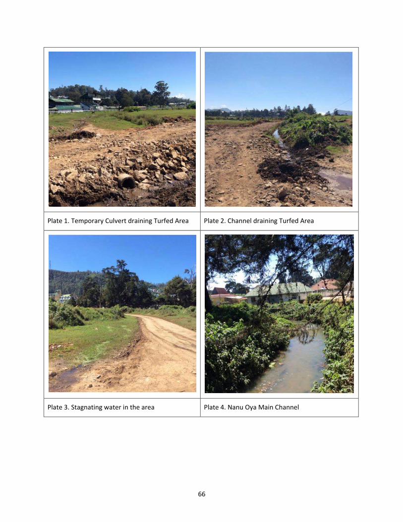
66
Plate 1. Temporary Culvert draining Turfed Area Plate 2. Channel draining Turfed Area
Plate 3. Stagnating water in the area Plate 4. Nanu Oya Main Channel

67
Plate 5. Low-lying Marsh/Fen outside Study Site Plate 6. Low-lying Marsh/Fen within Study Site
Figure 3.12 Surface Water drainage features in the Study site area
The main surface water flow paths in the upper boundary area are primarily from west to east and north to south, and the meandering stream flows along the east boundary of the site towards the Lake Gregory in the downstream. A small catchment beside and along west side boundary of the Study site area send their flows to the Lake through the roadside drains and minor/tertiary channel network located around the boundary of the Study site.
Several culverts and channels are used to drain the Study Site area (Figure3.12) to the downstream Lake, but the turfed areas remain wet and boggy during most part of the monsoon months, due to water stagnation, high water table and loamy soil in the area.
3.4.2 Floods experienced within the area during recent past and Areas inundated by such floods
Nuwara Eliya is known to be one of the least impacted areas during the periods of monsoonal floods and flash floods due to extreme storm events. However, as a district having a high terrain and a high rainfall regime, occasional flash floods, erosion and earth slips due to theheavy storm have been recorded. Especially, flash flood conditions have occurred due to over bank spilling of Thalagala Oya on several occasions in the recent past, including in the aftermath of extreme storm weather in 2013 and 2014, causing inundation in the adjacent low-lying flood fringes.
The flood depths have been recorded to be in the range of 0.30 ~ 0.90 m in most areas, and wet soil conditions have reportedly lasted for longer periods even after the flood waters had receded.

68
3.4.3 Surface water quality and present uses of surface water
The main inflow to the Lake Gregory is through Nanu Oya, which drains from the North Eastern side of the Lake. The average flow of Nanu Oya is more than 1,000 m3/day. Lake Gregory and Nanu Oya are subjected to heavy pollution, mainly from untreated wastewater from houses, shops, and other institutions, small-scale industries, and most notably from agricultural fields. Water samples collected from Nanu Oya during the field visit on June 17, 2017, and were tested and the results are provided below:
Table 3.1: Water quality of the Nanu Oya (samples were collected within the proposed premises on June 17, 2017)
Sample BOD ppm
COD ppm
NH4+
as N
ppm
DO
ppm
NO3.
as N
ppm
PO43.
as P
ppm
Total Coliforms MPN/
100mL
Faecal Coliforms MPN/
100mL
TSS ppm
1 31.0 120.0 8.00 4.5 3.41 0.52 2,220 790 76.0
2 46.0 100.0 2.00 5.1 5.47 0.85 1,790 640 21.0
3 41.0 120.0 3.20 4.9 5.37 0.92 1,700 590 35.0
It can be seen from Table 1 that BOD, COD and TDS levels are very high and the dissolved oxygen was fairly low which indicates high organic contents being present in the water. Ammonia and nitrates (as N) levels were found to be high, while phosphate (as P) levels were also detected to be moderately high. FaecalColiforms were detected in fairly high numbers, at all the three locations indicating the water contaminated with fresh sewage, probably from the low-cost houses located within the proposed project site.
In addition, National Aquatic Resources Agency has conducted long-term water quality surveys (from 2007 – 2009) in Lake Gregory, which also has indicated heavy pollution (See Table 3.2).
Table 3.2: Some physic-chemical water quality parameters at selected sites in Lake Gregory. Note: LA denotes the Average for all the sites.

69
Source: Shirantha, R. R. A. R., Amarathunga, A. A. D. and Pushpa Kumara, N. W. J. Lake Gregory, Alien Flora and Urban Aqua-Environments in a Misty City of Sri Lanka, Proceedings of International Conference on Sustainable Built Environment (ICSBE-2010), Kandy, 13.14 December 2010, PP. 55-62.
In addition, the huge amounts of solid waste are dumped into the stream, and the water is much polluted, as shown in the photographs. The water is covered with aquatic weeds, as nutrient levels are apparently very high. The stretch of the stream close to the Lake received heavy loads of agricultural runoff, which polluted the water intensely.
Photographs of Nanu Oya within the proposed Project area
Plate 1. Nanu Oya behind the Paddock area Plate2. Nanu Oya Near the low-cost houses
Plate 3. Unprotected banks near the marshy area Plate 4. Protected walls at some locations

70
Plate 5. Stream blocked with solid waste Plate 6. Stream covered with aquatic vegetation
Plate 7. Toilets & solid waste near the stream Plate8. Location of effluent discharge
Plate 9. D/S of bridge over Race Course Road Plate 10. Surrounded by agricultural land

71
From the above photographs, it is clear that Nanu Oya is being polluted due to the present and use of the area. The proposed effluent discharge, therefore, will not pollute the stream any further, if the wastewater is treated properly.
It is believed that the roadside drainage canals, mostly draining to marshy area and Lake Gregory, are polluted with fecal matter and high levels of oil and grease, biodegradable organic matter represented by biochemical oxygen demand (BOD), nutrients and even heavy metals as a consequence of the disposal of sewage (domestic wastewater), industrial wastewaters and municipal solid wastes (which also contain hazardous materials due to lack of appropriate solid waste management strategies in the vicinity). At present houses, commercial enterprises and numerous institutions premises located in the vicinity of the drainage canals have no appropriate sewage and other wastewater treatment plants or the existing treatment plants are malfunctioning due to various reasons such as excessively high volumes of wastewaters or high strength wastewaters being pumped into treatment reactors subsequently resulting in plant failure, lack of appropriate maintenance works and competent staff for plant operation. In fact, the presence of algal blooms (cultural eutrophication) and aquatic weeds such as water hyacinth (Eichhornia crassipes (Mart.) Solms) and duckweed (Lemna minor) in some canals seems to be positive indicators of intense nutrient pollution.
3.4.4 Ground water availability, quality and present uses of ground water
In Nuwara Eliya area, the cover of the overburden is relatively thin and therefore there is a good yield exists for groundwater in rock masses, which are joined, fractured and possibly weathered. Such rock masses comprising of quartzite, limestone, and calc-gneiss bands provide a very good yield. The data on groundwater availability in the project area is very sketchy, and therefore it is not possible to exactly quantify the availability, yield and capacity within the project area.
Groundwater table is relatively shallow in areas close to the Lake. However, due to the sloping terrain, the groundwater table lies fairly deep in hilly areas. Further, due to the location in the Lake Gregory floodplain, groundwater is available at shallow depths varying from <1.0 m ~ 8.0 m from Existing Ground Level (EGL) in the area. The shallow groundwater is rarely used for household usages as the majority of theentire suburban city population is served either by pipe borne water supplied by NWSDB or bowsered water, otherwise. Most of the residents in the area use pipe-borne water for consumption, but their old wells are still in use for purposes such as bathing and washing. Several households dug wells, and shallow tube wells are observed to be in use in the residential/village area north of the Study Site. The groundwater from shallow dug wells is used for gardening, landscaping and agriculture/cultivation at several locations. The groundwater is not extracted in large quantities for water supply projects or for commercial purposes.
The groundwater quality has not been extensively studied with compared to that of surface water. However, the groundwater quality is expected to be relatively better than surface water. The presence of agricultural land and solid waste dumps are a major concern as the leachate may have polluted the groundwater extensively.
-

72
- Depth to ground water levels and seasonal changes in level
- Any floods experienced within the area during recent past
- Areas inundated by such floods (if any)
3.4.5 Noise Levels
Measured noise levels around the project area are given in Table 3.3 (measured on July 7, 2017).
Table 3.3: Measured noise levels in dB(A) at locations within the proposed premises
Location Leq in dB(A) Remarks
Day time Night time
N1 62 52 Day time noise is due to vehicular traffic
N2 58 52 do
N3 60 55 Effects of vehicular traffic
N4 59 53 do
N5 67 54 Noise from a garage
Figure 3.13: Locations for monitoring noise levels around the proposed project area

73
All noise measurements were carried out at the premises of the proposed development, and high noise levels were predominantly due to the vehicular movement along the road in front of the proposed premises. Night-time levels were somewhat suppressed compared to those of daytime due to the lesser number of vehicles on the road.
3.4.6 Ambient air quality
The closest air quality measurement has been for Kandy city. The ambient average air quality levels in the Kandy City has been measured by CEA in 7th to 13th July 2010 and given in Table 3.4.
Table 3.4: Average ambient air quality levels in the Kandy City in 7th to 13th July 2010 (Source: CEA Data Base)
Pollutant Maximum permissible level
Average concentration
Recorded maximum average concentration
SO2 0.08 ppm (1 hr) 0.02 0.04
CO2 26 ppm (1 hr) 1.2 4.4
NO2 0.13 ppm (1 hr) 0.06 0.08
PM10 100 micro g/Nm3 (24 hrs)
87 103
It was clear from the measurements that maximum average PM10 levels have been above the permissible levels due to the vehicular emissions. Valley effect may have aggravated the problem of getting them accumulated within the city itself. However, just outside the Kandy City such impacts would not be significant. As such, we could presume that the ambient air quality in the proposed premises would be within the permissible levels.
3.5 Land use
3.5.1 Present land use of the study area
The land use characteristics around the proposed site area exhibitmixed use. The site area (within 100m radius) comprises the commercial land uses (retail shops, small restaurants, and convenient stores such as bakeries. These activities occupy small land lots and vary in size (6-20 perches). The site area consists of medium size hotels too. The Gregory Lake is located within 100m of the site area. Although the predominant land use types area commercial, lake, and recreation, a few residential uses found in the

74
surrounding area. A small percentage of land is also used for open space in the site area. Further, a Buddhist temple (modern, not historical) is located within 100m distance.
3.5.2 Land use potential of the site
Since this site is not located in a protected area, sloppy area, forest area or an environmentally sensitive area, this area is suitable for recreational, tourism, commercial and residential activities. This is also highlighted in the existing Development Plan for Nuwara Eliya City area of the Urban Development Authority (UDA). According to this plan, High Altitude Training Centre has been proposed a suitable development for this area (Nuwara Eliya Development Plan, Volume 1, p19). This area is suitable for medium residential density development and medium or low rise buildings as they do not obstruct the views that have value to the community.
3.5.3 Zoning
UDA has prepared a zoning plan for the Nuwara Eliya city area for 2004- 2016. This zoning plan is still applicable to the site area. In the Zoning plan, this area belongs to Parks, Playgrounds and Recreational Zone (Urban Development Authority, Proposed Zoning Plan, Annex 6a-3). The permitted uses in the site area are stadia and related buildings, play grounds and parks, utility service related activities, recreational clubs, temporary shops in the festival season and aquariums and zoological gardens.
According to the UDA development plan, the proposed High Altitude Sports training centre and related buildings (accommodation) are permitted uses.
3.6 Visual amenities
Nuwara Eliya is generally famous for its scenery and temperate climate, and the historic ‘Tudor Style’ 19th-century British architecture for which the city is named “Little England” of Sri Lanka. In particular to Race Course premises, Lake Gregory from its south east end and the surrounding mountain range towards the west direction creates an authentic panorama in enriching the surrounding landscape.

75
Figure3.14: Visual Amenities (Source: Modified from Google Earth)
3.7 Ecological Resources (both terrestrial and aquatic)
3.7.1 Existing environment of the area
The proposed project site is located within Nuwara Eliya municipality, which comprised of urban (man-made) environment set-up including parks and lakes. Most of the structures have built in British periods and new constructions based on same architectural pattern, therefore, the city still stands with its scenic beauty. Most of the habitats/components found in the Nuwara Eliya municipality are artificial; the city centre, home gardens, Victoria Park, Racecourse and Lake Gregory. The project development takes place in racecourse land and plans to acquire adjacent lands. However, the study site was already disturbed by human interventions, and secondary vegetation could be observed.
The species identification in the proposed project area was carried out by a rapid assessment of both terrestrial and aquatic ecological resources. The survey was carried out during the daytime with the aim of preparing a detailed species inventory. In addition, problems/issues identification related to the proposed project (within and outside of the proposed project site) and identification of possible environmental impacts due to the proposed project were noted down. The methodology used for the study was line transects method and line was laid through identified habitats/vegetations in the study site. In addition, recently published and unpublished materials/data were also used to gather

76
information. Further, relevant secondary information were gathered from people living in nearby communities and relevant officials.
A floristic survey of higher plants found in the area was carried out. During the survey, flora species found along transect were recorded. In order to determine the floristic diversity of the area, direct recording method was used. Observed floral species were identified using descriptions and photographs in “A field guide to the common trees and shrubs of Sri Lanka”, "Invasive plants of Sri Lanka" and "Illustrated field guide to the flowers of Sri Lanka". The national conservation status of the species was recorded according to the National Red List 2012 of Sri Lanka; Conservation Status of the Fauna and Flora. Ministry of Environment, Colombo, Sri Lanka. Nomenclature of theflowering plant was based on Senaratna (2001).
Sampling of fauna was done in parallel to the floral transects. Visual Encounter Survey (VES) method was used to record faunal species. Both direct and indirect observations (Calls, foot prints, pellets, and tracks) were made during VES. Both floral and faunal survey was carried out within the project site and 100 m away from the project boundary. Secondary information on biodiversity and environmental issues were also collected by personal communication with relevant officers and villagers. The study of reviewing of published documents and unpublished data was also carried out. In addition, photographic records were used to identify the visual aspects of habitats of the proposed project area.
Observed faunal species were identified using published descriptions and taxonomic keys provided by Harrison (1999), Philips (1980), Das and De Silva (2005), de Silva Wijeyeratne (2006), and Gunathilaka (2007), Manamendrarachchi and Petiyagoda (2006). The conservation status of the species was recorded according to the National Red List 2012 of Sri Lanka; Conservation Status of the Fauna and Flora. Ministry of Environment, Colombo, Sri Lanka.
The observations and findings from the survey related to ecological resources are discussed under following sub-topics (1) terrestrial habitats: flora and fauna, (2) aquatic habitats: flora and fauna, (3) avifauna and (4) ecosystem services.
3.7.1.1 Terrestrial Habitats: Flora and Fauna
Most of the plants/trees present in the area are introduced species, which are now naturalized in the area. Most of the floral species found within the study site are small shrubs and herbs A few larger trees observed along the edges and roadside. The nearby area is used for vegetable cultivation.
Of the 74 recorded flora species in the area,52 were introduced and naturalized in Sri Lanka (Table 3.5). There is no natural vegetation within the study site. During field visits, habitat types/components and species were identified, and description of flora and fauna is given in the section below.
(a) City Center
The city centre is bit congested and comprises of hotels, restaurants, vegetables and fruits markets, shopping complex, postal complex, police station, school, religious places, etc. Many of the buildings retained the features from the colonial period, and even new hotels are often built and furnished

77
according to the colonial style. In addition, the surrounding environment consists of marshes, vegetable cultivations and tea plantations.
However, there is no natural habitat found in the city centre area. Some introduced plants species such as trumpet flower, Mexican daisy, Dalia and different types of lilies have been planted in some institutions. Around the city centre, and the lake some people used to earn money by colts (pony) riding.
(b) Home gardens
Many private homes still maintain their old English-style lawns and gardens. The commonly observed flora are different types of Roses, Lilies, Daisy and Dalia. All floral species found in the home gardens are introduced ornamental plants, having a commercial value. In addition, some vegetables have cultivated in the same home garden such as carrots, cabbage, leaks, etc. Domestic dogs and cats are observed in most houses.
(c) Racecourse
The Nuwara Eliya racecourse is the only remaining horse racing venue in Sri Lanka.Generally, horseracing meets are held during the festival season (April). In addition, meets are also held in August and December. There are line houses located nearby to the boundary of the racecourse and domestic animals such as hens, ducks, and dogs are observed in the vicinity of these houses. In addition, cattle grazing could be observed nearby to the boundary (Figure 3.15). Most of the flora identified in the adjacent area have introduced and attributed to higher elevations above ~2,000 m (Figure3.15). In addition, Senna didymobotrya (Rata- Tora) cultivated as an ornamental and as green manure and Brugmansia candida (E: Trumpet flower, S: Rata-Attana), a hybrid species, cultivated as an ornamental plant.
A few numbers of Lantana sp. and Ulex sp were observed, which are well-known invasive species to the montane region (Figure 3.17). Eucalyptus sp, Pinus sp. and Cypress sp. trees have observed as large trees in the proximity. The Cypress tree has a considerable commercial value as it uses as Christmas trees in Sri Lanka, though Pinus trees are popular in other countries. Cypress grows straight with a perfect conical shape making it perfect for a Christmas tree. Cypress has been frequently observed within the municipality of Nuwara Eliya.A total of 74 plant species belonging to 34 plant families were recorded within the study site (proposed project site and 100 m away from the boundary). One endemic plant species were recorded within the study site out of three endemic species. Most of the species were introduced to Sri Lanka as ornamental plants and are now naturalized. Further, some of these introduced species had become invasive species. e.g.,Ulex europaeus. Summary of floral species recorded are given in Tables 3.5 and 3.6.
Table 3.5: Overall summary of flora recorded within the study site
Families Total number Endemic Species
Native Species Introduced Species
34 74 3 (4.1 %) 19 (25.7 %) 52 (70.2 %)

78
Table 3.6: Detailed information on flora observed during the study
Plant type Number of Species Native Endemic Threatened Introduced
Shrub 22 9 13
Herb 41 12 3 26
Creeper 1 1
Tree 10 2 8
A detail description of the terrestrial flora and fauna list is given in Annex 6g.
Figure 3.15: Existing boundary of the racecourse

79
Figure 3.16: Naturalized (introduced) plant species recorded during the study
(a)Tibouchina urvilleana ; (b) Plectranthus grandis; (c) Sambucus hookeri
(d) Rubus leucocarpus [Wal rosa]; (e) Erigeron karvinskianus [Mexican daisy]
(f) Aristea ecklonii [Blue star]
The proposed development will not occupy the existing racetrack. However, certain extent from the middle of the grass ground will be occupied for hockey, rugby/foot ball, synthetic track and tennis court, etc. As proposed, high-rise buildings will be located at the immediate boundary of the racecourse land, without disturbing to the visibility from existing pavilion.

80
Moreover, by the proposed development project, unauthorized households and commercial establishments will be relocated, and new buildings (from single to multiple stories) are to be added to the existing environmental set-up.
Figure 3.17: Invasive plant species (a) Ulex sp. (b) Lantana sp.
3.7.1.2 Aquatic Habitats: Flora and Fauna
The marshy area of the Nanu Oya and Lake Gregory were identified as two main aquatic ecosystems in the area. During the study period, perennial herbs (Ludwigia peploides, Myriophyllum sp and Eichhornia sp) were found to grow in moist to wet riparian areas in the lake Gregory, Nanu Oya and marshy area spread to form mats on the sediment, or floats ascending in the water edge areas. The aquatic weeds of Eichhornia crassipes and Altermantheraphiloxeroideswere found to colonize in aquatic ecosystems. In addition, Myriophyllum sp. Salvinia molestawas also found. Ulex europaeus and Wedelia trilobotawere found in water edge areas forming dense thickets and found to invade grass land very rapidly

81
intheperipheral area of the lake and some part of Nanu Oya. Densely grown patches of Colocasia esculenta, and Cyprus grass species in themarshy area and were found to facilitate sedimentation leading to clogging the inflow channels of the lakes. They were found in water edge areas as well as semi aquatic peripheral areas where grazing cattle and horse/pony are often found. Most aquatic invasive plants are tolerant of many water pollutants thereby they tend to invade disturbed areas where native plants cannot adapt to the alteration.
(a) Nanu Oya
The Nanu oya flows nearby to the racecourse land (at theEasternboundary), and it is connected to the Lake Gregory. The colour of the water is brownish and seems to have a contamination from sewer lines, septic tanks and agricultural lands located nearby (Figure 3.18). Ludwigiagrandiflora (Water Primrose) and Polygonium molle (Sikkim Knot weed) vegetation types could be commonly observed along the unprotected stream bank. However, inflowing of solid waste to the marshy area and Lake Gregory is avoided by placing a mesh across the Nanu oya.
Figure 3.18: Existing condition of the Nanu Oya

82
By the proposed development project both sides of stream bank are to be protected, and vegetation cover will be removed. The observed species along the stream bank are introduced and naturalized in the area. Also, treated wastewater from the sports complex (during operation period) are planned to be discharged to the Nanu Oya.
(b) The Lake Gregory
Lake Gregory is a man-made tank, named after Sir William Gregory, Governor in the past from 1872 to 1877. The area of the Gregory’s Lake is about 0.4 km2 with a perimeter of about 3.5 km. Lake Gregory receives an average annual rainfall of 2,000-2,500 mm, and a mean annual temperature of approximately 16oC. The Lake is bounded on all sides by roads, and the surrounding area has been severely altered by tourism, recreation and urban development. As of the Lake’s aesthetic value and scenic attraction, many holiday homes and tourist hotels have been established around it. A major tributary of this Lake is the Nanu Oya stream that originates from the Pidurutalagala Peak. Most of the streams in the catchment area have been changed over the years for commercial agriculture developments.
The aquatic vegetation in the Lake consists of phytoplankton and rooted macrophytes. The fauna recorded from the marshy area and Lake Gregory include 11 species of invertebrates and 77 species of vertebrates (National Wetland Directory of Sri Lanka, 2006).
Aquatic Flora:
The phytoplankton communities are dominated by Myxophyceae (blue green algae). The floating
macrophytes in the Lake are dominated by two exotic species; Salvinia molesta, and Pistia stratiotes. The other rooted aquatic plants that are common in the Lake include Hydrilla verticillata, Nymphaea spp., and Cabomba sp. Predominant plant species in the Lake bank include Aristea eckloni, Pogostemon reflexus, Eriocaulon brownianum, and Osbeckia parvilolia.
Aquatic Fauna:
The freshwater fish populations in the Lake consist introduced, exotic species, dominated by Oreochromisspp. and Cyprinus spp. Among the aquatic amphibians, the endemic Polypedates eques and Lankanectus corrugate inhabit the streams and marshes around the Lake. Aquatic birds that visit the Lake include cormorants (Phalacrocorax niger), egrets (Egretta garzetta, Mesophoyx intermedia), herons (Ardeola grayii) and kingfishers (Alcedo atthis, Halcyon smyrnensis), while raptors include Elanus caeruleus and Circus spp.
Among the mammals, Lutra lutra and Prionailurus viverrinus inhabit the surrounding environs. The riparian areas and associated streams harbour several endemic crab species (Perbrinkia spp. and Ceylonthelphusa spp.). A detail description of aquatic flora and fauna is given in Annex 6h.
By the proposed development, there will be direct impact through Nanu Oya. As mentioned above, Nanu Oya will be carrying the treated wastewater from the sports complex. Therefore, inflow to the Lake will be increase and nutrient level will be increased. As a result, the growth of blue-green algae and invasive aquatic plants will trigger by the nutrient supplement. This may have anegative impact on the lake sustainability especially to the native flora and livability of fauna.

83
3.7.1.3 Avifauna
In the proposed development area, common avifauna species are observed including domestic crow, kingfisher, heron and house sparrow. In addition, Victoria Park is popular among locals and foreigners for birdwatchers, particularly, the Indian Blue Robin, Pied Thrush or Scaly Thrush lurking in the denser undergrowth. Kashmir Flycatcher is another attractive bird species found in the park. However, there will be no direct impact to the avifauna due to proposed development project. A detail description of avifauna is given in Annex 6i.
The study site is not situated along a migratory path of animal species. However, migratory bird species are available around the project site during theNorthern winter season as the Gregory Lake is a roosting and feeding ground for such species. A summary of recorded faunal species given in Table 3.7.
Table 3.7: Summary of recorded faunal species
Taxonomic group Number of species
Native Endemic Threatened Introduced Migratory
Butterflies 5 4 1 NT - 1
Freshwater Fish 3 1
Amphibians 6 3 3 EN – 3
NT - 2
Reptiles 1 1 TR - 1
Birds 76 70 2 NT - 1 4
Mammals 12 8 1 EN – 2
NT - 2
2
(NT – Near Threatened; EN – Endangered; TR – Threatened
3.7.1.4 Ecosystem services
The North Eastern boundary of the racecourse is marshy and act as water retention area for surface water run-off from the surrounding area. In addition rainwater infiltration, ground water recharge is the other main function provided by the marshy land. The marshy vegetation is dominated by Alocasia sp, Juncus effuses and Cabomba sp (Figure 3.19). In addition,Solanum chrysotrichum(terrestrial) and Ludwigia grandiflora (aquatic) plants were also commonly observed in the marshy area. A few trees of, Cypress sp. and Pinussp. were observed at the boundary of the marshy area. Since the lack of safe roosting trees in the marshy area, it seems that the bird’s population does not attract to the place.

84
Figure 3.19: Existing condition of the marshy land
However, during field investigation, aquatic fauna could not observe in the water pockets of the marshy area and in thesmall tributary. Though light penetrates to the depth, closer observation revealed that the water surface has a thin oil layer and thick growth of water mosses. Due to proposed development project, the total marshy area will be cut and filled. As a result, existing vegetation will be removed, and the current functions provided by the marshy area will entirely be ruined.
The major functions provided by the marshy area include:
• Regulating the water quantity
• Groundwater recharge
• Regulating floods and the impacts of storms.
• Erosion control and sediment transport

85
The marshy area and Lake Gregory can be considered as the centre in the ecology of the area, providing the necessary ecological functions for a healthy environment. The ecosystem services provided by the Lake Gregory include:
• Water conservation
• Protection and sustain the surrounding ecosystems.
• Provide habitats for many flora and fauna
• Flood control
• Act as a roosting place for birds help to preserve the avifauna biodiversity including migratory birds.
• The dead storage of the tank also has the function to keep alive fish and other aquatic animals in the tank during the dry season.
In sum, the Lake fundamental to conserve the dynamics of the ecology of the area by connecting different ecological compartments (i.e., water, biota and soil), and creating a balance between the human actions exploiting the territory and the reposition and rehabilitation of the natural resources and dynamics.
-
3.7.1.5 Proximity to protected Area
The project area is located adjacent to the Lake Gregory Environmental Protection Area (EPA) (See Figure 3.20). The boundary of the Lake Gregory EPA is the Race Course Road which runs along the Western Boundary of the Project area. No part of the project area falls within the EPA.
3.8 Historical & Archaeological importance
Race course premises itself holds a historical and cultural significant due to its establishment by the British. Adjoin natural land mark Lake Gregory and unique typology of building such as Grand Stand in the premises augments the importance of such.
The only building which is of religious importance in the considered locality is the newly built temple adjoining the land, and these premisesdo not hold any evidence of Archeological importance.
3.9 Socio- economic Environment
This section focuses exclusively on the Socio- Economic Environment information of 54 families that are currently living within the premises of the Race Course ground who will be relocated as a result of the proposed High Altitude Training Centre project.
86
Figure 3.20: Boundary of the Lake Gregory Environmental Protection Zone(Source: Base map: Google Earth; Overlay: CEA EPA Maps)

87
3.9.1 No. of families living within the proposed project site and their socio, economic status
3.9.1.1 Population Dynamics
With regard to the population dynamics of this community, the following holds (Figure 3.21):
Figure3.21 : Racial distribution of the community to be relocated
Source: Compiled by the team
Based on the responses received during the secondary survey, it was identified that 94% of the 54 families to be relocated were Sri Lankan Tamils, 4% were Sinhalese, and 2% were Burghers.
Figure 3.22: Racial distribution of the community to be relocated
Source: Compiled by the team

88
Upon considering the distribution of religions among the community, it was identified that out of the 54 families 81% were Hindus, 15% were Christians, and 4% were Buddhists (Figure 2). There were no families representing the religion of Islam.
It was also identified that 1 family within the community consisted of a member who was in need of special attention due to physical impairments which hindered their ability to walk.
3.9.1.2 Income and Wealth
Based on the secondary survey, it was identified that a majority of the earners of the households were labourers whose livelihoods heavily depended on the Race Course ground and its activities.
On average, each household was found to be earning a monthly income of Rs 21,020. This monthly income was secured by the 54 families from a range of sources (Figure 3). On average only 55% of the monthly income was found to be secured from the salary received as a result of engaging in their main livelihood, while the rest of the income was secured from sources such as retirement pension (24%), additional jobs (12%) and various other sources of income (9%) such as the Samurdi benefit. However, what is especially noteworthy is that for 25 families out of the total of 54, the sole source of income was their main livelihood.
Figure3.23 : Sources of income
Source: Compiled by the team
Additionally, it was identified that 60% of the families of the community were receiving the Samurdhi benefit, while 40% were deemed ineligible (Figure3.24).

89
Figure3.24: Families receiving/not receiving the Samurdhi benefit
Source: Compiled by the team
3.9.1.3 Housing Conditions
With regard to the current ownership status of the houses of 54 families to be relocated the following can be identified:
Figure3.25: Status of ownership of housing units
Source: Compiled by the team

90
It was identified that 54% of the families have single ownership of their property, 8% of the families have encroached the current premises, 7% had joint ownership status which meant that a single house was shared among several other families, and 4% of the families currently pay taxes to the local authority.
With regard to the usage of the household units, all 54 housing units were used solely for residential purposes. No commercial activities were seen to be taking place within the community.
In terms of the number of stories of the housing units, only single storied houses were in existence. On average, each household has 3 rooms. However, housing units with a single room, which was the minimum recorded , as well as housing units with as many as 7 rooms, which was the maximum recorded could also be observed.
In considering the construction materials of the housing units, the roofs of 53% of the housing units were constructed with corrugated sheets, while the remaining 47% were constructed using asbestos. The floors of 98% of the households were made out of cement while only 2% of the houses had used tiles. With regard to the construction material of walls, walls of 59% of the houses were constructed using bricks, 19% using cement blocks, 16% using temporary materials such as sheets, 4% using mud or clay and 2% using various other construction materials such as wood (Figure3.26).
Figure3.26: Materials used for wall construction
Source: Compiled by the team

91
3.9.2 Availability of Infrastructure facilities
In terms of the availability of infrastructure at their current residences, 94% of the housing units were identified to be having electricity and water facilities (Figure3.27), depicted in blue and green respectively). Only 53% of the housing units were recorded to be having telephone facilities (Figure 9, depicted in purple). Fixed line telephones have not been provided, and hence, the families use mobile phones for communication purposes. With regard to the availability of proper sanitary facilities, 87% of the families recorded that they had access to decent sanitary facilities, while 13% claimed that they did not (Figure3.27, depicted in orange). Also, 73% of the families claimed that their housing units were equipped with decent drainage facilities, while 27% claimed that theirs were not.
Figure3.27 : Availability of infrastructure facilities
Source: Compiled by the team
3.9.3 Existing Infrastructure
The community to be relocated is currently enjoying its fair share of local infrastructure given their location amidst the Nuwara Eliya town. According to their responses, the community under discussion currently has to travel only approximately 1km to fulfil their basic necessities. The community travels approximately 0.95km for the nearest shop (grocery store), and the nearest fair is located 1.14km away. In term of hospitals, the nearest, the Nuwara Eliya General Hospital is located 1.27km away. However, what is especially noteworthy is that this hospital is located in Hawa Eliya, just 500m away from the site to which this community is planned to be relocated to. Also, the closest school is located just 1.09km away, the nearest post office 1.12km, nearest bank 1.07km, court 1.09km, community hall 0.11km, and playground 0.33km. However, the nearest kovil that is most frequently visited is located 15. 01km, which is of significant distance.

92
3.9.1.1 Existing infrastructure facilities which will be affected by the project
The water supply lines, electricity and telecommunication lines within the project area which serves the low-cost houses located within the proposed project area will have to shifted/removed, as these houses will be relocated. The gravel and dirt roads located within the project area too will be affected. Once these houses are relocated, there will be no need for these infrastructure and utilities to be in place within the project area. The utility and service lines will be removed, and new electricity, telecommunication and water lines will be laid according to the needs of the project. New road network (internal roads) will be established together with parking areas.
As the service and utility lines and the roads exclusively serve only the low-cost housing community, there is no impact to anybody due to theremoval of these infrastructure facilities.
3.9.1.2 Other facilities affected
No other infrastructure facilities, such as existing public playground, common recreational areas, etc., will be affected due to the project or project-related activities.
The existing playground will be temporally affected during the construction period when re-surfacing and turfing is carried out.

93
CHAPTER 4: ASSESSMENT OF THE ANTICIPATED ENVIRONMENTAL IMPACTS
4.1 Physical impacts
4.1.1 Erosion, siltation and sediment runoff
- Impact of simulation of the transport and dispersion of suspended sediments release from the excavation area due to removal of debris
- Effects of water ways and adjacent water bodies
- Destruction of natural landscape
- Impacts on existing land use of the area
Extensive extents of site clearing, cut-fill operations, debris removal etc., are envisaged during the proposed construction activities. The site clearing will expose soils in thesloping ground while freshly formed uncompacted soil layers and flow diversions might aggravate soil vulnerability to erosion, siltation and sediment runoff due to flash flows. If no proper construction practices are implemented, significant level of erosion might occur and eroded materials transported via water courses and washout of fines from exposed terrain slopes might pose a severe risk of water quality deterioration in flowing water bodies (Thalagala Oya and Nanu Oya), siltation and sediment deposition in waterways and downstream reservoirs (i.e. Lake Gregory), leading to short- and long term impact on ecology and biology of associated sensitive wetland and water body systems. Further, deposition of eroded materials in large quantities would also affect the conveyance and storage capacity of waterways and reservoirs.
The hill-country capital city of Nuwara Eliya is famous for its spectacularly beautiful approach, cool climate and picturesque landscape. If this particular ecological character splendidly merging with geographical features in the area is not considered and preserved, the alteration of natural landscape will lead to long-term adverse impacts to the natural equilibrium triggering irreversible damages to the interconnected ecological/biological systems and inherent natural landscape.
The existing land use will be altered due to the proposed development activities, and especially the only few presently existing isolated patches of vegetation and boggy marshes within the Study site area (in North and South peripheral edges), will have to be removed, significantly affecting the existing land use of the area.
Both Thalagala Oya and Nanu Oya stream channels remain as unlined natural channels with meandering and buffer vegetation which promotes natural filtering, cleansing, groundwater recharging and enriching of associated hydro-ecological and biological ecosystems. Channel lining, straightening and stream training to enhance flow conveyance capacity will destroy these interconnected natural ecosystems in the long run.

94
4.1.2 Land stability
Impact on land stability, especially, due to heavy constructional activities of the project components and the resettlement activities will be completed only after a detailed geotechnical investigations are over. The investigations have been undertaken by the National Buildings Research Organization.
Included in the following section are the conceptual level recommendations for feasibility level geotechnical evaluations for the major components of the envisioned project. The subsequent and more advanced level of design will require additional geotechnical investigation and additional evaluation of the site. Geotechnical feasibility Study would include the following:
• Conduct a review of available literature regarding the subsurface conditions and geology of the project site.
• Conduct a reconnaissance survey of the proposed development to assess the surface conditions and identify the locations for exploratory borings and test pits.
• For thepreliminary level investigation, it is recommended to advance an exploratory boring within the footprint of each structure. Heavily loaded areas and/or areas with apparent soft ground conditions shall be selected for subsurface investigation. The Standard Penetration Test (SPT) shall be conducted at 1.0 m intervals along the boreholes. The exploratory borings should extend until a stiff subsurface (SPT N > 50) is encountered. In order to assess the geology of the site, it is recommended to carry out at least 3.0 m of rock drilling in several selected boreholes. Core Recovery (CR) and Rock Quality Designation (RQD) of rock shall be obtained.
• Conduct selected laboratory testing of the samples collected during the borehole and test pit investigations. Laboratory testing includes particle size distribution analysis, specific gravity, moisture content, corrosion potential testing and Atterberg limits tests. When the soft soils such as soft clay, organic clay or peat is encountered; representative undisturbed samples shall be retrieved for laboratory consolidation and unconsolidated undrained (UU) triaxial testing in addition to the tests listed above. Selected rock samples shall be tested for its Uniaxial Compressive Strength (UCS).
• If borrow areas are identified during reconnaissance survey, the approximate quantity and potential uses for available borrow material at each borrow location shall be estimated.
• Provide recommendations for the design-level subsurface investigation, as appropriate.
The results of the study will be reported under the following sections:
• Introduction – introduces the project and provides a description of the project details and scope with respect to the geotechnical feasibility.
• Site Characterization – provides details on the methods used to characterize the site.
• Site Conditions – presents the site conditions based on field investigations, previous work at the site by others, and readily available published data.

95
• Evaluations and Findings – presents a summary of the analyses, evaluation methods, and findings.
• Geotechnical Feasibility – presents the conclusions on the geotechnical feasibility of the Project.
• Recommendations – presents recommendations for foundations, soft ground treatment and further geotechnical evaluations in support of final Project design.
• References – provides a list of reviewed project documents and cited works.
4.1.3 Hydrology
4.1.3.1 Blocking of drainage pathways
The main channel of Thalagala Oya stream, the most upstream rivulet of Nanu Oya stream enters into the Study Site via its Northern boundary, confluence with the flows entering the Site across the main bridge on Udu Pussellawa Road and then passes along the Eastern boundary of the Site for over 400 m, before discharging into Nanu Oya main channel connected to the inlet to Lake Gregory. Further, it is proposed to widen the stream channel while the meandering channel will be straightened to enhance flow conveyance capacity.
The planned construction activities in this area will cause significant blockage to the stream flow conditions if no proper diversion and stream training are provided. Recurrent bank over topping and spilling have been reported in the recent past years, during monsoonal rainy periods and if the construction period coincides with these high flow periods in the stream, significant additional blockage to the existing inadequate stream conveyance capacity is envisaged leading to severe local floods and inundation in the low-lying flood fringes.
4.1.3.2 Reduction of flood retention / detention areas
The only few presently existing isolated patches of vegetation and boggy marshes within the Study site area (in North and South peripheral edges) provides the essentially required retention-detention to flash flows from sloping grounds while they also serve as natural filter buffers to remove excess turbidity due to eroded materials and debris/contaminants washed out from partly urbanized upstream catchments. The loss of these storage and filter zones into proposed construction area will lead to losing of their inherent flow retarding and natural cleansing cum filtration functions, overloading already underperforming downstream channels while deteriorating flow water quality.
4.1.3.3 Increased demand for water and impacts on existing water users.
The main source of water for the proposed HASTC Facilities will be NWS&DB, supplemented by groundwater and reused water. The daily quantities of groundwater pumping or planned extraction rates are not detailed yet. However, continuous and excessive pumping from groundwater sources for extended durations without allowing for natural replenishment of declined water table or excessive dewatering during construction period will lead to adverse environmental impacts including

96
temporary/permanent lowering of groundwater table, loss of recharge to natural channels, well and stream drying up, and in worst case scenarios, drying up of local aquifers and land subsidence.
The huge demand of water for consumption and nonconsumptive uses to maintain required other services (gardening, washing, etc) will lead to overstressing of existing service lines and water shortages/low-pressure system to existing users.
4.1.4 Wastewater
4.1.4.1 Quality and quantity of treated effluent to be discharged to the environment
- See Section 2.3.6.1 for details.
The location of the effluent discharge is shown in Figure 2.4 a, b)
4.1.4.2 Impact of treated / untreated effluent disposal on the environment
This has been identified as one of the negative impacts both during construction and operational stages. Water pollution, both groundwater (during construction phase) and surface water (during operational phase) is inevitable if wastewater and solid waste is not properly treated before it is discharged.
During Construction
Disposal of grey water and black water from the workers quarters or from temporary toilets within the project site could cause contamination with high levels of BOD, nutrients, pathogens such faecal coliforms (Escherichia coli), Enterobacter spp. and faecal streptococci (e.g., Streptococcus faecalis and Streptococcus durans). Similarly, disposal of MSW produced by the work force could lead to BOD rich leachate enrichment. Improper disposal of such waste has the potential to pollute the surface waters, notably the Nanu Oya where surface runoff will ultimately find its way.
The surface runoff generated within the construction site, if contaminated with wastewater and/or solid waste can pollute the nearby waterways, especially the toe drainage along the Race Course Road, Nanu Oya and the downstream. Occupation of nearly 100 - 200 persons during stages of construction can generate moderate amounts of municipal solid waste. If the waste is not properly disposed of, leachate loads and high sediment loads can contaminate surface water canals running nearby during rainy seasons. This will also lead to organic pollution as a result of leachate contamination and high turbidity due to the high levels of suspended matters being washed off.
During Operations
It is expected that the treated effluent will be disposed at the location as depicted in Figure 2.3. The details of the treatment system are provided in Section 2.1.5. The discharge of treated effluent to conform to Regulations (as specified in Section 2.1.5) will not cause any negative impacts as there is sufficient dilution throughout the year.

97
The minimum discharge of Nanu Oya at the project location is approximately 1,000 m3/day (0.011 m3/s). The maximum discharge of wastewater is estimated at5,000 m3/day, which is approximately 0.058 m3/s. Therefore, there is a dilution of 13.3 times occurs, even during the minimum flow of the River. Therefore, it can be assumed that the pollution that could occur due to thedischarge of treated effluent is negligible when the dilution is considered. It is important to note that proper treatment should be ensured all times and strict monitoring measures should be in place.
Treated wastewater will be stored in a collection pond within the project premised before discharge. This will act as an equalization tank which will dilute any high loads, and the effluent quality will be maintained at a uniform level in addition to uniform levels of discharge. Also, any sample collection for monitoring and record keeping can be obtained from this collection pond.
4.1.4.3 Impacts of malfunctioning of treatment plant
The operation of the treatment plant needs skilled operators and should be maintained well. Collection and holding of sewage and wastewater without treatmentwill create anaerobic conditions resulting in theemission of noxious gases, which in turn creates abad odour. This scenario creates inconvenience to the users of the HASTC. Methane and Hydrogen Sulfide gases and mercaptans that are likely to emanate are the major gaseous emissions that would cause odour issues in the nearby areas. The downwind direction, wind speed, topography, etc. will aggravate this problem in certain periods of the year.
However, the treatment plant malfunction is a low probability, and always, when this happens, the sewage can be collected and transported away from the premises for proper disposal elsewhere. Therefore, the chances of the impacts due to malfunctioning of the treatment plant are very low.
4.1.4.4 Analysis of impact of the project on water quality of the Gregory Lake
- during pertinent phases of construction
During construction, water quality of marshy area and Lake Gregory can be affected when pollutants resulting from, therelease of nutrients, oil and grease, organic pollutants, noxious substance and oxygen consuming substance, etc. are released to the Nanu Oya, which will be washed away to the Lake.
Vehicles and equipment used in thetransportation of material, excavation, construction, etc., will have minor impacts on water quality. Contamination of water with fuel, grease and oil could occur during the cleaning of the soil and construction material transporting vehicles. Possible oil spills from machinery and other equipment used for construction works would cause contamination of the nearby soil, eventually leading to contamination of the water bodies, particularly during heavy rainy periods. Also wash water arising during cleaning of machinery used for concreting, laying of liner material, etc., may cause colour and turbidity problems as well as contamination with oils.
- During post construction
During operations, oil leaks are possible at parking bays and machinery yards, however, this is very insignificant given the condition of the present-day vehicles, and then impermeable parking lots allow collection of surface runoff which can be diverted from the premises. Large dilution of surface runoff will disperse the pollutants before it contaminates the nearby marshy area and Lake Gregory.

98
4.1.5 Solid waste
4.1.5.1 Impacts due to solid waste disposal on surface ground water and / or soil
Improper disposal of solid waste will create nuisance among the users of the Sports Training Facility as well as neighbouring communities. The Ministry of Sports is expected to establish proper operations and maintenance plan for proper maintenance of services, of which proper solid waste management is a major part of it. The proposed solid waste management plan, when implemented will not cause any significant negative impacts.
The sealed storage chamber which is air tight and air conditioned (at 10 ͦC) will prevent any odour emanating due to storage of solid waste. A daily collection of biodegradable solid waste will not cause any bad odour – which is essential for maintaining pleasant and sanitary conditions of the premises, which is meant for effluent clientele.
4.1.5.2 Impacts due to debris disposal on surface ground water and / or soil
Debris and spoil will be removed from the site after low-cost houses are demolished, and peat layers and top soil is removed. Construction debris and spoil after separation will be transported to the selected dumping sites for disposal. During transportation, the spilling of the spoil is possible, and the frequency of the vehicle movement will depend on the rate of excavation.
The debris and excavated soil after dewatering will be disposed to the selected disposal sites and disposed of in a predetermined pattern. However, when debris and disposed spoil is exposed to rain without a ground cover, it may be easily subjected to erosion due to the high percentage of peaty and sandy material in the soil. Soil erosion and transportation of the eroded soil will cause severe environmental problems such as siltation and blocking of existing waterway, reducing the capacity of the canal downstream of the project, siltation of the marshy area and Gregory Lake, flooding due to blockage of drainage paths and pollution of water sources.
It should also be noted that spillage is very likely during transportation unless the proper vehicular fleet is not deployed. When transporting, material, as most of the time they are in semi-liquid form, may spill over to the road network creating apublic nuisance.
4.1.5.3 Impacts due to disposal of sludge from wastewater treatment plant
The sludge production is very small due to the nature of the proposed design of the wastewater treatment plant. The anaerobic reactor, followed by the aerobic reactor will reduce the sludge production to very small levels. The frequency of sludge removal will probably be once in several months time, depending on the load it received. The sludge which will be removed will be handed over to a collector authorized by the Nuwara Eliya MC, who is expected to dispose of it without any environmental effects.

99
4.1.6 AirQuality/ Noise / vibration impacts
4.1.6.1 Noise, vibration and dust due to constructional activities
Noise impacts due to constructional activities and during operations Noise is generally described as unwanted sound. Existing ambient noise levels in the area are consistent with urban residential settings. There is also traffic noise from the roads in the nearby areas, especially Badulla Road. Noise levels within and adjacent to the project area would increase during the proposed construction activities mostly as a result of theoperation of construction equipment.
High noise from heavy vehicles and irritating noise emitted from beeping horns during transportation of material during construction of the project facility and haulage of construction waste during commissioning and vibration induced noise effects will cause inconvenience to neighbours living by the side of the roads or in the vicinity.
Along the hauling route to the site area, the noise levels from traffic on the existing road can be clearly noticed. As the haulage road is the main Badulla Road, via either from Welimada or Nanu-Oya, it is at present used by a heavy flow of vehicles. The noise from traffic during daytime is much higher than that at night time, due to the increased traffic congestion during the day particularly during school hours.
It should be noted that no Sri Lankan standard for vehicular noise is available. Hence a similar set of regulations developed in the USA could be used as a guideline in order to predict the vehicular impact in the affected road network. It should be noted that the noise levels in terms of Leq dB(A) should be maintained below 67 dB(A) (see Table 4.1) depending on the land use in accordance with the Federal Highway Association of USA (FHWA). However, the addition of a couple of new vehicles during day time will not have a significant impact in terms of noise level, but during night time it will create inconvenience even disturbing the sleep of some. Hence there is a minor impact during night time but no effect during the day time.
Therefore, even though the noise from transportation vehicles is more sporadic, the level of noise produced by a passing truck appears higher than the noise produced by other traffic on the road. Therefore, aconsiderable level of noise from engines and irritating noise emanated from beeping horns and vibration effects of the heavy vehicles will cause inconvenience to residential areas located close to the haulage routes, though the effects may be temporary (since the haulage of equipment and construction material is confined to a shorter time period).
During the construction period, apart from minor increased traffic there could be several high noise levels generated by noise levels far exceeding 75 dB(A) (which is the maximum permissible level stipulated in the Sri Lankan legislation for daytime activities defined as 6.00 am to 9.00 pm), though these effects are sporadic and temporary in nature. Some of the high noise generating activities includes clearing, excavation, earth work and construction of foundations, etc. Activities such as site clearing, earth work, land preparation and other storm water collection drainage lines, construction of offices, contractor huts and other temporary buildings together with infrastructure facilities, construction,

100
erection, assembly of super structure and construction of other ancillary structures will have minor impact with related to noise and vibration induced noise.
Table 4.1. The maximum allowable noise levels Generated by highway traffic (Hourly A – Weighted Sound Levels – dB(A)1)
Active Category
Leq (h) Description
A 57 (exterior) Lands on which serenity and quiet are of extraordinary significance and serve an important public need and where the preservation of those qualities is essential if the area is to continue to serve its intended purpose
B 67 (exterior) Picnic areas, recreation areas, playgrounds, active sports area, parks, residences, motels, hotels, schools, churches, libraries and hospitals
C 72 (exterior) Developed lands, properties or activities not included in A or B
D - Undeveloped lands
E 52 (interior) Residences, motels, hotels, schools, churches, libraries, hospitals and auditoriums
1Either L10 (h) or Leq (h) based on 1-hour samples (but not both) may be used on a project
Equipment used in clearing and demolition the site, excavation, paving and concreting is also known to generate moderate noise levels. Most of the machinery and equipment used during construction works (infrastructure facilities or buildings) are known to produce moderate levels of noise levels (apart from the use of several construction vehicles though the effects may be temporary (since the construction phase is confined to a shorter time period). Tables 4.2 and 4.3 presents typical noise levels of some of the machinery used in construction works. Deep foundations are necessary to erect superstructures, due to existing ground conditions. The foundation construction will result in the temporary increase in the noise level in the vicinity of each boring.
As can be seen from the above Table, drilling (including that are needed for geotechnical investigations) would lead to minor impacts as the noise levels abate at a distance of 50 ft to levels less than 75 dB(A), which is the permissible noise levels. However, drilling related to piling creates considerable levels of noise and vibration. Such noise pollution created during construction operations can present a health hazard to site operatives and cause annoyance to neighbours.

101
Table 0.2: Relative range of noise levels for some common types of heavy construction machinery
Machinery Noise levels at distance of 16 m
Compactors (rollers) 71-75
Backhoes/excavators 70-85
Tractors 78-95
Scrapers, graders 78-93
Pavers 85-88
Trucks 83-93
Concrete mixers 75-88
Concrete pumps 81-83
Jack hammers and drills 82-98
Such high noise levels generated by the machinery and equipment may have a disturbing effect on the noise sensitive fauna living in the nearby areas. The disturbing effects will be even higher as the anticipated noise levels are higher than the stipulated limit of 50 dB(A) in thecase of night time construction activities defined from 9.00 pm – 6.00 am on the following day. However, as the construction period is limited the effects may be sporadic and temporary in nature.
Table 0.3: Typical noise levels of construction equipment
Equipment Noise level at 7 m in dB(A)
Compressor 109
Truck, scraper or grader 94
Pneumatic drill 85
Excavator 112
Loader 112
Roller vibrator 108
Poke vibrator 113
Sound reduced jack hammers and lock drills 82

102
Constant exposure to very high noise levels often causes hearing deficiencies. Relatively elderly workers will be at a risk as hearing impairment is known to occur with theadvancement of age. Also, machine operators who are directly involved in such activities will be at high risk. Table 4.5shows the exposure levels and time limits adopted in the United Kingdom, and they can be used as guides in Sri Lanka as such a guideline is not yet available in Sri Lanka.
Table 0.1: Exposure levels and time limit in the UK
Levels (dB) Dose time limits
90 8 hr
93 4 hr
100 48 min
110 4.8 min
120 28.8 min
130 2.88 min
Since the project site is very much close to the housing units in the study area high noise levels if generated will hamper the day today activities of people. As this proposed development is a five storied building the noise effect seems to be substantial hence air borne noise will transmit to such sensitive places without much attenuation. Hence this scenario needs to be curtailed so as to avoid disturbances for people in the surrounding. Further noise-induced vibrations could also trigger rattling noise of window panes and frames causing once again inconvenience to people of the nearby housing units.
Vibration impacts due to constructional activities and during operations
The Interim Standard on Vibration Pollution Control for Sri Lanka provides guidelines for theoperation of machinery, construction activities, vehicular movements, acceptable human exposure to vibrations depending on the length of the vibration period (continuous, intermittent, and impulsive).
It should be noted that structures are sensitive to vibration and the ground induced vibrations and shocks can have severe damages to nearby properties when ground vibrations are exceeding well over 2.0 mm/sec (Peak Particle Velocity - PPV) at Frequency of vibration at 0-10 Hz and type of vibration: intermittent (vibration standards for Type 3 structures – single and two storey domestic houses and buildings made of lighter construction material such as bricks and cement blocks, not designed to resist seismic activities). Vibration standards for Type 2 structures – Single and two storey houses and buildings made of reinforced block work, pre-cast units and with reinforced floor and roof construction, or wholly of reinforced concepts, not designed to resist seismic activities should have a maximum value of 4.0 mm/sec (PPV) at 0-10 Hz and type of vibration: intermittent. The multi-story buildings could have a maximum vibration level of 10.0 mm/sec (PPV) without any adverse impact from vibration.

103
The vibration from the heavy vehicles during transportation of equipment and haulage of materials could induce vibrations which would sometimes exceed above levels which will damage property and even cause discomfort to persons living in the immediate vicinity. Inconvenience for occupants in buildings is of concern, especially in residential areas (during night-time) and offices (during daytime) along the transportation routes. As heavy vehicles create intermittent vibration the maximum allowable limit of PPV would be 1.59 mm/sec at 1 Hz, and 9.5 mm/sec.
Concrete chipping (e.g. before pile capping) could create moderately high vibration in the area as well. Pneumatic drills and excavators can induce ground vibrations, which may lead to human disturbance and structural damage. The vibrations induced by dynamic pneumatic methods typically influence a zone stretching 10-50 m from the operation. Moreover, according to BS 5228 and Eurocode 3, Peak Particle Velocity (PPV) measured ground vibrations during dynamic pneumatic methods would drop to less than 1.0 mm/sec for vibrators having 2 -50 kJ/cycle at a distance of 100 m or more. As there are nearby structures located in close vicinity (less than 100 m), there is a possibility of vibration-related impact on other structures in the vicinity.
Dust / Air Quality impacts due to constructional activities and during operations
There are three key potential sources of damage to air quality during construction.
Emission of dust during land preparation activities Emission of dust at the project site due to construction activities Emission of gaseous pollutants from the exhaust of vehicles servicing the construction activities
The site clearing work and construction activities have a potential to generate airborne dust particles in term of Suspended Particulate Matter (SPM), Particulate matter with aerodynamic diameter less than 10 microns (PM10) and less than 2.5 microns (PM2.5). The gaseous pollutants emission from the exhaust of machinery, vehicles servicing the construction activities could be identified as SO2, NOx, O3, CO, HC, etc. The presence of significant fine dust particles along with other gaseous pollutants could affect nearby sensitive recipients in the area. Elderly persons and small children who frequently visit the picnic area adjacent to the lake would be at risk from asthmatic and other respiratory problems that cause by particulate matter. Furthermore, significant dust would lead to asthmatic and other respiratory problems to work force too.
Dust generated from site demolition and clearing work and construction activities causes nuisance in and around the project site especially during dry weather conditions particularly due to the depositions in nearby properties and households, surface water and vegetation, etc. The potential for dust to be emitted during the construction phase is strongly dependent on the type of construction activities taking place, the prevalence of hot, dry weather during the construction period, the strong wind speeds towards potential sensitive receptors (particle size), etc. The type of activities most likely to generate dust and other gaseous pollutants in this type of project are as follows,
Fugitive dust and gaseous pollutant emission from construction activities such as site clearing, land preparation and other construction work, such as construction of offices, contractor’s huts

104
and other temporary buildings together with infrastructure facilities, etc. and subsequent building structures and facilities
Dust and gaseous pollutant emission from vehicles of materials (construction material), machinery, and equipment transportation to the site.
Disposal of construction waste, municipal solid waste, sewerage and wastewater.
Emission of dust and cement particles may occur during construction of office, contractor huts, other buildings and infrastructure facilities, etc. since a fairly high quantity of cement and sand would be required for these constructions. Improper handling and unloading of construction material such as cement from vehicles as well as improper storage or cover of the construction material would also contribute. The presence of fine cement dust particles along with other suspended particulate matter in significant quantities could lead to asthmatic problems to the work force. However, this impact would not be significant since the construction activities are restricted to a shorter period.
The methodologies for predicting dust impacts are not straightforward and depend on the type of activity, the state of the ground and the prevailing wind speed, etc. At wind speeds above 3 m/s, particles of dust may become airborne and may be transported from their original place. Of the particles which become airborne, for a typical mean wind speed of 5 m/s, particles of diameter greater than 100 micro m are likely to settle out within 100 m of the source. Smaller particles, particularly those below 10 micro m, are more likely to have their settling rate retarded by atmospheric turbulence and to be transported further off-site. In high winds, some of these fine dust particles could be deposited at a distance of 500 m from the site, and high winds will cause more dust to be created at source if there are dry surfaces. However, the dust generated during construction activities such as site clearing, land preparation, etc. will principally be larger than 10 µm and the maximum average monthly wind speed recorded in the area was found to be less than 5 m/s. Therefore, the deposition of airborne dust as a consequence of construction activities from the site in the residential areas would be rather unlikely.
4.1.6.2 Air emissions from generators / boilers
Emission from start-up generators would result in an increased dust and other gaseous pollutants such as methane (CH4), Volatile Organic Compounds (VOCs) as well as Sulphur Dioxide (SO2), Oxides of Nitrogen (NOx), Carbon Monoxide (CO) and various other gases such as Methane, VOC, HCl vapors, water vapors etc. However such emissions will persist only for a short period of time.
The generators and boilers will fall into Tier 4, for which the emission limits are as follows:
NOx /HC/CO/PM:0.4/0.19/3.5/0.02 (Units - g/kW-hr)
These EPA-certified Tier 4 generator sets provide end-users with the latest low-emissions diesel technology while delivering low fuel consumption, superior electrical performance and low maintenance. At the same time, the emission levels of the above flue gases will be below the limits as specified in National Environmental (Ambient Air Quality) Regulations of Sri Lanka (Gazette No. 1562/22, 15th Friday 2008).
105
4.1.7 Traffic Impacts
- Traffic movements along road during construction and operation stages
- Usage of vehicles and their loading during construction period
- Traffic Impact Assessment report approved by the Urban Development Authority. Traffic Impact Assessment should be undertaken by a qualified person in consultation with the UDA, NuwaraEliya Municipal Council and Director (Traffic)
- Safety issues
See Appendix 2 for the Traffic Impact Assessment.
4.1.8 Impacts on Visual Environment
As the proposed development includes certain high rise buildings, there is a probability of obstruction to the vistas in the immediate vicinity.
(Refer to Mitigation for more details)
4.2 Ecological resources
4.2.1 Loss, disruption of natural habitats
Construction Impacts
The marshy area (wetland) will not be filled or be occupied by any permanent constructions (See Figure 2.2 and Annex 6j). The marshy area will be preserved and conserved as part of the landscape area of the project.Strict control will be exercised and strict monitoring will be carried out to prevent any pollutants (including soil particles) being washed into the marshy area. No trees will be cut which are located within the and the periphery of the marshy area. However, some larger trees will be removed which are located away from the marshy area. However, the marshy area has a rich composition of biodiversity.
The marshy area serves as a water retention, infiltration and ground water recharge area. Due to the construction of buildings in adjoin areas (which will lose much of the areas for infiltration of surface runoff), an additional flow of water will be flowing into the marshy areas and then to the Lake. Sedimentation of water bodies is other anticipated negative impact due to the loss during theconstruction period.
Migratory bird species inhabit the lake and surrounding environment during the migratory season of birds. Noise generated during construction activities may adversely affect the habitats of animals and birds may quit the area due to excessive noise. However, the impact due to excessive noise is short term and confined to the development area.

106
Few alien invasive species have inhabited the proposed development area. Land clearance due to the proposed development may also remove such plants, which is a positive impact of the development project. Further, existing waste grounds may be cleared and environmental conditions may further be improved in the area.
4.2.2 Loss of forest land / biodiversity due to resettlement of affected families in sensitive areas etc. (if any)
Not applicable.
4.2.3 Impacts on aquatic ecosystems due to waste disposal, siltation, etc. (special attention be paid on Gregory Lake)
4.2.3.1 Construction stage
Dumping of construction waste and other waste materials during construction may pollute the nearby water streams (Nanu Oya). This may adversely affect the aesthetic beauty of the area and degrade the quality of water. The bank of the Nanu Oya plan to be protected by concrete/gabion wall. Alsoremoval of invasive aquatic plants/weeds in the stream bank is a positive impact from the project.
Accelerated soil erosion of the area may cause land instability and canal siltation if necessary precautions are not adopted. Siltation in thecanal may not adversely affect flora and fauna in thenearby water body (marshy area and Gregory's Lake). However, siltation may affect the productivity of water bodies in the downstream. Microhabitat available for animals may change due to land clearance. This may lead to loss of food and other resources available for animals, and as a result, animals may leave the area.
4.2.3.2 Operational stage
The existing environmental functions provided by the marshy area and Lake Gregory will be disrupted due to theexcessive inflow of treated wastewater and rainwater run-off. The nutrient level of the treated water could trigger the growth of phytoplankton and invasive plant species (if not properly treated). It may have anegative impact on native aquatic flora and fauna.
Treated wastewater disposal to the Nanu Oya will unlikely to increase Biochemical and Chemical Oxygen Demand (BOD and COD) in the Lake (the effluent treatment will be conforming to stricter standards than that of National Standardsas the final receiving point of wastewater is Gregory Lake).
Use of detergents/soap/shampoo may lead to increase alkalinity level in thewater. Most of the aquatic plants are sensitive to the changes in alkalinity in water. Therefore, higher alkalinity levels decrease the aquatic plant and aquatic fauna diversity in the lake. Therefore, prolonged discharge of treated wastewater into thelake may adversely affect flora and fauna and may lead to degradation of aquatic ecosystem gradually.

107
Improper disposal of solid waste in the sports complex may cause proliferation of scavenging birds into the area. This may lead to discrimination of other bird populations/migratory birds due to thecontagion of the environment. Further, solid wastes (non-biodegradable) may be consumed by wild and domesticated animals living in the area. Such consumption may lead to severe digestive problems to those animals and lead them to death. This may cause further reduction of animal diversity in the area. In addition, recreational activities associated with the lake will be increased due to theinflux of peoples to the sports complex, which may lead to havingdisposal of solid waste at the Lake and the area nearby.
4.3 Socio economic / cultural aspects
4.3.1 Potential Impacts of the HASTC project
The Resettlement Action Plan (RAP) has been prepared to examine and document the possible social impacts of the proposed High Altitude Training Centre (HASTC) on the local community and all potential users of it. Thus, this chapter deals with the existing information regarding the main impacts, main issues and areas of mitigation which was identified during the field surveys of the proposed HASTC project.
4.3.1.1 Displacement and Resettlement
The HASTC project will lead to displacement of 54 households. The social assessments and consultations conducted with these 54 households pointed a number of direct and indirect impacts on their lives. Those impacts include disruptions to their livelihood activities, loss of their consumer networks, loosening of their familiar kinship and neighbourhoodties, etc.
4.3.1.2 Impact on Livelihood
It is expected that affected families will have to face severe hardships and disruption of livelihood during the resettlement process of the project. According to the social survey, a majority (Annex 5a) of the earners of the households were labourers whose livelihoods heavily depended on the Race Course ground and its activities; it will be most appropriate to involve them in the same sector, even after the resettlement. This would be the best means of restoration of their livelihood as current location is an income resource to them.
4.3.1.3 Disruption of Social Relationship
In general, the affected persons who are living in the project area with their relatives and friends over the years will lose their relationships which they have established with the neighbourhood due to the resettlement in the host areas. However, in this project, all the affected persons would be resettled in the same place according to their preferences. Therefore, it is believed that the disruption of social relationship will not be so graved.
4.3.1.4 Impact on Public Facilities
Affected public utilities (common tap, common toilet and a small open space for recreation facilities), religious places (Kovil) and other community facilities will be replaced in new settlement area in

108
consultation with the affected communities and the relevant authorities. These include electricity, water supply, telecommunication, religious place (Kovil) and community hall. Further, the nearest playground is located adjacent to the proposed resettlement site. Hence, that will be of great advantage in fulfilling their recreational activities which were earlier limited to a small area.
In addition to aforesaid facilities, any affected social infrastructure facility will be restored in the new settlement area where necessary, in consultation with the community.
Positive impacts of the project and mitigation of social impacts are discussed in Chapter 5.
4.4 Any other impacts not listed here but may be significant in view of the project proponent
Contingency plan for emergency situations
No flood hazard is envisaged for extreme events up to 50-year return period or above. However, general guidelines pertaining to evacuation routes, evacuation areas, and required precautionary measure in case of an emergency will be provided and displayed to all parties, as necessary.
No significant impacts other than what is listed below are anticipated. However, it is likely that construction-related accidents can occur. Most common safety related incidents in the construction sites are;
Falls (from heights); Trench collapse; Scaffold collapse; Electric shock and arc flash/arc blast; Failure to use proper personal protective equipment; Repetitive motion injuries.
Thus it is recommended to deploy a safety plan during construction period based on the standards recommended by the National Institute for Occupational Safety and Health of the Department of Labour related to worker safeguards during the construction and maintenance stages of the project. During the construction period such safeguard measures would include to cover;
Protection from fall hazards due to improper erection of Scaffolding Protection from other types of falls. Protection from ladders and stairways Protection from unprotected trenches Protection from faulty cranes and improper handling of cranes Protection from improper handling of forklifts Protection from head injuries (provision of high-quality hard hats. Protection from eye and face injuries (Provision of high quality personal protective equipment –
PPE)

109
During the selection of a contractor in accordance with the ICTAD registration, the developer should give additional consideration to a contractor having adequate experience related to occupational safety and health and facilities to attend to emergency requirements if arises during construction.
Fire Protection Requirements for the proposed Project will be obtained by the Fire Services Department, Colombo Municipal Council.

110
CHAPTER 5: PROPOSED MITIGATORY MEASURES
5.1 Mitigation of Physical Impacts
5.1.1 Mitigatory Measures for Suppressing Erosion, siltation and sediment runoff
Following measures are proposed for theprotection of receiving water bodies.
a. Plan construction avoiding monsoonal wet periods; provide all necessary diversions with measures to minimize erosion, siltation and sediment runoff (lining, maintaining preferable flow rates/velocities, etc.)
b. The flow of sediments from the construction site should be kept to a minimum by providing silt traps at all drainage channels from the construction site to the stream flowing in the North/East sides of the site selected for Indoor Sports Complex, Hostels, Administration Blocks, Apartment Blocks, Worker Flats, etc. See Drainage Management Plan (Annex 6k).
c. Use of silt screens/silt barriers/catch pits/filter buffers and filter zones to avoid mixing of fines with surface water flows. Most appropriate erosion and sedimentation control measures should be used at the site (e.g., geotextiles, silt fencing, thebenching of cuts, sediment basins, sediment traps, and filter fabric fences, etc.).
d. The possibility of flow of waste material to the stream should be avoided by ensuring proper disposal of waste material (including construction material, debris and spoil material) and also avoiding disposal of waste material in places where it can be carried away by runoff. The debris and spoil shall be disposed of in such a manner that (i) waterways and drainage paths are not blocked; (ii) the disposed of material should not be washed away by floods and (iii) should not be a nuisance to the public. See Drainage Management Plan (Annex 6k).
e. Cover the stockpiles adequately before heavy rains, and they should not be located close to watercourses. Locate stockpiles where intervening vegetated buffers, are available to control any unexpected runoff.
f. All debris and residual spoil material shall be disposed only at locations approved by the Local Authority.
g. Only if consented by the Engineer the Contractor can dispose the debris and spoil as a filling material where the contractor shall take the responsibility that such material is used for legally acceptable filling work and disposed of in an environmentally acceptable manner.
h. Transport of construction material: Contractor shall adhere to the Best Management Practices with regard to transport and storage of construction materials. Such measures shall include but not limited to cover the material during transport; store the material away from drainage paths; clean the tyres before the lorries/trucks carrying the material to prevent spreading of mud along the other roads; ensure material to be reasonably dry when transporting, so that muddy water will not drip on the roads, etc.

111
i. Landscaping and turfing etc. should be used as an integrated component of construction activity as an erosion control measure. Cut areas should be treated against flow acceleration, and filled areas need to be carefully designed to avoid improper drainage.
5.1.2 Mitigatory Measures for Suppressing Adverse Impacts to Hydrology and Drainage
Adhering to proper construction practices and material use/disposal methods can avoid adverse impacts on drainage pattern, deterioration of water quality, sedimentation, temporary flooding, thecreation of stagnant water bodies, and effects on surface water flows and groundwater level and quality. Therefore, well-drawn contract specifications and proper supervision/monitoring of construction work could significantly reduce the possibility of occurrence of negative hydrological impacts. See Drainage Management Plan (Annex 6k).
a) Impacts of drainage pattern of the area
1. Provision of temporary diversions to the existing surface water flows to avoid ponding/localized flooding leading to soil over saturation (until proper establishment of permanent drainage channels, curtain walls/cut-off drains, and provision of horizontal subsurface drainage where necessary to reduce high water table)
2. Provision of cross drainage to all permanent/temporary/pilot roads following design peak flow calculations and existing guidelines/practices
3. Carry out construction work during thedry season. Notwithstanding compliance with the above requirement, adequate flow diversions and cross drainage commensurate with the anticipated or prevailing weather conditions should be provided.
4. Suitable sites for residue and debris, stock piling and dumping (both on-site and off-site) should be pre-identified, and related guideline/approval procedures should be strictly followed to avoid possible blockage of existing drainage paths due to stock pile up and improper disposal.
5. Proper maintenance of the downstream canal system during construction (including roadside/toe drains) and culverts to ensure that no blockage due to siltation or debris accumulation occurs
b) Impacts on ground water table and ground water quality
1. Dewatering should be performed with precautions not to over drain the shallow aquifers with high clay (low permeability)
2. Avoid build-up of soil water pressure by allowing adequate sub-surface flows and this help reducing elevated water tables

112
3. Seepage curtains should be provided when excavations extend below groundwater table to avoid fines washout, weakening soil structure and degrading downstream water quality.
c) Impact on Natural Landscape and Loss of Storage and Natural Cleansing
1. Alteration to natural landscape and existing vegetation patches/marshes should be kept to a minimum, and compensatory reforestation/tree planting, provision of bio swales, vegetation buffers as natural filter zones or erecting permanent filter traps/catch pits should be ensured if any design alteration to avoid these impacts is not feasible
2. Downstream channel sections should be widened/ deepen as necessary to provide additional conveyance capacity lost due to loss of retention-detention storage
3. Additional debris/silt/contaminant removal measures should be adopted in downstream channels to compensate for loss of natural filtration and cleansing capacities in marshes/vegetation buffers due to removal/reclamation of marshlands
4. Natural flow channels conditions should be maintained wherever possible to avoid ecosystem damage due to lined, straightened, trained artificial channel networks or bio-swales should be introduced where necessary to compensate for those lost ecosystem functioning in certain parts of the flow network.
Table 0.1: Soil Conservation and Erosion Prevention Methods
Environmental issue Mitigation measures
Impacts of land clearing, cutting, filling, levelling and residue disposal
• Only the shrubs and bushes will be cut, and the top soil will not be removed.
• The cut plant material will be removed from the site premises and disposed appropriately through a commercial waste collector and directed to a dump site
• The cut material during theexcavation of drainage canals will be used as a fill material at the site.
Soil erosion and silt runoff • No significant impact during land development During construction of buildings and other facilities:
• Fills will be compacted as soon as they are laid to an appropriate degree of compaction.
• Erosion of the soil used for filling will be controlled during rainfall and surface runoff. Any top soil excavated be stacked separately at locations not far from where they were removed for later

113
filling of nearby locations as necessary. The soil heaps can be appropriately covered. They will never be stored close to the drainage canals. Drainage paths will be constructed with shallow depressions around the soil heaps, so that surface runoff will be diverted away without washing away any excavated soil material. Continuous visual monitoring is needed to make sure that no soil is eroded into the drainage canals and the coastal areas.
• Erosion control practices will be implemented during construction to limit turbidity and silt transport off site. Temporary barriers such as soil mounds, temporary drains, silt traps will be considered to control soil washing away to the lake. Silt traps will be in place in areas close to the sea by placing such traps appropriately.
See Drainage Management Plan (Annex 6k).
During operations of the Sports Facility
• Erosion control during the operational period is not needed. Any erodible areas will be rehabilitated during construction by paving of surfaces and covering of exposed surfaces. These measures will effectively control erosion; however, continuous visual monitoring is needed to ascertain that there is no erosion taking place within the project area. If any signs of erosion are detected, preventive action will be implemented immediately.
Storage of material during construction
Safe handling of construction material would minimize the potential contamination of surface runoff and thereby prevent affecting the quality of the Nanu Oya. Given the measures outlined above, no significant short or long term impacts would be anticipated.
5.1.3 Waste management techniques
5.1.3.1 Wastewater
The treated water will be used for three purposes, and the remaining quantity of the effluent will be discharged to the Nanu Oya:
- Irrigation – Landscaped areas and the garden - Part of Toilet flushing (staff toilets) - Discharged to Nanu OyaRiver (See Section 2.1.5)

114
It has been estimated that the total requirement of irrigation water is approximately 20,000 litres per day. Therefore, the treated wastewater will be used for irrigation purposes, and toilet flushing (2,000 l) and the excess treated wastewater (53,000 l) will be discharged into the Nanu Oya by a pipeline.
The design methodologies for wastewater treatment (as provided in Chapter 2) and subsequent approval by the CEA will be observed to ensure that the river is not polluted.
For the portion of the treated effluent that will be used for toilet flushing and for irrigation, the operations of the treatment plant will be strictly monitored in order to ensure that the effluent quality conforms to CEA Standards. The part of the effluent that would be used for irrigation, vehicle washing and toilet flushing will be treated to a level that is stipulated in Tolerance Limits for the Discharge of Industrial Waste into Inland Surface Waters as defined in National Environmental (Protection and Quality) Regulations, No. 1 of 2008 (Gazette Extraordinary No. 1534/18). The quality of treated effluent will be maintained at (maximum):
TDS: 50 mg/l (max.); pH: 6.5 – 8.0
BOD520: 30 mg/l (max.)
COD: 250 mg/l (max.)
Faecal Coliform: 40 MPN/100 ml (max.)
Oil & Greases: 10 mg/l (max.)
It is expected that the dilution is large enough to enable dilution of the anticipated volumes of wastewater to near background levels before or upon dilution (See Chapter 3 for further details).
5.1.3.2 MSW disposal during construction
It is expected that the solid waste (both domestic and garden waste) during construction stage is disposed of through the local authority.
Construction and Demolition wastewill be disposed appropriately at landfill sites; Follow best practices to minimize generation of mixed waste during construction and finding ways for reduction of thevolume of waste during construction is encouraged. Arranging the local authority to collect the waste twice a week for a fee mutually agreed upon; construction operations will attempt at minimizing the waste generation, by way of attempting to compost the biodegradable part, and handover the non-biodegradable portion to the collectors. All attempts will be made at minimizing the waste generation, by way of attempting to compost the biodegradable part and handing over the non-biodegradable portion to the collectors.
Each contractor (and/or sub-contractor/s) will be responsible for the handling, treatment and disposal of all construction waste (whether directly or indirectly generated). Neither the Project Proponent, nor the Project Manager will be responsible for any actual construction waste arisings (including demolition waste), but will endeavour to ensure that all waste management issues are appropriately addressed and observed by all Contractors.

115
Contractors and sub-contractors shall engage competent personnel:
a. To prepare and be responsible for Contractor’s Construction Waste Management Plan (C-WMP) pursuant to compliance with the requirements set forth
b. To actively and comprehensively manage all of theContractor’s waste handling and collection activities to ensure compliance with statutes and regulations (as described above)
c. To directly and exclusively perform and be responsible for the following of the Contractor’s waste handling and collection activities:
o Providing waste collection bins and other containers of all sorts
o Handling, emptying and removal of those bins and containers
o Removal of waste of all sorts from the Project Site
o Pest and Vermin Control
Each Contractor and sub-contractors shall use the generic C-WMP as the basis and Pro forma for thepreparation of individual WMP (including Construction and demolition waste and debris). The Contractor shall elaborate and/or expand on that generic WMP as noted therein or additionally as may be required to address all aspects of the overall waste management scheme.
The WMP should specifically address the proposed arrangements for:
a. avoidance, reuse, recovery/recycling
b. Collection
c. storage, treatment and disposal of each category of waste anticipated to arise from works
In addition, the proposed designation of areas for segregation and temporary storage of reusable and recyclable material should be explicitly mentioned.
In view of all listed above, the Project Proponent will conduct regular (with the first audit conducted at the commencement of the construction work and quarterly thereafter) of each contractor’s waste stream to:
a. determine if wastes are being managed in accordance with the approved procedure
b. assess all aspects of contractor’s waste management, including waste generation, storage, recycling, transport and disposal
c. ensure that the wastes arising from contractor’s works are handled, stored, collected, transferred and disposed of in a manner that is environmentally acceptable and compliant with the relevant statutory requirements
d. ensure that Contractors properly implement the appropriate environmental protection and waste pollution control mitigation measures (especially for debris removal)
e. to encourage the reuse and recycle of materials

116
5.1.3.3 MSW disposal during operations
Domestic waste which is predominantly biodegradable can be composted (offsite) if properly separated. Appropriate bins will be fixed for this purpose at each building. Biodegradable waste generated at each apartment, food and restaurant waste generated at the restaurants, kitchens, etc. or elsewhere will be collected using proper bins, emptied at a central collecting bin within the premises. All attempts will be made at minimizing the waste generation, by way of separating the biodegradable part and handing over the non-biodegradable portion to the recyclers.
• Recyclable material: handed over to recyclers
• Biodegradable material: collected separately be handed over to Nuwara Eliya MC.
• Reusable material: be used for productive purposes or handed over to third parties.
• Residual material: Non-biodegradable material which cannot be recycled or reused be handed over to be handed over to the Nuwara Eliya MC.
The separated waste will be transferred to the final collection chambers located within the condominium premises (the size and location is given in the Solid Waste Management Plan). The collection chambers will have the capacity to hold non-biodegradable waste for more than a week and biodegradable waste for seven days. The chambers proposed for biodegradable waste have to be air conditioned to maintain the temperature at 10 0C and enclosed with airtight doors. The waste collection trucks will have clear access up to the door of the main collection chamber (i.e., direct access has been provided).
The above types of wastes will be handed over to the Nuwara Eliya MCfor final disposal. The PS has plans to transfer the waste to an Integrated Waste Management Facility (including a commercial level composting facility and a Sanitary Landfill) in Nuwara Eliya, for which land has been already obtained, and the composting plant is in operation.
The following classification of solid waste will be adopted:
(i) Recyclable material
e.g., PET bottles, cardboard, newspapers, glass bottles and containers, other material including polyethene, paper, etc.
Recycling of these items is possible as long as they are not contaminated with thenoxious matter, including food waste. Therefore, separation of recyclable material at source is important. This recyclable material will be sold or hand over to persons collecting such items. Temporary storage for this material is necessary so that they are not contaminated.
(ii) Biodegradable material
e.g., food remains, kitchen waste (cooked food, refuse arising from vegetable and fruit cuttings), floral refuse, and garden waste
This waste will be collected separately and will be composted.

117
(iii) Reusable material
Any wooden debris, coconut shells, husks, etc. will be used for productive purposes or handed over to outsiders.
(iv) Residual material
All other non-biodegradable material which cannot be recycled or reused will be collected at a designated place and will be handed over to the Local Authority.
(v) Toxic, noxious and dangerous material
e.g., Batteries, aerosol spray cans, any clinical waste disposed of by guests, corrosive material such as bleaching powder, etc., fluorescent bulbs, and pesticide remains any construction debris, etc.
Such material will be specially disposed of with the consultation of PHI of the Local Authority.
5.1.4 Mitigation of Dust and Air Quality impacts during Construction
Removal and stock pilingof top vegetation and excavation for foundations, sumps, underground structures andswimming pools and transporting the debris and excavated material to the disposal sites will involve dust emissions which could result in minor effects to air quality in the area immediately surrounding the construction. Fugitive dust particles could escape into the atmosphere during land clearing and construction activities and during transportation and subsequent storage and handling. However, the effects would be localized and of short duration. However, main access road and other access roads along which the haulage trucks travel are highly populated, and airborne dust emission has to be controlled. The material will be covered while transporting earth and any other material which would cause high dust emissions. The construction yard and the access road will be sprinkled with water to prevent any air borne dust. The following measure is adequate for mitigating dust and air pollution during construction:
• The tyres of the trucks and other machinery will be washed before they enter the Main Road. A washing bay equipped with high-speed water sprinkler guns will be located near the gate. The wash water will be diverted to the nearby roadside drain after the dirt and soil particles are filtered by way of a silt trap.In addition, Water sprinkling will be necessary for any activity that causes generation of dust particles within the proposed site
• Vehicles while transporting materials will be covered so as not to cause any airborne dust in the critical areas.
• Vehicles and machinery should be maintained properly, and emission control limits should be adhered to.
• Any equipment and machinery which uses diesel will be properly maintained, and emissions will be controlled.
• The land clearing and other preparatory activities will be completed within a short time period. Any soil heaps (after excavations/debris removal) will be kept covered.
• The construction debris will be disposed to other areas without keeping them

118
Vehicle Emission Test (VET) became mandatory from 15th July 2008 in order to enforce the environmental standards on vehicle emission provided in the Motor Traffic Act (Emission Control) Regulation of 1994, 817/6, Part I, Section I. This regulation is applicable to all construction vehicles as well.
5.1.5 Mitigation of impacts due to noise
Construction activities that could cause excessive noise generation including heavy vehicle movements will be avoided as practical as possible during night time to cut off disturbances to nearby areas.
According to Schedules I and II of National environmental (Noise Control) regulations No.1 1996 (924/12), the study area belong to “Medium noise area”, as the project is located within Nuwara Eliya MC area. Therefore the ambient noise level of the area can be considered as 63 dB (A) during day time (06.00 hrs-18.00 hrs) and 50 dB (A) night time (18.00 hrs - 06.00 hrs). The absence of vegetation in the project area provides no efficient noise absorbent. Therefore, noise barriers have to be erected as appropriate during construction.
Provisions of the National Environmental (Noise Control) Regulation No. 1 of 1996 (Schedule III), will be strictly adhered to during construction. The maximum permissible Noise Levels at boundaries of the land in which the source of noise is located in LAeq’, T, for construction activities are as follows:
• Day time: 75 dB (A) • Night time: 50 dB (A)
Note: LAeq’, T means the equivalent continuous, A-weighted sound pressure determined over a time interval T (in dB).
During the construction period, apart from noise generated from construction vehicles, there could be several high noise levels generated by noise levels far exceeding 75 dB(A) (which is the maximum permissible level stipulated in the Sri Lankan legislation for daytime activities defined as 6.00 am to 6.00 pm), though these effects are sporadic and temporary in nature. The machinery to be used for the construction phase need to be regularly serviced and well-maintained in order to avoid generation of significant unwarranted noise levels. The noise generating machinery should have good quality mufflers or silencers to reduce exhaust noise. Alternately low noise generating or properly maintained machinery and equipment will be used wherever possible. Similarly, low noise generating machinery such as concrete/cement mixers or a batching plant for in-situ construction activities should be used to the extent possible. However, all machinery to be used during the construction work need proper and regular maintenance in order to minimize any potential noise generation which may include irritating hums and hissing sounds, which could be thelow frequency in nature. For example, proper lubrication of the moving parts of the machinery in contact will reduce noise due to friction or metal to metal contact thereby emanating less noise.

119
5.1.6 Mitigation of impacts due to vibration
Conformity to the Interim Standard on Vibration Pollution Control for Sri Lanka provides guidelines to mitigate the vibration-related impacts due to theoperation of machinery, construction activities, vehicular movements, and also provides acceptable human exposure levels to vibrations depending on the length of the vibration period.
Vibration during construction is significant during excavations for the basement and pile foundation construction. Ground vibrations will be monitored and should not exceed 2.0 mm/sec (Peak Particle Velocity - PPV) at frequency of vibration of 0-10 Hz and type of vibration: intermittent (vibration standards for Type 3 structures – single and two storey domestic houses and buildings made of lighter construction material such as bricks and cement blocks, not designed to resist seismic activities). As with construction plan, the information available during the preliminary engineering phase will not be sufficient to define specific construction vibration mitigation measures. It is appropriate to describe and commit to a mitigation plan that will be developed and implemented during the final design and construction phases of the project. The objective of the plan would be to minimize construction vibration damage using all reasonable and feasible means available. If vibration causes structural damages to nearby residences compensation package have to be worked out and accordingly with verification affected parties would be compensated. A prior crack survey will be carried out for this purpose.
5.1.7 Noise and vibration due to transportation activities
Proper traffic management practices have to be implemented along with proper maintenance of access roads during transport of materials, in order to reduce traffic noise. Heavy vehicle movements too will be restricted during night time (9 pm to 6 am the following day) to avoid disturbances to neighbouring communities. The drivers will be advised not to beep the horns unless it is required, and avoid it altogether near noise-restricted areas such as schools (Gamini National College) and the temple located close-by (Sri Senananda International Buddhist Centre).
During transportation of equipment selection of a route for heavily-loaded trucks away from densely residential roads, is one possibility of avoiding vibrations affecting buildings and dwelling units. The possibility of phasing out of transportation operations will be looked into so as not to anticipate truck movements continuously and to avoid night time movements. Further maximum loadings allowable for bridges and culverts will be looked into for possible damages in terms of excessive vibrations, and the upper sealing levels will not be exceeded when transporting goods and machinery. Inconvenience for occupants in buildings, especially in residential areas (especially during night-time) and office buildings (especially during daytime) along the transportation routes could be avoided if intermittent vibration levels are limited to the maximum allowable limit of PPV of 1.59 mm/sec at 1 Hz, and 9.5 mm/sec.

120
5.2 Mitigation of Ecological Impacts
5.2.1 Marshy area: Loss, disruption of natural habitats
There cannot be any mitigatory measure for complete loss of flora, fauna and habitat. However, similar function (e.g., water retention) provided by the marshy area can be obtained by directing surface water run-off to other flattened area (if any).
5.2.2 Nanu Oya and Lake Gregory: Loss, disruption of natural habitats
The Nuwara Eliya municipality receives ahigh amount of precipitation throughout the year. Therefore, restriction of construction activities during therainy season is not a practical option. Therefore, special precautions should be adopted during vegetation clearance and land preparation (cut and fill) to avoid soil erosion in the area. It is essential to cover the bare grounds with a suitable grass species (Buffalo grass or Australian blue grass) to avoid direct contact with soil and rain water.
Reservation area for Nanu Oya should be established from the stream bank (20 ft reservation as stipulated by the Preliminary Planning Clearance Approval of the UDA – See Annex 6a-1. However, it has been agreed that the UDA will further relax this to be 10 feet, for which the concurrence of the Department of Irrigation has been obtained – see Annex 6l). The stream edge can be further enhanced by growing species such as Vetiveria zizanioides (Savandara) or an ornamental species. It is better to alien invasive species in the reservation area and introduces other native species such as Impatiens macrophylla, Cyathea gigantea, Gaultheria leschenaultia, Osbeckia parvifolia, Rhododendron sp. and Rhodomyrtus tomentosaor any ornamental species suitable for the area. This action will improve theenvironment in the area.
The loss of habitat in the aquatic ecosystems will not be expected due to the proposed development. However, according to the present plan, the surface water run-off retained by the marshy land will be directed to the Lake via Nanu oya. Therefore, wastewater treatment is essential for the sustainable operation of the sports complex. Treated wastewater can be directed to the Nanu Oya with stringent water quality standards for discharges for inland water bodies imposed by the Central Environment Authority. The quality of discharge waters should be checked once in three months.
Necessary precautions should always be adopted to avoid excessive noise during theconstruction stage. Therefore, use of heavy machinery for construction is limited.
Special arrangements should be made with the Nuwara Eliya Municipal Council (NMC) to remove construction debris. If not construction waste will simply be dumped into the abandoned reservation area by the contractor. Separation of generated solid waste during construction activities is essential as solid waste is collected by NMC.
Source separation of solid waste should be practised during sports complex operation. Five colour coded bin system should be introduced to the sports complex. The biodegradable waste can be composted and non-biodegradable wastes can be collected and stored in a separate area and can sell to a recycler in the

121
area or hand over to NMC. Instructions should be provided to the staff to reducing the amount of non- biodegradable waste generation.
Contractor's staff and staff of the sports complex should essentially be trained before operation regarding the importance of the environment and environmental conservation. Visitors should be informed of the no activity zone and environmental conservation by means of sign boards as each and every guest cannot be educated personally. Small leaflet containing information of the environmentally sensitive area next to the sports complex can be distributed among guests.
Limited use of detergents and use of mild detergents enhance the productivity of biological sewage treatment plant as well. Most of themild detergents are environmentally friendly. Therefore it minimizes the adverse effect of theuse of large amounts of detergents.
Most of the impacts that will arise due to the proposed project on the ecological resources are short term low magnitude impacts that can be easily mitigated with a well-defined environmental management plan. The only significant impact that could arise is due to the release of treated wastewater into the Nanu Oya and Lake Gregory. The project proponent has already taken this impact into consideration and devised the treatment plant to remove pollutants adhering to more stringent standards than what has been stipulated in order to allow sufficient dilution of the wastewater before it reaches the lake. Therefore, no special mitigation measures are recommended. However, the following general mitigation measures are recommended to ensure that the project will have minimum impact on the ecological resources as well as the overall environment in the project area.
• Clearing in vegetation should be kept to the minimum required. Cleared vegetation should be stockpiled outside of watercourses and must be disposed in at a location agreed upon by local government authorities.
• Soil stockpiles or other construction material should not be placed near water drains or any surface water bodies. Further, silt traps should be placed to avoid sediment runoff during construction.
• The invasive alien plants if present should be removed and destroyed on site. The plants should not be dumped at disposal sites at any time.
• Conduct periodic surveys to identify new weed infestations and take appropriate actions to manage them
• All cleared areas, temporary storage areas should be properly landscaped with native plant species to prevent alien invasive species from establishing in these areas
• Use of exotic species, especially species that have the potential to become alien invasive species, for landscaping should be strictly avoided.

122
5.3 Mitigation of Social Impacts
5.3.1 Better Housing for Relocated Community
The affected persons will be moved to permanent housing instead of temporary built structures which consist of, living and dining room, pantry/kitchen, 2-bed rooms, 1 bathroom, verandah / balcony passage. Thus, they will ultimately benefit in terms of improved housing and living conditions with minimal disruption to livelihoods and education as relocation will be within a 2 km distance from their previous location.
5.3.2 Healthy and Safe Environment
The HASTC project will have a long term positive impact on the community in the means of clean, healthy environment and omitting the local flood risk during rainy periods. Currently, these settlers are residing in a flood-prone area where regular flooding causes afinancial burden, disease, and disruption to children’s schooling. Considering the above-mentioned benefits, the 54 households have expressed their willingness to relocate in the new settlement.
5.3.3 Improved social environment in relocated housing scheme
The households expressed that their relocation would not only provide them with better housing conditions but also a good social environment. Several people, particularly the women believed that their new environments in the housing scheme would provide a better environment for socialization of children and the pursuit of their education.
5.3.4 Special Additional Allowances and Benefits Given by the Ministry of Sports
• Priority will be given to the affected persons in employing for project construction activities.
• Each main family will be provided with necessary goods transport facilities (lorry) to the proposed relocation site.
• Food rations will be given to new settlers for a period of 2 weeks.
• Special facilities will be provided for elderly, handicapped and female heads of households.
In addition to the provision of displacement support, certain categories of affected persons would need special assistance and measures for them to be resurrected in thecase of any mental stresses. This can be achieved in creating awareness on resolving various issues/ disputes amongst them and facilitating that process during the resettlement program.
The Types of Issues/Disputes and Remedial Measures would be as follows:
Counseling on project impacts, resettlement options and sites development.

123
Assessment of current economic activities and potentials in the new settlement areas for improvements of these activities as well as alternative income earning opportunities.
General information dissemination and awareness programmes will be carried out amongst the affected persons on construction schedules, acquisition data, grievance resolution mechanism and employment opportunities in the project.
With the establishment of Grievance Redress Committees (GRCs), the performance of severely affected and vulnerable groups will be monitored and evaluated by the Ministry of Sports regularly to determine what additional or corrective measures needed for the improvement of thequality of life of any backward families.

124
5.4 Health and Safety Plan (H&SP)
In compliance with IFC EHS Guidelines on Occupational Health and Safety, a comprehensive & site-specific Health and Safety Plan (H&SP) will be prepared to describe in detail how the health and safety of all site personnel (workers, staff and visitors) will be maintained at all times. It is to provide guidance on establishing a management strategy and applying practices that are intended to eliminate, or reduce, fatalities, injuries and illnesses for workers performing activities and tasks associated with the project. It will be important to ensure that the H&SP:
o describes all construction work processes, examines their H&S risks fully and describes theaction to be taken to avoid accidents, with clearly allocated responsibility for each individual action;
o covers all construction sites and work areas, including road transportation, and includes measures to protect contractor’s employees, subcontractors’ employees and the general public;
o includes regular training for all site personnel in all aspects that are relevant to their work, with the content of and attendance at all training being accurately recorded and provided monthly to the client;
o allocates responsibility for maintenance of health and safety on and off site to an H&S Manager, who is a senior member of the site management team, and has a team working under him/her, who will inspect all worksites at least weekly and will be responsible for enforcing all relevant H&S procedures;
o requires all site employees to be provided with and use Personal Protective Equipment (PPE) that is appropriate to their work duties;
o requires the H&S Manager to keep records of all accidents and incidents with H&S implications, and the action taken, and to review these records periodically in order to learn lessons and implement preventative action;
o requires the H&S Manager to report monthly to the client on H&S training, accidents and incidents and remedial and preventative action in the month;
o it will also be important to ensure that the H&SP is not simply a document but provides a vehicle and process through which rigorously high standards of safety are enforced throughout the project as a matter of course.
Provide compulsory H&S orientation training to all new workers to ensure that they are apprised of H&S Plan including rules of work, PPE, preventing injury to fellow workers, etc.,
Conduct regular tool box safety briefings; leanings, causes, risks & safe procedures
Conduct periodic safety audit, identify and remove potential hazard
Ensure that qualified first-aid is provided at all times; equipped first-aid stations shall be easily accessible throughout the work sites and camps.

125
Provide medical insurance coverage to workers.
Secure all installations from unauthorized intrusion and accident risks.
Provide supplies of potable drinking water
Provide clean eating areas where workers are not exposed to hazardous or noxious substances.
Provide visitor orientation if visitors to the site can gain access to areas where hazardous conditions or substances may be present; visitors not to enter hazard areas unescorted
Ensure the visibility of workers through their use of high visibility vests when working in or walking through heavy equipment operating areas
Ensure moving equipment is outfitted with audible backup alarms
Mark and provide sign boards for hazardous areas such as energized electrical devices and lines, service rooms housing high voltage equipment, and areas for storage and disposal. Signage shall be in accordance with international standards and be well known to, and easily understood by workers, visitors, and the general public as appropriate.
Disallow worker exposure to high noise level for a duration of more than 8 hours per day without hearing protection. The use of hearing protection shall be enforced actively.

126
CHAPTER 6: ENVIRONMENTAL MONITORING PROGRAMME
6.1 Environmental Management Plan (EMP)
The Environmental Management Plan (EMP) is summarized indicating anticipated significant adverse environmental impacts together with the mitigation measures for each anticipated significant adverse environmental impacts are shown in Tables 6.1, 6.2 and 6.3.
6.2 Environmental Monitoring Plan (EMoP)
Environmental monitoring is required in order to make sure that the anticipated adverse impacts are kept minimal with the implementation of mitigation measures as and when required. The monitoring objectives are therefore focused on the mitigation of likely impacts. In addition, compliance with the existing regulations and legislation is also guaranteed. Table 6.4 provides the summary of monitoring required for the entire project, where disturbances created by drainage patterns, noise and dust levels, elevated levels of sediments in the surface runoff (during land clearing and construction), wastewater and solid waste disposal (during operational phases) are significant environmental impacts.
The Monitoring Program outlines the monitoring objectives, specific information to be collected (by sampling or other means) and the management of construction activities giving mitigation measures for abating or lessening potential environmental impacts. In addition, the parameters to be monitored continuously during the project implementation period and subsequent operations of the project, with the participation of relevant institutions and agencies are also detailed out.
6.3 Institutional arrangements for Implementation of the EMP and EMoP
The Ministry of Sports is the Executing Agency (EA) with overall responsibility for HASTC Project, and the Implementing Agency (IA) responsible for construction and operation is the Department of Sports Development.
The Ministry will set up a Project Management and Implementation Unit (PMIU) in Colombo to oversee detailed design and construction supervision (by the Ellipse Projects SAS), national level coordination, preparation of O&M manuals and other guidelines, capacity building, and other aspects common to both Sports and Fitness Training and Management components. PMIU staff will comprise a Project Director, an Engineer, Procurement Officer, Specialist Panel to look after each Sports category, a Land Acquisition and Resettlement Officer, and an Environmental Officer, plus support staff. These key technical and managerial staff are supported by consultants funded by the project (University of Moratuwa) including specialists to assist in monitoring and supervising implementation of the EMP and in coordinating any land acquisition and resettlement activities.
The design and construction will be carried out by Ellipse SAS under the direct supervision of the PCMIU with the assistance of theUniversity of Moratuwa.

127
The project will be overseen by a National Project Coordination Committee (NPCC), with membership comprising Secretaries of relevant ministries, representatives from other relevant institutions/agencies and senior staff of the PMIU and PIU. There will also be a provincial Project Coordinating Committee in Nuwara Eliya (PCC) with representatives from all relevant government organizations, relevant community organizations, whose main role will be in project oversight at thelocal level, reporting to the NPCC.
Detailed designs will be prepared by the Contractor (Ellipse SAS) in this design-build contract approach. PMIU must ensure that all recommendations and investigations recommended in EIA and EMP are implemented effectively. To this effect, besides, Environmental officer, PMIU may engage services of theUniversity of Moratuwa, Sri Lanka for conducting confirmatory surveys, and overseeing and monitoring the construction work. The PMIU must also ensure that a qualified and experienced environmental specialist is engaged in construction activities continuously during the design and construction phase. The functions and responsibilities of the Environmental Officer, shall include the following:
(i) Oversee that the environmental/technical requirements and administrative policies and recommendations are properly integrated into the designing and planning as well as during construction and operation of the project;
(ii) Coordinate the EIA update and EMP (iii) Ensure that all the field, confirmatory surveys, baseline surveys and monitoring are
conducted as per the EIA and EMP (iv) Oversee the monitoring activities during construction and operation phases of the project
conducted by others; (v) Ensure that mitigating measures and preventative activities are properly implemented, and
adequate measures are taken in cases where unexpected impacts arise; (vi) Prepare Environmental Monitoring Plans and regular reports on the activities undertaken and
the results of monitoring for submission to appropriate authorities (Nuwara Eliya MC and the CEA).
(vii) Submit quarterly Environmental Monitoring Results
6.4 Implementation of the EMoP and Reporting Procedure
The mechanism suggested to monitorthe implementation of mitigatory measures is as follows:
The mitigatory measures suggested will be implemented by the Contractor (Ellipse SAS) to address the potential negative impacts highlighted in the EIA report and also other negative impacts emerged in the process of construction activities and also in the activities during post construction phase.
The Monitoring Committee may be established to oversee the process (referred to as ‘The Monitoring Committee’). This committee should comprise the following agencies/persons are proposed for monitoring the impact mitigatory process.

128
• Divisional Secretary of Nuwara Eliya • Representatives from the CEA • Grama Niladari of the area • Three community leaders selected by the GN from the 500 m radius of the project site(including
a representative of the resettled community) • Secretary or a representative from Nuwara Eliya MC • Representative from the Project Proponent (Ministry of Sports) • (During construction phase) A representative of the Contractor and Project Manager • In addition, the chief priest of International Buddhist Centre also can be considered as a
member of the committee. • Representatives of the Stables (e.g., Jayaratne Stables) and Race Course Management and a
member representing the Racing Club should also participate in the committee.
The committee will be responsible for monitoring the mitigatory action implementation process and also to act as the institution responsible for grievance redress. The grievances submitted to the committee will be inquired by the committee and draw the attention of the relevant parties to attend the each grievance submitted to the committee.
This committee can meet once a month during theconstruction phase (or as decided by them) and the Committee can meet when needs arise during theoperation phase. This institutional mechanism developed should be informed to the local communities and also request them to refer any grievances they have to this committee. The meetings can be held at an appropriate location as decided by the Committee, preferably at the DS office. The following issues may be monitored at these meetings and seek solutions.
• During Construction phase: Problems related to land clearing and land preparation (especially, dust, noise, vibration and solid and liquid waste, construction debris, etc.)
• During Construction phase: Conflicts between migrant labourers and the local communities. • Solid waste and wastewater disposal, traffic-related impacts during subsequent operation of the
Training Centre. • Potential benefits for the local communities from the project developers. • Any disturbances caused by activities of the Training Centre on the social harmony of the nearby
communities The physical, biological and social impacts likely to emerge during construction and operation phases of the project need to be monitored. The details on the monitoring plan suggested are shown in Table 6.4.
6.5 Capital and recurrent costs to implement mitigation and monitoring measures
Tables 6.1, 6.2 and 6.3 show that most of the mitigation proposed by this EIA study comprises activities that are standard practice on most modern construction sites (e.g., watering exposed soil to reduce dust, preparing and implementing a site H&S Plan, planning access routes to avoid sensitive areas, etc.). Even the less commonly encountered measures (e,g., stringent designs incorporated for wastewater

129
treatment and disposal, etc.) would not be unusual for contractors who are used to working in similar environments. Most of the mitigation specified by this EMP, therefore, requires normal or good site practice and applies construction standards to which an experienced international contractor would work as a matter of course. The costs of these mitigation measures will therefore be covered by the contractor’s normal budget estimates for project design, construction and operation.
There are however some measures that contractors would not normally budget for, and these are the measures that are required because of the sensitive aspects of this project site. These include ecological surveys to collect data and plan mitigation for the at-risk terrestrial species; ecological surveys of potential access road routes; turbidity monitoring to reduce the spread of suspended sediment; and longer-term monitoring of the impacts of the project on the marshy area and Lake Gregory. The public consultation element of the project might also not normally be funded from budgets for construction and operation.
Table 6.5: Estimated costs of EMP implementation
Item Estimated Duration
Estimated Cost (LKR)
1. Design Stage
Confirmatory survey (protected/rare species of flora) 1 month 30,000
Confirmatory survey of water quality of the Nanu Oya and the Lake 6 months 50,000
Preparation of various plans suggested in the EMP - 250,000
2. Construction Stage
Re-plantation and re-vegetation 1 month 250,000
Environmental monitoring (water, air, noise etc.) - 750,000
Ecological monitoring - 25,000
3. Operation Stage
Environmental Monitoring (quarterly and yearly) - 25,000 p.a.
The estimated cost of these activities is shown in Table 6.5, based on the cost of similar exercises on other projects in Sri Lanka and elsewhere. This shows that the total cost of implementing those aspects of the EMP that will not be covered by standard budgets for plant design, construction and operation.

130
Table 6.1: Pre-construction EMP Table
Potential Impact
Mitigation Measures Parameter / indicator of compliance
Monitoring Frequency
Implementation Agency
Monitoring
Agency
Estimated cost
Establishment of proper environmental management procedures by the Contractor
• Designate a full-time environment specialist (expertise in works in marine habitats) who will be in charge of coordination with PMU for updating this draft EIA and developing EMP as per detailed design and implementing EMP including theconduct of all surveys, monitoring actions, etc.,
• Environmental specialist shall be in place from the day of mobilization of contractor (throughout design and construction, and intermittent during operation phase)
• Coordinate with the PMIU on confirmatory surveys to be conducted during the design phase and complete as required with support of external experts
Mobilization of staff with suitable experience and expertise
One-off during mobilization, and continuously throughout the contract period
Contractor PMIU Part of construction cost

131
Potential Impact
Mitigation Measures Parameter / indicator of compliance
Monitoring Frequency
Implementation Agency
Monitoring
Agency
Estimated cost
Loss of scrub land, flora, fauna: protected flora species
• Conduct a confirmatory survey by an Ecologist to identify and mark, if any, protected plant species on site and also on the site survey maps.
Protected plants survey map & markings on site
One-off after survey
Contractor through a pre-approved agency
PMIU supported by an independent agency
Lump sum costs: Rs. 30,000
• Develop a 3-5 m green buffer zone around the Training Facility (within the facility or just outside the boundary) with local tree species, so that the scrub land around the plant is used as in the existing condition without any perceived intrusion by fauna
Layout plan One-off during layout finalization
Contractor through a preapproved sub-contractor
PMIU Part of construction cost
Impacts on protected species of avifauna
• Conduct field surveys by an ecologist (6 months prior to start of work) to confirm if there are any birds of protected species (and identify if any trees with nests
• If there are birds any of these species on trees within the site, but no nests, ensure that the birds are not harmed, and
ToR for the survey
Confirmation survey output & mitigation measures
One-off prior to survey
One-off after survey
Contractor through a pre-approved agency
PMIU) Lump sum costs: Rs. 25,000

132
Potential Impact
Mitigation Measures Parameter / indicator of compliance
Monitoring Frequency
Implementation Agency
Monitoring
Agency
Estimated cost
allowed to move away freely • If there are any trees with
nests / breeding birds, work shall not commence until nesting cycle is complete and the birds leave the nest
• If there are no protected birds or any other protected species, immediately initiate work on boundary fencing; the work related disturbance will ensure the birds move away from the site, and do not prefer the site for further roosting/nesting
Impacts on protected species of fauna
• Conduct confirmatory surveys by experts to rule out reptile breeding areas in the proposed project sites
Confirmatory survey results & suggested mitigation measures
One-off after survey
Contractor through a pre-approved agency
PMIU supported by independent agency
Lump sum costs: LKR 10,000
Effluent disposal
• Design the WWTP according to the Standards suggested by the CEA
Effluent quality data for parameters suggested by the CEA
Monitoring is required during operations
Contractor through consultation with University of Moratuwa
PMIU and University of Moratuwa
Part of construction cost

133
Potential Impact
Mitigation Measures Parameter / indicator of compliance
Monitoring Frequency
Implementation Agency
Monitoring
Agency
Estimated cost
Solid Waste Management
• Prepare a solid waste management plan
• All solid waste streams emanating from the Training Facility must comply with: National Environmental (Municipal Solid Waste) Regulations, No. 1 of 2009.
• Hazardous waste shall be disposed of as per the international practice
Quantity and quality of waste and disposal methods
One-off during the detailed design stage
Contractor PMIU No additional costs
Disturbance to natural drainage
Identify & demarcate drainage lines on the site & access roads
Integrate these channels in the layout design so that natural drainage is not disturbed
• Provide cross drainage structures wherever necessary along the new approach roads
Site drainage plan
One off during finalization of layout & drainage plan
Contractor PMIU No additional Costs
Work program & plans
• Finalize construction program duly considering EMP provisions on work schedule
Work schedule One-off prior to starting of construction
Contractor PMIU No additional costs

134
Potential Impact
Mitigation Measures Parameter / indicator of compliance
Monitoring Frequency
Implementation Agency
Monitoring
Agency
Estimated cost
• Following plans be developed for implementation o Construction Waste
Management Plan o Transportation Plan for
construction material, equipment and waste
o Health & Safety Plan o Construction Camp
Development & Management Plan
o Spill Control and Containment Plan
o Erosion control plan near the Nanu Oya
Respective plans One-off prior to starting of construction
Contractor PMIU No additional costs
Consents, permits, clearances, no objection certificate (NOC), etc.
Obtain all necessary consents, permits, clearance, prior to start of civil works (See Section 1.7, Chapter 1)
Clearances and Approvals
One-off prior to starting of construction
PMIU
Ministry of Sports
No additional costs
• Include in project implementation all conditions and provisions where necessary
Integration in designs
One-off during design & prior to start of construction
Contractor PMIU No additional costs

135
Potential Impact
Mitigation Measures Parameter / indicator of compliance
Monitoring Frequency
Implementation Agency
Monitoring
Agency
Estimated cost
Utilities • Identify and include locations and operators of these utilities in the detailed design to prevent unnecessary disruption of services during the construction phase.
• Prepare a contingency plan to include actions to be done in thecase of unintentional interruption of services.
• Identify the list of affected utilities and operators and coordinate closely with relevant government departments.
• If relocations are necessary, coordinate with the providers to relocate the utility.
Maps showing utilities & likely disruptions
Emergency plans in case of any likely disruption
One-off during design & prior to start of construction
Contractor PMIU No additional costs
Sites for construction work camps, areas for stockpile, storage and
• Except for disposal sites, all work sites (camps, storage, stockpiles, etc.) will be located within site.
• Waste shall be disposed of in existing approved disposal
List of pre-approved sites for construction work camps, areas for storage and disposal
Waste
One-off prior to starting of construction
Contractor PMIU No additional costs

136
Potential Impact
Mitigation Measures Parameter / indicator of compliance
Monitoring Frequency
Implementation Agency
Monitoring
Agency
Estimated cost
disposal sites; any new sites shall be developed considering siting guidelines, maintained and operated accordingly
management plan
Sources of construction materials
• Obtain construction materials for this project from the existing quarries permitted / licensed by government (Geological Survey and Mines Bureau, GSMB) only
• For new borrow-pits, prior permission must be obtained from the PMU, landowner, GSMB, and the Central Environment Authority, and the environmental impacts of the operation should properly examined and mitigated as necessary
• Make efforts to minimize the overall material required for the project by adopting various approaches – balanced cut and fill, reuse as much excavated material from this project as
Permits issued to quarries/sources of materials
One-off prior to starting of work
Contractor PMIU No additional costs

137
Potential Impact
Mitigation Measures Parameter / indicator of compliance
Monitoring Frequency
Implementation Agency
Monitoring
Agency
Estimated cost
possible
• Submit to PMU on a monthly basis, documentation (materials quantities with source).
Access • Plan transportation routes so that heavy vehicles do not use narrow local roads, except in the immediate vicinity of delivery sites.
• Schedule transport and hauling activities during non-peak hours.
• Locate entry and exit points in areas where there is low potential for traffic congestion.
• Keep the site free from all unnecessary obstructions.
• Drive vehicles in a considerate manner.
• Coordinate with the Traffic Police for temporary road diversions and for theprovision of traffic aids if transportation
Transportation Plan
One-off prior to starting of construction work
Contractor PMIU No additional costs

138
Potential Impact
Mitigation Measures Parameter / indicator of compliance
Monitoring Frequency
Implementation Agency
Monitoring
Agency
Estimated cost
activities cannot be avoided during peak hours.
• Notify affected sensitive receptors by providing sign boards with information about the nature and duration of construction works and contact numbers for concerns/complaints
• Road works and road signage must be illuminated at night.
• Ensure access to households along the alignment of conveyance main during the construction phase.

139
Table 6.2: Construction EMP Table
Potential Impact
Mitigation Measures Parameter / Indicator of compliance
Monitoring Frequency
Implementing Agency
Monitoring Agency
Estimated cost
Air quality impacts: Site works
• As far as possible, plan site clearance and earthwork activities towards the end of the north-east monsoon (January - February), when the soils will be damp naturally, without being subject to the downpours of the previous two months.
• To suppress dust, Contractor should water exposed sand, soil and stockpiled material on site sufficiently frequently (several times per day)
• Provide a compound wall or wind breaking structure around the plant site to minimize the wind; this will minimize dust generation, and also drifting of sand into excavated trenches
• If dust generation is significant, provide a dust screen of appropriate height
• Workers and staff should be provided with dust masks & instructed to use them on site
• Conduct work in stages to reduce dust impacts; clearing and then conducting construction in only a portion of the site at a time.
Schedule of works
Dust suppression measures - Visual site observations
Ambient air quality monitoring as per EMP
Weekly Contractor PMIU Part of construction cost

140
Potential Impact
Mitigation Measures Parameter / Indicator of compliance
Monitoring Frequency
Implementing Agency
Monitoring Agency
Estimated cost
• Retention of vegetation is the most natural and effective way of protecting soil from erosion by wind and rain; the feasibility of phasing site clearance in this way in order to reduce these impacts should be investigated when the construction work is planned in detail by the Contractor.
• Control access to work area, prevent unnecessary movement of vehicles, workers, public trespassing into work areas; limiting soil disturbance will minimize dust generation
• Contractor’s environmental manager should monitor these activities and take action to apply the mitigation if dust production becomes significant.
Air quality impacts: material haulage, vehicle and equipment use
• Use tarpaulins to cover loose material (soil, sand, aggregate) when transported by trucks
• Clean wheels and undercarriage of haul trucks prior to leaving construction site/quarry
• Control dust generation while unloading the loose material (particularly aggregate, soil) at the site by sprinkling water and
Transportation Plan
Dust suppression measures - Visual site observations
Ambient air quality
Weekly Contractor PMIU Part of construction cost

141
Potential Impact
Mitigation Measures Parameter / Indicator of compliance
Monitoring Frequency
Implementing Agency
Monitoring Agency
Estimated cost
unloading inside the barricaded area • Stabilize surface soils where loaders,
support equipment and vehicles will operate by using water and maintain surface soils in a stabilized condition
• Ensure that all the construction equipment, machinery are fitted with pollution control devices, which are operating correctly,
• Ensure that only those vehicles and equipment in good condition, and are in good maintenance are used for project construction
• Vehicles / equipment should have a valid Vehicle Emission Certificate (VEC) showcasing emissions below the specified limits
• Maintain VEC records of all vehicles all times for ready inspection at the work sites
monitoring as per EMP
Debris / waste disposal
• Implement a Construction Waste Management Plan (C-WMP); include the following measures in the plan
• Reuse as much waste sand in this project as possible;
• Find alternative beneficial uses for any unused sand, for example as infill in other
Implementation of C-WMP
Visual site observations
Weekly Contractor PMIU Part of construction cost

142
Potential Impact
Mitigation Measures Parameter / Indicator of compliance
Monitoring Frequency
Implementing Agency
Monitoring Agency
Estimated cost
construction works; • stripping out the trunks and larger
branches of trees and shrubs and providing these to the local community free of charge for building or fuel.
• No vegetation should be burnt on site to avoid release of greenhouse gases;
• All waste/waste sand and vegetation should be covered by secure tarpaulins whenever transported offsite, to prevent material being blown from trucks
• Avoid stockpiling any excess spoils at the site for long time. Excess excavated soils should be disposed ofin approved designated areas immediately
• If disposal is required, the site shall be selected from barren, infertile lands, no/least vegetated areas; site should locate away from residential areas, forests, lake or river banks, other water bodies and any other sensitive land uses
• Domestic solid wastes should be properly segregated for collection & disposal to designated disposal site; create a compost pit at workers camp sites for disposal of biodegradable waste; non-biodegradable /

143
Potential Impact
Mitigation Measures Parameter / Indicator of compliance
Monitoring Frequency
Implementing Agency
Monitoring Agency
Estimated cost
recyclable material shall be collected separately and sold in the local recycling material market
• Residual and hazardous wastes such as oils, fuels, and lubricants shall be disposed of in approved disposal sites/third party sources approved by CEA
• Prohibit burning of construction and/or domestic waste;
• Ensure that wastes are not haphazardly thrown in and around the project site; provide proper collection bins, and create awareness to use the dust bins.
• Conduct site clearance and restoration to original condition after the completion of construction work especially along the conveyance pipeline route, beach area, and around the RODP; ensure that site is properly restored prior to issuing of completion certificate
Water quality
Nanu Oya, marshy area and Lake
• Avoid earthworks during rainy season to prevent the problem of soil run-off
• Avoid stockpiling of earth fill during the monsoon season unless covered by tarpaulins or plastic sheets
Work program
Visual site
One-off
Contractor
PMIU
Part of construction

144
Potential Impact
Mitigation Measures Parameter / Indicator of compliance
Monitoring Frequency
Implementing Agency
Monitoring Agency
Estimated cost
Gregory • Dispose of spoils in designated disposal areas only
• Install temporary silt traps or sedimentation basins along drainage leading to Nanu Oya, marchy area and the Lake Gregory
• Place storage areas for fuels & lubricants away from any drainage leading to Nanu Oya
• Store fuel, construction chemicals, etc., on an impervious floor, also avoid spillage
• Conduct surface quality inspection according to monitoring plan
• Consider safety aspects related to trench /pit collapse due to accumulation of water
• Conduct water quality monitoring as per EMP
• Water, slurry (silt / sand mixed with water) collected in excavated areas and pits shall not be pumped/disposed back directly into the Nanu Oya or the Lake; this should be pumped to a temporary sedimentation basin or tank; after proper settling in the basin, clarified water can be let into surface discharge (not to be pumped directly into the Lake; collected sand and silt be utilized
observations
Water quality monitoring data
Weekly cost

145
Potential Impact
Mitigation Measures Parameter / Indicator of compliance
Monitoring Frequency
Implementing Agency
Monitoring Agency
Estimated cost
in the construction and shall not be disposed off in the Lake or the vicinity
• Develop a Concrete Spill Prevention and Containment Plan, educate workers about the plan, and have the necessary materials on site prior to and during construction
• Do not conduct any cleaning, washing, rinsing of concrete or other equipment near the water canals; prevent any waste / water from discharging into the canal network.
• Inspect all vehicles daily for fluid leaks before leaving the vehicle staging area, and repair any leaks before the vehicle resumes operation
• Excess water sprinkling on soil, material to control dust may also generate runoff which may enter the lagoon; this should be avoided by controlled water sprinkling
• Conduct water quality monitoring as per EMP
Pollution from concrete operation
• Ensure that concrete mixing plant is installed within-built air pollution and dust control system; for fugitive emissions /dust from loading area, provide dust screen
Establishment of batching plant
One-off
Contractor
PMIU
Part of construction

146
Potential Impact
Mitigation Measures Parameter / Indicator of compliance
Monitoring Frequency
Implementing Agency
Monitoring Agency
Estimated cost
around the components • Ensure that plant is well operated &
maintained at all times according to O&M manuals provided by the equipment manufacturer;
• The concrete loading area is equipped with a leak-proof concrete floor, from which all drainage is collected and treated as necessary prior to discharge
• Mixer trucks and especially mixer drums are washed out only in a designated area, which should also be equipped with a leak-proof floor, from which drainage is collected and treated as necessary
• All chemicals used in concrete preparation are properly stored, whether dry, in powder or granular form, or as liquids. Storage facilities should be as specified in the appropriate international standard and should include equipment to extract dust and completely contain any spillage from leaks
Visual site observations
Weekly
cost
Construction noise & vibration
• Do not conduct any high noise generating activities during night-time; conduct regular monitoring of noise levels as per
Work program
Visual site observations
One-off
Contractor PMIU Part of construction cost

147
Potential Impact
Mitigation Measures Parameter / Indicator of compliance
Monitoring Frequency
Implementing Agency
Monitoring Agency
Estimated cost
the monitoring plan • Limit construction activities to day time
only • Noise level at the boundary of site shall not
exceed 70 dB(A) during day and 50 dB(A) during night
• Minimize noise from construction equipment by using vehicle silencers, fitting jackhammers with noise-reducing mufflers, and use portable street barriers to minimize sound impact to surrounding sensitive receptor
• Avoid loud random noise from sirens, air compression, etc.
• Avoid using multiple high noise generating equipment / activities simultaneously
• Install temporary or portable acoustic barriers around stationary construction noise sources
• Identify any buildings at risk from vibration damage and avoiding any use of pneumatic drills or heavy vehicles in the vicinity (for pipeline works)
• Horns should not be used unless it is necessary
• Consult local communities in advance of
Noise monitoring data
Weekly

148
Potential Impact
Mitigation Measures Parameter / Indicator of compliance
Monitoring Frequency
Implementing Agency
Monitoring Agency
Estimated cost
the work to identify and address key issues, and avoid working at sensitive times, such as religious and cultural festivals
• Conduct noise monitoring as per the EMP
Loss / damage to flora and fauna
• Ensure that all construction activities are conducted strictly within the site footprint (including offices, car parking and other activities that might normally be located in an exterior contractor’s area); no clearance of vegetation/trees outside footprint is permitted
• Prohibit any deliberate killing or harming of animals on or off-site; any hunting or fishing at the Lake or in nearby areas by site personnel; preventive actions shall be put in place by contractor for hunting/killing of wild animals
• Ensure that all construction work or other activities near the site perimeter are conducted with particular care and include measures to reduce noise and dust to minimum possible
• Conduct the site clearance and earthworks in a phased manner, gradually advancing noise & visual disturbance, which will
Construction camp establishment & management plant
Visual observations
Interviews with workers and local people
Accident and medical records
One-off prior to starting of work
Weekly
Monthly
Contractor
PMIU with the assistance of specialist monitoring agency
Part of construction cost

149
Potential Impact
Mitigation Measures Parameter / Indicator of compliance
Monitoring Frequency
Implementing Agency
Monitoring Agency
Estimated cost
encourage animals to leave before their habitat is affected
• Create awareness in all site staff & workers on the importance of the animals and plants on site and in the surrounding area, and their vulnerability
• To protect site personnel, training should also be provided to enable them to recognize & deal safely & humanely wilt all venomous animals that may be encountered (e.g. snakes and scorpions)
• Conduct site preparation activities, including vegetation removals, outside of the breeding season for wildlife, including migratory birds
• Prevent access to areas located beyond the construction zone; fence and barricade the plant area with controlled entry and exit
Impacts on protected species of flora and fauna
• Prepare a method statement following accepted construction procedures in environmentally sensitive areas. This includes pollution control (water, air, noise), limiting disturbance, unharming wildlife, etc.,
• Create awareness among workers and site
Awareness & training programs
Presence of marine biologist during the work
Monthly
Daily
Contractor
PMIU with the assistance of specialist monitoring agency
Part of construction cost

150
Potential Impact
Mitigation Measures Parameter / Indicator of compliance
Monitoring Frequency
Implementing Agency
Monitoring Agency
Estimated cost
staff on sensitivity of the marshy area and Lake Gregory and its environs, wildlife and flora species
• Provide to workers or post in work area for the workers, illustrations or pictures of protected/ endangered species, which can be found in the work area or its immediate surroundings
• Instruct workers to stop work immediately and report to supervisor/contractor’s environment specialist on any on-site presence of protected/endangered species
Community safety & health
Work along public roads for conveyance pipeline
• Adopt standard and safe practices for construction, material transport and all related activities.
• Ensure access to houses and business along the alignment; provide wooden planks, metal sheet with protective barricades/rails to allow access to the properties
• Provide temporary traffic control (e.g. flag men) & signs where necessary to improve safety and provide directions
• Restrict public access to all areas where
Work methods and implementation of measures
Visual site observations, interviews with workers and community
Weekly Contractor
PMIU Part of construction cost

151
Potential Impact
Mitigation Measures Parameter / Indicator of compliance
Monitoring Frequency
Implementing Agency
Monitoring Agency
Estimated cost
construction works are on-going through the use of barricading and security personnel
• Ensure that all material, equipment, workers and all activities are conducted within the demarcated / barricaded strip of land along the road; there should be no spillage of any activity outside this zone
• Clearly separate work area with traffic/pedestrian flow; provide public information boards to easily identify the work area
• Warning signs, blinkers will be attached to the barricading to caution the public about the hazards associated with the works such as presence of trenches / deep excavation
• Plan carefully using section-by-section approach, so that open trenches are quickly closed and road restored
• Control dust pollution – implement dust control measures as suggested under air quality
• Organize public awareness campaigns.
Safety risk due to construction vehicle/equipment movement on public roads
Implementation of Transportation
Monthly Contractor PMIU Part of construction

152
Potential Impact
Mitigation Measures Parameter / Indicator of compliance
Monitoring Frequency
Implementing Agency
Monitoring Agency
Estimated cost
• Prepare a Transportation Plan for material, waste and equipment; consult highways agencies, police and other relevant authorities during both planning & implementation
• Plan transportation routes to avoid heavily populated areas
• Schedule deliveries to avoid town centres and other congested areas during morning and evening peak traffic periods
• Astute coordination to combine deliveries where possible, to avoid under-utilization of vehicles and reduce the number of journeys
• Source materials in Jaffna and other local outlets wherever possible, to reduce the length of delivery journeys
Plan
Visual site observations, interviews with workers and community
cost
Safety risk due to use of local site approach roads
• Conduct awareness programs and information campaigns in habitations along the roads about the movement of heavy vehicles and traffic safety measures
• Provide safety, information and caution
Visual site observations, interviews with workers and community
Weekly Contractor
PMIU Part of construction cost

153
Potential Impact
Mitigation Measures Parameter / Indicator of compliance
Monitoring Frequency
Implementing Agency
Monitoring Agency
Estimated cost
boards where necessary • Schedule the transportation activities in
pre-fixed timings, which should be finalized in consultation with the local administration and community
• There are schools along the road; construction vehicle movement shall be restricted during the school opening and closing hours; if unavoidable, place traffic guards at school and other sensitive places, like hospitals, religious place, etc.
• Provide continuous training to drivers to drive vehicles in safe & considerate manner
• Coordinate with the Traffic Police for temporary road diversions and for theprovision of traffic aids if transportation activities cannot be avoided during peak hours.
• Notify affected sensitive receptors by providing sign boards with information about the nature and duration of construction works and contact numbers for concerns/complaints
Occupational health
• Comply with IFC EHS Guidelines on Occupational Health and Safety (this can be
Health & Safety Plan
Weekly Contractor
In
MOH and PHI of the
Part of construction

154
Potential Impact
Mitigation Measures Parameter / Indicator of compliance
Monitoring Frequency
Implementing Agency
Monitoring Agency
Estimated cost
&safety downloaded from http://www1.ifc.org/wps/wcm/connect/9aef2880488559a983acd36a6515bb18/2%2BOccupational%2BHealth%2Band%2BSafety.pdf?MOD=AJPERES).
Implementation of measures
Visual observations
Interviews with workers
consultation with Department o Labour
Nuwara Eliya MC
cost
Labor camps • Avoid establishing establish labour camps by employing local workers as far as possible
• Avoid / minimize the requirement to establish camp at the site; presence of workers throughout the day and night during the construction work will disturb the environment
• In unavoidable cases, establish camp within the site; no outside area to be used
• If necessary contractor to identify a barren, vacant land (preferably private unused land) to establish the camp nearby; ensure that such camp is at least 500 m away from habitation, water bodies, scrub lands, etc.,
• Prepare & implement Construction Camp
Construction Camp Management Plan
Visual observations, interviews with workers and local people
Monthly Contractor
Public Health Inspector of the Nuwara Eliya MC
Part of construction cost

155
Potential Impact
Mitigation Measures Parameter / Indicator of compliance
Monitoring Frequency
Implementing Agency
Monitoring Agency
Estimated cost
Management Plan (CCMP). The plan should include: o Layout plan showing all the proposed
facilities, offices, material storage area (separately for hazardous waste, fuel, chemicals, etc.), amenities, repair and washing areas, and circulation areas/roads
o Integrate drainage, water pollution, air pollution, and noise control measures
o Drinking water, sanitation, washing, eating and resting places for workers
o Proper liquid waste and solid waste collection, treatment and disposal system
o Fire safety, medical facilities • Separate the workers living areas and
material storage areas, work sites clearly with a fencing and separate entry and exit
• Ensure conditions of livability at work camps are maintained at the highest standards possible at all times; living quarters and construction camps shall be provided with standard materials (as far as possible to use portable ready to fit-in reusable cabins with proper ventilation);

156
Potential Impact
Mitigation Measures Parameter / Indicator of compliance
Monitoring Frequency
Implementing Agency
Monitoring Agency
Estimated cost
thatched huts, and facilities constructed with materials like GI sheets, tarpaulins, etc., shall not be allowed as accommodation for workers
• Camp shall be provided with proper drainage; there shall not be any water accumulation
• Provide drinking water, water for other uses, & sanitation facilities (separate toilets for men and women)
• Prohibit employees from cutting of trees for firewood; contractor should provide cooking fuel (oil or gas; fire wood not allowed)
• Manage solid waste according to the following preference hierarchy: reuse, recycling and disposal to designated areas; provide a compost pit for biodegradable waste, and non-biodegradable / recyclable waste shall be collected and sold in local market
Occupational & community health & safety
Additional measures for developing / managing project construction facilities (facilities, storage, office, labourcamps, etc.)
• Entire site/facility area shall be provided
Health & Safety Plan
Implementation of
Weekly Contractor
MOH and PHI of the Nuwara Eliya MC
Part of construction cost

157
Potential Impact
Mitigation Measures Parameter / Indicator of compliance
Monitoring Frequency
Implementing Agency
Monitoring Agency
Estimated cost
with hard levelled surface as appropriate; no loose soil, water logging, etc.,
• Develop Landscaping / grasses / plantation as feasible
• Facilities / offices / stores shall be developed with proper construction materials Use ready to use prefab units as far as possible
• All internal roads, vehicle movement /circulation / parking areas shall be properly paved to allow easy & safe vehicle movement and avoid dust generation
• Mark pedestrian pathways clearly for the safe movement
• Store hazardous material, chemical, fuels, etc. in covered place with impervious surface (follow MSDS); display MSDS, train staff on storage &handling; ensure spillage collect and disposal system; handle this material only on impervious floors with spillage collection system
• Demarcate vehicle repair & fueling areas; provide with proper impervious smooth surface, spillage & waste oil collection system, etc.
• Provide caution & information boards
measures
Visual observations
Interviews with workers

158
Potential Impact
Mitigation Measures Parameter / Indicator of compliance
Monitoring Frequency
Implementing Agency
Monitoring Agency
Estimated cost
(traffic, safety, information, etc.,) • Do not allow unauthorized / public entry
into work sites / facilities • Undertake all necessary public safety
measures, precautions • Ensure proper maintenance and cleanliness
of the site and facilities • Demarcate assembly area for emergencies • Provide medical aid facilities (first aid,
doctor on call, etc.,)

159
Table 6.3: Operation Phase EMP Table
Potential Impact
Mitigation Measures Parameter / Indicator of compliance
Monitoring Frequency
Implementing Agency
Monitoring Agency
Estimated cost
Poor operation & maintenance practices leading to adverse impacts
• Ensuring that a well-qualified and experienced sub-contractor - operator is engaged through proper bidding conditions and process
• Preparing and implementing various operational safety plans to ensure high quality, professional organization of HASTC operation
• Ensuring that O&M manuals, H&S Plan, Process Safety Management Plan, Risk Management Plan, Facilities Safety and Security Plan, and the necessary programmes for compliance with all other applicable safety regulations, are all prepared by individuals with appropriate qualifications and extensive experience.
• Ensuring that the above plans and other plans and programmes, and indeed all of the work tasks involved in operating the HASTC are thoroughly and professionally implemented at all times by Plant Manager
• Ensuring that all of the mitigation measures discussed in this Chapter, and described along with implementation activities and schedules in Environmental Management Plant are implemented in full, in the manner described.
Appointment of well-qualified Contractor, preparation and implementation of plans, following SOPs in O&M
Continuously during the operation
Contractor PMIU Part of O&M costs

160
Potential Impact
Mitigation Measures Parameter / Indicator of compliance
Monitoring Frequency
Implementing Agency
Monitoring Agency
Estimated cost
Disposal of brine in open sea
• Ensure that WWTP is operated as per the design (ensuring that required effluent quality is achieved)
• Conduct monitoring of water quality (Nanu Oya) to ensure that dilution is achieved as intended
• Undertake corrective measures if required • Include the details in monitoring reports for
disclosure
Quarterly Monitoring report
Corrective Action Plan
Throughout the operation phase
Contractor PMIU Part of O&M costs
Solid waste disposal
• Prepare and implement a solid waste management plan (SWMP)
• All solid waste streams emanating from the Training Centre at their respective points of discharge must comply with: National Environmental (Municipal Solid Waste) Regulations, No. 1 of 2009
• Dispose of biodegradable waste by composting, and other waste such as inert by land filling
• E-waste, hazardous and other scheduled waste shall be managed or dispose of as per their specifications
• Hazardous waste shall be stabilized, encapsulated, and disposed of as per internationally accepted practices
SW&SMP Plan preparation and implementation
Throughout the operation phase
Contractor PMIU Part of O&M costs

161
Potential Impact
Mitigation Measures Parameter / Indicator of compliance
Monitoring Frequency
Implementing Agency
Monitoring Agency
Estimated cost
Noise from operations
• Ensure that all the equipment are operated and maintained as per the manufacturer specifications
• Immediately replace equipment not meeting the noise levels
• Noise level at the boundary of site shall not exceed 63 dB(A) during day and 50 dB(A) during night
• Conduct noise monitoring to confirm the compliance with set values
Quarterly Monitoring report
Corrective Action Plan
Throughout operation phase
Contractor PMIU Part of O&M costs
Traffic impacts during operations
• Closely monitor incoming traffic • Prohibit parking of vehicles outside the HASTC
premises.
Quarterly Monitoring report
Corrective Action Plan
Throughout operation phase
Contractor PMIU Part of O&M costs
Light pollution during operation
• Ensure that no light spill on to the surroundings from the HASTC facilities.
Site observations and discussions with local people
Throughout operation phase
Contractor PMIU Part of O&M costs
Accidents &emergencies
• Ensure that Emergency Response Plans are in place prior to start of operation
• Conduct awareness programs & mock drills • Implement emergency response plans • Undertake corrective actions where required
Quarterly Monitoring report
Corrective Action Plan
Throughout operation phase
Contractor PMIU Part of O&M costs

162
Table 6.4: Proposed Environmental Monitoring Plan
Specific issue Parameters to be monitored
Frequency of Monitoring and location
Total Time Period Months
Responsible agency for implementation
Facilities available to such agencies
Availability of funds, expertise and facilities
Responsible Party for supervision
Water Quality of surface runoff flowing into the marshy area
Turbidity and oil slicks by visual observations
Continuous during construction
During construction
PMIU and Contractor
No special facilities and additional funds are needed
The Monitoring Committee
Elevated dust levels in the air
Levels of dust on surfaces (visual observation)
During land preparation and construction phase including transportation
Frequency: when complaints are received
During construction phase, when needed
PMIU and Contractor
No special facilities and additional funds are needed
The Monitoring Committee
Make sure the provisions of the Ambient Air Quality Regulation, Gazette Extraordinary No.850/4 dated 20/12/1994 as amended by Extraordinary No.1562/22 dated 15/08/2008 are adhered to.
Emission of vehicles
Exhaust and emissions of vehicles
During construction
Annually for all the construction vehicles
During construction phase, when needed
PMIU and Contractor
No special facilities and additional funds are needed
The Monitoring Committee
Ensure that the Regulations stipulated in the Gazette Extraordinary No: 1557/14 dated 09.07.2008 Air Emission. Fuel and Vehicle Importation Standards are adhered to.

163
High Noise levels
Noise levels Continuous monitoring during construction
Frequency: when complaints are received
Construction phase PMIU and Contractor
No special facilities and additional funds are needed
The Monitoring Committee
Provisions of the National Environmental (Noise Control) Regulation No. 1 of 1996 (Schedule III), will be strictly adhered to during construction and operations.
High vibration levels
Vibration levels Continuous monitoring during construction
Frequency: Crack survey before construction and continuous monitoring of cracks (if any) in buildings
Construction phase PMIU and Contractors
The initial crack survey has to be carried out by the PMIU.
Monitoring of vibration levels need a ground vibration accelerometer (cost: less than Rs. 30,000); No special expertise needed for recording data.
The Monitoring Committee
Ensure that the provisions of The Interim Standard on Vibration Pollution Control for Sri Lanka
Erosion of soil during excavation, storage of material and transport operations
Suspended sediments and elevated turbidity in surface runoff (visual observation)
Continuous monitoring during rainy season
Construction phases
PMIU and Contractors
No special facilities and additional funds are needed
The Monitoring Committee
Disturbances created by drainage patterns
Blockage of roadside drains & local flooding due to improper drainage
During rainy seasons, in and around the vicinity of the project area
Continuous PMIU
No special facilities and additional funds are needed
The Monitoring Committee

164
Inconvenience to other road users due to traffic movements
Subjective observation
When complaints are received
Construction phase
and continuously during Operational phase
PMIU, Contractors and
Individual Households/neighbours
The Monitoring Committee
Disposal of wastewater
Proper designs for the treatment plant; check effluent quality
At the time of issuing the building permit and Certificate of completion; (During operations: see below)
At the time of issuing the building permit
HASTC management
Water quality testing to be outsourced
Cost: Rs. 10,000
Technical Officer and PHI of the Nuwara Eliya MC
Disposal of effluent from wastewater treatment filter
Total suspended solids; pH; BOD; COD; Faecal Coliform;
Oil & Greases
Point of effluent disposal
Frequency: Bi-monthly
Continuously during Operational phase
HASTC management
Water quality testing to be outsourced
Cost: Rs. 10,000
CEA
The disposal of treated effluent should conform to National Environmental (Protection and Quality) Regulations, No. 1 of 2008 (Gazette Extraordinary of the Democratic Socialist Republic of Sri Lanka – No. 1534/18, 01.02.2008): Schedule 1, List 1: Tolerance limits for discharge of industrial waste discharged into inland waters.
Disposal of solid waste
Proper collection of solid waste
Continuous monitoring at Collection points
Continuous HASTC management
A collection fee should be paid to the Nuwara Eliya MC under the Agreement
The Monitoring Committee and the PHI of the Nuwara Eliya MC
The provisions of the Solid Waste Management Plan approved by the Nuwara Eliya MC have to be observed.

165
Community /stakeholder complaints on construction and operation of the HASTC
Complaints made by the neighbouring community
When complaints are received by the PMIU by community members living within a radius of 100 m and beyond
Continuous PMIU/ Environmental officer, Community Development officer attached to the DS office
Divisional Secretariat
OIC – Nuwara Eliya Police Station
Generation of employment for locals (during construction and operation)
Number of employment for local persons
Within the Nuwara Eliya area, especially the vicinity of the HASTC project
End of construction phase and once at the full operation phase of the project
GN office GN office is the agency responsible for data collection on socio-economic condition in the GN area
General health of the marshy area
Turbidity and oil slicks in water
General appearance of wetland plants
Continuous during construction
During construction
PMIU and Contractor
No special facilities and additional funds are needed
The Monitoring Committee
Spread of alien species
Establishment of alien invasive species
Temporary use areas, construction vehicle parking areas and areas used for storing soil and sand stockpiles
Once a month The environmental officer of the contractor
To be referred to an expert
If a new alien invasive species has been observed on site, it must be removed and destroyed on site. It is recommended that the advice of an expert is taken before undertaking any management action.

166
CHAPTER 7: CONCLUSIONS AND RECOMMENDATIONS
The proposed project will not create significant negative impacts on the existing socio-economic environment in the area (project site and its immediate vicinity). The project land has already been acquired for the project, and proper Resettlement Action Pans have been prepared to relocate the 54 human settlements. The sensitive feature in the existing environment is the Lake GregoryEnvironmental Protection Area (EPA) the bordering the proposed site for the HASTC and the relatively densely populated nature in the immediate vicinity of the Race Course. The project development activities need to be carried out in such a way to avoid all possible negative impacts on the neighbouring environment (soil erosion, noise pollution, traffic congestions, etc.).
The project will create significant positive impacts on the country’s sports personnel providing them with high altitude training facilities, which would be the first ever such facility in Sri Lanka. Therefore, this proposed project can be assessed as socially feasible development intervention as suggested and will the national development goals in the sports sector.
The site selected for the proposed project can be classified as a land that has been under thehigh human influence for a long time. The project site is presently covered with shrubs and secondary vegetation comprising of terrestrial and aquatic (wetland) species and few scattered trees. The fauna and flora observed are common species that are found in urban areas. None of the recorded endemic or threatened species are restricted to the project area. Therefore, the project will not have major adverse impacts on the habitats or fauna and flora in the proposed project site. Since the access road to the site is quite busy and traffic congestion during the construction phase could become an issue that needs to be addressed by the contractor. Apart from this dust generation due to land preparation, construction work and transport of raw materials and construction, noise and vibrations arising due to construction work, use of heavy machinery, transport of construction material, temporary blockage or alteration of surface runoff are the other anticipated impacts during the construction phase. During the operation phase generation of solid waste, sewage and wastewater, and noise arising from the HASTC are the main impacts that are anticipated. However, since the HASTC intends to have an aerobic-anaerobic treatment system for sewage treatment to process all the sewage and wastewater and its subsequent disposal to Nanu Oya (complying with Discharge Standards) will not have a significant impact on the environment. However, during the operation phase,the HASTC have ensured that there is sufficient time for dilution to take place. The negative impacts that will affect the local communities such as inconvenience due to traffic congestion, dust, noise and vibrations can be easily mitigated, and it is recommended that the contractor develops a traffic management plan and environmental management plan for the construction phase to address these issues.
The local communities will benefit from the project as the HASTC will create direct employment opportunities both during the construction and operation phase. The 54 households that will be relocated will receive far better houses with sanitary and infrastructure facilities. Therefore, the positive social impacts of this project far outweigh the anticipated negative social impacts. Therefore, it can be

167
concluded that the project will be beneficial for the country as it will be a significant milestone in developing the country’s performance in sports events in the international arena.
The execution of the project is recommended with all the proposed mitigatory measures and monitoring/management requirements properly in place. Emission control Standards (Effluent, noise, vibration, air, etc.) should be strictly enforced by way of monitoring the construction activities. All necessary contractual provisions and stipulations regarding mitigatory measures should be included in the contract documents prepared for construction and subsequent operations of each contractor/sub-
Specific Recommendations
Management of site preparation for construction
• Clearing in vegetation should be kept to the minimum as required. Cleared vegetation should be stockpiled away from watercourses and must be disposed in at a location agreed upon by local government authorities (e.g., Nuwara Eliya Landfill site).
• Soil stockpiles or other construction material should not be placed near the water drains and close to the lake. Further, silt traps should be placed to avoid sediment runoff during construction
• ROW, influence zones and buffer zones for construction, vehicular movements, storage of equipment, material and spoil as recommended should be demarcated and marked properly, without causing inconvenience to others (especially traffic and pedestrian movements) as they are part of the mitigation strategies.
Management of air quality at the site
• Vehicles and machinery should be fitted with exhaust systems, and devices and vehicles should have emission licenses
• Minimize the quantity and duration of soil exposure • Watering of construction sites as required minimizing the potential of dust causing
inconvenience to nearby residents. Watering frequency should be increased during periods of high risk (e.g. high winds).
• All vehicles transporting construction material should have coverings to prevent dust generation
Management of noise and vibration causing events
• Adequate community notice of any scheduled, typical noise events should be provided • Noise generating work should be restricted to 6 am - 6 pm. Noise limit for construction
equipment and vehicles should not exceed 75 dB (A). • Vehicles should besubjected to periodic maintenance to ensure adherence to standards • All motor-driven generators, compressors, pumps, etc., must be fitted with silencers
Management of erosion at the site
• Minimize the quantity and duration of soil exposure

168
• The timing of construction to occur predominantly in the dry season minimizing thelikelihood of construction sedimentation events. Rehabilitation to be scheduled to be completed prior to the first storms of the wet season.
• Installing and maintaining permanent erosion and sediment control measures
Recommendations on construction
• It is recommended to obtain advice from qualified civil engineers during the ground preparation and construction of the building. The foundation should support on or within bedrock where practicable. It is better to avoid high earth cuts into the ground during theconstruction period.
• The natural stormwater paths should not be blocked by any kind of construction or waste dumping. Sufficient concrete line drains should be placed so that the rain water runoff shall flow freely avoiding water clogging.
• It is better to avoid deep earth cuts during construction. Although excavation in the residual soil, care must be taken to avoid loosening the finished surface, which may lead to severe erosion. Trimming should be carried out with manual methods or with light earth moving equipment as appropriate.
• The slope cuts (ground excavations should be stabilized with suitable retaining structures.
Management of construction related waste
• Reusable and recyclable wastes should be stockpiled or salvaged • Waste oil, solvents and other toxic materials from thesite should be collected and removed (via
a contractor licensed to transport such wastes) for recycling, reuse or disposal at a facility licensed to accept such wastes. Waste oil and chemical storage areas must be bunded to prevent accidental run off.
• Spoil must only be disposed of in the approved spoil disposal sites • Vegetation, oil, lubricants and other debris should be captured from vehicle wash down water
using traps and destroyed on site to prevent introduction of weeds • Refuse containers should be located at each worksite. All general refuse and food wastes
(taking into account health and hygiene issues where practicable) should be collected and transported to approved disposal sites. No on-site disposal of waste without prior approval.
• Clean-up and rehabilitation of all temporary structures, storage areas, site office, etc., after construction work is completed
• Permanent erosion/sediment control measures should be installed where necessary • All waste materials and equipment should be removed from the construction area • All cleared areas, temporary storage areas should be properly landscaped with native plant
species to prevent alien invasive species from establishing in these areas.
Traffic Impact Assessment (TIA)
A comprehensive Traffic Impact Assessment (TIA) has to be conducted, and approvals should be obtained from the NMC and Sri Lanka Police (Traffic).

169
A Traffic Management Plan shall clearly identify what traffic control measures shall be implemented for the work. Proper monitoring of traffic related impacts and mitigation is needed. Effectiveness mitigation strategies should be reviewed, and corrective action should be made without delay. Traffic management plans implemented on thesite shall be inspected daily or at agreater frequency as required to ensure they are maintained in accordance with the plans. A register of traffic management plans shall be maintained to reflect inspections and maintenance undertaken.
Health & Safety and Contingencies
• In compliance with IFC EHS Guidelines on Occupational Health and Safety, a comprehensive & site-specific Health and Safety Plan (H&SP) should be prepared to describe in detail how the health and safety of all site personnel (workers, staff and visitors) will be maintained at all times.
• It is of paramount importance to develop a comprehensive contingency plan for emergencies for different industries and for common services provided in the industrial zone. Emergency procedures should be well-publicized. Contingency and Evacuation plans should be well-tested before implementation.
It is also recommended to institute the proposed monitoring plan so that all pollutant levels that are of concern could be carefully monitored so that the risk of environmental impacts occurring due to project interventions and operations could be well managed.
In conclusion, the proposed project will not create significant negative impacts on the existing physical, ecological and socio-economic environment in the area (project site and its immediate vicinity).

Annexes: Annex 1 The Terms of Reference (TOR) for conducting the EIA Study Annex 2 Sources of Data and Information Annex 3 References Annex 4 List of Preparers Annex 5a Public Consultations Annex 5b Details of the Households who are to be relocated Annex 6a-1 Preliminary Planning Clearance of the UDA Annex 6a-2 The Gazette of the Democratic Socialist Republic of Sri Lanka Extraordinary No. 1,487/10 – Monday, March 05, 2007, which declared Lake Gregory and its Environs as an EPA Annex 6a-3 Proposed Zoning Plan of the UDA for NuwaraEliya. Annex 6b CEA Approval for discharge of treated effluent Annex 6c NBRO Approval Annex 6d Approval for Water Supply Annex 6e Request letter sent to the CEB Annex 6f Request Letters sent to the Disaster Management Centre and Civil Aviation Authority of Sri Lanka Annex 6g A detail description of the terrestrial flora and fauna list Annex 6h A detail description of aquatic flora and fauna Annex 6i A detail description of avifauna Annex 6j Site Layout Plans of the project Annex 6k Drainage Management Plan Annex 6l Letter obtained from the UDA for NanuOya reservation to be 10-m
Appendix 1 Traffic Impact Assessment Report Appendix 2 Solid Waste Management Plan