environmental geochemical study of red mountain—an ... · pdf filethe 26 known vms...
TRANSCRIPT
Environmental Geochemical Study of Red Mountain—An Undisturbed Volcanogenic Massive Sulfide Deposit in the Bonnifield District, Alaska Range, East-Central Alaska
By Robert G. Eppinger, Paul H. Briggs, Cynthia Dusel-Bacon, Stuart A. Giles, Larry P. Gough, Jane M. Hammarstrom, and Bernard E. Hubbard
Chapter I ofRecent U.S. Geological Survey Studies in the Tintina Gold Province, Alaska, United States, and Yukon, Canada—Results of a 5-Year ProjectEdited by Larry P. Gough and Warren C. Day
Scientific Investigations Report 2007–5289–I
U.S. Department of the InteriorU.S. Geological Survey

iii
Contents
Abstract ........................................................................................................................................................ I1Introduction .................................................................................................................................................. I1Geology, Alteration, and Mineral Deposit Setting .................................................................................. I1Methods......................................................................................................................................................... I2Results and Discussion ............................................................................................................................... I2
Waters .............................................................................................................................................. I2Sediments ........................................................................................................................................ I2Precipitates ..................................................................................................................................... I4REE in Water .................................................................................................................................... I4Comparison With Mine Drainage Waters .................................................................................. I6Comparison With Water Quality Standards ............................................................................... I6
Conclusions................................................................................................................................................... I7Acknowledgments ....................................................................................................................................... I8References Cited.......................................................................................................................................... I8
Figures I1. Generalized geologic map and sites for samples collected at the Red Mountain
deposit, east-central Alaska ..................................................................................................... I3 I2. Photographs showing precipitates in outcrop and alluvium at Red Mountain ................ I5 I3. Graph showing cerium in Red Mountain filtered and acidified water compared
to cerium from mine drainage and mineralized water from diverse deposit types from Argentina, Brazil, Canada, Spain, and the United States ........................................... I6
I4. Ficklin diagram of pH versus the dissolved metals Cd + Co + Cu + Ni + Pb + Zn from filtered and acidified water samples .............................................................................. I7
Tables I1. Sulfide, hydroxysulfate, and unusual minerals identified in samples from Red
Mountain detected by X-ray diffraction and scanning electron microscopy .................. I4

Environmental Geochemical Study of Red Mountain—An Undisturbed Volcanogenic Massive Sulfide Deposit in the Bonnifield District, Alaska Range, East-Central Alaska
By Robert G. Eppinger,1 Paul H. Briggs,1 Cynthia Dusel-Bacon,1 Stuart A. Giles,1 Larry P. Gough,1 Jane M. Hammarstrom,1 and Bernard E. Hubbard1
1U.S. Geological Survey.
Abstract The Red Mountain volcanogenic massive sulfide (VMS)
deposit exhibits well-constrained examples of acid-generating, metal-leaching, metal-precipitation, and self-mitigation (via co-precipitation, dilution, and neutralization) processes that occur in an undisturbed natural setting, a rare occurrence in North America. The unmined pyrite-rich deposit displays a remarkable environmental footprint of natural acid generation, high metal concentrations, and exceedingly high rare-earth-element (REE) concentrations in surface waters. Dissolution of pyrite and associated secondary reactions under near-surface, oxidizing conditions are the primary causes for the acid generation and metal leaching. The deposit is hosted in Devonian to Mississippian felsic metavolcanic rocks of the Mystic Creek Member of the Totatlanika Schist.
Water samples with the lowest pH values, highest specific conductances, and highest major- and trace-element concentrations are from springs and streams within the quartz-sericite-pyrite alteration zone. Aluminum, As, Cd, Co, Cu, Fe, Mn, Ni, Pb, Y, and particularly Zn and the REEs are all found in high concentrations, ranging across four orders of magnitude. Waters collected upstream from the alteration zone have near-neutral pH values, lower specific conductances, lower metal concentrations, and measurable alkalinities. Water samples collected downstream of the alteration zone have pH values and metal concentrations intermediate between these two extremes. Stream sediments are anomalous in Zn, Pb, S, Fe, Cu, As, Co, Sb, and Cd relative to local and regional background abundances. Red Mountain Creek and its tributaries do not support, and probably never have supported, significant megascopic faunal aquatic life.
Introduction Environmental geochemical studies of a group of
unmined volcanogenic massive sulfide (VMS) deposits in the Bonnifield mining district include a detailed study of the Red Mountain deposit, in the northern flank of the Alaska Range (see fig. 1 of Editors’ Preface and Overview). The Red Mountain deposit (also known as the Dry Creek deposit) displays a significant environmental footprint of natural acid generation, high metal concentrations, and remarkably high REE concentrations in surface waters. The deposit and its associated alteration halo are well exposed, allowing for sample collection above, within, and downstream of the mineralized rocks and surrounding alteration zone. Details on the physiography and biota at Red Mountain are presented by Gough and others (this volume, chap. J).
This study is important because it establishes a premining geochemical baseline of an exposed, unmined VMS deposit, a rare occurrence in North America. Data and interpreta-tions from this study may be useful as natural analog data to previously developed VMS deposits in similar climatic set-tings where premining data do not exist.
Geology, Alteration, and Mineral Deposit Setting
The 26 known VMS prospects in the district occur within a greenschist-facies assemblage of metavolcanic and metasedimentary rocks of the Yukon-Tanana terrane. The volcanic rocks are Late Devonian to Early Mississippian (376–353 million years old, Ma) in age, compositionally bimodal, and were emplaced in an extensional setting, inferred to be the attenuating continental margin of ancestral North America (Dusel-Bacon and others, 2004, 2005; Dusel-Bacon and others, this volume, chap. B).
At Red Mountain, a 4-square-kilometer (km2) quartz-sericite-pyrite alteration zone (QSPAZ) is characterized

I2 Recent U.S. Geological Survey Studies in the Tintina Gold Province, Alaska, United States, and Yukon, Canada
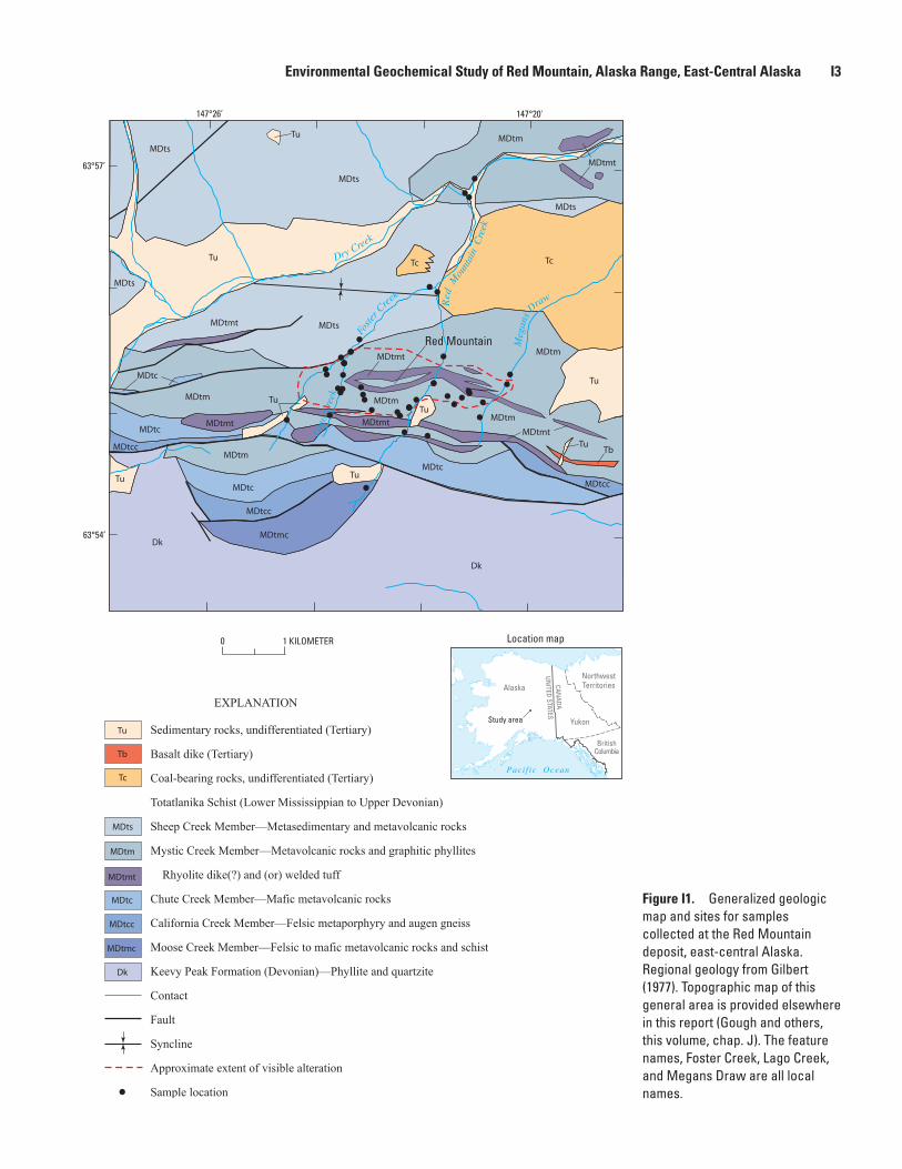
by prominent shades of red, maroon, orange, and yellow in outcrop and colluvium and by a general lack of vegetation. Although actively explored through 1998, the Red Mountain deposit has never been mined. Mineralized rocks lie within the Mystic Creek Member of the Totatlanika Schist (fig. I1; Newberry and others, 1997; Smit, 1999).
Red Mountain is a pyrite-rich VMS deposit containing sphalerite, galena, chalcopyrite, and locally precious metals, as massive to semimassive sulfides. The deposit is tilted to the north, and subsequent erosion has exposed underlying quartz stockwork veins in pyrite-bearing altered footwall rocks and massive sulfide horizons in hanging wall rocks. Supergene oxidation of pyrite and ground-water flow are facilitated by the intensely fractured nature of the footwall and hanging wall rocks.
MethodsBedload stream sediment, stream and spring water, or
rock samples were collected at 36 sites in the vicinity of Red Mountain (fig. I1), under low-flow conditions during precipitation-free periods. Details on sample collection, analysis, quality assurance/quality control procedures used, and a listing of the analytical data are found in Giles and others (2007). Advanced Spaceborne Thermal Emission and Reflection Radiometer (ASTER) satellite data were used to identify the extent of altered bedrock at Red Mountain by indi-cating the distribution of ferric iron, illite-muscovite, kaolinite, smectite, and hydrous silica-jarosite (Eppinger and others, 2007; Hubbard and others, this volume, chap. E). Secondary efflorescent salts and mineral precipitates that form in stream-beds were characterized by X-ray diffraction (XRD) and scan-ning electron microscopy (SEM).
At water sample sites, onsite measurements included pH, specific conductance, alkalinity, acidity, dissolved oxygen, water temperature, ferrous iron, turbidity, and a qualitative estimate of discharge. A representative water sample was collected at each site, filtered (0.45 micrometer, µm), and acidified with ultrapure nitric acid. Unacidified water samples were refrigerated prior to analysis. Samples were analyzed by inductively coupled plasma–atomic emission spectro-scopy (ICP-AES), ICP-mass spectrometry (ICP-MS), and ion chromatography.
Bedload stream sediment samples were collected at 20 sites. Sieved samples were analyzed by ICP-AES, ICP-MS, and several element-specific methods. For the water and sediment samples, site duplicates, analytical duplicates, blanks, and reference standards comprised approximately 15 percent of the samples analyzed.
Results and DiscussionThe information described herein is summarized from
Eppinger and others (2004, 2007).
Waters
Surface and spring water samples were collected from within (19 samples), upstream of (8 samples), and downstream of the QSPAZ (6 samples). With respect to major ions, the waters are largely dominated by sulfate and intermediate with respect to calcium and magnesium. High concentrations of aluminum, iron, and sulfate are found in water samples within and downstream of the QSPAZ.
Water pH values range from 2.4 to 7.8. Waters upstream of the QSPAZ are all near-neutral, while those within the QSPAZ generally have pH values below 3.5. Specific conductances upstream of the QSPAZ are lowest, rang-ing from 370 to 830 microsiemens per centimeter (µS/cm), rise significantly in waters within the QSPAZ (commonly above 2,500 µS/cm; maximum = 4,800 µS/cm), and fall to 580 µS/cm upon mixing with surrounding streams. Below the QSPAZ, pH values remain low to the mouth of Red Mountain Creek (pH 4.2), about 2.5 kilometers (km) down-stream, but pH quickly rises to 7.1 after mixing with the alkaline, glacial-silt-laden stream water of Dry Creek.
Trace elements in water that exhibit the widest variation, spanning four or more orders of magnitude, include Al, As, Cd, Co, Cu, Fe, Mn, Ni, Pb, Zn, La, Ce, Pr, Nd, Sn, and Y. Extremely high concentrations are found for Zn (median 13,000 micrograms per liter (µg/L), maximum=240,000 µg/L), Mn (median=4,200 µg/L, maximum=49,000 µg/L), and the summed REEs (median=3,200 µg/L, maximum=59,000 µg/L). In all cases, the highest trace-metal concentrations are found in springs and streams having low pH and high specific con-ductance, all within or downstream of the QSPAZ. Elements exhibit low concentrations above the QSPAZ, very high con-centrations within and downstream of the QSPAZ, and rapid attenuation via co-precipitation, sorption, and dilution upon mixing with water from Dry Creek.
Sediments
Elemental abundances in stream sediments vary across one to two orders of magnitude. Zinc, Pb, S, and Fe are found in relatively high concentrations (Zn median=440 parts per million (ppm), maximum=2,300 ppm; Pb median=71 ppm, maximum=410 ppm; S median=0.39 percent, maximum=1.2 percent; Fe median=4.8 percent, maximum=30 percent), with median concentrations that are about an order of magnitude above those expected for average granitic or local Mystic Creek Member background rocks. Other elements found in high concentrations relative to these background rocks include As, Cd, Cu, Co, Mn, Mo, Sb,
Environmental Geochemical Study of Red Mountain, Alaska Range, East-Central Alaska I3
Dry Creek
Foste
r C
reek
Meg
ans
DrawRed
Mou
ntai
n C
reek
Lago
Cre
ekRed Mountain
Tu
Tu
Tu
Tu
Tu
Tu
Tu
Tu
Tu
Tb
Tb
Tc
TcTc
MDts
MDts
MDts
MDts
MDts
MDts
MDtm
MDtm
MDtm
MDtm
MDtm
MDtm
MDtmt
MDtmt
MDtmt
MDtmt
MDtmt
MDtmt
MDtmt
MDtc
MDtc
MDtc
MDtc
MDtc
MDtcc
MDtcc
MDtcc
MDtcc
MDtmc
MDtmc
Dk
Dk
Dk
MDtm
Sedimentary rocks, undifferentiated (Tertiary)
Basalt dike (Tertiary)
Coal-bearing rocks, undifferentiated (Tertiary)
Totatlanika Schist (Lower Mississippian to Upper Devonian)
Sheep Creek Member—Metasedimentary and metavolcanic rocks
Mystic Creek Member—Metavolcanic rocks and graphitic phyllites
Rhyolite dike(?) and (or) welded tuff
Chute Creek Member—Mafic metavolcanic rocks
California Creek Member—Felsic metaporphyry and augen gneiss
Moose Creek Member—Felsic to mafic metavolcanic rocks and schist
Keevy Peak Formation (Devonian)—Phyllite and quartzite
Contact
Fault
Syncline
Approximate extent of visible alteration
Sample location
EXPLANATION
0 1 KILOMETER
63°57’
63°54’
147°26’ 147°20'
Pacif ic Ocean
Alaska
Yukon
NorthwestTerritoriesCAN
ADA
UNITED STATES
BritishColumbia
Location map
Study area
Figure I1. Generalized geologic map and sites for samples collected at the Red Mountain deposit, east-central Alaska. Regional geology from Gilbert (1977). Topographic map of this general area is provided elsewhere in this report (Gough and others, this volume, chap. J). The feature names, Foster Creek, Lago Creek, and Megans Draw are all local names.
I4 Recent U.S. Geological Survey Studies in the Tintina Gold Province, Alaska, United States, and Yukon, Canada
Table I1. Sulfide, hydroxysulfate, and unusual minerals identified in samples from Red Mountain detected by X-ray diffraction and scanning electron microscopy.
Mineral Formula
Sulfides
Chalcopyrite
Galena
Pyrite
Sphalerite
CuFeS2
PbS
FeS2
ZnS
Hydroxysulfates
Alunogen
Goslarite
Gypsum
Halotrichite
Hexahydrite
Hydronium jarosite
Jarosite
Kalinite
Melanterite
Natrojarosite
Pentahydrite
Pickeringite
Schwertmannite
Slavikite
A1 (SO ) • 17H O2 4 3 2
ZnSO • 7H O4 2
CaSO • 2H O4 2
Fe2+Al (SO ) • 22H O2 4 4 2
MgSO • 6H O4 2
(H O)Fe (SO ) (OH)3 3 4 2 6
KFe (SO ) (OH)3 4 2 6
KAl(SO ) • 11H O4 2 2
FeSO • 7H O4 2
NaFe (SO ) (OH)3 4 2 6
MgSO • 5H O4 2
MgAl (SO ) • 22H O2 4 4 2
(Fe3+) O OH (SO )16 16 12 4 2
NaMg (Fe3+) (SO ) (OH)2 5 4 7 6 • 33H O2
Oxyhydroxides
Ferrihydrite
Goethite
5Fe O • 9H O or Fe O2 3 2 2 32.6H O2
α-Fe3+O(OH)
• 2FeOOH •
Carbonates/Halides/Oxifluorides
Bastnäsite(?)1
Häleniusite(?)1
(Ce,La)(CO )F3
(La,Ce)OF1Identification uncertain.
Se, Tl, and V. This suite generally agrees with the anomalous metals found in mineralized rock samples. Cerium and La concentrations in stream sediments have moderately elevated medians that are near those for local background rocks, likely a reflection of the intrinsically high REE concentrations found throughout peralkaline metarhyolites of the Mystic Creek Member (Dusel-Bacon and others, 2004).
Precipitates
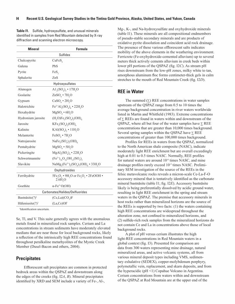
Efflorescent salt precipitates are common in protected bedrock areas within the QSPAZ and downstream along the edges of the creeks (fig. I2A, B). Mineral precipitates identified by XRD and SEM include a variety of Fe-, Al-,
Mg-, K-, and Na-hydroxysulfate and oxyhydroxide minerals (table I1). These minerals are all compositional endmembers of pseudo-stable secondary minerals and are products of oxidative pyrite dissolution and coincident acid rock drainage. The presence of these various efflorescent salts indicates mobility of the above elements in the weathering environment. Ferricrete (Fe-oxyhydroxide-cemented alluvium) up to several meters thick actively cements alluvium in creek beds within lower pH portions of the QSPAZ (fig. I2C). As stream pH rises downstream from the low-pH zones, milky white to tan, amorphous aluminum floc forms centimeter-thick gels in calm stretches to the mouth of Red Mountain Creek (fig. I2D).
REE in Water
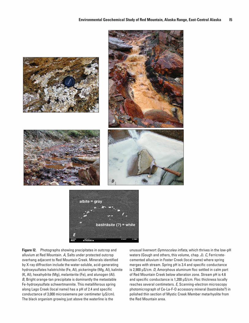
The summed (∑) REE concentrations in water samples upstream of the QSPAZ range from 0.5 to 10 times the average background concentration in river waters worldwide listed in Martin and Whitfield (1983). Extreme concentrations of ∑ REEs are found in waters within and downstream of the QSPAZ, where all but four of the water samples have ∑ REE concentrations that are greater than 10,000 times background. Several spring samples within the QSPAZ have ∑ REE concentrations of greater than 100,000 times background.
Profiles for REEs in waters from the QSPAZ, normalized to the North American shale composite (NASC), indicate moderately light REE enrichment but are overall exceedingly high at 0.01 to 0.5 times NASC. Normally, REE profiles for natural waters are around 10-6 times NASC, and mine drainage profiles rarely exceed 10-3 times NASC. Prelimi-nary SEM investigation of the source of the REEs in the felsic metavolcanic rocks reveals a micron-scale Ce-La-F-O accessory mineral that is tentatively identified as the carbonate mineral bastnäsite (table I1; fig. I2E). Accessory bastnäsite likely is being preferentially dissolved by acidic ground water, resulting in light REE enrichment in the spring and stream waters in the QSPAZ. The premise that accessory minerals in host rocks rather than mineralized horizons are the source of the REEs is supported by two facts: (1) the waters containing high REE concentrations are widespread throughout the alteration zone, not confined to mineralized horizons, and (2) sulfide-rich rock samples from the mineralized horizons do not contain Ce and La in concentrations above those of local background rocks.
A plot of pH versus cerium illustrates the high light-REE concentrations in Red Mountain waters in a global context (fig. I3). Presented for comparison are data from 300 waters representing mine drainage, natural mineralized areas, and active volcanic systems, all from various mineral deposit types including VMS, sedimen-tary exhalative (SEDEX), copper-molybdenum porphyry, polymetallic vein, replacement, and skarn deposits, and from the hyperacidic (pH <1) Copahue Volcano in Argentina. Cerium concentrations from waters within and downstream of the QSPAZ at Red Mountain are at the upper end of the
Environmental Geochemical Study of Red Mountain, Alaska Range, East-Central Alaska I5
A
B
C D
E
Figure I2. Photographs showing precipitates in outcrop and alluvium at Red Mountain. A, Salts under protected outcrop overhang adjacent to Red Mountain Creek. Minerals identified by X-ray diffraction include the water-soluble, acid-generating hydroxysulfates halotrichite (Fe, Al), pickeringite (Mg, Al), kalinite (K, Al), hexahydrite (Mg), melanterite (Fe), and alunogen (Al). B, Bright orange-tan precipitate is dominantly the metastable Fe-hydroxysulfate schwertmannite. This metalliferous spring along Lago Creek (local name) has a pH of 2.4 and specific conductance of 3,000 microsiemens per centimeter (µS/cm). The black organism growing just above the waterline is the
unusual liverwort Gymnocolea inflata, which thrives in the low-pH waters (Gough and others, this volume, chap. J). C, Ferricrete-cemented alluvium in Foster Creek (local name) where spring merges with stream. Spring pH is 3.4 and specific conductance is 2,900 µS/cm. D, Amorphous aluminum floc settled in calm part of Red Mountain Creek below alteration zone. Stream pH is 4.6 and specific conductance is 1,200 µS/cm. Floc thickness locally reaches several centimeters. E, Scanning-electron microscopy photomicrograph of Ce-La-F-O accessory mineral (bastnäsite?) in polished thin section of Mystic Creek Member metarhyolite from the Red Mountain area.
I6 Recent U.S. Geological Survey Studies in the Tintina Gold Province, Alaska, United States, and Yukon, Canada
Red Mountain waters—33 samplesWithin alteration zone—19 samplesDownstream of alteration zone—6 samplesUpstream of alteration zone—8 samples
Other waters—300 samples from Argentina, Brazil, Canada, Spain, and the United States
Diverse mine drainageNatural, mineralizedCopahue Volcano, Argentina
EXPLANATION
0.001
0.01
0.1
1
10
100
1,000
10,000
100,000
1 2 3 4 5 6 7 8 9 10
pH
CERI
UM, I
N M
ICRO
GRAM
S PE
R LI
TER
Figure I3. Cerium (in micrograms per liter) in Red Mountain filtered and acidified water compared to cerium from mine drainage and mineralized water from diverse deposit types from Argentina, Brazil, Canada, Spain, and the United States. For data references, see Eppinger and others (2007).
cluster of samples at all pH levels and are among the highest concentrations found in the literature. Clearly the REE concentrations at Red Mountain are unique and exceedingly high. More work is needed to identify additional REE-bearing mineral phases at Red Mountain.
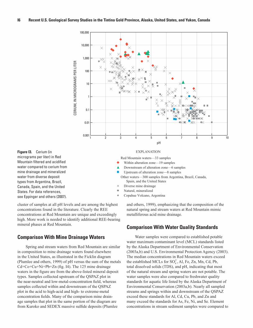
Comparison With Mine Drainage Waters
Spring and stream waters from Red Mountain are similar in composition to mine drainage waters found elsewhere in the United States, as illustrated in the Ficklin diagram (Plumlee and others, 1999) of pH versus the sum of the metals Cd+Co+Cu+Ni+Pb+Zn (fig. I4). The 125 mine drainage waters in the figure are from the above-listed mineral deposit types. Samples collected upstream of the QSPAZ plot in the near-neutral and low-metal-concentration field, whereas samples collected within and downstream of the QSPAZ plot in the acid to high-acid and high- to extreme-metal concentration fields. Many of the comparison mine drain-age samples that plot in the same portion of the diagram are from Kuroko and SEDEX massive sulfide deposits (Plumlee
and others, 1999), emphasizing that the composition of the natural spring and stream waters at Red Mountain mimic metalliferous acid mine drainage.
Comparison With Water Quality Standards
Water samples were compared to established potable water maximum contaminant level (MCL) standards listed by the Alaska Department of Environmental Conservation (2003a,b) and U.S. Environmental Protection Agency (2003). The median concentrations in Red Mountain waters exceed the established MCLs for , Al, Fe, Zn, Mn, Cd, Pb, total dissolved solids (TDS), and pH, indicating that most of the natural stream and spring waters are not potable. The water samples were also compared to freshwater quality standards for aquatic life listed by the Alaska Department of Environmental Conservation (2003a,b). Nearly all sampled streams and springs within and downstream of the QSPAZ exceed these standards for Al, Cd, Cu, Pb, and Zn and many exceed the standards for As, Fe, Ni, and Se. Element concentrations in stream sediment samples were compared to
Environmental Geochemical Study of Red Mountain, Alaska Range, East-Central Alaska I7
Red Mountain waters—33 samplesWithin alteration zone—19 samplesDownstream of alteration zone—6 samplesUpstream of alteration zone—8 samples
Diverse mine drainage waters—125 samples
EXPLANATION
1
pH-1 0 1 2 3 4 5 6 7 8 9
0.0001
0.001
0.01
0.1
10
100
1,000
10,000
100,000
High acid, high metal
High acid, low metal
Acid, high metal
Ultra acid, extrememetal
High acid, extrememetal
Acid, extreme metal Near neutral, extreme metal
Near neutral, high metal
Acid, low metal Near neutral, low metal
Ultra acid, ultrametal
High acid, ultra metal
SUM
Cd+
Co+C
u+N
i+Pb
+Zn,
IN M
ILLI
GRAM
S PE
R LI
TER
Figure I4. Ficklin diagram of pH versus the dissolved metals Cd+Co+Cu+Ni+Pb+Zn (in milligrams per liter) from filtered and acidified water samples. Comparison mine drainage waters are from diverse mineral deposits in the United States (data from appendix of Plumlee and others, 1999).
guidelines for freshwater ecosystems (MacDonald and others, 2000). The guidelines are exceeded for As, Cd, Cu, Ni, Pb, and Zn in most sediment samples, suggesting that the stream sediment is inhospitable to benthic organisms, using this standard.
ConclusionsThe Red Mountain deposit is a well-constrained example
of acid-generating, metal-leaching, metal-precipitation, and self-mitigation processes that occur in an undisturbed natu-ral setting. Dissolution of pyrite and associated secondary reactions under near-surface, oxidizing conditions are the primary causes for the acid generation and metal leaching of the rocks at Red Mountain. However, the acidic waters mix with surrounding alkaline waters that have interacted with carbonate veinlets, resulting in self-mitigation (via dilution, neutralization, and attendant co-precipitation). This process limits downstream hydrogeochemical evidence of the deposit to within a few kilometers. Red Mountain Creek and its tributaries within the QSPAZ do not support, and probably never have supported, significant megascopic faunal aquatic life, except perhaps those organisms that have adapted to
the extreme environment of low pH and very metalliferous conditions.
Water geochemistry varies widely, largely as a func-tion of the local geologic setting. Samples with the low-est pH values, highest specific conductance, highest TDS concentrations, and highest major- and trace-element concen-trations are all from springs and streams within the QSPAZ. Samples collected upstream of the QSPAZ have near-neutral pH values, lower specific conductance, lower metal concentra-tions, and measurable alkalinities. Water samples collected downstream of the QSPAZ have pH values and metal concen-trations intermediate between these two extremes. As dem-onstrated here, an understanding of the local geologic setting is of first-order importance for environmental geochemical studies.
Some of the metals found enriched in waters within the QSPAZ, such as Fe, Zn, Pb, Cd, and Co, are directly related to dissolution of sulfides and associated secondary minerals. The high concentrations of REEs in these waters are a result of ground-water interaction with Mystic Creek Member felsic metavolcanic rocks that are intrinsically elevated in REEs due to their peralkaline composition. REE enrichment is consider-ably enhanced by the presence and selective dissolution of accessory REE minerals, such as bastnäsite, by dissociated sulfuric acid-rich ground water. High concentrations of Al,
I8 Recent U.S. Geological Survey Studies in the Tintina Gold Province, Alaska, United States, and Yukon, Canada
Mg, F -, K, Mn, and Si in the waters, and extensive min-eral precipitates, ferricrete, and Fe and Al flocs in the lower reaches of the creeks are all indications of extensive supergene bedrock dissolution. The oxidation of pyrite and associated acid generation are enhanced by the dense fault and fracture network, the extensively exposed QSPAZ, and the relative abundance of shallow ground water. Any future exploration and exploitation of the Red Mountain VMS deposit needs to include a thorough recognition and understanding of the deposit’s great acid-generating and metal-liberating potential.
At the mouth of Red Mountain Creek, about 2.5 km below the QSPAZ, stream water is acidic (pH is 4.2) and metalliferous. In contrast, Dry Creek, both upstream and just 0.3 km downstream of the confluence with Red Mountain Creek, is near neutral, alkaline, and relatively nonmetalliferous. The neutralization and reduction of metals are attributed to dilution by, and the acid-consuming capability of, Dry Creek, a relatively large, turbid, glacial flour-rich creek that drains rock types with high acid-neutralizing capaci-ties. Red to orange iron-oxide staining on alluvium (with co-precipitated metals) is prominent along Red Mountain Creek within and downstream of the QSPAZ and continues down Dry Creek for about 1.5 km. Beyond this point, weaker hues of red and orange continue for another 0.5 km. The extreme hydrogeochemical and visual indications that char-acterize the Red Mountain VMS deposit appear to be largely self-mitigating within a few miles downstream of the deposit.
AcknowledgmentsThanks are given to the following U.S. Geologi-
cal Survey employees: Melanie Hopkins and Cameron Rombach for help with sample collection; Monique Adams, Mike Anthony, Phil Hageman, Pete Theodorakos, and Ruth Wolf for laboratory analyses; Steve Sutley for X-ray diffraction; Phil Zelenak for drafting; and Robert Oscarson for SEM imaging and mineral identification. Ed and Megan Busby provided excellent food and lodging in a wilderness setting at Busby’s Camp. Pilot Arnie Johnson of Johnson Flying Service provided helicopter logistical support. Reviews by David Fey and Bill Langer significantly improved the manuscript.
References Cited
Alaska Department of Environmental Conservation, 2003a, Water quality standards: Alaska Department of Environmental Conservation Report 18–AAC–70, 54 p. (Also available online at http://www.dec.state.ak.us/regulations/pdfs/70mas.pdf.)
Alaska Department of Environmental Conservation, 2003b, Alaska water quality criteria manual for toxic and other deleterious organic and inorganic substances: Alaska Department of Environmental Conservation, 51 p. (Also available online at http://www.dec.state.ak.us/water/wqsar/wqs/pdfs/70wqsmanual.pdf.)
Dusel-Bacon, Cynthia, Premo, W.R., and Aleinikoff, J.N., 2005, Geochemical and Nd isotopic evidence for an extending continental-margin arc/back arc setting for peralkaline rhyolite-hosted massive sulfide deposits of the Bonnifield district, east-central Alaska [abs.]: Geological Society of America, Abstracts with Program, v. 37, no. 7, p. 97.
Dusel-Bacon, Cynthia, Wooden, J.L., and Hopkins, M.J., 2004, U-Pb zircon and geochemical evidence for bimodal mid-Paleozoic magmatism and syngenetic base-metal mineralization in the Yukon-Tanana terrane, Alaska: Geological Society of America Bulletin 116, p. 989–1015.
Eppinger, R.G., Briggs, P.H., and Dusel-Bacon, Cynthia, 2004, Environmental geochemistry of an undisturbed volcanogenic massive sulfide deposit, Red Moun-tain, Bonnifield mining district, east-central Alaska, in Wanty, R.B., and Seal, R.R., II, eds., Water-rock interaction, Proceedings of the Eleventh International Symposium on Water-Rock Interaction, Saratoga Springs, N.Y., June 27–July 2, 2004: London, Taylor and Francis Group Publishers, p. 1483–1487.
Eppinger, R.G., Briggs, P.H., Dusel-Bacon, Cynthia, Giles, S.A., Gough, L.P., Hammarstrom, J.M., and Hubbard, B.E., 2007, Environmental geochemistry at Red Mountain, an unmined volcanogenic massive sulphide deposit in the Bonnifield district, Alaska Range, east-central Alaska: Geochemistry: Exploration, Environment, Analysis, v. 7, no. 3, p. 207–223.
Gilbert, W.G., 1977, General geology of Healy D–1 and southern Fairbanks A–1 quadrangles and vicinity, Alaska: Alaska Division of Geological and Geophysical Surveys Open-File Report 105, 13 p., 2 sheets, scale 1:63,360.
Giles, S.A., Eppinger, R.G., Granitto, Matthew, Zelenak, P.P., Adams, M.G., Anthony, M.W., Briggs, P.H., Gough, L.P., Hageman, P.L., Hammarstrom, J.M., Horton, J.D., Sutley, S.J., Theodorakos, P.M., and Wolf, R.E., 2007, Geochemical data for stream-sediment, surface-water, rock, and vegetation samples from Red Mountain (Dry Creek), an unmined volcanogenic massive sulfide deposit in the Bonnifield district, Alaska Range, east-central Alaska: U.S. Geological Survey Data Series DS–204, 64 p., 1 CD-ROM. (Also available online at http://pubs.usgs.gov/ds/2006/204/.)
Environmental Geochemical Study of Red Mountain, Alaska Range, East-Central Alaska I9
MacDonald, D.D., Ingersoll, C.G., and Berger, T.A., 2000, Development and evaluation of consensus-based sediment quality guidelines for freshwater ecosystems: Archives of Environmental Contamination and Toxicology, v. 39, no. 1, p. 20–31.
Martin, J.M., and Whitfield, Michael, 1983, The significance of the river input of chemical elements to the ocean, in Wong, C.S., Boyle, E.A., Bruland, K.W., Burton, J.D., and Goldberg, E.D., eds., Trace metals in sea water: New York, Plenum Press, p. 265–296.
Newberry, R.J., Crafford, T.C., Newkirk, S.R., Young, L.E., Nelson, S.W., and Duke, N.A., 1997, Volcanogenic mas-sive sulfide deposits of Alaska, in Goldfarb, R.J., and Miller, L.D., eds., Mineral deposits of Alaska: Economic Geology Monograph 9, p. 120–150.
Plumlee, G.S., Smith, K.S., Montour, M.R., Ficklin, W.H., and Mosier, E.L., 1999, Geologic controls on the composition of natural waters and mine waters draining diverse mineral-deposit types, in Filipek, L.H., and Plumlee, G.S., eds., The environmental geochemistry of mineral deposits, part B, Case studies and research topics: Reviews in Economic Geology, v. 6B, p. 373–432.
Smit, Hans, 1999, The Dry Creek VMS project, Bonnifield district, central Alaska, in Pathways ‘99, Extended abstracts volume: Vancouver, British Columbia, Canada, British Columbia and Yukon Chamber of Mines, p. 17–18.
U.S. Environmental Protection Agency, 2003, National primary drinking water standards: U.S. Environmental Protection Agency Report EPA 816–F–03–016. (Also available online at http://www.epa.gov/safewater/mcl.html.)
