environmental assessment state highway 10 widening … · environmental assessment . state highway...
TRANSCRIPT

ENVIRONMENTAL ASSESSMENT STATE HIGHWAY 10 WIDENING AND BRIDGE REPLACEMENT MIAMI, OKLAHOMA July 2007 Post-hearing Version
Oklahoma Department of Transportation 200 N.E. 21st Street Oklahoma City, Oklahoma 73105-6948


TABLE OF CONTENTS Chapter Page
1. PURPOSE OF AND NEED FOR ACTION ............................................................................ 1-1 1.1 Introduction and Location ................................................................................ 1-1 1.2 Purpose of and Need for Action ...................................................................... 1-2 1.3 Participating Agencies and Organizations....................................................... 1-5
2. ALTERNATIVES ............................................................................................................. 2-1 2.1 Introduction...................................................................................................... 2-1 2.2 Description of All Alternatives.......................................................................... 2-1 2.3 Alternatives Considered but Dismissed from Detailed Analysis ...................... 2-1
2.3.1 Alternative A2 ...................................................................................... 2-1 2.3.2 Alternative A3 ...................................................................................... 2-2 2.3.3 Alternative A3 Modification .................................................................. 2-2 2.3.4 Alternative B1 Modification .................................................................. 2-2 2.3.5 Alternative B2 ...................................................................................... 2-2 2.3.6 Alternative B2 Modification .................................................................. 2-3 2.3.7 Super 2 Design Alternative .................................................................. 2-3 2.3.8 The North Side Alternative................................................................... 2-3
2.4 Alternatives Considered for Detailed Analysis ................................................ 2-4 2.4.1 Alternative A1 ...................................................................................... 2-4 2.4.2 Alternative B1 ...................................................................................... 2-4 2.4.3 Alternative B3 ...................................................................................... 2-5 2.4.4 Alternative C ........................................................................................ 2-6
2.5 Preferred Alternative ....................................................................................... 2-7 2.5.1 Screening Process .............................................................................. 2-7 2.5.2 Screening Criteria ................................................................................ 2-7
3. EXISTING CONDITIONS .................................................................................................. 3-1 3.1 Introduction...................................................................................................... 3-1 3.2 Land Use ......................................................................................................... 3-1 3.3 Relocation ....................................................................................................... 3-4 3.4 Geology and Soils ........................................................................................... 3-5 3.5 Water Resources........................................................................................... 3-11 3.6 Designated Floodplains................................................................................. 3-13 3.7 Wetlands ....................................................................................................... 3-13 3.8 Vegetation ..................................................................................................... 3-15 3.9 Wildlife and Fisheries .................................................................................... 3-16 3.10 Threatened and Endangered Species........................................................... 3-17 3.11 Cultural Resources........................................................................................ 3-19 3.12 Native American Resources.......................................................................... 3-21 3.13 Hazardous and Toxic Materials and Waste................................................... 3-21 3.14 Visual Resources .......................................................................................... 3-23 3.15 Air Quality...................................................................................................... 3-23 3.16 Noise ............................................................................................................. 3-23 3.17 Socioeconomics and Environmental Justice ................................................. 3-25 3.18 Traffic ............................................................................................................ 3-36 3.19 Section 4(f) Resources.................................................................................. 3-36
July 2007 State Highway 10 Widening and Bridge Replacement EA i

TABLE OF CONTENTS (continued) Chapter Page
July 2007 State Highway 10 Widening and Bridge Replacement EA ii
4. ENVIRONMENTAL CONSEQUENCES................................................................................ 4-1 4.1 Introduction...................................................................................................... 4-1
4.1.1 Cumulative Effects Analysis ................................................................ 4-1 4.1.2 Terminology......................................................................................... 4-6
4.2 Land Use ......................................................................................................... 4-8 4.2.1 Impact Methodology ............................................................................ 4-8 4.2.2 Alternative A1 ...................................................................................... 4-8 4.2.3 Alternative B1 ...................................................................................... 4-9 4.2.4 Alternative B3 .................................................................................... 4-10 4.2.5 Alternative C ...................................................................................... 4-10 4.2.6 Cumulative Effects............................................................................. 4-10
4.3 Relocation ..................................................................................................... 4-11 4.3.1 Impact Methodology .......................................................................... 4-11 4.3.2 Alternative A1 .................................................................................... 4-11 4.3.3 Alternative B1 .................................................................................... 4-12 4.3.4 Alternative B3 .................................................................................... 4-12 4.3.5 Alternative C ...................................................................................... 4-13 4.3.6 Cumulative Effects............................................................................. 4-13
4.4 Geology and Soils ......................................................................................... 4-13 4.4.1 Impact Methodology .......................................................................... 4-13 4.4.2 Alternative A1 .................................................................................... 4-14 4.4.3 Alternative B1 .................................................................................... 4-16 4.4.4 Alternative B3 .................................................................................... 4-17 4.4.5 Alternative C ...................................................................................... 4-18 4.4.6 Cumulative Effects............................................................................. 4-18
4.5 Water Resources........................................................................................... 4-19 4.5.1 Impact Methodology .......................................................................... 4-19 4.5.2 Alternative A1 .................................................................................... 4-19 4.5.3 Alternative B1 .................................................................................... 4-20 4.5.4 Alternative B3 .................................................................................... 4-20 4.5.5 Alternative C ...................................................................................... 4-20 4.5.6 Cumulative Effects............................................................................. 4-20
4.6 Designated Floodplains................................................................................. 4-20 4.6.1 Impact Methodology .......................................................................... 4-20 4.6.2 Alternative A1 .................................................................................... 4-21 4.6.3 Alternative B1 .................................................................................... 4-21 4.6.4 Alternative B3 .................................................................................... 4-22 4.6.5 Alternative C ...................................................................................... 4-22 4.6.6 Cumulative Effects............................................................................. 4-22
4.7 Wetlands ....................................................................................................... 4-23 4.7.1 Impact Methodology .......................................................................... 4-23 4.7.2 Alternative A1 .................................................................................... 4-23 4.7.3 Alternative B1 .................................................................................... 4-24 4.7.4 Alternative B3 .................................................................................... 4-25 4.7.5 Alternative C ...................................................................................... 4-25 4.7.6 Cumulative Effects............................................................................. 4-25
TABLE OF CONTENTS (continued) Chapter Page
July 2007 State Highway 10 Widening and Bridge Replacement EA iii
4.8 Vegetation ..................................................................................................... 4-25 4.8.1 Impact Methodology .......................................................................... 4-25 4.8.2 Alternative A1 .................................................................................... 4-26 4.8.3 Alternative B1 .................................................................................... 4-26 4.8.4 Alternative B3 .................................................................................... 4-27 4.8.5 Alternative C ...................................................................................... 4-27 4.8.6 Cumulative Effects............................................................................. 4-28
4.9 Wildlife and Fisheries .................................................................................... 4-28 4.9.1 Impact Methodology .......................................................................... 4-28 4.9.2 Alternative A1 .................................................................................... 4-28 4.9.3 Alternative B1 .................................................................................... 4-30 4.9.4 Alternative B3 .................................................................................... 4-30 4.9.5 Alternative C ...................................................................................... 4-31 4.9.6 Cumulative Effects............................................................................. 4-31
4.10 Threatened and Endangered Species........................................................... 4-31 4.10.1 Impact Methodology .......................................................................... 4-31 4.10.2 Alternative A1 .................................................................................... 4-31 4.10.3 Alternative B1 .................................................................................... 4-33 4.10.4 Alternative B3 .................................................................................... 4-33 4.10.5 Alternative C ...................................................................................... 4-34 4.10.6 Cumulative Effects............................................................................. 4-34
4.11 Cultural Resources........................................................................................ 4-34 4.11.1 Impact Methodology .......................................................................... 4-34 4.11.2 Alternative A1 .................................................................................... 4-34 4.11.3 Alternative B1 .................................................................................... 4-36 4.11.4 Alternative B3 .................................................................................... 4-36 4.11.5 Alternative C ...................................................................................... 4-37 4.11.6 Cumulative Effects............................................................................. 4-37
4.12 Native American Resources.......................................................................... 4-38 4.12.1 Impact Methodology .......................................................................... 4-38 4.12.2 Alternative A1 .................................................................................... 4-38 4.12.3 Alternative B1 .................................................................................... 4-38 4.12.4 Alternative B3 .................................................................................... 4-38 4.12.5 Alternative C ...................................................................................... 4-39 4.12.6 Cumulative Effects............................................................................. 4-39
4.13 Hazardous and Toxic Materials and Waste................................................... 4-39 4.13.1 Impact Methodology .......................................................................... 4-39 4.13.2 Alternative A1 .................................................................................... 4-39 4.13.3 Alternative B1 .................................................................................... 4-40 4.13.4 Alternative B3 .................................................................................... 4-40 4.13.5 Alternative C ...................................................................................... 4-41 4.13.6 Cumulative Effects............................................................................. 4-41
4.14 Visual Resources .......................................................................................... 4-41 4.14.1 Impact Methodology .......................................................................... 4-41 4.14.2 Alternative A1 .................................................................................... 4-41 4.14.3 Alternative B1 .................................................................................... 4-42 4.14.4 Alternative B3 .................................................................................... 4-42

TABLE OF CONTENTS (continued) Chapter Page
July 2007 State Highway 10 Widening and Bridge Replacement EA iv
4.14.5 Alternative C ...................................................................................... 4-43 4.14.6 Cumulative Effects............................................................................. 4-43
4.15 Air Quality...................................................................................................... 4-43 4.15.1 Impact Methodology .......................................................................... 4-43 4.15.2 Alternative A1 .................................................................................... 4-43 4.15.3 Alternative B1 .................................................................................... 4-44 4.15.4 Alternative B3 .................................................................................... 4-44 4.15.5 Alternative C ...................................................................................... 4-44 4.15.6 Cumulative Effects............................................................................. 4-44
4.16 Noise ............................................................................................................. 4-44 4.16.1 Impact Methodology .......................................................................... 4-44 4.16.2 Alternative A1 .................................................................................... 4-45 4.16.3 Alternative B1 .................................................................................... 4-47 4.16.4 Alternative B3 .................................................................................... 4-47 4.16.5 Alternative C ...................................................................................... 4-48 4.16.6 Cumulative Effects............................................................................. 4-48
4.17 Socioeconomics and Environmental Justice ................................................. 4-48 4.17.1 Impact Methodology .......................................................................... 4-48 4.17.2 Alternative A1 .................................................................................... 4-49 4.17.3 Alternative B1 .................................................................................... 4-51 4.17.4 Alternative B3 .................................................................................... 4-51 4.17.5 Alternative C ...................................................................................... 4-51 4.17.6 Cumulative Effects............................................................................. 4-52
4.18 Traffic ............................................................................................................ 4-52 4.18.1 Impact Methodology .......................................................................... 4-52 4.18.2 Alternative A1 .................................................................................... 4-53 4.18.3 Alternative B1 .................................................................................... 4-53 4.18.4 Alternative B3 .................................................................................... 4-54 4.18.5 Alternative C ...................................................................................... 4-54 4.18.6 Cumulative Effects............................................................................. 4-55
4.19 Section 4(f) Resources.................................................................................. 4-55 4.19.1 Impact Methodology .......................................................................... 4-55 4.19.2 Alternative A1 .................................................................................... 4-56 4.19.3 Alternative B1 .................................................................................... 4-56 4.19.4 Alternative B3 .................................................................................... 4-56 4.19.5 Alternative C ...................................................................................... 4-56 4.19.6 Cumulative Effects............................................................................. 4-56
5. COMMENTS AND COORDINATION ................................................................................... 5-1 5.1 Introduction...................................................................................................... 5-1 5.2 Summary of Activities ...................................................................................... 5-1 5.3 Scoping Comments Received ......................................................................... 5-2 5.4 Solicitation ....................................................................................................... 5-2 5.5 Advertisements and Announcements.............................................................. 5-3
5.5.1 Public Meetings ................................................................................... 5-3 5.6 Distribution of the Environmental Assessment ................................................ 5-3 5.7 Section 7 Endangered Species Act Consultation............................................ 5-4
TABLE OF CONTENTS (continued) Chapter Page
July 2007 State Highway 10 Widening and Bridge Replacement EA v
5.8 Public Hearing on Environmental Assessment................................................ 5-4 6. SUMMARY OF CRITICAL ISSUES AND MITIGATION MEASURES AND/OR COMMITMENTS ..... 6-1
6.1 Introduction...................................................................................................... 6-1 6.2 Land Use ......................................................................................................... 6-1 6.3 Relocation / Socioeconomics and Environmental Justice ............................... 6-1 6.4 Geology and Soils ........................................................................................... 6-2 6.5 Water Resources............................................................................................. 6-2 6.6 Designated Floodplains................................................................................... 6-2 6.7 Wetlands ......................................................................................................... 6-3 6.8 Vegetation ....................................................................................................... 6-3 6.9 Wildlife and Fisheries ...................................................................................... 6-3 6.10 Threatened and Endangered Species............................................................. 6-4 6.11 Cultural Resources.......................................................................................... 6-5 6.12 Native American Resources............................................................................ 6-5 6.13 Hazardous and Toxic Materials and Waste..................................................... 6-5 6.14 Visual Resources ............................................................................................ 6-5 6.15 Traffic .............................................................................................................. 6-6
7. REFERENCES................................................................................................................ 7-1
8. LIST OF PREPARERS ..................................................................................................... 8-1

LIST OF FIGURES Figure Page 1-1 Project Area Map .......................................................................................................................1-3 1-2 Project Area Photo .....................................................................................................................1-4 2-1 All Alternatives (Map 1 of 3).......................................................................................................2-9 2-2 All Alternatives (Map 2 of 3).....................................................................................................2-10 2-3 All Alternatives (Map 3 of 3).....................................................................................................2-11 3-1 Existing Features within and near the Study Corridor ...............................................................3-3 3-2 Structures within and near the Study Corridor...........................................................................3-6 3-3 Prime Farmland Soils...............................................................................................................3-10 3-4 Floodplains...............................................................................................................................3-14 3-5 Projected Growth .....................................................................................................................3-28 3-6 Per Capita Income ...................................................................................................................3-34 5-1 Summary of Public Comments Received ..................................................................................5-2
LIST OF TABLES Table Page 1-1 Steering Committee Members ...................................................................................................1-5 1-2 Advisory Committee Members...................................................................................................1-6 2-1 Preliminary Evaluation of Alternatives Considered for Detailed Analysis................................2-12 3-1 Soil Map Units in the EA Study Corridor ....................................................................................3-9 3-2 Groundwater Wells within 0.5 Mile of the Study Corridor ........................................................3-12 3-3 Federally Listed Threatened and Endangered Species That Occur or Have Historically Occurred in Ottawa County, Oklahoma ...................................................................................3-18 3-4 Federal Highway Administration Noise Abatement Criteria.....................................................3-25 3-5 Existing Year (2007) Noise Levels...........................................................................................3-25 3-6 Population ................................................................................................................................3-27 3-7 Housing Characteristics ...........................................................................................................3-29 3-8 Housing Characteristics—Sample Data for Block Groups ......................................................3-30 3-9 Ottawa County Schools, 2004-2005 School Year ...................................................................3-31 3-10 Population Percentage by Race/Ethnicity................................................................................3-35 4-1 Summary of Environmental Consequences of Alternatives Considered for Detailed Analysis......................................................................................................................................4-2 4-2 Past, Present, and Reasonably Foreseeable Activities Considered in the Cumulative Effects Analysis..........................................................................................................................4-7 4-3 Predicted Year 2027 Sound Levels .........................................................................................4-46
LIST OF APPENDICES A Traffic Analysis B NRCS Coordination C Wetlands Finding D Threatened and Endangered Species Assessment E Cultural Resources Study F Hazardous Waste/ Underground Storage Tank Report G Traffic Noise Analysis H Solicitation I Public Meeting at Project Inception J Public Hearing on Environmental Assessment
July 2007 State Highway 10 Widening and Bridge Replacement EA vi
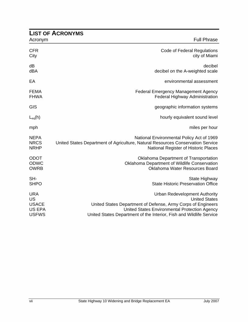
LIST OF ACRONYMS Acronym Full Phrase CFR Code of Federal Regulations City city of Miami dB decibel dBA decibel on the A-weighted scale EA environmental assessment FEMA Federal Emergency Management Agency FHWA Federal Highway Administration GIS geographic information systems Leq(h) hourly equivalent sound level mph miles per hour NEPA National Environmental Policy Act of 1969 NRCS United States Department of Agriculture, Natural Resources Conservation Service NRHP National Register of Historic Places ODOT Oklahoma Department of Transportation ODWC Oklahoma Department of Wildlife Conservation OWRB Oklahoma Water Resources Board SH- State Highway SHPO State Historic Preservation Office URA Urban Redevelopment Authority US United States USACE United States Department of Defense, Army Corps of Engineers US EPA United States Environmental Protection Agency USFWS United States Department of the Interior, Fish and Wildlife Service
vii State Highway 10 Widening and Bridge Replacement EA July 2007

This page intentionally left blank.
July 2007 State Highway 10 Widening and Bridge Replacement EA viii

1. PURPOSE OF AND NEED FOR ACTION
July 2007 State Highway 10 Widening and Bridge Replacement EA 1-1

July 2007 State Highway 10 Widening and Bridge Replacement EA 1-2

CHAPTER 1 PURPOSE OF AND NEED FOR ACTION
1.1 INTRODUCTION AND LOCATION The Oklahoma Department of Transportation (ODOT) is proposing to reconstruct State Highway (SH-) 10 near the city of Miami (City) in Ottawa County, Oklahoma (Figures 1-1 and 1-2). The project proposes to widen SH-10 beginning just west of the Will Rogers Turnpike Tollgate (Interstate 44) bridge and extending east 3.5 miles to SH-137. It would widen SH-10 from two to four lanes (with a 16-foot paved at grade, dual-turn center lane) and would replace three bridges: the SH-10 bridge crossing Interstate 44, the SH-10 load-posted bridge crossing Little Elm Creek, and the SH-10 load-posted bridge crossing an unnamed creek. Signs posted before each load-posted bridge provide notification of safe load-carrying capacity.
The ODOT is preparing an environmental assessment (EA), as required by the National Environmental Policy Act of 1969 (NEPA), ODOT NEPA guidelines (ODOT 2000), Federal Highway Administration (FHWA) Technical Advisory T-6640.8A (FHWA 1987), and 23 Code of Federal Regulations (CFR) Part 771 in anticipation of requesting future federal funding. The EA will identify the location and basic design components of a feasible roadway alignment within a study corridor. Because the study corridor is that area within which a roadway alignment would be identified, the study corridor is wider and longer than the proposed SH-10 section to be widened. The study corridor is 600 feet wide, 300 feet on either side of the centerline of SH-10. It begins just west of the Interstate 44 bridge and extends east 3.75 miles to 0.25 mile east of the intersection of SH-10 and SH-137. Additionally, the study corridor includes a 300-foot-wide corridor, 150 feet on either side of the centerline, of SH-137 and of each of three county roads: South 580, South 590, and South 600. These roads are perpendicular to and cross SH-10. The 300-foot-wide corridor along each road extends north-south along each road for 1,000 feet to the north and 1,000 feet to the south of the centerline of SH-10. The study corridor is depicted on Figures 1-1 and 1-2.
July 2007 State Highway 10 Widening and Bridge Replacement EA 1-1

Chapter 1 – Purpose of and Need for Action
July 2007 State Highway 10 Widening and Bridge Replacement EA 1-2
Ultimately, the ODOT wants to refine the feasible roadway alignment to a specific alignment that can be preserved for the construction of the improved highway. Funding for the SH-10 project will come from federal and state programs.
1.2 PURPOSE OF AND NEED FOR ACTION The purpose of improving SH-10 east of the City, including reconstructing two load-posted bridges and one overpass, is to achieve the following goals:
• Reduce congestion along the SH-10 corridor, thereby improving traffic flow between the Interstate 44 overpass and SH-137;
• Facilitate the flow of goods and services through the area by providing passing opportunities and adding turning lanes. Such mobility would be enhanced with improvements in system capacity and the quality and level of service;
• Improve access to tourism attractions, such as the casino near SH-10 and SH-137, the proposed travel plaza at SH-10 and SH-137, and the proposed 42-acre commercial development at Interstate 44 and SH-10;
• Improve safety by improving geometry and increasing visibility. The collision rate along the subject corridor is 237 collisions per 100 million vehicle miles, which is more than double the state average of 88 collisions per 100 million vehicle miles (ODOT 2006a);
• Improve hydrologic conditions along SH-10 by reducing roadway flooding from Little Elm Creek; and
• Conform to state, regional, and local plans and policies, including the ODOT’s 8-Year Construction Work Plan (8 Year Work Plan – Division 8 Federal Fiscal Year 2007 to 2009).
The need for improving SH-10 east of the City, including reconstructing two load-posted bridges and one overpass, is based on several aspects of the current transportation system, which is inadequate to serve current and future traffic, as documented in the ODOT’s Need Study Report, dated September 2005. This is for several reasons:
• The current Average Annual Daily Traffic on SH-10 is approximately 11,000 vehicles per day (Tetra Tech, Inc. 2007). Combined with anticipated growth in the area, traffic exceeds the capacity of the two-lane highway, two load posted bridges, and the Interstate 44 overpass, resulting in increased congestion along SH-10. The existing highway was not designed to handle current capacity, and projected area growth will exacerbate current conditions. Traffic projections along the SH-10 corridor indicate a 40- percent increase in traffic over the next 20 years (Tetra Tech, Inc. 2007), thereby indicating the need for a four-lane highway.

Figure 1-1 Project Area Map
July 2007 State Highway 10 Widening and Bridge Replacement EA 1-3

July 2007 State Highway 10 Widening and Bridge Replacement EA 1-4
Figure 1-2 Project Area Photo
Chapter 1 – Purpose of and Need for Action
• Load-posted bridges crossing Little Elm Creek and an unnamed creek are structurally deficient (FHWA 2006, ODOT 2006b, ODOT 2006c). For a bridge to be considered structurally deficient, it must have a condition rating of four or less out of nine for one of the following categories: deck, superstructures, substructures, or culvert and retaining walls. A bridge may also qualify for structurally deficient if it has an appraisal rating of two or less out of nine for structural condition or waterway adequacy (FHWA 1995, FHWA 2006).
• There is a need to provide better transportation access to developments in the immediate vicinity, including the new casino near SH-10 and SH-137 and the planned developments associated with the casino (including a motel, smoke shop, and travel plaza), and a planned 42-acre commercial development at Interstate 44 and SH-10. The regional economy is dependent on reliable transportation for the efficient movement of people, goods, and services. One of the roles of an efficient transportation system is to enable businesses and individuals to pursue economic opportunities. An efficient transportation system enhances the region’s competitive position in the global marketplace.
• The current transportation system does not provide for a balanced, efficient, and safe movement of goods, people, and services across northeastern Oklahoma.
• The existing roadway geometrics are substandard.
• As the City vicinity increases to develop, residents and business owners are in need of safer and improved highway access.
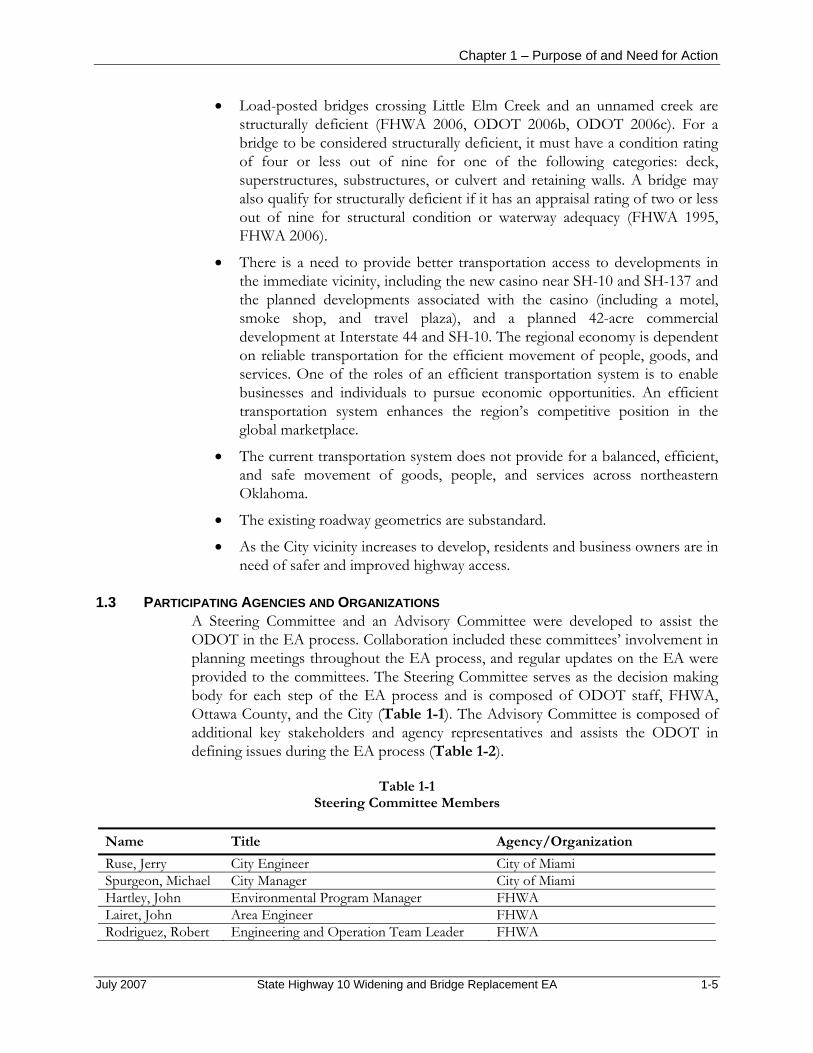
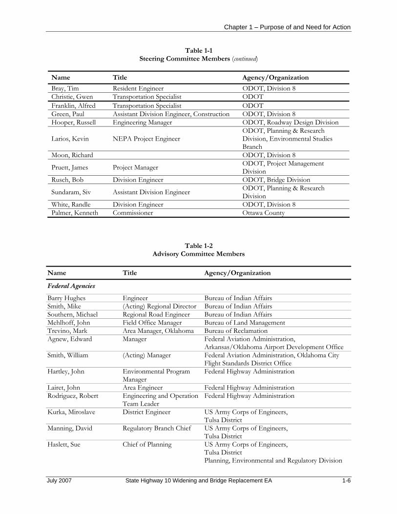
1.3 PARTICIPATING AGENCIES AND ORGANIZATIONS A Steering Committee and an Advisory Committee were developed to assist the ODOT in the EA process. Collaboration included these committees’ involvement in planning meetings throughout the EA process, and regular updates on the EA were provided to the committees. The Steering Committee serves as the decision making body for each step of the EA process and is composed of ODOT staff, FHWA, Ottawa County, and the City (Table 1-1). The Advisory Committee is composed of additional key stakeholders and agency representatives and assists the ODOT in defining issues during the EA process (Table 1-2).
Table 1-1 Steering Committee Members
Name Title Agency/Organization Ruse, Jerry City Engineer City of Miami Spurgeon, Michael City Manager City of Miami Hartley, John Environmental Program Manager FHWA Lairet, John Area Engineer FHWA Rodriguez, Robert Engineering and Operation Team Leader FHWA
July 2007 State Highway 10 Widening and Bridge Replacement EA 1-5
Chapter 1 – Purpose of and Need for Action
Table 1-1 Steering Committee Members (continued)
Name Title Agency/Organization Bray, Tim Resident Engineer ODOT, Division 8 Christie, Gwen Transportation Specialist ODOT Franklin, Alfred Transportation Specialist ODOT Green, Paul Assistant Division Engineer, Construction ODOT, Division 8 Hooper, Russell Engineering Manager ODOT, Roadway Design Division
Larios, Kevin NEPA Project Engineer ODOT, Planning & Research Division, Environmental Studies Branch
Moon, Richard ODOT, Division 8
Pruett, James Project Manager ODOT, Project Management Division
Rusch, Bob Division Engineer ODOT, Bridge Division
Sundaram, Siv Assistant Division Engineer ODOT, Planning & Research Division
White, Randle Division Engineer ODOT, Division 8 Palmer, Kenneth Commissioner Ottawa County
Table 1-2
Advisory Committee Members Name Title Agency/Organization
Federal Agencies
Barry Hughes Engineer Bureau of Indian Affairs Smith, Mike (Acting) Regional Director Bureau of Indian Affairs Southern, Michael Regional Road Engineer Bureau of Indian Affairs Mehlhoff, John Field Office Manager Bureau of Land Management Trevino, Mark Area Manager, Oklahoma Bureau of Reclamation Agnew, Edward Manager Federal Aviation Administration,
Arkansas/Oklahoma Airport Development Office Smith, William (Acting) Manager Federal Aviation Administration, Oklahoma City
Flight Standards District Office Hartley, John Environmental Program
Manager Federal Highway Administration
Lairet, John Area Engineer Federal Highway Administration Rodriguez, Robert Engineering and Operation
Team Leader Federal Highway Administration
Kurka, Miroslave District Engineer US Army Corps of Engineers, Tulsa District
Manning, David Regulatory Branch Chief US Army Corps of Engineers, Tulsa District
Haslett, Sue Chief of Planning US Army Corps of Engineers, Tulsa District Planning, Environmental and Regulatory Division
July 2007 State Highway 10 Widening and Bridge Replacement EA 1-6

Chapter 1 – Purpose of and Need for Action
Table 1-2 Advisory Committee Members (continued)
Name Title Agency/Organization
Federal Agencies (continued)
Ramming, Michael District Conservationist US Department of Agriculture, Natural Resources Conservation Service
Brabander, Jerry Supervisor US Fish and Wildlife Service, Ecological Services Native American Tribes
Smith, Chad Principal Chief Cherokee Nation Wallace, Glenna J. Chief Eastern Shawnee Tribe Leonard, Floyd E. Chief Miami Nation Follis, Bill Chief Modoc Tribe of Oklahoma Shadwick, Jack Modoc Tribe of Oklahoma Gray, Jim Chief Osage Nation Todd, Charles Chief Ottawa Tribe Froman, John Chief Peoria Tribe Berrey, John Chairperson Quapaw Tribe Spicer, Paul Chief Seneca-Cayuga Tribe of Oklahoma Ross, Brandi Natural Resources Director United Keetoowah Band of Cherokees (UKB) Wickliffe, George Chief United Keetoowah Band of Cherokees (UKB) McAdams, Gary President Wichita and Affiliated Tribes Bearskin, Leaford Chief Wyandotte Nation State Agencies
Bray, Tim Resident Engineer ODOT, Division 8 Case, Rosemary Branch Manager ODOT, Division 8, Local Government Division Christie, Gwen Transportation Specialist ODOT Franklin, Alfred Transportation Specialist ODOT Green, Paul Assistant Division Engineer,
Construction ODOT, Division 8
Harms, Kurt Chief of Right-of-Way ODOT, Right-of-Way Division Hooper, Russell Engineering Manager ODOT, Roadway Design Division Larios, Kevin Project Engineer ODOT, Planning & Research Division,
Environmental Studies Branch Moon, Richard ODOT, Division 8 Perryman, Cole Public Information Officer ODOT, Division 8, Public Affairs Division Pruett, James Project Manager ODOT, Project Management Division Rusch, Bob Division Manager ODOT, Bridge Division Smart, Harold Division Engineer ODOT, Traffic Engineering Division Sundaram, Siv Assistant Division Engineer ODOT, Planning & Research Division White, Randle Division Engineer ODOT, Division 8 Thralls, Mike Executive Director Oklahoma Conservation Commission Grooms, Terry District Manager Oklahoma Corporation Commission,
Oil and Gas Conservation Division Poulsen, David Oklahoma Corporation Commission,
Oil and Gas Conservation Division Peach, Terry L. Secretary of Agriculture Oklahoma Department of Agriculture
July 2007 State Highway 10 Widening and Bridge Replacement EA 1-7

Chapter 1 – Purpose of and Need for Action
Table 1-2 Advisory Committee Members (continued)
Name Title Agency/Organization
State Agencies (continued)
Clark, Vaughn Director Oklahoma Department of Commerce Datin, Dennis Oklahoma Department of Environmental Quality,
Land Protection Division Thompson, Scott Oklahoma Department of Environmental Quality,
Land Protection Division Mankin, Dr. Charles Director Oklahoma Geological Survey Blackburn, Bob Executive Director Oklahoma Historical Society Willcox, Stan Operations Manager Oklahoma Natural Gas Heisch, Melvena Deputy State Historic
Preservation Officer Oklahoma State Historic Preservation Office
Glenn, Larry State Representative, District 7
Oklahoma State Congress
Marek, Kristina S. Director Oklahoma Tourism and Recreation Department, Research and Development Division
Strong, Eric Chief Engineer Oklahoma Turnpike Authority Herrmann, Rudolf John Chairman (Tulsa) Oklahoma Water Resources Board Brooks, Robert L. State Archaeologist University of Oklahoma
Oklahoma Archaeological Survey Local Agencies
Brooks, Gary Emergency Management Coordinator
City of Miami
Ruse, Jerry City Engineer City of Miami Spurgeon, Michael City Manager City of Miami Jim, Rebecca L.E.A.D. Agency, Inc. Hubbard, Suzanne Executive Director Miami Chamber of Commerce Barger, Brian Community and Economic
Development Director Miami Economic Development Authority
Stephens, Bill Superintendent of Schools Miami Public Schools Dolph, Paul Airport Manager Miami Regional Airport Helmick, Earnestine Marketing Specialist Northeast Oklahoma Electric Cooperative, Inc. Shipman, Rick Senior Field Engineer Northeast Oklahoma Electric Cooperative, Inc. Earls, Russell Commissioner Ottawa County, District 3 Palmer, Kenneth Commissioner Ottawa County Payton, Michael Floodplain Advisor Ottawa County Hudson, Shirley Commissioner Ottawa County Conservation District Ankenman, William Ottawa County Rural Water, District 4 Crafton, Jackie Operator Ottawa County Rural Water, District 4
July 2007 State Highway 10 Widening and Bridge Replacement EA 1-8

Chapter 1 – Purpose of and Need for Action
Table 1-2 Advisory Committee Members (continued)
Name Title Agency/Organization
Organizations
Haas, Frank General Manager High Winds Casino Hart, Joel Administrator Integris Baptist Regional Health Center Price, Tom Facility/Safety Director Integris Baptist Regional Health Center Christie, Helen Director Inter-Tribal Council Snodderly, Judee Executive Director Miami Area Economic Development Service, Inc. Bearden, Ted Director Miami Indian Health Center Brown, Billie Conservation Organizer Sierra Club Gregory, Martha Group Chair Sierra Club, Green County
July 2007 State Highway 10 Widening and Bridge Replacement EA 1-9

Chapter 1 – Purpose of and Need for Action
This page intentionally left blank.
July 2007 State Highway 10 Widening and Bridge Replacement EA 1-10

2. ALTERNATIVES
July 2007 State Highway 10 Widening and Bridge Replacement EA 2-1

List of Preparers
July 23, 2004 Gilcrease Northwest Expressway EA 2-2 Preliminary Draft – Not for Public Release
CHAPTER 2 ALTERNATIVES
2.1 INTRODUCTION In this chapter is a description of the alternatives considered for the SH-10 Widening and Bridge Replacement Project EA, including those eliminated from further analysis. In accordance with FHWA Technical Advisory T6640.8a guidelines (FHWA 1987), build alternatives and the No Build, or No Action, Alternative have been considered. For the purpose of this EA, symmetrical is defined as widening the same distance to the north and south sides of the existing centerline. Nonsymmetrical is defined as widening only to the south and/or only to the north of SH-10.
2.2 DESCRIPTION OF ALL ALTERNATIVES A total of 12 alternatives were considered during the EA process, including the No Build Alternative. The alternatives range from widening the highway from two to four lanes symmetrically and/or nonsymmetrically about the existing centerline at various locations, to constructing a “super two-lane” highway. The latter would consist of a two-lane section with a striped center lane and paved shoulders on either side.
Each of the 12 alternatives considered is described in further detail in Section 2.3, Alternatives Considered but Dismissed from Detailed Analysis, and Section 2.4, Alternatives Considered for Detailed Analysis.
2.3 ALTERNATIVES CONSIDERED BUT DISMISSED FROM DETAILED ANALYSIS
2.3.1 Alternative A2 Alternative A2 consists of a five-lane section that includes a 16-foot paved, at-grade, dual-turn center lane. The proposed roadway would remain symmetrical to the centerline of the existing alignment of SH-10 throughout the entire 3.75-mile project area. The existing vertical profile would not be changed, so the stopping sight distance would not be corrected and would not meet the design speed criteria. As a
July 2007 State Highway 10 Widening and Bridge Replacement EA 2-1

Chapter 2 – Alternatives
result, the proposed roadway would not meet vertical geometrical requirements identified in the purpose of and need for the project (Chapter 1).
2.3.2 Alternative A3 Alternative A3 consists of a five-lane section that includes a 16-foot paved, at-grade, dual-turn center lane. The proposed roadway would not remain symmetrical but would offset 22 to 30 feet to the south of SH-10 and would remain parallel to the existing roadway. The nonsymmetrical roadway to the south would transition to a symmetrical five-lane section immediately east of the power substation (1 mile west of SH-137) and would remain symmetrical for the remaining 1.25 miles of the project corridor. The existing vertical profile would not be changed, so the stopping sight distance would not be corrected and would not meet the design speed criteria. As a result, the proposed roadway would not meet vertical geometrical requirements identified in the purpose of and need for the project (Chapter 1).
2.3.3 Alternative A3 Modification A modification to Alternative A3 was considered that includes a transition of the roadway to the north side of SH-10 immediately east of the power substation. This alignment would minimize impact on property and residences on the south side of SH-10. However, west of SH-137, this shift in the alignment would require two aggressive transitions with horizontal curves in less than a one-mile span. Because the added transitions and curves to the alignment would create a legitimate safety concern, this modification would not meet the purpose of and need for the project, as identified in Chapter 1.
2.3.4 Alternative B1 Modification A modification to Alternative B1 was considered that includes a transition of the roadway to the north side of SH-10 immediately east of the power substation. This alignment would minimize the impact on the property and residences on the south side of SH-10. However, west of SH-137, this shift in the alignment would require two aggressive transitions with horizontal curves in less than a one-mile span. Because the added transitions and curves to the alignment would create a legitimate safety concern, this modification would not meet the purpose of and need for the project, as identified in Chapter 1.
2.3.5 Alternative B2 Alternative B2 consists of a five-lane section that includes a 16-foot paved, at-grade, dual-turn center lane. The proposed roadway consists of both symmetrical and nonsymmetrical alignments in relation to the existing alignment of SH-10. The symmetrical widening of the proposed roadway would begin immediately west of Interstate 44 and would continue 4,000 feet (0.75 mile) to the east. The symmetrical alignment would then transition to a nonsymmetrical alignment to the south of SH-10, 22 to 30 feet, and would remain parallel to the existing roadway. The nonsymmetrical roadway to the south would transition to a symmetrical five-lane section immediately east of the power substation (1 mile west of SH-137) and would remain symmetrical for the remaining 1.25 miles of the project. The existing vertical
July 2007 State Highway 10 Widening and Bridge Replacement EA 2-2
Chapter 2 – Alternatives
profile would not be changed; therefore, the stopping sight distance would not be corrected and would not meet the design speed criteria. As a result, the proposed roadway would not meet vertical geometrical requirements identified in the purpose of and need for the project (Chapter 1).
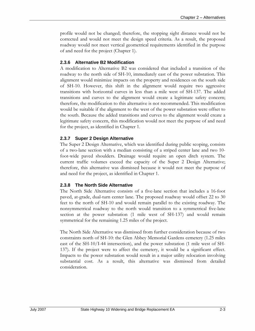
2.3.6 Alternative B2 Modification A modification to Alternative B2 was considered that included a transition of the roadway to the north side of SH-10, immediately east of the power substation. This alignment would minimize impacts on the property and residences on the south side of SH-10. However, this shift in the alignment would require two aggressive transitions with horizontal curves in less than a mile west of SH-137. The added transitions and curves to the alignment would create a legitimate safety concern; therefore, the modification to this alternative is not recommended. This modification would be suitable if the alignment to the west of the power substation were offset to the south. Because the added transitions and curves to the alignment would create a legitimate safety concern, this modification would not meet the purpose of and need for the project, as identified in Chapter 1.
2.3.7 Super 2 Design Alternative The Super 2 Design Alternative, which was identified during public scoping, consists of a two-lane section with a median consisting of a striped center lane and two 10-foot-wide paved shoulders. Drainage would require an open ditch system. The current traffic volumes exceed the capacity of the Super 2 Design Alternative; therefore, this alternative was dismissed because it would not meet the purpose of and need for the project, as identified in Chapter 1.
2.3.8 The North Side Alternative The North Side Alternative consists of a five-lane section that includes a 16-foot paved, at-grade, dual-turn center lane. The proposed roadway would offset 22 to 30 feet to the north of SH-10 and would remain parallel to the existing roadway. The nonsymmetrical roadway to the north would transition to a symmetrical five-lane section at the power substation (1 mile west of SH-137) and would remain symmetrical for the remaining 1.25 miles of the project.
The North Side Alternative was dismissed from further consideration because of two constraints north of SH-10: the Glen Abbey Memorial Gardens cemetery (1.25 miles east of the SH-10/I-44 intersection), and the power substation (1 mile west of SH-137). If the project were to affect the cemetery, it would be a significant effect. Impacts to the power substation would result in a major utility relocation involving substantial cost. As a result, this alternative was dismissed from detailed consideration.
July 2007 State Highway 10 Widening and Bridge Replacement EA 2-3

Chapter 2 – Alternatives
2.4 ALTERNATIVES CONSIDERED FOR DETAILED ANALYSIS
2.4.1 Alternative A1 Alternative A1 includes constructing a five-lane section that includes four driving lanes with a 16-foot paved, at-grade, dual-turn center lane. Each of the four lanes would be 12 feet wide. Shoulders, if included, would be 10 feet wide. The proposed highway would be symmetrical to the centerline of the existing SH-10 alignment, beginning immediately west of Interstate 44 at the Will Rogers Turnpike Tollgate and continuing 3.75 miles east, ending 1,200 feet (0.25 mile) east of the SH-10/SH-137 intersection. The new alignment/pavement under Alternative A1 would be closest to the Glen Abbey Memorial Gardens cemetery; however, right-of-way would not encroach within the cemetery boundaries. In addition, widening for this alternative would encroach on the north side of the existing highway at the power substation, and the additional right-of-way would extend into the south portion of this site.
The permanent right-of-way width would vary, depending on cut and fill requirements related to topography, and would average 250 feet, totaling approximately 122 acres. The proposed utility easement is within the proposed permanent right-of-way on the north and south of SH-10. The average utility easement width within the right-of-way is 20 feet. The maximum temporary right-of-way needed would total approximately 10 acres.
Minor construction also would be required at the statutory section line roads and SH-137 due to the change in the vertical profile of SH-10. In addition, the lane configuration of SH-137 may include additional lanes at the intersection of SH-10 to accommodate traffic turning movements and traffic capacity, if warranted.
Twelve drainage structures would be constructed. Three bridges, one of which spans Interstate 44, would be replaced with new bridges.
The vertical profile of the proposed highway would correct sight deficiencies in distance for braking and stopping and would meet the appropriate design speed. Drainage would require either an open ditch or a storm sewer system.
2.4.2 Alternative B1 As with Alternative A1 above, Alternative B1 includes construction of a five-lane section that includes four driving lanes, with a 16-foot paved, at-grade, dual-turn center lane. Each of the four lanes would be 12 feet wide. Shoulders would be 10 feet wide, unless a curb section is used. However, different than Alternative A1 above, the proposed highway would consist of both symmetrical and nonsymmetrical alignments in relation to the existing alignment of SH-10.
Symmetrical widening would begin immediately west of Interstate 44 and would continue 4,000 feet (0.75 mile) to the east. The symmetrical alignment would then transition to a nonsymmetrical alignment 22 to 30 feet to the south of SH-10 and would remain parallel to the existing highway. The nonsymmetrical highway to the
July 2007 State Highway 10 Widening and Bridge Replacement EA 2-4

Chapter 2 – Alternatives
south would transition back to a symmetrical five-lane section immediately east of the power substation (1 mile west of SH-137) and would remain symmetrical for 1.25 miles to the project terminus, 1,200 feet (0.25 mile) east of the SH-10/SH-137 intersection.
Similar to Alternative A1 above, the permanent right-of-way width under Alternative B1 would vary, depending on cut and fill requirements related to topography, and would have an average width of 250 feet, totaling approximately 128 acres. The proposed utility easement is within the proposed permanent right-of-way on the north and south of SH-10. The average utility easement width within the right-of-way is 20 feet. New alignment/pavement under Alternative B1 would be farther from the Glen Abbey Memorial Gardens cemetery than under Alternative A1. Alternative B1’s right-of-way would not encroach within the cemetery boundaries. The widening for this alternative would not encroach on the north side of the existing highway at the power substation. The additional right-of-way would not extend into the south portion of the substation site. The maximum temporary right-of-way needed would total approximately 10 acres.
As with Alternative A1 above, Alternative B1 also includes minor construction at the statutory section line roads and SH-137 due to the change in the vertical profile of SH-10. In addition, the lane configuration of SH-137 may include additional lanes at the intersection of SH-10 to accommodate traffic turning movements and traffic capacity, if warranted.
The same as Alternative A1 (above), Alternative B1 also includes constructing 12 drainage structures and replacing 3 bridges, one of which spans Interstate 44.
As with Alternative A1 above, the vertical profile of the proposed highway under Alternative B1 would correct stopping sight distance and would meet the appropriate design speed. Drainage would require either an open ditch or a storm sewer system.
2.4.3 Alternative B3 Alternative B3 would include construction of a five-lane section that includes four driving lanes with a 16-foot paved, at-grade, dual-turn center lane. Each of the four lanes would be 12 feet wide. Shoulders would be 10 feet wide, unless a curb section is used. The proposed highway would consist of an offset alignment in relation to the existing alignment of SH-10. For the purposes of this document, non-symmetrical is defined as widening to both the south and the north of existing SH-10, and the offset sections will transition from one side to the other).
Symmetrical widening would begin immediately west of I-44 and continue to just west of the Will Rogers Turnpike Tollgate. The symmetrical alignment would then transition to a non-symmetrical alignment to the south of the existing SH-10, and would remain parallel to the existing highway. The non-symmetrical highway to the south would transition back to the north of the existing highway as a non-symmetrical five-lane section immediately east of the power substation (one mile
July 2007 State Highway 10 Widening and Bridge Replacement EA 2-5

Chapter 2 – Alternatives
west of SH-137) and would remain offset to the north side or non-symmetrical for 1.25 miles to project terminus approximately 1,200 feet east of the SH-10/SH-137 intersection.
Similar to Alternative B1 (above), the permanent right-of-way width under Alternative B3 would vary, depending on cut and fill requirements related to topography, and would have an average width of approximately 250 feet, totaling approximately 128 acres. The proposed utility easement is within the proposed permanent right-of-way on the north and south of SH-10. The average utility easement width within the right-of-way is 20 feet. Like Alternative B1, the new alignment/pavement under Alternative B3 would be farther from the Glen Abbey Memorial Gardens cemetery than Alternative A1. Also like Alternative B1, Alternative B3’s right-of-way would not encroach within the cemetery boundaries. The widening for this alternative would not encroach on the north side of the existing highway at the power substation. The additional right-of-way would not extend into the south portion of the substation site. The maximum temporary right-of-way needed would total approximately 10 acres.
The same as Alternative B1 (above), Alternative B3 would also include minor construction at the statutory section line roads and SH-137 due to the change in the vertical profile of SH-10. In addition, the lane configuration of SH-137 may include additional lanes at the intersection of SH-10 to accommodate traffic turning movements and traffic capacity if warranted. In addition, the intersection with SH 137 would be reconstructed to the north of the existing intersection since the alignment will remain offset to the north through the intersection.
The same as Alternative B1 (above), Alternative B3 would also include construction of approximately 12 drainage structures and replacement of three existing bridges, one of which spans I-44.
The same as Alternative B1 (above), the vertical profile of the proposed highway under Alternative B3 would correct stopping sight distance and meet the appropriate design speed. Drainage would require either an open ditch or a storm sewer system.
2.4.4 Alternative C The No Build, or No Action, Alternative is included to serve as a baseline with which to evaluate the effects of the other alternatives, as well as to meet requirements of NEPA. Under the No Build Alternative, SH-10 would remain two lanes, and the roadway would not be widened. The SH-10 bridge crossing Interstate 44 would not be reconstructed, but the SH-10 load-posted bridge crossing Little Elm Creek and the SH-10 load-posted bridge crossing an unnamed creek would be reconstructed. Reconstruction of the bridges on the existing alignment would require land and/or road closures resulting in access issues for the businesses and residences along SH-10. This alternative does not meet the purpose of and need for this project, as identified in Chapter 1.
July 2007 State Highway 10 Widening and Bridge Replacement EA 2-6

Chapter 2 – Alternatives
2.5 PREFERRED ALTERNATIVE The agency-preferred alternative is B3. The selection of the preferred alterative was based on the screening criteria described below, the impact analysis (Chapter 4), the traffic analysis (Appendix A), resource agency comments, solicitation responses, written comments received from the public at the beginning of the project (during the scoping process), and Steering Committee and Advisory Committee review and input. Alternative B3 also would impact the cemetery and power substation the least of all alternatives by offsetting the alignment to the south. To the east of the power substation, potential impacts to residences and businesses would be minimized by offsetting the alignment to the north. Alternative B3 would provide access for traffic on the existing highway throughout construction. In addition, all three bridge structures would be built offset or parallel to the existing bridges with the least impact to traffic.
2.5.1 Screening Process The preliminary alternatives (A1 and B1) were presented to the Steering Committee and the Advisory Committee in January 2007 (Figures 2-1 and 2-2). Preliminary evaluations of how the alternatives could affect residences, businesses, vegetation, wetlands, and a variety of other resources were developed according to the screening criteria described below. Table 2-1 shows the results of this preliminary evaluation. This evaluation was presented to the Steering Committee and the Advisory Committee at their January 30, 2007, meetings. The committees reviewed the preliminary evaluations of each alternative (relative to one another) and discussed the results of the process. During this evaluation the No Build (or No Action) Alternative was not considered.
After additional input from the Steering Committee, Alternative B3 (Figure 2-3) was designed to further avoid the Glen Abby Memorial Gardens cemetery and the power substation.
In accordance with findings documented in the individual special studies (see appendices), a more thorough evaluation of Alternatives A1, B1, and B3 has been completed. An updated evaluation matrix is presented in Chapter 4 (Table 4-1).
2.5.2 Screening Criteria The screening criteria described below were used to select the preferred alternative. These criteria were developed based on pertinent available data and literature and, for some resources, field surveys and inspections of the 285-acre study area, within which the considered alternatives lie. These criteria were presented and discussed at Steering Committee and Advisory Committee meetings, and then committee members commented on them.
Land Use Alternatives were evaluated within the context of minimizing adverse effects and maximizing beneficial effects on existing and future land use, including
July 2007 State Highway 10 Widening and Bridge Replacement EA 2-7

Chapter 2 – Alternatives
neighborhoods, schools, parks and community services, public lands, open space, infrastructure, utilities, and structures, within the engineering and cost constraints.
Relocation The number of residences and businesses within the right-of-way of each alternative was determined using geographic information systems (GIS) mapping of the structures within the study corridor and overlaying each potential alternative’s right-of-way. The location of residences and businesses was compiled using aerial photography, a cursory windshield survey of properties visible from SH-10, and Ottawa County Assessor’s data. Those residences and businesses that fell within an alternative’s right-of-way could require acquisition and relocation. Estimated right-of-way widths are subject to change as final design plans are developed, and the final alignment would be designed to minimize the number of relocations required. The necessity of relocating a particular residence or business would be determined by the final alignment location/design. Relocation for federal and federally assisted projects must comply with the Uniform Relocation Assistance and Real Property Acquisition Policy Act of 1970 (49 CFR Part 24, Uniform Act, 42 United States [US] Code 4601-4655, as amended by Public Law 105-117), which provides relocation assistance (advisory services and compensation) for businesses, farms, nonprofit organizations, and residents. In addition, the US Department of Housing and Urban Development requires that comparable decent, safe, and sanitary replacement housing within a person’s financial means be made available before that person may be displaced. When such housing cannot be provided through the use of replacement housing payments, the Urban Redevelopment Authority (URA) provides for “housing of last resort” (49 CFR 24.404). Housing of last resort may involve the use of replacement housing payments that exceed the URA maximum amounts or other methods of providing the appropriate housing (US Department of Housing and Urban Development 2005).
Geology and Soils Ground disturbance during construction may create unstable cut-and-fill slopes, particularly in steep areas and areas underlain by weak rock material. Slope instability would be a short-term local effect, occurring primarily during construction along steeply sloped areas. In addition to instability, ground disturbance could increase the potential for soil erosion either by runoff or by wind. In some areas, soil erosion resulting from ground disturbance may create permanent scars on the landscape, and loss of soil may prevent vegetation from becoming established on the disturbed area. Soils with a high shrink-swell potential can cause settling and cracking in roadway surfaces and require commensurate design measures.
The acreage of soils under crop cultivation has been decreasing as more land is used for development (US Department of Agriculture, Soil Conservation Service and US Department of the Interior, Bureau of Indian Affairs 1979). Prime farmland soils are capable of the greatest agricultural productivity. Projects are subject to Farmland Protection Policy Act requirements if they could irreversibly convert farmland
July 2007 State Highway 10 Widening and Bridge Replacement EA 2-8

Chapter 2 – Alternatives
Figure 2-1 All Alternatives (Map 1 of 3)
July 2007 State Highway 10 Widening and Bridge Replacement EA 2-9

Chapter 2 – Alternatives
Figure 2-2 All Alternatives (Map 2 of 3)
July 2007 State Highway 10 Widening and Bridge Replacement EA 2-10

Chapter 2 – Alternatives
Figure 2-3 All Alternatives (Map 3 of 3)
July 2007 State Highway 10 Widening and Bridge Replacement EA 2-11

Chapter 2 – Alternatives
Table 2-3 Preliminary Evaluation of Alternatives Considered for Detailed Analysis1
Scoring 2:
Relatively Positive Effects Relatively Neutral Effects
Relatively Negative Effects ALTERNATIVE A1 ALTERNATIVE B1 ALTERNATIVE B3
Relative Effects Scoring
Notes Relative Effects Scoring
Notes Relative Effects Scoring
Notes
Environmental Considerations
Land Use
Relocation: Residential
Relocation: Business
Geology and Soils
Water Resources
Designated Floodplains
Potential Jurisdictional Wetland Sites
Vegetation
Wildlife and Fisheries
Threatened and Endangered Species
Cultural Resources
Native American Resources
Hazardous and Toxic Materials and Waste
Visual Resources
Air Quality
July 2007 State Highway 10 Widening and Bridge Replacement EA 2-12

Chapter 2 – Alternatives
July 2007 State Highway 10 Widening and Bridge Replacement EA 2-13
Table 2-1 Preliminary Evaluation of Alternatives Considered for Detailed Analysis1 (continued)
Noise
Traffic
Section 4(f) Resources
Socioeconomics & Environmental Justice
Engineering Considerations
Topographic Considerations
Utility Conflicts
Constructability Considerations
Probable Cost
Mobility Considerations
Multi-modal Considerations
Notes: 1) Detailed field studies have not been performed. 2) Scoring is based on a comparison of the three alternatives to each other (not to the existing highway). Scoring is not compared to not building the road.
(directly or indirectly) to nonagricultural use and are completed by a federal agency or with assistance from a federal agency. A Farmland Conversion Impact Rating Form AD-1006 has been completed in coordination with the US Department of Agriculture, Natural Resources Conservation Service (NRCS) for the proposed SH-10 improvement corridor. The land evaluation and total site assessment were assigned 120 points from a total maximum of 160 points. Guidelines for implementing the Farmland Protection Policy Act (7 CFR 658.4) indicate that sites receiving a total score of less than 160 need not be given further consideration for protection and no additional sites need to be evaluated. Coordination with NRCS is documented in Appendix B.
Implementing the proposed project in areas where there are mineral rights would involve compensating mineral rights owners for use of land with economically viable crushed stone and sand resources and avoiding these properties wherever possible.
Chapter 2 – Alternatives
The methods for assessing the effects of the alternatives considered on these resources included the following:
• Gathering topographic data for the study corridor and using GIS to evaluate slope within the corridor;
• Using NRCS soil survey data to assess the soil types within the study corridor, determining their physical and chemical characteristics, and evaluating the spatial distribution of highly erodible soils, areas of high shrink-swell potential, and prime farmland soils; and
• Identifying active mining operations within the study corridor.
Once this background data were established for the study corridor, for each alternative considered, the EA preparers compiled a list of areas with slopes of 15 percent or greater, with highly erodible soils (water erosion K-factor greater than 0.37 and wind and water erosion T-factors of 1 or 2), with high shrink-swell potential, with prime farmland soils, and with mineral lease areas. In addition, the number of active mining operations within the area covered by each alternative was compiled. A comparison among the alternatives for geology and soils effects was made, based on acreages of sensitive areas disturbed and the number of mining claims/operations affected.
Water Resources Each alternative was evaluated for the following:
• Whether or not any construction-related support features (such as material stockpiles, equipment, and batch plant sites) would affect surface water quality or quantity in Little Elm Creek and its unnamed tributary;
• Whether or not borrow areas or excavated material disposal areas would affect surface water quality or quantity in Little Elm Creek and its unnamed tributary;
• Whether or not any project features would impact water well 22391, located 315 feet south of the centerline of SH-10 and 1,635 feet east of South 580 Road;
• How construction activities would affect downstream areas of Little Elm Creek and its unnamed tributary;
• Upon completion of construction, how surface water quality and quantity in Little Elm Creek and its unnamed tributary would be affected by use of the widened roadway, as well as what specific pollutants would be introduced into surface waters as a result of operating the widened roadway; and
• Whether or not the construction operation would fall under the Oklahoma Department of Environmental Quality, Water Quality Division’s OKR10 general permit (for stormwater discharges from construction) or if an individual permit would be required for construction.
July 2007 State Highway 10 Widening and Bridge Replacement EA 2-14
Chapter 2 – Alternatives
Designated Floodplains Each alternative was evaluated for the following:
• Whether or not any feature of the highway would cause an increase in the size of the Federal Emergency Management Agency (FEMA) regulated floodplain centered on Little Elm Creek (if so, the amount of increase would be quantified);
• Whether or not a letter of FEMA floodplain map revision would be required;
• Whether or not construction of any feature of the highway would cause increased flooding of any adjacent land (if so, it would be quantified); and
• Whether or not construction on sites, including borrow areas, disposal areas, lay-down yards, staging areas, and batch plants, would cause any increase in flood levels on adjacent properties (if so, it would be quantified).
Also, the cost of purchasing additional land required to mitigate increases in flood damages would be estimated.
Wetlands The approximate total area of wetlands and other jurisdictional waters of the US and their functions and values that would be affected by any alternative were evaluated based on the results of a wetland finding and preliminary delineation, which was conducted for use in Section 404 of the Clean Water Act permitting with the US Department of Defense, Army Corps of Engineers (USACE) (Appendix C).
Vegetation The number of acres of direct and indirect effects was approximated for each alternative under consideration. Effects were assessed in the context of their role in wildlife habitats, potential habitat of threatened and endangered wildlife species, wetlands, recreation, water, and visual resources. No threatened and endangered plant species occur in Ottawa County (USFWS 2006a).
Wildlife and Fisheries Changes in habitat quantity or quality and the potential for direct exposure of wildlife to traffic and human contact were analyzed to determine potential effects on wildlife resources from each alternative under consideration. Potential habitat fragmentation, displacement of individuals, interruption to or modification of migration routes, and mortality resulting from the alternatives were evaluated by reviewing National Wetland Inventory maps, topographic maps, and aerial photography and by making observations from a preliminary field investigation (Tetra Tech 2006).
Threatened and Endangered Species Effects on threatened and endangered species were assessed as to their potential to affect or jeopardize the continued existence of these species and their habitats. There is no designated critical habitat in Ottawa County to evaluate. The assessment (Appendix D) was based on comparisons of the species’ habitat requirements and
July 2007 State Highway 10 Widening and Bridge Replacement EA 2-15

Chapter 2 – Alternatives
range obtained from literature review and discussions and correspondence with US Department of the Interior, Fish and Wildlife Service (USFWS) biologists to habitats present in the study corridor, as observed in the field (Tetra Tech 2006), and as extracted from information on maps and aerial photos.
Cultural Resources Alternatives were compared regarding the potential number and varieties of archaeological and historical sites based on a survey of the study corridor (Appendix E). A contracted professional archaeologist who meets the Secretary of the Interior’s Standards examined Oklahoma Archaeological Survey and State Historic Preservation Office (SHPO) files, historic maps, and aerial photos. Because the area was previously unsurveyed, Phase I and II surveys of the study corridor were conducted to identify historic objects, sites, locations, structures, or buildings. The Phase II survey included evaluation of the eligibility of archaeological and architectural resources for the National Register of Historic Places (NRHP) and recommendations for any necessary mitigation measures to avoid significant impacts.
Native American Resources Effects on Native American tribes were assessed in conjunction with analysis of cultural resources, socioeconomics impacts, environmental justice, land use, geology, and other resources. The tribes that could be affected are the Cherokee Nation, Eastern Shawnee Tribe, Miami Nation, Modoc Tribe, Osage Nation, Ottawa Tribe, Peoria Tribe of Indians, Quapaw Tribe of Oklahoma, Seneca-Cayuga Tribe of Oklahoma, United Keetoowah Band of Cherokees, and Wichita and Affiliated Tribes. ODOT contacted the tribes early in the project during the solicitation process regarding cultural concerns for the study corridor and again as part of a formal consultation process in January 2007. Any impacts on a federally recognized tribe, either directly or indirectly, were evaluated.
Hazardous and Toxic Materials and Waste Numerous federal, state, and local laws regulate the storage, use, recycling, disposal, and transportation of hazardous materials and waste. The primary goal of these laws is to protect human health and the environment. The methods for assessing potential hazardous material and waste effects generally included the following:
• Reviewing and evaluating each of the alternatives to identify the action’s potential to use hazardous or toxic substances or to generate hazardous waste, based on the activities proposed;
• Assessing the compliance of each alternative with applicable site-specific hazardous material and waste management plans;
• Assessing the compliance of each alternative with applicable site-specific standard operating procedures and health and safety plans in order to avoid potential hazards; and
• Using professional judgment to determine if any additional known or suspected potential hazardous material and waste effects or concerns relate to
July 2007 State Highway 10 Widening and Bridge Replacement EA 2-16
Chapter 2 – Alternatives
each alternative, including impacts on existing and abandoned wells, wellheads, pipelines, and underground storage tanks.
A Hazardous Waste/ Underground Storage Tank report has been prepared (Appendix F). The number of sites that would be affected by any alternative was evaluated based on the results of this study.
Visual Resources Using GIS mapping of aerial photography and alternative rights-of-way, visually sensitive receptors and visual resources were identified along the study corridor, in addition to areas of major terrain alternation or vegetation removed by the introduction of the alternatives. For each alternative, a qualitative assessment of areas with visual sensitivity was identified. Additionally, natural and human-made visual resources directly and indirectly affected by each alternative were assessed.
Air Quality Section 176(c) of the Clean Air Act Amendments requires that no federal agencies engage in, or support in any way, activities that do not conform to established goals for maintaining air quality or to mitigate existing air quality problems. Ottawa County is an attainment area for all criteria pollutants with the US Environmental Protection Agency (US EPA) (US EPA 2006a). Based on the current attainment status, no significant air quality impacts are anticipated from construction or utilization status of any alternative’s proposed improvements.
Noise A traffic noise assessment report has been prepared (Appendix G), in accordance with ODOT’s Highway Noise Abatement Policy Directive C-201-3 and FHWA’s Noise Abatement Criteria (23 CFR 772). The number of noise-sensitive receivers that would be affected by any alternative was evaluated based on the results of this traffic noise assessment.
Socioeconomics and Environmental Justice The socioeconomic and environmental justice effects of the alternatives considered were evaluated by the following:
• Determining a region of influence for socioeconomic and environmental justice effects;
• Identifying communities, population trends, housing characteristics, employment, and income within the region of influence for socioeconomic effects, as well as the age distribution of the population and the presence of facilities directed toward children, and compiling race/ethnicity numbers and data on low-income persons within the region of influence for environmental justice effects; and
• Analyzing the potential for the proposed project to generate population growth beyond the capacity of housing, schools, and infrastructure to absorb; to cause a substantial decline in employment, income, or housing values
July 2007 State Highway 10 Widening and Bridge Replacement EA 2-17

Chapter 2 – Alternatives
(based on community cohesion effects and structural acquisitions); or to result in a substantial increase in unemployment.
Traffic Alternatives were evaluated within the context of improving both the safety and overall operation of the study corridor. The safety evaluation included determining deficiencies within the study corridor and determining possible mitigation measures. Operational reviews are focused on improving the flow of traffic through the study corridor and minimizing vehicle delays. These evaluations were performed by:
• Using the design-year traffic volumes and performing operational reviews of individual intersections and the overall corridor;
• Reviewing the crash history of the corridor and evaluating locations of frequent collisions (if any), locations of vehicle or pedestrian conflicts, and physical features representing a hazard to the traveling public. This includes evaluating structures and features adjacent to the roadway, in addition to features at intersections;
• Evaluating the use of traffic-control devices within the study corridor; and
• Examining how alternatives addressed or impacted the concerns identified in the analyses and reviews listed above.
Section 4(f) Resources Section 4(f) of the Department of Transportation Act of 1966, as amended (49 US Code 303), protects publicly owned parks and recreation areas, wildlife or waterfowl refuges, and NRHP-eligible historic sites regardless of ownership. Alternatives were compared regarding the potential number and varieties of Section 4(f) resources. There are no Section 4(f) resources in the study corridor.
Engineering Considerations Evaluations were based on existing horizontal and vertical alignments developed from a survey provided by ODOT. The alternatives were evaluated based on the following groups, which are used as indicators for engineering constraints:
• Existing Highway Geometrics—Each alternative was evaluated from a safety perspective. Adequate stopping sight distance and maneuverability was considered when evaluating each alternative;
• Right-of-Way Considerations—Each alternative was evaluated to determine the impact on property owners along the project corridor;
• Drainage Improvements—Proper drainage and stormwater improvements was evaluated for each alternative. Drainage improvements should address existing drainage issues and should provide adequate drainage for the future alternative;
• Utility Conflicts—Each alternative was evaluated to assess effects on existing major utilities (oil and gas pipelines, overhead power lines, fiber optic lines,
July 2007 State Highway 10 Widening and Bridge Replacement EA 2-18

Chapter 2 – Alternatives
and major municipal utility lines) and to determine which alternative minimizes utility relocation needs;
• Traffic Capacity Improvements—For each alternative, the impact of current and future traffic volumes due to ongoing development was considered;
• Constructability Considerations—The complexity of constructing each alternative was evaluated; and
• Probable Cost—An order-of-magnitude cost was determined for each alternative. Construction and right-of-way costs were evaluated.
Mobility Considerations Mobility under each alternative was evaluated by whether or not it serves transportation needs, while taking into account multimodal considerations. Each alternative was evaluated for connectivity to existing infrastructures and future infrastructures or developments, including the proposed 42-acre development at the northeast corner of Interstate 44 and SH-10. In addition, each alternative was evaluated to determine the ability to accommodate business owners, special events, and residents, and to provide improvements for turning movements throughout the study corridor.
July 2007 State Highway 10 Widening and Bridge Replacement EA 2-19

Chapter 2 – Alternatives
This page intentionally left blank.
July 2007 State Highway 10 Widening and Bridge Replacement EA 2-20

3. EXISTING CONDITIONS
July 2007 State Highway 10 Widening and Bridge Replacement EA 3-1

July 2007 State Highway 10 Widening and Bridge Replacement EA 3-2

CHAPTER 3 EXISTING CONDITIONS
3.1 INTRODUCTION This chapter is an overview of the existing environment in the EA study corridor (Figures 1-1 and 1-2). It summarizes investigations of each resource’s conditions. This analysis includes laws, regulations, and the ODOT, FHWA, county, or City regulations and guidance that pertain to the management of each resource.
Generally, the discussion is limited to the human and natural environmental conditions that could be affected by the proposed project. Information about existing conditions was collected and compiled from numerous sources. Most of the data were provided by federal, tribal, state, county, the City, and local agencies, organizations, and other public and private sources. Data included published and unpublished reports, maps, and digital file format (GIS). Some data were based on field investigations.
3.2 LAND USE Laws, regulations, and guidance applicable to land use include the Uniform Relocation Assistance and Real Property Acquisition Policies Act of 1970, Surface Transportation and Uniform Relocation Assistance Act of 1987, (Public Law 100-17), Section 6(f) of the Land and Water Conservation Fund Act of 1965, Section 4(f) of the Department of Transportation Act of 1966, as amended (49 US Code 303), Section 1010 of the Urban Park and Recreation Recovery Act of 1978, and the City comprehensive plan. In addition, disturbance of underground utilities is governed by the Oklahoma Underground Facilities Damage Prevention Act (Laws 1981, c. 94 § 1, effective January 1, 1982).
Comprehensive Plans and Zoning Most of the study corridor is in unincorporated Ottawa County. Approximately 24 acres within the far western portion of the study corridor lie within the City limits. Ottawa County has no comprehensive plan, and there are no county zoning regulations (Palmer 2006). The portion of the City within the study corridor to the
Juyl 2007 State Highway 10 Widening and Bridge Replacement EA 3-1
Chapter 3 – Existing Conditions
west of Interstate 44 is zoned for single-family residences, general commercial, residence-agriculture, and intensive industry. To the east of Interstate 44, along North Treaty Road, are single- and multifamily residential areas, professional office districts, and intensive industrial districts. City zoning to the south of SH-10 in this area and extending east from Interstate 44 to just east of South 580 Road is single-family residential (Patton 2006).
The study corridor is a predominantly rural area with areas of relatively low-density development. Land uses consist of open fields, single-family residences, churches, veterinary offices, and commercial/industrial uses, including gas stations, auto body facilities, a cemetery, a power substation, a casino, and a convenience store. Development along North Treaty Road includes physicians’ offices, a night club, offices for the Oklahoma Natural Gas Company, Grand Lake Mental Health Center, a day care facility, a lumber yard, and a tractor sales business, along with residences (Tetra Tech 2006; Palmer 2006). Future development is planned near the intersection of SH-10 and SH-137, including expansion of the High Winds Casino and a new housing development (Palmer 2006; Ross 2006).
The cemetery, Glen Abbey Memorial Gardens, is near the northwest corner of the intersection of SH-10 and South 590 Road. The cemetery is currently in use and appears to have been in use since the 1950s, based on dates from the earliest gravestones.
The High Winds Casino is 4.5 miles east of the City, near the southeast corner of the intersection of SH-10 and SH-137. A phased development plan for the property includes a hotel/conference center, expansion of the casino, an outdoor amphitheater, a 20-acre campground, a convenience store/fueling station, a fire station, a smoke shop, and parking (Ross 2006).
Utilities and Infrastructure Pipelines for Oklahoma Natural Gas extend through the study corridor between the Interstate 44 interchange and South 592 Road, along Interstate 44, SH-10, South 580 Road, South 590 Road, East 101 Road, and East 102 Road (Oklahoma Natural Gas 2006).
Cable One and Qwest have fiber optic and cable lines in the study corridor (Figure 3-1). Cable One fiber optic and cable lines extend along SH-10, from N. Elm Street to South 580 Road and from South 590 Road to one block east of South 593 Road. These lines extend across SH-10 at South 580 Road, South 590 Road, South 592 Road, South 593 Road, and the road one block east of South 593 Road. Cable One cable lines also extend along SH-10, between South 606 Road and South 614 Road, and they cross SH-10 at SH-137 (Cable One 2006).
Northeast Oklahoma Electric Cooperative (rural electric cooperative) and Grand River Dam Authority have electrical lines in the study corridor, and KAMO (Kansas, Arkansas, Missouri and Oklahoma) Power has connections with these lines outside of the study corridor (Figure 3-1). Grand River Dam Authority lines and structures
July 2007 State Highway 10 Widening and Bridge Replacement EA 3-2

Chapter 3 – Existing Conditions
Figure 3-1 Existing Features within and near the Study Corridor
July 2007 State Highway 10 Widening and Bridge Replacement EA 3-3

Chapter 3 – Existing Conditions
are at the western end of the study corridor, near the Interstate 44 interchange, and on the north and south of SH-10 along South 600 Road.
The East Miami substation is at the northwest corner of SH-10 and South 600 Road. Maps of the Northeast Oklahoma Electric Cooperative power lines and facilities were not available at the time of this report. Water lines owned by the Ottawa County Rural Water District also are within the study corridor, but the location of this infrastructure also was not available for this report.
Airport Involvement No airports are situated in the study corridor, although there is one public airport and two private airstrips in and around the City. The Miami Municipal Airport is within City limits, about 3.2 miles northwest of the western boundary of the study corridor. A landing facility operated by the Baptist Regional Health Facility within City limits is 1.8 miles northwest of the western boundary of the study corridor, and the Old 66 Strip is about 3.8 miles southwest of the western boundary of the study corridor in unincorporated Ottawa County (Bureau of Transportation Statistics 2002).
Pedestrian and Bicyclist Facilities There are no known existing or planned pedestrian or bicycle paths in the study corridor (Palmer 2006).
Public Lands Public lands are those owned by federal, state, or local jurisdictions, not including parklands (which are discussed below). There are no known public lands within the study corridor (Palmer 2006).
Parklands Parklands, which include parks and recreation areas, are those properties owned by state, county, or local jurisdictions that are open to the public. Some parklands may have special status under Section 4(f) of the Department of Transportation Act of 1966, as amended (49 US Code 303). Parklands may also be subject to the provisions of Section 6(f) of the Land and Water Conservation Fund Act of 1965 or Section 1010 of the Urban Park and Recreation Recovery Act of 1978. No parklands are within the study corridor. The nearest park is Lion Chaney Park, about 0.3 mile northwest of the western terminus of the study corridor in the City (Oklahoma Tourism and Recreation Department 2006).
3.3 RELOCATION For any roadway corridor project, right-of-way may be required from business, commercial, institutional, and residential properties. Depending on the project, right-of-way acquisition may result in an easement across vacant land, actual construction of the proposed facility on unoccupied land, or the relocation of structures that cannot be avoided. Relocation for federal and federally assisted projects must comply with the Uniform Relocation Assistance and Real Property Acquisition Policy Act of
July 2007 State Highway 10 Widening and Bridge Replacement EA 3-4

Chapter 3 – Existing Conditions
1970, as amended (49 CFR Part 24, Uniform Act, 42 US Code 4601-4655, amended by Public Law 105-117), which provides relocation assistance (advisory services and compensation) for businesses, farms, nonprofit organizations, and residents.
Business Relocation Business, commercial, and institutional structures within and near the right-of-way are depicted in Figure 3-2. Structures in this category within the study corridor include two vacant businesses, three churches, three medical facilities, one day care facility, one animal hospital, three utility structures, and 22 other commercial/business structures, for a total of 35 business/commercial/institutional structures.
Business Relocation Residences within and near the right-of-way are depicted in Figure 3-2. A total of 45 residences are within the study corridor.
3.4 GEOLOGY AND SOILS Law, regulation, and guidance applicable to geology and soils include the Farmland Protection Policy Act, the Clean Water Act, the American Association of State Highway and Transportation Officials Roadside Design Guide, and the Oklahoma Pollutant Discharge Elimination System Act. Mining and mineral exploration is regulated under 36 CFR, Part 228.
The Farmland Protection Policy Act is intended to minimize the impact federal programs have on the unnecessary and irreversible conversion of farmland soils to nonagricultural uses (NRCS undated b). The Clean Water Act regulates sedimentation in waterways, which can result from soil erosion. Guidance on roadside topography and drainage features is provided by Chapter 3 of the American Association of State Highway and Transportation Officials Roadside Design Guide.
Under the authority of the Oklahoma Pollutant Discharge Elimination System Act, the Oklahoma Department of Environmental Quality is responsible for approving erosion and sedimentation control plans, grading plans, and stormwater discharges from construction on lands in Oklahoma; however, the US EPA retains jurisdiction over construction sites on tribal lands and those that include oil and gas exploration, drilling, operations, and pipelines.
The study corridor is the region of influence for geology and soils because this would be where physical disturbance would occur for the proposed project. Regional context is provided where appropriate.
July 2007 State Highway 10 Widening and Bridge Replacement EA 3-5

Chapter 3 – Existing Conditions
Figure 3-2 Structures within and near the Study Corridor
July 2007 State Highway 10 Widening and Bridge Replacement EA 3-6

Chapter 3 – Existing Conditions
Definition of Resource Geology, soil, and mineral resources include the topography, underlying geology, unique geologic features, underlying soils, and minerals of the study corridor. Topographic characteristics that could affect the proposed project include steep or unstable slopes and geologic features, such as rock with steeply sloping bedding planes or rock that is erodible or friable. These characteristics would require road cuts that minimize rockfall onto the road surface. Unique geologic features can be scenic landmarks, can have religious context, or can be examples of formations, rock type, or fossil content not commonly found elsewhere. Important soil characteristics include erodibility and shrink-swell potential. Soils that are capable of crop production are identified in order to avoid a substantial loss of arable land. Prime farmland soils are those that are capable of being the highest quality cropland. Unique mineral resources and areas with mining claims and mineral rights, where the potential for resource development could be present, could be factors in the implementation and location of the proposed project.
Topography Slope is an important indicator of constraints related to engineering requirements, erosion hazard, and potential slope instability. For purposes of mapping, slopes are classified into four groups: flat (less than 1 percent slope), gently sloping (1 to 5 percent), moderately sloping (5 to 15 percent), and steeply sloping (greater than 15 percent). Gently sloping terrain covers most of the land within the study corridor (approximately 77 percent). The steepest terrain can be found along the unnamed tributary to Little Elm Creek, where some slopes are as steep as 17 percent.
Geology The southeastern two thirds of Ottawa County, including the study corridor, is underlain by rocks of Mississippian age (from 363 to 323 million years ago). Mississippian rocks include thick sequences of limestone deposited under the quiet marine conditions found in the epicontinental seas that covered the state during this time. These early Mississippian rocks are characterized by a wide variety of invertebrate fossils and mineral deposits, such as galena (lead sulfide), sphalerite (zinc sulfide), and pyrite (iron sulfide) in the tri-state mining district (Oklahoma Geologic Survey, undated).
Quaternary deposits of gravel, sand, and clay that form unconsolidated terrace deposits are found along the banks of the Neosho River. The Quaternary Period (1.65 million years ago to the present) is divided into two epochs: the Pleistocene (1.8 million to 11,000 years ago) and the younger Holocene (from 11,000 years ago to the present). Waters from the melting Pleistocene glaciers in the Rocky Mountains formed the major river systems in Oklahoma. Quaternary sediments may reach as much as 100 feet in thickness. Pleistocene-age terraces may occur hundreds of feet above current floodplains, and Holocene terraces and floodplains occur adjacent to river channels. Fossils may also be found in these Quaternary sedimentary deposits, and may consist of wood, clams, snails, and teeth and bones of horses, camels, bison, and mammoths. Some of these older terrace deposits can be modified by strong
July 2007 State Highway 10 Widening and Bridge Replacement EA 3-7
Chapter 3 – Existing Conditions
winds, which blow the loose sand and silt into dune structures and ridges (Oklahoma Geologic Survey, undated).
Soils Soil is the unconsolidated mineral or organic material on the surface of the earth that serves as a natural medium for the growth of land plants (Soil Science Society of America 2006). A combination of precipitation, rock type, and the presence of microbes dictates the type of soil that is formed in a particular area. Soil is grouped into classes on the basis of such considerations as parent material, chemical composition, particle size and makeup, and manner of deposition.
The primary source of information for soils within the study corridor was obtained from the US Department of Agriculture and the NRCS, using data contained in the Soil Survey Geographic digital database for Ottawa County, published in July 2006.
Soil survey mapping generally organizes soils into series and map units. The soil series is the lowest category of the national soil classification system and is the most homogeneous class in the system of taxonomy. Soil map units typically represent associations of two or three major soil components, as well as inclusionary soils. The study corridor is composed of areas dominated by soils on gentle slopes. Table 3-1 shows the map units within the study corridor.
Erosion factor K indicates the susceptibility of a soil to erosion by water, with values ranging between 0.05 and 0.69 (NRCS, undated a). For this analysis, a soil was assumed to have a high water erosion potential if the K-factor was greater than 0.37 (the midpoint of the range). Table 3-1 presents the K-factors for soils within the study corridor. Approximately 52 percent of the study corridor has soils with high water erosion potential.
As described by the NRCS, the T-factor is the maximum rate of soil erosion (tons of soil loss per acre per year) from either water or wind that can occur without reducing the value of the soils (NRCS, undated a). The T-factor ranges from 1 to 5, with 1 being the most highly erodible. Table 3-1 indicates that most soils in the study corridor have moderate to low overall erosion potential.
Shrink-swell potential depends on the amount and type of clay found in the soil. Substantial shrinking and swelling of soils can damage roads unless special designs are used (NRCS, undated a). As shown in Table 3-1, for approximately 64 percent of soils in the study corridor, shrink-swell potential could affect the design of the road.
The acreage of soils under crop cultivation has been decreasing as more land is used for development (NRCS, undated a). Prime farmland soils are capable of the greatest agricultural productivity. Table 3-1 identifies eight map units within the study corridor that are classified as prime farmland soils, which cover approximately 73 percent of the study corridor. Figure 3-3 depicts prime farmland soils within and surrounding the study corridor.
July 2007 State Highway 10 Widening and Bridge Replacement EA 3-8

Chapter 3 – Existing Conditions
Table 3-1 Soil Map Units in the EA Study Corridor
Soil Type Prime Farmland Status
Percent of Study Corridor K-Factor T-Factor Shrink-Swell
Bates loam, 1 to 3 percent slopes
All areas are prime farmland 6.65 0.28 3
Bates loam, 3 to 5 percent slopes
All areas are prime farmland 15.91 0.28 3
Bates loam, 3 to 5 percent slopes, eroded
Not prime farmland 1.26 0.28 3
Collinsville stony loam, 3 to 20 percent slopes
Not prime farmland 0.29 0.1 1 Shrink-swell
Coweta-Bates complex, 1 to 5 percent slopes
Not prime farmland 10.60 0.32 2
Craig silt loam, 1 to 3 percent slopes
All areas are prime farmland 0.19 0.37 5 Shrink-swell
Dennis silt loam, 0 to 1 percent slopes
All areas are prime farmland 0.04 0.43 5 Shrink-swell
Dennis silt loam, 1 to 3 percent slopes
All areas are prime farmland 39.87 0.43 5 Shrink-swell
Eram-Verdigris complex, 0 to 20 percent slopes
Not prime farmland 1.03 0.37 3 Shrink-swell
Kanima gravelly clay loam, 1 to 30 percent slopes
Not prime farmland 0.36 0.17 2
Mayes silty clay loam, 0 to 1 percent slopes
Not prime farmland 0.26 0.43 5 Shrink-swell
Mayes silty clay loam, 1 to 3 percent slopes
Not prime farmland 2.95 0.43 5 Shrink-swell
Newtonia-Shidler complex, 1 to 8 percent slopes
Not prime farmland 2.83 0.37 5 Shrink-swell
Osage-Verdigris complex, 0 to 1 percent slopes, frequently flooded
Not prime farmland 0.40 0.28 5 Shrink-swell
Parsons silt loam, 0 to 1 percent slopes
All areas are prime farmland 1.22 0.49 3 Shrink-swell
Parsons silt loam, 1 to 3 percent slopes
All areas are prime farmland 7.39 0.49 3 Shrink-swell
Riverton gravelly loam, 3 to 5 percent slopes
All areas are prime farmland 1.63 0.32 5
Wynona silty clay loam, 0 to 1 percent slopes, frequently flooded
Not prime farmland 7.12 0.37 5 Shrink-swell
Sources: NRCS 2006, NRCS undated a
July 2007 State Highway 10 Widening and Bridge Replacement EA 3-9

Chapter 3 – Existing Conditions
Figure 3-3 Prime Farmland Soils
July 2007 State Highway 10 Widening and Bridge Replacement EA 3-10

Chapter 3 – Existing Conditions
Minerals Ottawa County lies outside of Oklahoma’s coal, oil, and gas-producing areas. Ottawa County is identified as a major producing area for crushed stone, industrial sand, and construction sand and gravel. In 2004, crushed stone continued to be Oklahoma’s leading nonfuel mineral commodity, based on value, accounting for nearly 40 percent of the state’s total nonfuel mineral production value. The combined values of three of Oklahoma’s four major construction materials, which are crushed stone, construction sand and gravel, and gypsum (in descending order of value), accounted for about 53 percent of the state’s total nonfuel mineral production value (US Department of the Interior, Geological Survey 2004).
3.5 WATER RESOURCES Law, regulation, and guidance applicable to water resources include the federal Clean Water Act of 1977, Oklahoma Water Quality Standards, which are a set of rules adopted by Oklahoma in accordance with the federal Clean Water Act, and the following Oklahoma Department of Environmental Quality’s Water Quality Standards Implementation Plan elements: Stormwater Management, Wellhead and Surface Source Water Protection, Groundwater Protection, and Hazardous Substances.
Surface Water Resources The study corridor is within the Lake O’ The Cherokees Watershed (US EPA 2006b). This watershed is located primarily in northeastern Oklahoma but also extends into Kansas to the north, Missouri to the east, and Arkansas to the southeast.
The only surface water body to cross the study corridor is Little Elm Creek and an unnamed tributary to Little Elm Creek (Figures 1-1 and 1-2). There are no designated Wild and Scenic Rivers in Oklahoma (National Park Service, National Wild and Scenic Rivers System 2006).
Little Elm Creek is an intermittent stream in the western portion of the study corridor. This 6.9-mile creek traverses from its headwaters, located 4.6 miles northeast of the creek’s intersection with the study corridor, to its confluence with the Neosho River, 1.2 miles to the south of this intersection (US EPA 2006b). Little Elm Creek is only mildly incised within the study corridor due to the bedrock creek bed and shallow soils in the creek’s vicinity (Tetra Tech 2006). Little Elm Creek was not one of the water courses assessed in the EPA’s most recent water quality assessment cycle in 2002 and does not have any reported impairments (US EPA 2006b).
Groundwater Resources Groundwater in the study corridor is defined by the two aquifers that the study corridor straddles: the Pennsylvanian aquifer on the west and the Boone aquifer on the east. Both of these minor aquifers are underlain by the major, deep Robidoux aquifer. The Oklahoma Water Resources Board (OWRB) considers major aquifers or
July 2007 State Highway 10 Widening and Bridge Replacement EA 3-11
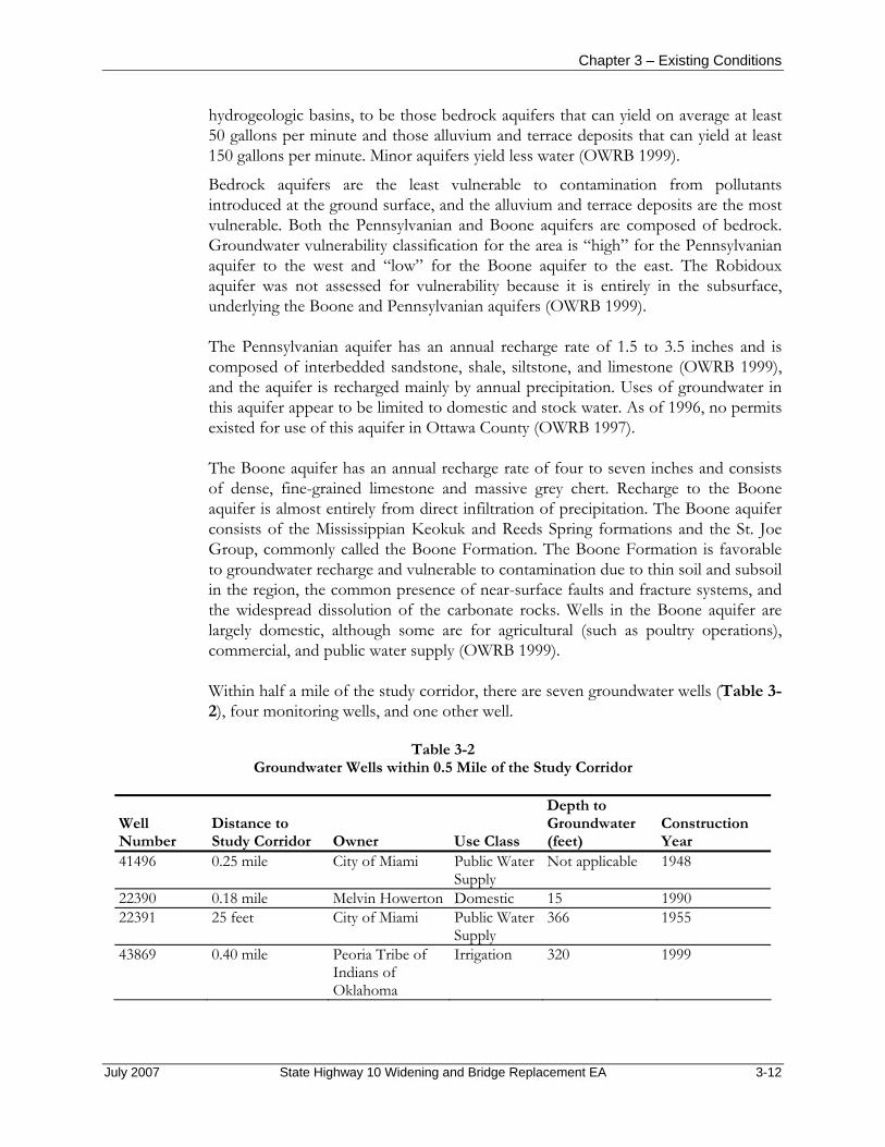
Chapter 3 – Existing Conditions
hydrogeologic basins, to be those bedrock aquifers that can yield on average at least 50 gallons per minute and those alluvium and terrace deposits that can yield at least 150 gallons per minute. Minor aquifers yield less water (OWRB 1999).
Bedrock aquifers are the least vulnerable to contamination from pollutants introduced at the ground surface, and the alluvium and terrace deposits are the most vulnerable. Both the Pennsylvanian and Boone aquifers are composed of bedrock. Groundwater vulnerability classification for the area is “high” for the Pennsylvanian aquifer to the west and “low” for the Boone aquifer to the east. The Robidoux aquifer was not assessed for vulnerability because it is entirely in the subsurface, underlying the Boone and Pennsylvanian aquifers (OWRB 1999).
The Pennsylvanian aquifer has an annual recharge rate of 1.5 to 3.5 inches and is composed of interbedded sandstone, shale, siltstone, and limestone (OWRB 1999), and the aquifer is recharged mainly by annual precipitation. Uses of groundwater in this aquifer appear to be limited to domestic and stock water. As of 1996, no permits existed for use of this aquifer in Ottawa County (OWRB 1997).
The Boone aquifer has an annual recharge rate of four to seven inches and consists of dense, fine-grained limestone and massive grey chert. Recharge to the Boone aquifer is almost entirely from direct infiltration of precipitation. The Boone aquifer consists of the Mississippian Keokuk and Reeds Spring formations and the St. Joe Group, commonly called the Boone Formation. The Boone Formation is favorable to groundwater recharge and vulnerable to contamination due to thin soil and subsoil in the region, the common presence of near-surface faults and fracture systems, and the widespread dissolution of the carbonate rocks. Wells in the Boone aquifer are largely domestic, although some are for agricultural (such as poultry operations), commercial, and public water supply (OWRB 1999).
Within half a mile of the study corridor, there are seven groundwater wells (Table 3-2), four monitoring wells, and one other well.
Table 3-2 Groundwater Wells within 0.5 Mile of the Study Corridor
Well Number
Distance to Study Corridor Owner Use Class
Depth to Groundwater (feet)
Construction Year
41496 0.25 mile City of Miami Public Water Supply
Not applicable 1948
22390 0.18 mile Melvin Howerton Domestic 15 1990 22391 25 feet City of Miami Public Water
Supply 366 1955
43869 0.40 mile Peoria Tribe of Indians of Oklahoma
Irrigation 320 1999
July 2007 State Highway 10 Widening and Bridge Replacement EA 3-12

Chapter 3 – Existing Conditions
Table 3-2 Groundwater Wells within 0.5 Mile of the Study Corridor (continued)
94594 360 feet Ottawa Tribe of
Oklahoma Public Water Supply
Not applicable Not applicable
15718 0.38 mile Keith Manion Domestic 60 1986 15719 0.38 mile Mr. and Mrs. Bill
Wescott Domestic 41 1985
Source: OWRB 2006
Water Quality Neither Little Elm Creek nor the Neosho River is on the US EPA’s list of impaired waters within the watershed (US EPA 2006b). No water quality information for Little Elm Creek has been reported by the OWRB.
3.6 DESIGNATED FLOODPLAINS Law, regulation, and guidance applicable to designated floodplains include the National Flood Insurance Act, Executive Order 11988: Floodplain Management (May 24, 1977), FEMA National Flood Insurance Manual, the OWRB’s Guidebook for Local Floodplain Ordinance Administrators, and the OWRB’s Rules (Title 785, Chapter 55, Development on State Owned or Operated Property Within Floodplains, July 1, 1999).
The study corridor passes through FEMA-regulated floodplain and floodway areas along Little Elm Creek (Figure 3-4). The regulated areas within the study corridor are classified as Zone AE (base flood [100-year] elevations have been determined), and Zone X (areas outside the 500-year floodplain) (FEMA 1988).
3.7 WETLANDS Law, regulation, and guidance applicable to wetlands include the Clean Water Act/ Water Quality Act of 1987, Emergency Wetlands Resources Act of 1986, North American Wetlands Conservation Act, Executive Order 11990: Protection of Wetlands (May 24, 1977), and Department of Transportation Order 5660.1A. Section 404 of the Clean Water Act (33 US Code 1344) regulates the discharge of dredged or fill material into waters of the US. The USACE administers a permit system to authorize these actions.
Wetlands are defined under the Clean Water Act as “Those areas that are inundated or saturated by surface or groundwater at a frequency and duration sufficient to support, and that under normal circumstances do support, a prevalence of vegetation typically adapted for life in saturated soil conditions. Wetlands generally include swamps, marshes, bogs and similar areas” (Environmental Laboratory 1987). The criteria for the presence of wetlands are: (1) a dominance of hydrophytic vegetation; (2) presence of hydric soils; and (3) presence of wetland hydrology. Wetlands and other bodies of water are currently only under the jurisdiction of the USACE if there is a hydrological connection to navigable waters.
July 2007 State Highway 10 Widening and Bridge Replacement EA 3-13

Chapter 3 – Existing Conditions
Figure 3-4 Floodplains
July 2007 State Highway 10 Widening and Bridge Replacement EA 3-14

Chapter 3 – Existing Conditions
A wetland finding survey (Eagle Environmental Consulting, Inc. 2007a) was conducted to identify areas that may be potential jurisdictional wetlands and waters of the US within a 600-foot corridor centered on the existing roadway (Appendix C). Fifteen aquatic areas were documented within the study corridor. Five stream channels, five wetlands, and five ponds and/or borrow pits were identified.
Two creeks cross the alignment of SH-10; Little Elm Creek (FS-4) and an unnamed tributary to Little Elm Creek (FS-5), located west of South 590 Road and are likely Waters of the US according to the field criteria used by the USACE to determine jurisdiction pursuant to Section 404 of the Clean Water Act (Eagle Environmental Consulting, Inc. 2007a; Tetra Tech 2006). A load-posted bridge spans Little Elm Creek and a second load-posted bridge, consisting of a series of culverts, contains the tributary. FS-1 and FS-15 are small tributaries that are likely jurisdictional waters that do not cross the roadway (Appendix C). FS-11 is a grass-lined ditch that has a defined bed and bank but does not have an obvious connection to navigable waters and thus is likely not a jurisdictional water.
Five wetland areas, both herbaceous and forested (FS-2, FS-6, FS-7, FS-9, FS-14) were documented associated with the tributaries and are likely jurisdictional (Appendix C). Additionally, five ponds or borrow pits (FS-3, FS-8, FS-10, FS-12, FS-13) were documented within the study corridor. FS-3 and FS-8 could be jurisdictional waters as they are associated with the tributaries. FS-10, FS-12, and FS-13 are more likely not jurisdictional as they appear to be hydrologically isolated. FS-3 and FS-13 are located within the 600-foot study corridor but outside of the proposed right-of-way of Alternative A1 or B1.
Details on wetland and waterway vegetation, soils, and hydrology can be found in Appendix C.
3.8 VEGETATION The study corridor is in the Central Irregular Plains ecoregion, which is characterized primarily by tall grass prairie (Oklahoma Department of Wildlife Conservation [ODWC] 1996). Big bluestem (Andropogon gerardii), little bluestem (Schizachyrium scoparium), indiangrass (Sorghastrum nutans), and switchgrass (Panicum virgatum) are the dominant native grasses and wildflowers. These grasslands are maintained by fire; in the absence of fire, woody plants become established, such as blackberry (Rubus spp.), persimmon (Diospyros spp.), and sumac (Rhus spp.). Relatively open, short, dry upland forests occur in draws and ravines and are dominated by post oak (Quercus stellata), blackjack oak (Q. marilandica), and black hickory (Carya texana). Floodplains tend to be relatively broad in this ecoregion and trees include elm (Ulmus spp.), oak (Quercus spp.), hackberry (Celtis occidentalis), cottonwood (Populus deltoides), and sycamore (Platanus occidentalis). In unshaded areas, shrubs, including sumac, elderberry, and strawberrybush, grasses, and other herbaceous plants occur. Where wetlands occur in floodplains, sedges (Carex spp., Cyperus spp., Eleocharis spp.), buttonbush (Cephalanthus occidentalis), and willows (Salix spp.) occur. Little Elm Creek
July 2007 State Highway 10 Widening and Bridge Replacement EA 3-15

Chapter 3 – Existing Conditions
is generally consistent with this description, but most riparian vegetation was recently cleared in a short segment of this creek on either side of SH-10.
In general, vegetation in relatively undisturbed areas within the study corridor corresponds somewhat with the typical communities for the ecoregion, except with less dominance of native grasses due to lack of fire and other habitat modifications. Approximately 75 to 80% of the study corridor is open (treeless) (Eagle Environmental Consulting, Inc. 2007a). Residential and commercial development occupies much of the study corridor, so that a substantial portion of the vegetation consists of mowed lawns and ornamental plantings (Tetra Tech 2006).
Tree species documented in the study corridor include black willow (Salix nigra), cottonwood (Populus deltoides), American elm (Ulmus Americana), green ash (Fraxinus pennsylvanica), silver maple (Acer saccharinum), honey locust (Gleditsia triacanthos), pecan (Carya illinoensis), and red bud (Cercis Canadensis) (Eagle Environmental Consulting, Inc. 2007a). Shrub and vine species documented include multifolora rose (Rosa multiflora), poison ivy (Toxicondendron radicans), rough leaf dogwood (Cornus drumondii), honeysuckle (Lonciera japonica), buttonbush (Celtis occidentalis), eastern redcedar (Juniperus virginiana), blackberry (Rubus oklahomensis), and false indigo (Amorpha fruitcosa) (Eagle Environmental Consulting, Inc. 2007a). Herbaceous (non-woody) species documented include great ragweed (Ambrosia trifida), foxtail (Setaria gracilis), broomsedge bluestem (Andropogon virginicus), spike rush (Eleocharis palustris), goldenrod (Solidago sp.), fescue (Festuca arundinacea), foxtail (Setaria gracilisa), yellow fruit sedge (Carex annectans), serecia (Serecia lespedeza), annual broomweed (Gutierrezia dracunculoides), and Illinois bundle flower (Desmanthus illinoensis) (Eagle Environmental Consulting, Inc. 2007a).
3.9 WILDLIFE AND FISHERIES Law, regulation, and guidance applicable to wildlife and fisheries include the Fish and Wildlife Coordination Act and Migratory Bird Treaty Act.
As described in Section 3.8 (Vegetation), the study corridor is within the Central Irregular Plains ecoregion, which contains tall grass prairie, dry upland forest, and floodplain habitats. Three hundred and twenty-seven vertebrate species are native to the ecoregion (ODWC 1996). Land use practices in the study corridor include urban development at the far western end of the corridor, relatively low-density rural residential areas, commercial development, and agriculture (Tetra Tech 2006). Vegetation found in the corridor is described in Section 3.8 (Vegetation), and water and wetlands are described in Sections 3.5 (Water Resources) and 3.7 (Wetlands). These resources considered together shape the habitats and the corresponding wildlife and fish species found within the study corridor. Diversity and density of wildlife is likely highest in the riparian areas of Little Elm Creek and its tributaries. The recent clearing of vegetation, as described in Section 3.8 has temporarily reduced the value of this area for wildlife.
July 2007 State Highway 10 Widening and Bridge Replacement EA 3-16

Chapter 3 – Existing Conditions
Representative mammals found in the study corridor could include least shrew (Cryptotis parva), little brown myotis (Myotis lucifugus), striped skunk (Mephitis mephitis), red fox (Vulpes vulpes), coyote (Canis latrans), raccoon (Procyon lotor), white-tailed deer (Odocoileus virginianus), beaver (Castor canadensis), muskrat (Ondatra zibethicus), opossum (Didelphis virginiana), eastern fox squirrel (Sciurus niger), prairie vole (Microtus ochrogaster), deer mouse (Peromyscus maniculatus), and eastern cottontail (Sylvilagus floridanus) (Burt and Grossenheider 1976; ODWC 1996; Tetra Tech 2006).
Birds likely include a variety of raptors, including red-tailed hawk (Buteo jamacensis), red-shouldered hawk (B. lineatus), American kestrel (Falco sparverius), great horned owl (Bubo virginianus), barred owl (Strix varia), and barn owl (Tyto alba) (Peterson 1980; ODWC 1996; Tetra Tech 2006). Wading birds, such as great blue heron (Ardea herodias) and green heron (Butorides virescens), could occur in ponds and streams. Game species could include common bobwhite (Colinus virginianus). A variety of migrant and resident songbirds also are present, likely including such common species as common grackle (Quiscalus quiscula), American robin (Turdus migratorius), house sparrow (Passer domesticus), brown-headed cowbird (Molothrus ater), northern cardinal (Cardinalis cardinalis), and common yellowthroat (Geothlypis trichas).
Reptiles could include eastern collared lizard (Crotaphytus collaris), copperhead (Agkistrodon contortrix), timber rattlesnake (Crotalus horridus), eastern hognose snake (Heterodon platyrhinos), black rat snake (Elaphe obsoleta), and ornate box turtle (Terrapene ornata) (Conant and Collins 1991; ODWC 1996; Tetra Tech 2006). Amphibians could include bullfrog (Rana catesbeiana) and American toad (Bufo americanus).
Ponds in the study corridor potentially contain common warm water game fish, such as channel catfish (Ictalurus punctatu), bluegill (Lepomis macrochirus), and largemouth bass (Micropterus salmoides) (ODWC 1996; Tetra Tech 2006). Fish in the streams are likely limited by shallow water and warm temperatures, but various small species of the minnow family (cyprinidae), such as shiners and minnows, likely occur.
3.10 THREATENED AND ENDANGERED SPECIES Law, regulation, and guidance applicable to threatened and endangered species include the Endangered Species Act (16 US Code 1.531-1543).
The USFWS lists ten species that could occur or historically occurred in Ottawa County that are currently classified as threatened, endangered, or a candidate for listing (Table 3-3) (USFWS 2006a). All of these species are unlikely to occur in the study corridor based on their habitat requirements and known occurrences, as described below. Presence or absence of listed species and their habitats were assessed with literature review (primarily USFWS documents), conversations with USFWS personnel (Collins 2006, Martinez 2006, Stark 2006), a brief site visit (Tetra Tech 2006), and a habitat assessment (Eagle Environmental Consulting, Inc. 2007b) (Appendix D).
July 2007 State Highway 10 Widening and Bridge Replacement EA 3-17
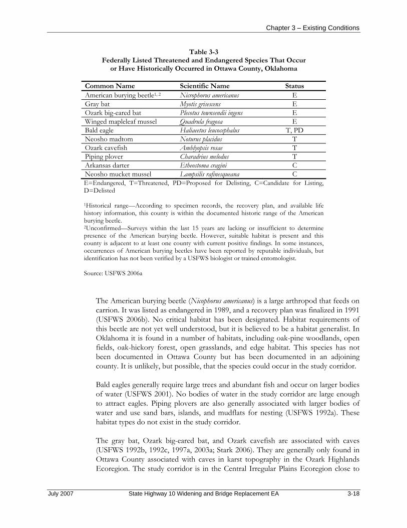
Chapter 3 – Existing Conditions
Table 3-3 Federally Listed Threatened and Endangered Species That Occur
or Have Historically Occurred in Ottawa County, Oklahoma
Common Name Scientific Name Status American burying beetle1, 2 Nicrophorus americanus E Gray bat Myotis grisescens E Ozark big-eared bat Plecotus townsendii ingens E Winged mapleleaf mussel Quadrula fragosa E Bald eagle Haliaeetus leucocephalus T, PD Neosho madtom Noturus placidus T Ozark cavefish Amblyopsis rosae T Piping plover Charadrius melodus T Arkansas darter Etheostoma cragini C Neosho mucket mussel Lampsilis rafinesqueana C E=Endangered, T=Threatened, PD=Proposed for Delisting, C=Candidate for Listing, D=Delisted
1Historical range—According to specimen records, the recovery plan, and available life history information, this county is within the documented historic range of the American burying beetle. 2Unconfirmed—Surveys within the last 15 years are lacking or insufficient to determine presence of the American burying beetle. However, suitable habitat is present and this county is adjacent to at least one county with current positive findings. In some instances, occurrences of American burying beetles have been reported by reputable individuals, but identification has not been verified by a USFWS biologist or trained entomologist. Source: USFWS 2006a
The American burying beetle (Nicophorus americanus) is a large arthropod that feeds on carrion. It was listed as endangered in 1989, and a recovery plan was finalized in 1991 (USFWS 2006b). No critical habitat has been designated. Habitat requirements of this beetle are not yet well understood, but it is believed to be a habitat generalist. In Oklahoma it is found in a number of habitats, including oak-pine woodlands, open fields, oak-hickory forest, open grasslands, and edge habitat. This species has not been documented in Ottawa County but has been documented in an adjoining county. It is unlikely, but possible, that the species could occur in the study corridor.
Bald eagles generally require large trees and abundant fish and occur on larger bodies of water (USFWS 2001). No bodies of water in the study corridor are large enough to attract eagles. Piping plovers are also generally associated with larger bodies of water and use sand bars, islands, and mudflats for nesting (USFWS 1992a). These habitat types do not exist in the study corridor.
The gray bat, Ozark big-eared bat, and Ozark cavefish are associated with caves (USFWS 1992b, 1992c, 1997a, 2003a; Stark 2006). They are generally only found in Ottawa County associated with caves in karst topography in the Ozark Highlands Ecoregion. The study corridor is in the Central Irregular Plains Ecoregion close to
July 2007 State Highway 10 Widening and Bridge Replacement EA 3-18
Chapter 3 – Existing Conditions
the Ozark Highlands. The USFWS has records of Ozark cavefish 10 miles east of the City, but they do not have records of caves or any of these species in the study corridor (Stark 2006). It is unlikely but possible that cave openings and associated listed species are within the study corridor.
The Neosho madtom (a small freshwater catfish) and the Neosho mucket (a freshwater mussel) are generally associated with larger rivers and gravel bottoms such as the Spring and Neosho Rivers (USFWS 1997b, 2005a). Little Elm Creek does not meet these criteria. The winged mapleleaf mussel is known only from the St. Croix River in Minnesota and Wisconsin (USFWS 2003b). Its inclusion on USFWS’s Ottawa County list is likely a historical record (Collins 2006), and it is not a concern in the study corridor (Martinez 2006).
The Arkansas darter is associated with aquatic vegetation in spring-fed creeks with high water quality (USFWS 2005b; Collins 2006). It is unlikely to occur in Little Elm Creek or its tributaries. This species is only a candidate for listing and thus is not protected by the Endangered Species Act.
3.11 CULTURAL RESOURCES Law, regulation, and guidance applicable to cultural resources include the National Historic Preservation Act, as amended (Section 106), Archaeological and Historic Preservation Act, Antiquities Act, Archaeological Resource Protection Act, American Indian Religious Freedom Act, Executive Order 13007: Indian Sacred Sites, Section 4(f) of the Department of Transportation Act, Surface Transportation and Uniform Relocation Assistance Act, Native American Graves Protection and Repatriation Act, and Executive Order 11593: Protection and Enhancement of the Cultural Environment.
Five major prehistoric cultural periods for the Great Plains and the study corridor have been identified by archaeologists. These are the Paleoindian Period, the Archaic Period, the Woodland Period, the Plains Village Tradition/Protohistoric Period, and the Historic Period. A Pre-Paleoindian Period has been suggested by some archaeological data, but further research is necessary to confirm the possibility. During the Historic Period (1700s to present), the Oklahoma region witnessed the relocation of the Five Civilized Tribes (Choctaw, Chickasaw, Cherokee, Creek, and Seminole) from the southeast, as well as the Delaware, Shawnees, Kaw, Pawnee, and many others from other territories to Oklahoma along the “Trail of Tears” (Effigy Archaeological Services, Inc. 2005).
Based on Oklahoma Archaeological Survey and SHPO maps, there are no prehistoric or historic-age cultural resources within the study corridor and the area that had not been previously surveyed (Oklahoma Archaeological Survey 2006). However, there is a modern cemetery, Glen Abbey Memorial Gardens, near the northwest corner of the intersection of SH-10 and South 590 Road (Figures 1-1 and 1-2). As such, a Phase I (reconnaissance) and II (pedestrian survey) survey was conducted of the study corridor (Appendix E). The Phase I survey consisted of a
July 2007 State Highway 10 Widening and Bridge Replacement EA 3-19

Chapter 3 – Existing Conditions
simple reconnaissance and archival review, while the Phase II survey included an intensive pedestrian survey and recordation and eligibility assessments of cultural resources noted during the Phase I survey. The surveys identified one archaeological site, six isolated artifacts, seven standing historic-age structures, three bridges, one cemetery, and one historic-age trail. The following discussions are based on the findings and evaluations detailed in Appendix E.
The one archaeological site is a building foundation associated with one of the historic-age standing structures. The foundation is associated with a dairy barn, silo, and various remnants of a farming complex. The farmstead was built by the twelfth chief of the Ottawa Tribe of Oklahoma, Chief Guy A. Jennison, Sr., sometime in the early 1920s. Chief Jennison lived in the house throughout his tenure as Chief (1936 to 1959) and until his death in 1967. The property was sold to George Vanpool, the current owner, in 1978 by Chief Jennison’s widow and son. The house was razed in subsequent years. Despite the farmstead’s association with Chief Jennison, the site has been recommended as ineligible for the NRHP due to a lack of integrity since the house is no longer standing and the surrounding setting has been graded and altered since the period of the chief’s tenure.
All identified historic-age standing residences are believed to have been built between 1905 and the 1950s. None were recommended as eligible for the NRHP since none are associated with significant historic events or persons, nor do they embody a distinctive architectural characteristic. Additionally, each of the houses displays modern modifications that greatly diminish the historical integrity of the buildings.
The three identified historic-age bridges are the same three bridges proposed for replacement under Alternatives A1 and B1. The five-span Interstate 44 bridge was constructed in 1957 and is in the style of a steel I-beam bridge. The bridge over Little Elm Creek was constructed in 1939 and is composed of five spans in a plain concrete slab style. The final bridge over an unnamed creek is composed of three round metal culverts. No date was obtained for this bridge. None of the bridges have been recommended as eligible for the NRHP since they are not associated with significant historic events or persons, nor do they embody a distinctive architectural characteristic.
The noted cemetery is the active Glen Abbey Memorial Gardens identified previously on topographic maps. This is the only modern cultural resource. The cemetery appears to have been in use since the 1950s, based on dates from the earliest headstones. None of the headstones were especially noteworthy in style or design. The Ottawa County Historical Society and the Tribal Historian of the Ottawa Tribe were unaware of any persons significant in state or national history buried in the cemetery.
The historic-age trail has been named “Old Military Trail” and was traced in 1961 as an Ottawa County Historical Society project. It was established in 1828 between Fort Leavenworth, Kansas, and Fort Gibson in the Indian Territory and was used until
July 2007 State Highway 10 Widening and Bridge Replacement EA 3-20

Chapter 3 – Existing Conditions
the late 1800s. It was also sometimes used by immigrants traveling from Missouri to Texas, and is thus sometimes referred to as the “Texas Trail.” Several forts and trading posts are reported to have existed along the trail, but the Historical Society project found that none are still present, at least within or near the study corridor. Furthermore, the portion of the study corridor through which the trail runs has been extensively disturbed by construction of residences, pipelines, commercial buildings, and terracing, effectively removing any indication or integrity of the trail segment. Therefore, this segment of the trail is not recommended as eligible for the NRHP.
SHPO concurred with ODOT’s finding of no historic-age properties affected in a letter dated April 3, 2007 (SHPO File No. 1061-07). Oklahoma Archaeological Survey deferred their opinion to the SHPO in a letter dated March 14, 2007. Therefore, it has been determined that none of the cultural resources within the project area are eligible for listing on the NRHP.
3.12 NATIVE AMERICAN RESOURCES Law, regulation, and guidance applicable to Native American resources include those listed under Section 3.11 (Cultural Resources).
During the Historic Period (1700s to present), the Oklahoma region witnessed the relocation of the Five Civilized Tribes (Choctaw, Chickasaw, Cherokee, Creek, and Seminole) from the southeast, as well as the Delaware, Shawnees, Kaw, Pawnee, and many others from other territories to Oklahoma along the “Trail of Tears” (Effigy Archaeological Services, Inc. 2005).
The study corridor is within the Ottawa Indian Reservation and near the southern boundary of the Peoria Indian Reservation. Other potentially interested tribes include the Cherokee Nation, Eastern Shawnee Tribe, Miami Nation, Modoc Tribe, Osage Nation, Ottawa Tribe, Peoria Tribe of Indians, Quapaw Tribe of Oklahoma, Seneca-Cayuga Tribe of Oklahoma, United Keetoowah Band of Cherokees, and Wichita and Affiliated Tribes. ODOT contacted these tribes during the solicitation process regarding cultural concerns for the study corridor and again as part of a formal consultation process in January 2007. ODOT received one response letter, from the Miami Tribe of Oklahoma. The tribe was unaware of any tribally owned land, tribal cemeteries, cultural or religious sites, or other land held in trust that would be affected by the project. As such, it is presumed that there are no cultural resources of particular significance to Native American tribes within the study corridor.
3.13 HAZARDOUS AND TOXIC MATERIALS AND WASTE The US EPA is the principal agency regulating the generation, use, storage, and disposal of hazardous and toxic materials and waste under the authority of the Resource Conservation and Recovery Act. The US EPA regulates hazardous substance sites under the Comprehensive Environmental Response Compensation and Liability Act. Additional federal regulations include the Community Environmental Response Facilitation Act of 1992, Clean Water Act, Clean Air Act,
July 2007 State Highway 10 Widening and Bridge Replacement EA 3-21

Chapter 3 – Existing Conditions
Safe Drinking Water Act, Occupational Safety and Health Act, Atomic Energy Act, Toxic Substances Control Act, and the Federal Insecticide, Fungicide and Rodenticide Act. Executive Order 12088, Federal Compliance with Pollution Control, mandates that necessary actions be taken to prevent and control environmental pollution with respect to federal facilities and activities.
In addition to federal regulations, hazardous and toxic materials and waste are regulated by the Oklahoma Department of Environmental Quality, Oklahoma Corporation Commission, and Oklahoma State Department of Health.
To identify areas where hazardous substances or petroleum products or their derivatives could have been stored, released, or disposed of, a background search of available federal and state environmental records was conducted (Environmental Data Resources, Inc. 2006) (Appendix F). Environmental Data Resources investigates databases that contain reported underground storage tanks and hazardous waste sites. The Environmental Data Resources report identified several sites of environmental concern within the study corridor (Figure 3-1); however, all of these sites were reported to be closed by the applicable regulatory agency, meaning that there is no remaining concern for risk to human health or the environment from these sites. An interview with the applicable case worker at the Oklahoma Corporation Commission confirmed that the two leaking underground storage tank facilities within the study corridor are also closed (Douglah 2006). It is possible that unreported areas of contamination could be located within the study corridor.
A search of the OWRB online wells mapping application shows that four monitoring wells are within half a mile of the study corridor (OWRB 2006). These wells are owned by Conoco Phillips of Bartlesville, Oklahoma, and are associated with the site mapped as Environmental Data Resources Report ID #1 (Phillips SS#27059). Conoco Phillips reported that they used to own a service station at this location on Interstate 44 and that these wells were short-term soil and water quality testing wells that were both drilled and plugged in 2004 as part of an environmental site assessment in support of the sale of the property (Hathaway 2006).
The study corridor also crosses natural gas and water pipelines that could create health and safety impacts (Figure 3-1).
The Environmental Data Resources report identifies three underground storage tanks within the study corridor.
This project is near an area that has been historically mined for lead and zinc, so there is a potential for mining wastes and contaminated soils to be in the study corridor.
July 2007 State Highway 10 Widening and Bridge Replacement EA 3-22

Chapter 3 – Existing Conditions
3.14 VISUAL RESOURCES Law, regulation, and guidance applicable to visual resources include the Department of Transportation Act of 1966, as amended, and Surface Transportation and Uniform Relocation Assistance Act of 1987.
The terrain is relatively flat with some gentle slopes. The area including and surrounding the study corridor is predominantly low density and rural, consisting of open fields, scattered commercial operations, single-family and multifamily residences, and three churches. There are large trees in some areas along the study corridor. Several residences and a church in the study corridor would be subject to views of the highway during construction and operation. US Route 66, a scenic byway (University of Oklahoma 2006), passes through the City, 1.3 miles west of the study corridor. Interstate 44 was designed to bypass US Route 66, which lost its historic certification in 1985 (Oklahoma Route 66 Association, undated).
3.15 AIR QUALITY Law, regulation, and guidance applicable to air quality include the Clean Air Act. Air quality is defined by ambient air concentrations of specific pollutants determined to be of concern with respect to the health and welfare of the general public. Under the Clean Air Act Amendments of 1990, the US EPA established National Ambient Air Quality Standards for seven criteria pollutants: lead, ozone, sulfur dioxide, oxides of nitrogen, carbon monoxide, particulate matter smaller than 10 microns in diameter, and particulate matter smaller than 2.5 microns in diameter. Areas that exceed a federal air quality standard are designated as nonattainment areas. The study corridor is in the Northeastern Oklahoma Intrastate Air Quality Control Region (#186) (US EPA 2006c). The study corridor is in attainment for all criteria pollutants (US EPA 2006a).
3.16 NOISE Traffic noise studies must be performed in accordance with 23 CFR 772 (FHWA’s Noise Abatement Criteria), FHWA’s Highway Traffic Noise Analysis and Abatement Policy and Guidance (FHWA 1995), and ODOT’s Highway Noise Abatement Policy Directive Number C-201-3 (ODOT 1996). ODOT’s Highway Noise Abatement Policy Directive incorporates FHWA’s Noise Abatement Criteria into its policy. The traffic noise study for this project is included as Appendix G.
Background Noise is defined as unwanted sound. Airborne sound is a rapid fluctuation of air pressure above and below atmospheric pressure. There are several ways to measure noise, depending on the source of the noise, the receptor, and the reason for the noise measurement. The unit used in sound measurement is the dB, and the unit used for traffic noise is the dBA. The A-weighted scale most closely represents the response of the human ear to sound. Human hearing typically encompasses the sound range from just above zero dBA at the quietest end to 140 dBA, where pain and permanent hearing loss would result for most listeners. The measurement that is more commonly used to express dBA levels for traffic noise is Leq(h), where h is the
July 2007 State Highway 10 Widening and Bridge Replacement EA 3-23

Chapter 3 – Existing Conditions
number of hours. This describes a noise-sensitive receptor’s average exposure from all noise-producing events over a given number hours, usually one. All traffic noise levels in this analysis are expressed in dBA Leq(h), or Leq1h.
To an average listener, a 10-dBA increase is perceived as twice as loud as the original noise. One dBA is the smallest change in sound level an average person can detect under ideal conditions. Usually a person cannot discern a three- to four-dBA increase in sound if it increases over a period of several years. Furthermore, the energy in sound dissipates with distance from the source. For a point source, sound levels will decrease at a rate of six dBA per doubling of distance from the source. For a line source, such as a roadway, traffic noise dissipates at a rate of three dBA per doubling of distance. For example, a sound level of 65 dBA measured 50 feet from a roadway would be 62 dBA at 100 feet from the roadway.
It is intuitive that traffic levels can vary over time. Traffic noise depends on several factors, including traffic volume, type and speed of vehicle, and roadway surface. Vehicle noise originates from a variety of sources. For most cars, the primary noise source is the interaction of tires with the pavement. For trucks, the dominant noise source is attributed to the exhaust and engine. Traffic noise is also generated and can be affected by brakes, loose body components, and faulty exhaust systems.
Noise-Sensitive Receivers Noise-sensitive receivers are those locations where activities occur that could be affected by increased noise levels, such as residences, motels, churches, schools, parks, and libraries. Existing noise levels are determined for the outdoor living area at sensitive receivers. Table 3-4 shows the FHWA’s Noise Abatement Criteria for different activity categories. For this analysis, categories B and C were used as the criteria for sensitive receivers.
Noise-sensitive receivers are interspersed throughout the study corridor and potential sensitive receptors in the study corridor vicinity include residences, three churches, a day care facility (if associated with a church), and a skating rink (if associated with a park).
Existing Noise Conditions Ambient noise levels vary depending on location. Roadway traffic noise is the primary source of noise-generating activities in the study corridor and vicinity. The existing roadway was examined to identify potential receivers. Eight receivers were modeled using existing traffic volume data for the existing noise levels along the SH-10 study corridor. These receivers included seven residential and one commercial location. Table 3-5 provides the corresponding ambient condition noise level data. Four of the eight receivers approach, meet, or exceed the FHA Noise Abatement Criteria.
July 2007 State Highway 10 Widening and Bridge Replacement EA 3-24

Chapter 3 – Existing Conditions
Table 3-4 Federal Highway Administration Noise Abatement Criteria
Activity
Category Leq Noise
Level Description of Activity Category
A 57 Exterior
Tracts of land in which serenity and quiet are of extraordinary significance and serve an important public need and where the preservation of these qualities is essential if the area is to continue to serve its intended purpose.
B 67 Exterior
Picnic area, recreation areas, playgrounds, active sports areas, and parks which are not included in Category A and residences, motels, hotels, public meeting rooms, schools, churches, libraries, and hospitals.
C 72 Exterior
Developed lands, properties, or activities not included in Categories A or B above.
D -- Undeveloped lands.
E 52 Interior
Residences, motels, hotels, public meeting rooms, schools, churches, libraries, hospitals, and auditoriums.
Source: 23 CFR 772
Table 3-5 Existing Year (2007) Noise Levels
Receiver Receiver Type Leq (dBA)
1 Residential 66
2 Residential 68
3 Residential 63
4 Residential 67
5 Residential 64
6 Residential 67
7 Residential 61
8 Commercial 69
Source: Eagle Environmental Consulting, Inc. 2007c
3.17 SOCIOECONOMICS AND ENVIRONMENTAL JUSTICE NEPA requires that EAs analyze the effects that a project and its alternatives would have on the “human environment,” which the Council on Environmental Quality defines as the natural and physical environment and the relationship of people with that environment (40 CFR 1508.14). Executive Order 13045, Protection of Children from Environmental Health Risks and Safety Risks, directs each federal agency to make it a high priority to identify and assess environmental health risks and safety risks that may disproportionately affect children. Executive Order 12898, Federal
July 2007 State Highway 10 Widening and Bridge Replacement EA 3-25
Chapter 3 – Existing Conditions
Actions to Address Environmental Justice in Minority Populations and Low-Income Populations, requires that each implementing agency address, as appropriate, disproportionately high and adverse human health or environmental effects of its programs, policies, and activities on minority populations and low-income populations.
The study corridor lies in Ottawa County, Oklahoma, with the far western terminus in the City. While the physical effects of the proposed project would not extend beyond the study corridor, the residents and businesses in Ottawa County and the City would be affected by the transportation strategies for the proposed project. For these reasons, demographic and economic data are presented for these areas, as well as for the Census Tracts in which the study corridor is located. The study corridor is within Ottawa County Census Tracts 9741, 9746, and 9747. The region of influence for social resources includes the community within and immediately adjacent to the study corridor, since this community would be the one affected by changes to community/neighborhood cohesion resulting from the proposed project. Additional demographic data concerning low-income and minority populations also is presented in order to evaluate potential environmental justice effects. Supplementary regional information also is provided, where applicable. The most recent data available at the time of the analysis is supplied for each topic. This section is a description of recent socioeconomic trends and the interdependence of socioeconomic factors with the proposed project.
Definition of Resource Social resources include community/neighborhood cohesion, access to community facilities, and community property values. Demographic characteristics include population, housing, and schools. Population trends, housing availability, and school enrollment and capacity are important considerations in assessing the effects of potential growth. The economic characteristics of the study corridor are described by employment and income. Each of these socioeconomic characteristics is discussed below.
Social Background The study corridor is predominantly rural, with approximately 61 percent of the population living in rural areas and 39 percent living in small urbanized clusters. Within the study corridor Census Tracts, about 33 percent of residents have a high school diploma, and 10 percent have received a college bachelor’s degree. Most of the population (82 percent) consists of long-term residents (greater than five years), living in the same house since 1995. The most common occupations for residents were professional, service, sales, and production/transportation jobs, whereas agricultural occupations were by far the least common, followed by construction jobs. As described below, most of the working population commutes to work (US Census Bureau 2000), indicating that the transportation network is an important factor in the daily lives of area residents. An informal survey of City residents revealed that street and road improvement is the most important issue for all City residents (City of Miami 2006).
July 2007 State Highway 10 Widening and Bridge Replacement EA 3-26
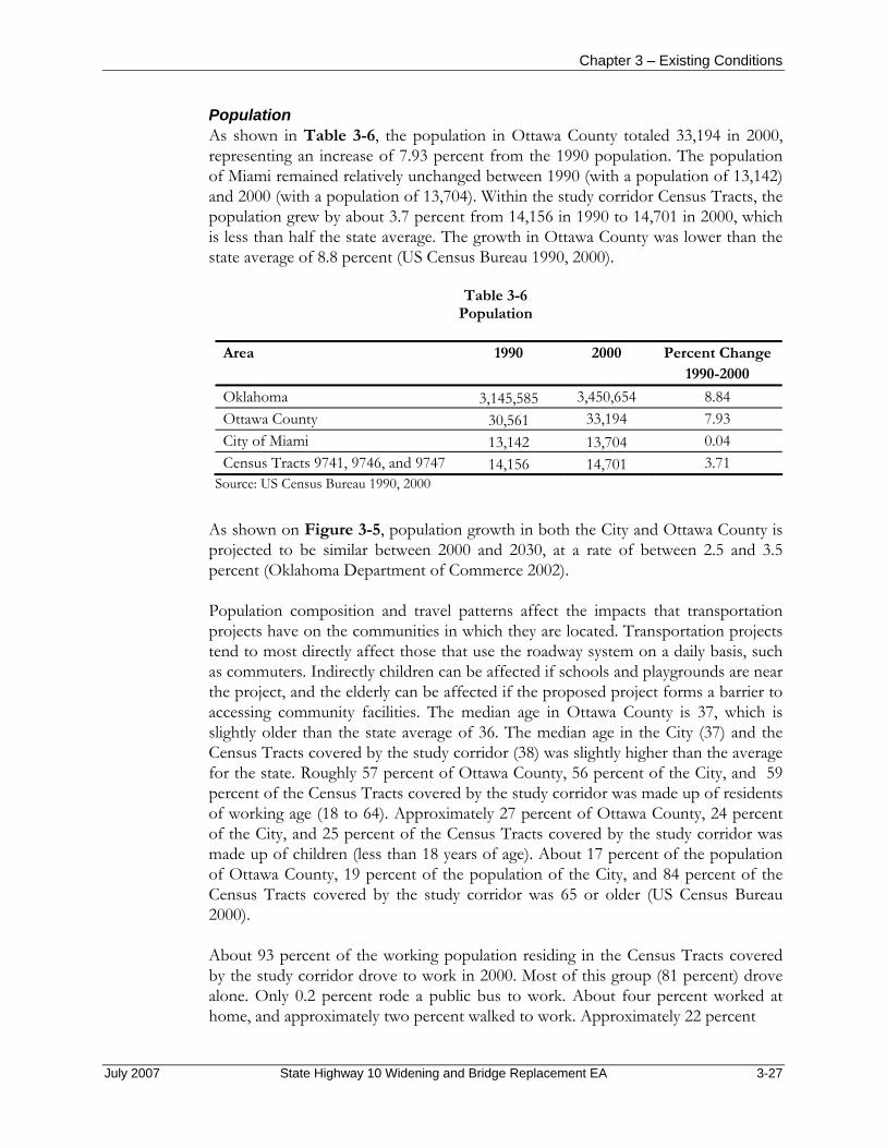
Chapter 3 – Existing Conditions
Population As shown in Table 3-6, the population in Ottawa County totaled 33,194 in 2000, representing an increase of 7.93 percent from the 1990 population. The population of Miami remained relatively unchanged between 1990 (with a population of 13,142) and 2000 (with a population of 13,704). Within the study corridor Census Tracts, the population grew by about 3.7 percent from 14,156 in 1990 to 14,701 in 2000, which is less than half the state average. The growth in Ottawa County was lower than the state average of 8.8 percent (US Census Bureau 1990, 2000).
Table 3-6 Population
Area 1990 2000 Percent Change
1990-2000 Oklahoma 3,145,585 3,450,654 8.84 Ottawa County 30,561 33,194 7.93 City of Miami 13,142 13,704 0.04 Census Tracts 9741, 9746, and 9747 14,156 14,701 3.71
Source: US Census Bureau 1990, 2000
As shown on Figure 3-5, population growth in both the City and Ottawa County is projected to be similar between 2000 and 2030, at a rate of between 2.5 and 3.5 percent (Oklahoma Department of Commerce 2002).
Population composition and travel patterns affect the impacts that transportation projects have on the communities in which they are located. Transportation projects tend to most directly affect those that use the roadway system on a daily basis, such as commuters. Indirectly children can be affected if schools and playgrounds are near the project, and the elderly can be affected if the proposed project forms a barrier to accessing community facilities. The median age in Ottawa County is 37, which is slightly older than the state average of 36. The median age in the City (37) and the Census Tracts covered by the study corridor (38) was slightly higher than the average for the state. Roughly 57 percent of Ottawa County, 56 percent of the City, and 59 percent of the Census Tracts covered by the study corridor was made up of residents of working age (18 to 64). Approximately 27 percent of Ottawa County, 24 percent of the City, and 25 percent of the Census Tracts covered by the study corridor was made up of children (less than 18 years of age). About 17 percent of the population of Ottawa County, 19 percent of the population of the City, and 84 percent of the Census Tracts covered by the study corridor was 65 or older (US Census Bureau 2000).
About 93 percent of the working population residing in the Census Tracts covered by the study corridor drove to work in 2000. Most of this group (81 percent) drove alone. Only 0.2 percent rode a public bus to work. About four percent worked at home, and approximately two percent walked to work. Approximately 22 percent
July 2007 State Highway 10 Widening and Bridge Replacement EA 3-27
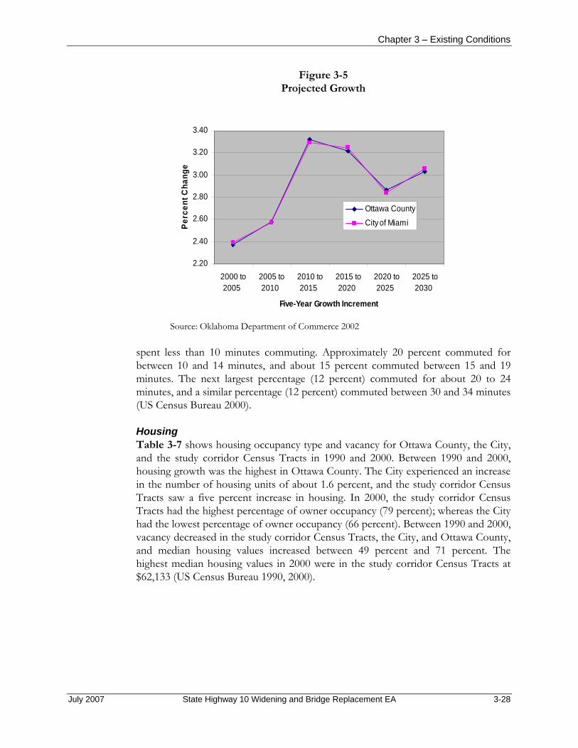
Chapter 3 – Existing Conditions
Figure 3-5 Projected Growth
2.20
2.40
2.60
2.80
3.00
3.20
3.40
2000 to2005
2005 to2010
2010 to2015
2015 to2020
2020 to2025
2025 to2030
Five-Year Growth Increment
Perc
ent C
hang
e
Ottawa County
City of Miami
Source: Oklahoma Department of Commerce 2002
spent less than 10 minutes commuting. Approximately 20 percent commuted for between 10 and 14 minutes, and about 15 percent commuted between 15 and 19 minutes. The next largest percentage (12 percent) commuted for about 20 to 24 minutes, and a similar percentage (12 percent) commuted between 30 and 34 minutes (US Census Bureau 2000).
Housing Table 3-7 shows housing occupancy type and vacancy for Ottawa County, the City, and the study corridor Census Tracts in 1990 and 2000. Between 1990 and 2000, housing growth was the highest in Ottawa County. The City experienced an increase in the number of housing units of about 1.6 percent, and the study corridor Census Tracts saw a five percent increase in housing. In 2000, the study corridor Census Tracts had the highest percentage of owner occupancy (79 percent); whereas the City had the lowest percentage of owner occupancy (66 percent). Between 1990 and 2000, vacancy decreased in the study corridor Census Tracts, the City, and Ottawa County, and median housing values increased between 49 percent and 71 percent. The highest median housing values in 2000 were in the study corridor Census Tracts at $62,133 (US Census Bureau 1990, 2000).
July 2007 State Highway 10 Widening and Bridge Replacement EA 3-28

Chapter 3 – Existing Conditions
Table 3-7 Housing Characteristics
Ottawa County City of Miami Census Tracts 9741,
9746, and 9747
1990 2000
Percent Change
1990-2000 1990 2000
Percent Change 1990-
2000 1990 2000
Percent Change
1990-2000
Total 14,064 14,842 5.5 6,012 6,111 1.6 5,827 6,118 5.0 Occupied 12,124 12,984 7.1 5,414 5,580 3.1 5,200 5,534 6.4
(Percent) (86.2) (87.5) — (90.1
) (91.3
) — (89.2) (90.5
) — Vacant 1,940 1,858 -4.2 598 531 -11.2 627 584 -6.9 (Percent) (13.8) (12.5) — (9.9) (8.7) — (10.8) (9.5) — Owner Occupied 8,965 9,590 7.0 3,664 3,671 0.2 1,695 4,376 158.2 (Percent) (73.9) (73.9) (67.7) (65.8) (78.3) (79.1) Renter Occupied 3,159 3,394 7.4 1,750 1,909 9.1 391 1,158 196.2 (Percent) (26.1) (26.1) (32.3) (34.2) (21.7) (20.9) Median Value $30,200 $47,200 56.3 $33,000 $49,000 48.5 $36,400 $62,133 70.7
Source: US Census Bureau 1990, 2000
The Census block group is the lowest-level geographic entity for which the Census Bureau tabulates sample data from a ten-year census, including the year that houses were built, the number of rooms, the value of owner-occupied housing units, and gross rent. Census block groups generally contain between 300 and 3,000 people, with an optimum size of 1,500 people. The proposed project lies within block groups 1 and 3 in Census Tract 9746 (west of Interstate 44, to the north and south of SH-10, respectively), block group 1 in Census Tract 9747 (east of Interstate 44), and block group 1 in Census Tract 9741 (east of SH-137 and north of SH-10). Table 3-8 shows Census sample data for these housing characteristics for Ottawa County, the City, and the study corridor block groups for 2000.
The highlighted cells in Table 3-8 show that housing in the Census Tracts affected by the proposed project is generally newer than that found in Ottawa County and the City. Similar to Ottawa County and the City, the highest percentages of housing in Census Tract 9741, block group 1, and Tract 9746, block group 1 had five or six rooms. The highest percentages of housing in Tract 9746, block group 3, had slightly fewer rooms, while, in Tract 9747, block group 1, which covers the largest portion of the study corridor, had slightly more rooms. Most housing values in the study corridor block groups, as well as in Ottawa County and the City, fell below $100,000. More than 20 percent of the housing values in Census Tract 9741, block group 1, and Tract 9746, block group 1 ranged from $100,000 to $149,000, whereas, a much lower percentage of Ottawa County and the City housing was within this range.
July 2007 State Highway 10 Widening and Bridge Replacement EA 3-29

Chapter 3 – Existing Conditions
Table 3-8 Housing Characteristics—Sample Data for Block Groups1
Ottawa County
(Percent) City of Miami
(Percent)
Census Tract 9741, Block
Group 1 (Percent)
Census Tract 9746, Block
Group 1 (Percent)
Census Tract 9746, Block
Group 3 (Percent)
Census Tract 9747, Block
Group 1 (Percent)
Year Structure Was Built
1999 to March 2000 2.0 0.8 1.7 1.4 1.0 5.8 1995 to 1998 5.4 2.5 18.3 6.0 7.6 7.6 1990 to 1994 3.3 1.8 5.7 6.0 5.1 4.9 1980 to 1989 13.9 10.7 15.9 29.9 8.0 23.3 1970 to 1979 19.8 18.0 25.4 26.8 23.8 27.1 1960 to 1969 13.4 13.9 9.7 13.4 9.6 5.3 1940 to 1959 25.9 35.3 11.4 12.8 32.0 13.3 1939 or earlier 16.4 17.0 11.9 3.7 13.1 12.5
Number of Rooms
1 room 1.2 0.9 0.7 0 0 0 2 rooms 2 2.5 0 0.5 2.1 1 3 rooms 8 9.2 4.5 7.8 5.1 5.6 4 rooms 18.5 15.9 15.9 6.5 34.1 12.4 5 rooms 29.4 28.7 28.7 22.1 37.2 18 6 rooms 22.5 25.7 22.1 26.3 17.3 28.5 7 rooms 10.9 10 18.1 17.5 2.9 17.1 8 rooms 4.4 4.4 6.4 11.2 1.2 7.4 9 or more rooms 3.1 2.7 3.6 8.1 0 10 Median (rooms) 5.2 5.3 5.5 6.0 4.7 6.0
Value Less than $50,000 53.7 51.5 24.4 6.9 72.0 33.1 $50,000 to $99,999 35.4 37.0 37.8 48.0 20.4 38.7 $100,000 to $149,999 8.1 8.7 24.4 31.8 7.5 17.4 $150,000 to $199,999 1.6 1.2 8.7 4.7 0.0 10.8 $200,000 to $299,999 0.7 0.9 1.6 4.7 0.0 0.0 $300,000 to $499,999 0.3 0.4 3.1 2.0 0.0 0.0 $500,000 to $999,999 0.1 0.2 0.0 1.1 0.0 0.0 $1,000,000 or more 0.1 0.2 0.0 0.9 0.0 0.0
Gross Rent Less than $200 13.2 15.8 0.0 0 32.9 7.9 $200 to $299 18.2 16.8 16.7 0 8.7 43.8 $300 to $499 43.2 43.3 22.2 54.9 47.4 21.3 $500 to $749 13.3 15.6 5.6 38.7 6.4 20.2 $750 to $999 1.3 1.1 0.0 2.5 1.7 0 $1,000 to $1,499 0.8 0.8 0.0 1.5 0.0 0.0 $1,500 or more 0.0 0.0 0.0 0.0 0.0 0.0
Source: US Census Bureau 2000 1The highlighted cells show that housing in the Census Tracts affected by the proposed project is generally newer than that found in Ottawa County and the City.
July 2007 State Highway 10 Widening and Bridge Replacement EA 3-30
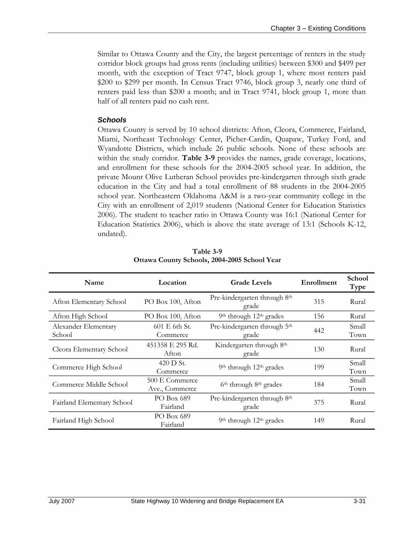
Chapter 3 – Existing Conditions
Similar to Ottawa County and the City, the largest percentage of renters in the study corridor block groups had gross rents (including utilities) between $300 and $499 per month, with the exception of Tract 9747, block group 1, where most renters paid $200 to $299 per month. In Census Tract 9746, block group 3, nearly one third of renters paid less than $200 a month; and in Tract 9741, block group 1, more than half of all renters paid no cash rent.
Schools Ottawa County is served by 10 school districts: Afton, Cleora, Commerce, Fairland, Miami, Northeast Technology Center, Picher-Cardin, Quapaw, Turkey Ford, and Wyandotte Districts, which include 26 public schools. None of these schools are within the study corridor. Table 3-9 provides the names, grade coverage, locations, and enrollment for these schools for the 2004-2005 school year. In addition, the private Mount Olive Lutheran School provides pre-kindergarten through sixth grade education in the City and had a total enrollment of 88 students in the 2004-2005 school year. Northeastern Oklahoma A&M is a two-year community college in the City with an enrollment of 2,019 students (National Center for Education Statistics 2006). The student to teacher ratio in Ottawa County was 16:1 (National Center for Education Statistics 2006), which is above the state average of 13:1 (Schools K-12, undated).
Table 3-9 Ottawa County Schools, 2004-2005 School Year
Name Location Grade Levels Enrollment School Type
Afton Elementary School PO Box 100, Afton Pre-kindergarten through 8th grade 315 Rural
Afton High School PO Box 100, Afton 9th through 12th grades 156 Rural Alexander Elementary School
601 E 6th St. Commerce
Pre-kindergarten through 5th grade 442 Small
Town
Cleora Elementary School 451358 E 295 Rd. Afton
Kindergarten through 8th grade 130 Rural
Commerce High School 420 D St. Commerce 9th through 12th grades 199 Small
Town
Commerce Middle School 500 E Commerce Ave., Commerce 6th through 8th grades 184 Small
Town
Fairland Elementary School PO Box 689 Fairland
Pre-kindergarten through 8th grade 375 Rural
Fairland High School PO Box 689 Fairland 9th through 12th grades 149 Rural
July 2007 State Highway 10 Widening and Bridge Replacement EA 3-31

Chapter 3 – Existing Conditions
Table 3-9 Ottawa County Schools, 2004-2005 School Year (continued)
Name Location Grade Levels Enrollment School Type
Kindergarten Center 319 A St. SW, Miami
Pre-kindergarten through kindergarten 188 Small
Town
Miami High School 2000 E Central Ave. Miami 9th through 12th grades 703 Small
Town
Nichols Elementary School 504 14th Ave. NW Miami
Kindergarten through 5th grade 315 Rural
Picher-Cardin Elementary School PO Box 280, Picher Pre-kindergarten through 6th
grade 228 Rural
Picher-Cardin High School PO Box 280, Picher 9th through 12th grades 120 Rural Picher-Cardin Junior High School PO Box 280, Picher 7th and 8th grades 94 Rural
Quapaw Elementary School 305 W 1st St. Quapaw
Pre-kindergarten through 5th grade 310 Rural
Quapaw High School 305 W 1st St. Quapaw 9th through 12th grades 188 Rural
Quapaw Middle School 305 W 1st St. Quapaw 6th through 8th grades 158 Rural
Rockdale Elementary School 2116 Rockdale Blvd., Miami 1st through 5th grades 99 Small
Town Roosevelt Elementary School
130 A St. NE Miami
Kindergarten through 5th grade 227 Small
Town Turkey Ford Elementary School
23900 S 670 Rd. Wyandott
Pre-kindergarten through 6th grade 107 Rural
Washington Elementary School
1930 B ST NE Miami
Kindergarten through 5th grade 187 Small
Town
Will Rogers Middle School 504 Goodrich Blvd. Miami 6th through 8th grades 599 Rural
Wilson Elementary School 308 G St. NW Miami 1st through 5th Grades 188 Small
Town Wyandotte Elementary School
PO Box 360 Wyandott
Kindergarten through 5th grade 321 Rural
Wyandotte High School PO Box 360 Wyandott 9th through 12th grades 257 Rural
Wyandotte Middle School PO Box 360 Wyandott 6th through 8th grades 193 Rural
Source: National Center for Education Statistics 2006
Employment Between 1990 and 2005, the labor force in Ottawa County increased by less than employment (about 21 percent versus about 26 percent), resulting in reduced unemployment (Bureau of Labor Statistics 2006). In Ottawa County in 2004, the government sector employed 2,638 people, the largest portion of the labor force,
July 2007 State Highway 10 Widening and Bridge Replacement EA 3-32

Chapter 3 – Existing Conditions
most of whom (1,780 employees) were employed in local government. This sector is followed by retail trade (1,663 employees), manufacturing (1,638 employees), and services (1,125 employees). In Ottawa County between 1990 and 2000, the wholesale trade sector grew the most (by approximately 91 percent), and employment in state government declined by the greatest percentage (about -13 percent) (Bureau of Economic Analysis 2006a). Between 2001 and 2004, during which time businesses began classification under the North American Industry Classification System, almost all reporting sectors experienced a decline, except for the local government sector, which increased by almost 9 percent. The greatest decline was in the wholesale trade sector (-10 percent) (Bureau of Economic Analysis 2006b).
Census 2000 data is the most recent information available for the City and the Census Tracts in which the study corridor is located. In 2000, educational, health, and social services (1,595 employees) and manufacturing (1,124 employees) employed the most residents in the City and in the study corridor Census tracts (US Census Bureau 1990, 2000).
Occupations that are forecast to experience the largest percentage growth within the northeastern Oklahoma labor market area between 2002 and 2012 include sales representatives, wholesale and manufacturing (except technical and scientific products), medical assistants, police and sheriff patrol officers, social and human service assistants, and first-line supervisors/managers of fire fighting and prevention workers. Occupations with the greatest employment include retail salespersons, general office clerks, cashiers, heavy equipment and tractor-trailer truck drivers, general and operations managers, waiters and waitresses, and freight and stock laborers. Occupations in which employment is projected to decline by more than 15 percent include word processors and typists, computer operators, procurement clerks, utility meter readers, and loan interviewers and clerks. Positions with the greatest number of openings are cashiers and retail salespersons (Oklahoma Employment Security Commission 2006).
Income As shown on Figure 3-6, per capita income in Ottawa County ($22,167) is lower than the state average ($27,840). Between 1990 and 2004, per capita income in Ottawa County increased gradually at an uneven rate. Growth was relatively flat (0.8 percent) in Ottawa County between 1997 and 1998, during which time growth at the state level was five percent. Annual per capita income growth for the state in general was higher overall from 1990 to 2004 than for Ottawa County; however, Oklahoma experienced a decline in growth from 2001 to 2002 (-0.6 percent) and lower growth than Ottawa County between 1990 and 1991, 1998 and 1999, 2002 and 2003, and 2003 and 2004. Since 1990, per capita income increased by less than the state average of 72 percent, with a 63-percent increase in Ottawa County (Bureau of Economic Analysis 2006c). In 1999, the average income per capita for the Census Tracts within
July 2007 State Highway 10 Widening and Bridge Replacement EA 3-33
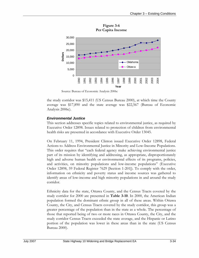
Chapter 3 – Existing Conditions
Figure 3-6 Per Capita Income
0
5,000
10,000
15,000
20,000
25,000
30,000
1990
1991
1992
1993
1994
1995
1996
1997
1998
1999
2000
2001
2002
2003
2004
Year
Dol
lars
Oklahoma
Ottaw a
Source: Bureau of Economic Analysis 2006c
the study corridor was $15,411 (US Census Bureau 2000), at which time the County average was $17,890 and the state average was $22,567 (Bureau of Economic Analysis 2006c).
Environmental Justice This section addresses specific topics related to environmental justice, as required by Executive Order 12898. Issues related to protection of children from environmental health risks are presented in accordance with Executive Order 13045.
On February 11, 1994, President Clinton issued Executive Order 12898, Federal Actions to Address Environmental Justice in Minority and Low-Income Populations. This order requires that “each federal agency make achieving environmental justice part of its mission by identifying and addressing, as appropriate, disproportionately high and adverse human health or environmental effects of its programs, policies, and activities, on minority populations and low-income populations” (Executive Order 12898, 59 Federal Register 7629 [Section 1-201]). To comply with the order, information on ethnicity and poverty status and income sources was gathered to identify areas of low-income and high minority populations in and around the study corridor.
Ethnicity data for the state, Ottawa County, and the Census Tracts covered by the study corridor for 2000 are presented in Table 3-10. In 2000, the American Indian population formed the dominant ethnic group in all of these areas. Within Ottawa County, the City, and Census Tracts covered by the study corridor, this group was a greater percentage of the population than in the state as a whole. The percentage of those that reported being of two or more races in Ottawa County, the City, and the study corridor Census Tracts exceeded the state average, and the Hispanic or Latino portion of the population was lower in these areas than in the state (US Census Bureau 2000).
July 2007 State Highway 10 Widening and Bridge Replacement EA 3-34

Chapter 3 – Existing Conditions
Table 3-10 Population Percentage by Race/Ethnicity
Race/Ethnicity OklahomaOttawa County
City of Miami
Study Corridor Census Tracts
White 76.2 74.1 75.4 74.7 Black or African American 7.6 0.6 1.2 0.9 American Indian and Alaska Native 7.9 16.5 15.3 16.4 Asian 1.4 0.3 0.5 0.3 Native Hawaiian and Other Pacific Islander 0.1 0.1 0.2 0.2 Some other race 2.4 1.5 0.9 0.6 Two or more races 4.5 6.8 6.5 6.8 Hispanic or Latino 5.2 3.2 2.3 1.8 Source: US Census Bureau 2000 Note: Percentages for a given area for a given year do not total 100 because Hispanic is an ethnicity category, which includes all races.
The FHWA uses the US Department of Health and Human Services poverty guidelines to determine whether a household is considered low income. The poverty guidelines are issued each year in the Federal Register and are based on the US Census poverty thresholds. For example, in 1999 (the year for which Census 2000 income levels are calculated), the average estimated poverty guideline for an individual was an annual income of $8,240 or less, and for each additional person, an additional $2,820 was added. For a four-person household, the US Department of Health and Human Services poverty guideline was $16,700 or less (US Department of Health and Human Services 2005). According to US Census 2000 estimates, the percentage of the populations of Ottawa County and the City at income levels below the poverty threshold was higher than the state average of 15 percent, at 17 and 19 percent, respectively. The average poverty level in the study corridor Census Tracts was similar to the state average at 15 percent (US Census Bureau 2000).
Executive Order 13045, Protection of Children from Environmental Health Risks and Safety Risks (62 Federal Register 19885), states that each federal agency shall make it a high priority to identify and assess environmental health and safety risks that may disproportionately affect children. The agency also must ensure that its policies, programs, activities, and standards address disproportionate risks to children that result from environmental health or safety risks, which are those attributable to products or substances that children are likely to come into contact with or to ingest.
Approximately 26 percent of Ottawa County, 24 percent of the City, and 25 percent of the study corridor Census Tracts was made up of children (less than 18 years of age) (US Census Bureau 2000). A day care facility along South 580 Road within 1,000 feet of the north side of SH-10 is an area where children could be affected and where safety issues, particularly during construction, could occur.
July 2007 State Highway 10 Widening and Bridge Replacement EA 3-35
Chapter 3 – Existing Conditions
3.18 TRAFFIC Law, regulation, and guidance applicable to traffic include policies developed by FHWA, ODOT, and the City; the FHWA 2003 edition of the Manual of Uniform Traffic Control Devices; the American Association of State Highway and Transportation Officials 2004 Geometric Design of Highways and Streets; and the Transportation Research Board 2000 Highway Capacity Manual.
The study corridor consists of a two-lane concrete roadway under the jurisdiction of ODOT. The roadway is classified as a rural minor arterial where it is closer to Interstate 44 and as a rural collector one mile east of Interstate 44.
The study corridor contains a two-lane roadway with level (flat) grades and a posted speed limit varying between 45 and 55 miles per hour (mph). At the SH-10 entrance to Interstate 44 traveling east for 0.1 mile, the posted speed limit on SH-10 is 45 mph. From 0.1 mile east of the SH-10 entrance to Interstate 44, the posted speed limit on SH-10 increases to 50 mph, and continues for 0.7 mile east. At this point (0.8 miles east of the entrance to Interstate 44), the posted speed limit on SH-10 increases to 55 mph, and continues east to 0.5-mile east of the SH-10/SH-137 intersection. The posted speed limit on SH-137 to the north and south of the SH-10 intersection is 55 mph. The speed limit on the three county roads (South 580 Road, South 590 Road, and South 600 Road) north and south of their intersections with SH-10 is an unposted 45 mph (Ruse 2006).
Based on information obtained from ODOT, the current Average Annual Daily Traffic on SH-10 is approximately 12,000 vehicles per day (ODOT, undated). Within the study corridor, there are numerous nonsignalized intersections formed by cross streets and private driveways. There does not appear to be any roadway drainage structures within the study corridor. In addition, the roadway does not have any street lights for nighttime illumination. There are no sidewalks adjacent to the roadway within the study corridor. A guardrail is provided along the edge of the roadway in the vicinity of Interstate 44.
3.19 SECTION 4(F) RESOURCES Section 4(f) of the Department of Transportation Act of 1966, as amended (49 US Code 303) protects publicly owned parks and recreation areas, wildlife and waterfowl refuges, and eligible historic sites regardless of ownership. Section 4(f) requires that impacts on these sites resulting from a proposed project must be avoided if there are feasible and prudent alternative courses of action. If avoidance is not feasible and prudent, then all possible planning to minimize harm to these sites must be included in the project.
Based on a review of topographic maps, aerial photographs, the ODWC Digital Wildlife Management Areas Atlas (ODWC 2006a), the City Web site (Miami, Oklahoma 2006), and the cultural resources study undertaken in support of this project (Appendix E), there are not any publicly owned parks or recreation areas or wildlife or waterfowl refuges, nor are there any NRHP-eligible or NRHP-listed historic sites within the study corridor.
July 2007 State Highway 10 Widening and Bridge Replacement EA 3-36

4. ENVIRONMENTAL CONSEQUENCES
July 2007 State Highway 10 Widening and Bridge Replacement EA 4-1

July 2007 State Highway 10 Widening and Bridge Replacement EA 4-2
CHAPTER 4 ENVIRONMENTAL CONSEQUENCES
4.1 INTRODUCTION This chapter is an evaluation of the potential environmental effects of the alternatives, including the No Build Alternative (Alternative C). This analysis includes likely beneficial and adverse effects on the human environment, including short-term and long-term effects, direct and indirect effects, and cumulative effects. The analysis of effects on resources focuses on environmental issues in proportion to their potential effects. Detailed consideration is given to those resources that have a potential for environmental effects. Interpretation of effects in terms of their duration, intensity, and scale are provided where possible. Table 4-1 shows the summary of environmental consequences of alternatives that were considered for detailed analysis. Each evaluation category was compared relatively to the other alternative. The No Build (or No Action) Alternative was not considered in this analysis. Therefore, each category could have positive or negative effects relative to the other alternative. If each alternative would have relatively the same effects, they were considered neutral. This matrix helped determine which alternative would be preferable based on the total effects score.
4.1.1 Cumulative Effects Analysis Cumulative effects are the direct and indirect effects of a proposed project alternative’s incremental effects when they are added to other past, present, and reasonably foreseeable actions, regardless of who carries out the action (40 CFR Part 1508.7). Guidance for implementing NEPA recommends that federal agencies identify the temporal and geographic boundaries of the potential cumulative effects of a proposed action (Council on Environmental Quality 1997). For the purposes of this EA, the period of analysis is from 2005 to 2030, which encompasses a range within which data are reasonably available and forecasts can be reasonably made.
July 2007 State Highway 10 Widening and Bridge Replacement EA 4-1

Chapter 4 – Environmental Consequences
Table 4-1 Summary of Environmental Consequences of Alternatives
Considered for Detailed Analysis
Scoring 1: Relatively Positive Effects
Relatively Neutral Effects Relatively Negative Effects
ALTERNATIVE A1 ALTERNATIVE B1 ALTERNATIVE B3
Relative Effects Scoring
Notes Relative Effects Scoring
Notes Relative Effects Scoring
Notes
Environmental Considerations
Land Use
No conflicts with land use plans. Short-term negative comprehensive access impacts due to detours and bridge closures; long-term impacts include more parcels because of widening on both north and south sides.
No conflicts with land use plans. Short-term negative comprehensive access impacts; long-term impacts include fewer parcels because of more widening on south side.
No conflicts with land use plans. Short-term negative comprehensive access impacts; long-term impacts include more parcels because of widening on both north and south sides.
Relocation: Residential
10 potential relocations including 4 on the right-of-way edge. Vacant land available for relocation.
14 potential relocations including 9 on the right-of-way edge. Vacant land available for relocation.
14 potential relocations including 5 on the right-of-way edge. Vacant land available for relocation.
Relocation: Business
11 potential relocations including 7 on the right-of-way edge. Vacant land available for relocation.
11 potential relocations including 5 on the right-of-way edge. Vacant land available for relocation.
12 potential relocations including 2 on the right-of-way edge. Vacant land available for relocation.
Geology and Soils
Least erodible and prime farmland soils disturbed.
More soil disturbed, so an increased potential for erosion.
Most erodible and prime farmland soils disturbed.
Water Resources
Short-term effects during construction in and around Little Elm Creek and the unnamed creek would have water quality impacts. Appropriate permits incorporating water quality protection measures would need to be obtained for these two locations.
Short-term effects during construction in and around Little Elm Creek and the unnamed creek would have water quality impacts. Appropriate permits incorporating water quality protection measures would need to be obtained for these two locations.
Short-term effects during construction in and around Little Elm Creek and the unnamed creek would have water quality impacts. Appropriate permits incorporating water quality protection measures would need to be obtained for these two locations.
July 2007 State Highway 10 Widening and Bridge Replacement EA 4-2

Chapter 4 – Environmental Consequences
Table 4-1
Summary of Environmental Consequences of Alternatives Considered for Detailed Analysis (continued)
ALTERNATIVE A1 ALTERNATIVE B1 ALTERNATIVE B3
Relative Effects Scoring
Notes Relative Effects Scoring
Notes Relative Effects Scoring
Notes
Designated Floodplains
Localized effects at load posted bridges. To maintain traffic during construction (short-term effects), bridges would be closed, and fill material to construct detours would be required.
Localized effects at load-posted bridge locations only. Bridges could be constructed offset without fill in channel.
Localized effects at load-posted bridge locations only. Bridges could be constructed offset without fill in channel.
Potential Jurisdictional Wetland Sites
13 potential locations in right-of-way. Two waterways (not wetlands) would likely be impacted (bridge reconstruction).
11 potential locations. Two waterways (not wetlands) would likely be impacted (bridge reconstruction).
11 potential locations. Two waterways (not wetlands) would likely be impacted (bridge reconstruction).
Vegetation
29 acres of permanent vegetation loss to pavement. 83 acres of potential vegetation type conversion in unpaved right-of-way.
29 acres of permanent vegetation loss to pavement. 89 acres of potential vegetation type conversion in unpaved right-of-way.
29 acres of permanent vegetation loss to pavement. 89 acres of potential vegetation type conversion in unpaved right-of-way.
Wildlife and Fisheries
29 acres of permanent habitat loss to pavement. 83 acres of potential habitat type conversion in unpaved right-of-way.
29 acres of permanent habitat loss to pavement. 89 acres of potential habitat type conversion in unpaved right-of-way.
29 acres of permanent habitat loss to pavement. 89 acres of potential habitat type conversion in unpaved right-of-way.
Threatened and Endangered Species
No effect on winged mapleleaf mussel, bald eagle, Neosho madtom, Ozark cavefish, piping plover, Neosho mucket, or Arkansas darter. Unlikely to adversely affect the American burying beetle, gray bat, and Ozark big-eared bat.
No effect on winged mapleleaf mussel, bald eagle, Neosho madtom, Ozark cavefish, piping plover, Neosho mucket, or Arkansas darter. Unlikely to adversely affect the American burying beetle, gray bat, and Ozark big-eared bat.
No effect on winged mapleleaf mussel, bald eagle, Neosho madtom, Ozark cavefish, piping plover, Neosho mucket, or Arkansas darter. Unlikely to adversely affect the American burying beetle, gray bat, and Ozark big-eared bat.
July 2007 State Highway 10 Widening and Bridge Replacement EA 4-3

Chapter 4 – Environmental Consequences
July 2007 State Highway 10 Widening and Bridge Replacement EA 4-4
Table 4-1 Summary of Environmental Consequences of Alternatives
Considered for Detailed Analysis (continued) ALTERNATIVE A1 ALTERNATIVE B1 ALTERNATIVE B3
Relative Effects Scoring
Notes Relative Effects Scoring
Notes Relative Effects Scoring
Notes
Cultural Resources
No NRHP-eligible sites. New alignment/pavement under Alternative A1 would be closest to Glen Abbey Memorial Gardens cemetery; however, right-of-way would not encroach within the cemetery boundaries.
No NRHP-eligible sites. New alignment/pavement under Alternatives B1 and B3 would be farthest from Glen Abbey Memorial Gardens cemetery. Right-of-way would not encroach within the cemetery boundaries.
No NRHP-eligible sites. New alignment/pavement under Alternatives B1 and B3 would be the farthest from Glen Abbey Memorial Gardens cemetery. Right-of-way would not encroach within the cemetery boundaries.
Native American Resources
No known Native American resources, so no impacts expected.
No known Native American resources, so no impacts expected.
No known Native American resources, so no impacts expected.
Hazardous and Toxic Materials and Waste
EDR report identified no active or unremediated hazardous waste sites of concern within a 1-mile radius of study corridor.
EDR report identified no active or unremediated hazardous waste sites of concern within a 1-mile radius of study corridor.
EDR report identified no active or unremediated hazardous waste sites of concern within a 1-mile radius of study corridor.
Visual Resources
No conflicts with local regulations. No sensitive receptors. Short-term negative effects. Long-term positive effects.
No conflicts with local regulations. No sensitive receptors. Short-term negative effects. Long-term positive effects.
No conflicts with local regulations. No sensitive receptors. Short-term negative effects. Long-term positive effects.
Air Quality Not expected to result in nonattainment.
Not expected to result in nonattainment.
Not expected to result in nonattainment.
Noise
Total of 34 structures affected based on existing centerline. 21 are potential relocations; if all are relocated, then 13 structures would be affected.
Total of 34 structures affected based on existing centerline. 23 are potential relocations; if all are relocated, then 11 structures would be affected.
Total of 34 structures affected based on existing centerline. 22 are potential relocations if all are relocated, then 12 structures would be affected.
Traffic
Short-term negative construction impacts on traffic. Increased long-term capacity and improved operations.
Short-term negative construction impacts on traffic. Increased long-term capacity and improved operations.
Short-term negative construction impacts on traffic. Increased long-term capacity and improved operations.

Chapter 4 – Environmental Consequences
July 2007 State Highway 10 Widening and Bridge Replacement EA 4-5
Table 4-1 Summary of Environmental Consequences of Alternatives
Considered for Detailed Analysis (continued) ALTERNATIVE A1 ALTERNATIVE B1 ALTERNATIVE B3
Relative Effects Scoring
Notes Relative Effects Scoring
Notes Relative Effects Scoring
Notes
Section 4(f) Resources
There are no 4(f) resources within corridor.
There are no 4(f) resources within corridor.
There are no 4(f) resources within corridor.
Socioeconomics & Environmental Justice
Fewer residences (potential of 10 total) affected could result in increased potential for adverse effects to low-income or minority populations.
The most residences (potential of 14 total) affected could result in increased potential for adverse effects to low-income or minority populations.
More residences (potential of 12 total) affected could result in increased potential for adverse effects to low-income or minority populations.
Engineering Considerations
Topographic Considerations
Minimal cut/fill sections would be required because right-of-way would be symmetrical to existing alignment.
Additional cut sections would be required, resulting in additional distance for toe of slopes and additional right-of-way.
Additional cut sections would be required, resulting in additional distance for toe of slopes and additional right-of-way.
Utility Conflicts
Short-term negative construction impacts on traffic. Additional widening necessary to maintain traffic flow during construction would negatively impact the power substation.
Short-term negative construction impacts on traffic. No impacts to power substation. Minimal impacts to utility corridor within right-of-way.
Short-term negative construction impacts on traffic. No impacts to power substation. Minimal impacts to utility corridor within right-of-way.
Constructability Considerations
Symmetrical alignment would be more difficult to construct/maintain. Would result in negative short-term traffic closures (full detours) during construction.
Offset alignment would provide better short-term traffic access and maintenance during construction (fewer detour lanes would be necessary).
Offset alignment would provide better short-term traffic access and maintenance during construction (fewer detour lanes would be necessary).
Probable Cost
Costs would be increased because of additional right-of-way needs to accommodate detours during construction.
Costs would be lower because of less right-of-way needs to accommodate detours during construction. There would be less cost associated with bridge construction because
Costs would be lower because of less right-of-way needs to accommodate detours during construction. There would be less cost associated with bridge construction
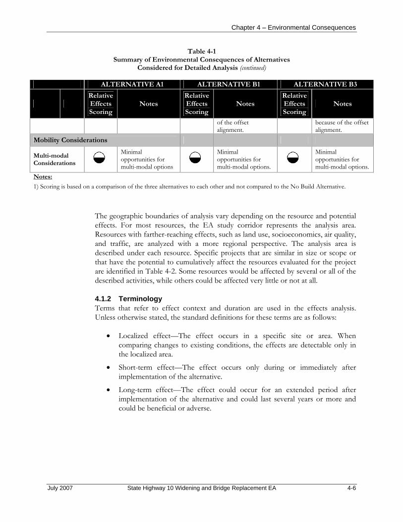
Chapter 4 – Environmental Consequences
July 2007 State Highway 10 Widening and Bridge Replacement EA 4-6
Table 4-1 Summary of Environmental Consequences of Alternatives
Considered for Detailed Analysis (continued) ALTERNATIVE A1 ALTERNATIVE B1 ALTERNATIVE B3
Relative Effects Scoring
Notes Relative Effects Scoring
Notes Relative Effects Scoring
Notes
of the offset alignment.
because of the offset alignment.
Mobility Considerations
Multi-modal Considerations
Minimal opportunities for multi-modal options
Minimal opportunities for multi-modal options.
Minimal opportunities for multi-modal options.
Notes: 1) Scoring is based on a comparison of the three alternatives to each other and not compared to the No Build Alternative.
The geographic boundaries of analysis vary depending on the resource and potential effects. For most resources, the EA study corridor represents the analysis area. Resources with farther-reaching effects, such as land use, socioeconomics, air quality, and traffic, are analyzed with a more regional perspective. The analysis area is described under each resource. Specific projects that are similar in size or scope or that have the potential to cumulatively affect the resources evaluated for the project are identified in Table 4-2. Some resources would be affected by several or all of the described activities, while others could be affected very little or not at all.
4.1.2 Terminology Terms that refer to effect context and duration are used in the effects analysis. Unless otherwise stated, the standard definitions for these terms are as follows:
• Localized effect—The effect occurs in a specific site or area. When comparing changes to existing conditions, the effects are detectable only in the localized area.
• Short-term effect—The effect occurs only during or immediately after implementation of the alternative.
• Long-term effect—The effect could occur for an extended period after implementation of the alternative and could last several years or more and could be beneficial or adverse.

Chapter 4 – Environmental Consequences
Table 4-2
Past, Present, and Reasonably Foreseeable Activities Considered in the Cumulative Effects Analysis
Cumulative Action Project Description Past Present Future
High Winds Casino (Ottawa Tribe)
Construction of the High Winds Casino at the southeast intersection of SH-10 and SH-137 X
42-acre development (City of Miami)
Proposed construction of a 42-acre commercial development at the northeast intersection of Interstate 44 and SH-10, including a motel, convenience store, truck stop, and recreational vehicle park
X
Alternate entrance to High Winds Casino (Ottawa Tribe)
Proposed construction of an alternate entrance to High Winds Casino off of SH-137 south of SH-10.
X
Peoria Pow Wow Grounds Roads Project, East 90 Road (Bureau of Indian Affairs, Eastern Oklahoma Region, Miami Agency)
Proposed construction along East 90 Road between South 580 Road and SH-137
X
High Winds Casino expansion (Ottawa Tribe)
Proposed expansion of the High Winds Casino at the southeast intersection of SH-10 and SH-137, including a hotel and conference center, fire station, convenience store and fuel shop, smoke shop, 20-acre campground, amphitheater, and parking
X
Buffalo Run Casino (Peoria Tribe)
Construction of the Buffalo Run Casino, half a mile north of the Interstate 44/Highway 69A junction
X
Traffic light at Highway 69A and Buffalo Run Casino (Peoria Tribe)
Proposed construction of a traffic light at the intersection of Highway 69A and the Buffalo Run Casino entrance (ASCG Incorporated of New Mexico 2006)
X
New utilities along SH-10 (City of Miami)
Proposed construction of new water, sewer, and power lines within the SH-10 EA study corridor
X
Oklahoma Department of Transportation
Proposed bridge replacement on SH-137 over unnamed creek, four miles north of US 60 (2014 construction)
X
Oklahoma Department of Transportation
Proposed bridge redecking on SH-10 over Spring River (2014 construction)
X
Oklahoma Department of Transportation
Proposed bridge redecking on SH-10 over Spring River overflow (2014 construction)
X
July 2007 State Highway 10 Widening and Bridge Replacement EA 4-7

Chapter 4 – Environmental Consequences
4.2 LAND USE
4.2.1 Impact Methodology The effects of each alternative on land use were evaluated by identifying the established residences, businesses, farms, schools, parks and community services, public lands, open space, and utilities within each alternative’s right-of-way, as well as the presence of planned developments within each alternative’s right-of-way. The relative impact of each alternative was estimated based on the number, area, or length of each of these elements that fell within each right-of-way. A less extensive presence of the aforementioned land use elements would result in a lower level of impact. No comprehensive planning documents or zoning regulations would restrict development along SH-10 in unincorporated Ottawa County; however, the extent of changes in land use within each right-of-way were compared against the City zoning at the western terminus of the proposed project.
4.2.2 Alternative A1
Direct and Indirect Effects The expansion of SH-10 is consistent with adopted land use plans and zoning regulations. The comprehensive plan for the City supports the expansion (Ruse 2007), which is consistent with the City’s zoning regulations, although only a short segment on the west end of the SH-10 corridor lies within City limits. No comprehensive plan or zoning regulations exist for Ottawa County, so any development that occurs as a result of the project would not conflict with either City or county land use plans or zoning regulations. Access to industrial, commercial, and residential areas along the SH-10 study corridor would improve as a long-term result of the project. Improved access could have an indirect effect on land use by inducing development along SH-10. Short-term disruptions to businesses or residents from construction would be reduced to not significant by implementing the mitigation measures described below.
Multiple utilities are within the study corridor footprint of the project (Figure 3-1) and would be affected by Alternative A1. Utility lines occur on both the north and south sides of SH-10, and also cross the roadway at various points including along county roads. Utilities on both sides of SH-10 would be equally affected by Alternative A1 since the widening would be symmetrical (equal widening north and south of the existing centerline).
Oklahoma Natural Gas pipelines extend along about half the length of SH-10 within the project limits and along the county roads that intersect SH-10. Cable One and Qwest fiber optic and cable lines also extend along portions of SH-10 and intersect it along county roads at several points. Electrical lines in the corridor would also be affected, primarily those belonging to the Northeast Oklahoma Electric Cooperative. Those lines extend from South 580 Road to SH-137, which is almost the entire length of the SH-10 study corridor. Grand River Dam Authority electrical lines would be less affected because they are not as extensive in the corridor. Since
July 2007 State Highway 10 Widening and Bridge Replacement EA 4-8

Chapter 4 – Environmental Consequences
Oklahoma Electric Cooperative lines and Grand River Dam Authority lines connect to KAMO power lines outside of the study corridor, any interruptions in power due to relocation could affect KAMO. In addition, both the Northeast Oklahoma Electric Cooperative and Grand River Dam Authority have structures in the study area that could be affected by SH-10 expansion, depending on final design. The East Miami power substation located at the northwest corner of SH-10 and South 600 Road, and owned by the Northeast Oklahoma Electric Cooperative, would be encroached upon by the proposed SH-10 expansion under this alternative because of additional widening necessary to maintain traffic flow during construction. Empire District Electric Company Lines extend along SH-10 just west of SH-137 and along SH-137 north of SH-10. Ottawa County Rural Water District water lines are also present in the study corridor and would likely be affected by the project.
The effects on utilities would be short term during construction and would be reduced to not significant by implementing the mitigation measures described below. In addition, since some relocation of, and improvements to, utilities in the SH-10 study corridor are planned by the City (see Section 4.2.5, Cumulative Effects, below), the long-term effects on utilities from the project would be beneficial since those relocations and improvements could occur in conjunction with the SH-10 improvements (Ruse 2007).
There are no airports, pedestrian or bicycle paths, or public lands or parklands in the study corridor, so there would be no effects on any of these features. New alignment/pavement under Alternative A1 would be closest to Glen Abbey Memorial Gardens cemetery; however, right-of-way would not encroach within the cemetery boundaries.
Mitigation Short-term disruptions to businesses or residents from construction will be reduced to not significant by notifying property owners in advance of any project activities that would affect them. Signs will be provided to alert motorists to detours and delays.
Relocation plans will be prepared and approved prior to utility relocations, and will be coordinated with utility owners and customers in the study corridor. If disruption of services is anticipated, affected customers will be notified and the duration of the interrupted services will be limited to short periods.
4.2.3 Alternative B1
Direct and Indirect Effects The effects on land use from Alternative B1 are similar to those of Alternative A1 because the footprint is largely the same, except that more widening occurs to the south of the existing centerline of SH-10. Utility lines and structures on the south side of SH-10 would be affected more than on the north side under Alternative B1. The East Miami power substation would not be affected under Alternative B1. New
July 2007 State Highway 10 Widening and Bridge Replacement EA 4-9
Chapter 4 – Environmental Consequences
alignment/pavement under Alternative B1 would be farther from the Glen Abbey Memorial Gardens cemetery than that under Alternative A1. Alternative B1’s right-of-way would not encroach within the cemetery boundaries.
Mitigation Mitigation measures will generally be the same as for Alternative A1.
4.2.4 Alternative B3
Direct and Indirect Effects The effects on land use from Alternative B3 are similar to those of Alternative A1 and B1 because the footprint is largely the same, with a combination of symmetrical and non-symmetrical widening. Like alternative B1, the East Miami power substation would not be affected under Alternative B3. Also like Alternative B1, the new alignment/pavement under Alternative B1 would be farther from the Glen Abbey Memorial Gardens cemetery than that under Alternative A1. Alternative B3’s right-of-way would not encroach within the cemetery boundaries. Alternative B3 would impact the cemetery and power substation the least of all alternatives by offsetting the alignment the farthest to the south.
Mitigation Mitigation measures will generally be the same as for Alternative A1.
4.2.5 Alternative C
Direct and Indirect Effects No effects on land use would occur if Alternative C, the No Build Alternative, were implemented. SH-10 would not be widened, but the bridges over Little Elm Creek and an unnamed creek would be reconstructed. Effects on utilities would be limited to those associated with bridge reconstruction.
Mitigation Mitigation measures for effects from the bridge reconstructions will be the same as for the other alternatives.
4.2.6 Cumulative Effects The cumulative effects analysis area is Ottawa County. Several commercial development or expansion projects are planned for the SH-10 study corridor, all of which would affect land use in the area. The expansion of SH-10 would facilitate this development and could promote additional development.
These planned projects would affect utilities, as would implementation of any of the alternatives for SH-10, although the fewest effects on utilities would occur with the implementation of Alternative C. Utility improvements along SH-10 are planned by the City regardless of the implementation of other projects. The cumulative effects on utilities would be beneficial.
July 2007 State Highway 10 Widening and Bridge Replacement EA 4-10

Chapter 4 – Environmental Consequences
There are no airports, pedestrian or bicycle paths, public lands or parklands in the study corridor, so there would be no cumulative effects on any of these features from any of the alternatives.
4.3 RELOCATION
4.3.1 Impact Methodology The number of residences and businesses within the right-of-way of each alternative was determined using GIS mapping of the structures within the study corridor and overlaying the footprint of the right-of-way of each alternative. The location of residences and businesses was compiled using aerial photography, a cursory windshield survey of properties visible from SH-10, and Ottawa County Assessor’s data.
The residences and businesses that fall within an alternative’s right-of-way could need to be acquired and relocated. Due to the preliminary nature of the project, estimated right-of-way widths are subject to change as final design plans are developed, and the final alignment would be designed to minimize the number of relocations that would be required. The necessity to relocate a particular residence or business would be determined by the final alignment location and design. Relocation for federal and federally assisted projects must comply with the Uniform Relocation Assistance and Real Property Acquisition Policy Act of 1970, as amended (49 CFR Part 24, Uniform Act, 42 US Code 4601-4655, as amended by Public Law 105-117), which provides relocation assistance (advisory services and compensation) for businesses, farms, nonprofit organizations, and residents. In addition, the US Department of Housing and Urban Development requires that comparable decent, safe, and sanitary replacement housing within a person’s financial means be made available before that person may be displaced. When such housing cannot be provided through the use of replacement housing payments, the URA provides for “housing of last resort” (49 CFR 24.404). This may involve replacement housing payments that exceed the URA maximum amounts or other methods of providing the appropriate housing (US Department of Housing and Urban Development 2005).
4.3.2 Alternative A1
Direct and Indirect Effects Permanent right-of-way acquisition for expanding SH-10 under Alternative A1 is estimated at 122 acres, which would affect business, commercial, institutional, and residential properties. Acquisitions could result in easements or construction of the highway across vacant land and could require relocating structures that could not be avoided. The extent of the effects cannot be established until the final alignment is determined and final design plans are developed. However, for Alternative A1, preliminary estimates show that 21 structures are within the right-of-way of Alternative A1 and, therefore, could require relocation, including 11 businesses and 10 residences. Of those 21 potentially affected structures, 11 are on the edge of the
July 2007 State Highway 10 Widening and Bridge Replacement EA 4-11
Chapter 4 – Environmental Consequences
right-of-way, 7 of which are businesses and 4 of which are residences. The potentially affected businesses include the East Miami power substation, which would be encroached upon under this alternative. Although the structure for the Turnpike Chrysler business would be outside the right-of-way of Alternative A1, a majority of its car lot is within the right-of-way and, as such, this business could be affected.
Mitigation The final alignment and design will minimize the number of necessary easements and relocations. The Uniform Relocation Assistance and Real Property Acquisition Policy Act of 1970, as amended, and the other provisions described under Section 4.3.1 above will be used to reduce effects on property owners. Property owners will be compensated for easements or for any structures that must be removed as a result of the project. Displaced residents will be provided with replacement housing or replacement housing payments. Businesses will receive moving assistance to relocate in the Miami area. Property owners will be informed in advance of project activities that could affect them.
4.3.3 Alternative B1
Direct and Indirect Effects Permanent right-of-way acquisition under Alternative B1 is estimated at 128 acres, which is slightly greater than under Alternative A1. More widening would occur to the south of the centerline of SH-10 under Alternative B1, and more structures could require relocation under this alternative. Preliminary estimates show that 25 structures would be within the right-of-way of Alternative B1 and could require relocation, including 11 businesses and 14 residences. These 25 potential relocations include 14 (5 businesses and 9 residences) that are on the edge of the right-of-way. The effects on the Turnpike Chrysler business would be similar to those identified under Alternative A1, but more of the car lot lies within the right-of-way for Alternative B1.
Mitigation Mitigation measures are generally the same as those for Alternative A1.
4.3.4 Alternative B3
Direct and Indirect Effects Permanent right-of-way acquisition under Alternative B3 is estimated at 128 acres, which is slightly greater than under Alternative A1 but the same as Alternative B1. Widening under Alternative B3 would be a combination of symmetrical and non-symmetrical. Preliminary estimates show that 26 structures would be within the right-of-way of Alternative B3 and could require relocation, including 12 businesses and 14 residences. Of those 26 potentially affected structures, 7 (2 businesses and 5 residences) are on the edge of the right-of-way.
July 2007 State Highway 10 Widening and Bridge Replacement EA 4-12

Chapter 4 – Environmental Consequences
This alternative potentially affects more residences and businesses than Alternative A1 or B1; however, Alternative B3 would impact the cemetery and power substation the least of all alternatives by offsetting the alignment the farthest to the south. The effects on the Turnpike Chrysler business would be similar to those identified for Alternative A1, but more of the car lot lies within the right-of-way for Alternative B3 than under Alternatives A1 and B1.
Mitigation Mitigation measures will be generally the same as those for Alternative A1 and B1.
4.3.5 Alternative C
Direct and Indirect Effects No permanent right-of-way acquisition would be required under Alternative C because SH-10 would not be widened and only the bridges over Little Elm Creek and an unnamed creek would be reconstructed.
Mitigation No relocation mitigation will be required under Alternative C.
4.3.6 Cumulative Effects The cumulative effects analysis area is the study corridor. The number of residential relocations could range from as few as 5 to a potential maximum of 14 depending on the final alignment and design chosen for implementation. Business relocations could range from 4 to a potential maximum of 12. Adequate vacant land is available for construction of appropriate housing or business establishments for residents and/or landowners displaced by any of these alternatives. In addition, residential relocations under any of the alternatives could be accommodated by the housing stock in Ottawa County and Miami. Because zoning regulations only apply to a small portion of the western end of the SH-10 corridor, such regulations would not preclude residential or commercial relocations in most of the corridor. Most reasonably foreseeable future projects are commercial, not residential, and are not expected to affect residential housing. Effects on existing commercial enterprises are expected to consist of expansion only and are expected to have positive effects. All relocation effects on residences and businesses in the corridor would be mitigated. Therefore, the cumulative effects on residential housing or businesses from implementation of any of the alternatives are expected to be minimal.
4.4 GEOLOGY AND SOILS
4.4.1 Impact Methodology Ground disturbance during construction may create unstable cut-and-fill slopes, particularly in steep areas and areas underlain by weak rock material. Slope instability would be a short-term localized effect, occurring primarily during construction along high slope areas. In addition to instability, ground disturbance could increase the potential for soil erosion either by runoff or by wind. In some areas, soil erosion
July 2007 State Highway 10 Widening and Bridge Replacement EA 4-13

Chapter 4 – Environmental Consequences
resulting from ground disturbance may create permanent scars on the landscape, and loss of soil may prevent vegetation from becoming established on the disturbed area. Soils with a high shrink-swell potential can cause settling and cracking in roadway surfaces and require appropriate design measures.
The acreage of soils under crop cultivation has been decreasing as more land is used for development (US Department of Agriculture, Soil Conservation Service and US Department of the Interior, Bureau of Indian Affairs 1979). Prime farmland soils are capable of the greatest agricultural productivity. Projects are subject to Farmland Protection Policy Act requirements if they could irreversibly convert farmland (directly or indirectly) to nonagricultural use and are completed by a federal agency or with assistance from a federal agency. A Farmland Conversion Impact Rating Form AD-1006 has been completed in coordination with the NRCS for the proposed SH-10 improvement corridor (Appendix B). The land evaluation and total site assessment were assigned 120 points from a total maximum of 160 points. Guidelines for implementing the Farmland Protection Policy Act (7 CFR 658.4) indicate that sites receiving a total score of less than 160 need not be given further consideration for protection and no additional sites need to be evaluated.
The methods used for assessing the effects of the proposed project on these resources include:
• Gathering topographic data for the study corridor and using GIS to evaluate slope; and
• Using NRCS soil survey data to assess the soil types within the study corridor, determining their physical and chemical characteristics, and evaluating the spatial distribution of highly erodible soils, areas of high shrink-swell potential, and prime farmland soils within the right-of-way of each alternative.
Once this background data was established for the study corridor, acreages of steep slopes (15 percent or greater), highly erodible soils (water erosion K-factor greater than 0.37 and wind and water erosion T-factors of 1 or 2), high shrink-swell potential, and prime farmland soils were compiled for each alternative. A comparison among the alternatives for geology and soils impacts was made based on acreages of sensitive areas disturbed and the number of mining claims/operations affected.
4.4.2 Alternative A1
Direct and Indirect Effects Grading (cut and fill operations) under Alternative A1 could expose construction workers to geologic hazards related to slope instability. Approximately 0.2 percent of the right-of-way for Alternative A1 is characterized by steep slopes, and about 12.3 percent is moderately sloping. Grading cuts are common in roadway projects, and construction workers would follow standard worker safety practices. Cuts would be stabilized as part of the construction process, resulting in an adverse temporary effect.
July 2007 State Highway 10 Widening and Bridge Replacement EA 4-14

Chapter 4 – Environmental Consequences
No unique geological resources were identified within the study corridor. As such, there would be no effects from Alternative A1.
Grading could disturb soils that temporarily would be prone to erosion from wind or precipitation. Within the right-of-way of Alternative A1, 61.4 acres of soil have a high erosion K-factor and could be subject to water erosion where exposed. About 10.4 acres have an erosion T-factor of 1or 2, where there is a high overall erosion potential. The increased potential for erosion within the right-of-way would be temporary and would be minimized by implementing the soil erosion and sedimentation control measures described below. With implementation of standard mitigation measures, residual adverse effects would be reduced and temporary.
Roughly 76.8 acres of soils within the right-of-way of Alternative A1 are characterized as having a shrink-swell potential that could affect the design of the road.
Of prime farmland soils that would be within the right-of-way of Alternative A1, 92.8 acres would be of the following types: Bates loam, 1 to 3 percent slopes; Bates loam, 3 to 5 percent slopes; Craig silt loam, 1 to 3 percent slopes; Dennis silt loam, 1 to 3 percent slopes; Parsons silt loam, 0 to 1 percent slopes; Parsons silt loam, 1 to 3 percent slopes; and Riverton gravelly loam, 3 to 5 percent slopes. These soils would be permanently removed within the footprint of pavement, culverts, berms, other infrastructure, and landscaping. However, most of this area has already been disturbed for the existing alignment of SH-10 and the utilities along this alignment. Other urban development is also present within the study corridor, and the land is not currently under cultivation. The loss of additional acreage of federal prime farmland soils beyond that disturbed by the existing road and associated facilities and additional suburban development would be a permanent adverse effect.
Under Alternative A1, there would be an increase in impermeable surface of 29.0 acres. The linear nature of the proposed project means that surface water runoff generated at any point on the parkway does not have far to travel before reaching permeable soil. During heavy precipitation and adjacent ground saturation, pooling may occur on the sides of the roadway. Pooling would result in delayed water infiltration into soils but not likely in a measurable decrease in overall infiltration. The effect on groundwater infiltration would be adverse in the study corridor.
There are no crushed stone, sand and gravel, or gypsum operations within the right-of-way of Alternative A1.
Under Alternative A1, all effects on geology and soils would not be significant with the implementation of the mitigation measures outlined below.
Mitigation Erosion- and sediment-control measures will be installed and maintained throughout the construction phase of the project, particularly in the vicinity of streams and
July 2007 State Highway 10 Widening and Bridge Replacement EA 4-15

Chapter 4 – Environmental Consequences
wetlands. At a minimum, these measures will involve the use of best management practices for the control of erosion and stormwater runoff and may include a combination of the following:
• Vegetated buffer zones around the construction area and all streams or wetlands;
• Silt fencing around the construction area;
• Stabilization of disturbed ground using mulch, erosion control fabric, or temporary vegetation during construction;
• Restriction of disturbed soil area during construction; or
• The construction of temporary stormwater retention or detention basins during construction and of permanent stormwater retention or detention basins after construction is completed.
4.4.3 Alternative B1
Direct and Indirect Effects Similar to Alternative A1, Alternative B1 could expose construction workers to geologic hazards related to slope instability. Approximately 0.3 percent of the right-of-way for Alternative B1 is characterized by steep slopes, and about 14.6 percent is moderately sloping. Cuts would be stabilized as part of the construction process, resulting in an adverse temporary effect.
No unique geological resources were identified within the study corridor. As such, there would be no effects from Alternative B1.
Within the right-of-way of Alternative B1, 62.9 acres of soil have a high erosion K-factor and could be subject to water erosion where exposed. Approximately 11.7 acres have an erosion T-factor of 1 or 2, where there is a high overall erosion potential. As identified for Alternative A1, the increased potential for erosion within the right-of-way for Alternative B1 would be temporary and would be minimized by implementing standard mitigation measures; residual adverse effects would be reduced and temporary.
Roughly 79.0 acres of soils within the right-of-way of Alternative B1 are characterized as having a shrink-swell potential that could affect the design of the road.
Within the right-of-way of Alternative B1, 97.6 acres of prime farmland soils of the same types described for Alternative A1 would be present. These soils would be permanently removed within the footprint of pavement, culverts, berms, other infrastructure, and landscaping. However, most this area has already been disturbed for the alignment of SH-10 and the utilities along this alignment. Other urban development is also present within this corridor, and the land is not under cultivation. The loss of additional acreage of federal prime farmland soils, beyond
July 2007 State Highway 10 Widening and Bridge Replacement EA 4-16
Chapter 4 – Environmental Consequences
that disturbed by the existing road and associated facilities and additional suburban development, would be a permanent adverse effect.
Under Alternative B1, the increase in impermeable surface in the area would be the same as that under Alternative A1. The effect on groundwater infiltration is similar to that described for Alternative A1 and would be adverse in the study corridor.
There are no crushed stone, sand and gravel, or gypsum operations within the right-of-way of Alternative B1.
Under Alternative B1, all effects on geology and soils would not be significant with the implementation of the mitigation measures outlined below.
Mitigation Mitigation measures for Alternative B1 are generally the same as those for Alternative A1.
4.4.4 Alternative B3
Direct and Indirect Effects Similar to Alternative A1, Alternative B3 could expose construction workers to geologic hazards related to slope instability. Approximately 0.3 percent of the right-of-way for Alternative B3 is characterized by steep slopes, and about 14.2 percent is moderately sloping. Cuts would be stabilized as part of the construction process, resulting in an adverse temporary effect.
No unique geological resources were identified within the study corridor. As such, there would be no effects from Alternative B3.
Within the right-of-way of Alternative B3, 65.2 acres of soil have a high erosion K-factor and could be subject to water erosion where exposed. Approximately 12.2 acres have an erosion T-factor of 1 or 2, where there is high overall erosion potential. As identified for Alternative A1, the increased potential for erosion within the right-of-way for Alternative B1 would be temporary and would be minimized by implementing standard mitigation measures; residual adverse effects would be reduced and temporary.
Roughly 82.2 acres of soils within the right-of-way of Alternative B3 are characterized as having a shrink-swell potential that could affect the design of the road.
Within the right-of-way of Alternative B3, 99.7 acres of prime farmland soils of the same types described for Alternative A1 would be present. These soils would be permanently removed within the footprint of pavement, culverts, berms, other infrastructure, and landscaping. However, most this area has already been disturbed for the alignment of SH-10 and the utilities along this alignment. Other urban
July 2007 State Highway 10 Widening and Bridge Replacement EA 4-17

Chapter 4 – Environmental Consequences
development is also present within this corridor, and the land is not under cultivation. The loss of additional acreage of federal prime farmland soils, beyond that disturbed by the existing road and associated facilities and additional suburban development, would be a permanent adverse effect.
Under Alternative B3, the increase in impermeable surface in the area would be the same as that under Alternative A1. The effect on groundwater infiltration is similar to that described for Alternative A1 and would be adverse in the study corridor.
There are no crushed stone, sand and gravel, or gypsum operations within the right-of-way of Alternative B3.
Under Alternative B3, all effects on geology and soils would not be significant with the implementation of the mitigation measures outlined below.
Mitigation Mitigation measures for Alternative B3 are generally the same as those for Alternative A1.
4.4.5 Alternative C
Direct and Indirect Effects Under Alterative C, existing conditions for soils adjacent to the SH-10 alignment would continue, except in the area of the bridges over Elm Creek and the unnamed creek. The bridge over Elm Creek is in flat to gently sloping terrain, and the bridge over the unnamed creek would affect moderately to steeply sloping terrain. Shrink-swell potential is an issue for the soils surrounding both bridges and could affect construction. Prime farmland soils are not directly beneath these bridges but are in the vicinity of both bridges. Erosion effects are primarily temporary due to construction-related soil disturbance. Disturbance of soils classified as prime farmland may occur, depending on the extent of the area that would be affected by bridge construction. No increase in impermeable surface area would occur. The impacts on geology and soils are similar to those described under Alternatives A1 and B1, but they would affect a much smaller area.
Mitigation Mitigation measures for Alternative C are generally the same as those for Alternative A1.
4.4.6 Cumulative Effects The study corridor is the cumulative effects analysis area for soils. The construction projects described in Table 4-2 that are also within the EA study corridor combine to disturb a substantial amount of soil within the corridor. The direct and indirect effects of implementing Alternative A1 or B1 would combine with these projects for a cumulative effect on erosion in the EA study corridor. Mitigation measures would reduce the cumulative effects on geology and soils to not significant.
July 2007 State Highway 10 Widening and Bridge Replacement EA 4-18
Chapter 4 – Environmental Consequences
4.5 WATER RESOURCES
4.5.1 Impact Methodology Each alternative was evaluated for the following criteria:
• Would the alignments cross watercourses identified as Aquatic Resources of Concern by OWRB?
• If yes, how would construction impact these surface waters (quantity and quality)?
• Would any support features (such as lay-down yards, staging areas, and batch plant sites) impact surface water quality or quantity?
• Would borrow areas or excavated material disposal areas affect surface water quality or quantity?
• How would construction activities affect downstream areas on each watercourse?
• Upon completion of construction, how would surface water quality and quantity be impacted by use of the widened roadway? What specific pollutants would be introduced into surface waters by operating the widened roadway?
• Would the construction operation fall under the OKR10 General Permit or would an individual permit be required for construction?
• Would the construction operation impact an existing water well or monitoring well, either functional or closed?
4.5.2 Alternative A1
Direct and Indirect Effects Construction along the banks of Elm Creek and the unnamed waterway could introduce soils into the water, increasing turbidity, total suspended solids, and total dissolved solids. Groundwater resources could become contaminated with construction-related pollutants such as fuels, oils, and lubricants from spills of these substances onto the ground and subsequent infiltration into aquifers. With the mitigation measures below, construction activities would not affect downstream areas of Little Elm Creek or its tributary.
Mitigation Construction activities around Little Elm Creek and the unnamed tributary to Little Elm Creek would incorporate best management practices that prevent erosion of, and sediment deposit into, the creeks. Pollution prevention measures would be taken in the vicinity of the two creeks to prevent discharges of oil, grease, lubricants, and fuels into surface waters due to maintenance and upkeep of equipment during construction. Subsurface activities would be performed in a manner that ensures no degradation of groundwater resource quantity or quality.
July 2007 State Highway 10 Widening and Bridge Replacement EA 4-19

Chapter 4 – Environmental Consequences
4.5.3 Alternative B1 Direct and Indirect Effects Impacts under Alternative B1 are similar to those described under Alternative A1.
Mitigation Mitigation for Alternative B1 is similar to that described for Alternative A1.
4.5.4 Alternative B3 Direct and Indirect Effects Impacts under Alternative B3 are similar to those described under Alternative A1.
Mitigation Mitigation for Alternative B3 is similar to that described for Alternative A1.
4.5.5 Alternative C Direct and Indirect Effects Impacts under Alternative C are similar to those described under Alternative A1.
Mitigation Mitigation for Alternative C is similar to that described for Alternative A1.
4.5.6 Cumulative Effects The cumulative effects analysis area is the study corridor. None of the alternatives would have any cumulative effects on water resources with implementation of the listed mitigation.
4.6 DESIGNATED FLOODPLAINS
4.6.1 Impact Methodology Each alternative was evaluated for the following:
• Would any feature of the completed roadway cause an increase in a FEMA regulated floodplain or floodway? If yes, what would be the amount of increase?
• Would a Letter of Map Revision be required?
• Would the construction of any feature of the roadway increase flooding to any adjacent land owner? If so, by how much?
• Would construction in areas, including borrow areas, disposal areas, lay-down yards, staging areas, and batch plants, cause any increase in flood levels on adjacent properties? If so, by how much?
July 2007 State Highway 10 Widening and Bridge Replacement EA 4-20
Chapter 4 – Environmental Consequences
• What would be the estimated cost of additional land purchase required to mitigate increases in flood damages?
4.6.2 Alternative A1 Direct and Indirect Effects Under Alternative A1, the FEMA-regulated floodplain and floodway areas along Little Elm Creek, the Unnamed Creek crossing SH-10 just west of S. 590 Road, and other various tributaries to the Neosho and Spring Rivers would be minimally affected. Constructing the roadway would increase the impermeable surface area in the study corridor and would thus slightly increase runoff into all drainages within the corridor. The direct effects of Alternative A1 are related to the increase in impermeable surface area that would increase due to the highway widening. This would slightly increase the runoff into all drainage ditches within the project area. The localized flooding along SH-10 would be improved due to upgraded drainage design and construction practices.
The ODOT drainage design manual (ODOT 1988), FEMA, Ottawa County, and City policies would be followed to minimize affects on regulated floodplains and floodways. Appropriate design and engineering procedures and policies would be implemented to prevent flooding problems along the right-of-way. Where necessary, permits required by the National Flood Insurance Program would be obtained from the Oklahoma Water Resources Board. The requirements of the National Pollution Distribution Elimination System permit would be satisfied. Drainages would be crossed at a perpendicular angle to minimize area of effect as much as practicable. Dredge and fill of jurisdictional waters of the US, including wetlands, would be minimized and residual effects would be mitigated, as described in Section 4.7.2 (Wetlands, Alternative A1).
Mitigation Avoid modifications to the channel area and protect/stabilize the embankments at the ends of both bridges. If channel modification is required, appropriate federal, state, and local laws regarding floodplains will be followed.
4.6.3 Alternative B1 Direct and Indirect Effects The direct effects of Alternative B1 would be related to the increase in impermeable surface area that would increase due to the highway widening. This would slightly increase the runoff into all drainage ditches within the project area. The localized flooding along SH-10 would not directly be improved; however, indirectly the conditions could be improved due to upgraded drainage design and construction practices.
Under Alternative B1 the FEMA-regulated floodplain and floodway areas along Little Elm Creek would be affected. Constructing the roadway would increase the
July 2007 State Highway 10 Widening and Bridge Replacement EA 4-21

Chapter 4 – Environmental Consequences
impermeable surface area for Little Elm Creek in the study corridor. Due to the proposed non-symmetrical alignment offset to the south of the existing SH-10 alignment, the drainage area for Little Elm Creek would be slightly increased also. Both of these factors would minimally increase runoff into Little Elm Creek within the corridor.
Mitigation Avoid modifications to the channel area and protect/stabilize the embankments at the ends of both bridges. With the offset alignment, localized drainage design could be sized for future growth. This would also allow for improved channel geometry at the bridges. If any channel modifications are required, appropriate federal, state, and local laws will be followed.
4.6.4 Alternative B3
Direct and Indirect Effects Effects would be the same as those described under Alternative B1 (Section 4.6.3, Alternative B1).
Mitigation Mitigation would be the same as that described under Alternative B1 (Section 4.6.3, Alternative B1).
4.6.5 Alternative C Direct and Indirect Effects Implementing the No Build Alternative would result in existing conditions continuing in the short term. Localized flooding would remain the same. The existing bridges are hydraulically undersized and constrict the channel flow. This would increase as upstream development occurs. This alternative includes approved future upgrades to existing bridges within the study corridor, as described in Section 2; however, these upgrades would have no effect on the regulated floodplains within the corridor.
4.6.6 Cumulative Effects Implementing any of the alternatives would have a negligible effect on the designated floodplain and floodway areas along the Unnamed Creek crossing SH-10 just west of S. 590 Road and the other various tributaries to the Neosho and Spring Rivers. Constructing the roadway would increase the impermeable surface area for these tributaries in the study corridor, having an increasing effect on the runoff to the tributaries. However, because of the offset alignment, the drainage area for the tributaries in the study corridor would be decreased slightly, having a decreasing effect on the runoff into the tributaries. These two factors would negate each other causing a negligible effect on the runoff into the Unnamed Creek and other various tributaries to the Neosho and Spring Rivers within the corridor.
July 2007 State Highway 10 Widening and Bridge Replacement EA 4-22

Chapter 4 – Environmental Consequences
4.7 WETLANDS
4.7.1 Impact Methodology Locations and approximate size of wetlands and other waterways and their functions and values that would be affected by the alternatives were evaluated. A study of waters and wetlands within the study corridor was completed based on National Wetlands Inventory maps, topographic maps, aerial photography, and a field investigation of accessible areas. This preliminary investigation was followed by a wetlands finding, which identified, described, and mapped all wetlands and waterways in the study corridor, as described in Section 3.7; this report is included as Appendix C (Eagle Environmental Consulting, Inc. 2007a). Indirect impacts on wetlands were evaluated by assessing the potential for wetlands to be degraded or contaminated by changes in the quality or quantity of surface water or groundwater. Preliminary jurisdictional determinations were made based on presence of a hydrological connection to navigable waters (Eagle Environmental Consulting, Inc. 2007a). Impacts were assessed in the context of wetland mitigation in the form of restoration and creation to compensate for impacts on jurisdictional Waters of the US.
4.7.2 Alternative A1
Direct and Indirect Effects Small areas of jurisdictional waters of the US, including wetlands, as described in Section 3.7, would likely be filled or disturbed to widen the roadway. The bridge crossings of Little Elm Creek and the tributary to Little Elm Creek, where existing bridges would be reconstructed, are the two areas where minor impacts are most likely (Figures 2-1 and 2-2 of Appendix C). The exact quantity of fill would depend on the final bridge design and exact alignment and would likely be less than 0.5 acre. The next most likely areas to be impacted are FS-11, a ditch just north of the roadway and west of South 600 Road, and FS-15, a small drainage that begins at the southeast corner of SH-10 and SH-137. As described in Section 3.7, FS-11 is likely not under USACE jurisdiction. FS-15 may be jurisdictional, but the area of impact, if any, would be small. Impacts on other small wetlands and waterways in the right-of-way are less certain. Most of these areas (Appendix C) are along the periphery of the right-of-way, and thus many or all of them could be outside of the paved roadway and graded area. FS-3 and FS-13, which were within the 600-foot-wide study corridor, appear to be outside of the proposed right-of-way of Alternative A1. The exact quantity of wetlands and waterways that would be impacted would be determined associated with a wetland delineation overlaid with the final design.
Functions and values of these wetlands, including wildlife and fish habitat, flood control, and water pollution filtering, would be at least temporarily impacted until mitigated wetlands achieve maturity. With implementation of mitigation described below, effects on these waters from implementing Alternative A1 would be reduced to minor levels and not be significant.
July 2007 State Highway 10 Widening and Bridge Replacement EA 4-23

Chapter 4 – Environmental Consequences
Mitigation ODOT will avoid and minimize impacts on jurisdictional Waters of the US, to the extent practicable, with final roadway and bridge design. ODOT will coordinate with the relevant agencies, such as USACE, USFWS, Oklahoma Conservation Commission, ODWC, and NRCS, on methods to minimize wetland impacts and on permitting scenarios. The use of channelization and riprap at stream crossings would be minimized to the extent possible. Restoring the riparian corridors using principles of fluvial morphology (the study of landform evolution related to rivers) will be considered in final design.
A Section 404 permit will be obtained from the USACE to authorize placing dredged or fill materials in jurisdictional waters of the US, including installing culverts and bridges in streams or wetlands. Nationwide Permits cover specific types of projects with minor effects, generally less than 0.5 acre. Individual Permits are more complicated and generally are used for projects with greater than 0.5 acre of fill. With either permit, mitigation will be required to compensate for effects. A wetland and waterway delineation will be completed for areas impacted by the final design to support the permit application. The USACE will make the final determination of jurisdiction for these waters in conjunction with the permit application.
As part of the application process, the USACE will be required to assess the effects of the action (issuing a permit) on threatened and endangered species under Section 7 of the Endangered Species Act. Section 7 requires federal agencies to consult with the USFWS on all actions that may affect listed species. Therefore, the Section 7 consultation conducted by ODOT and proposed mitigation for threatened and endangered species, as described in Section 4.10, will be relevant to the Section 404 permit process as well.
Potential mitigation associated with a Section 404 permit will involve constructing, restoring, or enhancing wetlands or other Waters of the US via grading, manipulating hydrology, placing appropriate soils, and planting wetland vegetation on-site or possibly off-site. ODOT, as FHWA’s designate, is responsible for Section 404 compliance and thus will commit to ensuring all mitigation and other Section 404 permit stipulations be carried out.
4.7.3 Alternative B1
Direct and Indirect Effects The types of impacts on wetlands and other waterways are the same as those described for Alternative A1. The area of potential impact from constructing the roadway could be slightly higher than under Alternative A1 because the alignment would be non-symmetrical at the bridges at Little Elm Creek and the tributary to Little Elm Creek. This would necessitate more work in currently undeveloped areas of the creeks rather than replacing infrastructure in place. The difference in adverse impacts is minor and primarily short-term. FS-8 and FS-10 are on the outside border of the proposed right-of-way for Alternative A1, so these areas are less likely to be
July 2007 State Highway 10 Widening and Bridge Replacement EA 4-24

Chapter 4 – Environmental Consequences
impacted by Alternative B1 than Alternative A1. However, because they are on the periphery of both rights-of-way, they may not be impacted by either alternative.
Mitigation Mitigation would be similar as that for Alternative A1.
4.7.4 Alternative B3
Direct and Indirect Effects The types of impacts on wetlands and other waterways are the same as those described for Alternatives A1 and B1. The area of potential impact from constructing the roadway would be very similar to that under Alternative B1. The differences in conceptual alignments of the roadway relative to the locations and size and shape of wetlands and waterways are too similar to distinguish a difference between alternatives B1 and B3.
Mitigation Mitigation would be similar to that described for Alternative B1.
4.7.5 Alternative C
Direct and Indirect Effects The types of impacts on wetlands and other waterways are the same as those described for Alternative A1. The location of impacts is limited to the bridge reconstructions at Little Elm Creek and the tributary to Little Elm Creek. The area of impact at these two locations is less than that under Alternatives A1 or B1 because the reconstructed bridges would be two lanes rather than four.
Mitigation Mitigation is the same as that for Alternative A1, but the potential impacts and mitigation will be limited to the two bridge replacement locations.
4.7.6 Cumulative Effects The cumulative effects analysis area for wetlands is Ottawa County. The projects described in Table 4-2, such as bridge replacement and land development, are likely to have small-scale minor impacts on wetlands. The assumption is that these effects would be reduced to the extent possible with mitigation under Section 404 permits. Under any of the alternatives, there would be a minor contribution to cumulative impacts on wetlands and other jurisdictional waters from fill and other indirect impacts, mitigated with restoration measures and best management practices.
4.8 VEGETATION
4.8.1 Impact Methodology The number of acres of impact, both direct and indirect, by vegetation community types, was approximated. Impacts were assessed in the context of their role in
July 2007 State Highway 10 Widening and Bridge Replacement EA 4-25

Chapter 4 – Environmental Consequences
wildlife habitats, wetlands, threatened and endangered wildlife species, recreation, water, and visual resources. No threatened and endangered plant species occur in Ottawa County.
4.8.2 Alternative A1
Direct and Indirect Effects Under Alternative A1, vegetation would be permanently lost in the footprint of additional pavement, totaling approximately 29 acres more than existing pavement (10 acres), including pasturelands, fallow fields, riparian areas, woodlands, and residential and commercial landscaping, as described in Section 3.8. Cover types in the unpaved areas of the right-of-way, such as the shoulders, would be converted to a different cover type in many areas, such as permanent conversion of wooded areas to maintained grassy areas. The total area of the proposed right-of-way is approximately 122 acres. Subtracting the approximate total proposed area of pavement (39 acres), approximately 83 acres of vegetation would not be paved, but a portion of this area could be converted to a different type of vegetation. The total area that would actually be impacted is substantially less but cannot be determined until final design.
In the short term, vegetation may be removed from areas of the right-of-way during construction that would be replanted. Noxious weeds thrive in disturbed soils, so that they may increase in the study corridor as a result of construction. This potential would be minimized with the mitigation measures described below. Loss of and changes in vegetation could affect soils, water, wildlife, and threatened and endangered species, as described in Sections 4.4, 4.5, 4.9, and 4.10. With implementation of proposed mitigation, all adverse effects on vegetation would not be significant.
Mitigation To the extent practicable, vegetation native to Ottawa County will be used to revegetate lands disturbed by construction within the right-of-way. Lands that will be permanently landscaped and maintained for safety and maintenance reasons are not subject to revegetation with species native to Ottawa County. Within engineering and safety design standards and constraints, removal of vegetation, especially large trees, in the right-of-way will be minimized, especially in riparian areas. Soils would be left bare for a minimum practical period. The ODOT commits to all terms, conditions, and mitigation requirements included in any USACE Section 404 permit(s) related to vegetation that will be secured to authorize placement of dredge or fill materials in jurisdictional Waters of the US.
4.8.3 Alternative B1 Direct and Indirect Effects Types of effects on vegetation and their related indirect effects on other resources are the same as those described for Alternative A1. The area of vegetation that would
July 2007 State Highway 10 Widening and Bridge Replacement EA 4-26
Chapter 4 – Environmental Consequences
be permanently lost to pavement is the same as that under Alternative A1. Although the total paved area would be the same, under Alternative B1 the area of vegetation that would be disturbed would be greater because the asymmetrical alignment along a portion of the roadway would not reuse areas that are already devoid of vegetation. Because most of the vegetation along the roadway is relatively disturbed anyway and any existing pavement not reused would be replanted, this additional impact would be minor. The total area of right-of-way where a portion of vegetation could be converted to a different type is 6 acres greater. Based on a review of aerial photography (Figures 2-1 and 2-2), there are more trees in the right-of-way of Alternative B1 than there are in Alternative A1. These trees are located along the southern boundary of the right-of-way between Little Elm Creek and the unnamed tributary to Little Elm Creek; therefore, it is possible that a few more trees may need to be removed under Alternative B1 than under Alternative A1, which would be a negligible difference in impacts.
Mitigation Mitigation is similar as that for Alternative A1.
4.8.4 Alternative B3
Direct and Indirect Effects Types of effects on vegetation and their related indirect effects on other resources are similar as those described for Alternative B1. The area of vegetation that would be permanently lost to pavement is the same as that under the other alternatives. However, the total amount of vegetation disturbed by construction would be greatest under Alternative B3 because of the greater use of asymmetrical alignments. As with Alternative B1, these additional impacts would be minor due to the generally disturbed nature of the vegetation alongside the roadway and revegetation of currently paved area that would not be reused.
Mitigation Mitigation would be similar as that described for Alternatives A1 and B1.
4.8.5 Alternative C Direct and Indirect Effects A relatively small amount of vegetation would be disturbed in the short term in conjunction with replacement of the bridges at Little Elm Creek and the unnamed tributary to Little Elm Creek. The total area of vegetation that would be disturbed or lost is substantially less than that under Alternatives A1 or B1 because the rest of the study corridor would not be disturbed.
Mitigation The ODOT commits to any vegetation mitigation that could be associated with Section 404 permits for the two bridge replacements, as described for Alternatives
July 2007 State Highway 10 Widening and Bridge Replacement EA 4-27

Chapter 4 – Environmental Consequences
A1 and B1. No vegetation mitigation will be necessary for the rest of the study corridor.
4.8.6 Cumulative Effects The cumulative effects analysis area for vegetation is the study corridor. The projects in the study corridor described in Table 4-2, such as the High Winds Casino and the proposed 42-acre commercial development near Interstate 44, combine to remove or alter a substantial amount of vegetation but with limited adverse impacts on other resources. The direct and indirect effects of implementing Alternative A1 or B1 described above would contribute loss and conversion of vegetation and slightly increased potential for spread of noxious weeds to the cumulative effects on vegetation in the study corridor.
4.9 WILDLIFE AND FISHERIES
4.9.1 Impact Methodology Changes in habitat quantity or quality, potential for direct exposure of wildlife to traffic and human contact were analyzed to determine potential impacts on wildlife resources. Potential habitat fragmentation, displacement of individuals, interruption or modification to migration routes, and mortality resulting from the alternatives was evaluated. Qualitative biological surveys were conducted in spring 2007 to identify habitat types and thus likely wildlife and fish species present within the study corridor. Assessment was specific to habitat and taxonomic groups whenever possible.
4.9.2 Alternative A1 Under Alternative A1, small mammals, reptiles, amphibians, and invertebrates, especially those that burrow, would experience direct mortality from grading and other construction. Wildlife habitat would be permanently lost in the footprint of pavement, culverts, and other infrastructure, totaling approximately 29 acres. These habitat types include woodlands, pasturelands, riparian areas, fallow fields, and residential and commercial landscaping.
In the short term, construction noise and other disturbances would have an adverse effect on wildlife within and adjacent to the right-of-way. Species that do not tolerate human disturbance would likely be found in fewer numbers in the vicinity of the highway, both in the short term and long term. In the short term, animals near construction would likely flush in response to sudden loud noises, movements, and vibrations.
Altered areas within the right-of-way that are not paved, such as mowed grasslands, could be converted to a different habitat type. The unpaved portion of the right-of-way would total approximately 83 acres, which represents the maximum potential area of habitat type conversion. The actual area disturbed within this right-of-way would likely be less. Because most of the study corridor is already in some form of
July 2007 State Highway 10 Widening and Bridge Replacement EA 4-28

Chapter 4 – Environmental Consequences
disturbed grassland, these conversions would be less extreme than if the corridor were predominately forested or in native prairie grasses.
Movement of wildlife for foraging, dispersion, and migration would be slightly altered by enlarging the highway. Road-killed wildlife would likely increase because of additional lanes and increased speeds. The increased width of the highway could represent a greater obstacle than existing conditions to some species that may not attempt to cross, thus decreasing or altering their home range. Streams are frequently used as travel corridors, and these may increase in importance as bridge crossings would allow safe passage of wildlife under the roadway. These areas exist under the Interstate 44 bridge, the Little Elm Creek bridge, and possibly the unnamed tributary, depending on final design specifications. Mitigation measures described below would reduce, but not eliminate, the adverse effects on wildlife movements.
Fish and other aquatic species would generally be less affected than wildlife by construction. Adverse effects on aquatic organisms from placing culverts and from construction erosion and siltation would be mitigated, as described below, which would minimize adverse effects. Indirectly, if improving the highway induces growth in and near the study corridor, wildlife could be adversely affected through loss of and fragmentation of habitat. With implementation of proposed mitigation described below, all adverse effects on wildlife and fisheries would not be significant.
Mitigation The ODOT will implement the following mitigation measures to reduce impacts on wildlife and fisheries consistent with the recommendations of Oklahoma Conservation Commission (2006), ODWC (2006b), and USFWS (2006c) (Appendix H):
• All losses of jurisdictional waters of the US will be mitigated in accordance with the provisions of Section 404 and 401 of the Clean Water Act, as described in Section 4.7. The ODOT will implement standard best management practices to minimize erosion and siltation of streams, riparian areas, and wetlands within and near the right-of-way, consistent with NRCS and ODWC recommendations.
• The use of channelization and riprap at stream crossings will be minimized to the extent possible. Restoring the riparian corridors using principles of fluvial morphology (the study of landform evolution related to rivers) will be used to the extent possible.
• The bridges at Little Elm Creek and the unnamed tributary will be designed to avoid impediments to fish movements to the extent practical. Structures such as broad box culverts that distribute the flow of water in a shallow even manner that prevents fish movements during low-flow conditions will be avoided to the extent practicable.
• Losses of riparian forest and bottomland hardwood forest associated with stream crossings will be minimized to the extent possible.
July 2007 State Highway 10 Widening and Bridge Replacement EA 4-29

Chapter 4 – Environmental Consequences
• Vegetation native to eastern Oklahoma will be used for revegetating lands within the right-of-way to the extent possible. Lands that will be permanently landscaped and maintained for safety and maintenance reasons (such as shoulders) are not subject to revegetation with native species.
• Within engineering constraints, riparian habitats will be retained as much as possible under and adjacent to bridge crossings to conserve wildlife movement corridors.
• Cement barriers are not planned for this project because there would be a shared center turning lane. Should barriers be needed in specific locations, they will be limited to short distances (less than 700 feet) to minimize barriers to wildlife movement.
• Recommendations listed in Section 4.4 (Geology and Soils), Section 4.5 (Water), Section 4.7 (Wetlands), and Section 4.8 (Vegetation) will also reduce adverse impacts on wildlife and fisheries habitats.
4.9.3 Alternative B1 Direct and Indirect Effects Under Alternative B1, effects on wildlife are similar to those described under Alternative A1. Approximately the same amount of wildlife habitat would be permanently lost to pavement as under Alternative A1. Area of vegetation and thus potential wildlife habitat disturbed by construction would be slightly greater than under Alternative A1 because of the asymmetrical alignment. As described in Section 4.8.3, these additional impacts would be minor due to the generally disturbed nature of the vegetation alongside the roadway and revegetation of currently paved area that would not be reused. There would be six additional acres of potential impact within the larger proposed right-of-way than under Alternative A1, but actual impacts would be similar.
Mitigation Mitigation is the same as that for Alternative A1.
4.9.4 Alternative B3
Direct and Indirect Effects Under Alternative B1, effects on wildlife are similar to those described under Alternative B1. Approximately the same amount of wildlife habitat would be permanently lost to pavement as under Alternative B1. However, the greatest amount of disturbance of vegetation and thus potential wildlife habitat would occur under Alternative B3 because of the asymmetrical alignment. These additional impacts would be minor due to the generally disturbed nature of the vegetation alongside the roadway and revegetation of currently paved area that would not be reused.
July 2007 State Highway 10 Widening and Bridge Replacement EA 4-30
Chapter 4 – Environmental Consequences
Mitigation Mitigation is the same as that for Alternative A1.
4.9.5 Alternative C Direct and Indirect Effects Under Alternative C, minor localized effects on wildlife could occur adjacent to the two bridges that would be replaced. Impacts are largely from temporary disturbance that could deter small numbers of wildlife from using the area immediately surrounding the bridges. Depending on the bridge design and alignment, small amounts of wildlife habitat could be permanently lost or altered.
Mitigation Terms, conditions, and mitigation measures in any Section 404 permits secured to authorize work on the two stream crossing bridge replacements will be implemented and would indirectly reduce potential impacts on wildlife and fisheries. All the mitigation measures described under Alternative A1 will also be applicable to Alternative C on a smaller scale specific to the two bridge replacements.
4.9.6 Cumulative Effects The cumulative effects analysis area for wildlife and fisheries varies by species’ home range and migratory patterns, ranging from the right-of-way itself for small mammals to other states and continents for migratory birds. The projects described in Table 4-2 combine to remove or alter a substantial amount of wildlife habitat in and near the proposed right-of-way. The proposed project would contribute to the loss of wildlife habitat in and near the right-of-way. The quality of this wildlife habitat is generally fair to poor, varying by species, due to its proximity to the existing highway, other buildings and infrastructure, and existing land uses. For migratory birds, the effects of implementing these alternatives would not be detectable in other states or continents.
4.10 THREATENED AND ENDANGERED SPECIES
4.10.1 Impact Methodology Impacts on threatened and endangered species were assessed as to their potential to affect or jeopardize the continued existence of these species and their habitats. There is no designated critical habitat within the study corridor to evaluate. Additional surveys or mitigation necessary to comply with the Endangered Species Act were identified and developed.
4.10.2 Alternative A1 Direct and Indirect Effects The ODOT, acting as the duly authorized agent for the FHWA, initiated informal Section 7 of the Endangered Species Act consultation with the USFWS on February 23, 2007. The ODOT submitted a threatened and endangered species habitat
July 2007 State Highway 10 Widening and Bridge Replacement EA 4-31
Chapter 4 – Environmental Consequences
assessment (Eagle Environmental Consulting, Inc. 2007b), along with a cover letter (ODOT 2007). Based on the assessment’s findings, the ODOT made effect determinations for each species. The project would have no effect on winged mapleleaf mussel, bald eagle, Neosho madtom, Ozark cavefish, piping plover, Neosho mucket, or Arkansas darter. The project would be unlikely to adversely affect the American burying beetle, gray bat, and Ozark big-eared bat. The USFWS concurred with these findings on March 5, 2007 (Appendix D). The ODOT drafted a memo on March 9, 2007, summarizing the consultation and steps that need to be taken prior to construction to comply with the findings of the consultation (Appendix D).
No listed or candidate species were observed during site surveys of the study corridor (Tetra Tech 2006; Eagle Environmental Consulting, Inc. 2007b). Alternative A1 would have no effect on winged mapleleaf mussel, bald eagle, Neosho madtom, Ozark cavefish, piping plover, Neosho mucket, or Arkansas darter because no appropriate habitat for these species exists within the proposed right-of-way. An assessment of the presence or absence of appropriate habitat for each species is presented in Section 3.10 and in Eagle Environmental Consulting, Inc. (2007b) (Appendix D).
Implementing Alternative A1 would be unlikely to adversely affect the American burying beetle, gray bat, and Ozark big-eared bat. Presence or absence of these species could not be determined based solely on habitat and will be more clearly defined with additional surveys conducted in spring or summer, as described below under mitigation. If any of these species are present, implementing Alternative A1 with the mitigation measures described below would minimize but not completely eliminate the possibility of “take” or any other impacts. Any residual adverse effects on threatened and endangered species are not significant.
Mitigation Several mitigation measures will be implemented to minimize the potential for impacts on threatened, endangered, and candidate species, based on guidance and recommendations in Collins (2006), Martinez (2006), USFWS (2006b, 2006c), Eagle Environmental Consulting, Inc. (2007b), and ODOT (2007). The ODOT, as the FHWA’s designate, is responsible for informal consultation under Section 7 of the Endangered Species Act with USFWS and thus commits to ensuring these surveys and mitigation measures are carried out.
American Burying Beetle The approved USFWS survey protocols for American burying beetle (Creighton et al. 1993) will be followed within the right-of-way if conducted prior to project letting; or, if conducted after project letting, then trapping and relocating will be implemented before the ground is disturbed. Per requirements, the survey will be conducted by a USFWS Section 10 permit holder, and it will not be initiated until minimum temperatures have exceeded 60 degrees Fahrenheit for one continuous week, which is usually possible between May and September (Creighton et al. 1993).
July 2007 State Highway 10 Widening and Bridge Replacement EA 4-32

Chapter 4 – Environmental Consequences
The results will be valid for one year. As such, the survey will not be conducted until one year before groundbreaking.
If American burying beetles are found during the survey, they will either be moved out of the project footprint by trapping and relocating or by baiting away with decaying carcasses immediately before and during construction, following USFWS protocols. The USFWS does not protect habitat for the American burying beetle, so no land would need to be protected if beetles were found during these surveys.
Karst Species (Gray Bat, Ozark Big-Eared Bat) If caves or sinkholes are encountered at any point during project construction, a buffer/no-work zone of approximately 300 feet (and within the project limits) will be established around the newly discovered feature(s), and the contractor and resident engineer will immediately contact the department biologist in Planning & Research Division at (405) 521-2671. Best management practices for construction in karst areas are available at the USFWS Web site at http://www.fws.gov/southwest/es/oklahoma/karst.htm.
In addition, bridges will be assessed for the presence of gray bat. A qualified biologist will evaluate the bridges proposed for replacement between April 1 and September 30 for roosting gray bats, using criteria provided by the USFWS (2006c) (Appendix D). If gray bats are documented on a bridge, ODOT will include features that are desirable to roosting bats, such as designing appropriately sized vertical crevices on the new bridge(s) or retrofitting the new bridges post-construction with roost features.
4.10.3 Alternative B1 Direct and Indirect Effects Under Alternative B1, the potential effects on listed and candidate species are similar to those described for Alternative A1. Because the proposed right-of-way under this alternative is six acres larger than that under Alternative A1, there is a slightly greater possibility of the presence of American burying beetle, gray bat, and Ozark big-eared bat, thus the potential for adverse impacts is slightly greater. This difference is negligible.
Mitigation Mitigation for Alternative B1 is the same as that for Alternative A1.
4.10.4 Alternative B3 Direct and Indirect Effects Under Alternative B3, potential effects on listed and candidate species are similar to those described for Alternative B1.
July 2007 State Highway 10 Widening and Bridge Replacement EA 4-33

Chapter 4 – Environmental Consequences
Mitigation Mitigation for Alternative B3 is the same as that for Alternatives A1 and B1.
4.10.5 Alternative C Direct and Indirect Effects Under Alternative C, the potential effects on listed and candidate species are similar to those under Alternatives A1 and B1. However, the area in which they could occur is greatly reduced to the immediate vicinity of the two bridges that would be replaced.
Mitigation Mitigation measures for Alternative C are the same as those described for Alternative A1. The amount of area for which surveys will need to be conducted is much less than under Alternatives A1, B1, or B3.
4.10.6 Cumulative Effects The cumulative effects analysis area for wildlife and fisheries varies by species’ home range and migratory patterns ranging from the right-of-way itself for small mammals to other states and continents for migratory birds. The projects described in Table 4-2 combine to remove or alter a substantial amount of wildlife habitat in and near the proposed right-of-way. The proposed project would contribute to the loss of wildlife habitat in and near the right-of-way. The quality of this wildlife habitat is generally fair to poor, varying by species, due to its proximity to the existing highway, other buildings and infrastructure, and existing land uses. For migratory birds, the effects of implementing these alternatives would not be detectable in other states or continents.
4.11 CULTURAL RESOURCES
4.11.1 Impact Methodology Impacts on cultural resources were assessed by evaluating physical, aural, and visual impacts on NRHP-eligible or NRHP-listed historic or prehistoric buildings, structures, and sites and the ease of mitigating any adverse effects in consultation with SHPO. If impacts could not be avoided within an alternative, attempts were made to minimize those impacts through isolated location shifts, design variations, or the ease with which additional mitigation measures, such as Historic American Buildings Survey/Historic American Engineering Record documentation or data recovery, could be conducted. Determinations were made as to which alternative minimizes adverse impacts on these resources. All impacts were considered localized and long term because cultural resources are finite, nonrenewable resources.
4.11.2 Alternative A1 Three of the historic-age buildings, Structures 2, 5, and 6, are within the Alternative A1 right-of-way. Four buildings, Structures 3, 4, 7, and 8, are immediately adjacent to the southern boundary of Alternative A1. The foundation of Chief Jennison’s house
July 2007 State Highway 10 Widening and Bridge Replacement EA 4-34

Chapter 4 – Environmental Consequences
(archaeological site 34Ot111 documented in Appendix E) is also immediately adjacent to the southern boundary of Alternative A1. The path of the old military trail (Location 10 in Appendix E) passes through the eastern end of the alternative’s corridor. Additionally, all three of the bridges proposed for demolition under Alternative A1 are considered historic age. However, none of the above archaeological or architectural resources are eligible for the NRHP.
Alternative A1 would require demolition of the three historic-age residences and three historic-age bridges within the study corridor. Additionally, the alternative would most likely affect the adjacent historic-age buildings and archaeological site with noise and vibrations from construction and ensuing traffic, as well as an altered setting. However, because none of these resources have been determined to be NRHP-eligible, these impacts are considered not significant. Similarly, since it was determined that the portion of the old military trail that passes through the alternative’s corridor no longer exists and is therefore NRHP-ineligible, there would be no impact on this resource.
The northern right-of-way boundary for Alternative A1 would be aligned with the southern property line of the Glen Abbey Memorial Gardens cemetery (Location 9 in Appendix E). The new roadway under Alternative A1 would be the closest to the cemetery, as the new roadway would be laid immediately adjacent to the property line. The cemetery is considered historic age and would most likely be affected by noise, vibrations, and a change in visual setting due to construction and the closer proximity of SH-10 traffic. The cemetery is not considered eligible for the NRHP. However, it is recommended that this location be avoided by project activities. In order to avoid a significant impact on this resource, avoidance mitigation would be implemented.
There also remains the possibility for subsurface archaeological resources to be affected by ground disturbance associated with Alternative A1. As such, an inadvertent discovery mitigation would be implemented.
Mitigation Prior to project activities, the property boundary of the Glen Abbey Memorial Gardens will be staked and fenced off. All construction-related activity will avoid intruding into this area, including staging, vehicles, and paving.
If subsurface archaeological materials are exposed during construction, the Contractor and Resident Engineer shall notify the Department Archaeologist in accordance with Section 202.04(a), Standard Specifications for Highway Construction.
July 2007 State Highway 10 Widening and Bridge Replacement EA 4-35

Chapter 4 – Environmental Consequences
4.11.3 Alternative B1
Direct and Indirect Effects The buildings and bridges and a portion of the old military trail within the Alternative A1 corridor are also within the Alternative B1 corridor. Building 7 in Appendix E is also within the Alternative B1 corridor. Additionally, the buildings, archaeological site, and cemetery immediately adjacent to the Alternative B1 corridor are the same as those under Alternative A1, with the exception of Building 7 in Appendix E. Neither of the above archaeological or architectural resources is eligible for the NRHP.
Alternative B1 would require demolishing the four historic-age residences and the three historic-age bridges within the corridor. Additionally, the alternative would most likely affect the adjacent historic-age buildings and archaeological site with noise and vibrations from construction and ensuing traffic and would alter the setting. However, because none of these resources have been determined to be NRHP-eligible, these impacts are considered not significant. Similarly, it was determined that the portion of the old military trail that passes through the alternative’s corridor no longer exists and is therefore NRHP-ineligible, there would be no impact on this resource.
The northern right-of-way boundary for Alternative B1 would be aligned with the southern property line of the Glen Abbey Memorial Gardens, although the new right-of-way would not encroach within the cemetery boundaries. The roadway would be laid within proximity to the property boundaries of the cemetery, but the new alignment/pavement would be farther from the cemetery than that under Alternative A1. It is recommended that this location be avoided by project activities. In order to avoid any inadvertent damage to the cemetery, avoidance mitigation would be implemented.
Although no impacts are expected on known cultural resources, there remains the possibility for subsurface archaeological resources to be affected by ground disturbance associated with Alternative B1. As such, an inadvertent discovery mitigation would be implemented.
Mitigation Mitigation would be the same as that for Alternative A1.
4.11.4 Alternative B3
Direct and Indirect Effects The Alternative B3 corridor includes the same historic-age buildings as Alternative A1 (Structure numbers 2, 5, and 6 in Appendix E) and is immediately adjacent to the same historic-age buildings (Structure numbers 3, 4, 7, and 8 in Appendix E), archaeological site (34Ot111), and cemetery (Glen Abbey Memorial Gardens, Location 9 in Appendix E) as Alternative A1 as well. All three historic-age bridges
July 2007 State Highway 10 Widening and Bridge Replacement EA 4-36

Chapter 4 – Environmental Consequences
are also within the corridor as well as a portion of the old military trail near the eastern terminus.
Alternative B3 would require demolition of the three historic-age residences and three historic-age bridges within the study corridor. Additionally, the alternative would most likely affect the adjacent historic-age buildings and archaeological site with noise and vibrations from construction and ensuing traffic, as well as an altered setting. However, because none of these resources have been determined to be NRHP-eligible, these impacts are considered not significant. Similarly, since it was determined that the portion of the old military trail that passes through the alternative’s corridor no longer exists and is therefore NRHP-ineligible, there would be no impact on this resource.
The Alternative B3 right-of-way would come within the same proximity to the Glen Abbey Memorial Gardens (Location 9 in Appendix E) as Alternative B1. However, the highway centerline of Alternative B3 would be south of the centerline of Alternatives A1 and B1. Therefore, Alternative B3 would impact the cemetery the least of all alternatives by offsetting the alignment the farthest to the south. It is recommended that this location be avoided by construction activities. In order to avoid any inadvertent damage to the cemetery, avoidance mitigation would be implemented.
There also remains the possibility for subsurface archaeological resources to be affected by ground disturbance associated with Alternative A1. As such, an inadvertent discovery mitigation would be implemented.
Mitigation Mitigation would be the same as that for Alternative A1.
4.11.5 Alternative C
Direct and Indirect Effects Only two of the historic-age bridges would be demolished under Alternative C. Because neither of the bridges is eligible for the NRHP, there would be no significant impact from their removal and replacement. To avoid significant impacts on unidentified subsurface archaeological materials during ground-disturbing activities, an accidental discovery mitigation measure would be put into place.
Mitigation Mitigation would be the same as that for Alternative A1.
4.11.6 Cumulative Effects The cumulative effects analysis area is the study corridor. There would be no detectable cumulative effects when any of the alternatives is considered with other projects in Table 4-2.
July 2007 State Highway 10 Widening and Bridge Replacement EA 4-37

Chapter 4 – Environmental Consequences
4.12 NATIVE AMERICAN RESOURCES
4.12.1 Impact Methodology Impacts on Native American resources were assessed in conjunction with analysis of cultural resources, socioeconomics, environmental justice, land use, geology, and other resources. Any direct or indirect impacts on the consulted, federally recognized Native Americans or Traditional Cultural Properties were evaluated, and tribes were contacted for information and comment. Impact duration and extent was determined in consultation with the local federally recognized Native American tribes.
4.12.2 Alternative A1
Direct and Indirect Effects There are no known Native American resources within the Alternative A1 study corridor, so no impacts on Native American resources are expected. However, because the Native American consultation process is ongoing, Native American concerns could be raised in the future. To avoid any future impacts on Native American resources, mitigation for continued consultation would be implemented.
Mitigation Should any of the local tribes contacted as part of the scoping and Native American consultation processes for this project voice concern for Native American resources that could be affected by project activities, those concerns would be taken into consideration by ODOT in its planning and implementation process, and it would continue formal consultation with the tribe(s).
4.12.3 Alternative B1
Direct and Indirect Effects Impacts on Native American resources are similar to those under Alternative A1.
Mitigation Mitigation for potential impacts on Native American resources is the same as that for Alternative A1.
4.12.4 Alternative B3
Direct and Indirect Effects Impacts on Native American resources are similar to those under Alternative A1.
Mitigation Mitigation for potential impacts on Native American resources is the same as that for Alternative A1.
July 2007 State Highway 10 Widening and Bridge Replacement EA 4-38

Chapter 4 – Environmental Consequences
4.12.5 Alternative C
Direct and Indirect Effects Impacts on Native American resources are similar to those under Alternative A1.
Mitigation Mitigation for potential impacts on Native American resources is the same as that for Alternative A1.
4.12.6 Cumulative Effects The cumulative effects analysis area is the study corridor. There would be no detectable cumulative effects on Native American Resources when any of the alternatives is considered with other projects in listed in Table 4-2.
4.13 HAZARDOUS AND TOXIC MATERIALS AND WASTE
4.13.1 Impact Methodology Numerous federal, state, and local laws regulate the storage, use, recycling, disposal, and transportation of hazardous materials and waste. The primary goal of these laws is to protect human health and the environment. The methods for assessing potential hazardous material and waste impacts included the following:
• Reviewing and evaluating each of the alternatives to identify the action’s potential to use hazardous or toxic substances or to generate hazardous waste, based on the activities proposed;
• Reviewing government databases of hazardous materials sites and assessing the alternative’s potential to expose construction workers or the public to contaminated soils or waters;
• Assessing the compliance of each alternative with applicable site-specific hazardous material and waste management plans;
• Assessing the compliance of each alternative with applicable site-specific SOPs and health and safety plans in order to avoid potential hazards; and
• Using professional judgment to determine if any additional known or suspected potential hazardous material and waste impacts or concerns relate to each alternative.
4.13.2 Alternative A1
Direct and Indirect Effects Alternative A1 involves construction equipment and activities that use fuel, oils, and lubricants. Introducing these materials into the project area increases the risk of release into the environment; however, with the proper use of standard construction practices, this risk would be minimal.
July 2007 State Highway 10 Widening and Bridge Replacement EA 4-39

Chapter 4 – Environmental Consequences
There are no known contaminated soils, surface waters, or groundwater within the study corridor, so it is unlikely that construction workers or the public would be exposed to contaminated soils or waters.
No site-specific hazardous material and waste management plans nor have any site-specific standard operating procedures or health and safety plans have been identified.
Alternative A1 could damage underground storage tanks, plugged wells, and a pipeline that have been identified within the study corridor. These features could be damaged by construction equipment and release contaminants into the environment. Implementing the mitigation measures identified below would reduce these impacts.
Construction workers may be exposed to lead and zinc should construction disturb mining wastes and related contaminated soils. Implementing the mitigation below would reduce this potential impact.
Mitigation ODOT will confirm the exact locations of all underground storage tanks, wells, and pipelines and determine their position within the study corridor. If construction would occur within 20 feet of any of these wells or underground storage tanks (or any other known wells or underground storage tanks not identified here), the tank or well and associated equipment will be abandoned or moved, or the highway will be rerouted. Precautions will be taken to incorporate the existing pipeline into the highway.
Workers in contact with soils will observe normal hygiene and wash their hands before eating or smoking. Workers will remove any accumulated soil from their clothing and shoes before leaving the worksite. Dust control measures, such as watering, will be observed where feasible.
4.13.3 Alternative B1 Direct and Indirect Effects Impacts under Alternative B1 are similar to those described for Alternative A1.
Mitigation Mitigation for Alternative B1 is similar to that for Alternative A1.
4.13.4 Alternative B3
Direct and Indirect Effects Impacts under Alternative B3 are similar to those described for Alternative A1.
Mitigation Mitigation for Alternative B3 is similar to that for Alternative A1.
July 2007 State Highway 10 Widening and Bridge Replacement EA 4-40

Chapter 4 – Environmental Consequences
4.13.5 Alternative C Direct and Indirect Effects The construction of the load-posted bridge over Elm Creek could impact the underground storage tank at Dick’s Place, located at 309 East Gate. Construction equipment could puncture the tank and release contents into surrounding soil and groundwater.
Alternative C would involve construction equipment and activities that use fuel, oils, and lubricants. Introducing these materials into the project area increases the risk of release into the environment; however, with the proper use of standard construction practices, this risk would be minimal.
There are no known contaminated soils, surface waters, or groundwater within the study corridor, so it is unlikely that construction workers or the public would be exposed to contaminated soils or waters.
No site-specific hazardous material and waste management plans nor any site-specific standard operating procedures or health and safety plans have been identified.
Mitigation The exact location of the underground storage tank at Dick’s Place at 309 East Gate will be confirmed. If construction of the load-posted bridge would occur within 20 feet of this underground storage tank, the tank will be removed or the bridge alignment adjusted to avoid it.
4.13.6 Cumulative Effects The cumulative effects analysis area is the study corridor. None of the alternatives would result in cumulative effects related to the introduction of hazardous and toxic materials and wastes into the environment.
4.14 VISUAL RESOURCES
4.14.1 Impact Methodology Changes in the views from residences and businesses located along the SH-10 study corridor, resulting from such factors as the removal of screening vegetation, were evaluated for each alternative. Views from the roadway were also evaluated.
4.14.2 Alternative A1
Direct and Indirect Effects Businesses and residences along SH-10 would experience minimal changes to their view of the highway under Alternative A1. Motorist views of the surrounding area from the highway would also be minimally affected. Both short-term and long-term effects on the view would be roughly equal on the north and south sides of the
July 2007 State Highway 10 Widening and Bridge Replacement EA 4-41

Chapter 4 – Environmental Consequences
highway due to the symmetrical widening under this alternative. Short-term effects, whether for businesses, residents or motorists, include views of the construction activities, signage, and loss of vegetation. Long-term effects for businesses and residents could include more visibility of the highway from a particular location due both to the widening and some potentially permanent loss of vegetation, including trees. Motorists could experience a minimal long-term effect on their view from the highway, dependent primarily on the amount and type of permanent vegetation loss.
The visual effects of the highway widening would not conflict with local regulations. Because no parks exist in the study corridor, views from these types of public areas would not be affected. The full extent of the visual effects cannot be determined until the final alignment is determined and final design plans are developed, but the effects are expected to be minimal. Visual impacts from implementation of Alternative A1 would not be significant due to the mitigation discussed below.
Mitigation Vegetation removed for improvements to SH-10 will be replaced with similar vegetation, i.e., grasses or shrubs. Revegetation would begin upon completion of construction activities. Revegetation would occur as segments of the improvements are constructed, rather than delaying it until completion of the entire project. The replacement species, ratios, and diameters for removed vegetation would be consistent with ODOT’s Standard Practices. Revegetation would also be subject to safety and sight distance requirements.
4.14.3 Alternative B1
Direct and Indirect Effects Visual effects under Alternative B1 would be similar to those for Alternative A1 but slightly greater for businesses and residents on the south side of the roadway due to the nonsymmetrical widening to the south of the SH-10 centerline under this alternative. Motorist views toward the south would also be affected slightly more than on the north side. These effects would be long term and reduced to not significant with mitigation.
Mitigation Mitigation measures will be the same as for Alternative A1.
4.14.4 Alternative B3
Direct and Indirect Effects Visual effects under Alternative B3 would be similar to those for the Alternative A1 and B1 since the footprint is roughly the same. These effects would be long term and reduced not significant with mitigation.
Mitigation Mitigation measures will be the same as for Alternative A1 and B1.
July 2007 State Highway 10 Widening and Bridge Replacement EA 4-42

Chapter 4 – Environmental Consequences
4.14.5 Alternative C
Direct and Indirect Effects Since no widening of SH-10 would occur and only the bridges over Little Elm Creek and an unnamed creek would be reconstructed, both short-term and long-term visual effects from this alternative would be minimal. Short-term effects, whether for businesses, residents or motorists, include views of the construction activities, signage, and loss of vegetation. Revegetation would reduce the visual impacts from implementation of Alternative C to not significant. Only businesses or residents with views of the bridges or motorists using the bridges would experience any effects on their views. The long-term effects could be beneficial since the bridges would be new.
Mitigation Mitigation measures for effects from the bridge reconstructions will be the same as for Alternative A1, B1, and B3.
4.14.6 Cumulative Effects The cumulative effects analysis area is the study corridor. Widening SH-10 under Alternative A1, B1, or B3 would have minimal effects on the SH-10 viewshed. However, several commercial developments are planned for the study corridor. The combined visual effects from SH-10 improvements and these projects would not be major and would not be significant due to mitigation.
4.15 AIR QUALITY
4.15.1 Impact Methodology Impacts were evaluated based on the project area’s current attainment status and projected changes in air pollutants, such as those generated by traffic or dust (soil erosion).
4.15.2 Alternative A1
Direct and Indirect Effects Minor effects on air quality could occur during construction when higher-than-normal amounts of dust are released in the air. Additionally, increased traffic would contribute to minor increases in exhaust emissions. Based on the state’s current attainment status, these effects are not expected to meet or exceed the threshold of significance and the Northeastern Oklahoma Intrastate Air Quality Control Region is expected to remain in attainment.
Mitigation No mitigation is anticipated under Alternative A1. However, in the future, transportation plan model indicators could raise based on future expanded facilities. The primary indicator would be the US EPA air quality monitoring stations in the vicinity. If these stations note violations exceeding the US EPA’s limits, then
July 2007 State Highway 10 Widening and Bridge Replacement EA 4-43

Chapter 4 – Environmental Consequences
mitigating nonattainment conditions will be required at which time detailed air quality models will be run.
4.15.3 Alternative B1
Direct and Indirect Effects Because Alternative B1 occupies the same alignment and footprint as Alternative A1, it would have similar effects on air quality.
Mitigation Future mitigation under Alternative B1 will be the same as Alternative A1.
4.15.4 Alternative B3
Direct and Indirect Effects Effects under Alternative B3 would be similar to Alternative A1 above.
Mitigation Future mitigation under Alternative B3 would be the same as Alternative A1.
4.15.5 Alternative C
Direct and Indirect Effects While future average daily traffic rates would still increase in the future under Alternative C, thus leading to slightly increased emissions, no violations of National Ambient Air Quality Standards are expected. As such, the Northeastern Oklahoma Intrastate Air Quality Control Region is expected to remain in attainment.
Mitigation No mitigation would occur under Alternative C. Similar to Alternatives A1 and B1, however, if US EPA air quality monitoring stations note violations exceeding the US EPA’s limits for criteria pollutants, then mitigating nonattainment conditions will be required and detailed air quality models will be run.
4.15.6 Cumulative Effects The cumulative effects analysis area is the Northeastern Oklahoma Intrastate Air Quality Control Region. This control region is expected to remain in attainment as violations of National Ambient Air Quality Standards are not expected under any of the alternatives when combined with the projects in Table 4-2.
4.16 NOISE
4.16.1 Impact Methodology Because this project is eligible to receive federal funding from FHWA, a traffic noise assessment report was prepared in accordance with ODOT’s Highway Noise Abatement Policy Directive C-201-3 and FHWA’s Noise Abatement Criteria (23
July 2007 State Highway 10 Widening and Bridge Replacement EA 4-44
Chapter 4 – Environmental Consequences
CFR 772). There are five main steps comprising traffic noise studies: 1) identify noise-sensitive receivers; 2) determine existing ambient peak noise levels; 3) predict future peak noise levels; 4) identify traffic noise impacts; and 5) evaluate mitigation measures for sensitive receivers where traffic noise impacts occur.
Potential noise impacts are commonly distinguished as either short-term or long-term impacts. Short-term impacts are typically associated with the noise generated during construction activities, while long-term impacts on surrounding land uses are generated by future traffic volumes. Long-term noise impacts were determined in accordance with ODOT’s Highway Noise Abatement Policy Directive, specific requirements of which include:
• Using design year traffic volumes to predict future traffic noise levels;
• Comparing noise levels for build and no build alternatives to existing noise levels;
• Ensuring that existing noise levels reflect the noisiest hour of the day affecting a given receptor; and
• Using exterior 67 dBA Leq(h) criterion for most noise-sensitive receptors.
ODOT’s Highway Noise Abatement Policy Directive states that noise impacts occur when:
1) The projected future noise level approaches by one dB or exceeds the FHWA’s Noise Abatement Criteria;
2) When predicted exterior Leq noise levels exceed existing exterior Leq noise levels by 15 dB or more; and
3) In those cases where no frequent exterior human activities occur, the interior criterion of the FHWA’s Noise Abatement Criteria shall be used. Impacts occur when interior noise levels approach by one dB or exceed this interior criterion level (ODOT 1996).
An FHWA-approved traffic noise model was used in the assessment.
4.16.2 Alternative A1
Direct and Indirect Effects Future estimated Leq(h) noise levels in the study area were calculated using the FHWA traffic noise model, TNM 2.5 (Appendix G). Based on the current alignment, a total of 23 single-family dwellings and 11 businesses would be affected by traffic noise at design year sound levels (Table 4-3). The single-family dwellings and businesses are estimated to experience sound levels that approach by one decibel, meet, or exceed the FHWA Noise Abatement Criteria for activity category B and C, respectively (Table 3-4). Substantial noise increases (defined as an increase of 15 dBA from the current noise level) would not occur at any of the locations.
July 2007 State Highway 10 Widening and Bridge Replacement EA 4-45

Chapter 4 – Environmental Consequences
Table 4-3 Predicted Year 2027 Sound Levels
Receiver
Identification Number
Receiver Type Estimated Future Leq(s) dBA
9 Residential 7110 Commercial 7111 Commercial 7112 Commercial 7113 Commercial 7114 Residential 6615 Residential 6616 Residential 7117 Residential 7118 Commercial 7119 Commercial 7120 Residential 7121 Commercial 7122 Residential 6623 Residential 6624 Residential 6625 Residential 6626 Residential 6627 Residential 6628 Residential 7129 Residential 7130 Residential 6631 Residential 7132 Residential 7133 Commercial 7134 Residential 7135 Residential 6636 Residential 6637 Commercial 7138 Residential 7139 Residential 7140 Residential 7141 Commercial 7142 Commercial 71
Source: Eagle Environmental Consulting, Inc. 2007c
While 34 receivers would be affected based on the current alignment, Alternative A1 has the potential to result in the relocation of 21 the affected receivers. This would
July 2007 State Highway 10 Widening and Bridge Replacement EA 4-46

Chapter 4 – Environmental Consequences
reduce the number of affected receivers from 34 to 13. However, necessary relocations would not be confirmed until final design.
Traffic noise approaching and exceeding the sound levels specified in the ODOT Highway Noise Abatement Policy (Appendix G) resulting from the proposed facility have been identified. Future development adjacent to the proposed SH-10 improvement project is likely to occur. To aid in noise-compatible land use planning, the approximate distance from the centerline of the existing SH-10 was used to determine the 66 and 71 dBA impact lines. The impact lines are 298 and 135 feet from the existing centerline, respectively. Development within these respective zones on either side of the proposed construction zone should be compatible with elevated traffic noise levels. Residential land use is discouraged in this impact corridor due to anticipated future noise levels.
Mitigation Noise abatement considerations evaluate both reasonableness and feasibility in accordance with the ODOT Highway Noise Abatement Policy (Appendix G). A sound barrier analysis to identify insertion loss and determine if barrier installation would be reasonable or feasible was not warranted. Based on the distances between receivers and the associated cost per benefited receiver, installation of sound barriers would not be effective for the single-family dwellings. The multiple access road entrances would also reduce the effectiveness of noise abatement (Eagle Environmental Consulting, Inc. 2007c). Therefore, no noise mitigation has been identified.
4.16.3 Alternative B1
Direct and Indirect Effects Effects from Alternative B1 would be similar to those described under Alternative A1. However, different from Alternative A1, Alternative B1 could result in the relocation of 23 of the affected receivers. This would reduce the number of affected receivers from 34 to 11. Necessary relocations would not be confirmed until final design.
Mitigation Mitigation would be the same under Alternative B1 as that described under Alternative A1.
4.16.4 Alternative B3
Direct and Indirect Effects Effects from Alternative B3 would be similar to those described under Alternative A1. However, different from Alternative A1, Alternative B3 could result in the relocation of 22 of the affected receivers. This would reduce the number of affected receivers from 34 to 12. Necessary relocations would not be confirmed until final design.
July 2007 State Highway 10 Widening and Bridge Replacement EA 4-47

Chapter 4 – Environmental Consequences
Mitigation Mitigation would be the same under Alternative B3 as that described under Alternative A1.
4.16.5 Alternative C
Direct and Indirect Effects Under the no action alternative, existing conditions would continue in the near future. In the long term, noise levels due to traffic increases would likely increase with increased population around the SH-10 corridor and in the Miami area. Because the SH-10 corridor would not be widened, the existing two lanes would constrain the amount of traffic that could travel in the project area, so this long-term increase would be slight.
Mitigation No mitigation would be conducted under Alternative C.
4.16.6 Cumulative Effects The cumulative effects analysis area for noise is the EA study corridor. When combined with projects listed in Table 4-1, the SH-10 project would further increase noise in the area because more vehicles would be traveling along SH-10. All alternatives would contribute to the increase in noise fairly equally.
4.17 SOCIOECONOMICS AND ENVIRONMENTAL JUSTICE
4.17.1 Impact Methodology The socioeconomic and environmental justice effects of the project and its alternatives were evaluated by the following methods:
• Determining a region of influence for socioeconomic and environmental justice effects;
• Identifying communities, population trends, housing characteristics, employment, and income within the region of influence for socioeconomic effects, as well as the age distribution of the population and the presence of facilities directed toward children;
• Compiling race/ethnicity and poverty/low-income statistics within the region of influence to evaluate environmental justice effects;
• Using mapping techniques to determine if a project alternative would result in community cohesion impacts by
- bisecting a neighborhood, isolating a portion of a neighborhood, or separating neighborhood residents from community facilities,
- removing residential structures or commercial structures or diverting traffic away from businesses,
July 2007 State Highway 10 Widening and Bridge Replacement EA 4-48

Chapter 4 – Environmental Consequences
- exposing children in schools or at recreation facilities to potential health and safety risks,
- removing residential and commercial structures in predominantly low-income and/or minority communities; and
• Analyzing the potential for an alternative to
- generate population growth beyond the capacity of housing, schools, and infrastructure to absorb,
- cause a substantial decline in employment, income, or housing values (based on community cohesion impacts and structural takes),
- result in a substantial increase in unemployment, or
- disproportionately adversely affect environmental justice populations in context to other populations displaced on the project who are not low-income or minority populations.
Available mitigation measures for potential adverse effects were identified and described, including the potential availability of adequate replacement housing, based on the housing characteristics within the Census blocks in the right-of-way of each alternative, as compared to the Ottawa County average.
4.17.2 Alternative A1
Direct and Indirect Effects Implementing Alternative A1 would not result in direct population growth, but improved access and traffic flow could result in additional development in the study corridor. This increased development could result in nearby population increases. Because Alternative A1 would upgrade an existing roadway and would be constructed to accommodate existing and projected traffic flows, such population increases would likely be small and unlikely to result in higher student-to-teacher ratios in schools or a shortage of housing. Increased development could have the beneficial effect of increasing employment in the study corridor.
Improved driving times could provide an economic benefit to the City and to Ottawa County. Improved driving times would provide the potential for more customers to reach existing businesses, which could increase revenue and incomes in the study corridor, potentially generating additional employment. Improved access also could reduce the costs of commuting for study corridor residents, allowing workers to allocate their income to other, potentially more efficient, uses. Construction is expected to delay travel and increase commute times, which could adversely affect businesses with primary access via SH-10. However, construction phasing would minimize these delays, and construction-related effects would be short term. Construction could pose a temporary short-term barrier to access to community facilities and services; however, these barriers would be minimized by
July 2007 State Highway 10 Widening and Bridge Replacement EA 4-49
Chapter 4 – Environmental Consequences
construction phasing. In the long term no barrier would be presented by Alternative A1.
Eleven businesses are within the right-of-way of Alternative A1 and could be relocated. Although the structure for the Turnpike Chrysler business would not be within the right-of-way of Alternative A1, it is probable that the business would be affected because the car lot would be within the right-of-way. All relocations would be conducted in accordance with the Uniform Relocation Assistance and Real Property Acquisition Policy Act of 1970 (49 CFR Part 24, Uniform Act, 42 US Code 4601-4655, as amended by Public Law 105-117), as described below under Mitigation. Although businesses could need to be relocated, losses in business activity would be temporary during relocation and should not create a permanent loss in employment or economic activity in the region of socioeconomic influence.
Ten residences lie within the right-of-way of Alternative A1 and could be relocated. All of these residences are in Census Tract 9747, block group 1, within which the right-of-way for Alternative A1 would affect residences in blocks 1005, 1031, 1040, and 1060. Four residences in block 1005, whose population is approximately 20 percent minority, all of whom are Native American, are within the right-of-way of Alternative A1; none of the population are Hispanic or Latino. One residence in block 1031, which has no minority or Latino population, is within the right-of-way of Alternative A1. Two residences in block 1040 are within the right-of-way of Alternative A1; this block has a population that is approximately 23 percent minority, the largest of which is Native American and 15 percent of the block’s population. One individual in this block is Hispanic or Latino. Three residences in block 1060 are within the right-of-way of Alternative A1; this block has a population that is approximately 18 percent minority, the largest of which is Native American and 11 percent of the block’s population. Two individuals in this block are Hispanic or Latino, representing about two percent of the block’s population (US Census Bureau 2000).
Census Tract 9747 has the highest median household income and the lowest percentage of families or individuals below the poverty line of the three Census Tracts affected by Alternative A1.
Based on the distribution of minority and low-income populations, the likelihood of disproportionately affecting these populations is low.
Mitigation Relocation will comply with the Uniform Relocation Assistance and Real Property Acquisition Policy Act of 1970 (49 CFR Part 24, Uniform Act, 42 US Code 4601-4655, as amended by Public Law 105-117), which provides advisory services and compensation for businesses, farms, nonprofit organizations, and residents. If comparable decent, safe, and sanitary replacement housing within a person’s financial means could not be provided through replacement housing payments, “housing of last resort” (49 CFR 24.404) will be provided in accordance with the URA
July 2007 State Highway 10 Widening and Bridge Replacement EA 4-50
Chapter 4 – Environmental Consequences
requirements. Housing of last resort may involve the use of replacement housing payments that exceed the URA maximum amounts or other methods of providing the appropriate housing (US Department of Housing and Urban Development 2005).
4.17.3 Alternative B1
Direct and Indirect Effects The socioeconomic and environmental justice effects of Alternative B1 are the same as those identified under Alternative A1, except that more residences are within the right-of-way of Alternative B1 and could be relocated.
Four residences within the right-of-way of Alternative B1 are in addition to those within the right-of-way of Alternative A1 and are in Census block 1040. This Census block has a population that is approximately 23 percent minority, most of whom are Native American (15 percent of the block’s population). As under Alternative A1, the likelihood of disproportionately affecting these populations is low.
Mitigation Mitigation measures for Alternative B1 are generally the same as those for Alternative A1.
4.17.4 Alternative B3
Direct and Indirect Effects The socioeconomic and environmental justice effects of Alternative B3 are the same as those identified under Alternative A1, except that more residences are within the right-of-way of Alternative B3 and could be relocated.
There are 2 more residences within the right-of-way of Alternative B3 than within the right-of-way of Alternative A1. Both residences are in Census block 1040. This block has a population that is approximately 23 percent minority, most of whom are Native American (15 percent of the block’s population). As under Alternative A1, the likelihood of disproportionately affecting minority populations is low.
Mitigation Mitigation measures for Alternative B3 are generally the same as those for Alternative A1.
4.17.5 Alternative C
Direct and Indirect Effects Implementing the No Build Alternative would result in the continuation of existing socioeconomic conditions. The bridge replacements would not provide improved traffic flow, so there would be no additional development that could result from improved traffic flow and access. No residences or businesses are within 300 feet of
July 2007 State Highway 10 Widening and Bridge Replacement EA 4-51

Chapter 4 – Environmental Consequences
either of the two bridges. Alternative C would result in no change in socioeconomic and environmental justice conditions and, therefore, would result in no significant impacts on these resources.
Mitigation No mitigation for effects on socioeconomic resources is required.
4.17.6 Cumulative Effects The cumulative effects analysis area for socioeconomics and environmental justice is the City and Ottawa County. Construction-related traffic delays that could result from widening SH-10 alongside the other proposed road improvement projects could result in less business activity and lower revenues to local businesses. However, these effects would be short term and would be minimized through appropriate signs for detours and construction phasing.
The improved access and commute times that would be provided by the proposed road and highway improvement projects, along with the existing and proposed commercial development, in combination with the proposed project, would be likely to improve economic conditions within the cumulative effects analysis area. In addition the proposed construction of new utilities, together with the proposed project, could offset some of the increased demand for public infrastructure that would result from increased development and improved access. The proposed project could add to the number of residential and business displacements that could result from the other proposed road improvements. However, following the mitigation measures identified under Alternative A1 would reduce the possible adverse effects on these residents’ economic and social well-being to not significant. Moreover, these mitigation measures would reduce the possible effects on low-income or minority populations to not significant.
4.18 TRAFFIC
4.18.1 Impact Methodology Traffic effects on the project and its alternatives were evaluated by the following criteria:
• Performing a Level of Service analysis of the corridor intersections and roadway segments to determine and evaluate the relative queue lengths and operational characteristics under each alternative alignment;
• Reviewing crash histories for each intersection and roadway segment, and evaluating the effectiveness of each alternative for mitigating existing safety deficiencies, if any deficiencies exist;
• Evaluating each alternative alignment for connectivity to existing infrastructures and future infrastructures or developments; and
• Evaluating the potential for intermodal junctions or connections within the study corridor for each alternative alignment.
July 2007 State Highway 10 Widening and Bridge Replacement EA 4-52
Chapter 4 – Environmental Consequences
4.18.2 Alternative A1
Direct and Indirect Effects The direct effect of Alternative A1 on traffic within the study corridor would be an increase in capacity of SH-10, which would improve the operations of the various intersections within the study corridor along with the operation of the roadway itself.
These operational improvements would include fewer conflict locations between vehicles at the various intersections and reduced delays for vehicles traveling through the study corridor. The reduction in delay would also reduce queues (stacking of vehicles waiting to complete a turn) within the study corridor, which would also be removed from the through traffic stream, increasing the safety of the corridor.
The increase in capacity of the roadway would also allow SH-10 to handle and support future growth around the study corridor, by allowing greater volumes of vehicles to access the study corridor. All of the intersections within the study corridor would operate at acceptable levels with the application of this alternative.
Mitigation Mitigation would be necessary to provide acceptable operation at the design year of 2030 utilizing the design hour volumes. Mitigation includes:
• Constructing northbound and southbound left-turn lanes at the intersection of SH-10 and South Tribal Trail/I-44 ramps;
• Constructing northbound and southbound right-turn lanes at the intersection of SH-10 and South Tribal Trail/I-44 ramps;
• Constructing eastbound and westbound right-turn lanes at the intersection of SH-10 and South Tribal Trail/I-44 ramps;
• Constructing northbound and southbound left-turn lanes at the intersection of SH-10 and S. 580 Road;
• Constructing northbound and southbound left-turn lanes at the intersection of SH-10 and S. 590 Road;
• Constructing northbound and southbound left-turn lanes at the intersection of SH-10 and S. 600 Road;
• Constructing northbound and southbound left-turns lanes at the intersection of SH-10 and SH-137; and
• Making future traffic signal improvements as conditions warrant.
4.18.3 Alternative B1
Direct and Indirect Effects The direct effect of Alternative B1 on traffic within the study corridor would be similar to the effects of Alternative A1, with an increase in capacity of SH-10, which
July 2007 State Highway 10 Widening and Bridge Replacement EA 4-53

Chapter 4 – Environmental Consequences
would improve the operations of the various intersections within the study corridor along with the operation of the roadway itself.
These operational improvements would include fewer conflict locations between vehicles at the various intersections and reduced delays for vehicles traveling through the study corridor. The reduction in delay would also reduce queues (stacking of vehicles waiting to complete a turn) within the study corridor, which would also be removed from the through traffic stream, increasing the safety of the corridor.
The increase in capacity of the roadway would also allow SH-10 to handle and support future growth around the study corridor, by allowing greater volumes of vehicles to access the study corridor. All of the intersections within the study corridor would operate at acceptable levels with the application of this alternative.
Mitigation Mitigation for Alternative B1 would be the same as those described for Alternative A1 (Section 4.19.2, Alternative A1).
4.18.4 Alternative B3
Direct and Indirect Effects The direct effect of Alternative B3 on traffic within the study corridor would be similar to the effects of Alternatives A1 and B1, with an increase in capacity of SH-10, which would improve the operations of the various intersections within the study corridor along with the operation of the roadway itself.
These operational improvements would include fewer conflict locations between vehicles at the various intersections and reduced delays for vehicles traveling through the study corridor. The reduction in delay would also reduce queues (stacking of vehicles waiting to complete a turn) within the study corridor, which would also be removed from the through traffic stream, increasing the safety of the corridor.
The increase in capacity of the roadway would also allow SH-10 to handle and support future growth around the study corridor, by allowing greater volumes of vehicles to access the study corridor. All of the intersections within the study corridor would operate at acceptable levels with the application of this alternative.
Mitigation Mitigation for Alternative B1 would be the same as those described for Alternative A1 (Section 4.19.2, Alternative A1).
4.18.5 Alternative C
Direct and Indirect Effects The direct effects of Alternative C would include an increase in delays and a reduction in the efficiency of the study corridor. As traffic levels increase, the
July 2007 State Highway 10 Widening and Bridge Replacement EA 4-54
Chapter 4 – Environmental Consequences
operation of the various intersections within the study corridor would degrade beyond the poor performance experienced at many of the intersections.
This alternative does not address the existing safety concern of the corridor, with maintaining the numerous conflict points within the study corridor. Without the center turn lane to allow turning vehicles an opportunity to move out of the through lane to complete their turning maneuver, a hazardous condition exists with the formation of queue vehicles within the through traffic stream.
This alternative would not support future growth within the study area, as there would be minimal capacity for SH-10 to accept higher traffic volume levels.
Mitigation No mitigation for effects on traffic is required.
4.18.6 Cumulative Effects The cumulative effects of the proposed Alternatives A1, B1, and B3 would be an increase in capacity, a reduction in delays and vehicle queue formation, and an improvement in the overall safety of the study corridor. Moderate mitigation measures would be required to have the study corridor operate at acceptable levels at the design year with design hour volumes. These alternatives would provide the capacity for the study corridor to accept and promote growth within the surrounding study area.
The cumulative effects of Alternative C include a continued degradation of the operation of the study corridor, since the capacity of the roadway would remain the same as traffic volumes increase. The existing safety concern would continue to exist, with numerous vehicle conflict points existing throughout the study corridor. This alternative would not provide the capacity to support future growth in the surrounding study area.
4.19 SECTION 4(F) RESOURCES
4.19.1 Impact Methodology Impacts on 4(f) resources were assessed in conjunction with analysis of cultural resources, land use, and the various biological resources sections for each alternative. If Section 4(f) properties were identified as present within the study corridor, alternatives were analyzed to determine if another more feasible or prudent option was available and if all possible efforts had been exhausted to minimize harm to the 4(f) resources. If no Section 4(f) properties were identified within the study corridor, alternatives were determined to have no impact on 4(f) resources.
July 2007 State Highway 10 Widening and Bridge Replacement EA 4-55

Chapter 4 – Environmental Consequences
4.19.2 Alternative A1
Direct and Indirect Effects There are no 4(f) resources within the Alternative A1 corridor. As such, no impacts on 4(f) resources would occur.
Mitigation Because there would be no impacts on 4(f) resources, no mitigation is proposed.
4.19.3 Alternative B1
Direct and Indirect Effects Impacts under Alternative B1 would be the same as those under Alternative A1.
Mitigation Because there would be no impacts on 4(f) resources, no mitigation is proposed.
4.19.4 Alternative B3
Direct and Indirect Effects Impacts under Alternative B3 would be the same as those under Alternative A1. Mitigation Since there would be no impacts on 4(f) resources, no mitigation is proposed.
4.19.5 Alternative C
Direct and Indirect Effects Impacts under Alternative C would be the same as those under Alternative A1. Mitigation Since there would be no impacts on 4(f) resources, no mitigation is proposed.
4.19.6 Cumulative Effects The cumulative effects analysis area is the study corridor. There would be no detectable cumulative effects on Section 4(f) Resources when any of the alternatives is considered with other projects listed in Table 4-2.
July 2007 State Highway 10 Widening and Bridge Replacement EA 4-56

Chapter 4 – Environmental Consequences
5. COMMENTS AND COORDINATION
July 2007 State Highway 10 Widening and Bridge Replacement EA 5-1

Chapter 4 – Environmental Consequences
July 2007 State Highway 10 Widening and Bridge Replacement EA 5-2

CHAPTER 5 COMMENTS AND COORDINATION
5.1 INTRODUCTION Public involvement is a vital component of NEPA for vesting the public in the decision making process and allowing for full environmental disclosure. Guidance for implementing public involvement is codified in 40 CFR 1506.6, thereby ensuring that federal agencies make a diligent effort to involve the public in preparing NEPA documents.
Public involvement for the SH-10 project was conducted in two phases:
• Public scoping prior to NEPA analysis to obtain public input on issues and proposed alternatives; and
• Public review and comment on the EA, which includes analyzing possible environmental effects and identifying the preferred alternative.
Scoping is a public process designed to determine the scope of issues and alternatives to be addressed in a NEPA document. Scoping helps ensure that real problems are identified early and that they are properly studied; that issues of no concern do not consume time and effort; and that the proposed action and alternatives are balanced, able to be implemented, and thorough.
5.2 SUMMARY OF ACTIVITIES The public has been involved in the SH-10 widening and bridge replacement project since September 2006 when the first open house was held. The ODOT invited the public to comment on the general project aspects at that time. Individuals could submit comments at the meeting, or had the option of submitting comments by mail, facsimile, or electronic mail or by completing the comment form on the Web site. A broad analysis of the three draft alignments was done to compare the effects of each on the environment (water resources, noise, residential and business effects, and other aspects), engineering, and mobility. A preferred alignment (Alternative B3) was
July 2007 State Highway 10 Widening and Bridge Replacement EA 5-1

Chapter 5 – Comments and Coordination
July 2007 State Highway 10 Widening and Bridge Replacement EA 5-2
1Road Design (Super-2) defined as a two-lane section with a median consisting of a striped center lane that includes two 10-foot paved shoulders.
selected that would have the overall least effects on the environment, engineering, and mobility (Figure 2-1 through 2-3).
5.3 SCOPING COMMENTS RECEIVED Methods of submitting scoping comments included letters, comment forms, and electronic mail. Comments were considered official if submitted in written form. No verbal testimony was collected as official comments during scoping, and all individuals were encouraged to submit comments in writing. The official close of the scoping period was October 9, 2007, but comments were accepted and considered throughout the planning process. A total of 18 written submissions were received from 16 individuals. Copies of the written submissions can be found in Appendix I. Many of the submissions contained multiple comments on different topics. Within the 18 written submissions received, 27 individual comments were made. All information received through written scoping comments was evaluated, verified, and incorporated into the EA, as appropriate. All comments received indicated a Miami mailing address. Figure 5-1 shows the number and proportion of individual comments received by category.
Figure 5-1 Summary of Public Comments Received
5.4 SOLICITATION
During the scoping period, letters soliciting comments relating to the effects of the proposed project were mailed to 62 local, state, tribal, and federal officials on August 30, 2006. Sixteen replies were received. Comments received in response to solicitation and a description of how the comments were addressed in the EA can be found in Appendix H.
Flooding7%
Road Design (Super -2)
26%
Utilities 7% Right-of-way
Acquisition26%
Traffic/Safety 34%

Chapter 5 – Comments and Coordination
5.5 ADVERTISEMENTS AND ANNOUNCEMENTS
Web Site In September 2006, an SH-10 Web site was launched to serve as a clearinghouse of project information while the EA is being developed. The Web site provides background information about the project, a public meeting calendar, and copies of public information documents, such as study corridor maps. A link is also available for Web site visitors to submit comments about the project: www.oksh10-ea.com. An ODOT press release dated November 11, 2006, which announced the availability of the Web site, can be found in Appendix I.
Mailings, Newspaper Advertisements, and Notices The scoping process for the SH-10 project began on September 7, 2006, with an open house to kick off the EA process. This meeting was advertised through ODOT’s press release on August 30, 2006. An invitation letter and project area map was mailed to 85 residents and businesses in and surrounding the EA study corridor on August 30, 2006. A newspaper advertisement announcing the open house and the Web site address appeared in the Miami News-Record on September 3, 2006.
Newspaper articles and editorials appeared in the September 10 and October 26, 2006, editions of the Miami News-Record. These materials can be found in Appendix I.
The June 19, 2007, public hearing on the EA also was advertised via a press release issued on June 11, 2007. A legal notice and advertisement were published in the Miami News-Record on June 10, 2007. On June 7, 2007, personal invitations to the hearing were mailed to 97 members of the public, including residents and businesses in and surrounding the EA study corridor, 12 elected officials, and all members of the Advisory Committee. Materials associated with the June 19, 2007 public hearing on the EA can be found in Appendix J.
5.5.1 Public Meetings Kickoff Open House An open house was held on September 7, 2006, to kick off the project and the scoping process. Sixty people attended the open house, which was held at the Miami Civic Center near the EA study corridor. Attendees were given a one-page project summary, a study corridor map, a project schedule, and blank comment form. A silent slideshow depicting project information ran continuously throughout the meeting. Materials associated with this meeting can be found in Appendix I.
5.6 DISTRIBUTION OF THE ENVIRONMENTAL ASSESSMENT Individuals and organizations, including members of the Steering and Advisory Committees (Tables 1-1 and 1-2), were provided a copy of the June 2007 EA or were notified of its availability by direct mailing, which included information on where to view the document or how to request a copy. The June 2007 EA was also
July 2007 State Highway 10 Widening and Bridge Replacement EA 5-3
Chapter 5 – Comments and Coordination
made available to the public at the Miami Civic Center, Miami Public Library, ODOT offices in both Tulsa and Oklahoma City from June 8 through July 9, 2007. It was also available for download on the project website.
5.7 SECTION 7 ENDANGERED SPECIES ACT CONSULTATION The ODOT, acting as the duly authorized agent for the FHWA, initiated informal consultation with the USFWS under Section 7 of the Endangered Species Act on February 23, 2007. The ODOT submitted a threatened and endangered species habitat assessment (Eagle Environmental Consulting, Inc. 2007b), along with a cover letter (ODOT 2007) (Appendix H). Based on the assessment, the ODOT made effect determinations for each species. The project would have no effect on winged mapleleaf mussel, bald eagle, Neosho madtom, Ozark cavefish, piping plover, Neosho mucket, or Arkansas darter. The project would be unlikely to adversely affect the American burying beetle, gray bat, and Ozark big-eared bat. The USFWS concurred with these findings on March 5, 2007 (Appendix D). The ODOT drafted a memo on March 9, 2007 summarizing the consultation and steps that need to be taken prior to construction to comply with the findings of the consultation (Appendix D).
5.8 PUBLIC HEARING ON ENVIRONMENTAL ASSESSMENT The ODOT hosted a public hearing on June 19, 2007, during the 30-day public availability period of the EA, which extended from June 8 to July 9, 2007. At the hearing, the public was given an opportunity to ask questions about the EA and provide written comments. A total of 69 citizens attended the hearing. Attendees were given a project fact sheet (including the preferred alternative alignment), a study corridor map, and a blank comment form.
The ODOT received a total of 24 written or verbal submissions on the June 2007 EA. Of those, 15 were received in writing, and 9 were received orally via a court reporter at the public hearing. Appendix J contains materials made available at the public hearing, written and verbal submissions received on the EA, and how the ODOT is addressing those comments.
July 2007 State Highway 10 Widening and Bridge Replacement EA 5-4

6. SUMMARY OF CRITICAL ISSUES AND MITIGATION MEASURES AND/OR COMMITMENTS
July 2007 State Highway 10 Widening and Bridge Replacement EA 6-1

Chapter 5 – Comments and Coordination
July 2007 State Highway 10 Widening and Bridge Replacement EA 6-2
CHAPTER 6 SUMMARY OF CRITICAL ISSUES AND MITIGATION
MEASURES AND/OR COMMITMENTS
6.1 INTRODUCTION Chapter 4 provides a comprehensive analysis of the environmental consequences of all alternatives considered. The following is a summary of the critical issues involved in the selected alternative, Alternative B3, and the respective mitigation measures to which the ODOT has committed. No critical issues or mitigations/commitments are identified for the following resources, so they are not discussed in this chapter: Air Quality, Noise, and Section 4(f) Resources.
6.2 LAND USE The ODOT will notify property owners in advance of any project activities that would affect them. Signs will be provided to alert motorists to detours and delays. Relocation plans will be prepared and approved prior to utility relocations, and will be coordinated with utility owners and customers in the study corridor. If disruption of services is anticipated, affected customers will be notified and the duration of the interrupted services will be limited to short periods.
6.3 RELOCATION / SOCIOECONOMICS AND ENVIRONMENTAL JUSTICE Under Alternative B3, an estimated 128 acres of right-of-way would be acquired during the acquisition process. Preliminary estimates show that 26 structures would be within the right-of-way. Of those, seven structures are on the edge of the right-of-way.
The final alignment and design will minimize the number of necessary easements and relocations to the fullest extent possible. All relocations involved will comply with the Uniform Relocation Assistance and Real Property Acquisition Policy Act of 1970 (49 CFR Part 24, Uniform Act, 42 US Code 4601-4655, as amended by Public Law 105-117), which provides advisory services and compensation for businesses, farms, nonprofit organizations, and residents. If comparable decent, safe, and sanitary
July 2007 State Highway 10 Widening and Bridge Replacement EA 6-1
Chapter 6 – Summary of Critical Issues and Mitigation Measures and/or Commitments
replacement housing within a person’s financial means could not be provided through replacement housing payments, “housing of last resort” (49 CFR 24.404) will be provided in accordance with the URA requirements. Housing of last resort may involve the use of replacement housing payments that exceed the URA maximum amounts or other methods of providing the appropriate housing (US Department of Housing and Urban Development 2005).
6.4 GEOLOGY AND SOILS Within the right-of-way of Alternative B3, approximately 99.7 acres of prime farmland soils are present. These soils would be permanently removed within the footprint of pavement, culverts, berms, other infrastructure, and landscaping. However, most this area has already been disturbed for the alignment of SH-10 and the utilities along this alignment. Other urban development is also present within this corridor, and the land is not under cultivation.
Erosion- and sediment-control measures will be installed and maintained throughout the construction phase of the project, particularly in the vicinity of streams and wetlands. At a minimum, these measures will involve the use of best management practices for the control of erosion and stormwater runoff and may include a combination of the following:
• Vegetated buffer zones around the construction area and all streams or wetlands;
• Silt fencing around the construction area;
• Stabilization of disturbed ground using mulch, erosion control fabric, or temporary vegetation during construction;
• Restriction of disturbed soil area during construction; or
• The construction of temporary stormwater retention or detention basins during construction and of permanent stormwater retention or detention basins after construction is completed.
6.5 WATER RESOURCES Construction activities around Little Elm Creek and the unnamed tributary to Little Elm Creek will incorporate best management practices that prevent erosion of, and sediment deposit into, the creeks. Pollution-prevention measures will be taken in the vicinity of the two creeks to prevent discharges of oil, grease, lubricants, and fuels into surface waters due to maintenance and upkeep of equipment during construction. Subsurface activities will be performed in a manner that ensures no degradation of groundwater resource quantity or quality.
6.6 DESIGNATED FLOODPLAINS The proposed project passes through FEMA-regulated floodplains and floodway areas along Little Elm Creek and will be designed and constructed in compliance with all applicable State or local flood plain standards.
July 2007 State Highway 10 Widening and Bridge Replacement EA 6-2

Chapter 6 – Summary of Critical Issues and Mitigation Measures and/or Commitments
6.7 WETLANDS Small areas of jurisdictional waters of the US, including wetlands, would likely be impacted. The ODOT will avoid and minimize impacts on jurisdictional Waters of the US, to the extent practicable, with final roadway and bridge design. The appropriate Section 404 permit will be obtained from the USACE to authorize placing dredged or fill materials in jurisdictional waters of the US, including installing culverts and bridges in streams or wetlands. A wetland and waterway delineation will be completed for areas impacted by the final design to support the permit application. The USACE will make the final determination of jurisdiction for these waters in conjunction with the permit application.
6.8 VEGETATION Vegetation would be permanently lost in the footprint of additional pavement, totaling approximately 29 acres more than existing pavement (10 acres). Cover types in the unpaved areas of the right-of-way, such as the shoulders, would be converted to a different cover type in many areas.
To the extent practicable, vegetation native to Ottawa County will be used to revegetate lands disturbed by construction within the right-of-way. Lands that will be permanently landscaped and maintained for safety and maintenance reasons are not subject to revegetation with species native to Ottawa County. Within engineering and safety design standards and constraints, removal of vegetation, especially large trees, in the right-of-way will be minimized, especially in riparian areas. Soils would be left bare for a minimum practical period. The ODOT will commit to all terms, conditions, and mitigation requirements included in any USACE Section 404 permit(s) related to vegetation that will be secured to authorize placement of dredge or fill materials in jurisdictional Waters of the US.
6.9 WILDLIFE AND FISHERIES Under Alternative B3, small mammals, reptiles, amphibians, and invertebrates, especially those that burrow, would experience direct mortality from grading and other construction. Wildlife habitat would be permanently lost in the footprint of pavement, culverts, and other infrastructure, totaling approximately 29 acres. These habitat types include woodlands, pasturelands, riparian areas, fallow fields, and residential and commercial landscaping.
The unpaved portion of the right-of-way would total approximately 83 acres, which represents the maximum potential area of habitat type conversion. The actual area disturbed within this right-of-way would likely be less. The ODOT will implement the following mitigation measures to reduce impacts on wildlife and fisheries consistent with the recommendations of Oklahoma Conservation Commission (2006), ODWC (2006b), and USFWS (2006c) (Appendix H):
• All losses of jurisdictional waters of the US will be mitigated in accordance with the provisions of Section 404 and 401 of the Clean Water Act. The ODOT will implement standard best management practices to minimize
July 2007 State Highway 10 Widening and Bridge Replacement EA 6-3
Chapter 6 – Summary of Critical Issues and Mitigation Measures and/or Commitments
erosion and siltation of streams, riparian areas, and wetlands within and near the right-of-way, consistent with NRCS and ODWC recommendations.
• The bridges at Little Elm Creek and the unnamed tributary will be designed to avoid impediments to fish movements to the extent practical. Structures such as broad box culverts that distribute the flow of water in a shallow even manner that prevents fish movements during low-flow conditions will be avoided to the extent practicable.
• Losses of riparian forest and bottomland hardwood forest associated with stream crossings will be minimized to the extent possible.
• Vegetation native to eastern Oklahoma will be used for revegetating lands within the right-of-way to the extent possible. Lands that will be permanently landscaped and maintained for safety and maintenance reasons (such as shoulders) are not subject to revegetation with native species.
• Within engineering constraints, riparian habitats will be retained as much as possible under and adjacent to bridge crossings to conserve wildlife movement corridors.
• Cement barriers are not planned for this project because there would be a shared center turning lane. Should barriers be needed in specific locations, they will be limited to short distances (less than 700 feet) to minimize barriers to wildlife movement.
6.10 THREATENED AND ENDANGERED SPECIES The following are the mitigation measures that will be implemented to minimize the potential for impacts on threatened, endangered, and candidate species, based on guidance and recommendations in Collins (2006), Martinez (2006), USFWS (2006b, 2006c), Eagle Environmental Consulting, Inc. (2007b), and ODOT (2007).
American Burying Beetle The USFWS concurred with the ODOT’s Biologist determination that the project will have a “may affect - unlikely to adversely affect” to the American Burying Beetle (ABB), a federally-listed endangered species. A presence/absence survey for the ABB will conducted prior to the initiation of ground disturbance activities and if ABB’s are not found as a result of the survey, ODOT may conclude that this project would be unlikely to adversely affect the ABB. If the survey reveals the presence of the ABB at the project site, the ODOT will perform a trap-and-relocate procedure for the ABB and they will either be moved out of the project footprint immediately before and during construction, following USFWS protocols.
Karst Species (Gray Bat, Ozark Big-Eared Bat) If caves or sinkholes are encountered at any point during project construction, a buffer/no-work zone of approximately 300 feet (and within the project limits) will be established around the newly discovered feature(s), and the contractor and resident engineer will immediately contact the department biologist in Planning & Research Division at (405) 521-2671. Best management practices for construction in karst
July 2007 State Highway 10 Widening and Bridge Replacement EA 6-4

Chapter 6 – Summary of Critical Issues and Mitigation Measures and/or Commitments
areas are available at the USFWS Web site at http://www.fws.gov/southwest/es/oklahoma/karst.htm.
In addition, bridges will be assessed for the presence of gray bat. A qualified biologist will evaluate the bridges proposed for replacement between April 1 and September 30 for roosting gray bats, using criteria provided by the USFWS (2006c) (Appendix D). If gray bats are documented on a bridge, ODOT will include features that are desirable to roosting bats, such as designing appropriately sized vertical crevices on the new bridge(s) or retrofitting the new bridges post-construction with roost features.
6.11 CULTURAL RESOURCES No NRHP eligible properties would be affected by this project. However, prior to project activities, the property boundary of the Glen Abbey Memorial Gardens will be staked and fenced off. All construction-related activity will avoid intruding into this area, including staging, vehicles, and paving. If subsurface archeological materials are exposed during construction, the Contractor and Resident Engineer shall notify the Department Archeologist in accordance with Section 202.04(a), Standard Specifications for Highway Construction.
6.12 NATIVE AMERICAN RESOURCES Should any of the local tribes contacted as part of the scoping and Native American consultation processes for this project voice concern for Native American resources that could be affected by project activities, those concerns would be taken into consideration by ODOT in its planning and implementation process, and it would continue formal consultation with the tribe(s).
6.13 HAZARDOUS AND TOXIC MATERIALS AND WASTE As final design plans are completed, ODOT will confirm the exact locations of all underground storage tanks, wells, and pipelines and determine their position within the proposed project limits. In accordance with the Department’s Policy Directive C-201-2D(2), the project design plans will include the appropriate “Environmental Mitigation Notes” to address the necessary precautions regarding these hazardous materials involved.
6.14 VISUAL RESOURCES Vegetation removed for improvements to SH-10 will be replaced with similar vegetation, i.e., grasses or shrubs. Revegetation will begin upon completion of construction activities. Revegetation will occur as segments of the improvements are constructed, rather than delaying it until completion of the entire project. The replacement species, ratios, and diameters for removed vegetation will be consistent with ODOT’s Standard Practices. Revegetation will also be subject to safety and sight distance requirements.
July 2007 State Highway 10 Widening and Bridge Replacement EA 6-5

Chapter 6 – Summary of Critical Issues and Mitigation Measures and/or Commitments
6.15 TRAFFIC Mitigation would be necessary to provide acceptable operation at the design year of 2030 utilizing the design hour volumes. Mitigation includes:
• Constructing northbound and southbound left-turn lanes at the intersection of SH-10 and South Tribal Trail/I-44 ramps;
• Constructing northbound and southbound right-turn lanes at the intersection of SH-10 and South Tribal Trail/I-44 ramps;
• Constructing eastbound and westbound right-turn lanes at the intersection of SH-10 and South Tribal Trail/I-44 ramps;
• Constructing northbound and southbound left-turn lanes at the intersection of SH-10 and S. 580 Road;
• Constructing northbound and southbound left-turn lanes at the intersection of SH-10 and S. 590 Road;
• Constructing northbound and southbound left-turn lanes at the intersection of SH-10 and S. 600 Road;
• Constructing northbound and southbound left-turns lanes at the intersection of SH-10 and SH-137; and
• Making future traffic signal improvements as conditions warrant.
July 2007 State Highway 10 Widening and Bridge Replacement EA 6-6

7. REFERENCES
July 2007 State Highway 10 Widening and Bridge Replacement EA 7-1

Chapter 6 – Summary of Critical Issues and Mitigation Measures and/or Commitments
July 2007 State Highway 10 Widening and Bridge Replacement EA 7-2

CHAPTER 7 REFERENCES
ASCG Incorporated of New Mexico. 2006. Transportation Plan for the Peoria Tribe of Indians of Oklahoma. Prepared for the Peoria Tribe of Indians of Oklahoma and the Bureau of Indian Affairs Eastern Oklahoma Regional Office.
Bureau of Economic Analysis. 2006a. Regional Economic Accounts, Per Capita Personal Income, Table CA1-3. April 2006. Internet Web site: http://www.bea.doc.gov/bea/regional/reis.
_____. 2006b. Regional Economic Information System, total full-time and part-time employment by industry 1969-2000, Table CA25. April 2006. Internet Web site: http://www.bea.doc.gov/bea/regional/reis.
_____. 2006c. Regional Economic Accounts, total full-time and part-time employment by NAICS (North American Industry Classification System) industry 2001-2002, Table CA25 (NAICS). April 2006. Internet Web site: http://www.bea.doc.gov/bea/regional/reis.
Bureau of Labor Statistics. 2006. State and Local Area Labor Force, Employment, and Unemployment Statistics. Internet Web site: http://data.bls.gov/servlet/ SurveyOutputServlet.
Bureau of Transportation Statistics. 2002. Vector digital spatial data for Oklahoma airports, provided by the Oklahoma Center for Geospatial Information (OCGI). Washington, DC. Internet Web site: http://www.ocgi.okstate.edu/zipped/.
Burt, W. H., and R. P. Grossenheider. 1976. A Field Guide to the Mammals, North America North of Mexico. 3rd edition. Houghton Mifflin Company, Boston.
Cable One. 2006. Mike Slyman, company representative. Personal communication with Genevieve Kaiser, Environmental Planner/GIS Specialist, Tetra Tech, Inc. October 20, 2006.
City of Miami. 2006. Miami, City of Vision, Spirit and Opportunity, Volume ’06, Issue 4.
July 2007 State Highway 10 Widening and Bridge Replacement EA 7-1

Chapter 7 – References
Collins, K. 2006. Fish and Wildlife Biologist, US Fish and Wildlife Service, Oklahoma Ecological Services. Personal communication with Craig Miller, Senior Biologist, Tetra Tech, Inc., October 12, 2006.
Conant, R. and J. T. Collins. 1991. A Field Guide to Reptiles and Amphibians, Eastern and Central North America. Third edition. Houghton Mifflin Company, Boston.
Council on Environmental Quality. 1997. Considering Cumulative Effects under the National Environmental Policy Act. January 1997.
Creighton, J. C., M. V. Lomolino, and G. D. Schnell. 1993. Survey Methods for the American Burying Beetle (Nicrophorus americanus) in Oklahoma and Arkansas. Oklahoma Biological Survey, University of Oklahoma, Norman.
Douglah, S. 2006. Case worker, Oklahoma Corporation Commission. Personal communication with Andrew Gentile, Environmental Scientist, Tetra Tech, Inc. October 5, 2006.
Eagle Environmental Consulting, Inc. 2007a. Wetland Finding. State Highway 10 Widening and Bridge Replacement Project, Miami, Ottawa County, Oklahoma.
_____. 2007b. Threatened and Endangered Species Habitat Assessment. State Highway 10 Widening and Bridge Replacement Project, Miami, Ottawa County, Oklahoma.
_____. 2007c. Traffic Noise Impact Assessment. State Highway 10 Widening and Bridge Replacement Project, Miami, Ottawa County, Oklahoma.
Effigy Archaeological Services, Inc. 2005. A Phase I Cultural Resources Survey of Approximately 140 Acres for a Proposed Casino and Hotel Resort Near the Chilocco Indian Agricultural School, Kay County, Oklahoma. Thomas N. Gannon, principal investigator and report author. EAS project no. 05-06. Prepared for Tetra Tech, Inc., Boulder, Colorado. Tetra Tech, Inc. job no. T15739.
Environmental Data Resources, Inc. 2006. Environmental Data Resources DataMap Corridor Study. ODOT Hwy 10 Widening and Bridge Replacement, Miami, Oklahoma. September 13, 2006.
Environmental Laboratory. 1987. Corps of Engineers Wetlands Delineation Manual, Technical Report Y-87-1. US Army Corps of Engineers Waterways Experiment Station, Vicksburg, Mississippi.
FEMA (Federal Emergency Management Agency). 1988. Firmette from Flood Insurance Rate Map ID 4001540057B.
FHWA (Federal Highway Administration). 1987. FHWA Technical Advisory T6640.8A, Guidance for Preparing and Processing Environemntal and Section 4(f) Documents. October 30, 1987.
July 2007 State Highway 10 Widening and Bridge Replacement EA 7-2
Chapter 7 – References
_____. 1995. Highway Traffic Noise Analysis and Abatement Policy and Guidance. US Department of Transportation, FHWA, Office of Environment and Planning, Noise and Air Quality Branch. Washington, DC.
Hathaway, D. 2006. Conoco Phillips company representative. Personal communication with Andrew Gentile, Environmental Scientist, Tetra Tech, Inc. October 13, 2006.
Martinez, D. 2006. US Fish and Wildlife Service, Ecological Services, Fish and Wildlife Biologist. Personal communication with Craig Miller, Senior Biologist, Tetra Tech, Inc. October 19, 2006.
Miami, Oklahoma. 2006. Internet Web site: http://www.miamiok.org/.
National Center for Education Statistics. 2006. CCD public school data 2001-2002 school year. Internet Web site: http://nces.ed.gov/ccd/schoolsearch.
National Park Service, National Wild and Scenic Rivers System. 2006. Wild and Scenic Rivers Study Status. Internet Web site: www.nps.gov/rivers/study.html.
NRCS (Natural Resources Conservation Service). 2006. Soil Survey Geographic database for Ottawa County, Oklahoma. Fort Worth, Texas. July 12, 2006.
_____. Undated a. Web Soil Survey, Ottawa County, Oklahoma. Internet Web site: http://websoilsurvey.nrcs.usda.gov/app/WebSoilSurvey.aspx.
_____. Undated b. Farmland Protection Policy Act. Internet Web site: http://www.nrcs.usda.gov/programs/fppa/.
ODOT (Oklahoma Department of Transportation). 1996. Policy Directive C-201-3: Highway Noise Abatement. August 1, 1996.
_____. 2000. Scope of Services for Environemntal Process. ODOT Planning Division, Oklahoma. November 2000.
_____. 2006a. Collision Rate Analysis. ODOT Traffic Engineering Division, Oklahoma. December 2006.
_____. 2006b. Bridge Inspection Report. NBI No. 00670. Structure No. 5824 1247 X. February 9, 2006.
_____. 2006c. Bridge Inspection Report. NBI No. 00570. Structure No. 5824 1181 X. February 9, 2006.
July 2007 State Highway 10 Widening and Bridge Replacement EA 7-3

Chapter 7 – References
_____. 2007. Section 7 of the ESA Informal Consultation Letter from Phillip Crawford (for John Dyer), Department Biologist to Ken Frazer, Assistant Field Supervisor, US Fish and Wildife Service, Ecological Services. February 23, 2007.
ODWC (Oklahoma Department of Wildlife Conservation). 1996. Oklahoma’s Biodiversity Plan: A Shared Vision for Conserving our Natural Heritage.
_____. 2006a. Internet Web site: http://fishlab.ou.edu/odwcims/.
_____. 2006b. Letter from Mark Howery, Natural Resources Biologist to Dawn Sullivan, Oklahoma Department of Transportation. October 27, 2006.
Oklahoma Archaeological Survey. 2006. Kurt Schuster, State Archaeologist, and Robert L. Brooks, State Archaeologist, Oklahoma Archaeological Survey, University of Oklahoma. Personal communication with Dawn Sullivan, Planning and Research Division Engineer, ODOT. Subject: Proposed State Highway 10 Widening and Bridge Replacement Project; Legal Description Sections 32, 33, 34, and 35 T28N R23E, Ottawa County, Oklahoma. September 5, 2006.
Oklahoma Conservation Commission. 2006. Letter from Christopher DuBois, Wetlands Program Coordinator. September 29, 2006.
Oklahoma Department of Commerce. 2002. County and MSA Population Projections: 2000-2030. Internet Web site: http://www.okcommerce.gov.
Oklahoma Employment Security Commission. 2006. Northeast Workforce Investment Area Occupational Outlook 2002-2012. Internet Web site: http://www.oesc.state.ok.us/lmi.
Oklahoma Geologic Survey. Undated. Interactive Geology. Internet Web site: http://www.ogs.ou.edu/earthscience/intgeol/index.php.
Oklahoma Natural Gas. 2006. Oklahoma Natural Gas. 2006. GIS data mapping (gas_pipe.shp) of natural gas distribution lines within the vicinity of the study corridor. Provided by Oklahoma Natural Gas on November 21, 2006.
Oklahoma Route 66 Association. Undated. Oklahoma Route 66 Fact Sheet. Internet Web site: http://www.oklahomaroute66.com/theroad/factsheet.html.
Oklahoma Tourism and Recreation Department. 2006. Letter from Susan Henry, Alternate State Liaison Officer for the Land and Water Conservation Fund, describing Land and Water Conservation Fund Projects and Miami Parks. September 12, 2006.
OWRB (Oklahoma Water Resources Board). 1997. Hydrogeologic Report of the Northeastern Oklahoma Minor Groundwater and the Neosho River Minor Groundwater Basins. Oklahoma Water Resources Board Technical Report 97-3. June 1997.
July 2007 State Highway 10 Widening and Bridge Replacement EA 7-4

Chapter 7 – References
_____. 1999. Statewide Groundwater Vulnerability Map of Oklahoma. Oklahoma Water Resources Board Technical Report 99-1. January 1999.
_____. 2006. Water Information Mapping System. Internet Web site: www.owrb.state.ok.us/maps/server/wims.php.
Palmer, K. 2006. Ottawa County Commissioner. Personal communications with Genevieve Kaiser, Environmental Planner/GIS Specialist, Tetra Tech, Inc. October 16, 17, and 19, 2006.
Patton, D. 2006. City of Miami Zoning Officer. Personal communication with Genevieve Kaiser, Environmental Planner/GIS Specialist, Tetra Tech, Inc. October 13, 2006.
Peterson, R. T. 1980. A Field Guide to the Birds. Fourth edition. Houghton Mifflin Company, Boston.
Ross, M. 2006. Ottawa Tribe of Oklahoma representative. Personal communication with Genevieve Kaiser, Environmental Planner/GIS Specialist, Tetra Tech, Inc. October 16, 2006.
Ruse, J. 2006. City of Miami representative. Personal communication with Jennifer Zakrowski, Environmental Planner, Tetra Tech, Inc. October 23, 2006.
_____. 2007. City of Miami representative. Personal communication with Cynthia Adornetto, Senior Environmental Planner, Tetra Tech, Inc. March 2, 2007.
Schools K-12. Undated. Internet Web site: http://www.schoolsk-12.com/Oklahoma/index.html.
Soil Science Society of America. 2006. Internet Glossary of Soil Science Terms. Internet Web site: http://www.soils.org/sssagloss/index.php.
Stark, R. 2006. US Fish and Wildlife Service, Ecological Services, Fish and Wildlife Biologist. Personal communication with Craig Miller, Senior Biologist, Tetra Tech, Inc. October 16, 2006.
Tetra Tech, Inc. 2006. Unpublished site photographs of study corridor taken by Craig Miller, Senior Biologist, Tetra Tech Inc. August 18, 2006.
Tetra Tech, Inc. 2007. State Highway 10 Environmental Assessment Traffic Evaluation. City of Miami, Oklahoma. March, 2007.
University of Oklahoma. 2006. Route 66: “The Mother Road.” Internet Web site: http://www.okscenicbyways.org/explore/route66.html.
US Census Bureau. 1990. 1990 Census of Population and Housing: 1990 Summary Tape File 1 (STF 1) - 100-Percent data, 1990 Census Summary Tape File 3 (STF 3) – Sample data. April 1, 1990. Internet Web site: http://factfinder.census.gov/servlet.
July 2007 State Highway 10 Widening and Bridge Replacement EA 7-5

Chapter 7 – References
_____. 2000. Census 2000 Summary File 1 (SF 1) 100-Percent Data, Census 2000 Summary File 2 (SF 2) 100-Percent Data, Census 2000 Summary File 3 (SF 3) - Sample Data. April 1, 2000. Internet Web site: http://factfinder.census.gov/servlet.
US Department of Agriculture Soil Conservation Service and US Department of the Interior Bureau of Indian Affairs. 1979. Soil Survey of Osage County, Oklahoma. Prepared in cooperation with Oklahoma Agricultural Experiment Station.
US Department of Health and Human Services. 2005. The 2005 US Department of Health and Human Services Poverty Guidelines, One Version of the US Federal Poverty Measure. Washington, DC. March 23, 2005. Internet Web site: http://aspe.hhs.gov/poverty/05poverty.shtml.
US Department of Housing and Urban Development. 2005. US Department of Housing and Urban Development. 2005. Housing of Last Resort. Internet Web site: http://www.hud.gov/offices/cpd/affordablehousing/training/web/relocation/lastresort.cfm. September 13, 2005. Accessed on February 23, 2007.
US Department of the Interior, Geological Survey. 2004. Minerals Yearbook. Internet Web site: http://minerals.usgs.gov/minerals/pubs/ state/ok.html.
US EPA (US Environmental Protection Agency). 2006a. County Air Quality Report-Criteria Air Pollutants, Oklahoma 2006. October 3, 2006. Internet Web site: http://iaspub.epa.gov/airsdata/adaqs.summary.
_____. 2006b. Surf Your Watershed. Internet Web site: www.epa.gov/surf.
_____. 2006c. Monitor Data Queries – Reference Table, AQCR Table Data. October 4, 2006. Internet Web site: http://www.epa.gov/aqspubl1/aqcr.html.
USFWS (United States Department of Interior, Fish and Wildlife Service). 1992a. Piping Plover (Charadrius melodus). Internet Web site: http://www.fws.gov/ifw2es/ Oklaohoma/plover.htm.
_____. 1992b. Gray Bat (Myotis grisescens). Internet Web site: http://www.fws.gov/ifw2es/ Oklaohoma/graybat.htm.
_____. 1992c. Ozark Cavefish (Amblyopsis rosae). Internet Web site: http://www.fws.gov/ifw2es/ Oklaohoma/cavefish.htm.
_____. 1997a. Ozark Big-eared Bat (Corynorhinus townsendii ingens). Internet Web site: http://www.fws.gov/ifw2es/Oklaohoma/bgerbat.htm.
_____. 1997b. Neosho Madtom (Noturus placidus). Internet Web site: http://www.fws.gov/ifw2es/Oklaohoma/madtom.htm.
July 2007 State Highway 10 Widening and Bridge Replacement EA 7-6

Chapter 7 – References
_____. 2001. Bald Eagle (Haliaeetus leucocephalus). Internet Web site: http://www.fws.gov/ifw2es/Oklaohoma/eagle1.htm.
_____. 2003a. Recommended Best Management Practices for Proposed Activities in Karst Areas – Oklahoma. Internet Web site: http://ifw2es.fwsgov/Oklahoma/karst.htm.
_____. 2003b. Winged Mapleleaf Mussel. Internet Web site: http://www.fws.ov/midwest/fisheries/topic-wingedmapleleaf.htm.
_____. 2005a. US Fish and Wildlife Service Species Assessment and Listing Priority Assignment Form (Neosho Mucket). USFWS, Washington, DC.
_____. 2005b. US Fish and Wildlife Service Species Assessment and Listing Priority Assignment Form (Arkansas Darter). USFWS, Washington, DC.
_____. 2006a. County Occurrences of Oklahoma Federally-Listed Endangered, Threatened, Proposed and Candidate Species, August 8, 2006. Internet Web site: http://www.fws.gov/ifw2es/Oklahoma/document.htm.
_____. 2006b. American Burying Beetle (Nicrophorus americanus). Internet Web site: http://ifw2es.fws.gov/Oklahoma/beetle1.htm.
_____. 2006c. Letter from Jerry Brabander, Field Supervisor to Dawn Sullivan, Oklahoma Department of Transportation. October 25, 2006.
July 2007 State Highway 10 Widening and Bridge Replacement EA 7-7

Chapter 7 – References
This page intentionally left blank.
July 2007 State Highway 10 Widening and Bridge Replacement EA 7-8

8. LIST OF PREPARERS
July 2007 State Highway 10 Widening and Bridge Replacement EA 8-1

Chapter 7 – References
July 2007 State Highway 10 Widening and Bridge Replacement EA 8-2

CHAPTER 8 LIST OF PREPARERS
Oklahoma Department of Transportation, Planning & Research Division, Environmental Studies Branch Kevin Larios, PE BS, Agriculture (Forestry) Years of Experience: 21 (Project Manager)
Oklahoma Department of Transportation, Special Studies Reviewers Robert Bartlett MA, Anthropology Years of Experience: 17 (Cultural Resources Study)
Phillip Crawford Ph.D., Botany Years of Experience: 5 (Wetlands Finding, Threatened and Endangered Species Assessment)
Rhonda S. Fair MA, Anthropology Years of Experience: 4 (Native American Consultation)
Daryl Johnson, P.E. BS, Civil Engineering Years of Experience: 21 (Traffic Analysis)
July 2007 State Highway 10 Widening and Bridge Replacement EA 8-1

Chapter 8 – List of Preparers
Kevin Larios, P.E. BS, Agriculture (Forestry) Years of Experience: 21 (Traffic Noise Analysis)
Greg Worrell MS, Environmental Science Years of Experience: 7 (Hazardous Waste/Underground Storage Tank Report)
Contractors Marc Long BS, Civil Engineering Years of Experience: 17 (Project Manager, QA/QC, Floodplains)
Angie Adams BA, Biology and English Years of Experience: 11 (Assistant Project Manager)
Jennifer Zakrowski MS, Management (expected 2007) BS, Public Affairs, concentration Natural Resource Management Years of Experience: 8 (Assistant Project Manager)
Cynthia Adornetto MS, Environmental Policy and Management BS, Natural Resource Management Years of Experience: 20 (Land Use, Relocation, Visual Resources)
Eric Atkinson BS, Civil Engineering Years of Experience: 7 (Project Engineer)
Andrew Gentile MS, Environmental Management BS, Biochemistry Years of Experience: 5 (Water Quality, Hazardous and Toxic Materials and Waste)
July 2007 State Highway 10 Widening and Bridge Replacement EA 8-2

Chapter 8 – List of Preparers
Dr. Don Henry PhD Anthropology Years of Experience: 32 (Cultural Resources)
Genevieve Kaiser MS, Energy Management and Policy, GIS Certificate Years of Experience: 15 (Land Use, Geology and Soils, Visual Resources, Air Quality, Socioeconomics/Environmental Justice, GIS)
Erin King MA, Anthropology/Public Archaeology Years of Experience: 6 (Cultural Resources, Native American Resources, Section 4(f) Resources)
Craig Miller MS, Wildlife Biology Years of Experience: 15 (Wetlands, Vegetation, Wildlife and Fisheries, Threatened and Endangered Species)
Trey Palmer BS, Biology Years of Experience: 18 (Hazardous Waste)
Kyle Ramakers ME, Construction Engineering and Management BSE, Civil Engineering Years of Experience: 9 (Traffic)
Randolph Varney MFA, Writing BA, Technical and Professional Writing Years of Experience: 16 (Technical Editor)
Steve Votaw Pst. Grad., Environmental Science BS, Biology Years of Experience: 18 (Wetlands, Biological Resources, Noise)
July 2007 State Highway 10 Widening and Bridge Replacement EA 8-3
Chapter 8 – List of Preparers
Kate Wynant BA, Environmental Studies Years of Experience: 1 (Air Quality, Noise)
Additional Steering Committee Reviewers
Name Title Agency/Organization Ruse, Jerry City Engineer City of Miami Spurgeon, Michael City Manager City of Miami Hartley, John Environmental Program Manager FHWA Lairet, John Area Engineer FHWA Rodriguez, Robert Engineering and Operation Team Leader FHWA Bray, Tim Resident Engineer ODOT, Division 8 Christie, Gwen Transportation Specialist ODOT Franklin, Alfred Transportation Specialist ODOT Green, Paul Assistant Division Engineer, Construction ODOT, Division 8 Hooper, Russell Engineering Manager ODOT, Roadway Design Division
Larios, Kevin NEPA Project Engineer ODOT, Planning & Research Division, Environmental Studies Branch
Moon, Richard ODOT, Division 8
Pruett, James Project Manager ODOT, Project Management Division
Rusch, Bob Division Engineer ODOT, Bridge Division
Sundaram, Siv Assistant Division Engineer ODOT, Planning & Research Division
White, Randle Division Engineer ODOT, Division 8 Palmer, Kenneth Commissioner Ottawa County
July 2007 State Highway 10 Widening and Bridge Replacement EA 8-4

Appendix A – Traffic Analysis
July 2007 State Highway 10 Widening and Bridge Replacement EA A-1
APPENDIX A TRAFFIC ANALYSIS

Appendix A – Traffic Analysis
July 2007 State Highway 10 Widening and Bridge Replacement EA A-2
This page intentionally left blank.

Appendix B – NRCS Coordination
July 2007 State Highway 10 Widening and Bridge Replacement EA B-1
APPENDIX B NRCS COORDINATION

Appendix B – NRCS Coordination
July 2007 State Highway 10 Widening and Bridge Replacement EA B-2
This page intentionally left blank.

Appendix C – Wetlands Finding
July 2007 State Highway 10 Widening and Bridge Replacement EA C-1
APPENDIX C WETLANDS FINDING

Appendix C – Wetlands Finding
July 2007 State Highway 10 Widening and Bridge Replacement EA C-2
This page intentionally left blank.

Appendix D – Threatened and Endangered Species Assessment
July 2007 State Highway 10 Widening and Bridge Replacement EA D-1
APPENDIX D THREATENED AND ENDANGERED SPECIES
ASSESSMENT

Appendix D – Threatened and Endangered Species Assessment
July 2007 State Highway 10 Widening and Bridge Replacement EA D-2
This page intentionally left blank.

Appendix E – Cultural Resources Study
July 2007 State Highway 10 Widening and Bridge Replacement EA E-1
APPENDIX E CULTURAL RESOURCES STUDY

Appendix E – Cultural Resources Study
July 2007 State Highway 10 Widening and Bridge Replacement EA E-2
This page intentionally left blank.

Appendix E – Cultural Resources Study
July 2007 State Highway 10 Widening and Bridge Replacement EA
FINAL PHASE I AND II CULTURAL RESOURCES STUDY FOR THE
SH-10 WIDENING AND BRIDGE REPLACEMENT PROJECT, NEAR MIAMI OTTAWA COUNTY, OKLAHOMA
Information regarding the location, character and ownership of cultural resources contained in this section is protected from general public disclosure by Section 304 of the Nation Historic Preservation Act. Prior authorization pertaining to release of this information must be obtained from the Oklahoma Department of Transportation and the Federal Highway Administration. Requests for the cultural resources study report prepared for the SH-10 Miami Environmental Assessment must be done so in writing to:
Planning & Research Division Engineer Oklahoma Department of Transportation 200 N.E. 21st Street Oklahoma City, Oklahoma 73105-3204

Appendix E – Cultural Resources Study
July 2007 State Highway 10 Widening and Bridge Replacement EA
This page intentionally left blank.
Appendix F – Hazardous Waste/Underground Storage Tank Report
July 2007 State Highway 10 Widening and Bridge Replacement EA F-1
APPENDIX F HAZARDOUS WASTE/UNDERGROUND STORAGE
TANK REPORT

Appendix F – Hazardous Waste/Underground Storage Tank Report
July 2007 State Highway 10 Widening and Bridge Replacement EA F-2
This page intentionally left blank.

Appendix G – Traffic Noise Analysis
July 2007 State Highway 10 Widening and Bridge Replacement EA G-1
APPENDIX G TRAFFIC NOISE ANALYSIS

Appendix G – Traffic Noise Analysis
July 2007 State Highway 10 Widening and Bridge Replacement EA G-2
This page intentionally left blank.

Appendix H – Solicitation
July 2007 State Highway 10 Widening and Bridge Replacement EA H-1
APPENDIX H SOLICITATION
On August 30, 2007, letters soliciting comments relating to the effects of the proposed project were mailed to 37 local, state, and federal agencies, and 22 tribes. Seventeen replies were received. A summery of comments received and how those comments were addressed in the EA are provided below. The solicitation letter, a list of recipients, and solicitation response letters can be found in their entirety in this appendix.
Modoc Tribe of Oklahoma Comments: Rather than a four (4) lane highway, it would be best to construct a super highway. The funds (the difference between the cost of a super highway and that of a four (4) lane) might best be used to complete a super highway from where highway 137 intersect on highway 10, on east to the intersection where highway 10 turns south to Wyandotte, Oklahoma.
Response: A super-two lane highway was considered but dismissed from detailed analysis because it does not meet the purpose and need of the project as described in Section 2.3.7, Super 2 Design Alternative.
Eastern Shawnee Tribe of Oklahoma Comments: The Eastern Shawnee Tribe of Oklahoma is currently unaware of any documentation directly linking Indian Religious Sites to the proposed construction. In the event any items falling under the Native American Graves Protection and Repatriation Act (NAGPRA) are discovered during construction, the Eastern Shawnee Tribe request notification and further consultation.
Response: Comments noted. The tribe would be notified if any applicable cultural resources were found, as described in the Mitigation section of Section 4.12.2, Native American Resources.

Appendix H – Solicitation
July 2007 State Highway 10 Widening and Bridge Replacement EA H-2
Oklahoma Archeological Survey Comments: No sites in the project area are listed in the state site files, but based on the topographic and hydrologic setting of the project archeological materials are likely to be encountered. An archaeological field inspection is considered necessary prior to project construction in order to identify significant archaeological resources that may exist in the project area.
Response: A Phase I and II Cultural Resources Study was performed for this project and identified one location for avoidance, the Glenn Abbey Memorial Gardens. If subsurface archaeological materials are exposed during construction, the Contractor and Resident Engineer will notify the Department Archaeologist in accordance with Section 202.04(a), Standard Specifications for Highway Construction.
National Park Service, Intermountain Region Comments: The National Park Service reviewed this project, and determined that no parks will be affected; therefore, we have no comments.
Response: Comments noted.
US Department of the Interior Comments: Returned without response.
Response: Comments noted.
Bureau of Land Management, Oklahoma Field Office, Moore Oklahoma Comments: No BLM interests will be affected by this proposed action. Thank you for the opportunity to comment.
Response: Comments noted.
Bureau of Land Management, Oklahoma Resources Area Comments: No BLM interests will be affected by this proposed action. Thank you for the opportunity to comment.
Response: Comments noted.
Miami Tribe of Oklahoma Comments: The Miami Tribe of Oklahoma strongly supports the proposed SH-10 project. The Miami Tribe of Oklahoma strongly urges you to consider expanding the SH-10 project to include a plan to either funnel US-69A traffic onto I-44 at a different location to eliminate the traffic congestion at the intersection, or at the very least, to widen US-69A at the SH-10/US-69A entrance to include installation of turn signals and turn lanes at this intersection.

Appendix H – Solicitation
July 2007 State Highway 10 Widening and Bridge Replacement EA H-3
Response: Thank you for your comment. The ODOT’s 8-Year Construction Work Plan describes this project as extending from just west of the Will Rogers Turnpike Tollgate bridge for 3.5 miles east to SH-137. Conforming to the 8-Year Construction Work Plan is identified as a purpose of the project (as described in Section 1.2, Purpose of and Need for Action) of the project; therefore, construction at the intersection of US-69A and SH-10 is not included in the scope of this project.
Oklahoma State Senator Charles Wyrick Comments: The Miami Tribe of Oklahoma make several good points in their letter regarding the State Highway 10 Widening and Bridge Replacement project. I am in full support of the project and agree that we need to move forward on this as soon as possible.
Response: Thank you for your comment. Please see response to comments from Miami Tribe of Oklahoma, above.
Seneca-Cayuga Tribe Comments: The Seneca-Cayuga Tribe has no comments at this time, but would like to be informed of any future archaeological finds or project changes.
Response: Comments noted. The tribe would be notified if any applicable cultural resources were found, as described in the Mitigation section of Section 4.12.2, Native American Resources.
Shawnee Tribe Comments: Because this portion of Highway 10 runs through the jurisdiction of the Ottawa Tribe of Oklahoma, we will defer to their recommendations concerning the widening project.
Response: Comments noted.
Grand Gateway Economic Development Association Comments: This request does not concern Grand Gateway Economic Development Association.
Response: Comments noted.
United Keetoowah Band of Cherokee Indians in Oklahoma Comments: We feel that our comments were noted at the first Advisory Committee meeting (held on September 7, 2006) and no further input from our tribe is needed.
Response: Comments noted.
Oklahoma Tourism & Recreation Department Comments: If there will be no permanent impact on federal park and recreation area locations near the project area, then there will be no negative impact. If

Appendix H – Solicitation
July 2007 State Highway 10 Widening and Bridge Replacement EA H-4
additional right-of-way will be needed that would affect any of these locations, a conversion may result, in that this land is protected under Section 6f of the Land and Water Conservation Act.
Response: No parklands are within the study corridor.
US Fish and Wildlife Service Comments: The Service recommends that impacts to streams, riparian habitats, wetlands, and water quality be avoided or minimized to the greatest extent practicable. If streams or wetlands would be impacted by the project, we recommend that you contact the U.S. Army Corps of Engineers concerning any permit requirements. If the project will result in adverse impacts to streams or wetland areas, compensatory mitigation may be required. The gray bat Myotis grisescens and Ozark cavefish Amblyopsis rosae are known to occur in caves in Ottawa County. The American burying beetle Nicrophorus americanus historically occurred and is believed to currently persist in Ottawa County. Suggested mitigation measures were provided to minimize project effects on said species.
Response: The ODOT initiated informal consultation with the USFWS as required by Section 7 of the Endangered Species Act on February 23, 2007. Consultation materials and an endangered species habitat assessment (summarized in Section 4.10.2, Threatened and Endangered Species), can be found in Appendix D, Threatened and Endangered Species Assessment. Mitigation measures for American burying beetle and karst species are also described in Section 4.10.2 and Appendix D.
Oklahoma Conservation Commission Comments: The Oklahoma Conservation Commission has concerns that riparian and wetland areas may be disturbed and siltation problems may arise during this process. We recommend that the principles of fluvial geomorphology be used to shape and stabilize stream systems at these crossings as an alternative to rip rap and channelization. If this method cannot be used, we recommend that permanently protected riparian mitigation be implemented possibly through a conservation easement. In addition, we recommend that practices be implemented to contain sediment that is disturbed during construction.
Response: Comments noted. Related mitigation measures are described in the Mitigation sections of Section 4.4.2, Geology and Soils; Section 4.5.2, Water Resources; Section 4.6.2, Designated Floodplains; and Section 4.7.2, Wetlands.
Oklahoma Department of Wildlife Conservation Comments: Based on review of our records, it is unlikely that any state-listed endangered or threatened species occur along the route of this project, however, we recommend that you contact the U.S. Fish and Wildlife Service in the event that they have additional records. Highway reconstruction typically affects local wildlife populations through the loss and modification of habitat. The proposed project has limited potential to alter wildlife habitat, but could eliminate or modify mature flood

Appendix H – Solicitation
July 2007 State Highway 10 Widening and Bridge Replacement EA H-5
plain forest and aquatic habitat. Suggested mitigation measures were provided to minimized project effects on wildlife, flood plain forest, and aquatic habitat.
Response: All documentation and recommendations were noted. Informal consultation with USFWS was initiated on February 23, 2007, materials from which can be found in Appendix D, Threatened and Endangered Species Assessment. A Wetland Finding was also conducted in February of 2007 and mitigation measures were identified by the Oklahoma Biological Survey in their letter of concurrence, which can be found in Appendix C, Wetlands Findings. All recommendations have been incorporated into the document, specifically in Section 4.7.2, Wetlands; Section 4.8.2, Vegetation; Section 4.9.2, Wildlife and Fisheries; and Section 4.10.2, Threatened and Endangered Species.

Appendix H – Solicitation
July 2007 State Highway 10 Widening and Bridge Replacement EA H-6
This page intentionally left blank.

Appendix I – Public Meeting at Project Inception
July 2007 State Highway 10 Widening and Bridge Replacement EA I-1
APPENDIX I PUBLIC MEETING AT PROJECT INCEPTION

Appendix I – Public Meeting at Project Inception
July 2007 State Highway 10 Widening and Bridge Replacement EA I-2
This page intentionally left blank.

Appendix I – Public Meeting at Project Inception
July 2007 State Highway 10 Widening and Bridge Replacement EA
PUBLIC MEETING MATERIALS

Appendix I – Public Meeting at Project Inception
July 2007 State Highway 10 Widening and Bridge Replacement EA
This page intentionally left blank.

Appendix I – Public Meeting at Project Inception
July 2007 State Highway 10 Widening and Bridge Replacement EA
SCOPING COMMENTS RECEIVED

Appendix I – Public Meeting at Project Inception
July 2007 State Highway 10 Widening and Bridge Replacement EA
This page intentionally left blank.

Appendix J – Public Hearing on Environmental Assessment
July 2007 State Highway 10 Widening and Bridge Replacement EA J-1
APPENDIX J PUBLIC HEARING ON ENVIRONMENTAL
ASSESSMENT
The following appendix contains materials presented at the public hearing on June 19, 2007. The hearing was held during the 30-day public availability period of the EA, which extended from June 8 to July 9, 2007. Attendees were given a project fact sheet (including the preferred alternative alignment), a study corridor map, and a blank comment form.
Since project inception, 42 written or verbal submissions have been received on the SH-10 EA. A total of 27 comments within 18 written submissions were recorded immediately following project kickoff (September 2006; see Appendix I). An additional 44 comments were recorded within 15 written and 9 verbal submissions on the June 2007 SH-10 EA (see end of this appendix).
All comments received since project inception were broken into seven categories including lifestyle, design, casino, excessive truck traffic, schedule, right-of-way, and county roads. One recorded letter did not pertain to this project. Refer to Appendix I for copies of comment received following project kickoff, and refer to the end of this appendix for verbal and written submissions on the EA. The following information provides the ODOT’s responses to the seven comment categories.
Lifestyle Comments: Two comments discuss the potential effects the facility will have on the lifestyles of residents in the project area. In general, concerns reflected a desire for the area to remain undeveloped and not experience an increase in traffic volumes.
Response: Current traffic counts on the existing SH-10 facility already warrant an expansion to a four-lane facility. Furthermore, it is anticipated that future traffic will

Appendix J – Public Hearing on Environmental Assessment
July 2007 State Highway 10 Widening and Bridge Replacement EA J-2
increase based on developments proposed by both the City of Miami and tribes. As a result, the proposed facility has been designed to meet these needs.
Design Forty comments pertain to the design of the facility. Those comments were then further divided into the following design sub-categories: 1) alignment, 2) traffic signals, 3) logical termini, 4) vertical site distance, 5) bridge design, and 6) 5-lane design, as follows.
Alignment/Widening Comments: Nineteen comments pertain to the proposed alignment and widening of SH-10; two of those comments simply showed support of the facility. About half of the comments received under this sub-category expressed a preference about where the widening should occur. The preference of all comments was for a south alignment; however, one comment expressed preference for a north alignment, and two comments expressed satisfaction with a symmetrical alignment as a secondary choice.
Response: The preferred alternative, Alternative B3, generally responds to these preferences. By offsetting the alignment to the south, the preferred alternative would impact the cemetery and power substation the least of all alternatives considered. To the east of the power substation, potential impacts to residences and businesses would be minimized by offsetting the alignment to the north. The preferred alternative would provide access for traffic on the existing highway throughout construction. In addition, all three bridge structures would be built offset or parallel to the existing bridges with the least impact to traffic. The proposed center lane would accommodate SH-10 left-turn traffic at county road intersections.
Traffic Signals Comments: Four comments express support of a fully signalized intersection at SH-10 and SH-137.
Response: As final design is completed, traffic signal warrant analysis will be performed for this intersection. As warranted, signalization can be installed.
Logical Termini Comments: Five comments request that the project be extended further east of SH-137. One comment noted a preference to extend the termini and retain the design of the Super 2 Design Alternative.
Response: As previously noted, current traffic counts on the existing facility warrant an expansion to a four-lane facility, and traffic counts are expected to increase. Based on average daily traffic volumes on SH-10, there is approximately a 40-percent reduction in traffic east of SH-137. As traffic increases, capacity improvements will be evaluated east of SH-137.

Appendix J – Public Hearing on Environmental Assessment
July 2007 State Highway 10 Widening and Bridge Replacement EA J-3
Vertical Site Distance Comments: One comment raises issues regarding the vertical sight distance west of the intersection of SH-10 and SH-137.
Response: Vertical sight distance at the intersection will be addressed in the final design process by complying with American Association of State Highway and Transportation Officials design criteria, which has specific requirements for vertical sight distances.
Bridge Design Comments: Five comments are regarding a preference to not change the channel hydraulics under the Little Elm Creek bridge. Comments include concerns as to whether the bridge would be raised to the 774-foot watermark.
Response: The bridge opening under the proposed project would be similar to the existing bridge and would not be raised to the 774-foot watermark.
Super-2 Design Comments: Six comments express preference for a Super-2 Highway.
Response: The existing traffic on SH-10 already exceeds the design requirements for a four-lane facility. Traffic projections indicate additional traffic created by anticipated development along the corridor.
Casino Comments: Nine comments suggest that the purpose of the project is primarily related to casino development.
Response: The project is needed because of current and future traffic, as well as safety concerns about the existing bridges and lack of shoulders. The initiation of planning this project began in 1995 prior to any anticipated casino-development plans.
Excessive Truck Traffic Comments: Three comments pertain to overloaded trucks using SH-10 and/or the desire for truck scales on SH-10.
Response: The provision for a truck scale/weigh station and the policies for overload trucks are beyond the scope of this EA. The ODOT has policies in place for addressing both of these items and maintaining the safety of the traveling public.
Schedule Comments: Two comments pertain to the project schedule.

Appendix J – Public Hearing on Environmental Assessment
July 2007 State Highway 10 Widening and Bridge Replacement EA J-4
Response: The ODOT’s 8-Year Work Plan has identified construction of the load-posted bridges within the next fiscal year. The load-posted bridges and a roadway portion of the facility is expected to commence in 2008.
Right-Of-Way Comments: Twelve comments were received regarding specific right-of-way or acquisition concerns, such as the amount of area that would be affected or the effects on property values on the respondents’ property.
Response: At present, the exact amount of right-of-way required for this project cannot be determined. As design is finalized, the effects on individual properties will be determined and minimized as feasible. All property acquisitions will conform to the provisions of Public Law 91-646, the Uniform Relocation Assistance and Real Property Acquisition Policies Act of 1970.
County Road Comments: Three comments were received addressing projects on nearby county roads, such as a desire for improvement to the county bridge on East 90 Road.
Response: Comments that pertain to unrelated projects on nearby county facilities are beyond the scope of this project. However, ODOT will forward these concerns to the Ottawa County Commissioners for their consideration.

Appendix J – Public Hearing on Environmental Assessment
July 2007 State Highway 10 Widening and Bridge Replacement EA
PUBLIC HEARING MATERIALS

Appendix J – Public Hearing on Environmental Assessment
July 2007 State Highway 10 Widening and Bridge Replacement EA
This page intentionally left blank.

Appendix J – Public Hearing on Environmental Assessment
July 2007 State Highway 10 Widening and Bridge Replacement EA
COMMENTS RECEIVED ON EA

Appendix J – Public Hearing on Environmental Assessment
July 2007 State Highway 10 Widening and Bridge Replacement EA
This page intentionally left blank.