environmental assessment east side stormwater lift … · environmental assessment east side...
TRANSCRIPT
Environmental Assessment
East Side Stormwater Lift StationCity of Delano, Wright County, MinnesotaFEMA-1419-DR-MNJune 2006
U.S. Department of Homeland SecurityFEMA Region V536 South Clark StreetChicago, IL 60605
This document was prepared by
200 Orchard Ridge Drive, Suite 101Gaithersburg, Maryland 20878
Contract No. EMW-2000-CO-0247Task Order 311
TABLE OF CONTENTS
V:\RESOURCE MANAGMENT\FEMA\PROJECTS\DELANO EAS\EAST SIDE LIFT STATION\FINAL DRAFT\ESIDELIFTSTATION_EA.DOC\18-AUG-05\\ i
List of Acronyms and Abbreviations ........................................................................................................ iii
Section 1 ONE Introduction..................................................................................................................... 1-1
1.1 Project Authority...................................................................................... 1-11.2 Project Location and Setting.................................................................... 1-11.3 Purpose and Need .................................................................................... 1-1
Section 2 Alternatives Analysis ..................................................................................................... 2-1
2.1 Alternative 1 – No Action........................................................................ 2-12.2 Alternative 2 – Lift Station with 40 cfs Pumping Capacity from
Pond 1 (Preferred Alternative)................................................................. 2-12.3 Alternative 3 – Lift Station with 40 cfs Pumping Capacity from
Pond 2 ...................................................................................................... 2-22.4 Alternatives Considered But Dismissed .................................................. 2-2
Section 3 Affected Environment and Environmental Consequences......................................... 3-1
3.1 Physical Environment .............................................................................. 3-13.1.1 Geology, Seismicity, and Soils .................................................... 3-13.1.2 Water Resources and Water Quality............................................ 3-23.1.3 Floodplain Management (EO 11988) .......................................... 3-53.1.4 Air Quality ................................................................................... 3-7
3.2 Biological Environment ........................................................................... 3-83.2.1 Terrestrial and Aquatic Environment........................................... 3-83.2.2 Wetlands (EO 11990) ................................................................ 3-103.2.3 Threatened and Endangered Species ......................................... 3-12
3.3 Hazardous Materials .............................................................................. 3-133.4 Socioeconomics ..................................................................................... 3-14
3.4.1 Zoning and Land Use................................................................. 3-143.4.2 Visual Resources........................................................................ 3-163.4.3 Noise .......................................................................................... 3-163.4.4 Public Services and Utilities ...................................................... 3-183.4.5 Traffic and Circulation............................................................... 3-193.4.6 Environmental Justice (EO 12898)............................................ 3-193.4.7 Safety and Security .................................................................... 3-20
3.5 Cultural Resources ................................................................................. 3-213.5.1 Tribal Coordination.................................................................... 3-22
Section 4 Cumulative Impacts........................................................................................................ 4-1
Section 5 Public Participation ........................................................................................................ 5-1
Section 6 Mitigation Measures and Permits.................................................................................. 6-1
TABLE OF CONTENTS
V:\RESOURCE MANAGMENT\FEMA\PROJECTS\DELANO EAS\EAST SIDE LIFT STATION\FINAL DRAFT\ESIDELIFTSTATION_EA.DOC\18-AUG-05\\ ii
Section 7 Consultations and References ...................................................................................... 7-1
7.1 Consultations ........................................................................................... 7-17.1.1 Distribution .................................................................................. 7-1
7.2 References................................................................................................ 7-2
Section 8 List of Preparers ............................................................................................................. 8-1
TablesTable 1 Demographic Information.................................................................................. 3-18
Table 2 Impact Summary Matrix .................................................................................... 3-22
Table 3 Permits and Mitigation by Alternative................................................................. 6-1
FiguresFigure 1 Regional Location
Figure 2 Project Location
Figure 3 Project Alternatives
Figure 4 FEMA Floodplains
Figure 5 Proposed HMGP Project Locations
AppendicesAppendix A Project Area Photos
Appendix B Agency Correspondence
Appendix C Best Management Practices
Appendix D EO 11988 and EO 11990 Eight-Step Planning Process
Appendix E Public Notice and Public Comment
List of Acronyms and Abbreviations
V:\RESOURCE MANAGMENT\FEMA\PROJECTS\DELANO EAS\EAST SIDE LIFT STATION\FINAL DRAFT\ESIDELIFTSTATION_EA.DOC\18-AUG-05\\ iii
APE Area of Potential EffectASTM American Society for Testing and MaterialsBMP Best Management PracticeBWSR Board of Water and Soil Resources
CAA Clean Air ActCERCLA Comprehensive Environmental Response, Compensation, and Liability ActCEQ Council on Environmental QualityCFR Code of Federal RegulationsCFS cubic feet per secondCO carbon monoxideCR County RoadCWA Clean Water Act
dB decibelDHS United States Department of Homeland SecurityDNL Day/Night Average Sound Level
EA Environmental AssessmentEDR Environmental Data ResourcesEO Executive OrderEPA Environmental Protection AgencyESA Endangered Species Act
FEMA Federal Emergency Management AgencyFONSI Finding of No Significant Impact
HMGP Hazard Mitigation Grant ProgramHWL High Water Level
LGU Local Governmental Unit
MDNR Minnesota Department of Natural ResourcesMNRRA Mississippi National River and Recreation AreaMPCA Minnesota Pollution Control AgencyMRCA Mississippi River Critical Area
NAAQS National Ambient Air Quality StandardsNCA Noise Control Act of 1972NEPA National Environmental Policy ActNFIP National Flood Insurance ProgramNHP National Heritage ProgramNO2 nitrogen dioxideNPDES National Pollution Discharge Elimination SystemNPS National Park ServiceNRHP National Register of Historic Places
List of Acronyms and Abbreviations
V:\RESOURCE MANAGMENT\FEMA\PROJECTS\DELANO EAS\EAST SIDE LIFT STATION\FINAL DRAFT\ESIDELIFTSTATION_EA.DOC\18-AUG-05\\ iv
NWI National Wetland Inventory
O3 ozoneOSA Minnesota Office of the State ArchaeologistOSHA Occupational Safety and Health Administration
PM10 particulate matter of 10 microns or less
RCRA Resource Conservation and Recovery Act
SHPO State Historic Preservation OfficeSQG Small Quantity GeneratorSWA Solid Waste Act
TSCA Toxic Substance Control Act
URS URS Group, Inc.USACE United States Army Corps of EngineersUSDA United States Department of AgricultureUSFWS United States Fish and Wildlife Service
WCA Wetland Conservation ActWSRA Wild and Scenic Rivers Act
SECTIONONE Introduction
V:\RESOURCE MANAGMENT\FEMA\PROJECTS\DELANO EAS\EAST SIDE LIFT STATION\FINAL DRAFT\ESIDELIFTSTATION_EA.DOC\18-AUG-05\\ 1-1
1. Section 1 ONE Introduction
1.1 PROJECT AUTHORITYSince 2001, levels of the South Fork of the Crow River have caused floodgates to close on fiveseparate occasions. During each of these events, the City of Delano experienced a 100-yearstorm event with the floodgates closed, which required the setup of four portable pumps. Despitethe City’s best efforts, a number of homes in the area experienced flooding and significantproperty damage.
The City of Delano, Wright County, Minnesota, applied for Hazard Mitigation Grant Program(HMGP) funding under Section 406 of the Robert T. Stafford Disaster Relief and EmergencyAssistance Act after significant flooding in 2002. The Federal Emergency Management Agency(FEMA) grants funds under this program for mitigation measures, projects, or actions proposedto reduce risk of future damage, hardship, loss, and suffering from future disasters. In accordancewith the National Environmental Policy Act (NEPA) of 1969, the Council on EnvironmentalQuality (CEQ) regulations implementing NEPA (40 Code of Federal Regulations [CFR] Parts1500 through 1508), and FEMA regulations for NEPA compliance (44 CFR Part 10), FEMAmust fully understand and consider the environmental consequences of actions proposed forFederal funding. The purpose of this Environmental Assessment (EA) is to meet the FEMAresponsibilities under NEPA and to determine whether to prepare a Finding of No SignificantImpact (FONSI) or an Environmental Impact Statement for the proposed project.
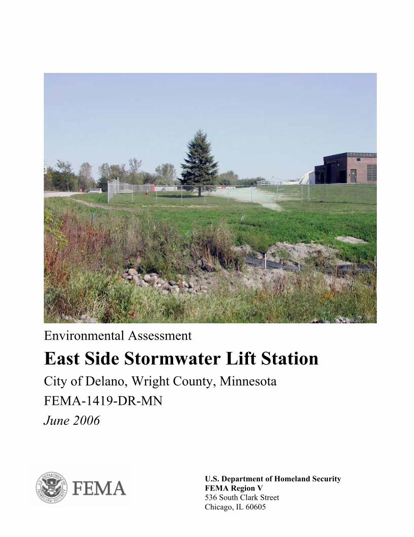
1.2 PROJECT LOCATION AND SETTINGThe City of Delano is in Wright County, approximately 25 miles west of the Minneapolis-St.Paul Metropolitan area in east-central Minnesota (Figure 1). The County is bordered on the northby the Mississippi River and on the east by the Crow River. The project site is located in the Cityof Delano, which lies along the Crow River in the southeastern part of the County. Delano has apopulation of 3,847 (U.S. Census, 2000). The project is proposed to be located just south of thecurrent Wastewater Treatment Facility, in the northeast quadrant of the intersection of CountyRoad (CR) 30 and CR 17. The South Fork of the Crow River lies to the northwest of theproposed project site (see project area photographs in Appendix A). A park and approximately37 residences lie south of the project site.
1.3 PURPOSE AND NEEDThe objective of the FEMA HMGP is to assist the community in mitigating conditions that willcontinue to occur during future natural disasters. The City has requested Federal funding underHMGP to construct a lift station near the current Wastewater Treatment Plant, to protectsurrounding homes from flooding and to relieve sanitary sewer backup.
There is an earthen emergency levee that runs through the City, along the eastern bank of theSouth Fork of the Crow River. When the river reaches a flood level of 9 feet, the City’sfloodgates close, preventing the flow of water out of the City. In the project area, this procedure,in combination with the levee, creates a landlocked basin. All runoff goes toward the river andaccumulates in the neighborhoods that the levee protects from the river, flooding area homes.Prior to 2001, the east side drainage area had 15 different crests over 10-foot flood level since1990, over eight different years. In each case, the City had to pump water because high river
SECTIONONE Introduction
V:\RESOURCE MANAGMENT\FEMA\PROJECTS\DELANO EAS\EAST SIDE LIFT STATION\FINAL DRAFT\ESIDELIFTSTATION_EA.DOC\18-AUG-05\\ 1-2
levels closed the floodgates. Since 2001, the river has reached this level on five separateoccasions.
In one of the most significant events, on June 24, 2002, the flooding resulted in blockage of theoutlet for the east side drainage area of the City. This forced the city to sustain a 100-year stormevent with no outlet for the drainage system. The City initiated emergency pumping operations,setting up four large pumps near the outlet to pump water over the levee. The pumps required 24-hour maintenance and supervision. The four pumps ran continuously, causing one pump to burnup within three days. The remaining three pumps ran for a total of seven days to get the water toa manageable level. In all, this storm event caused basement flooding and property damage tonine residences.
From an engineering standpoint, typical storm sewer design for a landlocked basin is to handletwo consecutive 100-year storm events. Based on stormwater modeling and the events of 2002,two consecutive flooding events within this area could affect up to 37 buildings. Based onCounty Assessor data of average market value of $115,000 in this flood area, the total value ofthe 37 structures exceeds $4,250,000. All of these buildings would be susceptible to flooding inback-to-back events. Therefore, a conservative estimate of damages at 10 percent of buildingvalue would be $425,000 in damages per flood event. In addition, since 1990 the City hasincurred an average cost of $52,500 per flood event for emergency pumping activities, includingequipment rental, staffing, fuel, and equipment replacement.
In the past, flooding in this area has also resulted in sanitary sewer backup. The City instituted aninspection program to find and eliminate sump pump connections into the sanitary sewer, andalso replaced a number of manhole covers in flood-prone areas to reduce the amount of floodwaters entering the sanitary sewer system through manholes. However, the City has determinedthat flooded basements also contribute to sanitary sewer problems. Floodwater enters basementsand infiltrates the separate sanitary sewer system through shower and basement drains. Theinfiltration exceeds system capacity, forcing sewage and contaminated waters out into thebasement. In addition to causing property damage, sanitary sewer system backup poses asignificant and widespread health and safety risk to residents when raw sewage backs up intotheir homes. Therefore, improvement of the storm sewer system will also address the sanitarystorm sewer issues in the project area.
Prolonged flood conditions and standing water in residential neighborhoods surrounding theproposed project site have also caused the area to be subject to sedimentation of wetlands,stormwater ponds, and stormwater pipes. It also causes surface erosion. Sedimentation impactswetlands and further impairs the function of the drainage system, and surface erosion causes lossof vegetation and topsoil. The proposed improvements would help to reduce these impacts in theproject area.
The purpose of the proposed project is to fulfill the need for more efficient (and cost-effective)handling of stormwater in flood events in order to protect human health, safety and privateproperty. The project would protect surrounding homes from flooding and relieve sanitary sewerbackups, and would also decrease the risk of surface erosion and sedimentation of thestormwater drainage system.
The CEQ has developed regulations for implementing NEPA. These Federal regulations requirean evaluation of alternatives and a discussion of the potential environmental impacts of a
SECTIONONE Introduction
V:\RESOURCE MANAGMENT\FEMA\PROJECTS\DELANO EAS\EAST SIDE LIFT STATION\FINAL DRAFT\ESIDELIFTSTATION_EA.DOC\18-AUG-05\\ 1-3
proposed Federal action as part of the EA process. FEMA regulations, which establish theFEMA process for implementing NEPA, are set forth in 44 CFR, Subpart 10. This EA wasprepared in accordance with FEMA regulations as required under NEPA. As part of this NEPAreview, the requirements of other environmental laws and Executive Orders (EOs) are alsoaddressed.
SECTIONTWO Alternatives Analysis
V:\RESOURCE MANAGMENT\FEMA\PROJECTS\DELANO EAS\EAST SIDE LIFT STATION\FINAL DRAFT\ESIDELIFTSTATION_EA.DOC\18-AUG-05\\ 2-1
2. Section 2 TWO Alternatives Analysis
2.1 ALTERNATIVE 1 – NO ACTIONUnder the No Action Alternative, a lift station would not be constructed, and improvementswould not be made to the existing storm sewer or outlets to the South Fork of the Crow River.The City of Delano would be required to continue to emergency pumping operations. Duringmajor storm events, residents would continue to experience flooded basements and extensiveproperty damage. Health and safety risks for area residents as a result of sanitary sewer backupinto homes would also continue, and the City of Delano would continue to expend local fundsfor emergency pumping costs.
2.2 ALTERNATIVE 2 – LIFT STATION WITH 40 CFS PUMPING CAPACITY FROMPOND 1 (PREFERRED ALTERNATIVE)
Alternative 2 involves installation of a 1,024-square-foot lift station (approximately 32-feet by32-feet) near the City’s current Wastewater Treatment Facility on CR 17, north of theintersection with CR 30 (see Figure 2). The East Side Stormwater Lift Station would pump 40cubic feet per second (cfs) of water from the existing pond (Pond 1) and force it through 250 feetof new 30-inch pipe. The pipe would run from the lift station to vicinity of the existing outlet onthe west side of CR 17, with approximately 100 feet of the pipe jacked under the roadway. Waterpumped from the lift station would discharge over the levee on the west side of the roadway, andwould then be directed to an existing stream channel that outlets to the South Fork of the CrowRiver (see Figure 3). This would reduce the flood elevation of the area 5.3 feet by lowering thehigh water level (HWL) of the pond from 918 feet to 912.7 feet (Bonestroo, 1997). Constructionof the lift station would require excavation to increase depth of the western one-third of Pond 1.This deepening of the pond would allow for proper pump operation, which is defined as anapproach velocity of flow to the lift station intake that is less than 0.5 feet per second (Bonestroo,1997).
Pond 1 is characterized by a small ditch that extends east from CR 17, which enlarges out to theremainder of the pond. Stormwater flows from the south-southeast through a series of ponds,wetlands, and ditches leading to Pond 1. Currently, the pond is connected to this system to thesouth via a 48-inch pipe under CR 30. It is not anticipated the capacity of this existing pipewould need to be modified as a result of this project. Water that enters Pond 1 then dischargesvia a 48-inch pipe under CR 17, which discharges into the existing stream that outlets to theSouth Fork of the Crow River. This 48-inch pipe will be retained to maintain normal waterelevation of the pond. The new 30-inch pipe will discharge to the same area, but will onlydischarge when the lift station is operating.
As part of construction, existing turf grass would be cleared along the west side of Pond 1 wherethe lift station is being built, and along the path of the pipe until it meets CR 17. Vegetation onthe west side of CR 17 would also be disturbed along the path of the proposed pipe. Allvegetation will be restored to its existing condition after construction. Dewatering is anticipatedduring project construction.
Construction equipment and materials would be stored on site, which is part of the City-ownedWastewater Treatment Facility property.
SECTIONTWO Alternatives Analysis
V:\RESOURCE MANAGMENT\FEMA\PROJECTS\DELANO EAS\EAST SIDE LIFT STATION\FINAL DRAFT\ESIDELIFTSTATION_EA.DOC\18-AUG-05\\ 2-2
Traffic on CR 17 will not be disrupted during construction of the lift station. The new 30-inchpipe under CR 17 will be directionally bored or jacked, and will not disrupt the roadway. The liftstation and pipe from the lift station to CR 17 will be constructed on City property, with accessfrom the existing driveway to the Public Works building. The entire project is anticipated torequire up to three months to complete, with a planned start date of January/February 2006.
2.3 ALTERNATIVE 3 - LIFT STATION WITH 40 CFS PUMPING CAPACITY FROMPOND 2
Alternative 3 involves installation of a 1,024-square-foot lift station within the City-ownedCentral Park property, just south of CR 30 near its intersection with CR 17 (see Figure 3). Thislift station would pump 40 cfs of water, similar to Alternative 2. The water would be pumpedfrom an area identified in the City’s Stormwater Management Plan as HS-P607 (Pond 2). Thisarea is near a large wetland complex that has been filled in recent years to construct athleticfields in the park, but retains characteristics of a wetland in some areas. A new 30-inch pipewould be installed along the south side of CR 30, west under CR 17, and north to the samedischarge point as Alternative 2. This would be a total of approximately 400 feet of piping. Thewater would discharge over the levee and would then be directed to an existing stream channelthat outlets to the South Fork of the Crow River (see Figure 2), also as in Alternative 2.
Construction of this lift station would reduce the flood elevation of the area 5.1 feet by loweringthe HWL of the pond from 918 feet to 912.9 feet (Bonestroo, 1997). Construction of the liftstation would require excavation of the area to achieve appropriate pumping capacity for theproposed lift station. This would allow for proper pump operation, which is defined as anapproach velocity of flow to the lift station intake that is less than 0.5 feet per second.
As part of construction, existing turf grass and wetland vegetation would be cleared along thenortheast side of Pond 2 where the lift station is being built. Dewatering is anticipated duringproject construction.
Construction equipment and materials would be stored at the City-owned Wastewater TreatmentFacility property, across CR 30 from the proposed site.
Traffic on CR 30 and CR 17 would not be disrupted during construction of the lift station. Thenew 30-inch pipe under CR 17 would be directionally bored or jacked, and would not disrupt theroadway. The lift station itself will be constructed on City park property, with access from themain park entrance off CR 17. Trucks would drive across park turf to reach the site ofconstruction. The entire project would require up to three months to complete, with a plannedstart date of January/February 2006.
2.4 ALTERNATIVES CONSIDERED BUT DISMISSEDConstruction of a lift station with 60 cfs pumping capacity was also considered as an alternativeto this project. However, this alternative was dismissed because it would provide very littleadded flood protection at a much higher cost.
SECTIONTWO Alternatives Analysis
V:\RESOURCE MANAGMENT\FEMA\PROJECTS\DELANO EAS\EAST SIDE LIFT STATION\FINAL DRAFT\ESIDELIFTSTATION_EA.DOC\18-AUG-05\\ 2-3
The City of Delano also considered removing the homes within the area frequently affected byflooding. However, this alternative was dismissed because it would require significant effort andresources to reach agreements with each of the homeowners.
SECTIONTHREE Affected Environment and Environmental Consequences
V:\RESOURCE MANAGMENT\FEMA\PROJECTS\DELANO EAS\EAST SIDE LIFT STATION\FINAL DRAFT\ESIDELIFTSTATION_EA.DOC\18-AUG-05\\ 3-1
3. Section 3 THREE Affected Environment and Environmental Consequences
3.1 PHYSICAL ENVIRONMENT
3.1.1 Geology, Seismicity, and SoilsThe physical relief in the region that includes the project area was formed by pre-Wisconsinglaciation, resulting in outwash plains, gently rolling to steep hills, and numerous depressionsfilled with marshes, wetlands, and lakes. The South Fork of the Crow River bisects the City ofDelano, creating a well-defined river valley. The City is largely situated on a relatively flatfloodplain, although the project area is outside of the 100-year floodplain.
Bedrock underlying the project area is primarily composed of Cambrian and Precambriansedimentary rock formations, consisting of sandstone, shale, and dolomite in upper layers, andsandstone, siltstone, and shale in lower layers. Bedrock is overlain with undifferentiated drift,which is primarily gray, calcareous, silty till that is largely unsorted and unstratified. There maybe buried sand and gravel deposits of varying extents (Wenck Associates, 2004).
Soils within the City of Delano area are mapped almost entirely within the Hayden-Lester-Peatassociation, which is described as “deep, medium-textured and moderately fine-textured soils onstrongly rolling and hilly uplands” (USDA, 1968). However, soils in the project area consist ofsoils from the Hubbard Series, more specifically Hubbard loamy sand. This soil consists of deep,excessively drained loamy sands with slopes of 6 to 12 percent. The area is surrounded byalluvial deposits and other sandy soil types. Historically, aggregate mining has taken place on theproject site.
Alternative 1 – No ActionUnder the No Action Alternative, surface erosion and sedimentation of the stormwater drainagesystem would continue. In addition, with no lift station, sanitary sewer backup would continue tobe a problem in the project area. Raw sewage could infiltrate the soil and cause contamination.
Alternative 2 – Stormwater Lift Station with 40 cfs Pumping Capacity on Pond 1(PREFERRED ALTERNATIVE)It is not anticipated Alternative 2 would result in permanent negative impacts on geology,seismicity, or soils in the project area. Areas along the path of the proposed 30-inch pipe wouldbe open-cut from the lift station to CR 17, and from CR 17 to the outlet past the levee, resultingin potential surface soil erosion. Approximately 500 cubic yards (CY) of excavation would berequired to install the open-cut portions of pipe installation. This would be temporary and limitedto periods of pipe installation. Soil disturbances as a result of the travels of constructionequipment to and from the site may also result in a minimal temporary increase in surface soilerosion and compaction. This would be mitigated through use of required Best ManagementPractices (BMPs) that include protecting erodible surfaces (see Appendix C). Earthwork wouldnot be allowed during precipitation events. Additionally, exposed soils would be seeded with aturf grass mix comparable to that which currently exists. In addition, compacted soils would beloosened by disking or raking prior to seeding. Overall, the project would reduce long-term
SECTIONTHREE Affected Environment and Environmental Consequences
V:\RESOURCE MANAGMENT\FEMA\PROJECTS\DELANO EAS\EAST SIDE LIFT STATION\FINAL DRAFT\ESIDELIFTSTATION_EA.DOC\18-AUG-05\\ 3-2
surface erosion and sedimentation of the stormwater drainage system by more efficientlycollecting and moving floodwaters.
All excavated soils would be inspected for contamination during the excavation process. Allclean soils would be disposed of at the City Compost Facility, located across CR 17 to the westof the proposed project site. Any suspected or known contaminated soils would be disposed ofand handled by the City in accordance with applicable local, State, and Federal regulations. Thisincludes proper transportation and deposit of the soil at an MPCA-approved disposal site.
Alternative 3 – Stormwater Lift Station with 40 cfs Pumping Capacity on Pond 2It is not anticipated that Alternative 3 would result in permanent negative impacts on geology,seismicity, or soils in the project area. Areas along the path of the proposed 30-inch pipe wouldbe open-cut, resulting in potential surface soil erosion. Approximately 800 cubic yards (CY) ofexcavation would be required to install the open-cut portions of pipe installation. This would betemporary and limited to periods of pipe installation. Soil disturbances as a result of the travelsof construction equipment to and from the site may result in a minimal temporary increase insurface soil erosion and compaction, and would be minimized through the use of BMPs asdescribed under Alternative 2. Overall, the project would reduce long-term surface erosion andsedimentation of the stormwater drainage system by more efficiently collecting and movingfloodwaters.
All excavated soils would be inspected for contamination during the excavation process. Allclean soils would be disposed of at the City Compost Facility, located across CR 17 to the westof the proposed project site. Any suspected or known contaminated soils would be disposed ofand handled by the City in accordance with applicable local, State, and Federal regulations. Thisincludes proper transportation and deposit of the soil at an MPCA-approved disposal site.
3.1.2 Water Resources and Water QualityAs part of the Clean Water Act (CWA) Sections 404 and 401, each State is required to prepare abiennial report for the Environmental Protection Agency (EPA) on the quality of its waterresources. States may measure water quality through a number of parameters, includingexamining fish and wildlife contaminants, water and sediment chemistry, biologicalintegrity/physical habitat, and stream flow. The goal of the CWA is to achieve waters suitable forfishing and swimming. This is assessed in terms of aquatic life, aquatic consumption, and aquaticrecreation.
Minnesota’s 2004 Water Quality Report states that the 31.4-mile stretch of the South Fork of theCrow River from Buffalo Creek to the North Fork of the Crow River, which includes the projectarea, is listed as not supporting the aquatic life and aquatic consumption assessment criteria. Itwas not evaluated for aquatic recreation. The indicators of impairment for this stretch of riverinclude fish, turbidity, and mercury. This stretch of the river also exceeds ecoregion norms fortotal phosphorus, nitrite/nitrate, oxygen demand, and suspended solids (Minnesota PollutionControl Agency [MPCA], 2004).
As a result, this segment of the river is on the Impaired Waters List under Category 5A. UnderCategory 5, the water body does not meet applicable water quality standards or is threatened forone or more designated uses by one or more pollutants. Historically, agricultural runoff and
SECTIONTHREE Affected Environment and Environmental Consequences
V:\RESOURCE MANAGMENT\FEMA\PROJECTS\DELANO EAS\EAST SIDE LIFT STATION\FINAL DRAFT\ESIDELIFTSTATION_EA.DOC\18-AUG-05\\ 3-3
faulty septic systems/wastewater treatment systems have been the primary causes of waterpollution in this region.
Potential water quality impacts as a result of any new project construction generally originatefrom the following:
• Erosion of exposed soils during construction;• Reduced infiltration and increased runoff from the construction of new impervious
surfaces;• Pollutants from automobiles, such as oil, grease, and metals, that collect on impervious
surfaces and are washed off by runoff;• Increased runoff that overburdens existing drainage systems, causing flooding; and• Fill or construction in floodplains that affects flood levels in streams and rivers.
Both the Minnesota Department of Natural Resources (MDNR) Waters Division and the UnitedStates Army Corps of Engineers (USACE) were sent information describing and illustrating theproposed project. In an e-mail dated October 13, 2004, Patricia Fowler, MDNR AreaHydrologist, indicated that the proposed project does not impact any public waters of the State,and MDNR authorization is not required. She noted that a MDNR Water Appropriation Permitwould be required if proposed construction dewatering would exceed 10,000 gallons per day orone million gallons per year (Appendix B). The proposed project alternatives would requiredewatering due to construction of lift station footings and intakes. The Water AppropriationPermit will be applied for through the MDNR. The MDNR did not voice any concerns aboutimpacts to the South Fork of the Crow River.
USACE also reviewed the project and did not voice any concerns about impacts to the SouthFork of the Crow River (Appendix B). Wetlands are addressed in Section 3.2.2.
The proposed project would slightly increase the amount of impervious surface by constructingthe lift station. However, the project would help to decrease the overburden on existing drainagesystems that currently results in flooding and septic system backup during significant stormevents. Erosion of exposed soils would be managed by BMPs as described in Section 3.1.1.
Potential sedimentation due to temporary construction impacts is discussed below. The proposedproject would direct water through existing wetlands, which are discussed in Section 3.2.2.
Special Designation AreasThe project does not lie within the MNRRA or areas protected by the Wild and Scenic RiversAct (WSRA). There are no other Federal- or State-designated areas within the project area. Nofurther action is necessary under MNRRA, WSRA, or any State-designated program.
Alternative 1 – No ActionUnder the No Action Alternative, periodic flooding and sanitary sewer backup during heavyrainfall events would still occur. Residents would continue to be at risk from raw sewageinfiltrating the storm sewer and potentially reaching surface waters and drinking water supplies.Continued flooding would also result in increased erosion and sedimentation of water bodies.
SECTIONTHREE Affected Environment and Environmental Consequences
V:\RESOURCE MANAGMENT\FEMA\PROJECTS\DELANO EAS\EAST SIDE LIFT STATION\FINAL DRAFT\ESIDELIFTSTATION_EA.DOC\18-AUG-05\\ 3-4
Alternative 2 – Stormwater Lift Station with 40 cfs Pumping Capacity on Pond 1(PREFERRED ALTERNATIVE)Alternative 2 does not lie within any streams, lakes, or rivers, but stormwater would outlet fromthe proposed lift station to a small stream leading to the South Fork of the Crow River. The liftstation would direct stormwater to the river in a more controlled manner than the emergencypumps that currently operate during storm events. Alternative 2 would not cause pollution orlong-term sedimentation on the South Fork of the Crow River.
Alternative 2 has the potential for minor impacts on water quality as a result of constructiongrading, which may cause temporary sedimentation of Pond 1 due to erosion of bare soils. Thispossibility of sedimentation would be controlled through the use of BMPs as outlined in erosioncontrol plans. BMPs may include protecting erodible surfaces and avoiding construction duringprecipitation events. The City of Delano has an approved Stormwater Management Plan, whichoutlines BMPs that are required through City ordinance (copies available at Delano City Hall,952 Bridge Street). The following ordinances are cited in the plan and have BMP provisions forprotecting water resources and water quality (Bonestroo, 1997):
• Grading, Erosion, and Sediment Control Ordinance• Wetland Systems District Ordinance• Floodplain District Ordinance
Each of these ordinances would be adhered to during project construction. A National PollutionDischarge Elimination System (NPDES) permit is required, as the project would involve morethan one acre of grading. The City has initiated this permit process by preparing a StormwaterPollution Prevention Plan (SWPPP), which lists the BMPs that would be used as part of theproject, and how and when the BMPs would be implemented. The plan states the BMPs wouldall be in place prior to any excavation/construction, and would be maintained until viable turf orground cover has been established. BMPs included in the SWPPP are:
• Rock construction entrance• Erosion control blankets (Bioroll blanket system)• Silt fence• Inlet sediment filters
The City has initiated preparation of this plan, and will submit the plan to the selected contractor.The BMP detail sheets that would be included in the SWPPP are included in Appendix C. Itwould be the contractor’s responsibility to use the SWPPP information to submit an NPDESpermit to the Minnesota Pollution Control Agency (MPCA). This would be submitted 48 hoursprior to construction, as mandated in permit requirements. The permit acts as a notification so theMPCA can monitor the project.
Alternative 3 – Stormwater Lift Station with 40 cfs Pumping Capacity on Pond 2Alternative 3 does not lie within any streams, lakes, or rivers, but stormwater would dischargefrom the proposed lift station to a small stream leading to the South Fork of the Crow River. Thelift station would direct stormwater to the river in a more controlled manner than the emergency
SECTIONTHREE Affected Environment and Environmental Consequences
V:\RESOURCE MANAGMENT\FEMA\PROJECTS\DELANO EAS\EAST SIDE LIFT STATION\FINAL DRAFT\ESIDELIFTSTATION_EA.DOC\18-AUG-05\\ 3-5
pumps that currently operate during storm events. Alternative 3 would not impose pollution orlong-term sedimentation on the South Fork of the Crow River.
Alternative 3 would also lie near a wetland area, which creates the potential for minor impacts onwater quality as a result of construction grading, which could cause temporary sedimentation ofsurrounding wetlands due to erosion of bare soils. This possibility of sedimentation would becontrolled through the use of BMPs as outlined in erosion control plans, as described aboveunder Alternative 2.
Ordinances as described under Alternative 2 would be adhered to during project construction. ANational Pollution Discharge Elimination System (NPDES) permit would also be obtained fromthe MPCA, as the project would involve more than one acre of grading.
3.1.3 Floodplain Management (EO 11988)Floodplain refers to the 100-year floodplains as defined by FEMA. They are shown on FloodInsurance Rate Maps or Flood Hazard Boundary Maps for all communities participating in theNational Flood Insurance Program (NFIP).
The 100-year floodplain designates the area inundated during a flood that has a one percentchance of occurring in any given year. FEMA also identifies the 500-year floodplain, whichdesignates the area inundated during a flood that has a 0.2 percent chance of occurring in anygiven year. Both of the project alternatives are located within the 100-year floodplain (see Figure4).
EO 11988 directs Federal agencies to take action to minimize occupancy of and modification tofloodplains. Specifically, EO 11988 prohibits FEMA from funding construction in the floodplainunless there are no practicable alternatives. FEMA regulations for complying with EO 11988 arepromulgated in 44 CFR Part 9. FEMA applies the Eight-Step Planning Process as required byregulation to meet the requirements of EO 11988 (Appendix D).
Both the MDNR Waters Division and the USACE were sent information describing andillustrating the proposed project. In an e-mail dated October 13, 2004, Patricia Fowler, MDNRArea Hydrologist, noted that the proposed project does lie within the 100-year floodplain, andshould be either floodproofed to meet State building code standards or elevated above theregulatory flood protection elevation in accordance with the City's floodplain ordinance. USACEalso reviewed the project and did not voice any concerns about impacts to the 100-yearfloodplain (Appendix B).
FEMA applies the Eight-Step Planning Process as required by regulation to meet therequirements of EO 11988. This step-by-step analysis is included in Appendix D of thisdocument.
Alternative 1 – No ActionNo occupancy or direct modification to the 100-year floodplain would occur; therefore, EO11988 is not applicable.
SECTIONTHREE Affected Environment and Environmental Consequences
V:\RESOURCE MANAGMENT\FEMA\PROJECTS\DELANO EAS\EAST SIDE LIFT STATION\FINAL DRAFT\ESIDELIFTSTATION_EA.DOC\18-AUG-05\\ 3-6
Alternative 2 – Stormwater Lift Station with 40 cfs Pumping Capacity on Pond 1(PREFERRED ALTERNATIVE)Alternative 2 lies within the 100-year floodplain. Elevation of the project area is not being raised.The project would direct floodwaters more efficiently across the floodplain and into the SouthFork of the Crow River, decreasing the need for long-term flood storage and allowing forfloodplain vegetation to withstand shorter durations of immersion. The 32 by 32-foot lift stationstructure would occupy approximately 5,120 cubic feet of floodplain, assuming a 5-foot verticalimpact. Approximately 2,250 cubic feet of excavation would take place to deepen the westernone-third of Pond 1. Therefore, this project would result in a loss of approximately 2,870 cubicfeet of storage in the floodplain. This loss of flood storage at the East Side Lift Station locationwould ultimately be mitigated by the creation of a stormwater pond associated with the proposedWest Side Lift Station, also located within Delano’s 100-year floodplain. This stormwater pondwould create approximately 12,000 cubic feet of water storage. See Section 4, CumulativeImpacts for additional information.
The project would also reduce the time that it takes for water to reach the river by providing amore efficient outlet system for Pond 1 and the project drainage area. The upstream watershedof the South Fork of the Crow River is approximately 1,200 square miles (768,000 acres).According to the City’s Stormwater Management Plan, proposed Alternative 2 improvementswould impact a watershed that is approximately 60 acres. Thus, the watershed affected by theproposed project is less than 0.01 percent of the upstream watershed. In addition, the proposedproject would pump 40 cfs of water during a 100-year flood event. The National WeatherService categorizes “minor” flooding in South Fork of the Crow River at Delano as 8 to 12 feet.“Moderate” flooding is considered to be 12 to 14 feet, and “major” flooding is considered to beabove 14 feet (National Weather Service, 2005). Since 2001, a majority of flooding has occurredin the moderate category (U.S. Army Corps of Engineers, 2005). Using the June 2002 floods asan example, the river reached a flood stage of approximately 13.5 feet. At this stage, the SouthFork of the Crow River is flowing at 6,489 cfs (National Weather Service, 2005). The impact ofthe addition of 40 cfs at this stage is negligible at 0.6 percent. Based on this analysis, theproposed project will not negatively impact the elevation of the 100-year flood of the South Forkof the Crow River, and would not cause concerns for downstream properties (Krogstad, personalcommunication).
The lift station structure would be floodproofed in accordance with State building codestandards, and would adhere to regulations established in the local Floodplain District Ordinance.
Alternative 3 – Stormwater Lift Station with 40 cfs Pumping Capacity on Pond 2Alternative 3 also lies within the 100-year floodplain. Excavation of Pond 2 would occur toachieve appropriate water velocity for the intake structure. This would increase storage withinthe floodplain. Elevation of the project area is not being raised. The project would directfloodwaters more efficiently across the floodplain and into the South Fork of the Crow River,decreasing the need for long-term flood storage and allowing for floodplain vegetation towithstand shorter durations of immersion. Similar to Alternative 2, which proposes the samepumping capacity, the project would not have any negative impact on floodplain elevation underthis alternative.
SECTIONTHREE Affected Environment and Environmental Consequences
V:\RESOURCE MANAGMENT\FEMA\PROJECTS\DELANO EAS\EAST SIDE LIFT STATION\FINAL DRAFT\ESIDELIFTSTATION_EA.DOC\18-AUG-05\\ 3-7
3.1.4 Air QualityThe Clean Air Act (CAA) of 1970, as amended, requires the EPA to set National Ambient AirQuality Standards (NAAQS) for pollutants considered harmful to public health and theenvironment. The CAA establishes two types of national air quality standards: primary andsecondary. Primary standards set limits to protect public health, including the health of sensitivepopulations such as asthmatics, children, and the elderly. Secondary standards set limits toprotect public welfare, visibility, and damage to animals, crops, vegetation, and buildings.
The EPA Office of Air Quality Planning and Standards has set NAAQS for six principalpollutants called “criteria” pollutants: sulfur dioxide (SO2), nitrogen dioxide (NO2), carbonmonoxide (CO), lead (Pb), particulate matter of 10 microns or less (PM10), and ozone (O3).
The EPA has designated specific areas throughout Minnesota as NAAQS attainment or non-attainment areas. Non-attainment areas are those that do not meet, or that contribute to ambientair quality in a nearby area that does not meet, either the national primary or the secondary airquality standards for a pollutant. According to the EPA, Wright County is in attainment for allsix criteria pollutants (EPA, 2003).
Alternative 1 – No ActionNo construction activities would take place under this alternative; therefore, there would be noimpact to air quality.
Alternative 2 – Stormwater Lift Station with 40 cfs Pumping Capacity on Pond 1(PREFERRED ALTERNATIVE)Implementation of Alternative 2 would involve limited use of heavy construction equipment,such as a backhoe, equipment trucks, power tools, and concrete trucks. The duration of theproposed project activities is anticipated to be approximately three months.
Heavy construction equipment is a source of fugitive dust emissions that may have a temporaryeffect on air quality. Emissions occurring during construction would be associated with earth-moving (grading). Dust emissions can vary from day to day, depending on the level of activity,the specific operations, and weather. Emissions from fuel-burning internal combustion engines(heavy equipment and earth-moving machinery) could temporarily increase the levels of volatileorganic compounds and some of the priority pollutants, including CO, NO2, O3, and PM10.
To mitigate for potential air quality impacts from fugitive dust and equipment emissions, vehicleengines would be kept in good repair and turned off while not in use, and the project area wouldbe watered in dry conditions. The same measures would also be taken in the identifiedconstruction staging areas.
SECTIONTHREE Affected Environment and Environmental Consequences
V:\RESOURCE MANAGMENT\FEMA\PROJECTS\DELANO EAS\EAST SIDE LIFT STATION\FINAL DRAFT\ESIDELIFTSTATION_EA.DOC\18-AUG-05\\ 3-8
Alternative 3 – Stormwater Lift Station with 40 cfs Pumping Capacity on Pond 2Implementation of Alternative 3 would involve limited use of heavy construction equipment, asdescribed above under Alternative 2. The duration of the proposed project activities isanticipated to be approximately three months.
Heavy construction equipment is a source of fugitive dust emissions that may have a temporaryeffect on air quality. Emissions occurring during construction would be associated with earth-moving (grading). Dust emissions can vary from day to day, depending on the level of activity,the specific operations, and weather. Emissions from fuel-burning internal combustion engines(heavy equipment and earth-moving machinery) could temporarily increase the levels of volatileorganic compounds and some of the priority pollutants, including CO, NO2, O3, and PM10.
Mitigation measures to control fugitive dust emission would be the same as those describedunder Alternative 2.
3.2 BIOLOGICAL ENVIRONMENT
3.2.1 Terrestrial and Aquatic EnvironmentTerrestrial EnvironmentThe proposed project site includes the area in which the lift station will be constructed, and areaswest across the road and leading to the river.
A biologist with URS Group (URS) performed a site visit on September 17, 2004. The lift stationwould be constructed on the north side of Pond 1. The proposed lift station would draw waterfrom the pond during high-water events, and would force water via pipe under CR 17 to near theexisting outlet, and would discharge into a stream leading to the South Fork of the Crow River.Pond 1 was constructed in summer 2003 as part of the expansion of the Wastewater TreatmentFacility, and functions as a stormwater pond. This area is vegetated with turf grass, alfalfa(Medicago sativa), clover (Melilotus sp.), and foxtail barley (Hordeum jubatum). This is low-lying vegetation and provides only limited wildlife habitat. Vegetation on the west side of CR17, near the proposed pipe outlet, has limited vegetation. Riprap has been installed to dissipatewater velocity. As floodwaters travel along the existing stream, the riprap gives way to typicalfloodplain forest, dominated by silver maple (Acer saccharinum) and some cottonwood (Populusdeltoides). As the stream approaches the riverbank and becomes more of a wetland area, othervegetation emerges, such as reed canary grass (Phalaris arundinaceae), willow (Salix exigua),and jewelweed (Impatiens capensis). Annual weeds such as smartweed (Polygonumpenslyvanicum) are also present.
Wildlife that may use the project site include mammals such as white-tailed deer (Odocoileusvirginianus), Eastern cottontail rabbit (Sylvilagus floridanus), gray squirrel (Sciurus carolinesis),and raccoon (Procyon lotor), which likely use the site for movement between wooded areas.Songbirds will move through the area as habitat is suitable. Various songbirds were the onlywildlife observed during the site visit.
SECTIONTHREE Affected Environment and Environmental Consequences
V:\RESOURCE MANAGMENT\FEMA\PROJECTS\DELANO EAS\EAST SIDE LIFT STATION\FINAL DRAFT\ESIDELIFTSTATION_EA.DOC\18-AUG-05\\ 3-9
Aquatic EnvironmentWater directed by the proposed lift station would be discharged into the nearby South Fork of theCrow River, which contains a variety of fish species, including, but not limited to: walleye,northern pike, smallmouth bass, sunfish, bluegill, black crappie, catfish, bullhead, carp, andwhite sucker.
Ponds occasionally attracts ducks and geese. The proposed project would also direct waterthrough a wetland area near the river. These areas likely provide temporary aquatic habitat,primarily in the spring, to species such as wood ducks, amphibians (frogs, toads, andsalamanders), reptiles (snakes and turtles), and songbirds. Wetland impacts are discussed inSection 3.2.2.
Alternative 1 – No ActionUnder this alternative, no changes to the existing terrestrial or aquatic environment would occur.
Alternative 2 – Stormwater Lift Station with 40 cfs Pumping Capacity on Pond 1(PREFERRED ALTERNATIVE)Terrestrial EnvironmentThe effects of Alternative 2 would include temporary disturbances to terrestrial habitat duringproject implementation. Existing turf grass along the bank of Pond 1, where the lift station wouldbe constructed, would be removed. Turf grass along the path of the proposed pipe from the liftstation to CR 17 would also be disturbed to allow for pipe installation. The area west of CR 17 tothe outlet past the levee would also be open-cut to allow for pipe installation, disturbing limitedvegetation. This area is also home to some rock riprap and debris, such as concrete block,monument spoil, and wire fence. Following project construction, turf grass will be reestablishedon the lift station site and along the path of the pipe. The area between CR 17 and the outlet nearthe levee will also be restored, and debris would be removed. It is not anticipated that anyvegetation would be removed from construction staging sites or at any point west of the outletnear the levee as a result of the proposed project.
Effects to the terrestrial environment would be limited and temporary until vegetation becomesreestablished. Existing habitat is limited due to the dominance of turf grass. Construction noisecould disturb some species, but this impact would be temporary and last only for the duration ofconstruction. Heavy construction equipment would compact soils in the project area. Soilscompacted by construction machinery would be loosened by methods such as disking or raking.Overall, the existing terrestrial environment would be maintained, and would be improved bycleaning up debris in vicinity of the outlet.
Aquatic Environment
Limited temporary impacts to aquatic habitats would occur. These impacts would last for theduration of construction and would include removal of vegetation, soil erosion, and noiseimpacts. The proposed project would not impact water levels, but would rather assist in restoringwater to normal levels more quickly after flooding. The proposed project is not anticipated tohave negative consequences on aquatic resources.
SECTIONTHREE Affected Environment and Environmental Consequences
V:\RESOURCE MANAGMENT\FEMA\PROJECTS\DELANO EAS\EAST SIDE LIFT STATION\FINAL DRAFT\ESIDELIFTSTATION_EA.DOC\18-AUG-05\\ 3-10
Alternative 3 – Stormwater Lift Station with 40 cfs Pumping Capacity on Pond 2Terrestrial EnvironmentThe effects of Alternative 3 would include temporary disturbances to terrestrial habitat duringproject implementation. This disturbance would be in greater amounts than those experiencedunder Alternative 2, as this alternative requires additional piping. Existing wetland vegetationand turf grass along the bank of Pond 2, where the lift station would be constructed, would beremoved. The predominant vegetation at this site is reed canary grass (Phalaris arundinaceae).Turf grass along the path of the proposed pipe would also be disturbed to allow for pipeinstallation. Following project construction, similar vegetation would be reestablished along thebanks of Pond 2, and turf grass would be restored in the other areas. It is not anticipated that anyvegetation would be removed from construction staging sites or at any point west of the outletnear the levee as a result of this alternative.
Effects to the terrestrial environment would be limited and temporary until vegetation becomesreestablished. Construction noise could disturb some species, but this impact would be temporaryand last only for the duration of construction. Heavy construction equipment would compactsoils in and around the project area, due to limited park access. Soils compacted by constructionmachinery would be loosened by methods such as disking or raking, and replanted with similarvegetation. Overall, the existing terrestrial environment would be maintained.
Aquatic EnvironmentLimited temporary impacts to aquatic habitats would occur. These impacts would last for theduration of construction and would include removal of vegetation, soil erosion, and noiseimpacts. The proposed project would not impact water levels, but would rather assist in restoringwater to normal levels more quickly after flooding, although it would be a slightly slowerresponse than that of Alternative 2. The proposed project is not anticipated to have negativeconsequences on aquatic resources.
3.2.2 Wetlands (EO 11990)A wetland is defined by State and Federal regulations as an area that exhibits three distinctcharacteristics: 1) hydric soils; 2) inundation or saturation at or near the ground surface for aperiod of the growing season; and, 3) a prevalence of vegetation adapted to wet soil conditions.Wetlands are recognized as having important functions, including flood storage, water quality,wildlife and fisheries habitat, vegetation diversity, shoreland protection, aesthetics, and publicrecreation, resulting in their protection by local, State, and Federal regulations. These regulationsrequire that wetland impacts be avoided or minimized to the extent feasible, with wetlandreplacement required for unavoidable impacts. Impacts that are unavoidable must be replaced ata ratio of at least 2 acres of wetland creation or restoration for every acre of wetland impact.
Under EO 11990, Federal agencies are required to minimize the destruction, loss, or degradationof wetlands and preserve and enhance their natural and beneficial values. If a Federal action hasthe potential to impact jurisdictional waters of the United States as defined by Section 404 of theCWA, the USACE is contacted for appropriate permitting requirements. Section 404 of theCWA authorizes the USACE to issue permits, after notice and opportunity for public hearings,for the discharge of dredged or fill material into waters of the United States at specified disposal
SECTIONTHREE Affected Environment and Environmental Consequences
V:\RESOURCE MANAGMENT\FEMA\PROJECTS\DELANO EAS\EAST SIDE LIFT STATION\FINAL DRAFT\ESIDELIFTSTATION_EA.DOC\18-AUG-05\\ 3-11
sites. The MDNR has regulatory authority over activities within selected wetlands and waters, asidentified on Public Waters Inventory maps, published by the MDNR. The City of Delano hasregulatory authority for all wetlands within its legal boundary.
FEMA applies the Eight-Step Planning Process as required by regulation to meet therequirements of EO 11990. This step-by-step analysis is included in Appendix D of thisdocument.
In 1991, the State of Minnesota enacted the Wetland Conservation Act (WCA). This legislationauthorized Local Governmental Units (LGUs) to administer State wetland regulations. The WCArequires that activities resulting in the draining or filling of a wetland must be avoided orminimized. Impacts that are unavoidable must be replaced at a 2:1 ratio. At least the first 1:1must be creation of new wetland or purchase of wetland bank credits. The remaining 1:1 can bein the form of plantings or other creative mitigation on the site (MDNR-approved fishing areas,habitat improvements, etc.). The WCA is administered by the Board of Water and SoilResources (BWSR) and implemented by LGUs. In those cases where wetland impacts occur onState land, the LGU is the State agency with administrative responsibility for that land.
Wetlands were identified using National Wetland Inventory (NWI) mapping and verified duringa site visit on September 17, 2004. The proposed project is located in an historic upland areawith soils that are not conducive to wetlands. The City constructed Pond 1 on the proposedproject site in summer 2003, in conjunction with expansion of the Wastewater TreatmentFacility. During and after flood events, excess water would be pumped through the lift stationdown the South Fork of the Crow River, where wetlands are more prevalent. Water would bedirected via a small stream that splits two wetland areas, classified by the NWI as PEMCd(Palustrine, Emergent, Seasonally Flooded, Partially Drained/Ditched) and PFO1Bd (Palustrine,Forested, Broad-Leaved Deciduous, Saturated, Partially Drained/Ditched). Typical vegetationincludes reed canary grass (Phalaris arundinaceae), willow (Salix exigua)), and jewelweed(Impatiens capensis) in the PEMCd wetland (Wetland 1), with silver maple (Acer saccharinum)dominating the PFO1Bd wetland (Wetland 2).
Both the MDNR Waters Division and the USACE were sent information describing andillustrating the proposed project. In an e-mail dated October 13, 2004, Patricia Fowler, MDNRArea Hydrologist, indicated that the proposed project does not impact any public waters of theState (including wetlands), and MDNR authorization is not required. It should be noted that theentire area bordered by CR 17 and CR 30, home of the Wastewater Treatment Facility, PublicWorks building, and the proposed lift station, is covered by WCA Exemption under MinnesotaRule Chapter 8420.0122 (Appendix B). This exemption was granted March 31, 2003.
Following additional phone consultation, the USACE issued an email dated February 21, 2005,that stated a Federal permit is not required for excavation of Pond 1, and installation of theinfall/outfall structures at the pond and on the west side of the levee would be authorized by anon-reporting General Permit (Installation of Outfall Structures).
Alternative 1 – No ActionUnder this alternative, wetlands would continue to be subject to frequent flooding, causingpotential sedimentation and contamination from sewer backups. This would cause temporary
SECTIONTHREE Affected Environment and Environmental Consequences
V:\RESOURCE MANAGMENT\FEMA\PROJECTS\DELANO EAS\EAST SIDE LIFT STATION\FINAL DRAFT\ESIDELIFTSTATION_EA.DOC\18-AUG-05\\ 3-12
impacts to water quality, wildlife and plants during flood events, and could cause long-termdegradation of the wetland system.
Alternative 2 – Stormwater Lift Station with 40 cfs Pumping Capacity on Pond 1(PREFERRED ALTERNATIVE)There are no jurisdictional wetlands located within the vicinity of the proposed lift station. Noconstruction is proposed within the Wetlands 1 and 2, east of CR 17 near the South Fork of theCrow River. It is not anticipated that water directed to the South Fork of the Crow River willadversely affect Wetlands 1 and 2, which contain the small stream channel. These wetlandswould be inundated with water during flood periods, but this is similar to existing floodconditions where emergency pumps are utilized. The proposed lift station will provide apermanent pumping structure that would maintain a constant velocity of water during stormevents, thereby reducing erosion and stream impacts associated with intermittent bursts of waterdue to pumps breaking down, or several pumps running through one outlet. Therefore, thisproject would provide the wetlands with a more consistent hydrologic regime, as compared tocurrent conditions. This alternative does not require 2:1 replacement requirements under theWCA or MDNR.
Alternative 3 – Stormwater Lift Station with 40 cfs Pumping Capacity on Pond 2The Pond 2 area is very near a wetland area, and retains wetland characteristics of hydric soilsand wetland vegetation such as reed canary grass. If this alternative were chosen, it wouldrequire more extensive review by the USACE and may require 2:1 replacement requirementsunder the WCA or MDNR.
As the outlet and path of the water to the river would be the same, Alternative 3 would havesimilar effects as described under Alternative 2.
3.2.3 Threatened and Endangered SpeciesThe Endangered Species Act (ESA) of 1973 requires Federal agencies to determine the effects oftheir actions on threatened and endangered species of fish, wildlife, and plants and on theirhabitats, and to take steps to conserve and protect these species.
The MDNR was contacted in February 2003 for information regarding known occurrences ofthreatened, endangered, or otherwise significant plant and animal species, natural plantcommunities, and other natural features. In a letter dated November 10, 2003 (Appendix B), theMDNR concluded that there are four known occurrences of rare species or natural communitieswithin an approximate 1-mile radius of the project site. However, based on the nature andlocation of the proposed project, the MDNR has determined that no known occurrences of rarefeatures would likely be affected. In e-mail correspondence dated September 28, 2004 (AppendixB), the MDNR confirmed that this determination was still acceptable.
The United States Fish and Wildlife Service (USFWS) was sent a letter requesting review of theproject for Federal threatened or endangered species. In e-mail correspondence dated January 6,2005, the USFWS documented that the Federal threatened bald eagle (Halieaeetusleucocephalus) is known to nest in Wright County, typically in floodplain forest environments.
SECTIONTHREE Affected Environment and Environmental Consequences
V:\RESOURCE MANAGMENT\FEMA\PROJECTS\DELANO EAS\EAST SIDE LIFT STATION\FINAL DRAFT\ESIDELIFTSTATION_EA.DOC\18-AUG-05\\ 3-13
However, no bald eagles are known to nest within the project area. Therefore, the USFWS doesnot believe the project will have any adverse impacts on the bald eagle or any other Federalthreatened or endangered species (Appendix B).
No impacts to threatened and endangered species are anticipated under any of the alternatives.
3.3 HAZARDOUS MATERIALSThe Resource Conservation and Recovery Act (RCRA) defines hazardous waste as “a solidwaste, or combinations of solid wastes, which because of its quantity, concentration, or physical,chemical, or infectious characteristics may (1) cause, or significantly contribute to, an increase inmortality or an increase in serious irreversible or incapacitating reversible illness or (2) pose asubstantial present or potential hazard to human health or the environment when improperlytreated, stored, transported or disposed of or otherwise managed.” While the definition refers tosolids, it has also been interpreted to include semisolids, liquids, and contained gases (Wentz,1989).
Hazardous materials and wastes are regulated in Minnesota through a combination of Federallymandated laws and State laws developed by the MPCA. Minnesota State Hazardous Waste Rulesare contained in Chapter 7045 of the Minnesota Rules. Federal regulations governing hazardouswastes include RCRA; the Comprehensive Environmental Response, Compensation, andLiability Act (CERCLA); the Solid Waste Act (SWA); and the Toxic Substance Control Act(TSCA).
To determine the presence and approximate location of known hazardous materials in thevicinity of the proposed project, a database search was conducted by FirstSearch TechnologyCorporation (FirstSearch, 2005). The database search queried multiple Federal, State, and localhazardous materials and underground storage tank (UST) databases to identify sites of potentialconcern. Identified USTs were also cross-checked in the MPCA Storage Tank Database (MPCA,2004).
Three sites were identified within 0.5 mile of the proposed project site. One site is approximately320 feet northeast of the proposed lift station, and is classified as a State SPILLS site. In March2003, approximately 5 gallons of sewage/wastewater spilled due to an equipment malfunction atthe Wastewater Treatment Plant. Response was completed in accordance with State guidelines,and the site was closed within two days. The small size of the spill, and the fact it wasappropriately closed, suggests that risk of contamination to the project site is minimal.
The remaining two sites are registered UST sites containing fuel oil, with no reported violations.One is located approximately 600 feet southeast of the project site, and one is located 0.5 mileeast of the project site. According to topographic mapping, the first UST site (600 feet southeast)is located at higher elevation than the project site, in a presumed upgradient groundwater flowposition from the project site. Area elevations indicate that surface and groundwater drainageoccurs toward the proposed project site, and west to the river. The second UST site (0.5 mileeast) does not appear to present a potential risk to the project area give the distance of this sitefrom the proposed lift station.
SECTIONTHREE Affected Environment and Environmental Consequences
V:\RESOURCE MANAGMENT\FEMA\PROJECTS\DELANO EAS\EAST SIDE LIFT STATION\FINAL DRAFT\ESIDELIFTSTATION_EA.DOC\18-AUG-05\\ 3-14
No subsurface materials testing was conducted in the project area as part of this analysis.Conclusions are based on FirstSearch review, MPCA database search, and review of topographicmaps and aerial photos.
Alternative 1 – No ActionUnder the No Action Alternative, there would be no impacts to hazardous materials or wastes.Any unknown hazardous wastes and materials that may be present in the project area would notbe altered from their present condition.
Alternative 2 – Stormwater Lift Station with 40 cfs Pumping Capacity on Pond 1(PREFERRED ALTERNATIVE)Based upon the information reviewed, no impacts from hazardous materials or wastes areanticipated under Alternative 2. Although a UST site is located approximately 600 feetupgradient from the project site, a fuel release has not been documented from the UST at thislocation. Additionally, the distance between the UST site and the proposed lift station minimizesthe potential for impact from an unknown release.
Although subsurface hazardous materials are not anticipated to be present in the project area,excavation activities could expose or otherwise affect subsurface hazardous wastes or materials.Any hazardous materials discovered, generated, or used during implementation of the proposedproject would be disposed of and handled by the City in accordance with applicable local, State,and Federal regulations.
Alternative 3 – Stormwater Lift Station with 40 cfs Pumping Capacity on Pond 2Impacts from hazardous materials or wastes are also not anticipated under Alternative 3.However, under this alternative, the proposed pump station location shifts to the southeast and iswithin 300 feet of the first UST site. While a release has not been detected from this UST, thecloser proximity and upgradient position of the tank raises the potential for impact from anunknown fuel release.
Although subsurface hazardous materials are not anticipated to be present in the project area,excavation activities could expose or otherwise affect subsurface hazardous wastes or materials.Any hazardous materials discovered, generated, or used during implementation of the proposedproject would be disposed of and handled by the City in accordance with applicable local, State,and Federal regulations.
3.4 SOCIOECONOMICS
3.4.1 Zoning and Land UseWright County, Minnesota, was officially created in 1855. It is located in the east-central part ofthe State, and is one of seven counties in the Twin Cities Metropolitan Area. The size of theCounty is approximately 716 square miles (Wright County, 2003), containing 17 cities and 18townships. It is bordered by Sherburne and Stearns Counties to the north, Meeker County to the
SECTIONTHREE Affected Environment and Environmental Consequences
V:\RESOURCE MANAGMENT\FEMA\PROJECTS\DELANO EAS\EAST SIDE LIFT STATION\FINAL DRAFT\ESIDELIFTSTATION_EA.DOC\18-AUG-05\\ 3-15
west, Carver and McLeod Counties to the south, and Hennepin County to the east. Due to WrightCounty’s proximity to the Twin Cities, it is considered one of the fastest growing counties in theState. The population of Wright County has increased 31 percent since 1990, to an estimated89,986 people.
The proposed project is located within the limits of the City of Delano, in the southeast corner ofWright County. The current population of the City is 3,847. It has experienced steady populationgrowth, most recently experiencing a 38 percent growth in population between 1990 and 2000(U.S. Census Bureau, 2000). It is anticipated that this trend will continue, with an estimatedgrowth of 103 people per year through the year 2015 (Bonestroo, 1997).
The project site lies within City-owned property occupied by the Wastewater Treatment Facilityand the Public Works building. The project area is zoned public/institutional. Land uses to thenorthwest, across CR 17, are primarily undeveloped and include woodlands and wetlands typicalof a floodplain environment. The City Compost Facility is also located in this area. Land use tothe south, across CR 30, is occupied by City-owned Central Park, which includes several athleticfields and an open area. Residential homes lying south and east of Central Park are those thathave been historically affected by flood events. These homes were built from the 1970s topresent, and are identified by the City of Delano as medium to upper-value homes.
Alternative 1 – No ActionUnder the No Action Alternative, there would be no land use and zoning changes. In a stormevent, area residents would likely be affected by basement flooding and sanitary sewer backups.In the future, reoccurrence of these events could continue to depress home and land values ofnearby properties.
Alternative 2 – Stormwater Lift Station with 40 cfs Pumping Capacity on Pond 1(PREFERRED ALTERNATIVE)Alternative 2 would improve the drainage in the project area during storm events, protectingsurrounding land uses from flooding and sanitary sewer backup. Property values in the area mayincrease as a result of flood control activities. Most of the surrounding area is already developed,and opportunities for additional development are also constrained by the City’s FloodplainDistrict Ordinance.
Improvements under Alternative 2 are consistent with current land use and zoning in the projectarea. No rezoning would be required due to the proposed project.
Alternative 3 – Stormwater Lift Station with 40 cfs Pumping Capacity on Pond 2Alternative 3 would improve the drainage in the project area during storm events, protectingsurrounding land uses from flooding and sanitary sewer backup. Property values in the area mayincrease as a result of flood control activities. Most of the surrounding area is already developed,and opportunities for additional development are also constrained by the City’s FloodplainDistrict Ordinance.
Improvements under Alternative 3 are consistent with current land use and zoning in the projectarea. No rezoning would be required due to the proposed project.
SECTIONTHREE Affected Environment and Environmental Consequences
V:\RESOURCE MANAGMENT\FEMA\PROJECTS\DELANO EAS\EAST SIDE LIFT STATION\FINAL DRAFT\ESIDELIFTSTATION_EA.DOC\18-AUG-05\\ 3-16
3.4.2 Visual ResourcesVisual resources refer to the landscape character (what is seen), visual sensitivity (humanpreferences and values regarding what is seen), scenic integrity (degree of intactness andwholeness in landscape character), and landscape visibility (relative distance of seen areas) of ageographically defined viewshed.
The general character of the project area is public use, as it is contained within City-ownedproperty. The site contains a Wastewater Treatment Facility containing several structures, and alarge Public Works building, in addition to Pond 1 near the intersection of CR 17 and CR 30.Vegetation is mostly turf grass with some other types of low-lying vegetation. The project site isrelatively flat to gently sloping, and is not directly visible from residential homes in the area.Drivers traveling on CR 17 or CR 30 get the best view of the site.
Alternative 1 – No ActionUnder the No Action Alternative, no activities would be undertaken and visual resources wouldnot be affected.
Alternative 2 – Stormwater Lift Station with 40 cfs Pumping Capacity on Pond 1(PREFERRED ALTERNATIVE)Under Alternative 2, new piping would be installed underground and would not be visible to thepublic. During construction, overturned earth would be visible in the installation areas, as well asconstruction fencing and equipment in the staging area. Post-construction, the disrupted soilwould be seeded with grass to match the existing turf. These would be temporary impacts and,overall, visual resources would be unchanged under this alternative.
Alternative 3 – Stormwater Lift Station with 40 cfs Pumping Capacity on Pond 2Heavy equipment would be seen more predominantly during construction than that seen underAlternative 2, as this alternative is located within a City park. The staging areas would also bemore visible. However, these would be temporary impacts and, overall, visual resources wouldbe unchanged under this alternative.
3.4.3 NoiseSound is most commonly measured in decibels (dB) on the A-weighted scale, which is the scalemost similar to the range of sounds that the human ear can hear. The Day/Night Average SoundLevel (DNL) is an average measure of sound. The DNL takes into account the volume of eachsound incident, the number of times each incident occurs, and the time of day each incidentoccurs (nighttime sound is weighted more heavily because it is assumed to be more annoying tothe community). The DNL descriptor is accepted by Federal agencies as a standard forestimating sound impacts and establishing guidelines for compatible land uses.
Noise, defined herein as unwanted or unwelcome sound, is regulated by the Federal NoiseControl Act (NCA) of 1972. Although the NCA gives the EPA authority to prepare guidelinesfor acceptable ambient noise levels, it only requires those Federal agencies that operate noise-
SECTIONTHREE Affected Environment and Environmental Consequences
V:\RESOURCE MANAGMENT\FEMA\PROJECTS\DELANO EAS\EAST SIDE LIFT STATION\FINAL DRAFT\ESIDELIFTSTATION_EA.DOC\18-AUG-05\\ 3-17
producing facilities or equipment to implement noise standards. EPA guidelines (and those ofmany Federal agencies) state that outdoor sound levels in excess of 55 dB DNL are “normallyunacceptable” for noise-sensitive land uses such as residences, schools, and hospitals. Potentialnoise-sensitive receivers in the vicinity of the project consist of residences and a park.
City ordinance dictates that construction can only occur between 7:00 AM and 7:00 PM Mondaythrough Saturday.
Alternative 1 – No ActionUnder the No Action Alternative, proposed activities would not occur and noise levels would beanticipated to remain at current levels.
Alternative 2 – Stormwater Lift Station with 40 cfs Pumping Capacity on Pond 1(PREFERRED ALTERNATIVE)Noise associated with Alternative 2 would be limited to construction noise emitted bymechanical equipment, including a backhoe, trucks, and a skid steer. Noise typically associatedwith this type of construction equipment can measure as much as 80 dB within 50 feet of thesource, attenuating at a rate of 6 dB per doubling of distance away from the source.
As the project lies on City property that houses many of the same noises on a day-to-day basis, itis not anticipated that noise would be an issue for this alternative. The closest residence is over600 feet away from the proposed project. Central Park is located approximately 300 feet away,but it is across CR 30 from the site and is not a passive recreational park where quiet isnecessary. Rather, it is an active recreational park with ball fields where groups of people gatherin the summer on a regular basis. Construction activities would not be continuous, would berestricted to daylight areas, and are not anticipated to impact the park.
Area residents may also experience daily noise from trucks hauling to and from staging areas andthe project site. However, Public Works trucks already travel these routes, and additional trafficdue to project construction would be minimal. In addition, project-related traffic would betemporary and spaced out over the daily hours of construction.
All activities would conform to the set hours of 7:00 AM to 7:00 PM as dictated by cityordinance. Construction equipment would be kept in good repair to ensure that proper noisemuffling is maintained. Appropriate protective gear would be required to ensure the hearingprotection of project workers.
Alternative 3 – Stormwater Lift Station with 40 cfs Pumping Capacity on Pond 2
Noise associated with Alternative 3 would be limited to construction noise emitted byconstruction equipment as described above under Alternative 2, as both alternatives are in thesame general area. However, this alternative is much closer to residential-sensitive noisereceivers, with the closest being a multi-family development less than 100 feet east of the projectarea. Therefore, residents would experience a higher level of noise during periods ofconstruction.
SECTIONTHREE Affected Environment and Environmental Consequences
V:\RESOURCE MANAGMENT\FEMA\PROJECTS\DELANO EAS\EAST SIDE LIFT STATION\FINAL DRAFT\ESIDELIFTSTATION_EA.DOC\18-AUG-05\\ 3-18
All activities would conform to the set hours of 7:00 AM to 7:00 PM as dictated by cityordinance. Construction equipment would be kept in good repair to ensure that proper noisemuffling is maintained. Appropriate protective gear would be required to ensure the hearingprotection of project workers.
3.4.4 Public Services and UtilitiesThere is currently a 48-inch storm sewer pipe running from Pond 1 to the outlet on the west sideof CR 17, and a 48-inch pipe between Pond 1 and a ditch on the south side of CR 30. Thesepipes provide day-to-day drainage and maintenance of the normal water level of ponds withinstormwater drainage system, and would not be affected by the project alternatives. During stormevents, temporary emergency pumps direct water over CR 17 and discharge on the west side ofthe levee. The lift station and new 30-inch pipe under CR 17 would replace this emergencypumping scenario. The 30-inch pipe will accommodate a continuous flow of 40 cfs during floodevents.
There are also underground electric utilities in the project area. Delano Municipal Utilities is thelocal power supplier. There are no other utilities within the proposed project site.
Alternative 1 – No ActionUnder the No Action Alternative, periodic flooding would still occur, and nearby residentswould still experience flooded basements and structural damage, as well periodic backups of thesanitary sewer system.
Alternative 2 – Stormwater Lift Station with 40 cfs Pumping Capacity on Pond 1(PREFERRED ALTERNATIVE)Under Alternative 2, the existing emergency pumping system would be upgraded with theconstruction of a lift station and more efficient routing of water during a storm event. This wouldallow for quicker restoration of normal water levels, and would alleviate the effects of thelandlocked basin in residential and public areas when the floodgates close. It would also help toprevent infiltration of floodwaters into the sanitary sewer system, alleviating backup of sewageinto residences.
Electric utilities exist along CR 17 within the route of the proposed pipe. Service interruptionswould be minor and would occur only during final hookup. Area residents would be notified ofany potential service interruptions prior to final hookup. No other utilities would be affected bythis alternative.
SECTIONTHREE Affected Environment and Environmental Consequences
V:\RESOURCE MANAGMENT\FEMA\PROJECTS\DELANO EAS\EAST SIDE LIFT STATION\FINAL DRAFT\ESIDELIFTSTATION_EA.DOC\18-AUG-05\\ 3-19
Alternative 3 – Stormwater Lift Station with 40 cfs Pumping Capacity on Pond 2Alternative 3 would provide the same benefits to the storm and sanitary sewer systems, and thesame interruptions to electric service as described under Alternative 2, with the addition ofelectric utilities located under CR 30. Area residents would be notified as described underAlternative 2. No other utilities would be affected by this alternative.
3.4.5 Traffic and CirculationThe proposed project involves construction of a lift station on City property, and replacement ofexisting storm sewer piping beneath CR 17, which is a two-lane County roadway that borders theproject site to the west. The pipe would be directionally bored or jacked, and therefore theroadway would not be open-cut during installation.
Alternative 1 – No ActionUnder the No Action Alternative, the existing storm sewer beneath CR 17 would not bedisturbed. However, flooding would likely continue to overtop CR 17 and occasionally CR 30,which would temporarily close the roads to traffic.
Alternative 2 – Stormwater Lift Station with 40 cfs Pumping Capacity on Pond 1(PREFERRED ALTERNATIVE)Under Alternative 2, CR 17 would not be disturbed, and traffic would not be impeded at anytime during construction. Current access to the Wastewater Treatment Facility and Public Worksbuilding would be maintained. Access to the lift station would occur from the existing PublicWorks driveway.
In addition, the proposed improvements would reduce the HWL in Pond 1 and nearby areas,thereby alleviating existing problems of water overtopping the adjacent roadways during floodevents, and preventing the need for emergency pumps to direct water over the roadway.
Alternative 3 – Stormwater Lift Station with 40 cfs Pumping Capacity on Pond 2Under Alternative 3, CR 30 and CR 17 would not be disturbed, and traffic would not be impededat any time during construction. Current access to Central Park would be maintained.
In addition, the proposed improvements would reduce the HWL in Ponds 1 and 2 and nearbyareas, thereby alleviating existing problems of water overtopping the adjacent roadways duringflood events, and preventing the need for emergency pumps to direct water over the roadway.
3.4.6 Environmental Justice (EO 12898)EO 12898 requires Federal agencies to make environmental justice part of their mission.Agencies are required to identify and correct programs, policies, and activities that havedisproportionately high and adverse human health or environmental effects on minority and low-income populations. EO 12898 also tasks Federal agencies with ensuring that public notificationsregarding environmental issues are concise, understandable, and readily accessible.
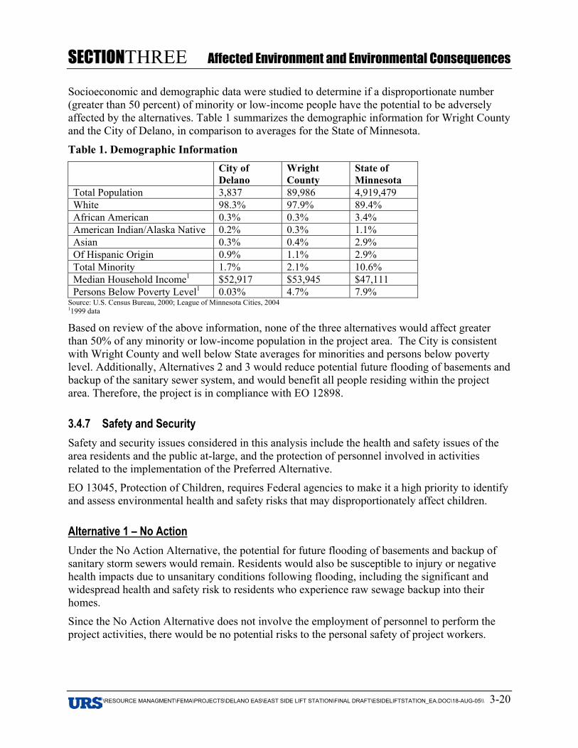
SECTIONTHREE Affected Environment and Environmental Consequences
V:\RESOURCE MANAGMENT\FEMA\PROJECTS\DELANO EAS\EAST SIDE LIFT STATION\FINAL DRAFT\ESIDELIFTSTATION_EA.DOC\18-AUG-05\\ 3-20
Socioeconomic and demographic data were studied to determine if a disproportionate number(greater than 50 percent) of minority or low-income people have the potential to be adverselyaffected by the alternatives. Table 1 summarizes the demographic information for Wright Countyand the City of Delano, in comparison to averages for the State of Minnesota.
Table 1. Demographic InformationCity ofDelano
WrightCounty
State ofMinnesota
Total Population 3,837 89,986 4,919,479White 98.3% 97.9% 89.4%African American 0.3% 0.3% 3.4%American Indian/Alaska Native 0.2% 0.3% 1.1%Asian 0.3% 0.4% 2.9%Of Hispanic Origin 0.9% 1.1% 2.9%Total Minority 1.7% 2.1% 10.6%Median Household Income1 $52,917 $53,945 $47,111Persons Below Poverty Level1 0.03% 4.7% 7.9%
Source: U.S. Census Bureau, 2000; League of Minnesota Cities, 200411999 data
Based on review of the above information, none of the three alternatives would affect greaterthan 50% of any minority or low-income population in the project area. The City is consistentwith Wright County and well below State averages for minorities and persons below povertylevel. Additionally, Alternatives 2 and 3 would reduce potential future flooding of basements andbackup of the sanitary sewer system, and would benefit all people residing within the projectarea. Therefore, the project is in compliance with EO 12898.
3.4.7 Safety and SecuritySafety and security issues considered in this analysis include the health and safety issues of thearea residents and the public at-large, and the protection of personnel involved in activitiesrelated to the implementation of the Preferred Alternative.
EO 13045, Protection of Children, requires Federal agencies to make it a high priority to identifyand assess environmental health and safety risks that may disproportionately affect children.
Alternative 1 – No ActionUnder the No Action Alternative, the potential for future flooding of basements and backup ofsanitary storm sewers would remain. Residents would also be susceptible to injury or negativehealth impacts due to unsanitary conditions following flooding, including the significant andwidespread health and safety risk to residents who experience raw sewage backup into theirhomes.
Since the No Action Alternative does not involve the employment of personnel to perform theproject activities, there would be no potential risks to the personal safety of project workers.
SECTIONTHREE Affected Environment and Environmental Consequences
V:\RESOURCE MANAGMENT\FEMA\PROJECTS\DELANO EAS\EAST SIDE LIFT STATION\FINAL DRAFT\ESIDELIFTSTATION_EA.DOC\18-AUG-05\\ 3-21
Alternative 2 – Stormwater Lift Station with 40 cfs Pumping Capacity on Pond 1(PREFERRED ALTERNATIVE)Under Alternative 2, storm sewer improvement activities could present safety risks to individualsperforming the activities. To minimize risks to safety and human health, all project activitieswould be performed using qualified personnel trained in the proper use of the appropriateequipment, including safety precautions. In addition, all activities would be conducted inaccordance with Occupational Safety and Health Administration (OSHA) regulations.
Implementation of Alternative 2 would increase the efficiency of the storm sewer system. Thiswould reduce the risk of injury and negative health impacts to residents as a result of floodingand storm sewer backup.
Persons of all ages reside in the project area neighborhood, and youth of all ages utilize nearbyCentral Park. Additional protection will be ensured at the project site by the used of cautionarysignage and protective fencing. The project would take measures to protect children, and istherefore in compliance with EO 13045.
Alternative 3 – Stormwater Lift Station with 40 cfs Pumping Capacity on Pond 2Under the Alternative 3, storm sewer improvement activities could present safety risks toindividuals performing the activities. Actions to minimize risks to safety and human healthwould be completed as described under Alternative 2, as both alternatives follow similaralignment and would require similar construction activities.
Implementation of Alternative 3 would increase the capacity of the storm sewer system. Thiswould reduce the risk of injury and negative health impacts to residents as a result of floodingand storm sewer backup.
Persons of all ages reside in the project area neighborhood, and the project would occur withinCentral Park, which is utilized by youth of all ages. Additional protection will be ensured at theproject site by the used of cautionary signage and protective fencing. The project would takemeasures to protect children, and is therefore in compliance with EO 13045.
3.5 CULTURAL RESOURCESIn addition to review under NEPA, consideration of impacts to cultural resources is mandatedunder Section 106 of the National Historic Preservation Act, as amended, and implemented by36 CFR Part 800. Requirements include identification of significant historic properties that maybe affected by the proposed project. Historic properties are defined as archaeological sites,standing structures, or other historic resources listed in or eligible for listing in the NationalRegister of Historic Places (NRHP) (36 CFR 60.4).
As defined in 36 CFR Part 800.16(d), the Area of Potential Effect (APE) “is the geographic areaor areas within which an undertaking may directly or indirectly cause changes in the character oruse of historic properties, if any such properties exist.”
In addition to identifying historic properties that may exist in the APE of the PreferredAlternative, FEMA must also determine, in consultation with the appropriate State HistoricPreservation Office (SHPO), what effect, if any, the action would have on historic properties.
SECTIONTHREE Affected Environment and Environmental Consequences
V:\RESOURCE MANAGMENT\FEMA\PROJECTS\DELANO EAS\EAST SIDE LIFT STATION\FINAL DRAFT\ESIDELIFTSTATION_EA.DOC\18-AUG-05\\ 3-22
Moreover, if the project would have an adverse impact on these properties, FEMA must consultwith the SHPO on ways to avoid, minimize, or mitigate the adverse effect.
The Minnesota Department of Public Safety/Homeland Security and Emergency Managementinitiated consultation with the SHPO in October 2003. The SHPO responded in a letter datedDecember 2, 2003, that no properties eligible for or listed in the NRHP are within the project’sarea of effect. In an e-mail dated October 1, 2004, the SHPO stated that its review findings from2003 remain the same (Appendix B).
Alternative 1 – No ActionUnder the No Action Alternative, there would be no effects to cultural resources becauseproposed improvements would not occur.
Alternative 2 – Stormwater Lift Station with 40 cfs Pumping Capacity on Pond 1(PREFERRED ALTERNATIVE)Based on research and the archaeological survey, it is not anticipated that any NRHP-eligible orlisted properties exist within the proposed project area; however, if artifacts or human remainsare encountered during construction, work in the vicinity would be halted, and FEMA, the Officeof the State Archaeologist (OSA), and the SHPO would be immediately contacted.
Alternative 3 – Stormwater Lift Station with 40 cfs Pumping Capacity on Pond 2As under Alternative 2, it is not anticipated that any NRHP-eligible or listed properties existwithin the project area for Alternative 3; however, if artifacts or human remains are encounteredduring construction, work in the vicinity would be halted, and FEMA, the OSA, and the SHPOwould be immediately contacted.
3.5.1 Tribal CoordinationInitial American Indian group contacts were suggested by the Minnesota SHPO (see list inSection 7). Letters were sent to the list of potential consulting and interested parties on October29, 2004.
Follow-up consultation was initiated on April 8, 2005. A response was received from theShakopee Mdewakanton Community, which expressed an interest in any areas of potentialhistorical significance that may be disturbed (see Appendix B). Consultation with the SHPO wasaddressed as discussed above. The American Indian community will continue to be notified ofproject progress, and will be involved in review of this EA.
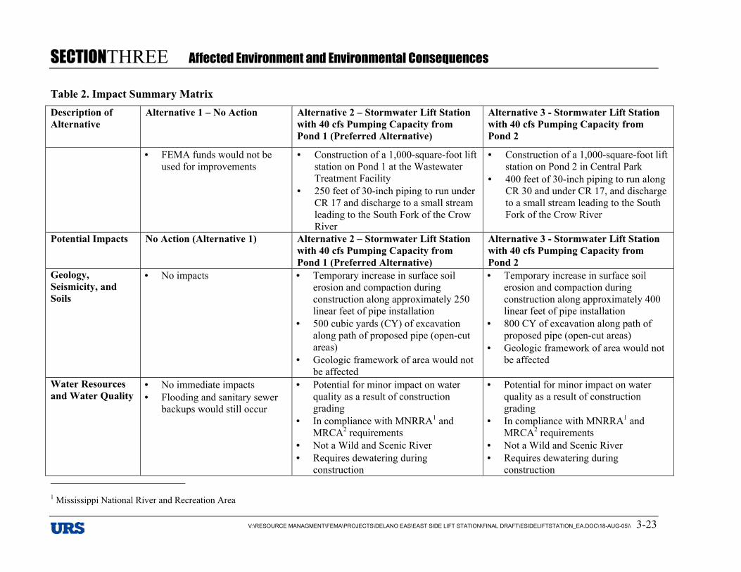
SECTIONTHREE Affected Environment and Environmental Consequences
V:\RESOURCE MANAGMENT\FEMA\PROJECTS\DELANO EAS\EAST SIDE LIFT STATION\FINAL DRAFT\ESIDELIFTSTATION_EA.DOC\18-AUG-05\\ 3-23
Table 2. Impact Summary MatrixDescription ofAlternative
Alternative 1 – No Action Alternative 2 – Stormwater Lift Stationwith 40 cfs Pumping Capacity fromPond 1 (Preferred Alternative)
Alternative 3 - Stormwater Lift Stationwith 40 cfs Pumping Capacity fromPond 2
• FEMA funds would not beused for improvements
• Construction of a 1,000-square-foot liftstation on Pond 1 at the WastewaterTreatment Facility
• 250 feet of 30-inch piping to run underCR 17 and discharge to a small streamleading to the South Fork of the CrowRiver
• Construction of a 1,000-square-foot liftstation on Pond 2 in Central Park
• 400 feet of 30-inch piping to run alongCR 30 and under CR 17, and dischargeto a small stream leading to the SouthFork of the Crow River
Potential Impacts No Action (Alternative 1) Alternative 2 – Stormwater Lift Stationwith 40 cfs Pumping Capacity fromPond 1 (Preferred Alternative)
Alternative 3 - Stormwater Lift Stationwith 40 cfs Pumping Capacity fromPond 2
Geology,Seismicity, andSoils
• No impacts • Temporary increase in surface soilerosion and compaction duringconstruction along approximately 250linear feet of pipe installation
• 500 cubic yards (CY) of excavationalong path of proposed pipe (open-cutareas)
• Geologic framework of area would notbe affected
• Temporary increase in surface soilerosion and compaction duringconstruction along approximately 400linear feet of pipe installation
• 800 CY of excavation along path ofproposed pipe (open-cut areas)
• Geologic framework of area would notbe affected
Water Resourcesand Water Quality
• No immediate impacts• Flooding and sanitary sewer
backups would still occur
• Potential for minor impact on waterquality as a result of constructiongrading
• In compliance with MNRRA1 andMRCA2 requirements
• Not a Wild and Scenic River• Requires dewatering during
construction
• Potential for minor impact on waterquality as a result of constructiongrading
• In compliance with MNRRA1 andMRCA2 requirements
• Not a Wild and Scenic River• Requires dewatering during
construction 1 Mississippi National River and Recreation Area
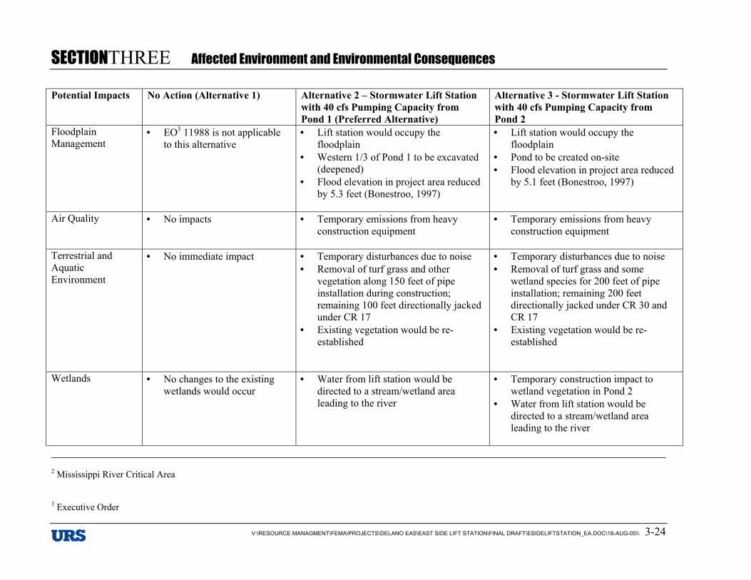
SECTIONTHREE Affected Environment and Environmental Consequences
V:\RESOURCE MANAGMENT\FEMA\PROJECTS\DELANO EAS\EAST SIDE LIFT STATION\FINAL DRAFT\ESIDELIFTSTATION_EA.DOC\18-AUG-05\\ 3-24
Potential Impacts No Action (Alternative 1) Alternative 2 – Stormwater Lift Stationwith 40 cfs Pumping Capacity fromPond 1 (Preferred Alternative)
Alternative 3 - Stormwater Lift Stationwith 40 cfs Pumping Capacity fromPond 2
FloodplainManagement
• EO3 11988 is not applicableto this alternative
• Lift station would occupy thefloodplain
• Western 1/3 of Pond 1 to be excavated(deepened)
• Flood elevation in project area reducedby 5.3 feet (Bonestroo, 1997)
• Lift station would occupy thefloodplain
• Pond to be created on-site• Flood elevation in project area reduced
by 5.1 feet (Bonestroo, 1997)
Air Quality • No impacts • Temporary emissions from heavyconstruction equipment
• Temporary emissions from heavyconstruction equipment
Terrestrial andAquaticEnvironment
• No immediate impact • Temporary disturbances due to noise• Removal of turf grass and other
vegetation along 150 feet of pipeinstallation during construction;remaining 100 feet directionally jackedunder CR 17
• Existing vegetation would be re-established
• Temporary disturbances due to noise• Removal of turf grass and some
wetland species for 200 feet of pipeinstallation; remaining 200 feetdirectionally jacked under CR 30 andCR 17
• Existing vegetation would be re-established
Wetlands • No changes to the existingwetlands would occur
• Water from lift station would bedirected to a stream/wetland arealeading to the river
• Temporary construction impact towetland vegetation in Pond 2
• Water from lift station would bedirected to a stream/wetland arealeading to the river
2 Mississippi River Critical Area
3 Executive Order
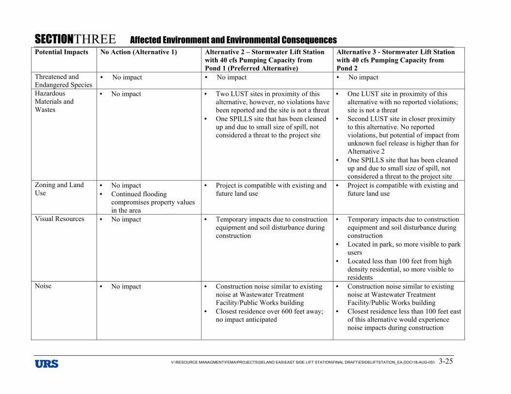
SECTIONTHREE Affected Environment and Environmental Consequences
V:\RESOURCE MANAGMENT\FEMA\PROJECTS\DELANO EAS\EAST SIDE LIFT STATION\FINAL DRAFT\ESIDELIFTSTATION_EA.DOC\18-AUG-05\\ 3-25
Potential Impacts No Action (Alternative 1) Alternative 2 – Stormwater Lift Stationwith 40 cfs Pumping Capacity fromPond 1 (Preferred Alternative)
Alternative 3 - Stormwater Lift Stationwith 40 cfs Pumping Capacity fromPond 2
Threatened andEndangered Species
• No impact • No impact • No impact
HazardousMaterials andWastes
• No impact • Two LUST sites in proximity of thisalternative, however, no violations havebeen reported and the site is not a threat
• One SPILLS site that has been cleanedup and due to small size of spill, notconsidered a threat to the project site
• One LUST site in proximity of thisalternative with no reported violations;site is not a threat
• Second LUST site in closer proximityto this alternative. No reportedviolations, but potential of impact fromunknown fuel release is higher than forAlternative 2
• One SPILLS site that has been cleanedup and due to small size of spill, notconsidered a threat to the project site
Zoning and LandUse
• No impact• Continued flooding
compromises property valuesin the area
• Project is compatible with existing andfuture land use
• Project is compatible with existing andfuture land use
Visual Resources • No impact • Temporary impacts due to constructionequipment and soil disturbance duringconstruction
• Temporary impacts due to constructionequipment and soil disturbance duringconstruction
• Located in park, so more visible to parkusers
• Located less than 100 feet from highdensity residential, so more visible toresidents
Noise • No impact • Construction noise similar to existingnoise at Wastewater TreatmentFacility/Public Works building
• Closest residence over 600 feet away;no impact anticipated
• Construction noise similar to existingnoise at Wastewater TreatmentFacility/Public Works building
• Closest residence less than 100 feet eastof this alternative would experiencenoise impacts during construction
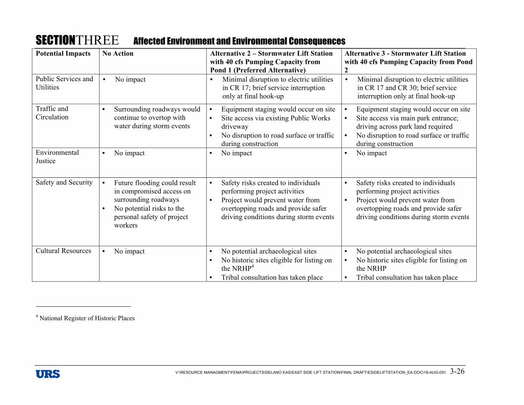
SECTIONTHREE Affected Environment and Environmental Consequences
V:\RESOURCE MANAGMENT\FEMA\PROJECTS\DELANO EAS\EAST SIDE LIFT STATION\FINAL DRAFT\ESIDELIFTSTATION_EA.DOC\18-AUG-05\\ 3-26
Potential Impacts No Action Alternative 2 – Stormwater Lift Stationwith 40 cfs Pumping Capacity fromPond 1 (Preferred Alternative)
Alternative 3 - Stormwater Lift Stationwith 40 cfs Pumping Capacity from Pond2
Public Services andUtilities
• No impact • Minimal disruption to electric utilitiesin CR 17; brief service interruptiononly at final hook-up
• Minimal disruption to electric utilitiesin CR 17 and CR 30; brief serviceinterruption only at final hook-up
Traffic andCirculation
• Surrounding roadways wouldcontinue to overtop withwater during storm events
• Equipment staging would occur on site• Site access via existing Public Works
driveway• No disruption to road surface or traffic
during construction
• Equipment staging would occur on site• Site access via main park entrance;
driving across park land required• No disruption to road surface or traffic
during constructionEnvironmentalJustice
• No impact • No impact • No impact
Safety and Security • Future flooding could resultin compromised access onsurrounding roadways
• No potential risks to thepersonal safety of projectworkers
• Safety risks created to individualsperforming project activities
• Project would prevent water fromovertopping roads and provide saferdriving conditions during storm events
• Safety risks created to individualsperforming project activities
• Project would prevent water fromovertopping roads and provide saferdriving conditions during storm events
Cultural Resources • No impact • No potential archaeological sites• No historic sites eligible for listing on
the NRHP4
• Tribal consultation has taken place
• No potential archaeological sites• No historic sites eligible for listing on
the NRHP• Tribal consultation has taken place
4 National Register of Historic Places
SECTIONTHREE Affected Environment and Environmental Consequences
V:\RESOURCE MANAGMENT\FEMA\PROJECTS\DELANO EAS\EAST SIDE LIFT STATION\FINAL DRAFT\ESIDELIFTSTATION_EA.DOC\18-AUG-05\\ 3-27
SECTIONFOUR Cumulative Impacts
V:\RESOURCE MANAGMENT\FEMA\PROJECTS\DELANO EAS\EAST SIDE LIFT STATION\FINAL DRAFT\ESIDELIFTS
4. Section 4 FOUR Cumulative Impacts
Cumulative impacts are those effects on the environment that result from the incremental effectof the action when added to past, present, and reasonably foreseeable future actions regardless ofwhat agency (Federal or non-Federal) or person undertakes such other actions. Cumulativeeffects can result from individually minor, but collectively significant, actions taking place overa period of time.
Four HMGP projects are currently proposed within the City of Delano. The East Side LiftStation project is one of these four projects. The other three include the Elm Avenue Diversion,the West Side Lift Station, and Alley Resurfacing (Figure 5). All of these projects are designedto control excessive flooding that has plagued the City of Delano in recent years. On manyoccasions in 2001 and 2002, the City was forced to conduct emergency pumping andsandbagging activities to attempt to protect local homes and businesses.
Cumulatively, a basic hydraulic analysis of total stormwater discharge from the four projectscompared to total watershed size indicates these projects will not have substantial negativeimpacts on the South Fork of the Crow River system or the floodplain system as a whole(Bonestroo, 1997). The Elm Avenue Diversion would direct water to the area south of the highschool, which is part of the same system of ditches and wetlands that would eventually runthrough the East Side Lift Station and to the South Fork of the Crow River. The northeast portionof the Alley Resurfacing Project would also direct water through wetlands to the East Side LiftStation, with the remainder of the area draining through the existing stormwater piping to theriver. The West Side Lift Station would serve the west part of the City, collecting stormwater fordischarge to the river. Collectively, during a 100-year flood event the projects would deliverapproximately 120 cfs to the South Fork of the Crow River. This is derived from the 40 cfspumping capacity at East Side Lift Station (which would collect water from the Elm AvenueDiversion and the Alley Resurfacing Project) and the 80 cfs of pumping capacity at the WestSide Lift Station. Using the June 2002 flood example of 13.5 feet, the South Fork of the CrowRiver is flowing at 6,489 cfs (National Weather Service, 2005). The impact of the addition of120 cfs is negligible at 1.8 percent. This slight increase would not increase the elevation of the100-year floodplain or impact downstream areas (Krogstad, personal communication).
With these projects implemented, the City of Delano would be better able to manage itsstormwater and floodwater during and after storm events. This allows for quicker emergencyresponse, and also contributes positively to the overall quality of life for Delano residents. Betterwater management would reduce risk of property damage from flooding, and protect residentsfrom health and safety risks associated with excess water and sewer backups. The City would beable to expend money on other necessary municipal improvements and programs, instead offunding extensive emergency pumping activities.
It is not anticipated that floodplain development would be promoted as a result of implementingthe proposed projects. The City of Delano has an existing Floodplain District Ordinance thatprohibits development within the floodway of the South Fork of the Crow River within the City.In addition, the City has actively pursued and successfully obtained Flood Damage Reduction(FDR) grant funding from the WDNR to purchase and remove repetitive loss properties withinthe 100-year floodplain. The former Bock property, at the site of the proposed West Side LiftStation, was purchased under this grant. The City continues to identify and pursue funding forremoval of additional properties. Currently, FDR funding has been received for removal of aresidence in the south part of the city, and two other commercial properties along the east bank
SECTIONFOUR Cumulative Impacts
V:\RESOURCE MANAGMENT\FEMA\PROJECTS\DELANO EAS\EAST SIDE LIFT STATION\FINAL DRAFT\ESIDELIFTS
of the river in the downtown area are also slated for acquisition and demolition (Fick, personalcommunication).
Individually, each of the projects would have long-term positive impacts on the naturalenvironment. Any combination of these projects would magnify these benefits citywide.Managing stormwater and handling floodwater more efficiently would create a more consistenthydrologic regime for wetlands, which supports stable habitat and plant and animal life, as wellas overall water quality. A more controlled system would also reduce erosion and sedimentationimpacts that result from emergency pumping, standing basins of floodwater, and overtopping ofroads and basins.
SECTIONFIVE Public Participation
V:\RESOURCE MANAGMENT\FEMA\PROJECTS\DELANO EAS\EAST SIDE LIFT STATION\FINAL DRAFT\ESIDELIFTSTATION_EA.DOC\18-AUG-05\\ 5-1
5. Section 5 FIVE Public Participation
The Delano Stormwater Task Force (Task Force) was appointed by the Delano City Council onNovember 12, 2002. This was a nine-member committee appointed to identify priorities forflood mitigation projects within the City. Members included City residents as well as twoprofessional engineers. Task Force meetings were held on the following dates:
• November 21, 2002• December 6, 2002• December 12, 2002• December 19, 2002• January 6, 2003• January 9, 2003• January 30, 2003• February 5, 2003• February 19, 2003• March 13, 2003 – joint meeting with City Council
All City Council meetings are open to the public and are also locally televised. Minutes frommeetings are also available on the City of Delano website. A specific public hearing discussingsump pump operations and the City’s stormwater drainage ordinance was held February 4, 2003.The public notice from this meeting is included on the following page.
Public notice advertising the availability of the draft EA was drafted and provided to a local newspaper of general distribution (see Appendix E). The document was made available for hardcopy review and was also available for review online at the FEMA website: http://www.fema.gov/ehp/docs.shtm. The public was provided 30 days for comment on the EA, anda public meeting was held on September 6, 2005.
The Minnesota Department of Natural Resources provided comments on the Draft EA. The commentletter is included in Appendix E.
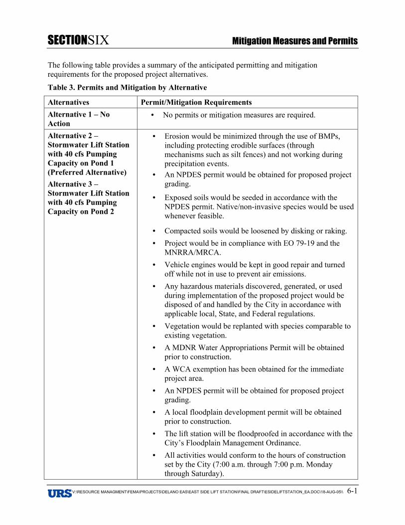
SECTIONSIX Mitigation Measures and Permits
V:\RESOURCE MANAGMENT\FEMA\PROJECTS\DELANO EAS\EAST SIDE LIFT STATION\FINAL DRAFT\ESIDELIFTSTATION_EA.DOC\18-AUG-05\\ 6-1
6. Section 6 SIX Mitigation Measures and Permits
The following table provides a summary of the anticipated permitting and mitigationrequirements for the proposed project alternatives.
Table 3. Permits and Mitigation by Alternative
Alternatives Permit/Mitigation RequirementsAlternative 1 – NoAction
• No permits or mitigation measures are required.
Alternative 2 –Stormwater Lift Stationwith 40 cfs PumpingCapacity on Pond 1(Preferred Alternative)Alternative 3 –Stormwater Lift Stationwith 40 cfs PumpingCapacity on Pond 2
• Erosion would be minimized through the use of BMPs,including protecting erodible surfaces (throughmechanisms such as silt fences) and not working duringprecipitation events.
• An NPDES permit would be obtained for proposed projectgrading.
• Exposed soils would be seeded in accordance with theNPDES permit. Native/non-invasive species would be usedwhenever feasible.
• Compacted soils would be loosened by disking or raking.• Project would be in compliance with EO 79-19 and the
MNRRA/MRCA.• Vehicle engines would be kept in good repair and turned
off while not in use to prevent air emissions.• Any hazardous materials discovered, generated, or used
during implementation of the proposed project would bedisposed of and handled by the City in accordance withapplicable local, State, and Federal regulations.
• Vegetation would be replanted with species comparable toexisting vegetation.
• A MDNR Water Appropriations Permit will be obtainedprior to construction.
• A WCA exemption has been obtained for the immediateproject area.
• An NPDES permit will be obtained for proposed projectgrading.
• A local floodplain development permit will be obtainedprior to construction.
• The lift station will be floodproofed in accordance with theCity’s Floodplain Management Ordinance.
• All activities would conform to the hours of constructionset by the City (7:00 a.m. through 7:00 p.m. Mondaythrough Saturday).
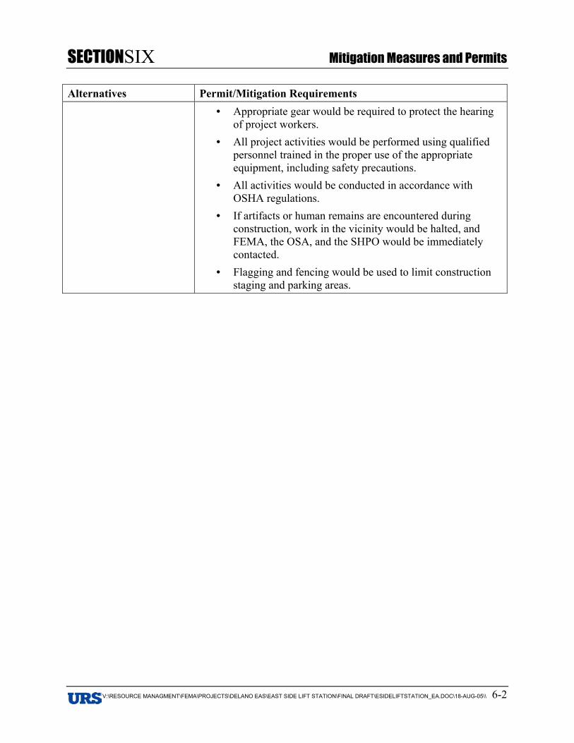
SECTIONSIX Mitigation Measures and Permits
V:\RESOURCE MANAGMENT\FEMA\PROJECTS\DELANO EAS\EAST SIDE LIFT STATION\FINAL DRAFT\ESIDELIFTSTATION_EA.DOC\18-AUG-05\\ 6-2
Alternatives Permit/Mitigation Requirements• Appropriate gear would be required to protect the hearing
of project workers.• All project activities would be performed using qualified
personnel trained in the proper use of the appropriateequipment, including safety precautions.
• All activities would be conducted in accordance withOSHA regulations.
• If artifacts or human remains are encountered duringconstruction, work in the vicinity would be halted, andFEMA, the OSA, and the SHPO would be immediatelycontacted.
• Flagging and fencing would be used to limit constructionstaging and parking areas.
SECTIONSEVEN Consultations and References
V:\RESOURCE MANAGMENT\FEMA\PROJECTS\DELANO EAS\EAST SIDE LIFT STATION\FINAL DRAFT\ESIDELIFTSTATION_EA.DOC\18-AUG-05\\ 7-1
7. Section 7 SEVEN Consultations and References
7.1 CONSULTATIONSThe Minnesota Office of Homeland Security and Emergency Management sent initialconsultation letters to the following agencies in October 2003:
• Minnesota Department of Natural Resources, Division of Waters
• State Historic Preservation Office
• United States Army Corps of Engineers
These agencies were contacted again by URS in September/October 2004 to ensure that findingsrelayed in 2003 were still applicable to the project. Agencies were sent a summary of the projectand an update on the NEPA process.
In addition, MDNR consultation for rare, threatened, and endangered species was initiated by theMinnesota Office of Homeland Security and Emergency Management in February 2003.Consultation with the USFWS was initiated by URS in October 2004, and the MDNR NaturalHeritage Program (NHP) was also contacted to ensure that the original findings were stillapplicable to the project. The findings of the USFWS and the MDNR NHP are incorporated intothe EA. These responses are included in Appendix B.
Additional consultations included:
• Federal Emergency Management Agency
• Minnesota Department of Public Safety - Homeland Security and Emergency Management
• City of Delano
The following will receive a copy of the Draft EA:
Federal AgenciesUnited States Army Corps of Engineers
United States Department of the Interior, U.S. Fish and Wildlife Service
TribesLower Sioux Community
Prairie Island Indian Community
Shakopee Mdewakanton Sioux Community
Upper Sioux Community
State, County, and Local AgenciesMinnesota Department of Emergency Management
Minnesota Department of Natural Resources
State Historic Preservation Office
SECTIONSEVEN Consultations and References
V:\RESOURCE MANAGMENT\FEMA\PROJECTS\DELANO EAS\EAST SIDE LIFT STATION\FINAL DRAFT\ESIDELIFTSTATION_EA.DOC\18-AUG-05\\ 7-2
Office of the State Archaeologist
Minnesota Indian Affairs Council
Board of Water and Soil Resources
Wright County Soil and Water Conservation District
Wright County Planning
City of Delano
7.2 REFERENCESBonestroo Rosene Anderlik & Associates. 2002. June 2002 Flood Analysis, Delano, Minnesota.
File No. 280-02-124.
Bonestroo Rosene Anderlik & Associates. 1997. Stormwater Management Plan, Delano,Minnesota. File No. 28066.
City of Delano. 2002. City of Delano Web Page, Home Page. http://www.delano.mn.us.Accessed August 11, 2004.
Delano, Minnesota. 2003. Delano Citisite: For the Community, From the Community.http://delano.citisite.com/. Accessed August 11, 2004.
Delano School District. 2004. http://www.delano.k12.mn.us/sitepages/pid45.php. AccessedOctober 29, 2004.
Environmental Protection Agency (EPA). 2003. Air Quality. Accessed August 20, 2004, fromhttp://www.epa.gov/air/oaqps/greenbk/mapnpoll.html.
League of Minnesota Cities. 2004. Census 2000 Update: Expanded Minnesota Profiles.http://www.lmnc.org/census/census.cfm. Accessed August 20, 2004.
Minnesota Pollution Control Agency (MPCA). 2004. Minnesota 305(b) Report to Congress ofthe United States, Assessments of Stream Conditions in Minnesota’s Major River Basins.Retrieved September 14, 2004, fromhttp://www.pca.state.mn.us/water/basins/305briver.html.
MPCA. 2003. Storage Tank Systems. Accessed September 23, 2004, fromhttp://www.pca.state.mn.us/cleanup/tanks.html.
National Park Service (NPS). 2003. Wild and Scenic Rivers by State,http://www.nps.gov/rivers/wildriverslist.html#mn. Accessed November 28, 2004.
National Weather Service (NWS). 2005. Advanced Hydrologic Prediction Service, Crow Riverat Delano. http://www.crh.noaa.gov/cgi-bin/ahps.cgi?mpx Accessed July 21, 2005.
U.S. Army Corps of Engineers (USACE). 2005. DCP Real Time Data, South Fork of CrowRiver at Delano. http://www.mvp-wc.usace.army.mil/dcp/DELM5.html Accessed July 21, 2005.
U.S. Census Bureau. 2000. Accessed August 20, 2004, from http://www.census.org.
SECTIONSEVEN Consultations and References
V:\RESOURCE MANAGMENT\FEMA\PROJECTS\DELANO EAS\EAST SIDE LIFT STATION\FINAL DRAFT\ESIDELIFTSTATION_EA.DOC\18-AUG-05\\ 7-3
U.S. Department of Agriculture (USDA). 1968. Soil Survey of Wright County, Minnesota. UnitedStates Department of Agriculture, Soil Conservation Service, in cooperation with theMinnesota Agricultural Experiment Station. Washington, D.C.
Wenck Associates, Inc. 2004. Phase I Environmental Site Assessment, Bock Property, 102Babcock Boulevard West, Delano, MN. Prepared for City of Delano.
Wentz, C. 1989. Hazardous Waste Management. McGraw-Hill Chemical Engineering Series:New York.
Wright County. 2003. Wright County Web Page, Home Page, http://www.co.wright.mn.us.Accessed August 16, 2004.
Personal CommunicationAnfinson, Scott. SHPO. Personal communication with Evelyn Tidlow, URS Vice President,
October 18, 2004.
Dressler, Lisa, Minnesota Homeland Security and Emergency Management, Hazard MitigationAdministrator. Personal communication with Jessica Overmohle, URS EnvironmentalPlanner, ongoing throughout project process.
Fairchild, Laurie, USFWS. 2004. Personal communication with Jessica Overmohle, URSEnvironmental Planner, September 28, 2004.
Fell, Tim, USACE. Personal communication with Lydia Nelson, URS Professional WetlandScientist, October 15, 2004.
*Fick, Ed, MDNR, Hydrologist. Personal communication with Jessica Overmohle, URSEnvironmental Planner, July 22, 2005.
Fowler, Patricia, MDNR, Area Hydrologist. Personal communication with Jessica Overmohle,URS Environmental Planner, September 28, 2004.
*Krogstad, Brad, URS Engineer. Personal Communication with Jessica Overmohle, URSEnvironmental Planner, July 25, 2005.
Torve, Kent, Wenck Associates, Inc., City Engineer for Delano. Personal communication withJessica Overmohle, URS Environmental Planner, ongoing throughout project process.
Torve, Kent, Wenck Associates, Inc., City Engineer for Delano. Personal communication withLydia Nelson, URS Professional Wetland Scientist, February 17, 2005.
*Referenced in text; Record of Conversation attached.
SECTIONEIGHT List of Preparers
V:\RESOURCE MANAGMENT\FEMA\PROJECTS\DELANO EAS\EAST SIDE LIFT STATION\FINAL DRAFT\ESIDELIFTSTATION_EA.DOC\18-AUG-05\\ 8-1
8. Section 8 EIGHT List of Preparers
Lydia Nelson, Professional Wetland Scientist, URS-Minneapolis (MSP) – Peer Reviewer/FieldAssessment/Floodplain Review. Conducted field research for sections on Water Resources andWater Quality, Floodplain Management, Terrestrial and Aquatic Environment, Wetlands.
Jessica Overmohle, Environmental Planner, URS-MSP – Technical Researcher and TaskCoordinator. Author of sections on Purpose and Need, Alternatives, Geology, Seismicity, andSoils, Air Quality, Hazardous Materials, Threatened and Endangered Species, Zoning and LandUse, Visual Resources, Noise, Public Services and Utilities, Traffic and Circulation,Environmental Justice, Safety and Security, Cumulative Impacts.
Amy Siegel, Document Control Supervisor, URS-Gaithersburg (GTB) – Document QualityControl.
Stephen Carruth, FEMA National Environmental Coordinator, URS-GTB – IndependentTechnical Reviewer.
Evelyn Tidlow, URS-MSP – Project Manager.

Figures
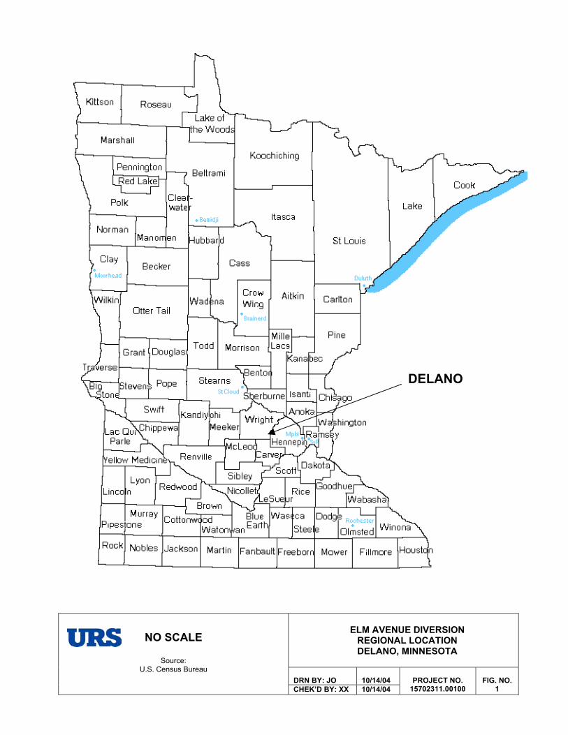
ELM AVENUE DIVERSION REGIONAL LOCATION DELANO, MINNESOTA
DRN BY: JO 10/14/04
NO SCALE
Source:U.S. Census Bureau
CHEK’D BY: XX 10/14/04PROJECT NO.
15702311.00100FIG. NO.
1
DELANO
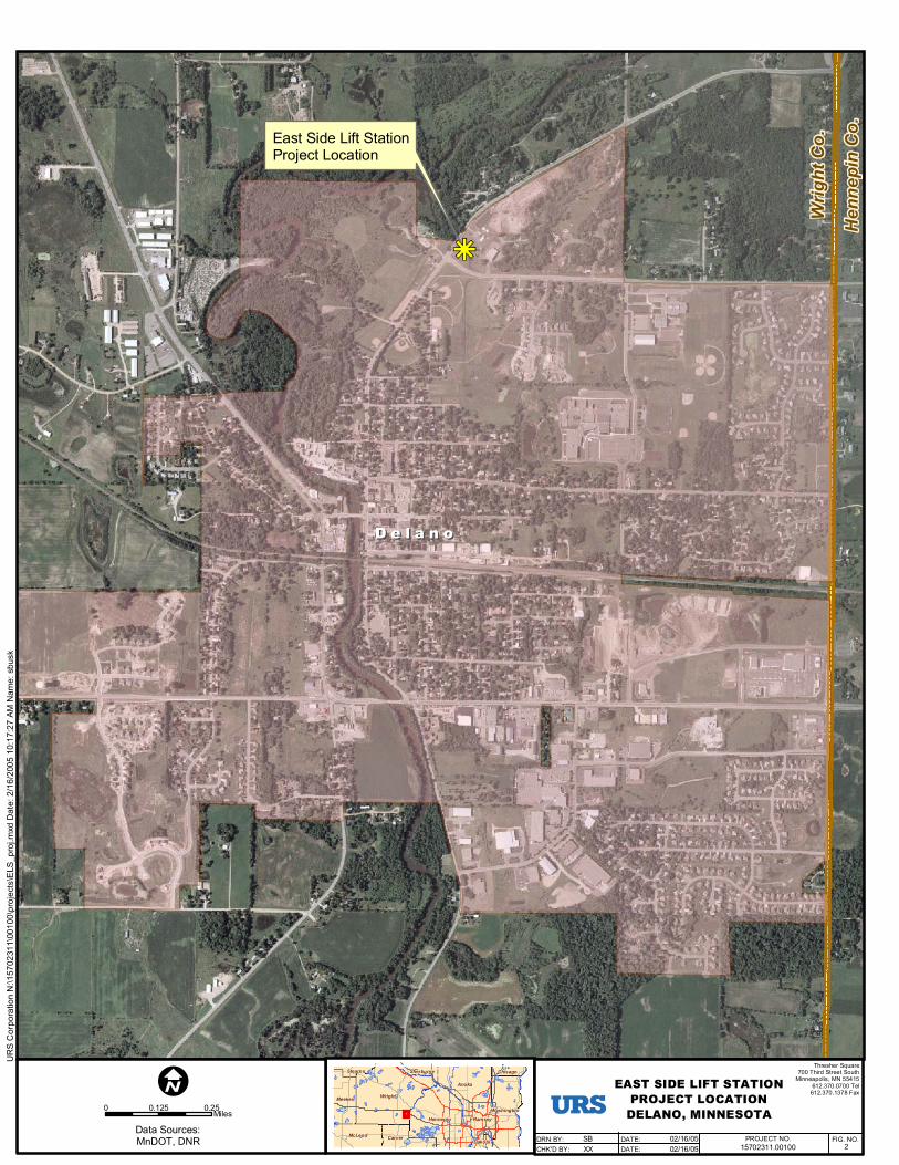
D e l a n oD e l a n o
Wrig
ht C
o.
Hen
nepi
n C
o.
hg
East Side Lift StationProject Location
Wright
Hennepin
Anoka
Washington
Meeker
McLeod Carver
Ramsey
Chisago
Dakota
Stearns Sherburne
0 0.250.125Miles
Data Sources:MnDOT, DNR
IThresher Square
700 Third Street SouthMinneapolis, MN 55415
612.370.0700 Tel612.370.1378 Fax
EAST SIDE LIFT STATIONPROJECT LOCATION
DELANO, MINNESOTA
15702311.00100 2PROJECT NO. FIG. NO.SB
XX02/16/0502/16/05
DRN BY:CHK'D BY:
DATE:DATE:
UR
S C
orpo
ratio
n N
:\157
0231
1\00
100\
proj
ects
\ELS
_pro
j.mxd
Dat
e: 2
/16/
2005
10:
17:2
7 AM
Nam
e: s
busk
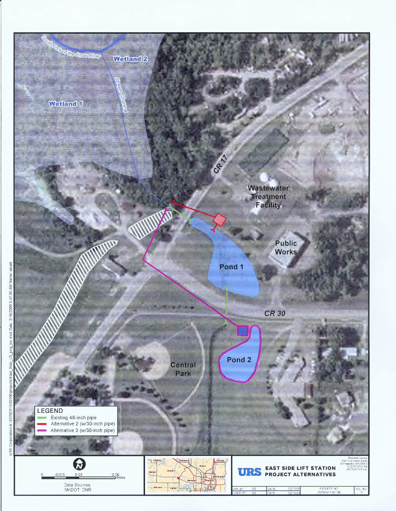
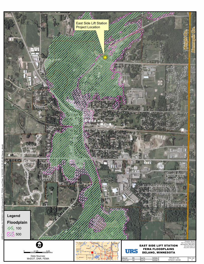
D e l a n oD e l a n o
Wrig
ht C
o.
Hen
nepi
n C
o.
hg
East Side Lift StationProject Location
Wright
Hennepin
Anoka
Washington
Meeker
McLeod Carver
Ramsey
Chisago
Dakota
Stearns Sherburne
0 0.250.125Miles
Data Sources:MnDOT, DNR, FEMA
IThresher Square
700 Third Street SouthMinneapolis, MN 55415
612.370.0700 Tel612.370.1378 Fax
EAST SIDE LIFT STATIONFEMA FLOODPLAINS
DELANO, MINNESOTA
15702311.00100 4PROJECT NO. FIG. NO.ES
XX10/5/0410/5/04
DRN BY:CHK'D BY:
DATE:DATE:
Legend
Floodplain100
500
UR
S C
orpo
ratio
n N
:\157
0231
1\00
100\
proj
ects
\ELS
_FE
MA
.mxd
Dat
e: 2
/16/
2005
10:
35:4
3 AM
Nam
e: s
busk
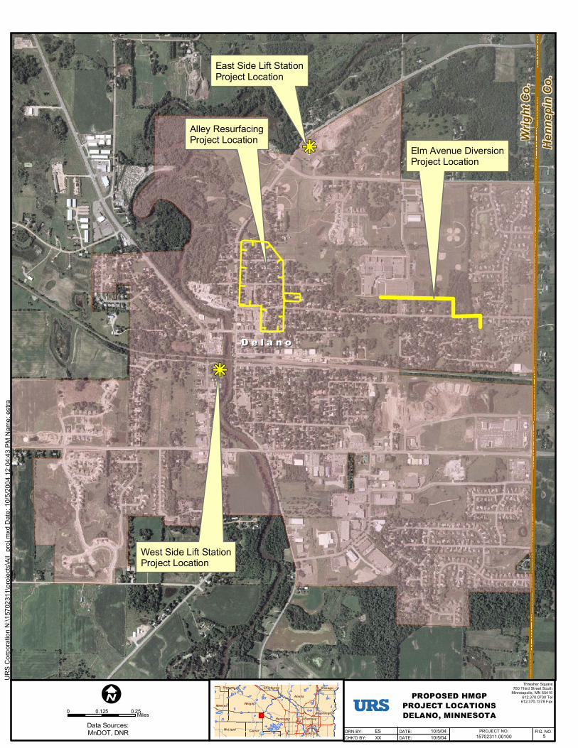
D e l a n oD e l a n o
Wrig
ht C
o.
Hen
nepi
n C
o.
Alley ResurfacingProject Location
Elm Avenue DiversionProject Location
hg
East Side Lift StationProject Location
hg
West Side Lift StationProject Location
Wright
Hennepin
Anoka
Washington
Meeker
McLeod Carver
Ramsey
Chisago
Dakota
Stearns Sherburne
0 0.250.125Miles
Data Sources:MnDOT, DNR
IThresher Square
700 Third Street SouthMinneapolis, MN 55415
612.370.0700 Tel612.370.1378 Fax
PROPOSED HMGPPROJECT LOCATIONSDELANO, MINNESOTA
15702311.00100 5PROJECT NO. FIG. NO.ES
XX10/5/0410/5/04
DRN BY:CHK'D BY:
DATE:DATE:
UR
S C
orpo
ratio
n N
:\157
0231
1\pr
ojec
ts\A
ll_pr
oj.m
xd D
ate:
10/
5/2 0
04 1
2:04
:43
PM N
ame:
est
ra

Appendix AProject Area Photos
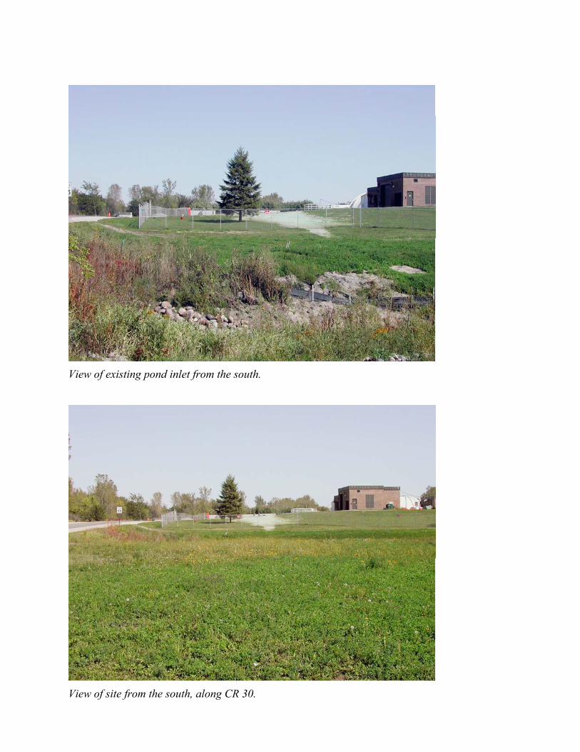
View of existing pond inlet from the south.
View of site from the south, along CR 30.
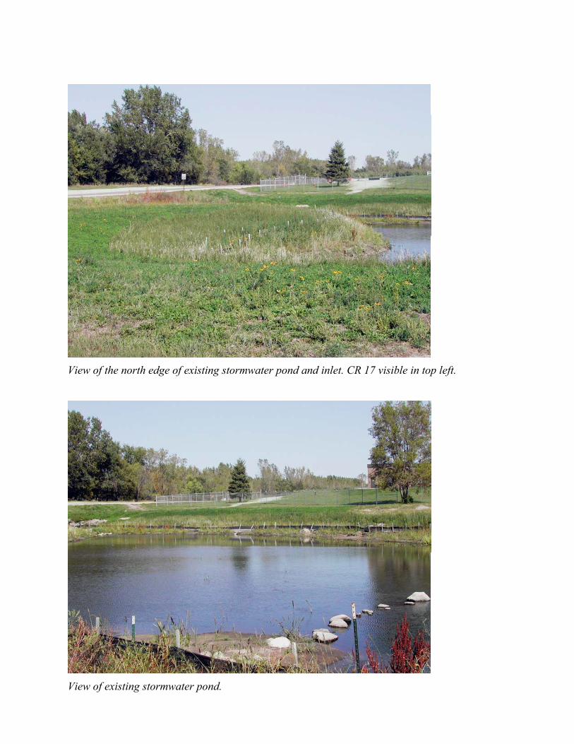
View of the north edge of existing stormwater pond and inlet. CR 17 visible in top left.
View of existing stormwater pond.
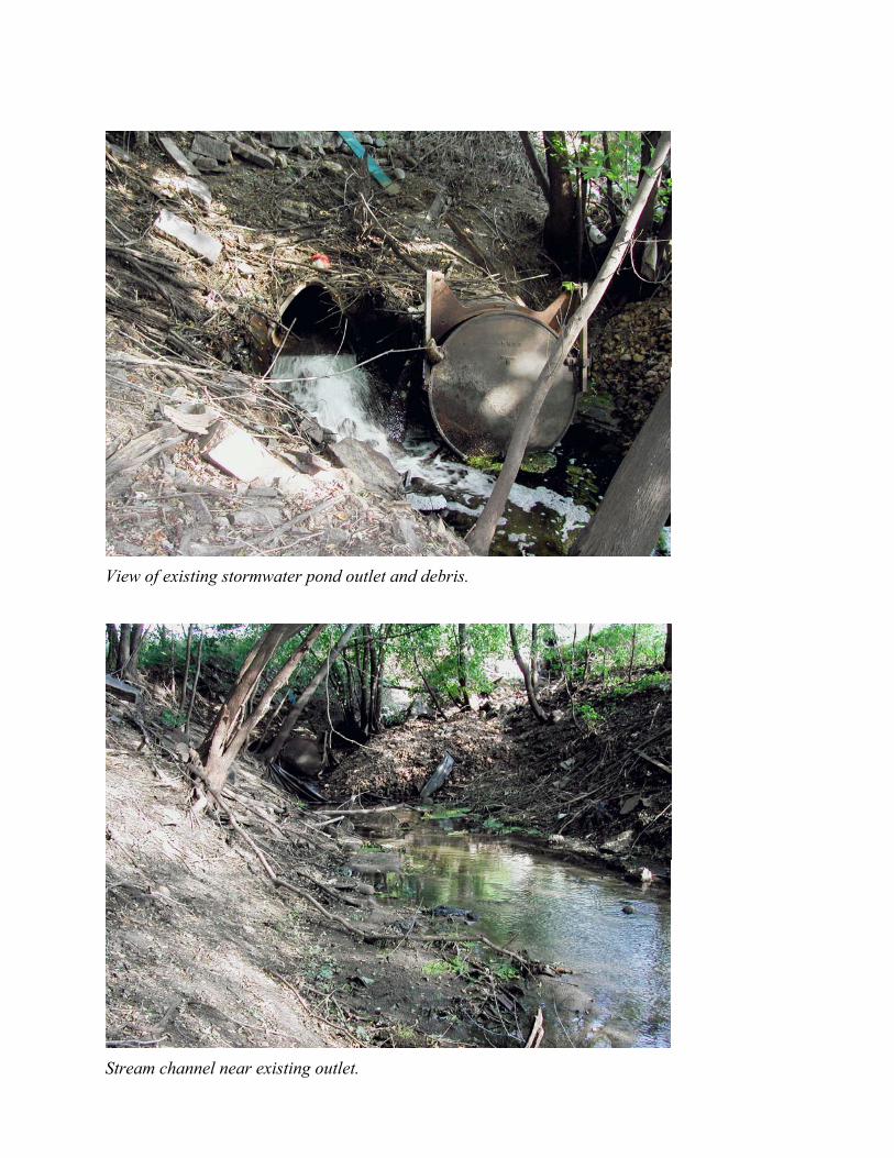
View of existing stormwater pond outlet and debris.
Stream channel near existing outlet.
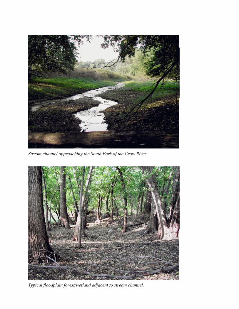
Stream channel approaching the South Fork of the Crow River.
Typical floodplain forest/wetland adjacent to stream channel.
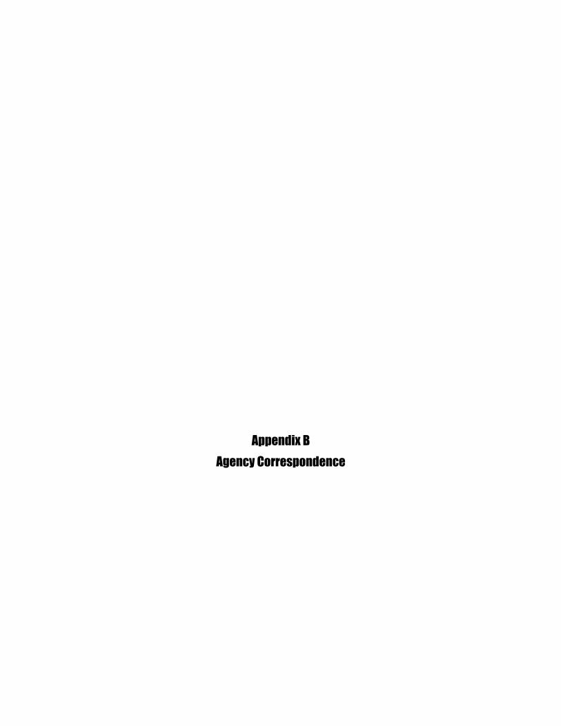
Appendix BAgency Correspondence
Appendix CBest Management Practices (BMPs)
For information on the availability of Appendix C which is not included due to size formattingissues, please use contact instructions given in the Public Notice.
Appendix DEO 11988 and EO 11990 Eight-Step Planning Process
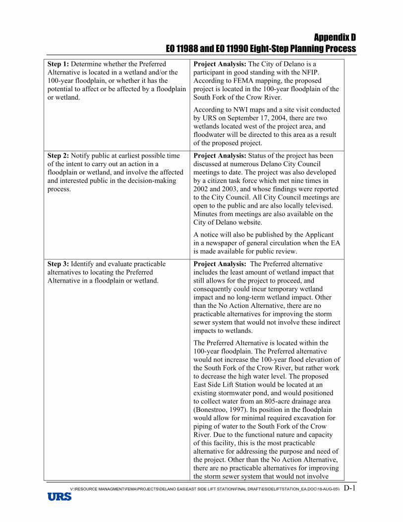
Appendix DEO 11988 and EO 11990 Eight-Step Planning Process
V:\RESOURCE MANAGMENT\FEMA\PROJECTS\DELANO EAS\EAST SIDE LIFT STATION\FINAL DRAFT\ESIDELIFTSTATION_EA.DOC\18-AUG-05\\ D-1
Step 1: Determine whether the PreferredAlternative is located in a wetland and/or the100-year floodplain, or whether it has thepotential to affect or be affected by a floodplainor wetland.
Project Analysis: The City of Delano is aparticipant in good standing with the NFIP.According to FEMA mapping, the proposedproject is located in the 100-year floodplain of theSouth Fork of the Crow River.
According to NWI maps and a site visit conductedby URS on September 17, 2004, there are twowetlands located west of the project area, andfloodwater will be directed to this area as a resultof the proposed project.
Step 2: Notify public at earliest possible timeof the intent to carry out an action in afloodplain or wetland, and involve the affectedand interested public in the decision-makingprocess.
Project Analysis: Status of the project has beendiscussed at numerous Delano City Councilmeetings to date. The project was also developedby a citizen task force which met nine times in2002 and 2003, and whose findings were reportedto the City Council. All City Council meetings areopen to the public and are also locally televised.Minutes from meetings are also available on theCity of Delano website.
A notice will also be published by the Applicantin a newspaper of general circulation when the EAis made available for public review.
Step 3: Identify and evaluate practicablealternatives to locating the PreferredAlternative in a floodplain or wetland.
Project Analysis: The Preferred alternativeincludes the least amount of wetland impact thatstill allows for the project to proceed, andconsequently could incur temporary wetlandimpact and no long-term wetland impact. Otherthan the No Action Alternative, there are nopracticable alternatives for improving the stormsewer system that would not involve these indirectimpacts to wetlands.
The Preferred Alternative is located within the100-year floodplain. The Preferred alternativewould not increase the 100-year flood elevation ofthe South Fork of the Crow River, but rather workto decrease the high water level. The proposedEast Side Lift Station would be located at anexisting stormwater pond, and would positionedto collect water from an 805-acre drainage area(Bonestroo, 1997). Its position in the floodplainwould allow for minimal required excavation forpiping of water to the South Fork of the CrowRiver. Due to the functional nature and capacityof this facility, this is the most practicablealternative for addressing the purpose and need ofthe project. Other than the No Action Alternative,there are no practicable alternatives for improvingthe storm sewer system that would not involve
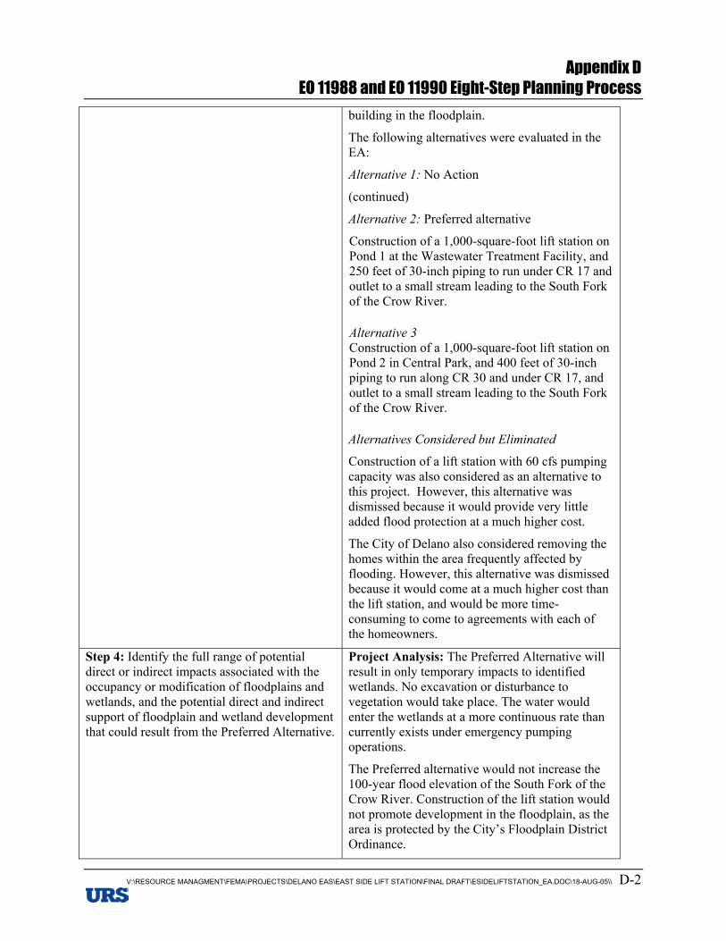
Appendix DEO 11988 and EO 11990 Eight-Step Planning Process
V:\RESOURCE MANAGMENT\FEMA\PROJECTS\DELANO EAS\EAST SIDE LIFT STATION\FINAL DRAFT\ESIDELIFTSTATION_EA.DOC\18-AUG-05\\ D-2
building in the floodplain.
The following alternatives were evaluated in theEA:
Alternative 1: No Action
(continued)
Alternative 2: Preferred alternative
Construction of a 1,000-square-foot lift station onPond 1 at the Wastewater Treatment Facility, and250 feet of 30-inch piping to run under CR 17 andoutlet to a small stream leading to the South Forkof the Crow River.
Alternative 3Construction of a 1,000-square-foot lift station onPond 2 in Central Park, and 400 feet of 30-inchpiping to run along CR 30 and under CR 17, andoutlet to a small stream leading to the South Forkof the Crow River.
Alternatives Considered but Eliminated
Construction of a lift station with 60 cfs pumpingcapacity was also considered as an alternative tothis project. However, this alternative wasdismissed because it would provide very littleadded flood protection at a much higher cost.
The City of Delano also considered removing thehomes within the area frequently affected byflooding. However, this alternative was dismissedbecause it would come at a much higher cost thanthe lift station, and would be more time-consuming to come to agreements with each ofthe homeowners.
Step 4: Identify the full range of potentialdirect or indirect impacts associated with theoccupancy or modification of floodplains andwetlands, and the potential direct and indirectsupport of floodplain and wetland developmentthat could result from the Preferred Alternative.
Project Analysis: The Preferred Alternative willresult in only temporary impacts to identifiedwetlands. No excavation or disturbance tovegetation would take place. The water wouldenter the wetlands at a more continuous rate thancurrently exists under emergency pumpingoperations.
The Preferred alternative would not increase the100-year flood elevation of the South Fork of theCrow River. Construction of the lift station wouldnot promote development in the floodplain, as thearea is protected by the City’s Floodplain DistrictOrdinance.
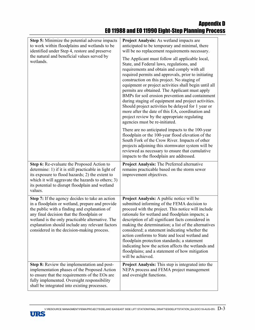
Appendix DEO 11988 and EO 11990 Eight-Step Planning Process
V:\RESOURCE MANAGMENT\FEMA\PROJECTS\DELANO EAS\EAST SIDE LIFT STATION\FINAL DRAFT\ESIDELIFTSTATION_EA.DOC\18-AUG-05\\ D-3
Step 5: Minimize the potential adverse impactsto work within floodplains and wetlands to beidentified under Step 4, restore and preservethe natural and beneficial values served bywetlands.
Project Analysis: As wetland impacts areanticipated to be temporary and minimal, therewill be no replacement requirements necessary.
The Applicant must follow all applicable local,State, and Federal laws, regulations, andrequirements and obtain and comply with allrequired permits and approvals, prior to initiatingconstruction on this project. No staging ofequipment or project activities shall begin until allpermits are obtained. The Applicant must applyBMPs for soil erosion prevention and containmentduring staging of equipment and project activities.Should project activities be delayed for 1 year ormore after the date of this EA, coordination andproject review by the appropriate regulatingagencies must be re-initiated.
There are no anticipated impacts to the 100-yearfloodplain or the 100-year flood elevation of theSouth Fork of the Crow River. Impacts of otherprojects adjoining this stormwater system will bereviewed as necessary to ensure that cumulativeimpacts to the floodplain are addressed.
Step 6: Re-evaluate the Proposed Action todetermine: 1) if it is still practicable in light ofits exposure to flood hazards; 2) the extent towhich it will aggravate the hazards to others; 3)its potential to disrupt floodplain and wetlandvalues.
Project Analysis: The Preferred alternativeremains practicable based on the storm sewerimprovement objectives.
Step 7: If the agency decides to take an actionin a floodplain or wetland, prepare and providethe public with a finding and explanation ofany final decision that the floodplain orwetland is the only practicable alternative. Theexplanation should include any relevant factorsconsidered in the decision-making process.
Project Analysis: A public notice will besubmitted informing of the FEMA decision toproceed with the project. This notice will includerationale for wetland and floodplain impacts; adescription of all significant facts considered inmaking the determination; a list of the alternativesconsidered; a statement indicating whether theaction conforms to State and local wetland andfloodplain protection standards; a statementindicating how the action affects the wetlands andfloodplains; and a statement of how mitigationwill be achieved.
Step 8: Review the implementation and post-implementation phases of the Proposed Actionto ensure that the requirements of the EOs arefully implemented. Oversight responsibilityshall be integrated into existing processes.
Project Analysis: This step is integrated into theNEPA process and FEMA project managementand oversight functions.

Appendix EPublic Notice and Public Comment
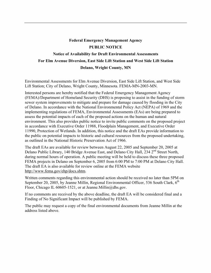
Federal Emergency Management Agency
PUBLIC NOTICE
Notice of Availability for Draft Environmental Assessments
For Elm Avenue Diversion, East Side Lift Station and West Side Lift Station
Delano, Wright County, MN
Environmental Assessments for Elm Avenue Diversion, East Side Lift Station, and West SideLift Station; City of Delano, Wright County, Minnesota. FEMA-MN-2003-MN.
Interested persons are hereby notified that the Federal Emergency Management Agency(FEMA)/Department of Homeland Security (DHS) is proposing to assist in the funding of stormsewer system improvements to mitigate and prepare for damage caused by flooding in the Cityof Delano. In accordance with the National Environmental Policy Act (NEPA) of 1969 and theimplementing regulations of FEMA, Environmental Assessments (EAs) are being prepared toassess the potential impacts of each of the proposed actions on the human and naturalenvironment. This also provides public notice to invite public comments on the proposed projectin accordance with Executive Order 11988, Floodplain Management, and Executive Order11990, Protection of Wetlands. In addition, this notice and the draft EAs provide information tothe public on potential impacts to historic and cultural resources from the proposed undertaking,as outlined in the National Historic Preservation Act of 1966.
The draft EAs are available for review between August 22, 2005 and September 20, 2005 atDelano Public Library, 140 Bridge Avenue East, and Delano City Hall, 234 2nd Street North,during normal hours of operation. A public meeting will be held to discuss these three proposedFEMA projects in Delano on September 6, 2005 from 6:00 PM to 7:00 PM at Delano City Hall.The draft EA is also available for review online at the FEMA websitehttp://www.fema.gov/ehp/docs.shtm.
Written comments regarding this environmental action should be received no later than 5PM onSeptember 20, 2005, by Jeanne Millin, Regional Environmental Officer, 536 South Clark, 6th
Floor, Chicago IL 60605-1521, or at [email protected].
If no comments are received by the above deadline, the draft EA will be considered final and aFinding of No Significant Impact will be published by FEMA.
The public may request a copy of the final environmental documents from Jeanne Millin at theaddress listed above.