environmental analysis - lot e san pedro and w taylor
TRANSCRIPT

APPENDIX C

Environmental Constraints Analysis Bridge Housing Communities Project
Lot E Site
Prepared By:
In Consultation With:
June 2021

BHC Lot E Site i Environmental Constraints Analysis City of San José June 2021
TABLE OF CONTENTS
Section 1.0 Project Summary ............................................................................................................. 2
Section 2.0 Site Review Methods ...................................................................................................... 3
Section 3.0 Environmental Constraints Summary ............................................................................. 5

BHC Lot E Site 2 Environmental Constraints Analysis City of San José June 2021
SECTION 1.0 PROJECT SUMMARY
In September 2016, the State of California passed Assembly Bill (AB) 2176 into law allowing San José to declare a shelter crisis and create Emergency Bridge Housing Communities (BHCs). AB 2176 allows San José to develop communities of small sleeping cabins, along with common buildings, which could include meeting space, showers, and laundry facilities. AB 2176 also allows San José to adopt local standards in lieu of State and local building codes and requirements that may hinder or delay development of BHCs on these sites. These potential BHC sites must be either City-owned or leased. Because AB 2176 sunsets in January 2022, BHCs are temporary communities. The sunset date of AB 2176 of January 2022 was extended by AB1745 to January 1, 2025 which extends the time that these temporary BHCs can operate. Further, the California Environmental Quality Act (CEQA) (Division 13 of the public resources code) was suspended under California Executive Order N-32-20 for projects like BHC using special funding (Homeless Emergency Aid Program funds; Homeless Housing, Assistance, and Prevention funds, or SB89 funds). The California Environmental Quality Act (CEQA), however, would still apply to any temporary development consistent with BHC under AB 2176. In September 2017, the San José City Council set a goal of identifying one to three sites for future BHC development. The “Lot E” at the corner of East Taylor and North San Pedro Streets has been identified by the City as a potential site.

BHC Lot E Site 3 Environmental Constraints Analysis City of San José June 2021
SECTION 2.0 SITE REVIEW METHODS
The potential BHC site was screened for several environmental constraints commonly encountered at development projects in San José. The following environmental constraints were studied as part of this preliminary environmental review:
1. Hazardous materials/contaminants: Geotracker, Envirostor, and other hazardous materials databases were utilized to determine if the site or adjacent properties have active soil or groundwater contamination/remediation cases.
2. Geologic hazards: Santa Clara County’s Geologic Hazard Zones maps were utilized to
determine if the site is located in an area exposed to geologic hazards, such as fault rupture, landslides, or liquefaction.
3. Flooding: Federal Emergency Management Act (FEMA) flood zone maps were utilized to
determine whether the site is located in a Special Flood Hazard Area such as Flood Zone A (100-year flood).
4. Habitat: The Santa Clara Valley Habitat Agency Geobrowser was utilized to identify the
site’s Habitat Plan land cover designation, and whether special surveys or land cover fees are required.1
5. Noise: The City’s General Plan noise contours maps and the Santa Clara County Airport
Land Use Commission’s (ALUC) noise contours maps were utilized to identify if the site is exposed to substantial roadway and/or aircraft noise.2 The U.S. Environmental Protection Agency has found that average daily exposure to noise over 75 dBA is hazardous to human health, and the Envision 2040 San José General Plan considers areas with noise levels over 75 dBA to be unacceptable for residential development.
6. Air quality: The subject site, which is adjacent to a freeway, was analyzed for its potential to
have unhealthy levels of air pollutant exposure using annual average daily traffic (AADT) counts and a previous air quality analysis for a project in close proximity to the proposed site.3,4 The CEQA impact threshold for ambient PM2.5 exposure is 0.3 µg/m3 and the threshold for cancer risk is 10.0 cases per one million people.
1 Temporary impact fees can be calculated using the methodology above but prorated based on the duration of the activity. This fee is calculated by multiplying the total calculated fee amount (development area x fee rate) x (the number of calendar years for disturbance + number of calendar years for the site to return to pre-project conditions [maximum 1 year]) all divided by 50. 2 Projected 2035 noised contours used. Source: Illingworth & Rodkin, Inc. Envision San José 2040 General Plan Comprehensive Update Environmental Noise Assessment San José, California. December 7, 2010. 3 AADT is the total volume for the year divided by 365 days. Source: Caltrans. “2015 Traffic Volumes”. Accessed April 21, 2021. http://www.dot.ca.gov/trafficops/census/volumes2015/. 4 Illingworth & Rodkin, Inc. Arbor Office Project Initial Study.

BHC Lot E Site 4 Environmental Constraints Analysis City of San José June 2021
7. Historic: The analysis determined whether there are any existing structures on the site or immediately adjacent to the site that are listed on the City’s Historic Resources Inventory, which could constrain their removal or influence placement of new structures elsewhere on site. The subject site does not contain historic structures.
The results of the preliminary environmental constraints analysis for the potential BHC site are discussed in the section that follows.

BHC Lot E Site 5 Environmental Constraints Analysis City of San José June 2021
SECTION 3.0 ENVIRONMENTAL CONSTRAINTS SUMMARY
Location: “Lot E” at the northwest corner of East Taylor and North San Pedro Streets Current Land Use: City of San José Parking Lot Zoning District: Commercial Office General Plan Land Use Designation: Neighborhood Community Commercial Adjacent Land Uses:
Northwest – San José Police Department, surface parking lot
Northeast – Office (Santa Clara County Public Defender), commercial land uses, surface parking lot
Southeast – Commercial land uses, single-family residential homes
Southwest – SR-87 freeway, on-ramp and off-ramp

BHC Lot E Site 6 Environmental Constraints Analysis City of San José June 2021
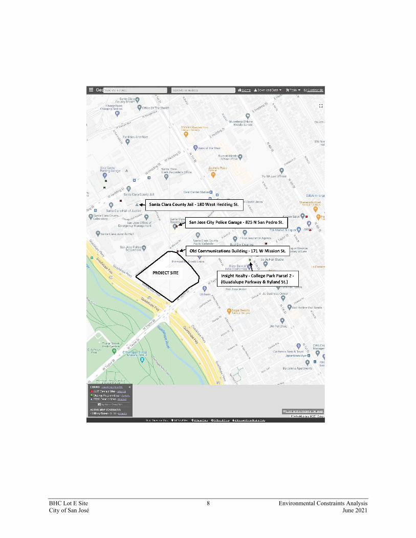
For the purposes of this analysis, multiple APNs were analyzed, which explains why the map above depicts a much larger area than the final footprint of the Lot E development. The development of Lot E will only use a small portion of the overall evaluated site. Hazardous Materials: Based on the State Water Resources Control Board GeoTracker map and data, there are no reported cases of hazardous materials or contaminants on the project site. There are two Leaking Underground Storage Tank (LUST) cleanup site cases located within 1,000 feet of the site that has been completed and is closed. There is one open site assessment mapped as being located 750 feet east of the project site (Insight Reality College Park Parcel Two at Guadalupe Parkway and Ryland Street). Possible contaminants at this site include arsenic, insecticides/pesticide/fumigants/herbicides, polychlorinated biphenyls, polynuclear aromatic hydrocarbons, trichlorethylene. The potential media of concern on the site is soil. Soil contamination that exceeds direct contact Environmental Screening Levels will be addressed by: 1) construction of a building slab that will cap the contamination; 2) installing an orange plastic warning layer under landscaped areas with at least three feet of fill; 3) recording a

BHC Lot E Site 7 Environmental Constraints Analysis City of San José June 2021
deed restriction on the property; and 4) submitting an acceptable site/soil management plan to the San Francisco Bay Regional Water Quality Control Board (Region Two) to work with the deed restriction to maintain the protective measures.5 Additionally, there is one Department of Toxic Substances Control cleanup site located approximately 950 feet northwest of the proposed project site (Santa Clara County Jail at 180 West Hedding Street). This cleanup site has had a certified clean status since 1983 and is a closed case.6 The two LUST cleanup sites and the DTS cleanup sites are shown in relation to the project site on the GeoTracker map below. The open site assessment case location is described as being at Guadalupe Expressway and Ryland Avenue, which would be approximately 2,600 feet south of the site. It is mapped, however, at North First Street and Taylor Street, approximately 750 east of the project site. This location may not be mapped accurately.
5 State Water Resources Control Board. GeoTracker. Accessed April 20, 2021. https://geotracker.waterboards.ca.gov/ 6 Department of Toxic Substances Control. Santa Clara County Jail (43920002). Accessed April 21, 2021. https://www.envirostor.dtsc.ca.gov/public/profile_report?global_id=43920002
BHC Lot E Site 8 Environmental Constraints Analysis City of San José June 2021

BHC Lot E Site 9 Environmental Constraints Analysis City of San José June 2021
Geologic Hazards: The project site is located within a designated Liquefaction Zone on the County of Santa Clara Department of Planning and Development’s County Geologic Hazard Zones map.7 Standard building permit requirements to deal with soil liquefaction hazards would apply. Flood Hazards: According to the FEMA Flood Insurance Rate Map of the area (Map No. 06085C0232H, dated May 18, 2009), the project site is located within Zone X. Zone X is designated for areas outside of the Special Flood Hazard area, between the limits of the base flood (100-year flood) and the 0.2 percent annual chance flood (500 year flood).8 Zone X is not a Special Flood Hazard Area designation, therefore no requirements are placed on new development in this area by the City of San José as it relates to flood insurance and/or flood protection.
Santa Clara Valley Habitat Plan: The project site is located within the Santa Clara Valley Habitat Plan Permit area. The site is within a designated urban area that is not subject to special fees or survey requirements.9 Noise: The project site is located within the General Plan’s 70 to 75 dBA, DNL noise contour.10 In addition, a very small portion of the western corner of the site is within the 65 CNEL (dB) aircraft noise contour for San José International Airport, contained in the Airport Land Use Commission
7 County of Santa Clara Department of Planning and Development. County Geologic Hazard Zones. October 26, 2012. 8 FEMA. FEMA Flood Map Service Center. Accessed April 21, 2021. https://msc.fema.gov/portal/search?AddressQuery=174%20asbury%20street%20san%20Jose%20ca%2095110#searchresultsanchor 9 Santa Clara Valley Habitat Plan. Santa Clara Valley Habitat Agency Geobrowser. Accessed April 21, 2021. http://www.hcpmaps.com/habitat/ 10 City of San José. Envision San José 2040 General Plan DEIR. Figure 3.3-2 Citywide 2035 Traffic Noise Contours. June 2011.

BHC Lot E Site 10 Environmental Constraints Analysis City of San José June 2021
Comprehensive Land Use Plan.11 Areas exposed to noise levels above 75 dBA DNL are not considered appropriate for residential uses, however, according to General Plan policy, residential land use may be permitted after a detailed analysis of the noise reduction requirements and noise mitigation features included in the design of the project has been prepared. A detailed noise analysis for the future project on the site is therefore recommended. Air Quality/Traffic Volumes: Due to the project site’s location in close proximity to two freeways, I-880 and SR 87, it exceeds CEQA health-risk impact thresholds with regard to air quality, with the two freeways combining for cumulative risks. Fine particulate matter (PM2.5) and toxic air contaminants (TAC) are the principal pollutants of concern generated by automobile traffic. The annual average daily traffic (AADT) counts at nearby locations are provided below:
I-880 at N. First Street: 331,000 AADT
SR 87 at W. Taylor Street: 224,800 AADT
Existing PM2.5 data are not available for the project site itself, but recent data from an air quality study on a nearby site (Arbor Office Project at 255 W. Julian Street) indicated a PM2.5 level of 0.32 μg/m3, which exceeds the CEQA impact threshold of 0.30 μg/m3. The Arbor Office Project is in close proximity to the proposed site; therefore, exposure levels would be similar. Note, however, that the Arbor Office Project site is set back approximately 300 feet from SR 87, while the proposed project site would be approximately 100 feet from SR 87. The project site could therefore be expected to be exposed to a higher level of PM2.5. Prior to construction of the project, the City should complete an air quality analysis specific to the site that includes mitigation measures to address exposure to excessive PM 2.5 levels caused by traffic on the surrounding roadways. Conclusion: This site is not exposed to significant noise levels considered inappropriate for residential uses; however, it has potential to have elevated health risks due to roadway air pollution. Mitigation measures, such as air filters, may be required to screen out harmful pollutants..
11 County of Santa Clara Department of Planning and Development. Airport Land Use Commission Comprehensive Land Use Plan. Figure 5: 2022 Aircraft Noise Contours. November 2016.