environment levy program 2015 - 2016 racemosa
TRANSCRIPT

Environment Levy Program 2015 - 2016
Racemosa Environmental Reserve
Draft Management Plan

© Sunshine Coast Regional Council 2009-current. Sunshine Coast Council™ is a registered trademark of Sunshine Coast Regional Council.
www.sunshinecoast.qld.gov.au
[email protected] T 07 5475 7272 F 07 5475 7277 Locked Bag 72 Sunshine Coast Mail Centre Qld 4560
Acknowledgements
Council wishes to thank all contributors and stakeholders involved in the development of this document.
Disclaimer
Information contained in this document is based on available information at the time of writing. All figures and diagrams are indicative only and should be referred to as such. While the Sunshine Coast Regional Council has exercised reasonable care in preparing this document it does not warrant or represent that it is accurate or complete. Council or its officers accept no responsibility for any loss occasioned to any person acting or refraining from acting in reliance upon any material contained in this document.

Footer 3
Executive Summary
Racemosa Environmental Reserve was purchased by Sunshine Coast Council in December 2011 under the Environmental Levy Land Acquisition Program. The reserve contributes 113.74 hectares of land to the region’s conservation estate, protecting one of the most unique tracts of coastal lowland plains complex remaining in the region.
Racemosa Environmental Reserve is situated approximately one kilometre southeast of the Landsborough village within the Pumicestone Passage catchment.
The topography encompasses simple landscape features including gentle slopes and rises, gully lines, creek flats and terraces. A series of meandering streams traverse the landscape, draining the nearby catchment area south into Mellum Creek.
The subtle variations in topography support a mosaic of vegetation types, all of which have
been significantly reduced as a result of widespread clearing and modification in the Sunshine Coast Local Government Area (SCLGA) and the broader SEQ bioregion.
Four different Regional Ecosystems have
been identified within this reserve, including three Of concern, and one listed as Endangered under the Vegetation Management Act 1999 (VMA). 73% of
Racemosa Environmental Reserve contains the Endangered RE 12.5.3. (Eucalyptus racemosa subsp. racemosa woodland on remnant tertiary surfaces), which is among the most poorly conserved REs on the Sunshine Coast (12% of its original extent
remaining in the SCLGA).
Within these vegetation communities exists a
rich diversity of native fauna and flora.
Fauna and flora surveys have identified at least 179 native plant and 84 native fauna
species, including one plant species listed as Endangered’ and two 'acid frogs' listed as Vulnerable under the Nature Conservation Act 1992. Furthermore, many of the species observed are uniquely adapted to the nutrient
poor soils and acidic water associated with Coastal lowland plain ecosystems.
The occurrence of migratory birds and 'drought waifs' on site indicates that the site serves as an important refuge. Its location in the landscape also provides an important link between larger tracts of continuous vegetation occurring to the south, north and northwest.
Despite the relatively small area and surrounding land uses, the reserve demonstrates a high level of resilience. Bushland Operational Assessments (BOA) conducted in 2012 identified vegetation condition as predominantly ‘good’ and ‘very good’ with ‘moderate’ and 'very poor' areas occurring along watercourses and an existing fire trail.
Since acquisition, the Natural Areas Environmental Operations branch has coordinated a range of establishment works to protect the reserve’s inherent biodiversity values and ecological resilence. These include:
Environment Levy signage and gates installed 2012
Fire trail upgraded and illegal tracks closed 2012
Weed control program targeting ‘Declared’ and ‘Significant pest species’
Approximately 3 hectares of exotic Slash Pine (Pinus elliotti) removed
Threatened species mapped
This Management Plan is the final phase in the planning and establishment of the Racemosa Environmental Reserve. From 2016, the reserve will be managed for conservation under the Natural Areas Operational Management Team—guided by this Management Plan, supporting technical documents and the Natural Areas Master Management Plan.
Future management of this reserve is intended to further protect and restore the site’s intrinsic biodiversity values as well as to create, consolidate and protect connectivity values to link the surrounding conservation estate; and to facilitate nature-based recreation and education.

Acknowledgements
Sunshine Coast Council acknowledges the establishment and management funding contributions received for this project under the Sunshine Coast Council Environment Levy Land Acquisition and Establishment Program.
Council also wishes to thank Birdlife Sunshine Coast for contributing bird species lists; Ron Farmer for providing a detailed history of the site and surrounding area; and Australia Zoo for providing previous fauna and flora survey reports.
Cover photo courtesy of Sunshine Coast Council.

Footer 5
Contents Executive Summary ................................................................................................ 3
Acknowledgements ................................................................................................. 4
1 Introduction ....................................................................................................... 6
1.1 Purpose of Management Plan ...................................................................... 6
2 Background ....................................................................................................... 6
2.1 Location and Description .............................................................................. 6
2.2 Recent history and land use ......................................................................... 8
3 Establishment Works ..................................................................................... 11
3.1 Planning and Maintenance ......................................................................... 12
4 Reserve Values ............................................................................................... 13
4.1 Ecological Values ....................................................................................... 13
4.2 Cultural and Social Values ......................................................................... 19
4.3 Economic Values ........................................................................................ 23
4.4 Condition of Values .................................................................................... 23
5. Bioregional and Landscape Context ............................................................... 24
5.1. IBRA ........................................................................................................... 24
5.2 Catchment .................................................................................................. 24
5.3 Local Planning Context .............................................................................. 24
5.4 CAR Contribution ....................................................................................... 24
6 Management Issues ........................................................................................... 25
6.1 Regional Background ................................................................................. 25
6.2 Preliminary Risk Analysis ........................................................................... 25
6.3 Environmental Weeds and Declared Animals and Plants.......................... 26
6.4 Fire ............................................................................................................. 27
6.5 Erosion ....................................................................................................... 28
6.6 Salinity/Acidity ............................................................................................ 28
6.7 Historical Land Use .................................................................................... 28
6.8 Climate Change .......................................................................................... 29
7. Implementation Plan ...................................................................................... 30
7.1 Purpose of the Protected Area .................................................................... 30
7.2 Management objectives .............................................................................. 30
7.3 Protection Mechanism ................................................................................. 30
7.4 Restoration Goals ........................................................................................ 30
7.5 Finance and Resourcing ............................................................................ 37
7.6 Monitoring .................................................................................................... 37
7.6 Communications Plan ................................................................................. 39
7.7 Management Plan Review Schedule .......................................................... 39
References ............................................................................................................. 40
Appendices ............................................................................................................ 41
Glossary and Abbreviations ................................................................................. 85

6 Footer
1 Introduction
Sunshine Coast Council’s Corporate Plan (2014-2019) identifies ‘an enviable lifestyle and environment’ as a corporate goal to achieving its vision to be “Australia’s most sustainable region – vibrant, green, diverse”. In order to achieve this, Council has endorsed a range of strategic directions and principles under the Biodiversity Strategy 2010-2020 that includes “expand, protect and enhance Council conservation areas”. This is supported through the Environment Levy Land Acquisition Program.
1.1 Purpose of Management Plan
This Management Plan provides an adaptive management framework which has been developed under nationally recognised guidelines and principles of protected area management (see Appendix 1).
The purpose of this Management Plan is to describe the reserve’s ecological, cultural, social and economic values and express the associated management actions required to maintain or enhance these values.
The Management Plan is subject to a 10 year review schedule underpinned by the framework of actions, relevant monitoring and evaluation strategies, and performance indicators described in this plan.
2 Background
2.1 Location and Description
Racemosa Environmental Reserve is located at Hardwood Road, Landsborough (see Figure 1). The reserve comprises two lots—Lot 456 on CG2857 (SCC freehold) and Lot 744 on CG2857 (water reserve - SCC trustee)—with a total area of 113.74 hectares.
The main access to the reserve is via Wintzloff Road. Additional access to the northern and eastern boundaries is obtained via Forestry Road, off Steve Irwin Way. A fire trail off the northern boundary is the only
existing trail in the reserve (see Appendix 2a).
The northern and eastern reserve boundaries adjoin pine plantations (Beerwah State Forest), while the landscape to the south and west is dominated by rural residential lots. Nestled in the southeast corner of the “L” shaped site is a private property that retains small patches of native vegetation along its eastern and southern boundaries.
Racemosa Environmental Reserve forms part of a near continuous tract of connecting and core habitats spanning from the Glasshouse Mountains National Parks in the southwest, to Pumicestone Passage and Bribie Island National Park in the southeast, through to Dularcha National park and Ewen Maddock Dam in the north (see Appendix 2b). The reserve is also closely situated to a regional corridor identified in the Queensland Government Biodiversity Planning and Assessment Mapping (BPA) for southeast Queensland (see Appendix 2c).
The site's geology is defined as Landzone 3 and Landzone 9-10 under the Queensland Government’s RE mapping (v8), however ground truthing determined that geological features associated with Landzone 9-10 are absent from the site (see Appendix 2d and Figure 2). Landzones 3 and 5 observed on site are described by Wilson and Taylor (2012) as:
Landzone 3: Alluvial river and creek flats currently under freshwater influence, inland lakes and associated wave built lunettes. Includes a diverse range of soils.
Landzone 5: Near level or gently undulating plains with sandy or loamy soils, and plateau remnants with moderate to deep soils usually overlying duricrust.
The reserve area retains relatively simple landform features ranging from approximately 18 to 32 metres above sea level. Features include gentle slopes and rises, creek flats (and other flat areas), gully lines and terraces. Several watercourses ranging from Stream Order (SO)1 to 4 traverse the northern portion of the reserve and flow into a single, SO5 watercourse which runs south across the far southern boundary (see Appendix 2e).

Footer 7
Figure1. Locality Map

8 Footer
2.2 Recent history and land use
2.2.1 Surrounding landscape
Properties around Landsborough were first surveyed in 1916 as part of the Soldier Settlers Scheme that occurred after World War 1.
The majority of the landscape surrounding Racemosa Environmental Reserve has been historically cleared.
Clearing for pine plantations north and east of the reserve site occurred just prior to 1979, when the first plantation was established (Venz, P 2015 pers. comm., 11 Dec). LandSat imagery (1972) shows that prior to clearing, a large, homogenous patch of native vegetation occurred over the reserve site and adjoining land to the north and south (see Figure 2a & 2b).
The property immediately south of Wintzloff Road was utilised for cattle grazing since at least the 1970s (Farmer, R 2015 pers.comm., 4 Nov). Grazing activities have since ceased and a large portion of the property is currently dominated by Slash Pine wildlings (see Figure Figure 2d).
Large rural residential lots were established along Hardwood Road before 1972, while the development of smaller residential estate lots commenced around the early 1990s (see Figure 2a, 2c & 2d).
A waste management facility, situated in the upper catchment of the reserve on Forestry Road, was operational between 1972 and 2000. A sewerage treatment plant, situated adjacent to the waste facility, commenced operation in 1999 and underwent minor modifications in 2006 to increase the capacity (see Figure 2c & 2d).
Plantation areas to the north and east of the reserve have been recently harvested (2014-15) and are are in the process of being replanted (Venz, P 2015 pers. comm., 11 Dec).
2.2.2 Racemosa Environmental Reserve
No historical vegetation clearing is known to have occurred at Lot on plan 456CG2857, with at least the two previous owners purchasing the land for conservation (Farmer, R 2015, pers.comm., 4 Nov). Lot on plan 744CG2857 is a Queensland Government-
owned water reserve that is also covered by native vegetation, with the exception of a cleared fire trail.
Aerial images show that minimal change to native vegetation cover has occurred between 1991 and 2015 although a proliferation of Slash Pine wildlings has occurred along reserve boundaries (see Figure 2).
Two high intensity fires are known to have occurred at the site in the mid 1970s and between 1995-96 (Farmer, R 2015 pers.comm., 4 Nov). Little is known of the circumstances surrounding the 1970s fire, while the latter was a prescribed burn lit after the large bushfires that occurred between Beerwah and the Glasshouse Mountains in 1994. The boundary of the site was graded to create a fire break.
Prior to the 1990s, the property immediately south of Wintzloff Road was regularly burnt by the owners but did not spread into the reserve (Farmer, R 2015 pers.comm., 4 Nov). Also, in 2007, a car was illegally burnt on an adjoining forestry track causing an isolated fire in the northeast corner of the reserve.
Slash Pine along Wintzloff Rd prior to removal works (Image G.Morgan)

Footer 9
Figure 2a. LandSat imagery (1972) showing homogenous vegetation cover over the reserve
site and adjacent areas to the north and east.
Figure 2b. LandSat imagery (1980) showing removal of vegetation north and east of site.

10 Footer
Figure 2c. Aerial image (1991) showing maturity of pine plantations and maintained forestry trails.
Figure 2d. Aerial image (2015) showing encroachment of Slash Pine and surrounding land use changes.
Waste management facility and sewage treatment plant location
Slash Pine Wildlings
smaller residential estate lots built in the 1990s

Footer 11
3 Establishment Works
All properties purchased under the Environment Levy Land Acquisition Program receive a 3-5 year annual allocation of funding as a percentage of the purchase price from the Environment Levy budget for establishment works. This initial injection of funds covers the establishment costs and prepares the reserve for future on-going maintenance.
The status of establishment works is described in Table 1. From 2016 the reserve will be managed by the Natural Areas Operational Management team, guided by this Management Plan and the following
supporting technical documents also summarised in this plan:
Bushland Operational Assessment (BOA) (ArborCare QLD)
Draft Fire Management Plan
Racemosa Environmental Reserve Flora Assessment (Thomas 2012)
Racemosa Environmental Reserve, Fauna Survey Report (Fox 2012)
Camera trap survey (Burnett & Kroenert 2015)
The draft Natural Areas Master Management Plan 2015 provides a strategic management framework which includes reserve management principles, service level guidelines, and management resources required to guide and prioritise operational activities.
Table 1: Status of establishment works at Racemosa Environmental Reserve
Establishment Activity Description Status
Condition Assessment Commission the preparation of a resilience based condition assessment to guide management planning.
BOAs completed 2012 (Lot 456 on CG2857) and 2013 (Lot 744 on CG2857)
Restoration Works Plan Commission the preparation of a bush Restoration works plan
RWP completed 2012.
Weed Management According to the works plan all high priority areas are targeted for weed removal
Annual works plan implemented in line with service level for this reserve
Trail Maintenance No open space at this site. Fire trails mapped and upgraded. Requires periodic vegetation management.
Sediment / Erosion Control No risk identified
Access Gate and Fencing 2 x locked access gates installed. Vehicle exclusion fencing installed.
Complete 2012
Revegetation Nil ‘Planting’ as per 2012 BOA N/A
Signage Environment Levy regulatory signage Installed 2012
Tenure Protection SCC Planning Scheme 2014 (statutory) identifies Environmental Reserves, Riparian Protection Areas, Wetlands and Native Vegetation Areas as map overlays.
Current
Values Assessment Fauna survey, flora survey and cultural heritage database searches
Recreational values
Complete 2015
Not assessed
Hazards Removed Overhanging boundary trees Removed 2014

12 Footer
3.1 Planning and Maintenance
The ongoing planning and maintenance requirements of Racemosa Environmental Reserve are guided by Council’s Service Level Reserve Score (rank 1-3 for each biodiversity and recreation score).
Scores are based on a range of values including size, linkages, and significant species, biodiversity and community values.
The biodiversity score for Racemosa Environmental Reserve is "B1 District". Table 2 and Table 3 list service level requirements under this category. No recreational score has been assigned as there is no existing infrastructure to support recreational usage.
Table 2: Racemosa Environmental Reserve Service Level category B1 – District Reserve1
Category MP SMI BOA Flora Assessment
Fauna Assessment
FMP RWP
*B1
Frequency Frequency will be determined as an outcome of the Natural Areas Master Management Plan 2014
Annual
Current Status
Draft draft Complete 2012
Complete 2012
Complete 2012
Scheduled 2015/16
Complete 2012
*B# = Biodiversity Class.
Note: The above table provides an overview of the required planning documentation required. SMI:
Statement of Management Intent, BOA: Bushland Operational Assessment; FMP: Fire Management Plan.
Table 3: Maintenance Service Levels
Category B1
Inspections Monthly
Weed management Monthly
Revegetation Annual
Prescribed burning – if required As per FMP
Fire trail management - drainage / surface maintenance Annual
Fire trail slashing 1-6/yr
Fuel reduced zones – vegetation management 1-6/yr
Tree management Annual
Urgent & hazardous matter arising 24-48hrs
Inspections Monthly
1 this biodiversity score will likely be upgraded to a Regional category once the state mapped RE’s have been amended
to reflect flora assessment results.

Footer 13
4 Reserve Values
4.1 Ecological Values
Racemosa Environmental Reserve provides an important refuge for a range of local and endemic species while facilitating movements by migratory species across the landscape.
Natural values described below have been compiled from the following sources:
Flora assessment report (Thomas 2012)
Post-wet season fauna assessment report (Fox 2012)
Camera survey (Burnett & Kroenert 2015)
SCC Koala survey (Woosnam 2014)
Bird list (Birdlife Sunshine Coast 2013)
Ecological reports written prior to acquisition (LAMR 2003, Czechura 2003, Lyon 2009).
Personal observations by Council ecologists and local resident (Farmer, R 4 Nov 2015)
4.1.1 Vegetation Communities
The observed vegetation communities at Racemosa Environmental Reserve differ from the Queensland Government’s Regional Ecosystem mapping for the site.
Flora assessments identified four REs at the reserve, of which only one (RE12.3.13) is identified in the Queensland Government’s RE mapping (v8) (see Table 4 and Appendix 2d).
Endangered RE12.5.3 constitutes 73% of the Racemosa Environmental Reserve Area.
One observed RE not mapped by the Queensland Government is Endangered and one is Of Concern with respect to Vegetation Management Act 1999 Vegetation Management class (VM class) and Biodiversity Status (BD status). These two REs make up 73% and 1% of the reserve area respectively. The remaining two observed REs are Least Concern with respect to VM class although their BD status is Of concern (see Table 4 and Figure 3).
Table 4: Observed Regional Ecosystems of Racemosa Environmental Reserve
Observed RE equivalent
Relative Area (Ha) % reserve
VM Class / BD status
Description Distribution in the reserve1
12.3.5 20.2 ha
(17.8%)
LC / OC Tall open forest with Melaleuca quinquenervia, Lophostemon suaveolens and Eucalyptus robusta, sedges, ferns as well as scattered notophyll forest species on alluvial substrates
Dominates riparian areas associated with the main watercourse and its major tributaries
12.3.8 1.0 ha
(0.9%)
OC / OC Wetlands and swamps with Rhynchospora corymbosa, Nymphoides indica, Philydrum lanuginosum, Triglochin procerum, Gahnia clarkei, Blechnum indicum, occasionally scattered trees Melaleuca
quinquenervia and Lophostemon suaveolens are present, on alluvial substrates
Three relatively small patches of vegetation occurring along the central and southern portions of the main watercourse, and along a tributary in the central northern portion of the site
12.3.13 9.3 ha
(8.2%)
LC / OC Low wet heath with a suite of mixed species; also present are trees and taller shrubs, including Melaleuca quinquenervia, M. sieberi and Hakea actites, on alluvial substrates
Seasonally inundated alluvial plains occurring near the western boundary adjacent Wintzloff Road, and in the central eastern portion of the site
12.5.3 82.8 ha (72.9%)
E / E Tall to very tall open forest with Eucalyptus racemosa, E. tindaliae, Corymbia trachyphloia, C.intermedia and Syncarpia glomulifera on remnant Tertiary surfaces
Flats, gentle rises and slopes occurring on non-alluvial substrates
L
LC = Least Concern; OC = Of Concern; E = Endangered

14 Footer
Figure 3: Observed RE mapping for Racemosa Environmental Reserve

Footer 15
The Sunshine Coast Biodiversity Report Card (2015) provides an assessment of the current status of regional ecosystems found within the region.
The report shows that RE12.5.3 is also among the most poorly conserved and vulnerable REs found on the Sunshine Coast, with only 12% of the pre-clearing extent remaining (see Appendix 3a). RE 12.3.5 and 12.3.13 have also experienced significant losses to their regional pre-clearing extents (68% and 68% respectively).
Furthermore, only a proportion of their remaining regional extent is represented in protected areas such as National Parks, Nature Refuges, Environment Levy Acquired Properties and environmental covenants (see Appendix 3b).
Management Action
Ammend Queensland Government RE mapping for site through a Property Map of Assessable Vegetation (PMAV)
4.1.2 Flora
A total of 204 plant species were identified in the 2012 flora assessment including 179 native and 25 exotic species. An additional 80 plant species (62 native and 18 exotic or planted native species) were recorded during a previous flora assessment at Lot on plan 456CG2857 (LAMR 2003). See Appendix 4 for all flora survey species lists.
179 native plant species were identified at Racemosa Environmental Reserve in 2012 including the NCA Endangered Christmas Bells and the SCBS Significant fauna species, Wax Flower.
The area supports one Endangered plant species listed under the Queensland Government’s Nature Conservation Act 1992 (NCA) and one Significant Flora Species listed under the Sunshine Coast Biodiversity Strategy 2010-2020 (SCBS) (See Table 5).
Christmas Bells (Image G. Morgan)
Table 5: EVNT and significant plant species found at Racemosa Environmental Reserve
Common Name Scientific Name Status
Christmas Bells Blandfordia grandiflora Endangered (NCA)
Wax Flower Philotheca myoporoides subsp. queenslandica
Significant (SCBS)

16 Footer
4.1.3 Fauna
The 2012 post-wet season fauna survey and 2013 camera trap survey located a moderate diversity of native fauna at Racemosa
Environmental Reserve. Surveys identified 84 native vertebrate fauna species,
comprising the following numbers of species in each of the major terrestrial vertebrate fauna groups:
44 bird species
7 ground dwelling mammal species
1 arboreal mammal species
12 micro bat species
11 reptile species
7 amphibian species
2 fish species
An additional 21 bird species were identified by Birdlife Sunshine Coast in 2013.
Previous data records and surveys compiled by Gregory Czechura (Queensland Museum) for the period between the 1970s and 2003, recorded a total of 243 native vertebrate fauna species including: 162 bird; 23 mammal; 40 reptile and 19 amphibian species. This suggests that a significant biodiversity impact event or events have occurred around this site in the past 30 to 40 years.
According to local Resident R. Farmer (2015
pers. Comm., 4 Nov), pure dingoes used to frequent the area and were last observed in March and August 2000. Dingoes observed since 2000 have been dingo-dog hybrids.
See Appendix 5 for all fauna survey species lists.
Two 'acid frog' species, the Wallum Rocketfrog and Wallum Froglet (listed as Vulnerable under the NCA); the Rufous Fantail (EPBC Act listed Terrestrial Migratory bird species); and Swamp Wallaby (SCBS listed Significant Fauna Species) were recorded at the site in 2012. An additional two Terrestrial Migratory bird species, the Rainbow Bee-eater and Spectacled Monarch, were identified by Birdlife Sunshine Coast in 2013.
Two 'Vulnerable' acid frog species, the Wallum Rocketfrog and Wallum Froglet, and three Terrestrial Migratory bird species, the Rufous Fantail, Rainbow Bee-eater and Spectacled Monarch, were recorded between 2012 and 2013.
18 additional species listed under the EPBC Act, NCA or SCBS have been identified in or near the water reserve between the 1970s and 2003. This included 'declining woodland birds', 'drought waifs' and a number of 'altitudinal and latitudinal migrants'. Czechura (2003) notes that a number of these species have only been recorded rarely or appear to have disappeared from the site or local area.
A fauna survey undertaken by Australia Zoo wildlife rangers in 2009, and observations by the late Steve Irwin, and Terry Irwin, recorded several known and additional listed EVNT fauna at the site (Lyon 2009).
The status of all listed EVNT and significant species recorded at Racemosa Environmental Reserve is shown in Table 6 below.
‘Acid frog’ habitat occurring alongside Wintzloff Road (Image Sunshine Coast Council)

Footer 17
Table 6: Listed EVNT and significant fauna species found at Racemosa Environmental Reserve
Common Name Scientific Name Status
Racemosa Environmental Reserve, Fauna Survey Report (Fox 2012)
Wallum Rocketfrog Litoria freycineti Vulnerable (NCA)
Wallum Froglet Crinia tinnula Vulnerable (NCA)
Rufous Fantail Rhipidura rufifrons Migratory Terrestrial; Marine (EPBC Act)
Swamp Wallaby Wallabia bicolor Significant (SCBS)
Birdlife Sunshine Coast (2013)
Rainbow Bee-eater Merops ornatus Migratory Terrestrial (EPBC Act)
Spectacled Monarch Monarcha trivirgatus (Symposiachrus trivirgatus)
Migratory Terrestrial; Marine (EPBC Act)
Australia Zoo 'Heathlands'Wildlife Reserve Ecological Summary Report (2009)
Platypus Ornithorhynchus anatinus Special least concern (NCA)
Krefft's Tiger Snake Notechis scutatus Vulnerable (EPBC Act)
Wallum Rocketfrog Litoria freycineti Vulnerable (NCA)
Wallum Froglet Crinia tinnula Vulnerable (NCA)
Beerwah Water Reserve - Fauna Assessment (1970s to 2003)
Wallum Rocketfrog Litoria freycineti Vulnerable (NCA)
Wallum Froglet Crinia tinnula Vulnerable (NCA)
Wallum Sedgefrog Litoria olongburensis Vulnerable (EPBC Act; NCA)
Platypus Ornithorhynchus anatinus Special least concern (NCA)
Echidna Tachyglossus aculeatus Special least concern (NCA)
Greater Glider Petauroides volans Significant (SCBS)
Swamp Wallaby Wallabia bicolor Significant (SCBS)
Grey-headed Flying-fox Pteropus poliocephalus Vulnerable (EPBC Act)
Great Egret Ardea alba Migratory Wetland; Marine (EPBC Act)
Square-tailed Kite Lophoictinia isura Near Threatened (NCA)
White-bellied Sea-eagle Haliaeetus leucogaster Migratory Terrestrial; Marine (EPBC Act)
Wedge-tailed Eagle Aquila audax Significant (SCBS)
Bush Stone-Curlew Burhinus grallarius Significant (SCBS)
Latham's Snipe Gallinago hardwickii Migratory Wetland; Marine (EPBC Act)
Glossy Black Cockatoo Calyptorhynchus lathami Vulnerable (NCA)
Oriental Cuckoo Cuculus saturatus Significant (SCBS)
Fork-tailed Swift Apus pacificus Migratory Marine (EPBC Act)
White-throated Needletail Hirundapus caudacutus Migratory Terrestrial; Marine (EPBC Act)
Rainbow Bee-eater Merops ornatus Migratory Terrestrial; Marine (EPBC Act)
Yellow-tufted Honeyeater Lichenostomus melanops Significant (SCBS)
Crested Shrike-tit Falcunculus frontatus Significant (SCBS)
Rufous Fantail Rhipidura rufifrons Migratory Terrestrial; Marine (EPBC Act)
Lewin's Rail Lewinia pectoralis (Rallus pectoralis
Near threatened (NCA)

18 Footer
The reserve also contains suitable habitat and previous nearby records of other listed EVNT species including:
Water Mouse (Xeromys myoides)
Long-nosed Potoroo (Potorous tridactylus tridactylus) (recorded within 5km)
Black-necked Stork (Ephippiorhynchus asiaticus)
Grey Goshawk (Accipiter novaehollandiae)
Ground Parrot (Pezoporus wallicus wallicus)
Powerful Owl (Ninox strenua)
Tusked Frog (Adelotus brevis)
Richmond Birdwing (Ornithoptera richmondia) (Currently no host plants)
Honey Blue-eye (Pseudomugil mellis)
Mt. Emu She-oak (Allocasuarina emuina)
Swamp Stringbark (Eucalyptus conglomerata)
Whipstick Wattle (Acacia attenuata)
The Spotted Harrier (Circus assimilis), Swamp Harrier (Circus approximans) and Black Kite (Milvus migrans) have also been observed near the reserve margins.
Despite the occurrence of suitable habitat and historical records within 5 kilometres of the reserve, no Long-nosed Potoroo were identified during targeted surveys in 2012 and 2013, suggesting that the species does not occur at the site (Burnett & Kroenert 2013).
Koalas have been recorded 1.2 km from the site however no scats were found during a targeted search in 2014, and none have been seen or heard at an adjoining property since the 1970s (AKF 2015, Woosnam 2014, R. Farmer 2015 pers.comm., 4 Nov).
Management Action
Monitor existing populations of EVNT and significant fauna and flora to detect changes in population size
Undertake targeted fauna assessments for EVNT and significant species likely to occur at reserve, or previously recorded by Czechura between the 1970s and 2003
Promote partnerships for monitoring, data collection and research
Review opportunities to plant Richmond Birdwing Vine (Pararistolochia praevenosa)
4.1.4 Ecosystem
Wetlands have important ecosystem functions—they filter pollutants to improve water quality and provide important habitat for fauna and flora. They also have important social and economic values since they support recreation, agriculture and fishing industries (DERM n.d).
The Queensland Government maps wetlands as High Ecological Significance and General Ecological Significance according to the degree of wetland conservation values.
A large proportion of Racemosa Environmental Reserve has been mapped as HES and GES wetlands, corresponding with major waterways and seasonally waterlogged alluvial plains at the site (see Appendix 2f).
The site is also situated within the Pumicestone Passage catchment. Pumicestone Passage is identified as an Area of Interest in the Sunshine Coast Biodiversity Strategy 2010-2020 since it forms a part of a Ramsar listed site and its tidal wetlands and water systems are protected as part of the Moreton Bay Marine Park.
4.1.5 Habitat
This site is identified as Core Habitat under the Sunshine Coast Biodiversity Strategy 2010-2020 and provides a variety of habitat opportunities for fauna (see Appendix 2b). Habitat features include: numerous tree and log hollows of different sizes; ephemeral creeks; permanent creeks with large pools and sheltered hollows on banks; melaleuca swamps; and thick ground cover comprising sedges and grasses.
A range of EVNT and significant species are dependent on the areas preserved habitat characteristics (See Appendix 2g). For example, habitats with a dense understorey provide suitable habitat for Swamp Wallabies while permanent creeks with sheltered hollows on banks provide ideal habitat for Platypus. Conversely, the ‘acid frogs’ are adapted to and show preference for acidic waters, ephemeral perched swamps and emergent sedges.

Footer 19
4.2 Cultural and Social Values
4.2.1 Indigenous
Racemosa Environmental Reserve is located within the native title application area boundary of the Kabi Kabi People.
A search of the Cultural Heritage Database and Register for Lot on plan 456CG2857 and 744CG2857 advised that at the time of purchase there was no Aboriginal cultural heritage sites recorded for this area. However, it is probable that the absence of recorded Aboriginal cultural heritage places reflects a lack of previous cultural heritage surveys in the area.
A number of Aboriginal Cultural Heritage sites are known to occur in the Landsborough area.
All significant Aboriginal cultural heritage in Queensland is protected under the Aboriginal Cultural Heritage Act 2003, and penalty provisions apply for any unauthorised harm. Under the legislation a person carrying out an activity must take all reasonable and practical measures to ensure the activity does not harm Aboriginal cultural heritage.
Management Action
Immediately cease management activities and notify the Kabi Kabi People if any Cultural Heritage Finds are located on site.
4.2.2 Recreation
Racemosa Environmental Reserve has not been assigned a recreational score as there is no existing recreational infrastructure on the site. Furthermore, there are no existing links to a trail network south of Steve Irwin Way, with the closest network occurring southwest of Ewen Maddock Dam approximately 3.3 kilometres from the reserve.
The reserve has a centralised location one kilometre from Landsborough village and fifteen kilometres from Caloundra South—a master planned community intended to house 50,000 people in the next 30 years. Furthermore, the Sunshine Coast Open Space Strategy 2011 puts a recreational park in close proximity to the reserve (see Appendix 2h & 2i).
In light of these factors, future recreational use should be considered at this reserve. As such, a benefit/cost analysis table has been
provided as a tool to inform this decision (see Table 7).
Providing recreational trails have negligible impacts to the reserve’s natural values and align with the Sunshine Coast Recreational Trail Plan 2012, the reserve may be classified as Recreational (R) under the proposed three zone—Recreational, Educational and Sanctuary—classification system (draft Natural Areas Masterplan 2015).
Management Action
Analyse the cost/benefit table to determine the most appropriate zoning for this site.
Develop a draft landscape plan for any proposed trails
Review public access within the broader context of the Recreational Trails Plan and the draft Natural Areas Master Management Plan
4.2.3 Eco-recreation
In 2013, the community group Birdlife Sunshine Coast conducted a bird survey at the site and the University of the Sunshine Coast used the site for a research project targeting Long-nosed Potoroos. In both cases, Council was provided with survey findings to guide future management at the site.
Other opportunities may present in future for public restoration projects, environmental education, and research pertaining to the reserve's natural values and ecosystem functions.
Potential rezoning of the reserve as (R)-recreational or (E) educational will permit building of trails and other infrastructure—improving access for activities and research while providing opportunity to promote events and projects to reserve users.
Management Action
Promote partnerships with community groups such as Birdlife Sunshine Coast
Investigate potential for this reserve to be used for recreational and / or educational purposes.
If feasible conduct educational seminars and guided interpretive walks for local community
Provide opportunities to involve the local community in public restoration projects where appropriate

20 Footer
Table 7: Benefit/cost analysis table for the potential rezoning of Racemosa Environmental Reserve
Opportunities Risks
Recreational zoning (for multi-use or shared use recreational activities such as walking, mountain bikes and/or horse riding)
Provide economic benefit to the local community
Increased public surveillance of illegal activities
Recreational trails used simultaneously as fire breaks to facilitate
prescribed mosaic burns
opportunities to involve the local community in site-based management of
trails and weeds
Provides for an affordable means of exercise in close proximity for local
residents and to the Landsborough village
Cycling was undertaken by 11% of Australians during the 12 months prior
to the 2009 Exercise, Recreation and Sport Survey (Recreational Trail
Plan 2012)
In 2004, 54 percent of Queensland residents participated in trail-based
activities including walking for exercise, cycling (including BMX and
mountain bikes), bushwalking and horse riding (Recreational Trail Plan
2012)
Provision of multi-use trails in natural areas is currently below the Sunshine
Coast community expectations (Recreational Trail Plan 2012)
Meets community expectations to provide more trails in natural areas
Provide recreational opportunities to cater for expected population growth
in locality and adjacent localities
Opportunities to engage with community over trail proposal and design
Moderate to high potential for weed entry via recreational trails
feral animals are known to utilise recreational trails to increase activity in
bushland areas
Increase potential for illegal access by trail bikes using multi-use
recreational trails
Moderate to high potential for erosion along trails
Potential to impact on important habitat areas and EVNT species
Trails and increased traffic to create potential barriers for sensitive fauna
Financial costs associated with the installation and maintenance of
recreational infrastructure. NB. highly erodible soils are likely to require
regular maintenance and upgrading
Car parking is required to facilitate utilisation of trails
Potential barrier to obtaining perpetual protection of values through a
legally binding mechanism such as a Nature Refuge under the NCA.
Landsborough is not identified under the Recreational Trails Plan 2012
as a locality with no signed trails or a locality where the provision of
signed trails is less than adequate.
Safety issues and potential conflict associated with multi-use and no
opportunity to separate trails due to limitations at this site
Duplication of provision. Existing multi-use trails in Landsborough-Mt
Mellum locality and nearby Mooloolah Valley. Proposals to further
develop and upgrade mountain bike and multi-use trails in surrounding
localities.
Trail is unlikely to be long enough to facilitate mountain-biking and horse
riding.
Unlikely to have high tourism value and scenic amenity therefore not
considered a priority under the Recreational Trail Plan 2012

Footer 21
Opportunities Risks
Recreational zoning (for low impact walking trails only)
Provide economic benefit to the local community
Enables appreciation and awareness of natural landscape values and
provides incentives for preservation
Increased public surveillance of illegal activities
Recreational trails used simultaneously as fire breaks to facilitate
prescribed mosaic burns
Opportunities to engage with community over trail proposal and design
Opportunities to involve the local community in site-based management of
trails and weeds
Meets community expectations to provide more trails in natural areas
Opportunities for education and interpretive signage
Potential linkages to a proposed recreational park
Single use trails provide safety for bush walkers and other low impact
recreational users
Provide recreational opportunities to cater for expected population growth
in locality and adjacent localities
The Recreational Trails Plan 2012 identifies that there is distinct lack of
trails for local users.
Currently there are no reserves designated for low impact recreation in
close proximity
Walking has the highest participation rate of all physical activities Australia
wide and in Southeast Queensland (Recreational Trail Plan 2012)
Address the suggestion by walkers, bird watchers and environmentalists to
be separated from mountain bike riders (Sunshine Coast Recreation Trail
Plan 2012)
Opportunity to establish as bird trail given the high diversity of birds on site
(Nearest council-managed bird trail is in Noosa)
Some potential for weed entry via recreational trails
feral animals are known to utilise via recreational trails to increase
activity in bushland areas
Increase potential for illegal access via recreational trails
Some potential for erosion along trails
Potential to impact on important habitat areas and EVNT species
Trails and increased traffic to create potential barriers for sensitive fauna
species
Financial costs associated with the installation and maintenance of
recreational infrastructure. NB. highly erodible soils are likely to require
regular maintenance and upgrading
Car parking is potentially required to facilitate utilisation of trails
Potential barrier to obtaining perpetual protection of values through a
legally binding mechanism such as a Nature Refuge under the Nature
Conservation Act 1992.
Landsborough is not identified under the Recreational Trails Plan 2012
as a locality with no signed trails or a locality where the provision of
signed trails is less than adequate.

22 Footer
Opportunities Risks
Educational zoning- controlled access, maintain existing trails
Increased opportunities for monitoring, data collection and research
Facilitate partnerships with research institutions
Provide an outdoor study area for students
Research to contribute to conservation at this site and similar sites
Facilitate partnerships with community groups such as Birdlife Sunshine
Coast
Opportunities to conduct educational seminars and guided interpretive
walks for local residents and wildlife enthusiasts
No net increase to existing trail infrastructure
Financial costs associated with the installation and maintenance of
educational infrastructure
Sanctuary zoning – fire trails only
No financial costs associated with installation and maintenance of
educational infrastructure
No negative impacts associated with trails and increased traffic
Protect areas of high environmental value from human impact
Provides control sites for monitoring reserve impacts
Limits opportunities for recreational and educational usage and
associated benefits
Limits contribution towards local tourism and associated economic
benefits

Footer 23
4.2.4 Restoration
At the time of purchase, the ecological condition of Racemosa Environmental Reserve was essentially ‘good’ with moderate levels of disturbance occurring along major watercourses and high disturbance occurring along the fire trail (See Appendix 2j).
As part of establishment works, contractors have been employed to undertake weed management in accordance with the RWP.
4.3 Economic Values
Conservation of natural values at Racemosa Environmental Reserve may contribute to the local and broader economy.
For example, Sunshine Coast reserves are a major drawcard for tourism—providing an aesthetically pleasing environment; opportunities for nature tourism; and habitat for a rich biodiversity of flora and fauna that draws wildlife enthusiasts.
Tourism and hospitality are key industries on the Sunshine Coast, contributing $1,078.7 million to the local economy and employing 15% of the labour force between 2013/14.
In addition, conservation of the reserve's wetland values may indirectly contribute to the commercial and recreational fishing industry by improving water quality downstream
Management Action
Investigate potential for this reserve to be used for recreational and / or educational purposes
Undertake water quality assessments upstream and downstream of the reserve to measure wetland conservation values
4.4 Condition of Values
Despite the surrounding land uses, the condition of vegetation according to categories prescribed by Buchanan (1989) is ‘Good' (Thomas 2012).
Bushland Operational Assessments (BOAs) were completed for this site in 2012 (see Appendix 2j). The BOA is useful as a vegetation condition assessment tool which guides bush restoration activities.
According to Appendix 2j, the condition of most of the reserve is ‘very good’ to ‘good’ with less resilient and structurally diverse areas, mapped as moderate and very poor,
occurring along major watercourses and the fire access track.
The condition of most of the Reserve is ‘very good’ to ‘good’.
The abundance of weeds along boundaries and watercourses indicates that weeds from the surrounding landscape are directly encroaching the reserve and in some cases, are being transported by water. For example, Salvinia located in a watercourse at the southern reserve boundary has been linked to Salvinia occurring upstream of Mellum Creek.
Several potential sources of pollutants occur in the upstream catchment of the reserve. Stormwater outlets for a housing estate to the northwest, and the sewerage treatment plant to the north, are in close proximity to watercourses that flow directly into the site, and may deliver high nutrient runoff during heavy rainfall events (See Figure 1 and 2).
The waste management facility to the north received domestic, commercial and industrial wastes from the local area between 1970 and 2000. Given the north to south slope of the land, it is possible that groundwater (and therefore leachate) will move south and impact the reserve.
The recent decline in fauna diversity may be attributed to vegetation clearing in the surrounding landscape. The decline in
fauna diversity suggests that surrounding land uses are acting as a barrier for wildlife recruitment into Racemosa Environmental Reserve from other areas—leading to concerns about the long-term viability of some fauna and flora populations.
Pine plantations may also be a source of instream sediment during periods of harvest when soils are exposed.
Management Action
Undertake a BOA every five years to determine changes in vegetation condition and to measure success of restoration works
Undertake a macroinvertebrate analysis to determine general stream health and water quality assessment targeting sources of pollutants from the surrounding landscape
Consider options to create native vegetation corridors through surrounding pine plantations
Collaborate with adjacent property owners to facilitate coordinated weed management

24 Footer
5. Bioregional and Landscape Context
The bioregional landscape descriptions which have been included here may be used to support any future recognition of this site as part of a national reserve system1.
5.1. IBRA
Interim Biogeographic Regionalisation for Australia (IBRA) is endorsed by all levels of government as a key tool for identifying land for conservation. Australia's landscapes have been classified into 89 large geographically distinct bioregions based on common climate, geology, landform, native vegetation and species information. Under the latest IBRA (7), Racemosa Environmental Reserve is located in the SEQ bioregion (no.74) which has a total area of 62,484.2 square kilometres.
5.2 Catchment
Racemosa Environmental Reserve is situated in the Pumicestone Passage catchment and Mellum Creek subcatchment. A series of meandering streams traverse the landscape, draining the nearby catchment south into Mellum Creek via the main watercourse.
5.3 Local Planning Context
The area falls within the Sunshine Coast Council Planning Area. Under the Sunshine Coast Planning Scheme 2014 the conservation values of this site have been identified and protected.
5.4 CAR Contribution
Comprehensive: There are four regional ecosystems occurring within the Racemosa Environmental Reserve which are included in the SEQ bioregion and SEQ04-Sunshine Coast Gold Coast Lowlands sub-region province.
Adequate: The reserve comprises 113.74 hectares of remnant and regrowth vegetation--predominantly observe to be in 'good' to 'very good' condition indicating an overall high level of resilience within the reserve.
Although interrupted by roads and various land uses, the reserve provides an important link between extensive corridors and isolated
remnant patches scattered throughout the landscape—therefore providing ecological viability and integrity for numerous populations, species and ecological communities.
Representative: The unique mosaic of RE's found within the Racemosa Environmental Reserve provide representation of the pre-clearing landscape that once existed along the coastal lowland plains of the Sunshine Coast and broader SEQ bioregion.
Furthermore, RE12.5.3 is one of the most poorly conserved REs in the SEQ bioregion and the SCLGA. Presently, only 5% (606 ha) of the Sunshine Coast pre-clearing extent is protected in the conservation estate—of which 82.8 ha is contained within Racemosa Environmental Reserve. A further 627 ha is required to obtain the desired 10% (of pre-clearing extent). 1 Australian Government, 2009, Australia’s Strategy for
the National Reserve System, 2009 – 2030, endorsed by the Natural Resource Management Ministerial Council (NRMMC), ACT.
Management Action
If feasible, consider further land acquisition to
increase core and connecting habitat in the
local area
Eucalyptus woodlands on raised crests (Image Sunshine Coast Council)

Footer 25
6 Management Issues
6.1 Regional Background
The SEQ region is the most densely populated part of Queensland, experiencing rapid growth over the previous two decades, (Ambrey and Fleming, 2011.
The SEQ bioregion has been identified as an area which is at a critical threshold, where increased development throughout the urban footprint is likely to lead to increasing loss and degradation of remaining ecosystems and their fauna (Peterson et al., 2007).
Biodiversity loss is an important issue for this region, therefore the restoration and recovery of significant habitat corridors, catchments, and remnant vegetation, such as that which occurs at Racemosa Environmental Reserve, will play an important role in protecting ecological function and associated biodiversity for SEQ.
6.2 Preliminary Risk Analysis
Throughout the establishment phase of works undertaken on this reserve, a range of risks
have been identified in the RWP and by Council, which may affect Council’s capacity to protect and restore biodiversity values of this site. These include:
Slash Pine (Pinus elliottii) recruitment
Other woody weeds eg. Camphor Laurel (Cinnamomum camphora)
Aquatic Weeds (Salvinia molesta)
Sedimentation in the creek system
Grass and herbaceous weeds in creek system
Rubbish dumping on roadside edges;
Track erosion
Pest animals and plants
Koala fodder harvesting
tenure security
Wildfire and Arson
Table 7 below highlights the corresponding
opportunities proposed to address each of the
risks identified here.
Table 7. Summary of reserve management risks and opportunities
Risks Opportunities
Slash Pine (Pinus elliottii) recruitment Locate and remove Slash Pine within the reserve and along the road reserve (See RWP)
Woody weeds eg Camphor Laurel and Umbrella Tree Locate and remove woody weeds
Aquatic weeds. Salvinia (Salvinia molesta) occurs in a watercourse at the southern boundary. Reinfestation risks following biocontrol may occur due to upstream occurrence of Salvinia.
Partnership with SCC Community Services branch to
use biocontrol methods.
Weevle released on site in 2015. Monitoring is
underway. Continued catchment-wide approach and local treatment required.
Sedimentation in creek system Implement erosion control measures as required
Install barricades to restrict illegal access by horses, dogs, mountain and trail bikes
Monitor causes of sedimentation external to reserve
HQ Plantations partnership
Exotic grass and herbaceous weeds in creek system Control exotic grasses and herbaceous weeds on edges and in creeks.
Rubbish dumping on roadside edges Locate and remove rubbish
Increase surveillance
Inappropriate fire regime having negative impacts on flora and fauna
Develop a Fire Management Plan that aims to preserve the mosaic of habitats and species existing

26 Footer
at the site.
Design recreational trails to be simultaneously used as fire breaks for mosaic burns.
Illegal Koala fodder harvesting Advise fodder harvesting operators to cease harvesting (Completed March 2013)
Illegal access to reserve causing track erosion and degradation of natural values
Erect signage
Install locked gates at Wintzloff Road and the fire trail
Install barricades to restrict illegal access around locked gates
Construct recreation trails to avert high conservation areas and increase public surveillance
Pest animals Monitoring for pest animals occurred in March 2015. Continue to monitoring pest animals and impacts to
EVNT species and habitat
Informed pest management program; monitor progress
University partnerships
High costs associated with managing weeds. Environment Levy provides opportunity for adequate establishment investment to build long term resilience and reduce future maintenance costs.
Class 2 and 3 weeds currently managed
Undertake weed management in accordance with RWP—Increased efficiency
Partnerships with community and recreation groups
Partnership with HQ Plantations
Declines to EVNT flora and fauna populations and their habitat
Monitor existing populations and habitat
Undertake additional targeted searches for EVNT species identified as likely to occur in reserve.
Record specimen locations and inform Council and contractors working on site.
University and community group partnerships
Local land acquisition to expand core and connecting habitat
Tenure does not guarantee long term environmental protection
Progress legal mechanism to protect conservation values in perpetuity (e.g. nature refuge)
Compatible recreational use
Educational use
Wildfire and Arson Implement Racemosa Fire Management Plan (Draft)
6.3 Environmental Weeds and Declared Animals and Plants
25 weeds species were identified at this site by Thomas (2012)—including one Class 2 ‘declared’ species and three Class 3 ‘declared’ species under the Land Protection (Pest and Stock Route Management) Act 2002,and 15 locally significant weeds. An
additional 25 weed species were recorded during the 2003 flora assessment (LAMR) and in bush regeneration contractor reports between 2012 – 2015, including three Class 2 and two Class 3 ‘declared’ species and 12 locally significant weeds (See Appendix 6 for all pest plant species).
Weeds occurring in or along major watercourses include the 'declared' species,

Footer 27
Salvinia, Camphor Laurel and Small-leaved Privit, and the significant pest species, Cockspur Coral Tree. Class 3 'declared' species, Lantana and Slash Pine are scattered throughout the site, with Slash Pines most prevalent along boundaries.
Fauna surveys have detected the following eight pest animals at the site:
Feral Pig (Sus scrofa)
Domestic Horse (Equus caballus)
Cane Toad (Rhinella marina)
Red Fox (Vulpes vulpes)
Dingo (Canis lupus)
Domestic Cat (Felis cattus)
House Mouse (Mus musculus)
Black Rat (Rattus rattus)
Of these, three are listed as Class 2 Declared species under the Land Protection (Pest and Stock Route Management) Act 2002 and allocated for 'strategic management' under the Sunshine Coast Local Government Area Pest Management Plan 2011-2015. There is also one Locally Significant Pest allocated for 'local control' (See Appendix 6 for all pest animals).
A juvenile pig was observed on a forestry track running along the northern boundary (Fox 2012), although no obvious signs of pig damage have been observed in the reserve. Horse tracks have been observed along the fire trail and are presumably from domestic horses. Some track erosion has occurred as a result.
Council manages wild dog and fox populations through its pest management unit in accordance with the most recent Pest Management Plan. A targeted pest animal survey undertaken in 2015 (duration 4 weeks) recorded two wild dogs at this site. A dead wallaby was also observed that may have been killed by a dog.
Management Action
Implement weed management activities in line
with the RWP and the most recent Pest
Management Plan
when necessary implement a pest management
program in line with the most recent Pest
Management Plan and relevant
Commonwealth, state and regional plans
Review BOA and RWP every five years.
6.4 Fire
The composition and structure of understorey vegetation at Racemosa Environmental Reserve are indicators of limited fire management in recent years—consistent with accounts by R.Farmer (pers.comm., 4 Nov 2015) discussed in Section 2.2.
Previous fires occurring at the reserve in the 1970s and mid 1990s were of high intensity and incorporated the whole reserve. This type of fire management may have negatively impacted the reserve’s fauna populations due to:
a) the lack of connectivity to other native remnants that would act as fire refuges; and
b) the speed and intensity of fires limiting the time for fauna to move to refuges.
The potential for inappropriate fire regimes to negatively impact on the reserve’s natural values highlights the importance of having a fire management program that conserves the mosaic of habitat types and sensitive fauna and flora species occurring on site.
Fox (2012) recommends that some patches be left unburnt for 20 years or longer, and that fire be excluded from moist habitats.
The development of a detailed fire management plan will provide guidance for asset protection and for maintaining ecological processes.
The area has an existing maintained fire trail which provides access for management purposes and emergencies (see Appendix 2a). Further access will be created using temporary fire breaks, while future recreational tracks may provide additional permanent fire breaks.
Access will be limited to authorised vehicles only through locked gates.
Management Action
Finalise Fire Management Plan (scheduled 2015 – 2016).
FMP to give due consideration to the ecological requirements of EVNT / locally significant fauna and flora, and associated habitat
Design future recreational trails to be simultaneously used as fire breaks for mosaic burns.

28 Footer
6.5 Erosion The sandy and loamy soils associated with Landzones 3 and 5 at Racemosa Environmental Reserve are highly susceptible to erosion, particularly during heavy rainfall events.
Fortunately, dense vegetation cover provides natural protection against erosion throughout much of the site and watercourse banks are predominantly stable.
Land use in the surrounding landscape may also contribute to additional erosion at the site. For example, stormwater outlets in close proximity to upstream watercourses may significantly increase water flowing into the reserve during heavy rainfall events. Furthermore, harvesting of pine plantations exposes highly erodible soils and increases overland waterflow, potentially resulting in increased water flows and sediment loads to the reserve.
Weed control methods used by contractors aim to prevent the occurrence of erosion impacts. Methods such as ‘Frill and fill’, ‘stem injection’ and ‘cut and swab’ woody weeds are felled or killed and left insitu.
Management Action
Implement erosion control measures where required.
Install locked gates at fire trail and Wintzloff Road (and barricades around gates where necessary) to prevent track erosion caused by trespassing vehicles and domestic horses
Undertake freshwater ecology assessment, including water quality to monitor changes in watercourse sediment loads
Factor highly erodible soils into future track construction
6.6 Salinity/Acidity
A portion of the southern reserve extent corresponding with existing watercourses is mapped as 'land above 5m AHD and below 20m AHD' under the Sunshine Coast Planning Scheme 2014 Acid Sulphate Soils (ASS) mapping (See Appendix 2k). The balance of the reserve area is not triggered by ASS mapping.
Acidic water is typical of Coastal lowland plain ecosystems and the presence of 'acid frogs' indicates that suitable acidic breeding habitats are present on site. No negative impacts
pertaining to salinity or acidity have been observed however water quality assessments are required to accurately measure salinity and acidity levels on site.
The upstream catchment is also not triggered by ASS mapping therefore limiting the potential of upstream activities, such as forestry harvesting, to cause negative impacts relating to acidity. In any case, Forestry is required to act in accordance with the VMA, which specifies that no adverse effects on the environment are permitted to occur as a result from the disturbance of acid sulfate soils caused by forestry practices. Otherwise the disturbed area must be treated in accordance with the Queensland Acid Sulfate Soil Technical Manual - Soil Management Guidelines Version 3.8.
Management Action
Undertake freshwater ecology assessment, including targeted water quality to determine salinity and pH levels and potential impacts to natural values.
6.7 Historical Land Use
6.7.1 Vegetation Clearing
No known historical clearing has occurred at Racemosa Environmental Reserve. The abundance of medium and large tree hollows is indicative of the mature age of native trees in the reserve. Extensive vegetation clearing has occurred in the surrounding landscape.
Management Action
Inform private landholders of Conservation Partnership initiatives that will assist them to restore core and connecting habitat on their properties
6.7.2 Stock Grazing
Old fencing along reserve boundaries was erected by previous adjoining land owners for cattle grazing.Stock grazing in the surrounding landscape has had no obvious impact in the reserve.
Management Action
Remove existing fencing that is not required or presents a risk to staff, contractors or fauna

Footer 29
6.7.3 Timber Extraction
There is no evidence of previous logging at the reserve.
Slash Pine plantations adjoin the northern and eastern boundaries while the property immediately south of Wintzloff Road has been heavily overrun by Slash Pine wildlings.
Slash Pine wildlings are currently being managed at the reserve.
Management Action
Continue to manage Slash Pine wildling and allow for ongoing natural recruitment of native species.
Partnerships with industry to manage future wildling recruitment at this site
6.7.4 Visitor Use and Impact
The adjacent Beerwah State Forest is used for recreational activities. Horse and trail bike riders are known to illegally access the reserve’s fire trail via forestry trails causing track erosion.
Access to the fire trail and Wintzloff Road is not currently available to the public without prior consent.
Management Action
Consider implementing recreational trails to provide legal access to the reserve and to increase public surveillance of illegal activities.
Install barricades to restrict illegal access by horses, mountain and trail bikes
Ensure trail footprint is minimised and managed to prevent increased pest animal access via the trail network
6.8 Climate Change
Research to date indicates that climate change will accelerate a decline in biodiversity through loss of plant and animal species, loss of habitat, proliferation of weed species, and increased bush fire risks. Stream processes may also be impacted by increased flood events.
Sunshine Coast Council Biodiversity Strategy 2010-2020 recognises that climate change is a significant long-term threat to the areas biodiversity. This is also addressed in the Sunshine Coast Council Climate Change and Peak Oil Strategy 2010-2020 where protecting habitat, rehabilitating areas, enhancing wildlife corridors and reducing pest species are suggested to help wildlife adapt to changing conditions and also provide the potential to sequester carbon.
Management Action
Build resilience in stream ecosystems by restoring riparian vegetation and controlling bank and bed erosion
Build resilience to hydrological changes through protecting natural surface and groundwater flows.
If feasible, consider additional land acquisition to provide increased core habitat and connectivity
Slash Pine logs left insitu provide habitat opportunities for fauna (Image Sunshine Coast Council)

30 Footer
7. Implementation Plan
7.1 Purpose of the Protected Area
To protect and restore the biodiversity values associated with the reserve; to create, consolidate and protect future connectivity values to link the existing surrounding conservation estate; and to facilitate nature based recreation and education.
7.2 Management objectives
Manage the area in order to perpetuate, in as natural a state as possible, representative examples of regional ecosystems, biotic communities, genetic resources and unimpaired natural processes;
Maintain viable and ecologically functional populations and assemblages of native species at densities sufficient to conserve ecosystem integrity and resilience in the long term;
Contribute in particular to conservation of wide-ranging species, regional ecological processes and migration routes;
Manage visitor use for inspirational, educational, cultural, and recreational purposes, at a level which will not cause significant biological or ecological degradation to the natural resources;
Take into account the non-exclusive native title rights of the Kabi Kabi People;
Contribute to local economies through ecological knowledge, habitat restoration and tourism
7.3 Protection Mechanism
The majority of Racemosa Environmental reserve is freehold tenure owned by Sunshine Coast Council (lot of plan 456 on CG2857); the water reserve which is incorporated into the Racemosa Environmental reserve management area is a separate lot (Lot on plan 744 on CG2857) where Council is the trustee for the Queensland Government. Under the SCC Planning Scheme 2014 the whole reserve area is protected for the purpose of environmental management and conservation
The intent of reserve management established through this management plan is therefore to ensure the conservation values are maintained so that the current protection mechanisms are not compromised.
7.4 Restoration Goals
Restoration activities at Racemosa Environmental Reserve aim to maintain and enhance existing natural values and improve overall resilience of vegetation.
The Racemosa Environmental Reserve Restoration Works Plan 2012 (RWP) describes priorities for restoration based on the reserve’s BOA mapping. To further assist restoration, the site has been partitioned into five management zones that govern the types of activities required to improve each zone’s BOA classification.
All vegetation management activities undertaken on this site are guided by this works plan. The works plan will be reviewed every five years.
7.4.1 Significant Fauna and Flora
A number of Commonwealth, state and locally listed fauna and flora species have been found at Racemosa Environmental Reserve (see Table 5 and 6).
Recovery plans for Commonwealth listed EVNT species and ecological communities have been made or adopted under the EPBC Act. Once a recovery plan is in place, Australian Government agencies must act in accordance with that plan.
The following plans are available for EVNT species relevant to Racemosa Environmental Reserve:
National recovery plan for the wallum sedgefrog and other wallum-dependent frog species (2006)
Draft National Recovery Plan for the Grey-headed Flying-fox Pteropus poliocephalus (2009)
Wildlife Conservation Plan for Migratory Shorebirds (2006) (for management of Latham’s Snipe)
Additional plans available to guide management of EVNT species at Racemosa Environmental Reserve include:

Footer 31
Threat abatement plan for predation by feral cats (2015)
Threat abatement plan for predation by European Fox (2008)
Threat abatement plan for the biological effects, including lethal toxic ingestion, caused by cane toads
Consultation Document on Listing Eligibility and Conservation Actions -Petauroides volans (greater glider)
Recovery Plan for the Bush Stone-curlew Burhinus grallarius (NSW Government 2006)
Saving our species Species Action Statement – Square-tailed Kite (Lophoictinia isura) (NSW Government 2014)
The Species Recovery Information Gateway (SPRING) is a Queensland Government initiative that provides information about the conservation and recovery of Queensland’s native plant and animal species, particularly EVNT species. This includes a prioritisation framework that uses multiple criteria to prioritise native species and guide conservation management and recovery.
Under the framework, the management of Grey-headed Flying-fox is ranked as a critical priority and management of Christmas Bells, Wallum Froglet and Glossy Black Cockatoo are ranked as high priority in Queensland. Management of the Elf Skink is ranked as a high priority in Southeast Queensland.
Management Action
Implement national recover plans for Wallum Rocketfrog, Wallum Froglet, Grey-headed Flying-fox and Latham’s Snipe.
Adopt SPRING guidelines for the management of Grey-headed Flying-fox, Christmas Bells, Wallum Froglet, Elf Skink and Glossy Black Cockatoo
Other requirements for significant fauna include:
protecting habitat for the Elf Skink that prefers moist conditions under leaf litter (Queensland Museum, 2007). Threats to this species include habitat alterations which may open the canopy cover, lower moisture levels and reduce litter accumulation, (DNR, DoE and EA, 1988).
Maintaining forest areas with a dense understorey for Rufous Fantail and Swamp Wallaby (DoE 2006, Van Dyck et. al. 2013)
Maintaining or revegetating with She-oaks (Allocasuarina sp.) and less commonly used food trees (eucalypts, angophoras, acacias and hakeas) for Glossy Black Cockatoos (DEC 2004).
Management Action
Ensure management actions are in accordance with fauna and flora survey recommendations.
Protect habitat for Swamp Wallaby, Elf Skink, Rufous Fantail and other species with a similar requirement for forest understorey vegetation.
Ensure managers and contractors are aware of the species on site, their location and their requirements for survival
Ensure management activities do not
negatively impact on important habitat areas
Future planting activities to include food and habitat plants for EVNT and significant fauna
7.4.2 Management Actions
The following section provides a table of all of the management actions reported in this
document and shows the associated work plan linked to the service level category for this reserve.
Bush Stone-curlews located at property south of Wintzloff Road in 2013 (Image G.Morgan)

32 Footer
Table 8: Management Implementation Plan for Racemosa Environmental Reserve.
Management Actions Relevant documentation Status Priority
Vegetation Communities
Ammend Queensland Government RE mapping for site through a Property Map of Assessable Vegetation (PMAV)
Section 4.1.1 Not started Medium
Native Fauna and Flora
Monitor existing populations of EVNT and significant fauna and flora to detect changes in population size
Racemosa Environmental Reserve, Fauna Survey Report, Section 4.1.2 and 4.1.3
Not assessed Ongoing
Undertake targeted fauna assessments for EVNT and significant species likely to occur at reserve, or previously recorded by Czechura between the 1970s and 2003
Racemosa Environmental Reserve, Fauna Survey Report, Section 4.1.2 and 4.1.3
Not assessed Low
Promote partnerships for monitoring, data collection and research
Section 4.1.2 and 4.1.3 Not started Medium
Promote partnerships with community groups such as Birdlife Sunshine Coast Section 4.2.4 Underway Medium
Review opportunities to plant Richmond Birdwing Vine (Pararistolochia praevenosa) Section 4.1.3 Not started Low
Cultural Heritage values
Immediately cease management activities and notify the Kabi Kabi People if any Cultural Heritage Finds are located on site.
Aboriginal Cultural Heritage Act 2003 Duty of Care Guidelines; Section 4.2.1
As required Ongoing
Recreation and Restoration / Eco-recreation
Investigate potential for this reserve to be used for recreational and / or educational purposes
Section 4.2.4, 4.3 and 6.7.4; Sunshine Coast Open Space Strategy 2011; Sunshine Coast Recreational Trail Plan 2012; Natural Areas Master Management Plan
Not started Medium
Analyse the cost/benefit table to determine the most appropriate zoning for this site under the Recreational, Educational and Sanctuary classification system.
Section 4.2.2 Not started Medium

Footer 33
Management Actions Relevant documentation Status Priority
Develop a draft landscape plan for any proposed trails Section 4.2.2 Not started Medium
Review public access within the broader context of the Recreational Trails Plan and the Natural Areas Master Management Plan
Section 4.2.2 Underway Medium
If feasible, Conduct educational seminars and guided interpretive walks for local community Section 4.2.4 Not started Low
Provide opportunities to involve the local community in public restoration projects where appropriate Section 4.2.4 As required Low
Economic Values
Undertake a freshwater ecology assessment, including water quality assessments upstream and downstream of the reserve to measure wetland conservation values
Section 4.3 Not started Medium
Condition of Values
Undertake a BOA every five years to determine changes in vegetation condition and to measure success of restoration works.
Section 4.4, 6.3 and 7.4 Next BOA scheduled 2017
Delivered/Ongoing
Undertake freshwater ecology assessment, including a macroinvertebrate analysis to determine general stream health and water quality assessment targeting sources of pollutants from the surrounding landscape
Section 4.4 Not started Medium
Consider options to create native vegetation corridors through the surrounding pine plantations Section 4.4 Not started Low
Collaborate with adjacent property owners to facilitate coordinated weed management
Section 4.4; Sunshine Coast Local Government Area Pest Management Plan 2012-2016
Not started Medium
Bioregional and landscape context
If feasible, consider further land acquisition to increase core and connecting habitat in the local area
Section 5, Sunshine Coast Biodiversity Strategy 2010-2020, Environment Levy Land Acquisition Program
Noted Ongoing

34 Footer
Management Actions Relevant documentation Status Priority
Environmental weeds, declared plants and pest animals
Implement weed management activities in accordance with the RWP and most recent Pest Management Plan (scheduled 2015-2016)
Section 6.3 Underway Delivered/Ongoing
When necessary, implement a pest management program in line with the Sunshine Coast Local Government Area Pest Management Plan 2012-2016 and relevant Commonwealth, state and regional plans
Section 6.3 As required Ongoing
Review BOA and RWP every five years. Section 6.3 Scheduled 2017
Delivered/Ongoing
Fire
Finalise Fire management plan Section 6.4; FMP Final draft scheduled 2015-16
High
FMP to give due consideration to the ecological
requirements of EVNT / locally significant fauna and flora and associated habitat.
Section 6.4; FMP; Racemosa Environmental Reserve, Fauna survey Report
Underway Ongoing
Design future recreational trails to be simultaneously utilised as fire breaks for mosaic burns Section 6.4; FMP As required Ongoing
Erosion
Install locked gates at fire trail and Wintzloff Road (and barricades around gates where necessary) to reduce track erosion caused by trespassing vehicles and domestic horses
Section 6.5 Complete 2012 Delivered/Ongoing
Implement erosion control measures Section 6.5 As required Ongoing
Undertake freshwater ecology assessment, including water quality assessments to monitor changes in watercourse sediment loads
Section 6.5 Not started Medium
Factor highly erodible soils into future track construction Section 6.5 As required Low
Salinity/acidity

Footer 35
Management Actions Relevant documentation Status Priority
Undertake freshwater ecology assessment, including water quality assessments to determine salinity and pH levels and
potential impacts to natural values. Section 6.6 Not started Medium
Historical Land Use
Vegetation Clearing
Medium Inform private landholders of Conservation Partnership initiatives that will assist them to restore core and connecting habitat on their properties
Section 6.7.1
Stock Grazing
High Remove existing fencing that is not required or presents a
risk to staff, contractors or fauna. Section 6.7.2 Not started
Timber Extraction
Ongoing Continue to manage Slash Pine wildling and allow for ongoing natural recruitment of native species. Section 6.7.3
Partnerships with industry to manage future wildling recruitment at this site Section 6.7.3 Medium
Visitor Use and Impact
Consider implementing recreational trails to provide legal access to the reserve and to increase public surveillance of illegal activities.
Section 6.7.4; Appendix 6 Noted Medium
Ensure trail footprint is minimised and managed to prevent increased pest animal access via the trail network Section 6.7.4 As required Ongoing
Install barricades to restrict illegal access by horses, dogs, mountain and trail bikes Section 6.7.4
Installation complete 2012; Annual maintenance
Delivered/Ongoing
Climate Change
Build resilience in stream ecosystems by restoring riparian vegetation and controlling bank and bed erosion Section 6.8 Underway Ongoing
Build resilience to change through habitat connectivity Section 6.8 Underway Ongoing

36 Footer
Management Actions Relevant documentation Status Priority
If feasible, consider additional land acquisition to provide increased core habitat and connectivity Section 6.8 Underway Ongoing
Build resilience to hydrological changes through protecting natural surface and groundwater flows. Section 6.8 Noted Ongoing
Restoration Goals (NB: also includes actions related to the implementation of the Regeneration Works Plan)
Implement national recover plans for Wallum Rocketfrog, Wallum Froglet, Grey-headed Flying-fox and Latham’s Snipe.
Section 7.4.1 Underway Ongoing
Adopt SPRING guidelines for the management of Grey-headed Flying-fox, Christmas Bells, Wallum Froglet, Elf Skink and Glossy Black Cockatoo
Section 7.4.1 Underway Ongoing
Ensure management actions are in accordance with fauna and flora survey recommendations. Section 7.4.1 Underway Delivered/Ongoing
Protect habitat for Swamp Wallaby, Elf Skink, Rufous Fantail and other species with a similar requirement for forest understorey vegetation.
Section 7.4.1 Underway Delivered/Ongoing
Ensure managers and contractors are aware of the species on site, their location and requirements for survival Section 7.4.1
Underway; as required
Delivered/Ongoing
Ensure management activities do not negatively impact on important habitat areas Section 7.4.1
Underway; as required
Delivered/Ongoing
Future planting activities to include food and habitat plants
for EVNT and significant fauna Section 7.4.1 As required Ongoing
* MMP: Master Management Plan; SMI: Statement of Management Intent; BOA: Bushland Operational Assessment; FMP: Fire Management Plan; NRS: National Reserve System; MP: this Management Plan; RWP: Restoration Works Plan.

Footer 37
7.5 Finance and Resourcing
The Natural Area management program delivers the restoration, maintenance and development of Council’s Environmental Reserve network.
7.5.1 Establishment
Establishment activities are funded under Council’s Environment Levy Establishment Program which applies to each new reserve for a period of approximately three to five years when all major planning reports and establishment works are implemented.
7.5.2 Operational
The levy operational budget is used for on-going maintenance of the reserve, following establishment. An annual operational budget is determined by the service level classification for each reserve which is based on several factors including:
biodiversity values and risk
reserve condition, function and size
recreation and educational opportunities
minimum community expectations
The ongoing management and maintenance of the Racemosa Environmental Reserve will continue to be funded by the Environment Levy Program.
7.5.3 Community Conservation Partnerships Unit
The Community Nature Conservation Program supports Council’s reserve management and maintenance—engaging and supporting community volunteers in actively protecting and rehabilitating the region’s environmental assets on public lands and includes over 1,000 volunteers.
7.5.4 Pest Management Unit
Pest management fulfils and delivers Council’s statutory responsibility to manage impacts of declared and environmental pest plant and animals on Council owned lands.
7.6 Monitoring
The SEQ Natural Resource Management Plan uses the Monitoring, Evaluation, Reporting and Improvement (MERI) plan. Figure 7 shows the MERI program logic which provides time-frames and outcomes linked to the management plan objectives which can be assessed during monitoring and evaluation.
The MERI plan provides a framework to:
1. evaluate the contribution of the reserve to the overall Sunshine Coast reserve network
2. evaluate the effectiveness of the methodology and approach used
3. incorporate lessons learned into future work in the area of land purchased for inclusion in Council’s reserve estate.
Permanent watercourse at Racemosa Environmental Reserve (Image G.Morgan)

38 Footer
Figure 7: MERI Program Logic – based on the National Reserve System and SREQ NRM Plan
Outcomes CouncilOwned/managed Environmental Reserve
Long-term outcomes
(20 years)
This site will contribute to a well-managed, comprehensive reserve network protecting in perpetuity examples of at least 80% of the extant
native ecosystems present in the Sunshine Coast Region
.
Environment outcomes
(5 years)
Reduced
threat
from
invasive
species
Thematic
Links
GERI;
Improved
ecological
connectivity
Increased
representativeness of
regional ecosystems
Increased
protection of
under-
represented
RE’s
Enhanced
resilience of
the protected
areas to
disturbance
Protected
native
habitat
Address Matters
of National
Environmental
Significance
Protection and
management outcomes
(5 years)
Managers are effectively implementing management actions of the
Management Plan
Engagement and capacity
outcomes
(5 years)
Managers have the capacity for effective management planning
Immediate outcomes
(biophysical and non-
biophysical outcomes)
High value areas (including those within under-represented bioregions) are prioritised for acquisition and managed for nature conservation
Proponent influence
activities Partnership purchases (Discretionary grants)

Footer 39
7.6 Communications Plan
Preliminary consultation for this management plan has been based on input from stakeholders within Council. This includes recreational, conservation, community partnerships, and cultural heritage sectors. The first draft version of the plan was developed following this consultation.
Public and external stakeholder groups are then invited to comment on the first draft through the Council web site and specific targeted notifications.
7.6.1 Publicity about the Values and Achievements
Council will continue to provide information to the public via reports, publications,
newsletters, and webpages and through media outlets as and when suitable opportunities present.
7.7 Management Plan Review Schedule
The Management Plan will be reviewed after five years in line with the MERI guidelines, supported by the five year review of the Restoration Works Plan.
It is anticipated that this management plan will only be comprehensively evaluated after 10 years of implementation underpinned by the framework of actions; relevant monitoring and evaluation strategies, described in this plan.
Blue Tongue Nunyi-um at Racemosa Environmental Reserve (Image Sunshine Coast Council)

40 Footer
References Ambrey, Cl & Fleming, CM 2011, Valuing ecosystem diversity in South East Queensland: a life satisfaction approach Paper presented at the 2011NZARES Conference, Tahuna Conference Centre- Nelson, and New Zealand. August 25 - 26, 2011. Australian Koala Foundation (AKF) 2015, KoalaMap, interactive mapping, viewed 9 October 2015, <http://54.254.101.117/koalasightings/>. Buchanan, RA 1989, Bushland Regeneration, recovering Australian landscapes, TAFE Student Learning Publications, TAFE NSW, Sydney. Burnett, S & Kroenert A 2015, ‘Camera trap survey fails to locate long-nosed potoroos P. tridactylus at Racemosa Environmental Reserve’, School of Science and Engineering, University of the Sunshine Coast, Sippy Downs. Department of Environment and Conservation (DEC) 2004, Glossy Black Cockatoo Feed Trees, New South Wales Government, viewed 10 November 2015, <http://www.environment.nsw.gov.au/resources/nature/landholderNotes02GlossyBlackCockatoo.pdf>. Department of Environment and Resource Management (DERM) n.d, 'What makes a wetland significant', Queensland Government, viewed 15 November 2015, <http://www.ehp.qld.gov.au/ecosystems/wetlands/pdf/wetland_significance.pdf>. DNR, DoE and EA, 1998. ‘Fauna Assessment’, in ‘Response to Disturbance, Threatening Processess and Recovery planning for forest taxa in SEQ, eds Queensland Department of Environment, Queensland Department of natural resources and commonwealth Environment task Force. Department of the Environment (DoE) 2006, Rhipidura rufifrons in Species Profile and Threats (SPRAT) database, Australian Government, viewed 10 November 2015, <http://www.environment.gov.au/cgi-bin/sprat/public/publicspecies.pl?taxon_id=592>. Economy ID 2014, Sunshine Coast tourism and hospitality value, Economic profile, Sunshine Coast Council, viewed 15 October 2015, <http://economy.id.com.au/sunshine-coast/tourism-value>.
Fox, P 2012, ‘Racemosa Environmental Reserve, Fauna Survey Report (R001647b)’, O2 Ecology, Peregian Beach. Harris, A 2015, Koala Tracker, Interactive mapping, Koala Tracker, viewed 21 October 2015 <http://www.koalatracker.com.au/view-mapped-koala-sightings>. International Union for the Conservation of Nature, (IUCN) 2008, ‘Guidelines for Applying Protected Area Management Categories’, Nigel Dudley (Ed.), Gland, Switzerland Sunshine Coast Council, 2010. Sunshine Coast Council Biodiversity Strategy, 2010 – 2020. Sunshine Coast Council, Nambour, Qld. Landscape Assessment, Management and Rehabilitation Pty. Ltd. (LAMR) 2003, ‘Flora attributes and values: Irwin property’, Landsborough. Lyon, B 2009, ‘Ecological summary report on the Australia Zoo Heathlands Wildlife Reserve via Landsborough’, Sunshine Coast hinterland, Australia Zoo Wildlife Reserves, Beerwah. Office of Economic and Statistical Research. 2010. Queensland regional profiles: SEQ region, Queensland Treasury, Brisbane. Queensland Museum 2007, Wildlife of Greater Brisbane, Queensland Museum. Sattler, P.S. and Williams, R.D. (Eds). 1999. The Conservation Status Queensland Bioregional Ecosystems. Environment Protection Agency, Brisbane. Shaw, S 2012, ‘Racemosa Environmental Reserve Regeneration Works Plan December 2012’, Brush Turkey Enterprises, Maleny. Thomas, G 2012, ‘Racemosa Environmental Reserve Flora Assessment’, ECO9 Pty Ltd, Marcus Beach. Van Dyck, S Gynther, I & Baker, A 2013, Field Companion to the Mammals of Australia, New Holland Publishers, Sydney. Wilson, PR and Taylor, PM 2012, Land Zones of Queensland, Queensland Herbarium, Queensland Department of Science, Information Technology, Innovation and the Arts, Brisbane. Woosnam, O 2014, ‘Sunshine Coast Council Koala survey’, OWAD Environmental, Brisbane.

Footer 41
Appendices
Appendix 1. National Reserve System Principles of Protected Area Management
Appendix 2: State and local mapping
2a) Existing Firetrails and Proposed Fire Breaks
2b) Biodiversity Planning Assessment (PBA) – State and regional corridors
2c) Core and Connecting Habitat (BRC 2013)
2d) Mapped REs V8 (and Landzones) – Vegetation Management Class Status
2e) Mapped Watercourses
2f) Mapped Wetlands of Ecological Significance
2g) Mapped Essential Habitat
2h) SCC Existing Regional Open Space Planning Areas
2i) SCC Future Regional Open Space Planning Areas
2j) Vegetation Condition Assessment at time of purchase (BOA)
2k) Acid sulphate soils (Sunshine Coast Planning Scheme 2014)
2l) Mapped High Value Regrowth (V2)
Appendix 3: Sunshine Coast priority Regional Ecosystems
3a) Status of vegetation communities on the Sunshine Coast
3b) Extent of observed Regional Ecosystems in conservation estate
Appendix 4: Flora species lists
Appendix 5: Fauna species lists
Appendix 6: Weed and pest species lists
Glossary and abbreviations

42 Footer
Appendix 1: National Reserve System Principles of Protected Area Management
Interconnectedness of values and places
Protected area management aims to incorporate and integrate natural values, Indigenous cultural
values and broader community and historic heritage values.
Protected areas are also part of broader bioregional, social, cultural and economic landscape and
they should be managed in this context.
Good neighbour
Protected area managers are economically and socially part of local and regional communities and
recognise the need to be valued, responsible, and active local and regional community participants
and members.
Community participation and collaboration
Protected areas are conserved for the benefit of and with the support of the community and this is
best achieved through awareness, understanding and involvement.
Environmental stewardship
Responsibility for protecting and conserving protected area values extends beyond the
management body to include lessees, licensees, relevant public and private authorities, visitors,
neighbours and the wider community.
Transparent decision making
The framework and processes for decision-making should be open and transparent. The reasons
for making decisions should be publicly available, except to the extent that information, including
information that is culturally sensitive or commercial-in-confidence, needs to be treated as
confidential.
Effective and adaptive management
Protected area management should apply an adaptive management approach to support
continuous improvement in management. This includes monitoring the outcomes of management
and taking account of the findings of monitoring and other research to improve management
effectiveness. Management decisions should have a firm scientific basis or be supported by
relevant experience. Management bodies need to maintain and improve their capacity to learn
from experience, to value and build staff expertise and draw on input from other stakeholders.
Appropriate use
Access to and use of protected areas must be consistent with the long term protection of their
values, the maintenance of physical and ecological processes and agreed management objectives.
Indigenous people’s knowledge and role
Protected areas are part of landscapes that have supported and continue to give identity to
Indigenous people who have traditional and historical connections to and knowledge of the land.
Indigenous people are recognised and respected as the original custodians of the lands, waters,
animals and plants within protected areas. Their living and spiritual connections with the land
through traditional laws, customs and beliefs passed on from their ancestors are also recognised.
The role of Indigenous organisations in the protection and management of country is
acknowledged.

Footer 43
Applying the “precautionary principle”
Protection of the natural and cultural heritage of the NRS should include identifying and taking
appropriate actions to avert and actively manage emerging threats and risks. Effective
management must be based on the best available information. However, where there are threats
or potential threats of serious or irreversible damage, lack of full scientific certainty should not be
used as a reason for postponing measures to prevent environmental degradation or harmful
disturbance to natural and cultural places.
Inter-generational and intra-generational equity
Management seeks to ensure that the health, diversity and productivity of the environment and the
integrity and significance of cultural places are maintained or enhanced for the benefit of future
generations and that decisions affecting current generations are socially equitable.

44 Footer
Appendix 2: State, regional and local mapping
2a) Existing Firetrails and Proposed Fire Breaks

Footer 45
2b) Core and Connecting Habitat (BRC 2013)

46 Footer
2c) Biodiversity Planning Assessment (PBA) – State and regional corridors

Footer 47
2d) Mapped Regional Ecosystems V8 (including Landzones) – Vegetation Management Class

48 Footer
2e) Mapped Watercourses

Footer 49
2f) Mapped Wetlands of Ecological Significance

50 Footer
2g) Mapped Essential Habitat

Footer 51
2h) SCC Existing Regional Open Space Planning Areas

52 Footer
2i) SCC Future Regional Open Space Planning Areas

Footer 53
2j) Vegetation Condition Assessment at time of purchase (BOA map 2011-12 = Lot 456 on CG2857; 2012-13 = Lot 744 on CG2857).
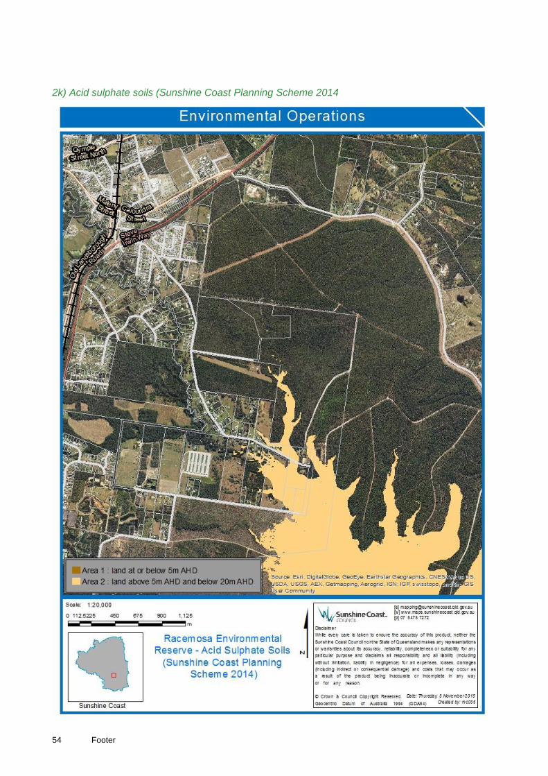
54 Footer
2k) Acid sulphate soils (Sunshine Coast Planning Scheme 2014

Footer 55
2l) High Value Regrowth (V2)

56 Footer
Appendix 3: Sunshine Coast Priority regional ecosystems
3a) Status of vegetation communities on the Sunshine Coast
Vegetation Community
RE SCLGA Pre-clearing extent (Ha)
SCLGA Current extent (Ha)
SCLGA Vulnerable
2
Loss (%)
Conservation status (VMA)
SCLGA Poorly Conserved REs (Target RE)
Extent currently protected
Additional area required to adequately represent (ha)
SEQ poorly Conserved REs
EPBC EEC/ LSR
Eucalypt 12.5.3 12,332 1,445 88 Endangered 606 (5%) 627
Heath 12.3.8 281 216 23 Of Concern 88 (31%)
Heath 12.3.13 4,189 1,331 68 Least Concern 945 (23%)
Melaleuca 12.3.5 10,213 3,230 68 Least Concern 1,297 (13%)
A regional ecosystem is considered to be a ‘target’ based on one or more of the following factors: 1) VMA endangered conservation status; 2) Vulnerable at a SCLGA scale; 3)
having lost more than 70% of its Sunshine Coast pre-clearing extent; 4) Poorly conserved at a SCLGA scale (>10% of SC pre-clearing extent protected); 5) Poorly conserved at a SEQ scale (>10% of SEQ pre-clearing extent protected); 6) Commonwealth EPBC listed critically endangered ecosystems (Lowland sub-tropical rainforest)
3b) Extent of observed Regional Ecosystems in Sunshine Coast conservation estate
Vegetation Community
RE Pre-
clearing extent
Current Extent
Protected areas (Ha) Voluntary
Conservation Areas (Ha)
Total extent of RE within conservation estate (Ha) Nature
Refuge Covenant State Council
Total extent in protected
areas
Land for Wildlife
Eucalypt 12.5.3 12,332 1,445 0 8 578 20 606 62 668
Heath 12.3.8 281 216 0 0 50 37 88 7 95
Heath 12.3.13 4,189 1,331 0 2 780 163 945 7 952
Melaleuca 12.3.5 10,213 3,230 0 9 855 433 1,297 10 1,397
2 Vulnerable = Loss of < 70% of pre-clearing extent

Footer 57
Appendix 4: Flora Species Lists
Racemosa Environmental Reserve Flora Assessment (Thomas, G 2012)
Taxon Family
Qld Herb. (2002) Status
LP Act 2002 G/F Common Name g l m c 12.3.5 12.3.13 12.3.8 12.5.3 Abund.
Acacia complanata MIMOSACEAE
SH Flat-stemmed Wattle g l - - - - - x C
Acacia hubbardiana MIMOSACEAE
SH Yellow Prickly Moses g l - - x x - x C
Acacia longissima MIMOSACEAE
T Narrow-leaf Wattle - l - - x - - x R/U
Acacia melanoxylon MIMOSACEAE
T Blackwood - - m - x - - - U
Acacia penninervis v. longiracemosa MIMOSACEAE
ST Hickory Wattle - l - - x - - x R/U
Acacia suaveolens MIMOSACEAE
SH Sweet Wattle - l - - - x - x O
Acrotriche aggregata ERICACEAE
SH Red Cluster Heath - l - - - - - x U
Ageratina riparia * ASTERACEAE 25 LC
H Mist Flower g - - - x - - - A
Ageratum houstonianum * ASTERACEAE 115 GEP
H Blue Top g - - - x - - - C
Allocasuarina littoralis CASUARINACEAE
T Coastal She Oak g l m - - - - x C
Alphitonia excelsa RHAMNACEAE
T Red Ash g l m - x - - x C
Amyema miquelii LORANTHACEAE
H Mistletoe - - - c - - - x U/O
Andropogon virginicus * POACEAE
LC
H Whisky Grass g - - - - - - x O
Archontophoenix alexandrae # ARECACEAE
GEP
T Alexander Palm - l - - x - - - U
Archontophoenix cunninghamiana ARECACEAE
T
Picabeen/Bangalow Palm g l - - x - - - O
Ardisia crenata * MYRSINACEAE
LC
SH Coral Berry - l - - x - - - R

58 Footer
Taxon Family
Qld Herb. (2002) Status
LP Act 2002 G/F Common Name g l m c 12.3.5 12.3.13 12.3.8 12.5.3 Abund.
Ardisia humilis * MYRSINACEAE
LC
ST Low Shoebutton - l - - x - - - R
Aristida warburgii POACEAE
H Speargrass g - - - - - - x O
Babingtonia bidwillii MYRTACEAE
SH Twiggy Myrtle - l m - x - - - R/U
Baloskion pallens RESTIONACEAE
H Pale Cord Rush g - - - - x - - U
Baloskion tetraphyllum ssp meiostachyum RESTIONACEAE
H Tassel Cord Rush g - - - x - - - O
Banksia aemula PROTEACEAE
T Wallum Banksia - l m - - - - x U
Banksia oblongifolia PROTEACEAE
SH Dwarf Banksia g l - - x x - x C
Banksia robur PROTEACEAE
SH Broad-leaved Banksia g l - - x x x - C
Banksia spinulosa v. collina PROTEACEAE
SH Golden Candlesticks g l - - - - - x C
Baumea articulata CYPERACEAE
H Jointed Twigrush g - - - x - x - U
Baumea juncea CYPERACEAE
H Bare Twigrush g - - - x - - - O
Baumea rubiginosa CYPERACEAE
H Soft Twigrush g - - - - x - - O
Bidens pilosa * ASTERACEAE 110 LC
H Pitchforks g - - - - - - x U
Billardiera scandens PITTOSPORACEAE
V Climbing Apple-berry g l - - x - - x C
Blechnum indicum BLECHNACEAE
F Bungwahl g - - - x - x - C
Bossiaea heterophylla FABACEAE
SH Variable Bossiaea - l - - - - - x R
Brachiaria mutica * POACEAE
LC
H Parra Grass g - - - x - x - O
Burchardia umbellata COLCHICACEAE
H Milkmaids g - - - - x - - U
Calochlaena dubia DICKSONIACEAE
F False Bracken g - - - x - - x U
Carex brunnea CYPERACEAE
H Greater brown sedge g - - - x - - - O/C
Cassytha glabella LAURACEAE
V Slender dodder-laurel g - - - x x - - O
Cassytha pubescens LAURACEAE
V Dodder Vine g - - - - x - - C
Caustis blakei CYPERACEAE
H Foxtail g - - - - - - x C
Caustis recurvata CYPERACEAE
H Curly Wig g - - - - x - - U/O

Footer 59
Taxon Family
Qld Herb. (2002) Status
LP Act 2002 G/F Common Name g l m c 12.3.5 12.3.13 12.3.8 12.5.3 Abund.
Centella asiatica APIACEAE
H Pennywort g - - - x - - - U
Chorizandra cymbaria CYPERACEAE
H Heron bristle rush g - - - x x - - O/C
Christella dentata THELYPTERIDACEAE
F Dinung g - - - x - - - U
Cinnamomum camphora * LAURACEAE 8 LC C3 T Camphor Laurel g l m - x - - - C
Cissus hypoglauca VITACEAE
V Five leaf water vine g l - - x - - - R
Commelina diffusa COMMELINACEAE
H Native Wandering Jew g - - - x - - - U/O
Conospermum taxifolium PROTEACEAE
H Devil's Rice - l - - - x - - R/U
Corymbia gummifera MYRTACEAE
T Red Bloodwood - l m c - - - x O
Corymbia intermedia MYRTACEAE
T Pink Bloodwood - l m c x - - x O
Corymbia trachyphloia MYRTACEAE
T Brown Bloodwood - l m c x x - x O
Cryptocarya glaucescens LAURACEAE
T Jack wood - l m - x - - - U
Cupaniopsis anacardioides SAPINDACEAE
T Tukeroo - l - - x - - - R
Cyanthillium cinerea ASTERACEAE
H Little ironweed g - - - - - - x U
Cyathea cooperi CYATHEACEAE
F Scaly Tree Fern - - m - x - - - R
Cymbidium madidum ORCHIDACEAE
H Native Cymbidium - l - - x - - - R
Cymbopogon refractus POACEAE
H Barbed Wire Grass g - - - - - - x U
Cyperus polystachyos CYPERACEAE
H Bunchy sedge g - - - x - x - U
Dampiera sylvestris GOODENIACEAE
H Blue fan flower g - - - x x - x A
Daviesia umbellulata FABACEAE
SH Bitter Pea g l - - - - - x O/C
Dianella caerulea LAXMANNIACEAE
H Blue Flax Lilly g - - - x x - x O
Dianella revoluta LAXMANNIACEAE
H Spreading Flax-Lily g - - - - - - x U
Drosera DROSERACEAE
H Sundew g - - - - x - x C

60 Footer
Taxon Family
Qld Herb. (2002) Status
LP Act 2002 G/F Common Name g l m c 12.3.5 12.3.13 12.3.8 12.5.3 Abund.
spathulata
Drymaria cordata CARYOPHYLLACEAE
H Tropical Chickweed g - - - x - - - U
Dysoxylum rufum MELIACEAE
T Hairy Rosewood g - - - x - - - R
Elaeocarpus reticulatus ELAEOCARPACEAE
ST Blueberry Ash - l - - x - - x U
Empodisma minus RESTIONACEAE
H Spreading Rope Rush g - - - - - - x O
Endiandra discolor LAURACEAE
T Rose Walnut g l m - x - - - U
Endiandra sieberi LAURACEAE
T Corkwood - l - - x - - - R
Entolasia stricta POACEAE
H Wiry Panic g - - - x x - x A
Epacris obtusifolia ERICACEAE
SH Common Heath - l - - - - - x R/U
Epacris pulchella ERICACEAE
SH Wallum Heath g l - - - x - - O
Erechtites valerianifolia * ASTERACEAE
H Brazilian Fireweed g - - - - - - x U
Eriocaulon australe ERIOCAULACEAE
H Tall Pipewort g - - - x - - - R
Eriocaulon scariosum ERIOCAULACEAE
H Common Pipewort g - - - x - - - U
Erythrina crista-gallii * FABACEAE
T Cockspur Coral Tree - l m - x '- - - U/O
Eucalyptus pilularis MYRTACEAE
T Black Butt - - - c - - - x U
Eucalyptus racemosa MYRTACEAE
T Scribbly Gum - l m c x - - x C
Eucalyptus robusta MYRTACEAE
T Swamp Mahogany - - m c x - - - O
Eucalyptus tindaliae MYRTACEAE
T Qld White Stringybark - l m c x - - x C
Ficus coronata MORACEAE
T Creek Sandpaper Fig - l - - x - - - U
Flindersia brayleana # RUTACEAE
T Queensland Maple - l - - - - - x R
Gahnia clarkei CYPERACEAE
H Tall Saw sedge g - - - x x x - O/C
Gahnia sieberiana CYPERACEAE
H Red-fruited Saw sedge g - - - x - - - U
Gleichenia dicarpa GLEICHENIACEAE
F Pouched Fern g - - - x - - - O

Footer 61
Taxon Family
Qld Herb. (2002) Status
LP Act 2002 G/F Common Name g l m c 12.3.5 12.3.13 12.3.8 12.5.3 Abund.
Gleichenia mendellii GLEICHENIACEAE
F Coral Fern g - - - x - - - O
Glochidion ferdinandi v. ferdinandi PHYLLANTHACEAE
T Cheese Tree - l m - x - - - O
Glochidion sumatranum PHYLLANTHACEAE
T Umbrella Cheese Tree - l - - x - - - U
Glycine clandestina v clandestina FABACEAE
V Twining Glycine g - - - - - - x U
Gompholobium virgatum v virgatum FABACEAE
SH Wallum Wedge Pea g l - - - - - x U
Gonocarpus micranthus HALORAGACEAE
H Creeping raspwort g - - - - x - - O
Goodenia hederacea GOODENIACEAE
H Ivy Goodenia g - - - x x - - C
Goodenia rotundifolia GOODENIACEAE
H Star Goodenia g - - - - - - x U/O
Grevillea leiophylla PROTEACEAE
SH Dwarf Spider Oak - l - - - - - x U
Hakea actites PROTEACEAE
SH Wallum Hakea - l - - x x - x A
Hakea florulenta PROTEACEAE
SH Three-veined Hakea - l - - x - - x O/C
Hibbertia aspera DILLENIACEAE
SSH Rough Guinea Flower g l - - - - - x O
Hibbertia salicifolia DILLENIACEAE
V Willow Guinea Flower g - - - - x - - U/O
Hibbertia vestita DILLENIACEAE
SSH Hairy Guinea Flower g - - - x x - x C/A
Hydrocotyle tripartita APIACEAE
H Slender pennywort g - - - x - - - U/O
Hypericum gramineum CLUSIACEAE
H Small St. John's Wort g - - - x - - - U
Hypolepis muelleri DENNSTAEDTIACEAE
F Harsh Ground Fern g - - - x - - - U
Imperata cylindrica POACEAE
H Blady Grass g - - - - - - x C
Ischaemum australe POACEAE
H Large bluegrass g - - - - x - - O
Ischaemum fragile POACEAE
H
g - - - - x - - O/C
Jagera pseudorhus SAPINDACEAE
T Foam Bark - l - - x - - - R

62 Footer
Taxon Family
Qld Herb. (2002) Status
LP Act 2002 G/F Common Name g l m c 12.3.5 12.3.13 12.3.8 12.5.3 Abund.
Lantana camara * VERBENACEAE 1 LC C3 SH Lantana g l - - x - - - O
Laxmannia gracilis LAXMANNIACEAE
H Slender Wire Lilly g - - - - - - x U
Lepidosperma laterale v angustum CYPERACEAE
H Variable sawsedge g - - - x - - x C
Lepidosperma longitudinale CYPERACEAE
H Common Sawsedge g - - - - - - x O
Lepironia articulata CYPERACEAE
H Tube Sedge g - - - x - - - U
Leptospermum polygalifolium MYRTACEAE
ST Wild May - l - - x x - - O
Leptospermum semibaccatum MYRTACEAE
SH Heath May - l - - - - - x U
Leptospermum speciosum MYRTACEAE
SH Broad-leaved Tea Tree - l - - x x - - O
Leptospermum trinervium MYRTACEAE
SH Paperbark tea-tree - l - - - - - x O/C
Leptospermum whitei MYRTACEAE
ST Paperbark tea-tree - l - - - x - - U/O
Lepyrodia scariosa RESTIONACEAE
H Scaly Rush g - - - x x - x O
Leucopogon leptospermoides ERICACEAE
SH Beard heath - l - - - - - x U
Ligustrum sinense * OLEACEAE 21 SM C3 ST Small Leaved Privet - l - - x - - - U/O
Lindsaea ensifolia LINDSAEACEAE
F Lace fern g - - - x - - - O
Lindsaea incisa LINDSAEACEAE
F Screw Fern g - - - x - - - O
Lindsaea microphylla LINDSAEACEAE
F Lacy Wedge Fern g - - - x - - - U
Lobelia alata CAMPANULACEAE
H Angled Lobelia g - - - x - - - U
Lobelia purpurascens CAMPANULACEAE
H White Root g - - - x - - x O
Lomandra hystrix LAXMANNIACEAE
H Matt Rush g - - - x - - - O
Lomandra longifolia LAXMANNIACEAE
H Spinyhead Matt Rush g - - - x - - x O/C
Lomatia silaifolia PROTEACEAE
SH Crinkle Bush - l - - - - - x O

Footer 63
Taxon Family
Qld Herb. (2002) Status
LP Act 2002 G/F Common Name g l m c 12.3.5 12.3.13 12.3.8 12.5.3 Abund.
Lophostemon suaveolens MYRTACEAE
T Swamp Box g l m - x - x - C
Marsdenia lloydii APOCYNACEAE
V Corky Milk Vine g - - - - - - x R
Megathyrsus maximus * POACEAE 20 SM/LC
H Guinea Grass g - - - x - - - U
Melaleuca nodosa MYRTACEAE
SH Pricklyleaf Paperbark - l - - - x - - U/O
Melaleuca pachyphylla MYRTACEAE
SH Wallum Bottlebrush - l - - - x - - U
Melaleuca quinquenervia MYRTACEAE
T Broad-leaf Paperbark g l m c x x x - A
Melaleuca sieberi MYRTACEAE
ST
g l m - x x - x A
Melastoma malabathricum MELASTOMATACEAE
SH Blue Tongue - l - - x x x x O
Melicope elleryana RUTACEAE
T Pink Euodia g l m - x - - - C
Mischarytera lautereriana SAPINDACEAE
T Corduroy Tamarind - l - - x - - - R
Monotoca scoparia EPACRIDACEAE
SH Prickly Broom Heath - l - - - - - x O
Morinda jasminoides RUBIACEAE
V Jasmine morinda g - - - x - - - R
Neolitsea dealbata LAURACEAE
T Grey Bollywood - l - - x - - - R
Notelaea ovata OLEACEAE
SH Netted Mock Olive g l m - - - - x O
Nymphaea capensis * NYMPHAEACEAE
H Cape Blue Waterlilly g - - - x - x - O
Nymphoides indica MENYANTHACEAE
H Water Snowflake g - - - x - x - U
Oplismenus hirtellus ssp imbecillus POACEAE
H Slender panic grass g - - - x - - - U
Ottochloa gracillima POACEAE
H Shade Grass g - - - x - - - O
Panicum effusum v simile POACEAE
H Hairy panic g - - - x - - x O
Parsonsia straminea APOCYNACEAE
V Monkey Vine g l m - x - - x O

64 Footer
Taxon Family
Qld Herb. (2002) Status
LP Act 2002 G/F Common Name g l m c 12.3.5 12.3.13 12.3.8 12.5.3 Abund.
Paspalum mandiocanum * POACEAE
LC
H Broadleaf Paspalum. g - - - x - - - U
Paspalum urvillei * POACEAE
H Vasey Grass g - - - - - - x U
Patersonia glabrata IRIDACEAE
H Leafy Purple Flag g - - - - - - x R
Patersonia sericea IRIDACEAE
H Silky Purple Flag g - - - - - - x R
Persicaria strigosa POLYGONACEAE
H Spotted Knotweed g - - - x - x - O
Persoonia stradbrokensis PROTEACEAE
SH Broad-leaf Geebung - l - - - x - - U
Persoonia virgata PROTEACEAE
SH Narrow-leaf Geebung - l - - x x - - O
Petalostigma triloculare PICRODENRACEAE
ST Long-leaf Bitter Bark g l m - - - - x O
Petrophile shirleyae PROTEACEAE
SH Cone bush - l - - - x - x O
Philotheca myoporoides ssp queenslandica RUTACEAE
SFS
SH Wax Flower - l - - - x - - O/C
Philydrum lanuginosum PHILYDRACEAE
H Frog's Mouth g - - - x - x - O
Pimelea linifolia ssp linifolia THYMELAEACEAE
H Slender Rice Flower g l - - x x - - O
Pinus elliottii * PINACEAE
LC
T Slash Pine g l m c x - - x C
Piper hederaceum PIPERACEAE
H New Holland Pepper - l - - x - - - R
Pittosporum revolutum PITTOSPORACEAE
SH Yellow Pittosporum g l - - x - - x R
Psychotria loniceroides RUBIACEAE
SH Rusty Psychotria - l - - x - - - R
Pteridium esculentum DENNSTAEDTIACEAE
F Common Bracken Fern g - - - x - - x C
Ptilothrix deusta CYPERACEAE
H Ptilothrix g - - - - x - x A
Pultenaea myrtoides FABACEAE
SH Myrtle Pea-Bush - l - - - - - x O
Pultenaea paleacea FABACEAE
SH Chaffy Bush Pea - l - - x x - x O
Pultenaea villosa FABACEAE
SH Bronze Bush Pea - l - - - - - x C

Footer 65
Taxon Family
Qld Herb. (2002) Status
LP Act 2002 G/F Common Name g l m c 12.3.5 12.3.13 12.3.8 12.5.3 Abund.
Rhodomyrtus psidioides MYRTACEAE
T Native Guava - l m - x - - - R
Rhynchospora corymbosa CYPERACEAE
H Corymbed Beak-sedge g - - - x - x - C/A
Sacciolepis indica POACEAE
H India cupscale-grass g - - - x - - - U
Salvinia molesta * SALVINIACEAE 10 GS/SM C2 F Giant Salvinia g - - - x - x - U/O
Schefflera actinophylla # ARALIACEAE
LC
T Umbrella Tree - l m - x - - - U
Schizaea bifida SCHIZAEACEAE
F Forked Comb Fern g - - - - - - x U
Schizaea dichotoma SCHIZAEACEAE
F Branched Comb Fern g - - - - - - x O
Schizomeria ovata CUNONIACEAE
T Crab Apple - - m - x - - - R
Schoenus brevifolius CYPERACEAE
H Zig-Zag Bog Rush g - - - - x - x O
Schoenus melanostachys CYPERACEAE
H Black Bog Rush g - - - x x - x C
Schoenus paludosus CYPERACEAE
H Swamp Rush g - - - - x - - O
Senna pendula v. glabrata * CAESALPINIACEAE 45 LC
SH Winter Senna g l - - x - - - U
Setaria sphacelata v sericea * POACEAE
LC
H Sth African Pigeon grass g - - - x - - - U/O
Sida rhombifolia * MALVACEAE 153 GEP
H Sida g - - - x - - - R
Smilax australis SMILACACEAE
V Austral Smilax g l - - - x - x U
Smilax glyciphylla SMILACACEAE
V Sarsaparilla g - - - x - - x O
Sporadanthus caudatus RESTIONACEAE
H
g - - - - x - - O
Sprengelia sprengelioides EPACRIDACEAE
SH Sprengelia - l - - - x - - O
Stephania japonica MENISPERMACEAE
V Snake Vine g - - - x - - - R/U
Sticherus lobatus GLEICHENIACEAE
F Spreading Fan Fern g - - - x - - - O
Strangea linearis PROTEACEAE
SH Strangea - l - - - x - x O

66 Footer
Taxon Family
Qld Herb. (2002) Status
LP Act 2002 G/F Common Name g l m c 12.3.5 12.3.13 12.3.8 12.5.3 Abund.
Syagrus romanzoffiana * ARECACEAE 75 LC
T Cocos Island Palm - l - - x - - - U
Syncarpia glomulifera MYRTACEAE
T Turpentine g l m c x - - x C
Tetratheca thymifolia TREMANDRACEAE
H Black eyed Susan - l - - - x - x O
Trema tomentosa ULMACEAE
ST Native Peach - l - - x - - - U/O
Tricoryne elatior JOHNSONIACEAE
H Flat-stemmed rush-lily g - - - - - - x U/O
Triglochin procera JUNCAGINACEAE
H Water ribbons g - - - x - - - U
Trophis scandens MORACEAE
V Burny Vine g - - - x - - - R
Velleia spathulata GOODENIACEAE
H Northern Velleia g - - - - - - x U/O
Villarsia reniformis MENYANTHACEAE
H Running Marsh Flower g - - - x - x - O/C
Viola banksii VIOLACEAE
H Native Violet g - - - x - - - O/C
Xanthorrhoea fulva XANTHORRHOEACEAE
SH Swamp Grass tree g - - - x x - - C
Xanthorrhoea johnsonii XANTHORRHOEACEAE
SH Forest Black-Boy g - - - x - - x C
Xylomelum salicinum PROTEACEAE
ST Coastal Woody Pear - l - - x - - x O
Xyris juncea XYRIDACEAE
H Dwarf Yellow Eye g - - - - x - - O
Zieria laxiflora RUTACEAE
SH Wallum Zieria g l - - x - - x U/O
Zieria minutiflora RUTACEAE
SH Small Flowered Zieria - - - - x - - x U

Footer 67
Flora attributes and values--Irwin Property Landsborough (LAMR 2003) * = Introduced Taxa (Included planted native taxa)
Acacia complanata Chorizandra sphaerocephala Epaltes australis
Acacia disparrima Christella dentata Eragrostis curvula*
Acacia hubbardiana Chrysophyllum cainito* Eragrostis elongata
Acacia melanoxylon Cinnamomum camphora * Erechtites valerianifolia *
Acacia suaveolens Commelina ensifolia Eriocaulon australe
Acrotriche aggregata Corymbia gummifera Eriocaulon scariosum
Ageratina riparia * Corymbia intermedia Erythrina x sykesii*
Ageratum houstonianum * Corymbia trachyphloia Eucalyptus carnea
Allocasuarina littoralis Crassocephalum crepidioides* Eucalyptus pilularis
Alphitonia excelsa Cryptocarya glaucescens Eucalyptus racemosa
Amyema miquelii Cryptocarya microneura Eucalyptus robusta
Andropogon virginicus * Cupaniopsis anacardioides Eucalyptus tindaliae
Archontophoenix cunninghamiana Cuscata campestris* Ficus benjamina*
Aristida warburgii Cyanthillium cinerea Ficus coronata
Axonopus fissifolius Cyathea cooperi Gahnia clarkei
Baccharis halimifolia* Cyclosorus interruptus Gahnia sieberiana
Baloskion pallens Cymbopogon refractus Gleichenia dicarpa
Banksia aemula Cyperus polystachyos Gleichenia mendellii
Banksia oblongifolia Dampiera sylvestris Glochidion ferdinandi
Banksia oblongifolia x robur Daviesia umbellulata Glochidion sumatranum
Banksia robur Desmodium uncinatum* Gompholobium pinnatum
Banksia spinulosa Dianella caerulea Gompholobium virgatum
Bauera capitata Dianella revoluta Gonocarpus chinensis
Baumea planifolia Dicranopteris linearis Gonocarpus micranthus
Baumea rubiginosa Dillwynia floribunda Goodenia rotundifolia
Baumea teretifolia Drosera peltata Grevillea leiophylla
Bidens pilosa * Drosera pygmaea Grevillea robusta
Billardiera scandens Drosera spathulata Guioa semiglauca
Blechnum indicum Drymaria cordata Haemodorum tenuifolium
Brachiaria mutica * Drynaria rigidula Hakea actites
Burchardia umbellata Dysoxylum mollissimum Hakea florulenta
Callistemon pachyphyllus Elaeocarpus obovatus Hibbertia vestita
Calochlaena dubia Elaeocarpus reticulatus Hypericum gramineum
Carex brunnea Eleocharis equisetina Hypolepis muelleri
Cassytha glabella Empodisma minus Imperata cylindrica
Cassytha pubescens Endiandra discolor Ischaemum australe
Caustis blakei Endiandra sieberi Ischaemum fragile
Caustis recurvata Entolasia marginata Lantana camara *
Centella asiatica Entolasia stricta Laxmannia gracilis
Chorizandra cymbaria Epacris pulchella Lepidosperma laterale

68 Footer
Lepidosperma longitudinale Morinda jasminoides Rhynchospora corymbosa
Lepironia articulata Murdannia graminea Sacciolepis indica
Leptospermum juniperinum Murdannia graminea Schefflera actinophylla*
Leptospermum liversidgei Notelaea ovata Schizaea bifida
Leptospermum polygalifolium Nymphaea gigantea Schizaea dichotoma
Leptospermum semibaccatum Oplismenus hirtellus Schoenus apogon
Leptospermum trinervium Ottochloa gracillima Schoenus brevifolius
Leptospermum whitei Panicum effusum Schoenus melanostachys
Lepyrodia interrupta Panicum maximum* (Megathyrsus maximus) Schoenus paludosus
Lepyrodia scariosa Parsonsia straminea Scleria sphacelata
Leucopogon leptospermoides Paspalidium gausum Scoparia dulcis*
Ligustrum sinense * Paspalum scrobiculatum Setaria sphacelata
Lindsaea dimorpha Paspalum urvillei * Sida rhombifolia *
Lindsaea ensifolia Paspalum wettsteinii* (P. virgatum) Smilax australis
Lindsaea microphylla Passiflora edulis* Smilax glyciphylla
Litsea australis Passiflora suberosa Solanum seaforthianum*
Lobelia alata Patersonia fragilis Sporadanthus caudatus
Lobelia membranacea Patersonia glabrata Sporobolus natalensis*
Lobelia purpurascens Persicaria strigosa Sprengelia sprengelioides
Lomandra filiformis Persoonia stradbrokensis Stackhousia viminea
Lomandra hystrix Persoonia tenuifolia Stephania japonica
Lomandra longifolia Persoonia virgata Strangea linearis
Lomandra multiflora Petrophile shirleyae Stylidium debile
Lomatia silaifolia Philotheca myoporoides Stylidium graminifolium
Lophostemon confertus Philydrum lanuginosum Syncarpia verecunda
Lophostemon suaveolens Phyllota phylicoides Syzygium uniflorum*
Lygodium microphyllum Pimelea linifolia Tetratheca thymifolia
Macaranga tanarius Pinus elliottii * Themeda triandra
Macroptilium atropurpureum* Piper novae-hollandiae (P. hederaceum) Thysanotus tuberosus
Mallotus philippensis Pittosporum revolutum Tricoryne elatior
Melaleuca nodosa Platycerium bifurcatum Trophis scandens
Melaleuca quinquenervia Pseudanthus orientalis Velleia spathulata
Melaleuca sieberi Pseuderanthemum variabile Xanthorrhoea fulva
Melaleuca thymifolia Psidium guineense* Xanthorrhoea johnsonii
Melastoma affine Psychotria loniceroides Xanthorrhoea latifolia
Melicope elleryana Pteridium esculentum Xanthosia pilosa
Melinis minutiflora* Ptilothrix deusta Xylomelum salicinum
Mirbelia rubiifolia Pultenaea paleacea Zieria minutiflora
Mitrasacme paludosa Pultenaea villosa
Monotoca sp. "Fraser Island" Rapanea variabilis

Footer 69
Appendix 5: Fauna Species Lists
5a) Racemosa Environmental Reserve, Fauna Survey Report (Fox 2012)

70 Footer

Footer 71

72 Footer
5b) Camera trap survey fails to locate long-nosed potoroos P. tridactylus at Racemosa Environmental Reserve (Burnett & Kroenert 2015)
Species No. camera sites at which species occurred
yellow-footed antechinus, Antechinus flavipes 2
northern brown bandicoot, Isoodon macrourus 7
short-eared brushtail possum, Trichosurus caninus 2
swamp wallaby, Wallabia bicolor 5
fawn-footed melomys, Melomys cervinipes 2
grassland melomys, Melomys burtoni 1
bush rat, Rattus fuscipes 2
swamp rat, Rattus lutreolus 1
red fox, Vulpes vulpes 1
grey shrike thrush, Colluricincla harmonica 1
pacific black duck, Anas superciliosa 1
laughing kookaburra, Dacelo novaehollandiae 1
lace monitor, Varanus varius 2

Footer 73
5c) Birdlife Sunshine Coast (4th May 2013)

74 Footer

Footer 75
5d) Beerwah Water Reserve - Fauna Assessment (Czechura, G 2003)

76 Footer

Footer 77

78 Footer

Footer 79

80 Footer

Footer 81
82 Footer

Footer 83
Appendix 6:
6a) Weeds at the Racemosa Environmental Reserve
Common Name Scientific Name Commonwealth Queensland SCC
Racemosa Environmental Reserve Flora Assessment (Thomas 2012)
Ageratina riparia Mist Flower Local control
Ageratum houstonianum Blue Top Local control
Andropogon virginicus Whisky Grass Local control
Archontophoenix alexandrae
Alexander Palm
General environmental pest
Ardisia crenata Coral Berry Local control
Ardisia humilis Low Shoebutton Local control
Bidens pilosa Cobbler's Pegs Local control
Brachiaria mutica Parra Grass
Cinnamomum camphora Camphor Laurel Class 3 Local control
Erechtites valerianifolia Brazilian Fireweed
Erythrina crista-galli Cockspur Coral Tree Local control
Flindersia brayleana Queensland Maple
Lantana camara Lantana WoNS Class 3 Local control
Ligustrum sinense Small-leaved Privet
Class 3 Strategic management
Megathyrsus maximus Guinea Grass Local control
Nymphaea capensis Cape Blue Waterlily
Paspalum mandiocanum Broad Leaf Paspalum Local control
Paspalum urvillei Vasey’s Grass
Pinus elliottii Slash Pine Local control
Salvinia molesta Giant Salvinia WoNS
Class 2 Strategic management
Schefflera actinophylla Umbrella Tree Local control
Senna pendula v. glabrata Winter Senna Local control
Setaria sphacelata v. sericea
Sth African Pigeon Grass
Local control
Sida rhombifolia Sida
General environmental pest
Additional species recorded in Flora Attributes and Values – Irwin Property (LAMR 2003)
Axonopus fissifolius Carpet Grass
Baccharis halimifolia Groundsel Bush
Class 2 Strategic management
Chrysophyllum cainito Star Apple
Crassocephalum crepidioides
Thickhead
Cuscuta campestris Dodder Local control
Desmodium uncinatum silverleaf desmodium Local control
Eragrostis curvula African lovegrass Local control
Erythrina x sykesii Coral Tree Local control
Ficus benjamina Weeping Fig
General environmental pest

84 Footer
Macroptilium atropurpureum
Siratro
Local control
Melinis minutiflora Molasses Grass Local control
Paspalum wettsteinii (P. virgatum)
Saltwater Couch
Passiflora suberosa Corky Passionflower Local control
persicaria strigosa Spotted Knotweed
Psidium guineense West Indies Guava
General environmental pest
Scoparia dulcis Scoparia Weed
Solanum seaforthianum Brazilian Nightshade Local control
Sporobolus natalensis Giant Rat's Tail Grass
Class 2 Strategic management
Syzygium uniflorum
Additional species recorded in contractor reports (2012-2015)
Cyperus papyrus Dwarf Papyrus Local control
Nephrolepis cordifolia Fishbone Fern Local control
Pueraria montana var. lobata
Kudzu
Class 2 Broad control
Schinus terebinthifolius Broadleaved Pepper Tree
Class 3 Local control
Solanum hispidum Giant Devil's Fig Local control
Spathodea campanulata African Tulip Tree Class 3 Local control
Queensland = status under the Queensland Land Protection (Pest and Stock Route Management) Act 2002; SCC =
locally significant pest management categories under the Sunshine Coast Local Government Area Pest Management Plan 2012-2016; WoNS=Weeds of National Significance
6b) Pest animals at Racemosa Environmental Reserve
Common Name Scientific Name Queensland SCC
Racemosa Environmental Reserve Flora Assessment (Thomas 2012)
Sus Scrofa Feral Pig Class 2 Strategic management
Equus caballus Domestic Horse
Rhinella marina Cane Toad Local control
Camera trap survey fails to locate long-nosed potoroos P. tridactylus at Racemosa Environmental Reserve
Vulpes vulpes Red Fox Class 2 Strategic management
Additional species recorded in or near Beerwah Water reserve boundary (Czechura 2003)
Canis lupus Dingo Class 2 Strategic management
Felis cattus Domestic Cat
Mus musculus House Mouse
Rattus rattus Black Rat
Queensland = status under the Queensland Land Protection (Pest and Stock Route Management) Act 2002; SCC =
locally significant pest management categories under the Sunshine Coast Local Government Area Pest Management Plan 2011-2015.

Footer 85
Glossary and Abbreviations
AHD
Australian Height Datum
BOA
Bushland Operational Assessment
CAR system
Comprehensive: examples of all types of regional-scale ecosystems in each IBRA region should be included in the National reserve System.
Adequate: sufficient levels of each ecosystem should be included within the protected area network to provide ecological viability and to maintain the integrity of populations, species and communities.
Representative: the inclusion of areas at a finer scale, to encompass the variability of habitat within ecosystems.
DEHP
Department of Heritage Protection
E
Endangered
EPBC Act
Environment Protection and Biodiversity Conservation Act 1999
EVNT
Endangered, vulnerable and near threatened species listed by the state and / or Commonwealth government.
FMP
Fire Management Plan
GES Wetlands
General Ecological Significance Wetlands
HES Wetlands
High Ecological Significance Wetlands
IBRA
Interim biogeographical Regionalisation of Australia
IUCN
International Union for the Conservation of Nature
LC
Least Concern
MERI
Monitoring, Evaluation, Reporting, and Improvement
MP
Management Plan
NCA
Nature Conservation Act 1992
NRS
National Reserve System
OC
Of Concern
RE
Regional Ecosystem
RWP
Regeneration Works Plan
SCBS
Sunshine Coast Biodiversity Strategy 2010-2020
SCC
Sunshine Coast Council
SCLGA
Sunshine Coast Local Government Area
SEQ
Southeast Queensland
Significant fauna and flora Fauna and flora species listed as locally significant under the Sunshine Coast Biodiversity Strategy 2010-2020
SMI
Statement of Management Intent
VMA
Vegetation Management Act 1999
