environment impact assessment...
TRANSCRIPT
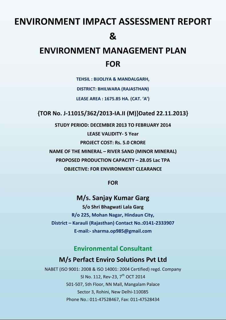
ENVIRONMENT IMPACT ASSESSMENT REPORT
&
ENVIRONMENT MANAGEMENT PLAN
FOR
TEHSIL : BIJOLIYA & MANDALGARH,
DISTRICT: BHILWARA (RAJASTHAN)
LEASE AREA : 1675.85 HA. (CAT. ‘A’)
{TOR No. J-11015/362/2013-IA.II (M)}Dated 22.11.2013}
STUDY PERIOD: DECEMBER 2013 TO FEBRUARY 2014
LEASE VALIDITY- 5 Year
PROJECT COST: Rs. 5.0 CRORE
NAME OF THE MINERAL – RIVER SAND (MINOR MINERAL)
PROPOSED PRODUCTION CAPACITY – 28.05 Lac TPA
OBJECTIVE: FOR ENVIRONMENT CLEARANCE
FOR
M/s. Sanjay Kumar Garg
S/o Shri Bhagwati Lala Garg
R/o 225, Mohan Nagar, Hindaun City,
District – Karauli (Rajasthan) Contact No.:0141-2333907
E-mail:- [email protected]
Environmental Consultant
M/s Perfact Enviro Solutions Pvt Ltd
NABET (ISO 9001: 2008 & ISO 14001: 2004 Certified) regd. Company
Sl No. 112, Rev-23, 7th
OCT 2014
501-507, 5th Floor, NN Mall, Mangalam Palace
Sector 3, Rohini, New Delhi-110085
Phone No.: 011-47528467, Fax: 011-47528434


Q-1
PROFORMA FOR ENVIRONMENTAL APPRAISAL OF MINING PROJ ECTS (MINING SECTOR PROJECTS)
1. General Information
(a) Name of the project : M/s. Sanjay Kumar Garg
Name of the proponent : M/s. Sanjay Kumar Garg
Mailing Address : S/o Shri Bhagwati Lala Garg, R/o-225, Mohan Nagar,
Hindaun City, District-Karauli (Rajasthan)
E-mail : [email protected]
Telephone : 0141-2333907
Fax No. : --
(i) Objective of the project : Mining of River Sand (Bajri) @ 28.05 lac TPA
(c) Location of mine (s)
Village(s) Tehsil District State Amarpura, Asawari,
Bagthala….Ummedpura Mandalgarh &
Bijoliya Bhilwara Rajasthan
(d) Does the proposal relate to
(i) New mine Yes No
(ii) Expansion Yes No
� Increase in ML area Yes No
� Increase in annual production Yes No
(iii) Renewal of ML Yes No
(iv) Modernisation Yes No
(e) Site Information
√
√
√
Note 1: All information to be given in the form of Annex/s should be properly numbered and form part of reply to this proforma.
Note 2: Please enter √ in appropriate box where answer is Yes/No
Note 3: No abbreviation to be used - Not available or Not applicable should be clearly mentioned.
Note 4: Core Zone is the mining lease area.
Buffer zone in case of ML area up to 25 ha. is to be considered as 5 km all around the periphery of the core zone and for ML area above 25 ha. an area 10 km all around the periphery of the core zone.
Note 5: Adopt Scoping process in carrying out EIA study.
Note 6: Please indicate source of data.
√
√
√
Q-2
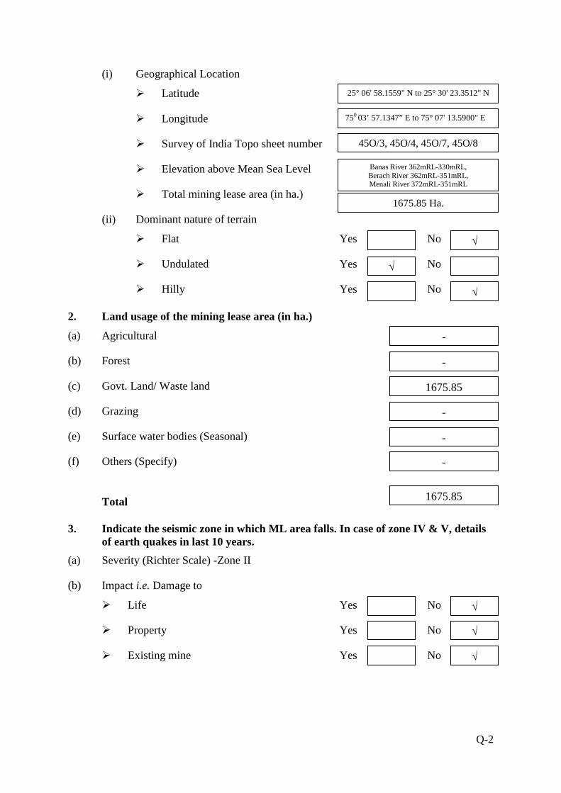
(i) Geographical Location
� Latitude
� Longitude
� Survey of India Topo sheet number
� Elevation above Mean Sea Level
� Total mining lease area (in ha.)
(ii) Dominant nature of terrain
� Flat Yes No
� Undulated Yes No
� Hilly Yes No
2. Land usage of the mining lease area (in ha.)
(a) Agricultural
(b) Forest
(c) Govt. Land/ Waste land
(d) Grazing
(e) Surface water bodies (Seasonal)
(f) Others (Specify)
Total
3. Indicate the seismic zone in which ML area falls. In case of zone IV & V, details of earth quakes in last 10 years.
(a) Severity (Richter Scale) -Zone II
(b) Impact i.e. Damage to
� Life Yes No
� Property Yes No
� Existing mine Yes No
√
√
√
√
√
√
25° 06' 58.1559" N to 25° 30' 23.3512" N
750 03’ 57.1347” E to 75° 07' 13.5900" E
45O/3, 45O/4, 45O/7, 45O/8
Banas River 362mRL-330mRL, Berach River 362mRL-351mRL, Menali River 372mRL-351mRL
1675.85 Ha.
-
-
1675.85
-
-
-
1675.85

Q-3
4. Break-up of mining lease area (in ha.) as per Approved Conceptual Plan:
Purpose
Mining Lease Area
Total
Area acquired Area to be acquired
Government Private Government Private Government Private
Forest Others Agri. Others Forest Others Agri. Others Forest Others Agri. Others
1. Area to be excavated - 301.0 - - 301.0 - 3.0 - - - 298.0 - -
2. Storage for top soil - - - - - - - - - - - - -
3. Overburden / Dumps - - - - - - - - - - - - -
4. Mineral storage - - - - - - - - - - - - -
5. Infrastructure (Workshop, Administrative Building)
- - - - - - - - - - - - -
6. Roads - 5.0 - - 5.0 - 5.0 - - - - -
7. Railways - - - - - - - - - - - - -
8. Green Belt - 5.4 - - 5.4 - - - - - 5.4 - -
9. Tailings pond - - - - - - - - - - - - -
10. Effluent treatment plant - - - - - - - - - - - - -
11. Coal handling plant / mineral separation plant
- - - - - - - - - - - - -
12. Township area - - - - - - - - - - - - -
13. Other (Specify)-Undisturbed - 1364.45 - - 1364.45 - - - - - - - -
TOTAL - 1675.85 - - 1675.85 - 8.0 - - - 303.4 - -

Q-4
5. Township (outside mining lease)
(a) Total area (in ha)
(b) No. of dwelling units
(c) Distance from mine site
6. Distance of water bodies (in km)
Distance from River Bank * Other Water bodies * Sea/creek/lake/nalla etc.(specify)
Mining lease boundary
Distance is nil in respect of Banas, Berach and Menali river as the project lies on river bed
Kankroliya Talab about 2.0km distance in west direction.
Ancillary facilities [* From highest flood line/high tide line]
7. For projects falling within the Coastal Regulation Zone (CRZ)
Whether the mineral to be mined is of rare nature and not available outside CRZ? Yes No
if yes, annex a scaled location map showing low tide line (LTL), high tide line (HTL) duly demarcated by one of the authorized agencies* [ *Director, Space Application Centre, Ahmedabad: Centre for Earth Sciences Studies, Thiruvananthapuram: Institute of Remote Sensing, Anna University, Chennai: Institute of Wetland Management & Ecological Designs, KolKata: Naval Hydrographers’s Office, Dehradun: National Institute of Oceanography, Panjim, Goa: and National Institute of Ocean Technology, Chennai], boundary of mining lease area, distance of ML area from LTL and HTL CRZ boundary and CRZ classification of the project area as per the approved Coastal Zone Management Plan, and settlements, sand dunes, mangroves, forest land/patches, turtles breeding and nesting sites etc., if any, in the project area.
8. Indicate aerial distance from the periphery of core zone/area from the periphery of the buffer zone to the boundary of following (up to 10 km):
S.No. Areas Name
Aerial distance from (in km.)
Core * Buffer* Zone Zone
1. National Park/Sanctuary No - -
2. Biosphere Reserve/Tiger Reserve/Elephant Reserve/ any other Reserve
No - -
3. Forest (RF/PF/unclassified)
A. Tehsil Mandalgarh (i) Singoli Reserve Forest is
located SW of lease area and extends upto the boundary of the lease area near village Gowta.
(ii) Protected Forest near village Adampura east of lease area.
(iii) Chitauriya Reserve
100m
√
-
-
-

Q-5
Forest is located in east of lease area.
(iv) Gowanpura Protected Forest North of lease area adjoining to the lease.
(v) Makariya Protected Forest is located in east of lease area.
(vi) Ummedpura Reserve Forest is located east adjoining of the lease area.
(vii) Natawata ka khera Reserve Forest is located in East of lease area.
(viii) Aampura Protected Forest is located east adjoining of the lease area.
(ix) Chainpura Reserve Forest is located east adjoining of the lease area.
(x) Govindpura Protected Forest east of lease area.
(xi) Khadgarji ka khera Protected Forest is located north of lease area adjoining to the lease.
(xii) Malpuriya Reserve Forest is located in west of lease area.
B. Tehsil Kotri (ii) Sorli Reserve Forest
is adjoining to the lease area towards SW.
(xiii) Kakroliya Protected Forest is located in west of lease area.
2.25 km 3.5 km 3.25 km 2.0 km 5.0 km 750 mtr
4. Habitat for migratory birds No - -
5. Corridor for animals of schedule I & II of the Wildlife (Protection) Act, 1972
No - -
6. Archaeological sites * Notified * Others
No - -
7. Defence Installation No - -
8. Industries/Thermal Power Plants
No - -
9. Other Mines - - -
10. Airport
International Airport, Jaipur
~235 km -

Q-6
11. Railway Lines Mandalgarh Railway Station in SE Direction
7.0 km -
12. National / State Highways (i) NH-76(Chittorgarh-Kota is passes in SE of lease area.
(ii) SH-29 (Bijoliya-Bundi) passes in East of lease area.
12 km - 35 km -
[*Buffer zone in case of ML area up to 25 ha. is to be considered as 5 km all around the periphery of the core zone and for ML area above 25 ha. an area 10 km all around the periphery of the core zone].
9. Description of flora & fauna separately in the core and buffer zones.*
[* Consult the Wildlife (Protection) Act, 1972 as amended subsequently and list species with (1) Common name (2) Scientific name and (3) under which schedule of the Wildlife (Protection) Act the identified species fall. Get the list authenticated by an Expert in the field / credible scientific institute / University / Chief Wildlife Warden office. Information to be based on field survey.]
A. Flora Core Zone Buffer Zone 1. Agricultural crops - Wheat, Bajra, Pulses, Jowar,
Maize, Gram etc. 2. Commercial crops - Mustard and Jeera 3. Plantation - - 4. Natural vegetation/forest type Acacia nilotica
Azadirachta indica Prosopis juliflora Ziziphus mauritiana Calotropis procera Physalis minima Ricinus communis Ziziphus nummularia Argemone mexicana Solanum xanthocarpum Amaranthus spinosus Acalypha indica Citrullus colocynthis Cucurbita pepo Datura metel Helianthus annuus Indigofera cordifolia Lantana camara Tephrosia purpurea Cenchrus biflorus Saccharin spontaneum Saccharum munja
Albizia lebbeck Ailanthus excelsa Acacia senegal Acacia leucophloea Acacia nilotica Azadirachta indica Butea monosperma Bamboo sp. Cassia siamea Cassia fistula Dalbergia sissoo Delonix regia Ficus religiosa Eucalyptus globulus Ficus benghalensis Mangifera indica Phoenix sylvestris Pithecellobium dulce Pongamia pinnata Polyalthia longifolia Prosopis cineraria Prosopis juliflora Terminalia arjuna Syzygium cumini Ziziphus mauritiana Holoptelea integrifolia Calotropis procera Calotropis gigantea Capparis decidua Euphorbia neriifolia Grewia tenex Opuntia elatior Nerium oleander Plumeria alba
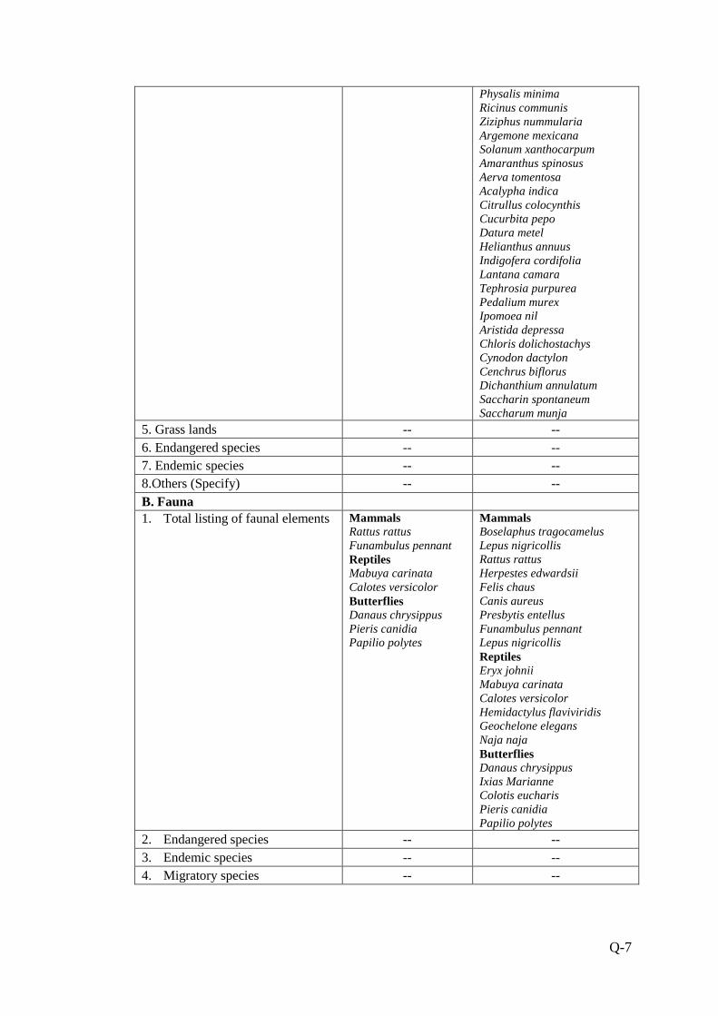
Q-7
Physalis minima Ricinus communis Ziziphus nummularia Argemone mexicana Solanum xanthocarpum Amaranthus spinosus Aerva tomentosa Acalypha indica Citrullus colocynthis Cucurbita pepo Datura metel Helianthus annuus Indigofera cordifolia Lantana camara Tephrosia purpurea Pedalium murex Ipomoea nil Aristida depressa Chloris dolichostachys Cynodon dactylon Cenchrus biflorus Dichanthium annulatum Saccharin spontaneum Saccharum munja
5. Grass lands -- -- 6. Endangered species -- -- 7. Endemic species -- -- 8.Others (Specify) -- -- B. Fauna 1. Total listing of faunal elements Mammals
Rattus rattus Funambulus pennant Reptiles Mabuya carinata Calotes versicolor Butterflies Danaus chrysippus Pieris canidia Papilio polytes
Mammals Boselaphus tragocamelus Lepus nigricollis Rattus rattus Herpestes edwardsii Felis chaus Canis aureus Presbytis entellus Funambulus pennant Lepus nigricollis Reptiles Eryx johnii Mabuya carinata Calotes versicolor Hemidactylus flaviviridis Geochelone elegans Naja naja Butterflies Danaus chrysippus Ixias Marianne Colotis eucharis Pieris canidia Papilio polytes
2. Endangered species -- -- 3. Endemic species -- -- 4. Migratory species -- --

Q-8
5. Details of aquatic fauna, if, applicable
Arthropods and Mollusca Periplaneta amercana Argiope arcuata Valvata piscinalis Oxynaia pugio Gastropoda Sp.
Amphibians Rana tigerinus Rana limnocharis Arthropods and Mollusca Buthus sp. Periplaneta amercana Apis indica Apis dorsata Artema atlenta Argiope arcuata Valvata piscinalis Oxynaia pugio Gastropoda Sp.
10. Details of mineral reserves (as per approved Mining Plan) Quantity (in million tonnes)
(a) Proved
(b) Indicated
(c) Inferred
(d) Mineable reserves
11. Major geological formation/disturbances in the mining lease area
(a) Geological maps submitted Yes No
(b) Geological sections submitted Yes No
(c) Contour map submitted Yes No
(d) Whether the presence, if any, noted of
(i) Faults Yes No
(ii) Dykes Yes No
(iii) Shear Zone Yes No
(iv) Folds Yes No
(v) Other weak zones Yes No
(e) Source of data (Indicate)
12. Production of mineral(s) and life of mine
(a) Rated capacity of mine mineral wise (Tonnes / annum)
(b) Life of mine at proposed capacity (Years)
(c) Lease period (Years)
28.05 Lac TPA
Not ascertain
5
√
√
√
√
√
GSI
62.41
-
-
56.17
√
√
√

Q-9
(d) Date of expiry of lease (D /M /Y)
(e) Indicate in case of existing mines
(i) Date of opening of mine
(ii) Production in the last 5 years 1st year to 5th year from year 2004-05 to year 2008-09 in million tonnes.
(iii) Projected production for the next
6th to 10th year 5 years from year ……… to year ……… in million tonnes.
(iv) Whether mining was suspended after Yes No Opening of the mine?
If yes, details thereof including last production figure and reason for the same.
(f) Whether plans & sections provided? Yes No
13. Type and method of mining operations
TYPE METHOD
Opencast Manual
Underground Semi-mechanised
Both Mechanised
14. Details of ancillary operations for mineral processing
(a) Existing
(b) Additional
15. Mine details
(a) Opencast Mine
(i) Stripping ratio (mineral in tonnes to over burden in m3)
(ii) Ultimate working depth (in m bgl)
(iii) Indicate present working depth in case of existing mine (in m bgl)
(iv) Thickness of top soil (in m.)
√
√
√
-
-
√
3m
-
-
-
-
-
Q-10
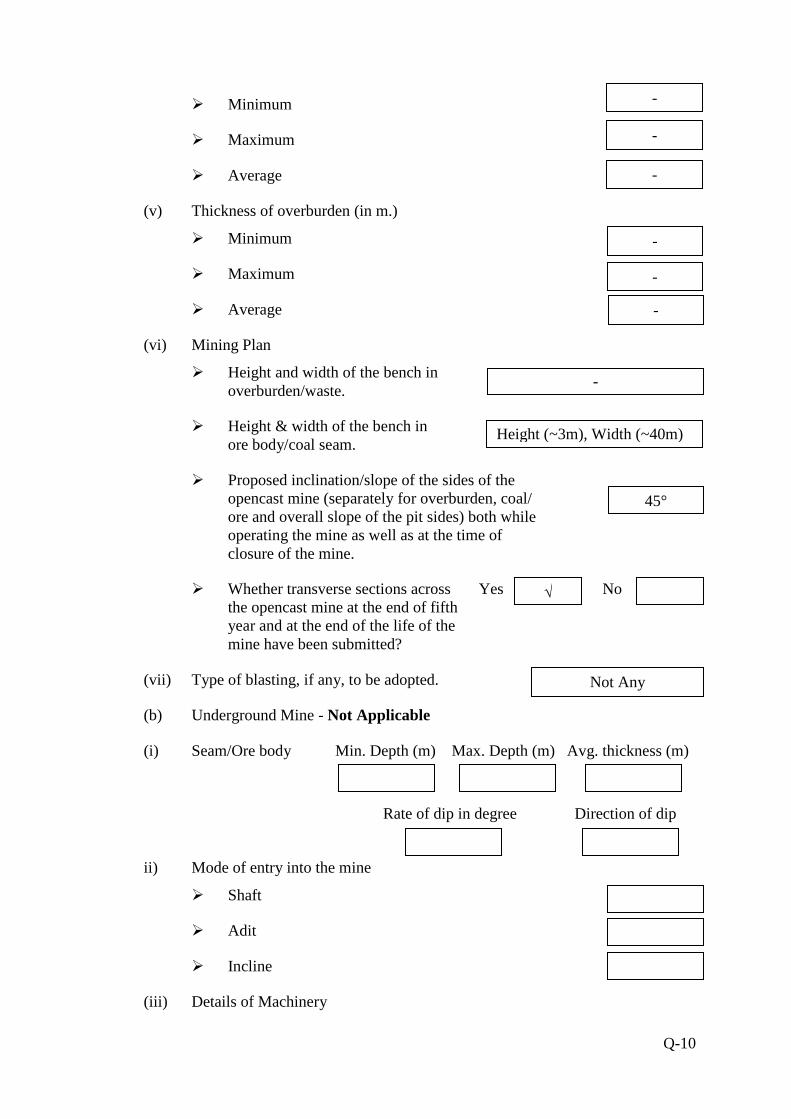
� Minimum
� Maximum
� Average
(v) Thickness of overburden (in m.)
� Minimum
� Maximum
� Average
(vi) Mining Plan
� Height and width of the bench in overburden/waste.
� Height & width of the bench in ore body/coal seam.
� Proposed inclination/slope of the sides of the opencast mine (separately for overburden, coal/ ore and overall slope of the pit sides) both while operating the mine as well as at the time of closure of the mine.
� Whether transverse sections across Yes No the opencast mine at the end of fifth year and at the end of the life of the mine have been submitted?
(vii) Type of blasting, if any, to be adopted.
(b) Underground Mine - Not Applicable
(i) Seam/Ore body Min. Depth (m) Max. Depth (m) Avg. thickness (m)
Rate of dip in degree Direction of dip
ii) Mode of entry into the mine
� Shaft
� Adit
� Incline
(iii) Details of Machinery
√
-
Height (~3m), Width (~40m)
45°
Not Any
-
-
-
-
-
-

Q-11
� On surface
� At Face
� For transportation
� Others
(iv) Method of Stoping (Metalliferrous Mines)
� Open
� Filled
� Shrinkage
� Caving
� Combination of above
� Others (Specify)
(v) Extraction method
� Caving
� Stowing
� Partial extraction
(vi) Subsidence
� Predicted max. subsidence (in m)
� Max. value of tensile strain (in mm/m)
� Max. slope change (in mm/m)
� Whether identified possible subsidence area(s) superimposed on Surface Plan has been submitted? Yes No
� Major impacts on surface features like natural drainage pattern, houses, buildings, water bodies, roads, forest, etc.
� Salient features of subsidence management (monitoring and control).
16. Surface drainage pattern at mine site
(a) Whether the pre-mining surface Yes No
√

Q-12
drainage plan submitted?
(b) Do you propose any modification/diversion Yes No in the existing natural drainage pattern at any stage? If yes, when. Provide location map indicating contours, dimensions of water body to be diverted, direction of flow of water and proposed route/changes, if any i.e. realignment of river/nallah/any other water body falling within core zone and its impact.
17. Embankment and/or weir construction
(a) Do you propose, at any stage, construction of
(i) Embankment for protection against flood? Yes No
(ii) Weir for water storage for the mine? Yes No
(b) If so, provide details thereof.
(c) Impact of embankment on HFL and settlement around.
(d) Impact of weir on down stream users of water.
18. Vehicular traffic density (outside the ML area)
Type of vehicles No. of vehicles per day
(a) Existing
(b) After the proposed activity
(c) Whether the existing road Yes No network is adequate? If no, provide details of alternative proposal?
19. Loading, transportation and unloading of mineral and waste rocks on surface:
(a) Manual Yes No
(b) Tubs, mine cars, etc. Yes No
(c) Scraper, shovels, dumpers / trucks. Yes No
(d) Conveyors (belt, chain, etc.) Yes No
(e) Others (specify).
20. Mineral(s) transportation outside the ML area
√
Two wheeler, 3 wheeler, cars, tractor trolleys, trucks and Bus
714
425 Tippers, Trucks, Dumpers, Tractor Trolleys
√
√
√
√
√
√
√
Tippers and Trucks

Q-13
Qty. (in TPD) Percentage (%) Length (in km)
(a) Road
(b) Rail
(c) Conveyors
(d) Rope way
(e) Water ways
(f) Pipeline
(g) Others (Specify)
Total
8500
-
8500
-
-
-
-
-
100%
-
100%
-
-
-
-
-

Q-14
21. Baseline Meteorological and Air Quality data
(a) Micro-meteorological data
[Continuous monitoring through autographic instrument for one full season other than monsoon]
(i) Wind rose pattern for one full season (16 points of compass i.e. N, NNE, NE, ---) based on 24-hourly data. For coastal area also
furnish day-time and night time data.
� Day time
� Night time
� 24 – hours period
(ii) Site specific monitored data
Month Wind Speed (kmph) Temperature (oC) Relative Humidity (%) Rain Fall * (mm) Cloud Cover**
(Octas of sky)
Mean Max. % of calm
Mean (Dry Bulb) Highest Lowest Mean Highest Lowest Total 24-hours
Highest No. of
rainy days Mean
Dec. 2013 0.734 2.583 0.016 17.70 28.65 6.85 50.7 76.2 29.3 4.358
Jan. 2014 0.756 3.611 0.004 14.99 27.55 4.35 49.2 78.4 24.1 4.395
Feb. 2014 0.999 4.111 0.004 18.89 29.75 8.15 50.3 87.9 17.3 4.365
* 24-hours rainfall should be reported from 08:30 hrs. IST of previous day to 08:30 hrs. IST of the day.
* Rainy day is considered when 24 hrs. rainfall is ≥ 2.5 mm.
** Visual observations of cloud cover should be recorded four times a day at regular intervals.
(iii) Indicate name and distance of the nearest IMD meteorological station from which climatological data have been obtained for reporting in the EIA report, if any.-Bhilwara, Rajasthan

Q-15
(b) Ambient air quality data* (RPM, SPM, SO2, and NOx)
[*Monitoring should be carried out covering one full season except monsoon – same season as in 21 (a) (i)] [*Frequency of sampling: Sampling to be done twice a week for the entire season 24 hourly for SPM & RPM. For gaseous pollutants 24- hourly data be given
irrespective of the sampling period.]
(i) Season and period for which monitoring has been carried out.-Winter Season (December-2013, January-2014 and February-2014)
(ii) No. of samples collected at each monitoring station: 24
Name of monitoring equipment used SPM PM10 SO2 NOx Pb**
- Respirable Dust
sampler APM-860 APM-860 APM-860 -
Equipment sensitivity - 5.0 5.0 5.0 - Permissible AAQ standard (CPCB) R
I
S
- 100 80 80 -
- 100 80 80 -
- 100 80 80 -
Monitoring Location
No. of Samples Drawn
Category* (R, I, S)
Min. Max.
98% tile
Min. Max. 98% tile
Min. Max. 98% tile
Min. Max. 98% tile
Min. Max. 95% tile
AAQ1 24 I - - - 47.3 60.3 60.21 6.1 8.7 8.56 10.4 13.2 13.11 - - - AAQ2 24 I - - - 50.9 59.8 59.80 5.6 8.3 8.21 9.9 12.8 12.62 - - - AAQ3 24 I - - - 49.0 61.9 61.72 5.9 8.5 8.41 10.1 13.0 12.95 - - - AAQ4 24 R - - - 48.7 69.3 68.75 6.3 8.8 8.66 10.2 13.3 13.16 - - - AAQ5 24 R - - - 46.9 65.5 65.36 6.0 8.7 8.61 9.9 13.5 13.32 - - - AAQ6 24 R - - - 52.1 67.9 67.53 5.8 8.5 8.36 10.3 13.7 13.61 - - - AAQ7 24 R - - - 51.0 68.6 68.42 6.1 8.6 8.51 10.5 13.8 13.71 - - - AAQ8 24 R - - - 48.2 61.4 61.31 6.2 8.2 8.11 10.1 13.2 13.15 - - - AAQ9 24 I - - - 50.3 59.9 59.76 5.7 8.3 8.21 10.3 13.4 13.31 AAQ10 24 R - -- 46.6 62.4 62.26 5.9 8.7 8.61 10.2 13.0 12.86
* R = Residential; I = Industrial; S = Sensitive ** Pb for mineral specific sites only. # Annex a location map indicating location of AAQ stations, their direction and distance with respect to project site.

Q-16
22. Stack and emission details, if any*
Sl. No.
Process / unit of operation (e.g. DG Set,
Boiler)
Height of stack
(m)
Internal top dia.
(m)
Flue gas exit
velocity (m/sec)
Emission rate (kg/hr) Heat emission rate from top
of stack (K.cal/hr)
Exhaust / Flue gas
SPM SO2 NOx CO Temp OC Density Specific
Heat
Volumetric flow rate (m3/hr.)
23. Details of fugitive emissions during mining operations* -During transportation
24. Air Quality Impact Prediction (AQIP)*
(a) Details of model (s) used for AQIP including grid size, terrain features, and input meteorological data: ISC-AERMOD View-6.8.6. Details are given in Chapter-5 of EIA/EMP report.
(b) Maximum incremental GLC values of pollutants based on prediction exercise (in µg/m3)
S.No. Pollutants Incremental Value Ambient Air Quality Resultant Air Quality
1. PM10 4.239 61.9 66.139
2**. SO2 - - -
3**. NOX - - -
[* Question Number 22, 23 & 24 need not be filled-in for mines having ML area of 25 ha. or less.]
[**Information on item no. 2 & 3 to be provided in cases with captive power generation of 500 KVA and above]

Q-17
25. Water requirement (m3/day)
Purpose Avg. Demand Peak Demand
A. Mine site
1. Mine operation
2. Land reclamation
3. Dust suppression
4. Drinking
5. Green Belt
6. Beneficiation
7. Washeries
8. Fire Service
9. Others (specify)
B. Township
1. Green Belt
2. Domestic
3. Other (specify)
-
-
6.0
3.0
5.0
-
-
-
-
-
-
-
-
-
-
-
-
-
-
-
-
-
-
-
Total 14 -
26. Source of water supply*
S.No. Source m3/day
1 River (name) -
2 Ground water 14
3 Mine water (sump/pit) -
4 Other surface water bodies (By tankers) -
[*Annex a copy of sanction letter/permission from the concerned authority (Central Ground Water Authority in case of ground water abstraction is from notified area / State Ground Water Board in case of non-notified area/State Irrigation Department for surface water pumping) for drawing water.]
27. Lean season flow in case of pumping from river/nalla (cumecs)
28. Ground water potential of the study area
28.1. Ground water availability
(a) Range of water table (m bgl)
(i) Pre-monsoon (April/May)
� Core Zone
� Buffer zone
(ii) Post-monsoon (November)
� Core Zone
� Buffer zone
8-10
25-30
8-10
20-25

Q-18
(b) Total annual replenishable recharge (million m3/ year)
� By ground water table fluctuation method
� By rainfall infiltration factor method
(c) Annual draft excluding estimated draft through mine discharge (million m3/year)
(d) Estimated draft through mine discharge (million m3/ year)
(e) Net annual ground water availability (million m3/ year)
(f) Stage of ground water development in %
28.2 Water demand - Competing users of the water source
S.No. Usage
Present Consumption
(m3/day)
Additional proposed as per local plan
(m3/day)
Total (m3/day)
Surface Ground Surface Ground Surface Ground
1 Drinking & Domestic Uses
- - - 3.0 - 3.0
2 Dust Suppression - - - 6.0 - 6.0
3 Industry - - - - - -
4 Mining - - - - - -
5 Greenbelt - - - 5.0 - 5.0
Total - - - 14.0 - 14.0
29. Water quality*
(a) Annex physico-chemical analysis of water at intake point **
(b) In case of existing mine, annex report on quality of water discharge i.e. complete physico - chemical analysis**
[*For non-discharging mines at least four ground water samples to be taken preferably from downstream direction of the mine in pre-monsoon and post-monsoon periods and analysed. For discharging mines six samples are to be analysed]
**All parameters as per BIS 10500. Indicate name of Methodology, Equipment used for analysis, and Detection Level (DL) for each parameter.
*** Wherever any analytical parameter is below detection level, “BDL” (Below Detection Level) should be written instead of ‘NIL’.
30. Impact on ground water regime/stream/lake/springs due to mine dewatering*
(a) Radius of influence (in m)
[To be estimated based on analysis of pumping test data and application of empirical formula]
(b) Whether saline water ingress will take place? Yes No (applicable to coastal areas)
-
-
-
-
-
-

Q-19
(c) Impact on stream/lake/springs
[* Provide a comprehensive hydro-geological assessment report if the average mine dewatering is more than 100 m3/day and or going below water table in non-monsoon period. The report should be based on preferably latest one year pre-monsoon and post-monsoon baseline data covering information on ground water situation, aquifer characteristics, water level conditions (April – May and November), estimate of ground water resources, predicted impact of the project on ground water regime and detailed remedial / conservation measures such as artificial recharge of ground water etc. The report should be based on actual field inventory out of existing wells, at least 30 observation wells in the buffer zone with supplementary information from secondary sources (mention name). For estimation** of ground water resource (refer question no. 28 above) be designated study area of the buffer zone may be sub-divided into command and non-command areas, watershed-wise (in case of hard rock/consolidated formations)/block-wise/mandal-wise in case of alluvial / unconsolidated formations)]
[**For estimating ground water resources in the area follow the Ground Water Estimation Committee recommendations of 1997]
31. Waste Water Management - Not Applicable
Mine
(a) Daily average discharge (m3/day) from different sources
(i) Mine water discharge during
� Lean period
� Monsoon period
(ii) Workshop
(iii) Domestic (mine site)
(iv) Beneficiation / Washeries
(v) Coal Handling Plant
(vi) Tailings pond
(vii) Others (Specify)
Total
(b) Waste water treatment plant; flow sheet for treatment process attached. Yes No
(c) Quantity of water recycled/reused/ to be recycled in
(i) Percentage
(ii) m3 /day
Nil
NA
NA
NA
NA
NA
NA
NA
NA
Q-20
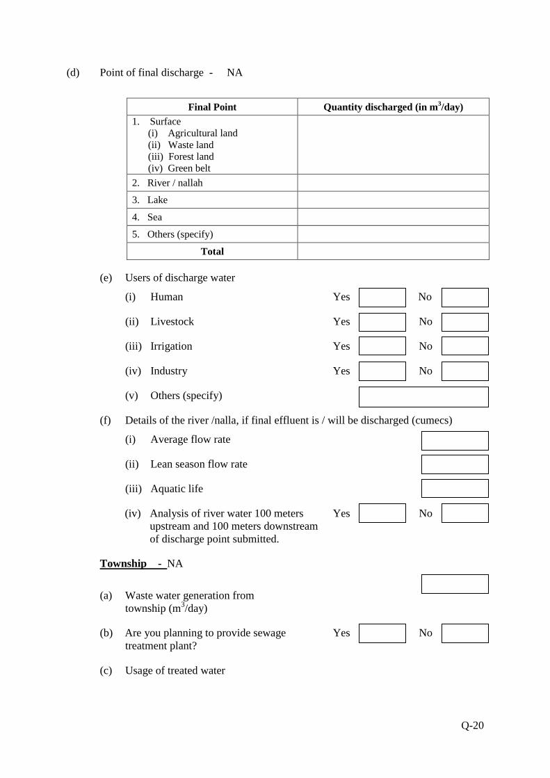
(d) Point of final discharge - NA
Final Point Quantity discharged (in m3/day) 1. Surface
(i) Agricultural land (ii) Waste land (iii) Forest land (iv) Green belt
2. River / nallah
3. Lake
4. Sea
5. Others (specify)
Total
(e) Users of discharge water
(i) Human Yes c No
(ii) Livestock Yes No
(iii) Irrigation Yes No
(iv) Industry Yes No
(v) Others (specify)
(f) Details of the river /nalla, if final effluent is / will be discharged (cumecs)
(i) Average flow rate
(ii) Lean season flow rate
(iii) Aquatic life
(iv) Analysis of river water 100 meters Yes No upstream and 100 meters downstream of discharge point submitted.
Township - NA
(a) Waste water generation from township (m3/day)
(b) Are you planning to provide sewage Yes No treatment plant?
(c) Usage of treated water

Q-21
32. Attach water balance statement in the form of a flow diagram indicating source
(s), consumption (Section-wise) and output.-Details are given in Chapter-9, of
EIA/EMP report.
33. Ambient noise level leq dB(A)
Location of sampling station Noise level
Day Time Night Time A. Core Zone 1. Banas River 2. 0.5km distance 3. Banas River near Biliya 4. Berach River near Barakhera
Min. Max. 51.4 54.3 52.6 56.7 52.7 55.1 52.5 54.1
Min. Max. 42.1 44.2 43.7 45.2 42.5 44.9 39.2 44.9
B. Buffer Zone 1. Manpura 2. Kachhola 3. Bigod 4. Mandalgarh 5. Devariya 6. Devali
61.1 64.2 58.3 62.9 62.7 65.1 72.2 74.8 51.9 54.6 53.8 57.7
43.9 46.2 44.1 45.7 43.8 46.3 44.5 48.6 41.3 43.5 43.7 46.2
34. Solid Waste- Not Any
(a) Top soil and Solid waste quantity and quality
Name (Lump/fines/slurry/
Sludge/others) Composition Quantity
(m3/month) Method of disposal
Mining activity*
a) Top Soil
b) Over burden
c) Others (specify)
- - -
- -
-
- -
-
Effluent Treatment Plant (sludge)
- - -
Total -- -
[* Annex layout plan indicating the dump sites.]
(b) (i) Does waste (s) contain any hazardous/toxic substance/ radioactive materials or Yes No heavy metals?
(ii) If yes, whether details and Yes No precautionary measures provided?
(c) Recovery and recycling possibilities.-No
(d) Possible user(s) of the solid waste.
(e) (i) Is the solid waste suitable for backfilling? Yes No √
√

Q-22
(ii) If yes, when do you propose to start backfilling.
(in million m3)
Solid waste (s) Already accumulated (A)
To be generated (B)
% of A & B to be backfilled A B
Over burden - - - - Others (specify) - - - -
Land reclamation Plan
(f) In case waste is to be dumped on the ground, indicate
(i) Associated environmental problems:
(ii) Number & type of waste dumps
� No. of external dumps
� Max. projected height of dumps (in m)
� No. of terraces and height of each stage
� Overall slope of the dump (degree)
� Proposed reclamation measures
(iii) Section of the waste dump in relation to the adjacent ground profile attached. Yes No
35. Fuel / Energy requirements*
[*To be furnished for mines having ML area more than 25 ha. or captive power generation of 500KVA and above]
(a) Total power requirement (in MW)
S.No. Mine Site Township Others (specify) Total 1 Present - - - - 2 Proposed /additional - - - -
Total - - - -
(b) Source of power (in MW)
S.No. SEB/Grid* Captive power plant DG Sets 1 Present - - - 2 Proposed - - -
Total - - -
[* Annex a copy of the sanction letter from the concerned authority]
(c) Details of fuels
-
√
-
-
-
-

Q-23
S.No. Fuel Daily Consumption (LPD) Calorific value
(Kcals/kg) %
Ash %
Sulphur Existing Proposed 1 2 3
HSD LSHS Other (specify)
- 2240 - - -
36. Storage of inflammable/explosive materials
S.No. Name Number of Storages
Consumption (in LPD)
Maximum Quantity at any point of time
1 Fuels - 2240 - 2 Explosives - - -
37. Human Settlement
Core Zone Buffer Zone Population* - 138379 No. of villages - 136 Number of households village-wise - 29211
[* As per 2011 census record or actual survey]
38. Rehabilitation & Resettlement (R&R) Plan*
[*Provide a comprehensive rehabilitation plan, if more than 1000 people are likely to be displaced, other-wise a summary plan]
(a) Villages falling within the study area
Villages
Number Name Core zone Nil Not Applicable 500 m from the blasting site (s) Nil Not Applicable
Buffer zone 136 List is enclosed and given in Chapter-4, Page No. 85-88 in EIA/ EMP report.
Township site Nil -
(b) Details of village(s) in the core zone-Not Any, as the lease area lies in river
bed.
S.No. Village Name Population* Average Annual
Income Tribal Others - - - -
[*As per 2001 census / actual survey]
(c) Population to be displaced and / or Land oustees
Name of village(s) falling within Number of oustees
Land (only)
Homestead (only)
Land and Homestead (both)

Q-24
Mining Lease 1. 2. � �
Township Site 1. 2. �
(d) Whether R & R package has been finalised? If yes, salient features of R&R plan for oustees. - Not Applicable
(i) Site details where the people are proposed to be resettled & facilities existing / to be created.
(ii) Funds earmarked for compensation package.
(iii) Agency /Authority responsible for their resettlement.
(iv) Time of commencement of resettlement of Project Affected People (PAP).
(v) Period by which resettlement of PAP will be over.
39. Lease -wise plantation details
(a) Lease area (in ha.) Existing mine New mine
(i) Area broken up
(ii) To be broken up
(iii) Area not to be broken-up
(b) Township area (in ha.)
(c) Area afforested and proposed (in ha.)
S.No. Peripheral Dumps Roads Top Soil Dump
Township Others Total
(i) Existing - - - - - - -
(ii) Proposed - - - - - 5.4 5.4
(d) No. and type of trees planted and proposed
(i) Existing
� When plantation was started? Month / Year
No.of plant species planted Number saplings (per ha.)
- -
- -
- 301.0
- 1364.45
-

Q-25
- -
� Survival rate % D Avg. height
(ii) Proposed
No. of plant species to be planted Number of saplings (per ha.)
5-10 1000
40. Environmental health and safety
(a) What major health and safety hazards are anticipated?
(i) Air borne disease
(ii) Noise borne problem
(iii) Accidents
The persons may get injured while working in the mine or suffer from occupational
diseases due to air born dust. Therefore measures are being taken to protect the
employed persons the safety and hazards.
(b) What provisions have been made/proposed to be made to conform to health and safety requirements?
� Masks will be provided to workers those who are working dust prone areas. Dust suppression is being done by water sprinkling.
� Earplugs have been provided to workers those who are working in near the mining machineries.
� Proper precautions are being taken care of to avoid accidents.
� Regular medical checkup of the employed persons would be done as per provision of Mines Act, 1952.
� A well equipped first aid station will be kept operated all the time of work.
� Group insurance scheme will be implemented to protect the future of mine worker and their families in case of any accident, mishappening while working in the mine.
(c) In case of an existing mine
(i) Comprehensive report on health status of the workers as under the Mines Act annexed. Yes No
(ii) Mineralogical composition of RPM (dust)
� Free silica
� Chromium* (Total as well as Hexavalent)
� Lead**
3m 80
√

Q-26
[* Only for Chromite mines]
[**Only for Base Metal mines]
(d) Information on radiation protection measures, if applicable.
41. Environmental Management Plan
Salient features of environmental protection measures
S.No. Environmental Issues*
Already practiced, if applicable Proposed
1. Air Pollution - � Water spraying arrangement is being done on haul roads to controlling fugitive emission.
� Air monitoring will be done once in 6 months.
� Masks are provided to workers engaged in mining activities.
� Emphasis given on afforestation activities for controlling of dust pollution in the area.
� Plantation of broad leaved vegetation along approach road, riparian zones, erosional prone zone etc.
2. Water Pollution - Mining will confined to 3mts. from surface of river channel or above water level whichever is less. During mining ground water table will not be intersected. During mining no waste water will be generated. Mine will maintain zero discharge status. So there will no chance of water pollution in core & buffer zone.
3. Water conservation
- Rainwater will get accumulated in the work area during rainy season and recharge the ground water table.
4. Noise Pollution - Proper maintenance & servicing of transport vehicles will be done to minimize the noise. Adequate silencer will be provided in all the trucks and tippers.
5. Solid Waste/ Tailings
- No waste generated during life of mine so there is no mitigation or management measure is proposed.
6. Land degradation - As the mining area is confined to river bed only no other land will disturbed due to mining or any other way.
7. Erosion & Sediment
- To control or prevent bank erosion, scientific mining practices will be followed. No undercutting will be taken at mine site. No mining activity will carried towards concave side of river. Erosional prone zone area will be identified and properly planted to stop further degradation.
8. Top soil - No top soil will be encountered during

Q-27
mining activity so no measures are proposed. All the material is directly marketable.
9. Ground Vibration - No blasting will be carried out during mining so there is no chance of ground vibration.
10. Wildlife Conservation
-- Mining is strictly confined to river bed only no other land will be disturbed due to mining activities in the area. There is no eco-sensitive area/zones exist within 10 km. radii. No schedule Ist species of animal was found/reported from area.
11. Forest protection - Plantation programme will improve the ecosystem in surrounding area. Afforestion programmes will continue to protect the local biodiversity of the study area.
12. Others (Specify) - For details, environment management plan is given as Chapter-9, Page No. 129-142 in EIA/EMP report.
[* As applicable]
42. Compliance with environmental safeguards (For existing units)
(a) Status of the compliance of conditions of environmental clearance issued by MoEF, Yes No if any, enclosed.
(b) Status of the compliance of ‘Consent to Operate’ issued by SPCB, if any, enclosed. Yes No
(c) Latest 'environmental statement' enclosed. Yes No
43. Scoping of EIA
Whether environmental impact assessment of the project has been carried out by Yes No following scoping process?
If yes, a copy of scoping of EIA annexed. Yes No
44. Mine closure
(a) Have you planned mine closure? Yes No
(b) Submitted a conceptual mine Yes No closure plan.
(c) If yes, indicate estimated amount for implementing the same (in Rs. lakhs)
√
√
√
√
√
√
√

Q-28
45. Capital cost of the project (in Rs. Lakh) (Based on latest estimate)
46. Cost of environmental protection measures (in Rs. Lakh)
S.No. Measures Capital cost Annual recurring cost
Existing Proposed Existing Proposed
1 Pollution Control such as Water sprinkling, etc. (Separately provide break-up)
- - - 6.0
2 Pollution Monitoring (Separately provide break-up)
- - - 3.0
3 Green Belt including protection - 3.0 - 7.0
4 Reclamation/Rehabilitation of mined out area
- - - -
5 Rainwater harvesting in nearby villages
- - - 4.0
6 Others (specify) Haul road maintenance
- - - 2.0
Total - 3.0 - 22.0
47. Amount earmarked for socio-economic welfare measures for the nearby villages other than R&R plans.-About 10 Lakh for various provision in surrounding areas for social welfare measures. Details are given in Chapter-9 of EIA/EMP report.
48. Public Hearing
(a) Date of Advertisement
(b) Newspapers in which the advertisement appeared
(c) Date of public hearing (DD/MM/YYYY)
(d) Public Hearing Panel chaired by & members present:
(e) No. of people attended the public hearing meeting and number of people from the lease area.
(e) Summary/details of public hearing in tabular form.
S.No. Issues raised by the Public
Response/Commitment of Project Proponents
Suggestions made by the Public Hearing Panel
1. Mr. Ranveer Singh, Resident- Mahua asked the information about plantation at road side and village. He said that govt. and other department also does plantation
Project proponent and his technical adviser said that water will be spread by the water sprinklers to control the pollution and dust emission by the transportation vehicles and sand vehicles will
500 Lakh
19.11.2014 and 20.11.2014
22.12.2014
56
Rajasthan Patrika and Hindustan Times
Tehsildar, Regional Officer, Members of RSPCB, Project
proponent & residents of nearby villages
Q-29
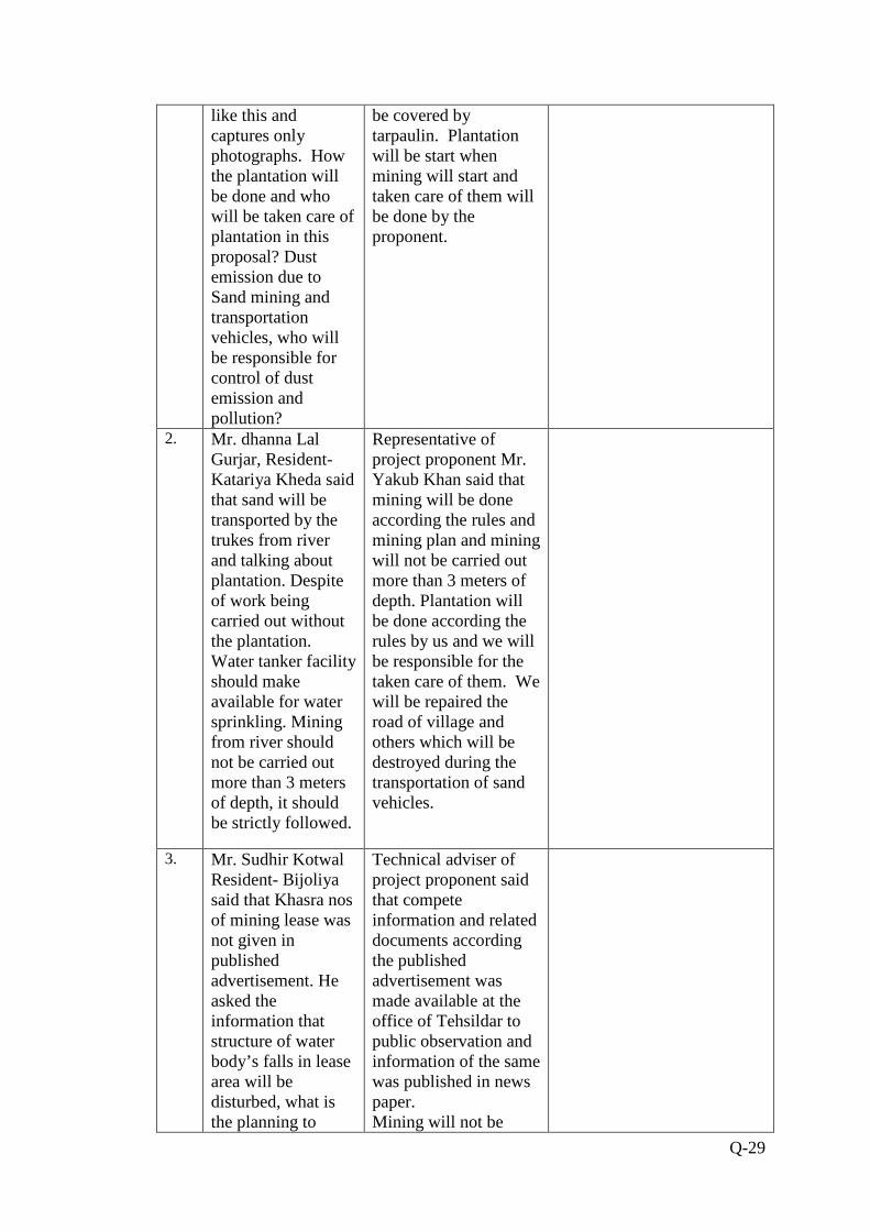
like this and captures only photographs. How the plantation will be done and who will be taken care of plantation in this proposal? Dust emission due to Sand mining and transportation vehicles, who will be responsible for control of dust emission and pollution?
be covered by tarpaulin. Plantation will be start when mining will start and taken care of them will be done by the proponent.
2. Mr. dhanna Lal Gurjar, Resident- Katariya Kheda said that sand will be transported by the trukes from river and talking about plantation. Despite of work being carried out without the plantation. Water tanker facility should make available for water sprinkling. Mining from river should not be carried out more than 3 meters of depth, it should be strictly followed.
Representative of project proponent Mr. Yakub Khan said that mining will be done according the rules and mining plan and mining will not be carried out more than 3 meters of depth. Plantation will be done according the rules by us and we will be responsible for the taken care of them. We will be repaired the road of village and others which will be destroyed during the transportation of sand vehicles.
3. Mr. Sudhir Kotwal Resident- Bijoliya said that Khasra nos of mining lease was not given in published advertisement. He asked the information that structure of water body’s falls in lease area will be disturbed, what is the planning to
Technical adviser of project proponent said that compete information and related documents according the published advertisement was made available at the office of Tehsildar to public observation and information of the same was published in news paper. Mining will not be

Q-30
correction of them? Provide a copy of rules to me.
done more than 3 meters of depth according to mining plan and transportation will be done through fixed evacuation route. Technical adviser given a copy of executive summary of proposel to Mr. Kotwal.
4. Mr. Ravi Dhaked Resident- Pitha Ji Ka Kheda said that what is the mean of 3 meter depth in mining?
Technical adviser said that miming will not be done during mansoon and where water will available. Mining will be carried out till 3 meters of depth from surface of river Chanel.
5. Shree Shantilal Vaishnav, resident Kachola,said that promises are made that bajri will be carried in the trucks with proper covering with the use of tripal but it is not followed which results in the damages to the roads.
The project
proponent’s
representative and
technical advisor
assured that the
project will start after
environmental
clearance and mining
will be done as par the
rules. It will be
mandatory for all the
bajari transportation
vehicles to be covered.
6. Shree Lala Ram Meena questioned that majority of people present were not the local residents of the village.In Reply to this Shree Jagdish Gaur ,resident –Triveni,said that he is a bajri tractor driver and contractor has made provision for water sprinkling and repairment of the roads.
The project
proponent’s
representative Mr.
Yakub Mohd. Assured
that mining will be
carried out as par the
approved mining plan
keeping in mind all the
rules and regulations
to assure that no
damage is done to the
village environment.
7. Shree Jamnalal Gurjar said that

Q-31
local residents are employed in the part of the river where mining of bajri is alredy being carried out and hopes that same will be provided in future.
8. Shree Lalaram proposed that mining should not disturb the course of the river and hence mining to be carried till 3m depth or 1m above the water level.
49. Whether the following approvals* (wherever applicable) have been obtained?
(i) Site clearance from MoEF Yes No
(ii) ‘Consent for Establishment’ from the State Pollution Control Board Yes No
(iii) NOC from Atomic Mineral Division Yes No
(iv) Mining plan approval from IBM/ Ministry of Coal Yes No
(v) In case of existing mines, mining scheme approval from IBM Yes No
(vi) Forestry clearance under FCA, 1980 Yes No
(vii) NOC from Chief Controller of Explosives Yes No
(viii) Commitment regarding availability/ pumping of water from the concerned Yes No Authorities
(ix) In case of ML area falling in notified areas of the Central Ground Water Authority, Yes No NOC from them.
[* Annex copies of approvals and number them]
50. Was/is there any court case relating to the project or related activities?
If so, provide details present status. - Yes No
√
√
√
√
√
√
√
√
√
√

Q-32
Verification: The data and information given in this proforma are true to the best of my knowledge and belief.
Date: Signature of the applicant* with full name & address Place: [* Owner or his authorized signatory]
Given under the seal of organisation on
Behalf of whom the applicant is signing

Page 1 of 7
By Speed Post
No. J-11015/362/2013-IA.II (M)
Government of India Ministry of Environment and Forests
IA Division ***
Paryavaran Bhavan,
C.G.O. Complex, Lodi Road, New Delhi-110 003
Telefax: 011-24364067
Dated: 22nd November, 2013
To M/s Sanjay Kumar Garg,
225, Mohan Nagar, Hindustan City, District Karauli
Rajasthan-322230.
Tele Fax. 0141-2333907; Email: [email protected] Sub.: River sand (Bajri) mine with production capacity of 28.05 Lakh TPA
(ROM) by M/s. Sanjay Kumar Garg, Mineral located at Revenue villages of Tehsil – Mandalgarh – Bijoliya, District – Bhilwara, Rajasthan
(1675.85 ha.) – Prescribing TORs regarding.
This has reference to your letter no. Nil dated 18.09.2013 regarding the proposal for determining the Terms of Reference (TORs) for undertaking detailed EIA study for the purpose of obtaining environmental clearance in accordance with the
provisions of the EIA Notification, 2006. For this purpose, the Proponent had submitted information in the prescribed format (Form-1) along with a Pre-feasibility Report. The
proposal was considered by the Reconstituted Expert Appraisal Committee in its 12th meeting held during 31st October, 2013 to 01st November, 2013.
2. The proposal of M/s Sanjay Kumar Garg is River sand (Bajri) mining with production capacity of 28.05 Lakh TPA (ROM). The mine lease area is located near
villages Amarpura, Asawari, Bagthala, Baroo Khera, Bedunda, Beeliya, Bhand Ka Khera, Bharliya, Bhawani Singh Ka Khera, Bilod, Chainpuriya, Chandpura, Chhitarsingh Ji Ka Khera, Chohli, Daulji Ka Khera, Devipura, Gandhari, Gariyan, Gheoriya, Golbari,
Gopalpura, Govta, Harisinghji Ka Khera, Hastra, Heengwaniya, Jaliya, Jojwa, Kankoliya, Kanti, Katariyon Ka Khera, Khakhunda, Khangarji Ka Khera, Khatwara,
Kherpura, Lakshmipura, Lodhiyana, Mahtaji Ka Khera, Moi, Padampura, Panderi, Peethalpura, Phalasiya, Phoolji Ki Kheri, Pratappura, Ralayata, Ramthali, Sand, Shyam Garh, Tahla, Thal Kalan, Thalkhurd, Tiroli, Ummedpura, Tehsil-Bijoliya & Mandalgarh,
District - Bhilwara (Rajasthan). The Latitudes and Longitudes of mine lease area are from 25o06’58.1559”N to 25o30’23.3512”N and 75o03’57.1347”E to 75o07’13.5900”E.The lease area lies on Banas River, Berach River & Menali River.

Page 2 of 7
3. The project is located in Seismic Zone-II. Total River stretches allotted for
mining is about 78.5km comprises Banas River (47.0km), Berach River (16.0km) & Menali River (15.5km).
4. Mining is by semi-mechanized opencast method. Excavation will be carried out up to a maximum depth of 3 meters from surface of sand deposit and not less than
one meter from the water level of the River channel whichever is reached earlier. The lease area has been granted as per the Rajasthan State Govt. Letter of Intent (F-7(10) Khan/Group-2/2013 Jaipur dated 5th March 2013).
5. Total water requirement will be 14 KLD. This water will be sourced from nearby
wells and tube wells through water tankers for drinking, dust suppression and plantation purposes. No waste will be generated during mining activities. The total cost of project would be around 5.0 Crores.
6. Based on the information content in the documents submitted and the
presentation made before the Committee for mining projects, the following TORs are prescribed for undertaking detailed EIA study:-
1) Year-wise production details since 1994 should be given, clearly stating the highest production achieved in any one year prior to 1994. It may also be
categorically informed whether there had been any increase in production after the EIA Notification, 1994 came into force w.r.t. the highest production achieved prior to 1994.
2) A copy of the document in support of the fact that the Proponent is the rightful lessee of the mine should be given.
3) All documents including approved mine plan, EIA and public hearing should be compatible with one another in terms of the mine lease area, production
levels, waste generation and its management and mining technology and should be in the name of the lessee.
4) All corner coordinates of the mine lease area, superimposed on a High
Resolution Imagery/toposheet should be provided. Such an Imagery of the proposed area should clearly show the land use and other ecological features
of the study area (core and buffer zone). 5) Does the company have a well laid down Environment Policy approved by its
Board of Directors? If so, it may be spelt out in the EIA report with description
of the prescribed operating process/procedures to bring into focus any infringement/deviation/violation of the environmental or forest norms/
conditions? The hierarchical system or administrative order of the Company to deal with the environmental issues and for ensuring compliance with the EC conditions may also be given. The system of reporting of non-compliances /
violations of environmental norms to the Board of Directors of the Company and/or shareholders or stakeholders at large may also be detailed in the EIA
report. 6) Issues relating to Mine Safety, including subsidence study in case of
underground mining and slope study in case of open cast mining, blasting
study etc. should be detailed. The proposed safeguard measures in each case should also be provided.
7) The study area will comprise of 10 km zone around the mine lease from lease

Page 3 of 7
periphery and the data contained in the EIA such as waste generation etc should be for the life of the mine / lease period.
8) Land use of the study area delineating forest area, agricultural land, grazing land, wildlife sanctuary, national park, migratory routes of fauna, water bodies, human settlements and other ecological features should be indicated.
Land use plan of the mine lease area should be prepared to encompass preoperational, operational and post operational phases and submitted.
Impact, if any, of change of land use should be given. 9) Details of the land for any Over Burden Dumps outside the mine lease, such as
extent of land area, distance from mine lease, its land use, R&R issues, if any,
should be given. 10) A Certificate from the Competent Authority in the State Forest Department
should be provided, confirming the involvement of forest land, if any, in the project area. In the event of any contrary claim by the Project Proponent regarding the status of forests, the site may be inspected by the State Forest
Department along with the Regional Office of the Ministry to ascertain the status of forests, based on which, the Certificate in this regard as mentioned
above be issued. In all such cases, it would be desirable for representative of the State Forest Department to assist the Expert Appraisal Committees.
11) Status of forestry clearance for the broken up area and virgin forestland
involved in the Project including deposition of net present value (NPV) and compensatory afforestation (CA) should be indicated. A copy of the forestry
clearance should also be furnished. 12) Implementation status of recognition of forest rights under the Scheduled
Tribes and other Traditional Forest Dwellers (Recognition of Forest Rights) Act,
2006 should be indicated. 13) The vegetation in the RF / PF areas in the study area, with necessary details,
should be given. 14) A study shall be got done to ascertain the impact of the Mining Project on
wildlife of the study area and details furnished. Impact of the project on the wildlife in the surrounding and any other protected area and accordingly detailed mitigative measures required, should be worked out with cost
implications and submitted. 15) Location of National Parks, Sanctuaries, Biosphere Reserves, Wildlife Corridors,
Tiger/Elephant Reserves/(existing as well as proposed), if any, within 10 km of the mine lease should be clearly indicated, supported by a location map duly authenticated by Chief Wildlife Warden. Necessary clearance, as may be
applicable to such projects due to proximity of the ecologically sensitive areas as mentioned above, should be obtained from the State Wildlife
Department/Chief Wildlife Warden under the Wildlife (Protection) Act, 1972 and copy furnished.
16) A detailed biological study of the study area [core zone and buffer zone (10
km radius of the periphery of the mine lease)] shall be carried out. Details of flora and fauna, duly authenticated, separately for core and buffer zone should
be furnished based on such primary field survey, clearly indicating the Schedule of the fauna present. In case of any scheduled-I fauna found in the study area, the necessary plan for their conservation should be prepared in
consultation with State Forest and Wildlife Department and details furnished. Necessary allocation of funds for implementing the same should be made as
part of the project cost.

Page 4 of 7
17) Proximity to Areas declared as ‘Critically Polluted’ or the Project areas likely to come under the ‘Aravali Range’, (attracting court restrictions for mining operations), should also be indicated and where so required, clearance certifications from the prescribed Authorities, such as the SPCB or State Minning Dept. Should be secured and furnished to the effect that the proposed
mining activities could be considered. 18) Similarly, for coastal Projects, A CRZ map duly authenticated by one of the
authorized agencies demarcating LTL. HTL, CRZ area, location of the mine lease w.r.t CRZ, coastal features such as mangroves, if any, should be furnished. (Note: The Mining Projects falling under CRZ would also need to
obtain approval of the concerned Coastal Zone Management Authority).
19) R&R Plan/compensation details for the Project Affected People (PAP) should be furnished. While preparing the R&R Plan, the relevant State/National Rehabilitation & Resettlement Policy should be kept in view. In respect of SCs
/STs and other weaker sections of the society in the study area, a need based sample survey, family-wise, should be undertaken to assess their
requirements, and action programmes prepared and submitted accordingly, integrating the sectoral programmes of line departments of the State Government. It may be clearly brought out whether the village located in the
mine lease area will be shifted or not. The issues relating to shifting of Village including their R&R and socio-economic aspects should be discussed in the
report. 20) One season (non-monsoon) primary baseline data on ambient air quality
(PM10, SO2 and NOx), water quality, noise level, soil and flora and fauna shall
be collected and the AAQ and other data so compiled presented date-wise in the EIA and EMP Report. Site-specific meteorological data should also be
collected. The location of the monitoring stations should be such as to represent whole of the study area and justified keeping in view the pre-
dominant downwind direction and location of sensitive receptors. There should be at least one monitoring station within 500 m of the mine lease in the pre-dominant downwind direction. The mineralogical composition of PM10,
particularly for free silica, should be given. 21) Air quality modelling should be carried out for prediction of impact of the
project on the air quality of the area. It should also take into account the impact of movement of vehicles for transportation of mineral. The details of the model used and input parameters used for modelling should be provided.
The air quality contours may be shown on a location map clearly indicating the location of the site, location of sensitive receptors, if any, and the habitation.
The wind roses showing pre-dominant wind direction may also be indicated on the map.
22) The water requirement for the Project, its availability and source should be
furnished. A detailed water balance should also be provided. Fresh water requirement for the Project should be indicated.
23) Necessary clearance from the Competent Authority for drawl of requisite quantity of water for the Project should be provided.
24) Description of water conservation measures proposed to be adopted in the
Project should be given. Details of rainwater harvesting proposed in the Project, if any, should be provided.
25) Impact of the project on the water quality, both surface and groundwater
Page 5 of 7
should be assessed and necessary safeguard measures, if any required, should be provided.
26) Based on actual monitored data, it may clearly be shown whether working will intersect groundwater. Necessary data and documentation in this regard may be provided. In case the working will intersect groundwater table, a detailed
Hydro Geological Study should be undertaken and Report furnished. Necessary permission from Central Ground Water Authority for working below ground
water and for pumping of ground water should also be obtained and copy furnished.
27) Details of any stream, seasonal or otherwise, passing through the lease area
and modification / diversion proposed, if any, and the impact of the same on the hydrology should be brought out.
28) Information on site elevation, working depth, groundwater table etc. Should be provided both in AMSL and bgl. A schematic diagram may also be provided for the same.
29) A time bound Progressive Greenbelt Development Plan shall be prepared in a tabular form (indicating the linear and quantitative coverage, plant species and
time frame) and submitted, keeping in mind, the same will have to be executed up front on commencement of the project.
30) Impact on local transport infrastructure due to the Project should be indicated.
Projected increase in truck traffic as a result of the Project in the present road network (including those outside the Project area) should be worked out, indicating whether it is capable of handling the incremental load. Arrangement
for improving the infrastructure, if contemplated (including action to be taken by other agencies such as State Government) should be covered.
31) Details of the onsite shelter and facilities to be provided to the mine workers should be included in the EIA report.
32) Conceptual post mining land use and Reclamation and Restoration of mined
out areas (with plans and with adequate number of sections) should be given in the EIA report.
33) A time bound Progressive Greenbelt Development Plan shall be prepared in a tabular form (indicating the linear and quantitative coverage, plant species and time frame) and submitted, keeping in mind, the same will have to be
executed up front on commencement of the project. Phase-wise plan of plantation and compensatory afforestation should be charted clearly indicating
the area to be covered under plantation and the species to be planted. The details of plantation already done should be given.
34) Occupational Health impacts of the Project should be anticipated and the
proposed preventive measures spelt out in detail. Details of pre-placement medical examination and periodical medical examination schedules should be
incorporated in the EMP. 35) Public health implications of the Project and related activities for the
population in the impact zone should be systematically evaluated and the
proposed remedial measures should be detailed along with budgetary allocations.
36) Measures of socio economic significance and influence to the local community proposed to be provided by the Project Proponent should be indicated. As far
as possible, quantitative dimensions may be given with time frames for implementation.
37) Detailed environmental management plan to mitigate the environmental

Page 6 of 7
impacts which, should inter-alia include the impacts of change of land use, loss of agricultural and grazing land, if any, occupational health impacts besides
other impacts specific to the proposed Project. 38) Public hearing points raised and commitment of the project proponent on the
same along with time bound action plan to implement the same should be
provided and also incorporated in the final EIA/EMP Report of the Project. 39) Details of litigation pending against the project, if any, with direction /order
passed by any Court of Law against the project should be given. 40) The cost of the project (capital cost and recurring cost) as well as the cost
towards implementation of EMP should clearly be spelt out.
41) Details of replenishment studies 42) Details of Transportation of mined out materials as per the Indian Road
Congress for both the ways (loaded as well as unloaded trucks) load and its impact on Environment;
43) Proper species specific Conservation plan for Schedule–I and II species;
44) Impact of mining on plankton; 45) Details of mining activity to be provided w.r.t Block Wise/ Calendar wise/
Zonal wise, as the mine lease area is having a long stretch, 46) Details of Gradient of river bed to be provided; 47) Details of excavation schedule & sequential mining plan;
48) Mining Plan shall be prepared carefully, dividing lease area into manageable blocks to ensure scientific and systematic mining of minor minerals; and
49) The base line data shall be collected so as to represent the whole mine lease area.
7. Besides the above, the below mentioned general points are also to be followed:-
a) All documents to be properly referenced with index and continuous page numbering.
b) Where data are presented in the report especially in tables, the period in which the data were collected and the sources should be indicated.
c) Where the documents provided are in a language other than English, an
English translation should be provided. d) The Questionnaire for environmental appraisal of industrial projects as devised
earlier by the Ministry shall also be filled and submitted. e) While preparing the EIA report, the instructions for the proponents and
instructions for the consultants issued by MoEF vide O.M. No. J-
11013/41/2006-IA.II(I) dated 4th August, 2009, which are available on the website of this Ministry, should also be followed.
f) Changes, if any made in the basic scope and project parameters (as submitted in Form-I and the F.R for securing the TOR) should be brought to the attention of MoEF with reasons for such changes and permission should be sought, as
the TOR may also have to be altered. Post Public Hearing changes in structure and content of the draft EIA/EMP (other than modifications arising out of the
P.H. process) will entail conducting the PH again with the revised documentation.
g) As per the circular no. J-11011/618/2010-IA.II(I) dated 30.5.2012, you are
requested to submit certified report of the status of compliance of the conditions stipulated in the environment clearance for the existing operations

Page 7 of 7
of the project by the Regional Office of Ministry of Environment & Forests, if applicable.
8. The EIA report should also include (i) surface plan of the area indicating contours of main topographic features, drainage and mining area, (ii) geological maps
and sections and (iii) sections of the mine pit and external dumps, if any, clearly showing the land features of the adjoining area.
9. The prescribed TORs would be valid for a period of two years for submission of the EIA/EMP reports, as per the O.M. No. J-11013/41/2006-IA.II(I) dated 22.3.2010.
10. After preparing the draft EIA (as per the generic structure prescribed in
Appendix- III of the EIA Notification, 2006) covering the above mentioned issues, the proponent will get the public hearing conducted and take further necessary action for obtaining environmental clearance in accordance with the procedure prescribed under
the EIA Notification, 2006.
(Dr. Saroj)
Director
Copy to:
1). The Secretary, Ministry of Mines, Government of India, Shastri Bhawan, New Delhi
2). The Secretary, Department of Mines & Geology, Government of Rajasthan
Secretariat, Jaipur.
3). The Secretary, Department of Environment, Government of Rajasthan,
Secretariat, Jaipur.
4). The Chief Conservator of Forests, Central Region, Ministry of Environment
and Forests, B-1/72, Sector-A, Aliganj, Lucknow-226020.
5). The Member Secretary, Rajasthan State Pollution Control Board, 4, Institutional area, Jhalana, Doongri, Jaipur.
6). The Controller General, Indian Bureau of Mines, Indira Bhavan, Civil Lines, Nagpur - 440 001
7). The District Collector, Bhilwara District, State of Rajasthan.
8). Guard File
9). MoEF website.
(Dr. Saroj)
Director

COMPLIANCE OF TOR VIDES LETTER NO. J-11015/362/2013-IA.II (M) DATE 22 nd NOVEMBER, 2013 OF M/S. SANJAY KUMAR GARG NEAR VILLAGE-AKOONA, AMAR PURA, ASAWARI, BAGTHALA, BAROO KHERA, BEDUNDA, BEDUNDA, BEELIYA, BHAND KA KH ERA, BHARLIYA, BHAWANI SINGH KA KHERA, BILOD, CHAINPURIYA, CHANDPURA, CHHI TARSINGH JI KA KHERA, CHOHLI, DAULJI KA KHERA, DEVIPURA, GANDHARI, GARIYAN, GHEOR IYA, GOLBARI, GOPALPURA, GOVTA, HARISINGHJI KA KHERA, HASTRA, HEENGWANIYA, J ALIYA, JOJWA, KANKOLIYA, KANTI, KATARIYON KA KHERA, KHAKHUNDA, KHANGARJI KA KHERA, KHATWARA, KHATWARA, KHERPURA, LAKSHMIPURA, LODHIYANA, MAHTAJI KA KHERA, MOI, PADAMPURA, PANDERI, PEETHALPURA, PHALASIYA, PHOOLJI KI KHERI, PRATAPPURA, RALAYATA, RAMTHALI, SAND, SHYAM GARH, TAHLA, THAL K ALAN, THALKHURD, TIROLI, UMMEDPURA TEHSIL–BIJOLIYA & MANDALGARH, DISTRICT–BH ILAWARA (RAJASTHAN).
S.No.
Conditions Status
1 Year-wise production details since 1994 should be given, clearly stating the highest production achieved in any one year prior to 1994. It may also be categorically informed whether there had been any increase in production after the EIA Notification, 1994 came into force w.r.t. the highest production achieved prior to 1994.
No mining activity relating to this lease has been undertaken. This is a new proposal of mining lease for which LOI has been granted in favour of M/s Sanjay Kumar Garg S/o Bhagwati Lala Garg, 225, Mohan Nagar, Hindaun City, Dist.–Karauli (Rajasthan) for mineral River Sand over an area of 1675.85 hectares by Department of Mines and Geology, Jaipur vide letter no. F-7(10) Khan/Group-2/2013 Jaipur dated 5th March 2013.
2 A copy of the document in support of the fact that the Proponent is the rightful lessee of the mine should be given.
A copy of LOI is annexed as Annexure-1 in EIA/EMP Report.
3 All documents including approved mine plan, EIA and public hearing should be compatible with one another in terms of the mine lease area, production levels, waste generation and its management and mining technology and should be in the name of the lessee.
All the documents submitted are compatible with one another.
Mining Lease Area- 1675.85 ha Lessee: M/s Sanjay Kumar Garg Proposed Production of River Sand (Bajri)–28.05 Lac TPA
Waste generation-No waste will be generated during mining operation because whatever mineral is being excavated, will be directly transported to the end users.
Mining Technology–Semi-mechanized opencast 4 All corner coordinates of the mine lease area,
superimposed on a High Resolution Imagery/ toposheet should be provided. Such an Imagery of the proposed area should clearly show the land use and other ecological features of the study area (core and buffer zone).
Map with all corner coordinates of mining lease area are superimposed on toposheet is enclosed with plate No.-2 of EIA/EMP report.
All the features such as land use and other ecological features are shown for core zone and buffer zone area on this map.
5 Does the company have a well laid down Environment Policy approved by its Board of Directors? If so, it may be spelt out in the EIA report with description of the prescribed operating process/procedures to bring into
Project Proponent M/s. Sanjay Kumar Garg is involved in mining of mineral River sand (Bajri). (i) Committed to mine, and then transport the
mineral to the end users as per customers requirements.
(ii) Committed to integrate the policy with all stages

focus any infringement/deviation/violation of the environmental or forest norms/ conditions? The hierarchical system or administrative order of the Company to deal with the environmental issues and for ensuring compliance with the EC conditions may also be given. The system of reporting of non - compliances / violations of environmental norms to the Board of Directors of the Company and/or shareholders or stakeholders at large may also be detailed in the EIA report.
of project and activities. (iii) Committed to comply with applicable statutory
requirements, proper implementation, management for prevention of pollution as per Environment Clearance/Clearance from pollution control board / Environmental Laws / CPCB norms / guidelines issued from time to time by related department.
(iv) Continue to improve the effectiveness of our environment and management system by regular training with optimum use of natural resources, better productivity, and waste management by regular internal audit and up gradation of technology.
(v) Committed to operate mines involving Stake holder participation.
(vi) The mine owner appointed a specific representative who, irrespective of other responsibilities, shall have defined roles, responsibilities and authority for ensuring that environmental management system requirements are established, implemented and maintained in accordance with this standard.
(vii) Management is committed to provide necessary resources, financial, manpower, technology and other resources for environmental performance.
(viii) Reporting on the performance of the deviations if any in environmental management system arising out of violations of environmental conditions pointed out by government bodies or other public authorities and the plan of action taken by mine owner for review and to include in board meeting and circulate the guidelines issued by the board to all concerned in writing and will be termed as environmental performance compliance report.
(ix) Scientific mining practices will adopted with proper care of environment.
Organizational Structure of Environment Monitoring C ell (EMC)
6 Issues relating to Mine Safety, including subsidence study in case of underground mining and slope study in case of open cast mining, blasting study etc. should be detailed. The proposed safeguard measures in each case should also be provided.
All the Safeguarding measures will be adopted during mining operation. All mitigative measures are proposed in Chapter-7, para 7.4 of EIA/EMP report.
7 The study area will comprise of 10 km zone around the mine lease from lease periphery and the data contained in the EIA such as waste
The EIA study has been carried out for 10km radius zone from the periphery of mine lease area. Key plan showing core zone (lease area) and buffer zone of 10
Mine Owner
Mine Manager
Foreman Environment Supervisor

generation etc should be for the life of the mine / lease period.
km radii from lease boundary has been incorporated in Plate No.-2.
Data regarding mining operations have been incorporated in Chapter-2 of EIA/EMP report. No waste will be generated during mining as all the excavated material will be directly transported to end users.
8 Land use of the study area delineating forest area, agricultural land, grazing land, wildlife sanctuary, national park, migratory routes of fauna, water bodies, human settlements and other ecological features should be indicated. Land use plan of the mine lease area should be prepared to encompass preoperational, operational and post operational phases and submitted. Impact, if any, of change of land use should be given.
The EIA study has been carried out for 10km radius zone from the periphery of mine lease area. Key plan showing core zone (lease area) and buffer zone of 10 km radii from lease boundary has been incorporated in Plate No. 2. There is no National Park, Wildlife Sanctuary, Migratory routes of fauna falls within the 10km radius study area.
9 Details of the land for any Over Burden Dumps outside the mine lease, such as extent of land area, distance from mine lease, its land use, R&R issues, if any, should be given.
No land outside the mining lease area is proposed for waste dumping. No waste will be generated during life of mine. As the mining will be confined to river bed only no other land will be disturbed due to mining or any other way.
10 A Certificate from the Competent Authority in the State Forest Department should be provided, confirming the involvement of forest land, if any, in the project area. In the event of any contrary claim by the Project Proponent regarding the status of forests, the site may be inspected by the State Forest Department along with the Regional Office of the Ministry to ascertain the status of forests, based on which, the Certificate in this regard as mentioned above be issued. In all such cases, it would be desirable for representative of the State Forest Department to assist the Expert Appraisal Committees.
Mine lease area falls under non-forest land as the lease area confined to riverbed only. Land status of river bed is govt. land, and details of Khasra No. and Jamabandi record are annexed as in EIA/EMP report.
11 Status of forestry clearance for the broken up area and virgin forestland involved in the Project including deposition of net present value (NPV) and compensatory afforestation (CA) should be indicated. A copy of the forestry clearance should also be furnished.
Not Applicable
12 Implementation status of recognition of forest rights under the Scheduled Tribes and other Traditional Forest Dwellers (Recognition of Forest Rights) Act, 2006 should be indicated.
Not Applicable
13 The vegetation in the RF / PF areas in the study area, with necessary details, should be given.
List of RF/PF are given in Chapter-2 in Table no. 2.1 of EIA/EMP report. Vegetation studies are given in

Chapter-4 in Point No. 4.5 Page No. 70 of EIA/EMP report.
14 A study shall be got done to ascertain the impact of the Mining Project on wildlife of the study area and details furnished. Impact of the project on the wildlife in the surrounding and any other protected area and accordingly detailed mitigative measures required, should be worked out with cost implications and submitted.
No schedule –I species are found in the study area, thus conservation plan is not required for proposed river sand mining project. Mining will be confined to riverbed only no other land will be disturbed due to mining or any other away. Detailed biological studies is given in Chapter -4, Para 4.5, Page no. 70 of EIA/EMP report.
15 Location of National Parks, Sanctuaries, Biosphere Reserves, Wildlife Corridors, Tiger/Elephant Reserves/(existing as well as proposed), if any, within 10 km of the mine lease should be clearly indicated, supported by a location map duly authenticated by Chief Wildlife Warden. Necessary clearance, as may be applicable to such projects due to proximity of the ecologically sensitive areas as mentioned above, should be obtained from the State Wildlife Department/Chief Wildlife Warden under the Wildlife (Protection) Act, 1972 and copy furnished.
No eco-sensitive areas such as National Parks, Wildlife Sanctuaries, Biosphere Reserves, Wildlife corridors, Tiger/Elephant Reserves (existing or proposed) etc. falls within the study area (10 km radius of the mine lease boundary).
A 10 km radius map is given and annexed as Plate No.-2 of EIA/EMP report.
16 A detailed biological study of the study area [core zone and buffer zone (10km radius of the periphery of the mine lease)] shall be carried out. Details of flora and fauna, duly authenticated, separately for core and buffer zone should be furnished based on such primary field survey, clearly indicating the Schedule of the fauna present. In case of any scheduled-I fauna found in the study area, the necessary plan for their conservation should be prepared in consultation with State Forest and Wildlife Department and details furnished. Necessary allocation of funds for implementing the same should be made as part of the project cost.
Detailed Biological study for the study area (core zone and buffer zone) has been conducted and same has been incorporated in Chapter-4, Point No. 4.5, of EIA/EMP Report.
No Schedule–I species are found in the study area, thus Conservation Plan is not required for this proposed project of river sand (bajri) mining.
17 Proximity to Areas declared as ‘Critically Polluted’ or the Project areas likely to come under the ‘Aravali Range’, (attracting court restrictions for mining operations), should also be indicated and where so required, clearance certifications from the prescribed Authorities, such as the SPCB or State Mining Dept. Should be secured and furnished to the effect that the proposed mining activities could be considered.
The mining lease area does not fall in the Aravalli ranges. There is no ‘Critically Polluted’ area nearby of proposed lease.
18 Similarly, for coastal Projects, A CRZ map duly authenticated by one of the authorized agencies
Not Applicable

demarcating LTL. HTL, CRZ area, location of the mine lease w.r.t CRZ, coastal features such as mangroves, if any, should be furnished. (Note: The Mining Projects falling under CRZ would also need to obtain approval of the concerned Coastal Zone Management Authority).
19 R&R Plan/compensation details for the Project Affected People (PAP) should be furnished. While preparing the R&R Plan, the relevant State/National Rehabilitation & Resettlement Policy should be kept in view. In respect of SCs /STs and other weaker sections of the society in the study area, a need based sample survey, family-wise, should be undertaken to assess their requirements, and action programmes prepared and submitted accordingly, integrating the sectoral programmes of line departments of the State Government. It may be clearly brought out whether the village located in the mine lease area will be shifted or not. The issues relating to shifting of Village including their R&R and socio-economic aspects should be discussed in the report.
Not Applicable as the mining will confined to riverbed only.
20 One season (non-monsoon) primary baseline data on ambient air quality (PM10, SO2 and NOx), water quality, noise level, soil and flora and fauna shall be collected and the AAQ and other data so compiled presented date-wise in the EIA and EMP Report. Site-specific meteorological data should also be collected. The location of the monitoring stations should be such as to represent whole of the study area and justified keeping in view the pre-dominant downwind direction and location of sensitive receptors. There should be at least one monitoring station within 500 m of the mine lease in the pre-dominant downwind direction. The mineralogical composition of PM10, particularly for free silica, should be given.
Primary baseline data for ambient air quality, water quality, noise level, soil, flora and fauna has been collected during winter season (December-2013, January-2014 and February-2014) along with site-specific meteorological data and details of the same are incorporated in Chapter-4 of EIA/EMP report. Met Data enclosed as annexure No.-6.
The locations of Ambient Air Quality monitoring stations were decided on the basis of prevailing micro – meteorological conditions (Wind direction & wind speed) of the study area.
The selection criteria for monitoring locations have been given in Chapter-4 of EIA/EMP report.
21 Air quality modeling should be carried out for prediction of impact of the project on the air quality of the area. It should also take into account the impact of movement of vehicles for transportation of mineral. The details of the model used and input parameters used for modeling should be provided. The air quality contours may be shown on a location map
The air quality modeling of this mining project has been given in Chapter-5 of EIA/EMP report.
The details about wind rose showing predominant wind direction given as Fig. No. 5.4-5.7 on Page No.110-113 in Chapter -5 of EIA/EMP report.

clearly indicating the location of the site, location of sensitive receptors, if any, and the habitation. The wind roses showing pre-dominant wind direction may also be indicated on the map.
22 The water requirement for the Project, its availability and source should be furnished. A detailed water balance should also be provided. Fresh water requirement for the Project should be indicated.
Total water requirement for the mining project will be 14 KLD and the same will be fulfilled by the nearby villages through tankers. Water balance diagram given in Chapter-9, Fig. No. 9.2 Page No. 147 of EIA/EMP report.
23 Necessary clearance from the Competent Authority for drawl of requisite quantity of water for the Project should be provided.
There will be no drawl of water as total water requirement for the proposed mining project will be 14 KLD. Drinking water will be purchased & brought by water tanker from nearby villages through tankers.
24 Description of water conservation measures proposed to be adopted in the Project should be given. Details of rainwater harvesting proposed in the Project, if any, should be provided.
� No negative impact of the project on water quality is anticipated as water table will not be intersected during mining activity.
� Mining in the area will be done well above the water table. The water table is at 8-10 m below river bed level while the workings in the area are proposed up to a maximum depth of 3m from surface of river channel, which will be above water table at the mine site.
� The lease area falls in part of river. Therefore, water harvesting is not proposed. Natural seepage will recharge the ground water table in the area.
25 Impact of the project on the water quality, both surface and groundwater should be assessed and necessary safeguard measures, if any required, should be provided.
Impact of the project on the water quality both surface and groundwater along with measures to control water pollution has been given in Chapter-9, Point No. 9.2, of EIA /EMP Report.
26 Based on actual monitored data, it may clearly be shown whether working will intersect groundwater. Necessary data and documentation in this regard may be provided. In case the working will intersect groundwater table, a detailed Hydro Geological Study should be undertaken and Report furnished. Necessary permission from Central Ground Water Authority for working below ground water and for pumping of ground water should also be obtained and copy furnished.
Ground water table lies between 8-10 mtr deep in core zone and 20-25 mtr deep in surrounding areas Ultimate working depth is 3m or above the water table whichever is less. During mining, no groundwater table level will be intersected. No water withdrawal proposed from the site.
27 Details of any stream, seasonal or otherwise, passing through the lease area and modification / diversion proposed, if any, and the impact of the same on the hydrology should be brought out.
As the mining will be carried on seasonal river during non-monsoon season. During mining, natural water course and morphology of river will not be disturbed/ obstructed. No modification and diversion is proposed during mining operation.
28 Information on site elevation, working depth, groundwater table etc. Should be provided both
Site elevation of the river bed is 362 mRL-330 mRL in Banas River, 362mRL-351mRL in Berach River,

in AMSL and bgl. A schematic diagram may also be provided for the same.
372mRL-351mRL in Menali River and maximum working depth is 3m from surface of river channel. Schematic diagram of river sand (Bajri) mining given in chapter-2 on page no 26 in EIA/EMP report.
29 A time bound Progressive Greenbelt Development Plan shall be prepared in a tabular form (indicating the linear and quantitative coverage, plant species and time frame) and submitted, keeping in mind, the same will have to be executed up front on commencement of the project.
To improve the environment of the area it is proposed to plant along the river side (riparian zone) of 7.5m buffer zone.
Details regarding plantation and green belt development programme are given in Chapter- 9, Table No.9.1 on page no. 151 of EIA/EMP report.
30 Impact on local transport infrastructure due to the Project should be indicated. Projected increase in truck traffic as a result of the Project in the present road network (including those outside the Project area) should be worked out, indicating whether it is capable of handling the incremental load. Arrangement for improving the infrastructure, if contemplated (including action to be taken by other agencies such as State Government) should be covered.
Tippers/trucks are the main vehicles running on the road for transportation of mineral from the mine site to the end user, the existing road network is adequate to handle the transportation activities due to project.
Projected increase in truck traffic & its impact on the local transport infrastructure has been given in Chapter-5, Point No. 5.8 of EIA/EMP report.
31 Details of the onsite shelter and facilities to be provided to the mine workers should be included in the EIA report.
Details regarding infrastructure facilities to be provided to the mine workers are given in Chapter-10 of EIA /EMP report.
32 Conceptual post mining land use and Reclamation and Restoration of mined out areas (with plans and with adequate number of sections) should be given in the EIA report.
The conceptual land use is given in Chapter-2 of EIA/EMP Report. Conceptual Plan has been annexed as Plate No.-4 in EIA/EMP Report.
33 A time bound Progressive Greenbelt Development Plan shall be prepared in a tabular form (indicating the linear and quantitative coverage, plant species and time frame) and submitted, keeping in mind, the same will have to be executed up front on commencement of the project. Phase-wise plan of plantation and compensatory afforestation should be charted clearly indicating the area to be covered under plantation and the species to be planted. The details of plantation already done should be given.
Details regarding plantation and green belt development programme are given in Chapter- 9, Table No. 9.1 on page no. 151 of EIA/EMP report.
34 Occupational Health impacts of the Project should be anticipated and the proposed preventive measures spelt out in detail. Details of pre-placement medical examination and periodical medical examination schedules should be incorporated in the EMP.
No major occupational health impact is anticipated. Dust will be generated during the proposed mining activities & for prevention of dust, dust masks will be provided to the mine workers.
Provision of periodical medical examination will be conducted as per the requirement. The same is being incorporated in Chapter -9, Para 9.9, Page No.153-155 of EIA/ EMP report.

35 Public health implications of the Project and related activities for the population in the impact zone should be systematically evaluated and the proposed remedial measures should be detailed along with budgetary allocations.
Dust will be generated due to transportation of mineral to the village roads. Water sprinkling measures will be taken at site to suppression of dust. Details regarding public health incorporated in Chapter -9, of EIA/ EMP Report.
36 Measures of socio economic significance and influence to the local community proposed to be provided by the Project Proponent should be indicated. As far as possible, quantitative dimensions may be given with time frames for implementation.
Measures for socio economic influence on the local community have been furnished and described. The activity creates employment for local persons directly and indirectly depending upon their skills.
S. No. Provisions
Budget (Recurring Cost) in Lacs
1. Regular health check up camps for the workers engaged in mines shall be organized.
0.5
2. Occupational health surveillance program of the workers shall be under taken periodically to observe any contractions due to exposure to dust and take corrective measures, if needed;
0.5
3. Insurance cover to all workers engaged in mine shall be provided;
2.0
4. Common vocational training centre shall be setup at district level;
2.0
5. Local needs of habitant like school, hospital, veterinary hospital, sanitation, drinking water etc. shall be considered positively.
5.0
Total 10 Lac per annum
37 Detailed environmental management plan to mitigate the environmental impacts which, should inter-alia include the impacts of change of land use, loss of agricultural and grazing land, if any, occupational health impacts besides other impacts specific to the proposed Project.
Detailed environmental management plan have been incorporated in Chapter-9, Page No. 143-160 and the environment impacts are given in Chapter-5, Page No. 96-120 of EIA/EMP report.
38 Public hearing points raised and commitment of the project proponent on the same along with time bound action plan to implement the same should be provided and also incorporated in the final EIA/EMP Report of the Project.
Public hearing points and commitment of the project proponent annexed as annexure.
39 Details of litigation pending against the project, if any, with direction /order passed by any Court of Law against the project should be given.
There is no litigation pending against the project.
40 The cost of the project (capital cost and recurring cost) as well as the cost towards implementation of EMP should clearly be spelt out.
Cost of the project is Rs.5.0 Crore.
Budget for Environmental Protection Measures
S.No. Particulars Capital
Cost (In Lacs)
Annual Recurring
Cost (In Lacs)
1 Pollution Monitoring Air, water, noise
- 3.00
2 Pollution Control Measures (Water Sprinkling & Others)
- 6.00
3 Plantation including protection 3.00 7.00
4 Rainwater harvesting in nearby villages
- 4.00
5 Maintenance of Haul Road - 2.00
Total 3.00 22.00
41 Details of replenishment studies. Replenishment study incorporated in Chapter-5, para No.5.9, page No.120 of of EIA/EMP report. Quantum of sediment yield per year has been calculated by dendy Bolton formula.

42 Details of Transportation of mined out materials as per the Indian Road Page 6 of 7 Congress for both the ways (loaded as well as unloaded trucks) load and its impact on Environment.
Projected increase in truck traffic & its impact on the local transport infrastructure is detailed in Chapter-5, Point no. 5.8 of EIA/EMP Report.
43 Proper species specific Conservation plan for Schedule–I and II species.
There is no schedule–I and II species found in study area.
44 Impact of mining on plankton. During survey, all the surface water bodies were found dried. Surface water bodies in the state are seasonal in nature. There are no anticipated impacts on aquatic ecosystem of the area.
45 Details of mining activity to be provided w.r.t Block Wise/ Calendar wise/ Zonal wise, as the mine lease area having a long stretch.
Mining activity will be carried out Block wise/ Calendar wise as per approved mine Plan. For same development plan is enclosed as plate no.6 in EIA/EMP report.
46 Details of Gradient of river bed to be provided. Details of gradient of river bed are given in Chapter-2, point No-2.5.2 page No-26 of EIA/EMP report.
47 Details of excavation schedule & sequential mining plan.
Details of excavation or mining schedule is given in approved mine plan and in brief it is also given in Para 2.5.1 of Chapter No.-2 of EIA/EMP report.
48 The Mining Plan shall be prepared carefully, dividing lease area into manageable blocks to ensure scientific and systematic mining of minor minerals.
Mining will be carried out systematically by block wise and calendar wise. A copy of Approval letter of mining plan enclosed.
49 The base line data shall be collected so as to represent the whole mine lease area.
The baseline data of whole lease and 10km radius study area have been incorporated in chapter-4, Page No. 34-95 of EIA/EMP report.
Besides the above, the below mentioned general points are also to be followed:-
A All documents to be properly referenced with index and continuous page numbering.
Complied
B Where data are presented in the report especially in tables, the period in which the data were collected and the sources should be indicated.
Complied
C Where the documents provided are in a language other than English, an English translation should be provided.
Complied
D The Questionnaire for environmental appraisal of industrial projects as devised earlier by the Ministry shall also be filled and submitted.
Questionnaire has been filled and enclosed with EIA/EMP report.
E While preparing the EIA report, the instructions for the proponents and instructions for the consultants issued by MoEF vide O.M. No. J- 11013/41/2006-IA.II(I) dated 4th August, 2009, which are available on the website of this Ministry, should also be followed.
Complied
F Changes, if any made in the basic scope and project parameters (as submitted in Form-I and
Not Any

the F.R for securing the TOR) should be brought to the attention of MoEF with reasons for such changes and permission should be sought, as the TOR may also have to be altered. Post Public Hearing changes in structure and content of the draft EIA/EMP (other than modifications arising out of the P.H. process) will entail conducting the PH again with the revised documentation.
G As per the circular no. J-11011/618/2010-IA.II(I) dated 30.5.2012, you are requested to submit certified report of the status of compliance of the conditions stipulated in the environment clearance for the existing operations of the project by the Regional Office of Ministry of Environment & Forests, if applicable.
Not Applicable

CONTENTS
Chapter No. Particulars Page No.
Chapter-1 Introduction 1-7
1.0 Preamble 2
1.1 General Information on Mining of Minerals 3
1.2 Environmental Clearance 4
1.3 TOR (Terms of Reference) 4
1.4 Public Consultation 4
1.5 Need for EIA 5
1.6 Details of Project Proponent 5
1.7 Brief Description of the Project 5
1.8 Need of the Project 6
Chapter 2 Project Description 8-30
2.0 General 9
2.1 Brief Description of the Project 10
2.2 Description of the Project 18
2.3 Geology 20
2.3.1 Regional Geology 20
2.3.2 Local Geology of the Lease and Adjoining Area 21
2.4 Geological Reserves 23
2.4.1 Exploration carried out in the area 23
2.4.2 Estimation of Geological Reserves 23
2.4.3 MINEABLE RESERVES 23
2.5 Life of Mine 24
2.5.1 Method of Mining 24
2.5.2 Graph Showing River Gradient 26
2.5.3 Human Resource 27
2.6 Conceptual Mining Plan 28
2.6.1 Nature of Waste 29
2.7 Transport from Mine Head to the Destination 29
2.7.1 Site Services 29
2.7.2 Proposed Infrastructure 29
2.7.3 Grade and Uses 30
2.8 Power, Water Supply & Other Infrastructure Requirement 30
2.9 Ancillary Features of Mines 27
2.10 Project Implementation Schedule 27
Chapter 3 Analysis of Alternatives 31-33
3.0 General 32
3.1 The Following Alternatives have to be Selected on their Merits and Demerits.
32
3.2 Other Factors Contribute to the Selection of mine site and others 32
3.3 Crusher and Beneficiation Plants, If any 32
3.4 Conclusion 33
Chapter 4 Description of Environment 34-97
4.0 General 35
4.1 Land Environment 36
4.1.1 Land-Use 36
4.1.2 Land Use -Core Zone 36
4.1.3 Physiography & Soils 38
4.1.4 Selection of Sampling Locations for soil 39
4.1.5 Methodology 40
4.1.6 Soil Quality Characteristics of Study Area 40
4.1.7 Soil Characteristics in and around the Mining Lease Area 42
4.1.8 Fertility Status of Soils 42
4.1.9 Photographs of Soil Sampling 42
4.2 Water Environment 43
4.2.1 Water Quality Characteristics of Study Area (Surface and Ground water) 45
4.2.2 Water Sampling Locations- Surface Water 45
4.2.3 Results of Water Samples 46
4.2.4 Conclusion 48
4.2.5 Photographs of Ground Water and Surface Water Sampling Stations 48
4.3 Air Environment 49
4.3.1 Meteorology 49
4.3.2 Climatology 50
4.3.2.1 Relative Humidity 50
4.3.2.2 Wind Direction 50
4.3.2.3 Rainfall 50
4.3.3 Ambient Air Quality 51
4.3.3.1 Methodology Adopted and Selection of Sampling Location 52
4.3.3.2 Frequency and Parameters of the Sampling 52
4.3.3.3 Details of Sampling Locations 53
4.3.3.4 Instrument used for the sampling 54
4.3.3.5 Sampling and Analytical Techniques for PM10, SO2 and NOX 54
4.3.3.6 Results of Ambient Air Quality Monitoring 55
4.3.3.7 Monitoring locations 63
4.3.3.8 Photographs of Ambient Air Quality Monitoring Stations 65
4.4 Noise Environment 66
4.4.1 Selection of Monitoring Locations 66
4.4.2 Instrument Used for Monitoring 67
4.4.3 Measurement of Parameters 67

4.4.4 Results of Ambient Noise 68
4.4.5 Photographs of Noise Monitoring Stations 69
4.5 Biological Environment 70
4.5.1 Objectives of Biological Studies 70
4.5.2 Phyto-sociological Study 71
4.5.3 Ecology of the Study Area 71
4.5.4 Phyto-sociological Study 71
4.5.4.1 Introduction 71
4.5.4.2 Forest Type 72
4.5.5 Methodology 72
4.5.5.1 Floral Study 72
4.5.5.2 Faunal Study 73
4.5.5.3 Terrestrial Flora in the Study Area 74
4.5.5.4 Threat Status of the Floristic Diversity 82
4.5.5.5 Ethno Botanical Study of Project Study Area 82
4.5.5.6 Fauna of Project Study Area 83
4.5.5.7 Aquatic Diversity 86
4.5.5.8 Cropping Pattern of the Study Area 87
4.6 Socio-Economic & Demographic Profile 87
4.6.1 Methodology Adopted for the Study 87
4.6.1.1 Baseline Status 88
4.6.2 Demographic Profile 88
4.6.3 Socio economic profile 92
4.6.4 Literacy Levels 92
4.6.5 Occupational Structure 92
4.6.6 Basic Amenities 95
Chapter 5 Anticipated Environmental Impact & Mitigation Measu res 96-120
5.0 General 97
5.1 Impacts on Land Environment 98
5.2 Impacts on Water Environment 99
5.2.1 Water Consumption/ Water Demand 100
5.2.2 Impact on Water Quality 100
5.3 Impacts on Air Environment 101
5.3.1 Prediction of Impacts 101
5.3.2 Impact on Air Environment 102
5.3.3 Overview of Environmental Impacts due to Mining 103
5.3.3.1 Operation & Major Pollutant Sources 103
5.3.4 Long-term Impacts of Mining 103
5.3.4.1 Impacts on Air Quality 103
5.3.5 Impact Assessment & Mitigation Measures 106
5.3.5.1 Mine Area Emissions 106
5.3.6 Air Quality Prediction 106
5.3.7 Post Project Scenario 108
5.3.8 Winter Season 108
5.4 Impacts on Noise Environment 114
5.5 Impacts on Biological Environment 116
5.6 Impacts on Socio-Economic Environment 116
5.6.1 Rehabilitation 116
5.7 Mine Waste Management 117
5.7.1 Solid Waste Generation and Disposal nature of Mineral Rejects 117
5.8 Traffic Study 117
5.8.1 Methodology 117
5.8.2 Existing Traffic Scenario 118
5.8.3 During Mining Activity 119
5.8.4 Results 119
5.9 Impact of sediment replenishment 119
5.1. Impacts Summary 120
Chapter 6 Environmental Monitoring Programme 121-129
6.0 General 122
6.1 Environmental Management Plan (EMP) 122
6.2 Implementation of Environmental Management Plan 122
6.3 Monitoring Schedules and Monitoring Cell Formation 123
6.3.1 Environmental Monitoring Cell 123
6.4 Functions of the Monitoring Cell 124
6.5 Environmental Administration 125
6.6 Post Project Monitoring Scheme 127
6.7 Programme to be Followed for Air, Water, Soil, Noise, Sampling & Analysis
127
6.8 Environmental Monitoring System & Methodology 128
Chapter 7 Additional Studies 130-139
7.0 General 131
7.1 Items Identified by the Proponent 131
7.2 Items Identified by the Regulatory Authority 131
7.3 Items Identified by the Public & Other Stakeholders 132
7.4 Risk Analysis and Disaster Management Plan 132
7.4.1 Define Environmental Risks 133
7.4.2 Objective of Risk Assessment 133
7.4.3 Methodology of Risk Assessment 133
7.4.4 Assessment of Risks & Mitigative Measures 134
7.4.4.1 Hazard Identification 134
7.4.4.2 Mitigation Measures 134

7.4.5 Disaster Management Plan (DMP) 137
7.4.5.1 Structure of the Disaster Management Plan 137
7.4.5.2 Offsite Emergency Plan 139
Chapter 8 Project Benefits 140-142
8.0 Importance of the project to the region and country 141
8.1 The project gains further importance to the state/ country on account of factors mentioned below
141
8.1.1 Economic Benefits 141
8.1.2 Environmental Benefits 141
8.1.3 Employment Opportunities 142
8.1.4 Improved Educational Facilities 142
8.1.5 Infrastructure Development 142
8.1.6 Medical Assistance 142
8.1.7 Improvement in Physico-social Infrastructure 142
8.1.8 Other Activities 142
8.2 Conclusion 142
Chapter 9 Environmental Management Plan 142-160
9.0 General 144
9.1 Air Pollution Control 145
9.1.1 Prevention and Control of Air Pollution 146
9.2 Water Management & Pollution Control 146
9.2.1 Ground Water 146
9.2.2 Surface Water 147
9.3 Control of Noise & Vibration 148
9.4 Biological Management 148
9.5 Solid Waste Management 149
9.6 Land Environment 149
9.7 Biological Environment 150
9.8 Post Mining Land Use-Conceptual 152
9.9 Occupational Health & Safety 153
9.9.1 Anticipated Occupational & Safety Hazards 153
9.9.2 Mitigation measures to ensure OH&S 153
9.9.3 EMP for the Occupational Safety & Health hazards 154
9.9.3.1 Plan for pre placement and periodical health status of worker 155
9.9.3.2 Budget allocation for OH&S in EMP 155
9.10 Socio-Economic Conditions of the Region 156
9.10.1 Developmental Activities to be undertaken 156
9.10.2 Contribution regarding the Social Development of the nearby residents 156
9.10.3 Details of Health Checkup and Insurance of the entire Employed Person 157
9.11 Environmental Control & Monitoring Programme 157
9.11.1 Budget Provision for EMP 158
9.11.2 Monitoring Schedule 158
9.11.3 Environmental Management Cell (EMC) 158
9.11.4 Compliance to Statutory Requirement 159
9.12 Conclusion 159
Chapter 10 Summary & Conclusions 161-173
10.0 Project Description 162
10.1 Introduction 162
10.1.1 Project Location (Mine Site) 162
10.2 Need of the Project 163
10.3 Local Geology 165
10.4 Method of Mining 165
10.5 Conceptual Mining Plan 167
10.6 EIA Methodology 168
10.7 Baseline Environmental Data 168
10.7.1 Ambient Air Quality 168
10.7.2 Water Quality 168
10.7.3 Noise Environment 169
10.7.4 Biological Environment 169
10.7.5 Land Use Pattern 169
10.7.6 Socio-Economics 170
10.7.7 Demographic Profile 170
10.7.8 Statutory Facilities Available at Mine 170
10.8 Environmental Impact Assessment 171
10.9 Environmental Management Plan (EMP) 171
10.9.1 Air Quality 171
10.9.2 Water Quality 171
10.9.3 Land Management 171
10.9.4 Noise Control 172
10.10 Post Project Environmental Quality Implementation & Monitoring Programmes
172
10.10.1 Monitoring Schedule 172
10.11 Environmental Cost 172
10.12 Conclusion 172
Chapter 11 Disclosure of Consultant 174-178

TABLES
S.No. Title Page No.
2.1 Salient Features of the Mine Site & Surrounding 11
2.2 Land status of Lease Area 20
2.3 Proposed Production details of River sand (Bajri) 27
2.4 Proposed Mechanization at Mine Site 27
2.5 Staff Details of Mine Site 27
2.6 Land: Stage Wise Land use Operational and Post Operational Reclamation Area (Ha.) 29
4.1 Land Status of Lease Area 37
4.2 Conceptual Land Use-Core Zone 37
4.3 Soil Sampling Locations of the Study Area 40
4.4 Results of Soil Sample 41
4.5 Details of Surface and Ground Water Sampling Locations 46
4.6 Results of Ground & Surface Water 47
4.7 Year wise Statistics of Rainfall Tehsil Bijoliya & Mandalgarh, District Bhilwara (Rajasthan)
51
4.8 Ambient Air Quality Monitoring Locations 52
4.9 Details of AAQM Parameters and Frequency of Sampling 53
4.10 Methods used for Ambient Air Quality Monitoring 55
4.11 Results of Ambient air quality monitoring of village Abhalpur 55
4.12 Results of Ambient air quality monitoring at 0.5km downwind 56
4.13 Results of Ambient air quality monitoring of village Biliya 57
4.14 Results of Ambient air quality monitoring of village Manpura 57
4.15 Results of Ambient air quality monitoring of village Kachola 58
4.16 Results of Ambient air quality monitoring of village Bigod 59
4.17 Results of Ambient air quality monitoring of village Mandalgarh 60
4.18 Results of Ambient air quality monitoring of village Devariya 60
4.19 Results of Ambient air quality monitoring of village Barakhera 61
4.20 Results of Ambient air quality monitoring of village Devali 62
4.21 Summary of Ambient Air Quality Monitoring 64
4.22 Details of Noise Measurement Locations 66
4.23 Results of Ambient Noise of Study Area 68
4.24 Ambient Noise Level Standards 68
4.25 Results of Phytosociology Study of Woody Vegetation of RF/PF-1 74
4.26 Results of Phytosociology Study of Herbaceous Vegetation of RF/PF-1 75
4.27 Results of Phytosociology Study of Woody Vegetation of RF/PF-2 76
4.28 Results of Phytosociology Study of Herbaceous Vegetation of RF/PF-2 76
4.29 Results of Phytosociology Study of Woody Vegetation of RF/PF-3 77
4.30 Results of Phytosociology Study of Herbaceous Vegetation of RF/PF-3 77

4.31 Flora of RF/PF of Project Study Area 78
4.32 Flora of Core & Buffer Zone of Project Study Site 80
4.33 Fauna were Recorded in Core & Buffer Zone of Project Study Site 83
4.34 Birds Species Recorded on Project Study Area 84
4.35 Aquatic Vegetation Recorded in Project Study Area 86
4.36 Demographic Profile of Study Area (Bijoliya & Mandalgarh) 88
4.37 Occupational Structure of Study Area (Bijoliya & Mandalgarh) 92
5.1 Land Use Operational & Post Operational 98
5.2 Status of Ground water and Surface water in Study Area 99
5.3 Water Requirement at Mine site 100
5.4 Details of Production (Tonnes per Year) 102
5.5 Line Source Emissions 104
5.6 Area Source Emissions 104
5.7 Emission Details 109
5.8 Existing Traffic Scenario & LOS 118
5.9 Capacity as per IRC: 64 (1990) 118
5.10 Proposed Traffic Scenario during Operational Activity 119
5.11 Summary of Anticipated Impacts 120
6.1 Ambient Noise level Standards 126
6.2 Guidelines for Permissible Noise for Industrial Workers as laid down by Central Pollution Control Board
126
6.3 Monitoring Schedule Details 128
9.1 Ecology: Stage wise Cumulative Plantation 151
9.2 Plant Species for Greenbelt Development 151
9.3 Post Mining (Conceptual) Land Use of Core Zone 152
9.4 Details of recurring budget proposed for OH & S in EMP 155
9.5 Budget for Corporate Social Responsibility 157
9.6 Budget for Environmental Protection Measures 158
9.7 Monitoring Schedule for Environmental Parameters 158
10.1 Site Details 163
10.2 Salient Features of the Site 164
10.3 Proposed Mechanization at Mine Site 166
10.4 Land: Stage Wise Land use Operational and Post Operational Reclamation Area (Ha.) 167
10.5 Environmental Baseline Data (December, 2013 to February, 2014) 169

FIGURE
Fig. No. Figures Page No.
1.1 Google image showing Location of River 6
2.1 Satellite image showing river and Surroundings 19
2.2 Seismic Zoning Map of India 22
2.3 Schematic Diagram of river sand mining 25
2.4 Graph showing Gradient of Banas River 26
2.5 Graph showing Gradient of Berach River 26
2.6 Graph showing Gradient of Menali River 26
4.1 Showing Existing Land Use 38
4.2 Showing Land Use-After Five Years 38
4.3 Geomorphology of District Bhilwara, Rajasthan 39
4.4 Photographs showing Soil Sampling in Study Area 43
4.5 Photographs showing Ground & Surface Water Sampling 49
4.6 Photographs showing Ambient Air Quality Monitoring 66
4.7 Photographs showing Ambient Noise Quality Monitoring 70
4.8 Overview of Study Area 74
4.9 Flora of Study Area 82
4.10 Fauna of Study Area 86
4.11 Aquatic Vegetation of Study Area 87
4.12 Demographic Profile-Literacy Status of the Study Area 92
4.13 Occupational Structure showing Worker & Non-Worker Status of the Study Area 96
5.1 Methodology adopted for Air Pollution Modeling 105
5.2 Various activities of Opencast Mine 106
5.3 Prediction of PM10 in December 2013 to February 2014 109
5.4 Wind Rose-December-2013 110
5.5 Wind Rose-January-2014 111
5.6 Wind Rose-February-2014 112
5.7 Wind Rose-(December 2013-February 2014) 113
5.8 Noise Modeling of study Area 115
6.1 Chart of Environment Monitoring Cell (EMC) 124
7.1 Methodology of Risk Assessment 133
7.2 Objectives of Disaster Management Plan 138
9.1 Objectives of Environment Management Plan (EMP) 145
9.2 Water Flow Diagram 147
9.3 Organizational Structure of Environment Monitoring Cell (EMC) 157
10.1 Schematic Diagram of river sand mining 166

Rapid – EIA Study Introduction
River Sand (Bajri) Mining Project of M/s. Sanjay Kumar Garg Page 1
CHAPTER -1
INTRODUCTION
Rapid – EIA Study Introduction
River Sand (Bajri) Mining Project of M/s. Sanjay Kumar Garg Page 2
1.0 PREAMBLE
Environment Impact Assessment (EIA) is a process used to identify the
environmental, social & economic impacts of a project prior to decision
making. It aims to predict environmental impacts at an early stage of project
planning & design, find ways & means to reduce adverse impacts. By using
EIA, both environmental & economic benefits can be achieved. By
environmental effects prediction & mitigation, early benefits in project
planning, protection of environment, optimum utilization of resources, thus
saving overall time & cost of the project.
Rivers are the most important life sustaining system of nature and play a vital
role in transport of sediment from one place to other. From total quantity of
materials transported by rivers, a substantial part is detained within its
channels as fluvial deposits. River sand (Bajri) mining do not create any
problem to riverine ecosystem as the quantity of bajri proposed to be
excavated is within sustainable limit. However, increase in population and the
rise in economic and industrial developments during the past few decades
have enhanced.
To overcome this problem systematic and scientific mining is necessary with a
certain depth from surface of river channel. River sand is a product of natural
weathering of rocks. It is mined from the river beds. Mining of river sand is an
important economic activity in India as well as in the state of Rajasthan.
Rajasthan has varying topographic features though a major part of the state is
dominated by ephemeral rivers. Rainfall of Rajasthan is uneven in nature.
Precipitation is erratic and varies from place to place. River sand (Bajri) plays
a crucial role to the construction industry and infrastructure projects used as a
basic raw material in mortars and concrete.
While on the other hand some problems are associated i.e. channel widening,
bank (riparian) erosion, alteration in channel morphology, local environment
change such as dust pollution due to increasing traffic activities etc.
From environment point of view, river sand mining is essential because river
has an assimilative capacity to retain certain amount of sand in their channel.
Due to filling of sand in river channel, river losses their natural passage and

Rapid – EIA Study Introduction
River Sand (Bajri) Mining Project of M/s. Sanjay Kumar Garg Page 3
morphology. River diverted and flows downward of both sides thus create new
water channels. River devastate its surrounding land may be agriculture land,
habitation, forest, waste land and riparian erosion along both of side of river
etc.
Lease area of this mine is 1675.85 Ha of River Sand (Bajri) (Category ‘A’).
Proposed production capacity of River Sand (Bajri) @ 28.05 Lac TPA, hence
requires appraisal for Environment Clearance from MoEF, New Delhi. As per
EIA Notification 14th September 2006 and subsequent amendments 2009, this
is fresh mining project and requires prior environment Clearance.
1.1 GENERAL INFORMATION ON MINING OF MINERALS
M/s. Sanjay Kumar Garg has a mining lease area (1675.85 Ha) of River
Sand (Bajri) near village – Amarpura, Asawari, Bagthala, Baroo Khera,
Bedunda, Bedunda, Beeliya, Bhand Ka Khera, Bharliya, Bhawani Singh Ka
Khera, Bilod, Chainpuriya, Chandpura, Chhitarsingh Ji Ka Khera, Chohli,
Daulji Ka Khera, Devipura, Gandhari, Gariyan, Gheoriya, Golbari, Gopalpura,
Govta, Harisinghji Ka Khera, Hastra, Heengwaniya, Jaliya, Jojwa, Kankoliya,
Kanti, Katariyon Ka Khera, Khakhunda, Khangarji Ka Khera, Khatwara,
Khatwara, Kherpura, Lakshmipura, Lodhiyana, Mahtaji Ka Khera, Moi,
Padampura, Panderi, Peethalpura, Phalasiya, Phoolji Ki Kheri, Pratappura,
Ralayata, Ramthali, Sand, Shyam Garh, Tahla, Thal Kalan, Thalkhurd, Tiroli,
Ummedpura Tehsil- Bijoliya & Mandalgarh, District- Bhilwara (Rajasthan).
LOI has been is granted in favor of Shri Sanjay Kumar Garg S/o Shri Bhagwati
Lala Garg, R/o 225, Mohan Nagar, Hindaun City, Dist.–Karauli, Rajasthan for
minerals River Sand over an area of 1675.85 hectares by Department of Mines
and Geology, Ajmer vide letter no. F-7(10) Khan/Group-2/2013 Jaipur dated
5th March 2013 (Copy of Letter is enclosed as annexure No-1). The material
produced is of good quality and is suitable for use in all type of civil works
and casting of pre casted concrete items such as blocks, polls and various pre
casted parts of building. Due to increasing use of pre-fabricated material and
use of locking tiles for pedestrian paths where river sand is used for leveling
the under surface for tiles. The use and demand of river sand has substantially
increased.

Rapid – EIA Study Introduction
River Sand (Bajri) Mining Project of M/s. Sanjay Kumar Garg Page 4
Mining is proposed with semi-mechanized open cast method mining. For the
systematic working of open cast mines, benching will be done for 3 mtr by
Poclain machine. Maximum permissible depth for digging is 3mtr from
surface level of river channel. No waste generated during life of mine. All the
material is directly saleable in the material.
1.2 ENVIRONMENTAL CLEARANCE
Applicant intends to proposed production of River Sand (Bajri) from 28.05
Lac TPA. Lease area of this mine is 1675.85 ha so it comes in Category ‘A’
project. Thus the project will be assessed by Expert Appraisal Committee
of Ministry of Environment & Forest (MoEF), New Delhi. Therefore, the
lessee will have to take environmental clearance from Ministry of
Environment & Forest (MoEF), New Delhi as per MoEF Notification of
EIA, 2006.
1.3 TOR (Terms of Reference)
TOR of this mining project has been issued from Ministry of Environment &
Forest (MoEF), New Delhi vide letter no. J-11015/362/2013-IA.II (M) Dated
22nd November, 2013.
1.4 PUBLIC CONSULTATION
Public consultation for this project was conducted on 22/12/2014 at 11:30 A.M.
at Tehsil Head Quarter Bijoliya, District - Bhilwara (Rajasthan) which was
presided over by the Tehsildar- Bijoliya and attended by officers of RSPCB,
Bhilwara. The public hearing was attended by various entities like local
community in surrounding who may have any concern about the project or other
specific person/organizations have to express any opinion in the project
approval. Requisite publicity through local news papers/ media i.e. in Rajasthan
Patrika dated 19.11.2014 and Hindustan Times Dated 20.11.2014 was given at
least 30 days in advance of the date fixed for public hearing through the
Collector and State Pollution Control Board official in the matter. The views
and grievances were listened and resolved. The project proponent has given
commitment to fulfill the environmental and social responsibility for
development of community of nearby villages. In this report, public hearing
proceedings and minutes of public hearing is included in the final EIA/EMP

Rapid – EIA Study Introduction
River Sand (Bajri) Mining Project of M/s. Sanjay Kumar Garg Page 5
report and submitting to Expert Appraisal Committee (EAC), MoEF, New Delhi
for Environment Clearance.
1.5 NEED FOR EIA
As per the EIA Notification, 2006, it is mandatory to prepare Environmental
Impact Assessment in order to evaluate the potential impacts that would arise
due to mining and production of mineral and to delineate management plan to
minimize the adverse impacts, if any. TOR for this project has been issued
from MoEF, New Delhi Vide letter no. J-11015/362/2013-IA.II (M) Dated
22nd November, 2013.
Therefore, the environment study (Collection of Primary & Secondary data)
has been carried out during Dec. 2013, Jan. 2014, Feb. 2014, as per EIA
guidelines laid by Ministry of Environment & Forests (MoEF) and various
statutory agencies. The findings of the study carried out during winter season
and its impact assessment is incorporated in this report.
1.6 DETAILS OF PROJECT PROPONENT
Name of Project Proponent : M/s. Sanjay Kumar Garg S/o Shri Bhagwati Lala Garg
Residence cum office Address : R/o 225, Mohan Nagar, Hindaun City, District – Karauli (Rajasthan)
E-mail Address : [email protected]
Contact No. : 0141-2333907
1.7 BRIEF DESCRIPTION OF THE PROJECT
M/s. Sanjay Kumar Garg has mining lease area of 1675.85 hectares for
mineral River Sand (Bajri) near village Amarpura, Asawari, Bagthala, Baroo
Khera, Bedunda, Beeliya, Bhand Ka Khera, Bharliya, Bhawani Singh Ka
Khera, Bilod, Chainpuriya, Chandpura, Chhitarsingh Ji Ka Khera, Chohli,
Daulji Ka Khera, Devipura, Gandhari, Gariyan, Gheoriya, Golbari, Gopalpura,
Govta, Harisinghji Ka Khera, Hastra, Heengwaniya, Jaliya, Jojwa, Kankoliya,
Kanti, Katariyon Ka Khera, Khakhunda, Khangarji Ka Khera, Khatwara,
Kherpura, Lakshmipura, Lodhiyana, Mahtaji Ka Khera, Moi, Padampura,
Panderi, Peethalpura, Phalasiya, Phoolji Ki Kheri, Pratappura, Ralayata,
Ramthali, Sand, Shyam Garh, Tahla, Thal Kalan, Thalkhurd, Tiroli,
Ummedpura, Tehsil-Bijoliya & Mandalgarh, District - Bhilwara (Rajasthan).

Rapid – EIA Study Introduction
River Sand (Bajri) Mining Project of M/s. Sanjay Kumar Garg Page 6
The cost of the proposed project is about Rs. 5.0 Crore. As per EIA
Notification 2006, Project proponent has to obtain Environmental Clearance
from MoEF for production of river sand (Bajri).
Mine site is well connected with rail and road transport. Nearest Railway
station is Mandalgarh falling on Chittorgarh-Bundi Broad-gauge section of
Western Railway located 7.0 km SE of lease area. National Highway-76
(Chittorgarh-Kota) passes about 12 km SE of lease area. State Highway-29
(Bijoliya-Bundi) passes from 35 km east of lease area. The location map and
Key Plan shows the position of lease area on route map and on GT Sheet Map
as Plate No.1 and 2, respectively.
Fig. No. 1.1 Google image showing Location of River
1.8 NEED OF THE PROJECT
Due to new ventures, the requirement for River Sand (Bajri) has been on the
rise over the last few years. Mineral river sand is used mainly in construction
sector. Sand is used as building material. Its strength and long life makes it
suitable for a number of purposes.
Mining industry play an important role in economic sector in India. Rajasthan
is rich in mineral wealth. The state is endowed with major and minor mineral
resources. The region, where the project is situated is mostly dependant on
agriculture and mineral resources. The development of mining in the area

Rapid – EIA Study Introduction
River Sand (Bajri) Mining Project of M/s. Sanjay Kumar Garg Page 7
provides direct and indirect employment opportunities, infrastructure
development, communication and socio-economic infrastructure. The
important benefits accruing from the project can thus be stated as-boost to
local and regional economy, direct contribution to the state exchequer.

Rapid –EIA study Project Description
River Sand (Bajri) mining Project of M/s. Sanjay Kumar Garg Page 8
CHAPTER-2
PROJECT DESCRIPTION

Rapid –EIA study Project Description
River Sand (Bajri) mining Project of M/s. Sanjay Kumar Garg Page 9
2.0 GENERAL
NAME OF PROJECT
River Sand (Bajri) mining project located near villages - Amarpura, Asawari,
Bagthala, Baroo Khera, Bedunda, Bedunda, Beeliya, Bhand Ka Khera,
Bharliya, Bhawani Singh Ka Khera, Bilod, Chainpuriya, Chandpura,
Chhitarsingh Ji Ka Khera, Chohli, Daulji Ka Khera, Devipura, Gandhari,
Gariyan, Gheoriya, Golbari, Gopalpura, Govta, Harisinghji Ka Khera, Hastra,
Heengwaniya, Jaliya, Jojwa, Kankoliya, Kanti, Katariyon Ka Khera,
Khakhunda, Khangarji Ka Khera, Khatwara, Khatwara, Kherpura,
Lakshmipura, Lodhiyana, Mahtaji Ka Khera, Moi, Padampura, Panderi,
Peethalpura, Phalasiya, Phoolji Ki Kheri, Pratappura, Ralayata, Ramthali,
Sand, Shyam Garh, Tahla, Thal Kalan, Thalkhurd, Tiroli, Ummedpura Tehsil-
Bijoliya & Mandalgarh, District- Bhilwara (Rajasthan).
Category of Project: ‘A’
DETAILS OF PROJECT PROPONENT
Name of Project Proponent : M/s. Sanjay Kumar Garg S/o Shri Bhagwati Lala Garg
Residence cum office Address : R/o 225, Mohan Nagar, Hindaun City, District – Karauli (Rajasthan)
E-mail Address : [email protected]
Contact No. : 0141-2333907
M/s. Sanjay Kumar Garg, having its residence cum office 225, Mohan Nagar,
Hindaun City, Dist.–Karauli, (Rajasthan) has a mining lease (M.L.Area-1675.85
Ha.) of River sand (Bajri) under Rajasthan minor minerals concession rules
1986, near village- Amarpura, Asawari, Bagthala, Baroo Khera, Bedunda,
Bedunda, Beeliya, Bhand Ka Khera, Bharliya, Bhawani Singh Ka Khera,
Bilod, Chainpuriya, Chandpura, Chhitarsingh Ji Ka Khera, Chohli, Daulji Ka
Khera, Devipura, Gandhari, Gariyan, Gheoriya, Golbari, Gopalpura, Govta,
Harisinghji Ka Khera, Hastra, Heengwaniya, Jaliya, Jojwa, Kankoliya, Kanti,
Katariyon Ka Khera, Khakhunda, Khangarji Ka Khera, Khatwara, Khatwara,
Kherpura, Lakshmipura, Lodhiyana, Mahtaji Ka Khera, Moi, Padampura,
Panderi, Peethalpura, Phalasiya, Phoolji Ki Kheri, Pratappura, Ralayata,
Ramthali, Sand, Shyam Garh, Tahla, Thal Kalan, Thalkhurd, Tiroli,
Ummedpura Tehsil- Bijoliya & Mandalgarh, District- Bhilwara (Rajasthan).

Rapid –EIA study Project Description
River Sand (Bajri) mining Project of M/s. Sanjay Kumar Garg Page 10
The area of this lease is 1675.85 hectares. The cost of the proposed project is
around Rs. 5.0 Crore. As per EIA Notification 2006 project proponent has to
obtain Environmental Clearance from MoEF, New Delhi for production of
River sand (Bajri) 28.05 Lac TPA.
2.1 BRIEF DESCRIPTION OF THE PROJECT
This is a fresh mining lease applied for mining of mineral River Sand located
near village- Amarpura, Asawari, Bagthala, Baroo Khera, Bedunda, Bedunda,
Beeliya, Bhand Ka Khera, Bharliya, Bhawani Singh Ka Khera, Bilod,
Chainpuriya, Chandpura, Chhitarsingh Ji Ka Khera, Chohli, Daulji Ka Khera,
Devipura, Gandhari, Gariyan, Gheoriya, Golbari, Gopalpura, Govta,
Harisinghji Ka Khera, Hastra, Heengwaniya, Jaliya, Jojwa, Kankoliya, Kanti,
Katariyon Ka Khera, Khakhunda, Khangarji Ka Khera, Khatwara, Khatwara,
Kherpura, Lakshmipura, Lodhiyana, Mahtaji Ka Khera, Moi, Padampura,
Panderi, Peethalpura, Phalasiya, Phoolji Ki Kheri, Pratappura, Ralayata,
Ramthali, Sand, Shyam Garh, Tahla, Thal Kalan, Thalkhurd, Tiroli,
Ummedpura Tehsil- Bijoliya & Mandalgarh, District- Bhilwara (Rajasthan),
LOI has been granted in favour of Shri Sanjay Kumar Garg S/o Shri Bhagwati
Lala Garg, R/o 225, Mohan Nagar, Hindaun City, Dist.–Karauli, Rajasthan for
minerals River Sand over an area of 1675.85 hectares by State Government
vide letter no. F-7(10) Khan/Group-2/2013 Jaipur dated 5th March 2013 (Copy
of Letter is enclosed as Annexure No-1).
The lease area is 1675.85 Ha. hence it come under jurisdiction of ‘A’ category
project and lies under Ministry of Environment & Forest, Govt. of India
(MoEF), New Delhi. Applicant has applied for environment clearance under
EIA Notification, 2006. Total land of mining lease comes under Gair Mumkin
Nadi (Government land). No forest land is involved in lease area.
Topographically, the area is gently sloping lease area is confined to Khasra of
revenue villages- Amarpura, Asawari, Bagthala, Baroo Khera, Bedunda,
Bedunda, Beeliya, Bhand Ka Khera, Bharliya, Bhawani Singh Ka Khera,
Bilod, Chainpuriya, Chandpura, Chhitarsingh Ji Ka Khera, Chohli, Daulji Ka
Khera, Devipura, Gandhari, Gariyan, Gheoriya, Golbari, Gopalpura, Govta,
Harisinghji Ka Khera, Hastra, Heengwaniya, Jaliya, Jojwa, Kankoliya, Kanti,
Katariyon Ka Khera, Khakhunda, Khangarji Ka Khera, Khatwara, Khatwara,

Rapid –EIA study Project Description
River Sand (Bajri) mining Project of M/s. Sanjay Kumar Garg Page 11
Kherpura, Lakshmipura, Lodhiyana, Mahtaji Ka Khera, Moi, Padampura,
Panderi, Peethalpura, Phalasiya, Phoolji Ki Kheri, Pratappura, Ralayata,
Ramthali, Sand, Shyam Garh, Tahla, Thal Kalan, Thalkhurd, Tiroli,
Ummedpura Tehsil- Bijoliya & Mandalgarh, District- Bhilwara (Rajasthan)
which are Gair Mumkin Nadi and forms the part of toposheet, 45O/3, 45O/4,
45O/7 and 45O/8.
Table 2.1 Salient Features of the Mine Site & Surrounding
S.No. Particulars Details
A. Project Details
Nature of project River sand mining project
Date of Grant of LOI 5th March 2013
Validity of applied lease period
5 Years from agreement of lease
Life of mine Cannot be estimated because river itself replenishes the
excavated area every year.
B. Size of Project
Lease area 1675.85 Ha.
Current production capacity
Nil
Proposed production capacity
28.05 Lac TPA
C. Project Location
Near Village Amarpura, Asawari, Bagthala, Baroo Khera, Bedunda, Beeliya, Bhand Ka Khera, Bharliya, Bhawani Singh Ka Khera, Bilod, Chainpuriya, Chandpura, Chhitarsingh Ji Ka Khera, Chohli, Daulji Ka Khera, Devipura, Gandhari, Gariyan, Gheoriya, Golbari, Gopalpura, Govta, Harisinghji Ka Khera, Hastra, Heengwaniya, Jaliya, Jojwa, Kankoliya, Kanti, Katariyon Ka Khera, Khakhunda, Khangarji Ka Khera, Khatwara, Kherpura, Lakshmipura, Lodhiyana, Mahtaji Ka Khera, Moi, Padampura, Panderi, Peethalpura, Phalasiya, Phoolji Ki Kheri, Pratappura, Ralayata, Ramthali, Sand, Shyam Garh, Tahla, Thal Kalan, Thalkhurd, Tiroli, Ummedpura,
Tehsil Bijoliya & Mandalgarh
District Bhilwara
State Rajasthan
Lease area Coordinates (Banas )
Latitudes 25° 16' 44.27" N 25° 30' 23.3512" N
Longitudes 740
57’23.63” E 75° 07' 13.5900" E
Lease area Coordinates (Mainali )
Latitudes 25° 06' 58.1559" N 25° 14' 32.36" N
Longitudes 740
03’57.1347” E 75° 01'56.96" E
Lease area coordinates (Berach river)
Latitudes 25° 11' 14.48" N 25° 14' 32.36" N
Longitudes 750
53’ 46.11” E 75° 01' 56.96" E
Stretch of Rivers Banas (47 Km), Berach(16Km),Mainali(15.5)
Toposheet No. 45O/3, 45O/4, 45O/7, 45O/8

Rapid –EIA study Project Description
River Sand (Bajri) mining Project of M/s. Sanjay Kumar Garg Page 12
Khasra Nos. allotted by state govt. for forming mine lease area
Details of village wise Khasra details are as:
S.No. Village Name Khasra No. Area
Banas
1. Khatwara
682 134.04
782 141.07
1795 220.08
2481 414.01
2482 23.15
2483 0.05
2. Bedunda
320 187.02
3. Bharliya
1 79.10
839 250.08
4. Kherpura
187 58.08
230 41.19
5. Chandpura
61 256.14
1 120.14
28 232.05
6. Ummedpura
1 221.16
7. Katariyon ka Khera
1 154.05
82 181.17
151 119.05
204 150.02
8. Thalkhurd
64 179.14
1 135.08
9. Beeliya
1 14.04
99 120
517 184
565 60.08
10. Ralayata
1 159
11. Harisinghji ka khera

Rapid –EIA study Project Description
River Sand (Bajri) mining Project of M/s. Sanjay Kumar Garg Page 13
1 137.10
12. Padampura
1 73
13. Thal Kalan
1 280
189 92
14. Gopalpura
1832 125.05
1845 144.03
15. Khakhunda
1 103.07
16. Peethalpura
1 79.06
17. Bagthala
1 36.09
18. Lakshmipura
1 87.10
19. Baroo Khera
1 44.03
2 33.08
503/1 53.13
20. Bhawani Singh Ka Khera
1 78.16
2 30.14
21. Jaliya
221 184
411 51
894 101.02
895 142
22. Moi
179 6.07
183 1.06
255 174.03
283 71.11
23. Pratappura
345 29.05
346 94.14
24. Dhulji ka Khera
50 33.08
3502/2 134

Rapid –EIA study Project Description
River Sand (Bajri) mining Project of M/s. Sanjay Kumar Garg Page 14
Kotri
25. Panderi
136 4.09
137 92.09
26. Gandheri
379 62.16
27. Chohli
1 197.14
28. Hastra
174 0.10
530 170.12
29. Kankoliya
1162 115.03
192 84.07
30. Gheoriya
215 146.14
595 218.10
31. Kanti
376 17.08
508 170.19
639 50
32. Golbari
436 129.18
33. Chhitarsingh ji ka khera
78 31.02
34. Bedunda
320 187.02
35. Asawari
93 83.17
36. Amarpura
163 104.03
176 94.03
Bedach
1. Khatwara
2502 110.07
2507/2289 160.02
2508/2484 14.05
2. Mahtaji ka khera
41 4.10
62 2.12

Rapid –EIA study Project Description
River Sand (Bajri) mining Project of M/s. Sanjay Kumar Garg Page 15
116 1.15
419 2.13
972 9.19
995/984 40
984 94.19
3. Bilod
1 207.04
7 2.10
180 1.08
4. Devipura
1 45
196 125.03
274 104.18
5. Heengwaniya
1 44.08
7 95.10
6. Jojwa
1 366.17
515 213.15
7. Sand
1 153
49 18.11
112 24.16
250 15.12
Mainali
1. Lodhiyana
46 54.10
360 10.08
2. Govta
508 39.15
3. Chainpuriya
175 0.15
225/45 32.10
229/152 20
4. Tahla
112 40.15
5. Shyam Garh
1 20
100 45.18
114 1.14

Rapid –EIA study Project Description
River Sand (Bajri) mining Project of M/s. Sanjay Kumar Garg Page 16
151 1.02
153 1.01
161 38.14
230 3.03
6. Phoolji ki Kheri
185 54.05
241 1.18
253 3.18
264 0.12
387 1.04
402 1.15
415 1.12
420 1.07
7. Ramthali
190 22.02
8. Gariyan
1 27.11
155 27.08
176 50.13
178 21.10
9. Khangarji ka khera
31 12.13
32 17.02
10. Phalasiya
1 37.07
711 0.13
712 9.03
675 2.08
11. Tiroli
1 8.08
122 32.03
12. Bhand Ka Khera
1 25.10
Total 10487.06Bigha/1675.85
Ha.
D. Land Details
Gair Mumkin Nadi(Govt. land)
1675.85 Ha.
Agriculture land Nil
Forest Land Nil

Rapid –EIA study Project Description
River Sand (Bajri) mining Project of M/s. Sanjay Kumar Garg Page 17
E. Mining Details
Stripping Ratio (Mineral in tonne : OB in cubic meter)
Nil
Method of Mining Open cast semi - mechanized
Operational days/year 330
Source of water Purchasing water from nearest tube wells of nearby
village
Total water requirement 14 KLD
Man power requirement 88 Persons
Maximum and Minimum R.L of lease area
Banas River 362mRL-330mRL, Berach River 362mRL-351mRL, Menali River 372mRL-351mRL
F. Project Site vicinity Details
Nearest Industry Nil
Nearest Highway (i) NH 76(Chittorgarh-Kota is passes about 12 km SE of lease area.
(ii) SH 29 (Bijoliya-Bundi) passes from 35 km East of lease area
Nearest Railway Station Nearest Railway station is Mandalgarh falling on
Chittorgarh-Bundi Broad-gauge section of Western Railway located 7.0 km SE of lease area.
Nearest Village Amarpura, Asawari, Bagthala, Baroo Khera, Bedunda, Beeliya, Bhand Ka Khera, Bharliya, Bhawani Singh Ka Khera, Bilod, Chainpuriya, Chandpura, Chhitarsingh Ji Ka Khera, Chohli, Daulji Ka Khera, Devipura, Gandhari, Gariyan, Gheoriya, Golbari, Gopalpura, Govta, Harisinghji Ka Khera, Hastra, Heengwaniya, Jaliya, Jojwa, Kankoliya, Kanti, Katariyon Ka Khera, Khakhunda, Khangarji Ka Khera, Khatwara, Kherpura, Lakshmipura, Lodhiyana, Mahtaji Ka Khera, Moi, Padampura, Panderi, Peethalpura, Phalasiya, Phoolji Ki Kheri, Pratappura, Ralayata, Ramthali, Sand, Shyam Garh, Tahla, Thal Kalan, Thalkhurd, Tiroli, Ummedpura.
Nearest City/Town The Tehsil headquarter Mandalgarh is located South East
direction at the distance of 7.0 km of the River.
Nearest Air Port Jaipur (235Km)
G. Environment Setting(Within 10Km Radius)
Ecological Sensitive Areas (Wild life Sanctuaries, National Parks, Biosphere Reserves, Reserve/ Protected Forest etc.)
None
Nearest Forest A. Tehsil Mandalgarh (i) Singoli Reserve Forest is located SW of lease area
and extends 100 mtr away from the lease area near village Gowta.
(ii) Protected Forest near village Adampura 150 mts east of lease area.
(iii) Chitauriya Reserve Forest is located 2.25 km east of lease area.
(iv) Gowanpura Protected Forest North of lease area 100 mtr to the lease.

Rapid –EIA study Project Description
River Sand (Bajri) mining Project of M/s. Sanjay Kumar Garg Page 18
(v) Makariya Protected Forest is located 3.5 km east of lease area.
(vi) Ummedpura Reserve Forest is located east 150mtr of the lease area.
(vii) Natawata ka khera Reserve Forest is located at 3.25 km East of lease area.
(viii) Aampura Protected Forest is located east 100 mtr away of the lease area.
(ix) Chainpura Reserve Forest is located east of the lease area.
(x) Govindpura Protected Forest 2 km east of lease area.
(xi) Khadgarji ka khera Protected Forest is located north of lease area .
(xii) Malpuriya Reserve Forest is located 5 km west of lease area.
B. Tehsil Kotri
(i) Sorli Reserve Forest is 150 mtr away of lease area towards SW.
(ii) Kakroliya Protected Forest is located at 750mts West of lease area
Historical places Chuleshwarji Temple is located West of River Banas,
Tehsil-Mandalgarh. Surface water body Kakroliya water pond is 2 km West of lease area.
Topography Gently Sloped
Seismic Zone II
2.2 DESCRIPTION OF THE PROJECT
Physiographic and Drainage:
The lease area forms part of G.T. Sheet No. 45O/3, 45O/4, 45O/7, 45O/8.
Topographically, Location of River Menali lies in extreme South part of
Tehsil Mandalgarh starts from village Tehla and Shyamgarh and continues to
flow south to North-East direction. It takes turn towards NW at Khangarji Ka
Kheda and merges at triveni with Banas and Berach River. High hills
surrounding of river area near Govta contributes in flow of water. There is one
annicut also in Govta.
Then it goes ahead passing villages Phalasiya and Sarana. There one bridge
also over there connecting villages. It further flows passing through village
Lodiyana and Sand. Three rivers i.e. Berach, Banas and Menali meet at near
village Devisingh ka Kheda known as Triveni Dham. It further flows
becoming as Banas River in north-East direction via villages Moi, Beeliya,
Jojiya, Padampura and flows with many more villages.
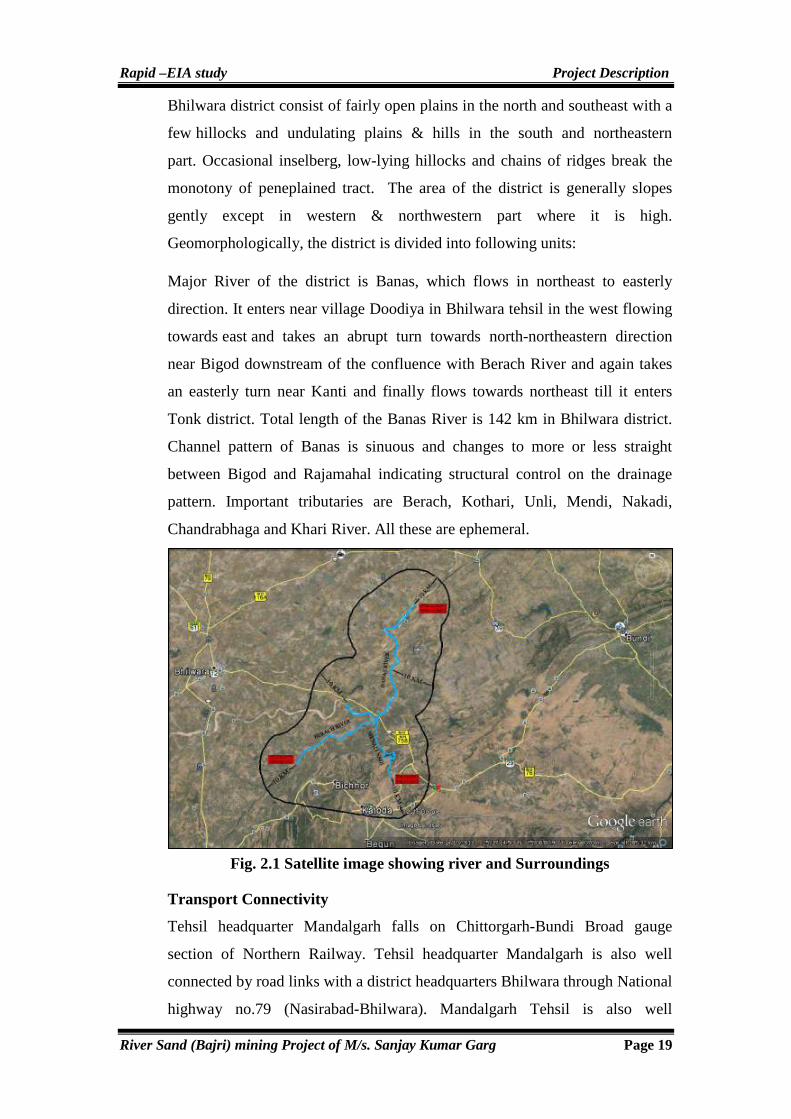
Rapid –EIA study Project Description
River Sand (Bajri) mining Project of M/s. Sanjay Kumar Garg Page 19
Bhilwara district consist of fairly open plains in the north and southeast with a
few hillocks and undulating plains & hills in the south and northeastern
part. Occasional inselberg, low-lying hillocks and chains of ridges break the
monotony of peneplained tract. The area of the district is generally slopes
gently except in western & northwestern part where it is high.
Geomorphologically, the district is divided into following units:
Major River of the district is Banas, which flows in northeast to easterly
direction. It enters near village Doodiya in Bhilwara tehsil in the west flowing
towards east and takes an abrupt turn towards north-northeastern direction
near Bigod downstream of the confluence with Berach River and again takes
an easterly turn near Kanti and finally flows towards northeast till it enters
Tonk district. Total length of the Banas River is 142 km in Bhilwara district.
Channel pattern of Banas is sinuous and changes to more or less straight
between Bigod and Rajamahal indicating structural control on the drainage
pattern. Important tributaries are Berach, Kothari, Unli, Mendi, Nakadi,
Chandrabhaga and Khari River. All these are ephemeral.
Fig. 2.1 Satellite image showing river and Surroundings
Transport Connectivity
Tehsil headquarter Mandalgarh falls on Chittorgarh-Bundi Broad gauge
section of Northern Railway. Tehsil headquarter Mandalgarh is also well
connected by road links with a district headquarters Bhilwara through National
highway no.79 (Nasirabad-Bhilwara). Mandalgarh Tehsil is also well

Rapid –EIA study Project Description
River Sand (Bajri) mining Project of M/s. Sanjay Kumar Garg Page 20
connected with the neighbouring districts Chittorgarh beside Bhilwara. Tehsil
headquarter Mandalgarh is also approached by National Highway No. NH-
76B from Bhilwara to Mandalgarh 48 Km.
Land Form, Land use and Land ownerships
Total land of mining lease comes under Gair Mumkin Nadi (Government
land). The lease area forms part of GT Sheet No. 45O/3, 45O/4, 45O/7, 45O/8.
The land details of lease area are given below:
Table 2.2 Land status of Lease Area
Type of Land Gair Mumkin Nadi & Nalla (Govt. Land)
Area in (Ha.) 1675.85 Ha.
Near Village Amarpura, Asawari, Bagthala, Baroo Khera, Bedunda, Beeliya, Bhand Ka Khera, Bharliya, Bhawani Singh Ka Khera, Bilod, Chainpuriya, Chandpura, Chhitarsingh Ji Ka Khera, Chohli, Daulji Ka Khera, Devipura, Gandhari, Gariyan, Gheoriya, Golbari, Gopalpura, Govta, Harisinghji Ka Khera, Hastra, Heengwaniya, Jaliya, Jojwa, Kankoliya, Kanti, Katariyon Ka Khera, Khakhunda, Khangarji Ka Khera, Khatwara, Kherpura, Lakshmipura, Lodhiyana, Mahtaji Ka Khera, Moi, Padampura, Panderi, Peethalpura, Phalasiya, Phoolji Ki Kheri, Pratappura, Ralayata, Ramthali, Sand, Shyam Garh, Tahla, Thal Kalan, Thalkhurd, Tiroli, Ummedpura
Tehsil Bijoliya & Mandalgarh
District Bhilwara
State Rajasthan
2.3 GEOLOGY
2.3.1 Regional Geology
Geologically, Litho units of Bhilwara district comprises of Precambrian rocks
and Vindhyan Super Group.
Litho units of Precambrian rocks of Bhilwara district have been divided into
Sand Mata Complex, Mangalwar Complex and Hindoli Group, Bedach
Granite, Jahajpur Granite, Jahajpur Group, Rajpura Dariba Group, Pur-Banera
Group, Ranthambor Group. Aravali Group is represented by Dovda Group;
Delhi Super Group is represented by Gogunda Group and Kumbhalgarh
Group. Vindhayn Group in Bhilwara Dristrict is represented by Khorip Group,
Kaimur Group, Rewa Group and Bhander Group is over lane by quaternary
from recent to sub recent.

Rapid –EIA study Project Description
River Sand (Bajri) mining Project of M/s. Sanjay Kumar Garg Page 21
2.3.2 Local Geology of the Lease and Adjoining Area
The lease area is confined to the river channel of river- Banas, Berach and
Mainali flowing in Tehsil-Mandalgarh, Kotri and Bijoliya. Major River
Channel containing mineral Bajri is obtained from Berach, Banas and Mainali.

Rapid –EIA study Project Description
River Sand (Bajri) mining Project of M/s. Sanjay Kumar Garg Page 22
Major flowing river is Banas passing through tehsil Mandalgarh from South to
North direction. The River Channel is monotonously occupied by (River
Sand) Obscuring the sub surface geology. However on the northern and
southern site of the river valley is seen exposed Granite, Amphibolites.
Granite is grayish color, coarse grained, composed of white colored
plagioclase feldspar, Hornblende and Biotite. Rhyolite is felsitic in texture and
show brownish to chocolate brown colored. Amphibolite shows light green
color, fine grained texture.
Seismicity
In view point of seismicity, district Bhilwara lies in a stable zone. In the
seismic zoning map of India, the district comes in a Zone-II (Least Active)
depicted in Fig. 2.1. No significant earthquakes originated in past history in
the district.
Fig. 2.2 Seismic Zoning Map of India & Rajasthan
Study Area
Rapid –EIA study Project Description
River Sand (Bajri) mining Project of M/s. Sanjay Kumar Garg Page 23
2.4 GEOLOGICAL RESERVES
2.4.1 Exploration carried out in the area
River sand is an incoherent mass of uneven grains deposited by flood waters
from upstream side and is naturally deposited when the Water Current in the
River slows down. Mineralization is found in the entire riverbed height from
surface hence no exploration is warranted.
2.4.2 Estimation of Geological Reserves
River sand is an incoherent mass of uneven grains deposited by water currents
from upstream side to downstream side and is naturally deposited when the
water current in the River slows down. Mineralization is found in the entire
river channel. Based on field survey geological reserves of river sand has been
computed for each block village wise by plan area method i.e., surface area
has been taken on the basis of revenue Khasra map, Rajasthan Government
under its circulars and Notification and amendment in Rajasthan Minor
Mineral Concession Rules vide order Government of Rajasthan Mines (Gr. II)
Department No. F-14(1) Mines/ Gr.II/2011 Jaipur Dated 23-05-2012 isssued
permission for bajri mining upto 3 mtr depth from Surface level of River bed.
It was Gazette notified by MINES (Gr.II) Department Notification; Jaipur
dated June 21, 2012 and bulk density has been taken 1.55 as revealed by
physical testing. The computation of river sand reserves are enumerated here
under:
GEOLOGICAL RESERVES AND GRADE
The geological reserves are of following order:
Total Geological reserves are: Proved Category reserves = 78023726.40 Tonnes
2.4.3 MINEABLE RESERVES
Mineral is well exposed on surface as well as depth up to 3mts in existing pits.
Hence mineable reserves have been considered as Proved Category reserves
up to 3mts depth from surface of the river channel. On either side of the river
channel a buffer zone 7.5 mts wide would be left from environmental view
point where in no mining will be carried out to prevent the erosion along
banks but would be utilized for plantation. Hence, 80% of the Computed
Geological reserves of river sand have been taken as Mineable Reserves/
62418981.12 Tons. further for computation of recoverable reserves, Annicuts,

Rapid –EIA study Project Description
River Sand (Bajri) mining Project of M/s. Sanjay Kumar Garg Page 24
check dams, bridges and roads with 45mtr safety zone is considered and 10%
reserves of mineable is further deducted for calculation of net mineable
reserves 62418981.12 Tons-6241898=5,61,77,083 tone.
The Recoverable/Mineable Reserves are as Follows
Total mineable reserves = Demonstrated reserves (Proved) - 10% Reserves
Locked in Boundary Buffer zone, other physical features such as Annicut,
Bridges, Wells, Culverts and permanent structures etc. = 62418981.12 Tonne-
6241898 Tonne = 5,61,77,083 Tonne.
2.5 LIFE OF MINE
In the proposed project of river sand mining, mining would be carried out @
28.05 Lac TPA life of mine of river cannot be ascertained as the river have a
inherent capacity to replenish with sand every year depends upon terrain
features such as slope, gradient, velocity, precipitation and catchment
characteristics. Quantity of mineral river sand (Bajri) taken out every year will
be replenished to some extent and will be again mined in the ensuing year at
the same rate of production.
2.5.1 Method of Mining
River Sand Mining
In this project of proposed river sand (Bajri) mining will be carried out by
open cast semi-mechanized method. All the pollution control measures will be
adopted at mine site. Mining will be done in scientific manner with proper
care taken of environment & surroundings.
Salient Points on Scientific mining of River Sand (Bajri) are:
1. First thing is to ascertain depth of mining which has been fixed by state
Govt. as 3 mtr or above water table whatever is earlier achieved. This
is safe working depth for River sand mining as fixed by State
Government.
2. Mining will be carried out only in one bench formation of maximum 3
mtr height and formation of Haul roads will be extended upto pits and
joined to nearest approach roads. Bench height will not be more than
3mtr at any site.

Rapid –EIA study Project Description
River Sand (Bajri) mining Project of M/s. Sanjay Kumar Garg Page 25
3. Main Haul road as center line joining all pits will be formed before
starting for movement of Heavy duty vehicles with width of Haul road
not less than 11 mtr and then it will be connected to nearest Highway
through village road.
4. Mineral will be directly filled into tippers, trolleys and trucks.
5. Mining will be carried out without harm to surrounding environment
with measures of water sprinkling on haul roads regularly.
6. conditions mentioned in bid and provisions of Rajasthan Minor Mineral
Concession Rules 1986, Second Amendment, 2012 & Lease agreement
made with Govt. Authorities strictly.
7. Mining will be carried out under supervision of competent person not
less than Second class manager of competency holder.
8. 7.5 mtr un-worked buffers will be maintained along the river bank
boundary (riparian zone) and vegetation growth generated on
meandering boundary to protect further erosion during flooding of water
in the River during monsoon.
9. There will be 45mtr unworked zone where any bridges & Anicuts and
any other permanent structure as per RMMCR, 1986 second Amendment
2012, are located.
10. No drilling and blasting will be carried for mining of river sand (Bajri).
and No Solid Waste will be generated during mining of river sand (Bajri)
11. Mining will be carried by Excavator–Dumper combination as shown
below figure:
Fig. 2.3 Schematic Diagram of river sand mining
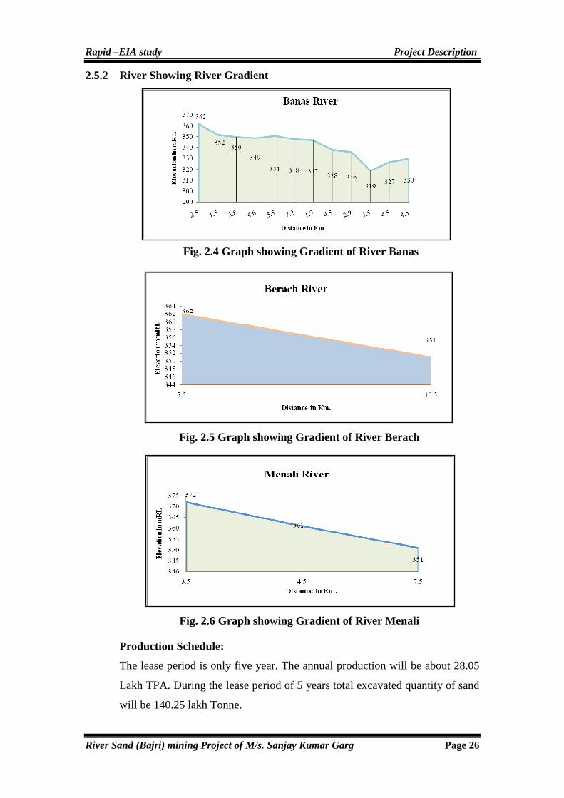
Rapid –EIA study Project Description
River Sand (Bajri) mining Project of M/s. Sanjay Kumar Garg Page 26
2.5.2 River Showing River Gradient
Fig. 2.4 Graph showing Gradient of River Banas
Fig. 2.5 Graph showing Gradient of River Berach
Fig. 2.6 Graph showing Gradient of River Menali
Production Schedule:
The lease period is only five year. The annual production will be about 28.05
Lakh TPA. During the lease period of 5 years total excavated quantity of sand
will be 140.25 lakh Tonne.

Rapid –EIA study Project Description
River Sand (Bajri) mining Project of M/s. Sanjay Kumar Garg Page 27
Table 2.3 Proposed Production details of River sand (Bajri)
Years Proposed Production in Metric Tons
First 28.05 Lac Tons
Second 28.05 Lac Tons
Third 28.05 Lac Tons
Fourth 28.05 Lac Tons
Fifth 28.05 Lac Tons
Total 140.25 Lac Tons
Extent of Mechanization
Various equipments to be used are as under.
Table 2.4 Proposed Mechanization at Mine Site
Type Nos. Size / Capacity Make Motive Power
Pocklane Excavator 7 Bucket capacity
(2.5 cum) As per availability
on hire basis Diesel
Front End Loaders 3 - - Diesel
Water Sprinklers 2 5000Ltr Capacity On Hire Basis Diesel
Jeep 2 For Supervision On Hire Basis Diesel
Road Grader/Compactor 1 For compactness of
Haul roads On Hire Basis Diesel
Van cum Ambulance 1 For emergency services On Hire Basis Diesel
Mobile Store Room with necessary tools
1 For maintenance of machinery at site
On Hire Basis Diesel
2.5.3 Human Resource
Deployment of man power for Management plan, Technical and other persons
to be employed will be as follows:
Table 2.5 Staff Details of Mine Site
S.No. Designation Qualification Requirement
1 Mines Manager First /Second Class certificate of Competency holder
1
2 Mining Engineer B.E. (Mining) 1
3 Mine Foreman Foreman Certificate of Competency 1
4 Mine Mate Mate certificate holder 2
5 Time Keeper & Chowkidar Matriculate 2
6 other supervisory staff Literate 3
7 Skilled labours To operate the machineries (Poclain machine)
8
8 Unskilled labour For loading & unloading material 50
Rapid –EIA study Project Description
River Sand (Bajri) mining Project of M/s. Sanjay Kumar Garg Page 28
9 labours For maintenance of road, afforestation, Potable water arrangement and miscellaneous works
10
Total 78
(In case of river sand mining, the human resource is same during development and operation phase)
For desired annual production of sand, desired excavation will have to be mined
out daily. The daily requirement considering 30 working days in a month. Days
of monsoon period or whenever water flows in river will be less and these are
assumed 30 days in a year. Hence net days are considered 330. It is proposed to
provide temporary site services as tin shed as mine office cum rest shelter; first
aid station; toilet etc. Total persons per day will work around 78 persons.
Labours deployment will be given priority for nearby villagers.
2.6 Conceptual Mining Plan
Mining will be started at various points within the river channel confined to
lease area @ 28,05,000 Tons per year. Lease will be worked for five year
period for 3mts working depth as it is prescribed for mining. Since river sand
is replenished in every rainy season hence, the life of mine is unlimited and
cannot be ascertained.
Afforestation along 7.5mts buffer zone River boundary of lease at places in the
area where possible to plant will be carried out in Phased manner with local
species in the Govt. land only as riparian vegetation so that erosion of slopes of
boundary is protected during monsoon season and environment is protected.
Lease is granted for Five year period so that progressive Plantation @1000 trees
along river bank, community center or nearby school, and haul roads in buffer
zone will be carried out.
Blasting: River sand is in loose form so there is no requirement of Blasting.
Mine Drainage: The ground water in this area gets intersected at a depth of
more than 8-10 mbgl in riverbed and more than 20-25 m in surrounding
agricultural fields as seen during field survey. No Mining work will be carried
out below the water Table. As such there shall be no need for any pumping
operations. A drain on the up-slope side of pit will be made so that rainwater
does not go into pit during mining operations. No water problem is envisaged
Rapid –EIA study Project Description
River Sand (Bajri) mining Project of M/s. Sanjay Kumar Garg Page 29
during the five years working of lease period. However working river course
will be stopped while flow of water in Channel. The details of conceptual plan
of the mine are given in table below:
Table 2.6 Land: Stage Wise Land use Operational and Post Operational Reclamation Area (Ha.)
S.No. Particular Present End of 5 Year
1. Area excavated 3 301
2. Storage of Top Soil Nil Nil
3. Overburden/ Dump Nil Nil
4. Mineral Storage Nil Nil
5. Infrastructure (Workshop, administration building etc)
Nil Nil
6. Roads 5 Ha. 5 Ha.
7. Railways Nil Nil
8. Green Belt - 5.4
9. Tailing Pond Nil Nil
10. Effluent Treatment Plant Nil Nil
11. Mineral Separation Plant Nil Nil
12. Township Area Nil Nil
13. Unworked 1667.85 1364.45
Total 1675.85 Ha. 1675.85 Ha.
2.6.1 Nature of Waste
No waste generated at mine site, except some gravelly stone met during
mining. No waste dump is proposed at mine site at end of life of mine so no
impact is anticipated. The entire mined out mineral is directly marketable.
2.7 TRANSPORT FROM MINE HEAD TO THE DESTINATION
From the working face, River sand (Bajri) is transported by trucks/dumpers
and then it is transported to customer’s destination.
2.7.1 Site Services
Infrastructure facilities such as temporary office building of Tin Shed, first aid
center, rest shelter, mobile workshop are proposed for working in the area. No
decommissioning is proposed at this stage. Thus no management measures
require in this progressive mine closure plan.
2.7.2 Proposed Infrastructure
A. Industrial Area (Processing Area)
An office-cum-store will be temporary constructed near mine site.

Rapid –EIA study Project Description
River Sand (Bajri) mining Project of M/s. Sanjay Kumar Garg Page 30
B. Resident Area (Non Processing Area)
No residential area is proposed.
C. Green Belt
To improve the environment of the area it is proposed to plant along the river
side (Riparian zone) of 7.5 m buffer zone along haul roads & others Govt.
land i.e Schools, Panchayat bhawan, community centres.
D. Drinking Water Management (Source & supply of water)
Water requirement of 3.0 KLD will be met from nearby villages.
E. Sewerage System
No sewerage will be generated from the project area.
F. Industrial Waste Management
No Industrial waste will be generated from the project.
G. Solid waste Management
No waste will be generated from this mine. All the material will be marketable.
H. Power Requirement
Nearby village’s area is well electrified.
2.7.3 Grade and Uses
Grains are fine to coarse grained. The general size of constituent particles of
River sand varies from 1 mm to 3 mm and is not uniform. The grains in all
sizes, small or large are rounded in shape. The color of sand is Pale white.
These deposits are of good quality and can be used for civil work.
2.8 POWER, WATER SUPPLY & OTHER INFRASTRUCTURE REQUIREMENT
Total water requirement in the mine will be about 14.0 KLD for drinking &
domestic use, dust suppression and plantation. Drinking water will be brought
by water tanker from nearby villages. Diesel is used as motive source of
primary energy for mine machinery. Diesel will be used in compressor, JCB
and dumpers and tractors. About 2240 liter per day is assumed to be
consumed. Diesel will be outsourced from nearby diesel pumps. Nearby
villages is well electrified.
Rapid –EIA study Analysis of Alternatives
River Sand (Bajri) Mining Project of M/s. Sanjay Kumar Garg Page 31
CHAPTER-3
ANALYSIS OF ALTERNATIVES
Rapid –EIA study Analysis of Alternatives
River Sand (Bajri) Mining Project of M/s. Sanjay Kumar Garg Page 32
3.0 GENERAL
The consideration of alternatives is most useful for the environmental
impact assessment in the project cycle. Mining of mineral river sand
(Bajri) is site specific project and there is no need to choose alternative.
Analysis of alternatives is the most effective way of meeting the needs
and purpose of the proposal either through enhancing the environmental
benefits of the proposed developmental activity and or through
minimizing or mitigating potentially significant negative impacts.
Analysis of alternatives provides all feasible option with a holistic view
of decision making in order to achieve the sustainable development of the
area/ region. A comparative analysis has to be done for alternatives help
to determine the best method of the project objectives with minimum
environmental impacts.
3.1 THE FOLLOWING ALTERNATIVES HAVE TO BE SELECTED
ON THEIR MERITS AND DEMERITS
� Energy demand shall be used efficiently but in this project the electric
energy is not available so diesel energy is being used for operating
mining machineries.
� For transportation of men and materials, public transport is being used
near to mine site. The mineral is transported by Trucks/Tippers of
adequate capacity.
3.2 OTHER FACTORS CONTRIBUTE TO THE SELECTION OF MI NE
SITE AND OTHERS
It is vital point to select mine site, choice of mining method, this is river sand
(bajri) mining project where the material will be lifted by Poclain into
Truck/Tippers. No new technology is involved. The mining shall be done as
per laid down procedures given in the mining plan. Other mitigation measures
will be taken to reduce the impacts on the environment during mining
operation.
3.3 CRUSHER AND BENEFICIATION PLANTS, IF ANY
No mineral beneficiation processing of any kind will be undertaken at mine
site. Mineral is directly saleable in the market.

Rapid –EIA study Analysis of Alternatives
River Sand (Bajri) Mining Project of M/s. Sanjay Kumar Garg Page 33
3.4 CONCLUSION
However, after analysis of the various factors the most environmentally
compatible alternative shall be selected. Selection of alternative may depend
upon available technology, policy objectives, social attitude, environmental
and site constraints & project economics.
Rapid – EIA Study Description of Environment
River Sand (Bajri) Mining Project of M/s. Sanjay Kumar Garg Page 34
CHAPTER-4
DESCRIPTION OF ENVIRONMENT

Rapid – EIA Study Description of Environment
River Sand (Bajri) Mining Project of M/s. Sanjay Kumar Garg Page 35
4.0 GENERAL
Baseline data generation forms a part of the Environmental Impact Assessment
study, which helps to evaluate the predicted impacts on the various
environmental attributes in the study area (Core and Buffer Zone) by using
scientifically developed and widely accepted environmental impact assessment
methodologies. This also helps in preparing an Environmental Management
Plan (EMP) outlining the measures for improving the environmental quality and
scope of future expansions for environmentally sustainable development.
Baseline environmental study also helps to identify the critical environmental
attributes, which are required to be monitored after the implementation of
project. Baseline data of environment is important to understand region’s
existing physical, biological, cultural and social environmental characteristics.
This chapter describes the existing environmental conditions of the study area,
which covers the mining lease area (core zone) and an area falling within
distance of 10 km from the boundary of the core zone, also known as buffer
zone. The baseline study for environmental attributes has been carried out in
core zone and buffer zone, collectively known as study area. The methodology
for establishing baseline environmental scenario has been briefly described and
details of data generation/collection; analysis and interpretation are presented in
the respective sections of this chapter. The main objectives of EIA/EMP studies
of River sand mining project are as:
� To establish the existing environmental scenario (Air, Water, Soil, Noise,
Flora & Fauna of study area (Core and Buffer Zone of 10km radii).
� To identify the impacts by proposed project of river sand mining
operations on environment.
� To suggest mitigative measures to minimize adverse impacts and to
maximize beneficial impacts.
� To suggest an environmental monitoring to evaluate the effectiveness of
mitigative measures.
� To prepare a detailed environmental management plan with capital and
annual recurring cost estimate for successful implementation of
mitigation measures as suggested in EIA/EMP report.

Rapid – EIA Study Description of Environment
River Sand (Bajri) Mining Project of M/s. Sanjay Kumar Garg Page 36
This chapter illustrates the description of the existing environmental status of
the study area with reference to the prominent environmental attributes. The
existing environmental setting is considered to be adjudge the baseline
conditions which are described with respect to climate, hydro-geological
aspects, atmospheric conditions, water quality, soil quality, vegetation pattern,
ecology, socio-economic profile, land use, etc. The environmental monitoring
includes meteorological parameters, ambient air quality, water quality, soil
quality, noise measurement, flora and fauna of the study area (Core Zone and
Buffer Zone of project site). The present report incorporates the data generated
for a period of three months i.e. during the period of December-2013,
January-2014 & February-2014 and secondary data collected from various
government, semi-government and public sector organizations as well as from
other studies available on the subject.
4.1 LAND ENVIRONMENT
4.1.1 Land-Use
Land is the vital resource for sustenance of life and degradation of land due to
industrialization, urbanization and population growth is a matter of concern.
Therefore, it is necessary to establish the existing land use pattern to optimize
the land use as well as minimize degradation due to the developmental
activities. The basic idea of land use classification for the purpose of EIA
study is to define the distribution of the existing land according to its actual
use. The land use pattern indicates the manner in which different parts of land
in the study area is being utilized or un-utilized. It is an important indicator of
environmental health and human activity and a degree of inter-play between
these two. Even though the soil quality, water availability and climatic
conditions have strong influence on agriculture and vegetation, the human
activity may alter the natural environment to a large extent to suit human
needs. In mining project, land plays a crucial role. Unplanned development of
land often triggers rapid environmental deterioration and disturbs ecological
balance i.e. flora & fauna).
4.1.2 Land Use-Core Zone
The core zone is devoid of top soil. The area is dominated by sand (Bajri). The
lease area is 1675.85 Ha. The area forms a part of GT Sheet No. 45O/3,

Rapid – EIA Study Description of Environment
River Sand (Bajri) Mining Project of M/s. Sanjay Kumar Garg Page 37
45O/4, 45O/7, 45O/8. Topographically, the area is almost flat with gentle
slope. The breakup of lease area is given below as follows:
Table 4.1 Land Status of Lease Area
Type of Land Gair Mumkin Nadi & Nalla (Govt. Land)
Area in (Ha.) 1675.85 Ha.
Near Village Amarpura, Asawari, Bagthala, Baroo Khera, Bedunda, Beeliya, Bhand Ka Khera, Bharliya, Bhawani Singh Ka Khera, Bilod, Chainpuriya, Chandpura, Chhitarsingh Ji Ka Khera, Chohli, Daulji Ka Khera, Devipura, Gandhari, Gariyan, Gheoriya, Golbari, Gopalpura, Govta, Harisinghji Ka Khera, Hastra, Heengwaniya, Jaliya, Jojwa, Kankoliya, Kanti, Katariyon Ka Khera, Khakhunda, Khangarji Ka Khera, Khatwara, Kherpura, Lakshmipura, Lodhiyana, Mahtaji Ka Khera, Moi, Padampura, Panderi, Peethalpura, Phalasiya, Phoolji Ki Kheri, Pratappura, Ralayata, Ramthali, Sand, Shyam Garh, Tahla, Thal Kalan, Thalkhurd, Tiroli, Ummedpura
Tehsil Bijoliya & Mandalgarh
District Bhilwara
State Rajasthan
The details of existing and proposed land use pattern of mining lease area are
given in Table 4.2. The land use pattern has been established based on Census
records of 2011, Revenue land data.
Table 4.2 Conceptual Land Use-Core Zone
S.No. Particular Present End of 5 Year
1. Area excavated 3 301
2. Storage of Top Soil Nil Nil
3. Overburden/ Dump Nil Nil
4. Mineral Storage Nil Nil
5. Infrastructure (Workshop, administration building etc)
Nil Nil
6. Roads 5 Ha. 5 Ha.
7. Railways Nil Nil
8. Green Belt - 5.4
9. Tailing Pond Nil Nil
10. Effluent Treatment Plant Nil Nil
11. Mineral Separation Plant Nil Nil
12. Township Area Nil Nil
13. Unworked 1667.85 1364.45
Total 1675.85 Ha. 1675.85 Ha.

Rapid – EIA Study Description of Environment
River Sand (Bajri) Mining Project of M/s. Sanjay Kumar Garg Page 38
Fig. 4.1 Showing Existing Land Use
Fig. 4.2 Showing Land Use-After Five Years
From the above table & figures, it is clear that the minimum part of the area is
already broken for various mining activities leaving maximum portion. The
objectives of the present study are:
� To map the study area with respect to various land use/ land cover
categories.
� To identify the sensitive areas within 10 km radius around the project site.
4.1.3 Physiography & Soils
Topographically, River Menali lies in extreme Southern part of Tehsil
Mandalgarh starts from village Tehla and Shyamgarh and continues to flow
south to north-east direction. It takes turn towards NW at Khangarji Ka Kheda
and merges at triveni with Banas and Berach River. High hills surrounding of

Rapid – EIA Study Description of Environment
River Sand (Bajri) Mining Project of M/s. Sanjay Kumar Garg Page 39
river area near Govta contributes in flow of water. There is one annicut also in
Govta.
Then it goes ahead passing villages Phalasiya and Sarana. There one bridge
also over there connecting villages. It further flows passing through village
Lodiyana and Sand. Three rivers i.e. Berach, Banas and Menali meet at near
village Devisingh ka Kheda known as Triveni Dham. It further flows
becoming as Banas River in north-East direction via villages Moi, Beeliya,
Jojiya, Padampura and flows with many more villages.
Bhilwara district consist of fairly open plains in the north and southeast
with a few hillocks and undulating plains & hills in the south and
northeastern part. Occasional inselberg, low-lying hillocks and chains of
ridges break the monotony of peneplained tract. The area of the district is
generally slopes gently except in western & northwestern part where it is
high.
Fig.4.3 Geomorphology of District Bhilwara, Rajasthan
4.1.4 Selection of Sampling Locations for Soil
Six soil sampling locations were identified based on the local distribution of
vegetation and the agricultural practices.
Bijoliya
Mandalgarh

Rapid – EIA Study Description of Environment
River Sand (Bajri) Mining Project of M/s. Sanjay Kumar Garg Page 40
4.1.5 Methodology
The soil samples were collected from the study area. The samples collected
from all location are homogeneous representative of each location. Soil was
dug from 30cm below the surface. It was uniformly mixed before
homogenizing the soil samples. The samples were filled in polythene bags,
labeled in the field with number and site name and sent to laboratory for
physico-chemical analysis.
4.1.6 Soil Quality Characteristics of Study Area
Soil quality characteristics of the study area have been established through
monthly sampling and analysis of the following parameters:
Physical Parameters: Color, Texture (Sand, Silt & Clay), Bulk density &
Porosity etc.
Chemical Parameters: pH, Electrical Conductivity, Organic Carbon,
Chloride, Calcium (Ca), Magnesium (Mg), Chloride (Cl-), Sodium (Na),
Potash (K2O), Available Nitrogen (N) and Available Phosphorus (P2O5).
Sampling locations were selected to know the physico-chemical characteristics
of the soil in the core zone and buffer zone of the study area.
Table 4.3 Soil Sampling Locations of the Study Area
Station Code Location Distance Direction
S1 Banas River - -
S2 Bhairu Khera 4.0 km West
S3 Thikariya 5.0 km East
S4 Mahran ka khera 3.25 km South
S5 Moriya Khera 3.0 km North West
S6 Manpura 6.25 km North East

Rapid – EIA Study Description of Environment
River Sand (Bajri) Mining Project of M/s. Sanjay Kumar Garg Page 41
Table 4.4 Results of Soil Sample
S.No. Parameter
SOIL SAMPLE LOCATION
Banas River Bhairu Khera Thikariya Mahran ka khera Moriya Khera Manpura
(S1) (S2) (S3) (S4) (S5) (S6)
A. Physical Characteristics
1. pH 8.02 7.8 7.95 7.7 7.9 8.1
2. Colour Light brown Brown Brown Brown Brown Brown
3. bulk density (gm/cc) 1.82 1.6 1.62 1.6 1.5 1.55
4. Porosity (%) 30.26 39.62 37.2 37.98 42.3 39.92
5. Texture class Sand Loam Loam Sandy Loam Sandy Loam Loam
6. Sand (%) 97.25 50.26 51.10 58.8 66.2 48.25
7. Silt (%) 1.65 35.2 29.6 23.35 20.15 32.6
8. Clay (%) 1.1 14.54 19.3 17.85 13.65 19.15
B. Chemical Characteristics
9. Conductivity (mS/cm) 0.06 0.1 0.18 0.8 0.13 0.5
10. Spe. Gravity (gm/cm3) 2.61 2.65 2.58 2.58 2.6 2.58
11. Calcium as Ca2+ (mg/kg) 7.96 18.16 21.3 16.2 19.7 22.3
12. Magnesium as Mg2+ (mg/kg) 4.81 10.8 14.1 9.7 11.7 17.48
13. Sodium as Na (mg/kg) 2.38 32.8 36.12 30.45 34.8 40.25
14. Potassium as K2O (kg/ha.) 74.99 990.8 710 635.2 885.45 1172
15. Ave. Phosphorus (kg/ha.) 10.2 25.4 30.5 23.32 28.65 31.45
16. Ave. Nitrogen as N (kg/ha.) 530.12 508.5 515.3 502.3 509.2 525.6
17. Organic carbon (%) 0.03 1.4 1.6 1.2 1.14 1.65
18. Chloride as Cl-(mg/kg) 42.6 37.1 41.2 36.75 38.25 42.3

Rapid – EIA Study Description of Environment
River Sand (Bajri) Mining Project of M/s. Sanjay Kumar Garg Page 42
4.1.7 Soil Characteristics in and around the Mining Lease Area
Physical Characteristics
Soil of the region is light brown to brown in color. Generally, soil of the area
varies between sandy loam, loam and sand in texture. The porosity of the soils
varies from 30.26 % to 42.3 % among different sites of study. The bulk
density of soils varies from 1.5 g/cc. to 1.82 g/cc.
Chemical Characteristics
The pH value of soil samples varies 7.7-8.1. The electrical conductivity of soil
varied between 0.06 mS/cm to 0.8 mS/cm among different sites of study.
Maximum value of EC was recorded at S4 and minimum at S1. The content of
chlorides in soil varies between 42.6 mg/kg (S1) to 36.75 mg/kg (S4). Calcium
content of soils varies between 7.96 mg/kg to 22.3 mg/kg (S1 & S6),
respectively. The magnesium content of soils varies between 7.81 mg/kg (S1)
to 17.48 mg/kg (S6), respectively.
4.1.8 Fertility Status of Soils
The fertility of soil is dependent on its organic carbon content, macro as well
as micronutrients. Organic carbon plays a vital role in binding of all types of
nutrients. Availability of these nutrients is determined by soil pH. During the
study period, the value of organic carbon varies 0.03% to 1.65% across
different sites. Soil of the study area clearly depicts that the soil retains
medium to higher content of organic carbon. The N, P and K value further
tells the macronutrients status of the soils of the study area and availability
among different site is good. The results of analysis of soils are presented in
table 4.4.
4.1.9 Photographs of Soil Sampling
BANAS RIVER BHAIRU KHERA


Rapid – EIA Study Description of Environment
River Sand (Bajri) Mining Project of M/s. Sanjay Kumar Garg Page 43
Fig. 4.4 Photographs showing Soil Sampling in Study Area
4.2 WATER ENVIRONMENT
Surface Water Scenario
Surface water resources are meager in the state. In the buffer zone, some of the
seasonal surface water bodies located i.e. Banas River, Berach River, Kothari
River, Menali Nadi, Unli Nadi and Kachola Pond water body. All the above
water bodies are seasonal in nature.
Ground Water Scenario
Ground water quality in Bhilwara significantly influenced by semi-arid
climate and hydro-geologically diversity-salinity, sodicity and fluoride are the
major factors affecting the ground water quality. Ground water is the major
source of irrigation in the district.
Geological Setup
The lease area is confine to the river channel of river- Banas, Berach and Mainali
flowing in Tehsil-Mandalgarh, Kotri and Bijoliya. Major River Channel
containing mineral Bajri is obtained from Berach, Banas and Mainali. Major
THIKARIYA MAHRAN KA KHERA
MORIYA KHERA MANPURA

Rapid – EIA Study Description of Environment
River Sand (Bajri) Mining Project of M/s. Sanjay Kumar Garg Page 44
flowing river is Banas passing through tehsil Mandalgarh from South to North
direction. The river channel is monotonously occupied by (River Sand) obscuring
the sub surface geology. However on the northern and southern site of the river
valley is seen exposed Granite, Amphibolites. Granite is grayish color, coarse
grained, composed of white colored plagioclase feldspar, Hornblende and Biotite.
Rhyolite is felsitic in texture and show brownish to chocolate brown colored.
Amphibolite shows light green color, fine grained texture.
Hydro-geology
Major water bearing formations are gneiss and schist (Bhilwara Super group);
gneiss, schist, phyllite, slate and limestone (Aravalli Super group); sandstone,
shale and limestone (Vindhyan Super group) and alluvium. Ground water
occurs under unconfined to semi-confined condition. Weathered zone below
the water table acts as a good storage. The joints, fissures and other plains of
structural weakness as well as their extent, size, opening and inter connection
control occurrence & movement of ground water. Weathered gneiss forms
upper part of the bedrock in central part. Weathered gneiss with schist
occupies most of the northern part under thin cover of alluvium.
In schists, phyllites and slates, weathered zone extends to depth greater than
in granites and gneisses. Muscovite schist often grade into gneiss. These
have well-developed foliation and irregular joints and are intruded by
granite, amphibolite, pegmatite and quartz vein. The contact between these
intrusives and schist, provide good channel for ground water circulation.
Dug wells in Gangapur and Bhilwara area tapping gneiss and mica schist
yield between 25 & 50 m3/day. Phyllites and schists are predominating in
the eastern parts of the district near Shakargarh, Amalda and Kachola
towards north of Great Boundary Fault. These formations are intercalated
with dolomitic limestone, quartzite and basic intrusives. Depth of wells
tapping these formations varies from 15 to 50 m. Yield of wells vary from 30
to 45 m3/day.
Understanding of the water quality is essential in preparation of environmental
impact assessment and to identify critical issues with a view to suggest
appropriate mitigation measures for implementation. The purpose of this study is
to:

Rapid – EIA Study Description of Environment
River Sand (Bajri) Mining Project of M/s. Sanjay Kumar Garg Page 45
� Assess the physico-chemical characteristics of water for various parameters.
� Evaluate the impacts on agricultural productivity, habitat conditions,
recreational resources and aesthetics in the vicinity.
� Prediction of impact on water quality by this project and related
activities.
The quality and quantity of ground water differ over an area, as these depend
on primarily topographical and hydro-geological characteristics of the area.
Methodology
Ground water and surface water samples were examined for physico-chemical
parameters in order to assess the effect of mining and other activities on
surface and groundwater. The samples were collected and analyzed as per the
procedures specified in “Standard Methods for the Examination of Water and
Waste Water” published by American Public Health Association (APHA) and
protocols of Indian Standards (IS: 10500). Samples for physico-chemical
analysis were collected in polyethylene carboys. The selected parameters of
physico-chemical have been analyzed for projecting the existing quality of
water and its status in the study area.
4.2.1 Water Quality Characteristics of Study Area (Surface and Ground water)
The water quality characteristics of the study area have been established
through monthly sampling and analysis of the following parameters:
Physical Characteristics: Color, Odour, Turbidity etc.
Chemical Characteristics: pH, Total Solids (TS), Total Dissolved Solids
(TDS), Total Suspended Solids (TSS), Electrical Conductivity (EC),
Dissolved Oxygen (DO), Chlorides, Total Hardness, Calcium, Magnesium,
Alkalinity, Nitrate, Phosphate, Fluoride and Sulphate (SO42-) etc.
4.2.2 Water Sampling Locations – Surface Water
Six ground water samples were collected from Hand pump/tube wells which
are commonly used for drinking purposes. The status of six surface water
bodies shows that out of six, one water sample was collected. These samples
were taken as grab samples and were analyzed for various physico-chemical
parameters and compared with the standards for drinking water as for IS:
10500 & IS: 2296. The water sampling locations are listed below in Table 4.5.

Rapid – EIA Study Description of Environment
River Sand (Bajri) Mining Project of M/s. Sanjay Kumar Garg Page 46
Table 4.5 Details of Surface and Ground Water Sampling Locations
Station Code Location Distance Direction
GW1 Laxmipura 1.5 km East
GW2 Nandary 4.5 km West
GW3 Rasingpura 3.75 km South East
GW4 Chaudhariyas 3.0 km North West
GW5 Hajiwas 2.75 km North west
GW6 Manoharpura 4.50 km North east
SW 1 Banas River - -
SW 2 Berach River* - -
SW 3 Kothari River* 2.0 km North
SW 4 Menali Nadi* - -
SW 5 Unli Nadi* - -
SW 6 Kachhola Pond* 4.0 km East
*denote dried GW= Ground water, SW=Surface Water
4.2.3 Results of Water Samples
The results of the ground water samples collected at six from different sites
are given in Table 4.6. The results for the water samples collected with the
study area and compared with standard limits.
� Ground water Quality
Six ground water samples were collected from different sites. pH of these
water samples ranged between 7.6 to 8.2 shows normal to slightly alkaline and
comes under permissible limits of standards prescribed by IS:10500 is (6.5-
8.5). Odor is unobjectionable throughout all sampling stations. The content of
total hardness of water samples shows variation among different sites between
200.2 mg/l (GW2) to 353.1 mg/l (GW4).
The results of water samples clearly depicts that the values of total
hardness in ground water were comparatively higher than surface water.
The content of calcium in ground water varied between 57.42 mg/l (GW3)
to 90.2 mg/l (GW5). Chloride values are within desirable limit in
groundwater. Maximum value of chloride was 122.4 mg/l at site GW6 and
minimum 70.4 mg/l at site GW2.
Maximum values of TDS 584 mg/l were found at GW1 and minimum 387
mg/l at GW2. The values of alkalinity ranged between 150.25 mg/l (GW2) to
292.12 mg/l (GW1). The contents of nitrate in ground water varied between
21.3 mg/l (GW6) to 182.05 mg/l (GW3). The concentration of fluoride is
slightly higher than permissible limits of standards.
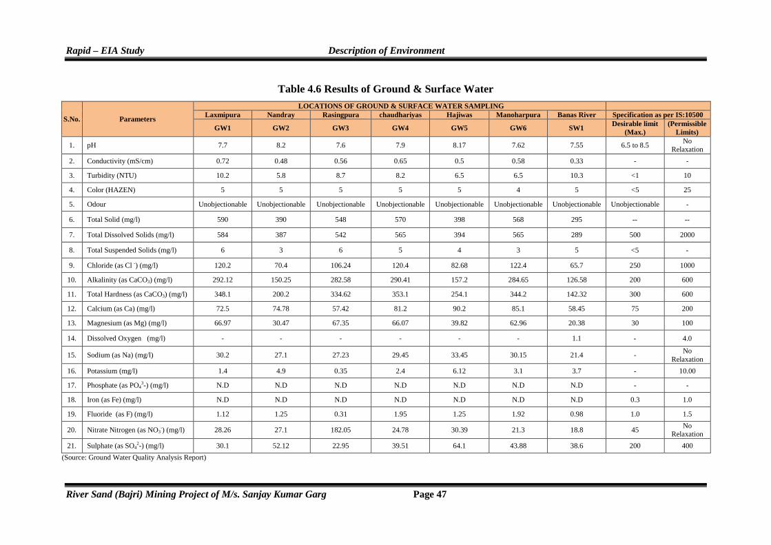
Rapid – EIA Study Description of Environment
River Sand (Bajri) Mining Project of M/s. Sanjay Kumar Garg Page 47
Table 4.6 Results of Ground & Surface Water
S.No. Parameters
LOCATIONS OF GROUND & SURFACE WATER SAMPLING Laxmipura Nandray Rasingpura chaudhariyas Hajiwas Manoharpura Banas River Specification as per IS:10500
GW1 GW2 GW3 GW4 GW5 GW6 SW1 Desirable limit
(Max.) (Permissible
Limits)
1. pH 7.7 8.2 7.6 7.9 8.17 7.62 7.55 6.5 to 8.5 No
Relaxation
2. Conductivity (mS/cm) 0.72 0.48 0.56 0.65 0.5 0.58 0.33 - -
3. Turbidity (NTU) 10.2 5.8 8.7 8.2 6.5 6.5 10.3 <1 10
4. Color (HAZEN) 5 5 5 5 5 4 5 <5 25
5. Odour Unobjectionable Unobjectionable Unobjectionable Unobjectionable Unobjectionable Unobjectionable Unobjectionable Unobjectionable -
6. Total Solid (mg/l) 590 390 548 570 398 568 295 -- --
7. Total Dissolved Solids (mg/l) 584 387 542 565 394 565 289 500 2000
8. Total Suspended Solids (mg/l) 6 3 6 5 4 3 5 <5 -
9. Chloride (as Cl -) (mg/l) 120.2 70.4 106.24 120.4 82.68 122.4 65.7 250 1000
10. Alkalinity (as CaCO3) (mg/l) 292.12 150.25 282.58 290.41 157.2 284.65 126.58 200 600
11. Total Hardness (as CaCO3) (mg/l) 348.1 200.2 334.62 353.1 254.1 344.2 142.32 300 600
12. Calcium (as Ca) (mg/l) 72.5 74.78 57.42 81.2 90.2 85.1 58.45 75 200
13. Magnesium (as Mg) (mg/l) 66.97 30.47 67.35 66.07 39.82 62.96 20.38 30 100
14. Dissolved Oxygen (mg/l) - - - - - - 1.1 - 4.0
15. Sodium (as Na) (mg/l) 30.2 27.1 27.23 29.45 33.45 30.15 21.4 - No
Relaxation
16. Potassium (mg/l) 1.4 4.9 0.35 2.4 6.12 3.1 3.7 - 10.00
17. Phosphate (as PO43-) (mg/l) N.D N.D N.D N.D N.D N.D N.D - -
18. Iron (as Fe) (mg/l) N.D N.D N.D N.D N.D N.D N.D 0.3 1.0
19. Fluoride (as F) (mg/l) 1.12 1.25 0.31 1.95 1.25 1.92 0.98 1.0 1.5
20. Nitrate Nitrogen (as NO3-) (mg/l) 28.26 27.1 182.05 24.78 30.39 21.3 18.8 45 No
Relaxation
21. Sulphate (as SO42-) (mg/l) 30.1 52.12 22.95 39.51 64.1 43.88 38.6 200 400
(Source: Ground Water Quality Analysis Report)

Rapid – EIA Study Description of Environment
River Sand (Bajri) Mining Project of M/s. Sanjay Kumar Garg Page 48
� Surface Water Quality
The status of 6 surface water bodies shows that, one water sample was collected
i.e. Banas River and remaining 5 were found dried. The sample were taken as
grab sample and were analyzed for the various physico-chemical parameters
and compared with the standards for drinking water as for IS: 2296. The pH of
the surface water sample was 7.55 which lies under normal condition and comes
under permissible limits of standards prescribed by IS: 2296 is (6.5-8.5). Odor is
unobjectionable throughout all sampling station.
The total hardness value of surface water sample is 142.32 mg/l. The content of
calcium was found 58.45 mg/l. The concentration of chloride in surface water
sample was 65.7 mg/l. Total dissolved solids value was 289 mg/l and the value of
alkalinity was 126.58 mg/l. The content of nitrate in surface water sample was 18.8
mg/l. The concentration of fluoride is well within permissible limits of standards.
4.2.4 Conclusion
The result of physico-chemical analysis of water samples reveals that the
variations in quality of ground water and surface water are clearly depicted in
Table 4.6 However, all the parameters are well within permissible limits of
standards and many are well within the desirable limits of standards.
4.2.5 Photographs of Ground Water and Surface Water Sampling Stations
LAXMIPURA NANDARY
RASINPURA CHAUDHARIYAS

Rapid – EIA Study Description of Environment
River Sand (Bajri) Mining Project of M/s. Sanjay Kumar Garg Page 49
Fig. 4.5 Photographs showing Ground & Surface Water Sampling
4.3 AIR ENVIRONMENT
4.3.1 Meteorology
Meteorological factors such as wind speed, direction, ambient temperature,
humidity etc. play an important role in dispersion and dilution of pollutants.
HAJIWAS MANOHARPURA
BANAS RIVER BERACH RIVER
KOTHARI RIVER MENALI NADI
UNLI NADI KACHHOLA POND


Rapid – EIA Study Description of Environment
River Sand (Bajri) Mining Project of M/s. Sanjay Kumar Garg Page 50
Atmospheric pressure, rainfall and cloud cover also govern this activity. Other
factors such as terrain and local topography also take part in atmospheric
dispersion of pollutants. The study area is a part of semi arid climatic zone
having hot summer, moderately cool winter and moderate monsoon during
June to September. The meteorological data recorded during the monitoring
period is extremely important for interpretation of the baseline information as
well as for input prediction models for air quality dispersion.
4.3.2 Climatology
Climate is semi-arid type. January is the coldest month with mean maximum
and minimum temperatures being lowest at 22.2ºC & 7.3ºC. Temperature in
summer month, i.e. in June, reaches up to 46ºC. There is drop in temperature due
to onset of monsoon and rises again in the month of September. Atmosphere is
generally dry except during the monsoon period.
4.3.2.1 Relative Humidity
The humidity is highest in the month of August with mean daily relative humidity
80%. The annual potential evapotranspiration in the district is 1495 mm and is the
highest in the month of May.
4.3.2.2 Wind Direction
The general pattern of wind in study area was observed and the prevailing
wind direction shown from North East to South West direction.
4.3.2.3 Rainfall
Mean annual rainfall (1986-2005) of the district is 633.9 mm whereas normal
rainfall (1901-70) is lower than average rainfall and placed at 603.3. Almost 95%
of the total annual rainfall is received during the southwest monsoon, which
enters the district in the last week of June and withdraws in the middle of
September. Probability of average annual rainfall exceeding 900 mm is only 10%.
However, there is 90% probability that the average rainfall will be more than 400
mm. The probability of occurrence of mean annual rainfall is 45%. Drought
analysis based on agriculture criteria indicates that the district is prone to mild and
normal type of droughts. Occurrence of severe and very severe type of drought is
very rare. The annual variation in the rainfall recorded from past 23 years is
given in Table 4.7.

Rapid – EIA Study Description of Environment
River Sand (Bajri) Mining Project of M/s. Sanjay Kumar Garg Page 51
Table 4.7 Year wise Statistics of Rainfall Tehsil Bijoliya & Mandalgarh, District-Bhilwara (Rajasthan)
S.No. Year Rainfall in mm. (Mandalgarh)
Rainfall in mm. (Bijoliya)
1 1990 940.0 1220.0
2 1991 786.0 1025.0
3 1992 960.0 797.0
4 1993 849.0 947.0
5 1994 1414.0 1164.0
6 1995 757.0 941.0
7 1996 979.0 1056.0
8 1997 753.0 1071.0
9 1998 402.0 673.0
10 1999 641.0 630.2
11 2000 602.0 746.0
12 2001 683.0 1012.0
13 2002 411.0 487.0
14 2003 914.0 796.0
15 2004 875.0 1161.0
16 2005 594.0 602.0
17 2006 904.0 1027.0
18 2007 885.0 474.0
19 2008 697.0 729.0
20 2009 465.0 552.0
21 2010 830.0 880.0
22 2011 883.0 767.0
23 2012 680.0 875.0
Annual Average Rainfall in mm. 778.4 853.6 (Source: www.waterresources.rajasthan.gov.in)
4.3.3 Ambient Air Quality
The baseline studies on air environment include identification of specific air
pollution parameters and their existing levels in ambient air. The ambient air
quality with respect to the study zone of 10 km radius around the project site
forms the baseline information. The sources of air pollution in the region are
mostly due to vehicular traffic, dust arising from unpaved village road and
domestic fuel burning.
The prime objective of the baseline air quality study was to establish the
exiting ambient air quality of the study area. These will also be useful for
Rapid – EIA Study Description of Environment
River Sand (Bajri) Mining Project of M/s. Sanjay Kumar Garg Page 52
assessing the conformity to standards of the ambient air quality during the
operation of proposed mine. This section describes the identification of
sampling locations, methodology adopted during the monitoring period and
sampling frequency. The results of ambient air monitoring during the
November-2013, December-2013 & January-2014 represent the study
period.
4.3.3.1 Methodology Adopted and Selection of Sampling Location
The baseline status of ambient air quality has been established through a
scientifically design ambient air quality monitoring network and is based on
the considerations such as:
� Meteorological conditions at the site
� Topography of the study area
� Representative of the regional background air quality for obtaining
baseline status
� Representative of the likely impact area
The ambient air quality monitoring stations (AAQM) were setup at 10
locations with due consideration to the above mentioned points and as per the
Ministry of Environment and Forest (MoEF), Government of India (GoI)
guidelines of AAQM.
Table 4.8 Ambient Air Quality Monitoring Locations
Station Code
Location Distance Direction Category
AAQ 1 Banas River N/v Abhalpur - - Industrial
AAQ 2 0.5 km Downwind 0.5 km SW Industrial
AAQ 3 Banas River N/v Biliya - - Industrial
AAQ 4 Manpura 4.0 km East Residential
AAQ 5 Kachhola 4.0 km East Residential
AAQ 6 Bigod 0.5 km North West Residential
AAQ7 Mandalgarh 7.5 km South East Residential
AAQ8 Devariya 4.0 km South Residential
AAQ9 Berach River N/v Barakhera - South west Industrial
AAQ10 Devali 5.5 km North west Residential
4.3.3.2 Frequency and Parameters of the Sampling
The frequency has been adopted for sampling are as follows: Ambient air
quality monitoring has been carried out with a frequency of two days per

Rapid – EIA Study Description of Environment
River Sand (Bajri) Mining Project of M/s. Sanjay Kumar Garg Page 53
week at ten locations for three months study period. The ambient air
quality parameters along with their frequency of sampling are given in
Table 4.9.
Table 4.9 Details of AAQM Parameters and Frequency of Sampling
Parameter Frequency
Particulate Matter (PM10) Twice in a Week (24 Hours a day)
Sulphur Dioxide (SO2) Twice in a Week (8 Hours a day)
Oxides of Nitrogen (NOx) Twice in a Week (8 Hours a day)
4.3.3.3 Details of Sampling Locations
� Core Zone- Banas River N/v Abhalpur (AAQ1)
The location has been selected to assess the air quality levels in the core
zone of the mine site. As the site is an open land, therefore no residential
buildings in the vicinity. The location was away from the village road
and did not experience any frequent vehicular movement. The sampler
was placed in the core zone area.
� Core Zone- 0.5 km Downwind from Luni River (AAQ2)
The location has been selected to assess the air quality levels from mine
site.The site is located in SW direction about 0.5 km downwind direction
away from mine site.
� Banas River N/v Biliya (Core Zone, AAQ3)
The location has been selected to assess the air quality levels in the core
zone of the mine site. As the site is an open land, therefore no residential
buildings in the vicinity. The location was away from the village road
and did not experience any frequent vehicular movement. The sampler
was placed in the core zone area.
� Manpura Village (Buffer Zone, AAQ4)
Manpura village is located at 4.0 km away from mine site in East
direction. This location includes residential and agricultural lands.
� Kachola Village (Buffer Zone, AAQ5)
The above site is located about 4.0 km in East direction from mine site.
The sampler was placed as per the norms in this area.

Rapid – EIA Study Description of Environment
River Sand (Bajri) Mining Project of M/s. Sanjay Kumar Garg Page 54
� Bigod Village (Buffer Zone, AAQ6)
Bigod is located about 0.5 km away from mine site in NW direction.
This location is representing buffer zone sampling location.
� Mandalgarh Village (Buffer Zone, AAQ7)
Mandalgarh village located away about 7.5 km in SE direction from
mine site. The site comes under residential.
� Deveriya Village (Buffer Zone, AAQ8)
Deveriya is located about 4.0 km in south direction of mine site. The site
comes under residential category.
� Berach River N/v Barakhera (Core Zone, AAQ9)
The location has been selected to assess the air quality levels in the core
zone of the mine site. As the site is an open land, therefore no residential
buildings in the vicinity. The location was away from the village road
and did not experience any frequent vehicular movement. The sampler
was placed in the core zone area.
� Devali Village (Buffer Zone, AAQ10)
Devali is located about 5.5 km in NW direction of mine site. The site
comes under residential category.
4.3.3.4 Instrument used for the sampling
Respirable Dust sampler APM-860, APM 460 was used for PM10 and
attachment of impingers for measuring gaseous pollutants such as SO2 and
NOx.
4.3.3.5 Sampling and Analytical Techniques for PM10, SO2 and NOX
The blower through the filter paper sucks suspended particulate matter
present in ambient air. A taping is provided on the suction side of the blower
to provide suction for sampling air through a set of impingers. Samples of
gases are drawn at a flow rate of 1 lit./min (LPM). Modified West and Gaeke
method (IS: 5182 Part-II, 1999-2006) has been adopted for the estimation of
SO2 and Jacob & Hochheiser method (IS: 5182 Part-VI, 1999-2006) has
been adopted for the estimation of NO2. Calibration curve have been
prepared for different gaseous pollutants. The calibration is carried out

Rapid – EIA Study Description of Environment
River Sand (Bajri) Mining Project of M/s. Sanjay Kumar Garg Page 55
whenever new absorbing solutions are prepared. The methods and test
protocol used for the analysis of the ambient air quality monitoring are
mentioned in Table 4.10.
Table 4.10 Methods used for Ambient Air Quality Monitoring
Parameters Methods Protocols Used
Sulphur dioxide as (SO2) West & Gaeke Method (IS: 5182 Part-II, 1999-2006)
Nitrogen dioxide as (NO2) Jacob and Hochhiser (IS: 5182 Part-VI, 1999-2006)
Respirable Suspended Particulate Matter (PM10)
Respirable Dust Sampler (Gravimetric Method)
(IS:5182 Part-23, 2006)
4.3.3.6 Results of Ambient Air Quality Monitoring
Details of the results of ambient air quality monitoring during the study period
of three months i.e. from December, 2013, January, 2014 & February, 2014
are mentioned in Table-4.11 to 4.20. Statistical analysis of all the AAQM
stations has been computed and the summary of these results for each location
is depicted in Table 4.21.
Table 4.11 Results of Ambient air quality monitoring of Banas River N/v Abhalpur
AAQ-1 (Unit = µg/m3 ) S.No. Date PM10 SO2 NO2
1 02.12.2013 50.7 7.9 11.3
2 03.12.2013 52.2 8.1 10.9
3 09.12.2013 48.3 7.4 11.4
4 10.12.2013 51.5 7.2 11.7
5 16.12.2013 57.0 6.6 12.1
6 17.12.2013 60.1 6.9 11.8
7 23.12.2013 58.3 7.1 12.4
8 24.12.2013 60.1 6.8 12.0
9 03.01.2014 59.4 6.1 11.2
10 04.01.2014 57.8 6.4 10.9
11 10.01.2014 55.6 7.0 10.4
12 11.01.2014 53.9 6.7 10.6
13 17.01.2014 47.3 7.5 11.8
14 18.01.2014 49.7 7.8 12.1
15 24.01.2014 52.5 8.3 12.9
16 25.01.2014 49.2 8.2 13.2
17 02.02.2014 56.8 7.7 13.0
18 03.02.2014 54.1 8.0 12.7
19 09.02.2014 54.7 8.4 11.9

Rapid – EIA Study Description of Environment
River Sand (Bajri) Mining Project of M/s. Sanjay Kumar Garg Page 56
20 10.02.2014 60.3 8.7 12.2
21 16.02.2014 59.3 7.9 11.1
22 17.02.2014 57.7 7.6 10.8
23 23.02.2014 59.8 7.1 11.5
24 24.02.2014 59.9 7.3 11.7
Min. 47.3 6.1 10.4
Max. 60.3 8.7 13.2
98 Percentile 60.21 8.56 13.11
Table 4.12 Results of Ambient air quality monitoring of 0.5 km Downwind
AAQ-2 (Unit = µg/m3 )
S.No. Date PM10 SO2 NO2
1 02.12.2013 58.3 6.1 10.8
2 03.12.2013 57.7 5.8 11.0
3 09.12.2013 53.5 5.6 10.3
4 10.12.2013 55.1 6.0 9.9
5 16.12.2013 54.2 6.7 10.6
6 17.12.2013 59.4 6.9 10.4
7 23.12.2013 54.2 7.4 11.2
8 24.12.2013 57.7 7.3 10.9
9 03.01.2014 59.8 8.0 11.5
10 04.01.2014 58.3 7.7 11.7
11 10.01.2014 59.8 8.3 12.3
12 11.01.2014 56.4 8.1 12.0
13 17.01.2014 58.4 7.5 12.8
14 18.01.2014 56.9 7.2 12.4
15 24.01.2014 50.9 6.4 11.8
16 25.01.2014 54.3 6.6 11.6
17 02.02.2014 56.2 5.9 12.2
18 03.02.2014 54.0 5.7 11.9
19 09.02.2014 56.9 6.5 11.1
20 10.02.2014 57.3 6.8 10.8
21 16.02.2014 56.0 7.3 10.5
22 17.02.2014 58.1 7.0 10.2
23 23.02.2014 57.4 8.1 11.1
24 24.02.2014 53.8 7.8 11.3
Min. 50.9 5.6 9.9
Max. 59.8 8.3 12.8
98 Percentile 59.80 8.21 12.62

Rapid – EIA Study Description of Environment
River Sand (Bajri) Mining Project of M/s. Sanjay Kumar Garg Page 57
Table 4.13 Results of Ambient air quality monitoring of Banas River N/v Biliya
AAQ-3 (Unit = µg/m3 )
S.No. Date PM10 SO2 NO2
1 02.12.2013 56.2 7.4 12.3
2 03.12.2013 58.1 7.1 12.7
3 09.12.2013 52.7 8.0 11.8
4 10.12.2013 49.0 7.8 11.6
5 16.12.2013 55.8 8.3 10.7
6 17.12.2013 57.3 7.9 11.0
7 23.12.2013 61.5 8.2 10.3
8 24.12.2013 61.9 6.8 10.1
9 03.01.2014 54.2 6.1 11.2
10 04.01.2014 50.6 5.9 11.5
11 10.01.2014 49.7 6.6 12.1
12 11.01.2014 53.4 6.3 11.8
13 17.01.2014 59.3 7.0 11.9
14 18.01.2014 60.3 7.2 12.3
15 24.01.2014 60.3 7.9 12.7
16 25.01.2014 60.8 8.2 13.0
17 02.02.2014 61.2 8.5 12.6
18 03.02.2014 59.1 8.1 12.9
19 09.02.2014 58.6 7.6 12.0
20 10.02.2014 60.1 7.3 12.2
21 16.02.2014 55.5 6.5 11.7
22 17.02.2014 56.4 6.7 11.6
23 23.02.2014 58.5 7.1 10.9
24 24.02.2014 60.8 6.9 11.1
Min. 49.0 5.9 10.1
Max. 61.9 8.5 13.0
98 Percentile 61.72 8.41 12.95
Table 4.14 Results of Ambient air quality monitoring of village Manpura
AAQ-4 (Unit = µg/m3 ) S.No. Date PM10 SO2 NO2
1 02.12.2013 54.9 6.3 10.9
2 03.12.2013 50.7 6.5 11.2
3 09.12.2013 49.3 7.2 10.7
4 10.12.2013 51.2 7.0 11.0
5 16.12.2013 56.4 7.8 11.8
6 17.12.2013 58.5 8.1 12.2

Rapid – EIA Study Description of Environment
River Sand (Bajri) Mining Project of M/s. Sanjay Kumar Garg Page 58
7 23.12.2013 63.6 7.6 12.1
8 24.12.2013 64.8 7.4 12.4
9 03.01.2014 69.3 6.8 12.1
10 04.01.2014 67.0 7.1 12.9
11 10.01.2014 59.2 6.4 13.3
12 11.01.2014 61.7 6.7 13.0
13 17.01.2014 52.4 7.5 12.3
14 18.01.2014 48.7 7.3 12.1
15 24.01.2014 55.8 8.2 11.5
16 25.01.2014 49.6 7.9 11.3
17 02.02.2014 66.3 8.5 10.6
18 03.02.2014 68.1 8.8 10.2
19 09.02.2014 57.9 8.0 11.1
20 10.02.2014 60.5 7.7 10.8
21 16.02.2014 52.7 8.3 12.0
22 17.02.2014 49.1 7.9 12.3
23 23.02.2014 56.8 7.3 11.9
24 24.02.2014 54.2 7.0 11.7
Min. 48.7 6.3 10.2
Max. 69.3 8.8 13.3
98 Percentile 68.75 8.66 13.16
Table 4.15 Results of Ambient air quality monitoring of village Kachola
AAQ-5 (Unit = µg/m3 )
S.No. Date PM10 SO2 NO2
1 04.12.2013 53.9 8.0 11.5
2 05.12.2013 50.0 7.6 11.9
3 11.12.2013 58.1 8.5 12.4
4 12.12.2013 55.7 8.3 12.7
5 18.12.2013 62.8 7.7 11.8
6 19.12.2013 65.5 7.3 11.6
7 25.12.2013 56.3 6.6 10.7
8 26.12.2013 52.7 6.8 10.4
9 06.01.2014 49.2 6.0 9.9
10 07.01.2014 51.4 6.4 10.3
11 13.01.2014 46.9 7.2 11.4
12 14.01.2014 47.8 7.0 11.7
13 20.01.2014 54.1 7.9 12.3
14 21.01.2014 57.0 8.3 12.1
15 27.01.2014 48.4 8.7 13.0
16 28.01.2014 50.9 8.4 12.7

Rapid – EIA Study Description of Environment
River Sand (Bajri) Mining Project of M/s. Sanjay Kumar Garg Page 59
17 04.02.2014 61.3 7.8 13.5
18 05.02.2014 59.5 8.1 13.1
19 11.02.2014 65.2 7.4 12.5
20 12.02.2014 63.7 7.1 12.8
21 18.02.2014 58.8 6.5 12.0
22 19.02.2014 55.1 6.3 11.7
23 25.02.2014 60.4 7.1 11.1
24 26.02.2014 62.6 7.5 10.8
Min. 46.9 6.0 9.9
Max. 65.5 8.7 13.5
98 Percentile 65.36 8.61 13.32
Table 4.16 Results of Ambient air quality monitoring of village Bigod
AAQ-6 (Unit = µg/m3 )
S.No. Date PM10 SO2 NO2
1 04.12.2013 62.0 6.8 12.3
2 05.12.2013 63.9 6.6 12.6
3 11.12.2013 56.7 5.8 11.8
4 12.12.2013 59.4 6.1 11.4
5 18.12.2013 64.6 6.7 10.7
6 19.12.2013 67.9 7.0 10.5
7 25.12.2013 60.5 7.5 10.9
8 26.12.2013 57.3 7.9 11.0
9 06.01.2014 65.8 8.2 10.6
10 07.01.2014 67.1 7.8 10.3
11 13.01.2014 59.7 7.3 11.7
12 14.01.2014 58.0 7.6 12.1
13 20.01.2014 52.1 6.9 13.2
14 21.01.2014 54.9 7.1 12.8
15 27.01.2014 61.2 6.2 13.7
16 28.01.2014 57.5 6.5 13.5
17 04.02.2014 53.4 7.2 12.9
18 05.02.2014 55.8 7.4 13.3
19 11.02.2014 62.3 8.1 12.4
20 12.02.2014 65.6 8.5 12.2
21 18.02.2014 58.7 7.7 11.6
22 19.02.2014 60.2 8.2 11.9
23 25.02.2014 66.9 7.2 10.8
24 26.02.2014 64.0 7.4 11.1
Min. 52.1 5.8 10.3

Rapid – EIA Study Description of Environment
River Sand (Bajri) Mining Project of M/s. Sanjay Kumar Garg Page 60
Max. 67.9 8.5 13.7
98 Percentile 67.53 8.36 13.61
Table 4.17 Results of Ambient air quality monitoring of village Mandalgarh
AAQ-7 (Unit = µg/m3 )
S.No. Date PM10 SO2 NO2
1 04.12.2013 57.6 6.1 12.7
2 05.12.2013 59.1 6.3 12.9
3 11.12.2013 64.7 7.2 13.6
4 12.12.2013 61.3 7.0 13.8
5 18.12.2013 58.9 6.4 13.2
6 19.12.2013 60.2 6.7 12.8
7 25.12.2013 66.4 7.5 12.1
8 26.12.2013 68.6 7.8 11.9
9 06.01.2014 55.8 8.0 10.7
10 07.01.2014 56.5 7.7 11.7
11 13.01.2014 62.9 7.1 11.8
12 14.01.2014 65.1 6.8 12.3
13 20.01.2014 68.2 6.2 13.4
14 21.01.2014 67.0 6.6 13.1
15 27.01.2014 59.6 7.9 12.2
16 28.01.2014 56.3 8.2 12.5
17 04.02.2014 51.0 8.6 11.4
18 05.02.2014 53.7 8.4 11.1
19 11.02.2014 52.1 7.6 10.5
20 12.02.2014 54.9 7.3 10.9
21 18.02.2014 63.2 6.9 11.2
22 19.02.2014 65.4 7.1 10.8
23 25.02.2014 57.5 6.5 11.6
24 26.02.2014 54.8 6.2 11.3
Min. 51.0 6.1 10.5
Max. 68.6 8.6 13.8
98 Percentile 68.42 8.51 13.71
Table 4.18 Results of Ambient air quality monitoring of village Devariya
AAQ-8 (Unit = µg/m3 )
S.No. Date PM10 SO2 NO2
1 04.12.2013 48.2 7.5 10.4
2 05.12.2013 50.3 7.9 10.1

Rapid – EIA Study Description of Environment
River Sand (Bajri) Mining Project of M/s. Sanjay Kumar Garg Page 61
3 11.12.2013 57.1 8.2 10.6
4 12.12.2013 59.4 8.0 11.0
5 18.12.2013 61.2 7.4 11.7
6 19.12.2013 61.4 7.6 11.5
7 25.12.2013 58.0 6.8 12.2
8 26.12.2013 60.6 6.6 12.4
9 06.01.2014 53.8 7.3 11.8
10 07.01.2014 49.9 7.0 11.6
11 13.01.2014 55.2 7.2 12.3
12 14.01.2014 52.3 7.5 12.7
13 20.01.2014 58.7 6.9 13.2
14 21.01.2014 61.1 6.7 13.1
15 27.01.2014 58.8 6.2 12.5
16 28.01.2014 59.8 6.5 12.2
17 04.02.2014 55.6 7.1 11.4
18 05.02.2014 60.7 7.2 11.1
19 11.02.2014 56.3 7.8 10.5
20 12.02.2014 54.9 8.0 10.2
21 18.02.2014 48.7 7.7 10.9
22 19.02.2014 51.6 7.9 11.2
23 25.02.2014 57.4 7.1 11.4
24 26.02.2014 60.2 7.4 11.7
Min. 48.2 6.2 10.1
Max. 61.4 8.2 13.2
98 Percentile 61.31 8.11 13.15
Table 4.19 Results of Ambient air quality monitoring of Berach River N/v Barakhera
AAQ-9 (Unit = µg/m3 )
S.No. Date PM10 SO2 NO2
1 06.12.2013 55.3 6.0 11.8
2 07.12.2013 52.9 5.7 12.1
3 13.12.2013 58.6 6.5 11.3
4 14.12.2013 57.9 6.3 11.0
5 20.12.2013 55.6 7.1 10.5
6 21.12.2013 59.6 6.9 10.3
7 27.12.2013 56.8 7.6 10.7
8 28.12.2013 54.8 7.4 10.9
9 08.01.2014 59.4 8.0 11.6
10 09.01.2014 56.2 7.7 11.9
11 16.01.2014 59.1 7.2 12.4

Rapid – EIA Study Description of Environment
River Sand (Bajri) Mining Project of M/s. Sanjay Kumar Garg Page 62
12 17.01.2014 59.9 7.5 12.8
13 23.01.2014 54.5 6.8 13.4
14 24.01.2014 56.6 6.4 13.2
15 30.01.2014 54.0 5.9 12.6
16 31.01.2014 50.3 6.2 13.1
17 06.02.2014 57.2 7.0 12.3
18 07.02.2014 53.9 7.4 12.5
19 13.02.2014 54.2 8.3 11.4
20 14.02.2014 59.4 7.9 11.2
21 20.02.2014 58.8 8.1 10.8
22 21.02.2014 56.5 7.8 10.6
23 27.02.2014 51.8 7.3 11.1
24 28.02.2014 54.6 7.1 11.5
Min. 50.3 5.7 10.3
Max. 59.9 8.3 13.4
98 Percentile 59.76 8.21 13.31
Table 4.20 Results of Ambient air quality monitoring of village Devali
AAQ-10 (Unit = µg/m3 ) S.No. Date PM10 SO2 NO2
1 06.12.2013 58.2 7.7 10.5
2 07.12.2013 60.7 8.1 10.9
3 13.12.2013 54.9 7.4 11.6
4 14.12.2013 52.5 7.2 11.8
5 20.12.2013 46.6 6.6 11.2
6 21.12.2013 59.0 6.3 11.4
7 27.12.2013 54.3 5.9 12.1
8 28.12.2013 56.8 6.0 12.5
9 08.01.2014 62.1 6.8 11.7
10 09.01.2014 59.4 7.1 11.9
11 16.01.2014 51.7 7.6 12.4
12 17.01.2014 48.5 7.8 12.6
13 23.01.2014 50.6 8.3 13.0
14 24.01.2014 53.9 8.0 12.7
15 30.01.2014 58.2 7.5 11.5
16 31.01.2014 61.3 7.3 11.3
17 06.02.2014 62.4 6.7 10.6
18 07.02.2014 60.1 6.9 10.2
19 13.02.2014 58.4 7.6 11.0
20 14.02.2014 56.5 7.4 10.7
21 20.02.2014 51.0 8.5 11.4
22 21.02.2014 49.8 8.7 11.9

Rapid – EIA Study Description of Environment
River Sand (Bajri) Mining Project of M/s. Sanjay Kumar Garg Page 63
23 27.02.2014 57.9 8.2 12.4
24 28.02.2014 55.2 7.8 12.6
Min. 46.6 5.9 10.2
Max. 62.4 8.7 13.0
98 Percentile 62.26 8.61 12.86
4.3.3.7 Monitoring locations
Ambient air quality analysis results for the 10 monitoring locations which
were selected to represent baseline conditions of the region are given below:
� Core Zone- Banas River N/v Abhalpur (AAQ1)
The location comes under industrial zone. PM10 was in the range of 47.3-
60.3 µg/m3; SO2 and NO2 were in the range of 6.1-8.7 µg/m3, and 10.4-
13.2 µg/m3 respectively.
� Core Zone- 0.5 km Down Wind from Luni River (AAQ2)
The location comes under industrial zone. PM10 was in the range of 50.9-
59.8 µg/m3; SO2 and NO2 were in the range of 5.6-8.3 µg/m3, and 9.9-
12.8 µg/m3 respectively.
� Banas River N/v Biliya (Core Zone, AAQ3)
The location comes under industrial zone. The value of PM10 was in the
range of 49.0-61.9 µg/m3, SO2, and NO2 were in the range of 5.9-8.5
µg/m3, and 10.1-13.0 µg/m3.
� Manpura Village (Buffer Zone, AAQ4)
The location comes under residential zone. The value of PM10 was in the
range of 48.7-69.3 µg/m3, SO2, and NO2 were in the range of 6.3-8.8
µg/m3, and 10.2-13.3 µg/m3.
� Kachola Village (Buffer Zone, AAQ5)
The location comes under residential zone. The value of PM10 was in the
range of 46.9-65.5 µg/m3, SO2, and NO2 were in the range of 6.0-8.7
µg/m3, and 9.9-13.5 µg/m3.
� Bigod Village (Buffer Zone, AAQ6)
The location comes under residential zone. The value of PM10 was in the
range of 52.1-67.9 µg/m3, SO2, and NO2 were in the range of 5.8-8.5
µg/m3, and 10.3-13.7 µg/m3.

Rapid – EIA Study Description of Environment
River Sand (Bajri) Mining Project of M/s. Sanjay Kumar Garg Page 64
� Mandalgarh Village (Buffer Zone, AAQ7)
The location comes under residential zone. The value of PM10 was in the
range of 51.0-68.6 µg/m3, SO2, and NO2 were in the range of 6.1-8.6
µg/m3, and 10.5-13.8 µg/m3.
� Deveriya Village (Buffer Zone, AAQ8)
The location comes under residential zone. The value of PM10 was in the
range of 48.2-61.4 µg/m3, SO2, and NO2 were in the range of 6.2-8.2
µg/m3, and 10.1-13.2 µg/m3.
� Berach River N/v Barakhera (Core Zone, AAQ9)
The location comes under industrial zone. The value of PM10 was in the
range of 50.3-59.9 µg/m3, SO2, and NO2 were in the range of 5.7-8.3
µg/m3, and 10.3-13.4 µg/m3.
� Devali Village (Buffer Zone, AAQ10)
The location comes under residential zone. The value of PM10 was in the
range of 46.6-62.4 µg/m3, SO2, and NO2 were in the range of 5.9-8.7
µg/m3, and 10.2-13.0 µg/m3.
Table 4.21 Summary of Ambient Air Quality Monitorin g
Station Sampling locations
SO2 NOX PM10
Min. Max. 98 perc.
Min. Max. 98 perc.
Min. Max. 98 perc.
AAQ1 Banas River N/v Abhalpur
6.1 8.7 8.56 10.4 13.2 13.11 47.3 60.3 60.21
AAQ2 0.5 km Downwind 5.6 8.3 8.21 9.9 12.8 12.62 50.9 59.8 59.80
AAQ3 Banas River N/v Biliya
5.9 8.5 8.41 10.1 13.0 12.95 49.0 61.9 61.72
AAQ4 Manpura 6.3 8.8 8.66 10.2 13.3 13.16 48.7 69.3 68.75
AAQ5 Kachola 6.0 8.7 8.61 9.9 13.5 13.32 46.9 65.5 65.36
AAQ6 Bigod 5.8 8.5 8.36 10.3 13.7 13.61 52.1 67.9 67.53
AAQ7 Mandalgarh 6.1 8.6 8.51 10.5 13.8 13.71 51.0 68.6 68.42
AAQ8 Deveriya 6.2 8.2 8.11 10.1 13.2 13.15 48.2 61.4 61.31
AAQ9 Berach River N/v Barakhera
5.7 8.3 8.21 10.3 13.4 13.31 50.3 59.9 59.76
AAQ10 Devali 5.9 8.7 8.61 10.2 13.0 12.86 46.6 62.4 62.26
(Unit = µg/m3) The summary of the monitoring results including minimum and
maximum are presented in Table 4.21. The results obtained were
compared for 24 hrs average standards for residential areas prescribed by
the National Ambient Air Quality Standards (NAAQS). The analysis
results of all the locations carried out during the study period are
presented in Table 4.11 - 4.20.

Rapid – EIA Study Description of Environment
River Sand (Bajri) Mining Project of M/s. Sanjay Kumar Garg Page 65
4.3.3.8 Photographs of Ambient Air Quality Monitoring Stations
BANAS RIVER N/V ABHALPUR 0.5 KM DOWNWIND FROM LUNI RIVER
BANAS RIVER N/V BILIYA
MANDALGARH
MANPURA
KACHHOLA BIGOD
DEVARIYA


Rapid – EIA Study Description of Environment
River Sand (Bajri) Mining Project of M/s. Sanjay Kumar Garg Page 66
Fig. 4.6 Photographs showing Ambient Air Quality Monitoring
4.4 NOISE ENVIRONMENT
Noise survey was conducted in the study area in the month of December-
2013, January-2014, February 2014 to assess the background noise levels in
different areas viz; residential, industrial, commercial and silence zones as per
the Gazette Notification dated 14.02.2000 of MoEF on ambient noise
standards In the present study, Sound Pressure Level (SPL) was measured by a
sound level meter make Lutron (Model SL-4010). Since loudness of sound is
important by its effects on people, the dependence of loudness upon frequency
must be taken into account in environmental noise assessment.
4.4.1 Selection of Monitoring Locations
Noise monitoring has been undertaken for the duration of 24 hrs at each
location to cover up all the periods of the day to establish the baseline noise
levels and assess the impact of the total noise generated by the operation of the
proposed project.
Table 4.22 Details of Noise Measurement Locations
Station Code Location Distance Direction Category
N1 Banas River N/v Abhalpur - - Industrial
N2 0.5 km Downwind from Luni River 0.5 km Industrial
N3 Banas River N/v Biliya - - Industrial
N4 Manpura 4.0 km East Residential
N5 Kachola 4.0 km East Residential
N6 Bigod 0.5 km North West Residential
N7 Mandalgarh 7.5 km South East Residential
N8 Deveriya 4.0 km South Residential
N9 Berach River N/v Barakhera - South west Industrial
N10 Devali 5.5 km North west Residential
BERACH RIVER N/V BARAKHERA DEVALI

Rapid – EIA Study Description of Environment
River Sand (Bajri) Mining Project of M/s. Sanjay Kumar Garg Page 67
4.4.2 Instrument Used for Monitoring
Sound pressure level (SPL) measurements were automatically recorded with
the help of an Integrated Sound Level Meter to give the equivalent noise level
for every hour continuously for 24 hours in a day. There are different types of
fields for measuring the ambient noise level, which can be categorized as free
field, near field and far field.
Free Field: The free field is defined as a region where sound wave propagates
without obstruction from source to the receiver. In such case, the inverse
square law can be applied so that the sound pressure level decreases by 6 dB
(A) as the distance is doubled near Field.
Near field: The near field is defined as that region close to the source where
the inverse square law does not apply. Usually this region is located within a
few wavelengths from the source.
Far Field: The far field is defined as that region which is at a distance of more
than 1 km from the source.
4.4.3 Measurement of Parameters
The important parameters measured are Leq, Lday, and Lnight.
Leq: Noise monitoring equipments have the facility for measurement of Leq
directly.
However, Leq can also be calculated using the following equation:
Leq (hr.ly) = L50 + (L10 - L90)2 / 60
Where, L10 (Ten Percentile Exceeding Level) is the level of sound, which
exceeds 10% of the total time of measurement. L50 (Fifty Percentile Exceeding
Level) is the level of sound, which exceeds 50% of the total time of
measurement. L90 (Ninety Percentile Exceeding Level) is the level of sound,
which exceeds 90% of the total time of measurement.
Lday: This represents Leq of daytime. Lday: is calculated as Logarithmic average
using the hourly Leq’s for day time hours from 6.00 A.M to 10.00 P.M.
Lnight: This represents Leq of night time Ln. Lnight is calculated as Logarithmic
average using the hourly Leq’s for night time hours from 10.00 P.M. to 6.00
A.M.

Rapid – EIA Study Description of Environment
River Sand (Bajri) Mining Project of M/s. Sanjay Kumar Garg Page 68
4.4.4 Results of Ambient Noise
The Results of noise level monitoring are given in the Table 4.23.
Table 4.23 Results of Ambient Noise of Study Area
S.No Location Date Day Night
Min. Max. Min. Max.
1 Banas River 16.12.2013 51.4 54.3 42.1 44.2
2 0.5 km downwind 16.12.2013 52.6 56.7 43.7 45.2
3 Banas River n/v Biliya 17.12.2013 52.7 55.1 42.5 44.9
4 Manpura 17.12.2013 61.1 64.2 43.9 46.2
5 Kachola 18.12.2013 58.3 62.9 44.1 45.7
6 Bigod 18.12.2013 62.7 65.1 43.8 46.3
7 Mandalgarh 19.12.2013 72.2 74.8 44.5 48.6
8 Devariya 19.12.2013 51.9 54.6 41.3 43.5
9 Berach River n/v Bara khera 27.12.2013 52.5 54.1 39.2 44.9
10 Devali 27.12.2013 53.8 57.7 43.7 46.2
From the monitoring survey of noise levels it was observed that the day time
noise levels were observed in the range of 51.4 – 74.8 dB (A). The day time
noise shows the values confirming to the standards given in table 4.24. The
range of 39.2 – 48.6 dB(A), which were found to be within the night time
standards, night time noise levels observed at all the ten locations were found
to be in the prescribed for residential and industrial zone.
Table 4.24 Ambient Noise Level Standards
Area Code
Category of Area/ Zone Limits in dB (A) Leq*
Day Time Night Time
(A) Industrial area 75 70
(B) Commercial area 65 55
(C) Residential Area 55 45
(D) Silence Zone 50 40 (Source: CPCB, New Delhi)
� Day time shall mean from 6.00 a.m. to 10.00 p.m.
� Night time shall mean from 10.00 p.m. to 6.00 a.m.
Silence zone is defined as an area comprising not less than 100 meters around
hospitals, educational institutions and courts. The silence zones are zones,
which are declared as such by the competent authority. Mixed categories of
areas may be declared as one of the four above mentioned categories by the
competent authority.

Rapid – EIA Study Description of Environment
River Sand (Bajri) Mining Project of M/s. Sanjay Kumar Garg Page 69
4.4.5 Photographs of Noise Monitoring Stations
BANAS RIVER N/V ABHALPUR 0.5 KM DOWNWIND FROM LUNI RIVER
BANAS RIVER N/V BILIYA MANPURA
KACHOLA BIGOD
MANDALGARH DEVERIYA

Rapid – EIA Study Description of Environment
River Sand (Bajri) Mining Project of M/s. Sanjay Kumar Garg Page 70
Fig. 4.7 Photographs showing Ambient Noise Quality Monitoring
4.5 BIOLOGICAL ENVIRONMENT
Environmental impact assessment is concerned with the study of any proposed
developmental activity or actions on biodiversity (flora and fauna) and
prediction of its impacts. Ecology is a branch of science which dealing the
relations and interactions between organisms and their environment. An
ecological survey of the study area was conducted, particularly with reference
to listing of species and assessment of the existing baseline ecological
conditions in the study area. The main objective of biological study is to
collect the baseline data regarding flora and fauna in the study area.
Data has been collected through extensive survey of the area with reference to
flora and fauna. Information is also collected from different sources i.e.
government departments such as District Forest Office, Government of
Rajasthan. On the basis of onsite observations as well as forest department
records the checklist of flora and fauna was prepared.
4.5.1 Objectives of Biological Studies
The present study was undertaken with the following objectives:
� To assess the nature and distribution of vegetation in and around the
project site (within 10 km. radii).
� To assess the animal life spectra (within 10 km radii).
� To achieve the above objectives a study area was undertaken. The
different methods adopted were as follows:
(i) Compilation of secondary data with respect to the study area from
published literature and various government agencies.
BERACH RIVER N/V BARAKHERA DEVALI


Rapid – EIA Study Description of Environment
River Sand (Bajri) Mining Project of M/s. Sanjay Kumar Garg Page 71
(ii) Generation of primary data by undertaking systematic ecological studies
in the area.
(iii) Discussion with local people so as to elicit information about local
plants, animals and their uses.
(iv) Generation of Primary Data.
(v) To prepare a general checklist of all plants encountered in study area.
This would indicate the biodiversity for wild and cultivated plants.
4.5.2 Phyto-sociological Study
A quadrant study was taken for woody and herbaceous flora in core and buffer
zone (within 10 km. radius of the mining site).
4.5.3 Ecology of the Study Area
Phyto-sociological studies of the region evident that the region is sparsely
vegetated. During the field visit, the site is almost barren with few thorny
vegetation including shrubs, herbs and trees. Site surveys indicate that the
open cast mining activities will have shown impacts on the biological
environment. The general topography and vegetation pattern of site is
inevitably no changed by proposed mining activities. During transportation,
dust will arise due to vehicular movement. Therefore, indigenous plantations
are necessary for the restoration of riparian zone (erosion prone zone), along
haul roads and other unworked areas towards improving the biological
diversity.
4.5.4 Phyto-sociological Study
4.5.4.1 Introduction
Plant and animal communities are indicators of the environment. They
respond not only to one environmental factor, but also to an interacting group
of factors. The plant and animal communities integrates these influences and
reacts sensitively to changes in the balance of environmental stresses such as
abiotic and biotic factors and anthropogenic activities. This could cause
changes in the physiognomy, structure and species composition of the flora
and fauna. Ecological integrity is one of the fundamental factors towards
attaining a sustainable ecosystem following biological study around the mine

Rapid – EIA Study Description of Environment
River Sand (Bajri) Mining Project of M/s. Sanjay Kumar Garg Page 72
lease areas was undertaken to assess the species diversity, distribution and
present status of flora and fauna.
Floral and faunal surveys for assessing biological diversity and its status over
a period of time form an integral part of impact assessment study. In an
environment impact assessment study, identify the baseline of relevant
parameters which are likely to be affected as result of operation of proposed
project of river sand mining. For this a detailed environmental study has been
conducted for river sand mining project in the area.
4.5.4.2 Forest Type
The vegetation comprises Tropical Dry Deciduous Forests, and Tropical
Thorn Forest in the project study area.
4.5.5 Methodology
4.5.5.1 Floral Study
Floral study is based on extensive field survey of the area. The seasonal study
has been conducted in winter season. The plant species were identified
taxonomically through available literature, consultation with forest department
and local people.
A nested quadrate technique was used for sampling the vegetation. The size
and number of quadrates needed were determined using the species area curve
(Mishra, 1968) and running mean method (Kershaw, 1973). Summarization of
previously used method and recommendations led to the use of more than
often (10*10 m) quadrates laid out of sampling the tree stratum at different
altitudinal gradients and (1*1 m) for herbaceous vegetation.
Quadrates were lased randomly on sampling site and were analyzed from each
quadrate by counting the tillers individually as per the method used was that of
Singh and Yadav (1974).
The vegetation data collected for phytosociology information were
quantitative analyzed for density, Frequency and Abundance according to
Curtis and McIntosh (1950). The relative value of frequency, density, and
dominance of all the species were summed up to represent Importance Value
Index (IVI). The following are the formulae to derive frequency, density,
dominance, IVI etc. Formulae used for various calculations are:

Rapid – EIA Study Description of Environment
River Sand (Bajri) Mining Project of M/s. Sanjay Kumar Garg Page 73
Density (D) =
Number of quadrats of occurrence % Frequency (F) = x 100
Total number of quadrats studied.
Number of individuals of a species Relative Density (RD = x 100
Total number of individuals of all species
Number of occurrence of a species Relative Frequency (RF) = x 100
Total number of occurrence of all species
Total basal area of a species Relative Basal Area (RBA) = x 100
Total basal area of all species
Importance Value Index (IVI) = Relative Density + Relative Frequency + Relative Dominance
4.5.5.2 Faunal Study
Ground survey were carried out by trekking the impact zone for identification
of important animal group such as butterflies (Insect), birds, mammals and
reptiles etc inhibiting the area. The fauna were identified by using standard
monograph of birds, butterflies, reptiles, Mammals etc.
Survey techniques:
The visual encounter survey (VES) technique was used. The VES technique
involves walking through the study site systematically searching for animals
during a given time period. No Time Constrained Studies (TCS) were utilized
and hence a varied amount of time was spent at the sites based on species
diversity. Micro-habitats studied included terrestrial, arboreal and aquatic during
the study.
Given the elusive nature of animals, VES techniques are very effective to
estimate the species richness. However, species counts of animals are very
difficult, given the terrain and nocturnal habits of many species.
Equipment used:
Torches for night searches, measuring tape and vernier calipers for
measurements and a Nikon camera with 25 X Zoom for photography and
binocular for assessment of animal to safe distance.
Total Number of quadrants in which species occurred
Total number of quadrants studied

Rapid – EIA Study Description of Environment
River Sand (Bajri) Mining Project of M/s. Sanjay Kumar Garg Page 74
Fig. 4.8 Overview of Study Area
4.5.5.3 Terrestrial Flora in the study area
Plant species were recorded during biodiversity assessment in study area
including RF/PF in which are described in following Table.
Table 4.25 Results of Phytosociology study of woody Vegetation of RF/PF-1
Species Freq. Den. Domi. R.Freq. R.Den. R.Domi. IVI
Anogeissus pendula 2 8 2418.26 18.2 44.4 38.61 101.23
Acacia nilotica 1 1 1632.3 9.1 5.6 26.06 40.71
Prosopis juliflora 1 1 824.06 9.1 5.6 13.16 27.80
Ziziphus nummularia 2 2 32.22 18.2 11.1 0.51 29.81
Caparis decidua 1 1 265.77 9.1 5.6 4.24 18.89
Butea monosperma 1 2 677.49 9.1 11.1 10.82 31.02
Lantana camera 1 1 2.01 9.1 5.6 0.03 14.7
Euphorbia neriifolia 1 1 326.69 9.1 5.6 5.22 19.9
Acacia senegal 1 1 84.91 9.1 5.6 1.36 16.0
Results were indicated that Anogeissus pendula was most dominant species on
IVI value basis.
RESERVED FOREST RESERVED FOREST
CORE AREA
BUFFER AREA

Rapid – EIA Study Description of Environment
River Sand (Bajri) Mining Project of M/s. Sanjay Kumar Garg Page 75
The dominant species were shown below in chronological order based on IVI
values-Anogeissus pendula ˃ Acacia nilotica > Butea monosperma ˃
Ziziphus nummularia > Prosopis juliflora > Euphorbia neriifolia˃ Caparis
decidua > Acacia senegal > Lantana camera
Table 4.26 Results of Phytosociology study of herbaceous Vegetation of RF/PF-1
Speies Freq. Den. Domi. R.Freq. R.Den. R.Domi. IVI
Achyranthes aspera 3 13 0.09 8.82 8.78 6.72 24.32
Bidens pilosa 1 3 0.07 2.94 2.03 5.22 10.19
Commelina benghalensis 3 19 0.10 8.82 12.84 7.46 29.12
Euphorbia hirta 2 10 0.06 5.88 6.76 4.48 17.12
Ocimum gratissimum 1 7 0.05 2.94 4.73 3.73 11.40
Sida acuta 1 19 0.08 2.94 12.84 5.97 21.75
Tribulus terrestris 1 2 0.10 2.94 1.35 7.46 11.76
Tridax procumbens 2 15 0.09 5.88 10.14 6.72 22.73
Triumfetta rhomboidea 2 13 0.11 5.88 8.78 8.21 22.88
Amaranthus spinosus 2 6 0.09 5.88 4.05 6.72 16.65
Aerva tomentosa 1 4 0.06 2.94 2.70 4.48 10.12
Acalypha indica 3 7 0.14 8.82 4.73 10.45 24.00
Indigofera cordifolia 2 5 0.05 5.88 3.38 3.73 12.99
Tephrosia purpurea 1 3 0.04 2.94 2.03 2.99 7.95
Pedalium murex 2 3 0.11 5.88 2.03 8.21 16.12
Ipomoea nil 2 3 0.05 5.88 2.03 3.73 11.64
Aristida depressa 3 10 0.03 8.82 6.76 2.24 17.82
Cenchrus cilliaris 2 6 0.02 5.88 4.05 1.49 11.43
Results were indicated that Commelina benghalensis was most dominant
species on IVI value basis.
The dominant species were shown below in chronological order based on IVI
values-Commelina benghalensis ˃ Achyranthes aspera > Acalypha indica ˃
Triumfetta rhomboidea > Tridax procumbens > Sida acuta .
Table 4.27 Results of Phytosociology study of woody vegetation of RF/PF-2
Species Freq. Den. Domi. R.Freq. R.Den R.Domi. IVI
Anogeissus pendula 2 5 1666.507 13.3 23.8 32.04 69.18
Acacia nilotica 2 2 1632.3 13.3 9.5 31.38 54.24
Prosopis juliflora 1 3 824.06 6.7 14.3 15.84 36.79
Ziziphus nummularia 3 4 38.57 20.0 19.0 0.74 39.79
Caparis decidua 1 1 160.5247 6.7 4.8 3.09 14.51
Butea monosperma 1 1 80.07785 6.7 4.8 1.54 12.97
Rapid – EIA Study Description of Environment
River Sand (Bajri) Mining Project of M/s. Sanjay Kumar Garg Page 76
Lantana camera 2 3 4.6629 13.3 14.3 0.09 27.7
Euphorbia neriifolia 1 1 589.3466 6.7 4.8 11.33 22.8
Acacia leucophloea 2 1 206.0154 13.3 4.8 3.96 22.1
Results were indicated that Anogeissus pendula was most dominant species on
IVI value basis.
The dominant species were shown below in chronological order based on IVI
values-Anogeissus pendula ˃ Acacia nilotica > Ziziphus mauritiana ˃
Prosopis juliflora ˃ Euphorbia neriifolia >Lantana camera
Table 4.28 Results of Phytosociology study of herbaceous vegetation of RF/PF-2
Species Freq. Den. Domi. R.Freq. R.Den. R.Domi. IVI
Achyranthes aspera 2 5 7.00 8.70 6.67 10.61 25.97
Bidens pilosa 1 4 5.00 4.35 5.33 6.06 15.74
Commelina benghalensis 3 10 13.00 13.04 13.33 15.15 41.53
Euphorbia hirta 2 5 7.00 8.70 6.67 13.64 29.00
Sida acuta 1 6 7.00 4.35 8.00 6.06 18.41
Tridax procumbens 1 3 4.00 4.35 4.00 6.06 14.41
Triumfetta rhomboidea 1 2 3.00 4.35 2.67 3.03 10.04
Amaranthus spinosus 2 7 9.00 8.70 9.33 7.58 25.60
Acalypha indica 1 3 4.00 4.35 4.00 7.58 15.92
Indigofera cordifolia 1 6 7.00 4.35 8.00 4.55 16.89
Tephrosia purpurea 1 3 4.00 4.35 4.00 6.06 14.41
Pedalium murex 1 3 4.00 4.35 4.00 3.03 11.38
Ipomoea nil 1 2 3.00 4.35 2.67 1.52 8.53
Results were indicated that Commelina benghalensis was most dominant
species on IVI value basis.
The dominant species were shown below in chronological order based on IVI
values-Commelina benghalensis ˃ Euphorbia hirta > Achyranthes aspera ˃
Amaranthus spinosus > Sida acuta > Indigofera cordifolia .
Table 4.29 Results of Phytosociology study of woody vegetation of RF/PF -3
Species Freq. Dens. Domi. R.Freq. R.Den. R.Domi. IVI
Anogeissus pendula 2 4 1364.254 11.1 12.9 15.42 39.43
Acacia nilotica 1 2 1632.3 5.6 6.5 18.45 30.45
Prosopis juliflora 3 7 1518.137 16.7 22.6 17.16 56.40

Rapid – EIA Study Description of Environment
River Sand (Bajri) Mining Project of M/s. Sanjay Kumar Garg Page 77
Ziziphus nummularia 2 3 40.73365 11.1 9.7 0.46 21.25
Caparis decidua 1 1 289.3824 5.6 3.2 3.27 12.05
Butea monosperma 2 3 1888.934 11.1 9.7 21.35 42.14
Lantana camera 3 7 336.6656 16.7 22.6 3.80 43.05
Euphorbia neriifolia 3 3 1359.322 16.7 9.7 15.36 41.71
Azadirachta indica 1 1 418.8839 5.6 3.2 4.73 13.52
Results were indicated that Prosopis juliflora was most dominant species on
IVI value basis.
The dominant species were shown below in chronological order based on IVI
values-Prosopis juliflora ˃ Lantana camera > Butea monosperma ˃
Euphorbia neriifolia > Anogeissus pendula > Acacia nilotica .
Table 4.30 Results of Phytosociology study of herbaceous Vegetation of RF/PF-3
Species Freq. Den. Domi. R.Freq. R.Den. R.Domi. IVI
Achyranthes aspera 2 5 7.00 7.69 5.62 7.14 20.45
Commelina benghalensis 3 14 17.00 11.54 15.73 12.86 40.13
Euphorbia hirta 2 4 6.00 7.69 4.49 7.14 19.33
Sida acuta 1 4 0.04 3.85 4.49 5.71 14.05
Tribulus terrestris 1 2 0.05 3.85 2.25 7.14 13.24
Tridax procumbens 2 8 0.07 7.69 8.99 10.00 26.68
Triumfetta rhomboidea 3 9 0.07 11.54 10.11 10.00 31.65
Amaranthus spinosus 3 9 0.09 11.54 10.11 12.86 34.51
Aerva tomentosa 1 2 0.02 3.85 2.25 2.86 8.95
Acalypha indica 1 3 0.04 3.85 3.37 5.71 12.93
Indigofera cordifolia 1 5 0.03 3.85 5.62 4.29 13.75
Tephrosia purpurea 1 2 0.02 3.85 2.25 2.86 8.95
Pedalium murex 1 4 0.04 3.85 4.49 5.71 14.05
Aristida depressa 3 13 0.03 11.54 14.61 4.29 30.43
Cenchrus cilliaris 1 5 0.01 3.85 5.62 1.43 10.89
Results were indicated that Commelina benghalensis was most dominant
species on IVI value basis.
The dominant species were shown below in chronological order based on IVI
values-Commelina benghalensis ˃ Amaranthus spinosus > Triumfetta
rhomboidea ˃ Aristida depressa > Tridax procumbens.

Rapid – EIA Study Description of Environment
River Sand (Bajri) Mining Project of M/s. Sanjay Kumar Garg Page 78
Table 4.31 Flora of RF/PF of project study area
S.No. Scientific Name Local name Family Habitat
1 Anogeissus pendula Dhok Combretaceae T
2 Acacia senegal Cumta Fabaceae T
3 Acacia leucophloea Ronjh Fabaceae T
4 Acacia nilotica Babool Fabaceae T
5 Azadirachta indica Neem Meliaceae T
6 Butea monosperma Dhak Fabaceae T
7 Cassia fistula Amaltash Fabaceae T
8 Dalbergia sissoo Shesham Fabaceae T
9 Ficus religiosa Pipal Moraceae T
10 Eucalyptus globulus Safeda/Sugandhapatra Myrtaceae T
11 Ficus benghalensis Bargad Moraceae T
12 Phoenix sylvestris Khajoor Arecaceae T
13 Pithecellobium dulce Jungal jalebi Fabaceae T
14 Prosopis cineraria Khejari Mimosaceae T
15 Prosopis juliflora Bilayati Babool Fabaceae T
16 Terminalia arjuna Arjun Combretaceae T
17 Ziziphus mauritiana Ber Rhamnaceae T
18 Holoptelea integrifolia Papri,Chilbul Utreaceae T
19 Calotropis procera Aak Asclepiadaceae S
20 Capparis decidua Kair Capparaceae S
21 Euphorbia neriifolia Dandathor Euphorbiaceae S
22 Grewia tenex White crossberry Tiliaceae S
23 Opuntia elatior Nag phani Cactaceae S
24 Ricinus communis Arandi Euphorbiaceae S
25 Lantana camara Raimuniya Verbenaceae H
26 Argemone mexicana Pili Kantili Papaveraceae H
27 Achyranthes aspera Apamarga Amaranthaceae H
28 Bidens pilosa Burr marigold Asteraceae H
29 Cenchrus cilliaris Buffelgrass Poaceae G
30 Commelina benghalensis Kanchara Commelinaceae H
31 Euphorbia hirta Bara dudhi Euphorbiaceae H
32 Ocimum gratissimum Ban tulsi Lamiaceae H
33 Sida acuta Chikana Malvaceae H
34 Tribulus terrestris Gokharu Zygophyllaceae H
35 Tridax procumbens Tal muriya Asteraceae H
36 Triumfetta rhomboidea Chiriyari Tiliaceae H
37 Amaranthus spinosus Jangli chaulai Amaranthaceae H
38 Aerva tomentosa Bui Amaranthaceae H
Rapid – EIA Study Description of Environment
River Sand (Bajri) Mining Project of M/s. Sanjay Kumar Garg Page 79
39 Acalypha indica Muktajhuri Euphorbiaceae H
40 Citrullus colocynthis Chitraa Cucurbitaceae H
41 Datura metel Dhatura Solanaceae H
42 Helianthus annuus Sunflower Asteraceae H
43 Indigofera cordifolia Gokhru Fabaceae H
44 Tephrosia purpurea Sarphonk Fabaceae H
45 Pedalium murex Bada gokhru Pedaliacae H
46 Ipomoea nil kaladana Convolvulaceae C
47 Aristida depressa Bristle grass Poaceae G
48 Cynodon dactylon Doob ghas Poaceae G
49 Dichanthium annulatum Sheda Grass Poaceae G
50 Saccharum munja - Poaceae G
Table 4.32 Flora of core and buffer zone of project study site
S.No. Scientific Name Local name Family Habitat Core Buffer
1 Albizia lebbeck Siris Mimosaceae T - +
2 Ailanthus excelsa Ardu Simaroubaceae T - +
3 Acacia senegal Cumta Fabaceae T - +
4 Acacia leucophloea Ronjh Fabaceae T - +
5 Acacia nilotica Babool Fabaceae T + +
6 Azadirachta indica Neem Meliaceae T + +
7 Butea monosperma Dhak Fabaceae T - +
8 Bamboo sp. Baas Poaceae G - +
9 Cassia siamea Kassod Fabaceae T - +
10 Cassia fistula Amaltash Fabaceae T - +
11 Dalbergia sissoo Shesham Fabaceae T - +
12 Delonix regia Gulmohar Caesalpiniaceae T - +
13 Ficus religiosa Pipal Moraceae T - +
14 Eucalyptus globulus Safeda/Sugandhapa
tra Myrtaceae T - +
15 Ficus benghalensis Bargad Moraceae T - +
16 Mangifera indica Mango Anacardiaceae T - +
17 Phoenix sylvestris Khajoor Arecaceae T - +
18 Pithecellobium dulce Jungal jalebi Fabaceae T - +
19 Pongamia pinnata Karanj Fabaceae T - +
20 Polyalthia longifolia Ashok Annonaceae T - +
21 Prosopis cineraria Khejari Mimosaceae T - +
22 Prosopis juliflora Bilayati Babool Fabaceae T + +
23 Terminalia arjuna Arjun Combretaceae T - +
24 Syzygium cumini Jamun Myrtaceae T - +
25 Ziziphus mauritiana Ber Rhamnaceae T + +
26 Holoptelea integrifolia Papri,Chilbul Utreaceae T - +

Rapid – EIA Study Description of Environment
River Sand (Bajri) Mining Project of M/s. Sanjay Kumar Garg Page 80
27 Calotropis procera Aak Asclepiadaceae S + +
28 Calotropis gigantea Aakra Asclepiadaceae S - +
29 Capparis decidua Kair Capparaceae S - +
30 Euphorbia neriifolia Dandathor Euphorbiaceae S - +
31 Grewia tenex White crossberry Tiliaceae S - +
32 Opuntia elatior Nag phani Cactaceae S - +
33 Nerium oleander Kaner Apocynaceae S - +
34 Plumeria alba Champa Apocynaceae S - +
35 Physalis minima Native gooseberry Solanaceae H + +
36 Ricinus communis Arandi Euphorbiaceae S + +
37 Ziziphus nummularia Jharberi Rhamnaceae S + +
38 Argemone mexicana Pili Kantili Papaveraceae H + +
39 Solanum xanthocarpum Kateli Solanaceae H + +
40 Amaranthus spinosus Jangli chaulai Amaranthaceae H + +
41 Aerva tomentosa Bui Amaranthaceae H - +
42 Acalypha indica Muktajhuri Euphorbiaceae H + +
43 Citrullus colocynthis Chitraa Cucurbitaceae H + +
44 Cucurbita pepo Pumpkin Cucurbitaceae C + +
45 Datura metel Dhatura Solanaceae H + +
46 Helianthus annuus Sunflower Asteraceae H + +
47 Indigofera cordifolia Gokhru Fabaceae H + +
48 Lantana camara Raimuniya Verbenaceae H + +
49 Tephrosia purpurea Sarphonk Fabaceae H + +
50 Pedalium murex Bada gokhru Pedaliacae H - +
51 Ipomoea nil kaladana Convolvulaceae C - +
52 Aristida depressa Bristle grass Poaceae G - +
53 Chloris dolichostachys - Poaceae G - +
54 Cynodon dactylon Doob ghas Poaceae G - +
55 Cenchrus biflorus - Poaceae G + +
56 Dichanthium annulatum Sheda Grass Poaceae G - +
57 Saccharin spontaneum - Poaceae G + +
58 Saccharum munja - Poaceae G + +
Where, T = Tree, S = Shrub, H = Herb, G = Grass, C= Climber, (-) = absent, (+) = Present
Datura metel Acacia senegal
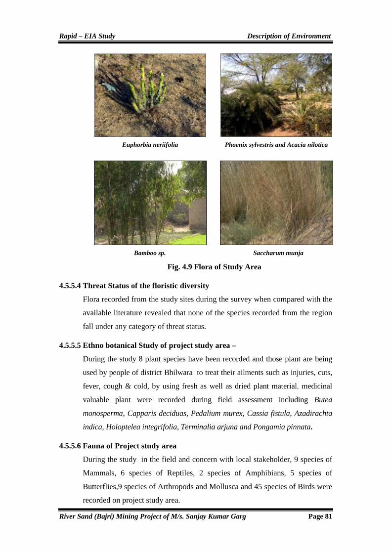
Rapid – EIA Study Description of Environment
River Sand (Bajri) Mining Project of M/s. Sanjay Kumar Garg Page 81
Fig. 4.9 Flora of Study Area
4.5.5.4 Threat Status of the floristic diversity
Flora recorded from the study sites during the survey when compared with the
available literature revealed that none of the species recorded from the region
fall under any category of threat status.
4.5.5.5 Ethno botanical Study of project study area –
During the study 8 plant species have been recorded and those plant are being
used by people of district Bhilwara to treat their ailments such as injuries, cuts,
fever, cough & cold, by using fresh as well as dried plant material. medicinal
valuable plant were recorded during field assessment including Butea
monosperma, Capparis deciduas, Pedalium murex, Cassia fistula, Azadirachta
indica, Holoptelea integrifolia, Terminalia arjuna and Pongamia pinnata.
4.5.5.6 Fauna of Project study area
During the study in the field and concern with local stakeholder, 9 species of
Mammals, 6 species of Reptiles, 2 species of Amphibians, 5 species of
Butterflies,9 species of Arthropods and Mollusca and 45 species of Birds were
recorded on project study area.
Euphorbia neriifolia Phoenix sylvestris and Acacia nilotica
Bamboo sp. Saccharum munja

Rapid – EIA Study Description of Environment
River Sand (Bajri) Mining Project of M/s. Sanjay Kumar Garg Page 82
Table 4.33 Fauna were recorded in Core and Buffer Zone of Project Study Site
S.No. Scientific Name Common Name Status Core Buffer
Mammals
Boselaphus tragocamelus Nilgai Sch.III - +
Lepus nigricollis Hare Sch.IV - +
Rattus rattus House Rat Sch.V + +
Herpestes edwardsii Common Mongoose Sch.II - +
Felis chaus Jungle cat Sch.II - +
Canis aureus Jackal Sch.II - +
Presbytis entellus Common Langur Sch.II - +
Funambulus pennant Four Striped Palm Squirrel Sch.IV + +
Lepus nigricollis Indian hare Sch. IV - +
Reptiles
Eryx johnii Red sand Boa Sch.IV - +
Mabuya carinata Brahminy Skink/ Bahmani - + +
Calotes versicolor Common Garden Lizard/Girgit - + +
Hemidactylus flaviviridis House Gecko/Chhipkali - - +
Geochelone elegans Starred Tortoise Kachhua Sch.IV - +
Naja naja Kobra Sch.II - +
Amphibians
Rana tigerinus Indian Bull Frog Sch.IV - +
Rana limnocharis Indian cricket Frog Sch.IV - +
Butterflies
Danaus chrysippus plain Tiger - + +
Ixias Marianne White –orange Tip - - +
Colotis eucharis Plain Orange-Tip - - +
Pieris canidia Indian Cabbage White - + +
Papilio polytes Common mormon - + +
Arthropods and Mollusca
Buthus sp. Scorpion - - +
Periplaneta amercana Cockroach - + -
Apis indica Choti Madhumakkhi - - +
Apis dorsata Badi Madhumakkhi - - +
Artema atlenta Spider - - +
Argiope arcuata Spider - + +
Valvata piscinalis Snail - + +
Oxynaia pugio Snail - + +
Gastropoda Sp. Mollusces - + +
Table 4.34 Birds species recorded on project study area
S.No. Scientific Name Common Name Status according to IWPA-1972
Core Area
Buffer Area
1 Pseudibis papillosa Black ibis Schedule IV - +
2 Threskiornis melanocephalus Black-headed Ibis Schedule IV - +

Rapid – EIA Study Description of Environment
River Sand (Bajri) Mining Project of M/s. Sanjay Kumar Garg Page 83
3 Actitis hypoleucos Common Sandpiper Schedule IV + +
4 Ceryle rudis Pied Kingfisher Schedule IV - +
5 Astur badius Shikra Schedule IV - +
6 Ardeola grayii Indian Pond Heron Schedule IV + +
7 Ardea cinerea Grey Heron Schedule IV - +
8 Vanellus cinereus Red-wattled lapwing - + +
9 Ploceus philippinus Baya weaver Schedule IV - +
10 Francolinus pondicerianus Grey francolin Schedule IV + +
11 Milvus migrans Black kite Schedule IV - +
12 Upupa epops Common hoopoe - - +
13 Merops orientalis Green bee-eater - + +
14 Centropus bengalensis Lesser coucal Schedule IV - +
15 Psittacula krameri Rose-ringed parakeet Schedule IV + +
16 Halcyon smyrnensis White-throated kingfisher Schedule IV + +
17 Apus affinis House swift - + +
18 Columba livia Rock pigeon Schedule IV - +
19 Streptopelia enegalensis Laughing dove Schedule IV - +
20 Streptopelia decaocto Eurasian dove Schedule IV - +
21 Streptopelia tranquebarica Red Collared dove Schedule IV + +
22 Psittacula krameri Rose-ringed parakeet Schedule IV - +
23 Mesophoyx intermedia Intermediate Egret Schedule IV - +
24 Egretta garzetta Little egret Schedule IV + +
25 Bubulcus ibis Cattle egret Schedule IV - +
26 Corvus splendens House crow Schedule V - +
27 Dicrurus macrocercus Black drongo Schedule IV + +
28 Saxicoloides fulicata Indian robin - - +
29 Sturnus pagodarum Brahminy starling Schedule IV - +
30 Sturnus contra Asian Pied starling Schedule IV - +
31 Acridotheres tristis Common myna Schedule IV + +
32 Pycnonotus cafer Red-vented bulbul Schedule IV - +
33 Turdoides striatus Jungle babbler Schedule IV - +
34 Nectarinia asiatica Purple sunbird Schedule IV - +
35 Passer domesticus House sparrow Schedule IV + +
36 Motacilla maderaspatensis White-browed wagtail - + +
37 Motacilla flava Yellow wagtail - - +
38 Microcarbo niger Little cormorant Schedule IV + +
39 Himantopus himantopus Black wing Still Schedule IV - +
40 Saxicola caprata Pied Bush chat Schedule IV - +
41 Prinia socialis Ashy Warn- Warbler Schedule IV - +
42 Chrysocola ptes festivus Wood piker Schedule IV - +
43 Amaurornis phoenicurus White-breasted waterhen Schedule IV - +
44 Dendrocitta vagabunda Rufous tree pie Schedule IV - +
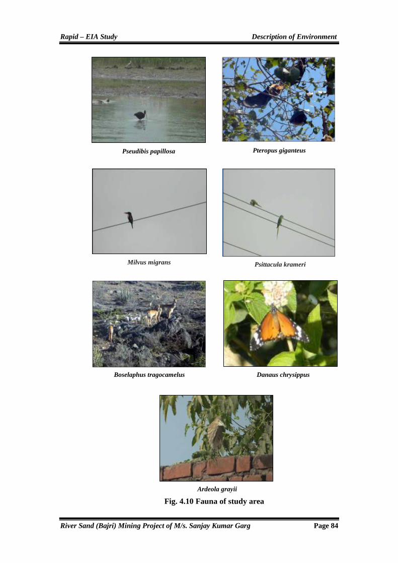
Rapid – EIA Study Description of Environment
River Sand (Bajri) Mining Project of M/s. Sanjay Kumar Garg Page 84
Fig. 4.10 Fauna of study area
Milvus migrans
Pseudibis papillosa Pteropus giganteus
Psittacula krameri
Boselaphus tragocamelus Danaus chrysippus
Ardeola grayii

Rapid – EIA Study Description of Environment
River Sand (Bajri) Mining Project of M/s. Sanjay Kumar Garg Page 85
4.5.5.7 Aquatic diversity
Riparian, free floating and submerge vegetation were observed in project
study area which are described in Table 4.35.
Table 4.35 Aquatic vegetation recorded in project study area
S.No. Scientific Name Local name Family Core Area
Buffer Area
1 Arundo donax Arundo Poaceae + +
2 Alternanthera philoxeroides - Amarenthaceae + +
3 Chenopodium album Bathua Amaranthaceae + +
4 Cyperus rotundus Nutgrass, Coco Cyperaceae + +
5 Eclipta alba Bhringraj Asteraceae + +
6 Hydrilla verticillata Hydrilla Hydrocharitales + +
7 Lemna perpusilla Small Duckweed Lemnaceae + +
8 Marsilia Sp. - Marsileaceae + +
9 Polygonum species Knotweed Polygonaceae + +
10 Phragmites karka - Poaceae + +
11 Scirpus cernuus - Cyperaceae + +
12 Spirodela polyrhiza Giant Duckweed Araceae + +
13 Typha elephantina Era Typhaceae + +
Fig. 4.11 Aquatic vegetation of study area
Algal Bloom. Scirpus cernuus
Marsilia Sp. Polygonum species

Rapid – EIA Study Description of Environment
River Sand (Bajri) Mining Project of M/s. Sanjay Kumar Garg Page 86
4.5.8 Cropping Pattern of the Study Area
Climatic factors chiefly determine the cropping pattern in the study area/
region. The area comes under arid zone of the state on account of non
availability of adequate water; cropping patter is by and large single only.
During Kharif, Maize, Groundnut, Soyabean, Sorghum and Urad are the main
crops cultivated and during Rabi, Wheat, Rapeseed, Gram and Mustard are the
main crops in the area.
4.6 SOCIO – ECONOMICS & DEMOGRAPHIC PROFILE
Every developmental project has its beneficial and adverse effects. The project
will impact on the local area and its socio-economic status. In EIA, all such
positive and negative impacts are to be identified, quantified or described and
predicted with futuristic approach of well being of environment and
community development in the area.
All developmental activities are undertaken for the social well-being and
upliftment for their living status in the area. Socio-economic plays a vital role
in environmental impact assessment study of such type of developmental
projects in the area/region.
4.6.1 Methodology Adopted for the Study
The general methodology of impact assessment that we have used to assess
socio-economic impacts associated with the project is as follows:
� Description of existing socio-economic or demographic environment in
the area of influence (baseline socio-economic set up of the proposed
project area)
� Procurement of relevant standards and criteria:
Review of secondary data, such as District Census data 2011 prepared by
Statistics Department of State Government, for the parameters of demography,
occupational structure of people and other details available within the core and
buffer zone of study area.
� Assessment of socio-economic impact significance.
� Mitigation measures for adverse socio-economic impacts and the
monitoring process.

Rapid – EIA Study Description of Environment
River Sand (Bajri) Mining Project of M/s. Sanjay Kumar Garg Page 87
4.6.1.1 Baseline Status
It is important to conduct socio-economic studies and assess the existing status
and also the impacts envisaged by proposed river sand mining project on the
socio-economic conditions of the study area, which will help in mitigating any
adverse impacts. The area comprises of government Gair Mumkin Nadi/
Nallah. There are no historical monuments, archaeological, cultural or
ecological places of importance in the study area.
4.6.2 Demographic Profile
As per the Census data for the year 2011, the study area over a radius of 10 km
has a number of villages. Total populations are about 138379 as per 2011
census in the study area. Out of the total population, 19.20 % are scheduled
caste and 10.08 % is scheduled tribes. Literacy status in study area depicts that
the area have 48.81 % literates and 51.19 % illiterates.
Table 4.36 Demographic Profile of Study Area (Bijoliya & Mandalgarh)
S.No. Name Household Population ST ST Literates Illiterates Literacy Rate
1 Amarpura 276 1162 541 449 480 682 41.31
2 Amartiya 130 592 98 72 282 310 47.64
3 Amli 201 952 106 97 380 572 39.92
4 Amritpuriya 54 257 12 0 160 97 62.26
5 Badanpura 131 665 24 0 344 321 51.73
6 Barodiya 162 686 64 402 238 448 34.69
7 Baroo Khera 217 1103 417 119 516 587 46.78
8 Barwa 41 200 0 93 112 88 56.00
9 Beeliya 189 916 264 49 550 366 60.04
10 Beer Ka Khera 101 436 41 164 285 151 65.37
11 Beethalpura 212 998 271 1 442 556 44.29
12 Bhagwanpura 38 195 60 10 127 68 65.13
13 Bhand Ka Khera 40 188 99 89 87 101 46.28
14 Bharenda 116 450 0 167 226 224 50.22
15 Bharji Ka Khera 38 161 104 0 59 102 36.65
16 Bharliya 102 505 112 0 102 403 20.20
17 Bhat Kheri 56 271 73 128 108 163 39.85
18 Bhawani Singh Ka Khera 58 287 147 31 81 206 28.22
19 Bheroopura 50 291 173 20 129 162 44.33
20 Bigod 2516 13062 2533 259 7149 5913 54.73
21 Bilod 110 528 186 11 224 304 42.42
22 Chainpuriya 77 333 15 24 152 181 45.65

Rapid – EIA Study Description of Environment
River Sand (Bajri) Mining Project of M/s. Sanjay Kumar Garg Page 88
23 Chainpuriya @ Theekariya 172 815 219 0 383 432 46.99
24 Chawandiya 66 303 45 0 111 192 36.63
25 Chenpuriya 87 391 42 330 229 162 58.57
26 Damti 77 279 20 148 126 153 45.16
27 Deogarh 21 93 22 55 41 52 44.09
28 Deogarh 40 178 0 0 121 57 67.98
29 Deopura 53 304 9 30 153 151 50.33
30 Deopura 36 152 7 0 69 83 45.39
31 Deopuriya 33 132 0 0 49 83 37.12
32 Deroli 72 379 51 134 206 173 54.35
33 Devipura 205 1036 12 61 416 620 40.15
34 Dhamniya 729 3230 942 141 1191 2039 36.87
35 Dhanwara 528 2320 160 1176 606 1714 26.12
36 Dhool Khera 6 49 0 7 23 26 46.94
37 Dhorela 134 598 177 42 236 362 39.46
38 Fatehpur 49 268 6 0 154 114 57.46
39 Fatehpura 15 56 0 56 21 35 37.50
40 Ganeshpura 197 1003 179 26 479 524 47.76
41 Ganeshpura 215 1075 163 50 613 462 57.02
42 Gariyan 38 148 0 91 52 96 35.14
43 Genoli 369 1661 551 128 720 941 43.35
44 Gopalpura 121 485 71 40 179 306 36.91
45 Gopalpura 130 671 226 0 345 326 51.42
46 Gothra 23 136 13 0 44 92 32.35
47 Govindpura 113 542 20 478 196 346 36.16
48 Govta 122 638 207 49 288 350 45.14
49 Haripura 3 9 0 9 0 9 0.00
50 Harjaspura 97 490 64 0 173 317 35.31
51 Harji Pura 66 332 189 0 215 117 64.76
52 Harpura 175 807 292 79 268 539 33.21
53 Heengwaniya 137 639 108 8 304 335 47.57
54 Jagpura 161 751 112 45 273 478 36.35
55 Jal Ka Khera 145 623 257 0 239 384 38.36
56 Jalam Ki Jhonpariyan 168 641 8 487 221 420 34.48
57 Jalindri 660 2840 225 262 1334 1506 46.97
58 Jaliya 328 1498 188 84 523 975 34.91
59 Jasaji Ka Khera 174 690 7 4 194 496 28.12
60 Jasuji Ka Khera 259 1152 293 33 591 561 51.30
61 Jojwa 713 3616 693 20 1869 1747 51.69
62 Kachhola 1482 7350 1823 561 4182 3168 56.90
63 Kacholiya Kalan 48 210 0 157 54 156 25.71
64 Kacholiya Khurd 54 227 0 0 68 159 29.96

Rapid – EIA Study Description of Environment
River Sand (Bajri) Mining Project of M/s. Sanjay Kumar Garg Page 89
65 Kalyanpura 118 629 202 0 500 129 79.49
66 Kaner 1 7 0 7 0 7 0.00
67 Karanpura 89 442 0 0 249 193 56.33
68 Karlao 54 229 0 161 66 163 28.82
69 Khachrol 438 2088 452 169 922 1166 44.16
70 Khakhunda 103 472 67 133 192 280 40.68
71 Kham Ka Khera 45 197 0 164 100 97 50.76
72 Khatwara 912 4307 985 176 2073 2234 48.13
73 Kherariya 134 679 138 44 329 350 48.45
74 Kherpura @ Meghpura 75 357 37 0 81 276 22.69
75 Kishanniwas 53 262 29 0 155 107 59.16
76 Kishanpuriya 73 347 0 35 181 166 52.16
77 Kishanpuriya 52 246 225 11 89 157 36.18
78 Lachhmangarh 50 231 38 173 87 144 37.66
79 Lachhmanpura 28 149 13 0 89 60 59.73
80 Ladpura 728 3267 606 214 1901 1366 58.19
81 Lalpura 105 488 28 0 214 274 43.85
82 Latala 50 260 0 0 104 156 40.00
83 Laxmipura 52 254 111 33 80 174 31.50
84 Lodhiyana 133 691 0 146 290 401 41.97
85 Madhopura 148 676 108 355 205 471 30.33
86 Madhu Puriya 51 238 77 0 156 82 65.55
87 Mahtaji Ka Khera 210 1031 176 95 452 579 43.84
88 Mahuwa 1099 5487 1313 312 2762 2725 50.34
89 Makariya 145 602 199 162 229 373 38.04
90 Mandalgarh 2817 13844 2619 402 8761 5083 63.28
91 Manganj 80 355 58 0 260 95 73.24
92 Manpura 647 3104 810 223 1669 1435 53.77
93 Manpura 44 212 0 38 102 110 48.11
94 Meghpura 54 222 37 0 112 110 50.45
95 Mohanpura 114 532 50 0 200 332 37.59
96 Mohanpura 483 1951 486 686 725 1226 37.16
97 Mol 134 650 30 56 273 377 42.00
98 Motipura 71 368 9 139 174 194 47.28
99 Nahargarh 198 797 253 58 297 500 37.26
100 Nahargarh 155 732 295 10 423 309 57.79
101 Naya Gaon 246 1282 49 134 783 499 61.08
102 Nayagaon 54 301 13 0 147 154 48.84
103 Neel Ki Kheri 124 648 28 108 321 327 49.54
104 Padampura 80 418 30 0 185 233 44.26
105 Padampura 145 627 85 75 281 346 44.82
106 Peepalda 124 582 81 55 331 251 56.87

Rapid – EIA Study Description of Environment
River Sand (Bajri) Mining Project of M/s. Sanjay Kumar Garg Page 90
107 Peethaji Ka Khera 156 808 98 92 394 414 48.76
108 Phoolji Ki Kheri 95 444 25 82 255 189 57.43
109 Pratappura 121 529 0 0 204 325 38.56
110 Raiseengpura 156 817 205 37 422 395 51.65
111 Rajgarh 151 739 74 117 299 440 40.46
112 Rajpura 120 517 134 5 244 273 47.20
113 Ralayata 287 1281 228 176 623 658 48.63
114 Rampuriya 175 795 124 165 342 453 43.02
115 Rampuriya 145 621 61 560 157 464 25.28
116 Rampuriya 153 664 152 14 313 351 47.14
117 Rampuriya 1 6 0 6 2 4 33.33
118 Ramthali 185 848 13 41 346 502 40.80
119 Ranikhera 225 1154 232 0 518 636 44.89
120 Rooparel 32 126 0 126 48 78 38.10
121 Sadaramji Ka Khera 126 669 142 14 476 193 71.15
122 Salampura 106 473 204 0 128 345 27.06
123 Sand 179 737 114 0 267 470 36.23
124 Sangrampura 49 193 0 0 47 146 24.35
125 Sarana 491 2470 427 176 1130 1340 45.75
126 Sarthala 471 1992 676 65 917 1075 46.03
127 Shopura 33 162 0 148 10 152 6.17
128 Shreenagar 105 514 0 0 303 211 58.95
129 Shyam Garh 84 361 4 55 195 166 54.02
130 Suras 394 1849 366 270 804 1045 43.48
131 Thal Kalan 602 2552 245 169 962 1590 37.70
132 Thalkhurd 163 743 257 0 231 512 31.09
133 Tharoda 270 1374 154 11 912 462 66.38
134 Tiroli 139 561 0 35 241 320 42.96
135 Ummedpura 140 554 53 122 144 410 25.99
136 Ummedpura 105 510 103 112 270 240 52.94
Total 29211 138379 26569 13948 67546 70833 44.36
Fig. 4.12 Demographic Profile-Literacy Status of the Study Area
Rapid – EIA Study Description of Environment
River Sand (Bajri) Mining Project of M/s. Sanjay Kumar Garg Page 91
4.6.3 Socio-economic Profile
The review of socio-economic profile of the villages around the mining site is
essential for understanding social impacts due to mining activity.
4.6.4 Literacy Levels
As per census data for the year 2011, the study area over a radius of 10 km
from the mining site has 67546 No. of literates. The summary of village-wise
literacy status is given in Table-4.37.
4.6.5 Occupational Structure
With reference to the Table-4.38 which have been generated through the study
of secondary occupational data for the villages within 10 km radius of the
proposed mining site. In the study area, predominant activity is agriculture,
cultivators and agricultural labours. The total workers in the study area are
68891 out of this main workers are 55778 and marginal workers are 13113.
Table-4.38 clearly shows that the status of non workers in the study area is
about 69488. The main occupation in the region is mining and allied activities.
Table 4.37 Occupational Structure of Study Area (Bijoliya & Mandalgarh)
S.No. Name Population Total Worker
Main Worker
Marginal Worker
Non Worker
1 Amarpura 1162 626 585 41 536
2 Amartiya 592 331 321 10 261
3 Amli 952 455 441 14 497
4 Amritpuriya 257 125 92 33 132
5 Badanpura 665 381 378 3 284
6 Barodiya 686 232 217 15 454
7 Baroo Khera 1103 644 202 442 459
8 Barwa 200 97 92 5 103
9 Beeliya 916 484 438 46 432
10 Beer Ka Khera 436 254 229 25 182
11 Beethalpura 998 591 573 18 407
12 Bhagwanpura 195 80 67 13 115
13 Bhand Ka Khera 188 94 87 7 94
14 Bharenda 450 252 140 112 198
15 Bharji Ka Khera 161 100 93 7 61
16 Bharliya 505 291 276 15 214
17 Bhat Kheri 271 143 112 31 128
18 Bhawani Singh Ka Khera 287 147 78 69 140

Rapid – EIA Study Description of Environment
River Sand (Bajri) Mining Project of M/s. Sanjay Kumar Garg Page 92
19 Bheroopura 291 102 80 22 189
20 Bigod 13062 5801 5150 651 7261
21 Bilod 528 230 192 38 298
22 Chainpuriya 333 118 105 13 215
23 Chainpuriya @ Theekariya 815 412 226 186 403
24 Chawandiya 303 172 142 30 131
25 Chenpuriya 391 206 198 8 185
26 Damti 279 164 91 73 115
27 Deogarh 93 27 25 2 66
28 Deogarh 178 99 88 11 79
29 Deopura 304 176 98 78 128
30 Deopura 152 80 42 38 72
31 Deopuriya 132 71 65 6 61
32 Deroli 379 201 181 20 178
33 Devipura 1036 635 575 60 401
34 Dhamniya 3230 1679 1263 416 1551
35 Dhanwara 2320 1087 961 126 1233
36 Dhool Khera 49 12 12 0 37
37 Dhorela 598 293 250 43 305
38 Fatehpur 268 155 148 7 113
39 Fatehpura 56 30 21 9 26
40 Ganeshpura 1003 585 582 3 418
41 Ganeshpura 1075 516 474 42 559
42 Gariyan 148 81 59 22 67
43 Genoli 1661 880 599 281 781
44 Gopalpura 485 300 73 227 185
45 Gopalpura 671 273 259 14 398
46 Gothra 136 66 66 0 70
47 Govindpura 542 226 226 0 316
48 Govta 638 392 374 18 246
49 Haripura 9 7 7 0 2
50 Harjaspura 490 294 136 158 196
51 Harji Pura 332 186 178 8 146
52 Harpura 807 484 480 4 323
53 Heengwaniya 639 377 374 3 262
54 Jagpura 751 450 445 5 301
55 Jal Ka Khera 623 383 343 40 240
56 Jalam Ki Jhonpariyan 641 367 297 70 274
57 Jalindri 2840 1369 1127 242 1471
58 Jaliya 1498 738 681 57 760

Rapid – EIA Study Description of Environment
River Sand (Bajri) Mining Project of M/s. Sanjay Kumar Garg Page 93
59 Jasaji Ka Khera 690 469 452 17 221
60 Jasuji Ka Khera 1152 669 642 27 483
61 Jojwa 3616 1990 1688 302 1626
62 Kachhola 7350 3066 2861 205 4284
63 Kacholiya Kalan 210 113 113 0 97
64 Kacholiya Khurd 227 129 129 0 98
65 Kalyanpura 629 348 329 19 281
66 Kaner 7 4 4 0 3
67 Karanpura 442 187 175 12 255
68 Karlao 229 133 78 55 96
69 Khachrol 2088 1195 570 625 893
70 Khakhunda 472 301 247 54 171
71 Kham Ka Khera 197 89 83 6 108
72 Khatwara 4307 2521 2118 403 1786
73 Kherariya 679 360 238 122 319
74 Kherpura @ Meghpura 357 157 156 1 200
75 Kishanniwas 262 149 139 10 113
76 Kishanpuriya 347 158 103 55 189
77 Kishanpuriya 246 111 19 92 135
78 Lachhmangarh 231 107 18 89 124
79 Lachhmanpura 149 81 76 5 68
80 Ladpura 3267 1612 1287 325 1655
81 Lalpura 488 284 245 39 204
82 Latala 260 127 2 125 133
83 Laxmipura 254 130 130 0 124
84 Lodhiyana 691 392 382 10 299
85 Madhopura 676 394 393 1 282
86 Madhu Puriya 238 121 106 15 117
87 Mahtaji Ka Khera 1031 555 547 8 476
88 Mahuwa 5487 2490 2059 431 2997
89 Makariya 602 267 13 254 335
90 Mandalgarh 13844 5207 4125 1082 8637
91 Manganj 355 211 183 28 144
92 Manpura 3104 1504 959 545 1600
93 Manpura 212 117 74 43 95
94 Meghpura 222 82 40 42 140
95 Mohanpura 532 321 287 34 211
96 Mohanpura 1951 1106 533 573 845
97 Mol 650 353 346 7 297
98 Motipura 368 161 131 30 207

Rapid – EIA Study Description of Environment
River Sand (Bajri) Mining Project of M/s. Sanjay Kumar Garg Page 94
99 Nahargarh 797 361 287 74 436
100 Nahargarh 732 317 292 25 415
101 Naya Gaon 1282 607 583 24 675
102 Nayagaon 301 180 180 0 121
103 Neel Ki Kheri 648 553 131 422 95
104 Padampura 418 184 183 1 234
105 Padampura 627 265 185 80 362
106 Peepalda 582 323 3 320 259
107 Peethaji Ka Khera 808 480 467 13 328
108 Phoolji Ki Kheri 444 157 110 47 287
109 Pratappura 529 238 229 9 291
110 Raiseengpura 817 478 473 5 339
111 Rajgarh 739 425 270 155 314
112 Rajpura 517 261 235 26 256
113 Ralayata 1281 684 587 97 597
114 Rampuriya 795 436 423 13 359
115 Rampuriya 621 270 171 99 351
116 Rampuriya 664 363 346 17 301
117 Rampuriya 6 2 2 0 4
118 Ramthali 848 312 157 155 536
119 Ranikhera 1154 640 628 12 514
120 Rooparel 126 66 64 2 60
121 Sadaramji Ka Khera 669 399 378 21 270
122 Salampura 473 276 243 33 197
123 Sand 737 433 405 28 304
124 Sangrampura 193 116 115 1 77
125 Sarana 2470 1154 955 199 1316
126 Sarthala 1992 1210 629 581 782
127 Shopura 162 74 67 7 88
128 Shreenagar 514 297 119 178 217
129 Shyam Garh 361 121 75 46 240
130 Suras 1849 1067 1056 11 782
131 Thal Kalan 2552 1263 1153 110 1289
132 Thalkhurd 743 372 281 91 371
133 Tharoda 1374 765 678 87 609
134 Tiroli 561 293 22 271 268
135 Ummedpura 554 307 252 55 247
136 Ummedpura 510 320 150 170 190
Total 138379 68891 55778 13113 69488

Rapid – EIA Study Description of Environment
River Sand (Bajri) Mining Project of M/s. Sanjay Kumar Garg Page 95
Fig. 4.13 Occupational Structure showing Worker & Non-Worker Status of the Study Area
4.6.6 Basic Amenities
Infrastructure resource base in villages under the study area of proposed
project at near village Amarpura, Asawari, Bagthala, Baroo Khera, Bedunda,
Bedunda, Beeliya, Bhand Ka Khera, Bharliya, Bhawani Singh Ka Khera,
Bilod, Chainpuriya, Chandpura, Chhitarsingh Ji Ka Khera, Chohli, Daulji Ka
Khera, Devipura, Gandhari, Gariyan, Gheoriya, Golbari, Gopalpura, Govta,
Harisinghji Ka Khera, Hastra, Heengwaniya, Jaliya, Jojwa, Kankoliya, Kanti,
Katariyon Ka Khera, Khakhunda, Khangarji Ka Khera, Khatwara, Khatwara,
Kherpura, Lakshmipura, Lodhiyana, Mahtaji Ka Khera, Moi, Padampura,
Panderi, Peethalpura, Phalasiya, Phoolji Ki Kheri, Pratappura, Ralayata,
Ramthali, Sand, Shyam Garh, Tahla, Thal Kalan, Thalkhurd, Tiroli,
Ummedpura Tehsil- Bijoliya & Mandalgarh, District- Bhilwara (Rajasthan) is
satisfactory. Education facility up to primary level is available in all the
villages. Facility up to middle school and high school is also available in some
of the villages. Medical facility includes primary health centre (PHC),
registered private practitioner etc. is available in some of the villages. In most
of the villages, medical facility is available at a distance of 5 to 10 km. Govt.
The main drinking water resource is through private dug-wells and bore wells.
Roads are built with pucca and kaccha, both of type. Density of house along
the main arterial roads comparatively higher than inner village areas. Other
facility includes rest shelter, canteen, amusement center, communication
facility with mobile telephone services and landline available at site. Other
amenities for workers and staff in form of bonus, PF is provided timely.

Rapid – EIA Study Anticipated Environmental Impacts & Mitigation Measures
River Sand (Bajri) Mining Project of M/s. Sanjay Kumar Garg Page 96
CHAPTER-5
ANTICIPATED ENVIRONMENTAL
IMPACTS & MITIGATION
MEASURES

Rapid – EIA Study Anticipated Environmental Impacts & Mitigation Measures
River Sand (Bajri) Mining Project of M/s. Sanjay Kumar Garg Page 97
5.0 GENERAL
In order to understand the impacts, the baseline data generated requires being
superimposed by impacts from different activities proposed to be taken up.
Every developmental project will have both positive and negative impacts on
the surroundings. Likely impacts on environment can be mitigated by proper
and effective environment management plan (EMP). Superimposed predicted
impacts over baseline environmental scenario give the ultimate
environmental scenario. With such an assessment an impact score will be
obtained with implementation of project without any mitigation measures.
Each effects of the project on each environmental parameter are detailed
below in accordance with the parameters of environment likely to be
affected. In the present study, baseline environmental scenario was
established through environmental monitoring data for the period of
December-2013, January 2014, February-2014. On the behalf of impact
analysis, the proposed mitigating measures and future monitoring
requirement are incorporated in the environment management plan for
minimizing the impacts.
In order to assessment of environmental process, the mitigation measures have
been developed with a view to bring down the levels of impacts within the
prescribed permissible limits. Based on the project details and status of
baseline environmental scenario, potential impacts as a result of the mining
project of Shri Sanjay Kumar Garg have been identified. The environmental
impact assessment of activities of project proponent comprises the following
for proposed production of mineral 28.05 Lac TPA of River sand (Bajri) from
this mine. The key environmental problems arising due to proposed project of
river sand mining are as follows:
� Change in Land-Use (Land Degradation, Soil Erosion etc.)
� Change in Ambient Air Quality
� Alteration in Water Quality Characteristics
� Change in Ambient Noise level
� Changes in Vegetation characteristics of the area
� Changes in Traffic Scenario
� Change in Socio-economic Status

Rapid – EIA Study Anticipated Environmental Impacts & Mitigation Measures
River Sand (Bajri) Mining Project of M/s. Sanjay Kumar Garg Page 98
5.1 IMPACTS ON LAND ENVIRONMENT
Predictions of impact of mining activity on land environment are based on the
nature of activities and associated aspects of environment. Degradation of
land is not a very significant adverse impact of riverbed mining due creation
of access roads, mining operations, transportation of mined out material.
Impact of sand mining may cause:
(i) Soil erosion due to excessive undercutting of river banks.
(ii) Changes in channel slope and velocity.
(iii) Changes in the downstream i.e. Deposition of sediment.
(iv) Alteration in channel bed morphology.
In order to prevent the environmental degradation of mine lease area and its
surroundings, the following measures shall be taken;
� Creation of ponds and pits on the river bed shall not be allowed.
� Mining will be carried out in scientific manner to avoid overcutting of
river banks.
� Slope and gradient of channel will not be disturbed due to proposed
mining operation.
� No modification in channel morphology is proposed.
The proposed project of river sand (Bajri) mining will not be much impact of
the project activity on the soil, land use and cropping pattern in the
surrounding areas as the mine is confined to riverbed only, there will no other
land disturbed. Vegetation is sparsely distributed in the area except few thorny
shrubs/bushes. No waste generated during proposed mining operation. Thus
no waste dump proposal at mine site. Following impacts will be on land use
due to proposed project of river sand mining as:
Table 5.1 Land Use Operational & Post Operational
S.No. Particular Present End of 5 Year
1. Area excavated 3.0 301
2. Storage of Top Soil Nil Nil
3. Overburden/ Dump Nil Nil
4. Mineral Storage Nil Nil
5. Infrastructure (Workshop, administration building etc)
Nil Nil
6. Roads 5.0 Ha. 5 Ha.

Rapid – EIA Study Anticipated Environmental Impacts & Mitigation Measures
River Sand (Bajri) Mining Project of M/s. Sanjay Kumar Garg Page 99
7. Railways Nil Nil
8. Green Belt - 5.4
9. Tailing Pond Nil Nil
10. Effluent Treatment Plant Nil Nil
11. Mineral Separation Plant Nil Nil
12. Township Area Nil Nil
13. Unworked 1667.85 1364.35
Total 1675.85 Ha. 1675.85 Ha.
5.2 IMPACTS ON WATER ENVIRONMENT
Excavation of sand within stream bed has a direct impact on the stream’s physical
characteristics such as geometry, gradient, substrate composition and stability,
depth, velocity and sediment transport. Climatologically, the district Ajmer comes
in semi-arid region. Average annual rainfall is about 500-600mm. Intensity of
rainfall in the district is moderate. Generally, ephemerals types of river are found
in the district. Water flows in rivers only in monsoon season. Anticipated impact
on water environment is alteration of flow patterns resulting from modification of
the river bed. No proposal for pumping of water either from river or tapping the
groundwater is envisaged. There will not be any adverse impacts on surface
hydrology and ground water regime. Mining of river sand is confined to 3m
depth from surface of channel or above the ground water table whichever is less.
Thus no ground water pollution is expected as the mining operation will not
intersect the ground water table. No liquid waste will be generated due to mining
or any other way. During mining, no diversion or modification of any part of the
river is proposed. The status of surface water and ground water in 10km radius in
Buffer zone of study area are depicted in table 5.2.
Table 5.2 Status of Ground water and Surface water in Study Area
Station Code Location Distance Direction
GW1 Laxmipura 1.5 km East
GW2 Nandary 4.5 km West
GW3 Rasingpura 3.75 km South East
GW4 Chaudhariyas 3.0 km North West
GW5 Hajiwas 2.75 km North west
GW6 Manoharpura 4.50 km North east
SW 1 Banas River - -
SW 2 Berach River* - -
Rapid – EIA Study Anticipated Environmental Impacts & Mitigation Measures
River Sand (Bajri) Mining Project of M/s. Sanjay Kumar Garg Page 100
SW 3 Kothari River* 2.0 km North
SW 4 Menali Nadi* - -
SW 5 Unli Nadi* - -
SW 6 Kachhola Pond* 4.0 km East
*denoted dried (GW= Ground Water, SW=Surface Water)
The ground water will not encounter in the workings. Rainwater flows only in
rainy days from mining area. The measures proposed in environment
management plan will cause to improve surface and ground water quality. The
impact on water has been considered as follows:
� Water Consumption
� Alteration of flow pattern/modification of river bed
� Mine seepage and impact on Ground water regime
� Impact on surface water bodies (Quantity and Quality)
� Storm water management (Run-off water)
5.2.1 Water Consumption/Water Demand
The water consumption at the mine is as following:
Table 5.3 Water Requirement at Mine site
S.No. Description Water
Requirement (KLD)
Source
1. Dust Suppression 6.0 Bore/Tube well in nearby villages.
2. Drinking & other domestic uses
3.0 Bore/Tube well in nearby villages.
3. Green belt 5.0 Bore/Tube well in nearby villages.
Total 14.0
5.2.2 IMPACT ON WATER QUALITY
Mining is proposed upto 3m depth only from surface of river channel or water
table whichever is less. There is no impact envisaged on quality of groundwater.
During mining ground water table will not be intersected. Ground water table
will remain always below the pit depth & hence not encounter in the workings
up to 3m UPL (Ultimate Pit Limit). Flow and direction will not be altered by
mining or any other way. Slope of the area is fairly even.
There will not be any wastewater discharges into nearby water bodies from the
mining operations and there is no possibility of pollution of water resources
due to liquid waste. Zero discharge status will be maintained at mine site. So

Rapid – EIA Study Anticipated Environmental Impacts & Mitigation Measures
River Sand (Bajri) Mining Project of M/s. Sanjay Kumar Garg Page 101
there is no water pollution due to discharge of water during monsoon. To
check the erosion and prevent silt being carried during monsoon period, a
series of plants would be planted at riparian zone (erosion prone).
5.3 IMPACTS ON AIR ENVIRONMENT
The proposed mining operations are not anticipated to raise the concentration of
the pollutants beyond prescribed limits. However, the following measures would
be adopted to mitigate the PM10 levels in ambient air. Dust particles generated
during various mining activities when airborne become lead to increase in PM10
level in the ambient air. Ambient air quality was studied and predicted through air
dispersion modeling that the mining activity is not likely affect the quality of air.
On the basis of modeling technique, anticipated impacts on ambient air
environment are insignificant. The major source of dust generation is the
transport of material by trucks and tippers. Adequate control measures shall be
taken during mining operations as well as transportation of minerals. The
following steps shall be adopted to prevent air pollution due to airborne dust.
� Plantation of trees along the 7.5m of riparian zone (erosion prone zone),
along haul roads to help to reduce the impact of dust in the nearby villages.
� Dust mask provided to the workers engaged at dust generation points like
excavations and loading points.
� Major sources of air pollution are the road transport network of the trucks.
� The dust suppression measures like water spraying arrangement will be
taken on the haul roads and other unworked areas to control fugitive
emission.
� Utmost care will be taken to prevent spillage of sand from the trucks.
� Overloading will be prevented. The trucks/tippers will be covered by
tarpaulin.
5.3.1 Prediction of Impacts
Prediction of impacts is the most important component in Environmental Impact
assessment studies. Many scientific techniques and methodologies are available to
predict impacts on physico-ecological and socio-economic environment. Such
predictions are superimposed over the baseline status of environmental quality to

Rapid – EIA Study Anticipated Environmental Impacts & Mitigation Measures
River Sand (Bajri) Mining Project of M/s. Sanjay Kumar Garg Page 102
derive the ultimate scenario of environmental conditions. The prediction of
impacts helps to identify and implement environmental management plan during
and after the execution of the developmental mining activity to minimize the
deterioration of environmental quality.
The mathematical models attempt to quantitatively describe the cause and effect
relationships between sources of pollution and different components of the
environment, viz air, noise, water, land, biological and socio-economic. There are
also various scientific techniques/ methodologies available to predict the
environmental impacts quantitatively as well as qualitatively.
The mathematical models used include steady state Gaussian Plume Dispersion
model designed for multiple applications for air quality. For land, biological and
socio - economic environments, the predictions have been made based on
available scientific knowledge and techniques. In the present study, the most
probable impacts on various components of the surrounding environment due to
the proposed River Sand mining operations have been predicted using
mathematical models and statistical techniques.
Prediction of impacts on air environment has been carried out taking into
consideration the proposed production and increase in emissions. This project
proposal is production of 28.05 Lac TPA River sand. Details of production
considered for prediction of impacts is given in Table below:
Table 5.4 Details of Production (Tonnes per Year)
Years Proposed Production in Metric Tonne
First 28,05,000 Tons
Second 28,05,000 Tons
Third 28,05,000 Tons
Fourth 28,05,000 Tons
Fifth 28,05,000 Tons
Total 1,40,25,000 Tons (Source: Mining Plan)
5.3.2 Impact on Air Environment
The air quality impact of a source or group of sources is evaluated by the use of
mathematical models. The models simulate the relationships between air pollutant
emissions and the resulting impact on air quality. The inputs to the model include
data relating to emissions, meteorology and atmospheric details like ambient
Rapid – EIA Study Anticipated Environmental Impacts & Mitigation Measures
River Sand (Bajri) Mining Project of M/s. Sanjay Kumar Garg Page 103
temperature, wind speed and wind direction all of which are determined by
formulating impact scenarios. The methodology adopted for air pollution
modeling for different area sources are shown in Figure 5.1 and the various
activities that are contributing dust pollution during opencast mining is shown in
Figure 5.2.
The estimation and evaluation of dust generation from mining activities is an
immensely complicated procedure. Dust to be generated during proposed mining
activities will be from various sources like excavation operations which generate
fugitive dust harmful to the human health and environment. Apart from this,
vehicular movement within and around the mining activity will also generate
huge quantity of dust. The proposed River Sand mine activity proposes to use
heavy equipments like hydraulic excavators, loaders, dumpers and dozers which
act as sources generating dust pollution along with movement of vehicles within
the mining area acting as line sources.
5.3.3 Overview of Environmental Impacts due to Mining
5.3.3.1 Operation & Major Pollutant Sources
At mining sites, the major pollutant sources of concern include transportation
of mineral, loading of mineral & moving of mining machineries.
5.3.4 Long-term Impacts of Mining
5.3.4.1 Impacts on Air Quality
The primary air pollutant of concern at mining sites is particulate matter. There
are established standards as per the NAAQS. A variety of mining operations emit
particulate, usually as fugitive dust (as opposed to emissions from stacks), and
relatively simple controls are often sufficient.
� Loading and unloading bins for minerals generate dust. Again water sprays are
typically used for control
� Equipment and vehicles travel on access and haul roads are major sources of fine
and coarse dust. Most mines use water trucks to dampen the surface periodically
� Venting of shafts can emit dusts
� Wind also entrains dust from dumps and spoil piles, roads, tailings (either dry as
disposed or the dry portions of impoundments), and other disturbed areas. Spray
from water trucks are often used when the mine is operating. During temporary

Rapid – EIA Study Anticipated Environmental Impacts & Mitigation Measures
River Sand (Bajri) Mining Project of M/s. Sanjay Kumar Garg Page 104
closures, particularly after the active life, stabilization and reclamation are aimed
in part at reducing fugitive dust emissions. Tailings in particular can be a potent
source of fine particulate; temporary or permanent closure greatly increases the
potential for surface tailings to dry out and become sources of dust.
The emission rates were calculated based on the field activities and the dust
emission effect was estimated at different location. The details are as bellow.
Table 5.5: Line Source Emissions
S.No. Input Details Units Sand
1 Silt content (Sp) % 10
2 No. of wheels truck carrying mined material (Wv) nos 6
3 Empty weight of the Vehicle Tons 10
4 Loaded weight of the Vehicle(Mv) Tons 30
5 Average speed of the Vehicle (Vv) miles/hour 25
6 Total no of working days (Tw) days 275
7 Total no of rainy days/ppt 0.01m (Dp) days 31
8 Production Capacity TPA 2805000
9 No. of Trips per year no.s 140250
10 No. of trips per day no.s 510
11 No. of working hours Hr.s 8
12 No. of vehicles per hour no.s/hrs 63.750
13 Width of the road in mine m 10
Emission Factor (Evt) gm/sec 1.1X10⁻²
Table 5.6: Area Source Emissions
S.No. Input Details Units Sand
1 Production TPA 2805000
2 Operational hours Hours/day 8
3 Total working days Days/year 275
4 Total operational hours Hours 2200
5 Activity rate Tons/hour 1275.00
6 Emission of dust as per AP 42 Manual g/ton 0.6
7 Emission of dust g/hour 765.00
8 Area of influence - length m 25
9 Area of influence - breath m 25
10 Area of influence - emissions m2 625
11 Uncontrolled Emission rate g/sec/m2 3.4X 10-04
12 Reduction % due to control measures % 75
After Controlled Emission rate g/sec/m2 8.5X10-05

Rapid – EIA Study Anticipated Environmental Impacts & Mitigation Measures
River Sand (Bajri) Mining Project of M/s. Sanjay Kumar Garg Page 105
Fig. 5.1 Methodology adopted for Air Pollution Modeling
Generation / Collection of Data
Laboratory Analysis & Estimation
Baseline Air Quality Baseline Air Quality Baseline Air Quality
Hourly Data
Windrose Diagram
Stability Class
Identification of Mining Activities
Estimation of Activity wise Emission Rate
Modeling for PM10 Concentration by ISCST3 MODEL
Prediction for PM10 Concentration Due to Mining Only
Prediction Total PM10 Concentration in the Area
Isopleths of SPM Concentration Due to Mining Only
PM10 2 SO NOx
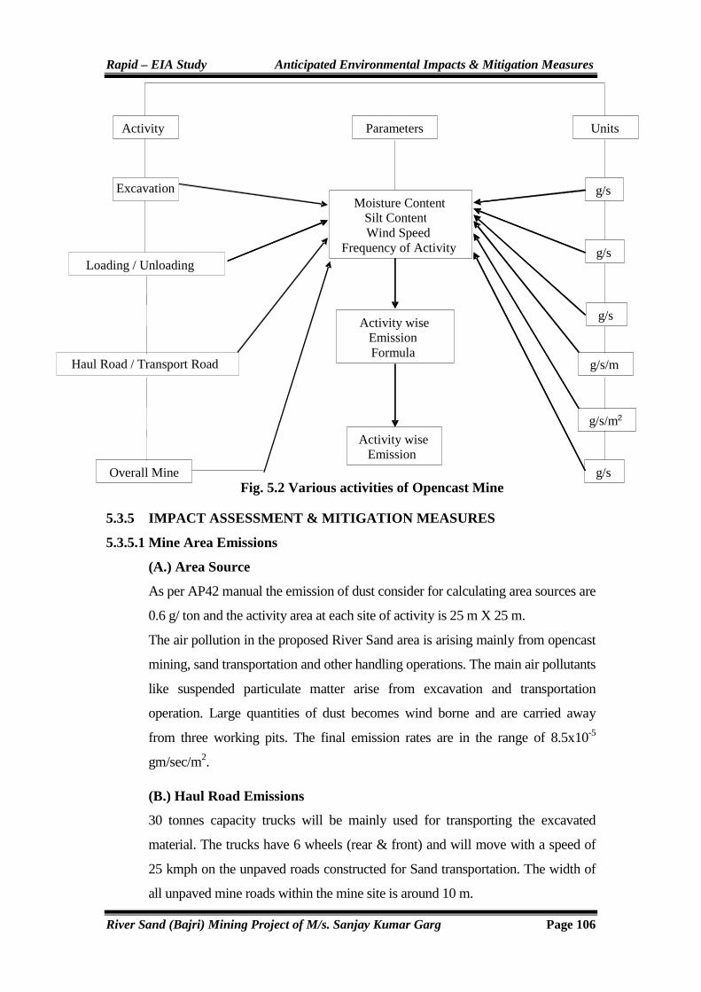
Rapid – EIA Study Anticipated Environmental Impacts & Mitigation Measures
River Sand (Bajri) Mining Project of M/s. Sanjay Kumar Garg Page 106
Fig. 5.2 Various activities of Opencast Mine
5.3.5 IMPACT ASSESSMENT & MITIGATION MEASURES
5.3.5.1 Mine Area Emissions
(A.) Area Source
As per AP42 manual the emission of dust consider for calculating area sources are
0.6 g/ ton and the activity area at each site of activity is 25 m X 25 m.
The air pollution in the proposed River Sand area is arising mainly from opencast
mining, sand transportation and other handling operations. The main air pollutants
like suspended particulate matter arise from excavation and transportation
operation. Large quantities of dust becomes wind borne and are carried away
from three working pits. The final emission rates are in the range of 8.5x10⁻⁵
gm/sec/m2.
(B.) Haul Road Emissions
30 tonnes capacity trucks will be mainly used for transporting the excavated
material. The trucks have 6 wheels (rear & front) and will move with a speed of
25 kmph on the unpaved roads constructed for Sand transportation. The width of
all unpaved mine roads within the mine site is around 10 m.
Activity
Loading / Unloading
Haul Road / Transport Road
Overall Mine
Units
g/s
g/s
g/s
g/s/m
g/s/m2
g/s
Parameters
Moisture ContentSilt ContentWind Speed
Frequency of Activity
Activity wise Emission Formula
Activity wise Emission
Excavation

Rapid – EIA Study Anticipated Environmental Impacts & Mitigation Measures
River Sand (Bajri) Mining Project of M/s. Sanjay Kumar Garg Page 107
Line sources covering the mine activity site and heavy vehicular movement areas
were considered for estimating the fugitive dust dispersion in the mine stretch of
mine road is considered as Four line sources from where all the heavy trucks will
be transporting the River Sand to the storage yards. The final line source
considered for the dispersion modeling to the main road on which only trucks
loaded with Sand will be transported. The final emission rates calculated for
trucks carrying sand are in the range of 1.1x10⁻² gm/ sec.
The details of emissions expected from vehicular movement during mining
activity are given in Table 5.5. The line source emission rates for the proposed
River sand mine are derived from the following equation:
Where,
Evt - Emission factor (lb / vehicle / mile travelled)
Sp - Silt content of road surface material
Vv - Mean vehicle velocity (miles / hour)
Mv - Mean vehicle mass (tonnes)
Wv - Mean number of wheels
Dp - Number of days per year with atleast 0.01 inch of precipitation
5.3.6 Air Quality Prediction
Simulation Model for Prediction Using INDUSTRIAL SOURCE COMPLEX (ISC) AERMOD View
The pollutants released into the atmosphere will disperse in the down wind
direction and finally reach the ground at farther distance from the source. The
concentration of ground level concentrations mainly depends upon the
strength of the emission source and micrometeorology of the study area.
In order to estimate the ground level concentrations due to the emission from
the proposed project, EPA approved Industrial Source Complex ISC
AERMOD View Model has been employed.
The mathematical model used for predictions on air quality impact in the present
study is ISC-AERMOD View-6.8.6. It is the next generation air dispersion
model, which incorporates planetary boundary layer concepts.
Evt = 5.9 Sp Vv Mv 0.7 Wv
0.5 365-Dp
12 30 3 4 365

Rapid – EIA Study Anticipated Environmental Impacts & Mitigation Measures
River Sand (Bajri) Mining Project of M/s. Sanjay Kumar Garg Page 108
The AERMOD is actually a modeling system with three separate components:
AERMOD (AERMIC Dispersion Model), AERMAP (AERMOD Terrain
Preprocessor), and AERMET (AERMOD Meteorological Preprocessor).
Special features of AERMOD include its ability to treat the vertical in
homogeneity of the planetary boundary layer special treatment of surface
releases, irregularly-shaped area sources, a plume model for the convective
boundary layer, limitation of vertical mixing in the stable boundary layer, and
fixing the reflecting surface at the stack base.
The AERMET is the meteorological preprocessor for the AERMOD. Input
data can come from hourly cloud cover observations, surface meteorological
observations and twice-a-day upper air soundings. Output includes surface
meteorological observations and parameters and vertical profiles of several
atmospheric parameters.
The AERMAP is a terrain preprocessor designed to simplify and standardize
the input of terrain data for the AERMOD. Input data include receptor terrain
elevation data. Output includes, for each receptor, location and height scale,
which are elevations used for the computation of airflow around hills.
5.3.7 Post Project Scenario
Predicted maximum ground level concentrations considering micro
meteorological data of December 2013,January 2014, February 2014 are
superimposed on the maximum baseline concentrations obtained during the
study period to estimate the post project scenario, which would prevail at the
post operational phase. The overall scenario with predicted concentrations
over the maximum baseline concentrations is shown in the following table
along with isopleths Figures 5.3.
5.3.8 Winter Season
Meteorological data was collected during December-2013 to February-2014.
Cumulative wind rose diagrams of all the 3 months were compiled. The
seasonal wind rose diagram has been presented in Figure 5.7, which covers all
the three months meteorological data.
From the model out puts, it is observed that the predicted GLC’s of PM10.
During Proposed activity the values are within prescribed standards. Also the

Rapid – EIA Study Anticipated Environmental Impacts & Mitigation Measures
River Sand (Bajri) Mining Project of M/s. Sanjay Kumar Garg Page 109
reduction of emission (GLC’s) in proposed scenario could be the use of trucks
in the proposed activity, improvement in the haulage system and latest
technological development like semi mechanized operation.
Table 5.7 Emission Details
Emission Rate GLC (µg/m3) Baseline
Conc. Total Area Source g/sec/m2
Line Source g/sec
8.5X10⁻⁵ 1.1X10⁻² 4.239 61.9 66.139 Ambient Air quality Standard as per GSR 742(E)-µg/m3 100
Fig 5.3 Prediction of PM10 in µµµµg/m3- December 2013 to February 2014
AE
RM
OD
Vie
w -
Lak
es E
nviro
nmen
tal S
oftw
are
SC
ALE
:0
10 k
m
1:54
8,40
2
M/s
. Sh
ri S
anja
y K
um
ar
SO
UR
CE
S:
5 RE
CE
PT
OR
S:
608
OU
TP
UT
TY
PE
:
Co
nce
ntr
atio
n
MA
X:
4.23
944
ug
/m^3
ug/m^3 PLOT FILE OF HIGH 1ST HIGH 1-HR VALUES FOR SOURCE GROUP: ALL1.
000
1.23
9
1.73
9
2.23
9
2.73
9
3.23
9
3.73
9
4.23
9
11
1
1
1
1
1.24
1.241.24
5800
0059
0000
6000
0061
0000
6200
0063
0000
6400
0065
0000
6600
00
UT
M E
ast [
m]
2790000280000028100002820000283000028400002850000UTM North [m]
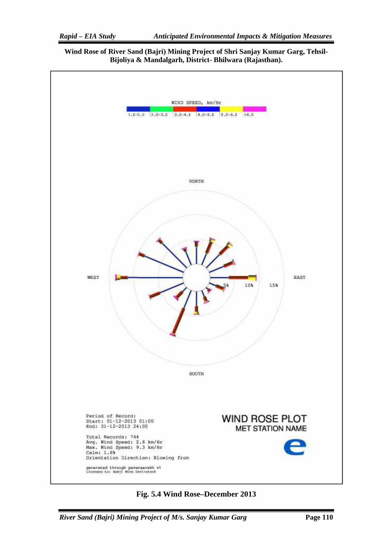
Rapid – EIA Study Anticipated Environmental Impacts & Mitigation Measures
River Sand (Bajri) Mining Project of M/s. Sanjay Kumar Garg Page 110
Wind Rose of River Sand (Bajri) Mining Project of Shri Sanjay Kumar Garg, Tehsil- Bijoliya & Mandalgarh, District- Bhilwara (Rajastha n).
Fig. 5.4 Wind Rose–December 2013

Rapid – EIA Study Anticipated Environmental Impacts & Mitigation Measures
River Sand (Bajri) Mining Project of M/s. Sanjay Kumar Garg Page 111
Fig. 5.5 Wind Rose- January-2014
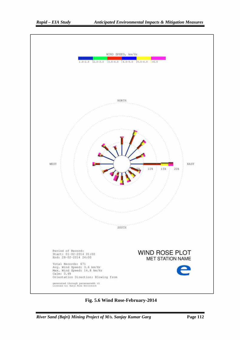
Rapid – EIA Study Anticipated Environmental Impacts & Mitigation Measures
River Sand (Bajri) Mining Project of M/s. Sanjay Kumar Garg Page 112
Fig. 5.6 Wind Rose-February-2014

Rapid – EIA Study Anticipated Environmental Impacts & Mitigation Measures
River Sand (Bajri) Mining Project of M/s. Sanjay Kumar Garg Page 113
Fig. 5.7 Wind Rose- Winter Season (December-2013 to February-2014)

Rapid – EIA Study Anticipated Environmental Impacts & Mitigation Measures
River Sand (Bajri) Mining Project of M/s. Sanjay Kumar Garg Page 114
5.4 IMPACTS ON NOISE ENVIRONMENT
The noise levels are dependent upon the deployment of mining machinery and
transport vehicles in the area. Ambient noise level in the core zone is likely to
increases from deployment of additional noise generating equipment such as
heavy earth moving machineries. The impact of noise will be restricted in the
working area only. The main sources of noise in the mine are classified as
follows:
� Mobile Mining Equipment (Poclain, Excavators etc.)
� Transportation (Dumpers, Trucks, Tippers & other vehicles.)
In order to protect the workers from higher noise levels, project proponent will
adopt the following noise abatement measures.
� Well maintained vehicle will be used which will reduce the noise level.
� Plantation of trees along the 7.5m riparian zone of the river will be done
to dampen the noise, if possible.
� The vehicles will be maintained in good running condition so that noise
will be reduced to minimum possible level.
� Imposition of speed limit on heavy earth moving machineries near
residential areas.
� Trucks drivers will be instructed to make minimum use of horns at the
residential area.
Computation of level of noise at the mine boundary is based on the
assumption that there are no attenuation paths between the source and the
mine boundary. Basic phenomenon of the model is the geometric attenuation
of sound. Noise at a point generates spherical waves, which are propagated
outwards from the source through the air at a speed of 1,100 ft/sec, with the
first wave making an ever-increasing sphere with time. As the wave spreads
the intensity of noise diminishes as the fixed amount of energy is spread over
an increasing surface area of the sphere. The assumption of the model is based
on point source relationship i.e. for every doubling of the distance the noise
levels are decreased by 6 dB (A). Point source propagation is defined by the
following equation:

Rapid – EIA Study Anticipated Environmental Impacts & Mitigation Measures
River Sand (Bajri) Mining Project of M/s. Sanjay Kumar Garg Page 115
Lp2 = Lp1 20 log r2/r1
Where Lp1 and Lp2 are sound pressure levels at points located at distances r1
and r2 respectively from the source.
Fig. 5.8 Noise Modeling of study Area

Rapid – EIA Study Anticipated Environmental Impacts & Mitigation Measures
River Sand (Bajri) Mining Project of M/s. Sanjay Kumar Garg Page 116
The noise level during the proposed mining activities at Bijoliya &
Mandalgarh has been predicted for the worst scenario. The cumulative noise
level due to these sources shall be 46 dB (A). Hence, no impact on ambient
noise level is anticipated.
5.5 IMPACTS ON BIOLOGICAL ENVIRONMENT
(A). Flora
The proposed mine lease area lies in semi-arid zone with sparsely vegetated
dominated by few shrubs & bushes. The floral species observed in the mine
lease area are Prosopis, juliflora, Calotropis procera & Ziziphus nummularia
etc. Thus, no significant impacts on ecology are anticipated as a result of
proposed mining as the core zone is of river bed only. As a part of the project,
it is proposed to plant along the river side (Riparian zone) of 7.5m buffer zone,
along haul roads and suitable places as per land availability for plantation.
Greenbelt development will have positive impacts on the ecology of the
project area.
(B). Fauna
The area does not form part of eco-sensitive areas like National Park, Wildlife
Sanctuary, Biosphere Reserves or Tiger Reserves. Likewise the area does not
form part of the migratory route of any wildlife species. The area does not
support any kind of wildlife. Thus no adverse impacts on fauna are anticipated
as a result of the proposed project of river sand mining.
5.6 IMPACTS ON SOCIO-ECONOMIC ENVIRONMENT
5.6.1 Rehabilitation
The mine area does not cover any habitation due the mine area is river bed.
Hence the mining activity does not involve any displacement of human
settlement. No public buildings, places, monuments etc. exist within the lease
area or in the immediate vicinity. The mining operations will not
disturb/relocate any village or need resettlement. Thus no impact is anticipated.
The manpower requirement for the proposed project will increase employment
opportunities to the local population. This will improve their socio-economic
status. Also, there will be indirect employment opportunities due to the mining
activities. The project will have beneficial impacts at the local level by

Rapid – EIA Study Anticipated Environmental Impacts & Mitigation Measures
River Sand (Bajri) Mining Project of M/s. Sanjay Kumar Garg Page 117
increase in transport and communication facilities, community welfare
measures and improved trade activities.
5.7 MINE WASTE MANAGEMENT
No waste will be generated from river sand mining activity. All the material
will be marketable.
5.7.1 SOLID WASTE GENERATION AND DISPOSAL NATURE OF MINERAL REJECTS
Nature of Waste
No waste will be generated from this mine.
Sub-grade Mineral
No sub grade will generated at site.
5.8 TRAFFIC STUDY
Study of traffic is important to the context of river sand mining project in the
area. Traffic access and impact studies gather and analyze information that will
help determine the need for any improvement to interior, adjacent, and nearby
road systems. Main aim of this study is to understand the existing carrying
capacity of the roads adjacent to the project site and the connecting main roads
in the area. Traffic impact analysis required for a proposed developmental
project of river sand mining is the use of trip generation data. The trip
generation of a proposed project of mining is essentially the number of inbound
and outbound vehicle trips that are expected to be generated by the operational
activities during an average day or during peak hour traffic. The proposed
project of river sand mining can impact the surrounding roadway system by
adding to existing traffic volumes or altering traffic patterns. In addition to
designing appropriate access for proposed project of river sand mining in the
area, proponent try to maintain a satisfactory level of transportation service and
safety for all roadway users. Traffic study provides a clear scenario of existing
traffic structure (existing carrying capacity of roads near project site) compared
to the numbers of trucks will be added during operational activities.
5.8.1 Methodology
Volume count survey has been conducted for 24 hourly. At each identified
station, count in both direction were carried out and classified traffic volumes

Rapid – EIA Study Anticipated Environmental Impacts & Mitigation Measures
River Sand (Bajri) Mining Project of M/s. Sanjay Kumar Garg Page 118
in one hour interval were recorded for two wheelers, four wheelers, heavy
vehicles and others. Three things covered in this study as per IRC: 64 (1990)
i.e. (i) Volume (flow) is the number of vehicles that pass through a given point
on the road during a designated time interval. The time unit selected is an hour
or a day. (ii) Capacity: The maximum hourly volume (Vehicle per hour) at
which vehicles can reasonably be expected to traverse a point or uniform
section of a lane or roadway during a given time period under the prevailing
roadway, traffic and control conditions & (iii) LOS (Level of Services): A
qualitative measurement describing operational conditions within a traffic
stream and their perception by drivers/passengers.
In the context of rural highways, it is usual to adopt daily traffic volume for
design instead of hourly flow need to be converted to daily values on the
basis of observed or anticipated hourly pattern of traffic during the 24 hour
day.
5.8.2 Existing Traffic Scenario
The existing traffic scenario is given in table 5.8
Table No. 5.8 Existing Traffic Scenario & LOS
S.No. Road Volume
(V) Capacity
(C) Existing
V/C Ratio
Level of Service (LOS)
1 Berach River to Barliyas 828.5 5800 0.14 A
2 Menali Nadi to Mandalgarh 731 5800 0.13 A
3 Banas River to Bigod (NH 76B) 810 12500 0.06 A
4 Banas River to Kachhola 638.5 5800 0.11 A
5. Banas River to Parol 548 5800 0.09 A
V= Volume in PCU’s/Day C=Capacity in PCU’s/Day
The existing level of service at near village is “A” i.e. Excellent.
Table No. 5.9 Capacity as per IRC: 64 (1990)
Volume/ Capacity Level of Services Performance
0.0-0.2 A Excellent
0.2-0.4 B Very Good
0.4-0.6 C Good/Average/Fair
0.6-0.8 D Poor
0.8-1.0 E Very Poor

Rapid – EIA Study Anticipated Environmental Impacts & Mitigation Measures
River Sand (Bajri) Mining Project of M/s. Sanjay Kumar Garg Page 119
5.8.3 During Mining Activity
Total Capacity of Mine : 28.05 Lac Tonne Per Annum
Number of Working Days : 330 Days
Truck Capacity : 20 Tonne
Number of Trucks Deployed : 425 Trucks
Working Hours per day : 8 Hours
Table No. 5.10 Proposed Traffic Scenario during Operational Activity
S.No. Road Volume
(V) Capacity
(C)
Existing V/C
Ratio
Level of Service (LOS)
1 Berach River to Barliyas 1338.5 5800 0.23 B
2 Menali Nadi to Mandalgarh 1241 5800 0.21 B
3 Banas River to Bigod (NH 76B) 1320 12500 0.11 A
4 Banas River to Kachhola 1148.5 5800 0.20 A
5. Banas River to Parol 1058 5800 0.18 A
5.8.4 Results
In the context of river sand mining project of based on the above analysis, it is
clear that the Volume/Capacity ratio is likely to change to 0.23 to 0.11 with
LOS being “B” and “A” respectively which is categorized as ‘Very Good’ and
‘Excellent’ as per classification given in IRC: 64 (1990). So the additional
load on the carrying capacity of the concerned road is not likely to have any
significant adverse affect at all.
5.9 Impact of sediment replenishment
Rivers of the state are seasonal in nature. Replenishment in these types of rivers is
meager. Precipitation is a key factor to carrying sediment load from one place to
another. Rivers in the state carrying maximum sediment load during rainy season.
Climate of the area is semi-arid type. Rainy season starts from mid of June to mid
of September in the area. Scanty, erratic and uneven nature of precipitation is
common phenomenon in the state. Maximum annual targeted production is 28.05
Lac TPA. The annual replenishment of the sediment of Banas River,Berach
River& Mainali River basin comes out to be 1768987.63 M. tons/yr (Details
of calculation is given in Annexure).
However actual amount of sediment replenishment may vary from computed
sediment in view of catchment topography, lithology, soil erodibility, vegetation,
land use, precipitation and river channel morphology.

Rapid – EIA Study Anticipated Environmental Impacts & Mitigation Measures
River Sand (Bajri) Mining Project of M/s. Sanjay Kumar Garg Page 120
5.10 IMPACTS SUMMARY
The environmental attributes which are likely to have an impact due to the
proposed river sand mining project at near village Amarpura, Asawari,
Bagthala, Baroo Khera, Bedunda, Bedunda, Beeliya, Bhand Ka Khera,
Bharliya, Bhawani Singh Ka Khera, Bilod, Chainpuriya, Chandpura,
Chhitarsingh Ji Ka Khera, Chohli, Daulji Ka Khera, Devipura, Gandhari,
Gariyan, Gheoriya, Golbari, Gopalpura, Govta, Harisinghji Ka Khera, Hastra,
Heengwaniya, Jaliya, Jojwa, Kankoliya, Kanti, Katariyon Ka Khera,
Khakhunda, Khangarji Ka Khera, Khatwara, Khatwara, Kherpura,
Lakshmipura, Lodhiyana, Mahtaji Ka Khera, Moi, Padampura, Panderi,
Peethalpura, Phalasiya, Phoolji Ki Kheri, Pratappura, Ralayata, Ramthali,
Sand, Shyam Garh, Tahla, Thal Kalan, Thalkhurd, Tiroli, Ummedpura Tehsil-
Bijoliya & Mandalgarh, District- Bhilwara (Rajasthan) are summarized in
Table 5.11.
Table 5.11 Summary of Anticipated Impacts
S.No. Proposed Activity/Parameters Anticipated Impacts
1 Air Environment
PM10 -
SO2 -
NOX -
2 Water Environment -
3 Biological Environment
Flora (Vegetation) +ve
Fauna (Wildlife) -
4 Noise Environment -
5 Socio-economic Environment
(a) Social Status -
(b) Economic Status +ve
(c) Generation of Employment +ve
(d) Infrastructure Resource Base +ve
6. Traffic Environment -
Note: (-) =No Impacts, (-ve) =Negative Impacts, (+ve) =Positive Impacts

Rapid – EIA Study Environmental Monitoring Programme
River Sand (Bajri) Mining Project of M/s. Sanjay Kumar Garg Page 121
CHAPTER-6
ENVIRONMENTAL MONITORING
PROGRAMME

Rapid – EIA Study Environmental Monitoring Programme
River Sand (Bajri) Mining Project of M/s. Sanjay Kumar Garg Page 122
6.0 GENERAL
Monitoring schedules are ensured to keep all the environmental parameters
of the project within statutory levels in respect of ambient air quality, water
quality, socio-economic improvement, noise level standards, biological
quality etc. Regular periodical returns are submitted to RSPCB, etc. in this
respect.
In respect of the proposed river sand mining project, well planned mitigation
measures and efficient environmental management plan will be implemented
promptly and attentively to ensure that during the project operation, the
various environmental parameters as described above are well within statutory
limits. Environmental monitoring is a useful tool to assess the cumulative
impacts of a project. The monitoring results help to judge the success of
mitigation measures for environmental protection. They are also used to
ensure compliance with environmental standards.
6.1 ENVIRONMENTAL MANAGEMENT PLAN (EMP)
The success of environmental management in an organization not only
depends on involvement at all levels but also on the creation of an effective
implementing organizational structure. Keeping this in view, organizational
structure responsible for the implementation of environmental control and
mitigatory measures as well as monitoring of such implementation has been
discussed below in this Chapter. The management of environment shall be
made an integral part of the major activities of mining.
6.2 IMPLEMENTATION OF ENVIRONMENT MANAGEMENT PLAN
The following system shall be followed to see that the scheme is
implemented as per schedule. These measures are being observed in present
working also.
1. Water table should be recharged by framing ground water recharge wells
or sumps for direct recharge of ground water table during monsoon
season.
2. Plantation should be carried out along the periphery of 7.5m riparian
zone of river, along the haul roads and other unworked areas etc.

Rapid – EIA Study Environmental Monitoring Programme
River Sand (Bajri) Mining Project of M/s. Sanjay Kumar Garg Page 123
3. Afforestation measures are attended by a crew on a regular basis for
culturing, manuring and watering.
4. On an annual basis the quality of air, water, noise and soil will be tested
to know their status vis-a-vis the baseline data. This will enable us to
take any corrective measures, if required. The frequency of sampling
shall be as prescribed by the Ministry of Environment & Forest (MoEF)
guideline issued in this regard.
6.3 MONITORING SCHEDULES & MONITORING CELL FORMATION
The monitoring schedule should include the following measures as
follows:
1. Noise Control: Twice in a year measurement of noise levels at
sensitive locations would bring out the efficacy of maintenance
schedules.
2. Air Monitoring: One 8-hr sample of ambient air quality at sensitive
locations at regular intervals.
3. Monitoring of Water Quality: from appropriate stations at regular
intervals. Drinking water monitoring will be done every fortnightly for
corrective measures for different physico-chemical parameters etc.
4. Monitoring of Soil Quality: Monitoring of soil quality in plantation
area after monsoon every year.
6.3.1 ENVIRONMENTAL MONITORING CELL
The monitoring shall be done by the supervisory officers of the mine. Any
abnormalities shall be brought to the notice of management to take immediate
corrective action to prevent any mishap. Following shall be the proposed
environmental organization chart for this mine. Mine manager shall be
in-charge of the environment cell. The mines owner will also frequently
review the work and the managers of mine will overview the arrangements for
effective functioning of environmental safeguards.
The environmental data shall be monitored initially by using an outside
agency and later an in house monitoring cell shall be developed.

Rapid – EIA Study Environmental Monitoring Programme
River Sand (Bajri) Mining Project of M/s. Sanjay Kumar Garg Page 124
Fig. 6.1 Chart of Environment Monitoring Cell (EMC)
6.4 FUNCTIONS OF THE MONITORING CELL
1. To carry out environmental monitoring at site for various
environmental parameters as required either departmentally or through
outside agencies. This will ensure that the environmental status of the
core and buffer zone of the mine will be preserved in good status as per
rules.
2. To observe the environmental control measures to be implemented.
3. To keep a watch on the flow patterns of drainage and keep vigil on the
efficiency of water management system.
4. To study the effects of project activities on the environment.
5. To ensure implementation of plantation programme. Regular monitoring
of survival rate of plants should also be carried out to achieve the desired
result, for five years.
6. To keep records of monitoring etc. in a systematic way, so as to facilitate
easy access, when needed by statutory agencies, etc.
7. Conducting environmental studies and reporting to SPCB.
8. To interact and liaise with State and Central Government Departments.
9. To ensure the availability of the necessary spares for the pollution
control equipment all the times so as to keep the pollutants of the
environment within the stipulated limits.
Foreman
Operator/ Helper
Mate
Water Sprinkler
Operator Gardner
Asstt. Manger
Mines Manager (In-charge Environment Cell)

Rapid – EIA Study Environmental Monitoring Programme
River Sand (Bajri) Mining Project of M/s. Sanjay Kumar Garg Page 125
10. To identify the source of pollution and to take immediate action to
prevent further pollution.
11. Conducting safety audits and programmes to create safety awareness in
workers/ staff.
12. Conducting regular health audits to detect any health problems promptly
to the workers/ staff. This will reduce occupational health problems.
13. Parting training on safety and conducting safety drills to educate employees.
14. Carrying out socio-economic study once in three years in the
surrounding areas to find out the benefits derived by the society due to
the project and also to fulfill the deficiency, if any, immediately.
The recorded data from monitoring of air water and noise will be submitted
half yearly by project proponent to Ministry of Environment and Forests
(Regional office) and State Pollution Control Board (SPCB).
6.5 ENVIRONMENTAL ADMINISTRATION
The mine manager at the project site will be directly responsible for various
environmental activities. The mine owner will frequently review the
monitoring activities. The advisor of the project will correlate and oversee the
environmental activities and their effective implementation in consonance
with the guideline in the Environment Management Plan (EMP).
Environmental control measures span various factors like land degradation,
soil, air, water quality, noise levels and afforestation measures etc. In addition
to the above participation by the executive level, staff support has to be
provided by way of employing workers for carrying out the activities. As far
as air, water and noise pollution is concerned, periodical monitoring has to be
performed either by the project proponent or by external agencies, during the
operational activities of mining. Air quality should be conforming to Central
Pollution Control Board (CPCB) standards.
Ground Water for Drinking
Ground water for drinking will be monitored once in a month to ensure
conformity with IS: 10500, including analysis of various physico-chemical
parameters etc.

Rapid – EIA Study Environmental Monitoring Programme
River Sand (Bajri) Mining Project of M/s. Sanjay Kumar Garg Page 126
Ambient Noise Level Standards:
THE ENVIRONMENT (PROTECTION) RULES, 1986 Table 6.1 Ambient Noise level Standards
Area Code
Category of Area Limits in dB (A) Leq
Day Time Night Time
(A) Industrial area 75 70
(B) Commercial area 65 55
(C) Residential area 55 45
(d) Silence Zone 50 40
Note:
1. Day Time shall mean from 6.00 a.m. to 10.00 p.m. (16 hours).
2. Night Time shall mean from 10-00 p.m. to 6.00 a.m. (8 hours).
3. Silence zone is defined as an area comprising not less than 100 meters
around hospitals, educational institutions and Courts. The silence zones
are zones, which are declared as such by the competent authority.
4. Mixed categories of areas may be declared as one of the four-above
mentioned categories by the competent authority.
*dB (A) Leq denotes the time weighted average of the level of sound in
decibels on scale A which is relatable to human hearing.
A “decibel” is a unit in which noise is measured.
“A”, in dB (A) L eq, denotes the frequency weighting in the measurement
of noise and corresponds to frequency response characteristics of the
human ear.
Leq: It is energy mean of the noise level over a specified period.
Table 6.2 Guidelines for Permissible Noise for Industrial Workers as laid down by Central Pollution Control Board
Exposure Time (in hr. per day) Limit in dB (A)
8 90
4 93
2 96
1 99
½ 102
¼ 105
1/8 108
1/16 111
1/32 114
Rapid – EIA Study Environmental Monitoring Programme
River Sand (Bajri) Mining Project of M/s. Sanjay Kumar Garg Page 127
Occupational exposure limit of noise prescribed by the Director General of
Mines & Safety (DGMS) shall be complied with. During operation of the
project, required number of locations of monitoring for air, water, noise, etc.
will be kept in consultation with RSPCB officials.
6.6 POST PROJECT MONITORING SCHEME
A well-defined environmental monitoring program would be employed with
trained and qualified staff to ensure that the various environmental parameters
maintained within the permissible limits of standards.
6.7 PROGRAMME TO BE FOLLOWED FOR AIR, WATER, SOIL, NOISE SAMPLING & ANALYSIS
Ambient Air Monitoring
Ambient air quality is essential for evaluation of the effectiveness of
abatement programmes and to develop appropriate control measures. Ambient
air quality will be monitored in 4 stations in core zone and 6 in buffer zone.
The sites will be identified keeping Prevailing wind directions in mind. The
ground level concentrations of Respirable Suspended Particulate Matter
(PM10) Sulphur Dioxide (SO2) and Nitrogen dioxides (NO2) established in the
ambient air outside the project boundaries and in the adjoining villages will be
monitored at regular intervals as given in post monitoring program. Frequency
mentioned in the monitoring schedule for various parameters and take
appropriate air pollution control measures in order to ensure that the
concentration of various air quality parameters are well within permissible
limit of standards. Any deviation from predicted/expected values will be
investigated and necessary corrective action will be taken.
Noise Monitoring
Noise levels at 4 station in core zone and 6 in buffer zone workspace
environment premises will be monitored periodically i.e. once in a month. If
any deviation is observed necessary corrective measures will be taken.
Monitoring noise level is essential to assess the efficacy of maintenance of
schedules undertaken to reduce noise levels and noise protection measures.
Monitoring of Water Quality
Ground water and surface water samples from study area are recommended to
be routinely tested for its quality as per Drinking Water Specification IS:

Rapid – EIA Study Environmental Monitoring Programme
River Sand (Bajri) Mining Project of M/s. Sanjay Kumar Garg Page 128
10500 and Surface Water Quality Standards as per IS: 2296. The water to be
collected half yearly and will be analyzed for any change in water quality due
to the mining operation.
Environment Policy
The mine management will prepare written environmental policy declaring its
responsibility and commitment to protect the environment and to ensure public
safety. The existing policy will be available with all concerned officials.
6.8 ENVIRONMENTAL MONITORING SYSTEM & METHODOLOGY
For timely evaluation of EMP, regular monitoring of the important
environmental parameters will be taken up. The schedule, duration and details
of parameters for monitoring are given briefly as under. Based on the results
of improvements of adversity in the environmental parameters, monitoring
schedules and duration will be restricted, if necessary, after consulting with
RSPCB and MoEF.
Table 6.3 Monitoring Schedule Details
S.No. Description of Parameters Schedule and duration of Monitoring 1. Ambient Air Quality
(a) In and around mines for SO2, NO2 , PM10
Samples for 24 hours continuously will be collected twice a week for one month for one season of the year or as per norms of RSPCB
2 Meteorological parameters like temperature, RH, wind speed, wind direction, rainfall, cloud cover
Continuous monitoring for meteorological parameters
3 Water quality of wells, and in water bodies around the mines
Monthly/Quarterly or as per norms of RSPCB & MoEF for various parameters
4 Ambient noise levels inside the mine premises and nearby villages
Once in a month or as per norms of RSPCB & MoEF
5 Soil characteristics in nearby villages.
Quarterly or as per norms of RSPCB & MoEF for various parameters
6 Occupational health check up Once a year
7 Inventory of Flora/ Fauna Once a year on all the green belt sites created and once in 5 years in study area
8 Socio-Economic Aspect Once in 3years through physical survey for detecting any adverse variation and prompt correctives
Ambient Air Quality: Ambient air quality will be monitored using Respirable
Dust Samplers.
Water Quality: The monitoring in this respect will be done for various
physico-chemical parameters of water like pH, TDS, Chlorides, Nitrate,
Alkalinity, Hardness and Fluoride etc. of the nearby wells/ bore wells and
surface water.

Rapid – EIA Study Environmental Monitoring Programme
River Sand (Bajri) Mining Project of M/s. Sanjay Kumar Garg Page 129
Noise Monitoring: This will be done in working environment, main noise
producing sources, around the mine and in the nearby villages.
Occupational Health Check-up: This will be organized once a year through
qualified medical personnel for detection of occupational diseases amongst
staff and workers of the mine for prompt action on devising remedial measures
urgently.
Green Belt Area: Continuous vigil and monitoring of green belt area will be
done for its healthy performance and survival rate. Timely provision for
fertilizer application and scheduled watering programmes will be enforced
through the ecologist/ forestry expert and supporting staff.

Rapid – EIA Study Additional Studies
River Sand (Bajri) Mining Project of M/s. Sanjay Kumar Garg Page 130
CHAPTER-7
ADDITIONAL STUDIES

Rapid – EIA Study Additional Studies
River Sand (Bajri) Mining Project of M/s. Sanjay Kumar Garg Page 131
7.0 GENERAL
1. The additional studies covered for the project will involve the following schemes.
2. Public consultation for this project was conducted on 22/12/2014 at 11:30
A.M. at Tehsil Head Quarter Bijoliya, District - Bhilwara (Rajasthan) which
was presided over by the Tehsildar- Bijoliya and attended by officers of
RSPCB, Bhilwara. The public hearing was attended by various entities like
local community in surrounding who may have any concern about the project
or other specific person/organizations have to express any opinion in the
project approval. Requisite publicity through local news papers/ media i.e. in
Rajasthan Patrika dated 19.11.2014 and Hindustan Times Dated 20.11.2014
was given at least 30 days in advance of the date fixed for public hearing
through the Collector and State Pollution Control Board official in the matter.
The views and grievances were listened and resolved. The project proponent
has given commitment to fulfill the environmental and social responsibility for
development of community of nearby villages. In this report, public hearing
proceedings and minutes of public hearing is included in the final EIA/EMP
report and submitting to Expert Appraisal Committee (EAC), MoEF, New
Delhi for want of Environment Clearance.
3. Risk Assessment (RA) and Disaster Management Plan (DMP) in connection
with mining and allied operations of the project should be spelt out in detail to
cover likely dangers/risks/explosions/accidents, etc. likely to arise from the
project operations, including onsite and offsite emergency plans to meet the
disastrous situations.
7.1 ITEMS IDENTIFIED BY THE PROPONENT
The most of the suggestions in regards to mitigation and action taken for
reducing impacts on surrounding environment during mining operation with
proposed production of River sand i.e. 28.05 Lac TPA has been covered in
TOR. The proponent has given ways & means to minimize the impacts due to
mining operations. The project proponent (lessee) has complied with all the
conditions stipulated in prescribed TOR.
7.2 ITEMS IDENTIFIED BY THE REGULATORY AUTHORITY
The project has already got TOR for environmental clearance for proposed

Rapid – EIA Study Additional Studies
River Sand (Bajri) Mining Project of M/s. Sanjay Kumar Garg Page 132
production of River sand i.e. 28.05 Lac TPA (Tonne Per Annum) by Expert
Appraisal Committee (EAC), MoEF, New Delhi Vide letter No. J-
11015/362/2013-IA.II (M) Dated 22.11.13. The Expert Appraisal Committee
(EAC) has stipulated specific and general conditions for the project.
7.3 ITEMS IDENTIFIED BY THE PUBLIC & OTHER STAKEHOL DERS
Public consultation for this project was conducted on 22/12/2014 at 11:30
A.M. at Tehsil Head Quarter Bijoliya, District - Bhilwara (Rajasthan) which
was presided over by the Tehsildar- Bijoliya and attended by officers of
RSPCB, Bhilwara. The public hearing was attended by various entities like
local community in surrounding who may have any concern about the project
or other specific person/organizations have to express any opinion in the
project approval. Requisite publicity through local news papers/ media i.e. in
Rajasthan Patrika dated 19.11.2014 and Hindustan Times Dated 20.11.2014
was given at least 30 days in advance of the date fixed for public hearing
through the Collector and State Pollution Control Board official in the matter.
The views and grievances were listened and resolved. The project proponent
has given commitment to fulfill the environmental and social responsibility for
development of community of nearby villages. In this report, public hearing
proceedings and minutes of public hearing is included in the final EIA/EMP
report and submitting to Expert Appraisal Committee (EAC), MoEF, New
Delhi for Environment Clearance.
7.4 RISK ANALYSIS & DISASTER MANAGEMENT PLAN
The possible risks in the case of river sand mining projects are erosion,
inundation/floods, accidents due to vehicular movement, Drowning, accident
during sand loading and transporting etc. Mining and allied activities are
associated with several potential hazards to both the employees and the public at
large. A worker in a mine should be able to work under conditions, which are
adequately safe and healthy. At the same time the environmental conditions
should be such as not to impair his working efficiency. This is possible only
when there is adequate safety in mines. Hence, mine safety is one of the most
essential aspects of any working mine. Safety of the mine and the employees is
taken care of by the mining rules & regulations, which are well defined with laid
down procedure for safety, which when scrupulously followed safety is ensured

Rapid – EIA Study Additional Studies
River Sand (Bajri) Mining Project of M/s. Sanjay Kumar Garg Page 133
not only to manpower but also to machines & working environment.
7.4.1 DEFINE ENVIRONMENTAL RISKS
To under the environmental risk assessment it is important to familiar both the
terms i.e. Risk and Hazard. The definitions of environmental risk are as follows:
(a) Risk: Risk is an actual or potential threat of adverse effects on
environment arising out of an organization activity.
(b) Hazards: Hazard is the potential to cause harm. An environmental
hazard is a generic term for any situation or state of events which poses
threat to the surrounding environment.
7.4.2 Objective of Risk Assessment
� Identifying hazardous activities
� Assessment of risk level and severity in different operations
� Identification of control measures
� Setting monitoring process
� Reduce the impact of mishaps of all kinds
� Reduce the inherent potential for major accidents.
7.4.3 Methodology of Risk Assessment
Risk assessment is mainly based on the environmental impact of various
parameters, which have been described in Chapter-V. The methodology of risk
assessment will involve following steps as:
Fig. 7.1 Methodology of Risk Assessment
Collection of information and identification of hazard
Classifying the severity of hazards and probability of occurrence Identification of exposed risks
Assessment of risks based on probability exposure and consequence. Prioritization of risks
Implementation of control measures
Monitoring Risk Assessment
Evaluation & Correction
Rapid – EIA Study Additional Studies
River Sand (Bajri) Mining Project of M/s. Sanjay Kumar Garg Page 134
7.4.4 Assessment of Risks & Mitigative Measures
7.4.4.1 Hazard Identification
Major Risks involved in River Bed Mining are following:
1. River Bed Inundation,
2. Dewatering,
3. Drowning ,if any
4. Possible risks due to failure of pit slope & its control
5. Soil Erosion,
6. Blanketing of River bed Suspended organic & Inorganic solids,
7. Uneven/ Irregular mining of sand or bajri
8. Accident due to Vehicular Movement
9. Accident during mineral loading and transportation
10. Failure of machinery
7.4.4.2 Mitigation Measures
A. Possible Risks Due to Inundation/Floods & Its Control
Mining will be done during the non monsoon periods; therefore problem of
inundation/floods is not likely to happen. There was no incidence of
inundation/floods reported from the area so far. River is seasonal hence flows
only in monsoon season.
B. Dewatering
The satate government rules permits mining upto depth of 3m or 1m above
the water level whichever is achieved earlier. The mining at site will be done
till 3m deep only from the surface of river channel whereas the ground water
flows at 8-10m below surface of river channel. Hence no dewatering is
required. During mining, no ground water table will be intersected at all.
C. Drowning, if Any
There are no possibilities of drowning in the river, mining operation carried
out in dry bed only. All mining activities will be stopped during the monsoon
season. The mining operation will be carried out under strict supervision of
competent person and only during dry season. Deep water zones in the river
will be identified and enclosed with barricades. No go zone will be clearly
marked and shall be aware to the mine workers.

Rapid – EIA Study Additional Studies
River Sand (Bajri) Mining Project of M/s. Sanjay Kumar Garg Page 135
D. Possible Risks Due to Failure of Pit Slope & Its Control
Pit will be created of limited depth only i.e. 3m thus the chance of failure of
pit slope is marginal. However pit slope of working bunch will be kept under
permissible limit which will not be more than 30degrees.
E. Soil Erosion
There is no top soil in the core zone. No mining will be done within 7.5 m
from the either side of river banks to maintain its protection. Mining will
proceed along the river in the direction from downstream to upstream in each
block. No mining will be done across the river’s nalla’s. However plantation
will be carried out along river banks in safety zone to protect banks and
prevent soil erosion.
F. Blanketing of River bed Suspended organic & Inorganic solid
River Bed mining causes blanketing of River by suspended organic &
Inorganic solids in overlaying water. Slope stabilization and time to time slope
stability monitoring along with slope failure study will avoid this.
G. Uneven/ Irregular mining of sand or bajri
Due to uneven/ irregular thickness of sand bed, river bed mining may result in
ponds to develop. Excessive mining can change River direction & geometry
altering recharging capacity of replenishment. Proper management of even
excavation will overcome this.
H. Accident due to Vehicular Movement and their Mitigation Measures
� Possibilities of road accidents are possible due to rash driving.
� Possibility of overloading may injure the passerby public.
� The possibility of accident during vehicular movement in the mine in case
pathway is not compacted or movement is at the embankment.
� All transportation within the mining lease working should be carried out
directly under the supervision and control of the management.
� The vehicles will be maintained in good condition and checked thoroughly
at least once a month by the competent person authorized for the purpose
by the management.
� Road signs will be provided at each and every turning point up to the main

Rapid – EIA Study Additional Studies
River Sand (Bajri) Mining Project of M/s. Sanjay Kumar Garg Page 136
road (wherever required).
� To avoid danger while reversing the equipments/ vehicles especially at the
working place/loading points, stopper should be posted to properly guide
reversing/spotting operating, otherwise no person should be there within
10m radius of machine.
� The maximum permissible speed limit should be ensured.
� Overloading of material will be avoided.
� A statutory provision of the fences, constant education, training etc will go
a long way in reducing the incidents of such accidents.
I. Accident during Mineral Loading and Transportation
� The mineral will be load in the trucks mechanically i.e. by Poclain and
JCB. There is a possibility of injury to the person during loading operation
at mine.
� There is a possibility of riverbank collapse.
� There is a chance of falling of animals/human into pits in river bed by
overlooking of fenced area near working.
J. Failure of machinery
� Records will be maintained and updated of all the machines used at the
minesite.
� Periodic maintenance and conditioning of the machines will be carried out
under expert supervision.
Other Possible Measures to Avoid Risks/Disaster Due To River sand Mining
� Unwanted material including mineral or spillage (if any) should not be
stacked on the banks as it will hinder the flow of water in monsoon
season.
� Every mining block will have clearly identified approach road/ entry
points into the rivers-nalla and similarly the exit points.
� Excavation will be carried out up to a maximum depth of 3 meters from
surface of sand deposit and not less than one meter from the water level of
the River channel whichever is reached earlier.

Rapid – EIA Study Additional Studies
River Sand (Bajri) Mining Project of M/s. Sanjay Kumar Garg Page 137
� The minerals will be mined out in a uniform way so that the river
flow/course will not be disturbed.
� River bank areas, under operation will be protected by avoiding
unauthorized gravel excavation along rivers as that may cause instability
to the river bank.
� River bank areas, under operation will be protected by avoiding
unauthorized gravel excavation along rivers as that may cause instability to
the river bank.
� Only excavated river gravel should be used to deposit against the river
bank to form access ramps.
� Access roads/ramps to river bed will be breached before onset of monsoon
to permit unhindered flow of river.
� The Guidelines issued by Rajasthan State Government Policy Notification
No. GSR 27 dated 21 June, 2012 in respect of mining of bajri will be
followed. Mining will be done as per Approved Mining Plan &
Progressive Mine Closure Plan.
7.4.5 Disaster Management Plan (DMP)
The Disaster Management Plan for the proposed river sand mining project will
cover hazard identification due to various mining and allied activities, the risk
involved due to the hazards and planning the necessary mitigation measures
for the same. The following natural/ industrial hazards as follows:
� Failure of pit slope
� Accident due to transportation & other equipment etc.
7.4.5.1 Structure of the Disaster Management Plan
(i) Outline of Disaster Management Plan
The purpose of disaster management plan is to restore the normalcy for early
resumption of mining operation due to an unexpected, sudden occurrence
resulting to abnormalities in the course of mining activity leading to a serious
danger to workers or any machinery or the environment. The following factors
will play major role in the management strategy. The disaster management
plan may be broadly divided into following steps as:

Rapid – EIA Study Additional Studies
River Sand (Bajri) Mining Project of M/s. Sanjay Kumar Garg Page 138
Fig.7.2 Objectives of Disaster Management Plan
(ii) System of Communication
Where is an internal communication system for the department head and to
their line of command with telephone. The telephone numbers and addresses
of adjoining mines, rescue station, police station, fire service station, local
hospital, electricity supply agency and standing consultative committee
members are also maintained for any emergency requirement.
(iii) Consultative Committee
A standing consultative committee will be formed under the head of mines
manager. The members consists of safety officer/medical officer/Asst.
manager/ public relation officer/ Foreman/ and environmental engineer.
(iv) Facilities & Accommodation
Accommodation and facilities for medical centre, rescue room and for various
working groups will be provided.
(v) First Aid & medical facilities
The mine management is having first aid/ medical centre for use in emergency
situation. All casualties would be registered and will be given first aid. The
centre will have facilities for first aid & minor treatment, resuscitation,
ambulance and transport. It will have proper telephone/wireless set for quick
communication with hospitals where the complicated cases are to be sent.
(vi) Transport services
A well defined transport control system will be provided to deal with the
situation.
(vii) Functions of Public Relations/ Responsibility of Mine Management
(a) To make a cordial relation with government officials and other social
service organization and working groups.
(b) To liaise with representatives of the mine to ameliorate the situation of panic,
tension, sentiments, grievances and misgivings created by any disaster.
Disaster Management Plan (DMP)
Emergency Preparedness Plan
Resource Availability
Response Action taken during Emergency

Rapid – EIA Study Additional Studies
River Sand (Bajri) Mining Project of M/s. Sanjay Kumar Garg Page 139
(c) To ameliorate the injured, survivors and family members of affected
persons by providing material, moral support and establishing contact
with relatives of victims.
(viii) Following infrastructure and operational system will be provided to meet any emergencies.
Emergency Control Room:
This will be situated near the mine site in such a way that response time is
minimal at time of disaster. It will be provided with the following facilities:
a) Master plan of the mines.
b) First aid boxes.
c) Telephone line
d) Emergency lighting system.
e) Transport facility.
Emergency control room will function as control base.
7.4.5.2 Offsite Emergency Plan
Offsite emergency plan defining the various steps to tackle any offsite
emergencies which may affect surrounding areas of the project has to be
prepared after due final discussion with local panchayat and revenue officials.
As per this offsite plan, actions have to be promptly initiated to deal with any
offsite disastrous situation, with help of Collector and other officials.

Rapid – EIA Study Project Benefits
River Sand (Bajri) Mining Project of M/s. Sanjay Kumar Garg Page 140
CHAPTER-8
PROJECT BENEFITS

Rapid – EIA Study Project Benefits
River Sand (Bajri) Mining Project of M/s. Sanjay Kumar Garg Page 141
8.0 IMPORTANCE OF THE PROJECT TO THE REGION AND COU NTRY
Mining is one of the major industries which play a crucial role in the process
of country’s economic development. Mineral wealth of Rajasthan provides
the employment opportunities to the people of the state as well as region.
Most of the people in the region are directly or indirectly dependent on
mining and allied activities. Due to the globalization and new ventures, the
requirement for River Sand (Bajri) has been on the rise over the last few
years. Mineral river sand is used mainly in construction sector. Sand is used
as building material. Its strength and long life makes it suitable for a number
of purposes. Mining industry play an important role in economic sector in
India. Rajasthan is rich in mineral wealth. The state is endowed with major
and minor mineral resources. The region, where the project is situated is
mostly dependant on agriculture and mineral resources. The development of
mining in the area provides direct and indirect employment opportunities,
infrastructure development, communication and socio-economic
infrastructure. The important benefits accruing from the project can thus be
stated as-boost to local and regional economy, direct contribution to the state
exchequer.
8.1 THE PROJECT GAINS FURTHER IMPORTANCE TO THE STA TE/ COUNTRY ON ACCOUNT OF FACTORS MENTIONED BELOW
8.1.1 Economic Benefits
The project is expected to encourage industrial growth in the area/ region with
proper utilization of local geological resources i.e. River sand. The project will
further help by increased revenue to the State Government by way of royalty
and taxes etc.
8.1.2 Environmental Benefits
Environmental benefits of river sand mining are as follows:
(i) To protect river banks
(ii) To control river channel
(iii) To protect from inundation/floods
(iv) Reducing submergence of adjoining agricultural lands
(v) Protection of crops being cultivated along the river bank
(vi) To increase its assimilative capacity i.e. hold more volume of water

Rapid – EIA Study Project Benefits
River Sand (Bajri) Mining Project of M/s. Sanjay Kumar Garg Page 142
8.1.3 Employment Opportunities
The employment to the local people of nearby villages for mine project
directly will certainly increase per capita income of inhabitants of nearby
localities.
8.1.4 Improved Educational Facilities
The project will help in better educational facilities in nearby area by
providing financial assistance.
8.1.5 Infrastructure Development
The proposed project will facilitates clean drinking water facilities in nearby
area. Maintenance of roads will be time to time.
8.1.6 Medical Assistance
Medical awareness campaign programmers will be organized time to time.
The medical checkup camps will be organized in systematic manner for mine
workers and nearby inhabitants.
8.1.7 Improvement in Physico-social Infrastructure
The proposed project of river sand mining will provide better living standards
in nearby area with basic social amenities such as educational facilities, health
care, road infrastructure and clean drinking water.
8.1.8 Other Activities
The proposed project will contribute in various cultural activities in
surroundings i.e. organization of religious functions, construction and repair of
religious places, local fairs and social activities etc.
8.2 CONCLUSION
Thus the proposed project of river sand mining of M/s Sanjay Kumar Garg
benefits to all persons of nearby villages and State/Central Govt. by way of
taxes & royalty. The local government body i.e. Panchayat Samiti/ blocks are
also get some part of royalty which will ultimately be utilized for the
development programmes of the region.
Rapid – EIA Study Environmental Management Plan
River Sand (Bajri) Mining Project of M/s. Sanjay Kumar Garg Page 143
CHAPTER-9
ENVIRONMENTAL
MANAGEMENT PLAN

Rapid – EIA Study Environmental Management Plan
River Sand (Bajri) Mining Project of M/s. Sanjay Kumar Garg Page 144
9.0 GENERAL
Environment Management Plan (EMP) is aimed at mitigating the possible
adverse impact of a project and for ensuring to maintain the existing
environmental quality. The mining activities in the area involve excavation of
mineral, machinery and movement of transport vehicles. These activities lead
to generation of air borne dust, which can cause air pollution in and around the
lease area. Other similar causes are land degradation, noise and water
pollution etc. In order to minimize impacts of mining on different
environmental parameters and keep air, noise, water quality within prescribed
limits a comprehensive environmental management plan has to be prepared. It
has been envisaged that the study area will not be adversely affected
significantly and impacts will be confined to the project. The mining
development in the study area needs to be intertwined with judicious
utilization of natural resources within the limits of permissible assimilative
capacity. The assimilative capacity of the study area is the maximum amount
of pollution load that can be discharged in the environment without affecting
the designated use and is governed by dilution, dispersion and removal due to
natural physico-chemical and biological processes.
Environment management plan is required to ensure sustainable development
in the area adopting proper safeguarding measures with the concept of
sustainable and scientific mining practices. The project proponent will be
implemented integrated environment management throughout various stages
of mine. To mitigate the adverse impacts which are likely to caused due to the
mining operation, environment management plan has been formulated and
integrated with mine plan. This chapter covers the genesis of pollution and the
proposed measures required for meeting the prevailing statutory requirements
of gaseous emissions, noise levels and water quality etc. for environmental
management purpose in connection with the mining and related activities in
the study area. For attaining the desired objective of good environmental
quality in the study area, several management strategies in different phases are
proposed and evaluated.
The Environmental Management Plan (EMP) is a site specific plan to ensure
that the activities of the project are implemented in sustainable manner. EMP

Rapid – EIA Study Environmental Management Plan
River Sand (Bajri) Mining Project of M/s. Sanjay Kumar Garg Page 145
Effective Control / Mitigation Measures
Objectives of EMP
Conservation of Environment
Monitoring of Cumulative & long term Impacts
Judicious Utilization of Natural Resources
also ensures that the project implementation is carried out taking appropriate
mitigation measures to reduce adverse environmental impacts due to
developing projects. The Environment Management Plan (EMP) aims to
mitigate measures to restore and conserve the ecosystem of the possible
adverse impacts due to proposed project. The mitigation steps are used to
minimize negative impacts on environment due to proposed project of river
sand mining. The EMP contains planned improvements with adopting some
control measures viz. fugitive dust reduction on roads & measures to alleviate
the problems in affected villages near project area and planning for the
sustainable development of the area/region.
Fig. 9.1 Objectives of Environment Management Plan (EMP)
This section discusses the management plan adopting various mitigation
measures and enhancement of beneficial impacts due to proposed project of
mining. The Environmental Management Plan (EMP) has been designed
within the framework of various Indian legislative and regulatory
requirements on environmental and socio-economic aspects. The aim of
environment management plan is to ensure that all the safeguarding measures
formulated with the concept of sustainable mining in the area/region. The
proposed project in study area maintains its sustainable balance of natural
resources. Environmental management plan giving the environmental
protection measures at mine to meet the stipulated norms of Ministry of
Environment & Forest (MOEF) are detailed below.
9.1 AIR POLLUTION CONTROL
The magnitude of air pollution in mining varies with methods of mining, type
of mineral and level of mechanization involved. Mitigation measures
suggested for air pollution controls are based on the baseline ambient air

Rapid – EIA Study Environmental Management Plan
River Sand (Bajri) Mining Project of M/s. Sanjay Kumar Garg Page 146
quality of the area. In view of maintain or control ambient air quality in the
area/ region, it is desirable that air quality is monitored on a regular basis to
check compliance of standards as prescribed by CPCB. In case of non-
compliance, appropriate mitigation measures needs to be checked.
As per the results of ambient air quality monitoring data, the background
concentrations of PM10, SO2 and NO2 should remain within the stipulated
CPCB standards for all of the samples. The addition of gaseous pollutants due
to the proposed mining activities is expected to be relatively high.
Information of ambient air quality was studied and various modeling
techniques predicted that the mining activity will not affect the air quality in a
significant manner. During mining operations, loading and transportation may
cause deterioration in air quality due to handling dry materials.
9.1.1 Prevention and Control of Air Pollution
� The only air pollution sources are the road transport network of the
trucks. The dust suppression measures like water spraying will be done
on the roads regularly.
� Care will be taken to prevent spillage by covering the carrying vehicles
with tarpaulin.
� Overloading of material will be kept under check.
� Proper tuning of vehicles will be ensured to keep gas emission from the
vehicles within prescribed limits/norms.
� Plantation of trees along the 7.5m of riparian zone to attenuate the
impact of dust in the nearby villages.
9.2 WATER MANAGEMENT & POLLUTION CONTROL
9.2.1 Ground Water
Mining of sand within a streambed has a direct impact on the streams physical
characteristics such as geometry, gradient, substrate composition and stability,
depth, velocity and sediment transport. Flow and direction will not be altered
by mining or any other way. Mine will not generate any toxic substance during
5 year period. Mining will be strictly restricted to 3m depth from surface of
river channel or above the ground water table whichever is less. So there will
no negative impact anticipated on ground water regime of the area.

Rapid – EIA Study Environmental Management Plan
River Sand (Bajri) Mining Project of M/s. Sanjay Kumar Garg Page 147
9.2.2 Surface Water
In view point of surface water, river itself have ecosystem. Most of the rivers
in the state of Rajasthan are seasonal in nature and flows only in monsoon
season. The mining from river bed does not have any impact on topography
and natural drainage of surrounding area as no part of land outside river bed is
disturbed. During mining no other water channel or natural drainage will be
obstructed. All the measures will be adopted to avoid surface water pollution
in and around the study area. No toxic waste will be generated by mining or
any other way. Mine will maintain zero discharge status. In order to mitigate
the likely impacts, the following measures have been proposed:
� It is not proposed to divert or truncate any part of the stream mining will
be restricted to riverbed only.
� No natural drainage/passage will be obstructed due to mining or any
other way.
The water supply is necessary for drinking, dust control, plantation & other
uses is given in schematic diagram of water requirement. At normal 16.0 KLD
water is required while at peak demand 19.0 KLD water will be required for
the above said purposed at mine. The water balance is given below:
�
�
Fig. 9.2 Water Flow Diagram
USE Source of Water Waste Water Disposal
Con
sum
ptio
n C
onsu
mpt
ion
N
orm
al
Dem
and
(14.
0 K
LD)
Water
Requirem
ent
Pea
k D
eman
d (1
7.0
KLD
)
Drinking (3.0 KLD)
Water supply from nearby villages through tankers Nil -Nil
Water Sprinkling (6.0 KLD)
Water supply from nearby villages through tankers
Nil
In Plantation (5.0 KLD)
Water supply from nearby villages through tankers
Nil
Drinking (4.0 KLD)
Water supply from nearby villages through tankers Nil
Nil
Water Sprinkling (7.0 KLD)
Water supply from nearby villages through tankers
Nil
In Plantation (6.0 KLD)
Water supply from nearby villages through tankers
Nil

Rapid – EIA Study Environmental Management Plan
River Sand (Bajri) Mining Project of M/s. Sanjay Kumar Garg Page 148
9.3 CONTROL OF NOISE & VIBRATION
The ambient noise level monitoring has been carried out in and around the
mine shows that the ambient noise levels are well within the stipulated norms
of Central Pollution Control Board (CPCB). Within an operational mine,
major source of noise are transportation of materials by trucks and movement
of machineries. There will not be any major impact on noise level due to
proposed mining and allied activities. Blasting will not be practiced as the
mineral is loose and soft in nature hence there will not be any possibility of
land vibration. It was found that the mining activity will not have any
significant impact on the noise environment of the region. To keep noise
generation in control, latest sophisticated technology and equipment will be
use. The only impact will be due to the transportation of materials by trucks &
excavation of material with excavator/poclain.
The equipment systems will include cabins to ensure that the operators and
other work persons in and around the operating equipment have comfortable
work stations. To keep the ambient noise levels within the permissible
limits of 75dB (A), the following measures will be taken to minimize noise
are as:
� Plantation of trees along the 7.5m riparian zone of the river will be done
to dampen the noise.
� The vehicles will be maintained in good running condition so that noise
will be reduced to minimum possible level.
� Timely maintenance of vehicles and their silencers to minimize vibration
and sound.
� Phasing out of old and worn out trucks.
� Trucks drivers will be instructed to make minimum use of horns at the
village area.
� Care will be taken to produce minimum sound during loading/excavation
activities.
9.4 BIOLOGICAL MANAGEMENT
The proposed project is only of extraction of mineral i.e. river sand (bajri) from
the river bed. Mining will confined to river bed only no other land will be
Rapid – EIA Study Environmental Management Plan
River Sand (Bajri) Mining Project of M/s. Sanjay Kumar Garg Page 149
disturbed due to proposed mining operations. No ecologically important species
of flora and fauna such as rare/endangered/threatened/vulnerable are existing
within river and 10km radius study area. Proposed afforestation measures will
provide aesthetic beauty and environmental protection in the area.
� There will be no significant impact of the river bed mining project on the
biological diversity found in the 10 km radius of the project site.
� The mining lease area is in non-forest land where presence of fauna is
very rare. No endangered species of fauna is found in and around lease
area. As such, there will be no adverse impact of the mining activity on
fauna found in the study area.
� No adverse impacts will be envisaged on the existing aquatic
phytoplankton and zooplankton on downstream side of the river.
� A detailed biological study has been conducted in core and buffer zone
of study area to represent the existing scenario of flora and fauna. Based
on the study made of the core and buffer zone of study area, there is no
impact envisaged on flora and fauna due to proposed project of river
sand mining in the area.
9.5 SOLID WASTE MANAGEMENT
During excavation of river sand (Bajri), no waste will be generated as all the
material is directly saleable/marketable. No waste will be generated so there
is no dump proposal at mine site.
� No stock piling of sand will be done in adjoining area.
� No liquid waste will be generated during mining and other associated
activities.
9.6 LAND ENVIRONMENT
Excavation of river bed mineral and allied activities are the main sources of
environmental degradation. Mining will not be done beyond the stipulated
limit/norms, so the chance of river channel widening, bank widening and
natural gradient will be negligible. Mining at concave side of the river channel
will not be done to prevent further bank erosion. Details are as follows:
(i) Damage of river bank due to access ramps to river bed, causing damage
to vegetation, soil erosion etc.

Rapid – EIA Study Environmental Management Plan
River Sand (Bajri) Mining Project of M/s. Sanjay Kumar Garg Page 150
(ii) Riparian vegetation losses standing along the bank due to making roads
connecting successive access to river bed.
Following measures to stop further degradation of land environment are as follows:
(i) Number of access roads to river bed shall be provided minimum for which
cutting of river banks will be avoided and ramps are to be maintained.
(ii) Mining schedule is synchronized with the river flow direction and
gradient of the land.
(iii) Haulage roads parallel to the river bank roads connecting access to river
bed will be made away from the bank.
(iv) Access point to the river bed will be decided basis on least steepness of
river bank and least human activity.
(v) Access roads from public roads and upto river bank will be aligned in
such a way that it would cause least environmental damage in the area.
(vi) Proper care will be taken to ensure that ponds are not formed in the river
bed.
(vii) Proposed afforestation measures along the banks of the river and along
the road side of the approach roads to arrest soil erosion and
strengthening of banks.
(viii) Mining will not be done during monsoon season.
9.7 BIOLOGICAL ENVIRONMENT
River sand (Bajri) mining operations will be managed to minimizes damage to
river and riparian habitats in the area. In view point of biological environment,
afforestation measures will be adopted for a healthy ecosystem in and around
the project area. This will lead to minimize the soil erosion, dust pollution and
noise abatement in the core and buffer zone. For this, plantation activities will
be carried out in phased manner at different places i.e. riparian zone (erosion
prone zone), along the haul roads and suitable places i.e. (In Panchayat
bhawans, schools, parks etc.) During plantation programme, local species of
plants will be given preferences. Vegetation covers in the area generally helps
in:

Rapid – EIA Study Environmental Management Plan
River Sand (Bajri) Mining Project of M/s. Sanjay Kumar Garg Page 151
(i) Stabilizing erodible slopes to minimize pollution.
(ii) To increases the mine site stability by strengthening their bank.
(iii) Control of dust.
(iv) Enhancement of aesthetic value.
(v) Noise abatement.
(vi) Conservation of biodiversity in the area.
It is recommended to plant fast growing local plant species, which can adapt to
the local climate.
Table 9.1 Ecology: Stage wise Cumulative Plantation
Year Fresh Plants Replace of Dead Plants (20%)
Ist Year @1000 200
II Year 1200 240
III Year 1200 240
IV Year 1200 240
V Year 1200 -
In the subsequent plan period also, the plantation programme will continue till
the mining operations continue. Preferences will be given to local species of
plant such as Prosopis juliflora (Vilayti Babool), Acacia nilotica (Babool),
Calotropis procera (Aak), Azadirachta indica (Neem), Prosopis cineraria
(Khejri). Periodic cleaning, manuring and watering will be done for healthy
growth of trees with proper fencing and guarding of trees. Plantation area will
be fenced to protect from cattle menace. The details of plants requirement and
stage wise cumulative plantation is given in table 9.1.
The plant shall meet the environmental and economic requirements like soil
improvement, timber, noise attenuation, avenue and aesthetic. The survival
rate has been considered 80% for the study area. The dead plants will be
replaced by fresh plants in the next year, proper earthwork, water and
manuring is being done for healthy growth of the trees. The trees will be
protected from cattle menace.
Table 9.2 Plant Species for greenbelt development
S.No. Plant Species Habitat
1 Azadirachta indica T
2 Acacia nilotica T
3 Albizia lebbeck T

Rapid – EIA Study Environmental Management Plan
River Sand (Bajri) Mining Project of M/s. Sanjay Kumar Garg Page 152
4 Cassia fistula T
5 Dalbergia sissoo T
6 Delonix regia T
7 Ficus benghalensis T
8 Ficus religiosa T
9 Hibiscus rosa sinensis S
10 Helianthus annuus H
11 Musa acuminate S
12 Nerium indicum S
13 Punica malus S
14 Rosa indica H
15 Thevetia peruviana S
16 Terminalia arjuna T
17 Ziziphus mauritiana S
Where’s T= Tree, S = Shrub, H = Herb
9.8 Post Mining Land Use-Conceptual
Mining will be started at various points within the river channel confined to
lease area @ 28,05,000 Tons per year. Lease will be worked for five year
period for 3mts working depth as it is prescribed for mining. Since river sand
is replenished in every rainy season hence, the life of mine cannot be
ascertained.
Afforestation along 7.5mts buffer zone River boundary of lease will be carried out
in Phased manner with local species in the Govt. land only as riparian vegetation
so that erosion of slopes of boundary is protected during monsoon season and
environment is protected. Lease is granted for Five year period so that progressive
Plantation @1000 trees along river bank, community center or nearby school, and
haul roads in buffer zone will be carried out.
Table 9.3 Post Mining (Conceptual) Land Use of Core Zone Area in (Ha.)
S.No. Particular Present End of 5 Year
1. Area excavated 3.0 301
2. Storage of Top Soil Nil Nil
3. Overburden/ Dump Nil Nil
4. Mineral Storage Nil Nil
5. Infrastructure (Workshop, administration building etc)
Nil Nil
6. Roads 5 Ha. 5 Ha.

Rapid – EIA Study Environmental Management Plan
River Sand (Bajri) Mining Project of M/s. Sanjay Kumar Garg Page 153
7. Railways Nil Nil
8. Green Belt - 5.4
9. Tailing Pond Nil Nil
10. Effluent Treatment Plant Nil Nil
11. Mineral Separation Plant Nil Nil
12. Township Area Nil Nil
13. Unworked 1667.85 1364.45
Total 1675.85 Ha. 1675.85 Ha.
9.9 OCCUPATIONAL HEALTH & SAFETY
The working conditions in the mines are governed by the enactments of the
Directorate General of Mines Safety (DGMS). As per the guidelines of the
Mines Act, the management will take all necessary precautions. Normal
sanitary facilities will be provided within the lease area. The major health
concerning areas in riverbed mining includes dust & noise and hygiene. The
management will carry out periodic health check up of workers.
9.9.1 Anticipated Occupational & Safety Hazards:
• Health Impact due to
� Physical activity
� Extremes of age, poor physical condition, fatigue
� Cardiovascular diseases
� Skin disorders
• Dust exposure
• Noise
9.9.2 Mitigation measures to ensure OH&S
Following points will be taken care of during mine operation for assuring
safety of workers:
1. Regular Health Awareness Programmes and camps will be organized.
2. Regular maintenance and testing of the machines and equipments. Best
available techniques to be employed in mining.
3. The mine workers will be provided all necessary Personal Protective
Equipment (Dust Masks & Boots) for their physical safe guard from dust &
hygiene.

Rapid – EIA Study Environmental Management Plan
River Sand (Bajri) Mining Project of M/s. Sanjay Kumar Garg Page 154
4. Speed of vehicles will be restricted to below 25km/hr to mitigate dust
generation while transporting of sand(bajri).
5. The fresh employees when taken will be thoroughly medically examined
under initial medical examination including chest X-ray, Blood pressure etc,
and thereafter during continuation of employment; the periodic medical
examination will be conducted.
6. Under initial vocational training, the workers will be given training related to
all safety and health aspects pertaining to sand mining and thereafter every
quarter, special training courses/ Awareness programme for Malaria
eradication, HIV and health effects on exposure to mineral dust will be
organized for employed person as well as for nearby villagers.
7. The Occupational Health Surveillance Programme: A team of qualified
doctors and nurses will visit periodically for health check up of all the
workers, team and its records is maintained properly.
NOISE:-
1. Since mining operations do not include any major source of generation of
noise in the working area thus, noise levels are not of significant levels.
However, ear plugs will be provided to all workers in the area.
2. Audiometery test of the workers shall be done regularly & medical health
provided wherever required.
9.9.3. EMP for the Occupational Safety & Health hazards
The health of workers can be protected by adopting the following measures:
• Good Housekeeping practices
• Enclosure of core zone to prevent unauthorized access.
• Enforcement of usage of Personal Protective Equipments.
• Regular Work Environment Monitoring
• Air emission control systems such as water sprinklers
Frequency Of Periodical Examination:
� For employees - <30 years once in a year
� Between 31-40 years once in a year

Rapid – EIA Study Environmental Management Plan
River Sand (Bajri) Mining Project of M/s. Sanjay Kumar Garg Page 155
� Between 41-50 years twice in a year
� Above >50 years twice in a year
9.9.3.1.Plan for pre placement and periodical health status of workers:
Pre-employment checkup will be made mandatory and following tests will be
conducted for all employees:
1. Plan of evaluation of health of workers
2. Chest x-rays
3. Audiometry
4. ECG
5. Haemogram (examination of the blood)
6. Urine (Routine and Microscopic)
7. Complete physical examination
� Musculo-skeletal disorders (MSD)
� Backache
� Pain in minor and major joints
� Fatigue, etc.
9.9.3.2. Budget allocation for OH&S in EMP :
� Insurance cover to all workers engaged in mines shall be provided
� A recurring budget of Rs 10 lac per annum for OH&S is proposed in
EMP.
Table 9.4 Details of recurring budget proposed for OH & S in EMP
S.No. Provisions Budget (Recurring Cost) in Lacs
1. Regular health check up camps for the workers engaged in mines shall be organized.
0.5
2.
Occupational health surveillance program of the workers shall be under taken periodically to observe any contractions due to exposure to dust and take corrective measures, if needed;
0.5
3. Insurance cover to all workers engaged in mine shall be provided;
2.0
4. Common vocational training centre shall be setup at district level;
2.0
5.
Local needs of habitant like school, hospital, veterinary hospital, sanitation, drinking water etc. shall be considered positively.
5.0
Total 10Lac per annum

Rapid – EIA Study Environmental Management Plan
River Sand (Bajri) Mining Project of M/s. Sanjay Kumar Garg Page 156
9.10 SOCIO-ECONOMIC CONDITIONS OF THE REGION
Mining activities have invariably brought a drastic change in the physical and
socio-economic environment. Mostly remote areas tucked away from
urbanization and influence of modern civilization fall within the limits of mine
development. A natural corollary to this the socio economic aspects of the
local inhabitants who have dwelling this region for generations, get suddenly
and probably a radical change, consequent to their abrupt exposure to the
mining activities. The impact of this mining project will be positive. Majority
of the work force shall be local people coming from and within the district.
The local people will get employment, better medical and educational
facilities etc., mainly due to the proposed mining project. In addition to this
the literacy rate and better living standards shall increase due to the enhanced
earning capacity of villagers. This area will also have better medical,
educational, transportation and communication facilities, which are also
directly linked with the establishment of the mining project. In the buffer zone
villages, this project will be one of the major economic activities resulting in
generation of revenues to the state and central governments by way of royalty
and taxes etc.
There is no resettlement or rehabilitation involved in this project as the project
lies on the river bed. Mining will be confined to river bed only.
9.10.1 Developmental Activities to be undertaken
In order to enhance the contribution of mining industry and share a greater
responsibility not only towards its employees but also for the community
residing around lease area. Hence, it is considered necessary to provide basic
facilities to the surrounding villages for upliftment of their livelihood in the
area/region.
9.10.2 Contribution regarding the Social Development of the nearby residents:
There are no other mines of river sand in vicinity of area. Looking towards
upliftment of living standard and earning, people generally goes outside for
earning their livelihood. This area will provide direct employment
opportunities as an additional employment to the local residents. Hence
earning of the people will increase and will help to uplift of socio-economic

Rapid – EIA Study Environmental Management Plan
River Sand (Bajri) Mining Project of M/s. Sanjay Kumar Garg Page 157
status of the area, which will improve their living standard. Besides this,
Lessee is ready to do help at their level best for surroundings.
9.10.3 Details of Health Checkup and Insurance of the entire Employed Person (for Existing Lease):
Fund allocation for CSR:
It is conventionally method to calculate fund for CSR as 2% of project cost.
Project cost of this project is 5 Carore so that it come out to be about 10 Lac
per year.
Table 9.5 Budget for Corporate Social Responsibility
S.No. Particulars Capital Cost (In Lakhs)
Annual Recurring Cost (In Lakhs)
1 Health Check up camps in villages - 2.00
2 Development of Drinking water facility - 1.00
3 Construction of Rooms in Schools or community centers
- 3.00
4 Rainwater harvesting in nearby villages - 2.00
5 Maintenance of Haul Road - 2.00
Total - 10.00
Local needs of habitant like school, crèche, hospital, veterinary hospital,
sanitation, drinking water etc. shall be considered positively.
9.11 ENVIRONMENTAL CONTROL & MONITORING PROGRAMME
For successful implementation of an Environmental management plan (EMP),
it is important that an effective environmental monitoring cell should be set up
whose role would be to check the efficiency of the organizational set up
responsible for implementation of EMP.
Fig. 9.3 Organizational Structure of Environment Monitoring Cell (EMC)
Mine Owner
Mine Manager
Environment Manager
Mine Foreman
Environment Supervisor

Rapid – EIA Study Environmental Management Plan
River Sand (Bajri) Mining Project of M/s. Sanjay Kumar Garg Page 158
9.11.1 Budget Provision for EMP
It is necessary to include the environmental cost as a part of the budgetary cost
component. It is proposed to take up measures like maintenance of haul road,
pollution monitoring, pollution control measures, plantation activities nearby
villages. The haul roads both within the lease and outside the mining lease are
being watered and good drainage system would be maintained. The project
authorities propose to undertake the following environmental works to achieve
the environmental quality as desired. Adequate budgetary provision has been
made by the company for execution of environmental management plan. The
detail of budget is given in following Table 9.3.
Table 9.6 Budget for Environmental Protection Measures
S.No. Particulars Capital Cost (In Lakhs)
Annual Recurring Cost (In Lakhs)
1 Pollution Monitoring Air,water,noise - 3.00
2 Pollution Control Measures (Water Sprinkling & Others)
- 6.00
3 Plantation including protection 3.00 7.00
4 Rainwater harvesting in nearby villages - 4.00
5 Maintenance of Haul Road - 2.00
Total 3.00 22.00
9.11.2 Monitoring Schedule
Table 9.7 Monitoring Schedule for Environmental Parameters
Particulars Monitoring Frequencies
Duration of Sampling
Monitoring Parameters
Ground water/ Surface water
Six monthly Grab As per IS:10500 & IS:2296
Ambient Air Quality Six monthly 24 Hr. PM10, SO2 and NO2.
Noise Pollution (Working environment)
Six monthly - Level in dB (A) and dB (C)
Soil Analysis Half Yearly/
Yearly -
pH, Electrical Conductivity, Available Nitrogen & Phosphorus, Potash and Texture.
9.11.3 Environmental Management Cell (EMC)
Environment management department should be developed with qualified and
experienced persons. It is recommended to monitor noise and air quality in
and around the plant site to know the quality of surrounding environment as
per SPCB/CPCB guidelines and as mentioned in consent order. The general

Rapid – EIA Study Environmental Management Plan
River Sand (Bajri) Mining Project of M/s. Sanjay Kumar Garg Page 159
maintenance department should do general and preventive maintenance
undertakes the following environmental works to achieve the environmental
quality as desired. Adequate budgetary provision has been made by the lessee
for execution of Environment Management Plan (EMP).
9.11.4 Compliance to Statutory Requirement
During mining all the statutory norms from the concerned department will be
strictly followed. Mining will be done in scientific manner and fulfills all the
condition given in approved mining plan. Apart from the above, project
proponent is abide by Rules and Regulations of various concerned
agencies/bodies/department (Mines/SPCB/CPCB/MOEF). These are as
follows:
(i) The Mines Act., 1952
(ii) The Mines and Mineral (Development and Regulation) Act, 1957
(iii) Mines Rules, 1955
(iv) Mineral Conservation and Development Rules, 1988
(v) Rajasthan Minor Mineral Concession Rules (RMMCR), 1986; Amended
on 19th July, 2012.
(vi) The Water (Prevention and Control of Pollution) Act, 1974
(vii) The Air (Prevention and Control of Pollution) Act, 1981
(viii) The Forest (Conservation) Act, 1980
(ix) The Wildlife (Protection) Act, 1972
(x) The Environment (Protection) Act, 1986.
9.12 CONCLUSION
River has an assimilative capacity to retain some amount of sand in their bed
but slowly river channel will get shallower due to continuous deposition of
sediment which will lead to widening of the channel and resultant effects
could be seen in the form of submergence of the nearby/adjacent areas. So the
river sand mining is essential in view point of environment as well as life.
Based on the environment impact assessment study, it is observed and
concluded that there will be an insignificant increase in the dust pollution,
which will be controlled by adopting various mitigative measures like
sprinkling of water, green belt development at riparian zone, along haul roads
and other unworked areas. Afforestation measures will be done at riparian

Rapid – EIA Study Environmental Management Plan
River Sand (Bajri) Mining Project of M/s. Sanjay Kumar Garg Page 160
zones, along haul roads and other unworked areas so that there will be
insignificant impact on ambient air environment and ecology due to proposed
mining activities while on the other hand mining operation will lead to direct
and indirect employment opportunities in the area. This will fulfills basic
amenities in nearby villages and play a pivotal role in betterment of life.
Hence, it can be summarized that the proposed project of river sand (Bajri)
mining of M/s. Sanjay Kumar Garg will have positive impact on the
environment, socio-economics of the area and lead to sustainable development
of the region.
Rapid – EIA Study Summary & Conclusions
River Sand (Bajri) mining Project of M/s. Sanjay Kumar Garg Page 161
CHAPTER-10
SUMMARY & CONCLUSIONS

Rapid – EIA Study Summary & Conclusions
River Sand (Bajri) mining Project of M/s. Sanjay Kumar Garg Page 162
10.0 PROJECT DESCRIPTION
10.1 INTRODUCTION
M/s. Sanjay Kumar Garg, having its residence cum office 225, Mohan Nagar,
Hindaun City, Dist.–Karauli, (Rajasthan) has a mining lease (M.L.Area-1675.85
Ha.) of River sand (Bajri) under Rajasthan minor minerals concession rules
1986, near village- Amarpura, Asawari, Bagthala, Baroo Khera, Bedunda,
Bedunda, Beeliya, Bhand Ka Khera, Bharliya, Bhawani Singh Ka Khera,
Bilod, Chainpuriya, Chandpura, Chhitarsingh Ji Ka Khera, Chohli, Daulji Ka
Khera, Devipura, Gandhari, Gariyan, Gheoriya, Golbari, Gopalpura, Govta,
Harisinghji Ka Khera, Hastra, Heengwaniya, Jaliya, Jojwa, Kankoliya, Kanti,
Katariyon Ka Khera, Khakhunda, Khangarji Ka Khera, Khatwara, Kherpura,
Lakshmipura, Lodhiyana, Mahtaji Ka Khera, Moi, Padampura, Panderi,
Peethalpura, Phalasiya, Phoolji Ki Kheri, Pratappura, Ralayata, Ramthali,
Sand, Shyam Garh, Tahla, Thal Kalan, Thalkhurd, Tiroli, Ummedpura Tehsil-
Bijoliya & Mandalgarh, District- Bhilwara (Rajasthan). The area of this lease
is 1675.85 hectares. The cost of the proposed project is around Rs. 5.0 Crore. As
per EIA Notification 2006 project proponent has to obtain Environmental
Clearance from MoEF, New Delhi for production of River sand (Bajri) 28.05
Lac TPA.
Name of Project Proponent : M/s. Sanjay Kumar Garg S/o Shri Bhagwati Lala Garg
Residence cum office Address : R/o 225, Mohan Nagar, Hindaun City, District – Karauli (Rajasthan)
E-mail Address : [email protected]
Contact No. : 0141-2333907
10.1.1 Project Location (Mine site)
The mining lease area is situated near village Amarpura, Asawari, Bagthala,
Baroo Khera, Bedunda, Bedunda, Beeliya, Bhand Ka Khera, Bharliya,
Bhawani Singh Ka Khera, Bilod, Chainpuriya, Chandpura, Chhitarsingh Ji Ka
Khera, Chohli, Daulji Ka Khera, Devipura, Gandhari, Gariyan, Gheoriya,
Golbari, Gopalpura, Govta, Harisinghji Ka Khera, Hastra, Heengwaniya,
Jaliya, Jojwa, Kankoliya, Kanti, Katariyon Ka Khera, Khakhunda, Khangarji
Ka Khera, Khatwara, Kherpura, Lakshmipura, Lodhiyana, Mahtaji Ka Khera,
Moi, Padampura, Panderi, Peethalpura, Phalasiya, Phoolji Ki Kheri,

Rapid – EIA Study Summary & Conclusions
River Sand (Bajri) mining Project of M/s. Sanjay Kumar Garg Page 163
Pratappura, Ralayata, Ramthali, Sand, Shyam Garh, Tahla, Thal Kalan,
Thalkhurd, Tiroli, Ummedpura Tehsil- Bijoliya & Mandalgarh, District-
Bhilwara (Rajasthan). The area is covered in the Survey of India Toposheet
No. 45O/3, 45O/4, 45O/7 and 45O/8. Details of mine lease are given in table
no. 10.1.
Table 10.1 Site Details
S.No. Particulars Details
1. District & State Bhilwara and Rajasthan
2. Tehsil Bijoliya & Mandalgarh
3. Village Amarpura, Asawari, Bagthala, Baroo Khera, Bedunda, Beeliya, Bhand Ka Khera, Bharliya, Bhawani Singh Ka Khera, Bilod, Chainpuriya, Chandpura, Chhitarsingh Ji Ka Khera, Chohli, Daulji Ka Khera, Devipura, Gandhari, Gariyan, Gheoriya, Golbari, Gopalpura, Govta, Harisinghji Ka Khera, Hastra, Heengwaniya, Jaliya, Jojwa, Kankoliya, Kanti, Katariyon Ka Khera, Khakhunda, Khangarji Ka Khera, Khatwara, Kherpura, Lakshmipura, Lodhiyana, Mahtaji Ka Khera, Moi, Padampura, Panderi, Peethalpura, Phalasiya, Phoolji Ki Kheri, Pratappura, Ralayata, Ramthali, Sand, Shyam Garh, Tahla, Thal Kalan, Thalkhurd, Tiroli, Ummedpura,
4. Mine Lease Area 1675.85 Ha.
5. Type of land Govt. Land (Gair Mumkin Nadi, Nala)
6. Survey of India Toposheet No.
45O/3, 45O/4, 45O/7, 45O/8
7. Lease area Coordinates (Banas )
Latitudes 25° 16' 44.27" N 25° 30' 23.3512" N
Longitudes 740
57’23.63” E 75° 07' 13.5900" E
Lease area Coordinates (Mainali )
Latitudes 25° 06' 58.1559" N 25° 14' 32.36" N
Longitudes 740
03’57.1347” E 75° 01'56.96" E
Lease area coordinates (Berach river)
Latitudes 25° 11' 14.48" N 25° 14' 32.36" N
Longitudes 750
53’ 46.11” E 75° 01' 56.96" E
8. Stretch of Rivers Banas (47 Km), Berach(16Km),Mainali(15.5)
10.2 NEED OF THE PROJECT
Due to infrastructure construction development, the requirement for River
Sand (Bajri) has been on the rise over the last few years. Mineral river sand is
used mainly in construction sector. Sand is used as building material. Its
strength and long life makes it suitable for a number of purposes.
Mining industry play an important role in economic sector in India. Rajasthan
is rich in mineral wealth. The state is endowed with major and minor mineral
resources. The region, where the project is situated is mostly dependant on

Rapid – EIA Study Summary & Conclusions
River Sand (Bajri) mining Project of M/s. Sanjay Kumar Garg Page 164
agriculture. The development of mining in the area provides direct and indirect
employment opportunities, infrastructure development, communication and
socio-economic infrastructure. The important benefits accruing from the
project can thus be stated as-boost to local and regional economy, direct
contribution to the state exchequer.
Table 10.2 Salient Features of the Site
S.No. Particulars Details 1. Nature & Size of the
Project: Proposed production capacity of 28.05 Lac TPA of River Sand (Bajri) mining project of M/s. Sanjay Kumar Garg.
2. Location:
Village Amarpura, Asawari, Bagthala, Baroo Khera, Bedunda, Beeliya, Bhand Ka Khera, Bharliya, Bhawani Singh Ka Khera, Bilod, Chainpuriya, Chandpura, Chhitarsingh Ji Ka Khera, Chohli, Daulji Ka Khera, Devipura, Gandhari, Gariyan, Gheoriya, Golbari, Gopalpura, Govta, Harisinghji Ka Khera, Hastra, Heengwaniya, Jaliya, Jojwa, Kankoliya, Kanti, Katariyon Ka Khera, Khakhunda, Khangarji Ka Khera, Khatwara, Kherpura, Lakshmipura, Lodhiyana, Mahtaji Ka Khera, Moi, Padampura, Panderi, Peethalpura, Phalasiya, Phoolji Ki Kheri, Pratappura, Ralayata, Ramthali, Sand, Shyam Garh, Tahla, Thal Kalan, Thalkhurd, Tiroli, Ummedpura
Tehsil Bijoliya & Mandalgarh
District Bhilwara
State Rajasthan
Toposheet No. 45O/3, 45O/4, 45O/7, 45O/8
3. Proposed project area: Mine Area 1675.85 Ha.
Surface water body Kakroliya water pond is 2 km West of lease area.
Water Requirement 14 KLD
Source of water Water supply from nearby village through Tankers.
Manpower Requirement: 88 Persons
4. Project Location Details: Elevation Range in the
area 362 mRL-330 mRL in Banas River, 362mRL-351mRL in Berach River, 372mRL-351mRL in Menali River
Water Table 8-10 m in Core Zone and 20-25 m in Buffer Zone
Nearest Industries None Within 10 km of the study area. Nearest Railway Station Nearest Railway station is Mandalgarh falling on
Chittorgarh-Bundi Broad-gauge section of Western Railway located 7.0 km SE of lease area.
Nearest Highway (i) NH 76(Chittorgarh-Kota is passes about 12 km SE of lease area.
(ii) SH 29 (Bijoliya-Bundi) passes from 35 km East of lease area
5. Environmental Setting: National Park/ Biosphere
Reserve/Reserved Forest/ Protected Forest, Wildlife
None

Rapid – EIA Study Summary & Conclusions
River Sand (Bajri) mining Project of M/s. Sanjay Kumar Garg Page 165
Sanctuary/ Migratory Routes for birds Archaeological Important Place
Chuleshwarji Temple is located West of River Banas, Tehsil-Mandalgarh.
Seismic Zone Zone II
10.3 LOCAL GEOLOGY
The lease area is confine to the river channel of river- Banas, Berach and
Mainali flowing in Tehsil-Mandalgarh, Kotri and Bijoliya. Major River Channel
containing mineral Bajri is obtained from Berach, Banas and Mainali. Major
flowing river is Banas passing through tehsil Mandalgarh from south to North
direction. The river channel is monotonously occupied by (rive sand) obscuring
the sub surface geology. However on the northern and southern site of the river
valley is seen exposed Granite, Amphibolites. Granite is grayish color, coarse
grained, composed of white colored plagioclase feldspar, Hornblende and
Biotite. Rhyolite is felsitic in texture and show brownish to chocolate brown
colored. Amphibolite shows light green color, find grained texture.
10.4 METHOD OF MINING
River Sand Mining
In this project of proposed river sand (Bajri) mining conventionally the river
sand mining is carried out manually but in the present mining will be carried
out open cast semi-mechanized method. All the pollution control measures
will be adopted at mine site. Mining will be done in scientific manner with
proper care of environment & surrounding.
Salient Points on Scientific mining of River sand (Bajri) are:
1. First thing is to ascertain depth of mining which has been fixed by state
Govt. as 3 mtr or above water table whatever is earlier achieved. This is
safe working depth for River sand mining as fixed by state government.
2. Mining will be carried out only in one bench formation of maximum 3
mtr height and formation of Haul roads will be extended within pits and
joined to nearest approach roads. Bench height will not be more than
3mtr at any site.
3. Main Haul road as center line joining all pits will be formed before
starting for movement of Heavy duty vehicles with width of Haul road
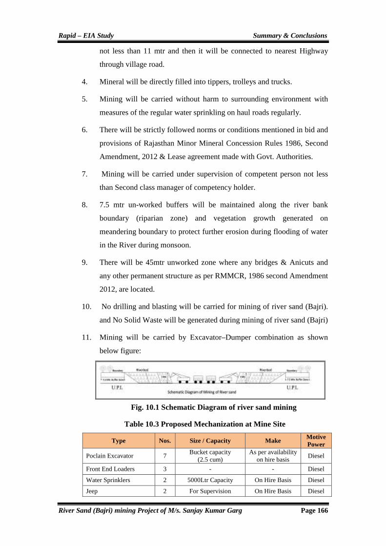
Rapid – EIA Study Summary & Conclusions
River Sand (Bajri) mining Project of M/s. Sanjay Kumar Garg Page 166
not less than 11 mtr and then it will be connected to nearest Highway
through village road.
4. Mineral will be directly filled into tippers, trolleys and trucks.
5. Mining will be carried without harm to surrounding environment with
measures of the regular water sprinkling on haul roads regularly.
6. There will be strictly followed norms or conditions mentioned in bid and
provisions of Rajasthan Minor Mineral Concession Rules 1986, Second
Amendment, 2012 & Lease agreement made with Govt. Authorities.
7. Mining will be carried under supervision of competent person not less
than Second class manager of competency holder.
8. 7.5 mtr un-worked buffers will be maintained along the river bank
boundary (riparian zone) and vegetation growth generated on
meandering boundary to protect further erosion during flooding of water
in the River during monsoon.
9. There will be 45mtr unworked zone where any bridges & Anicuts and
any other permanent structure as per RMMCR, 1986 second Amendment
2012, are located.
10. No drilling and blasting will be carried for mining of river sand (Bajri).
and No Solid Waste will be generated during mining of river sand (Bajri)
11. Mining will be carried by Excavator–Dumper combination as shown
below figure:
Fig. 10.1 Schematic Diagram of river sand mining
Table 10.3 Proposed Mechanization at Mine Site
Type Nos. Size / Capacity Make Motive Power
Poclain Excavator 7 Bucket capacity
(2.5 cum) As per availability
on hire basis Diesel
Front End Loaders 3 - - Diesel
Water Sprinklers 2 5000Ltr Capacity On Hire Basis Diesel
Jeep 2 For Supervision On Hire Basis Diesel

Rapid – EIA Study Summary & Conclusions
River Sand (Bajri) mining Project of M/s. Sanjay Kumar Garg Page 167
Road Grader/Compactor 1 For compactness of
Haul roads On Hire Basis Diesel
Van cum Ambulance 1 For emergency services On Hire Basis Diesel
Mobile Store Room with necessary tools
1 For maintenance of machinery at site
On Hire Basis Diesel
10.5 CONCEPTUAL MINING PLAN
Mining will be started at various points within the river channel confined to
lease area @ 28,05,000 Tons per year. Lease will be worked for five year
period for 3mts working depth as it is prescribed for mining. Since river sand
is replenished in every rainy season hence, the life of mine cannot be
ascertained.
Afforestation along 7.5mts buffer zone River boundary of lease will be carried out
in phased manner with local species in the Govt. land only as riparian vegetation
so that erosion of slopes of boundary is protected during monsoon season and
environment is protected. Lease is granted for five year period so that progressive
plantation @1000 trees along river bank, community center or nearby school and
haul roads in buffer zone will be carried out.
Blasting: River sand is in loose form so there is no requirement of Blasting.
Mine Drainage: The ground water in this area gets intersected at a depth of
more than 8-10 mbgl in riverbed and more than 20-25 m in surrounding
agricultural fields as seen during field survey. No mining work will be carried
out below the water table. As such there shall be no need for any pumping
operations. A drain on the up-slope side of pit will be made so that rainwater
does not go into pit during mining operations. No water problem is envisaged
during the five years working of lease period. The details of conceptual plan of
the mine are given in table below:
Table 10.4 Land: Stage Wise Land use Operational and Post Operational Reclamation Area (Ha.)
S.No. Particular Present End of 5 Year
1. Area excavated 3.0 301
2. Storage of Top Soil Nil Nil
3. Overburden/ Dump Nil Nil
4. Mineral Storage Nil Nil
5. Infrastructure (Workshop, administration building etc)
Nil Nil
6. Roads 5 Ha. 5 Ha.
7. Railways Nil Nil

Rapid – EIA Study Summary & Conclusions
River Sand (Bajri) mining Project of M/s. Sanjay Kumar Garg Page 168
8. Green Belt - 5.4
9. Tailing Pond Nil Nil
10. Effluent Treatment Plant Nil Nil
11. Mineral Separation Plant Nil Nil
12. Township Area Nil Nil
13. Unworked 1667.85 1364.45
Total 1675.85 Ha. 1675.85 Ha.
10.6 EIA METHODOLOGY
The environmental impacts from the proposed mining activity on different
environmental parameters viz. air, water, noise, land, biological and socio-
economic conditions has been assessed through rapid Environmental
Impact Assessment (EIA) studies in December, 2013 to February, 2014
within the impact zone of 10 Km radius. The area has been distinctly
divided into core zone (which forms the actual mining lease area of
1675.85 Ha.) and the buffer zone encompassing a radius of 10 km from the
periphery of the lease.
10.7 BASELINE ENVIRONMENTAL DATA
Environment baseline studies have been conducted during the December, 2013
to February, 2014 in respect of micrometeorology, air quality, ambient noise
levels, biological environment (flora & fauna), water quality, soil quality &
socio-economics in the core and buffer zone of 10 km radius.
10.7.1 Ambient Air Quality
The ambient air quality monitoring of study area comprising core and buffer
zone for the December, 2013 to February, 2014 was conducted and all the
parameters SO2, NOX and PM10 were found within the specified limit of
CPCB standards.
10.7.2 Water Quality
Surface Water: Surface water resources are meager in the state. In the buffer
zone, some of the seasonal surface water bodies located i.e. Banas River,
Berach River, Kothari River, Menali Nadi, Unli Nadi and Kachola Pond water
body. All the above water bodies are seasonal in nature.
Ground Water
Ground water quality in Ajmer significantly influenced by semi-arid climate
and hydro-geologically diversity-salinity, sodicity and fluoride are the major

Rapid – EIA Study Summary & Conclusions
River Sand (Bajri) mining Project of M/s. Sanjay Kumar Garg Page 169
factors affecting the ground water quality. Ground water is the major source of
irrigation in the district.
10.7.3 Noise Environment
Sound levels during day (6 A.M to 10 P.M) and Night (10 P.M to 6 A.M) at
10 stations covering 4 in core zone and 6 in buffer zone villages have been
monitored.
Table 10.5 Environmental Baseline Data (December, 2013 to February, 2014)
S.No. Parameters Details
A. Ambient Air Quality
1. PM10 46.6 µg/m3 to 69.3 µg/m3
2. SO2 5.6 µg/m3 to 8.8 µg/m3
3. NOx 9.9 µg/m3 to 13.8 µg/m3
B. Noise Level
5. At Day time 51.4 – 74.8 dB (A)
6. At Night time 39.2 – 48.6 dB(A)
C. Water Quality(Surface &Ground water)
7. pH 7.55 to 8.20
8. Total Dissolved Solid 289 mg/l to 584 mg/l
9. Nitrate 18.8 mg/l to 182.05 mg/l
D. Soil Quality
10. Organic Carbon 0.03% to 1.65%
10.7.4 Biological Environment
Flora: The floral species observed in the mine lease area are bushes, shrubs and
few trees like Prosopis juliflora (Vilayati Babool), Prosopis cineraria (Khejari),
Acacia nilotica (Babool), Azadirachta indica (Neem) and Ziziphus mauritiana
(Ber).
Fauna
Commonly found animal in the study area are Nevla (Herpestes edwardsii),
Rat (Rattus rattus), House Crow (Passer domesticus), Pigeon (Columba livia)
etc. The area does not support any kind of flora & fauna of ecologically
importance.
10.7.5 Land Use Pattern
Core Zone: of this project consists of mining lease near Amarpura, Asawari,
Bagthala, Baroo Khera, Bedunda, Bedunda, Beeliya, Bhand Ka Khera,

Rapid – EIA Study Summary & Conclusions
River Sand (Bajri) mining Project of M/s. Sanjay Kumar Garg Page 170
Bharliya, Bhawani Singh Ka Khera, Bilod, Chainpuriya, Chandpura,
Chhitarsingh Ji Ka Khera, Chohli, Daulji Ka Khera, Devipura, Gandhari,
Gariyan, Gheoriya, Golbari, Gopalpura, Govta, Harisinghji Ka Khera, Hastra,
Heengwaniya, Jaliya, Jojwa, Kankoliya, Kanti, Katariyon Ka Khera,
Khakhunda, Khangarji Ka Khera, Khatwara, Khatwara, Kherpura,
Lakshmipura, Lodhiyana, Mahtaji Ka Khera, Moi, Padampura, Panderi,
Peethalpura, Phalasiya, Phoolji Ki Kheri, Pratappura, Ralayata, Ramthali, Sand,
Shyam Garh, Tahla, Thal Kalan, Thalkhurd, Tiroli, Ummedpura with an area of
1675.85 Ha. The lease area falls in Gair Mumkin Nadi (government land).
Buffer Zone: Buffer zone comprises of agriculture land, scrub land, open land
& waste land. Dry agriculture and wet agriculture crops are being raised in the
buffer zone. The lease area will be used for mining and allied activities,
including a green belt development.
10.7.6 Socio-Economics
Population in these villages is mainly dependent on dry agriculture depending
on the rainfall. The mining activity provides some job opportunities to the
local villagers either by way of direct or indirect employment.
10.7.7 Demographic Profile
Total populations are about 138379 as per 2011 census in the study area. Out
of the total population, 19.20 % are scheduled caste and 10.08 % is scheduled
tribes. Literacy status in study area depicts that the area have 48.81 % literates
and 51.19 % illiterates.
10.7.8 Statutory Facilities Available at Mine
First Aid Station: A first aid station is to be made available with all necessary
medical kit. All engineers and supervisors are being trained in first-aid
treatment to take care of any emergency. An Ambulance is also proposed for
this purpose.
Canteen/Rest Shelter: A good canteen-cum-rest shelter is to be made
available in the mine complex.
Blasting Shelter: These are to be made available in the mining area.
Ablution Block: Appropriate number of Urinals & lavatories is to be made
available at the mine office, rest shelter.

Rapid – EIA Study Summary & Conclusions
River Sand (Bajri) mining Project of M/s. Sanjay Kumar Garg Page 171
10.8 ENVIRONMENTAL IMPACT ASSESSMENT
The effect of mining on the environment will be marginal. From the baseline
study it could be seen that all the values of ambient air, noise, water, soil etc.
are well within the prescribed limits. However, proper management measures
will be taken to minimize the impacts on the environment. The management of
mine has already initiated the following steps to control pollution and the same
shall be continued vigorously in future also.
10.9 ENVIRONMENTAL MANAGEMENT PLAN (EMP)
10.9.1 Air Quality
� The only air pollution sources are the road transport network of the
trucks. The dust suppression measures like water spraying will be done
on the roads.
� Dust mask provided to the workers engaged at dust generation points
like excavations, loading and unloading points.
� Overloading will be prevented. The trucks/ tractor trolley will be
covered by tarpaulin covers.
� Plantation of trees along the 7.5m of riparian zone to help reduce the
impact of dust in the nearby villages.
10.9.2 Water Quality
� The deposit will be worked from the top surface to 3m bgl or above the
ground water table whichever is less.
� Thus no ground water pollution is expected, as mining will not intersect
ground water.
� It is not proposed to divert or truncate any part of the stream and at no
point of time mining will be done from the stream.
10.9.3 Land Management
� Minimum number of access roads to river bed for which cutting of river
banks will be avoided and ramps are to be maintained.
� Access points to river bed will be decided basing on least steepness of
river bank and least human activity.
� Mining will be avoided during the monsoon season.
Rapid – EIA Study Summary & Conclusions
River Sand (Bajri) mining Project of M/s. Sanjay Kumar Garg Page 172
� Vegetation development is proposed along the road sides of the approach
roads, to arrest soil erosion. While selecting the plant species, preference
will be given for planting native species of the area.
10.9.4 Noise Control
� Well maintained vehicle will be used which will reduced the noise level.
� Plantation: Plantation of trees along the 7.5m riparian zone of the river
will be done to dampen the noise, if possible.
� Hearing Protection: No hearing protection is generally needed for River
sand mining projects.
� The vehicles will be maintained in good running condition so that noise
will be reduced to minimum possible level.
� Phasing out of old and worn out trucks.
� Trucks drivers will be instructed to make minimum use of horns at the
village area.
10.10 POST PROJECT ENVIRONMENTAL QUALITY IMPLEMENTATION & MONITORING PROGRAMMES
1.10.1 Monitoring Schedule
The monitoring schedule will include the following:
� Noise Control: Quarterly measurement of noise levels at sensitive
locations would bring out the efficacy of maintenance schedules.
� Monitoring (One 8-hr sample) of ambient air quality at sensitive
locations at regular intervals.
� Monitoring of water quality from appropriate stations at regular
intervals.
10.11 ENVIRONMENTAL COST
The annual cost for environmental measures would be Rs. 22 lakh. The annual
recurring cost in community development or socio-economic welfare would
be Rs. 10 lakh. Cost for OHS will be Rs 10 Lakh per annum.
10.12 CONCLUSION
M/s. Sanjay Kumar Garg LOI Holder of River sand mine M.L. Area
1675.85 Ha. is seeking environmental clearance for proposed production

Rapid – EIA Study Summary & Conclusions
River Sand (Bajri) mining Project of M/s. Sanjay Kumar Garg Page 173
capacity of River sand (28.05 Lac TPA). The baseline of air, water, soil and
noise levels are found to be normal and are well within the permissible limits.
The expected increase in the levels of the environmental pollution parameters
would be marginal as per the impact assessment made. Continuation of the
project will have the following benefits:
� Increased employment opportunities
� Increased Revenue to the Govt. in terms of Taxes & Royalty.
� Improved socio–economic conditions of nearby villagers

174
Disclosure of
Environment Consultant
PERFACT ENVPERFACT ENVPERFACT ENVPERFACT ENVIRO SOLUTIONS PVT LTDIRO SOLUTIONS PVT LTDIRO SOLUTIONS PVT LTDIRO SOLUTIONS PVT LTD....
501 501 501 501 –––– 507, 5507, 5507, 5507, 5thththth Floor,Floor,Floor,Floor, Front Wing, NN MallFront Wing, NN MallFront Wing, NN MallFront Wing, NN Mall
SectorSectorSectorSector---- 3, Rohini, New Delhi 3, Rohini, New Delhi 3, Rohini, New Delhi 3, Rohini, New Delhi ---- 110085 110085 110085 110085
Phone: +91Phone: +91Phone: +91Phone: +91----11111111----47528467/47021086/6528048347528467/47021086/6528048347528467/47021086/6528048347528467/47021086/65280483
Fax: +Fax: +Fax: +Fax: +91919191----11111111----47528434475284344752843447528434

175
About Environmental Consultant
� INTRODUCTION:INTRODUCTION:INTRODUCTION:INTRODUCTION:
Perfact Enviro Solutions Pvt LtdPerfact Enviro Solutions Pvt LtdPerfact Enviro Solutions Pvt LtdPerfact Enviro Solutions Pvt Ltd, , , , established by experienced environmental and related
experts, provides specialized services in the field of Environment and Pollution Control for
all types of InInInIndustrial, Construction, Nuclear Sciences, Biodustrial, Construction, Nuclear Sciences, Biodustrial, Construction, Nuclear Sciences, Biodustrial, Construction, Nuclear Sciences, Bio----diversity Mining and other diversity Mining and other diversity Mining and other diversity Mining and other
related fieldsrelated fieldsrelated fieldsrelated fields. Our transparent and professional approach, commitment to excellent quality
and service, timely deliveries have contributed to create a name in the field of environment.
We have a core group of highly qualified experts from various fields like environment,
chemistry, civil engineering, geology, social sciences, electronics and telecommunication with
rich and diversified experience in the field of environment and pollution control.
Perfact Enviro Solutions Pvt LtdPerfact Enviro Solutions Pvt LtdPerfact Enviro Solutions Pvt LtdPerfact Enviro Solutions Pvt Ltd is headed by Mr. Praveen BhargavaMr. Praveen BhargavaMr. Praveen BhargavaMr. Praveen Bhargava, Managing Director
and who has an experience of 25 years in the field of Environment and Mrs. Rachna Mrs. Rachna Mrs. Rachna Mrs. Rachna
BhargavaBhargavaBhargavaBhargava, Director & C.E.O who has an experience of 19 years in the field of
Environment.
Perfact Enviro Solutions Pvt LtdPerfact Enviro Solutions Pvt LtdPerfact Enviro Solutions Pvt LtdPerfact Enviro Solutions Pvt Ltd management, experience, excellence, professionalism and
ultimate satisfaction has helped in achieving the heights of success in their specialized field
of environment.
Perfact Enviro Solutions Pvt LtdPerfact Enviro Solutions Pvt LtdPerfact Enviro Solutions Pvt LtdPerfact Enviro Solutions Pvt Ltd compriscompriscompriscomprises of following companieses of following companieses of following companieses of following companies::::
• Perfact Enviro solutions Pvt. Ltd.
• Perfact Solutions
• Perfact Services
• Perfact Researchers Pvt.Ltd.
• Perfact Waste Management Pvt. Ltd
For specialized assignments we have experts from:For specialized assignments we have experts from:For specialized assignments we have experts from:For specialized assignments we have experts from:
• Delhi College of Engineering,
• IIT, Roorkee
• IIT, Delhi
• Thapar University

176
� ACCREDIATATIONS OBTAINED:ACCREDIATATIONS OBTAINED:ACCREDIATATIONS OBTAINED:ACCREDIATATIONS OBTAINED:
• ISO-9001:2008 Certification
• ISO-14001:2004 Certification
• QCI – NABET Scheme for Accreditation of EIA Consultant Organization
� NABET NABET NABET NABET Approved SectorsApproved SectorsApproved SectorsApproved Sectors &&&& EIA CoordinatorsEIA CoordinatorsEIA CoordinatorsEIA Coordinators::::
S.S.S.S.NoNoNoNo.... NABET Approved SectorsNABET Approved SectorsNABET Approved SectorsNABET Approved Sectors CatergoryCatergoryCatergoryCatergory EIA CoordinatorsEIA CoordinatorsEIA CoordinatorsEIA Coordinators
1 Mining of minerals including Opencast/ Underground mining
A Mr. Santosh Pant Mr. U.S. Pandey
2 Mineral beneficiation including pelletisation A Mr. U.S. Pandey
15 Leather/skin/hide processing industry A Mr. Praveen
Bhargava
19 Textile – cotton and manmade fibers B Mr. Praveen
Bhargava
22 Distilleries A Mr. Praveen
Bhargava
31
Industrial estates/ parks/ complexes/areas, export processing Zones (EPZs), Special Economic Zones (SEZs), Biotech Parks, Leather Complexes
B Mrs. Rachna
Bhargava
35 Aerial ropeways B Mrs. Rachna
Bhargava
38
Building and large construction projects including shopping malls, multiplexes, commercial complexes, housing estates, hospitals, institutions
B Mrs. Rachna
Bhargava
39 Townships and Area development projects B Mrs. Rachna
Bhargava
� Functional Area ExpertsFunctional Area ExpertsFunctional Area ExpertsFunctional Area Experts ((((FAEFAEFAEFAE) ) ) ) with area of expertisewith area of expertisewith area of expertisewith area of expertise::::
S.S.S.S.NoNoNoNo.... FAEsFAEsFAEsFAEs Functional AreasFunctional AreasFunctional AreasFunctional Areas AbbreviationAbbreviationAbbreviationAbbreviation
1 � Mr. Rajveer Singh Land Use LU
2 � Dr. R.P.Mathur � Mr. Praveen Bhargava
Air Pollution Monitoring, Prevention & Control
AP
3 � Dr. R.P.Mathur Meteorology, Air Quality Modelling & prediction
AQ
4 � Mr. Praveen Bhargava � Dr. R.P.Mathur � Dr. Purba Chatterji
Water Pollution Monitoring, Prevention & Control
WP
5 � Dr. Purba Chatterji Ecology & Biodiversity EB
6 � Dr. S.P.Nigam Noise & Vibration NV
7 � Mr. Rahul Deshmukh Socio- Economic Aspects SE

177
8 � Mr. Santosh Pant Hydrology, Ground Water &
Water Conservation HG
9 � Mr. Santosh Pant Geology GEO
10 � Mrs. Akta Chugh � Mr. Manoj Kumar
Soil Conservation SC
11 � Mr. S.C.Gupta Risk & Hazards Management RH
12 � Mr. Praveen Bhargava Solid & Hazardous Waste
Management SHW
*Applied For
The EIA report of “River sand Mining Project” (Ml. Area: “River sand Mining Project” (Ml. Area: “River sand Mining Project” (Ml. Area: “River sand Mining Project” (Ml. Area: 1675.851675.851675.851675.85 Ha.)”Ha.)”Ha.)”Ha.)” of M/s. Sanjay M/s. Sanjay M/s. Sanjay M/s. Sanjay
Kumar GargKumar GargKumar GargKumar Garg at Near Villages – Amarpura, Asawari, Bagthala, Baroo Khera, Bedunda,
Bedunda, Beeliya, Bhand Ka Khera, Bharliya, Bhawani Singh Ka Khera, Bilod,
Chainpuriya, Chandpura, Chhitarsingh Ji Ka Khera, Chohli, Daulji Ka Khera, Devipura,
Gandhari, Gariyan, Gheoriya, Golbari, Gopalpura, Govta, Harisinghji Ka Khera, Hastra,
Heengwaniya, Jaliya, Jojwa, Kankoliya, Kanti, Katariyon Ka Khera, Khakhunda,
Khangarji Ka Khera, Khatwara, Khatwara, Kherpura, Lakshmipura, Lodhiyana, Mahtaji
Ka Khera, Moi, Padampura, Panderi, Peethalpura, Phalasiya, Phoolji Ki Kheri,
Pratappura, Ralayata, Ramthali, Sand, Shyam Garh, Tahla, Thal Kalan, Thalkhurd, Tiroli,
Ummedpura TehsilTehsilTehsilTehsil---- Bijoliya & Mandalgarh,Bijoliya & Mandalgarh,Bijoliya & Mandalgarh,Bijoliya & Mandalgarh, District- Bhilwara (Rajasthan) was prepared
by Perfact Enviro Solutions Pvt Ltd, New Delhi.Perfact Enviro Solutions Pvt Ltd, New Delhi.Perfact Enviro Solutions Pvt Ltd, New Delhi.Perfact Enviro Solutions Pvt Ltd, New Delhi.
Team Team Team Team (EIA Coordinators (EIA Coordinators (EIA Coordinators (EIA Coordinators &&&& FAEs ) FAEs ) FAEs ) FAEs ) involved in involved in involved in involved in the Project:the Project:the Project:the Project:
� EIAEIAEIAEIA Coordinators Coordinators Coordinators Coordinators : : : : Mr. Santosh Pant
� Assistant EIA CoordinatorAssistant EIA CoordinatorAssistant EIA CoordinatorAssistant EIA Coordinator : : : : Mr. Mukesh Kumar Gupta
� FAEs Team FAEs Team FAEs Team FAEs Team ::::
S.S.S.S.NoNoNoNo.... FAEsFAEsFAEsFAEs Functional AreasFunctional AreasFunctional AreasFunctional Areas AbbreviationAbbreviationAbbreviationAbbreviation
1 � Mr. Rajveer Singh Land Use LU
2 � Mr. Praveen Bhargava Air Pollution Monitoring,
Prevention & Control AP
3 � Dr. R.P.Mathur Meteorology, Air Quality Modelling & prediction
AQ
4 � Mr. Praveen Bhargava Water Pollution Monitoring,
Prevention & Control WP
5 � Dr. Purba Chatterji Ecology & Biodiversity EB
6 � Dr. S.P.Nigam Noise &Vibration NV
7 � Mr. Rahul Deshmukh Socio- Economic Aspects SE
8 � Mr. Santosh Pant Hydrology, Ground Water &
Water Conservation HG

178
9 � Mr. Santosh Pant Geology GEO
10 � Mr. Manoj Kumar Soil Conservation SC
11 � Mr. S.C.Gupta Risk & Hazards Management RH
12 � Mr. Praveen Bhargava Solid & Hazardous Waste
Management SHW
*Applied For
� Assistant Assistant Assistant Assistant FAEsFAEsFAEsFAEs Team Team Team Team ::::
S.No.S.No.S.No.S.No. FAEsFAEsFAEsFAEs Functional AreasFunctional AreasFunctional AreasFunctional Areas AbbreviationAbbreviationAbbreviationAbbreviation
1 � Mrs. Sunita
(Ramji Mine Envirotech)(Ramji Mine Envirotech)(Ramji Mine Envirotech)(Ramji Mine Envirotech) Land Use LU
2
� Mrs. Rachna Bhargava (Perfact envirosolutions)(Perfact envirosolutions)(Perfact envirosolutions)(Perfact envirosolutions) � Mr. Mukesh Kumar Gupta
((((Ramji MineRamji MineRamji MineRamji Mine Envirotech)Envirotech)Envirotech)Envirotech)
Meteorology, Air Quality Modelling & prediction
AQ
3 � Dr. C.S.Chouhan � Mr. Ajay Kumar
(Ramji Mine Envirotech)(Ramji Mine Envirotech)(Ramji Mine Envirotech)(Ramji Mine Envirotech)
Water Pollution Monitoring, Prevention & Control
WP
4 � Dr. C.S.Chouhan � Mr. Rohit Kumar Tuteja
(Ramji Mine Envirotech)(Ramji Mine Envirotech)(Ramji Mine Envirotech)(Ramji Mine Envirotech) Ecology & Biodiversity EB
5
� Dr. C.S.Chouhan � Mr. Rohit Kumar Tuteja � Mr. Satish Chand Sharma � Mr. Mukesh Kumar Gupta
(Ramji Mine Envirotech)(Ramji Mine Envirotech)(Ramji Mine Envirotech)(Ramji Mine Envirotech)
Solid & Hazardous Waste Management
SHW
6 � Mr. Ashok Kothari
(Ramji Mine Envirotech)(Ramji Mine Envirotech)(Ramji Mine Envirotech)(Ramji Mine Envirotech) Soil Conservation SC
7
� Mr. Mukesh Kumar Gupta � Mr. Ajay Kumar � Mr. Shishir Chaturvedi
(Ramji Mine Envirotech)(Ramji Mine Envirotech)(Ramji Mine Envirotech)(Ramji Mine Envirotech)
Noise & Vibration NV
8 � Mrs. Sunita
(Ramji Mine Envirotech)(Ramji Mine Envirotech)(Ramji Mine Envirotech)(Ramji Mine Envirotech) Socio - Economic Aspects SE
9 � Mr. Ashok Kothari
(Ramji Mine Envirotech)(Ramji Mine Envirotech)(Ramji Mine Envirotech)(Ramji Mine Envirotech) Geology GEO
10 � Mr. Mukesh Kumar Gupta � Mr. Satish Chand Sharma
(Ramji Mine Envirotech)(Ramji Mine Envirotech)(Ramji Mine Envirotech)(Ramji Mine Envirotech) Risk & Hazards Management RH
11 � Mr. Satish chand Sharma � Mr. Ashok Kothari
(Ramji Mine Envirotech)(Ramji Mine Envirotech)(Ramji Mine Envirotech)(Ramji Mine Envirotech) Hydrogeology HG
12
� Mr. Mukesh Kumar Gupta � Dr. C.S.Chouhan � Mr. Shishir Chaturvedi
(Ramji Mine Envirotech)(Ramji Mine Envirotech)(Ramji Mine Envirotech)(Ramji Mine Envirotech)
Air Pollution Monitoring, Prevention & Control
AP

1
Annexure:
Point no. 41 of the TOR Details of Replenishment studies:
Computation of sediment of Budget in Applied lease area for mining of Mineral sand
Bajri by Shri. Mateshwari Minerals, near village- Amarpura, Asawari, Bagthala, Baroo
Khera, Bedunda, Beeliya, Bhand Ka Khera, Bharliya, Bhawani Singh Ka Khera, Bilod,
Chainpuriya, Chandpura, Chhitarsingh Ji Ka Khera, Chohli, Daulji Ka Khera, Devipura,
Gandhari, Gariyan, Gheoriya, Golbari, Gopalpura, Govta, Harisinghji Ka Khera, Hastra,
Heengwaniya, Jaliya, Jojwa, Kankoliya, Kanti, Katariyon Ka Khera, Khakhunda,
Khangarji Ka Khera, Khatwara, Kherpura, Lakshmipura, Lodhiyana, Mahtaji Ka Khera,
Moi, Padampura, Panderi, Peethalpura, Phalasiya, Phoolji Ki Kheri, Pratappura,
Ralayata, Ramthali, Sand, Shyam Garh, Tahla, Thal Kalan, Thalkhurd, Tiroli,
Ummedpura
(Lease area 1675.85 Ha.).
LOCATION AND APPROACH
Location of River Menali lies in extreme South part of Tehsil Mandalgarh starts from village
Tehla and Shyamgarh and continue to flow South to North-East direction. It take turn towards
NW at Khangarji Ka Kheda and merges at triveni with Banas and Berach river. High hills
surrounding of river area near Govta contributes in flow of water. There is one annicut also in
Govta.
Then it goes ahead passing villages PHalasiya and Sarana . There one bridge also over there
connecting villages. It further flows passing through village Lodiyana and Sand.
Three rivers i.e. Berach, Banas and Menali meets at near village Devisingh ka Kheda known as
Triveni Dham. It further flows becoming as Banas river in north-East direction via villages
Moi ,Beeliya, Jojiya, Padampura and flows with many more villages as given in Khasra details.
Tehsil headquarter Mandalgarh falls on Chittorgarh-Bundi Broad gauge section of Northern
Railway. Tehsil headquarter Mandalgarh is also well connected by road links with a district
headquarters Bhilwara through National highway no.79 (Nasirabad-Bhilwara). Mandalgarh
Tehsil is also well connected with the neighbouring districts Chittorgarh beside Bhilwara.

2
Tehsil headquarter Mandalgarh is also approached by National Highway No. NH-76B from
Bhilwara to Mandalgarh 48 Km.
Location of the River is shown in as under:
Fig. 1.1 Location Map of Mining Lease

3
TOPOGRAPHY AND DRAINAGE
Bhilwara district consist of fairly open plains in the north and southeast with a few
hillocks and undulating plains & hills in the south and northeastern part.
Occasional inselberg, low-lying hillocks and chains of ridges break the monotony of
peneplained tract. The area of the district is generally slopes gently except in western &
northwestern part where it is high. Geomorphologically, the district is divided into
following units:
Major River of the district is Banas, which flows in northeast to easterly direction. It
enters near village Doodiya in Bhilwara tehsil in the west flowing towardseast and takes
an abrupt turn towards north-northeastern direction nearBigod downstream of the
confluence with Berach River and again takes an easterly turn near Kanti and finally
flows towards northeast till it enters Tonk district. Total length of the Banas River is 142
km in Bhilwara district. Channel pattern of Banas is sinuous and changes to more or less
straight between Bigod and Rajamahal indicating structural control on the drainage
pattern.Important tributaries are Berach, Kothari, Unli, Mendi, Nakadi, Chandrabhaga
and Khari River.All these are ephemeral.
REGIONAL HYDROGEOLOGY
Major water bearing formations are gneiss and schist (Bhilwara Supergroup); gneiss,
schist, phyllite, slate and limestone (Aravalli Supergroup); sandstone, shale and limestone
(Vindhyan Supergroup) and alluvium. Ground water occurs under unconfined to semi-
confined condition. Weathered zone below the water table acts as a good storage. The
joints, fissures and other plains of structural weakness as well as their extent, size,
opening and inter connection control occurrence & movement of ground water.
Weathered gneiss forms upper part of the bedrock in central part. Weathered
gneiss with schist occupies most of the northern part under thin cover of alluvium.
In schists, phyllites and slates, weathered zone extends to depth greater than in
granites and gneisses. Muscovite schist often grade into gneiss. These have
well-developed foliation and irregular joints and are intruded by granite,
amphibolite, pegmatite and quartz vein. The contact between these intrusives
and schist, provide good channel for ground water circulation. Dug wells in
4
Gangapur and Bhilwara area tapping gneiss and mica schist yield between 25 & 50
m3/day.
Phyllites and schists are predominating in the eastern parts of the district near
Shakargarh, Amalda and Kachola towards north of Great Boundary Fault. These
formations are intercalated with dolomitic limestone, quartzite and basic intrusives.
Depth of wells tapping these formations varies from 15 to 50 m. Yield of wells vary from
30 to 45 m3/day.
3. (A) (ii) RAINFALL & CLIMATE,DRAINAGE PATTERN
• Mean annual rainfall (1986-2005) of the district is 633.9 mm whereas normal rainfall
(1901-70) is lower than average rainfall and placed at 603.3. Almost 95% of the total
annual rainfall is received during the southwest monsoon, which enters the district in the
last week of June and withdraws in the middle of September. Probability of average
annual rainfall exceeding 900 mm is only 10%. However, there is 90% probability that
the average rainfall will be more than 400 mm. The probability of occurrence of mean
annual rainfall is 45%. Drought analysis based on agriculture criteria indicates that the
district is prone to mild and normal type of droughts. Occurrence of severe and very
severe type of drought is very rare.January is the coldest month with mean maximum and
minimum temperatures being lowest at 22.20C & 7.30C. Temperature in summer month,
June, reaches up to 460C. There is drop in temperature due to onset of monsoon and rises
again in the month of September. Atmosphere is generally dry except during the
monsoon period. The humidity is highest in August with mean daily relative humidity
80%. The annual potential evapotranspiration in the district is 1495 mm and is the highest
in the month of May (228 mm).
• DRAINAGE PATTERN
Bhilwara district consist of fairly open plains in the north and southeast with a few
hillocks and undulating plains & hills in the south and northeastern part.
Occasional inselberg, low-lying hillocks and chains of ridges break the monotony of
peneplained tract. The area of the district is generally slopes gently except in western &
northwestern part where it is high. Geomorphologically, the district is divided into
following units:

5
Major River of the district is Banas, which flows in northeast to easterly direction. It
enters near village Doodiya in Bhilwara tehsil in the west flowing towardseast and takes
an abrupt turn towards north-northeastern direction nearBigod downstream of the
confluence with Berach River and again takes an easterly turn near Kanti and finally
flows towards northeast till it enters Tonk district. Total length of the Banas River is 142
km in Bhilwara district. Channel pattern of Banas is sinuous and changes to more or less
straight between Bigod and Rajamahal indicating structural control on the drainage
pattern.Important tributaries are Berach, Kothari, Unli, Mendi, Nakadi, Chandrabhaga
and Khari River.All these are ephemeral.
Table 1.5 Rainfall Data of Past 23 Years of Tehsil Bijoliya & Mandalgarh
S.No. Year Rainfall in mm. (Mandalgarh)
Rainfall in mm. (Bijoliya)
Rainfall in mm. (Kotri)
1 1990 940.0 1220.0 946.0
2 1991 786.0 1025.0 674.0
3 1992 960.0 797.0 757.0
4 1993 849.0 947.0 449.0
5 1994 1414.0 1164.0 1155.0
6 1995 757.0 941.0 574.0
7 1996 979.0 1056.0 1569.0
8 1997 753.0 1071.0 554.0
9 1998 402.0 673.0 423.0
10 1999 641.0 630.2 566.0
11 2000 602.0 746.0 518.0
12 2001 683.0 1012.0 780.0
13 2002 411.0 487.0 392.0
14 2003 914.0 796.0 512.0
15 2004 875.0 1161.0 1331.0
16 2005 594.0 602.0 514.0
17 2006 904.0 1027.0 674.0
18 2007 885.0 474.0 598.0
19 2008 697.0 729.0 911.0
20 2009 465.0 552.0 308.0
21 2010 830.0 880.0 882.0
22 2011 883.0 767.0 903.0
23 2012 680.0 875.0 700.0
Annual Average Rainfall in mm. 778.4 853.6 725.7
6
A Study by Dandy and Bolton shows that sediment yield can be related to catchment area
and mean annual runoff.
Sediment Yield versus Drainage Area Dandy and Bolton studied sedimentation data
from about 1500 reservoirs, ponds, and sediment detention basins. In developing their
formulas, they used data from about 800 of these reservoirs with drainage areas greater
than or equal to 1 mi2-were excluded because of their large variability of sediments yield,
reflecting the diverse effects of soils, local terrain, vegetation, land use, and agricultural
practices.
For drainage areas between 1 and 30,000 mi2, Dandy and Bolton found that the annual
sediment yield per unit area was inversely related to the 0.16 power of the drainage area:
In which S= sediment yield in tons per square mile per year; SR = Reference sediment
yield corresponding to a 1-mi2 drainage area, equal to 1645 tons per year; A = drainage
area in square miles; and AR = reference drainage area (1 mi2)
Sediments Yield versus Mean Annual Runoff. Dandy and Bolton studied
sedimentation data from 505 reservoirs having mean annual runoff data. Annual sediment
yield per unit area was shown to increase sharply as mean annual runoff Q in- creased
from 0 to 2 in. Thereafter, for mean annual runoff from 2 to 50 in. annual sediment yield
per unit area decreased exponentially. This led to the following equations.
For Q <2 in.:
For Q <2 in.:
In which QR = reference mean annual runoff QR = 2 in.
Dandy and Bolton combined Eqs. 15-10 and 15-11 into a set of equations to express
sediment yield in terms of drainage area and mean annual runoff.
For Q <2 in.:
For Q <2 in.:

7
Sec: 15.2 Sediment Production.
For SR = 1645 tons/mi2/y, QR = 2 in., and AR = 1 mi2, Eq. 15-12 reduces to the
followings:
For Q <2 in.: S = 1280 Q0.46(1.43 – 0.26 log A)
For Q <2 in.: S = 1965e-0.055Q(1.43 – 0.26 log A)
Equations 5-12 and 5-13 are based on average values of grouped data; therefore, they
should be used with caution. In Certain cases, local factors such as soils, geology,
topography, land use, and vegetation may have greater influence on sediment yield than
either mean annual runoff or drainage area. Nevertheless, these equations provide a first
approximation to be regional assessment of sediment yield for watershed planning
purposes.
Example:
Calculate the sediment yield by the Dandy and Bolton formula for a 150-mi2 watershed
with 3.5 in. of mean annual runoff.
The application of Eq. 15-13b leads to:
S= 1965 X e(-0.055.3.5)[1.43 – 0.26 log (150)] = 1400 ton/mi2/y
Therefore, the sediment yield is 210,000 ton/y.
The equations express the general relationships between sediment yield runoff and
drainage area. They may provide a quick rough approximation of mean sediment yields
on a regional basis for preliminary watershed planning. Because Dandy & Bolton have
derived the equation form average values computed sediment yields normally would be
low for highly erosive area and high for well stabilized drainage basins with high plant
density.
Factors which have direct bearing on sediments yield & limitations of Dandy & Bolton
equation.
Sediment yield of a sediment basin has direct impact of local terrain, climate, vegetation,
soils, agricultural practices & land use pattern of catchment area of the sediment basin
aforesaid factors varies from basin to basin therefore, Dandy & Bolton has categorily

8
stated that use of the equation to predict sediment yield for a specific location would be
unwise because of the wide variability caused by local factors not considered in the
equation development. Actual sediment yield form individual drainage basins may vary
10-fold or even 100-fold from computed yields.
Rainfall data relied on for computation sediment yield in the instant case are as under:
Rainfall Data of Past 23 Years of Tehsil Bijoliya & Mandalgarh
S.No. Year Rainfall in mm. (Mandalgarh)
Rainfall in mm. (Bijoliya)
Rainfall in mm. (Kotri)
1 1990 940.0 1220.0 946.0
2 1991 786.0 1025.0 674.0
3 1992 960.0 797.0 757.0
4 1993 849.0 947.0 449.0
5 1994 1414.0 1164.0 1155.0
6 1995 757.0 941.0 574.0
7 1996 979.0 1056.0 1569.0
8 1997 753.0 1071.0 554.0
9 1998 402.0 673.0 423.0
10 1999 641.0 630.2 566.0
11 2000 602.0 746.0 518.0
12 2001 683.0 1012.0 780.0
13 2002 411.0 487.0 392.0
14 2003 914.0 796.0 512.0
15 2004 875.0 1161.0 1331.0
16 2005 594.0 602.0 514.0
17 2006 904.0 1027.0 674.0
18 2007 885.0 474.0 598.0
19 2008 697.0 729.0 911.0
20 2009 465.0 552.0 308.0
21 2010 830.0 880.0 882.0
22 2011 883.0 767.0 903.0
23 2012 680.0 875.0 700.0 Annual Average Rainfall in
mm. 778.4 or 30.645669
inch 853.6 or 33.606299
inch 725.7 or
28.570866 inch
Calculation of Sediment budget for Banas River, Mainali & Berach
The annual rainfall in instant case is 778.4 or 30.645669 inch. & catchment area of Banas
River,Berach River& Mainali River sediment basin (As per GIS Map enclosed) is
1724425.70 Ha. i.e. 6658.0448501607 Sqmiles. On substitution aforesaid values in

9
Dandy & Bolton equation, the sediment yield of the Banas River,Berach River& Mainali
River basin comes out to be 1768987.63 M. tons/yr


