english - examination board - aga khan university
TRANSCRIPT
Higher Secondary School Certificate
Examination
GEOGRAPHY CLASSES XI-XII
(based on National Curriculum 2006)
Published by
Aga Khan University Examination Board
Bungalow # 233 / E.I.Lines,
Daudpota Road, Karachi, Pakistan.
June 2012
All rights reserved
This syllabus is developed by Aga Khan University Examination Board for distribution
to all its affiliated schools.
Higher Secondary School Certificate
Examination Syllabus
GEOGRAPHY CLASSES XI-XII
This subject is examined in the
May Examination session only

June 2012 Page 4
Sr. No. Table of Contents Page No.
Preface 5
1. Aims/Objectives of the National Curriculum (2006) 8
2. Rationale of the AKU-EB Examination Syllabuses 10
3. Topics and Student Learning Outcomes of the Examination Syllabus 74
4. Scheme of Assessment 72
5. Teaching-Learning Approaches and Classroom Activities 79
6. Recommended Texts and Reference Materials 79
7. Definition of Cognitive Levels and Command Words in the Student
Learning Outcomes in Examination Papers
82
Annex: HSSC Scheme of Studies 87
For queries and feedback
Address: The Aga Khan University Examination Board
Bungalow No. 233/ E.I.Lines, Daudpota Road, Karachi-Pakistan.
Phone: (92-21) 35224702-10
Fax: (92-21) 35224711
E-mail: [email protected]
Website: http://examinationboard.aku.edu
http://learningsupport.akueb.edu.pk
Facebook: www.facebook.com/akueb
June 2012 Page 5
PREFACE
In pursuance of National Education Policy (1998-2010), the Curriculum Wing of the Federal
Ministry of Education has begun a process of curriculum reform to improve the quality of
education through curriculum revision and textbook development (Preface, National
Curriculum documents 2000 and 2002).
AKU-EB was founded in August 2003 with the same aim of improving the quality of
education nationwide. As befits an examination board it seeks to reinforce the National
Curriculum revision through the development of appropriate examinations for the Secondary
School Certificate (SSC) and Higher Secondary School Certificate (HSSC) based on the
latest National Curriculum and subject syllabus guidance.
AKU-EB has a mandate by Ordinance CXIV of 2002 to offer such examination services to
English and Urdu medium Candidatess for SSC and HSSC from private schools anywhere in
Pakistan or abroad, and from government schools with the relevant permissions. It has been
accorded this mandate to introduce a choice of examination and associated educational
approach for schools, thus fulfilling a key objective of the National Curriculum of Pakistan:
“Autonomy will be given to the Examination Boards and Research and Development cells
will be established in each Board to improve the system” (ibid. para. 6.5.3 (ii)).
AKU-EB is committed to creating continuity of educational experience and the best possible
opportunities for its students. In consequence it offered HSSC for the first time in September,
2007 to coincide with the arrival of its first SSC students in college or higher secondary
school. Needless to say this is not an exclusive offer. Private Candidatess and students joining
AKU-EB affiliated schools and colleges for HSSC Part 1 are eligible to register as AKU-EB
Candidatess even though they have not hitherto been associated with AKU-EB.
This examination syllabus exemplifies AKU-EB’s commitment to national educational goals.
• It is in large part a reproduction, with some elaboration, of the Class XI and XII National
Curriculum of the subject.
• It makes the National Curriculum freely available to the general public.
• The syllabus recommends a range of suitable textbooks already in print for student
purchase and additional texts for the school library.
• It identifies areas where teachers should work together to generate classroom activities
and materials for their students as a step towards the introduction of multiple textbooks,
another of the Ministry of Education’s policy provisions for the improvement of higher
secondary education (ibid. para. 6.3.4).

June 2012 Page 6
This examination syllabus brings together all those cognitive outcomes of the National
Curriculum statement which can be reliably and validly assessed. While the focus is on the
cognitive domain, particular emphasis is given to the application of knowledge and
understanding, a fundamental activity in fostering “attitudes befitting useful and peaceful
citizens and the skills for and commitment to lifelong learning which is the cornerstone of
national economic development” (Preface to National Curriculum documents 2000 and
2002).
To achieve this end AKU-EB has brought together university academicians, teacher trainers,
writers of learning materials and above all, experienced teachers, in regular workshops and
subject panel meetings.
AKU-EB provides copies of the examination syllabus to subject teachers in affiliated schools
to help them in planning their teaching. It is the syllabus, not the prescribed textbook which is
the basis of AKU-EB examinations. In addition, the AKU-EB examination syllabus can be
used to identify the training needs of subject teachers and to develop learning support
materials for students. Involving classroom teachers in these activities is an important part of
the AKU-EB strategy for improving the quality of learning in schools.
The Curriculum Wing of the Federal Ministry of Education has recently released new
subject specifications and schemes of study which have been implemented since September,
2008. These documents are a major step forward towards a standards-related curriculum and
have been welcomed by AKU-EB. Our current SSC syllabuses have been revised to ensure
conformity with the National Curriculum.
We stand committed to all students who have embarked upon the HSSC courses in
facilitating their learning outcomes. Our examination syllabus document ensures all possible
support.
Dr. Thomas Christie
Director,
Aga Khan University Examination Board
July 2009

June 2012 Page 7
1. Aims/Objectives of the National Curriculum (2006)1
1. To emphasize learning in a way that encourages comprehension, observation,
creativity, questioning, application and evaluation skills.
2. To create an understanding of the key concepts, ideas, principles, nature and spirit
in relation to physical and human activities.
3. To provide an understanding and appreciation of the interrelationship between
physical environment and human activities and conceptual clarification of man
environment system.
4. To inculcate in students the qualities of national character, love for country, and
sense of national unity, integrity and gratitude to Almighty Allah for having
exemplary physical and human resources.
5. To provide understanding of the basic geographical character of locality/society
and day to day problems faced by human beings in which they live.
6. To develop an understanding of physical and human geography through
systematic study of various content matter.
7. To develop comprehension of interpreting data presented in various forms i.e.
models, charts, illustrations, statistics, maps, diagram, atlas extracts and written
materials.
8. To improve the abilities of students in practical geographical skills.
9. To enhance a positive attitude towards Geography discipline as an intellectual
subject relevant to everyday life.
1 Government of Pakistan (2006), National Curriculum; Geography Classes XI-XII, Islamabad, Ministry of
Education (Curriculum Wing)
June 2012 Page 8
2. Rationale of the AKU-EB Examination Syllabus
2.1 General Rationale
2.1.1 In 2007, the Curriculum Wing of the Federal Ministry of Education (MoE)
issued a revised part-wise Scheme of Studies. All subjects are to be taught
and examined in both classes XI and XII. It is therefore important for teachers,
students, parents and other stakeholders to know:
(a) that the AKU-EB Scheme of Studies for its HSSC examination
(Annex A) derives directly from the 2007 Ministry of Education
Scheme of Studies;
(b) which topics will be examined in Class XI and in Class XII;
(c) at which cognitive level or levels (Knowledge, Understanding,
Application and other higher order skills) the topics and sub-topics will
be taught and examined;
2.1.2 This AKU-EB examination syllabus addresses these concerns. Without such
guidance teachers and students have little option other than following a single
textbook to prepare for an external examination. The result is a culture of rote
memorization as the preferred method of examination preparation. The
pedagogically desirable objectives of the National Curriculum which
encourage “observation, creativity and other higher order thinking [skills]” are
generally ignored. AKU-EB recommends that teachers and students use
multiple teaching-learning resources for achieving the specific objectives of
the National Curriculum reproduced in the AKU-EB examination syllabuses.
2.1.3 The AKU-EB examination syllabuses use a uniform layout for all subjects to
make them easier for teachers to follow. Blank sheets are provided in each
syllabus for writing notes on potential lesson plans. It is expected that this
arrangement will also be found helpful by teachers in developing classroom
assessments as well as by question setters preparing material for the AKU-EB
external examinations. The AKU-EB aims to enhance the quality of education
through improved classroom practices and improved examinations.
2.1.4 The Student Learning Outcomes (SLOs) in Section 3 start with command
words such as list, describe, relate, explain, etc. The purpose of the command
words is to direct the attention of teachers and students to specific tasks that
candidates following the AKU-EB examination syllabuses are expected to
undertake in the course of their subject studies. The examination questions
will be framed using the same command words or the connotation of the
command words to elicit evidence of these competencies in candidates’
responses. The definitions of command words used in this syllabus are given
in Section 7. It is hoped that teachers will find these definitions useful in
planning their lessons and classroom assessments.

June 2012 Page 9
2.1.5 The AKU-EB has classified SLOs under the three cognitive levels,
Knowledge (K), Understanding (U) and Application of knowledge and skills
(A) in order to derive multiple choice questions and constructed response
questions on a rational basis from the subject syllabuses ensuring that the
intentions of the National Curriculum should be met in full. The weighting of
marks to the Multiple Choice and Constructed Response Papers is also derived
from the SLOs, command words and cognitive levels. In effect the SLOs
derived from the National Curriculum determine the structure of the AKU-EB
subject examination set out in Section 4 and 5.
2.1.6 Some topics from the National Curriculum have been elaborated and enriched
for better understanding of the subject and/or to better meet the needs of
students in the twenty-first century. These additional topics have been
italicized in Section 3 of this syllabus.
2.2 Specific Rationale of the AKU-EB Geography Examination Syllabus
2.2.1 Geography at the HSSC level lays emphasis on both theory and practical. The
present curriculum is developed to introduce the field of Geography and its
basic concepts in a simple but comprehensive manner so that a fresh student of
this discipline could also follow it without any difficulty as not all of them
come into HSSC after having studied Geography at SSC level.
2.2.2 Students will be required to apply their knowledge in practical activities like
measuring distance on the map, finding directions, identifying rocks, etc.
2.2.3 This course will develop a positive attitude towards Geography and to the
ground realities of life in a major river valley system at the junction of three
tectonic plates.
2.2.4 It will develop a positive attitude towards Geography as an intellectually
satisfying subject leading to extended in-depth study of disciplines such as
geology, cartography, meteorology, environmental management,
geomorphology and landscape ecology at tertiary level of education.
2.2.5 Geographical skills will be developed relating to collection, processing and
analysis of data/information and preparation of report including maps and
graphs and use of computers where ever possible; and
2.2.6 Geographical knowledge will be utilized in understanding issues concerning
the community such as environmental issues, socio-economic concerns, gender
and become responsible and effective members of the community.
June 2012 Page 10
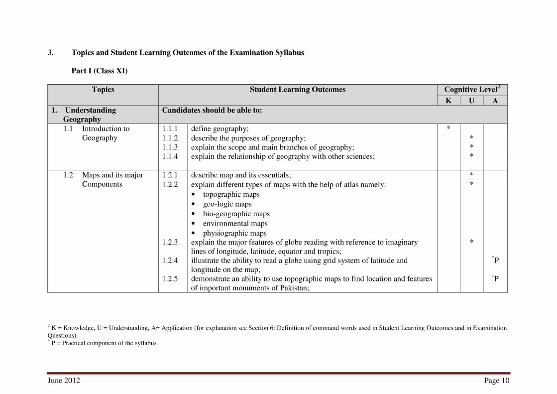
3. Topics and Student Learning Outcomes of the Examination Syllabus
Part I (Class XI)
Topics
Student Learning Outcomes Cognitive Level
2
K U A
1. Understanding
Geography
Candidates should be able to:
1.1 Introduction to
Geography
1.1.1 define geography; *
1.1.2 describe the purposes of geography; *
1.1.3 explain the scope and main branches of geography; *
1.1.4 explain the relationship of geography with other sciences;
*
1.2 Maps and its major
Components
1.2.1 describe map and its essentials; *
1.2.2 explain different types of maps with the help of atlas namely:
• topographic maps
• geo-logic maps
• bio-geographic maps
• environmental maps
• physiographic maps
*
1.2.3 explain the major features of globe reading with reference to imaginary
lines of longitude, latitude, equator and tropics;
*
1.2.4 illustrate the ability to read a globe using grid system of latitude and
longitude on the map;
*P
1.2.5 demonstrate an ability to use topographic maps to find location and features
of important monuments of Pakistan;
*P
2 K = Knowledge, U = Understanding, A= Application (for explanation see Section 6: Definition of command words used in Student Learning Outcomes and in Examination
Questions). * P = Practical component of the syllabus

June 2012 Page 11
NOTES
June 2012 Page 12
K U A
1.2.6 explain the method of finding direction without a compass using the
following the methods:
• watch method
• sun shadow method
• Polar is the north star method
• star method.
*
1.2.7 illustrate how to make a compass using:
• magnet and pins
• floating methods
• hanging methods
*P
1.2.8 illustrate how the time zones are allocated on the globe with the help of
longitude and latitude;
*P
1.3 Scale and its
Application on the
Maps
1.3.1 define scaling with reference to map reading *
1.3.1 describe the scale and its different types; *
1.3.2 explain the methods of showing scale on a physical map; *
1.3.3 illustrate scale conversion; *P
1.3.4 illustrate the construction of plain scale; *P
1.3.5 explain how distance is measured between two allocated point on a map; *
1.3.6 illustrate the ability of using a scale for measuring distance on the map
between allocated points;
*P
1.4 Representation of
Relief
1.4.1 define geographical term ‘relief;’ *
1.4.2 describe the methods of showing relief on a map using contours from line,
hill shading and layer tinting.
*
1.4.3 illustrate practically the methods of showing relief on a map using contours
from line, hill shading and layer tinting.
*P
* P = Practical component of the syllabus

June 2012 Page 13
NOTES
June 2012 Page 14
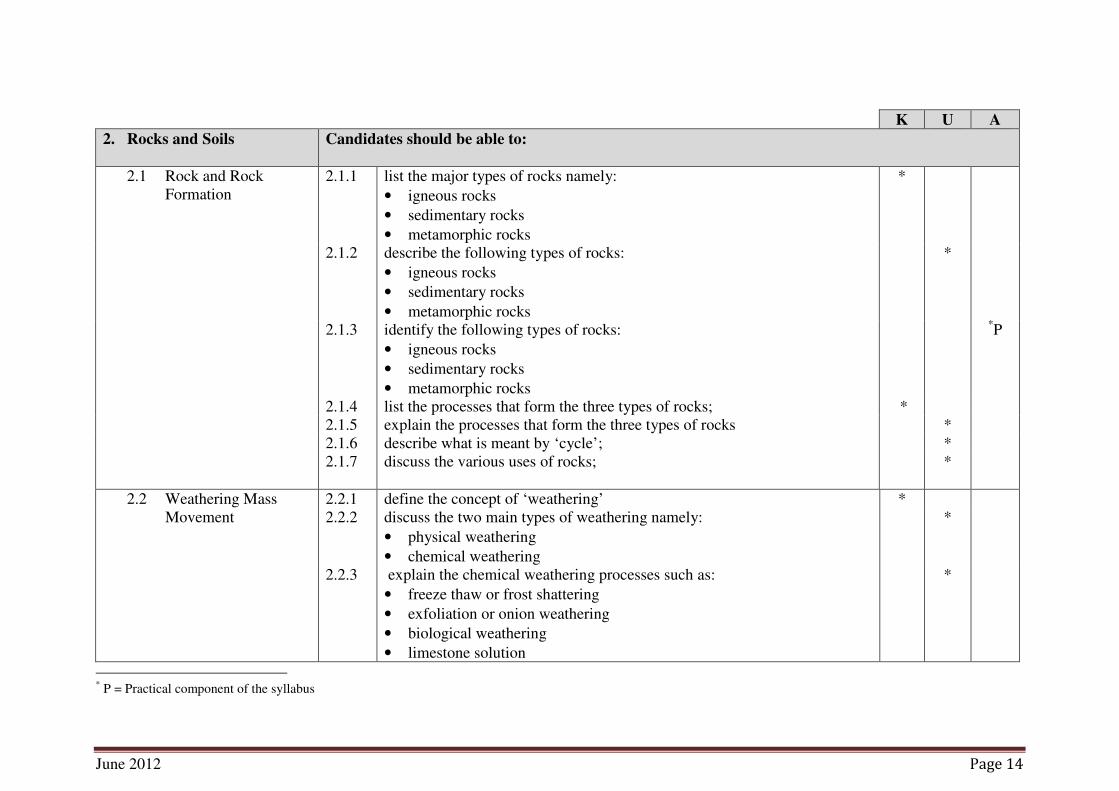
K U A
2. Rocks and Soils Candidates should be able to:
2.1 Rock and Rock
Formation
2.1.1 list the major types of rocks namely:
• igneous rocks
• sedimentary rocks
• metamorphic rocks
*
2.1.2 describe the following types of rocks:
• igneous rocks
• sedimentary rocks
• metamorphic rocks
*
2.1.3 identify the following types of rocks:
• igneous rocks
• sedimentary rocks
• metamorphic rocks
*P
2.1.4 list the processes that form the three types of rocks; *
2.1.5 explain the processes that form the three types of rocks *
2.1.6 describe what is meant by ‘cycle’; *
2.1.7 discuss the various uses of rocks;
*
2.2 Weathering Mass
Movement
2.2.1 define the concept of ‘weathering’ *
2.2.2 discuss the two main types of weathering namely:
• physical weathering
• chemical weathering
*
2.2.3 explain the chemical weathering processes such as:
• freeze thaw or frost shattering
• exfoliation or onion weathering
• biological weathering
• limestone solution
*
* P = Practical component of the syllabus

June 2012 Page 15
NOTES
June 2012 Page 16
K U A
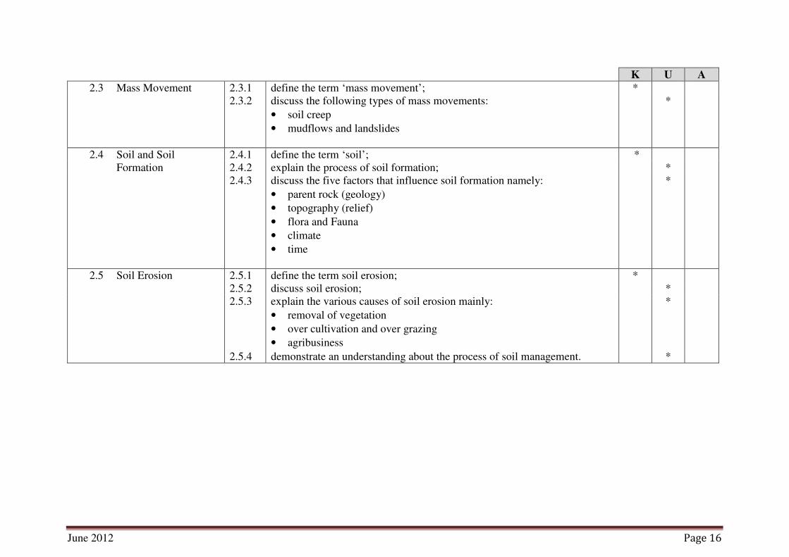
2.3 Mass Movement 2.3.1 define the term ‘mass movement’; *
2.3.2 discuss the following types of mass movements:
• soil creep
• mudflows and landslides
*
2.4 Soil and Soil
Formation
2.4.1 define the term ‘soil’; *
2.4.2 explain the process of soil formation; *
2.4.3 discuss the five factors that influence soil formation namely:
• parent rock (geology)
• topography (relief)
• flora and Fauna
• climate
• time
*
2.5 Soil Erosion 2.5.1 define the term soil erosion; *
2.5.2 discuss soil erosion; *
2.5.3 explain the various causes of soil erosion mainly:
• removal of vegetation
• over cultivation and over grazing
• agribusiness
*
2.5.4 demonstrate an understanding about the process of soil management. *

June 2012 Page 17
NOTES

June 2012 Page 18
K U A
3. The Earth’s Structure Candidates should be able to:
3.1 The Earth as Planet 3.1.1 demonstrate an understanding about the position of the earth within the
solar system;
*
3.1.2 demonstrate an understanding about earth’s shape and size; *
3.1.3 discuss the internal structure of the earth; *
3.1.4 diagrammatically illustrate the various layers of the inner structure of the
earth;
*
3.2 Tectonic Activity 3.2.1 define tectonic activities; *
3.2.2 discuss tectonic activities such as:
• earth quakes
• volcanic eruption
*
3.3 Folding 3.3.1 describe the process of folding; *
3.3.2 explain the formation of fold mountains; *
3.3.3 identify the famous fold mountain ranges on the map of the earth;
*
3.4 Faulting 3.4.1 describe the process of faulting; *
3.4.2 explain block mountains and rift valleys.
*
4. The World of Water Candidates should be able to:
4.1 Drainage Basins 4.1.1 define the following terms:
• drainage basin
• water shed
*
4.1.2 explain the function of drainage density; *
4.1.3 define ‘drainage density’; *
4.1.4 state the formula for calculating drainage density; *
4.1.5 explain the importance of drainage basins as a source of water; *

June 2012 Page 19
NOTES
June 2012 Page 20
K U A
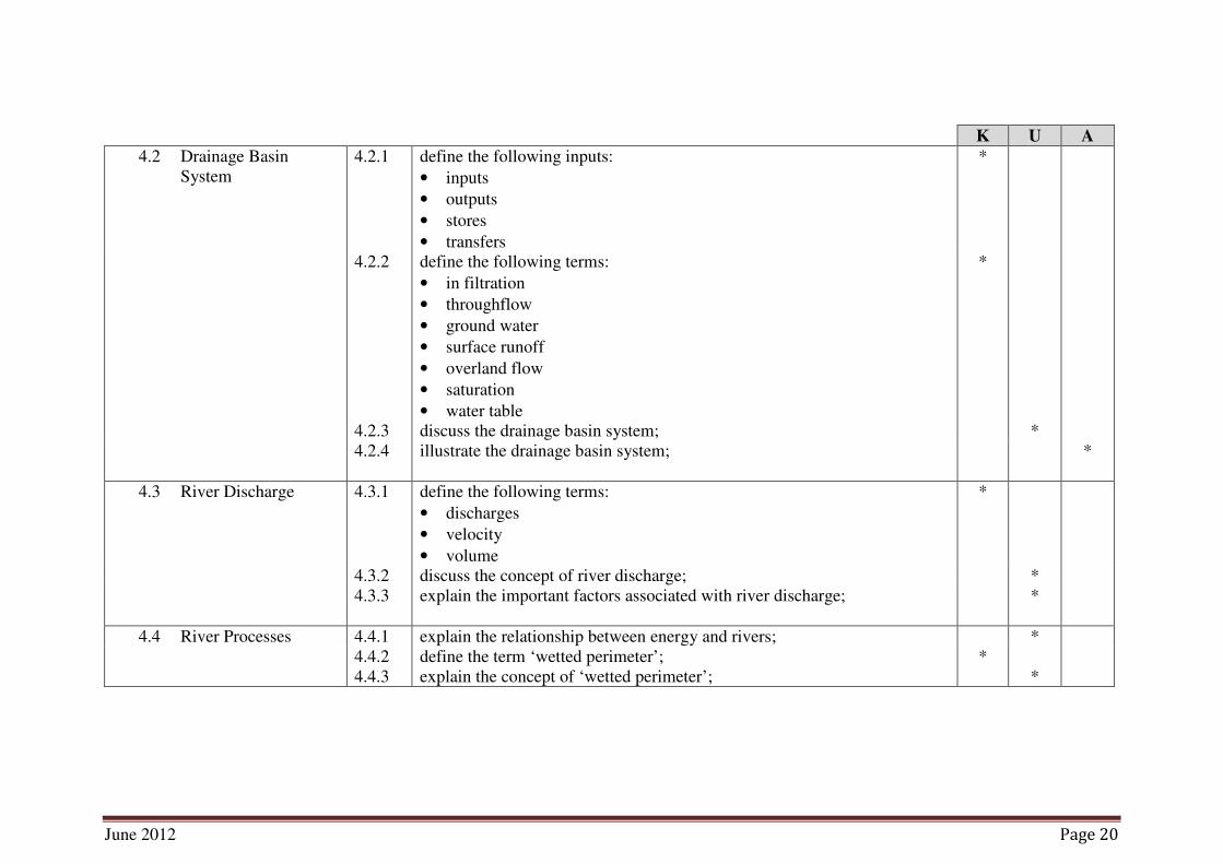
4.2 Drainage Basin
System
4.2.1 define the following inputs:
• inputs
• outputs
• stores
• transfers
*
4.2.2 define the following terms:
• in filtration
• throughflow
• ground water
• surface runoff
• overland flow
• saturation
• water table
*
4.2.3 discuss the drainage basin system; *
4.2.4 illustrate the drainage basin system;
*
4.3 River Discharge 4.3.1 define the following terms:
• discharges
• velocity
• volume
*
4.3.2 discuss the concept of river discharge; *
4.3.3 explain the important factors associated with river discharge;
*
4.4 River Processes 4.4.1 explain the relationship between energy and rivers; *
4.4.2 define the term ‘wetted perimeter’; *
4.4.3 explain the concept of ‘wetted perimeter’; *

June 2012 Page 21
NOTES
June 2012 Page 22
K U A
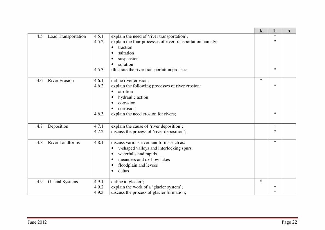
4.5 Load Transportation 4.5.1 explain the need of ‘river transportation’; *
4.5.2 explain the four processes of river transportation namely:
• traction
• saltation
• suspension
• solution
*
4.5.3 illustrate the river transportation process;
*
4.6 River Erosion 4.6.1 define river erosion; *
4.6.2 explain the following processes of river erosion:
• attrition
• hydraulic action
• corrasion
• corrosion
*
4.6.3 explain the need erosion for rivers;
*
4.7 Deposition 4.7.1 explain the cause of ‘river deposition’; *
4.7.2 discuss the process of ‘river deposition’;
*
4.8 River Landforms 4.8.1 discuss various river landforms such as:
• v-shaped valleys and interlocking spurs
• waterfalls and rapids
• meanders and ox-bow lakes
• floodplain and levees
• deltas
*
4.9 Glacial Systems 4.9.1 define a ‘glacier’; *
4.9.2 explain the work of a ‘glacier system’; *
4.9.3 discuss the process of glacier formation; *

June 2012 Page 23
NOTES

June 2012 Page 24
K U A
4.10 Glacial Erosion 4.10.1 describe ‘glacial erosion’; *
4.10.2 discuss the two main process of glacial erosion namely:
• abrasion
• plucking
*
4.11 Glacial Landforms 4.11.1 discuss the various ‘glacial landforms’ such as:
• cirques
• arêtes and pyramidal peaks
• glacial troughs
• truncated spurs
• hanging valleys and ribbon lakes
*
4.12 Transportation and
Deposition
4.12.1 discuss ‘glacial transportation and deposition’; *
4.12.2 explain various types of moraine such as:
• lateral moraine
• medial moraine
• ground moraine
• terminal moraine
• recessional moraines
*
4.12.3 discuss ‘drumlins’;
*
4.13 Coast 4.13.1 define ‘coast’; *
4.13.2 explain the formation of waves; *
4.13.3 discuss the impact of waves on formation of the coast;
*
4.14 Coastal Erosion 4.14.1 define ‘coastal erosion’; *
4.14.2 discuss the four types of coastal erosion:
• corrasion
• attrition
• corrosion
• hydraulic pressure
*

June 2012 Page 25
NOTES
June 2012 Page 26
K U A
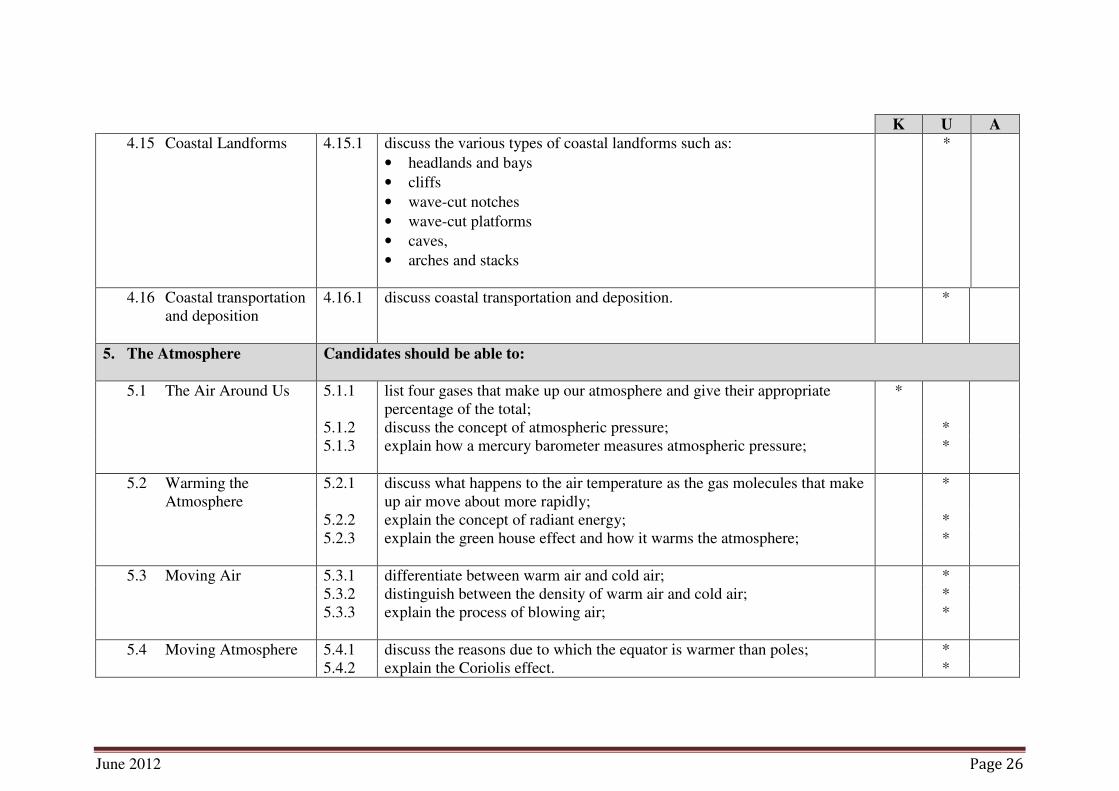
4.15 Coastal Landforms 4.15.1 discuss the various types of coastal landforms such as:
• headlands and bays
• cliffs
• wave-cut notches
• wave-cut platforms
• caves,
• arches and stacks
*
4.16 Coastal transportation
and deposition
4.16.1 discuss coastal transportation and deposition. *
5. The Atmosphere Candidates should be able to:
5.1 The Air Around Us 5.1.1 list four gases that make up our atmosphere and give their appropriate
percentage of the total;
*
5.1.2 discuss the concept of atmospheric pressure; *
5.1.3 explain how a mercury barometer measures atmospheric pressure;
*
5.2 Warming the
Atmosphere
5.2.1 discuss what happens to the air temperature as the gas molecules that make
up air move about more rapidly;
*
5.2.2 explain the concept of radiant energy; *
5.2.3 explain the green house effect and how it warms the atmosphere;
*
5.3 Moving Air 5.3.1 differentiate between warm air and cold air; *
5.3.2 distinguish between the density of warm air and cold air; *
5.3.3 explain the process of blowing air;
*
5.4 Moving Atmosphere 5.4.1 discuss the reasons due to which the equator is warmer than poles; *
5.4.2 explain the Coriolis effect. *

June 2012 Page 27
NOTES

June 2012 Page 28
K U A
6. Physical Environment and
Man
Candidates should be able to:
6.1 Physical Environment 6.1.1 define ‘physical environment’; *
6.1.2 explain the key features of physical environment; *
6.1.3 discuss the impact of physical environment on human life;
*
6.2 Physical Environment
and Human Activity
6.2.1 explain human activity with reference to commercial aspect; *
6.2.2 discuss the impact of physical environment on human activity such as:
• farming
• mining
• fishing
• hunting
• gathering
• trading
*
6.3 Classification of
Human Activity
6.3.1 explain classification of human commercial activities (i.e. primary,
secondary, tertiary);
*
6.3.2 discuss the key features of primary commercial activities ; *
6.3.3 discuss the key features of secondary commercial activities ; *
6.3.4 discuss the key features of tertiary commercial activities ; *
6.3.5 analyse how physical environment impacts human commercial activities
with some examples from the real world;
*
6.4 Conservation of
Environment
6.4.1 define environmental conservation; *
6.4.2 explain the significance of environmental conservation; *
6.4.3 suggest the ways to conserve our environment; *
6.4.4 analyse the impact of conserving environment on upcoming generations. *

June 2012 Page 29
NOTES
June 2012 Page 30
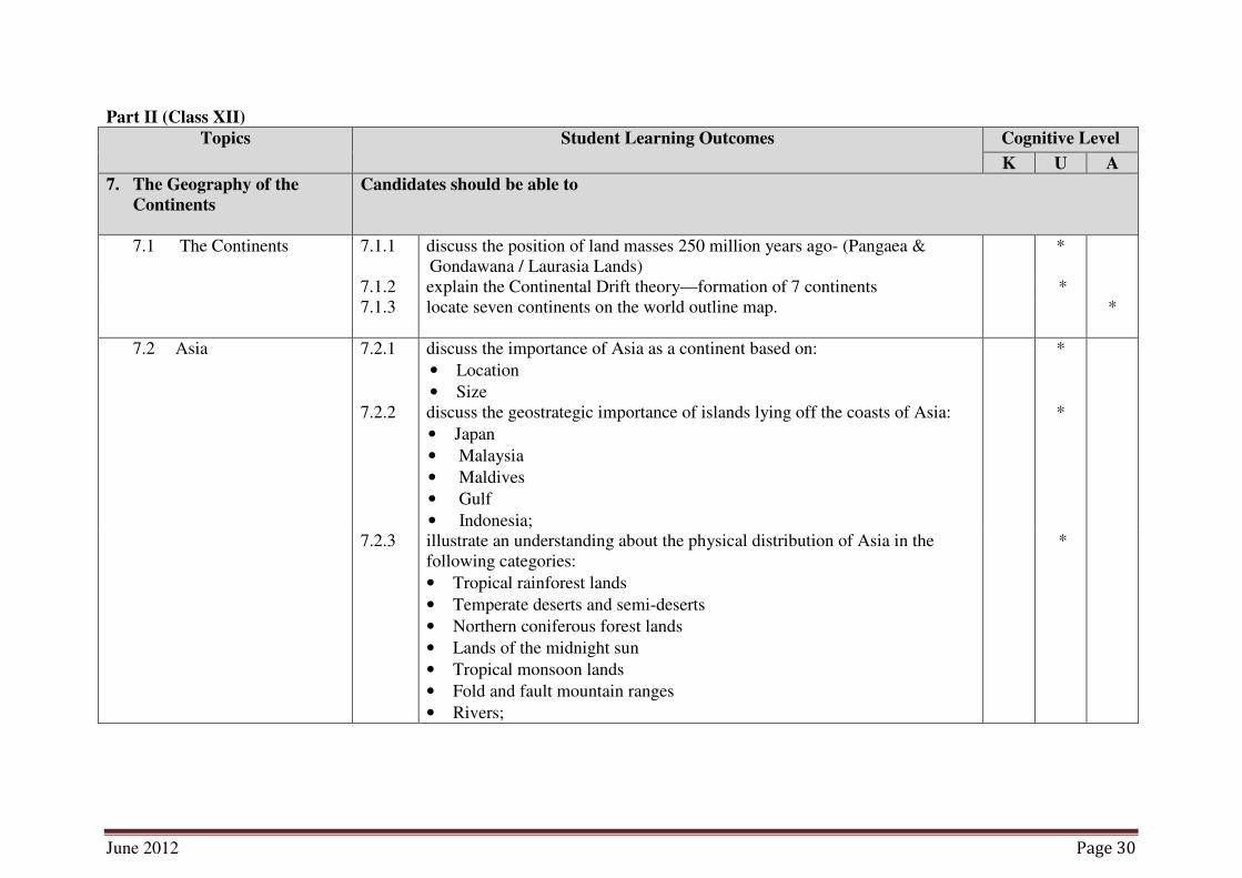
Part II (Class XII)
Topics Student Learning Outcomes Cognitive Level
K U A
7. The Geography of the
Continents
Candidates should be able to
7.1 The Continents 7.1.1 discuss the position of land masses 250 million years ago- (Pangaea &
Gondawana / Laurasia Lands)
*
7.1.2 explain the Continental Drift theory—formation of 7 continents *
7.1.3 locate seven continents on the world outline map.
*
7.2 Asia 7.2.1 discuss the importance of Asia as a continent based on:
• Location
• Size
*
7.2.2 discuss the geostrategic importance of islands lying off the coasts of Asia:
• Japan
• Malaysia
• Maldives
• Gulf
• Indonesia;
*
7.2.3 illustrate an understanding about the physical distribution of Asia in the
following categories:
• Tropical rainforest lands
• Temperate deserts and semi-deserts
• Northern coniferous forest lands
• Lands of the midnight sun
• Tropical monsoon lands
• Fold and fault mountain ranges
• Rivers;
*

June 2012 Page 31
NOTES
June 2012 Page 32
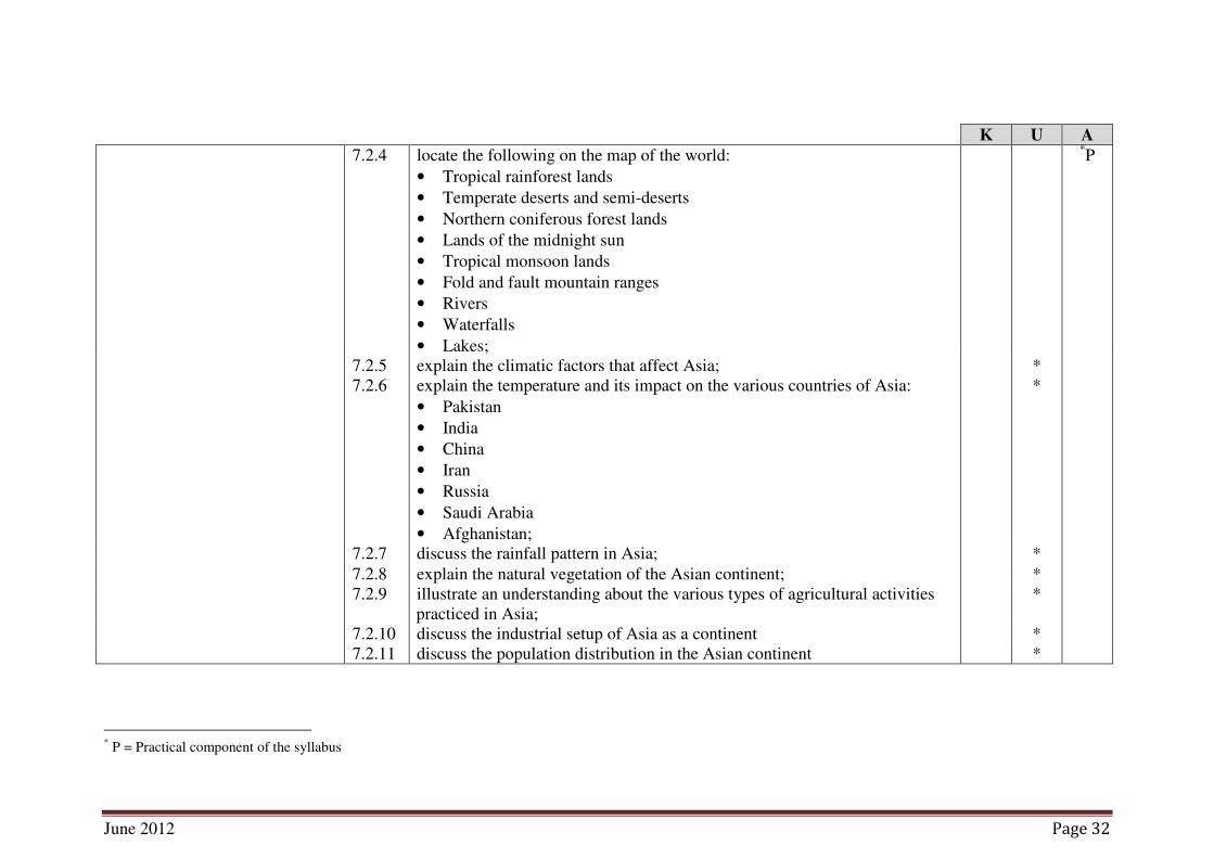
K U A
7.2.4 locate the following on the map of the world:
• Tropical rainforest lands
• Temperate deserts and semi-deserts
• Northern coniferous forest lands
• Lands of the midnight sun
• Tropical monsoon lands
• Fold and fault mountain ranges
• Rivers
• Waterfalls
• Lakes;
*P
7.2.5 explain the climatic factors that affect Asia; *
7.2.6 explain the temperature and its impact on the various countries of Asia:
• Pakistan
• India
• China
• Iran
• Russia
• Saudi Arabia
• Afghanistan;
*
7.2.7 discuss the rainfall pattern in Asia; *
7.2.8 explain the natural vegetation of the Asian continent; *
7.2.9 illustrate an understanding about the various types of agricultural activities
practiced in Asia;
*
7.2.10 discuss the industrial setup of Asia as a continent *
7.2.11 discuss the population distribution in the Asian continent *
* P = Practical component of the syllabus

June 2012 Page 33
NOTES

June 2012 Page 34
K U A
7.3 Africa 7.3.1 describe the discovery and exploration of Africa; *
7.3.2 discuss the physical features of Africa such as:
• Location and size
• High plateau regions
• Low plateau region
• Inland basins
• Fold and volcanic mountains
• Fault mountains and The Great Rift valley of East Africa
• River systems /Waterfalls / Lakes;
*
7.3.3 explain the climatic factors that affect Africa; *
7.3.4 explain the temperature and its impact on Africa;( northern & southern
deserts / central African forests)
*
7.3.5 discuss the rainfall pattern in Africa; *
7.3.6 explain the natural vegetation of the African continent with a special focus
on:
• Tropical Rainforest
• Savanna and Savanna Wood-Lands
• Semi-Arid Vegetation
• Desert
• Temperate Grassland
• Mediterranean Vegetation;
*
7.3.7 locate the following on the map of the world:
• Tropical Rainforest
• Savanna and Savanna Wood-Lands
• Semi-Arid Vegetation
• Desert
• Temperate Grassland
• Mediterranean Vegetation;
*P
* P = Practical component of the syllabus

June 2012 Page 35
NOTES
June 2012 Page 36
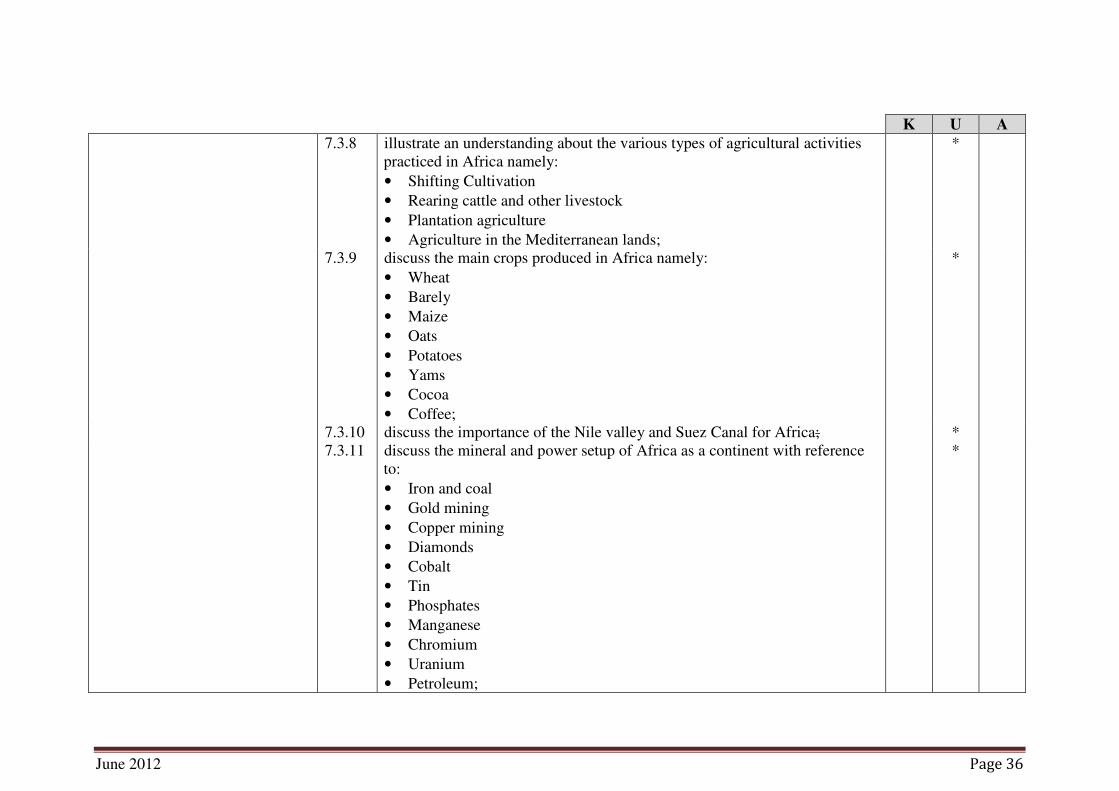
K U A
7.3.8 illustrate an understanding about the various types of agricultural activities
practiced in Africa namely:
• Shifting Cultivation
• Rearing cattle and other livestock
• Plantation agriculture
• Agriculture in the Mediterranean lands;
*
7.3.9 discuss the main crops produced in Africa namely:
• Wheat
• Barely
• Maize
• Oats
• Potatoes
• Yams
• Cocoa
• Coffee;
*
7.3.10 discuss the importance of the Nile valley and Suez Canal for Africa; *
7.3.11 discuss the mineral and power setup of Africa as a continent with reference
to:
• Iron and coal
• Gold mining
• Copper mining
• Diamonds
• Cobalt
• Tin
• Phosphates
• Manganese
• Chromium
• Uranium
• Petroleum;
*

June 2012 Page 37
NOTES

June 2012 Page 38
K U A
7.3.12 describe the population distribution in the African continent; *
7.3.13 discuss how population distribution impacts Africa; *
7.3.14 illustrate an understanding about the industrial distribution and industrial
setup in Africa;
*
7.3.15 explain the transportation system that is functional in Africa.
*
7.4 South America 7.4.1 describe the discovery and exploration of South America; *
7.4.2 discuss the physical features of South America based on:
• Location
• Size
• The western fold mountain system of the Andes
• The eastern highlands and plateau of Guiana, brazil and Patagonia
• The central lowlands
• River systems
• Deserts;
*
7.4.3 explain the climatic factors that affect South America; *
7.4.4 explain the temperature and its impact on South America; *
7.4.5 discuss the rainfall pattern in South America; *
7.4.6 explain the natural vegetation of the South American continent focusing on:
• Tropical Rainforests
• The llanos and Campos
• Subtropical Forests and Woodlands
• Temperate Grasslands
• Semi-Desert Vegetation
• West Cast Deserts
• Mediterranean Vegetation
• Cool Temperate Forests;
*

June 2012 Page 39
NOTES

June 2012 Page 40
K U A
7.4.7 locate the following on the map of the world:
• Tropical Rainforests
• The llanos and Campos
• Subtropical Forests and Woodlands
• Temperate Grasslands
• Semi-Desert Vegetation
• West Cast Deserts
• Mediterranean Vegetation
• Cool Temperate Forests;
*P
7.4.8 illustrate an understanding about the various types of agricultural activities
practiced in South America namely:
• Cattle rearing
• Sheep rearing
• Llama and Alpacas
• Agriculture in Mediterranean Central Chile;
*
7.4.9 discuss the main crops produced in South America namely:
• Coffee
• Sugar
• Rice
• Cotton
• Cocoa
• Maize
• Wheat;
*
7.4.10 discuss the mineral setup of South America as a continent focusing on:
• Iron and coal
• Iron and steel
• Copper and nitrates
• Petroleum
• Tin;
*
* P = Practical component of the syllabus

June 2012 Page 41
NOTES

June 2012 Page 42
K U A
7.4.11 discuss the importance of mines and minerals for the South American
continent;
*
7.4.12 explain the population distribution of the South American continent; *
7.4.13 discuss how population distribution impacts South America; *
7.4.14 discuss the important cities and ports of South America namely:
• Buenos Aries
• Sao Paulo
• Rio De Janeiro
• Caracas
• Quito
• Guayaquil
• Lima
• Bogota
• La Paz
• Maracaibo
• Santiago
• Valparaiso;
*
7.4.15 explain the transportation system that is functional in South America. *

June 2012 Page 43
NOTES
June 2012 Page 44
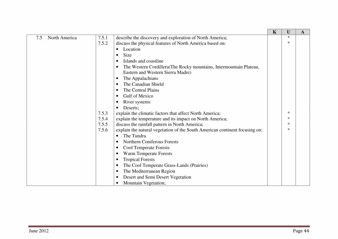
K U A
7.5 North America 7.5.1 describe the discovery and exploration of North America; *
7.5.2 discuss the physical features of North America based on:
• Location
• Size
• Islands and coastline
• The Western Cordillera(The Rocky mountains, Intermountain Plateau,
Eastern and Western Sierra Madre)
• The Appalachians
• The Canadian Shield
• The Central Plains
• Gulf of Mexico
• River systems
• Deserts;
*
7.5.3 explain the climatic factors that affect North America; *
7.5.4 explain the temperature and its impact on North America; *
7.5.5 discuss the rainfall pattern in North America; *
7.5.6 explain the natural vegetation of the South American continent focusing on:
• The Tundra
• Northern Coniferous Forests
• Cool Temperate Forests
• Warm Temperate Forests
• Tropical Forests
• The Cool Temperate Grass-Lands (Prairies)
• The Mediterranean Region
• Desert and Semi Desert Vegetation
• Mountain Vegetation;
*

June 2012 Page 45
NOTES
June 2012 Page 46
K U A
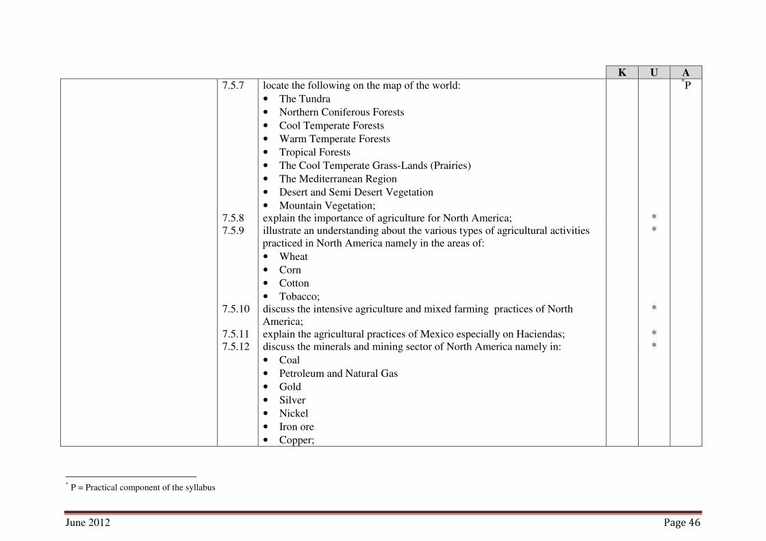
7.5.7 locate the following on the map of the world:
• The Tundra
• Northern Coniferous Forests
• Cool Temperate Forests
• Warm Temperate Forests
• Tropical Forests
• The Cool Temperate Grass-Lands (Prairies)
• The Mediterranean Region
• Desert and Semi Desert Vegetation
• Mountain Vegetation;
*P
7.5.8 explain the importance of agriculture for North America; *
7.5.9 illustrate an understanding about the various types of agricultural activities
practiced in North America namely in the areas of:
• Wheat
• Corn
• Cotton
• Tobacco;
*
7.5.10 discuss the intensive agriculture and mixed farming practices of North
America;
*
7.5.11 explain the agricultural practices of Mexico especially on Haciendas; *
7.5.12 discuss the minerals and mining sector of North America namely in:
• Coal
• Petroleum and Natural Gas
• Gold
• Silver
• Nickel
• Iron ore
• Copper;
*
* P = Practical component of the syllabus

June 2012 Page 47
NOTES
June 2012 Page 48
K U A
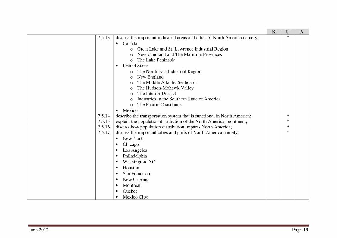
7.5.13 discuss the important industrial areas and cities of North America namely:
• Canada
o Great Lake and St. Lawrence Industrial Region
o Newfoundland and The Maritime Provinces
o The Lake Peninsula
• United States
o The North East Industrial Region
o New England
o The Middle Atlantic Seaboard
o The Hudson-Mohawk Valley
o The Interior District
o Industries in the Southern State of America
o The Pacific Coastlands
• Mexico
*
7.5.14 describe the transportation system that is functional in North America; *
7.5.15 explain the population distribution of the North American continent; *
7.5.16 discuss how population distribution impacts North America; *
7.5.17 discuss the important cities and ports of North America namely:
• New York
• Chicago
• Los Angeles
• Philadelphia
• Washington D.C
• Houston
• San Francisco
• New Orleans
• Montreal
• Quebec
• Mexico City;
*

June 2012 Page 49
NOTES

June 2012 Page 50
K U A
7.5.18 explain the importance of Central America and West Indies based on:
• Relief
• Climate and vegetation
• Agriculture
• The Panama Canal
• People.
*
7.6 Europe 7.6.1 discuss the physical features of Europe based on:
• Location
• Size
• Peninsula
• Islands
• Scandinavia
• The Great North European Plain
• The Uplands of Central Europe
• They Young Fold Alpine Mountain System
• The Russian Platform of Eastern Europe
• Rivers;
*
7.6.2 explain the climatic factors that affect Europe; *
7.6.3 explain the temperature and its impact on Europe; *
7.6.4 discuss the rainfall patterns of Europe; *
7.6.5 explain the natural vegetation of the European continent focusing on:
• Tundra and Mountain Vegetation
• Coniferous Forests
• Deciduous and Mixed Forests
• Mediterranean Vegetation
• Steppe Vegetation;
*

June 2012 Page 51
NOTES

June 2012 Page 52
K U A
7.6.6 locate the following on the map of the world:
• Tundra and Mountain Vegetation
• Coniferous Forests
• Deciduous and Mixed Forests
• Mediterranean Vegetation
• Steppe Vegetation;
*P
7.6.7 illustrate an understanding about the various types of agricultural activities
practiced in Europe namely:
• Pastoral farming
• Arable farming
• Market gardening and Horticulture
*
7.6.8 discuss the various agricultural regions of Europe such as:
• Northern Europe
• Northern European Plain
• The Region South of the European Plain
• Eastern Europe
• The Mediterranean Lands;
*
7.6.9 discuss the industrial setup of the European continent specially with
reference to:
• Coal
• Iron Ore
• Petroleum and natural gas
• Hydro-electric power;
*
* P = Practical component of the syllabus

June 2012 Page 53
NOTES
June 2012 Page 54
K U A
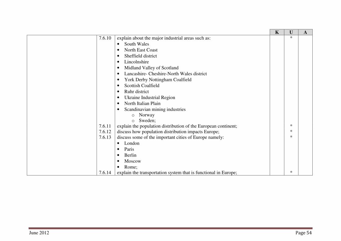
7.6.10 explain about the major industrial areas such as:
• South Wales
• North East Coast
• Sheffield district
• Lincolnshire
• Midland Valley of Scotland
• Lancashire- Cheshire-North Wales district
• York Derby Nottingham Coalfield
• Scottish Coalfield
• Ruhr district
• Ukraine Industrial Region
• North Italian Plain
• Scandinavian mining industries
o Norway
o Sweden;
*
7.6.11 explain the population distribution of the European continent; *
7.6.12 discuss how population distribution impacts Europe; *
7.6.13 discuss some of the important cities of Europe namely:
• London
• Paris
• Berlin
• Moscow
• Rome;
*
7.6.14 explain the transportation system that is functional in Europe; *

June 2012 Page 55
NOTES

June 2012 Page 56
K U A
7.7 Australia 7.7.1 discuss the physical features of Australia based on:
• Location
• Size
• Eastern Highlands
• Central Lowlands
• Western Plateau
• Ayers Rock
• Coral Reef
• Rivers;
*
7.7.2 explain the climatic factors that affect Australia; *
7.7.3 explain the temperature and its impact on Australia; *
7.7.4 discuss the rainfall patterns of Australia; *
7.7.5 explain the natural vegetation of the Australian continent focusing on ;
• Monsoon Forests
• Tropical rain forests
• Grasslands
• Forests
• Deserts and semi-desert vegetation
*
7.7.6 locate the following on the map of the world:
• Monsoon Forests
• Tropical rain forests
• Grasslands
• Forests
• Deserts and semi-desert vegetation
*P
* P = Practical component of the syllabus

June 2012 Page 57
NOTES

June 2012 Page 58
K U A
7.7.7 illustrate an understanding about the various types of agricultural activities
practiced in Australia namely:
• Wheat growing
• Fruit growing
• Sugarcane
• Sheep / cattle rearing
*
7.7.8 discuss the types of minerals mined in Australia specially:
• Coal
• Iron Ore
• Petroleum
• Silver
• Lead
• Zinc
• Copper
• Gold
• Tin
• Bauxite
• Uranium
*
7.7.9 explain about the major types of industries such as:
• Industrial metals, machines and conveyances 9( ships, aircrafts, trains,
motor vehicles)
• Clothing and textile
• Food, drink and tobacco
• Woodwork, furniture and boxes
• Paper, printing
• Electronics
• Plastic, glass and paint
*
7.7.10 explain the population distribution of Australia; *
7.7.11 discuss how population distribution impacts Australia; *

June 2012 Page 59
NOTES

June 2012 Page 60
K U A
7.7.12 discuss some of the important cities of Australia namely:
• Sydney
• Canberra
• Melbourne
• Brisbane
• Adelaide
• Perth
*
7.7.13 explain the transportation system that is functional in Australia;
*
7.8 Ocenia 7.8.1 illustrate an understanding about the regions that are a part of Oceania
(Australia, New Zealand, Melanesia, Polynesia, and Micronesia);
*
7.8.2 describe archipelagos.
*
8. Economic Geography Candidates should be able to:
8.1 Economic Geography
of Pakistan
8.1.1 establish the economic importance of Pakistan with respect to its location; *
8.1.2 discuss the population dynamics of Pakistan with reference to how they
impact its economy;
*
8.1.3 list the major crops grown in Pakistan; *
8.1.4 explain the various types of agricultural practices of Pakistan; *
8.1.5 analyse the importance of the agricultural sector for an agrarian economy
like Pakistan;
*
8.1.6 list the major mines and minerals of Pakistan; *
8.1.7 discuss the mines and mineral deposit of Pakistan; *
8.1.8 analyse the importance of the mines and minerals for Pakistan as a
developing nation;
*
8.1.9 discuss the various power resources of Pakistan; *
8.1.10 identify the major industries of Pakistan; *
8.1.11 explain the industrial setup of Pakistan; *
8.1.12 analyse the importance of the industrial sector for a developing economy like
Pakistan;
*

June 2012 Page 61
NOTES

June 2012 Page 62
K U A
8.1.13 list the primary exports and imports of Pakistan; *
8.1.14 discuss the importance of exports for a developing country like Pakistan; *
8.1.15 explain the reason for importing industrial goods by Pakistan; *
8.1.16 discuss Pakistan’s balance of trade over the years.
*
8.2 Economic Geography
of China
8.2.1 establish the economic importance of China with respect to its location; *
8.2.2 discuss the population dynamics of China with reference to how they impact
its economy;
*
8.2.3 list the major crops grown in China; *
8.2.4 explain the various types of agricultural practices of China; *
8.2.5 analyse the importance of the agricultural sector for a country like China; *
8.2.6 list the major mines and minerals of China; *
8.2.7 discuss the mines and mineral deposit of China; *
8.2.8 analyse the importance of the mines and minerals for China as a developing
nation;
*
8.2.9 discuss the various power resources of China; *
8.2.10 identify the major industries of China; *
8.2.11 explain the industrial setup of China; *
8.2.12 analyse the importance of the industrial sector for a developing economy like
China;
*
8.2.13 list the primary exports and imports of China; *
8.2.14 discuss the importance of exports for a developing country like China; *
8.2.15 explain the reason for importing raw material by China; *
8.2.16 analyse China’s trade relation with Pakistan over the years. *

June 2012 Page 63
NOTES

June 2012 Page 64
K U A
8.3 Economic Geography
of Saudi Arabia
8.3.1 establish the economic importance of Saudi Arabia with respect to its
location
*
8.3.2 discuss the population dynamics of Saudi Arabia with reference to how they
impact its economy;
*
8.3.3 identify the major imports and exports of Saudi Arabia; *
8.3.4 explain the impact that the Saudi imports and exports have on the Saudi
economy;
*
8.3.5 discus the way Saudi exports impact the region; *
8.3.6 discuss the importance of Saudi Arabia as an oil rich country; *
8.3.7 analyse the Saudi trade relations with Pakistan;
*
8.4 Economic Geography
of United States
8.4.1 establish the economic importance of the United States of America with
respect to its location;
*
8.4.2 discuss the population dynamics of the United States of America with
reference to how they impact its economy;
*
8.4.3 list the major crops grown in the United States of America; *
8.4.4 explain the various types of agricultural practices of the United States of
America;
*
8.4.5 analyse the importance of the agricultural sector for a country like the United
States of America;
*
8.4.6 list the major mines and minerals of the United States of America; *
8.4.7 discuss the mines and mineral deposit of the United States of America; *
8.4.8 analyse the importance of the mines and minerals for the United States of
America as a developed nation;
*
8.4.9 discuss the various power resources of the United States of America; *
8.4.10 identify the major industries of the United States of America; *
8.4.11 explain the industrial setup of the United States of America; *
8.4.12 analyse the importance of the industrial sector for a developed economy like
the United States of America;
*

June 2012 Page 65
NOTES
June 2012 Page 66
K U A
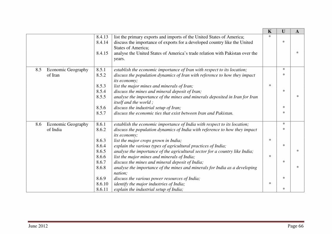
8.4.13 list the primary exports and imports of the United States of America; *
8.4.14 discuss the importance of exports for a developed country like the United
States of America;
*
8.4.15 analyse the United States of America’s trade relation with Pakistan over the
years.
*
8.5 Economic Geography
of Iran
8.5.1 establish the economic importance of Iran with respect to its location; *
8.5.2 discuss the population dynamics of Iran with reference to how they impact
its economy;
*
8.5.3 list the major mines and minerals of Iran; *
8.5.4 discuss the mines and mineral deposit of Iran; *
8.5.5 analyse the importance of the mines and minerals deposited in Iran for Iran
itself and the world ;
*
8.5.6 discuss the industrial setup of Iran; *
8.5.7 discuss the economic ties that exist between Iran and Pakistan.
*
8.6 Economic Geography
of India
8.6.1 establish the economic importance of India with respect to its location; *
8.6.2 discuss the population dynamics of India with reference to how they impact
its economy;
*
8.6.3 list the major crops grown in India; *
8.6.4 explain the various types of agricultural practices of India; *
8.6.5 analyse the importance of the agricultural sector for a country like India; *
8.6.6 list the major mines and minerals of India; *
8.6.7 discuss the mines and mineral deposit of India; *
8.6.8 analyse the importance of the mines and minerals for India as a developing
nation;
*
8.6.9 discuss the various power resources of India; *
8.6.10 identify the major industries of India; *
8.6.11 explain the industrial setup of India; *

June 2012 Page 67
NOTES
June 2012 Page 68
K U A
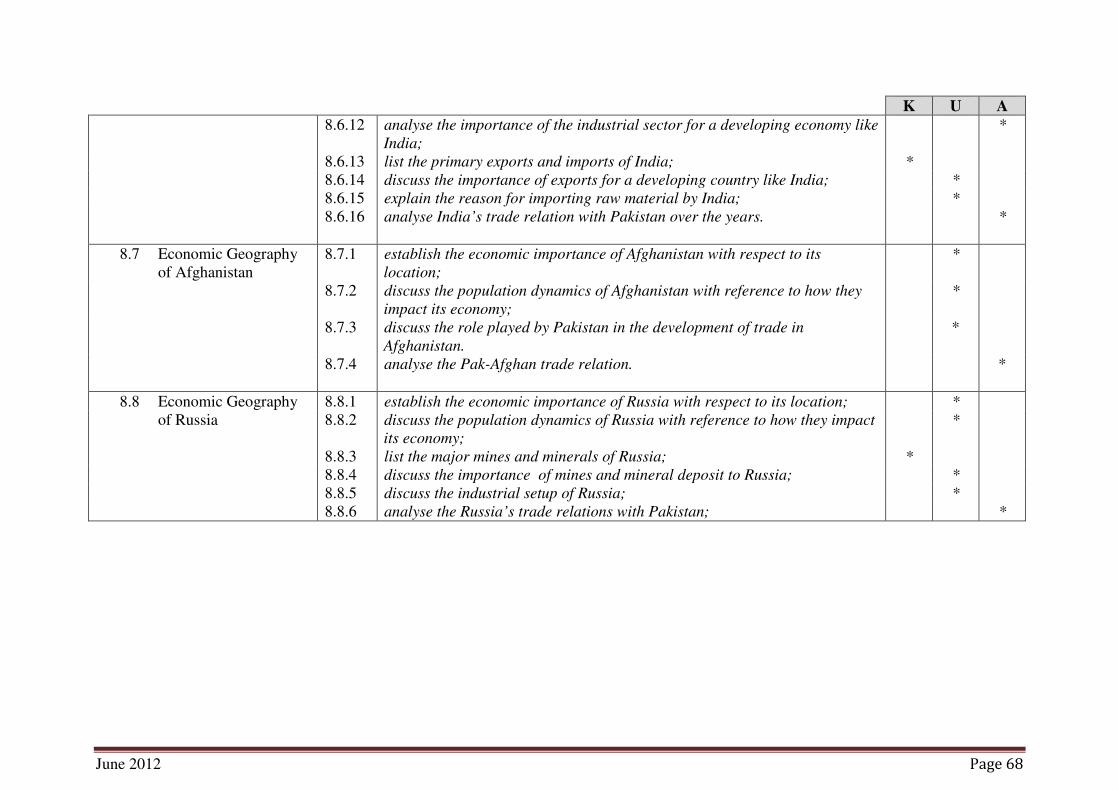
8.6.12 analyse the importance of the industrial sector for a developing economy like
India;
*
8.6.13 list the primary exports and imports of India; *
8.6.14 discuss the importance of exports for a developing country like India; *
8.6.15 explain the reason for importing raw material by India; *
8.6.16 analyse India’s trade relation with Pakistan over the years.
*
8.7 Economic Geography
of Afghanistan
8.7.1 establish the economic importance of Afghanistan with respect to its
location;
*
8.7.2 discuss the population dynamics of Afghanistan with reference to how they
impact its economy;
*
8.7.3 discuss the role played by Pakistan in the development of trade in
Afghanistan.
*
8.7.4 analyse the Pak-Afghan trade relation. *
8.8 Economic Geography
of Russia
8.8.1 establish the economic importance of Russia with respect to its location; *
8.8.2 discuss the population dynamics of Russia with reference to how they impact
its economy;
*
8.8.3 list the major mines and minerals of Russia; *
8.8.4 discuss the importance of mines and mineral deposit to Russia; *
8.8.5 discuss the industrial setup of Russia; *
8.8.6 analyse the Russia’s trade relations with Pakistan; *

June 2012 Page 69
NOTES

June 2012 Page 70
K U A
9. Population Geography Candidates should be able to:
9.1 Introduction of
Population Geography
9.1.1 describe the nature and significance of population geography; *
9.2 The Distribution and
Density of Population
9.2.1 discuss distribution and density of population; *
9.2.2 explain the factors affecting the distribution and density of population;
*
9.3 Population Growth 9.3.1 describe the nature of population growth; *
9.3.2 discuss how the resources and their development effects population growth;
*
9.4 Population
Characteristics
9.4.1 discuss some population characteristics such as age and gender structures,
rural and urban composition;
*
9.4.2 describe the geographical impact of migration.
*
10. The Environment Candidates should be able to:
10.1 Introduction 10.1.1 define the term ‘environment’ *
10.1.2 discuss the inter relation between the people and their environment in
Pakistan;
*
10.1.3 discuss resource management and conservation with respect to Pakistan; *
10.1.4 discuss pollution, the green house effect and the depletion of Ozone with
relation to human beings.
*

June 2012 Page 71
NOTES
June 2012 Page 72
K U A
11. Practical Geography Candidates should be able to:
11.1 Importance of Practical
Geography
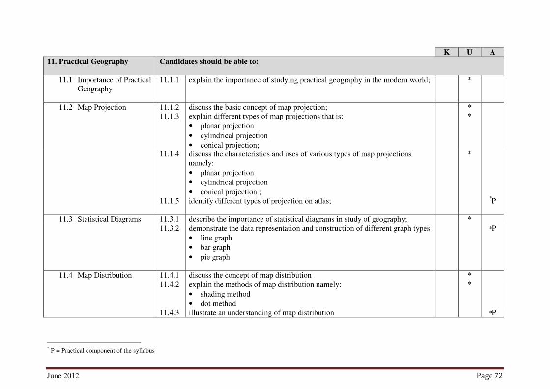
11.1.1 explain the importance of studying practical geography in the modern world; *
11.2 Map Projection 11.1.2 discuss the basic concept of map projection; *
11.1.3 explain different types of map projections that is:
• planar projection
• cylindrical projection
• conical projection;
*
11.1.4 discuss the characteristics and uses of various types of map projections
namely:
• planar projection
• cylindrical projection
• conical projection ;
*
11.1.5 identify different types of projection on atlas;
*P
11.3 Statistical Diagrams 11.3.1 describe the importance of statistical diagrams in study of geography; *
11.3.2 demonstrate the data representation and construction of different graph types
• line graph
• bar graph
• pie graph
*P
11.4 Map Distribution 11.4.1 discuss the concept of map distribution *
11.4.2 explain the methods of map distribution namely:
• shading method
• dot method
*
11.4.3 illustrate an understanding of map distribution *P
* P = Practical component of the syllabus

June 2012 Page 73
NOTES
June 2012 Page 74
4. Scheme of Assessment
Table 1: Number of Student Learning Outcomes by Cognitive level
Topics
No. Topics
No of
Sub-Topics
SLOs Total
K U A
1. Understanding Geography 4 4 12 6 4
2. Rocks and Soils 5 7 11 1 18
3. The Earth’s Structure 4 1 9 1 11
4. The World of Water 16 9 23 2 34
5. The Atmosphere 4 1 10 0 11
6. Physical Environment and Man 4 2 9 3 14
Total 37 24 74 13 111
Percentage 22 67 12 100
Table 2: Allocation of Marks for the Multiple Choice Questions (MCQs),
Constructed Response Questions (CRQs) and
Extended Response Questions (ERQs)
Topic
No. Topics
No of
Sub-
Topics
Marks
Total Multiple
Choice
Questions
Constructed
Response
Questions
Extended
Response
Questions
1. Understanding
Geography 4 3 3 0 6
2. Rocks and Soils 5 7 6 8 31
3. The Earth’s Structure 4 4 6
4. The World of Water 16 8 12 7 37
5. The Atmosphere 4 4 6
6. Physical Environment
and Man 4 4 7 0 11
Total 37 30 40 15 85

June 2012 Page 75
Table 3: Paper Specifications
* Extended response questions (ERQs) will require answers in more descriptive
form. The answers will be in a paragraph rather than a word or a single
sentence.
* There will be TWO questions and the candidates will be required to attempt
any ONE by making a choice out of the TWO.
Class XII
Table 4: Number of Student Learning Outcomes by Cognitive level
Topics
No. Topics
No of
Sub-Topics
SLOs Total
K U A
7. The geography of the Continents 8 7 75 2 84
8. Economic Geography 8 19 49 18 86
9. Population Geography 4 3 4 0 7
10. The Environment 1 1 3 0 4
11. Practical Geography 4 0 7 3 10
Total 25 30 138 23 191
Percentage 16 72 12 100
Topic
No. Topics Marks Distribution
Total
Marks
1. Understanding Geography MCQs 3 @ 1 Marks
CRQ 1 @ 3 Marks - 6
2. Rocks and Soils MCQs 7 @ 1 Marks
CRQs 2 @ 3 Marks each *ERQ 1 @
8 Marks
(choose any ONE
from TWO)
31 3. The Earth’s Structure MCQs 4 @ 1 Marks
CRQs 2 @ 3 Marks each
4. The World of Water MCQs 8 @ 1 Marks
CRQs 3 @ 4 Marks each ERQ 1 @
7 Marks
(choose any ONE
from TWO)
37 5. The Atmosphere MCQs 4 @ 1 Marks
CRQs 2 @ 3 Marks each
6. Physical Environment and
Man
MCQs 4 @ 1 Marks
CRQs 2 @ 3, 4 Marks - 11
Total
MCQS CRQs ERQs 85
30 40 15

June 2012 Page 76
Table 5: Allocation of Marks for the Multiple Choice Questions (MCQs),
Constructed Response Questions (CRQs) and
Extended Response Questions (ERQs)
Topic
No. Topics
No of
Sub-
Topics
Marks
Total Multiple
Choice
Questions
Constructed
Response
Questions
Extended
Response
Questions
7. The geography of
the Continents
8 12 15 7 34
8. Economic
Geography
8 12 15 8 35
9. Population
Geography
4 2 4 0 6
10. The Environment 1 2 4 0 6
11. Practical
Geography 4 2 2 0 4
Total 25 30 40 15 85
Table 6: Paper Specifications
Topic
No. Topics Marks Distribution Total Marks
7. The geography of the
Continents MCQs 12 @ 1 Mark
CRQs 3 @ 5 Marks
each
ERQ 1 @
7 Marks
Choose any
ONE from
TWO
34
8. Economic Geography MCQs 12 @ 1 Mark
CRQs 3 @ 5 Marks
each
ERQ 1 @
8 Marks
Choose any
ONE from
TWO
35
9. Population Geography MCQs 2 @ 1 Mark
CRQ 1 @ 4 Marks 6
10. The Environment MCQs 2 @1 Mark
CRQ 1 @ 4 Marks 6
11. Practical Geography MCQs 2 @1 Mark
CRQ 1 @ 2 Marks 4
Total Marks
MCQs CRQs ERQs 85
30 40 15
* Extended response questions (ERQs) will require answers in more descriptive
form. The answers will be in a paragraph rather than a word or a single
sentence.
* There will be TWO questions and the candidates will be required to attempt
any ONE by making a choice out of the TWO.

June 2012 Page 77
4.1 Tables 1 and 4 summarize the number and nature of SLOs for all topics of
Geography. This will serve as a guide in the construction of the examination paper.
The SLOs indicate that emphasis in Geography is on knowledge (22% and 16%)
about Pakistan and understanding of issues it faces (67% and 72%) and application of
ideas in real life (12%) respectively.
4.2 There will be two examinations, one at the end of Class XI and one at the end of
Class XII.
4.3 In each class, the theory paper will be in two parts: paper I and paper II. Both papers
will be of duration of 3 hours.
4.4 Paper I theory will consist of 30 compulsory multiple choice items. These questions
will involve four response options.
4.5 Paper II theory will carry 55 marks and consist of a number of compulsory, structured
questions and a number of extended response questions. Each extended response
question will be presented in an either/or form.
4.6 Practical examination will be conducted separate from the theory paper. It will be
based on the list of practical activities listed in the examination syllabus.
4.7 All constructed response questions will be in a booklet which will also serve as an
answer script.
4.8 Practical exams to assess performance skills will carry 15 marks in class XI and 15
marks in class XII.
4.9 It is essential for each school to equip its laboratories with chemicals, instruments,
apparatus, specimens etc. according to the requirements of the practicals. Each school
will be responsible to make sure that each student is provided the opportunity to do
the practicals.
List of practicals is attached as annex B.

June 2012 Page 78
5. Teaching–Learning Approaches and Classroom Activities
5.1 Teaching and learning approaches should foster a sense of understanding and respect,
and sensitize students with emotions and feelings of tolerance towards others.
5.2 Students should be taught through moral stories, dramas, skits and role play
activities. They can also discuss and debate upon the moral issues derived from these
activities with expected consequences and impact on individual life and on society as
a whole.
5.3 Teachers may also engage students in project work, group discussions on images
and pictures from the newspapers and magazines that depict moral issues and
problems. Experiential learning be encouraged through community service and
field work.
5.4 Customs and traditions of various communities, to which the students belong, may
be celebrated to create a sense of awareness, respect and understanding of diversity
and cultural pluralism.
5.5 Teaching approaches be geared towards fostering creativity, intellectual curiosity,
generating activity-based feelings of cohesion, unity, discipline, love and respect for
others and for maintaining a good civic sense
5.6 Students should be encouraged to engage in the following activities to stimulate their
interest in the topics being studied and to develop a better understanding of the
syllabus content:
(a) Draw, read, fill-in maps:
• Draw an outline map of World.
• Fill-in boundaries of World on an outline map.
• Identify with key the different landforms on the World map.
• Locate the distribution of forests, agricultural products and minerals on the
World map.
(b) Make charts, graphs, tables:
• Make charts showing imports and exports of the World.
• Prepare organizational charts of education in the country.
(c) Visit and write reports or make presentations on places visited:
• Historical places.
• Rivers, mountains, fields, forests, mines, canal headwork.
• Urban areas where development is taking place.
• Museums, industries, and factories.
June 2012 Page 79
6. Recommended Texts, Reference Materials and Websites
Recommended book
1. Prof. Mian Muhammad Anwar. Modern Physical Geography for Students
of Intermediate Part 1: White Rose Publisher, Lahore.
2. Prof. Mian Muhammad Anwar. Regional Geography (World) for Students
of Intermediate Part 2: White Rose Publisher, Lahore.
3. Sarfaraz Ahmaed Bajwa. Modern Physical Geography: Publishers
Emporium , Lahore.
Reference Books
1. Prof. Mian Muhammad Anwar. Modern Physical Geography for Students
of Degree & other classes: White Rose Publisher, Lahore.
2. A. Das Gupta, A. N. Kapoor. Principles of Physical Geography: S. Chand
& Company Ltd.
3. Alan Strahler, Arthur Strahler. Physical Geography Science and systems of
the Human Environment: John Wiley &Sons (ASIA) Pte Ltd.
4. Prof. Mian Muhammad Anwar. Practical Geography for Intermediate
Part I: White Rose Publisher, Lahore.
5. Prof. Mian Muhammad Anwar. Practical Geography for Intermediate
Part II: White Rose Publisher, Lahore.
7. Definition of Cognitive Levels and Command Words in the Student Learning
Outcomes and in Examination Papers
7.1 Definition of Cognitive Levels (Knowledge, Understanding and Application)
Knowledge:
This requires knowing and remembering facts and figures, vocabulary and contexts,
and the ability to recall key ideas, concepts, trends, sequences, categories, etc. It can
be taught and evaluated through questions based on: who, when, where, what, list,
define, describe, identify, label, tabulate, quote, name, state, etc.
Understanding:
This requires understanding information, grasping meaning, interpreting facts,
comparing, contrasting, grouping, inferring causes/reasons, seeing patterns,
organizing parts, making links, summarizing, solving, identifying motives, finding
evidence, etc. It can be taught and evaluated through questions based on: why, how,
show, demonstrate, paraphrase, interpret, summarise, explain, prove, identify the main
idea/theme, predict, compare, differentiate, discuss, chart the course/direction, report,
solve, etc.

June 2012 Page 80
Application:
This requires using information or concepts in new situations, solving problems,
organizing information and ideas, using old ideas to create new ones, generalizing
from given facts, analyzing relationships, relating knowledge from several areas,
drawing conclusions, evaluating worth, etc. It can be taught and evaluated through
questions based on: distinguish, analyse, show relationship, propose an alternative,
prioritize, give reasons for, categorize, illustrate, corroborate, compare and contrast,
create, design, formulate, integrate, re-arrange, reconstruct/recreate, re-organize,
predict consequences etc.
7.2 Definition of Command Words:
Knowledge
Define: Only a formal statement or equivalent paraphrase is required. No
examples need to be given unless specifically asked for.
Describe: Expects a response in words though supporting sketches and diagrams
may be used where appropriate. Full credit will be given when the
verbal description uses the technical terms of Geography and also give
examples.
List: Requires a number of points, generally of one word, each with no
elaboration. Where a given number of points is specified, this should not
be exceeded.
State: Invites a concise answer with little or no supporting argument, for
example, a name from memory or a map reference that can be
obtained by inspection.
Understanding
Demonstrate: Implies an answer with a detailed description of events with a
supporting argument.
Differentiate/
Distinguish:
Identify and describe those characteristics which always or usually
help us to tell two categories apart. Normally a list of features which
(a) always and (b) usually differentiate is all that is required.
Describe:
To state in words the main points of the topic. It is often used with
reference either to particular phenomena or to particular
experiments. In the former instance, the term usually implies that the
answer should include reference to (visual) observations associated
with the phenomena
Discuss: Expects an analytic account of the topic. There should be an
introductory sentence/paragraph introducing the topic. Related
material should be presented in paragraphs and there should be a
concluding paragraph drawing together the main points usually in a
statement of relationship or principle.
Diagrammatically:
Make a simple free hand sketch or diagram. Care should be taken
with proportions and the clear labelling of parts.
June 2012 Page 81
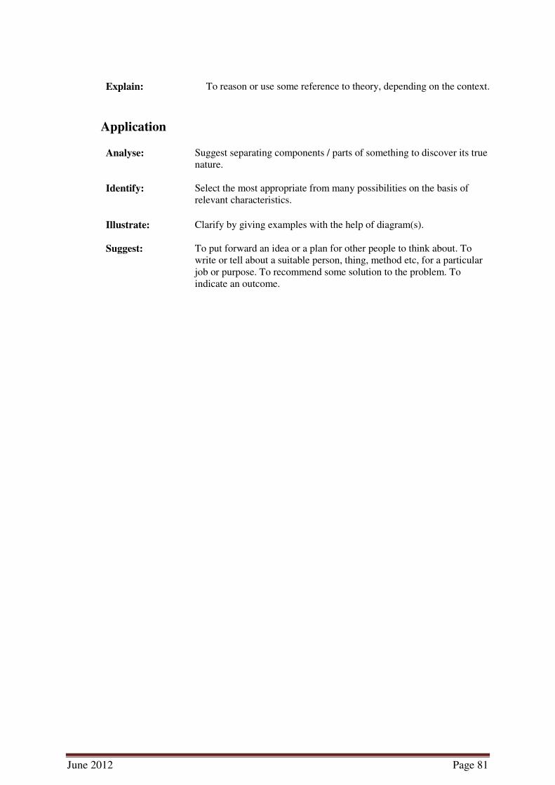
Explain: To reason or use some reference to theory, depending on the context.
Application
Analyse: Suggest separating components / parts of something to discover its true
nature.
Identify: Select the most appropriate from many possibilities on the basis of
relevant characteristics.
Illustrate: Clarify by giving examples with the help of diagram(s).
Suggest: To put forward an idea or a plan for other people to think about. To
write or tell about a suitable person, thing, method etc, for a particular
job or purpose. To recommend some solution to the problem. To
indicate an outcome.
June 2012 Page 82
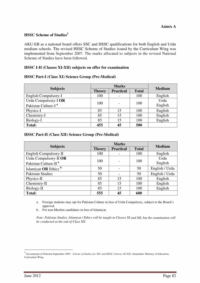
Annex A
HSSC Scheme of Studies3
AKU-EB as a national board offers SSC and HSSC qualifications for both English and Urdu
medium schools. The revised HSSC Scheme of Studies issued by the Curriculum Wing was
implemented from September 2007. The marks allocated to subjects in the revised National
Scheme of Studies have been followed.
HSSC I-II (Classes XI-XII) subjects on offer for examination
HSSC Part-I (Class XI) Science Group (Pre-Medical)
Subjects Marks
Medium Theory Practical Total
English Compulsory-I 100 - 100 English
Urdu Compulsory-I OR
Pakistan Culture-I a
100 - 100 Urdu
English
Physics-I 85 15 100 English
Chemistry-I 85 15 100 English
Biology-I 85 15 100 English
Total: 455 45 500
HSSC Part-II (Class XII) Science Group (Pre-Medical)
Subjects Marks
Medium Theory Practical Total
English Compulsory-II 100 - 100 English
Urdu Compulsory-II OR
Pakistan Culture-II a
100 - 100 Urdu
English
Islamiyat OR Ethics b 50 - 50 English / Urdu
Pakistan Studies 50 - 50 English / Urdu
Physics-II 85 15 100 English
Chemistry-II 85 15 100 English
Biology-II 85 15 100 English
Total: 555 45 600
a. Foreign students may opt for Pakistan Culture in lieu of Urdu Compulsory, subject to the Board’s
approval.
b. For non-Muslim candidates in lieu of Islamiyat.
Note: Pakistan Studies, Islamiyat / Ethics will be taught in Classes XI and XII, but the examination will
be conducted at the end of Class XII.
3 Government of Pakistan September 2007. Scheme of Studies for SSC and HSSC (Classes IX-XII). Islamabad: Ministry of Education,
Curriculum Wing.

June 2012 Page 83
HSSC Part-I (Class XI) Science Group (Pre-Engineering)
Subjects Marks
Medium Theory Practical Total
English Compulsory-I 100 - 100 English
Urdu Compulsory-I OR
Pakistan Culture-I a
100 - 100 Urdu
English
Physics-I 85 15 100 English
Chemistry-I 85 15 100 English
Mathematics-I 100 - 100 English
Total: 470 30 500
HSSC Part-II (Class XII) Science Group (Pre-Engineering)
Subjects Marks
Medium Theory Practical Total
English Compulsory-II 100 - 100 English
Urdu Compulsory-II OR
Pakistan Culture-II a
100 - 100 Urdu
English
Islamiyat OR Ethics b 50 - 50 English / Urdu
Pakistan Studies 50 - 50 English / Urdu
Physics-II 85 15 100 English
Chemistry-II 85 15 100 English
Mathematics –II 100 - 100 English
Total: 570 30 600
a. Foreign students may opt for Pakistan Culture in lieu of Urdu Compulsory, subject to the Board’s
approval.
b. For non-Muslim candidates in lieu of Islamiyat.
Note: Pakistan Studies, Islamiyat / Ethics will be taught in Classes XI and XII, but the examination will
be conducted at the end of Class XII.
June 2012 Page 84
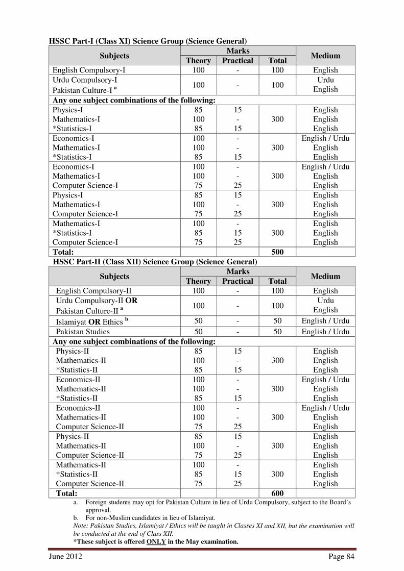
HSSC Part-I (Class XI) Science Group (Science General)
Subjects Marks
Medium Theory Practical Total
English Compulsory-I 100 - 100 English
Urdu Compulsory-I
Pakistan Culture-I a
100 - 100 Urdu
English
Any one subject combinations of the following:
Physics-I
Mathematics-I
*Statistics-I
85
100
85
15
-
15
300
English
English
English
Economics-I
Mathematics-I
*Statistics-I
100
100
85
-
-
15
300
English / Urdu
English
English Economics-I
Mathematics-I
Computer Science-I
100
100
75
-
-
25
300
English / Urdu
English
English Physics-I
Mathematics-I
Computer Science-I
85
100
75
15
-
25
300
English
English
English Mathematics-I
*Statistics-I
Computer Science-I
100
85
75
-
15
25
300
English
English
English Total: 500
HSSC Part-II (Class XII) Science Group (Science General)
Subjects Marks
Medium Theory Practical Total
English Compulsory-II 100 - 100 English
Urdu Compulsory-II OR
Pakistan Culture-II a
100 - 100 Urdu
English
Islamiyat OR Ethics b 50 - 50 English / Urdu
Pakistan Studies 50 - 50 English / Urdu
Any one subject combinations of the following: Physics-II
Mathematics-II
*Statistics-II
85
100
85
15
-
15
300
English
English
English Economics-II
Mathematics-II
*Statistics-II
100
100
85
-
-
15
300
English / Urdu
English
English Economics-II
Mathematics-II
Computer Science-II
100
100
75
-
-
25
300
English / Urdu
English
English Physics-II
Mathematics-II
Computer Science-II
85
100
75
15
-
25
300
English
English
English Mathematics-II
*Statistics-II
Computer Science-II
100
85
75
-
15
25
300
English
English
English Total: 600
a. Foreign students may opt for Pakistan Culture in lieu of Urdu Compulsory, subject to the Board’s
approval.
b. For non-Muslim candidates in lieu of Islamiyat.
Note: Pakistan Studies, Islamiyat / Ethics will be taught in Classes XI and XII, but the examination will
be conducted at the end of Class XII.
*These subject is offered ONLY in the May examination.
June 2012 Page 85
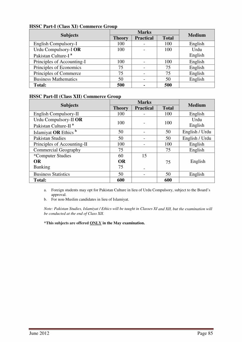
HSSC Part-I (Class XI) Commerce Group
Subjects Marks
Medium Theory Practical Total
English Compulsory-I 100 - 100 English
Urdu Compulsory-I OR
Pakistan Culture-I a
100 - 100 Urdu
English
Principles of Accounting-I 100 - 100 English
Principles of Economics 75 - 75 English
Principles of Commerce 75 - 75 English
Business Mathematics 50 - 50 English
Total: 500 - 500
HSSC Part-II (Class XII) Commerce Group
Subjects Marks
Medium Theory Practical Total
English Compulsory-II 100 - 100 English
Urdu Compulsory-II OR
Pakistan Culture-II a
100 - 100 Urdu
English
Islamiyat OR Ethics b 50 - 50 English / Urdu
Pakistan Studies 50 - 50 English / Urdu
Principles of Accounting-II 100 - 100 English
Commercial Geography 75 75 English
*Computer Studies
OR Banking
60
OR 75
15
-
75
English
Business Statistics 50 - 50 English
Total: 600 600
a. Foreign students may opt for Pakistan Culture in lieu of Urdu Compulsory, subject to the Board’s
approval.
b. For non-Muslim candidates in lieu of Islamiyat.
Note: Pakistan Studies, Islamiyat / Ethics will be taught in Classes XI and XII, but the examination will
be conducted at the end of Class XII.
*This subjects are offered ONLY in the May examination.

June 2012 Page 86
HSSC Part-I (Class XI) Humanities Group
Subjects Marks Medium
English Compulsory-I 100 English
Urdu Compulsory-I OR
Pakistan Culture-I a
100 Urdu
English
Any three of the following Elective Subjects 1. Civics-I
2. Computer Science-I (75+25 practical)
3. Economics-I
4. *Education-I
5. *Geography-I (85+15 practical)
6. *Islamic Studies-I
7. *Islamic History-I
8. Literature in English-I
9. Mathematics-I
10. *Psychology-I (85+15 practical)
11. *Statistics-I (85+15 practical)
12. *Sociology-I
13. Urdu Literature-I
14. *Fine Arts-I
300
(100
each)
English / Urdu
English
English / Urdu
English / Urdu
English / Urdu
English / Urdu
English / Urdu
English
English
English / Urdu
English
English / Urdu
Urdu
English
Total: 500
HSSC Part-II (Class XII) Humanities Group
Subjects Marks Medium
English Compulsory-II 100 English
Urdu Compulsory-II OR
Pakistan Culture-II a
100 Urdu
English
Islamiyat OR Ethics b 50 English / Urdu
Pakistan Studies 50 English / Urdu
Any three of the following Elective Subjects 1. Civics-II
2. Computer Science-II (75+25 practical)
3. Economics-II
4. *Education-II
5. *Geography-II (85+15 practical)
6. *Islamic Studies-II
7. *Islamic History-II
8. Literature in English-II
9. Mathematics-II
10. *Psychology-II (85+15 practical)
11. *Statistics-II (85+15 practical)
12. *Sociology-II
13. Urdu Literature-II
14. *Fine Arts-II
300
(100
each)
English / Urdu
English
English / Urdu
English / Urdu
English / Urdu
English / Urdu
English / Urdu
English
English
English / Urdu
English
English / Urdu
Urdu
English
Total: 600
a. Foreign students may opt for Pakistan Culture in lieu of Urdu Compulsory, subject to the Board’s
approval.
b. For non-Muslim candidates in lieu of Islamiyat.
Note: Pakistan Studies, Islamiyat / Ethics will be taught in Classes XI and XII, but the examination will
be conducted at the end of Class XII.
*These subjects are offered ONLY in the May examination.

June 2012 Page 87
Annex B
List of Practicals
Class XI
S.
No.
SLO
No. Objective Apparatus/Slide/Material
Topic 1: Understanding Geography
1 1.2.2 To identify different types of maps, its characteristics and
its uses.
Different types of maps(topographic, physical, political,
meteorological, environmental, geological)
2 1.2.4 To read the globe using the grid system of latitude and
longitude.
Globe
3 1.2.7 To make a compass using the given method.
Magnet, pins
4 1.2.8 To calculate the time with the help of latitude and
longitude.
Calculator, map
5 1.3.3 To draw a scale for the given statement.
Calculator, map
6 1.3.6 To measure distance on the map between allocated points
using the given scale.
Map, calculator
7 1.4.3 To draw contours for the given landform.
Compass, ruler, map
Topic 2: Rocks and soil
8 2.1.3 To identify the given sample of rock with its characteristics Types of rocks (sedimentary, igneous, metamorphic)

June 2012 Page 88
Class XII
S.
No.
SLO
No. Objective Apparatus/Slide/Material
Topic 7: The Geography of the Continents
1 7.2.4 To locate different landforms on the World map. World map (showing only continents and countries)
2 7.3.7 To locate different types of vegetation on the map of the
world.
World map (showing only continents and countries)
Topic 11: Practical Geography
3 11.1.5 Identify different types of projection on atlas (cylindrical,
conical or Zenithal) and its characteristics.
Atlas
4 11.3.2 To represent the given data using line, bar or pie chart.
Calculator, pencil and ruler
5 11.4.3 To show the distribution of the given data on the map
using qualitative or quantitative methods.
World map, calculator