english book-landlessness and sj - with...
TRANSCRIPT

Landlessness and Social JusticeA
nA
ssessment of D
isparities in Land Distribution and Prospects of Land R
eforms
PRAXISInstitute for Participatory Practices
Land, in the context of poverty eradication,
defies classical theories of economics. A
piece of land to a landless person goes far
beyond the economic significance as a
means of livelihood or a habitat. It is a
‘quantum leap’in self esteem, self worth and
entrepreneurship.
The land mapping excercise carried out by Ekta Parishad and Praxis is in
recognition of this critical role land plays in the lives of the poor. It is aimed at
understanding the nuances of land distribution in Bihar, to form the basis for
collective actions aimed at better entitlements for the poor. The current global
financial crisis has helped to re-establish a long forgotten paradigm that it is not
just the size of the cake that matters; but is how it is cut. The land mapping
exercise provides evidence of this in no uncertain terms.
Praxis
1st Floor, Maa Sharde ComplexEast Boring Canal Road,Patna - 800001Tel / Fax: +91 612 2521983 / 6453807Email: [email protected]: www.praxisindia.org
Ekta Parishad
Pragati Grameen Vikas SamitiPaschim Bailey Road,P.O. Danapur Cantt.,Patna - 801503Tel: +91 612 6412100Email: [email protected]: www.pragatigvs.org

Landlessnessand
Social JusticeAn Assessment of Disparities in
Land Distribution and Prospects of Land Reforms
Landlessnessand
Social JusticeA
nA
ssessment of D
isparitiesin
LandD
istributionand
Prospectsof Land
Reform
s
PRAXISInstitute for Participatory Practices

Landlessness and Social JusticeAn Assessment of Disparities in Land Distribution and
Prospects of Land Reforms
Based on a ‘Land Mapping’ process facilitated in five districts
Jamui, Gaya, Nawada, Patna, West Champaran
An Initiaitive ofEkta Parishad
andPraxis - Institute for Participatory Practices

Landlessness and Social JusticeAn Assessment of Disparities in Land Distribution andProspects of Land Reforms
Document Consolidation and AnalysisAnindo Banerjee
Designed and Production byPradeep Kumar
Printed and Published byPraxis - Institute for Participatory Practices
Edition : 2009
Copyright © Ekta Parishad & Praxis - Institute for Participatory Practices
ISBN : 978-81-89722-04-3Price : Rs. 165/-
Ekta ParishadPragati Grameen Vikas SamitiPaschim Bailey Road,P.O. Danapur Cantt., Patna - 801503Tel: +91 612 6412100Email: [email protected]: www.pragatigvs.org
PRAXIS1st Floor, Maa Sharde ComplexEast Boring Canal Road, Patna-800001Tel / Fax +91 612 2521983 / 6453807Email: [email protected]: www.praxisindia.org

Landlessness and Social Justice
AcknowledgementsPeople Involved in the Process of Land MappingForeword
Chapter Title Page No.No.1 An Account of Land Distribution
in Bihar and Challenges 1
2 The Process of Land Mapping 6– Identification of Suitable Locations for Land mapping 6– Preliminary Preparations and Initial Processes 7– Eight steps of the land mapping process at the village level 8
3 Distribution of Land in the Villages of Study andDisparities therein 11
4 Status of Land Rights of Dalits and Adivasisin the Locations of Study. 23
5 Status of Women’s Land Rights in theLocations of Study 27– Glaring issues related to landlessness of women 28
6 An Account of State Interventions towardsDistribution of Land 32
7 Issues that require Policy Interventions 38
AnnexèA. Compilation of village level data on land distribution – an example 45B. An example of maps focused on different variables 46C. List of Locations selected for the process of land mapping 47D. Description of land measurement units used in different districts 49E. Salient references 50F. A glossary of terminology used in the document 51
Table of Contents
i
Land Mapping in Bihar – A joint venture of Ekta Parishad and Praxis
Steering Team for the Land Mapping Exercise
Ekta Parishad PraxisManju Dungdung Jay Kumar VermaPradeep Priyadarshi Roma DeyAjay Choudhuri Anindo BanerjeeKapileshwar
With significant support fromAjai Manjhi, Varsha Jawalgekar, Sanjay Kumar Prasad, Mary Pinakattu, Mohd.AliAnwar, Manjusha ET, Mukta Ojha, Rajendra Ram, Ranjit Kumar Jha
Names of people involved in the process of land mapping at the district level
Jamui (Sikandra Block)Umesh Mahto, Saryug Mahto, Chamari Yadav, Sadhu Saran Mahto, Baldev Koda,Umesh Yadav, Ukhru Manjhi, Baleshwar Koda, Sacchidanand Kumar, Hazari PrasadVerma, Raja Ranjit Ram, Ramesh Kumar Singh, Pradeep Yadav, Mahendra Das,Sanjiv Singh, Anil Paswan, Sarita Koda
Gaya (Banke Bazar Block)Ram Lakhan Prasad, Basudev Nirala, Dhaneshwar Prasad, Mani Devi, Bimla Devi,Mritunjay
Nawada (Kavakol Block)Chandrika Prasad, Rajesh Mahto, Arvind Prasad, Kanchan Devi, Daro Sav, RaviPrasad, Rajesh Prasad, Muneshwar Mahto, Avdhesh Ram, Krishandev Prasad,Shatrughan Kumar
West Champaran (Bagah Block)Akhtari Begam, Ramayan Sahani, Basant Thakur, Bhola Kushwaha, Jhulan Baitha,Pradeep Kumar, Suresh Ram, Gaugri Ram, Ramesh Singh
Patna (Paliganj)Asrita Toppo, Babulal, Sanjay Yadav, Virendra Yadav, Ramanti Devi
ii

Landlessness and Social Justice
Land, in the context of poverty eradication, defies classical theories of economics.A piece of land to a landless person goes far beyond the economic significance as ameans of livelihood or a habitat. It is a ‘quantum leap’ in self esteem, self worth andentrepreneurship. The land mapping excercise carried out by Ekta Parishad and Praxis is in recognitionof this critical role land plays in the lives of the poor. It is aimed at understanding thenuances of land distribution in Bihar, to form the basis for collective actions aimed atbetter entitlements for the poor. The current global financial crisis has helped to re-establish a long forgotten paradigm that it is not just the size of the cake that matters;but is how it is cut. The land mapping exercise provides evidence of this in no uncertainterms. This report is the outcome of the relentless and often arduous efforts put in by thecadres of Ekta Parishad and colleagues from Praxis. It is just a small step. It wouldhave achieved its aim when the insights this offers and the questions it poses inspirepurposeful actions for a more equitable social order.
Pradeep Priyadarshi Tom ThomasNational Core Group Member Chief ExecutiveEkta Parishad PraxisPatna, Bihar
iii
Foreword

Landlessness and Social Justice
In the economically backward state of Bihar, agriculture is the main source oflivelihood for a majority of people, including landowners, agricultural workers andsharecroppers. According to the Census of 2001, nearly 75% of all main workers aredependent upon agriculture in the state, including cultivators and agricultural labourers.This high degree of dependence on land underscores the criticality of entitlementsand rights relating to land, which need to be secured for a large section of the state’scitizenry for addressing their long term development needs.
Distribution of land in Bihar showcases an unparalleled degree of disparity, comparedto any other state of the country. According to statistics released by the Ministry ofAgriculture for 1995-1996, the proportion of marginal land holdings in Bihar exceedsthe corresponding national figure by far. Whereas 61.58% land holdings are smallerthan 1 hectare in India, the same for Bihar is 80.14%. Furthermore, the average sizeof the marginal land holdings in Bihar (0.34 hectare) is also lower than the nationalaverage of 0.4 hectare. The total area covered by marginal land holdings in Biharamounts to only 36.24% of the total land area of the state. The serious nature ofdisparities in Bihar is also confirmed by the average sizes of different categories of
1 An Account of Distributionof Land in Bihar andChallenges
1

Land Mapping in Bihar – A joint venture of Ekta Parishad and Praxis
land holdings in the state relative to those for the rest of India. Overall, the averageland-holding size of 0.75 hectare in Bihar is far below the national average of 1.41hectare.
According to 55th round of survey undertaken by NSSO in the year 1999-2000,nearly 76.6% of the all agricultural labourers in Bihar are completely landless. This is6.3% higher than the corresponding proportion determined five years back, whichpoints at a steady rise in the scale of landlessness in the state. The condition of dalitsis particularly grave in the matter of landlessness, compared to other communities.The NSSO data for the same year shows that 23.8% of all households belonging toScheduled Castes were completely landless, a figure which is far higher than thecorresponding level in any other state of the country. If the number of de facto landlesshouseholds (i.e. people owning less than 40% of a hectare of land) is added to theabove figure, it shoots up to a whopping 91% of all Scheduled Caste households ofthe state!
Interventions of the Government in the direction of land reforms in Bihar have beenlargely inadequate, although several significant initiatives have been undertaken duringthe decades after independence. Bihar was one of the first states in independent Indiato formulate laws relating to land reforms. The Land Reform Act was passed in theyear 1950, which brought to an end the ownership of private holders over severalkinds of non-land immovable properties, e.g. water bodies, markets, forests, minesetc. Earlier, the state government had passed the ‘Abolition of Zamindari Act’ in1947, which came into effect in the modified form of a law in 1948. Subsequently, toprevent excessive private ownership of land, the state government prepared the BiharAgricultural Land (Ceiling and Management) Act in the year 1955, but this could notbe passed on account of resistance from influential landowners. It was only in 1961that the Bihar Land Reforms (Ceiling, Land Allocation and Surplus Land Aquisition)Act came into effect. It allowed any ‘person’ to own 20 to 30 acres of land with anadditional allowance for holding up to 10 acres of land as homestead area, 15 acresfor cultivation of fodder and up to one-fifth of the ceiling limit for each dependent ofthe family In case the number of dependents exceeded four, the overall limit ofownership was kept at double the ceiling limit. The Act was revised about a decadelater in 1971 and 1973, which vested land holding rights in a ‘family’ rather than in a‘person’ and determined a ceiling of 45 acres for each family.
2

Landlessness and Social Justice
Prior to the abolition of Zamindari in Bihar, there were nearly two lakh permanentlysettled land holdings in the state that used to regularly pay revenue to the government.The revenues used to be collected by big landlords, who used to forward a lion’sshare of the collections to the government, retaining a small part (about 10%) forthemselves and for sharing with the legal owners of the land, the occupancy ryots,contractors and agricultural labourers. With so many parties sharing a paltry portionof the land revenue, the insufficiency of the relative shares of small farmers andlabourers can be easily deduced.
Even after laws were passed in the 1950s towards land reforms and abolition of theZamindari system, the small farmers and agricultural labourers did not get much
3
Table 1 – Comparison of statistics relating to land distribution inBihar and the whole of India
Issue Bihar India
No. of Marginal land holdings 11344 000 (80.14%) 71179 000 (61.58%)
No. of Small land holdings 1526 000 (10.78%) 21643 000 (18.72%)
No. of Semi-Medium land holdings 941 000 (6.65%) 14261 000 (12.34%)
No. of Medium land holdings 314 000 (2.22%) 7092 000 (6.14%)
No. of Large land holdings 29 000 (0.2%) 1401 000 (1.21%)
Total no. of land holdings 14155 000 115580 000
Area covered by Marginal land holdings 3871 000 ha (36.24%) 28121 000 ha (17.21%)
Area covered Small land holdings 2018 000 ha (18.89%) 30722 000 ha (18.8%)
Area covered Semi-Medium land holdings 2566 000 ha (24.02%) 38953 000 ha (23.84%)
Area covered Medium land holdings 1749 000 ha (16.37%) 41398 000 ha (25.34%)
Area covered Large land holdings 479 000 ha (4.48%) 24163 000 ha (14.79%)
Total area covered by the land holdings 10682 000 ha 163357 000 ha
Average size of Marginal land holdings 0.34 ha 0.4 ha
Average size of Small land holdings 1.32 ha 1.42 ha
Average size of Semi-Medium land holdings 2.73 ha 2.73 ha
Average size of Medium land holdings 5.57 ha 5.84 ha
Average size of Large land holdings 16.52 ha 17.21 ha
Average size of total land holdings 0.75 ha 1.41 ha
Source: Ministry of Agriculture, Government of India

Land Mapping in Bihar – A joint venture of Ekta Parishad and Praxis
Table 1.1 - Description of the total land area of Bihar.
Type of Land Area (in thousand hectares)
Total Geographical Area 9416
Reporting area for land utilization statistics 9360
Land under forests 622
Land not available for cultivation 2081
Other uncultivated land excluding fallow land 302
Permanent pastures & other grazing lands 18
Land under misc. tree crops & groves not incl. in netsown area 238
Culturable waste land 46
Total Fallow land 643
Fallow lands other than current fallows 130
Current fallows 513
Net sown area 5712
Total cropped area 7882
Agriculture land/ Cultivable land/ Culturable land 6640
Source: Ministry of Agriculture, Government of India (2003-2004)
4
relief. There are two major reasons for this. The pace of implementation of the lawswas so slow that it gave ample opportunity to the big landowners to save their property.Many big landowners divided their land into small parts in compliance with the legalceilings and registered them in the names of different family members or loyal servants.Besides, the law had certain loopholes, which allowed the landowners to keep land inexcess of the prescribed ceilings for specific purposes (e.g. homestead land, khasland or land for commercial purposes).
According to data released by the Ministry of Agriculture, Government of India, only70.52% (i.e., about 6640 thousand hectares) of Bihar’s total geographical area iscultivable (ref. Table 1.1). If all the available cultivable land of the state is viewed interms of per capita availability for agriculture dependent population, it would amountto less than one-eighth of a hectare, far less than the corresponding average for other

Landlessness and Social Justice 5
states of India. Distribution of a vital resource like land to as many people as possibleand especially to those sections whose livelihood skills and capacities are predominantlycentered around agriculture should therefore be a pressing priority for any government.
Even after nearly five decades since the abolition of the Zamindari system, landdistribution in Bihar remains highly polarized. According to The Journal of PeasantStudies (edition dated April 1982, subsequently quoted in the yearend edition of TheTimes of India in 1983) fewer than 2% of Bihar’s population own more than 20% ofits land whereas a massive 64% of its rural families own only 16% of its total land.
The severely polarized distribution of land resources in Bihar provides the contextfor undertaking the process of Land Mapping across five districts of the state. Thefollowing chapters bring to light specific issues related to land distribution and relevantpolicy implications.

Land Mapping in Bihar – A joint venture of Ekta Parishad and Praxis
The need of preparing a fact-based document focusing on disparities in land distributionin Bihar had been discussed on several occasions by the state level workers of Praxis andEkta Parishad. It was felt that data bringing to light micro level challenges and prospectsrelating to land distribution would have a tremendous relevance for efforts directed atprovisioning of land in favour of the landless and homeless families of the state. In thecourse of these discussions, it was decided to initiate a thorough assessment of the currentstatus of land distribution in the state, which, even if undertaken on a small scale, wouldhelp in identification of necessary policy interventions based on a comprehensive analysisof the patterns of ownership and control vis-à-vis the land resources of a few selectedvillages.
Identification of Suitable Locations for Land mapping
In order to undertake a comprehensive analysis of the patterns of ownership andcontrol over the entire range of land holdings falling within the boundaries of a fewselected villages, the first step taken was selection of five districts of the staterepresentative of different geophysical settings and social features. The following arethe districts selected for the purpose and specific locations selected within them:
The Process of LandMapping
6
2

Landlessness and Social Justice 7
Jamui – 14 villages of Sikandara blockNawada – 7 villages of Kauwakol blockGaya – 6 villages of Bankebazaar blockWest Champaran – 10 villages of Bagaha blockPatna – 1 village of Paliganj block
Preliminary Preparations and Initial Processes
The land mapping process took off with a residential workshop held at Patna, whichbrought together representatives of selected villages from Jamui and Gaya districts.The aim of the workshop was to build a team, which would be able to facilitate theprocesses of mapping all the land holdings in selected locations with the support oflocal villagers. During the workshop, mock exercises were undertaken to attemptmapping of all holdings of a few familiar villages and to compile critical pieces ofinformation relating to each plot of land, so that this experience would enable themto orient others to carry out similar processes. A few days later, the facilitators trainedin the workshop initiated the pilot phase of the land mapping process in seven villagesof Sikandara block of Jamui in partnership with local villagers.
A review workshop was subsequently organized, to discuss the initial experiences,areas of success, shortcomings, challenges faced by the team and ideas towardsimproving the process.
Based on the experiences of the first phase, the second phase of the process wasstarted on 29th March 2007 with a three day workshop in Patna. In this workshop,representatives from villages of Nawada, Gaya, West Champaran and Patna cametogether in addition to village level facilitators from the first phase of the process.After the training of the newly joined group of village level facilitators, the process ofland mapping resumed in three new districts from the third week of April.
Subsequently, the process of land mapping was carried out in the selected villages inthe form of an eight-step-process as delineated below:
Land Mapping in Bihar – A joint venture of Ekta Parishad and Praxis
Eight steps of the land mapping process at the village level
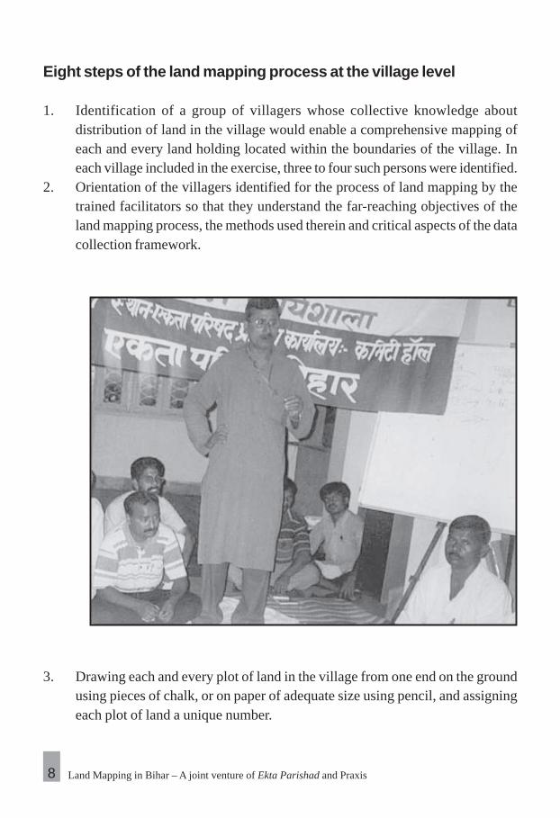
1. Identification of a group of villagers whose collective knowledge aboutdistribution of land in the village would enable a comprehensive mapping ofeach and every land holding located within the boundaries of the village. Ineach village included in the exercise, three to four such persons were identified.
2. Orientation of the villagers identified for the process of land mapping by thetrained facilitators so that they understand the far-reaching objectives of theland mapping process, the methods used therein and critical aspects of the datacollection framework.
3. Drawing each and every plot of land in the village from one end on the groundusing pieces of chalk, or on paper of adequate size using pencil, and assigningeach plot of land a unique number.
8

Landlessness and Social Justice 9
4. Entering the following details in a recording sheet, relating to each plot of landindicated on the map:
A reference number for the plotName of the person who presently has control or possession over the plot.Father’s nameCasteSize of the plotDuration of control over the plotBasis of control or possession of the plot.Type of land (according to its legal status)Irrigated or unirrigated / quality of landName of the legal owner of the plotWhether subjected to any dispute or notAny other remarksPlot number according to ‘Register 2’ of land records, or official maps
Land Mapping in Bihar – A joint venture of Ekta Parishad and Praxis
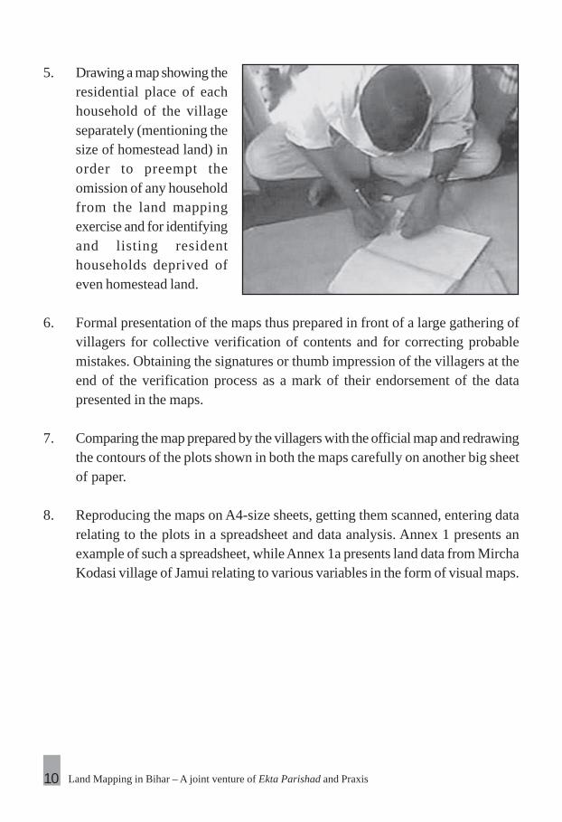
5. Drawing a map showing theresidential place of eachhousehold of the villageseparately (mentioning thesize of homestead land) inorder to preempt theomission of any householdfrom the land mappingexercise and for identifyingand listing residenthouseholds deprived ofeven homestead land.
6. Formal presentation of the maps thus prepared in front of a large gathering ofvillagers for collective verification of contents and for correcting probablemistakes. Obtaining the signatures or thumb impression of the villagers at theend of the verification process as a mark of their endorsement of the datapresented in the maps.
7. Comparing the map prepared by the villagers with the official map and redrawingthe contours of the plots shown in both the maps carefully on another big sheetof paper.
8. Reproducing the maps on A4-size sheets, getting them scanned, entering datarelating to the plots in a spreadsheet and data analysis. Annex 1 presents anexample of such a spreadsheet, while Annex 1a presents land data from MirchaKodasi village of Jamui relating to various variables in the form of visual maps.
10

Landlessness and Social Justice 11
3 Distribution of Land inLocations of Study andInherent Disparities
Amongst the 35 panchayats where the process of land mapping was carried out,disparities in distribution of land were found to be of utmost concern in the district ofWest Champaran. In several villages of the district the local people only have somehomestead land in their control and have no land for cultivation. Moreover, nearly allthe land in such villages is under the control of big landlords of the area, belongingeither to the same villages or nearby habitations. Jainagar is one such village situatedin Bagaha block where 81 families occupy only 17 acres of land and 69 familiesbelonging to the scheduled caste have on an average a mere 1.74 katha of land(inclusive of homestead land). In the neighbouring village of Bhartapur the averagegoes down to 1.08 katha, whereas in Sikatiya the average land holding of each dalitfamily is 2.89 katha.
If the pattern of land distribution across all the locations of study are examined together,the proportion of marginal farmers (having less than a hectare of land) emerges to bevery high. While 88.7% of all land holders based in study locations have marginalholdings, their concentration is highest in Nawada district (91.8%). The figures forthe districts of Jamui, West Champaran and Gaya are 87.8%, 86.3% and 82.6 %respectively. Amongst all communities, the proportion of marginal landholders ishighest amongst Scheduled Tribes and Scheduled Castes (95.1% and 92.6%respectively), while the proportion within Other Backward Castes, Muslims and Other

Land Mapping in Bihar – A joint venture of Ekta Parishad and Praxis
Castes stands at 88.1%, 82.7%, and 77.7%, respectively. Table 3.1 shows the proportionof marginal landholders in different communities in four of the districts included in thestudy.
Close examination of the category of marginal landholders reveals that most of themarginal landholders have less than 40% of an hectare, i.e., less than one acre ofland. Various surveys undertaken by the NSSO have treated such landholders asvirtually landless. The proportion of such virtually landless families was found to be
Table 3.1 – Proportion of marginal landholders in different caste-groups in study sites
Proportion of households with marginal Nawada Jamui Gaya Westlandholding (less than 1 hectare) Champaran
Scheduled Castes 0.95 0.95 0.86 1.00
Scheduled Tribes — 0.97 — 0.92
Other Backward Classes 0.92 0.88 0.80 0.82
Muslims 0.82 0.84 1.00 0.00
Other Castes 0.87 0.71 0.42 0.42
Total 0.92 0.88 0.83 0.86
Table 3.2 – Proportion of virtually landless households amongstdifferent communities.
Proportion of virtually landless Westhouseholds (owning less than Nawada Jamui Gaya Champaran0.4 hectares of land)
Scheduled Caste 0.89 0.75 0.70 0.96
Scheduled Tribes — 0.88 — 0.80
Other Backward Classes 0.79 0.67 0.59 0.64
Muslims 0.70 0.65 0.67 0.00
Other Castes 0.72 0.58 0.42 0.26
Total 0.80 0.70 0.64 0.73
12

Landlessness and Social Justice
very high (about 74.1%) in the areas under study. The concentration of such families ishighest in the district of Nawada (about 80.2%), while the same in West Champaran,Jamui and Gaya stands at 73.3%, 70.3%, 64.3%, respectively. Most families belongingto the Scheduled Tribes and Scheduled Caste (84.6% and 81.1% respectively) fallunder this category, while the proportion of virtually landless households amongstOther Backward Classes, Muslims and other castes is 70.8%. 67.9% and 66.5%respectively. Table 3.2 shows the concentration of virtually landless householdsamongst different communities in different districts.
It would be essential to point at the proportion of households within the category of‘virtually landless’ facing landlessness of almost an absolute nature. Table 3.3 containsdata relating to families that have less than 0.4 acres (or one-tenth of a hectare) land.The proportion of such families in the areas of study is 44.9%, whereas it is highest inNawada district (54.9%). The percentage of such families in West Champaran, Gayaand Jamui is 48.4%, 36.1% and 31.6% respectively. The concentration of familiesfacing near-absolute landlessness is highest amongst the Scheduled Castes (53.5%)whereas the same for the Scheduled Tribes, Other Backward Classes, Muslims andother castes is 47.98%, 40.9%, 45.7% and 39.2% respectively.
The limited availability of land can be clearly deduced from the data presented above. Ifthe average land availability per household is taken into account in different caste-groups,
Table 3.3 – Proportion of families facing near-absolute landlessnessin different castes
Proportion of completely landless Nawada Jamui Gaya Westfamilies (owning less than 0.1 Champaranhectare of land)
Scheduled Castes 0.70 0.36 0.38 0.71
Scheduled Tribes — 0.47 — 0.49
Other Backward Classes 0.50 0.28 0.34 0.42
Muslims 0.50 0.38 0.33 0.00
Other Castes 0.54 0.19 0.33 0.16
Overall 0.55 0.32 0.36 0.48
13

Land Mapping in Bihar – A joint venture of Ekta Parishad and Praxis
one notices an excessive pressure of population on land in the areas of study. The pressureis most visible in the land ownership of Scheduled Castes and Scheduled Tribes. While theaverage land holding per household is a dismal 1.13 acre across the whole area of study,the same for Scheduled Tribes and Scheduled Castes is 0.65 acres and 0.72 acres,respectively. Amongst the other backward classes, Muslims and socially advanced castesthe average land holding per family is 1.16, 2.02 and 2.13 acres respectively. In the districtsof West Champaran and Nawada, while the average land holding per landowning familyamongst the Scheduled Castes is extremely low (0.28 acre and 0.49 acre, respectively),the same amongst the socially advanced castes is found to be many times higher. Comparedto other districts, Nawada accounts for the lowest land holding (0.82 acres) per landowningfamily, while the same for West Champaran, Gaya and Jamui districts is found to the tuneof 1.04, 1.43, and 1.41 acres respectively. Table 3.4 shows the average land holding perlandowning family for different caste-groups in various districts covered under the study.
In almost all the districts included in the study, sharecropping is a commonphenomenon. Even within the limited area of the study, practices relating to largescale sharecropping were found in several villages. Sikandara village in Jamui districtis one good example, where around 312 acres of land is under sharecropping. Similarly,almost all the land in several villages of West Champaran is engaged in sharecropping.In villages like Sikatiya and Bhartapur located in Bagaha block of West Champaran,land amounting to 84 and 74 acres respectively are being employed for such purposes.
Table 3.4 – Average land holding per landowning family in differentcaste-groups
Average land holding per land owning Westfamily (acres) Nawada Jamui Gaya Champaran
Scheduled Castes 0.49 0.77 1.10 0.28
Scheduled Tribes — 0.61 — 0.71
Other Backward Classes 0.83 1.14 1.65 1.81
Muslims 1.24 3.45 0.87 7.48
Other Castes 1.17 3.00 4.44 5.49
14

Landlessness and Social Justice 15
Pict
ure
3.1
Out
line
map
of L
achh
uar v
illag
e (J
amui
), sh
owin
g ar
eas
unde
r sha
recr
oppi
ng
Out
line m
ap of
LA
CH
HU
AR
Vill
age (
Jam
ui),
show
ing s
hare
crop
ped
area
sN
early
295
acr
es (e
nclo
sed
with
in 5
6 ho
ldin
gs o
f lan
d, o
f whi
ch 3
3 be
long
to g
ener
al c
aste
s and
18
to O
BC
s) o
ut o
f the
gro
ss 7
17 a
cres
of
map
ped
area
of t
he v
illag
e is
und
er sh
are-
crop
ping
.
Not
to
scal
e; d
raw
n by
sha
recr
oppi
ng l
abou
rers
of
the
villa
geN
orth

Land Mapping in Bihar – A joint venture of Ekta Parishad and Praxis
Lachuar village of Jamui is another glaring case in point, where almost 295 acres of land isused for sharecropping (ref. Picture 3.1).
In most cases of sharecropping, the agreement between landowners and sharecroppersseem to violate the provisions of Bihar Tenancy Act of 1885. Importantly, most casesrelating to sharecropping in the state are based on verbal agreements and no landownerwants to have such agreements written out on paper or assume the form of formalcontracts. As a consequence, most sharecroppers in the state are unable to safeguardtheir legal rights. According to prevailing customs the sharecropper has to give one-half of the yield of the land cultivated by him to the land owner, which is a breach ofthe legal ceiling prescribed to this effect. Further, landowners make sure thatsharecroppers do not get to cultivate any plot of land continuously over a long time,to pre-empt possibilities of legal transfer of land ownership in the name of thesharecropper. A large-scale study on the scale and issues relating to sharecropping inthe state would be a meaningful initiative in the direction of safeguarding land rightsof a large number of sharecroppers.
Another important finding from the study of land distribution relates to an excessivelyhigh proportion of holdings lying in possession of people who do not own the same.Contrary to prevalent ideas, most encroachments are done by the prosperous andsocially advanced sections of society. As a matter of fact, the average land encroachedupon by socially advanced castes, at 2.04 acres, is 4.5 times higher than the amountof land being used by non-owner SC families. In the case of Scheduled Castes, mostsuch instances of unregulated occupancy of land are driven by compulsions of ekinga livelihood, as clearly evident from their high degree of landlessness. In contrast,illegal encroachments over nearly 11% of land are undertaken by a handful of peoplehailing from socially advanced castes (ref. Table 3.5), who additionally own largeamounts of legally sanctioned property, illustrates the high degree of control overland resources of the socially and economically advanced sections. The comparativedegrees of possession of land without ownership rights have been presented in Table3.5 for different caste-groups. Picture 3.2 from Jagdishpur village presents an exampleof such possessions.
16

Landlessness and Social Justice
The failure of the state machinery to provide effective control over land to the landless haspushed many landless communities in different parts of the state to take the path of activestruggle. Such efforts by landless labourers have yielded positive results in some parts ofthe state. A good example is the establishment of control over 700 acres of land by labourersattached to ‘Khet Majdoor Sabha’ in Gaunaha and Mainatand blocks of West Champaran.Although there have been stray instances of success towards securing possession overland by the underprivileged in a few places, on account of initiatives of agencies outside thegovernment, there is a need for strong interventions by the Government to find effectiveand large scale solution to address the issue of disparity.
Various issues relating to ownership of land that emerged in the course of the studyhave been explained in different sections of this document. One important issue thatseems to have affected a huge number of landless people is their inability to geteffective control over land allotted to them by the Government. Amongst variousreasons of such deprivations, one key reason is non-issuance of essential documentsof land-ownership (daakhil kharij, or receipt) after allotment. In many cases, noheadway could be made in this direction even after deprived villagers lodged appealsin the courts of law.
Table 3.5 – Possession of land by different caste-groups withoutownership rights
Caste-groups / Community Instances of Proportion Average sizepossession without of area of possessionownership (%) covered (acres)
Scheduled Castes 31.3 % 17.3 % 0.46
Scheduled Tribes 22.7 % 23.1 % 0.85
Other Backward Classes 38.8 % 45.6 % 0.98
Muslims 2.73 % 3.02 % 0.92
Other Castes 4.46 % 10.9 % 2.04
17

Land Mapping in Bihar – A joint venture of Ekta Parishad and Praxis18
Picture 3.2 – Land occupied without ownership by different castes inJagdishpur
Land occupied by different caste-groups without ownership rightsJagdishpur Kodasi village (Jamui)
Occupancy by SCsOccupancy by STsOccupancy by OBCsOccupancy by gen. castes

Landlessness and Social Justice 19
Struggle to own land – a fight carried down by several generationsMananpur village is located in Mahudar panchayat of Kauwakol block in Nawada. It exemplifies a village wherehundreds of farmers do not have formal ownership of land even though their families have been managing plotsof land since the Zamindari Raj and the British rule.
After promulgation of Ceiling Act, many large holdings of land belonging to big landowners, e.g. 81 acres ownedby Mahant Ramdhan, were divided and redistributed among people without land. However, till date no receiptsor documents have been issued by the Government to the recipients of land. After redistribution of the largechunk land, possessions by the new occupants was registered in a survey undertaken in 1971. The villagersfiled a case against the Goverrnment of Bihar in the Civil Court of Nawada raising the issue, but could not pursuethe same due to dearth of resources.
Later, an appeal was lodged by the villagers in Patna High Court to push for registration of the plots in theirnames on the basis of their possession. However, the farmers haven’t been able to secure papers relating tothe land till date.
For many deprived communities, aspirations of land ownership are directly linked withtheir identity, self-esteem and struggle for existence. In the absence of ownership overland, large sections of socially and economically backward communities are subjected tofrequent displacements, which have an enduring impact on their lives and future. The examplegiven below describes the struggle of a large mass of people displaced from their habitationsin Danapur block of Patna.
During the process of land mapping, many instances of violation of land rights cameto the fore, caused by absence of an efficient system for speedy settlement of long-drawn conflicts between families. In many cases, conflicts are on account of incompleteexecution of the process of land allotment by the government. During the processmany instances of conflict came to the fore. For example, in Dhaneta village of Gaya,an outsider called Pati Yadav has been issued a revenue receipt for a plot of one acreand 11.5 decimals that has been under the control of the family of Bartu Paswan forover a hundred years. Applications have been filed in the local Circle Office forsettlement of the consequent dispute as many as ten times, and the charges meant foravailing of the service of land measurement have also been paid. However, no remedialsteps have been taken till date. In the same village a big farmer called Mohan Yadavhas been able to get a document certifying a homestead plot of four decimals in hisname, located on a plot of land that the family of Munshi Thakur has been tending tofor over two centuries. To get it cancelled Munshi Thakur has been making rounds of

Land Mapping in Bihar – A joint venture of Ekta Parishad and Praxis20
We will fight unto death for securing land!— Sunil Kumar, victim of displacement on account of a new Railway project in Danapur
We came to Danapur from different districts of Bihar in 1982 and settled on a vacant stretch of land. Most of usdid not have land back home and were completely worn off due to heavy exploitation by landlords. We camehere in search of work and settled on a variety of livelihoods ranging from agriculture and masonry to odd jobsas daily wagers and domestic help. The vacant land we occupied belonged to the government, and many ofus were provided with ration cards, voter identity cards and basic amenities during the years that followed. Afew years later, the government claimed the land for allotting to a college, and we were forced to move out to thenext closest place. We moved to several nearby panchayats of Danapur and stayed on for over twenty years.We live as one big family despite hailing from different castes and religions.
In 2002, the government decided to lay a new railway track on public demand and we were once again facedwith the prospects of displacement. It was not easy for us to uproot ourselves once again. However, no noticewas served this time and one morning we were shocked to find bulldozers razing down houses from one endand leveling the area. We realized that some of the houses in our neighborhood had already disappeared andit was only a matter of time before all our houses were demolished.
As many as 2556 families from seven villages of the area were displaced during the days that followed. Thevillages include Jalalpur, Tejlal Varma Nagar, Sabari Nagar, Chuldai Chowk, Balapur Nagar, AbhimanyuNagar and Digha. The land was acquired by the Indian Railways for laying the new track. We had nochoice but to move to a location between the railway track and a canal, which makes us extremelyvulnerable to accidents on both sides. The children play on the tracks and are always in the danger ofbeing run over or falling in the canal. We have already faced an accident; during the last Holi festival, oneof our children lost his life after falling in the canal. We are not at all safe living here.
We approached the office of the block panchayat to resolve the crisis. They promised land for all thedisplaced and gave the assurance of relocating all of us as early as possible. Subsequently, the governmentdecided to allot land in the name of 274 families and the entitlements to this effect were formalized onstamp paper. However, none of the families have been able to acquire possession over land till date andtheir entitlement is only on paper. The government officials have not taken any action to hand over actualpossession over the land to the allottees, as the land allotted is in the control of some other farmers. Asfar as we are concerned, we are always pressed with some problem or the other and can hardly riseabove our own trials of life. We have to struggle hard to find work and our children can hardly attendschools under all the quandaries.
On the 12th of January 2007, we reorganized ourselves into a large gathering and once again assertedour demands, but the government remained silent. This compelled us to initiate an indefinite strike. Wedecided to sit on a peaceful dharna inside the premises of the block office and to continue the protest tillour demands were met. It is continuing till date. We take turns to sit on the dharna and our conviction isgrowing stronger by the day. We are ready to undertake any necessary measures to achieve our demandsand to secure our rights to own a piece of land. If we do not get a suitable response here, we shall marchto Delhi. We will meet the Prime Minister and press for fulfillment of our demands.

Landlessness and Social Justice
the Circle, Block and District Offices since 1990. Even the local Gram Panchayat hasmet over and discussed the issue, yet the receipt in Mohan Yadav’s name has not beencancelled. Similarly, in Macharganwa Tola of Siktiya village of West Champaran, eightfamilies (families of Basant Thakur, Sita Ram, Banarasi Ram, Dudhnath Ram, DinanathRam, Nand Kishor Thakur , Vijay Thakur and Kishun Ram) have been living on a plot ofland for years, yet they have not been able to get it registered in their names. Unfortunately,they have got entangled in a conflict over the possession of the land with other families
21
West Champaran district – epicenter of land disparities
The realities of West Champaran in the matter of distribution of land are shocking. The level of disparitycan be easily gauged from the fact that thousands of acres of land are occupied by merely half a dozenestates and a handful of families. The list below has the names of some of the people who occupy land inexcess of 200 acres.
Shikarpur Estate: Controlled by Dilip Verma (BJP MLA from Sikta), Madhu Verma (an electedrepresentative), Om Verma (Member, District Council) and their families, the estate possesses around5,000 acres of land spread over. Shikarpur, Gaunaha, Mainatanr and Ramnagar blocks of the district.
Bhaisahi Estate: Owned by Krishna Prasad and Om Prakash, the estate owns 2,500 acres of land.
Ramnagar Estate: Also known as Ramnagar royal dynasty, comprising Baba Raja, Dhananjay Raja andArjun Raja (MLA and former Minister) as its main members, the estate possess more than 5,000 acres ofland.
Vilaspur Estate: Owned by Chandramohan Rai (BJP MLA Ramnagar) and Vishwamohan Sharma(Congress MLA and former Minister), the estate possesses more than 3,000 acres.
Dumaria State: Owner by Ranvijay Shahi, the estate has 3,500 acres of land spread over differentblocks.
Bargaon Estate: Owned by two brothers, Markanday Singh and Jhunnu Singh, the estate possessesaround 1,500 acres of land.
Other families possessing between 250 – 1,000 acres of land: Bharat Rai and Shivji Prasad of LauriyaBlock; Sardar Bahadur Rai and Virendra Kunwar of Chanpatia block; Baldev Sah, Shankar Sharan Rai(Pakri Durbar) and Digvijay Yadav (Sherpur Durbar) of Gaunaha Block; Family of Brigadier BN Shahi inMajhaulia block; Purnamasi Ram and Lalu Yadav of Bagaha-II Block; Bhagar Yadav of Bairiya Block;Rajguru family and Rana Ranvijay Singh of Bettiah block and Markanday Pandey of Mainatanr block.
Source – “Land Struggle in West Champaran Reaches New Heights” – Liberation, September 2002
Land Mapping in Bihar – A joint venture of Ekta Parishad and Praxis22
(that of Farid Sah, Bishun Sah, Shambhu Kushwaha, Bashishth Sah etc.) and have beensubjected to brawls and arson. They have registered their complaint in this regard with theCircle Officer and the Subdivisional Officer, yet there has been no hearing of their plea tilldate.
Similarly, in accordance with the Ceiling Act, the surplus land of Pipra Estate ofGaya was distributed among 35 families and a notice was issued in this regard 15years ago. However, some other farmers of the village connived with the owner ofthe Estate and got the land registered in their names. They are fighting with thefamilies that were allotted the land by the government and have been trying to evictthem. In Pavapuri Gouraiya village of Nawada, Amrik Manjhi’s father-in-law JaladharManjhi had mortgaged his plot of five acres at a rate of Rs. 200 per kattha to oneShiva Choudhary. However, since the death of Jaladhar Majhi in 2005, ShivaChoudhary has started claiming that Jaladhar had handed over the ownership of theland to him vide a kewala (registration). When asked to show the papers that wouldprove the transfer of ownership, he refuses to show the same. Furthermore, he hadforcefully usurped the land and has started cultivating it too.

Landlessness and Social Justice
Land Rights of Dalits andAdivasis in the Areas UnderStudy
Analysis of outcomes of the land mapping process clearly underscores the fact thatthe issue of deprivation from an extremely vital resource like land is more severe amongstcommunities of Scheduled Tribes and Scheduled Castes, compared to other communities.Data included in Table 4.1 clearly shows that the scale of land ownership is very lowamongst Scheduled Castes and Scheduled Tribes and land ownership of nearly half of alllandowners from these communities is negligible. Most of the land owned by dalits andadivasis seem to be marginal land holdings, which are often not very productive, especiallyin the absence of irrigation and other essential inputs. Under such circumstances there is apressing need of firm steps towards enhancement of the scale and quality of land ownershipamongst these communities, which are socially disadvantaged and economically backward.
One important issue related to land distribution in Bihar is the existence of a largenumber of families deprived of ownership of even homestead land. During the processof land mapping many such families were identified in various villages, and it wasfound that most of such families belong either to Scheduled Castes or ScheduledTribes. For example, amongst families deprived of homestead land in Sukhodewraand Paharpur villages of Nawada, 98% (41 out of 42 families) and 88% (22 out of 25families) belong to Scheduled Castes. In Jagdishpur, Lacchuar and Mircha Kodasivillage of Jamui, these proportions were found to be of the order of 86% (30 out of35 families), 84% (26 out of 31 families) and 81% (58 out of 72 families) respectively,
4
23

Land Mapping in Bihar – A joint venture of Ekta Parishad and Praxis
whereas in Phulwaria Kodasi village all the 61 families lacking ownership of homesteadland belonged to Scheduled Tribes. In various villages of Gaya, the proportion of SCfamilies deprived of homestead land ranged from 83% to 100%.
According to a press release issued by the Joint Secretary of the Department of RuralDevelopment of Government of Bihar, the state government had decided in 2002 toissue documents certifying ownership of homestead land to all the deprived, and landfor this purpose was to be made available either out of Malik Gairmajaruwa land, orby acquiring 4 decimals of land on which Indira Awaas houses could be build. However,it is ironical that despite availability of funds for acquiring land to provide houses forhomeless SC families, the government could acquire only 26.22 acres as against theestimated 542 acres, according to a report of the Comptroller and Auditor General ofIndia published in the same year (2001)!
It was also found during the study that a large number of landless families hailingfrom dalit and tribal communities have benefited from land distribution exercisesundertaken by the state government on various occasions. However, a large proportionof such beneficiaries have been unable to use land allotted to them because of theirinability to establish control over the holdings. The examples given in various chaptersof this document regarding different land issues mostly concern families belonging to
Table 4.1 – Status of land ownership amongst Scheduled Castesand Scheduled Tribes.
Scheduled Castes Scheduled Tribes
Proportion of owners with less than0.1 hectare land holding 53-5 % 47-98 %
Proportion of owners with less than0.4 hectare land holding 84-6 % 81-1 %
Marginal Farmers (owning lessthan 1 hectare of land) 92-6 % 95-1 %
Average land owned by perland owning family 0-29 hectare 0-26 hectare
24

Landlessness and Social Justice
Scheduled Castes and Scheduled Tribes, which is not merely a coincidence but indicativeof a highly common phenomenon.
Assessment of land ownership patterns of the socially and economically advancedcommunities in the same villages where land owned by Scheduled Castes is minimalpoints at extreme disparities. Mircha Kodasi village of Jamui is an ideal example ofsuch disparities, where an individual owns more land than the collective holding ofevery community living the village. Given below is an account of the disparities inMircha Kodasi village.
Trials and tribulations to prove ownership of land
Ancestors of Shri Girdhari Koda (son of Shri Bansi Koda) of Phulwari Kodasi village of Jamui had cleared apart of the jungle and had started cultivating on a plot of 32 acres and 28 decimals. Subsequently, biglandlords of the area had unleashed a reign of terror on them and had forced them away to take refuge innearby caves. During the last land survey conducted by the government, the aggrieved tribal peoplecontacted the survey workers and got the land registered in their names. The details of the land are recordedin Khata number 12, Khasra number 564. Unfortunately, soon after the survey the Forest Department tookcontrol over the land and planted trees on it. The aggrieved villagers met the Karmachari, who confirmed that32 acres of the land is actually registered in the name of Shri Girdhari Koda. Hearing this, the villagersdecided to meet the Forester.
The Forester asked them to show the papers of the land within ten days. Around ten men from the village wentwith the papers to the Jamui office and met the Forester, who told them that the papers were not the right ones.Once again the villagers went to the Karmachari of the Circle Office and requested him to issue a revenuereceipt for the concerned plot of land. They were asked to submit an application to the District Collector in thisregard. Since then the villagers have made many trips to the District Collector’s office and have spent overRs.8000, but till date they haven’t managed to get the ‘Dakhil Kharij’ of the land.
25

Land Mapping in Bihar – A joint venture of Ekta Parishad and Praxis
Mircha Kodasi village – A striking example of disparities in land distribution
Mircha Kodasi village located in Sikandra block of Jamui is a striking example of disparities related to landdistribution. Only 18 of the 55 Scheduled Caste families in the village own land, amounting to a total holdingarea of 10.2 acres, or roughly 0.57 acres per family. About 433 acres of the village land is under illegal controlof villagers from various communities, of which a lion’s share (174.79 acres) is in the control of 122 familiesbelonging to Other Backward Castes. Even in the matter of unauthorized holdings, the average share of dalitfamilies is less than that of other communities. As many as 58 dalit families of the village have control over only74.29 acres of land whereas only 4 families of so-called forward castes have control over more than 40 acresof land.
Even today, a single individual of the village named Badru Jama Baig, is in control over 122 acres of land,whose forefathers used to be big landlords of the area. Some families belonging to Scheduled Tribesmanaged to wrest control over about 80 acres of land for several decades and Badru Jama has initiated legalcases against 20 of these families. According to local villagers, many labourers were settled in the villageduring the reign of the King of Gidhaur and many of their families also were issued revenue receipts for theland cultivated by them till 1977. Later, when Badru Jama stopped them from using the land, the aggrievedvillagers filed an application before the Circle Officer. On the latter’s instructions, the Circle Inspector examinedthe issue and asked Badru Jama to produce papers in support of his claim. Initially, Badru Jama tried to evadethe issue by claiming that the land had been obtained through auction; however, the Circle Inspector kept oninsisting for the papers. Soon, the matter was resolved in favour of the people but no action was taken againstBadru Jama. Today, though the villagers are contemplating to file a case in the Munsif Court, the costimplications of initiating a legal procedure is holding them back. It needs to be mentioned in this context thatmost of the villagers involved in the dispute still depend on collection and sale of wild leaves for their livelihood.
26

Landlessness and Social Justice
Women’s land rights in theareas under study
Analysis of the pattern of ownership of land in the areas under study points at anextremely limited share of women. In the entire area covered under the study, only1.85% of all landowners are women, owning a mere 1.84% of the total area occupied
5
27

Land Mapping in Bihar – A joint venture of Ekta Parishad and Praxis
by all land holdings. This percentage is the lowest in West Champaran, where only 0.28%of all land owners are women, each owning an average of only 0.35 acres of land. Theaverage amount of land owned by women in the other districts also is more or less thesame. This average is of the order of 0.44 acres in Nawada and Jamui districts, while inGaya, the average size of land owned by women is 1.46 acres. Table 5.1 shows the statusof land ownership by women in different districts.
In view of the extremely limited ownership of land by women, any allocation of landby the government must accord priority to the women.
Glaring issues related to landlessness of women
Mistreatment of women driven by motives of denying them their land rights is acommon phenomenon in the society of Bihar, which manifests in different forms. Acommon example of such denials is their dispossession from property after widowhood.Urmila Devi, a resident of Shaharrampur village located in Naubatpur block of Patnadistrict, is a living example of such dispossession and has been fighting a legal battlefor the last 14 years to secure rights over the property of her deceased husband.Urmila’s husband passed away two years after her marriage, after which she wassubjected to domestic violence for several months at the hands of her in-laws. Shesubsequently moved back with her parents and filed a case to secure her rights.
Another prevalent method of misappropriation of women’s land rights is by brandingthem as ‘witches’. Such instances are common in several pockets of Bihar. In additionto dispossession of property, the victims of witchcraft are subjected to severely
Table 5.1 – Status of land ownership by women in different districts
Land ownership among women Nawada Jamui Gaya WestChamparan
Percentage of women among allland owners 1.998 2.169 1.844 0.282
Average land owned by eachland owning women (acres) 0.443 0.444 1.463 0.351
28

Landlessness and Social Justice
humiliating experiences. During a public hearing organized at Patna by Ekta Mahila Manchin 2005, where testimonies were presented by victims of gender-based atrocities, the caseof Badamiya Devi, who had been forced to eat human excreta after being branded awitch, came to the fore as a shocking instance of violence stemming from motives ofmisappropriation of her property.
Banishment of first wives by men marrying a second time and their dispossessionfrom property rights is another common issue. One glaring example is the case ofNeelam Devi of Phulwarisharif, who’s husband married a second time after fatheringthree children, ruled her out from any share in the property of the household and alsoordered her to get Rs. 50,000 from her parents. Facing torture on a regular basis,Neelam’s husband has also been threatening to kill her.
Ownership of land has a direct bearing on the dignity of women. Women in a largenumber of landless SC households in rural Bihar have to use stretches of land belongingto powerful landlords for easing themselves and have to often face expulsion oratrocities in the process. A large number of households hailing from economicallydisadvantaged sections and deprived of ownership of even homestead land have toregularly face the problem of homelessness. Many such families settle on Gairmajarualand and face several difficulties, which get accentuated in the case of women-headedhouseholds. For instance, Gayatri Devi of Chhoti Tangraila village of Naubatpurblock in Patna was forcibly evicted by from the Gairmajarua land under her possessionby fellow villager Ram Sagar Singh. Singh staked a claim on the plot of land onwhich Gayatri Devi had been living for many years and got her hut razed. Suddendemolition of her hut not only caused the loss of many of her valuable belongings,but also subjected her to sudden homelessness. She has been running from pillar topost in search of support for securing a small piece of land, but in vain. She has beenliving under extremely insecure conditions for the last two years and hasn’t got anysupport from panchayat leaders at different levels.
High scale of distress migration in rural Bihar thrusts the responsibilities of managinghouseholds on the shoulders of women. Lack of agricultural land compels women ineconomically disadvantaged categories to work as daily wage labourers to fend forthemselves and their families, which often subjects them to exploitation of variouskinds due to lack of security and bargaining power. Households deprived of homestead
29

Land Mapping in Bihar – A joint venture of Ekta Parishad and Praxis
land often build their houses on very small stretches of land, which often prevents themfrom keeping any livestock. Even when families own livestock, they are unable to growfodder or graze the animals due to paucity of land or space.
A large number of women in Bihar play a vital role in managing agriculture, particularlyin areas where a large number of people migrate out of villages for long periods insearch of livelihood. The story of Shanti Devi, who takes care of all agriculturalactivities of her household in a self-reliant manner, is a good example.
One vital reason underlying the limited ownership of land by women in Bihar is theexclusion of women from her due share in paternal property. Even though daughtersin Hindu families are entitled to an equal share in paternal property as that of theirbrothers, as per an important amendment of Section 6 of the Hindu Succession Act1956 (amended in 2005), the awareness of such provisions among the masses is verylow. Furthermore, time-honored social norms prevent formal provisioning of a shareto women in paternal property. Assessment of responsibilities typical handled bywomen in various agricultural activities in Bihar shows that in most rural familieswomen play an equally important role as their male counterparts.
Shanti Devi – One among many efficient women farmersShanti Devi is a resident of Kubaul village of Kiratpur block of Darbhanga. Her husband Shri Ram DayalMukhiya has been working in a factory in Delhi for several years along with their elder son. This has madeit imperative for Shanti Devi to take charge of the household. She independently manages a cultivableplot of about one bigha of land and a cow owned by the household. Further, to meet both ends meet shealso cultivates an additional two and a half bighas of land as a sharecropper. Importantly, Shanti Devi,who cultivates about three and a half bighas of land, is not the only woman in her village who has to resortto active farming for ensuring the survival of her family. Women from many other families in the village,whose male members have migrated, shoulder the responsibilities of agriculture. During the Kharif season,Shanti Devi cultivates rice, and during the season of Rabi she cultivates maize and moong by locallyhiring a water pump for irrigation. It’s the earnings from farming activities that enables her to feed her twominor children, including a son and a daughter, besides herself. The money sent by her husband and hereldest son from Delhi, besides the earnings from sale of milk serve as additional sources of income for thefamily. Being situated between Kamla-Balan and Kosi rivers, the inhabitants of Kubaul village have to liveunder fear of severe floods that hit the area almost every year. Shanti Devi has to look after her fieldseven during periods of severe waterlogging.
30

Landlessness and Social Justice
There is a need for the government to seriously work towards enhancement of landownership among women. Government should make it a point to allot land only inthe names of women. Further, the government needs to provide important facilitieslike efficient markets and agricultural loans on convenient terms, to encourage womenfarmers. The examples presented below underscore the critical role of land ownershipin bringing about substantive improvements in the quality of life of women.
Some examples of improvements in the quality of life ofwomen due to ownership of land
Kunti Devi is a resident of Kotarwa village of Bodhgaya. She did not have any agricultural land till the year 1988and used to fend for herself and her family by undertaking wage labour. There were occasional days when shehad to starve as well. She was allotted a plot of land in 1988 – 89, which ensured the availability of a few months’foodgrains for her family from agriculture.
Gita Devi of the same village has a similar story. She had managed to secure 10 katthas of land throughsustained struggle during the Muth Movement, which ensures her family up to 4 months of food grainstoday, a difficult prospect during her earlier years as a landless labourer.
Muniya Devi’s widowed mother-in-law was allotted land in 1988-89 in Mastipur village of Bodhgaya,which enabled her to take care of her family for many years. Today, long after her death, the same ofpiece of land enables Muniya Devi and her family to eke a living.
Phoolwa Devi, who hails from the Musahar community, was allotted 1 acre of land after administration ofthe Land Ceiling Act. She draws a living by cultivating the land and is also able to grow fodder for hercattle.
It is evident therefore that ownership of land by women has the potential to address several practicalchallenges of survival faced by them. There are many other similar examples that support the propositionand make a strong case for securing the land rights of women.
31

Land Mapping in Bihar – A joint venture of Ekta Parishad and Praxis
An Account of Govt.Interventions towardsLand Distribution
Scrutiny of cases of allotment of different types of land to eligible categories of landlessfamilies by the Government of Bihar during the last two decades indicates that a largenumber of beneficiaries have not been able to establish control over the holdings allottedto them. This is mainly due to incomplete compliance with necessary legal formalitiesrelated to land ownership. Most cases of allotment of Gairmajarua or Bhoodan landstudied during the land mapping process were found to have some procedural shortcomingor the other. As a result, maintaining ownership over allotted land has become an arduousexperience for a large number of sufferers of such procedural shortcomings.
The incident mentioned above is not the only one of its kind. In a similar case in theyear 1955, twenty farmers of Duari village were allotted forty acres of land on thebasis of a common certificate of ownership by the Bhoodan Yajna Committee. Thepeople established control over this land and started cultivating it. Later, functionariesof the Forest Department started claiming the land as ‘forest land’ and entangled thevillagers in a legal suit. Similarly, some Manjhi families of Machhandra village ofNawada were allotted land on the edge of a dense forest by the Bhoodan YajnaCommittee. They too have not been able to obtain any revenue receipt for the land,while the Forest Department officials have started asking them to vacate the landclaiming the same as forest land. In the same village, some Musahar families wereeach allotted one acre of Bhoodan land by a Minister in 1972. However, no receipts were
32
6

Landlessness and Social Justice 33
issued at that time. When people approached the Circle Officer with the demand forreceipts, he asked for Form 10. The Bhoodan Yajna Committee demanded Rs.500/- foreach form. None of them could get the Form 10 due to scarcity of money and the receiptsfor the land have not been issued till date.
Few years back, a member of the Bhoodan Yajna Committee refused to issue revenuereceipts for a few recent years for the land allotted in the name of Late Shukar Mahtoof Madpo village, and a parwana for the same plot of land was subsequently allottedin the name of Shri Mahaveer Mistry vide a new notification. When the member wasasked about the issue, he promised to send the Amin (functionary responsible forcarrying out land measurements) for measuring the dimensions of the land and chargedBharat Mahto (Sukar Mahto’s son) Rs.200 towards for the purpose, besides anotherthousand rupees for issuing a Certificate of ownership. However, the certificate hasnot been issued till date since 2000.
The Toil for Securing ‘Dakhil Kharij’ – An Arduous ExperienceIn the year 1958, Shri Baldev Mahto, son of Shri Bhojal Mahto and resident of Madpo village in Lalpurpanchayat of Nawada, was allotted an acre and 40 decimals of land on the edge of a forest by the BiharBhoodan Yajna Committee. Although the land was barren and rocky, Baldev toiled hard and turned it intoa cultivable land, which became the mainstay of the livelihood of his family of twelve. Strangely, eventhough a parwana (ownership certificate) was issued in his name, Baldev’s efforts to secure the mutationcertificate have gone in vain for over fifty title.
When Baldev put an application to the Circle Office for mutation of the land he was asked to produce theownership certificate for the land distributed as Bhoodan land. On the next day, when he reached theoffice with the certificate, he was asked to fill and submit ‘Form 10’ at the Bhoodan office located in Gaya.He had to spend twelve hundred rupees to obtain the form for which he even had to borrow money. Whenthe filled-in Form reached the Circle Office, he was asked to get this Form verified by LRDC. Familyresponsibilities restricted Baldev from making any more rounds of the government offices. A fellow villageroffered him help in lieu of some money, but Baldev’s financial exigencies hindered him from seeking anyhelp.
Till date, mutation of Baldev’s land has not been carried out. Sometime back, the Forest Departmentstarted a drive to plant trees in the village. The forest officials cut a drain through the middle of Baldev’sland and started claiming the land up to the drain. Baldev is being asked to produce land documents andis also being threatened of legal procedures. In these circumstances, Baldev is finding himself helplessas he has nothing else to prove his ownership of his land other than the parwana.
Land Mapping in Bihar – A joint venture of Ekta Parishad and Praxis
In the course of the land mapping exercise, instances of forceful grabbing of land donatedto the socially and economically backward communities by powerful people came up inmany places,. For example, Bhoodan land was distributed in many villages in Nawada inthe year 1957 and parwana was issued in the names of the recipients. One such beneficiarywas Lalit Rai of Pavapuri Goraiya village. Even revenue receipts were issued for theseholdings. In 2001, a group of people including Ramswaroop Rai, Mishri Yadav, BishunYadav, Jagdish Yadav, Majir Mian, Ansi Mian and Karu Mian got together and forciblyploughed Lalit Rai’s land under the threat of bullets. The local police was informed aboutthe incident and the incidcent was investigated as well. Unfortunately, Lalit Rai’s family hadto leave the land fallow due to the threats of these people and had to depend on forestproduces for their livelihood.
Distribution of Bhoodan land undertaken on a large scale in Sondaha village of Gayashows that the wellbeing of socially and economically backward families can beenhanced substantially through effective provisioning of land. In Sondaha, around 73acres of Bhoodan land was distributed among 108 landless families, of which 60belong to the Scheduled Castes (recipients of 35.86 acres of land) and 48 familiesbelong to Other Backward Classes (recipients of 37.46 acres of land). About 18.64acres of land allotted to eligible families in the same village have not been yet settledin their names.
In the case of allotment of land to landless families hailing from eligible categories ,there are many instances where it is almost impossible for poor to establish controlover the allotted land even after allotment. It seems that mechanisms existing withincontemporary government systems to terminate the illegal control of powerful sectionsof the society from plots allotted officially and legally to landless people are severelyineffective. In Bagaha subdivision of West Champaran, holdings in excess of theceilings prescribed by the government were redistributed among the poor. However,the task of securing control over the land by the poor has proved to be highly arduous,which establishes the need for stringent punitive measures against inefficientadministrative officials and the need for provisions to hold them accountable to thepublic.
Efforts in the direction of reducing the scale of landlessness in Bihar have been largelyinadequate. Attempts by government and some voluntary agencies to redistribute
34

Landlessness and Social Justice 35
Government orders are not enough– Enforcing them is a greater necessity!
Although a large number of plots of land, confiscated after the Land Ceiling Act came into effect, were redistributedamongst landless families of Bihar, yet many of them have not received revenue receipts of the land allotted tothem till date. The experience of 29 families of Karmaha Bodsar village (Binvaliya Bodsar Panchayat) ofBagaha-II circle in West Champaran, who have not been able to ensure mutation of their land till date even aftera lot of efforts, is a clear example of such a case. The case number of the land is 1-77-78. A list of the affectedfamilies is given below:
S. Name Father’s/ Khata Khesra Size ofNo. husband’s name Number Number plot (in
decimal)
1 Shri Kana Baitha Shri Enar Baitha 18 281/1 702 Shri Dhure Mushar Shri Nagai Mushar 18 281/3 723 Shri Ram Vriksh Mushar Shri Guli Mushar 18 281/6 724 Shri Ramun Mushar Shri Guli Mushar 18 281/5 755 Shri Gulli Mushar Shri Chokar Mushar 18 281/4 756 Shri Jamun Mushar Shri Guli Mushar 18 281/8 727 Shri Garav Dhangad Shri Prasad Dhangad 27, 18 100, 93 40, 248 Mosamat Koshiya Shri Dhanu Mahto 25 49/1 599 Shri Dhebu Mushar Shri Johar Mushar 18 289/11 6210 Shri Mohar Hazra Shri Baksh Hazra 2, 4 21/1,293/20 18, 3611 Shri Paras Hazra Shri Mohar Hazra 18 295/4 6012 Shri Shiv Dhangad Shri Garav Dhangad 18 251/1 7713 Shri Shankar Dhangad Shri Ramjeet Dhangad 111 106/3 6514 Shri Ramjeet Dhangad Shri Bifai Dhangad 111 106/1 6515 Shri Jatan Dhangad Shri Tahal Dhangad 18 281/7 7416 Shri Kul Mushar Shri Sevak Mushar 27, 20 89, 80 30,3017 Shri Chokar Dhangad Shri Boba Dhangad 18 281/10 6918 Shri Dhannu Chamar Shri Rogi Chamar 27 200/2,3 7619 Shri Dhup Mushar Shri Lochan Mushar 18 251/3 7820 Shri Banhu Mushar Shri Bhagan Mushar 18 95/1 7121 Shri Chulhi Hazra Shri Budhiram Hazra 18 281/18 7222 Shri Bhukhal Hazra Shri Mani Hazra 18 281/17 7523 Shri Thagai Mushar Shri Jawahir Mushar 25 60/3 6324 Shri Jhulan Baitha Shri Chilar 18 167, 178 50, 2225 Shri Bamai Dhangad Shri Bifal Dhangad 18 281/11 7226 Shri Sanhu Mushar Shri Nagai Mushar 18 281/4 7527 Shri Amirik Mushar Shri Budhai Mushar 18 251/2 7728 Shri Keshwar Mushar Shri Jawahir Mushar 18 281/16 7229 Shri Ramdhari Hazra Shri Dehul Hazra 18 95/4 72
Contd...

Land Mapping in Bihar – A joint venture of Ekta Parishad and Praxis
land to the landless have had only limited impact. The proportion of landless households tothe total rural population continues to grow. One of the earliest measures implemented bythe state government of Bihar between 1972 and 1977 (including the period of emergencyproclaimed from 1975) was a statewide effort at redistribution of land. During this period,the government acquired 94,000 hectares of surplus land and distributed 53,000 hectaresto nearly 138,000 landless families. As a matter of fact, these measures came about at atime when success across the rest of the country was limited vis-à-vis land reforms. Thiswas preceded by an amendment relating to land reforms promulgated in 1973 that set arange of ceilings on land holdings for a family of five, from six to eighteen hectares dependingon land quality, and offered an allowance for each additional family member, subject to amaximum of one-and-one-half times the holding. It was an unprecedented measure thateventually brought about a massive debacle of ruling party in the assembly elections of1977.
Assessment of the 303 cases of distribution of Bhoodan land identified during thestudy clearly indicates that a good number of landless people hailing from ScheduledCastes have been provided with ownership of land through distribution of Bhoodanland. Out of the 303 cases, as many as 191 instances relate to distribution of land tolandless Scheduled Caste families, while about 99 families belonging to OtherBackward Classes have also been benefited. Thirteen cases relate to beneficiariesfrom other castes and not a single Muslim family was found to be part of the 303Bhoodan land beneficiaries identified during the study.
Although a large number of families have been benefited from distribution of Bhoodanland, the average size of the plots distributed to them is very small. According to an
The villagers have put in a lot of effort till date to get the mutation of the land carried out in their names. Forexample, on August 18, 2006, the villagers organized a one day gherao (sit-in) outside the office of theDistrict Collector of Betiah and also filed a written application in pursuit of their demands. On July 1, 2006,a written application for the same was submitted in the Circle Office at Bagaha-II. Furthermore, during aPublic Hearing organized on January 16, 2007, a written application was submitted to the SubdivisionOfficer. A two-day protest event was subsequently organized outside the Bagaha Block and Circle Officeson 18th and 19th June, 2007. Once again on July 2, 2007, the villagers sat in a protest meeting at the CircleOffice for a day and gave a written application about their demands. Unfortunately, even after so much ofefforts the villagers have not got their rights till date.
Contd...
36
Landlessness and Social Justice 37
assessment carried out during the land mapping exercise, the average size of landallotted to scheduled caste families is 0.65 acres and in case of OBC families thesame is 0.72 acres. Altogether 201 acres of land was distributed among 303 families,i.e. on an average of 0.66 acres per family.
The land donated by Zamindars during the Bhoodan movement was not of verygood quality. Though Bihar accounted for more than 50 per cent of the 21,17,756acres of land gifted during the movement in the country, a large part of it could not bedistributed because of its location; some was received without proper authorizationpapers from the donors; and some land was involved in litigation. Till 2001, about3,97,010 acres remained to be distributed. A total of 5,78,899 people received land,of whom the majority belonged to the Other Backward Classes (OBCs). The averagearea of land distributed to members of the Scheduled Castes, the Scheduled Tribesand the OBC groups was about 1.2, 1.85 and 0.89 acres respectively. There weresome 49,960 “other recipients” too, who received about 1.55 acres each. Theyapparently did not belong to any of the disadvantaged categories. About 5.6 lakhacres of land was distributed without proper record of ownership. In the absence oftransparent mechanisms of prompt redistribution and dispute settlement, a large partof the land meant for the landless ended up in the hands of local elites in variousdistricts, and need to be redistributed to the intended beneficiaries.
By January 2001, nearly 2.78 lakh acres of surplus land acquired under the provisionsof Bihar Land Ceiling Act of 1973 had been redistributed to 3.53 lakh landless families,which however, provides for too small an area per household for profitable cultivation.Besides, many tracts of redistributed land were stated to be of poor quality and thusof little agricultural value.
Non-issuance of ‘parcha’ (document indicating land-ownership) emerged as a keygrievance of a large number of landless people officially declared to be recipients ofsurplus land redistributed in Bihar. In many cases, where the ‘parcha’ had actuallybeen distributed, lack of clarity about the exact location of the land and forcefuloccupancy of a powerful third party were cited as commonest reasons for the inabilityof the land recipients to access and claim their land. In Tipalia panchayat of EastChamparan, 25-years old cases of ‘parcha’ distribution came to the fore, which didnot lead to actual occupancy of the land by the landless.

Land Mapping in Bihar – A joint venture of Ekta Parishad and Praxis
Issues that require PolicyInterventions
Keeping in view the large scale of landlessness in Bihar, policy interventions of a far-reaching nature are required in order that a large number of citizens of the state have alasting asset of livelihood. At least one-third of Bihar’s rural families are landless and insome districts this proportion rises as high as 70%. Even today there are numerous landowners in the state having control over more than ten times the legally prescribed ceiling ofland ownership.
It is clear that only allotment of land to the landless in the name of land reforms is notenough. Outcomes of the study jointly undertaken by Ekta Parishad and Praxis indicateclearly that securing lasting control of the landless over land allotted to them is thebiggest challenge for the government. For this, stringent punitive actions againstpeople encroaching upon land in an illegal manner, barring those belonging to thedeprived and eligible sections (e.g. landless from socially disadvantaged categories),would be most essential. Also, administrative authorities at the sub-division levelshould be empowered to take such actions. Failure to take appropriate action withina stipulated time frame, or inability to secure effective control over allotted land bythe beneficiary families should also be held to account, and erring governmentauthorities should also be subjected to punitive actions.
7
38

Landlessness and Social Justice 39
Allotment of land is of little meaning, unless control is ensured!In Nayagaon and Kathfor villages of West Champaran, 5.75 acres of land belonging to Smt. Sharda Devi wasdeclared (vide notification number 635, dated 10.8.83) to be in excess of ceiling limits, as per Article 15 (1) ofthe Land Ceiling Act, and was distributed among 12 Scheduled Caste families (record no. 6 / 83-84).Unfortunately, Paras Nath Yadav and few other men took control over the distributed land. Few peopleincluding Shri Lalwachan Harijan registered a dispute (No.1262 / 93) in the Court of the Sub-divisionalMagistrate and also registered a complaint with the District Magistrate in January 2004. Following the instructionsof the Sub-Divisional Magistrate the Karamchari and the Amin (functionaries attached with Circle Office) of thearea inspected the place and their report verified that the land was not under the control of the allottees and wasunder the illegal control of Paras Nath Yadav and others.
On 2nd June, 1994 Paras Nath Yadav and other encroachers were informed that they have to show the papersof the land. There was no reply to this for months. At last on 28th November 1994 the encroachers answeredthat their possession was backed by documents . However, they furnished no information about the type ofdocuments justifying their claim. On 5th July 1995, the Circle Court once again ordered the Circle Inspector,Circle Amin and the Circle Karmachari to secure the control of the land in the hands of the families of Lalwachanand others to whom the land had been allotted.
It has been twelve years since the order was issued, but even today the control over the land has not beenensured in the hands of Lalwachan and the rest, although Lalwachan has spent over twenty thousand rupeesin the process in running from pillar to post.
The names of the people who were allotted land in this case are:
S.No. Name Khata No. Khesra No. Size of plot Name ofVillage
1 Sarwan Chamar 3 12 64 Decimals Kathfor
2 Dharma Raj Harijan 50/5 161/1 54 Decimals Nayagaon
3 Ramkishun Harijan 50/5 161/3 50 Decimals Nayagaon
4 Jiwat Harijan 50/5 161/4 50 Decimals Nayagaon
5 Subhag Harijan 50/5 161/5 50 Decimals Nayagaon
6 Dahari Harijan 161/6 161/6 50 Decimals Nayagaon
7 Vyas Harijan 161/6 161/7 50 Decimals Nayagaon
8 Ganesh Harijan 161/6 161/8 50 Decimals Nayagaon
9 Lalwachan Harijan 50/5 161/9 50 Decimals Nayagaon
10 Basanti Harijan 50/5 161/10 50 Decimals Nayagaon
11 Biswanath Harijan 50/5 161/11 50 Decimals Nayagaon
12 Shankar Bhar 50/5 161/2 7 Decimals Nayagaon

Land Mapping in Bihar – A joint venture of Ekta Parishad and Praxis
It should be a priority of land reform policies to clear disputes that have been pending fora long time. According to a document (letter no.10/ L.R. 4-29/00-778/R, dated 28.7.99)of the Department of Revenue and Land Reforms of the Government of Bihar, as many as1723 cases of disputes related to land, involving 159820.17 acres of land, are pendingbefore various courts of the state. Timely resolution of these cases can make a large chunkof lank available for distribution to a large number of landless people in the state.
The plots of land allotted by the Bihar Bhoodan Yajna committee should beimmediately processed for mutation and the responsibility of this work should begiven entirely to the Committee and the Revenue Department. During the process ofland mapping many such cases were identified where the allottees of land had to runfrom pillar to post to accomplish mutation of their land, and in many cases they wereevicted from the land in the absence of “proper” documents. Moreover, there is aneed of urgent action towards resuming distribution of Bhoodan land, a process thathas been stalled for a long time.
In this context it would be important to bear in mind that most cases of illegalencroachment of land involve encroachments by well off people, as established bythe study undertaken by Praxis and Ekta Parishad. This indicates that generally it’snot the landless or underprivileged families that seize land illegally but it’s mostlyaffluent people, who do not belong to any of the disadvantaged categories. As perthe provisions of Bihar Public Lands Encroachment Act 1956 (amended in 1972), incase of encroachments by landless people or people owning very little land (i.e. caseswhere the encroacher owns less than 5 acres of land including homestead land andwhere the land encroached is (i) not Gairmajuruya Aam but Gairmajuruya Khas orGovernment land, (ii) is adjacent to the agricultural land of the encroacher and (iii) islimited to ten decimals of encroached land) steps should be taken in the direction ofsettlement of the land in favour of the encroacher, in keeping with the policy offacilitating land ownership of more and more landless families.
High degree of fragmentation and dispersion of multiple land holdings belonging tothe same owners is a teething problem in several districts of Bihar. For instance, it isquite common in districts like Nawada, Gaya and Jehanabad to find a 2-acre landholding scattered in ten different pieces and locations. The need for serious effortstowards consolidation of disjointed tracts of land have been felt for several decades, and
40

Landlessness and Social Justice 41
successive judicial interventions have sought to push the state government to act promptlyto this effect. However, the land consolidation office in Bihar has remained defunct formore than a decade and a half. Despite repeated judicial injunctions from the Patna HighCourt and Supreme Court of India, successive governments in the state haven’t been ableto operationalize the much-needed task of land consolidation. The principle of equityneeds to be adhered to in processes of chakbandi (land consolidation) to protect theinterests of marginal and small land owners. Many cases where chakbandi had affectedthe land rights of farmers utilizing a plot for years, were identified in the course of the study.
Keeping in view the low level of ownership of land amongst women in the state,there is a need for the government to seriously promote land rights of women. Landdistributed by the government should be necessarily allotted in the name of women.In addition, the government should provide loans on easy terms, markets and otherfacilities to women undertaking agriculture-based business activities. It is also essentialto scale up social acceptability of women’s land entitlements through large-scalemass awareness drives, which should also strive to bring about greater awarenessabout the important amendment to the Hindu Succession Act 1956 that entitlesdaughters to equal share in paternal property as their brothers.
Another important issue that needs policy intervention is related to the land rights ofa large number of active sharecroppers in the state. Since almost all the cases ofshare-cropping in the state are based on verbal agreements, it is essential to study theconditions of share-croppers in the state on a large scale and to initiate measures forprotection of the rights of the share-croppers through processes like village levelpublic hearings. It is a known fact that according to prevalent traditions, the sharecropperhas to give one half of the yield of the land cultivated by him to the landowner, which
Land alienation due to consolidation (Chakbandi)The families of Suresh Paswan and Swaroop Paswan, sons of Ram Chander Paswan of Gaya’s Lala Bigahavillage have been living in a house on the land their ancestors had lived on. Swaroop Paswan has also beenallotted an Indira Awaas on the same plot, but a recently undertaken survey has recorded the land within a‘consolidated’ unit of land belonging to of another person, Raju Mahto. Raju Mahto wishes to bring down thehouse of the Paswans on the plot. The dispute could not be resolved even after intervention of Police.Meanwhile, suresh Paswan has been stopped from undertaking any repair work of his ancestral house.

Land Mapping in Bihar – A joint venture of Ekta Parishad and Praxis
violates the maximum limit prescribed by law. Again, the landowners make sure that thesharecroppers do not get to cultivate a particular plot of land continuously. Non-maintenanceof records of sharecropping in the state denies many sharecroppers their due entitlementsas per various enabling provisions of Bihar Tenancy Act, 1885. Identification and registrationof sharecroppers is an urgent need of the hour to safeguard their land rights, to preventtheir expulsion from land and to ensure them due returns from their work. A task forcevested with special powers must be constituted in the state to work in this direction.
As per the provisions of the Bihar Privileged Persons Homestead Act, 1947 and adecision of the Government of Bihar, families lacking even homestead land need tobe identified with utmost urgency within a timeframe and homestead plots of 4 decimalsneed to be made available. Most of the families identified to be lacking homesteadland during the land mapping process were found to belong to Scheduled Castes andScheduled Tribes (see Chapter 4 for details). It needs to be mentioned that in 2002the state government had decided to issue ‘Waasgeet Parchas’ (certificates ofownership of homestead land) to families lacking any homestead land and to makeavailable suitable Gairmajaruwa Malik land or acquire 4 decimals of land forconstruction of Indira Awaas houses. The responsibility of execution of this veryimportant task should be handed over to officials of the level of District Magistrate,and there should be time-bound processes to hold them accountable to this effect.
Many farmers in the state have to mortgage their lands in the face of excessiveindebtedness and in numerous such cases they have to lose ownership of their land. Itis known that the Credit-Deposit Ratio of Scheduled Commercial banks in the stateis not only lower than that of other states, but is also far lower than the standard ratiofixed by the Reserve Bank of India. A large number of economically backward peopleliving in the rural areas of the state depend on local moneylenders for credit and oftenthe interest rates range up to as high as 5 or 10 percent per month. It is essential toenforce the provisions of Bihar Moneylenders (Regulation of Transactions) Act, 1938(including amendments of 1939 and 1972) to prevent dispossession of limited landownership of poor households in the state. According to this law there are a numberof restrictions on moneylenders, including prohibition of any kind of action byunregistered moneylenders towards recovery of loans other than filing a civil suit. In addition,it has also been stipulated that under no circumstances can the amount recovered (including
42

Landlessness and Social Justice 43
interest and principle) exceed twice the amount borrowed as principle. It also gives theborrowers the option of repaying loans through courts of law.
Formulation of mechanisms for speedy resolution of land disputes needs to be seenas a critically important policy intervention. During the course of the land mappingprocess, hundreds of cases were identified where the absence of any mechanism forfast and effective resolution of land disputes had severely affected the livelihoods offamilies. There is a pressing need for establishment of fast-track courts for speedydisposal of disputes relating to land. In addition, strong punitive provisions are requiredto effectively evict powerful people who encroach upon the lands belonging to sociallyand economically disadvantaged sections.

Land Mapping in Bihar – A joint venture of Ekta Parishad and Praxis
Annex
A. Example of village level data compilation on landB. List of places selected for the process of land mappingC. Description of land measurement units used in different districtsD. ReferencesE. Glossary of key words used in the document
44

Landlessness and Social Justice 45
Ann
ex-A
Exam
ple
of v
illag
e le
vel d
ata
com
pila
tion
on la
nd
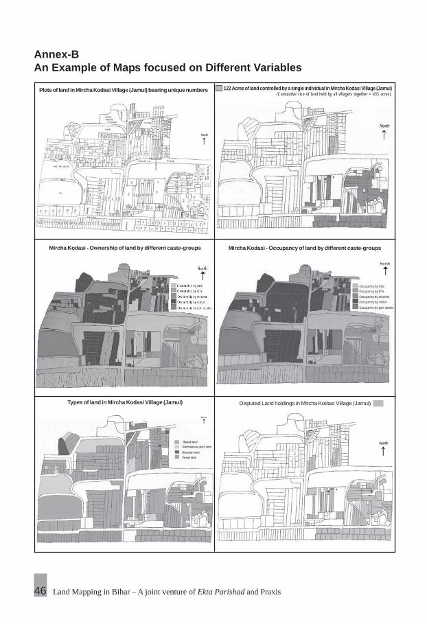
Land Mapping in Bihar – A joint venture of Ekta Parishad and Praxis
Annex-BAn Example of Maps focused on Different Variables
46
Plots of land in Mircha Kodasi Village (Jamui) bearing unique numbers 122 Acres of land controlled by a single individual in Mircha Kodasi Village (Jamui)(Cumulative size of land held by all villagers together = 433 acres)
Mircha Kodasi - Occupancy of land by different caste-groupsMircha Kodasi - Ownership of land by different caste-groups
Types of land in Mircha Kodasi Village (Jamui) Disputed Land holdings in Mircha Kodasi Village (Jamui)

Landlessness and Social Justice 47
Annex-CList of places selected for the process of land mapping
Jamui (Sikandra Block)
1. Mircha Kodasi2. Jagdishpur Kodasi3. Lachuar4. Etasagar5. Sikandra6. Sijhori7. Rave8. Dharampur9. Mahadev Simri10. Pote11. Mathurapur12. Bichwe13. Khardih14. Manjosh
West Champaran (Bagaha II Block)
1. Siktiya2. Asauni3. Jhankol4. Micholi5. Pokharbhinda6. Karmaha7. Nayagaon8. Balua9. Jai Nagar10. Bharthapur

Land Mapping in Bihar – A joint venture of Ekta Parishad and Praxis
Gaya (Bankebazar Block)
1. Dongila2. Sondaha3. Dhaneta4. Saifganj5. Shankarpur6. Devangarh
Nawada (Kovakol Block)
1. Paharpur2. Mahundar3. Pavapuri Gorewa4. Bandol5. Lalpur6. Pachamva7. Bhanwarkol
Patna (Paliganj Block)
1. Khanpura
48

Landlessness and Social Justice 49
Annex-DDescription of land measurement units used in differentdistricts
Jamui
1 katha = 0.0437 acre1 bigha = 0.874 acre1 dhur = 0.00185 acre1 decimal = 0.01 acre
Gaya/Nawada
1 katha = 0.037 acre1 bigha = 0.741 acre1 dhur = 0.00216 acre1 decimal = 0.01 acre
West Champaran
1 katha = 0.074021 bigha = 1.48051 dhur = 0.00371 decimal = 0.01 acre
Patna
1 katha = 0.03125 acre1 bigha = 0.625 acre1 dhur = 0.00156 acre1 decimal = 0.01 acre

Land Mapping in Bihar – A joint venture of Ekta Parishad and Praxis
Annex-EReferences
‘Bihar Tenancy Act, 1885’ (revised by Uma Prasad), V.K. Malhotra, Chief Editor,Bihar Revenue and Labour Journal, Bihar Criminal Case Reporter, PublisherMalhotra Brothers, Seventh Edition, 2007.
‘Bihar Land Reform Act,1950’, ‘ Bihar Land Reform Rules, 1951’, ‘Rules underPublic Department Act, 1944’, ‘Land Reform Circulars, Notification, Commentsand Case Law’, Vishal Malhotra, Editor, Bihar and Central Current Legislation,Rajesh Ranjan, Advocate, Patna High Court, Publisher Malhotra Books, 2007edition.
‘Bihar Land Ceiling Manual’, Ashok Priyadarshi, Advocate, Patna High Court,Publisher Malhotra Brothers, 2006 edition.
‘Bihar 2006: A long way to go!’ An alternative white paper on the state of governanceand development in 1000 villages of Bihar, published by PRAXIS – Institutefor Participatory Practices.
‘Towards Janadesh’, Anil Kumar Gupta, published by Ekta Parishad.
‘Principles of Mutation and Shariat Settlement (Law and Procedure)’, KamakhyaPrasad, published by Rajpal and Co., 2007.
‘The Bihar Bhudan Yajna Act 1954 and Rules, 1955’, ‘ Bihar Goshala Act 1950 andBihar Goshala Rules, 1953’, published by Malhotra Brothers.
‘The Bihar Law of Mutation’, Umeshwar Prasad, published by Pahuja Law House,2005
50

Landlessness and Social Justice 51
Annex-FGlossary of keywords used in the document
Bhoodan Name of movement launched by Acharya Vinoba Bhave in the earlysixties calling for voluntary donation of land held by big landlords forredistribution amongst the landless.
Bigha Measure of land of varying size (ranging from being equivalent of 0.625acres in Patna to 1.4805 acres in West Champaran; ref. Annex C fordetails)
Kattha Measure of land of varying size (ranging from being equivalent of 0.03125acres in Patna to 0.074 acres in West Champaran; ref. Annex C)
Dhur Measure of land of varying size (ranging from being equivalent of 0.00156acres in Patna to 0.0037 acres in West Champaran; ref. Annex C)
Raiyati Plots of land meant for agricultural use
Gair Majarua Plots of land historically allowed for residential settlement of agriculturallabourers by landowning gentry, now administered by land and revenuedepartment and settled either in the name of the landless (gair majaruamaalik land) by issue of parwanas or treated as common property land ofthe village community (gair majarua aam land)
Panchayat Smallest unit of local self-governance in India, corresponding to apopulation of approximately 7000 in Bihar
Parcha Certificate of ownership of Raiyati land
Parwana Document certifying settlement of Gair Majarua Khas land
Sanvyavahar viniyaman Regulation of transactions
Waasgeet parcha Certificate of ownership of homestead land