engineering geology laboratory manual - brcmcet.edu.in · engineering geology laboratory manual ......
TRANSCRIPT
Engineering Geology Laboratory
Manual
2015
Civil Engineering Department BRCM College of Engg. & Tech.
Bahal-127 028, Bhiwani Haryana
Prepared by: Urmil Yadav
Civil Engineering Department
Civil Engineering Department
Geology Laboratory Manual 2 Prepared By: Miss. Urmil Yadav
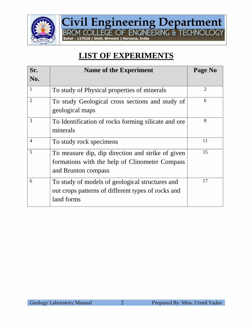
LIST OF EXPERIMENTS
Sr.
No.
Name of the Experiment Page No
1 To study of Physical properties of minerals 2
2 To study Geological cross sections and study of
geological maps
6
3 To Identification of rocks forming silicate and ore
minerals
8
4 To study rock specimens 11
5 To measure dip, dip direction and strike of given
formations with the help of Clinometer Compass
and Brunton compass
15
6 To study of models of geological structures and
out crops patterns of different types of rocks and
land forms
17

Civil Engineering Department
Geology Laboratory Manual 3 Prepared By: Miss. Urmil Yadav
EXPERIMENT NO. 1
Aim: To study of Physical properties of minerals.
Equipment Required
Mineral Specimens, Lenses, Colored pencils etc.
Theory
Mineral
Mineral are defined as naturally occurring, inorganic, solids with a definite chemical
composition and a regular, internal crystalline structure. Different chemical composition results
in different minerals. Mineral are the building blocks of rocks.
Mineral Physical Property chart
Physical Property Definition Testing Method
Cleavage Breakage of a mineral
along planes of
weakness in the crystal
structure
Examine the mineral for area where the mineral
is broken. Look for area where the light reflects
from planar surfaces. This can be easily
confused with a crystal face and is the most
difficult properties for student to master
Color Visible light spectrum
radiation reflected from
a mineral.
look at the sample and determine its color white,
green, black, clear etc.
crystal forms Geometric shape of a
crystal or mineral
examine and describe the geometric shape of the
mineral, cubic, hexagonal, etc. Not commonly
seen in most lab samples
Fractures Breakage of a mineral,
not along planes of
weakness in the crystal
structure
Examine the mineral for area where the mineral
is broken. Describe the breakage as either
irregular or conchoidal (has the appearance of
broken glass)
Hardness Resistance to scratching
or abrasion
Use mineral of know hardness from the Mohs
hardness Kits. Scratch the unknown mineral
with a know hardness to determine which is
harder. Continue doing this with harder or softer
minerals from the kit until the hardness is
determined.
Civil Engineering Department
Geology Laboratory Manual 4 Prepared By: Miss. Urmil Yadav
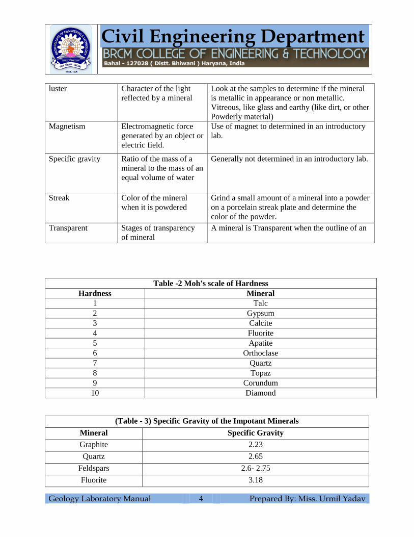
luster Character of the light
reflected by a mineral
Look at the samples to determine if the mineral
is metallic in appearance or non metallic.
Vitreous, like glass and earthy (like dirt, or other
Powderly material)
Magnetism Electromagnetic force
generated by an object or
electric field.
Use of magnet to determined in an introductory
lab.
Specific gravity Ratio of the mass of a
mineral to the mass of an
equal volume of water
Generally not determined in an introductory lab.
Streak Color of the mineral
when it is powdered
Grind a small amount of a mineral into a powder
on a porcelain streak plate and determine the
color of the powder.
Transparent Stages of transparency
of mineral
A mineral is Transparent when the outline of an
Table -2 Moh's scale of Hardness
Hardness Mineral
1 Talc
2 Gypsum
3 Calcite
4 Fluorite
5 Apatite
6 Orthoclase
7 Quartz
8 Topaz
9 Corundum
10 Diamond
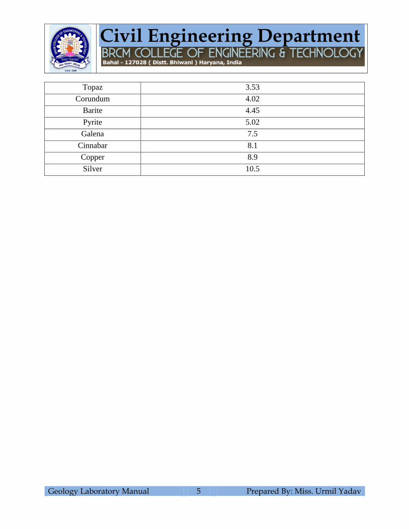
(Table - 3) Specific Gravity of the Impotant Minerals
Mineral Specific Gravity
Graphite 2.23
Quartz 2.65
Feldspars 2.6- 2.75
Fluorite 3.18
Civil Engineering Department
Geology Laboratory Manual 5 Prepared By: Miss. Urmil Yadav
Topaz 3.53
Corundum 4.02
Barite 4.45
Pyrite 5.02
Galena 7.5
Cinnabar 8.1
Copper 8.9
Silver 10.5
Civil Engineering Department
Geology Laboratory Manual 6 Prepared By: Miss. Urmil Yadav
Mineral Specimen Figure
Properties
Civil Engineering Department
Geology Laboratory Manual 7 Prepared By: Miss. Urmil Yadav
EXPERIMENT NO. 2
Aim: To study Geological cross sections and study of geological maps.
Equipments Required:
Maps, Scale, Set Square, Papers, Pencils etc.
Civil Engineering Department
Geology Laboratory Manual 8 Prepared By: Miss. Urmil Yadav
EXPERIMENT NO. 3
Aim: To Identification of rocks forming silicate and ore minerals.
Equipments Required
Mineral slides, Petrological Microscopes, Colored Pencils etc.
Theory
The silicate mineral make up the largest and most important class of rock forming minerals.
They are classified based on the structure of their silicate group. Silicate minerals are composed
largely of Silicon and Oxygen, with the addition of ions such as aluminum, magnesium, iron and
calcium. Some important rock forming silicate includes the feldspar, Quartz, Olivines,
Pyroxenes, Amphiboles, Garnets and Micas.
Subclasses
Nesosilicates or Isosilicates (They have isolated that are connected only by interstitial cations)
Sorosilicates (They have isolated double tetrahedral group) Cyclosilicates (rings silicates, in this
division, tetrahedral sharing two oxygen link together to form a ring of composition) Inosilicates
(chain silicates, have interlocking chains of silicates tetrahedral) Phyllosilicates (sheet silicates
formed when three oxygen all shared between adjacent tetrahedral) Tektosilicates (Framework
silicates, in this division the four oxygen’s in this division the four oxygen’s in each tetrahedron
are shared with other tetrahedral).

Civil Engineering Department
Geology Laboratory Manual 9 Prepared By: Miss. Urmil Yadav
Mineral Slide Figure
Properties

Civil Engineering Department
Geology Laboratory Manual 10 Prepared By: Miss. Urmil Yadav
Mineral Slide Figure
Properties
Civil Engineering Department
Geology Laboratory Manual 11 Prepared By: Miss. Urmil Yadav
EXPERIMENT NO. 4
Aim: To study rock specimens.
Equipment Required
Rock specimens, lenses, Colored pencils etc.
Procedure
To identify a rock three things must be considered: (1) Origin, (2) Composition (3) Texture
Rock Origin: The first step to identify a rock is to try categorizing the rock into of the three
main types or group of rocks. These include igneous, sedimentary and metamorphic types. The
only rocks which do not fall into one of these categories are meteorites. Igneous, sedimentary
and metamorphic rock tupes are distinguished by the processes of their formation.
Rock Composition: The rock composition is determined by the identification of mineral make
up the rock. By the identification, a rock is a solid mass or compound consisting of at least two
minerals (although there are some exceptions when a rock may consist entirely of one mineral).
The minerals comprising the rock cab be identified using common field testing method for
individual minerals, particularly where the texture is sufficiently coarse grained enough to
distinguish the individual minerals with the naked eye or a hand lens. Where the grain sizes of
the minerals comprising the rock are too fine grained to recognize identification in many cases.
Rock Texture: The texture of a rock is defined by observing two criteria: 1) grain size, 2) grain
shapes.
Grain Size: it is the average size of the mineral grains. The size scales used for sedimentary,
igneous and metamorphic rock are different.
Grain Shape: It is the general shape of the mineral grain (crystal faces evident, or crystals are
rounded)
Rock Type Very Fine
grained
Fine Grained Medium
Grained
Coarse
Grained
Very Coarse
Grained
Clastic
Sedimentary
.06 - .125mm .125 - .25 mm .25 - .5 mm .5 - 1 mm 1 - 2 mm
Metamorphic <.25 mm .25 - 1mm 1 - 2 mm > 2 mm
Igneous < 1 mm 1 - 5 mm 5 - 20 mm > 20 mm
Civil Engineering Department
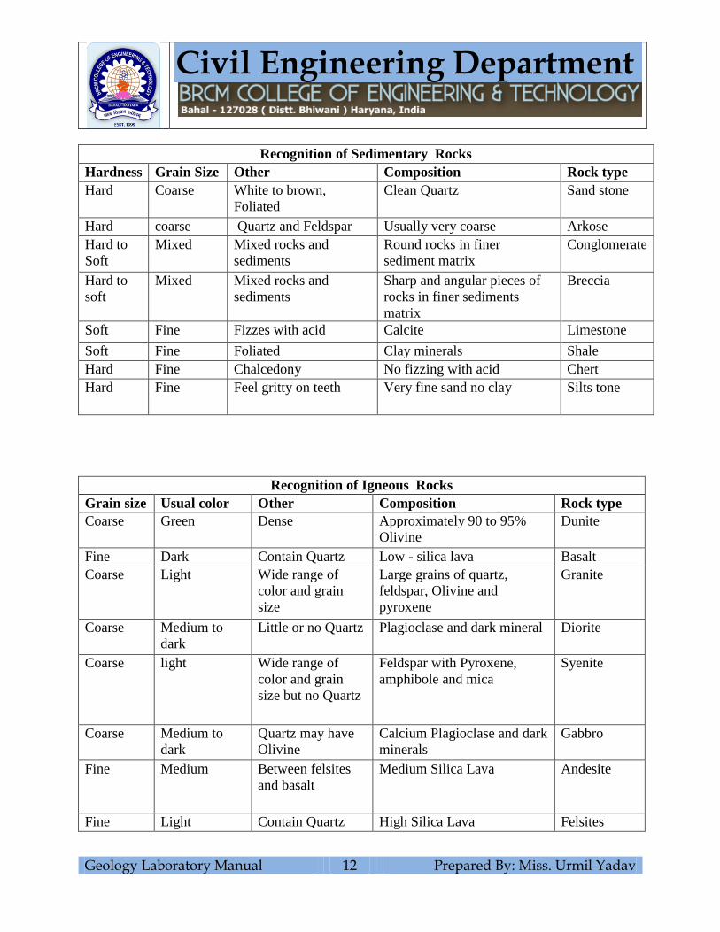
Geology Laboratory Manual 12 Prepared By: Miss. Urmil Yadav
Recognition of Sedimentary Rocks
Hardness Grain Size Other Composition Rock type
Hard Coarse White to brown,
Foliated
Clean Quartz Sand stone
Hard coarse Quartz and Feldspar Usually very coarse Arkose
Hard to
Soft
Mixed Mixed rocks and
sediments
Round rocks in finer
sediment matrix
Conglomerate
Hard to
soft
Mixed Mixed rocks and
sediments
Sharp and angular pieces of
rocks in finer sediments
matrix
Breccia
Soft Fine Fizzes with acid Calcite Limestone
Soft Fine Foliated Clay minerals Shale
Hard Fine Chalcedony No fizzing with acid Chert
Hard Fine Feel gritty on teeth Very fine sand no clay Silts tone
Recognition of Igneous Rocks
Grain size Usual color Other Composition Rock type
Coarse Green Dense Approximately 90 to 95%
Olivine
Dunite
Fine Dark Contain Quartz Low - silica lava Basalt
Coarse Light Wide range of
color and grain
size
Large grains of quartz,
feldspar, Olivine and
pyroxene
Granite
Coarse Medium to
dark
Little or no Quartz Plagioclase and dark mineral Diorite
Coarse light Wide range of
color and grain
size but no Quartz
Feldspar with Pyroxene,
amphibole and mica
Syenite
Coarse Medium to
dark
Quartz may have
Olivine
Calcium Plagioclase and dark
minerals
Gabbro
Fine Medium Between felsites
and basalt
Medium Silica Lava Andesite
Fine Light Contain Quartz High Silica Lava Felsites
Civil Engineering Department
Geology Laboratory Manual 13 Prepared By: Miss. Urmil Yadav
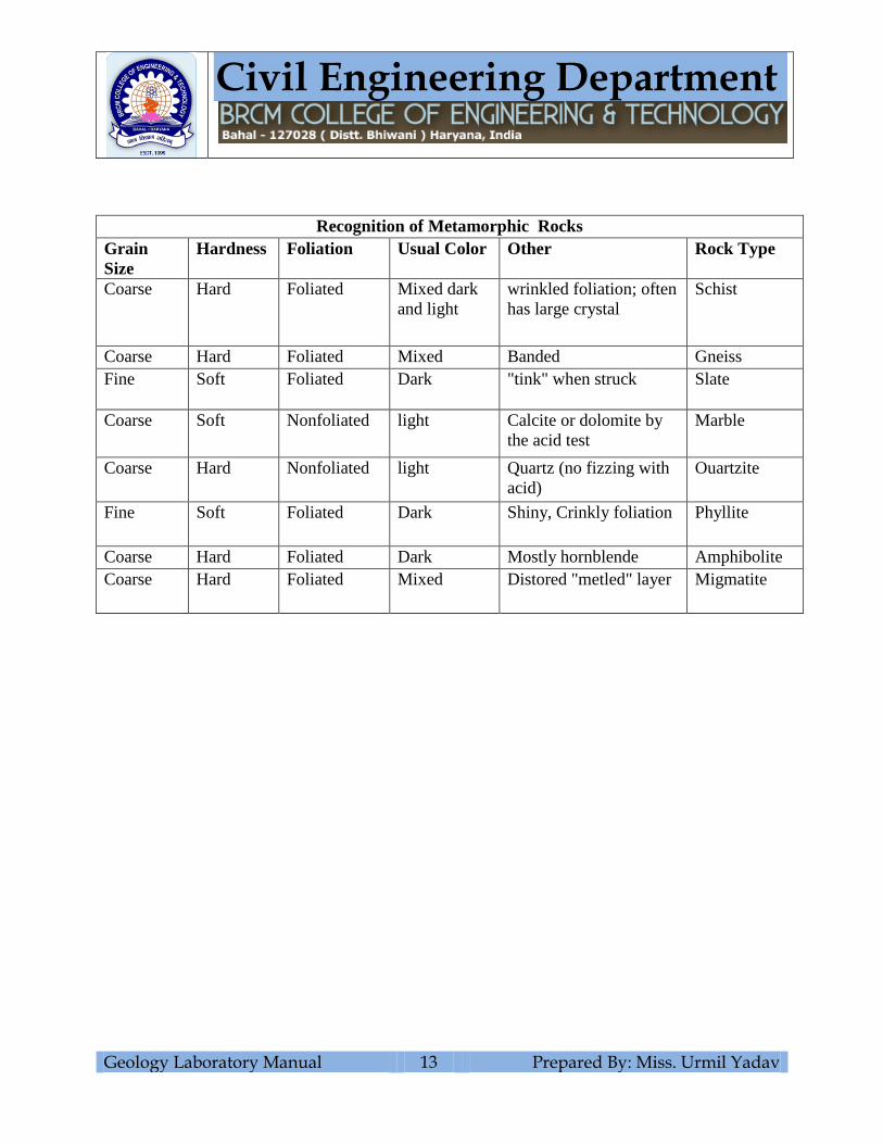
Recognition of Metamorphic Rocks
Grain
Size
Hardness Foliation Usual Color Other Rock Type
Coarse Hard Foliated Mixed dark
and light
wrinkled foliation; often
has large crystal
Schist
Coarse Hard Foliated Mixed Banded Gneiss
Fine Soft Foliated Dark "tink" when struck Slate
Coarse Soft Nonfoliated light Calcite or dolomite by
the acid test
Marble
Coarse Hard Nonfoliated light Quartz (no fizzing with
acid)
Ouartzite
Fine Soft Foliated Dark Shiny, Crinkly foliation Phyllite
Coarse Hard Foliated Dark Mostly hornblende Amphibolite
Coarse Hard Foliated Mixed Distored "metled" layer Migmatite
Civil Engineering Department
Geology Laboratory Manual 14 Prepared By: Miss. Urmil Yadav
Specimen Figure
Properties

Civil Engineering Department
Geology Laboratory Manual 15 Prepared By: Miss. Urmil Yadav
EXPERIMENT NO. 5
Aim: To measure dip, dip direction and strike of given formations with the help of Clinometer
Compass and Brunton compass.
Equipment Required
Clinometer compass, Brunton compass, formations.
Theory
The true dip of a plane is the angle that it makes with a horizontal plane the angle being
measured in a direction perpendicular to the strike of the plane. Apparent dip is the angle
measured in any other direction.
Dip Slope: A topographic surface which dips in the same direction as the underlying beds and is
often more or less parallel to them
Strike: The direction in which a horizontal line can be drawn on a plane. In geological usage, the
strike is important in determine the direction in which to measure the true dip. The term is also
used in the sense of the general trend or run of the beds; eg. One might say that the strike of the
beds in a particular region is east – west, ignoring the fact that there are minor variations in the
strike.
Strike line: A strike line (stratum contour and structure contour are synonyms) is a line joining
points of equal height above or below a datum, on a planar structure. For a flat, evenly dipping
plane, the strike line will be straight, parallel and evenly spaced. They are much used as a means
of illustrating structural features without the complicating effect of topography.
Brunton compass
Theory
North of magnetic needle in brunton is towards south of earth’s magnetic pole. Any magnetic is
needle aligns itself along N - S of earth. i.e. North of magnet is toward South and South of
magnet is toward North, that’s why the east and west are opposite in Brunton Compass.

Civil Engineering Department
Geology Laboratory Manual 16 Prepared By: Miss. Urmil Yadav
Observation Table
S.No. Formation Strike Dip Angle Dip Direction Final Reading
Observation Table
S.No. Formation Strike Dip Angle Dip Direction Final Reading
Civil Engineering Department
Geology Laboratory Manual 17 Prepared By: Miss. Urmil Yadav
EXPERIMENT NO. 6
Aim: To study of models of geological structures and out crops patterns of different types of
rocks and land forms.
Theory:
The dip and strike of beds can be easily measured in the field from their exposure called
outcrops. Outcrops, infact, are those sections on the Earth’s crust, where the solid rocks are
exposed at the ground surface, without being covered by any unconsolidated alluvium or soil
layer.
A landform is a natural feature of the Earth's surface. Landforms together make up a given
terrain, and their arrangement on the landscape or the study of same is known as topography.
Typical landforms include hills, mountains, plateaus, canyons, valleys, as well as shoreline
features such as bays, peninsulas, and seas, including submerged features such as mid-ocean
ridges, volcanoes, and the great ocean basins.
Description of Models