encom discover data sheet - element.nl one-stop gis shop! encom discover boosts the data handling...
TRANSCRIPT
Product OverviewEncom DiscoverTM is the desktop Geograpical Information System (GIS) designed especially for the geosciences, providing the comprehensive GIS toolbox you need to effectively compile, visualise, analyse and map spatial geosciences data. Discover with MapInfo® Professional is the GIS application of choice for geologists, engineers, exploration teams, hydrologists and environmental scientists worldwide.
Maximise the Value of Your DataMore than in any other industry, Natural Resources businesses rely on technical data to successfully locate, evaluate and develop primary assets. A lot of money is spent to acquire this business-critical data so you need to ensure you get the full value from your investment by using the right software. Discover does this by integrating data from multiple sources in a unified geospatial environment and then providing your specialists with leading-edge analytical tools in a powerful, yet easy-to-use, framework.
Unlock the Power of MapInfo ProfessionalWith its extensive range of features purpose-built for geosciences applications, Discover unlocks the power of MapInfo Professional for geologists and other geoscience professionals. Combined, they deliver a perfect balance of general purpose GIS functionality and specialised geoscience capabilities.
BENEFITS
ENCOM DISCOVERDATA SHEET
•Seamlessintegrationofgeochemical,geological,environmental,geophysical,drillingandcartographicdatasetsintoasingleenvironment
•Extensiveanalyticalcapabilitiesfortemporal,geostatistical,graphicalandspatialtrendidentificationanddatanormalisation
•Createandanalysedetaileddrillholecross-sections
•Advancedgridinterpolationandmanipulationcapabilities,includingmassivegridsupport
•SuperchargeMapInfoProfessionalwithamassiverangeofproductivitytools.
EncomDiscoverTM
EXTEND MAPINFO PROFESSIONAL
WITH GEOSPATIAL CAPABILITIES
DESIGNED SPECIFICALLY FOR THE
NATURAL RESOURCES INDUSTRY
ENCOM DISCOVER DATA SHEET
ENCOM DISCOVER IS THE ESSENTIAL GIS TOOLBOX FOR THE EXPLORATION
INDUSTRY - FROM REGIONAL EVALUATION AND INITIAL TENEMENT
ACQUISITION, THROUGH TO DETAILED PROSPECT-SCALE DRILLING AND
MINERALISATION MODELLING.
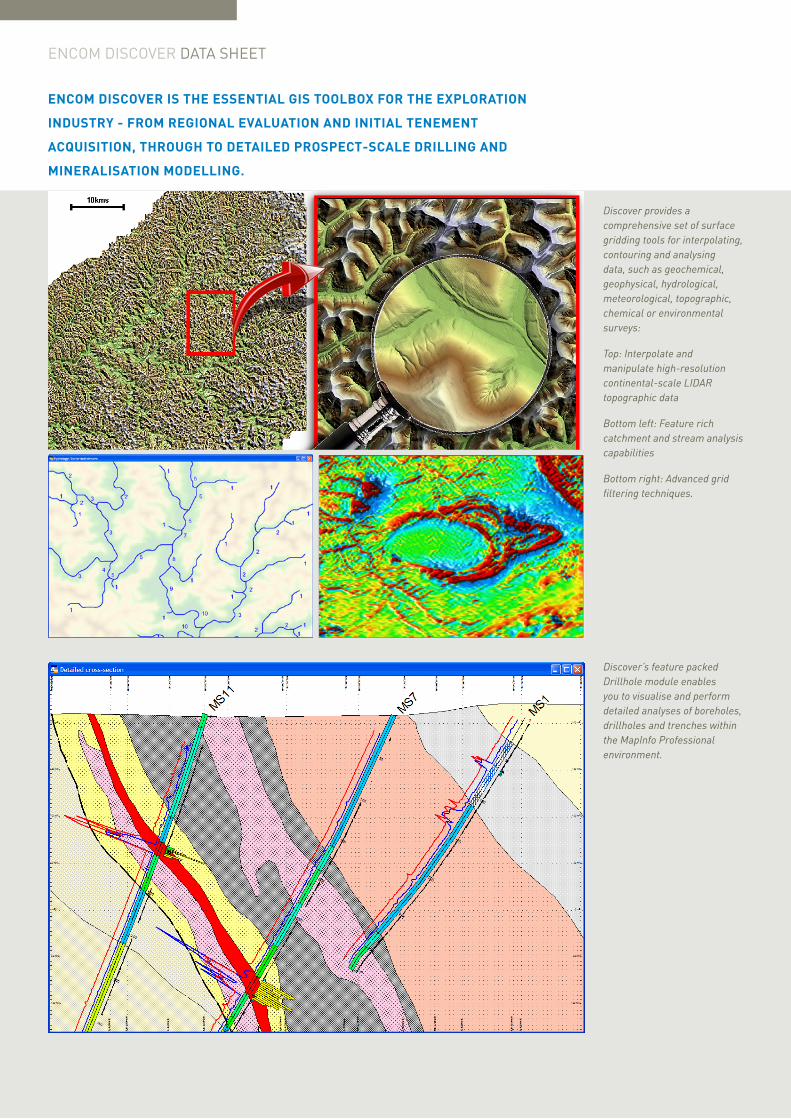
Discover provides a comprehensive set of surface gridding tools for interpolating, contouring and analysing data, such as geochemical, geophysical, hydrological, meteorological, topographic, chemical or environmental surveys:
Top: Interpolate and manipulate high-resolution continental-scale LIDAR topographic data
Bottom left: Feature rich catchment and stream analysis capabilities
Bottom right: Advanced grid filtering techniques.
Discover’s feature packed Drillhole module enables you to visualise and perform detailed analyses of boreholes, drillholes and trenches within the MapInfo Professional environment.
The One-Stop GIS Shop!Encom Discover boosts the data handling capabilities of MapInfo Professional, adding support for over one hundred further industry-standard formats. These include advanced functionality such as image rectification and re-projection, batch ECW import, vector import and conversion (such as the GPS eXchange and Google Earth formats) and database connectivity (e.g. DataShed and AcQuire).
Your Field Data is a Substantial Investment: Discover Can Help You Maximise its ValueThe detailed analysis and comparison of relationships between geochemical, structural and temporal datasets can add significant value to your data, increasing the chances of exploration success. With Discover, a wealth of advanced analytical functionality is at your fingertips, allowing varied datasets from multiple sources to be assessed dynamically in statistical, spatial, temporal, geostatistical and graphical views.
Are High-Resolution Terrain, Geochemical or Geophysical Surface Models Part of Your Project?Is trend and anomaly identification in environmental and geochemical datasets important? Do you need to perform detailed terrain analyses for flood risk or engineering assessments using LIDAR or SRTM datasets? Discover provides a comprehensive and powerful set of surface interpolation, modification and analysis tools, equally capable whether you are working at the local prospect or continental scales.
Confidently Integrate Your Drilling Program with Spatial DatasetsWith Discover, boreholes, drillholes and trenches can all be visualised and analysed accurately within the MapInfo Professional environment. Quickly and easily generate informative log, plan and sectional views, and effortlessly update these en-masse when new drilling is conducted.
The true spatial context of all data is maintained, allowing the overlay and incorporation of other GIS datasets, such as geological and regolith mapping, 3D wireframe and block models and interpolated geochemical surfaces, as well as terrain and pit models.
ProductivityEncom Discover provides a rich set of productivity tools enhancing the experience of any MapInfo Professional user as well as a range of specialised utilities for geoscientists, making both complex and repetitive tasks easy to perform.
For instance, efficient data capture and creation, whether from imaged historical data or field work, can save considerable time whilst increasing the value and usefulness of your data. Discover can facilitate this, with tools that automatically create geological polygons from digitised linework, on-the-fly field validation during data capture, as well as user-defined object style libraries.
Once you’ve used Discover’s productivity tools, you’ll wonder how you ever survived without them!
EncomDiscover
2012 New Features
•SupportsMapInfoProfessionalversion11.5
•Newdatacapturetools,includingcustomisablestylelibrariesandon-the-flyfieldvalidation
•Visualise3Dvectormodels(suchasmineralisationwireframes)ondrillholecross-sectionsasattributedpolygons,allowingforadvancedanalysis/refinement/interpolation
•Drillholecross-sectionsnowsupportmultiplecustomuserlayers
•Displayandmodelmulti-bandedgridsusingindependentRed,Green,Blue(RGB)bands/channels,aswellasanIntensity(shading)channel
•ExpandedGridBatchUtilitiescapabilities
•Sharegridfilesasfull-resolutionrasterimages,honouringthecellsizeoftheinputsurface
•BatchimportECWimagery
•Usersarenowautomaticallynotifiedwhenmaintenancereleasesareavailable.
Professional Map ProductionProfessional map production is a breeze with Discover. Automatically create correctly scaled and sized layouts for your desired page size, with titleblocks, scalebars and map grids. Batch create and print multiple map layouts from a series of map sheet boundaries covering a region, with auto-generated location indexes.
For more information visit us online: www.pbencom.com
UNITEDSTATES
CANADA
EUROPE/UNITEDKINGDOM
ASIAPACIFIC/AUSTRALIA
[email protected]@pb.com
ENCOM DISCOVERDATA SHEET
Pitney Bowes Software Inc. is a wholly-owned subsidiary of Pitney Bowes Inc. Pitney Bowes, the Corporate logo, pbEncom, Encom Discover and MapInfo Professional are [registered] trademarks of Pitney Bowes Inc. or a subsidiary. All other trademarks are the property of their respective owners. © 2012 Pitney Bowes Software Inc. All rights reserved.
Every connection is a new opportunity™
93238 APAC 1206 DS
SpecificationsEncom Discover 2012 requires MapInfo Professional version 10.0 or later.
Supported Operating Systems:
• Windows® XP Professional 32-bit Service Pack 3 (SP3)
• Windows® 7 Ultimate 32-bit SP1
• Windows® 7 Ultimate 64-bit SP1 with 32-bit compatibility mode.
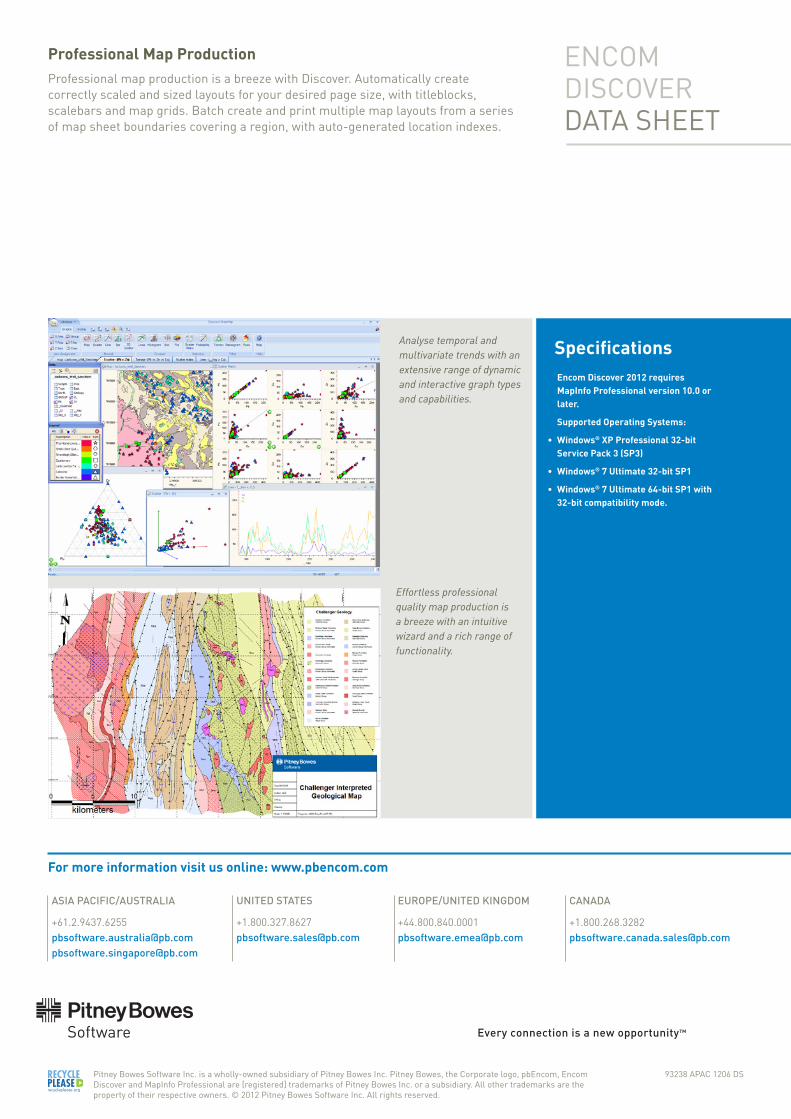
Analyse temporal and multivariate trends with an extensive range of dynamic and interactive graph types and capabilities.
Effortless professional quality map production is a breeze with an intuitive wizard and a rich range of functionality.