emsev 2012 cnfgg - université clermont auvergne · monitoring dak mcl t e l e m e t r y pan 14 ....
TRANSCRIPT

J. Zlotnicki1), Y. Sasai2), M. Johnston3), T. Nagao2),
F. Fauquet1), P. Yvetot1), G. Vargemezis4), I. Fikos4),
N. Pergola5), R. Singh6), A., Bernard7) and PHIVOLCS EM team8)
1) CNRS-UMR6524-Clermont-Fd Observatory, France;
Email: [email protected]
2) Earthquake Prediction Research Center, Tokai University, Shimizu, Japan
3) U.S. Geological Survey, Menlo Park, USA
4) Geophysical Laboratory Aristotle’s University of Thessaloniki, Greece
5) National Research Council of Italy, Institute of Methodologies for Environmental Analysis, Potenza, Italy
6) School of Earth and Environmental Sciences, Schmid College of Science and Technology, Chapman University, Orange, CA, USA
7) Laboratoire de Volcanologie, Université Libre de Bruxelles, Brussels, Belgium
8) Philippines Institute of Volcanology and Seismology, Quezon City, Philippines
8) E. Villarcorte, P. Alanis, J.M. Gordon Jr, L. Bong, P. Reniva, A. Loza
Loic, L.A. C. Banes, R.C. Pigtain, M. Bornas, and R. Solidum
1 CNFGG 2012 Clermont-Ferrand, France
http://www.emsev-iugg.org/emsev/

2
FRAME OF THE PHIVOLCS-EMSEV INTERNATIONAL COOPERATION
PHIVOLCS(M. Bornas), JAPAN (Sasai Y., T. Nagao …), FRANCE (Zlotnicki J.), US (Johnston M.J.S., R. Singh)
BELGIUM (Bernard A.) , ITALY (Tramutoli V., Pergola N.), GREECE (Vargemezis G.) : ~20 Researchers and Engineers
Understanding the volcano
• structure and hydrothermal system
• dynamism and eruptive activity
Volcano monitoring
Based on ground observations • Electromagnetic monitoring
• Geochemical studies
• Thermal budgets
• Ground deformation
Based on satellite observations • ASTER thermal imagery
• RST technique (thermal IR anomalies)
• MOPITT
Based on EM real time network
Educating PHIVOLCS EM team
Volcanic hazards, risk mitigation
• Lessons from historical eruptions
• Impacts and precursory phenomena
Education, preparedness, information
• Training (schools)
• Local and regional authorities
• Population (workshops in villages)
• Evacuation planning
Understanding the volcano
• Geology, relation with tectonics
Volcano monitoring
• Real time seismic monitoring
• Geochemical studies
• Ground deformation surveys
• Phenomenology
Building a new scientific community
P
H
I
V
O
L
C
S
E
M
S
V
E
V
W
G
In charge of the prediction
• Issues warning
• Raises alert levels
• Communicates with authorities
E
X
P
E
R
T
I
S
E
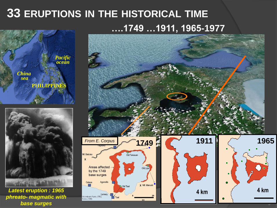
33 ERUPTIONS IN THE HISTORICAL TIME
3
China sea
Pacific ocean
PHILIPPINES
….1749 …1911, 1965-1977
Latest eruption : 1965
phreato- magmatic with
base surges
1749 From E. Corpus 1911
4 km
1965
4 km

2010 EVACUATION PLANNING
4
PHASE I – WITHIN THE SEVEN (7) KM DANGER ZONE
INVOLVING THE TAAL VOLCANO ISLAND AND THE SIX LAKE SHORE MUNICIPALITIES
10 000 inhabitants
PHASE II – WITHIN TEN (10) KM RADIUS INVOLVING
ELEVEN (11) LGUs
100 000 inhabitants
PHASE III – WITHIN THE FIFTEEN (15) KM RADIUS
INVOLVING SEVENTEEN (17) LGUs
DEPENDING ON THE WIND DIRECTION
(JANUARY TO AUGUST – SOUTHWESTERN WIND
DIRECTION WHILE SEPTEMBER ONWARD WILL
BE NORTHEASTERN SIDE OF THE PROVINCE)
650 000 inhabitants
After M. Cay / EMSEV Workshop, February 2010

HYDROLOGIC MODEL AND HYDROTHERMAL ACTIVITY
Low-T fumarolic gases interaction of magma vapours with the hydrothermal system
The hydrothermal system is a 3-components system resulting from: incorporation of seawater (Br/Cl) incroporation of magmatic waters (d18O, dD) incorporation of meteoric waters (Lake Taal waters slightly modified)
Hydrothermal system: 12% seawater + 17% volcanic water + 71% meteoric water
SW NE
NE SW SW
NE
5
(After Delmelle et al., 1998, modified by Toutain)

6
2004 2005 2006 2007 2008 2009 2010 2011 2012 Next
Ground magnetic mapping (TMF)
MCL TMF mapping
SP surveys and mapping, soil degassing, Ground temperature
Bottom MCL temperature
Degassing in MCL
AMT MT ERT
Autonomous magnetic network: TMF
Autonomous electric, 3 comp. magnetic, T° network
Telemeter Electric, T°, Tilt network: 3 stations
Telemeter ERT network
Satellite telemetry AMT-MT TMF network
+ 1
Autonomous monitoring of water level & T° of MCL
Aster thermal imagery
Thermal Infrared activity (MTSAT)
Measurements of Pollution In The Troposphere (MOPITT)
Su
rveys
Map
pin
gs
Lan
d b
ased
Mo
nit
ori
ng
Sate
llit
e
mo
nit
ori
ng
Demeter
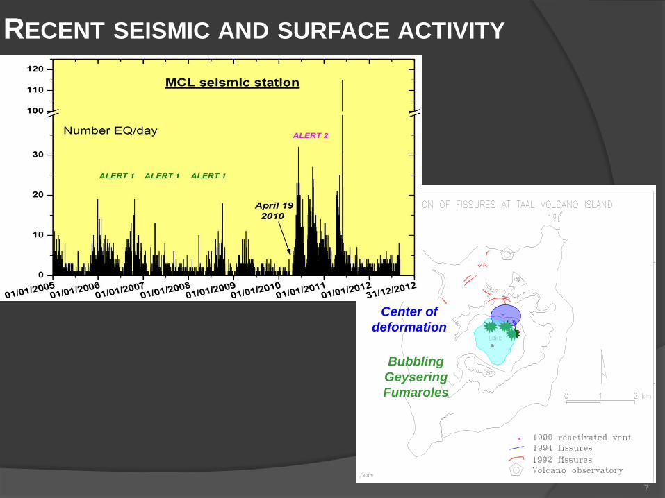
RECENT SEISMIC AND SURFACE ACTIVITY
7
Center of
deformation
Bubbling
Geysering
Fumaroles

ACTIVE FISSURES & GEOTHERMAL ACTIVITY ON THE
NORTHERN FLANK
N
Area of ~steady state of surface activity:
Active fissures characterized by
high GTE, CO2 concentration Area of diffuse geothermal activity
reactivated during the 2005-2010
seismic crises
8
SP MAPPING

THERMAL ANOMALIES CO2 DEGASSING AND TMF SURVEYS
Mar. 15, 2007
34.5°C
After A. Bernard
AS
TE
R IM
AG
ER
Y
MCL BOTTOM TEMPERATURE
N Non
magnetic
area
After Harada et al.
TOTAL MAGNETIC FIELD
CO
2 D
EG
AS
SIN
G
After A. Bernard
March 2011
9

ACTIVE FISSURES AND GEOTHERMAL ACTIVITY
Geyser
Fumarole
Mud pond
& Geyser
N
Bulge
10 CO2 degassing

INTERPRETATION OF ERT: NS CROSS SECTION
11 After Fikos et al., 2012
250 m
N S.SE
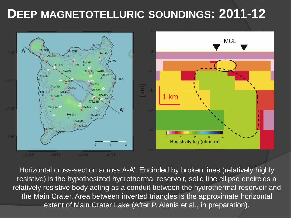
DEEP MAGNETOTELLURIC SOUNDINGS: 2011-12
Horizontal cross-section across A-A’. Encircled by broken lines (relatively highly
resistive) is the hypothesized hydrothermal reservoir, solid line ellipse encircles a
relatively resistive body acting as a conduit between the hydrothermal reservoir and
the Main Crater. Area between inverted triangles is the approximate horizontal
extent of Main Crater Lake (After P. Alanis et al., in preparation).
1 km

VOLCANO MONITORING CONTINUOUS MONITORING
Multi parameters EMSEV
stations
SP lines, GTE, Grad(GTE),
3 components magnetometers,
TMF, Tiltmeter, Seismometers,
WTE and water level
JICA stations
MT stations,
TMF magnetometers
PAN
DAK
MCL
BOU
Scheduled
in 2012-13
13
2010 SEISMIC CRISIS

14
II: MONITORING TAAL: Multi-parametric monitoring network:
S.P., B, seismicity, tilt, GTE and , Rn, geophone
VEML Web site: http://www.virtual-electromagnetic-laboratory.com/
Taal Buco
observatory PHIVOLCS
SERVER 2 DAILY
TRANSFERS
VEML
SERVER
Internet
PHIVOLCS Routine
Monitoring
CNRS-VEML Analysis
Visualization
Monitoring
DAK
MCL
T
e
l
e
m
e
t
r
y
PAN
14

15
(After Y. Sasai)
nT M
A
G
N
E
T
I
C
E
L
E
C
T
R
I
C
DKT-MUT
MCE-MUT

DAK STATION (NORTHERN FLANK)
Opening of fissures
Release of gas and
thermal anomalies
16
Tilt
Electric
field
Ground
Tempature
Seismic
noise
Inflation
April 29, 2010
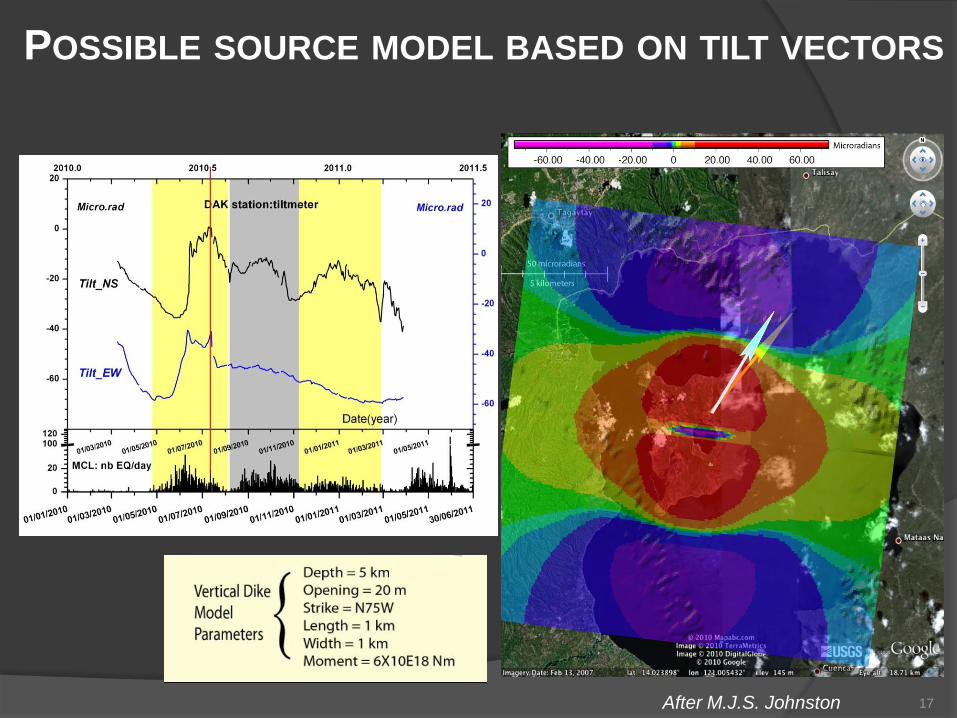
POSSIBLE SOURCE MODEL BASED ON TILT VECTORS
After M.J.S. Johnston 17

CURRENT STATE OF THE VOLCANO
Current activity
• The volcanic activity takes
place to the north of the crater
• The hydrothermal activity has
its source below the crater
• The northern part of crater is
mechanically unstable
Apr-Aug 2010 seismo-volcanic crisis:
• A dike could have intruded the northern part of
MC; the source should be at least at 4 km depth,
• The 2005-2010 decrease of surface activity has
partly clogged up the hydrothermal system, and
an increase of the hydrostatic pressure could have
been induced by magma thermal supply,
High risk of phreatic explosion
18

CNR-IMAA AND UNIBAS ACTIVITIES
Continuous monitoring of thermal activity of Taal volcano area by means
of a systematic processing, through RSTVOLC algorithm, of infrared
satellite observations
RSTVOLC
• Selecting historical (i.e. multi-annual) and homogeneous
data-sets of satellite images T(x,y,t) in infrared bands.
• Computing the background “Reference Fields” (x,y) and
(x,y), which are respectively the temporal mean and the
temporal standard deviation of the correspondent signal.
• Identifying possible thermal anomalies by comparing signal
at hands with reference fields
RSTVOLC (Marchese et al. 2011) is a specific configuration of the RST approach (Tramutoli, 2007) tailored to detect and monitor volcanic hot spots. Two local variation indexes (ALICE indexes) are computed to this aim. For RSTVOLC , both the signals TMIR(x,y,t) and TMIR – TIR (x,y,t), respectively representing the brightness temperatures measured at around 3.7µm (MIR) and 11µm (TIR), are considered.
- Marchese, F., M., Filizzola, N.Genzano, T., Mazzeo, G., Pergola, N., Tramutoli, V. (2011). Assessement and improvement of a robust satellite technique (RST) for thermal monitoring of volcanoes. Remote Sensing of Environment, 115, 1556-1563, DOI: 10.1016/j.rse.2011.02.014
- Tramutoli, V. (2007). Robust Satellite Techniques (RST) for Natural and Environmental Hazards Monitoring and Mitigation: Theory and Applications”, Proceedings of Multitemp, doi: 10.1109/MULTITEMP.2007.4293057.
ÄTMIR-TIR(x, y, t) =
TMIR-TIR(x, y, t)-mTMIR-TIR(x, y, t)
sTMIR-TIR(x, y, t)
),,(
),,(),,(),,(
tyx
tyxtyxTtyx
MIR
MIR
MIR
T
TMIR
T
ALICE
indexes
y
x
t

EMSEV-PHIVOLCS - OUTCOMES 1
20
Understanding Taal volcanic complex
Two geothermal fields are delineated
They are connected at depth
They constitute the most active part of the volcano, but the highest
activity takes place in the northern part of MC
A bulge exists in MCl along the northern rim, and outcrops at the bottom
of MCL take place within
The alignment of the bubbling areas and thermal anomalies show
segments of fissures in MCL
Hydrothermal fluids cross the northern rim of MC in land, while they do
not reach the eastern border
The northern outer flank of the volcano may collapse into MCL

EMSEV-PHIVOLCS - OUTCOMES 2
General changes of parameters with recent past seismic and surface
activity
Land between MCL and the crater rims is now dry
○ It causes thermal effects, modification of ground fluids pattern
The MC geothermal field can expand to the South (i.e. 2007)
Activity gives rise to larger CO2 fluxes inside the crater as compared to
DAK area
Fissures near DAK may be reactivated with higher temperatures
DAK geothermal field can expand toward the crater rim
But there is not (yet) any larger extension of the geothermal field
21
5 published papers, 3 in preparation, 1 PhD, and tens of communications
Two signed Agreements of cooperation have been signed: 2004, 2010
Two international workshops have been organized at PHIVOLCS: 2003, 2010