emergensig: an integrated location-based system for …§ão... · inem instituto nacional de...
TRANSCRIPT
UNIVERSITY OF BEIRA INTERIOR Faculty of Engineering Departamento de Informática
EmergenSIG: An Integrated
Location-based System for
Emergency Management
Bruno Daniel Marques dos Santos
Dissertation submitted in candidature for the degree of Master of Science in
Informatics Engineering
(2nd Cycle Degree)
Supervised by Prof. Dr. Joel José Puga Coelho Rodrigues
Covilhã, October 2013
Departamento de Informática
University of Beira Interior
Covilhã, Portugal
http://www.di.ubi.pt

iii
Acknowledgements
First of all, I would like to thank all the support given by Professor
Dr. Joel José Puga Coelho Rodrigues, for all the help provided during these
last two years, for keeping me motivated and for supervising my Master’s
Thesis.
I would also like to thank the Instituto de Telecomunicações, Next
Generation Networks and Applications Group (NetGNA), and SAPO -
Portugal Telecom for making me part of a project group of researchers with
quality, dynamic, and with a spirit of mutual aid.
I am especially grateful to my colleagues and friends Bruno Silva,
Michael Soares, Ivo Charro, Jorge Costa, Pedro Rosa, João Dias, Pedro
Correia, and Tiago Simões, for all the help and support provided.
I would also like to thank all the firefighters departments who
participated directly in the development of this application. Especially, I
would like to express my heartfelt gratitude to the Bombeiros Voluntários
de Belmonte for their availability and for making possible the simulated
emergencies scenarios. In particular, I want to thank Mr. Commander
Antonio Leitão, 2nd Commander João Carvalho, and the firefighters Hugo
Lopes, Luis Carvalho, Marcelo Martins, Marco Gaspar, and João Carvalho for
all the advice given and for believing in the EmergenSIG system.
Finally, I want to thank my humble family and girlfriend Stephanie
Soares, for all the support provided for the completion of this dissertation
was possible. I dedicate this work to them.
In humble way, I also would like to pay a tribute dedicating this
work to all the Portuguese firefighters who died on duty.


v
Abstract
Several solutions have been proposed for emergencies scenarios.
These solutions include real-time data communication, location-aware,
coordination, and decision-making support systems. In this context, this
dissertation presents a location-awareness system fully oriented to
emergency scenarios, called EmergenSIG. This approach provides and
gathers important field information from an occurrence (emergency
situation) and shares it to all the different agents. They include police,
firefighters, medical emergency teams, among others, mobilized to the
same operations theater (OT). Therefore, allowing a faster and integrated
response to all the involved agents, enhancing the emergency management
of the occurrence. The core of this proposal is based on a low cost solution
oriented to the agents on the field (EmergenSIG mobile application), which
interacts with the EmergenSIG Web application, oriented to the civil
protection entities, through REST Web services. EmergenSIG focuses on
medical emergencies and wildfires. It was evaluated and demonstrated in
different mobile devices considering different screen sizes following a user-
centered design. The system was also been evaluated and validated by real
entities and civil protection agents on simulated emergency scenarios.

vi
Keywords
Emergency Support, Mobile collaborative application, Real time
communication, Mobile Computing, Real time Geo-location Based, Mobile
Health, Agent Based application.

vii
Resumo
Várias soluções têm sido propostas para cenários de emergências
médicas . Estas soluções incluem comunicações de dados em tempo real
,sensíveis á localização , coordenação e sistemas de apoio à tomada de
decisão. Neste contexto, esta dissertação apresenta um sistema sensível à
localização totalmente orientada para cenários de emergência, chamada
EmergenSIG. Esta abordagem proporciona e reúne importantes informações
de uma ocorrência (situação de emergência) compartilhando-a para todos
os diferentes agentes. Nos quais se incluem a polícia, bombeiros, equipas
de emergência médica, entre outros, que se mobilizaram para o mesmo
teatro de operações (TO). Portanto, permite uma resposta mais rápida e
integrada para todos os agentes envolvidos, aumentando a eficácia da
gestão da emergência de uma ocorrência. O cerne desta proposta é
baseada numa solução de baixo custo direcionada para os agentes no
terreno (aplicação móvel EmergenSIG), que interage com o aplicativo Web
EmergenSIG, orientada para as entidades da proteção civil, através de
serviços Web REST. O EmergenSIG centra-se em emergências médicas e
incêndios florestais. Foi avaliada e demonstrada em diferentes dispositivos
móveis, considerando diferentes tamanhos de ecrã e seguindo um design
centrado no utilizador. O sistema também foi avaliado e validado por
entidades reais e agentes da proteção civil em cenários de emergência
simulados.

viii
Palavras Chave
Suporte à Emergência, Aplicação móvel colaborativa, Comunicação em
tempo real, Computação móvel, Georreferenciação em tempo real,
Tecnologias móveis para a saúde, Aplicação orientada a agentes

ix
Contents
Acknowledgements ................................................................. iii
Abstract ................................................................................ v
Keywords ............................................................................. vi
Resumo .............................................................................. vii
Palavras Chave .................................................................... viii
Contents .............................................................................. ix
List of Figures ..................................................................... xiii
List of Tables ....................................................................... xv
Acronyms ........................................................................... xvii
1. Introduction ..................................................................... 1
1.1 Focus ....................................................................... 1
1.2 Problem Definition and Objectives .................................... 9
1.3 Main Contributions ..................................................... 10
1.4 Dissertation Organization ............................................. 11
2. Related Work .................................................................. 13
2.1 Ubiquitous Computing ................................................. 13
2.2 Location Based Services ............................................... 15
2.3 Systems and Mobile applications for emergency scenarios ...... 20

x
3. Requirements Analysis ...................................................... 23
3.1 Essential requirements ................................................ 23
3.2 Use Case Diagrams ..................................................... 24
3.3 Activity Diagrams ....................................................... 30
3.1 Class Diagrams .......................................................... 32
3.2 Used technologies ...................................................... 34
4. EmergenSIG System Architecture ......................................... 37
4.1 System Agent-Entity Relationship .................................... 37
4.2 EmergenSIG Mobile Application Architecture ...................... 40
4.3 EmergenSIG Web Application Architecture ......................... 46
4.4 Hospital view (Special Case) .......................................... 49
4.5 System Agent-Entity Relationship .................................... 50
4.6 Security .................................................................. 53
4.7 Entities and Agents Privacy ........................................... 54
4.8 Functionalities .......................................................... 56
5. System Demonstration ...................................................... 59
5.1 EmergenSIG Mobile Application ...................................... 59
5.2 EmergenSIG Web application ......................................... 80
5.3 EmergenSIG Public Service ............................................ 86
5.4 EmergenSIG Web Interface for Medical Emergencies ............. 88

xi
6. System Validation ............................................................ 91
6.1 Simulated Cases Demonstration ........................................... 91
6.1.1 Wildfire emergency response process with use of EmergenSIG
system 91
6.1.2 Medical Emergency response process with use of EmergenSIG
system 93
6.2 User Survey ................................................................... 94
7. Conclusions and Future Work .............................................. 97
7.1 Conclusions .............................................................. 97
7.2 Future work ............................................................. 98
References .......................................................................... 99
Appendix ........................................................................... 105

xiii
List of Figures
FIGURE 1. LOGO OF NATIONAL AUTHORITY OF CIVIL PROTECTION (ANPC). ............................................................... 2
FIGURE 2. INEM LOGO. ........................................................................................................................................................... 3
FIGURE 3. ILLUSTRATION OF THE LIFE STAR. ....................................................................................................................... 4
FIGURE 4. REGIONS UNDER RESPONSIBILITY OF THE RESPECTIVE GCUP (4 REGIONS). .............................................. 5
FIGURE 5 - USE CASE RECEIVE SPECIFIC SITUATION POINTS. ....................................................................................... 25
FIGURE 6- USE CASE RECEIVE SPECIFIC AGENT STATUS. ............................................................................................... 26
FIGURE 7 -USE CASE RECEIVE SPECIFIC AGENT LOCATION. .......................................................................................... 27
FIGURE 8- USE CASE RECEIVE SPECIFIC PROCESSED OCCURRENCE INFORMATION. ................................................. 28
FIGURE 9 -GENERAL USE CASE DIAGRAM OF EMERGENSIG. ......................................................................................... 29
FIGURE 10 - ACTIVITY DIAGRAM OF DEVICE AUTHENTICATION ALGORITHM. ............................................................. 31
FIGURE 11 - ACTIVITY DIAGRAM. ....................................................................................................................................... 32
FIGURE 12 - CLASS DIAGRAM OF REST WEB SERVICES ................................................................................................... 33
FIGURE 13 - CLASS DIAGRAM SLICE OF THE ANDROID ACTIVITIES ............................................................................. 34
FIGURE 14 -EMERGENSIG SYSTEM ARCHITECTURE. ...................................................................................................... 40
FIGURE 15 - EMERGENSIG MOBILE APPLICATION SYSTEM ARCHITECTURE. ............................................................... 46
FIGURE 16 - EMERGENSIG WEB APPLICATION SYSTEM ARCHITECTURE. .................................................................... 49
FIGURE 17 - RELATION AGENTS-ENTITIES THAT SHOWS THE OCCURRENCE DATA SHARED BETWEEN THE AGENT
AND ENTITIES. ............................................................................................................................................................. 52
FIGURE 18 - ENTITIES AND AGENTS PRIVACY. ................................................................................................................. 55
FIGURE 19- EXAMPLE OF AN AGENT USING THE EMERGENSIG MOBILE APPLICATION. ............................................. 60
FIGURE 20 - DEVICE AUTHENTICATION FUNCTIONALITY. .............................................................................................. 61
FIGURE 21 - LOGIN FUNCTIONALITY .................................................................................................................................. 62
FIGURE 22 - APPLICATION SELF-UPDATE FUNCTIONALITY. .......................................................................................... 63
FIGURE 23- SELECTION OF THE VEHICLE FUNCTIONALITY. ............................................................................................ 64
FIGURE 24 - ON THE LEFT THE SELECTION OF THE TYPE OF ACTION INTERFACE, AND ON THE RIGHT THE
SELECTION OF THE TYPE OF THE EMERGENCY INTERFACE. .................................................................................. 65

xiv
FIGURE 25 - SELECT ACTIVE OCCURRENCE FUNCTIONALITY. ....................................................................................... 66
FIGURE 26 - OPERATIONAL INTERFACE ............................................................................................................................. 67
FIGURE 27 - OPERATIONAL INTERFACE SHOWING THE EPICENTER OF THE DANGER ZONE (ON THE LEFT) AND THE
PATH (RED LINE) TO THE EPICENTER OF THE OT(ON THE RIGHT) .................................................................... 68
FIGURE 28 - DIFFERENT VIEWS FOR THREE AGENTS INTO SAME OT. IN THE MIDDLE SHOWS THE LCRO AGENT.
....................................................................................................................................................................................... 69
FIGURE 29 - THE SITPO FORMS.ON THE LEFT SITPO FORMS ORIENTED TO HEALTH EMERGENCIES, ON THE RIGHT
THE SITPO FORM ORIENTED TO WILDFIRES .......................................................................................................... 72
FIGURE 30 - OCCURRENCE INFORMATION INTERFACE .................................................................................................... 73
FIGURE 31 - LCRO VIEW OF THE OCCURRENCE INFORMATION INTERFACE ................................................................ 74
FIGURE 32 - LCRO STATUS REQUEST DIALOG .................................................................................................................. 75
FIGURE 33 - WAY TO HOSPITAL FUNCTIONALITY ............................................................................................................. 76
FIGURE 34 - SITPO HANDLER MODULE FUNCTIONALITY................................................................................................. 77
FIGURE 35 -POINT OF INTEREST EXAMPLE ....................................................................................................................... 79
FIGURE 36 - AVAILABLE FUNCTIONALITY .......................................................................................................................... 80
FIGURE 37 - WEB APPLICATION GENERAL INTERFACE .................................................................................................... 82
FIGURE 38 - LEFT MENU AND RIGHT MENU(RESPECTIVELY)......................................................................................... 83
FIGURE 39- BOTTOM MENU OF GENERAL WEB INTERFACE. ........................................................................................... 84
FIGURE 40 - EXAMPLE OF AN OT HISTORY DATA IN PLAIN TEXT................................................................................... 84
FIGURE 41 - OT HISTORY FUNCTIONALITY ....................................................................................................................... 85
FIGURE 42 - EXAMPLE OF INFO WINDOW .......................................................................................................................... 86
FIGURE 43 - EXAMPLE OF JSON DATA OF AN ACTIVE OCCURRENCE ............................................................................. 87
FIGURE 44 - EMERGENSIG WEB INTERFACE FOR MEDICAL EMERGENCIES. .............................................................. 89
FIGURE 45 -GRAPH OF EMERGENSIG SURVEY RESULTS ................................................................................................ 96

xv
List of Tables
TABLE 1 - FUNCTIONALITIES AND THEIR ACTORS. ........................................................................................................... 57
TABLE 2 - WILDFIRE PROGRESSION VELOCITY ESTIMATIONS[62]. ............................................................................. 78
TABLE 3 - EMERGENSIG SURVEY QUESTIONS .................................................................................................................. 96
TABLE 4 - EMERGENSIG SURVEY RESULTS ....................................................................................................................... 96


xvii
Acronyms
AES Advanced Encryption Standard
AJAX Asynchronous JavaScript and XML
ANPC Autoridade Nacional da Proteção Civil
DBAS Database Administrator
DCRO District Command of Relief Operations
EMS Emergency Medical Systems
GCUP Guidance Center of Urgent Patients
GIS Geographic Information System
GPS Global Positioning System
GUID Globally Unique Identifier
GSM Global System for Mobile Communications
HTML Hypertext Markup Language
HTTP Hypertext Transfer Protocol
HTPS HyperText Transfer Protocol Secure
IMEI International Mobile Equipment Identify
INEM Instituto Nacional de Emergência Médica
IP Internet Protocol
IT Information Technology
JAX-RS Java API for RESTful Web Services
JSP Java Server Pages
JSON JavaScript Object Notation
JSR Java Specification Request
LBS Location Based Services
LCRO Local Commander of Relief Operations
MERV Medical Emergency Car and Resuscitation
MITA Multimedia Information Technology and Applications
NCRO National Command of Relief Operations
OT Operations Theater
PHR Personal Health Record

xviii
SIM Subscriber Identify Module
SitPo Situation Point
SQL Structured Query Language
SOA Service Oriented Architectures
UUID Universally Unique Identifier
VLCI Veiculo Ligeiro de Combate a Incêndios
VRCI Veiculo Rural de Combate a Incêndios
1
1. Introduction
1.1 Focus
In Portugal, the base of the civil protection is typically based on
Humanitarian Associations [1]. These associations takes the responsibility
to handle firefighters departments supporting the corresponding costs,
organize the response conditions, and prepare their capacity taking into
account the different characteristics of the territory (urban, rural) under
their responsibility.
Civil Protection is one of the activities of each state, autonomous
regions, and local authorities, or by citizens and private entities in order to
prevent collective risks inherent to serious accidents or disasters, to
mitigate its effects, to protect and rescue people and properties in danger
when those situations occur [2]. Civil Protection activity is permanent,
multidisciplinary and multisectoral, fitting Public Administration agencies
and departments to promote necessary conditions, in a decentralized way,
without prejudicing support of mutual entities and agencies of the same
level or from higher levels. The Civil Protection objectives include the
following: i) prevent collective risks and serious accident occurrence or
disaster result; ii) mitigate the risk and limit their collective effects; iii)
help and assist people and other living things; iv) protect endangered
cultural assets and values; v) environmental and high public interest; and
vi) support people's normal life replacement in areas affected by serious
accident or catastrophes [2]. In Portugal, the hierarchy of National
Authority of Civil Protection (ANPC) (Figure 1) is leaded by a National
Command of Relief Operations (NCRO). It has competences into operation
coordination of the District Commands of Relief Operations (DCRO), which
includes 18 centers, each one responsible for one district along the country

2
[3]. These entities are responsible to produce an initial plan to solve a
given emergency that occurs in their respective district area effectively. If
the evolution of the occurrence is favourable and, therefore, the
consequences reach a superior level of concerns, the NCRO have the
authority to manage the national resources (human and materials), to assist
the district entities on its resolution. The DCRO is the entity responsible to
inform and manage the respective Firefighters Departments Operations,
which are triggered on their respective territory (District). In rare
exceptions, the firefighters can went to an emergency without the pre
order of a DCRO, and if this happen, the firefighters must warn the DCRO
about all the emergency information available in an opportune moment.
Figure 1. Logo of National Authority of Civil Protection (ANPC).
The Portuguese National Institute of Medical Emergency (INEM), is
one of the entities that composes the National Civil Protection (Figure 2).
INEM is the agency of the Ministry of Health, responsible to coordinate the
Integrated System of Medical Emergency (SIEM). SIEM includes a set of
entities that cooperate with one goal: to provide assistance to victims of
accident or sudden illness. These entities are Police, INEM, Firefighters
Department, Red Cross, Portuguese Hospitals, and Health Centers. The
SIEM management operations are triggered after call to the European
Emergency Number - 112. The help request calls performed through 112,
which is relate to emergencies or medical emergency, are transferred to
the Guidance Center of Urgent Patients (GCUP). INEM has four operating
GCUP located in Lisbon, Oporto, Coimbra, and Faro. GCUP should meet and
3
evaluate the requests for help received, in a shortest time, in order to
determine the resources needed and appropriate for each case. GCUP
coordinates and manages a set of assistance means (bikes, rescue
ambulances, medical vehicles, and helicopters) following pre-determined
criteria according to the clinical situation of victims, the proximity of the
site of occurrence, and accessibility to the place of occurrence [4]. This
service monitors the rescue teams on the ground through clinical
information received.
Figure 2. INEM logo.
A Medical Emergency (Figure 3) is an activity in the area of health
that encompasses everything that goes from the place where there is an
emergency situation until getting definitive patient treatment. The concept
of Pre-hospital Medical Emergency defines all the assistance provided
outside a hospital environment, providing an adequate answer to an
emergent situation. This response is diverse, ranging from a simple medical
advice, remote guidance, or sending Medical Emergency teams to the
patient location [5].

4
Figure 3. Illustration of the life star.
Most of the Portuguese firefighters departments provide pre-hospital
care to citizens under the tutelage of the INEM (National Institute of
Medical Emergency). This way, it provides health assistance at remote
areas from a hospital. This type of assistance is identified by basic life
support. In more serious situations, a Medical Emergency and Resuscitation
Vehicle (MERV) is requested to assist with advance life support. This type of
operations is handled by the corresponding Guidance Center of Urgent
Patients (GCUP) of the region. In Portugal, there are four GCUP's,
distributed in different regions along the country (Figure 4) [6].

5
Figure 4. Regions under responsibility of the respective GCUP (4 regions).
The emergency response centers of National Protection Civil
Operations include National Command Relief Operations (NCRO), District
Command of Relief Operations (DCRO), and Guidance Center of Urgent
Patients (GCUP). They promote an integrated response of Police
Departments, Firefighters Departments and Hospitals. It is considered the
agents as the police agents, firefighters, medical emergency teams,
militaries, and civil protection staff agents. Usually, emergency scenarios
include wildfires, urban fire, car accidents, sudden illness, etc. Portugal is
a well-known country by the effectiveness of their civil protection,
although it is well-known the agents increasingly requires a centralized
system that enables the interconnection of different entities and forces to

6
stimulate the cooperation, real time coordination, efficiency, and smarter
management in order to promote the efficiency of the emergency
resolution. Till now, agents are not assisted by any common technological
tool enabling them to have a more comprehensive knowledge of the real
geographical extension of occurrence and its evolution according to the
adopted emergency response. Therefore, the emergency response must be
proactive, effective, and as fast as possible. It should use predefined
methods to each type of catastrophe, crisis, or casual emergency scenario,
such as wildfire, urban fire, car accident, floods, health emergency, etc.
[7]. In terms of emergency management, the members of different
emergency responders centers need to cooperate in order to reach a
common solution.
Unfortunately, Portugal suffers a large number of wildfires triggered
in summer time. Moreover, the amount of burned wild forest area, houses,
and people belongings destroyed cause a large incoming to the country [8].
The main factors that increase the number of these occurrences are the
weather, the type of combustibles available in forests, and geography [7,
9]. This kind of emergencies tend to consume large areas of forest, even if
agents are deployed appropriately on site, but there are some issues that
difficult the primary operations on emergency, such as the bad state of
pathways to remote regions. Although agents mobilized from other district
to assist the occurrence operations, usually do not know the geography of
the occurrence location, leading to some delays in the response process.
Furthermore, in the Portuguese territory there are dispersed clusters of
people in rural areas, creating difficulties to the emergency response
procedures, due to firefighters defined priority (defence endangered
isolated people and their belongings). This situation, in large scale
emergency events such Tavira wildfire (in 2012) [7], can lead to some
negligence with sparse support conditions to agents on the field.
The majority of the firefighters agents are typically volunteers. This
volunteering model denotes enormous fragilities, both in the associative

7
and operational components. It increases flaws, not only, at the level of
the initial and on going training, but also in the context of the culture of
the individual and collective safety [9]. Therefore, any solution guided to
this type of agents must be user-friendly, providing quick actions, oriented
to the respective agents and easy to use preventing additional costs of
their training.
Currently, in medical emergency scenarios, firefighters call with
mobile phone the respective GCUP in order to transmit the patient health
condition, which leads several times to a significant time delay caused by
the GCUP telephonic service. All the seconds during the transportation are
important in cases such cerebral haemorrhage or commonly called by
stroke, as is described in Moutinho, et al. [10]. It is also extremely
important in cases such as heart arrests [11], which immediately requires
advance life support on the hospital facilities or by MERV teams on defined
place (patient location or place combined between the MERV staff and
firefighters) [12]. Several technological tools have been developed to
prevent this type of procedure. However, the tests in the field have shown
poor results for I/Mobile application while Mobile clinic and Navigator INEM
presented better results [13].
The continuous evolution of mobile technology and communications
offer new possibilities to several emergent areas, such as, emergency
management. Mobile devices and applications are now capable to promote
a tactical effectiveness on several emergency operations scenarios. The use
of mobile devices and applications can stimulate this cooperation,
coordination, and communication among teams to achieve the common
approach without a setback [14]. Although this type of applications must
support the agents on the field, enabling them to make their own decisions
and actions more quickly and effective. To achieve this criteria, it must
exist reliable and real time information sharing between all the entities
involved in the OT [7, 15, 16]. Then, this dissertation focuses on the
organic of the civil protection and the relation between different civil

8
protection entities and agents, applied to Portugal that is very similar to
other countries in Europe. The proposed solution is based on the
information sharing between Entities and Agents in order to obtain filtered
and gathered real-time information of an Emergency scenario, distributed
to the different responsible and independent entities, including INEM and
ANPC. In order to support this proposal, a collaborative tool for providing
and collecting real-time data of field agents and sharing it among them
(emergency responders teams) and their entities, called EmergenSIG, is
proposed. It promotes cooperation in a plethora of incidents, such as
wildfires, urban fires, medical emergency, and accidents. Moreover, it
allows geo-locating, tracking, and gathering information about the incident
evolution and statistic data collection that is extremely useful for agents
mobilized to a specific emergency scenario. This application promotes the
integration of different forces that guarantee the people protection and
rescue, such as, medical emergency teams, police agents, and firefighters.
Moreover, it also includes entities (Emergency responders centers) that are
commonly involved on tactical support to field agents, such as, firefighters
departments, DCRO's, GCUP's, and NCRO. The EmergenSIG framework is an
agent based low-cost solution that focuses on data exchange effectiveness,
real-time agents tracking, decision support, multiple-agent information
sharing, and patient health data collection. EmergenSIG is described in
detail. Furthermore, it is evaluated, demonstrated, and validated through
experiments emulating real case scenarios with real agents. These agents
participated in a survey to evaluate the usability and the performance of
the proposed system.
Therefore, the solution presented must be useful, precise and
provide a friendly user interface to help the multiple type of agents, taking
primarily in consideration the level of anxiety [17] of the agents evolved in
such type of operations and secondly the low resources available to training
this agents and the capacity of the Humanitarian Associations to support
expensive IT solutions.

9
1.2 Problem Definition and Objectives
Currently, in Portugal, there are no technological tools that inform
the local commander of relief operations (LCRO) or other involved agents
about the current state of the occurrence, its evolution, the involved
entities and agents, routes to the emergency location or even real-time
information. It can include information related to the current location of
all the involved vehicles, about agent status or emergency situations points
[7]. Currently, this problem is demonstrated in [18]. It describes this
problematic based on a real situation where only few vehicles are geo-
located in emergency response operations, which lead to a lack of location-
aware in cases with an large number of involved agents. These
technological solutions have been deployed on the key vehicles of INEM.
However, many ambulances owned by firefighters department do not have
these solutions leading some lack of information about the patients that
are on the way to a hospital or even the estimated time for its arrival.
The main objective of this dissertation is the proposal and
development of a integrated location-based system to handle, generate,
and share the occurrence data of the OT, in almost real time. The OT data
sharing is extremely important for all the entities and agents involved, in
order to improve the emergency management in scenarios with a large
number of agents involved.
To accomplish this main objective, the following intermediate objectives
were identified:
An extensive analysis of the state of the art on ubiquitous computing and
location based services (LBS), along with the necessary review of the most
relevant and available mobile applications oriented to emergency response
agents.

10
The system requirements analysis in order to fetch all the system
necessities and functionalities.
The analysis, study, and design of the EmergenSIG framework
architecture.
Design and development of the EmergenSIG system mobile application
and the corresponding Web portal.
EmergenSIG system demonstration and validation through real users
and a survey application to users assessing their quality of experience
and usability.
1.3 Main Contributions
The dissertation presents fifth mainly contributions for the advance
of the state of the art on wildfire emergencies and health/medical
emergencies oriented solutions.
The first contribution of this thesis is a review of the related
literature addressing ubiquitous computing, location-based systems for
emergency management, and available mobile applications. This
contribution is presented in chapter two.
The second contribution is an location-based emergency
management solution. The proposal presents low-cost solution that focuses
on data exchange effectiveness, real-time agents tracking, decision making
support, multiple-agent information sharing, and centered-user designed. It
focus an agent - entity support on the emergency response procedures.
Described in chapter 4 and 5.
The third contribution consists in an integrated location-based
system for medical emergencies. It presents solutions to the problematic
lack of patient location and health condition knowledge, by hospital

11
urgencies staff during the patient transportation. It also focuses on the
agents effectiveness on the initial emergency response procedures in the
OT. This study entitled "EmergenSIG: An Integrated Location-based System
for Medical Emergencies" was presented at the International Conference on
Multimedia Information Technology and Applications (MITA 2013) July 2-6,
2013, Bali, Indonesia [19]. Presented in chapter 4 and 5.
The fourth contribution, includes in a solution oriented to wildfires
emergency management. It provides a method to calculate an wildfire
progression estimative for one hour of deflagration. Furthermore, it
provides graphical information, to the entities and agents involved in OT
operations. Presented in subsection 5.1 - EmergenSIG Mobile Application.
The fifth contribution, is proposed an method to record and provide
to entities, the occurrence events history. It is designed to Web application
interface. Presented in subsection 5.2 - EmergenSIG Web application
1.4 Dissertation Organization
This dissertation is organized in seven chapters. This chapter, the
first, presents the context of the dissertation, focusing on the topic under
study, defines the research problem and objectives, presents the main
contributions, and ends with the dissertation structure.
Chapter 2 – Related Work – Presents an extensive review of the state of
the art on Ubiquitous Computing and Location Based Services (LBS).
Furthermore it also presents the most relevant and available mobile
applications oriented to emergency response agents.
Chapter 3 - Requirements Analysis – This chapter presents all the
requirements analysis for EmergenSIG.
12
Chapter 4 - EmergenSIG System Architecture - This chapter presents and
describes the EmergenSIG System architecture, explaining the relation
between agents and entities and the description of the most important
system modules.
Chapter 5 – System Demonstration This chapter, demonstrates the design
and the functionalities of the EmergenSIG Web application, EmergenSIG
mobile application and public services.
Chapter 6- System validation – This chapter presents simulated cases
scenarios with use of EmergenSIG system and its performance evaluation
results.
Chapter 7 – Conclusions and Future Work – Concludes the dissertation and
presents a few remarks for future work.
13
2. Related Work
This chapter elaborates on ubiquitous and location based emergency
response approaches available in the related literature. It presents the
most significant and available systems and applications regarding
emergency management support system. Moreover, it compares the
EmergenSIG proposal to the surveyed ones.
2.1 Ubiquitous Computing
Ubiquitous computing, describe a vision introduced by Marc Weiser's
in early 90's on the scientific community. He presented a concept where
the integration of computing and environment, with man-technology
interaction with a total abstraction of the user, allowing the user, to access
and process information anytime and anywhere [20]. However, Weiser
vision had a major difficulty, taking to the account, the state of the
technology in his time. Today, his vision is a reality. More and more,
smaller devices with a large computing power are always connected to the
Internet. The ubiquitous collaboration between mobile devices and
webservices technologies, made the vision of Weiser's came true, allowing
connection of powerful resources available on the Web, with the processing
power on our hands, without the user need to have advance technical
knowledge or know how it function [21]. During the past two decades, the
number of developers has increased, in part due to the free and open
source community, that has been developed high quality software. This
high quality open-source software proved to be a serious rival to property
software produced by commercial companies [22]. The advance on the
potentially of the Mobile computing, allow more and more possibilities.
Currently the use of Smartphone's is growing rapidly [23]. The rise of

14
smartphones such Android and iPhone and others, allow the capability to
process intensive activities such multimedia playback, document editing,
and audio/video streaming via dedicated coprocessors. However, mobile
devices have different computing powers, human-machine interaction
resources, general limitations of network, battery life cycles, and other
specific topics. These are important constraints in mobile computing [24].
Regarding emergency scenario, ubiquitous computing offered in the
last decade several significant solutions. In [25] the authors presented a
prototype implementation of a system, named SociCare. It’s a ubiquitous
context aware mobile community emergency system. SociCare was
developed to help emergency call centers coordinate voluntary helpers
nearby of the emergency situation. The ubiquitous computing is used to
tracks real-time context information of certified voluntary helpers. In [26]
Koufi et. al, proposed a Personal Health Records (PHR) system based on
Emergency Medical Systems (EMS) at cloud computing environment. The
work focused on providing ubiquitous access to medical information and
dealing with emergency cases. The system was developed over service-
oriented architectures (SOA), facilitating interoperable services between
distributed systems to order to exchange and get data. The advantages
were focused in cloud computing in order to produce a flexible and scalable
system, providing secure access to sensitive data. In [27] the authors
proposed an architecture which include several advanced applications such
as live video streaming, void-over-IP, location information, status, which
require high bandwidth. The proposal is an architecture that can provide a
common system in the case of emergencies by interconnections several
heterogeneous multi-operator networks, through wireless mesh network.
They performed a test and measured the performance of a video streaming
in a real metropolitan wireless mesh network, showing that is possible use
to high quality video transmissions.

15
2.2 Location Based Services
Smartphones are now equipped with a variety of sensors including
inertial sensors (accelerometers and gyroscopes) and multiple position
sensors (GPS, Wi-Fi, and cellular radios) that compose the location based
services (LBS). These capabilities have made smartphones an attractive
platform for mobile application development. Actual smartphones allows
rapid developing mobile applications, which can process data from multiple
sensors continuously, to determine user’s context [28, 29]. Contemporary
LBS also known as 'location-aware services', 'wireless location services',
'mobile location services, are related to the use of the Global Positioning
System (GPS) and to information service applications such as Geographic
Information System (GIS) [30]. The LBS integrate wireless technology,
positioning technology, and location information management, which have
a significant potential to improve existing public services such as
emergency related ones. Nowadays, with mobile devices, is easier to have
access to all range of contents regardless the location of the user.
Location-aware situation reporting, and agents tracking are of great
importance to manage any emergency scenario where multiple and diverse
entities may be involved and whose cooperation is a key issue [15]. The
spatial data and related technologies have been proven to be crucial for
effective collaboration and decision making in emergency management
[16]. Geo-location of the vehicles and agents can improve the collaboration
dynamically in specific operations theatre (OT) where may be involved
multiple and diverse entities whose cooperation is important. In [20] it is
demonstrated an LBS application that presents a distributed LBS
framework, that provide to the agents "any kind of information at any
time", e.g. information about weather, local news, and others. The LBSs
[31-33], In the last years, the scientific community has reported, numerous
IT solutions to deal with real-time communication, localization-aware,
coordination, and decision making challenges in emergency scenarios [34].

16
In [35], it is presented the Mobile Shadow, an example of the LBS
application based, using the concept of location awareness computing. This
architecture is targeted at three issues: proactive location-aware,
scalability and fault tolerance issues, providing services that can be access
by the user with their user agent. The WORKPAD solution presented in [14],
provides an architecture, to improve the collaboration in emergency
management in Italy, based in two-level architecture: a first level is
deployed on the field and a second level that involve the servers of the
emergency responders centers. WORKPAD can be divided in two different
architectures: Front-end and Back-end. The Front-end architecture is
directed to the Rescue operators that are equipped with PDAs and co-work
is orchestrated by a Process Management System (PMS), which is hosted on
the most powerful device, typically the leader device. The PMS shares also
all information data between the agents with their software applications
and provides some automatic services to access the external data sources.
The PMS are the engine that performs the tasks according to user's
responsibility. The back-end side represents the data sources from several
servers that front-end devices can query, thus obtaining aggregated
information. In this solution on the organizational view the back-ends
perspective include the control rooms/headquarters of the diverse
organizations that have rescuers involved at front-end [36]. In Derekenaris,
G., et al. [37], is described a solution oriented to management for
ambulances guidance, the solution is based on Geographic Information
System (GIS), Global Position System (GPS) and Global System for Mobile
Communication (GSM). The purpose of this study is to formulate a
calculation algorithm designed to find the shortest route to any destination
(patient house, hospitals, roads, etc.) for any ambulance/emergency
vehicles or vice-versa. In [38], was proposed an integrated system, that
allow the creation of synergy between multiple available resources
operating in particular OT by providing a set of services that enable the
sharing of context-aware information between the various agents using
technology's such GSM, GPS, Wi-Fi applied to Pocket Pc's. This study, allows

17
data sharing between all actors, their own coordinates and geographic
graphical information, inserted by any agent, to inform each other about
recommended routes or other useful information. As features, this paper
presents a rate of 1Hz frequency of sending messages to the server with the
coordinates of the vehicle ensuring instant updating of the vehicles
coordinates. This study [39], similarly to the EmergenSIG, gives the
possibility to Firefighters in Chile, to reduce the use of radios in your
communications through an interconnected system between the firefighters
and the command center, making use of technologies such as GSM and GPS.
This solution provides the following features:
Destination service, this service allows to a specific entity to choose a
destination, using latitude and longitude on the map provided, or else
the destination is shared by the way of web server by command center,
improving the efficiency and rapidity of the agents arrival to
emergency site.
Distance Calculation is a tool that allows the agent to calculate the
distance between two points defined on the map, giving the possibility
to know which destinations or points are more closer, and manage their
actions.
Information management functionality allows the agents to consult
relevant information about the emergency, exchange information with
the other command center or with other firefighters and show the
various layers of information from maps provided.
MobileMap is a front-end functionality that allows the user, to make queries
about geographic Information such as maps of particular areas, location of
specific street or vehicles attending the occurrence. In Mobile map is
provided few tools, that provides support to the agents on the field:
Navigation Service: each an handheld device has pre-load maps of the
city, including interest points such as hydrants, hospitals, police station
and others.

18
Information management, provide a set of functionality such the
possibility of review of the emergency information, setting the
information layers on the map, and exchange information with the
command center and other firemen. This information is retrieved from
the command center when the device is connected to a GSM network.-
User current location show the user location by identifying the user
location on the center of the map.
Fire truck location show the other vehicles on current occurrence, and
the interest points available in that location.
This approach [40] presents a system for communicating data
through a middleware that allows transaction data by subscriptions /
publications in asynchronous mode, benefiting from savings in transaction
data and ensuring data reliability, since it agrees with the possibility of
scalable system resources. This system is an alternative to the use of
synchronous request, they are not very well considered in emergency
support systems. However, this article presents a model of transaction data
and not exactly a specific application-oriented agents deployed by
emergency scenario, with functions essential to the ongoing operations or
functionality in performing important tasks in early stages of the
intervention. In [41] the authors proposed a system for emergency medical
occurrences, called EmerLoc based upon the location aware technology.
The system uses a set of sensors that are attached to the body of the
patient. They used a micro-computing unit that is responsible for
processing the sensor reading and a central monitoring unit. The positioning
functionality was implemented outdoor and indoor, through GPS and UCLA
Nibble system respectively. The information captured is used to the doctor
in a hospital environment, which allows the visualization of the data e.g.,
body temperature, heart pressure, arterial pressure, heart rate, etc.
Kamarudin and Salam [42] proposed the use of Pull & Push location based
service to reduce the problems confronted by police and fire fighters. They
focus on the problem of the accuracy and in the time taken in an

19
emergency case. As EmergenSIG, the focus is getting the right information
at the right time in their mobile devices. The approach used was the use of
RSS and web service to provide news for the application. In [43], Peter
Thornycroft proposed and Emergency Call Location using Location based
services for cellular phones using Wi-Fi. The proposed system wants enable
on-campus location-based services at University of Cincinnati. The main
idea is identify the call by the incoming trunk ID as a call-center call and
the caller is identified from the automatic number identifier (ANI). During
the call, the application shows the caller’s location on campus map and
measuring and determination its location sending the information without
any further intervention.
LBSs [44] offer many advantages to users and several important and
intelligent information using their current location. In [45], the author
proposed the implementation and the using of Google Web Services and
Walk Score Transit APIs to give multiple services to the mobile user. The
system was written to Android OS, and the main idea is provide maps
navigation, marketing/advertising reminders and location search such as
ATMs or Restaurants from his current location. In emergency situations, as
described in this dissertation, LBS can be aimed at speeding up the work of
ambulance teams via GPS and smartphones. In [46] the authors developed a
system focused in allow that ambulance and hospital personnel work
together, which can be very useful in large accidents. The system can help
people in problems like type of injuries, number of people injured, real-
time communication, logistic problems, etc. Moreover, the pre-hospital LBS
system for disaster management was evaluated at Malaysia, and concluded
that can be a huge help by given a “big picture” in emergency case. In
contrast, LBSs are not just use for navigation or emergency scenarios. In
[47] is proposed a system to motivate the use of mobile devices for
personal safety services. They discuss features of an emergency alert
service, which activate the social group of the victim. Further, that group

20
can provide help. The system has several inherent challenges as legal
issues, privacy, emergency dialog and geo-positioning problems.
2.3 Systems and Mobile applications for emergency
scenarios
This section describes the most significant systems and applications
that are already available to emergency oriented occurrences and are not
described in the scientific community. There is already a set of software
deployed on INEM such as NAVIGATOR, whose features, trace the route
more favourable for the location or residence of the patient and also trace
the route more favourable to reach the hospital l[48].
MOBILE CLINIC system allows Emergency Ambulance technicians
receive data directly from GCUP, without needing to be done any kind of
phone call. This system is complemented with functionality for the
technicians enabling, occurrence data record such vital signs and other
observations of the health state of the patient, which are sent directly to
the hospital, so there is no need to proceed the triage in urgency, which
makes the system more quickly and effectively [48]. SIRESP is an integrated
network of Emergency and Public Safety, is a network that integrates all
and any national force, increasing the centralization of command and
response. SIRESP adopted the European standard TETRA. The Primary
functions are: Group Communication Support, Direct Mode, Data transfer
Service, Radio Remote Programming, Quick Call Establishment, Security,
Encryption and Geo-tagging. There is also [49], produced by IFTHEN that
allows gather all the activity information on a particular TO, for this to be
possible the agent must be fitted with a GPS PHONETRACK a Motorola
smartphone that uses Windows Phone. Which can be complemented with
software developed by the company. With a mobile phone with Mobile
21
IFFIRE a vehicle can make the tracking of the entire journey made since the
departure of the base until their return, with geo-tag (in time and space)
arrival at the place of occurrence, the record of casualties and sick patient
in the car, the arrival at the hospital, the availability and unavailability of
the vehicles, etc. With Mobile IFFIRE can georeferenced resources in
operations theater (vehicles, fire engines and other equipment and entities
involved), fronts fire, water points, access, risk areas, perimeters and
areas burnt, the position of checkpoints and any other information of
interest to the coordination of the event. Can be viewed the map with the
route and georeferenced points in phone itself, on Google Earth, Virtual
Earth or in any other geo-tagging software (GIS). Might save the geo-tagged
data for each occurrence, thus with a complete and accurate record of
services performed.
In the mobile applications stores have been found some solutions
that have served as examples for the development of this system, such as
the Mobile Emergency call [50], consisting an Android Mobile Application,
that place an emergency call in case of accidents. The FEMA Android
app[51], oriented to the general public, which provides "preparedness
information for different types of disasters" and other useful information to
inform the public during and after the disaster. AtHoc Notifier Mobile
Application [52], provides a 2-way communication to the emergency
response teams, by allowing them to share videos, photos, audio, text,
maps and receive audio-visual alerts form anywhere. In [53], Tennessee
Emergency Management Agency presents the Ready TN, an Android
application that provides, knowledge to the citizens about the hazards in
their community and the "preparations they should take to be ready, during
any emergency". The Mobile Emergency Application [54] developed by
Dept. of Information Engineering of University of Florence, "is an
application to manage emergency in hospitals and large areas via mobiles",
allowing the users to notify the emergencies, find the effective path to exit
of the critical area, get support to solve contingency problems, be
22
informed by any change of occurrence information. iMap Weather
Radio[55], is other mobile application, designed to alert the users about
"life-threatening weather events", in near their location, also provides
useful information, to avoid the weather event and allow the user view
multimedia content by streaming about weather coverage for up-to-the
minute information. The Hurricane by American Red Cross[56], "consider
one of the top six hurricane tracking apps", oriented only to the hurricane
climate events.
By the related word, it is possible to verify that there has been
described multiple applications targeted to emergency management which
are oriented to all types of emergencies. Many of them are focused on
specific cases of emergency scenarios. Other solution requires the use of
additional equipment, or even a specific type of device, which is not
available for many agents. Another peculiarity comes from the fact that
none of the available solutions has been developed is based on a national
range, and in an integrated manner, promoting the cooperation between
different entities and agents, following the prevailed hierarchy. It was to
fill this gap that the EmergenSIG was formulated. Granting, that all the
different entities and their agents can effectively connect and share
information through a common occurrence scenario. The proposed system,
called EmergenSIG, gathers contributions from the above-presented mobile
applications creating a more complete and comprehensive proposal in the
context of mobile and ubiquitous computing, and location-based services
on emergency management theme.

23
3. Requirements Analysis
This chapter presents the essential requirements, whereas this
proposal are based, use cases diagrams, where is described the most
complex and the general use case, and for last, the resume of the used
technologies for the system development and deployment.
3.1 Essential requirements
EmergenSIG is based on following essential requirements:
The agent interface (Mobile Application) must be as easy to use as
possible, with minimal input from the user. Screen size and orientation;
together with stylus input minimization dictate and interface with large
buttons, soft key use and appropriate font size, to enable on-the-move
application use. The minimum radius of miscalculation coordinate of the
location-based service module must be less than 10 meters of the real
agent location. The Mobile Application is oriented to all emergency
responders teams chief's on the field. The Mobile application must relate
the agent with the vehicle which is operating, facilitating the recognition
of the vehicle, the team and their chief by their holder's entities
(Emergency Responders Command Centers).
EmergenSIG mobile application should be supported by any mobile
device, giving special attention to the IP67 certified mobile devices, which
are mostly Android SO Mobile devices. IP67 (IP- International Protection
Rating) classifies the protection degree of the mobile device against the
intrusion of solid objects, dust, accidental contact, and water, which in
this case IP67 certified mobile device represent full protection against dust
and maximum 1 meter depth in liquid submersion.
24
The Entities Application (EmergenSIG web application), must inform
in real-time all the events resulting from the actions of their agents. All the
information about the state of mobile device (last coordinates update and
coordinates timestamp) must be available on second level (low priority).
The coordinates timestamp, inform the entities and the system about how
much time elapsed since the agent its stop or for some reason is offline.
The entities should receive all the information that concerns to the agents
on the field under their responsibility. The EmergenSIG must respect the
hierarchy of the different entities involved in particular Emergency
Scenario (Occurrence), even their relations between agents and entities.
The mobile application, should save as possible data transaction to the
webservices, when the mobile device are using primarily the GSM network,
reducing this way the costs associated. EmergenSIG framework must be
fault-tolerant with scalable resources. The maps provided must be current,
and updated. This is an important aspect, because mostly in rural areas or
forest areas, the dirt roads with time becomes covered with vegetation and
further become inaccessible for some vehicles, without opportune agent
knowledge .
3.2 Use Case Diagrams
Use case diagrams represent the features of the EmergenSIG
framework and their interaction with the user, which in this is case are
Agents. In this section is presented the most significant use cases.
In Figure 5 is presented the use case diagram Receive Specific
Situation Points. This use case represent one of the most important
functionalities of the EmergenSIG system. Following the agents hierarchical
criteria, the process of receiving the Situation Points, implies data filtering
for the different users privileges. Furthermore, for the agents actors, the

25
system only allow the LCRO agent, to view all Situation Points (SitPo)
submitted by the others simple agents in the OT. Simple agent, only can
view the last SitPo submitted by LCRO, which represent the general
occurrence SitPo.In entities actors, the SitPo data, is filtered according to
the agents involved or territory under their responsibility.
Figure 5 - Use Case Receive Specific Situation Points.
The use case of Receive Specific Agent Status scenario, figured in
Figure 6, demonstrates the use cases, when the actors receive the
operational status, submitted by the agents on the field. In this case also

26
demonstrate the use of the privacy concept used in use case Receive
Specific Situation Points.
Figure 6- Use Case Receive Specific Agent Status.
In use case Receive Specific Agent Location (Figure 7), represents
the scenario, when the actors receive the geographic location of the agents
in the OT. Only the LCRO actor have total access to the others agents
location data. The simple agent, only have privileges to view the LCRO
position in the OT.
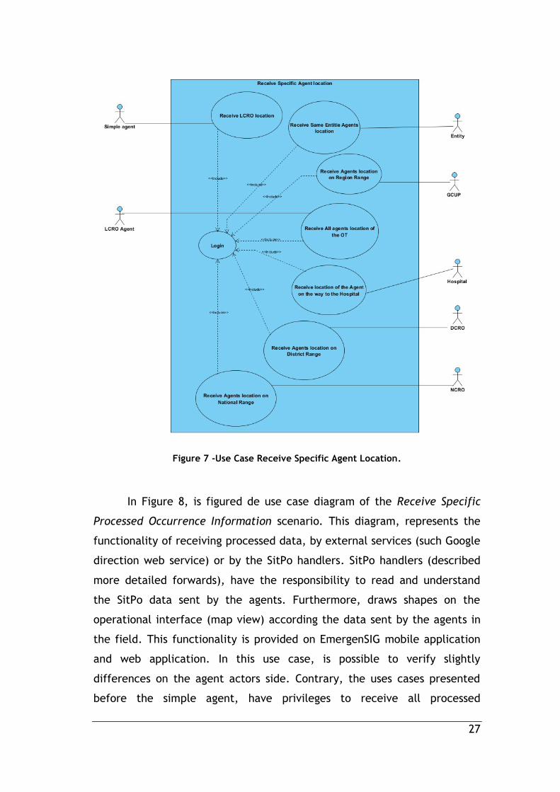
27
Figure 7 -Use Case Receive Specific Agent Location.
In Figure 8, is figured de use case diagram of the Receive Specific
Processed Occurrence Information scenario. This diagram, represents the
functionality of receiving processed data, by external services (such Google
direction web service) or by the SitPo handlers. SitPo handlers (described
more detailed forwards), have the responsibility to read and understand
the SitPo data sent by the agents. Furthermore, draws shapes on the
operational interface (map view) according the data sent by the agents in
the field. This functionality is provided on EmergenSIG mobile application
and web application. In this use case, is possible to verify slightly
differences on the agent actors side. Contrary, the uses cases presented
before the simple agent, have privileges to receive all processed
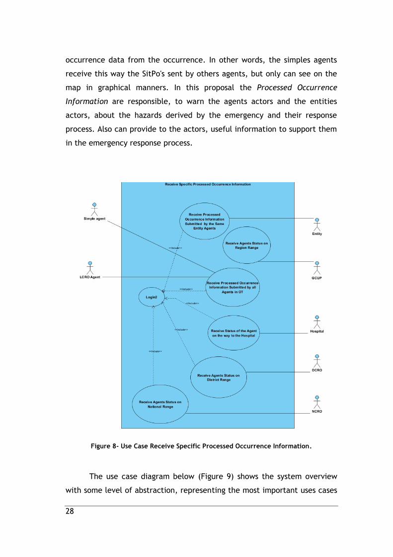
28
occurrence data from the occurrence. In other words, the simples agents
receive this way the SitPo's sent by others agents, but only can see on the
map in graphical manners. In this proposal the Processed Occurrence
Information are responsible, to warn the agents actors and the entities
actors, about the hazards derived by the emergency and their response
process. Also can provide to the actors, useful information to support them
in the emergency response process.
Figure 8- Use Case Receive Specific Processed Occurrence Information.
The use case diagram below (Figure 9) shows the system overview
with some level of abstraction, representing the most important uses cases

29
and their interaction with the actors. The diagram presents the
functionalities of the EmergenSIG System.
Figure 9 -General Use Case Diagram of EmergenSIG.
30
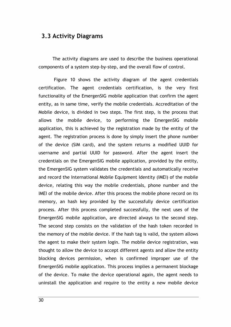
3.3 Activity Diagrams
The activity diagrams are used to describe the business operational
components of a system step-by-step, and the overall flow of control.
Figure 10 shows the activity diagram of the agent credentials
certification. The agent credentials certification, is the very first
functionality of the EmergenSIG mobile application that confirm the agent
entity, as in same time, verify the mobile credentials. Accreditation of the
Mobile device, is divided in two steps. The first step, is the process that
allows the mobile device, to performing the EmergenSIG mobile
application, this is achieved by the registration made by the entity of the
agent. The registration process is done by simply insert the phone number
of the device (SIM card), and the system returns a modified UUID for
username and partial UUID for password. After the agent insert the
credentials on the EmergenSIG mobile application, provided by the entity,
the EmergenSIG system validates the credentials and automatically receive
and record the International Mobile Equipment Identity (IMEI) of the mobile
device, relating this way the mobile credentials, phone number and the
IMEI of the mobile device. After this process the mobile phone record on its
memory, an hash key provided by the successfully device certification
process. After this process completed successfully, the next uses of the
EmergenSIG mobile application, are directed always to the second step.
The second step consists on the validation of the hash token recorded in
the memory of the mobile device. If the hash tag is valid, the system allows
the agent to make their system login. The mobile device registration, was
thought to allow the device to accept different agents and allow the entity
blocking devices permission, when is confirmed improper use of the
EmergenSIG mobile application. This process implies a permanent blockage
of the device. To make the device operational again, the agent needs to
uninstall the application and require to the entity a new mobile device
31
authentication credentials. The login is a process that identifies and allows
the agent and the entity to use the EmergenSIG application. The agent
login credentials are registered by the entity on EmergenSIG web
application.
Figure 10 - Activity Diagram of device authentication algorithm.
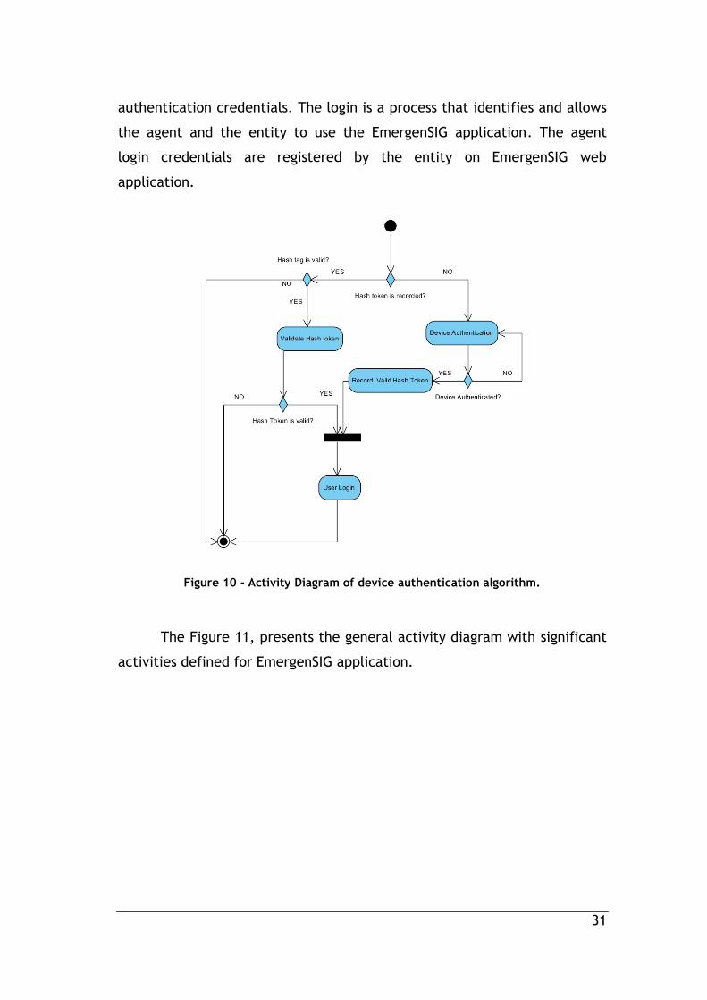
The Figure 11, presents the general activity diagram with significant
activities defined for EmergenSIG application.
32
Figure 11 - General Activity Diagram.
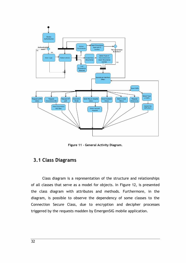
3.1 Class Diagrams
Class diagram is a representation of the structure and relationships
of all classes that serve as a model for objects. In Figure 12, is presented
the class diagram with attributes and methods. Furthermore, in the
diagram, is possible to observe the dependency of some classes to the
Connection Secure Class, due to encryption and decipher processes
triggered by the requests madden by EmergenSIG mobile application.
33
Figure 12 - Class diagram of REST web services
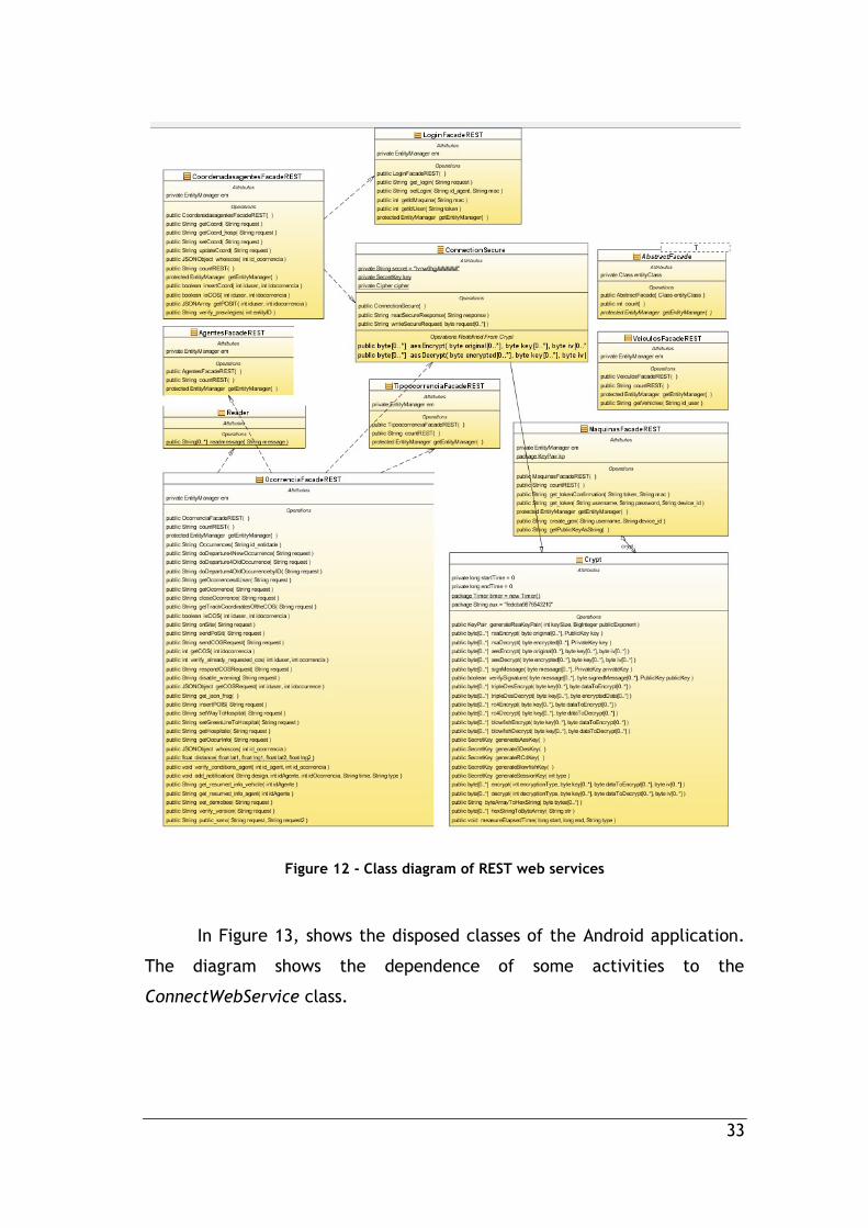
In Figure 13, shows the disposed classes of the Android application.
The diagram shows the dependence of some activities to the
ConnectWebService class.

34
Figure 13 - Class Diagram Slice of the Android Activities
3.2 Used technologies
The EmergenSIG is composed by three different modules. The
EmergenSIG mobile application, the EmergenSIG web application and the
REST Web Services. EmergenSIG mobile application targets mobile devices

35
running Android platform, which is a software stack for mobile devices that
includes an operating system, middleware and key applications [57]. The
EmergenSIG mobile application was developed in Java programming
language, by using the Android SDK in the Eclipse IDE (Integrated
Development Environment) with the ADT (Android Requirements Analysis
Development Tools) plugin. The ADT is designed to include a powerful and
integrated environment on Android applications [58]. To manage the
communications to the REST webservices, was used the Asynctask which is
an Android Native Class, that allows the execution of operations in
background and publish the result on the UI thread. In EmergenSIG mobile
application the Asynctask class are responsible to communicate in
asynchronous mode with the REST Web Services oriented to the mobile
devices.
EmergenSIG web application, was been structured in HTML markup
language and Cascading Style Sheets (CSS) with support of server-side
algorithms developed in Java Server Pages (JSP) programming language. In
the client-side, it was used JavaScript, with support of Asynchronous
JavaScript and XML (AJAX) methods, in order to make all the requests to
the EmergenSIG REST Webservices. Also, was used some jQuery functions,
to make the user actions more fluid and attractive. The data set transacted
between the EmergenSIG web Application and the EmergenSIG REST
Webservices, are in JavaScript Object Notation (JSON) data format.
EmergenSIG REST Webservices, was been developed in NetBeans
7.2.1 IDE that supports rapid development of REST web services using JSR
311 - Java API for REST Webservices (JAX-RS) and Jersey. These methods of
REST web services are connected to MySQL 5.5.28 database located in the
local server. For the database development and DB administration , was
used the Workbench 5.2.33 CE, an unified visual tool for database
architects, developers, and DBAs. Workbench provides data modeling, SQL
development, and comprehensive administration tools for server
configuration, user administration, backup, etc.[59]
36
This proposal was deployed and tested Intel Xeon E5405 @ 2.00Ghz
server with 4 GB RAM, performing in distributed computing, or in other
words in Cloud Computing.
37
4. EmergenSIG System Architecture
In this section, it is presented the general EmergenSIG system
architecture, and in the particular way, the EmergenSIG Web Application
architecture and the EmergenSIG Mobile Application. Moreover is described
the system Security, entities and agents privacy, the system agent-entity
relationship and for last a summary of the general EmergenSIG summary,
where is described the EmergenSIG functionalities and their user targets.
4.1 System Agent-Entity Relationship
The EmergenSIG is a Framework oriented to the agents and entities
involved in any emergency resolution operations, for this reason the
development of this system was based on the needs of the agents by
adopting User-Centered design [31]. User-Centered design relies on
continuous interaction with end users to understand how organizations are
arranged during the occurrences or disasters, what information is critical,
and how teams exchange this information among themselves and with their
operational centers (entities) [36]. EmergenSIG is a framework oriented to
the continuous evolution allowing future increment of new methods
oriented to the specific emergencies resolution. The objective is to
improve the emergency management process, during the initial and during
emergency response in almost real-time, benefiting this way the
proliferation of the emergency data to the entities that are generated on
the field by their respective agents.
EmergenSIG system architecture is presented in Figure 14 and
includes four main modules: i) agents, ii) entities, iii) administration
center, and iv) public services. Its mobile application (developed for
Android OS) is oriented to the agents. They can send and receive
38
information, through encrypted REST Web services via GSM/Wi-Fi Network
using HTTP protocol. The agent in this architecture can be all type of
rescuers in determined occurrence. (E.g., Police agent, firefighter, MERV
medic/nurse, civil protection agent and others). Entities interact with the
system through the EmergenSIG Web application, developed in Java Server
Pages (JSP). It consumes several Web services requested by JavaScript in
background, updating the information displayed in defined intervals,
almost, in real-time. In this case the entities are all responsible of the
department to send emergency rescuers to a determined occurrence to
resolve it (E.g., Firefighter department, police, army, hospital, National
Command of Relief Operations, District Command of Relief Operations and
others).
The administration center provides administration privileges to
users, such as the possibility to add entities, view the general information
updates, add geographic information, and other features for database
management. This view was designed and created for the NCRO
department location due to the exchange of sensitive data and for security
reasons.
The GIS database contains markers that characterize interesting
geographical information to the agents and their entities, such as interest
points, agent coordinates, hospital coordinates, hydrants points etc. The
operational database contains all the information about entities vehicles,
OT historic, registered agent devices, agent’s information and all related
data. The proposed architecture allows entities to control only their agents
and no others that are associated to a different entity roles.
The Operational database contains all the operational information,
about the agents, their entities, mobile devices and vehicles. This database
was thought to provide useful operational data to the agents and LCRO in
determined OT during the response process in the OT, such the grade of
the agent, his name, the designation and type of vehicle where he is being

39
transported, the agent phone number, the entity of the agent and the
agent ID. This database is also based on the actual emergency rescuers
identify other agents on the field (OT) and how the agents communicates
between them by the radio. This process is made by simple call the vehicle
designation, and the agent entity location. For example, if the vehicle
designation is VRC01 and the entity location is Covilhã, is called by VRCI-01
Covilhã Agent, for this reason, was chosen to relate the maximum of
information of the entity, enabling their quick identification and providing
all important information about the agent, their vehicle, phone number
and the description of their entity. The phone number of the agent is
obtained through the process Accreditation of the Device Figure 10 -
Activity Diagram of device authentication algorithm.(Figure 20) explained
more forward
Public services are provided by Web services that use JSON format
documents that reply information concerning the current state of incidents
on client location. This Web service receives the client place, by defining
on the request input the district name and the county name. The response
includes information about the current/local incidents that are active at
that place, such as, the type of active incidents on the client location,
emergency situation points, number of involved agents, incident time and
their precise OT epicenter location.

40
GSM
Medical Emergency and
Resuscitation Vehicle (MERV),
National / District
Command of Relief
Operations
Operational Data
Guidance Center
of Urgent
Patients (GCUP)
District Command of
Relief Operations
(DCRO)
National Command of
Relief Operations
(NCRO)
Firefighters
Headquarters
Police StationHospital
GIS DATA
Public
Police Agent
INTERNET
FireFighter Agent
Figure 14 -EmergenSIG System Architecture.
4.2 EmergenSIG Mobile Application Architecture
In this section is presented de Architecture of the EmergenSIG Mobile
Application (Figure 15).
The EmergenSIG mobile application is designed to support different
screen sized devices, providing user-friendly design, making its use more
effective and more easy, even in stressful situations, same situations, that
the emergency responders faces. The EmergenSIG mobile application is
oriented to the agent that composes the emergency response process. The
EmergenSIG Mobile Application is targeted for the transaction of relevant
data, from the field or from the operations theater (TO) to the control
centers, which in this dissertation are considered by entities. This
application was developed for Android devices, supporting the versions
41
Android 2.0.1 to Android 4.3. EmergenSIG is composed by a set of modules
or functions, for different Goals.
SitPo Modules, these type of modules or functions execute important tasks
in the application, they are the responsible to provide tools for agent to
describe and have knowledge of the evolution of any kind of emergency.
These functions are called Modules, for in algorithm abstract manner show
that they are independent and each SitPo module is only oriented to a
specific emergency. This allows the general application aggregate more
SitPo modules in the future, without the rest of the code have to be
changed, independently of the complexity inherent to this modules.
The Situation Points modules, are composed by two types of sub functions:
The SitPo forms - this functionality provides an specific activity in the
mobile application, which allows the user to describe the situation of
the occurrence and their evolution. This is achieved by creating simple
and intuitive report, with specific questions about the current
occurrence. Furthermore, if necessary, this functions can access to the
module of the mobile device, complementing the information inserted
by the agent, with more important information, such as device
orientation, atmospheric pressure, light condition, device temperature
(rare), device inclination etc.
The SitPo handlers are responsible to read and interpret the data
received by the system, which was generated by SitPo forms.
Furthermore, these important functions, interpret the SitPo
information, generating also visual content about all SitPo Information
sent by all agents. These types of graphical data are inserted into the
maps of the agent’s application.
In this dissertation, only the wildfires and wealth wmergency SitPo's are
given a special appreciation, due to their results significance.

42
Operational Functions - these functions are responsible to provide agent a
set of tools, such as Listing all available entity Vehicles (from Operational
Database), Listing all Active Occurrences (from Operational Database),
Drawing on the map the path of the first unit that arrive on the Operations
Theater (from GIS Database), Drawing Interest Points (from GIS Database),
Drawing the graphical information about the other agents (in same OT)
location and information (from Operational Database), the Overview of the
Occurrence information (from Operational Database) and Economic Mode,
that allow to the mobile application only send the coordinates of agent
location, pausing any others communications.
Agent Status is based on a set of different functions that describes the
actual state of the agent (user) in the EmergenSIG system. The
available agent status is the following:
In The Local - Inform the respective entities and LCRO, that the agent
just arrived at the OT.
Available - Inform the entities that was demobilized from the OT, and
its on the way to their base or department facilities.
On The Way To The Hospital - Is a special feature, that informs not
only their respective entities and the LCRO, but also the hospital,
about the new agent destination. This feature is special because the
entity, which in this case a hospital, is informed about other entity
agent, once the agent belongs from other entities. This is achieve by
listing to the agent the ten nearest hospitals of the agent location and
allowing the user the selection of the recipient hospital. Therefore the
selected hospitals can be informed about all agents in the system, that
are on the way to their facilities. The list of the nearest hospitals, are
sent by the EmergenSIG system to the mobile device, with the ten more
nearest hospitals to the last agent location. This process is done simply
by using the Euclidean distance, between the device and an Hospital
selected.
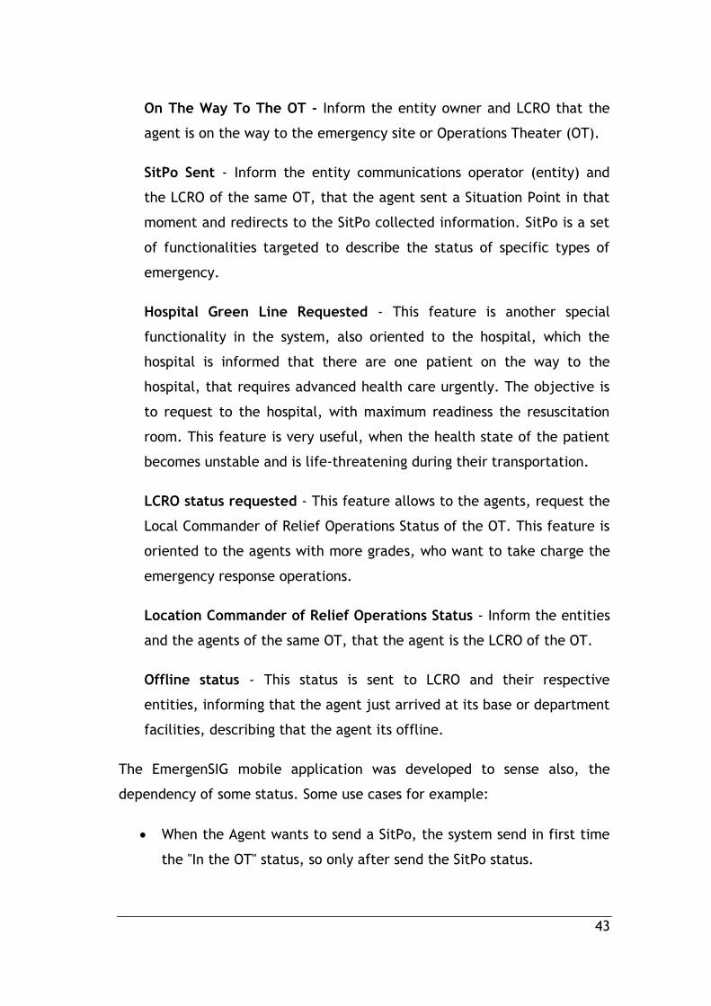
43
On The Way To The OT - Inform the entity owner and LCRO that the
agent is on the way to the emergency site or Operations Theater (OT).
SitPo Sent - Inform the entity communications operator (entity) and
the LCRO of the same OT, that the agent sent a Situation Point in that
moment and redirects to the SitPo collected information. SitPo is a set
of functionalities targeted to describe the status of specific types of
emergency.
Hospital Green Line Requested - This feature is another special
functionality in the system, also oriented to the hospital, which the
hospital is informed that there are one patient on the way to the
hospital, that requires advanced health care urgently. The objective is
to request to the hospital, with maximum readiness the resuscitation
room. This feature is very useful, when the health state of the patient
becomes unstable and is life-threatening during their transportation.
LCRO status requested - This feature allows to the agents, request the
Local Commander of Relief Operations Status of the OT. This feature is
oriented to the agents with more grades, who want to take charge the
emergency response operations.
Location Commander of Relief Operations Status - Inform the entities
and the agents of the same OT, that the agent is the LCRO of the OT.
Offline status - This status is sent to LCRO and their respective
entities, informing that the agent just arrived at its base or department
facilities, describing that the agent its offline.
The EmergenSIG mobile application was developed to sense also, the
dependency of some status. Some use cases for example:
When the Agent wants to send a SitPo, the system send in first time
the "In the OT" status, so only after send the SitPo status.

44
In the case that the agent wants to send a "Hospital Green Line"
before sent "On The Way to the Hospital" status, the application
recommends to first, send the "On the Way to The Hospital" status.
The offline status is available only, after the agent sends the
"Available Status" first.
After the agent pull the Offline status, the EmergenSIG mobile
application turns off.
All of this status, are composed by a time-stamp, to inform the system and
the respective entities, when they happened.
Location manager is an Android native class that provides access to
the system location services. These services allow the EmergenSIG mobile
system to obtain geographical location of the agent or device and instantly
send the location coordinates to the EmergenSIG system, through REST Web
services. In the EmergenSIG mobile application, was developed to calculate
the geographical location, with maximum error of 10 meters of the real
location, by filtering the horizontal accuracy of the Android Location
Provider. Moreover the system only determine the geographical location of
the agent of 10 in 10 meters, ensuring this way, the pre-established
requirements, which are conform with economization of data transaction.
The map API used is Google Map Android API v2. It is an API provided by
Google Play Services. The base of the choice of this API, was centered by
the set of tools provided by this API, as the currency of the satellite images
provided, which is a fact extremely important in the area of emergency
management. It is essential to provide current maps to the agents in the
field that can show them for example, the actual state of unpaved roads
(Rural Areas), which over time will be covered by vegetation, making the
paths inaccessible to the vehicles, if are not properly requalified over some
time, can causes some delays to the agents arrival in the OT. Moreover,
also provides to the user knowledge about, the extension of the continuous
vegetation, type of vegetation, water zones etc.

45
Control Unit, is a set of functions applied in the REST Webservices
oriented to the mobile devices, that are called every time by the system,
when the agents (Android) want to make an specific action, that is sent to
the Server. The Control Unit is responsible to grant the well functioning of
the system, by controlling and confirming all the actions performed by the
agents. The control unit is responsible to:
Validate Login sessions and verify the existence of multiple sessions
of one agent profile, if this case is confirmed the first session is
deactivated.
Control the creation of the occurrences, verify in the system if the
exists other occurrence, which is active with same ID and same
location, if it is confirmed, the system do not allow the operation.
Closing occurrences processes, allow the system to close an active
occurrence. This functionality is triggered when the only one agent
in active occurrence, stays offline during maximum period of 60 min.
Managing the LCRO status request, by redirecting any LCRO status
request to the actual LCRO, and define the actual LCRO agent,
consonantly the response of the actual LCRO. Furthermore the
Control Unit is responsibly to assign automatically the LCRO status to
the more graduated agent, when the actual LCRO exist the OT.
Auto LCRO assignment, this functionality is responsible to the LCRO
status assignment in two different situations. When the current LCRO
agent, send a "Available" Status, the system assigns to other agent
the LCRO status, by the selection of one more graduated agent. The
second Situation occurs when the system assigns the LCRO status to
the first agent that arrives in OT.
46
Figure 15 - EmergenSIG Mobile application system architecture.
4.3 EmergenSIG Web Application Architecture
This section describes the EmergenSIG Web Application Architecture
and their different essential elements (Figured in Figure 16). EmergenSIG
Web application is oriented to the respective entities of the agents that are
integrant part of the emergency response operations in OT. The primary
objective is to control the agents that are operating in the OT and allow
the support in real time to the agents by their own entity. This web
application, are developed in Java Server Pages, with JavaScript for client-
side interaction. Above, is described the most important, features and

47
modules, that composes the architecture of the EmergenSIG Web
Application.
Operational functions, provides a set of functionalities oriented to the
entities. These functions allow the entity to:
Add/Modify/Delete Vehicles, designed to agent selection through
EmergenSIG mobile application
Agent device registration, allowing the agent to use their
EmergenSIG mobile application in the device.
Consult the historic, this functionality allows the entities consult the
history of specific occurrence, including the agent location, SitPo
sent, in certain time. The entity user, must select one specific time
to the system, in order to retrieve occurrence state in that time (Any
eventual SitPo's and Vehicles/Agent Locations).
Save occurrence history in to a file, allowing the entity to record the
occurrence history (only SitPo data) in text file, easily
understandable by people.
Add/Delete interest point, allow the entity user to insert
geographical interest point, to be shared for all agents that are in
interest point location.
Consult in real time, the active occurrence information under its
domain, in other words, all occurrences created by their agents or
under their responsibility.
Agent Status information, provides textualized information about the
agent’s status on determined occurrence and their geographical
location on the map.

48
About the SitPo modules, unlike the mobile version, the EmergenSIG
web application only uses the SitPo handlers, which are responsible to
interpret the SitPo forms sent by the agents on the field, translating this
way, the SitPo text data, into graphical information to the entity user
final user. The graphical data, have the ability, to show e.g., the wind
direction, wildfire estimated extension progression shapes, and others.
To provide the map functionality, it was used the Google Map
JavaScript V3 is the most recent version of Google maps API, with new
capabilities, that helps the entity user, to control their units and
providing to them more effective support. One important functionalities
consists on the "street view", that allow the user to see from the street
view the site of the emergency, and gather this way more detailed
information about the site. Furthermore, with this tool and through the
API Web services, is also possible to calculate the estimated route
duration taken by the agents in order to achieve one specific
destination (e.g. Hospitals), based on the current traffic condition in
the local.
All communications are realized in AJAX by sending and receiving
Java Script Object Notation (JSON) data.

49
Figure 16 - EmergenSIG Web application system architecture.
4.4 Hospital interface (Special Case)
Currently, in some cases, the hospitals only have knowledge of the
patient health condition, when arrive to the hospital, and in some cases
the green line alert, is triggered after their arrival, leading to some delays
in providing advanced life support. For this reason the Hospital was
designed to be a special entity only oriented to the agents when transports
a patient to an hospital facility, unlike the other entities that have the
capacity to receive all relevant occurrence data. This special entity only
view the data sent by the agents and not the entire data of the occurrence.
In other words, this entity can receive all information about the agents that
are on the way to the hospital, by receiving the location of the agents, the
estimated time for the agent and patient arrival, receive the health
50
condition of the patient that was transported, and receive green line
alerts, while the patient is on the way. In order to warn the hospital staff
to create conditions in their facilities to receive the patient in the
resuscitation room with advanced life support and appropriate medical
staff. The functionality, in other words anticipates the patient arrival.
4.5 System Agent-Entity Relationship
EmergenSIG framework, is centered in two -level architecture: a
first level oriented to the agents on the field, always headed by one leader
(LCRO) agent on the field. A second level is oriented to the entities or
rescue organizations of the respective agents on the field.
The first level is composed by the Android Mobile Application, which
is based on pre-defined agent, by their skills and responsibility of the
process of the emergency management, provide multiple functionalities to
support the agents on the field, directing the resultant information to the
entities, that have responsibilities in such emergency management
operations.
In the second level, is provided Java Server Pages (JSP) oriented to
the entities or emergency responders centers. This Web Pages, provides a
set of functionality, that allows the entities to acknowledge in almost real
time, the information resultant in the process of emergency management
in the field, generated by the actions of their agents.
The first and second level is figured in Figure 17 that shows the
relationship between the agents and their own entities. Between the
agents and entities, must exist a shared set of data that it is called
Occurrence Data.

51
Occurrence Data in EmergenSIG framework is strictly necessary to
create a data set that is shared between the agents and entities, in other
words, the agents and entities must create at least on active occurrence in
the system to allow information sharing between entities and agents or
between agents-agents. The Occurrence Data is a set of data composed by
GIS data, Agents Location, SitPo data sent and Agents Status.
GIS data consists in Geographic Information inserted by the entities
when they are not on duty. Geographic Information supports the agents on
the field, providing useful information about available points of interest in
the locality of the occurrence. The information can be water spots
(hydrants), available roads access, hospitals coordinates, firefighters
department’s coordinates, and the path taken by the first agent to reach
the local of the emergency or Operations Theater (OT). The functionality
that provide the path taken by the first agent that reach de OT, is
extremely important in support to the agents, who comes from other
localities, because most of these agents have no geographic knowledge of
other locations that their own, often leading to a delays in their arrival,
contributing this way to a decrease in the effectiveness of the initial
response of the agents in OT.
Agents location, as the name implies, consists in a set of agents
location information or geographic coordinates, that are shared to the their
entities and to the other agents in the OT. This data set, in composed by
agent coordinates, last update timestamp to inform the system about the
availability of the agent in the moment, velocity and orientation.
SitPo Data Set, this data set, consists in processed information that
are created by the agents in the OT, such type of information describes the
Situation Point (SitPo) at a given time of the evolution of the emergency,
this information must be processed, in order to provide to the entities and
agents, a set of graphical and text information that describes in the

52
moment, the evolution of the emergency (SitPo), or in other words, what
the agent can see in the field.
Agent Status, this information allows the entities and the Local
Commander of Relief Operations of the OT (LCRO) determine their agents
status. There are several agent status available: In the local, Available, On
the way to the hospital, On the way to the OT, SitPo sent, Hospital Green
line requested, Local Commander of Relief Operations (LCRO) status, and
for last Offline status.
The communication between the agents and entities is executed by
two different webservices. One oriented to the agents and another
oriented to the entities. The agent oriented REST webservices, applies
cipher algorithms in all requests and responses.
Figure 17 - Relation Agents-Entities that shows the Occurrence Data shared between
the Agent and Entities.
53
The EmergenSIG system, create a new approach on this context,
which is based on the agent and respective entities relationship, has well
the relation between the different entities mostly involved in any
emergency response process, and it is extremely important, because allow
the constant support of the agents on the field, by their own entity on
decision making in almost real-time.
4.6 Security
EmergenSIG provides a channel for transmission of sensitive and
confidential information between agents and their entities. So it is
necessary to protect the privacy of the data sent. Once the EmergenSIG is a
platform that provides a set of real-time data, it is necessary simple and
fast processing algorithms, to provide appropriate response times to the
innumerous requests performed by the mobile and web applications.
Therefore the system, must be, capable to encrypt data, with minimal of
computational resources, ensuring this way the data security and fast
responses by the REST Web Services. In Silva et al [60], is presented a
comparison between symmetric encryption algorithm, where the AES 128
bits key encryption was the most efficient algorithm when handling with
both small and large amounts of data. For this reason the EmergenSIG
system, uses symmetric encryption algorithm only between the mobile
devices and REST Webservices, using the request format:
128 bits AES encryption(SESSION_ID # TIMESTAMP # ID_USER # REQUEST_DATA)
The request is encrypted, and is composed by the session id
(SESSION_ID) of the user login, the time stamp (TIMESTAMP) of the request,
user id (ID_USER) and the message sent to the system (REQUEST_DATA).In
the request, is necessary to insert the SESSION_ID of the login, in order to
ensure only one active session for the user at the time. The TIMESTAMP,

54
allow the system, to detect repetitive messages. in order to block them,
only the first is accepted. By the ID_USER information, the system confirms
the identity of the user, with the proprietary credentials of the SESSION_ID,
if the identification is confirmed, the system process the REQUEST_DATA.
In the REQUEST_DATA describes the type of the request, and all data
necessary to complete the order. The REQUEST_DATA are composed by
JSON data format. Furthermore the EmergenSIG web application, can be
used by HTTPS or HTTP protocol.
4.7 Entities and Agents Privacy
One of important topics in the area of civil protection is the
conservation of the privacy of the different organisms involved in such type
of operations. Normally in such operations are involved different types of
entities, with different types of responsibility. The same is applied to the
agents in the OT, but with a difference, the LCRO agent is the only agent in
the field, independently of the different type of agent, that must know
everything that occur in his OT, in other words all the information
transacted in the field is sent to the LCRO mandatorily.
In Figure 18 is exemplified the different levels of privacy in one
Operations Theater. In Entities section, the national department or
national command center of one determined entity, have the privileges to
receive of all activities related to all active occurrences in national range.
The District/Region Department view, have knowledge about the active
occurrences in their region or district area. The Department view, only
have knowledge of active occurrences operations in entity location range
under its responsibility. The Public Service, was applied more restricted
data filter, once its oriented to the public users, the information provided
must be resumed and useful. This public service only shows basic
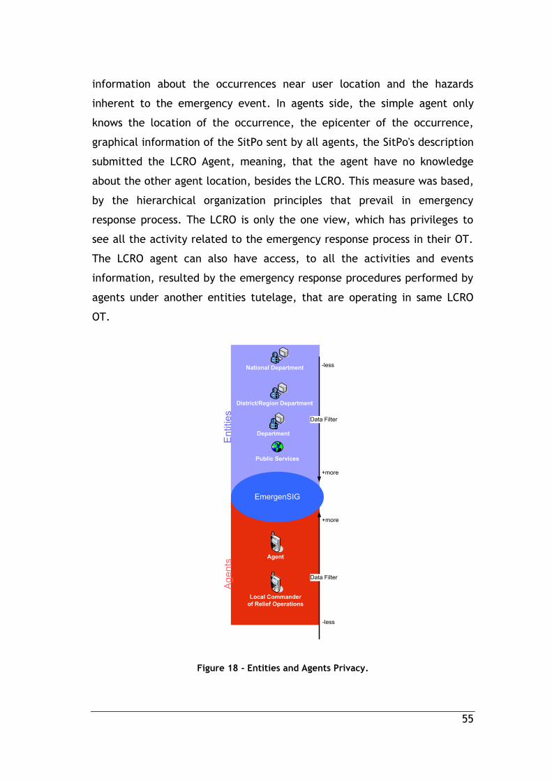
55
information about the occurrences near user location and the hazards
inherent to the emergency event. In agents side, the simple agent only
knows the location of the occurrence, the epicenter of the occurrence,
graphical information of the SitPo sent by all agents, the SitPo's description
submitted the LCRO Agent, meaning, that the agent have no knowledge
about the other agent location, besides the LCRO. This measure was based,
by the hierarchical organization principles that prevail in emergency
response process. The LCRO is only the one view, which has privileges to
see all the activity related to the emergency response process in their OT.
The LCRO agent can also have access, to all the activities and events
information, resulted by the emergency response procedures performed by
agents under another entities tutelage, that are operating in same LCRO
OT.
EmergenSIG
National Department
District/Region Department
Agent
Local Commander
of Relief Operations
Data Filter
Data Filter
-less
+more
+more
-less
Public Services
En
titie
sA
ge
nts
Department
Figure 18 - Entities and Agents Privacy.

56
4.8 Functionalities
In this section, is presented in
Table 1. It resumes the EmergenSIG provided functionalities and their user
targets. In the table, is possible to observe, the Hospital View. The view,
have less functionalities than the others actors, due to the occurrence data
privacy applied, which respects the limits of the entities responsibility on
the civil protection. Furthermore, the view is defined only to follow the
patient health state, since the agent defined the hospital, as the patient
health care destination. Thus, the hospital only receives specific agent
locations and their status, after the agents are on the way to the hospital
facilities. This view, also receives occurrence information such as
estimated time for the agent arrival and all SitPo's sent during the patient
transportation.
The general entity view, receives the location and the status
changes of the agents under their tutelage, receives their own inserted
interest points, specific occurrence information, inserted geographic
interest points. It is also provided a set of management functionalities
allowing to the entity final user to insert, edit, delete operational data,
such vehicles, agents accounts and devices permissions.
Furthermore, the entities have all access to the occurrence events
history functionality, that begins on the territory under their responsibility
and have at least one of their agent operating. This functionalities, is
designed to allow the entities control the agents locations and actions over
the duration of the emergency response process. The information retrieved
can also be oriented to academic and research purposes.
The agents are allowed to send SitPo's, their operational status, their
updated location, and LCRO status requests. It also receives the LCRO
agent location, receive the path to the OT epicenter, receive geographic

57
interest points and operational data. In this view, the operational data
consists, on the list of the operational vehicles available in the moment
(for the agent selection).
The LCRO agent, is the only view that are allowed to receive LCRO
requests, and having privileges to answer them. The LCRO agent can send
an general SitPo, their operational status, and their updated location. It
also receives, other agents (same OT) locations and their status changes,
geographic interest points, operational data inserted by their own entity,
and all the occurrence information provided by all agents in the OT.
Functionalities Actors
LCRO Agent Entity Hospital
Receive LCRO request
Send OT Situation Point (SitPo)
Send Agent Status Data
Send Agent Location
Receive Specific Agent Locations
Receive Tracking Paths
Receive Specific Agent Status Data
Receive Specific Geographic Interest Points
Receive Specific Occurrence Information
Insert Geographic Interest Points
Receive Operational Data
Insert Operational Data
Send LCRO request
OT History
Table 1 - Functionalities and their actors.

59
5. System Demonstration
This chapter focuses on the application functionalities demonstration
using print screens of the windows that make up the EmergenSIG mobile
application, through the Android activities screens and system
functionalities demonstration.
5.1 EmergenSIG Mobile Application
The EmergenSIG Mobile Application targets mobile devices running
Android platform, but can be easily reproduced to other mobile operating
system, such as iOS, Windows Phone, etc. This solution was also designed
to support more modules of emergencies, other than the two modules
explained and described in this thesis, wildfire and health emergencies.
The emergency modules or SitPo modules are independent parts of the
algorithm, which can be deployed in any time in the mobile application,
through a self-update functionality, without having the necessity to change
the application base structure, in order to apply new SitPo features. For
this motive, the EmergenSIG system is considered as framework.
The EmergenSIG user interface is simple, uses large buttons,
includes appropriated size for fingers use, and is customized according to
the sizes of different screen devices. An arm accessory sustains the mobile
device providing an excellent position for information access and
interaction. Figure 19 presents a firefighter agent using the EmergenSIG
application.

60
Figure 19- Example of an agent using the EmergenSIG mobile application.
The application requires user authentication. Credentials are
created by the EmergenSIG Web application (entity view) and shared only
with the proper agent. This procedure allows entities to control improper
actions from their agents, allowing to block agents devices(Figure 10) After
the procedures, the mobile application communicates with the EmergenSIG
web service, with the credentials provided by the entity. After the positive
validation, the system returns an Hash token similar as the Universally
Unique Identifier (UUID) [61]. Thereafter, the system record the hash token
in the system. The hash only can be readable by the EmergenSIG mobile
application. In every login procedure the EmergenSIG system checks the
validity of the recorded hash, and determine whether the device is blocked
or not.

61
Figure 20 - Device Authentication functionality.
Login activity (Figure 21) allows a registered agent to access into the
EmergenSIG mobile application. After a successful login, the EmergenSIG
process a temporarily hash token, that allow the system to have only one
active session every time, in other words, the system do not allow two
simultaneous active sessions of one user (agent). In order to achieve the
maximum simplicity on the login procedure, the EmergenSIG allows the
user to use simple username and passwords tokens, in order to promote
quick credentials submission and validation. This method is only possible by
a submission of the recorded device hash token plus the user credentials
trough the web service, allowing the recognition of the entity of the device
and the agent entity. The system only needs to find the user in the list of
all agent of the respective entity and not in the list of all agents of the
EmergenSIG system, resulting in short username and passwords to the
agents credentials validation, maintaining the security of those.

62
Figure 21 - Login Functionality.
The operational methodologies of the entities that represents the
civil protection in any country, is constantly changing over the years. Then,
any system that supports operations in the field must adapt and always be
updated. For this reason, a self-update tool was developed. Figure 22
shows the steps of the self-update functionality. On the right the
application, recognizes a new version available and request to the user if
he wants to update the application in that moment. After the agent
accepting, the application performs a quick download (in normal conditions
2-3 seconds), and asks the user, if he wants to update the application (in
the right). This self-update, have mandatory caracter, to prevent future
mismatches of information in the system, thus causing misunderstand
between agents during the operations.

63
Figure 22 - Application Self-Update Functionality.
Afterwards the agent must select a vehicle, as shown on Figure 23.
This activity presents only the vehicles of their department that are
available at that moment. This activity, requested by the web service,
presents the list of the vehicles available in every 2 seconds, that can hold
a significant data transaction during the time when the agent are choosing
the vehicle. However, normally, this activity is realized in the agent base,
where the mobile application can have Wi-Fi connection, minimizing this
way the costs of data transaction by the GSM module.
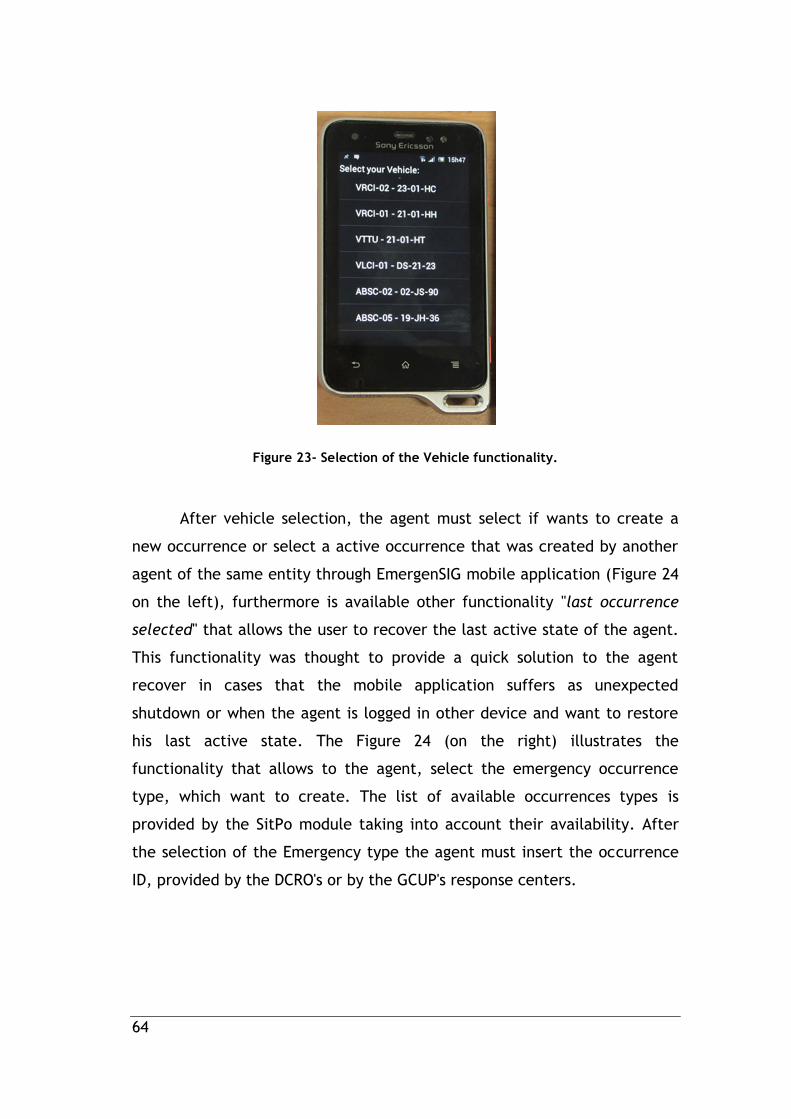
64
Figure 23- Selection of the Vehicle functionality.
After vehicle selection, the agent must select if wants to create a
new occurrence or select a active occurrence that was created by another
agent of the same entity through EmergenSIG mobile application (Figure 24
on the left), furthermore is available other functionality "last occurrence
selected" that allows the user to recover the last active state of the agent.
This functionality was thought to provide a quick solution to the agent
recover in cases that the mobile application suffers as unexpected
shutdown or when the agent is logged in other device and want to restore
his last active state. The Figure 24 (on the right) illustrates the
functionality that allows to the agent, select the emergency occurrence
type, which want to create. The list of available occurrences types is
provided by the SitPo module taking into account their availability. After
the selection of the Emergency type the agent must insert the occurrence
ID, provided by the DCRO's or by the GCUP's response centers.
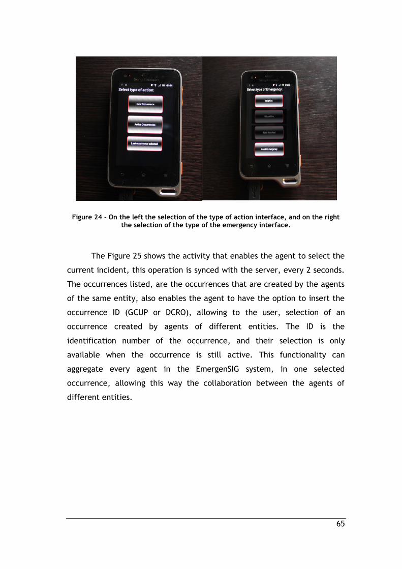
65
Figure 24 - On the left the selection of the type of action interface, and on the right the selection of the type of the emergency interface.
The Figure 25 shows the activity that enables the agent to select the
current incident, this operation is synced with the server, every 2 seconds.
The occurrences listed, are the occurrences that are created by the agents
of the same entity, also enables the agent to have the option to insert the
occurrence ID (GCUP or DCRO), allowing to the user, selection of an
occurrence created by agents of different entities. The ID is the
identification number of the occurrence, and their selection is only
available when the occurrence is still active. This functionality can
aggregate every agent in the EmergenSIG system, in one selected
occurrence, allowing this way the collaboration between the agents of
different entities.

66
Figure 25 - Select Active Occurrence Functionality.
In Figure 26 - Operational Interface. Figure 26, shows the
operational Interface oriented to the agents. The interface provides
current map, with different zoom levels and different view angles. Also
provides two menus, one on the top of the interface and other on the
bottom, keeping this way a simple interface and user friendly. On the top,
there are disposed the most useful operational functions oriented to the
agent operations. On the bottom is available the agent status
functionalities and the SitPo functionality with large button.
Top menu:
LCRO request, provides to the agent, the possibility to send LCRO
request to the current LCRO agent. Occurrence Info, provides to the agent,
all the information about the OT, according the agent current privileges.
OT path, allow the agent, to receive the path to the epicenter of the OT.
Economic mode, represented by I/0 (activated/deactivated). This mode,
when activated, reduces the data transmission over GSM, by blocking all
the requests responsible to receive data, about others vehicles and
occurrence. This mode only send the location of the vehicle, every 10
meters traveled by the agent.

67
Bottom menu:
Green line request- Allow the agent to send the green line alarm to
the hospital, when the patient is on the way to the selected hospital.
Available, send available status to the system, in order to inform their
entity and the LCRO agent, that the agent exit from the occurrence and he
is available. Way to hospital, this functionality, allow the agent to specify
the hospital so that the agent is directed. In local, send the "In local"
status, due to inform the LCRO and respective entities, of that agent
arrived to the OT. Send Situation Point (SitPo), allow the agent to send
precise information about the evolution of the occurrence, in order to
inform the LCRO and respective entities. Additionally, is presented the
current velocity of the agent, bellow the superior menu. To activate any
these functions, the agent must confirm their action, preventing this way,
any accidental action.
Figure 26 - Operational Interface

68
In Figure 27, shows the location of the epicenter and danger zone of
an occurrence. This red circle is drawn by taking into account the position
of the agent, after submit the "In local" status. The red circle represents
the danger zone and is showed to other units in the same OT, to the LCRO
agent and the respective entities. In the right of the Figure 27, is shown
the path of the first unit that traveled to reach the epicenter of the OT, in
order to inform others agents, about one possible path to reach the
epicenter of the OT. The path is drawn after the agent pushes the "OT
path" button in superior menu.
a) b)
Figure 27 - Operational Interface showing the epicenter of the danger zone (a) and the path (red line) to the epicenter of the OT (b).
Figure 28 shows the different views for three agents into same OT.
On the middle is shown the LCRO view, where is represented all
operational agents in the respective OT, represented in red markers. In this
figure are shown the different positions of the agents in the OT. Every
agents without LCRO privileges (left and right devices in Figure 28), only

69
can see the LCRO position (red marker), in order to inform all units where
is the LCRO location. This way, all agents have the possibility to move to
LCRO position, for making face-to-face meeting, if necessary. In the red
marker, is represented the other agents location, in blue marker the own
current position in the map. After click in any red marker is shown in the
dialog (above the marker) the designation of the agent and their entity.
(e.g., VLCI-01 B.V Belmonte, VLCI-02 B.V Belmonte and VTTU-01 B.V
Belmonte). These functionalities also have the ability to detect police and
medical/nurse staff in the occurrence, by highlight the location of them
with personalized markers. If one police agent is present on the
occurrence, the application set the marker into blue color with a "star"
shape, and if one vehicle transport, medical/nurse agent, the application,
represents the vehicle location with a yellow color, same color of INEM
vehicles, in order to quick identification of the medic or nurse agent.
Figure 28 - Different views for three agents into same OT. In the middle
shows the LCRO agent.

70
In Figure 29, is figured the two different types of SitPo, currently
available on the EmergenSIG mobile application, the Wildfire SitPo form
(Figure 29 on the right) and the health emergency SitPo form (Figure 29 on
the left). The SitPo forms, provides to the agent a very quick and effective
method to send information about what the agent is seeing, describing this
way the current situation of the occurrence.
In the Wildfire Emergency SitPo form, is possible to describe the wildfire
situation, trough the information:
Current State of the Occurrence - Describe the current state of the
occurrence, by selecting one of these several options: In progress
(Active), in resolution (Dominated), in conclusion (Aftermath) or
Finalized (Extinct).
Intensity of the fire - Describe the intensity of the fire, by selecting
one of these options: Low Intensity or High Intensity.
Type of fuel - Describe the type of fuel, by selecting one of these
options: Pine Forest, Bush, Agriculture, Mixture, or Eucalyptal.
Geography of the terrain- Describe the type of geography, the
options: Smooth slope, Sharp slope, Moderate slope and Flat terrain.
Access condition - Describe the access condition of the OT, the
listed options: Good, Difficult, Asphalted road, Dirt roads, Without
access and Rough terrain.
Sensitive infrastructures - Describe sensitive and threatened
infrastructures, the available options: None, Habitations,
Commercial, Industry and Mixed.
Flank -Describe operational location of the agent, by selecting the
defined flank, the options: A, B, C, etc.
Temperature - Describe the Ambient temperature.
Wind Velocity -Describe an interval of the wind velocity (Min-Max).

71
I'm doing - Describe the current procedure adopted by the agent,
the available options Head Attack, Cooling, Flank Attack and
Sensitive point defense.
Require- Allow the user to require more support units, by inserting
the quantity of: Combat brigades, Aerial Vehicles and Combat
group.
Orientation - The orientation is collected by the internal sensor
(compass) of the mobile device. In order to send the Wildfire SitPo.
The agent, must target the top of mobile device to the orientation of
the evolution of the fire, while the agent is submitting the SitPo
data.
The Health Emergency SitPo form is composed by:
Name - Input form designed to identify the patient
Age - Age of the patient
Sex - Specify the sex of the patient, by selecting one of these
option: Male or Female.
Saturation - Depict Level of oxygen in the patient blood
Glycemia -Describes the Glucose concentration in the blood
Temperature -Describes the patient body temperature.
Pulse - Information about the patient heart rhythm
Blood Pressure - Describes the patient blood pressure by inserting
two parameters: Systolic and Diastolic values.
State of consciousness - Describes the state of the patient by
selecting one of the two options available: Conscious or Unconscious
Breath -Inform if the patient is breathing, by selecting yes or no
options.
Pupils - Describes the pupil’s reaction of the patient, by selecting
one of the two options available: Contracted or Dilated.
Procedures - Describes the procedures performed by the agent,
until the moment.

72
Complaints - Describes the patient complaints.
Skin - Describes the patient skin state.
Shock - Confirm if the patient is in shock or not.
Type of lesion - Form designed to describe the patient lesions. The
agent must insert the anatomical location of the different lesions.
They are: Open Wounds, closed Wounds, burns, fractures and
bleedings.
Figure 29 - The SitPo forms.On the left SitPo forms oriented to Health Emergencies, on the right the SitPo form oriented to WildFires.
In the EmergenSIG mobile application, all agents that are operating
in the same OT must have general and singular knowledge about the

73
current reality of emergency OT and their evolution. In Figure 30, is
possible to view the Occurrence Information interface, divided by three
different tabs. The first (Car Symbol), shows all the vehicles and agents,
who are involved into the emergency operations, grouped by the
Agents/Vehicles, who are on the way and the Agents/Vehicles currently in
the OT. The second tab (Info Symbol) shows the timeline of information
related to the occurrence, which will be filtered according the privileges of
each agent. The information can be about the occurrence, LCRO agent and
SitPo's data sent by other agents. The third tab (Satellite Symbol), show the
current information about the state of device GPS module, such as latitude,
longitude, velocity, altitude and precision of the coordinates calculation.
Figure 30 - Occurrence Information interface.
Figure 31 demonstrates the level of detail of information received by
LCRO. Only the LCRO of the OT and the respective entities, can view and
record the vehicles/agents status, as well all SitPo data submitted by other
agents in the OT, unlike the simple agents, that only have privileges to
view SitPo data sent by the LCROs agents, view the OT information and
LCRO information, as shown on the center of the Figure 30.

74
Figure 31 - LCRO view of the occurrence information interface.
In Figure 32, show the LCRO status request dialog in the LCRO agent
view. The dialog is triggered when any agent submits the request, by
clicking the LCRO request button in the superior menu. Furthermore, the
dialog is shown to the current LCRO agent, allowing to the LCRO agent,
accept or denied the status transfer. This functionality was developed, by
taking into account the real procedures in the real emergency scenario
operations, wherein this operation is made by face-to-face, by the involved
agents. After the LCRO accept the request the agent requester becomes
the new LCRO of the OT, and .the old LCRO becomes simple agent. To
achieve the simplicity of this procedure, the LCRO must be informed about

75
the name of the agent requester, the graduation and the agent entity, in
order to identify the requester.
Figure 32 - LCRO status request dialog.
In Figure 33, shows the interface of the "Way to hospital"
functionality. This functionality shows the ten more nearest hospitals of the
current agent location. After the agent, selected the addressee hospital, is
sent to system the new agent status. This functionality is important, due to
define the addressee hospital, of the green line request functionality,
which the hospital in question is informed about the alarm. Therefore, the
"green line request" functionality is only available after the addressee
hospital selection. The distance calculation is madden by using the
Euclidean distance equation.
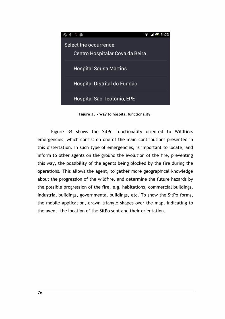
76
Figure 33 - Way to hospital functionality.
Figure 34 shows the SitPo functionality oriented to Wildfires
emergencies, which consist on one of the main contributions presented in
this dissertation. In such type of emergencies, is important to locate, and
inform to other agents on the ground the evolution of the fire, preventing
this way, the possibility of the agents being blocked by the fire during the
operations. This allows the agent, to gather more geographical knowledge
about the progression of the wildfire, and determine the future hazards by
the possible progression of the fire, e.g. habitations, commercial buildings,
industrial buildings, governmental buildings, etc. To show the SitPo forms,
the mobile application, drawn triangle shapes over the map, indicating to
the agent, the location of the SitPo sent and their orientation.

77
Figure 34 - SitPo handler module functionality.
The orientation of the triangle shapes is provided by the SitPo
handler module, which process the SitPo's forms submitted by the agents.
The length of the triangle shapes are drawn according the Wildfire
Progression Velocity estimations in Table 2 [62], where is possible to
calculate the estimation of the fire progression distance by taking the wind
velocity by the Wildfire SitPo submitted. For example, in fires with winds
of 15 km/h, the fire in one hour can reach a extension of 450 meters. This
graphical information is targeted to all agents that are operating in any
wildfire OT. Other approaches to calculate more efficiently the fire
progression, was been taken account such [63], [64] and [65], although not
been applied, due to two factors. These type of algorithms must have more
process capabilities than the smartphones, in order to grant quick and
effective responses. For the implementation of these algorithms the agents
must have strong knowledge of the numerous different types of fuel, most
of them, practically difficult to distinguish timely. Other reason, concerns

78
the fact, that the EmergenSIG system, was developed by adopting the User-
Centered design, whereby the system must adopt the typical procedures
associated to the pre-defined agents emergency response protocols.
Table 2 - Wildfire Progression Velocity estimations[62].
In Figure 35, shows the location of Interest Point (Hydrants Spots),
inserted by the entities of the district of the occurrence location, drawn
over the map, in order to advertise the agents about interest points for
their emergency response operations.

79
Figure 35 -Point of Interest example.
The available status is sent by clicking the "Available" button on
inferior menu. After clicking the button, the system is aware, that the
agent is available and is on the way to their base. For this reason, after the
status submission, the application, blocks all functions, showing, only one
dialog with "Ok" button, as figured on Figure 36. At the time, the agent
arrive to its base, should press the "Ok" button, informing the system about
his arrival. After the new status have been sent, the EmergenSIG mobile
application, shuts down the occurrence for that agent.

80
Figure 36 - Available functionality.
5.2 EmergenSIG Web application
The web application EmergenSIG, was developed for entities
responsible for the different agents present in current OT. As target, this
interface proposed to provide to entities a collection of information that
allows controlling and managing the agents in the OT. Resulting in a
reduction of data transmission via radio. Consequently turn the
communication between agents and entities more effective. In addition,
the web application provides a set of management tools and other
features, such as, devices registration, add vehicles, block devices, register
agents, add interest points and record all events of the OT. The general
interface (figured in Figure 37) is composed by four different sections. One
represented on the top of the interface, assigned to welcome the user and
provide a tool that allows the user to perform search for locations on the

81
map or logout the session. The interface items or menus are designed to be
movable, ensuring the user-friendly interface when a lot of information is
displayed in the interface. This functionality allows the user to move any
section (less the top menu), in order to display all graphical operation data
without any obstruction. It allows also the user to move the sections to
other screen, in cases where the users have more than two screens. This
interface is the same for all entities, such as NCRO, DCRO's, GCUP's and
other entities, but with differences regarding to the information received.
The NCRO interface receives all active occurrences at the national wide.
The DCRO only receives the active occurrence at the district wide and in
relation to fire departments. Moreover they only receive data from active
occurrences in which at least one firefighter department is in operation in
such occurrence or was created by. In its beginning, this interface triggers
multiple request to the EmergenSIG REST web service (oriented to web
browsers). These requests have intervals of 2 seconds, in order to take
active occurrences in almost real-time. When the web application detects
an active occurrence, the browser plays a characteristic sound to alert the
user of a new occurrence that was just created by at least one agent. After
the selection of one active occurrence, the system requests every 1 second
new data about the occurrence. It also requests the current location of all
agents in that OT, new SitPo's sent, new graphical information available,
how many different vehicles are in the OT, how many vehicles are on the
way, how many vehicles are available and the LCRO of the Occurrence. The
web application has the capability to distinguish new information
minimizing unnecessary computational resources and granting this way an
interface more fluid and more intuitive. Otherwise, the web application
would have to update all the different interface components giving the user
a sense of data updating. Moreover under certain network velocities it can
froze the interface due to the delay of asynchronous requests madden by
AJAX (http requests). Preventing this problem ensures a more fluid
interface to the user.

82
Figure 37 shows firefighters department interface with three active
occurrences at the moment, with one Wildfire Emergency occurrence
selected. This occurrence is displays two triangles shapes of two SitPo sent
by the agent, represented in the red marker (Agent VLCO1- B.V. Belmonte).
Figure 37 - Web application general interface.
Figure 38 presents a close up of the general interface left and right
elements. The general interface left side menu disposed one section that
lists all active occurrences, designated to the entity. This section allows
the occurrence selection showing all related data. The section of the left
menu is designed to provide to the entity user a set of functionalities such
as, assign/edit/block/delete Devices, create/edit/block Agents,
insert/edit/delete Entity Vehicles and Add/Delete Interest Points. On the
right side of Figure 38, is shown the right side menu, designed to inform
the entity about the number of agents involved in the selected active
occurrence. The information is separated and listed by the different agent
status at the moment, which are the agents/vehicles in the OT, the
Agents/Vehicles on the way to the OT and, the agents/vehicles available.
Such information, is composed by three different lists, where the agents

83
and their respective status are listed informing the entity about who they
are and the quantity of agents with the specific status. After clicking the
agent designation, the web application moves the "camera" of Google Maps
API to the clicked agent location. On the top of right side menu is displayed
the crucial information about the current LCRO Agent in the selected active
occurrence (OT), such as the name, vehicle, phone number and their entity
designation.
Figure 38 - Left menu and Right menu(respectively).
The bottom menu figured in Figure 39, is designed to list every event
occurred in the selected active occurrence, thus creating an historic of all
occurred events. The events listed can be agent's status changes and SitPo
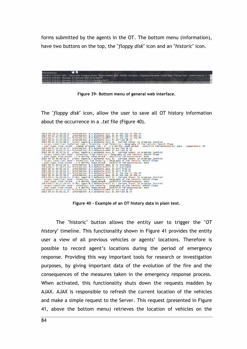
84
forms submitted by the agents in the OT. The bottom menu (information),
have two buttons on the top, the "floppy disk" icon and an "historic" icon.
Figure 39- Bottom menu of general web interface.
The "floppy disk" icon, allow the user to save all OT history information
about the occurrence in a .txt file (Figure 40).
Figure 40 - Example of an OT history data in plain text.
The "historic" button allows the entity user to trigger the "OT
history" timeline. This functionality shown in Figure 41 provides the entity
user a view of all previous vehicles or agents’ locations. Therefore is
possible to record agent’s locations during the period of emergency
response. Providing this way important tools for research or investigation
purposes, by giving important data of the evolution of the fire and the
consequences of the measures taken in the emergency response process.
When activated, this functionality shuts down the requests madden by
AJAX. AJAX is responsible to refresh the current location of the vehicles
and make a simple request to the Server. This request (presented in Figure
41, above the bottom menu) retrieves the location of vehicles on the

85
selected time defined by users, by selection of the time in the horizontal
scrollbar presented in Figure 41 (above the bottom menu).
Figure 41 - OT History functionality.
The EmergenSIG Web application also provides content information
about all graphical objects represented on the map. Figure 42 shows two
triangle shapes, which represents the SitPo sent by the agents. Clicking
above the shape triggers one info window, with all useful information for
the entity. This information contains the coordinates of the SitPo, the
information of the issuing agent and the data content of the SitPo, the
orientation and the location of the submission. Other objects represented
on the map, such as agent marker, also are clickable presenting the agent
basic information.
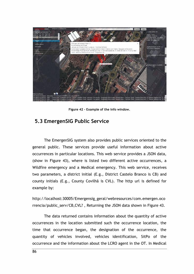
86
Figure 42 - Example of the info window.
5.3 EmergenSIG Public Service
The EmergenSIG system also provides public services oriented to the
general public. These services provide useful information about active
occurrences in particular locations. This web service provides a JSON data,
(show in Figure 43), where is listed two different active occurrences, a
Wildfire emergency and a Medical emergency. This web service, receives
two parameters, a district initial (E.g., District Castelo Branco is CB) and
county initials (E.g., County Covilhã is CVL). The http url is defined for
example by:
http://localhost:30005/Emergensig_geral/webresources/com.emergen.oco
rrencia/public_serv/CB,CVL? , Returning the JSON data shown in Figure 43.
The data returned contains information about the quantity of active
occurrences in the location submitted such the occurrence location, the
time that occurrence began, the designation of the occurrence, the
quantity of vehicles involved, vehicles identification, SitPo of the
occurrence and the information about the LCRO agent in the OT. In Medical
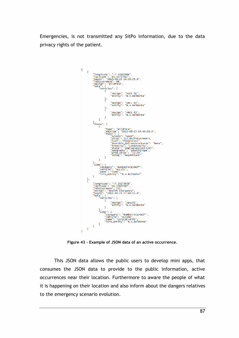
87
Emergencies, is not transmitted any SitPo information, due to the data
privacy rights of the patient.
Figure 43 - Example of JSON data of an active occurrence.
This JSON data allows the public users to develop mini apps, that
consumes the JSON data to provide to the public information, active
occurrences near their location. Furthermore to aware the people of what
it is happening on their location and also inform about the dangers relatives
to the emergency scenario evolution.

88
5.4 EmergenSIG Web Interface for Medical
Emergencies
The main goal of the Web application is to provide a set of tools that
enables the control of agents in a mobility environment. Figure 44 presents
the user’s interface of the EmergenSIG Web application for Medical
emergencies. This view informs the medical staff trough visual and beep
sound alarms who requested the green line and how long the ambulance
takes to arrive at the hospital. Furthermore, it points the current
geographic ambulance position and provides information, such as the
patient state condition. At the bottom of the screen is shown the SitPo
data and the patient health records submitted by the agent. The green line
alarm dialog is triggered by any agent request. This dialog describes the
information about the request and the vehicle that transports the patient.
Furthermore, it provides the direct link to more information about
the patient health status, the agent, and the estimated time for the
hospital arrival. Red dialog inform the medical staff, about who is the
agent that send the green line alarm. Above the red dialog, is shown an
dialog with the SitPo information, which describe the patient condition.
This dialog appears after the click of the user in the SitPo information
listed on the bottom menu of the interface.

89
Figure 44 - EmergenSIG Web Interface for Medical Emergencies.


91
6. System Validation
This chapter focuses on the performance validation of EmergenSIG
framework. Firstly it presents simulated cases scenarios, through simulated
scenarios with real agents, in order to collect real operational data and
simultaneously evaluating the system performance. Afterwards, the results
of the EmergenSIG users surveys, accessing the user experience, are
presented.
6.1 Simulated Cases Demonstration
This simulated case scenario, is a wildfire emergency and a Medical
emergency scenario, involving real agents in duty. On all exercises it was
possible to verify good integration of the EmergenSIG system with the
agents.
6.1.1 Wildfire emergency response process with
use of EmergenSIG system
The simulation begins with a phone call from the respective DCRO to
the Firefighters department communications operator agent. The operator
describes a wildfire occurrence in evolution, including its location and
number identification. In that moment, is given the order to VRCI-
01(vehicle) and their agents to move to the wildfire ignition location. One
agent of VRCI-01 executes the login in EmergenSIG mobile application,
selecting their vehicle and inserting the occurrence number. Automatically
creating a new occurrence with the number inserted. The communication

92
operator is warned with buzz sound played by the EmergenSIG web
application, warning that new occurrence was created by one of their Dpt.
agents. While the agent is on the way to the emergency OT, the
communications operator can see VRCI-01’s real location on the web
application’s map. Few minutes after, the agent sends to the system the
status "In the local”. Immediately the EmergenSIG system defines the
agent, as the OT’s LCRO. The firefighters department is informed of the
agent arrival on the OT. After the agent reached the site and sent a SitPo
of the occurrence, it is requested more vehicles to support the emergency
response process on the field. The DRCO and the firefighters department
are informed about the actual situation of the wildfire evolution and the
deflagration orientation (provided by the SitPo handlers). Immediately, it
orders are given to VRCI-02 to proceed to the emergency site. One of the
VRCI-02 agents did the login procedures, selected their vehicle on the list
provided by the system, and selected the respective active occurrence of
their Dpt., listed in the mobile application. Afterwards, DRCO, Firefighters
Department and the new LCRO agent (agent of VRCI 01) were warned that
the VRCI 02 was on the way to the occurrence to support VRCI 01. Through
the mobile application, VRCI 02 agent requests the path made by VRCI-01
agent to reach the OT epicentre, in order to know how to reach the site.
After following the "red line" path, the agent reaches the OT epicentre and
presses the status "In the local". Firefighters department, DCRO and LCRO
are informed about the new status sent by VRCI 02 agent. VRCI 02 agent
submitted the LCRO request functionality; in that moment, VRCI 01 agent
(current LCRO) is warned by the request with beeping sounds and vibrations
and accepts the request. Simultaneously, the system changes the LCRO
agent status of VRCI 02 agent, submitting a new occurrence SitPo.
Firefighters Dpt. and DRCO are warned about the new occurrence SitPo
sent. VRCI 01 agent are also informed, but only through "Occurrence Info"
functionality, where it is only possible to see the last SitPo sent by the last
LCRO agent. In SitPo form, it is described that the occurrence is
dominated. VRCI 01 pressed status button "Available", and the system

93
informed DCRO, Firefighters Dpt. and LCRO that the agent are available
and on the way to their operational base and on exit process of the OT.
Afterwards, VRCI 02 sends an available status and the system close the
wildfire occurrence playing the buzz sound in the entities view of
EmergenSIG Web Application.
All the tasks in this demonstration have been performed with 100% of
efficiency, with some communications delays, due to the beta edition of
the EmergenSIG system.
6.1.2 Medical Emergency response process with
use of EmergenSIG system
The exercise begins with a call made from GCUP to firefighters Dpt.
informing a sudden illness situation in the region under responsibility of the
firefighters Dpt. The GCUP informs the patient location and the occurrence
identification number. The communication operator informs the personnel
to attend to the patient location. Immediately, firefighters login in the
EmergenSIG system, selecting the ambulance and creating the
Health/Medical Emergency with the occurrence number provided by the
GCUP. After that, firefighters Dpt. and GCUP are informed that the agent
in the ambulance is "on the way" to the occurrence location. Moments
later, the ambulance reached the patient location and the agent submitted
the status "in local", informing GCUP and firefighters Dpt. of the new status
submitted. After the patient health conditions evaluation has been made,
the agent submitted the SitPo describing the patient health condition. It
was possible to determine an anomaly in the cardiac rhythm and in the
blood pressure. The firefighters Dpt. and the GCUP were informed about
the patient health condition. The agent was ordered by GCUP to transport
the patient to the nearest hospital facilities. The agent selected in the
94
EmergenSIG mobile app the nearest hospital of his location. After, was
listed in ascending order the most five nearest hospitals from the agent
location. After the hospital selection, firefighters Dpt. and GCUP were
informed of the destination of the patient. The hospital was also informed
about an ambulance of B.V. Belmonte, with one patient, was coming on the
way to the hospital, and reported that it took 15 minutes to reach the
hospital facilities. After 13 minutes, the patient health condition was
unstable and suffers cardio-respiratory arrest.
The agent have submitted immediately the "green line" alert which
triggers the alarm in the hospital’s urgent care unit view, by an buzz beep
sound play, and informed that the ambulance take two minutes to reach
the facilities, giving enough time to the medical urgency professionals
prepare the advanced life support room. After 2 minutes the ambulance
reached the hospital facilities and the patient was transported to the
advance life support room. Afterwards, the agent have submitted the
status "available", immediately the hospital EmergenSIG web view close the
occurrence, staying only active to the firefighters Dpt. and for GCUP view.
The entities followed the path taken by the ambulance to their base until
the ambulance reached their base, and the agent have pressed button "Ok"
of the status functionality "available". Immediately, the occurrence is
closed.
In these simulated scenarios, the hospital, GCUP, and the DCRO
entities have been simulated by others agents with experience in order to
make these exercises possible and reliable.
6.2 User Survey
The surveys where made in SurveyMonkey.com which provides free
online questionnaire and survey software.
EmergenSIG Web and Mobile application have been deployed,
configured, and was publicly accessible. A total of 38 firefighters of
95
Bombeiros Voluntários de Belmonte, Bombeiros Voluntários da Covilhã and
Bombeiros Voluntários do Entroncamento have answered the survey
questions. They have used the system for their own initiative and after
approximately ten minutes of training for each one. The questions are
shown in Table 3.
In Figure 45 and Table 4 it can be seen that the majority strongly
agree that platform is useful for their purposes, the environment is user
friendly intuitive and easy to use, text blocks are compact and with useful
information, fonts are easy to read, the application help to understand the
geographically reality of the occurrence and its evolution, and the
application help the LCRO agent in the initial emergency response process.
Furthermore, in Figure 45, it is also possible to verify low ratings on
questions 7 and 9. After all survey submissions, it has been made a quick
briefing in order to record the reasons for the low ratings in the highlighted
questions in above. For the low ratings in the Question 7, some users
related that was due to some data communication delays issues caused by
weak GSM signal in some locations, where the mobile application was
tested. In Question 9, users considered that the actual operational
protocols in tactical levels and the response capacity are well implemented
by the Portuguese National Authority. Although the majority of users,
classifies, that the EmergenSIG system helps in tactical procedures on the
emergency initial response cases and in large scale emergencies with a
large number of agents and entities involved.

96
Q1 Is the application useful for their purposes?
Q2 Is the application easy to use?
Q3 Does the application help the LCRO agent in the initial emergency response process?
Q4 Is the application environment user friendly and intuitive?
Q5 Text blocks are written in minimalist style. Are they compact and useful?
Q6 Are Fonts(style, color saturation) easy to read in screen?
Q7 Is the feedback and response time of the application fast enough?
Q8 Does the application help to understand the geographically reality of the occurrence and its evolution?
Q9 Does the application help in tactical procedures? Table 3 - EmergenSIG Survey Questions
Q1 Q2 Q3 Q4 Q5 Q6 Q7 Q8 Q9
Strongly agree
29 33 33 32 29 34 18 35 19
Agree 9 5 5 4 7 4 12 2 13
Tend to agree
0 0 0 2 2 0 7 1 6
Undecided 0 0 0 0 0 0 1 0 0
Tend to disagree
0 0 0 0 0 0 0 0 0
Disagree 0 0 0 0 0 0 0 0 0
Strongly disagree
0 0 0 0 0 0 0 0 0
Table 4 - EmergenSIG Survey Results
Figure 45 -Graph of EmergenSIG Survey Results
0%
10%
20%
30%
40%
50%
60%
70%
80%
90%
100%
Q1 Q2 Q3 Q4 Q5 Q6 Q7 Q8 Q9
Strongly disagree
Disagree
Tend to disagree
Undecided
Tend to agree
Agree
Strongly agree

97
7. Conclusions and Future
Work
This Chapter presents a synthesis of the main achievements and
points several directions for future works.
7.1 Conclusions
This dissertation proposed the development of a ubiquitous solution
of emergency management and location-aware system that promote the
integration and cooperation of different types of agents and entities
mobilized to an emergency scenario called EmergenSIG. This proposal
presents two different modules, a Web application oriented to entities and
a mobile application. Furthermore, it provides to field agents and other
agent’s location in almost real time, a collection of detailed data of the
occurrence through the wildfire situation points and medical emergency
SitPo. A useful solution oriented to the general public in order to provide
useful information about the hazards, caused by the emergencies events,
close the citizen locations was also presented.
Simulated emergency case studies with real agents on the ground
were performed and presented. In these exercises the results were
obtained with 100% efficiency with no messages lost. It was also possible to
verify good integration of the application with the agents. A survey to
evaluate the user experience was also applied to 38 users. The survey
results are very positives concluding that EmergenSIG system helps on the

98
initial emergency response process. It is easy to use, user friendly and
intuitive, and helps agents (LCRO) to understand the geographically reality
of the occurrence in large-scale emergencies. Therefore, all the proposed
objectives were successfully accomplished.
7.2 Future work
To conclude this dissertation, there are some suggestions for further
research works:
Extending the mobile application to other mobile operating systems.
The algorithm development of the device accelerometer to motion
detection on vehicles, in order to save energy expended on the
continuous use of the GPS, due to the constant distance calculation.
Development of solutions for EmergenSIG mobile application, in
order to prevent connection failures in areas not covered by GSM
networks.
Development, of low cost self-update tool for offline mobile maps
API, with current satellites images.
The development, of algorithms to provide dynamic rate of data
retrieving, to prevent unnecessary data refreshing cycles.

99
References
[1]. protection, T.P.n.s.f.f.c. The Portuguese System for Civil Protection. 2005; Available from: http://www.civilprotection.net/index.phtml?id=73.
[2]. Portuguesa, A.d.R., Lei de Bases da Protecção Civil, 2006, Governo Português.
[3]. Civil, A.N.d.P. 2013; Available from: http://www.proteccaocivil.pt/Pages/default.aspx.
[4]. Neto, R.S.M.R., A emergência pré-hospitalar-da rua ao hospital. 2012.
[5]. Coimbra, L., EMERGÊNCIA MÉDICA PRÉ-HOSPITALAR. 2011.
[6]. Médica, I.N.d.E. 2013; Available from: http://www.inem.pt/.
[7]. Viegas, D.X., et al., RELATÓRIO DO INCÊNDIO FLORESTAL DE TAVIRA/SÃO BRÁS DE ALPORTEL. 2012.
[8]. Relvas, P., et al. Estudo para implementação de um sistema de videovigilância florestal no Distrito de Viseu. in Silva, R., Páscoa, F.(eds.) Actas do 5º Congresso Florestal. 2005.
[9]. Amaro, A.D., F. Tedim, and L. Lourenço, O socorro em Portugal: organização, formação e cultura de segurança nos corpos de bombeiros, no quadro da Protecção Civil. 2009.
[10]. Moutinho, M., et al., Avaliação da Via Verde do Acidente Vascular Cerebral no Norte de Portugal: Caracterização e Prognóstico dos Utilizadores. Acta Médica Portuguesa, 2013. 26(2): p. 113-122.
[11]. Ramos, M.J.d.S.M., " Paragem Cardio-respiratória no Pré-hospitalar. Médico Dispensável". 2011.
[12]. Baptista, I.M.d.S., 112–A estrela da vida como se planeia a intervenção da emergência médica pré-hospitalar em Portugal? 2009.
[13]. Médica, I.N.d.E., 1 ano de Gestão, 2011, Instituto Nacional de Emergência Médica: INEM web page.
[14]. Catarci, T., et al. The WORKPAD Project Experience: Improving the Disaster Response through Process Management and Geo Collaboration. in Proceedings of the 7th International Conference on Information Systems for Crisis Response and Management, ISCRAM. 2010.
[15]. Aloudat, A., K. Michael, and R. Abbas. Location-Based Services for Emergency Management: A Multi-stakeholder Perspective. in Mobile

100
Business, 2009. ICMB 2009. Eighth International Conference on. 2009.
[16]. Mansourian, A., et al., Using SDI and web-based system to facilitate disaster management. Computers & Geosciences, 2006. 32(3): p. 303-315.
[17]. Driskell, J.E. and E. Salas, Stress and human performance2013: Psychology Press.
[18]. Civil, A.N.d.P., Diretiva Operacional Nacional nº2 - DECIF, M.d.A. Interna, Editor 2013.
[19]. Bruno D. M. Santos, J.J.P.C.R., Bruno M. C. Silva and Lei Shu, EmergenSIG: An Integrated Location-based System for Medical Emergencies. International Conference on Multimedia Information Technology and Applications, 2013.
[20]. Lv, W., et al. A Distributed Location Based Service Framework of Ubiquitous Computing. in Networking and Distributed Computing (ICNDC), 2010 First International Conference on. 2010. IEEE.
[21]. Satyanarayanan, M., Pervasive computing: Vision and challenges. Personal Communications, IEEE, 2001. 8(4): p. 10-17.
[22]. Michlmayr, M., F. Hunt, and D. Probert. Quality practices and problems in free software projects. in Proceedings of the First International Conference on Open Source Systems. 2005.
[23]. Gartner. Gartner Says Smartphone Sales Grew 46.5 Percent in Second Quarter of 2013 and Exceeded Feature Phone Sales for First Time. 2013 [cited 2013; Available from: http://www.gartner.com/newsroom/id/2573415.
[24]. Guan, L., et al. A survey of research on mobile cloud computing. in Computer and Information Science (ICIS), 2011 IEEE/ACIS 10th International Conference on. 2011. IEEE.
[25]. Bilandzic, M., et al., SociCare: Towards a Context Aware Mobile Community Emergency System, in Mobile Wireless Middleware, Operating Systems, and Applications2010, Springer. p. 338-352.
[26]. Koufi, V., F. Malamateniou, and G. Vassilacopoulos. Ubiquitous access to cloud emergency medical services. in Information Technology and Applications in Biomedicine (ITAB), 2010 10th IEEE International Conference on. 2010. IEEE.
[27]. Fragkiadakis, A.G., et al., Ubiquitous robust communications for emergency response using multi-operator heterogeneous networks. EURASIP Journal on Wireless Communications and Networking, 2011. 2011(1): p. 1-16.
[28]. Ravindranath, L., et al. Demo: code in the air-simplifying tasking on smartphones. in Proceedings of the 10th international conference on Mobile systems, applications, and services. 2012. ACM.
101
[29]. Beach, A., et al. Fusing mobile, sensor, and social data to fully enable context-aware computing. in Proceedings of the Eleventh Workshop on Mobile Computing Systems & Applications. 2010. ACM.
[30]. Petrova, K. and B. Wang, Location-based services deployment and demand: a roadmap model. Electronic Commerce Research, 2011. 11(1): p. 5-29.
[31]. Rosa, P.M., et al. An ubiquitous mobile multimedia system for events agenda. in Wireless Communications and Networking Conference (WCNC), 2012 IEEE. 2012. IEEE.
[32]. Joel JPC, R., O. Marco, and V. Binod, New trends on ubiquitous mobile multimedia applications. EURASIP Journal on Wireless Communications and Networking, 2010. 2010.
[33]. WeatherBug. Weather for Apple iPhone Smartphones. [cited 2013 01-06-2013]; Available from: http://weather.weatherbug.com/mobile.html.
[34]. Femminella, M. and G. Reali. An Experimental System for Continuous Users Tracking in Emergency Scenarios. in Global Telecommunications Conference (GLOBECOM 2011), 2011 IEEE. 2011.
[35]. Fischmeister, S., Mobile software agents for location-based systems, in Agent Technologies, Infrastructures, Tools, and Applications for E-Services2003, Springer. p. 226-239.
[36]. WORKPAD. An Adaptive Peer-to-Peer Software Infrasctructure for Supporting Collaborative Work of Humans Operators in Emergency Disaster Scenarios
[37]. Derekenaris, G., et al., Integrating GIS, GPS and GSM technologies for the effective management of ambulances. Computers, Environment and Urban Systems, 2001. 25(3): p. 267-278.
[38]. Matos, R., et al. A GPS-based Mobile Coordinated Positioning System for Firefighting Scenarios. in Mobile Computing and Wireless Communication International Conference, 2006. MCWC 2006. Proceedings of the First. 2006.
[39]. Monares, Á., et al., Mobile computing in urban emergency situations: Improving the support to firefighters in the field. Expert Systems with Applications, 2011. 38(2): p. 1255-1267.
[40]. Kassab, A., S. Liang, and Y. Gao, Real-time notification and improved situational awareness in fire emergencies using geospatial-based publish/subscribe. International Journal of Applied Earth Observation and Geoinformation, 2010.
[41]. Maglogiannis, I. and S. Hadjiefthymiades, EmerLoc: Location-based services for emergency medical incidents. International journal of medical informatics, 2007. 76(10): p. 747-759.

102
[42]. Kamarudin, N. and S. Salam. Enabling mobile Location Based Services for emergency cases. in Research and Innovation in Information Systems (ICRIIS), 2011 International Conference on. 2011. IEEE.
[43]. Thornycroft, P., Location-based services for cellular phones using Wi-Fi: The University of Cincinnati’s system for emergency call location. University of Cincinnati, White Paper, 2009.
[44]. Hewlett-Packard Location-based services: Consumer research findings from HP and Openwave. 2004. 8.
[45]. Singhal, M. and A. Shukla, Implementation of Location based Services in Android using GPS and Web Services. IJCSI International Journal of Computer Science Issues, 2012. 9(1).
[46]. Rahman, A.A. and S. Zlatanova. Pre-hospital location based services (LBS) for emergency management. in Proceedings of UDMS. 2006.
[47]. Geyer-Schulz, A., M. Ovelgönne, and A.C. Sonnenbichler, A Social Location-Based Emergency Service to Eliminate the Bystander Effect, in e-Business and Telecommunications2012, Springer. p. 112-130.
[48]. I-GOV. Tecnologia permite ao INEM agilizar resposta a emergências. 2011 [cited 2012 14-11-2012]; Available from: http://i-gov.org/index.php?article=16319&visual=1&id=155&subject=223.
[49]. Software, I., Iffire mobile. 2012.
[50]. Huwig, K., Mobile emergency call, 2013.
[51]. (FEMA), F.E.M.A. FEMA. 2013; Available from: https://play.google.com/store/apps/details?id=gov.fema.mobile.android.
[52]. AtHoc. AtHoc Notifier Mobile Application. 2013; Available from: http://www.athoc.com/products/mobile.html.
[53]. Agency, T.E.M., Ready TN. 2012.
[54]. Department of Information Engineering, U.o.F. Mobile Emergency. 2012; Available from: https://itunes.apple.com/us/app/mobile-emergency/id409326454?mt=8.
[55]. Weather Decision Technologies, I. iMap Weather Radio. 2013; Available from: https://play.google.com/store/apps/details?id=com.wdtinc.android.mwr&hl=en.
[56]. Cross, A.R. Hurricane by American Red Cross. 2013; Available from: https://itunes.apple.com/us/app/hurricane-by-american-red/id545689128?mt=8&ign-mpt=uo%3D2.
[57]. Developers, A. What is Android? | Android Developers. [cited 2012; Available from: http://developer.android.com/about/index.html.

103
[58]. Developers, A. Android Development Tools Plugin. 2012; Available from: http://developer.android.com/tools/sdk/eclipse-adt.html.
[59]. MySQL.com, My SQL Workbench.
[60]. Silva, B.M., et al., A Data Encryption Solution for Mobile Health Apps in Cooperation Environments. Journal of medical Internet research, 2013. 15(4).
[61]. Ed.6, J.P.S. Class UUID. Available from: http://docs.oracle.com/javase/6/docs/api/java/util/UUID.html.
[62]. Civil, A.d.P., Guia de Comando e Controlo.
[63]. Scott, J.H. and R.E. Burgan, Standard fire behavior fuel models: a comprehensive set for use with Rothermel's surface fire spread model. The Bark Beetles, Fuels, and Fire Bibliography, 2005: p. 66.
[64]. Scott, J.H. Introduction to Fire Behavior Modeling. 2012.
[65]. Andrews, P.L., Modeling wind adjustment factor and midflame wind speed for Rothermel's surface fire spread model2012: United States Department of Agriculture/Forest Service, Rocky Mountain Research Station.


105
Appendix

106