emergency action plan - department of natural resources...
TRANSCRIPT
EMERGENCY ACTION PLAN
COOBY DAM
ISSUE DATE: SEPTEMBER 2018
APPROVED BY DNRME UNTIL 3 JUNE 2022
Copy No.
QP-M-086 COOBY DAM EMERGENCY ACTION PLAN
TOOWOOMBA REGIONAL COUNCIL
TABLE OF CONTENTS
DOCUMENT CONTROL SHEET CONTROL DISTRIBUTION SHEETS
SECTION 1 COOBY DAM EMERGENCY ACTION PLAN
1.0 INTRODUCTION
1.1 DAM SAFETY INSPECTION AND SURVEILLANCE
1.2 RESPONSIBILITY OF PERSONNEL FOR THE ACTIVATION AND DEACTIVATION OF COOBY EAP
1.3 RESPONSIBILITY OF STAKEHOLDER NOTIFICATION – TRC LDMG
1.4 PROCEDURE FOR COOBY DAM DOWNSTREAM NOTIFICATIONS
1.5 FLOOD NOTIFICATION SYSTEMS, UPDATES AND FREQUENCY OF NOTIFICATIONS
1.6 SYSTEMS USED FOR DISSEMINATION OF WARNING NOTIFICATIONS
1.7 ENTITY NOTIFICATION TABLES
SECTION 2 EMERGENCY MANAGEMENT TRAINING AND EXERCISES
2.1 STAFF TRAINING ON DAM SAFETY AND EAP EXERCISES
2.2 EMERGENCY PREPAREDNESS EXERCISES BY TRC LDMG
2.3 REFERENCE DOCUMENTS AVAILABLE FOR PUBLIC KNOWLEDGE
2.4 DAM HAZARD EVALUATION PROCEDURE AND DEFINITION OF ACTIONS
SECTION 3 GENERAL OVERVIEW OF COOBY DAM 3.1 PURPOSE OF THE DAM
3.2 LOCATION OF THE COOBY DAM
3.3 DAM DEFINING FEATURES / TECHNICAL INFORMATION
3.4 OVERVIEW OF PAR (PERSONS AT RISK)
3.5 ASSOCIATED MAPS
SECTION 4 FLOOD RELATED DAM HAZARD EVENTS AND PROCEDURES
4.0 INTRODUCTION
4.1 FLOOD HAZARD EVENTS
4.2 RESPONSIBILITIES OF TRC DAM SAFETY GROUP
4.3 EMERGENCY EVENT REPORTING
SECTION 5 NON-FLOOD RELATED DAM HAZARD EVENTS AND PROCEDURES
5.0 INTRODUCTION
5.1 NON-FLOOD HAZARD EVENTS
5.2 RESPONSIBILITIES OF TRC DAM SAFETY GROUP
5.3 EMERGENCY EVENT REPORTING
QP-M-086 COOBY DAM EMERGENCY ACTION PLAN
TOOWOOMBA REGIONAL COUNCIL
SECTION 6 DOWNSTREAM INUNDATION MAPS
DETAILS OF POLYGONS FOR STATE DISASTER COORDINATION CENTRE
ANNEXURES
SECTION 1.0
ANNEXURE 1.1 FUNCTIONAL RESPONSIBILITIES OF DAM SAFETY MANAGEMENT GROUP
ANNEXURE 1.2 TRC ORGANISATIONAL CHART
ANNEXURE 1.3 EVENT DEFINITIONS
SECTION 3.0
ANNEXURE 3.1 LOCATION MAPS
ANNEXURE 3.2 ROUTE MAP TO COOBY DAM
ANNEXURE 3.3 ALTERNATIVE ROUTE MAP
ANNEXURE 3.4 GENERAL LAYOUT OF COOBY DAM
ANNEXURE 3.5 DETAILS OF THE FACING SLAB
ANNEXURE 3.6 DETAILS OF THE WING WALL
SECTION 4.0 & 5.0 EMERGENCY EVENTS REPORTS, GRAPHS AND FORMS
ANNEXURE 4.1 LOCATION OF IDENTIFIED PROPERTIES WITHIN 5 KM OF THE DAM
ANNEXURE 4.2 COOBY DAM ROAD CLOSURE MAPS
ANNEXURE 4.3 FLOOD RAINFALL RECORD SHEETS
ANNEXURE 4.4 RESERVOIR LEVELS GRAPHS
ANNEXURE 4.5 EVENT LOG SHEET
ANNEXURE 4.6 RECORD OF COMMUNICATION SHEET
ANNEXURE 4.7 STATUS REPORT
ANNEXURE 4.8 EMERGENCY EVENT REPORT FORMAT
ANNEXURE 4.9 COOBY DAM SPILLWAY CURVE RATING
ANNEXURE 4.10 COOBY RESERVOIR STORAGE CURVE
ANNEXURE 4.11 COOBY DAM INSTRUMENTATION LOCATION MAP
ANNEXURE 5.1 MERCALLI INTENSITY SCALE FOR EARTHQUAKE INTENSITIES
QP-M-086 COOBY DAM EMERGENCY ACTION PLAN
TOOWOOMBA REGIONAL COUNCIL
LIST OF TABLES TABLE 1.1 DOWNSTREAM NOTIFICATION BY WATER SERVICES WITHIN 5 KM OF DAM
TABLE 1.2 NOTIFICATIONS OF DOWNSTREAM PROPERTIES BY LDCC – STAND UP PROCESS
TABLE 1.3 NOTIFICATIONS OF DOWNSTREAM PROPERTIES BY LDCC – ALL CLEAR
TABLE 1.4 FORM OF COMMUNICTAION
TABLE 1.5 ENTITY NOTIFICATION TABLES
TABLE 1.5.1 TRC STAFF EMERGENCY CONTACT DETAILS
TABLE 1.5.2 DETAILS OF DOWNSTREAM RESIDENTS WITHIN 5KM
TABLE 1.5.3 EXTERNAL EMERGENCY CONTACT DETAILS
TABLE 1.5.4 BUREAU OF METEOROLOGY EMERGENCY CONTACT DETAILS
TABLE 2.1 TRC INTERNAL REFERENCE DOCUMENTATION
TABLE 3.1 SPECIFIC LOCATION DETAILS OF COOBY DAM
TABLE 3.2 DESIGN AND CONSTRUCTION DETAILS OF COOBY DAM
TABLE 3.3 TECHNICAL DETAILS OF COOBY DAM
TABLE 3.4 RISK RATINGS
TABLE 4.1 DETAILS OF DOWNSTREAM RESIDENTS WITHIN 5 KM
TABLE 4.2 INSPECTIONS DURING RESERVOIR RISING LEVELS
TABLE 4.3 DAM FLOOD HAZARD EVENT TRIGGER TABLE
TABLE 5.1 FREQUENCIES OF DAM INSPECTIONS DURING NON-FLOOD EMERGENCY EVENT
TABLE 5.2 EMERGENCY CONDITION LEVEL TRIGGERS DURING SUNNY DAY FAILURE
TABLE 5.3 EMERGENCY CONDITION LEVEL TRIGGERS DURING STRUCTURAL DAMAGE TO THE DAM
TABLE 5.4 INSPECTIONS AFTER AN EARTHQUAKE
LIST OF FIGURES
FIGURE 4.1 COOBY DAM EMERGENCY EVENTS AND STANDUP PROCEDURES – FLOOD EVENTS
FIGURE 4.2 COOBY DAM EMERGENCY EVENTS AND STANDDOWN PROCEDURES – FLOOD EVENTS
FIGURE 5.1 COOBY DAM EMERGENCY EVENTS AND STANDUP PROCEDURES – NON FLOOD EVENTS
FIGURE 5.2 COOBY DAM EMERGENCY EVENTS AND STANDDOWN PROCEDURES – NON FLOOD EVENT
FIGURE 6.1 COOBY DAM POLYGON 1 – SDCC REF AL2_EV2_SF
FIGURE 6.2 COOBY DAM POLYGON 2 – SDCC REF EV3
ABBREVIATIONS
AV1 ALERT STAGE 1
AV2 ALERT STAGE 1
EV1 EVENT STAGE 1
EV2 EVENT STAGE 2
EV3 EVENT STAGE 3
EV4 EVENT STAGE 4
EV5 EVENT STAGE 5
QP-M-086 COOBY DAM EMERGENCY ACTION PLAN
TOOWOOMBA REGIONAL COUNCIL
COOBY DAM EMERGENCY ACTION PLAN
QP-M-086 COOBY DAM EMERGENCY ACTION PLAN
TOOWOOMBA REGIONAL COUNCIL
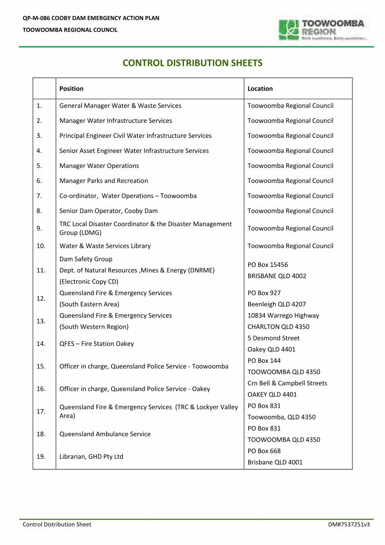
Control Distribution Sheet DM#7537251v3
CONTROL DISTRIBUTION SHEETS
Position Location
1. General Manager Water & Waste Services Toowoomba Regional Council
2. Manager Water Infrastructure Services Toowoomba Regional Council
3. Principal Engineer Civil Water Infrastructure Services Toowoomba Regional Council
4. Senior Asset Engineer Water Infrastructure Services Toowoomba Regional Council
5. Manager Water Operations Toowoomba Regional Council
6. Manager Parks and Recreation Toowoomba Regional Council
7. Co-ordinator, Water Operations – Toowoomba Toowoomba Regional Council
8. Senior Dam Operator, Cooby Dam Toowoomba Regional Council
9. TRC Local Disaster Coordinator & the Disaster Management Group (LDMG)
Toowoomba Regional Council
10. Water & Waste Services Library Toowoomba Regional Council
11.
Dam Safety Group
Dept. of Natural Resources ,Mines & Energy (DNRME)
(Electronic Copy CD)
PO Box 15456
BRISBANE QLD 4002
12. Queensland Fire & Emergency Services
(South Eastern Area)
PO Box 927
Beenleigh QLD 4207
13. Queensland Fire & Emergency Services
(South Western Region)
10834 Warrego Highway
CHARLTON QLD 4350
14. QFES – Fire Station Oakey 5 Desmond Street
Oakey QLD 4401
15. Officer in charge, Queensland Police Service - Toowoomba PO Box 144
TOOWOOMBA QLD 4350
16. Officer in charge, Queensland Police Service - Oakey Crn Bell & Campbell Streets
OAKEY QLD 4401
17. Queensland Fire & Emergency Services (TRC & Lockyer Valley Area)
PO Box 831
Toowoomba, QLD 4350
18. Queensland Ambulance Service PO Box 831
TOOWOOMBA QLD 4350
19. Librarian, GHD Pty Ltd PO Box 668
Brisbane QLD 4001
QP-M-086 COOBY DAM EMERGENCY ACTION PLAN
TOOWOOMBA REGIONAL COUNCIL
Section 1 Page 1 DM#7537251v3
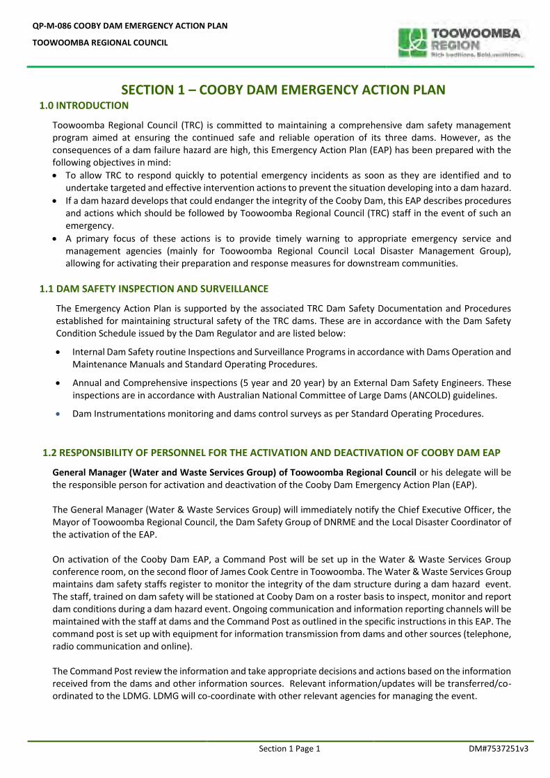
SECTION 1 – COOBY DAM EMERGENCY ACTION PLAN 1.0 INTRODUCTION
Toowoomba Regional Council (TRC) is committed to maintaining a comprehensive dam safety management program aimed at ensuring the continued safe and reliable operation of its three dams. However, as the consequences of a dam failure hazard are high, this Emergency Action Plan (EAP) has been prepared with the following objectives in mind:
To allow TRC to respond quickly to potential emergency incidents as soon as they are identified and to undertake targeted and effective intervention actions to prevent the situation developing into a dam hazard.
If a dam hazard develops that could endanger the integrity of the Cooby Dam, this EAP describes procedures and actions which should be followed by Toowoomba Regional Council (TRC) staff in the event of such an emergency.
A primary focus of these actions is to provide timely warning to appropriate emergency service and management agencies (mainly for Toowoomba Regional Council Local Disaster Management Group), allowing for activating their preparation and response measures for downstream communities.
1.1 DAM SAFETY INSPECTION AND SURVEILLANCE
The Emergency Action Plan is supported by the associated TRC Dam Safety Documentation and Procedures established for maintaining structural safety of the TRC dams. These are in accordance with the Dam Safety Condition Schedule issued by the Dam Regulator and are listed below:
Internal Dam Safety routine Inspections and Surveillance Programs in accordance with Dams Operation and Maintenance Manuals and Standard Operating Procedures.
Annual and Comprehensive inspections (5 year and 20 year) by an External Dam Safety Engineers. These inspections are in accordance with Australian National Committee of Large Dams (ANCOLD) guidelines.
Dam Instrumentations monitoring and dams control surveys as per Standard Operating Procedures.
1.2 RESPONSIBILITY OF PERSONNEL FOR THE ACTIVATION AND DEACTIVATION OF COOBY DAM EAP
General Manager (Water and Waste Services Group) of Toowoomba Regional Council or his delegate will be the responsible person for activation and deactivation of the Cooby Dam Emergency Action Plan (EAP). The General Manager (Water & Waste Services Group) will immediately notify the Chief Executive Officer, the Mayor of Toowoomba Regional Council, the Dam Safety Group of DNRME and the Local Disaster Coordinator of the activation of the EAP.
On activation of the Cooby Dam EAP, a Command Post will be set up in the Water & Waste Services Group conference room, on the second floor of James Cook Centre in Toowoomba. The Water & Waste Services Group maintains dam safety staffs register to monitor the integrity of the dam structure during a dam hazard event. The staff, trained on dam safety will be stationed at Cooby Dam on a roster basis to inspect, monitor and report dam conditions during a dam hazard event. Ongoing communication and information reporting channels will be maintained with the staff at dams and the Command Post as outlined in the specific instructions in this EAP. The command post is set up with equipment for information transmission from dams and other sources (telephone, radio communication and online). The Command Post review the information and take appropriate decisions and actions based on the information received from the dams and other information sources. Relevant information/updates will be transferred/co-ordinated to the LDMG. LDMG will co-coordinate with other relevant agencies for managing the event.
QP-M-086 COOBY DAM EMERGENCY ACTION PLAN
TOOWOOMBA REGIONAL COUNCIL
Section 1 Page 2 DM#7537251v3
1.3 RESPONSIBILITY OF STAKE HOLDER NOTIFICATION
Toowoomba Regional Council Local Disaster Management Group (LDMG) has the legislated responsibility for coordination of the LDMG agencies, community organisations and non-for-profits invested in disaster management for the Toowoomba Region. The Mayor (Toowoomba Regional Council) is the Chairperson of the LDMG. The LDMG has in place plans and processes, including the endorsed Local Disaster Management Plan (available online here), that details the Prevention, Preparedness, Response and Recovery arrangements for the Toowoomba Region. The LDMG is facilitated by TRC’s Disaster Management Unit to achieve the functions set out in in s30 of the Disaster Management Act 2003. The LDMG meets three times a year, regularly reviews their plans, conducts training, holds an annual exercise tailored to the specific requirements to the Toowoomba Region’s context. In the event of a potential disaster impacting the Toowoomba Region, there is an activation process in place to ensure effective communication across all parties to maintain situational awareness and readiness to respond . A key step of preparedness for disasters is the operational readiness of the Local Disaster Coordination Centre (LDCC). The LDCC’s primary location is in the Toowoomba Regional Council Customer Service Centre at Little Street, Toowoomba. During an activation it is manned by trained TRC staff and Agency Liaison Officers for efficient communication and coordination of activities to ensure public safety. The LDCC operates as per LDCC Standard Operating Procedures and is equipped with the required resources.
The TRC Dam Safety Management Group has an ongoing collaboration with the TRC Local Disaster Coordinator (LDC) and LDMG. Two way communication flows is established early between the Dam Safety Management Group and the LDCC to ensure region wide situational awareness is maintained. Depending on the disaster the EAP and the LDCC/LDMG may activate independently of each other or simultaneously. Regardless, continual notifications and reporting occurs between stakeholders.
Entity Notification Table of the stakeholders who are responsible for the Cooby Dam Emergency Action Plan and other important emergency contact numbers are given in Section 1.5 below. 1.4 PROCEDURE FOR COOBY DAM DOWNSTREAM NOTIFICATIONS Notification of the population at risk downstream from Cooby Dam is supported by the LDMG. If the LDCC is activated at the time of a threat being detected, then the functional groups will enact the necessary steps to ensure the warnings and advice are issued. If the LDCC is not activated at the time of downstream notifications being required, then the LDC and Chair of the LDMG will consult on whether the centre is activated in response to the hazard posed by the dam. Either way, there are public information and warnings processes in place, including and not limited to the pre-formatted and lodged Emergency Alerts, multi modal media platforms, door knocking and loud hailer public addressing systems, to warn the community. As there are NO control gates installed in Cooby Dam spillway, during flood events there will be ONLY spillway flows which are uncontrolled flows. A shared data sheet will be maintained in the TRC document management system with the following information for LDCC use.
a. Dam Levels and depth over spillway
b. Spillway Outflows Cooby Dam Downstream Inundation maps are given in Section 6.0 for each identified hazard event. An electronic file with a list of properties that could potentially be affected in case of Cooby Dam related hazard event will be made available for LDCC use. However this information is based ONLY on Cooby Dam outflows and does NOT include downstream flooding due to outflows from other sub-catchments. TRC Regional Flood Forecasting Team at LDCC will advise downstream flooding during flood related emergencies.
QP-M-086 COOBY DAM EMERGENCY ACTION PLAN
TOOWOOMBA REGIONAL COUNCIL
Section 1 Page 3 DM#7537251v3
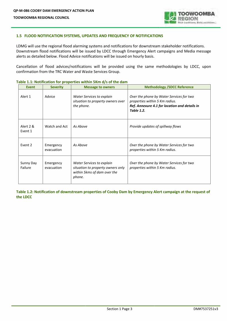
1.5 FLOOD NOTIFICATION SYSTEMS, UPDATES AND FREQUENCY OF NOTIFICATIONS LDMG will use the regional flood alarming systems and notifications for downstream stakeholder notifications. Downstream flood notifications will be issued by LDCC through Emergency Alert campaigns and Media message alerts as detailed below. Flood Advice notifications will be issued on hourly basis. Cancellation of flood advices/notifications will be provided using the same methodologies by LDCC, upon confirmation from the TRC Water and Waste Services Group.
Table 1.1: Notification for properties within 5Km d/s of the dam
Event Severity Message to owners Methodology /SDCC Reference
Alert 1
Advice
Water Services to explain situation to property owners over the phone.
Over the phone by Water Services for two properties within 5 Km radius. Ref. Annexure 4.1 for location and details in Table 1.2.
Alert 2 & Event 1
Watch and Act
As Above
Provide updates of spillway flows
Event 2
Emergency evacuation
As Above
Over the phone by Water Services for two properties within 5 Km radius.
Sunny Day Failure
Emergency evacuation
Water Services to explain situation to property owners only within 5kms of dam over the phone.
Over the phone by Water Services for two properties within 5 Km radius.
Table 1.2: Notification of downstream properties of Cooby Dam by Emergency Alert campaign at the request of the LDCC
QP-M-086 COOBY DAM EMERGENCY ACTION PLAN
TOOWOOMBA REGIONAL COUNCIL
Section 1 Page 4 DM#7537251v3
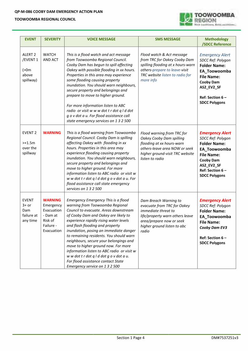
EVENT SEVERITY VOICE MESSAGE SMS MESSAGE Methodology /SDCC Reference
ALERT 2 /EVENT 1 (>0m above spillway)
WATCH AND ACT
This is a flood watch and act message from Toowoomba Regional Council. Cooby Dam has begun to spill affecting Oakey with possible flooding in xx hours. Properties in this area may experience some flooding causing property inundation. You should warn neighbours, secure property and belongings and prepare to move to higher ground. For more information listen to ABC radio or visit w w w dot t r dot q l d dot g o v dot a u. For flood assistance call state emergency services on 1 3 2 500
Flood watch & Act message from TRC for Oakey Cooby Dam spilling flooding at x hours-warn others-prepare to leave-visit TRC website listen to radio for more info
Emergency Alert SDCC Ref: Polygon
Folder Name: EA_Toowoomba File Name: Cooby Dam AS2_EV2_SF Ref: Section 6 –SDCC Polygons
EVENT 2 >+1.5m over the spillway
WARNING
This is a flood warning from Toowoomba Regional Council. Cooby Dam is spilling affecting Oakey with flooding in xx hours. Properties in this area may experience flooding causing property inundation. You should warn neighbours, secure property and belongings and move to higher ground. For more information listen to ABC radio or visit w w w dot t r dot q l d dot g o v dot a u. For flood assistance call state emergency services on 1 3 2 500
Flood warning from TRC for Oakey Cooby Dam spilling flooding at xx hours-warn others-leave area NOW or seek higher ground-visit TRC website listen to radio
Emergency Alert SDCC Ref: Polygon
Folder Name: EA_Toowoomba File Name: Cooby Dam AS2_EV2_SF Ref: Section 6 –SDCC Polygons
EVENT 3+ or Dam failure at any time
WARNING Emergency Evacuation - Dam at Risk of Failure - Evacuation
Emergency Emergency This is a flood warning from Toowoomba Regional Council to evacuate. Areas downstream of Cooby Dam and Oakey are likely to experience rapidly rising water levels and flash flooding and property inundation, posing an immediate danger to remaining residents. You should warn neighbours, secure your belongings and move to higher ground now. For more information listen to ABC radio or visit w w w dot t r dot q l d dot g o v dot a u. For flood assistance contact State Emergency service on 1 3 2 500
Dam Breach Warning to evacuate from TRC for Oakey immediate threat to life/property warn others leave area/prepare now or seek higher ground listen to abc radio
Emergency Alert SDCC Ref: Polygon
Folder Name: EA_Toowoomba File Name: Cooby Dam EV3 Ref: Section 6 –SDCC Polygons
QP-M-086 COOBY DAM EMERGENCY ACTION PLAN
TOOWOOMBA REGIONAL COUNCIL
Section 1 Page 5 DM#7537251v3
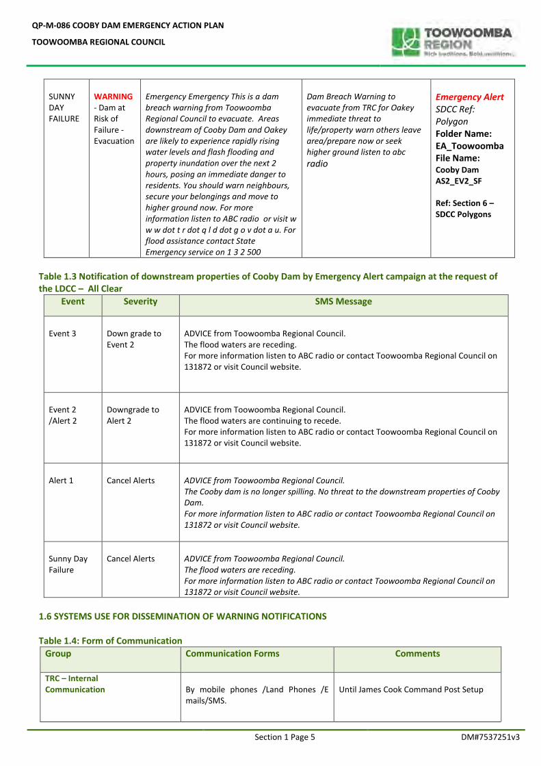
SUNNY DAY FAILURE
WARNING - Dam at Risk of Failure - Evacuation
Emergency Emergency This is a dam breach warning from Toowoomba Regional Council to evacuate. Areas downstream of Cooby Dam and Oakey are likely to experience rapidly rising water levels and flash flooding and property inundation over the next 2 hours, posing an immediate danger to residents. You should warn neighbours, secure your belongings and move to higher ground now. For more information listen to ABC radio or visit w w w dot t r dot q l d dot g o v dot a u. For flood assistance contact State Emergency service on 1 3 2 500
Dam Breach Warning to evacuate from TRC for Oakey immediate threat to life/property warn others leave area/prepare now or seek higher ground listen to abc radio
Emergency Alert SDCC Ref: Polygon Folder Name: EA_Toowoomba File Name: Cooby Dam AS2_EV2_SF Ref: Section 6 –SDCC Polygons
Table 1.3 Notification of downstream properties of Cooby Dam by Emergency Alert campaign at the request of the LDCC – All Clear
Event Severity SMS Message
Event 3
Down grade to Event 2
ADVICE from Toowoomba Regional Council. The flood waters are receding. For more information listen to ABC radio or contact Toowoomba Regional Council on 131872 or visit Council website.
Event 2 /Alert 2
Downgrade to Alert 2
ADVICE from Toowoomba Regional Council. The flood waters are continuing to recede. For more information listen to ABC radio or contact Toowoomba Regional Council on 131872 or visit Council website.
Alert 1
Cancel Alerts
ADVICE from Toowoomba Regional Council. The Cooby dam is no longer spilling. No threat to the downstream properties of Cooby Dam. For more information listen to ABC radio or contact Toowoomba Regional Council on 131872 or visit Council website.
Sunny Day Failure
Cancel Alerts
ADVICE from Toowoomba Regional Council. The flood waters are receding. For more information listen to ABC radio or contact Toowoomba Regional Council on 131872 or visit Council website.
1.6 SYSTEMS USE FOR DISSEMINATION OF WARNING NOTIFICATIONS Table 1.4: Form of Communication
Group Communication Forms Comments
TRC – Internal Communication
By mobile phones /Land Phones /E mails/SMS.
Until James Cook Command Post Setup
QP-M-086 COOBY DAM EMERGENCY ACTION PLAN
TOOWOOMBA REGIONAL COUNCIL
Section 1 Page 6 DM#7537251v3
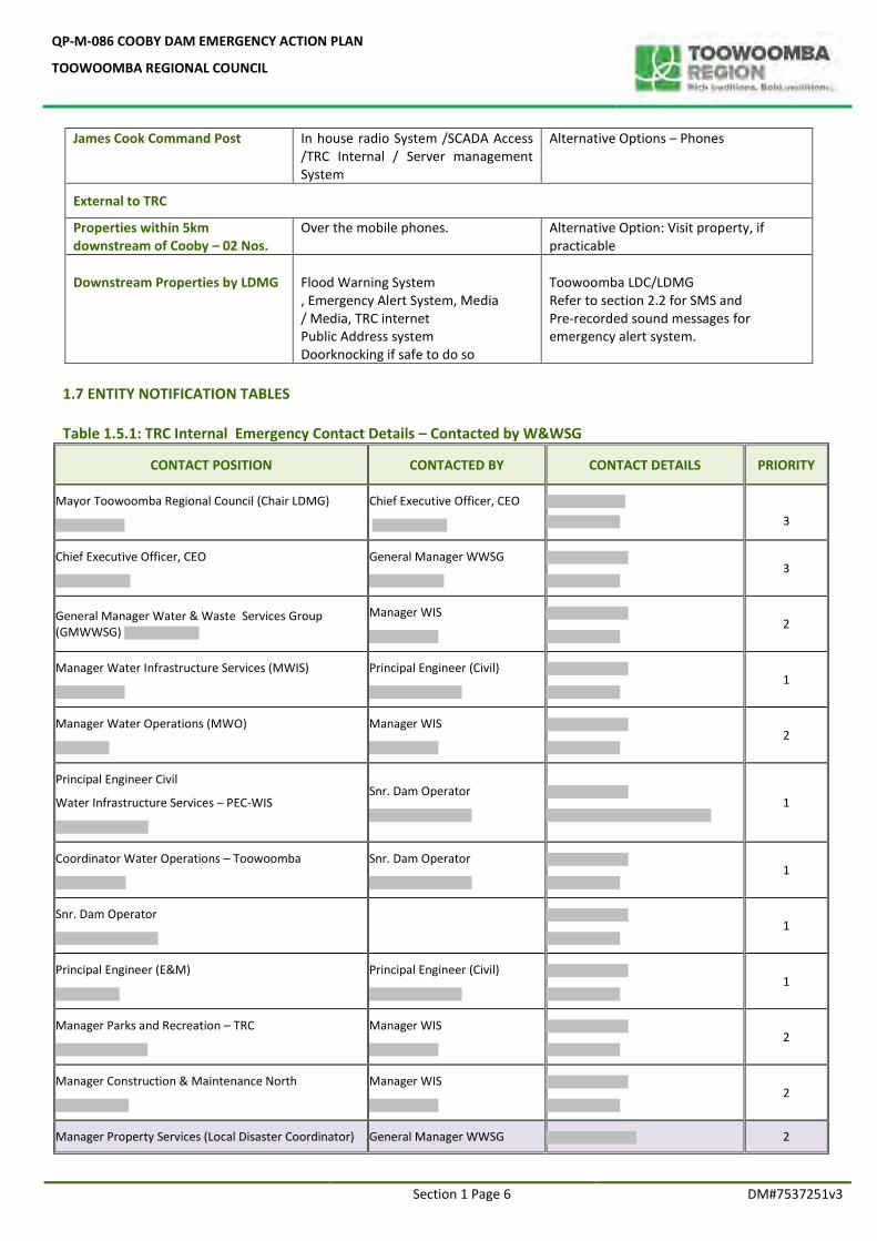
James Cook Command Post In house radio System /SCADA Access /TRC Internal / Server management System
Alternative Options – Phones
External to TRC
Properties within 5km downstream of Cooby – 02 Nos.
Over the mobile phones. Alternative Option: Visit property, if practicable
Downstream Properties by LDMG
Flood Warning System , Emergency Alert System, Media / Media, TRC internet Public Address system Doorknocking if safe to do so
Toowoomba LDC/LDMG Refer to section 2.2 for SMS and Pre-recorded sound messages for emergency alert system.
1.7 ENTITY NOTIFICATION TABLES
Table 1.5.1: TRC Internal Emergency Contact Details – Contacted by W&WSG
CONTACT POSITION CONTACTED BY CONTACT DETAILS PRIORITY
Mayor Toowoomba Regional Council (Chair LDMG)
Chief Executive Officer, CEO
3
Chief Executive Officer, CEO
General Manager WWSG
3
General Manager Water & Waste Services Group (GMWWSG)
Manager WIS
2
Manager Water Infrastructure Services (MWIS)
Principal Engineer (Civil)
1
Manager Water Operations (MWO)
Manager WIS
2
Principal Engineer Civil
Water Infrastructure Services – PEC-WIS
Snr. Dam Operator
1
Coordinator Water Operations – Toowoomba
Snr. Dam Operator
1
Snr. Dam Operator
1
Principal Engineer (E&M)
Principal Engineer (Civil)
1
Manager Parks and Recreation – TRC
Manager WIS
2
Manager Construction & Maintenance North
Manager WIS
2
Manager Property Services (Local Disaster Coordinator) General Manager WWSG 2
QP-M-086 COOBY DAM EMERGENCY ACTION PLAN
TOOWOOMBA REGIONAL COUNCIL
Section 1 Page 7 DM#7537251v3
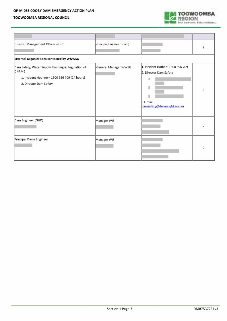
Disaster Management Officer –TRC
Principal Engineer (Civil)
2
External Organizations contacted by W&WSG
Dam Safety, Water Supply Planning & Regulation of DNRME
1. Incident Hot line – 1300 596 709 (24 hours)
2. Director Dam Safety
General Manager WWSG
1. Incident Hotline: 1300 596 709
2. Director Dam Safety
3.E mail: [email protected]
2
Dam Engineer (GHD)
Manager WIS
2
Principal Dams Engineer
Manager WIS
2
QP-M-086 COOBY DAM EMERGENCY ACTION PLAN
TOOWOOMBA REGIONAL COUNCIL
Section 1 Page 8 DM#7537251v3
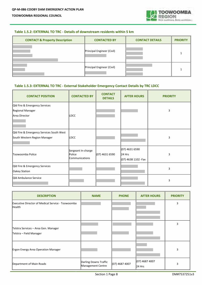
Table 1.5.2: EXTERNAL TO TRC - Details of downstream residents within 5 km
CONTACT & Property Description CONTACTED BY CONTACT DETAILS PRIORITY
Principal Engineer (Civil)
1
Principal Engineer (Civil)
1
Table 1.5.3: EXTERNAL TO TRC - External Stakeholder Emergency Contact Details by TRC LDCC
CONTACT POSITION CONTACTED BY CONTACT DETAILS
AFTER HOURS PRIORITY
Qld Fire & Emergency Services
Regional Manager
Area Director
LDCC
3
Qld Fire & Emergency Services South West
South Western Region Manager
LDCC
3
Toowoomba Police Sergeant In-charge Police Communications
(07) 4631 6590
(07) 4631 6590
24 Hrs
(07) 4638 1102 -Fax
3
Qld Fire & Emergency Services
Oakey Station
3
Qld Ambulance Service
3
DESCRIPTION NAME PHONE AFTER HOURS PRIORITY
Executive Director of Medical Service - Toowoomba Health
3
Telstra Services – Area Gen. Manager
Telstra – Field Manager
3
Ergon Energy Area Operation Manager
3
Department of Main Roads Darling Downs Traffic Management Centre
(07) 4687 4007 (07) 4687 4007
24 Hrs 3
QP-M-086 COOBY DAM EMERGENCY ACTION PLAN
TOOWOOMBA REGIONAL COUNCIL
Section 1 Page 9 DM#7537251v3
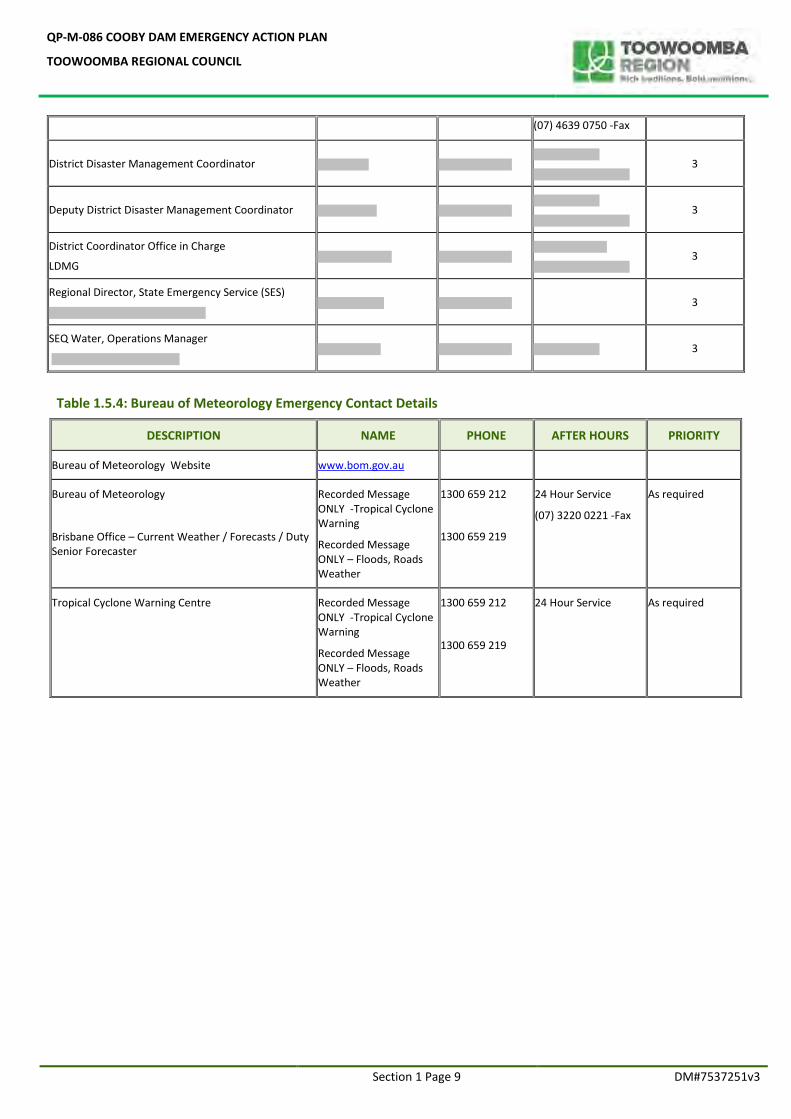
(07) 4639 0750 -Fax
District Disaster Management Coordinator
3
Deputy District Disaster Management Coordinator
3
District Coordinator Office in Charge
LDMG
3
Regional Director, State Emergency Service (SES)
3
SEQ Water, Operations Manager
3
Table 1.5.4: Bureau of Meteorology Emergency Contact Details
DESCRIPTION NAME PHONE AFTER HOURS PRIORITY
Bureau of Meteorology Website www.bom.gov.au
Bureau of Meteorology
Brisbane Office – Current Weather / Forecasts / Duty Senior Forecaster
Recorded Message ONLY -Tropical Cyclone Warning
Recorded Message ONLY – Floods, Roads Weather
1300 659 212
1300 659 219
24 Hour Service
(07) 3220 0221 -Fax
As required
Tropical Cyclone Warning Centre
Recorded Message ONLY -Tropical Cyclone Warning
Recorded Message ONLY – Floods, Roads Weather
1300 659 212
1300 659 219
24 Hour Service
As required
QP-M-086 COOBY DAM EMERGENCY ACTION PLAN
TOOWOOMBA REGIONAL COUNCIL
SECTION 2
EMERGENCY MANAGEMENT TRAINING AND EXERCISES
QP-M-086 COOBY DAM EMERGENCY ACTION PLAN
TOOWOOMBA REGIONAL COUNCIL
Section 2 Page 1 DM#7537251
2.1 STAFF TRAINING ON DAM SAFETY AND EAP EXERCISES
Toowoomba Regional Council employs in-house experienced dam safety inspection and monitoring staff. TRC provides regular ongoing dam safety training, on a five yearly basis for its staff through accredited dam safety training providers. Further, they receive on job training through participation in 3 months of dam safety inspections with in-house engineering staff as well as participating in the annual and comprehensive dam inspections performed by external dam safety engineers. Emergency Action Plans are reviewed, updated and submitted for the Dam Safety Regulator’s approval as per the regulatory requirement. All dam safety staff are involved in providing comments during the review process. The TRC Local Disaster Management staff are involved during the EAP review process and once the draft report is compiled, it is submitted to the LDMG for final comment. Once the reviewing process is completed, the Cooby Dam EAP is submitted for the Dam Safety Regulator (DSR) for approval. An internal stake holder meeting /training is organised to explain the contents of the EAP including amendments and distribute approved copies (hard and electronic versions) for relevant stakeholders as listed in the “Controlled Copy Distribution List”.
2.2 EMERGENCY PREPAREDNESS EXERCISES
Further, Cooby Dam Emergency Action Plan has been exercised in recent times during 2011 and 2013 floods events. After these events, EAP debrief exercises were organised to allow involved dam safety staff to make comments and suggestions for follow up actions. All suggestions have been reviewed and incorporated during EAP revisions. Emergency contacts lists and in-house dam safety emergency staff rosters have been tested and updated on regular basis (annually) for better preparedness. A table top exercise (Exercise “Bernborough”) organized by TRC Local Disaster Management Group have been conducted on Tuesday 31 May 2016 to test the significant amount of infrastructure and software, positioned to enhance the safety of the residents of Oakey, during a significant flooding event, requiring partial evacuation activities. The SOP’s of the TRC Flood Hazards including Cooby dam Emergency Action plans, LDCC (remote location) had been trialled. Participants were the TRC Flood Hazards Group, DM. ICT and representatives from the Local Emergency Coordination Committee (LEC). Memberships of this Group include QPS, QAS, QFES, SES and others. Regular EAP exercises will be undertaken in collaboration with Disaster Management staff on five yearly intervals with participation of all relevant entities and the residents within 5 km of the Cooby dam. A combination of exercise styles will be utilised to meet the training needs and objectives under this EAP. In addition to the above, community education has taken place concerning the activation of Oakey Siren for emergency alert and a SOP has been developed to identify how the siren will be activated in a disaster situation. Moving forward, an upgrade of the Oakey siren is being undertaken and planning is in place to implement new software initiatives to enhance incident management capabilities, stakeholder communications and public information and warnings. Furthermore the Disaster Management Unit will be implementing the Queensland Emergency Risk Management Framework in consultation with Water Infrastructure Services (WIS) staff. Key WIS staff attended a one day workshop with the Hazard and Risk Unit under the Community Resilience and Risk Mitigation, QFES early 2018. During April 2017, there was a preparation exercise carried out for Cooby Dam operational staff prior to the recent Cyclone Debbie.
QP-M-086 COOBY DAM EMERGENCY ACTION PLAN
TOOWOOMBA REGIONAL COUNCIL
Section 2 Page 2 DM#7537251
2.3 REFERENCE DOCUMENTS AVAILABLE FOR PUBLIC KNOWLEDGE
Website: http://www.tr.qld.gov.au/community-business/community-safety/managing-disasters/6264-local-disaster-management-group
Inundation Maps:
Table 2.1 TRC Internal Reference Documents
DM# Reference No. Document description
DM#6288569 TRC Local Disaster Management Plan
DM#4779608 TRC LDCC standing operating procedures
DM#7454046 Cooby EAP - Property Inundation details
DM#6508577 Dams - Status Report and Dam Safety Roster
2.4 DAM HAZARD EVENT EVALUATION PROCEDURE AND DEFINITION OF ACTIONS
The Summary below lists the specific section in this EAP which should be used to evaluate whether the event is a dam hazard event and to identify follow up actions required. TRC Dam Safety Management Group functional responsibilities are listed in Annexure 1.1 and the Organization Chart is listed in Annexure 1.2. Emergency Event definitions are listed in Annexure 1.3. Summary Sections Section 3.0 Technical /Location details of the dam
Section 4.0 Flood related dam hazard events
Section 5.0 Non Flood related dam hazard events
Section 6.0 Downstream Inundation Maps
QP-M-086 COOBY DAM EMERGENCY ACTION PLAN
TOOWOOMBA REGIONAL COUNCIL
SECTION 3
GENERAL OVERVIEW OF COOBY DAM

QP-M-086 COOBY DAM EMERGENCY ACTION PLAN
TOOWOOMBA REGIONAL COUNCIL
General Overview Section 3 Page 1 #7537251v3
SECTION 3.0 GENERAL OVERVIEW OF THE DAM 3.1 PURPOSE OF THE DAM Cooby Dam is owned and operated by the Toowoomba Regional Council (TRC) and impounds one of the reservoirs providing the water supply for the City of Toowoomba. Cooby Dam is located on Cooby Creek, approximately 20km north of Toowoomba. The other water supply dams owned and operated by TRC are Cressbrook Dam and Perseverance Dam. Refer Annexure 3.1: Location Map of Cooby, Cressbrook and Perseverance Dams for details. 3.2 LOCATION AND RELEVANT LDMG Cooby dam can be accessed by travelling north on New England Highway, turning left to Highfields Roads at Highfields where signposted to Cooby Dam. Dam access roads are sealed all-weather roads. Refer Annexure 3.2 for dam access routes map and Annexure 3.3 for alternative access routes map. Table 3.1: Specific Location Details of Cooby Dam
Location Latitude 27° 23’ 01” S and Longitude 151° 56’ 29” E
Local Government Area /LDMG Toowoomba, SE QLD
Nearest Town Meringandan
Stream and AMTD Cooby Creek 8.2km
3.3 DAM DEFINING FEATURES / TECHNICAL INFORMATION Refer Annexure 3.4 for layout of Cooby dam and the cross sectional details. Table 3.2: Design and Construction details of Cooby Dam
Designer (Date) Department of Irrigation and Water Supply (1930s) Upgrade wave wall 1997 GHD, B. Forbes
Construction Authority – Supervisor
Department of Irrigation and Water Supply
Construction Contractor
Construction Period 1938-41
Safety review dates 1990 (Stage 1), 1994 (Stage 2 ), 2011
Table 3.3: Technical Details of Cooby Dam
Dam type Concrete-faced rock fill
Purpose Water supply
Dam Height (above lowest toe) 32m
Dam length 207m
Storage at FSL 23,100 ML
Spillway Type Ungated ogee-controlled spillway with a unlined chute
Outlet Description A dry concrete intake tower with three valved inlets at different levels discharging through a common 600 mm diameter cast iron outlet pipe located in the concrete-lined diversion tunnel on the left bank.
Storage characteristics
Full supply level (FSL) 482.208 m AHD
Storage capacity 23,100 ML
Surface area 300 ha
Length of shoreline Unknown
Spillway capacity FSL is at spillway crest – zero discharge
QP-M-086 COOBY DAM EMERGENCY ACTION PLAN
TOOWOOMBA REGIONAL COUNCIL
Section 3 Page 2 DM#7537251v3
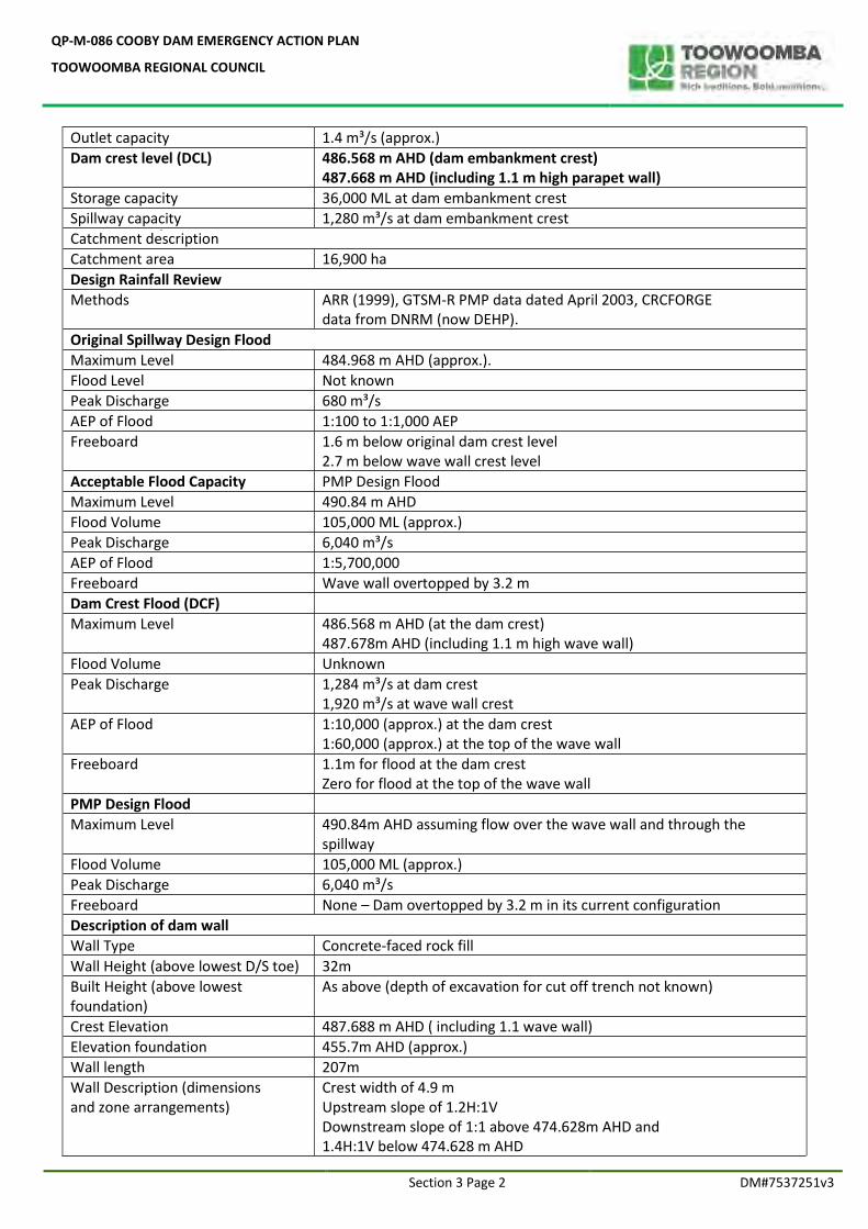
Outlet capacity 1.4 m³/s (approx.)
Dam crest level (DCL) 486.568 m AHD (dam embankment crest) 487.668 m AHD (including 1.1 m high parapet wall)
Storage capacity 36,000 ML at dam embankment crest
Spillway capacity 1,280 m³/s at dam embankment crest
Catchment description
Catchment area 16,900 ha
Design Rainfall Review
Methods ARR (1999), GTSM-R PMP data dated April 2003, CRCFORGE data from DNRM (now DEHP).
Original Spillway Design Flood
Maximum Level 484.968 m AHD (approx.).
Flood Level Not known
Peak Discharge 680 m³/s
AEP of Flood 1:100 to 1:1,000 AEP
Freeboard 1.6 m below original dam crest level 2.7 m below wave wall crest level
Acceptable Flood Capacity PMP Design Flood
Maximum Level 490.84 m AHD
Flood Volume 105,000 ML (approx.)
Peak Discharge 6,040 m³/s
AEP of Flood 1:5,700,000
Freeboard Wave wall overtopped by 3.2 m
Dam Crest Flood (DCF)
Maximum Level 486.568 m AHD (at the dam crest) 487.678m AHD (including 1.1 m high wave wall)
Flood Volume Unknown
Peak Discharge 1,284 m³/s at dam crest 1,920 m³/s at wave wall crest
AEP of Flood 1:10,000 (approx.) at the dam crest 1:60,000 (approx.) at the top of the wave wall
Freeboard 1.1m for flood at the dam crest Zero for flood at the top of the wave wall
PMP Design Flood
Maximum Level 490.84m AHD assuming flow over the wave wall and through the spillway
Flood Volume 105,000 ML (approx.)
Peak Discharge 6,040 m³/s
Freeboard None – Dam overtopped by 3.2 m in its current configuration
Description of dam wall
Wall Type Concrete-faced rock fill
Wall Height (above lowest D/S toe) 32m
Built Height (above lowest foundation)
As above (depth of excavation for cut off trench not known)
Crest Elevation 487.688 m AHD ( including 1.1 wave wall)
Elevation foundation 455.7m AHD (approx.)
Wall length 207m
Wall Description (dimensions and zone arrangements)
Crest width of 4.9 m Upstream slope of 1.2H:1V Downstream slope of 1:1 above 474.628m AHD and 1.4H:1V below 474.628 m AHD
QP-M-086 COOBY DAM EMERGENCY ACTION PLAN
TOOWOOMBA REGIONAL COUNCIL
Section 3 Page 3 DM#7537251v3
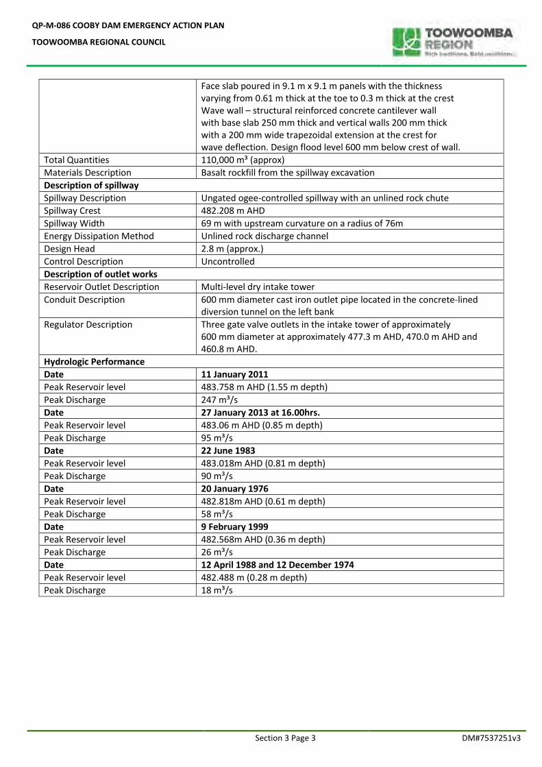
Face slab poured in 9.1 m x 9.1 m panels with the thickness varying from 0.61 m thick at the toe to 0.3 m thick at the crest Wave wall – structural reinforced concrete cantilever wall with base slab 250 mm thick and vertical walls 200 mm thick with a 200 mm wide trapezoidal extension at the crest for wave deflection. Design flood level 600 mm below crest of wall.
Total Quantities 110,000 m³ (approx)
Materials Description Basalt rockfill from the spillway excavation
Description of spillway
Spillway Description Ungated ogee-controlled spillway with an unlined rock chute
Spillway Crest 482.208 m AHD
Spillway Width 69 m with upstream curvature on a radius of 76m
Energy Dissipation Method Unlined rock discharge channel
Design Head 2.8 m (approx.)
Control Description Uncontrolled
Description of outlet works
Reservoir Outlet Description Multi-level dry intake tower
Conduit Description 600 mm diameter cast iron outlet pipe located in the concrete-lined diversion tunnel on the left bank
Regulator Description Three gate valve outlets in the intake tower of approximately 600 mm diameter at approximately 477.3 m AHD, 470.0 m AHD and 460.8 m AHD.
Hydrologic Performance
Date 11 January 2011
Peak Reservoir level 483.758 m AHD (1.55 m depth)
Peak Discharge 247 m³/s
Date 27 January 2013 at 16.00hrs.
Peak Reservoir level 483.06 m AHD (0.85 m depth)
Peak Discharge 95 m³/s
Date 22 June 1983
Peak Reservoir level 483.018m AHD (0.81 m depth)
Peak Discharge 90 m³/s
Date 20 January 1976
Peak Reservoir level 482.818m AHD (0.61 m depth)
Peak Discharge 58 m³/s
Date 9 February 1999
Peak Reservoir level 482.568m AHD (0.36 m depth)
Peak Discharge 26 m³/s
Date 12 April 1988 and 12 December 1974
Peak Reservoir level 482.488 m (0.28 m depth)
Peak Discharge 18 m³/s
QP-M-086 COOBY DAM EMERGENCY ACTION PLAN
TOOWOOMBA REGIONAL COUNCIL
Section 3 Page 4 DM#7537251v3
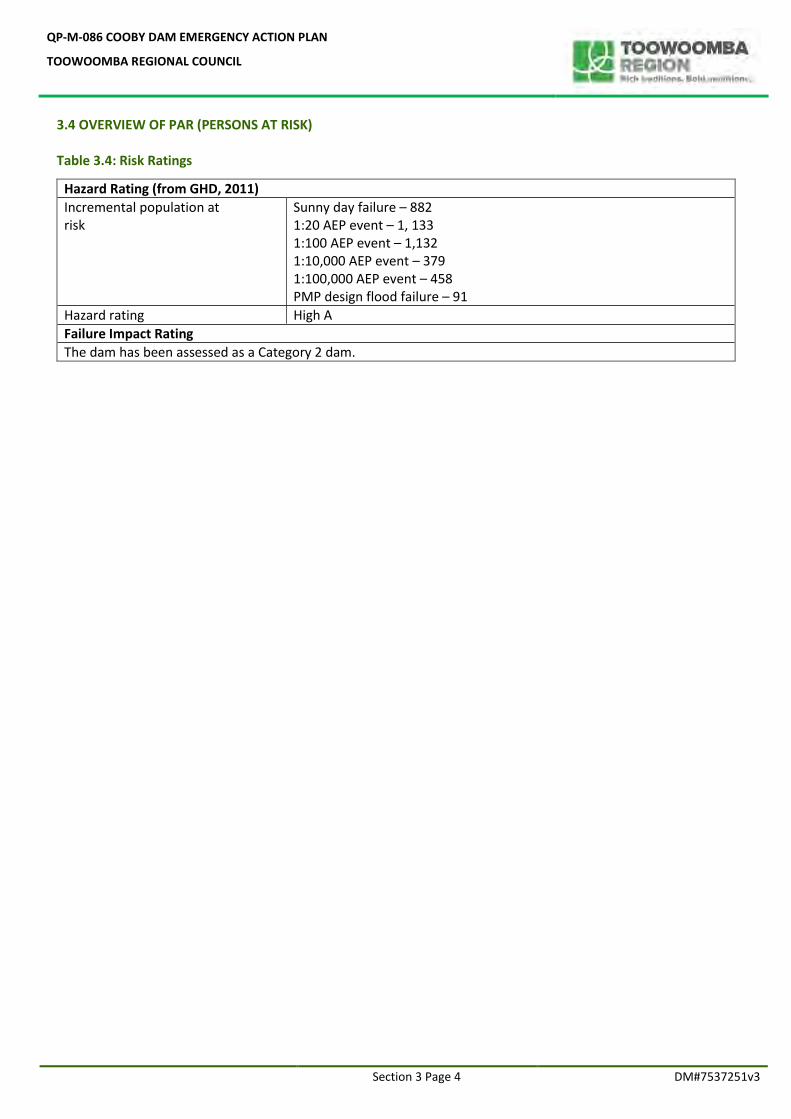
3.4 OVERVIEW OF PAR (PERSONS AT RISK) Table 3.4: Risk Ratings
Hazard Rating (from GHD, 2011)
Incremental population at risk
Sunny day failure – 882 1:20 AEP event – 1, 133 1:100 AEP event – 1,132 1:10,000 AEP event – 379 1:100,000 AEP event – 458 PMP design flood failure – 91
Hazard rating High A
Failure Impact Rating
The dam has been assessed as a Category 2 dam.
QP-M-086 COOBY DAM EMERGENCY ACTION PLAN
TOOWOOMBA REGIONAL COUNCIL
SECTION 4
FLOOD RELATED
DAM HAZARDS AND PROCEDURES
QP-M-086 COOBY DAM EMERGENCY ACTION PLAN
TOOWOOMBA REGIONAL COUNCIL
Emergency Events and Procedures Section 4 Page 7 DM#7537251v3
4.0 INTRODUCTION – FLOOD RELATED DAM HAZARDS AND PROCEDURES
Specific instructions are listed under Section 4.0 for Flood related dam hazards for TRC Dam Safety Management Group.
Downstream Residents, within 5 Km radius of the dam will be notified at Alert Stage 2. Two properties have been identified as per details given below. Note: Detailed location maps are given in Annexure 4.1 During Event Stage 1, there will be road closures for dam access roads. Details are attached in the Annexure 4.2: Road Closure Map.
Frequency of dam inspections is provided below as per Standing Operating Procedures (QP-M-029 – Appendix 1). There are no instrumentations installed at Cooby Dam except seepage monitoring. During inspections seepage and weather station readings are to be monitored and recorded by the Dam Operator or Standby Officer at the duty. All instrumentation locations including weather station (For rainfall, evaporation & thermometers) are marked in the attached in Annexure 4.11. Inflow weirs are monitored via telemetry. Table 4.1: Inspections during Reservoir Rising Levels
Cooby Dam Level Inspection Frequency
Rising by >1m in a single event Daily for one week and then return to previous inspection levels
Rising by >2m<3m in a single event Daily for one fortnight and then return to previous inspection levels
Rising by >3m<5m in a single event Daily for three weeks and then return to previous inspection levels
Flood ALERT 1 up to STANDUP Procedures
Alert 1&2 - Every 250mm rise or daily.
Event Stage 1&2 – Every 250mm rise or 2 hours.
Event Stage 3 - Every 100mm rise or 2 hours.
Event Stage 4 - Every 100mm rise or hourly.
Event Stage 5 - Every 50mm rise or hourly.
Table 4.2: Inspections during Reservoir Falling Levels
Cooby Dam Level Inspection Frequency
100% - 70% Daily
60% -40% Tri-weekly
30% -10% Twice weekly
STAND UP to STAND DOWN As per Table 4.1 listed above
If the incident may result in critical or catastrophic consequences, and may be an escalation of EAP W&WWG should ALERT the downstream residents within 5 Km of the dam as Priority 1 order and Contact TRC Local Disaster Management Coordinator immediately on
QP-M-086 COOBY DAM EMERGENCY ACTION PLAN
TOOWOOMBA REGIONAL COUNCIL
Emergency Event Trigger Table Section 4 Page 8 DM#7537251v3
4.1 FLOOD HAZARD EVENTS
Table 4.3 Dam Flood Hazard Event Trigger Table
TRIGGER ACTION
ALERT ALERTS STAGE 1
Reservoir Level rises >=5m in a 72 hour period and RL < 480.21 but does not reach the Alert and Event trigger levels. When storage is RL 480.21, -2m and rising to RL 481.71, - 0.5 m and daily rate of rise of 250mm and daily weather forecast indicates expected further rainfall over the catchment.
ALERT ALERTS STAGE 2
Reservoir Level is RL 481.71, - 0.5m and rising to RL 482.71, + 0.50m and daily rate of rise of 250mm and daily weather forecast indicates expected further rainfall over the catchment. If weather conditions indicate a large Spillway flow is imminent, station officers at the Dam. If damage to the dam is identified refer to procedures under Section 5.2
LEAN FORWARD EVENT STAGE 1
Reservoir Level is RL 482.71, + 0.5m and rising to RL 483.71, + 1.5m. In any Event, once the Spillway discharge peaks and commences to fall, inflow and tailwater levels should still be recorded as requested at the time of the Event. If damage to the dam is identified refer to procedures under Section 5.2
STAND UP EVENT STAGE 2
Reservoir Level is RL 483.71, + 1.5m and rising to RL 484.97, + 2.76m If damage to the dam is identified refer to procedures under Section 5.2
STAND UP EVENT STAGE 3
Reservoir Level is RL 484.97, + 2.76m and rising to RL 486.57, +4.36m The Dam structure is under significant loading at water depth of 4.36m. Evacuation orders for all downstream properties should have been issued by TRC LDCC. If damage to the dam is identified refer to procedures under Section 5.2
STAND UP EVENT STAGE 4
Reservoir Level is RL 486.57, 4.36 m and rising to RL 487.07, 4.86 m The Dam structure is under significant loading at water depth of 4.86m. The Residences downstream of the dam should have been evacuated. If damage to the dam is identified refer to procedures under Section 5.2
STAND UP EVENT STAGE 5
Reservoir Level is RL 487.07, +4.86 m and Reaching and Overtopping the Dam Crest Wave Wall at + 5.46 m (RL 487.67). The Dam structure is under significant loading at water depth of 4.86m. At 5.4m the wave wall will be overtopped and the dam is at imminent failure condition. The Residences downstream of the dam should have been evacuated by the TRC LDCC. The probable maximum precipitation flood is estimated to flow 8.3m over the spillway or assuming the dam does not fail first, approximately 2.8 m flowing over the dam crest wave wall. Note: If damage to the dam is identified refer to procedures under Section 5.2
POST EVENT REPORTING
REPORTING:
After the Flood Event ends and the EAP is deactivated, compile an Emergency Event Report, using the Format in Annexure 4. The Emergency Event Reports (EER) must be submitted to the Director, Dam Safety within 30 business days of the end of the event.
QP-M-086 COOBY DAM EMERGENCY ACTION PLAN
TOOWOOMBA REGIONAL COUNCIL
Emergency Events and Procedures Section 4 Page 9 DM#7537251 v3
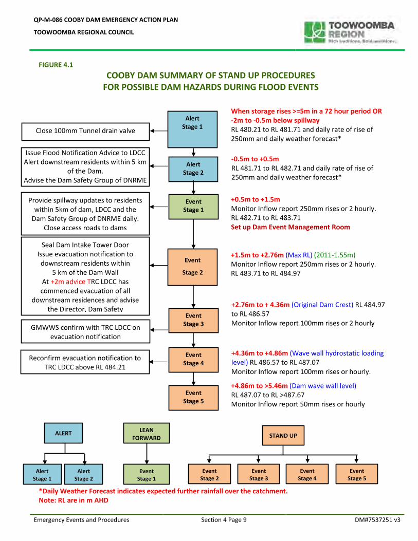
FIGURE 4.1
COOBY DAM SUMMARY OF STAND UP PROCEDURES FOR POSSIBLE DAM HAZARDS DURING FLOOD EVENTS
*Daily Weather Forecast indicates expected further rainfall over the catchment. Note: RL are in m AHD
When storage rises >=5m in a 72 hour period OR -2m to -0.5m below spillway RL 480.21 to RL 481.71 and daily rate of rise of 250mm and daily weather forecast*
+0.5m to +1.5m Monitor Inflow report 250mm rises or 2 hourly. RL 482.71 to RL 483.71 Set up Dam Event Management Room
+1.5m to +2.76m (Max RL) (2011-1.55m) Monitor Inflow report 250mm rises or 2 hourly. RL 483.71 to RL 484.97
+2.76m to + 4.36m (Original Dam Crest) RL 484.97 to RL 486.57 Monitor Inflow report 100mm rises or 2 hourly
+4.36m to +4.86m (Wave wall hydrostatic loading level) RL 486.57 to RL 487.07 Monitor Inflow report 100mm rises or hourly.
+4.86m to >5.46m (Dam wave wall level) RL 487.07 to RL >487.67 Monitor Inflow report 50mm rises or hourly
Close 100mm Tunnel drain valve
Alert Stage 1
Alert Stage 2
Event Stage 1
Event
Stage 2
Event Stage 3
Event Stage 4
Event Stage 5
Seal Dam Intake Tower Door Issue evacuation notification to downstream residents within
5 km of the Dam Wall At +2m advice TRC LDCC has commenced evacuation of all
downstream residences and advise the Director, Dam Safety
Provide spillway updates to residents within 5km of dam, LDCC and the
Dam Safety Group of DNRME daily. Close access roads to dams
Emergency Vehicles excepted
Reconfirm evacuation notification to TRC LDCC above RL 484.21
Issue Flood Notification Advice to LDCC Alert downstream residents within 5 km
of the Dam. Advise the Dam Safety Group of DNRME
-0.5m to +0.5m RL 481.71 to RL 482.71 and daily rate of rise of 250mm and daily weather forecast*
ALERT
Alert Stage 2
Alert Stage 1
LEAN FORWARD
Event Stage 1
Event Stage 3
STAND UP
Event Stage 4
Event Stage 2
Event Stage 5
GMWWS confirm with TRC LDCC on evacuation notification
Responsibilities – flood Events Section 4 Page 10 DM#7537251 v3
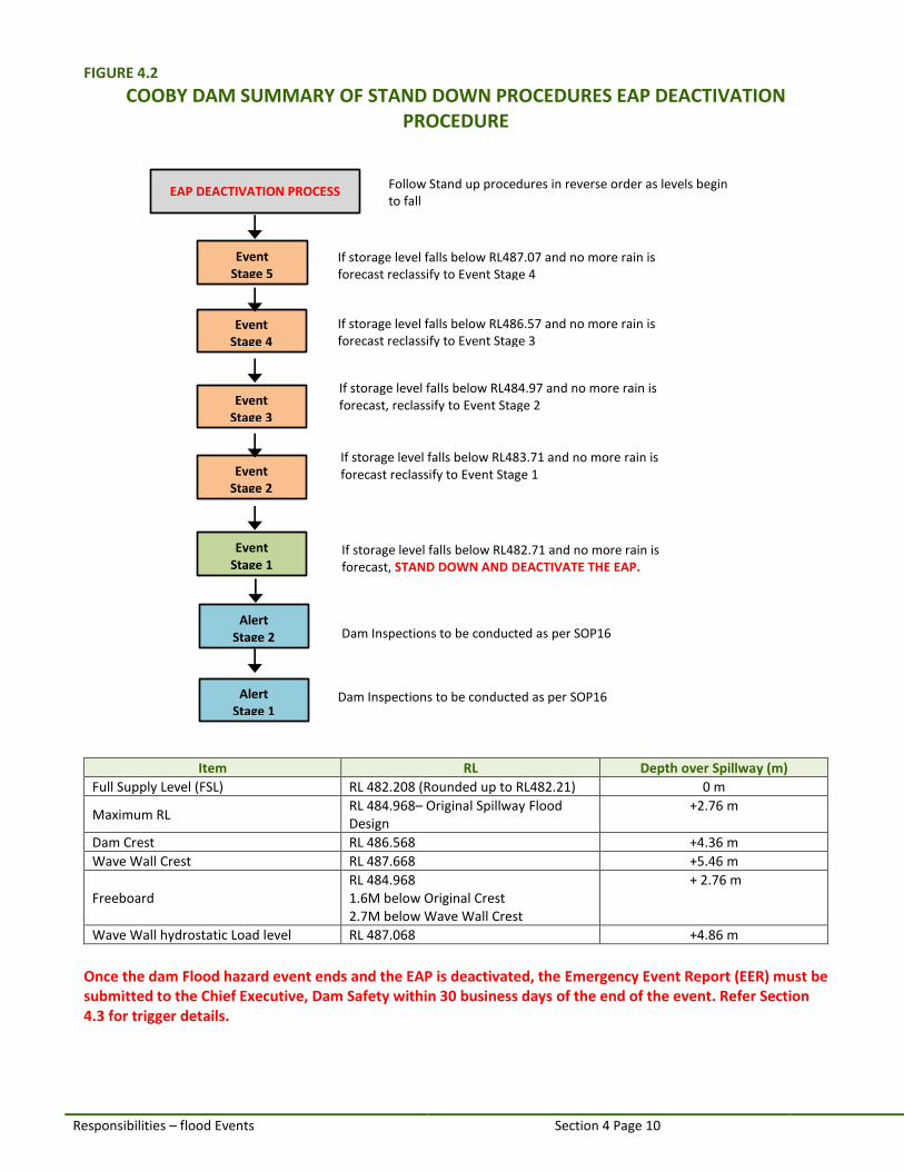
FIGURE 4.2
COOBY DAM SUMMARY OF STAND DOWN PROCEDURES EAP DEACTIVATION PROCEDURE
Item RL Depth over Spillway (m)
Full Supply Level (FSL) RL 482.208 (Rounded up to RL482.21) 0 m
Maximum RL RL 484.968– Original Spillway Flood Design
+2.76 m
Dam Crest RL 486.568 +4.36 m
Wave Wall Crest RL 487.668 +5.46 m
Freeboard RL 484.968 1.6M below Original Crest 2.7M below Wave Wall Crest
+ 2.76 m
Wave Wall hydrostatic Load level RL 487.068 +4.86 m
Once the dam Flood hazard event ends and the EAP is deactivated, the Emergency Event Report (EER) must be submitted to the Chief Executive, Dam Safety within 30 business days of the end of the event. Refer Section 4.3 for trigger details.
EAP DEACTIVATION PROCESS Follow Stand up procedures in reverse order as levels begin to fall
Dam Inspections to be conducted as per SOP16
Alert Stage 1
Alert Stage 2 Dam Inspections to be conducted as per SOP16
Event Stage 1
If storage level falls below RL482.71 and no more rain is forecast, STAND DOWN AND DEACTIVATE THE EAP.
Event Stage 2
Event Stage 5
Event Stage 3
Event Stage 4
If storage level falls below RL487.07 and no more rain is forecast reclassify to Event Stage 4
If storage level falls below RL486.57 and no more rain is forecast reclassify to Event Stage 3
If storage level falls below RL484.97 and no more rain is forecast, reclassify to Event Stage 2
If storage level falls below RL483.71 and no more rain is forecast reclassify to Event Stage 1
QP-M-086 COOBY DAM EMERGENCY ACTION PLAN
TOOWOOMBA REGIONAL COUNCIL
Responsibilities – Flood Events Section 4 Page 11 DM#7537251 v3
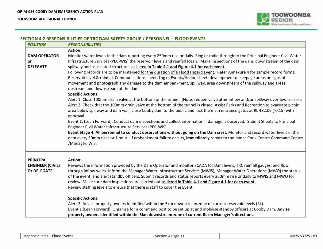
SECTION 4.2 RESPONSIBILITIES OF TRC DAM SAFETY GROUP / PERSONNEL – FLOOD EVENTS POSITION RESPONSIBILITIES
DAM OPERATOR or DELEGATE
Action: Monitor water levels in the dam reporting every 250mm rise or daily. Ring or radio through to the Principal Engineer Civil Water Infrastructure Services (PEC-WIS) the reservoir levels and rainfall totals. Make inspections of the dam, downstream of the dam, spillway and associated structures as listed in Table 4.1 and Figure 4.1 for each event. Following records are to be maintained for the duration of a Flood Hazard Event. Refer Annexure 4 for sample record forms. Reservoir level & rainfall, Communications sheet, Log of Events/Action sheet, development of seepage areas or signs of movement and photograph any damage to the dam embankment, spillway, area downstream of the spillway and areas upstream and downstream of the dam. Specific Actions: Alert 1: Close 100mm drain valve at the bottom of the tunnel. (Note: reopen valve after inflow and/or spillway overflow ceases). Alert 2: Check that the 100mm drain valve at the bottom of the tunnel is closed. Assist Parks and Recreation to evacuate picnic area below spillway and dam wall, close Cooby dam to the public and lock the main entrance gates at RL 482.06 (-0.15) with approval. Event 1: (Lean Forward): Conduct dam inspections and collect information if damage is observed. Submit Sheets to Principal Engineer Civil Water Infrastructure Services (PEC-WIS). Event Stage 4: All personnel to conduct observations without going on the Dam crest. Monitor and record water levels in the dam every 50mm rises or 1 hour. If embankment failure occurs, immediately report to the James Cook Centre Command Centre /Manager, WIS.
PRINCIPAL ENGINEER (CIVIL) Or DELEGATE
Action: Reviews the information provided by the Dam Operator and monitor SCADA for Dam levels, TRC rainfall gauges, and flow through inflow weirs. Inform the Manager Water Infrastructure Services (MWIS), Manager Water Operations (MWO) the status of the event, and alert standby officers. Submit records and status reports every 250mm rise or daily to MWIS and MWO for review. Make sure dam inspections are carried out as listed in Table 4.1 and Figure 4.1 for each event. Review staffing levels to ensure that there is staff to cover the Event. Specific Actions: Alert 2: Advise property owners identified within the 5km downstream zone of current reservoir levels (RL). Event 1 (Lean Forward): Organise for a command post to be set up at and mobilise standby officers at Cooby Dam. Advise property owners identified within the 5km downstream zone of current RL on Manager’s directions.
QP-M-086 COOBY DAM EMERGENCY ACTION PLAN
TOOWOOMBA REGIONAL COUNCIL
Responsibilities – flood Events Section 4 Page 12 DM#7537251 v3
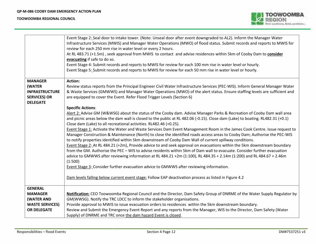
Event Stage 2: Seal door to intake tower. (Note: Unseal door after event downgraded to AL2). Inform the Manager Water Infrastructure Services (MWIS) and Manager Water Operations (MWO) of flood status. Submit records and reports to MWIS for review for each 250 mm rise in water level or every 2 hours. At RL 483.71 (+1.5m) , seek approval from MWIS to contact and advise residences within 5km of Cooby Dam to consider evacuating if safe to do so. Event Stage 4: Submit records and reports to MWIS for review for each 100 mm rise in water level or hourly. Event Stage 5: Submit records and reports to MWIS for review for each 50 mm rise in water level or hourly.
MANAGER (WATER INFRASTRUCTURE SERVICES) OR DELEGATE
Action: Review status reports from the Principal Engineer Civil Water Infrastructure Services (PEC-WIS). Inform General Manager Water & Waste Services (GMWWS) and Manager Water Operations (MWO) of the alert status. Ensure staffing levels are sufficient and are equipped to cover the Event. Refer Flood Trigger Levels (Section 6) Specific Actions: Alert 2: Advise GM (W&WSG) about the status of the Cooby dam. Advise Manager Parks & Recreation of Cooby Dam wall area and picnic areas below the dam wall is closed to the public at RL 482.06 (-0.15). Close dam (Lake) to boating. RL482.31 (+0.1) Close dam (Lake) to all recreational activities. RL482.46 (+0.25). Event Stage 1: Activate the Water and Waste Services Dam Event Management Room in the James Cook Centre. Issue request to Manager Construction & Maintenance (North) to close the identified roads access areas to Cooby Dam; Authorise the PEC-WIS to notify properties identified within 5km downstream of Cooby Dam Wall of current spillway conditions. Event Stage 2: At RL 484.21 (+2m), Provide advice to and seek approval on evacuations within the 5km downstream boundary from the GM. Authorise the PEC – WIS to advise residents within 5km of Dam wall to evacuate. Consider further evacuation advice to GMWWS after reviewing information at RL 484.21 +2m (1:100), RL 484.35 + 2.14m (1:200) and RL 484.67 + 2.46m (1:500) Event Stage 3: Consider further evacuation advice to GMWWS after reviewing information. Dam levels falling below current event stage: Follow EAP deactivation process as listed in Figure 4.2
GENERAL MAMAGER (WATER AND WASTE SERVICES) OR DELEGATE
Notification: CEO Toowoomba Regional Council and the Director, Dam Safety Group of DNRME of the Water Supply Regulator by GM(WWSG). Notify the TRC LDCC to inform the stakeholder organisations. Provide approval to MWIS to issue evacuation orders to residences within the 5km downstream boundary. Review and Submit the Emergency Event Report and any reports from the Manager, WIS to the Director, Dam Safety (Water Supply) of DNRME and TRC once the dam hazard Event is closed.
QP-M-086 COOBY DAM EMERGENCY ACTION PLAN
TOOWOOMBA REGIONAL COUNCIL
Responsibilities – flood Events Section 4 Page 13 DM#7537251 v3
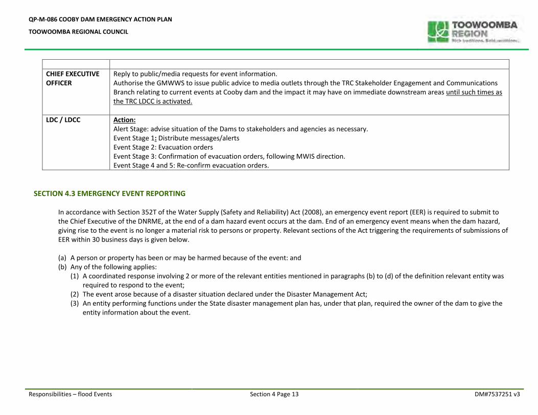
CHIEF EXECUTIVE OFFICER
Reply to public/media requests for event information. Authorise the GMWWS to issue public advice to media outlets through the TRC Stakeholder Engagement and Communications Branch relating to current events at Cooby dam and the impact it may have on immediate downstream areas until such times as the TRC LDCC is activated.
LDC / LDCC Action: Alert Stage: advise situation of the Dams to stakeholders and agencies as necessary. Event Stage 1: Distribute messages/alerts Event Stage 2: Evacuation orders Event Stage 3: Confirmation of evacuation orders, following MWIS direction. Event Stage 4 and 5: Re-confirm evacuation orders.
SECTION 4.3 EMERGENCY EVENT REPORTING
In accordance with Section 352T of the Water Supply (Safety and Reliability) Act (2008), an emergency event report (EER) is required to submit to the Chief Executive of the DNRME, at the end of a dam hazard event occurs at the dam. End of an emergency event means when the dam hazard, giving rise to the event is no longer a material risk to persons or property. Relevant sections of the Act triggering the requirements of submissions of EER within 30 business days is given below. (a) A person or property has been or may be harmed because of the event: and (b) Any of the following applies:
(1) A coordinated response involving 2 or more of the relevant entities mentioned in paragraphs (b) to (d) of the definition relevant entity was required to respond to the event;
(2) The event arose because of a disaster situation declared under the Disaster Management Act; (3) An entity performing functions under the State disaster management plan has, under that plan, required the owner of the dam to give the
entity information about the event.
QP-M-086 COOBY DAM EMERGENCY ACTION PLAN
TOOWOOMBA REGIONAL COUNCIL
SECTION 5.0
NON-FLOOD RELATED
DAM HAZARD EVENTS AND PROCEDURES
QP-M-086 COOBY DAM EMERGENCY ACTION PLAN
TOOWOOMBA REGIONAL COUNCIL
Emergency Events & Procedures – Non Flood Section 5 Page 1 DM#7537251 v3
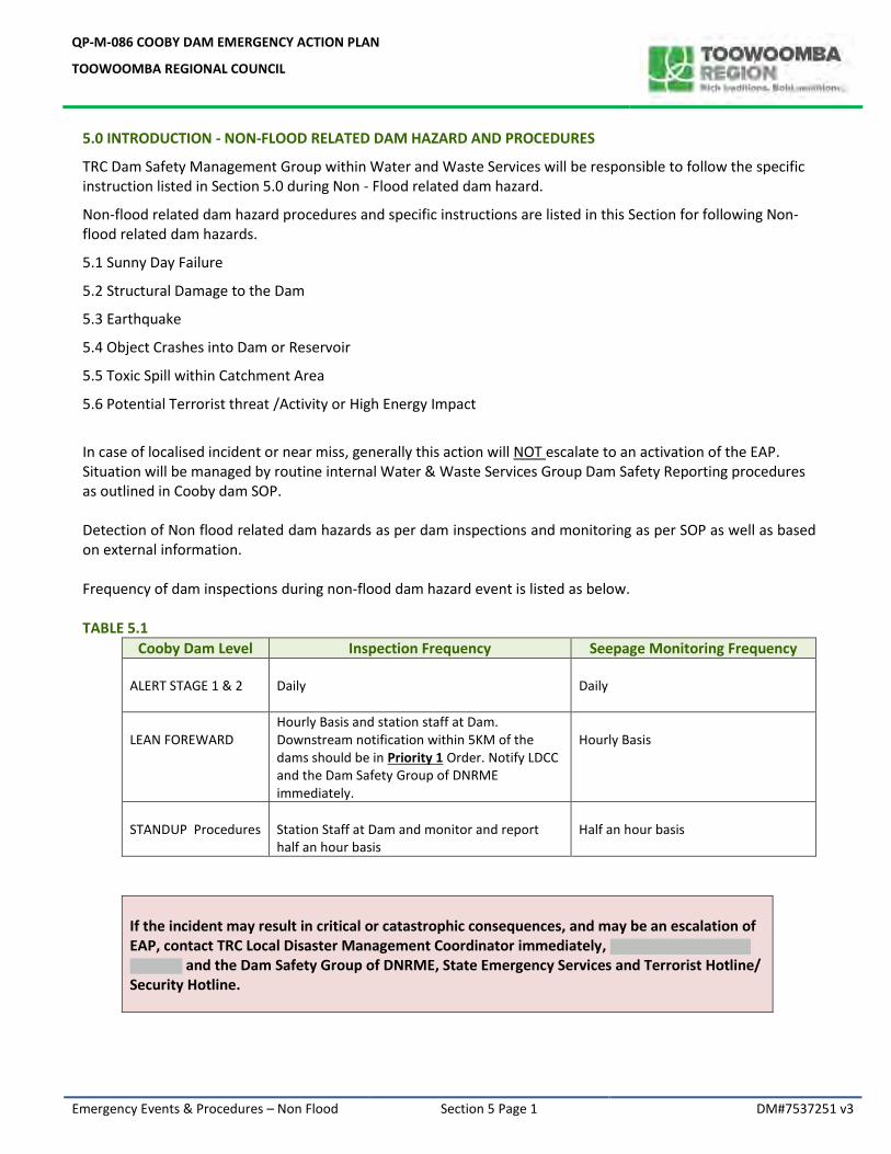
5.0 INTRODUCTION - NON-FLOOD RELATED DAM HAZARD AND PROCEDURES
TRC Dam Safety Management Group within Water and Waste Services will be responsible to follow the specific instruction listed in Section 5.0 during Non - Flood related dam hazard.
Non-flood related dam hazard procedures and specific instructions are listed in this Section for following Non-flood related dam hazards.
5.1 Sunny Day Failure
5.2 Structural Damage to the Dam
5.3 Earthquake
5.4 Object Crashes into Dam or Reservoir
5.5 Toxic Spill within Catchment Area
5.6 Potential Terrorist threat /Activity or High Energy Impact
In case of localised incident or near miss, generally this action will NOT escalate to an activation of the EAP. Situation will be managed by routine internal Water & Waste Services Group Dam Safety Reporting procedures as outlined in Cooby dam SOP. Detection of Non flood related dam hazards as per dam inspections and monitoring as per SOP as well as based on external information. Frequency of dam inspections during non-flood dam hazard event is listed as below. TABLE 5.1
Cooby Dam Level Inspection Frequency Seepage Monitoring Frequency ALERT STAGE 1 & 2
Daily
Daily
LEAN FOREWARD
Hourly Basis and station staff at Dam. Downstream notification within 5KM of the dams should be in Priority 1 Order. Notify LDCC and the Dam Safety Group of DNRME immediately.
Hourly Basis
STANDUP Procedures
Station Staff at Dam and monitor and report half an hour basis
Half an hour basis
If the incident may result in critical or catastrophic consequences, and may be an escalation of EAP, contact TRC Local Disaster Management Coordinator immediately,
and the Dam Safety Group of DNRME, State Emergency Services and Terrorist Hotline/ Security Hotline.
QP-M-086 COOBY DAM EMERGENCY ACTION PLAN
TOOWOOMBA REGIONAL COUNCIL
Emergency Events & Procedures – Non Flood Section 5 Page 2 DM#7537251 v3
Figure 5.1 DAM HAZARD EVENTS AND STAND UP PROCEDURES COOBY DAM SUMMARY FOR NON- FLOOD EVENTS
Follow specific instructions listed under Sections 5.1 to 5.6 for each non flood related dam
hazards/events. When reporting the status of non-flood related emergency, the Table 5.1 and Table 5.2 should be used as a guide to determine the Hazard Trigger Level.
Monitor the condition of the dam and assess the situation. Organise external dam inspection /advice if required. Organise preventive Actions, if feasible.
Monitor the condition, data and report. Organise preventive actions to minimise impacts.
Preventive actions to minimise the impact if possible
Evacuate to a higher ground u/s of dam and monitor the condition and record details and report asp.
Evacuate staff and residents – Compile reports, videos and photos
Imminent failure
On site monitoring including seepage monitoring
Alert Stage 1
Alert Stage 2
Event Stage 1
Event Stage 3
Event Stage 4
Event Stage 5
Issue evacuation notification to downstream residents within
5 km of the Dam Wall Advise TRC LDCC evacuation of all
downstream residences
Provide latest updates to the Director, Dam Safety, LDCC and alert the
downstream residents within 5 km of the Dam.
Close access roads to dams Emergency Vehicles excepted
Confirm evacuation notification to TRC LDCC
Notify the Director, Dam Safety and Alert the LDCC by GM,W&WSG
ALERT
Alert Stage 2
Alert Stage 1
LEAN FORWARD
Event Stage 1
Event Stage 3
STAND UP
Event Stage 4
Event Stage 2
Event Stage 5
Event Stage 2
Re confirm evacuation notification to TRC LDCC
QP-M-086 COOBY DAM EMERGENCY ACTION PLAN
TOOWOOMBA REGIONAL COUNCIL
Deactivation Procedure – Non Flood Section 5 Page 3 DM#7537251 v3
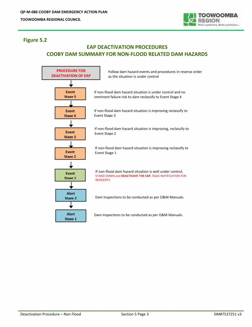
Figure 5.2 EAP DEACTIVATION PROCEDURES
COOBY DAM SUMMARY FOR NON-FLOOD RELATED DAM HAZARDS
PROCEDURE FOR DEACTIVATION OF EAP
Follow dam hazard events and procedures in reverse order as the situation is under control
Dam Inspections to be conducted as per O&M Manuals.
Alert Stage 1
Alert Stage 2 Dam Inspections to be conducted as per O&M Manuals.
Event Stage 1
If non-flood dam hazard situation is well under control, STAND DOWN and DEACTIVATE THE EAP. ISSUE NOTIFICATION FOR RESIDENTS
Event Stage 2
Event Stage 5
Event Stage 3
Event Stage 4
If non-flood dam hazard situation is under control and no imminent failure risk to dam reclassify to Event Stage 4
If non-flood dam hazard situation is improving reclassify to Event Stage 3
If non-flood dam hazard situation is improving, reclassify to Event Stage 2
If non-flood dam hazard situation is improving reclassify to Event Stage 1
QP-M-086 COOBY DAM EMERGENCY ACTION PLAN
TOOWOOMBA REGIONAL COUNCIL
Emergency Events & Procedures – Non Flood Section 5 Page 4 DM#7537251 v3
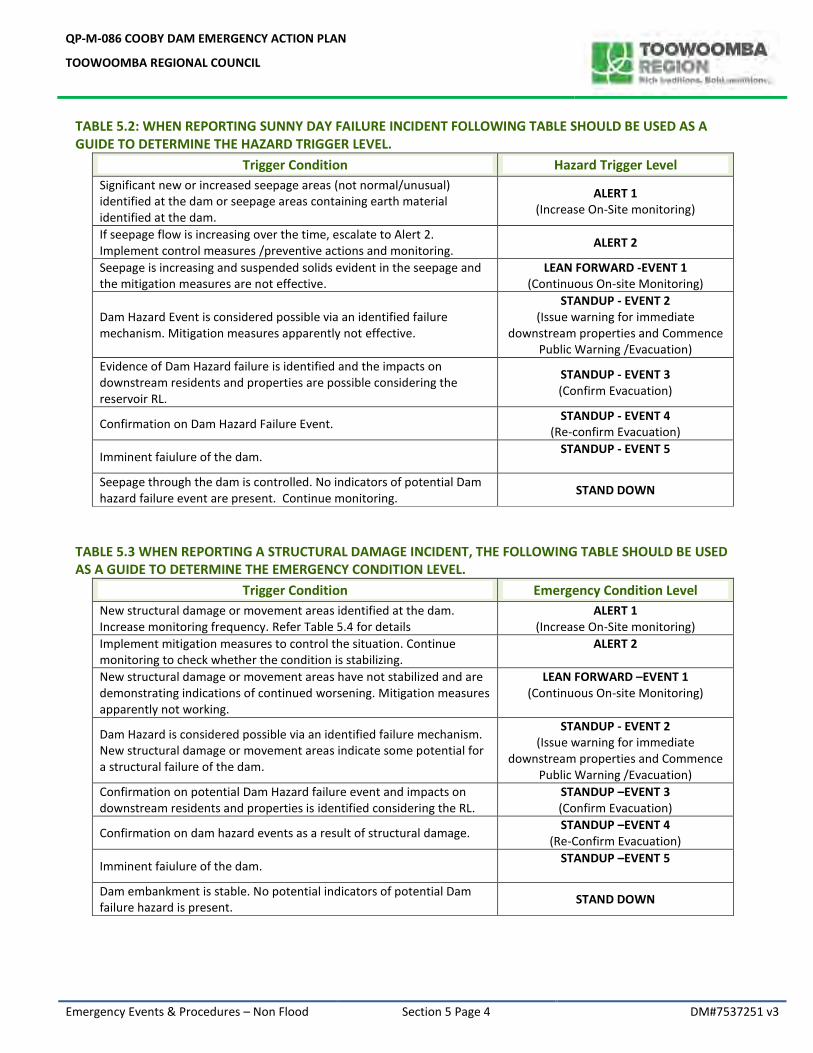
TABLE 5.2: WHEN REPORTING SUNNY DAY FAILURE INCIDENT FOLLOWING TABLE SHOULD BE USED AS A GUIDE TO DETERMINE THE HAZARD TRIGGER LEVEL.
Trigger Condition Hazard Trigger Level
Significant new or increased seepage areas (not normal/unusual) identified at the dam or seepage areas containing earth material identified at the dam.
ALERT 1 (Increase On-Site monitoring)
If seepage flow is increasing over the time, escalate to Alert 2. Implement control measures /preventive actions and monitoring.
ALERT 2
Seepage is increasing and suspended solids evident in the seepage and the mitigation measures are not effective.
LEAN FORWARD -EVENT 1 (Continuous On-site Monitoring)
Dam Hazard Event is considered possible via an identified failure mechanism. Mitigation measures apparently not effective.
STANDUP - EVENT 2 (Issue warning for immediate
downstream properties and Commence Public Warning /Evacuation)
Evidence of Dam Hazard failure is identified and the impacts on downstream residents and properties are possible considering the reservoir RL.
STANDUP - EVENT 3 (Confirm Evacuation)
Confirmation on Dam Hazard Failure Event. STANDUP - EVENT 4
(Re-confirm Evacuation)
Imminent faiulure of the dam. STANDUP - EVENT 5
Seepage through the dam is controlled. No indicators of potential Dam hazard failure event are present. Continue monitoring.
STAND DOWN
TABLE 5.3 WHEN REPORTING A STRUCTURAL DAMAGE INCIDENT, THE FOLLOWING TABLE SHOULD BE USED AS A GUIDE TO DETERMINE THE EMERGENCY CONDITION LEVEL.
Trigger Condition Emergency Condition Level
New structural damage or movement areas identified at the dam. Increase monitoring frequency. Refer Table 5.4 for details
ALERT 1 (Increase On-Site monitoring)
Implement mitigation measures to control the situation. Continue monitoring to check whether the condition is stabilizing.
ALERT 2
New structural damage or movement areas have not stabilized and are demonstrating indications of continued worsening. Mitigation measures apparently not working.
LEAN FORWARD –EVENT 1 (Continuous On-site Monitoring)
Dam Hazard is considered possible via an identified failure mechanism. New structural damage or movement areas indicate some potential for a structural failure of the dam.
STANDUP - EVENT 2 (Issue warning for immediate
downstream properties and Commence Public Warning /Evacuation)
Confirmation on potential Dam Hazard failure event and impacts on downstream residents and properties is identified considering the RL.
STANDUP –EVENT 3 (Confirm Evacuation)
Confirmation on dam hazard events as a result of structural damage. STANDUP –EVENT 4
(Re-Confirm Evacuation)
Imminent faiulure of the dam. STANDUP –EVENT 5
Dam embankment is stable. No potential indicators of potential Dam failure hazard is present.
STAND DOWN
QP-M-086 COOBY DAM EMERGENCY ACTION PLAN
TOOWOOMBA REGIONAL COUNCIL
As a result of an earthquake Section 5 Page 5 DM#7537251 v3
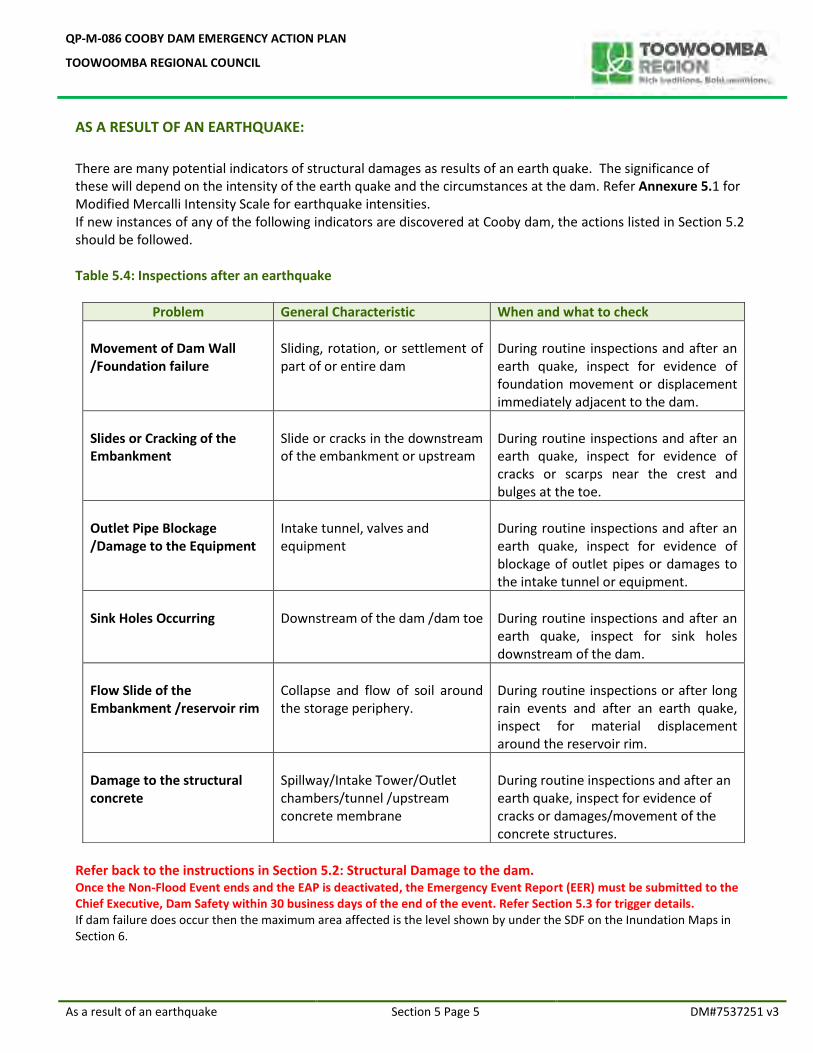
AS A RESULT OF AN EARTHQUAKE:
There are many potential indicators of structural damages as results of an earth quake. The significance of these will depend on the intensity of the earth quake and the circumstances at the dam. Refer Annexure 5.1 for Modified Mercalli Intensity Scale for earthquake intensities. If new instances of any of the following indicators are discovered at Cooby dam, the actions listed in Section 5.2 should be followed. Table 5.4: Inspections after an earthquake
Problem General Characteristic When and what to check
Movement of Dam Wall /Foundation failure
Sliding, rotation, or settlement of part of or entire dam
During routine inspections and after an earth quake, inspect for evidence of foundation movement or displacement immediately adjacent to the dam.
Slides or Cracking of the Embankment
Slide or cracks in the downstream of the embankment or upstream
During routine inspections and after an earth quake, inspect for evidence of cracks or scarps near the crest and bulges at the toe.
Outlet Pipe Blockage /Damage to the Equipment
Intake tunnel, valves and equipment
During routine inspections and after an earth quake, inspect for evidence of blockage of outlet pipes or damages to the intake tunnel or equipment.
Sink Holes Occurring
Downstream of the dam /dam toe
During routine inspections and after an earth quake, inspect for sink holes downstream of the dam.
Flow Slide of the Embankment /reservoir rim
Collapse and flow of soil around the storage periphery.
During routine inspections or after long rain events and after an earth quake, inspect for material displacement around the reservoir rim.
Damage to the structural concrete
Spillway/Intake Tower/Outlet chambers/tunnel /upstream concrete membrane
During routine inspections and after an earth quake, inspect for evidence of cracks or damages/movement of the concrete structures.
Refer back to the instructions in Section 5.2: Structural Damage to the dam. Once the Non-Flood Event ends and the EAP is deactivated, the Emergency Event Report (EER) must be submitted to the Chief Executive, Dam Safety within 30 business days of the end of the event. Refer Section 5.3 for trigger details. If dam failure does occur then the maximum area affected is the level shown by under the SDF on the Inundation Maps in Section 6.
QP-M-086 COOBY DAM EMERGENCY ACTION PLAN
TOOWOOMBA REGIONAL COUNCIL
Non flood hazard event trigger table Section 5 Page 6 DM#7537251 v3
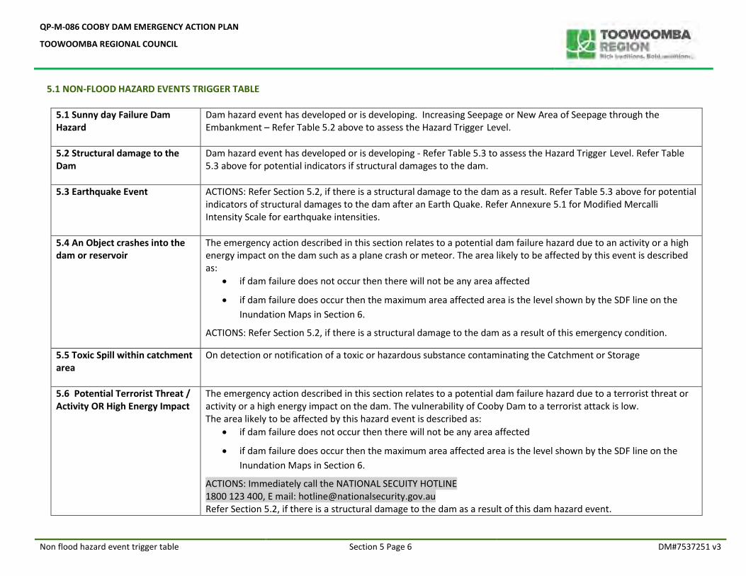
5.1 NON-FLOOD HAZARD EVENTS TRIGGER TABLE
5.1 Sunny day Failure Dam Hazard
Dam hazard event has developed or is developing. Increasing Seepage or New Area of Seepage through the Embankment – Refer Table 5.2 above to assess the Hazard Trigger Level.
5.2 Structural damage to the Dam
Dam hazard event has developed or is developing - Refer Table 5.3 to assess the Hazard Trigger Level. Refer Table 5.3 above for potential indicators if structural damages to the dam.
5.3 Earthquake Event
ACTIONS: Refer Section 5.2, if there is a structural damage to the dam as a result. Refer Table 5.3 above for potential indicators of structural damages to the dam after an Earth Quake. Refer Annexure 5.1 for Modified Mercalli Intensity Scale for earthquake intensities.
5.4 An Object crashes into the dam or reservoir
The emergency action described in this section relates to a potential dam failure hazard due to an activity or a high energy impact on the dam such as a plane crash or meteor. The area likely to be affected by this event is described as:
if dam failure does not occur then there will not be any area affected
if dam failure does occur then the maximum area affected area is the level shown by the SDF line on the
Inundation Maps in Section 6.
ACTIONS: Refer Section 5.2, if there is a structural damage to the dam as a result of this emergency condition.
5.5 Toxic Spill within catchment area
On detection or notification of a toxic or hazardous substance contaminating the Catchment or Storage
5.6 Potential Terrorist Threat / Activity OR High Energy Impact
The emergency action described in this section relates to a potential dam failure hazard due to a terrorist threat or activity or a high energy impact on the dam. The vulnerability of Cooby Dam to a terrorist attack is low. The area likely to be affected by this hazard event is described as:
if dam failure does not occur then there will not be any area affected
if dam failure does occur then the maximum area affected area is the level shown by the SDF line on the
Inundation Maps in Section 6.
ACTIONS: Immediately call the NATIONAL SECUITY HOTLINE 1800 123 400, E mail: [email protected] Refer Section 5.2, if there is a structural damage to the dam as a result of this dam hazard event.
QP-M-086 COOBY DAM EMERGENCY ACTION PLAN
TOOWOOMBA REGIONAL COUNCIL
Responsibilities – non flood events Section 5 Page 8 DM#7537251 v3
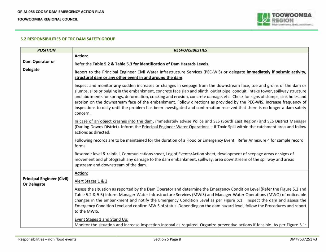
5.2 RESPONSIBILITIES OF TRC DAM SAFETY GROUP
POSITION RESPONSIBILITIES
Dam Operator or
Delegate
Action:
Refer the Table 5.2 & Table 5.3 for identification of Dam Hazards Levels.
Report to the Principal Engineer Civil Water Infrastructure Services (PEC-WIS) or delegate immediately if seismic activity, structural dam or any other event in and around the dam.
Inspect and monitor any sudden increases or changes in seepage from the downstream face, toe and groins of the dam or slumps, slips or bulging in the embankment, concrete face slab and plinth, outlet pipe, conduit, intake tower, spillway structure and abutments for springs, deformation, cracking and erosion, concrete damage, etc. Check for signs of slumps, sink holes and erosion on the downstream face of the embankment. Follow directions as provided by the PEC-WIS. Increase frequency of inspections to daily until the problem has been investigated and confirmation received that there is no longer a dam safety concern.
In case of an object crashes into the dam, immediately advise Police and SES (South East Region) and SES District Manager (Darling-Downs District). Inform the Principal Engineer Water Operations – if Toxic Spill within the catchment area and follow actions as directed.
Following records are to be maintained for the duration of a Flood or Emergency Event. Refer Annexure 4 for sample record forms.
Reservoir level & rainfall, Communications sheet, Log of Events/Action sheet, development of seepage areas or signs of movement and photograph any damage to the dam embankment, spillway, area downstream of the spillway and areas upstream and downstream of the dam.
Principal Engineer (Civil) Or Delegate
Action:
Alert Stages 1 & 2
Assess the situation as reported by the Dam Operator and determine the Emergency Condition Level (Refer the Figure 5.2 and Table 5.2 & 5.3) Inform Manager Water Infrastructure Services (MWIS) and Manager Water Operations (MWO) of noticeable changes in the embankment and notify the Emergency Condition Level as per Figure 5.1. Inspect the dam and assess the Emergency Condition Level and confirm MWIS of status. Depending on the dam hazard level, follow the Procedures and report to the MWIS.
Event Stages 1 and Stand Up: Monitor the situation and increase inspection interval as required. Organize preventive actions if feasible. As per Figure 5.1:
QP-M-086 COOBY DAM EMERGENCY ACTION PLAN
TOOWOOMBA REGIONAL COUNCIL
Responsibilities – non flood events Section 5 Page 9 DM#7537251 v3
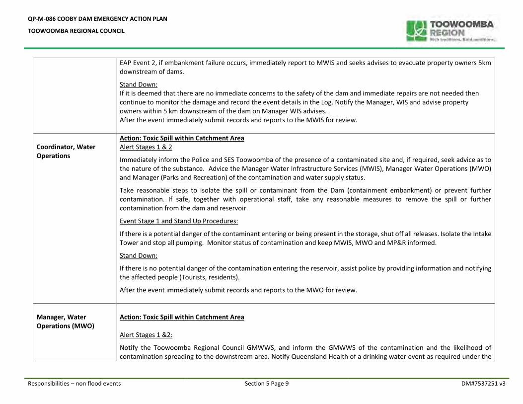
EAP Event 2, if embankment failure occurs, immediately report to MWIS and seeks advises to evacuate property owners 5km downstream of dams.
Stand Down: If it is deemed that there are no immediate concerns to the safety of the dam and immediate repairs are not needed then continue to monitor the damage and record the event details in the Log. Notify the Manager, WIS and advise property owners within 5 km downstream of the dam on Manager WIS advises. After the event immediately submit records and reports to the MWIS for review.
Coordinator, Water Operations
Action: Toxic Spill within Catchment Area Alert Stages 1 & 2
Immediately inform the Police and SES Toowoomba of the presence of a contaminated site and, if required, seek advice as to the nature of the substance. Advice the Manager Water Infrastructure Services (MWIS), Manager Water Operations (MWO) and Manager (Parks and Recreation) of the contamination and water supply status.
Take reasonable steps to isolate the spill or contaminant from the Dam (containment embankment) or prevent further contamination. If safe, together with operational staff, take any reasonable measures to remove the spill or further contamination from the dam and reservoir.
Event Stage 1 and Stand Up Procedures:
If there is a potential danger of the contaminant entering or being present in the storage, shut off all releases. Isolate the Intake Tower and stop all pumping. Monitor status of contamination and keep MWIS, MWO and MP&R informed.
Stand Down:
If there is no potential danger of the contamination entering the reservoir, assist police by providing information and notifying the affected people (Tourists, residents).
After the event immediately submit records and reports to the MWO for review.
Manager, Water Operations (MWO)
Action: Toxic Spill within Catchment Area Alert Stages 1 &2:
Notify the Toowoomba Regional Council GMWWS, and inform the GMWWS of the contamination and the likelihood of contamination spreading to the downstream area. Notify Queensland Health of a drinking water event as required under the
QP-M-086 COOBY DAM EMERGENCY ACTION PLAN
TOOWOOMBA REGIONAL COUNCIL
Responsibilities – non flood events Section 5 Page 10 DM#7537251 v3
Water Supply (Safety and Reliability) Act 2008. Notify Toowoomba Regional Council Manager Parks and Recreation to close the Cooby dam recreation area for public until further notification. Take action to identify the contaminant/contaminants and extent of the contamination and assess the risk to water quality and public health. If necessary, arrange for action to neutralise, remove or isolate the contaminant.
Event Stage 1 and Stand Up Procedures:
If the spill or contamination cannot be removed or isolated, arrange for specialist advice to address the problem in order to neutralise the effect of the contaminant. Advise Unit Leader to isolate the water supply from the Cooby dam and organize alternative supply sources.
Monitor the situation and provide updates for GMWWS, MWIS and MP&R and the Office of the Water Supply Regulator. Stand Down:
Determine when the contaminant no longer poses a significant risk to water supply quality and public health and advise the GMWWS that the Dam water is safe for drinking water supply. Advice the status of outcome for MWIS and Queensland Health. Notify the Manager (Parks and Recreation) that it is safe to open the Cooby dam recreation area for public.
After the event review records and reports from the ULWO-T and compile Emergency Event Report.
Manager Water Infrastructure Services (MWIS) or delegate
Action:
Alert Stages 1 &2:
Inform the GMWWS of the status of Emergency Condition Level. On receipt of damage report, carry out field inspection. If necessary, obtain specialist technical advice from a Dam Consultant for further actions.
Event Stage 1 and Stand Up Procedures:
Arrange for a command post to be set up and manned at James Cook Centre at Event Stage 1 or above. Advise PEC-WIS to issue evacuation notification to residents within the 5km zone if dam failure likely. Recommend GMWWS to activate the EAP and advise LDCC as listed in Figure 5.1. Advice Manager (Parks & Recreation) to evacuate the public in reservoir area. Refer Flood Trigger Levels (Section 6) and inundation maps in Section 6.
Stand Down:
If failure of the dam does not occur, arrange for a dam safety inspection after the event. If there is no potential danger to the dam, notify the GMWWS, to advise CEO, The Dam Safety Group of DNRME and the LDCC to de activate the EAP. Advise Manager (Parks and Recreation) to reinstate the public access to the recreational area.
QP-M-086 COOBY DAM EMERGENCY ACTION PLAN
TOOWOOMBA REGIONAL COUNCIL
Responsibilities – non flood events Section 5 Page 11 DM#7537251 v3
Review records and reports produced following the event and compile an Emergency Event Report to GMWWS for review and submit for the Director, dam Safety within 30 business days.
General Manager Water & Waste Services (GMWWS) or delegate
Action:
Alert Stages 1 &2:
Advise Manager (WIS) to organize onsite inspection and further monitoring. Notify the Director, Dam Safety and the Chief Executive Officer, TRC. Organize external advice and consider impact mitigation options. In case of toxic spill to the reservoir, advise the general public to avoid entry into the area or use of water directly from contaminated reservoirs and creeks, until the contamination is identified and isolated.
Event Stage 1 and Stand Up Procedures:
If reports from MWIS confirm that significant damage has occurred or emergency situation is (over Event Stage 1 or above) developing immediately inform the Toowoomba Regional Council CEO and the Dam Safety Group of DNRME of damage and steps taken or being taken to address the problem including the use of specialised technical advisors. Maintain contact hourly until the end of the event or until rectified and record all phone calls and conversations on sheets in Annexure 4 of this EAP.
Advise TRC LDCC Coordinator to notify Oakey and Toowoomba Police and SES (South East Region) and SES District Manager (Darling-Downs District) to evacuate residents downstream of Cooby Dam. Notification should include all properties that are within the boundaries of the inundation maps, the Army Aviation Base and residences in Oakey.
Arrange for additional steps to be taken as required to mitigate the effects of any damage. The Dam Safety Group of DNRME may direct activities based on the extent and type of damage.
If the TRC LDCC is not currently activated GMWWS is to contact the CEO Toowoomba Regional Council and advise him of the current situation. If the contamination is likely to spread to the downstream area, inform Police and State Emergency Service of contamination and prevent access to the area.
Submit report to Toowoomba Regional Council where a toxic spill has occurred within the catchment or storage area.
Stand Down:
Notify the CEO, The Dam Safety Group of DNRME and the LDCC to de activate the EAP. Review Emergency Event Report and submit to CEO. Advise Manager, WIS to submit the Emergency Event Report to the Dam Safety Group of DNRME.
Advise the general public it is safe to enter into the area or use of water directly from contaminated reservoirs and creeks, until the contamination is identified and isolated.
Submit report to Toowoomba Regional Council where damage to the dam or potential dam safety issues has occurred. If
QP-M-086 COOBY DAM EMERGENCY ACTION PLAN
TOOWOOMBA REGIONAL COUNCIL
Responsibilities – non flood events Section 5 Page 12 DM#7537251 v3
required after the event, arrange for an investigation.
Submit an Emergency Event Report to the Chief Executive after a dam hazard event within 30 business days.
Chief Executive Officer (CEO) Or Delegate
Reply to public/media requests for event information. Authorise the GMWWS to issue public advice to media outlets through the TRC Stakeholder Engagement and Communications Branch relating to current events at Cooby dam and the impact it may have on immediate downstream areas until such times as the TRC LDCC is activated.
SECTION 5.3 EMERGENCY EVENT REPORTING
In accordance with Section 352T of the Water Supply (Safety and Reliability) Act (2008), an emergency event report (EER) is required to submit to the Chief Executive of the DNRME, at the end of a dam hazard event occurs at the dam. End of an emergency event means when the dam hazard, giving rise to the event is no longer a material risk to persons or property. Relevant sections of the Act triggering the requirements of submissions of EER within 30 business days is given below. (c) A person or property has been or may be harmed because of the event: and (d) Any of the following applies:
(4) A coordinated response involving 2 or more of the relevant entities mentioned in paragraphs (b) to (d) of the definition relevant entity was required to respond to the event;
(5) The event arose because of a disaster situation declared under the Disaster Management Act; (6) An entity performing functions under the State disaster management plan has, under that plan, required the owner of the dam to give the
entity information about the event.

QP-M-086 COOBY DAM EMERGENCY ACTION PLAN
TOOWOOMBA REGIONAL COUNCIL
SECTION 6 DOWNSTREAM INUNDATION MAPS
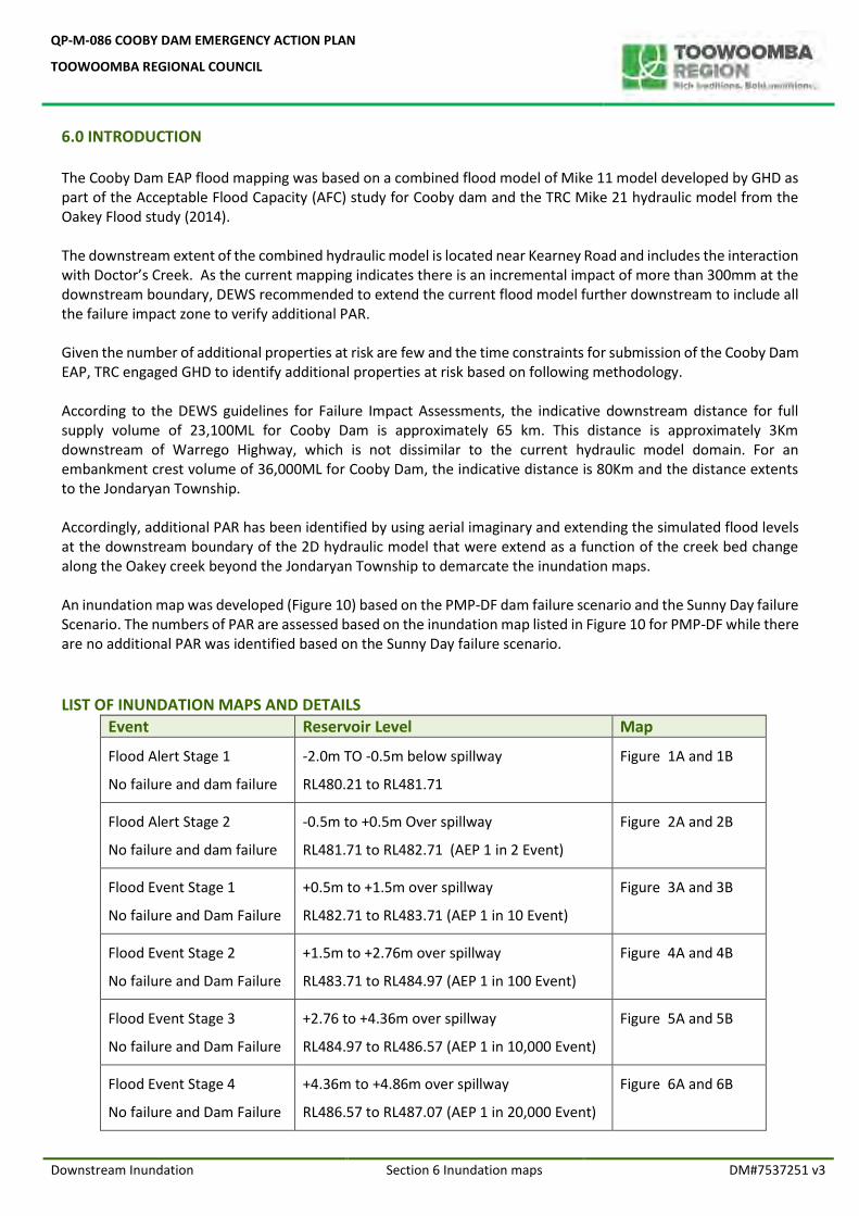
QP-M-086 COOBY DAM EMERGENCY ACTION PLAN
TOOWOOMBA REGIONAL COUNCIL
Downstream Inundation Section 6 Inundation maps DM#7537251 v3
6.0 INTRODUCTION The Cooby Dam EAP flood mapping was based on a combined flood model of Mike 11 model developed by GHD as part of the Acceptable Flood Capacity (AFC) study for Cooby dam and the TRC Mike 21 hydraulic model from the Oakey Flood study (2014). The downstream extent of the combined hydraulic model is located near Kearney Road and includes the interaction with Doctor’s Creek. As the current mapping indicates there is an incremental impact of more than 300mm at the downstream boundary, DEWS recommended to extend the current flood model further downstream to include all the failure impact zone to verify additional PAR. Given the number of additional properties at risk are few and the time constraints for submission of the Cooby Dam EAP, TRC engaged GHD to identify additional properties at risk based on following methodology. According to the DEWS guidelines for Failure Impact Assessments, the indicative downstream distance for full supply volume of 23,100ML for Cooby Dam is approximately 65 km. This distance is approximately 3Km downstream of Warrego Highway, which is not dissimilar to the current hydraulic model domain. For an embankment crest volume of 36,000ML for Cooby Dam, the indicative distance is 80Km and the distance extents to the Jondaryan Township. Accordingly, additional PAR has been identified by using aerial imaginary and extending the simulated flood levels at the downstream boundary of the 2D hydraulic model that were extend as a function of the creek bed change along the Oakey creek beyond the Jondaryan Township to demarcate the inundation maps. An inundation map was developed (Figure 10) based on the PMP-DF dam failure scenario and the Sunny Day failure Scenario. The numbers of PAR are assessed based on the inundation map listed in Figure 10 for PMP-DF while there are no additional PAR was identified based on the Sunny Day failure scenario.
LIST OF INUNDATION MAPS AND DETAILS
Event Reservoir Level Map
Flood Alert Stage 1
No failure and dam failure
-2.0m TO -0.5m below spillway
RL480.21 to RL481.71
Figure 1A and 1B
Flood Alert Stage 2
No failure and dam failure
-0.5m to +0.5m Over spillway
RL481.71 to RL482.71 (AEP 1 in 2 Event)
Figure 2A and 2B
Flood Event Stage 1
No failure and Dam Failure
+0.5m to +1.5m over spillway
RL482.71 to RL483.71 (AEP 1 in 10 Event)
Figure 3A and 3B
Flood Event Stage 2
No failure and Dam Failure
+1.5m to +2.76m over spillway
RL483.71 to RL484.97 (AEP 1 in 100 Event)
Figure 4A and 4B
Flood Event Stage 3
No failure and Dam Failure
+2.76 to +4.36m over spillway
RL484.97 to RL486.57 (AEP 1 in 10,000 Event)
Figure 5A and 5B
Flood Event Stage 4
No failure and Dam Failure
+4.36m to +4.86m over spillway
RL486.57 to RL487.07 (AEP 1 in 20,000 Event)
Figure 6A and 6B
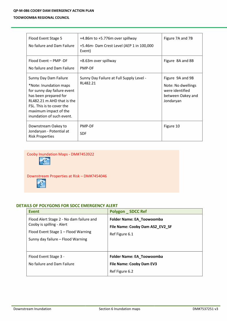
QP-M-086 COOBY DAM EMERGENCY ACTION PLAN
TOOWOOMBA REGIONAL COUNCIL
Downstream Inundation Section 6 Inundation maps DM#7537251 v3
Flood Event Stage 5
No failure and Dam Failure
+4.86m to +5.776m over spillway
+5.46m- Dam Crest Level (AEP 1 in 100,000 Event)
Figure 7A and 7B
Flood Event – PMP -DF
No failure and Dam Failure
+8.63m over spillway
PMP-DF
Figure 8A and 8B
Sunny Day Dam Failure
*Note: Inundation maps for sunny day failure event has been prepared for RL482.21 m AHD that is the FSL. This is to cover the maximum impact of the inundation of such event.
Sunny Day Failure at Full Supply Level -RL482.21
Figure 9A and 9B
Note: No dwellings were identified between Oakey and Jondaryan
Downstream Oakey to Jondaryan - Potential at Risk Properties
PMP-DF
SDF
Figure 10
DETAILS OF POLYGONS FOR SDCC EMERGENCY ALERT
Event Polygon _ SDCC Ref
Flood Alert Stage 2 - No dam failure and Cooby is spilling - Alert
Flood Event Stage 1 – Flood Warning
Sunny day failure – Flood Warning
Folder Name: EA_Toowoomba
File Name: Cooby Dam AS2_EV2_SF
Ref Figure 6.1
Flood Event Stage 3 -
No failure and Dam Failure
Folder Name: EA_Toowoomba
File Name: Cooby Dam EV3
Ref Figure 6.2
Cooby Inundation Maps - DM#7453922
Downstream Properties at Risk – DM#7454046
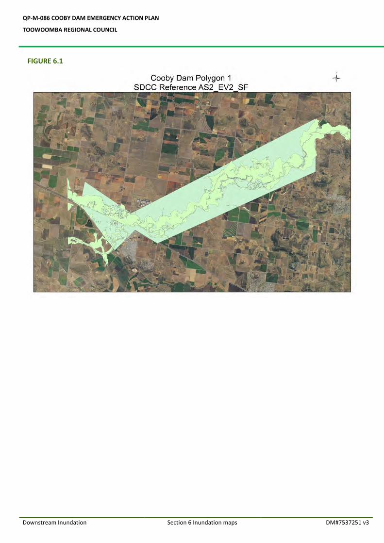
QP-M-086 COOBY DAM EMERGENCY ACTION PLAN
TOOWOOMBA REGIONAL COUNCIL
Downstream Inundation Section 6 Inundation maps DM#7537251 v3
FIGURE 6.1
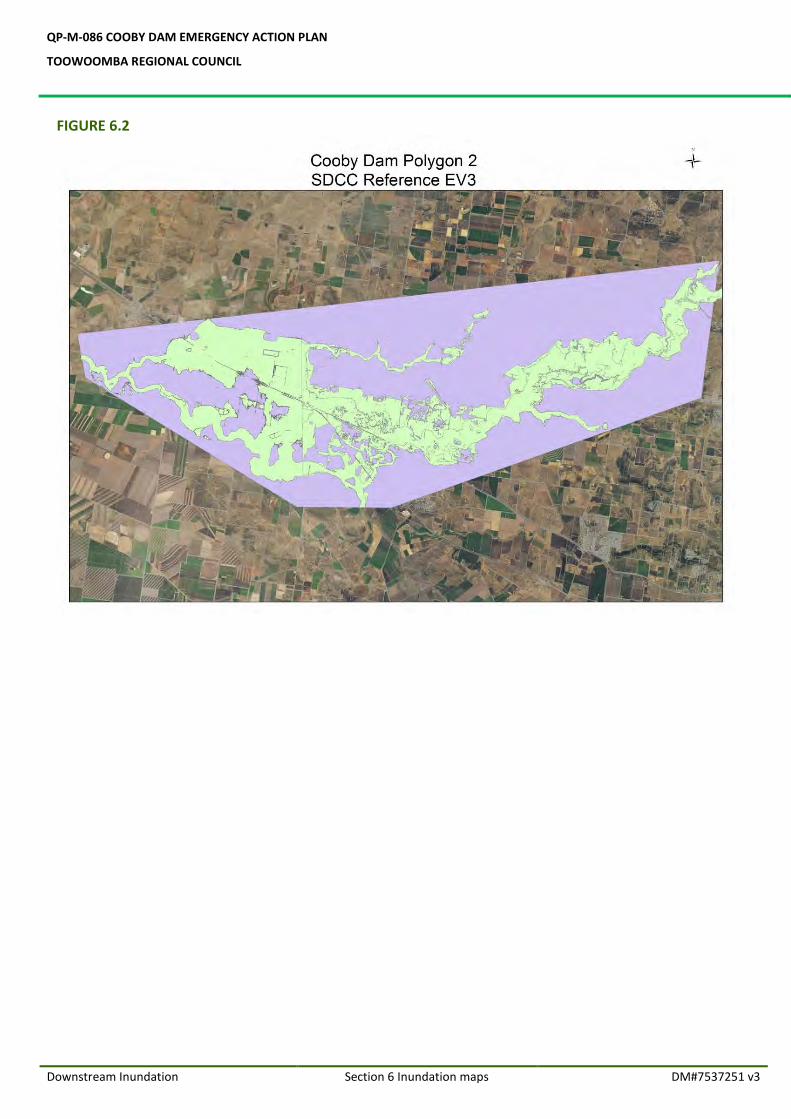
QP-M-086 COOBY DAM EMERGENCY ACTION PLAN
TOOWOOMBA REGIONAL COUNCIL
Downstream Inundation Section 6 Inundation maps DM#7537251 v3
FIGURE 6.2

ANNEXURES
QP-M-086 COOBY DAM EMERGENCY ACTION PLAN
TOOWOOMBA REGIONAL COUNCIL
Cooby Emergency Action Plan Annexures DM#7537251 v3
SECTION 1.0
ANNEXURE 1.1 FUNCTIONAL RESPONSIBILITIES OF DAM SAFETY MANAGEMENT GROUP
ANNEXURE 1.2 TRC ORGANISATIONAL CHART
ANNEXURE 1.3 FLOOD EVENT DEFINITIONS
SECTION 3.0
ANNEXURE 3.1 LOCATION MAPS
ANNEXURE 3.2 ROUTE MAP TO COOBY DAM
ANNEXURE 3.3 ALTERNATIVE ROUTE MAP
ANNEXURE 3.4 GENERAL LAYOUT OF THE COOBY DAM
ANNEXURE 3.5 DETAILS OF THE FACING SLAB
ANNEXURE 3.6 DETAILS OF THE WING WALL
SECTION 4.0
ANNEXURE 4.1 LOCATION MAP OF TWO PROPERTIES D/S OF DAM
ANNEXURE 4.2 COOBY DAM ROAD CLOSURE MAPS
ANNEXURE 4.3 FLOOD RAINFALL RECORD SHEETS
ANNEXURE 4.4 RESERVOIR LEVELS GRAPHS
ANNEXURE 4.5 EVENT LOG SHEET
ANNEXURE 4.6 RECORD OF COMMUNICATION SHEET
ANNEXURE 4.7 STATUS REPORT
ANNEXURE 4.8 EMERGENCY EVENT REPORT FORMAT
ANNEXURE 4.9 COOBY SPILLWAY CURVE RATING
ANNEXURE 4.10 COOBY DAM STORAGE CURVE
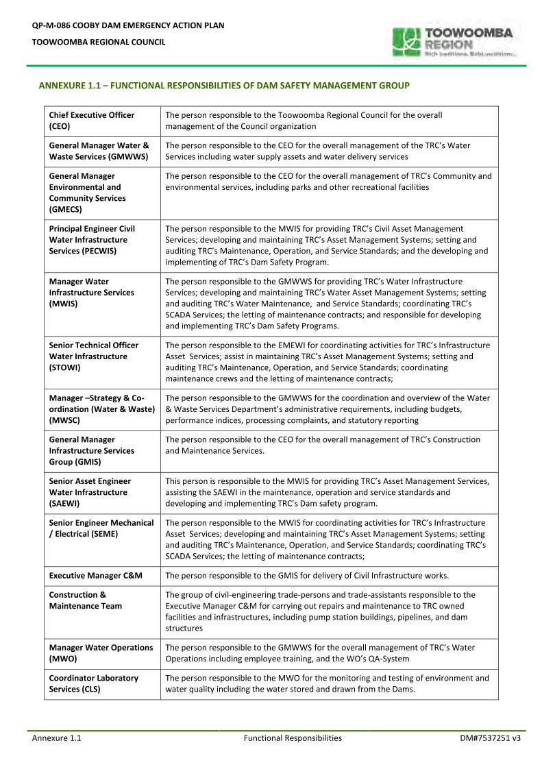
QP-M-086 COOBY DAM EMERGENCY ACTION PLAN
TOOWOOMBA REGIONAL COUNCIL
Annexure 1.1 Functional Responsibilities DM#7537251 v3
ANNEXURE 1.1 – FUNCTIONAL RESPONSIBILITIES OF DAM SAFETY MANAGEMENT GROUP
Chief Executive Officer (CEO)
The person responsible to the Toowoomba Regional Council for the overall management of the Council organization
General Manager Water & Waste Services (GMWWS)
The person responsible to the CEO for the overall management of the TRC’s Water Services including water supply assets and water delivery services
General Manager Environmental and Community Services (GMECS)
The person responsible to the CEO for the overall management of TRC’s Community and environmental services, including parks and other recreational facilities
Principal Engineer Civil Water Infrastructure Services (PECWIS)
The person responsible to the MWIS for providing TRC’s Civil Asset Management Services; developing and maintaining TRC’s Asset Management Systems; setting and auditing TRC’s Maintenance, Operation, and Service Standards; and the developing and implementing of TRC’s Dam Safety Program.
Manager Water Infrastructure Services (MWIS)
The person responsible to the GMWWS for providing TRC’s Water Infrastructure Services; developing and maintaining TRC’s Water Asset Management Systems; setting and auditing TRC’s Water Maintenance, and Service Standards; coordinating TRC’s SCADA Services; the letting of maintenance contracts; and responsible for developing and implementing TRC’s Dam Safety Programs.
Senior Technical Officer Water Infrastructure (STOWI)
The person responsible to the EMEWI for coordinating activities for TRC’s Infrastructure Asset Services; assist in maintaining TRC’s Asset Management Systems; setting and auditing TRC’s Maintenance, Operation, and Service Standards; coordinating maintenance crews and the letting of maintenance contracts;
Manager –Strategy & Co-ordination (Water & Waste) (MWSC)
The person responsible to the GMWWS for the coordination and overview of the Water & Waste Services Department’s administrative requirements, including budgets, performance indices, processing complaints, and statutory reporting
General Manager Infrastructure Services Group (GMIS)
The person responsible to the CEO for the overall management of TRC’s Construction and Maintenance Services.
Senior Asset Engineer Water Infrastructure (SAEWI)
This person is responsible to the MWIS for providing TRC’s Asset Management Services, assisting the SAEWI in the maintenance, operation and service standards and developing and implementing TRC’s Dam safety program.
Senior Engineer Mechanical / Electrical (SEME)
The person responsible to the MWIS for coordinating activities for TRC’s Infrastructure Asset Services; developing and maintaining TRC’s Asset Management Systems; setting and auditing TRC’s Maintenance, Operation, and Service Standards; coordinating TRC’s SCADA Services; the letting of maintenance contracts;
Executive Manager C&M The person responsible to the GMIS for delivery of Civil Infrastructure works.
Construction & Maintenance Team
The group of civil-engineering trade-persons and trade-assistants responsible to the Executive Manager C&M for carrying out repairs and maintenance to TRC owned facilities and infrastructures, including pump station buildings, pipelines, and dam structures
Manager Water Operations (MWO)
The person responsible to the GMWWS for the overall management of TRC’s Water Operations including employee training, and the WO’s QA-System
Coordinator Laboratory Services (CLS)
The person responsible to the MWO for the monitoring and testing of environment and water quality including the water stored and drawn from the Dams.
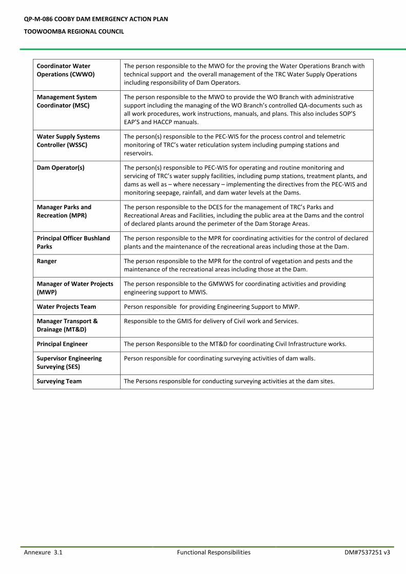
QP-M-086 COOBY DAM EMERGENCY ACTION PLAN
TOOWOOMBA REGIONAL COUNCIL
Annexure 3.1 Functional Responsibilities DM#7537251 v3
Coordinator Water Operations (CWWO)
The person responsible to the MWO for the proving the Water Operations Branch with technical support and the overall management of the TRC Water Supply Operations including responsibility of Dam Operators.
Management System Coordinator (MSC)
The person responsible to the MWO to provide the WO Branch with administrative support including the managing of the WO Branch’s controlled QA-documents such as all work procedures, work instructions, manuals, and plans. This also includes SOP’S EAP’S and HACCP manuals.
Water Supply Systems Controller (WSSC)
The person(s) responsible to the PEC-WIS for the process control and telemetric monitoring of TRC’s water reticulation system including pumping stations and reservoirs.
Dam Operator(s) The person(s) responsible to PEC-WIS for operating and routine monitoring and servicing of TRC’s water supply facilities, including pump stations, treatment plants, and dams as well as – where necessary – implementing the directives from the PEC-WIS and monitoring seepage, rainfall, and dam water levels at the Dams.
Manager Parks and Recreation (MPR)
The person responsible to the DCES for the management of TRC’s Parks and Recreational Areas and Facilities, including the public area at the Dams and the control of declared plants around the perimeter of the Dam Storage Areas.
Principal Officer Bushland Parks
The person responsible to the MPR for coordinating activities for the control of declared plants and the maintenance of the recreational areas including those at the Dam.
Ranger The person responsible to the MPR for the control of vegetation and pests and the maintenance of the recreational areas including those at the Dam.
Manager of Water Projects (MWP)
The person responsible to the GMWWS for coordinating activities and providing engineering support to MWIS.
Water Projects Team Person responsible for providing Engineering Support to MWP.
Manager Transport & Drainage (MT&D)
Responsible to the GMIS for delivery of Civil work and Services.
Principal Engineer The person Responsible to the MT&D for coordinating Civil Infrastructure works.
Supervisor Engineering Surveying (SES)
Person responsible for coordinating surveying activities of dam walls.
Surveying Team The Persons responsible for conducting surveying activities at the dam sites.
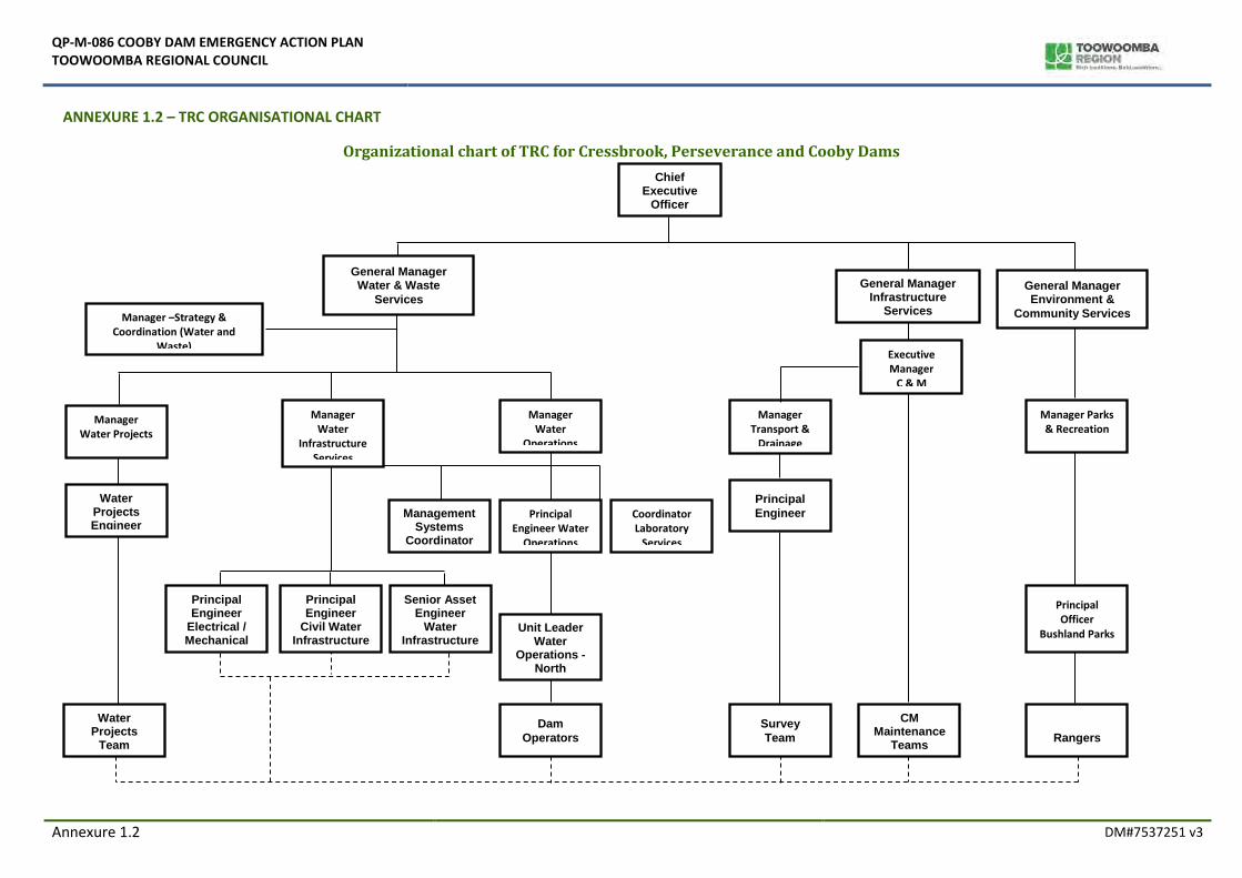
QP-M-086 COOBY DAM EMERGENCY ACTION PLAN TOOWOOMBA REGIONAL COUNCIL
Annexure 1.2 DM#7537251 v3
ANNEXURE 1.2 – TRC ORGANISATIONAL CHART
Organizational chart of TRC for Cressbrook, Perseverance and Cooby Dams
Manager –Strategy & Coordination (Water and
Waste)
Manager Water Projects
Manager Transport &
Drainage
Coordinator Laboratory
Services
General Manager Water & Waste
Services
Manager Water
Operations
Unit Leader Water
Operations - North
Management Systems
Coordinator
Principal Engineer Water
Operations
Dam
Operators
Chief Executive
Officer
CM Maintenance
Teams
Survey
Team
Manager Water
Infrastructure Services
General Manager Environment &
Community Services
Manager Parks & Recreation
Rangers
Water Projects
Team
Principal Engineer
Civil Water Infrastructure
s
Senior Asset Engineer
Water Infrastructure
Principal
Engineer
Water Projects Engineer
Principal Officer
Bushland Parks
General Manager Infrastructure
Services
Principal Engineer
Electrical / Mechanical
Executive Manager
C & M
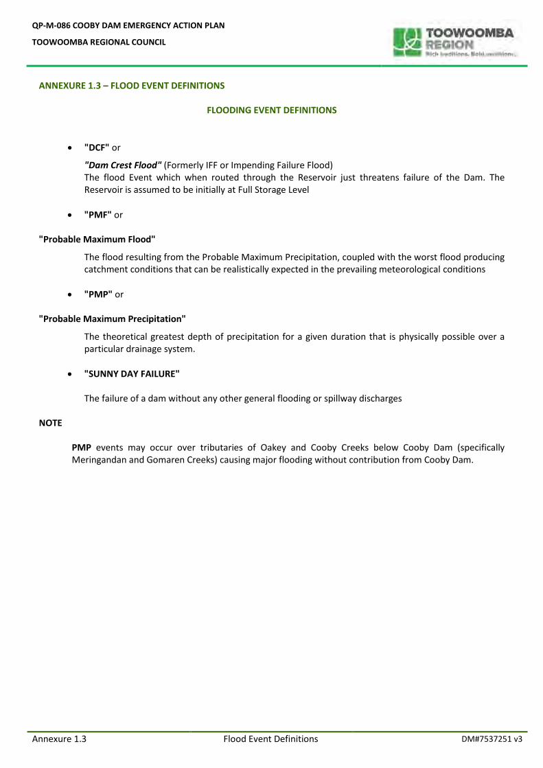
QP-M-086 COOBY DAM EMERGENCY ACTION PLAN
TOOWOOMBA REGIONAL COUNCIL
Annexure 1.3 Flood Event Definitions DM#7537251 v3
ANNEXURE 1.3 – FLOOD EVENT DEFINITIONS
FLOODING EVENT DEFINITIONS
"DCF" or
"Dam Crest Flood" (Formerly IFF or Impending Failure Flood) The flood Event which when routed through the Reservoir just threatens failure of the Dam. The Reservoir is assumed to be initially at Full Storage Level
"PMF" or
"Probable Maximum Flood"
The flood resulting from the Probable Maximum Precipitation, coupled with the worst flood producing catchment conditions that can be realistically expected in the prevailing meteorological conditions
"PMP" or
"Probable Maximum Precipitation"
The theoretical greatest depth of precipitation for a given duration that is physically possible over a particular drainage system.
"SUNNY DAY FAILURE"
The failure of a dam without any other general flooding or spillway discharges
NOTE
PMP events may occur over tributaries of Oakey and Cooby Creeks below Cooby Dam (specifically Meringandan and Gomaren Creeks) causing major flooding without contribution from Cooby Dam.
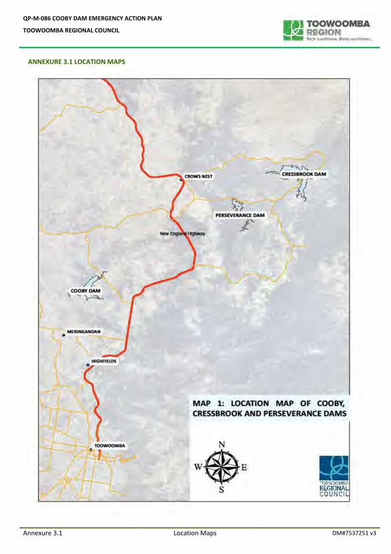
QP-M-086 COOBY DAM EMERGENCY ACTION PLAN
TOOWOOMBA REGIONAL COUNCIL
Annexure 3.1 Location Maps DM#7537251 v3
ANNEXURE 3.1 LOCATION MAPS
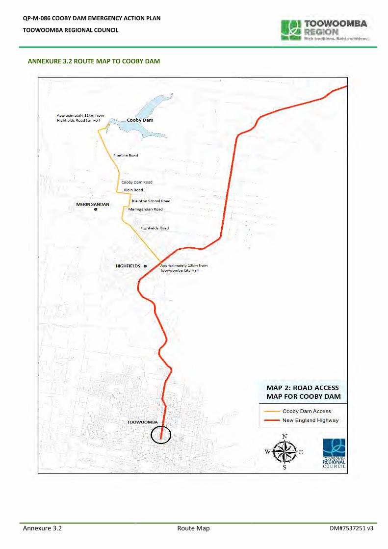
QP-M-086 COOBY DAM EMERGENCY ACTION PLAN
TOOWOOMBA REGIONAL COUNCIL
Annexure 3.2 Route Map DM#7537251 v3
ANNEXURE 3.2 ROUTE MAP TO COOBY DAM
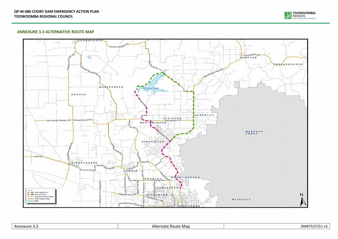
QP-M-086 COOBY DAM EMERGENCY ACTION PLAN TOOWOOMBA REGIONAL COUNCIL
Annexure 3.3 Alternate Route Map DM#7537251 v3
ANNEXURE 3.3 ALTERNATIVE ROUTE MAP
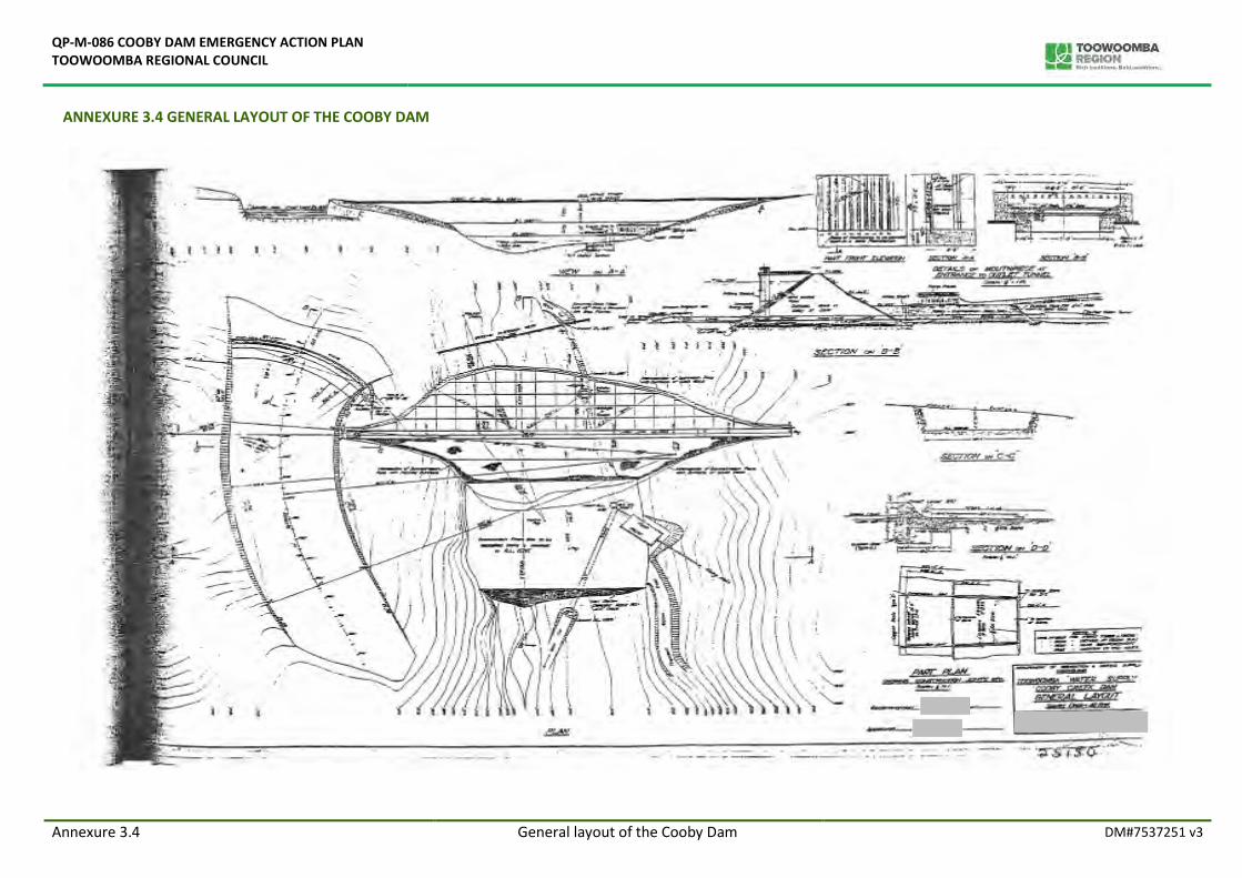
QP-M-086 COOBY DAM EMERGENCY ACTION PLAN TOOWOOMBA REGIONAL COUNCIL
Annexure 3.4 General layout of the Cooby Dam DM#7537251 v3
ANNEXURE 3.4 GENERAL LAYOUT OF THE COOBY DAM
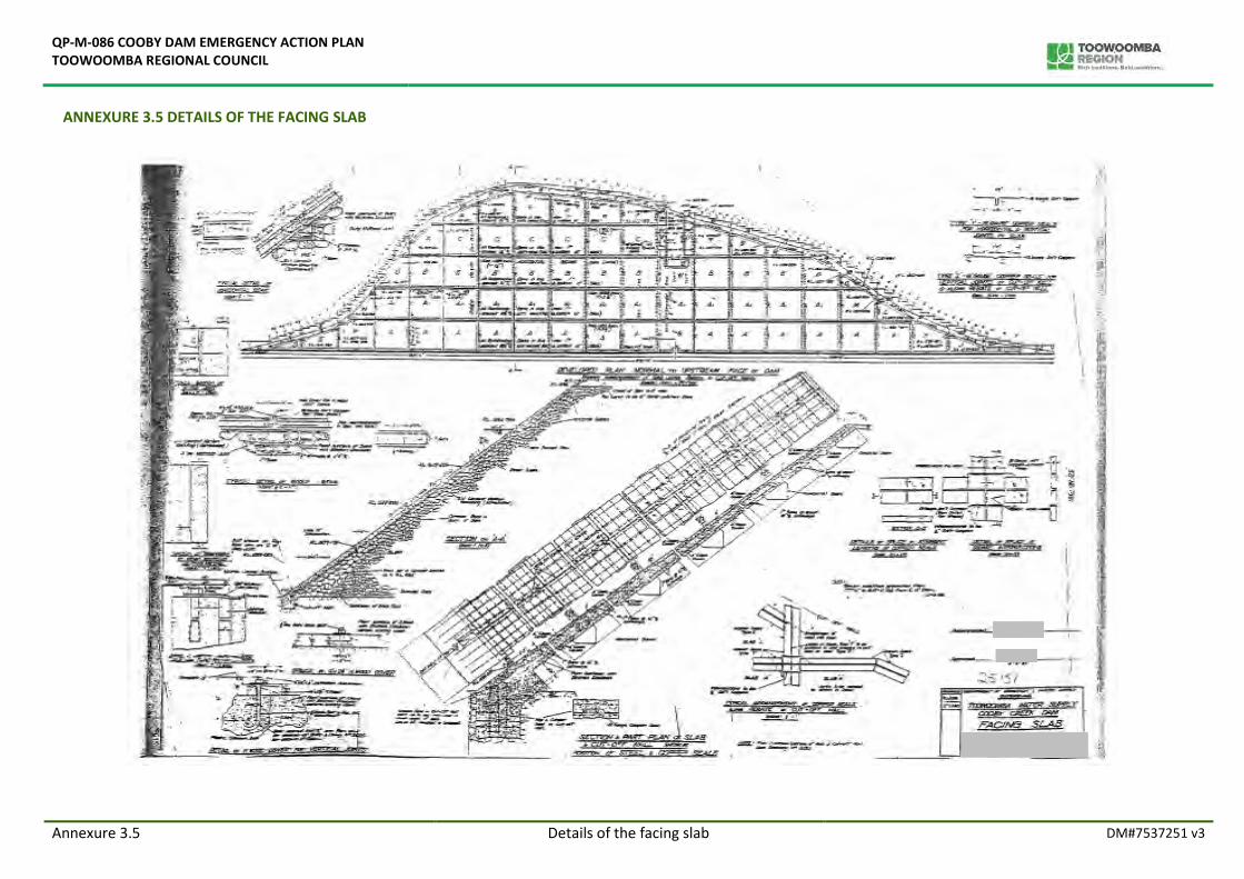
QP-M-086 COOBY DAM EMERGENCY ACTION PLAN TOOWOOMBA REGIONAL COUNCIL
Annexure 3.5 Details of the facing slab DM#7537251 v3
ANNEXURE 3.5 DETAILS OF THE FACING SLAB
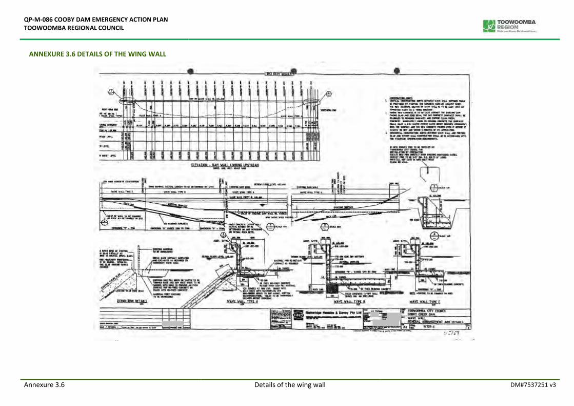
QP-M-086 COOBY DAM EMERGENCY ACTION PLAN TOOWOOMBA REGIONAL COUNCIL
Annexure 3.6 Details of the wing wall DM#7537251 v3
ANNEXURE 3.6 DETAILS OF THE WING WALL
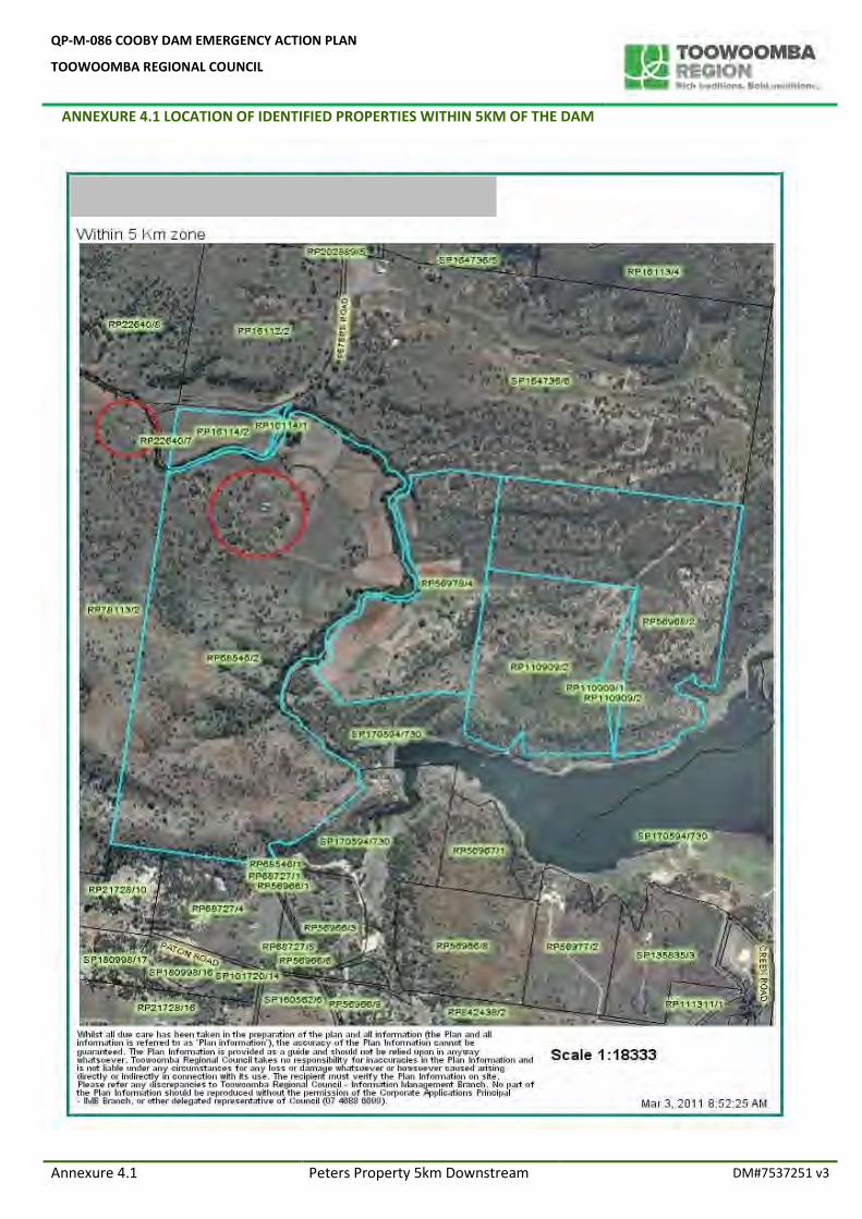
QP-M-086 COOBY DAM EMERGENCY ACTION PLAN
TOOWOOMBA REGIONAL COUNCIL
ANNEXURE 4.1 LOCATION OF IDENTIFIED PROPERTIES WITHIN 5KM OF THE DAM
Annexure 4.1 Peters Property 5km Downstream DM#7537251 v3
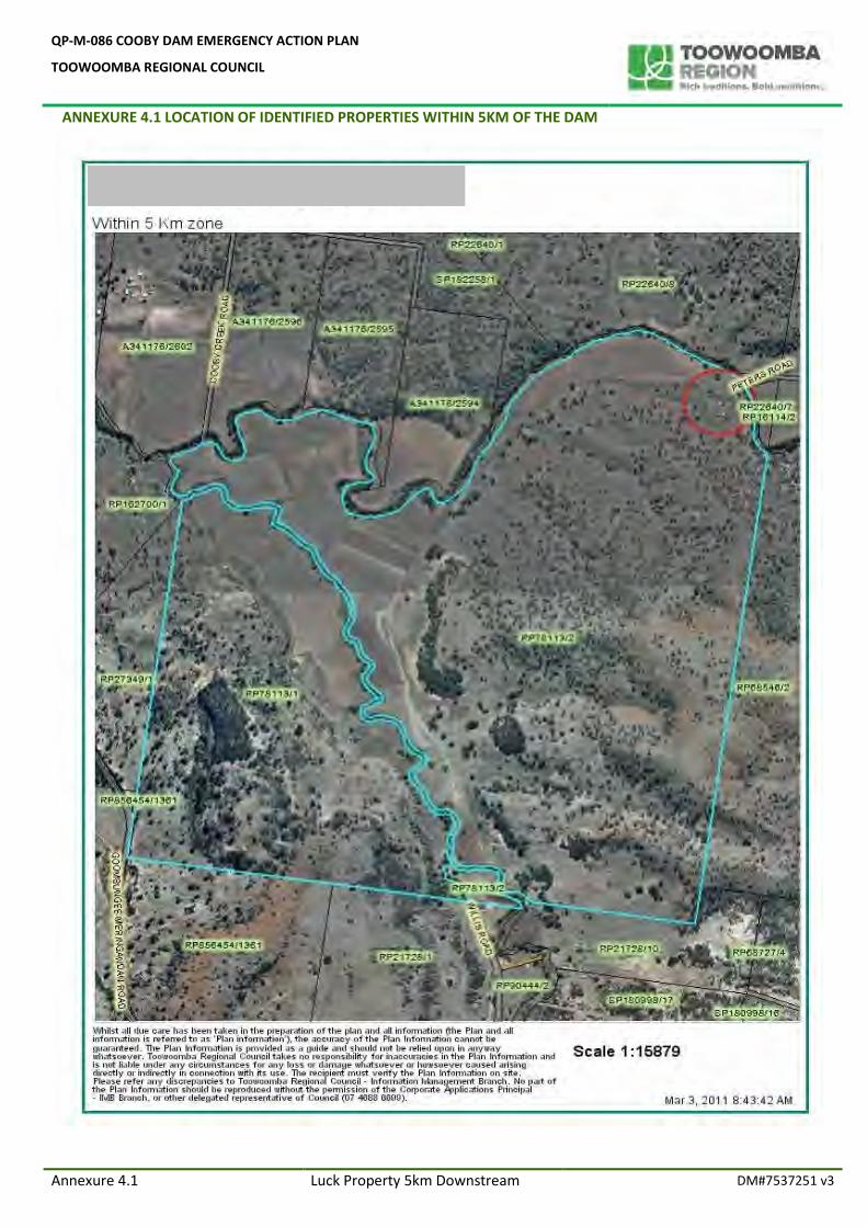
QP-M-086 COOBY DAM EMERGENCY ACTION PLAN
TOOWOOMBA REGIONAL COUNCIL
ANNEXURE 4.1 LOCATION OF IDENTIFIED PROPERTIES WITHIN 5KM OF THE DAM
Annexure 4.1 Luck Property 5km Downstream DM#7537251 v3
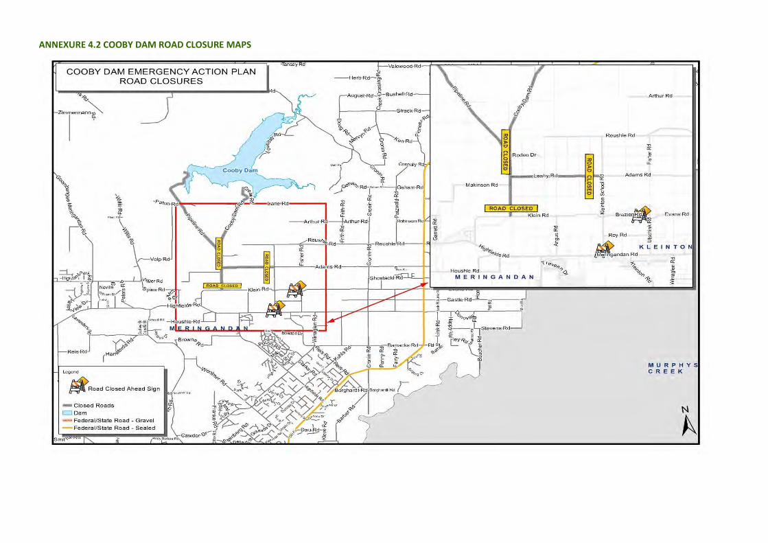
ANNEXURE 4.2 COOBY DAM ROAD CLOSURE MAPS
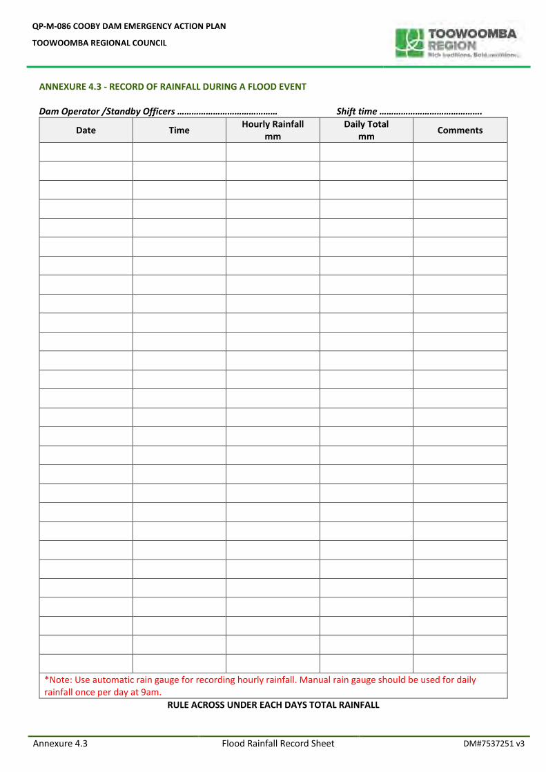
QP-M-086 COOBY DAM EMERGENCY ACTION PLAN
TOOWOOMBA REGIONAL COUNCIL
Annexure 4.3 Flood Rainfall Record Sheet DM#7537251 v3
ANNEXURE 4.3 - RECORD OF RAINFALL DURING A FLOOD EVENT Dam Operator /Standby Officers …………………………………… Shift time …………………………………….
Date Time Hourly Rainfall
mm Daily Total
mm Comments
*Note: Use automatic rain gauge for recording hourly rainfall. Manual rain gauge should be used for daily rainfall once per day at 9am.
RULE ACROSS UNDER EACH DAYS TOTAL RAINFALL
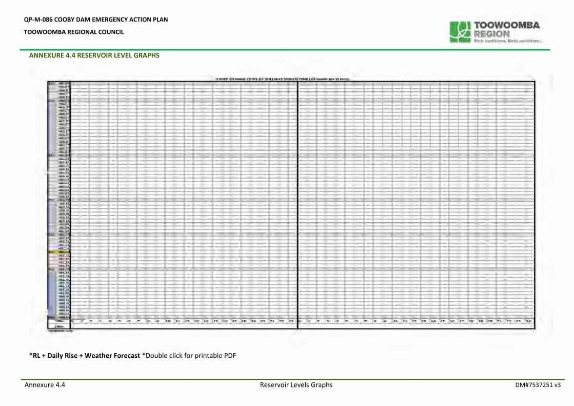
QP-M-086 COOBY DAM EMERGENCY ACTION PLAN
TOOWOOMBA REGIONAL COUNCIL
ANNEXURE 4.4 RESERVOIR LEVEL GRAPHS
Annexure 4.4 Reservoir Levels Graphs DM#7537251 v3
*RL + Daily Rise + Weather Forecast *Double click for printable PDF
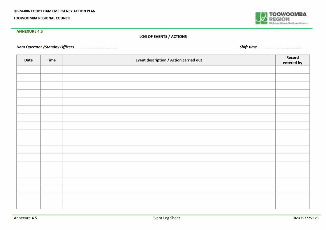
QP-M-086 COOBY DAM EMERGENCY ACTION PLAN
TOOWOOMBA REGIONAL COUNCIL
ANNEXURE 4.5
Annexure 4.5 Event Log Sheet DM#7537251 v3
LOG OF EVENTS / ACTIONS Dam Operator /Standby Officers …………………………………… Shift time …………………………………….
Date Time Event description / Action carried out Record
entered by
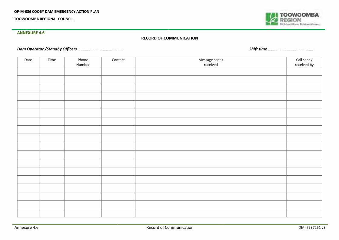
QP-M-086 COOBY DAM EMERGENCY ACTION PLAN
TOOWOOMBA REGIONAL COUNCIL
ANNEXURE 4.6
Annexure 4.6 Record of Communication DM#7537251 v3
RECORD OF COMMUNICATION
Dam Operator /Standby Officers …………………………………… Shift time …………………………………….
Date Time Phone Number
Contact Message sent / received
Call sent / received by
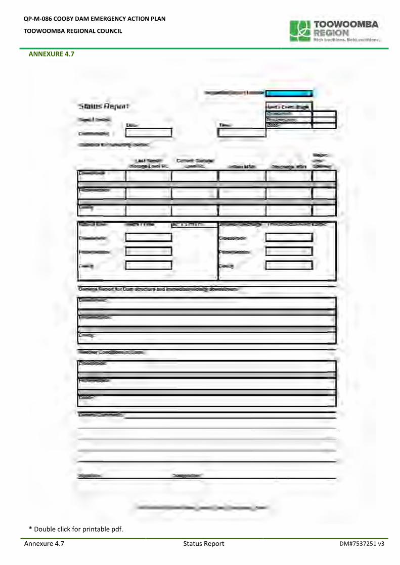
QP-M-086 COOBY DAM EMERGENCY ACTION PLAN
TOOWOOMBA REGIONAL COUNCIL
ANNEXURE 4.7
Annexure 4.7 Status Report DM#7537251 v3
* Double click for printable pdf.
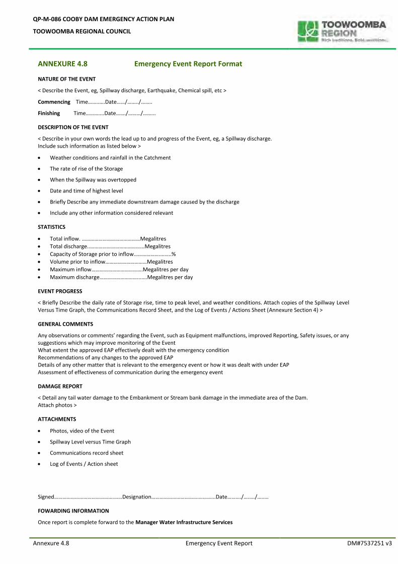
QP-M-086 COOBY DAM EMERGENCY ACTION PLAN
TOOWOOMBA REGIONAL COUNCIL
Annexure 4.8 Emergency Event Report DM#7537251 v3
ANNEXURE 4.8 Emergency Event Report Format
NATURE OF THE EVENT
< Describe the Event, eg, Spillway discharge, Earthquake, Chemical spill, etc >
Commencing Time……..….Date……/……../……..
Finishing Time………....Date……./………/……...
DESCRIPTION OF THE EVENT
< Describe in your own words the lead up to and progress of the Event, eg, a Spillway discharge. Include such information as listed below >
Weather conditions and rainfall in the Catchment
The rate of rise of the Storage
When the Spillway was overtopped
Date and time of highest level
Briefly Describe any immediate downstream damage caused by the discharge
Include any other information considered relevant
STATISTICS
Total inflow. ……………………………………Megalitres
Total discharge..………………………………...Megalitres
Capacity of Storage prior to inflow……………….……..%
Volume prior to inflow…………………………Megalitres
Maximum inflow……………………………….Megalitres per day
Maximum discharge………………………...….Megalitres per day
EVENT PROGRESS
< Briefly Describe the daily rate of Storage rise, time to peak level, and weather conditions. Attach copies of the Spillway Level Versus Time Graph, the Communications Record Sheet, and the Log of Events / Actions Sheet (Annexure Section 4) >
GENERAL COMMENTS
Any observations or comments’ regarding the Event, such as Equipment malfunctions, improved Reporting, Safety issues, or any suggestions which may improve monitoring of the Event What extent the approved EAP effectively dealt with the emergency condition Recommendations of any changes to the approved EAP Details of any other matter that is relevant to the emergency event or how it was dealt with under EAP Assessment of effectiveness of communication during the emergency event
DAMAGE REPORT
< Detail any tail water damage to the Embankment or Stream bank damage in the immediate area of the Dam. Attach photos >
ATTACHMENTS
Photos, video of the Event
Spillway Level versus Time Graph
Communications record sheet
Log of Events / Action sheet
Signed…………………………………….……Designation…………………………….………...Date………./…..…/…..…
FOWARDING INFORMATION
Once report is complete forward to the Manager Water Infrastructure Services
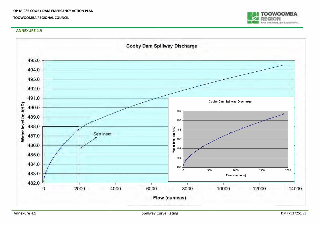
QP-M-086 COOBY DAM EMERGENCY ACTION PLAN
TOOWOOMBA REGIONAL COUNCIL
ANNEXURE 4.9
Annexure 4.9 Spillway Curve Rating DM#7537251 v3
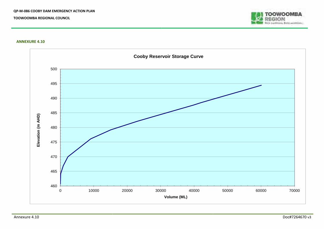
QP-M-086 COOBY DAM EMERGENCY ACTION PLAN
TOOWOOMBA REGIONAL COUNCIL
Annexure 4.10 Doc#7264670 v3
ANNEXURE 4.10
460
465
470
475
480
485
490
495
500
0 10000 20000 30000 40000 50000 60000 70000
Ele
vati
on
(m
AH
D)
Volume (ML)
Cooby Reservoir Storage Curve
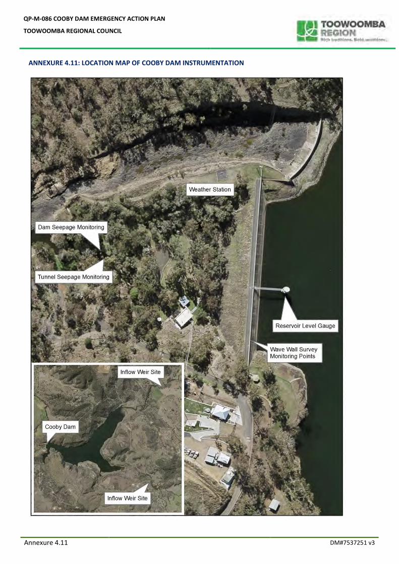
QP-M-086 COOBY DAM EMERGENCY ACTION PLAN
TOOWOOMBA REGIONAL COUNCIL
Annexure 4.11 DM#7537251 v3
ANNEXURE 4.11: LOCATION MAP OF COOBY DAM INSTRUMENTATION
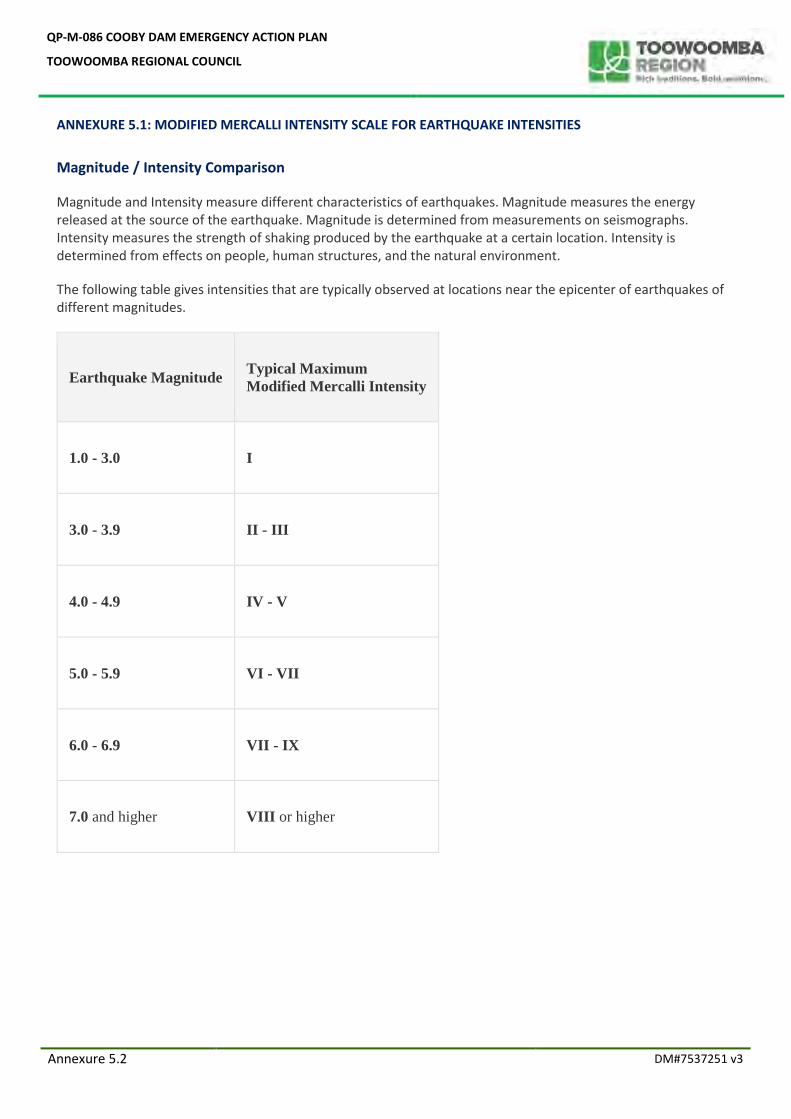
QP-M-086 COOBY DAM EMERGENCY ACTION PLAN
TOOWOOMBA REGIONAL COUNCIL
Annexure 5.2 DM#7537251 v3
ANNEXURE 5.1: MODIFIED MERCALLI INTENSITY SCALE FOR EARTHQUAKE INTENSITIES
Magnitude / Intensity Comparison
Magnitude and Intensity measure different characteristics of earthquakes. Magnitude measures the energy released at the source of the earthquake. Magnitude is determined from measurements on seismographs. Intensity measures the strength of shaking produced by the earthquake at a certain location. Intensity is determined from effects on people, human structures, and the natural environment.
The following table gives intensities that are typically observed at locations near the epicenter of earthquakes of different magnitudes.
Earthquake Magnitude Typical Maximum
Modified Mercalli Intensity
1.0 - 3.0 I
3.0 - 3.9 II - III
4.0 - 4.9 IV - V
5.0 - 5.9 VI - VII
6.0 - 6.9 VII - IX
7.0 and higher VIII or higher
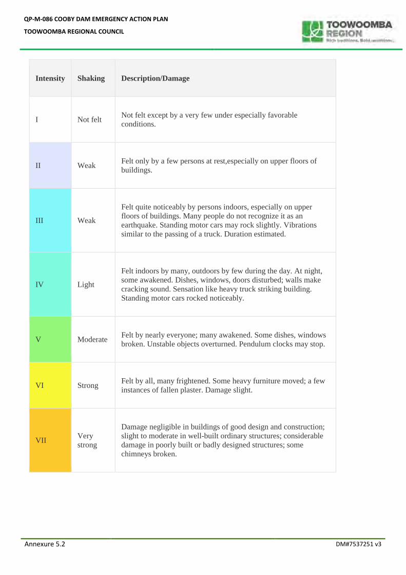
QP-M-086 COOBY DAM EMERGENCY ACTION PLAN
TOOWOOMBA REGIONAL COUNCIL
Annexure 5.2 DM#7537251 v3
Intensity Shaking Description/Damage
I Not felt Not felt except by a very few under especially favorable
conditions.
II Weak Felt only by a few persons at rest,especially on upper floors of
buildings.
III Weak
Felt quite noticeably by persons indoors, especially on upper
floors of buildings. Many people do not recognize it as an
earthquake. Standing motor cars may rock slightly. Vibrations
similar to the passing of a truck. Duration estimated.
IV Light
Felt indoors by many, outdoors by few during the day. At night,
some awakened. Dishes, windows, doors disturbed; walls make
cracking sound. Sensation like heavy truck striking building.
Standing motor cars rocked noticeably.
V Moderate Felt by nearly everyone; many awakened. Some dishes, windows
broken. Unstable objects overturned. Pendulum clocks may stop.
VI Strong Felt by all, many frightened. Some heavy furniture moved; a few
instances of fallen plaster. Damage slight.
VII Very
strong
Damage negligible in buildings of good design and construction;
slight to moderate in well-built ordinary structures; considerable
damage in poorly built or badly designed structures; some
chimneys broken.
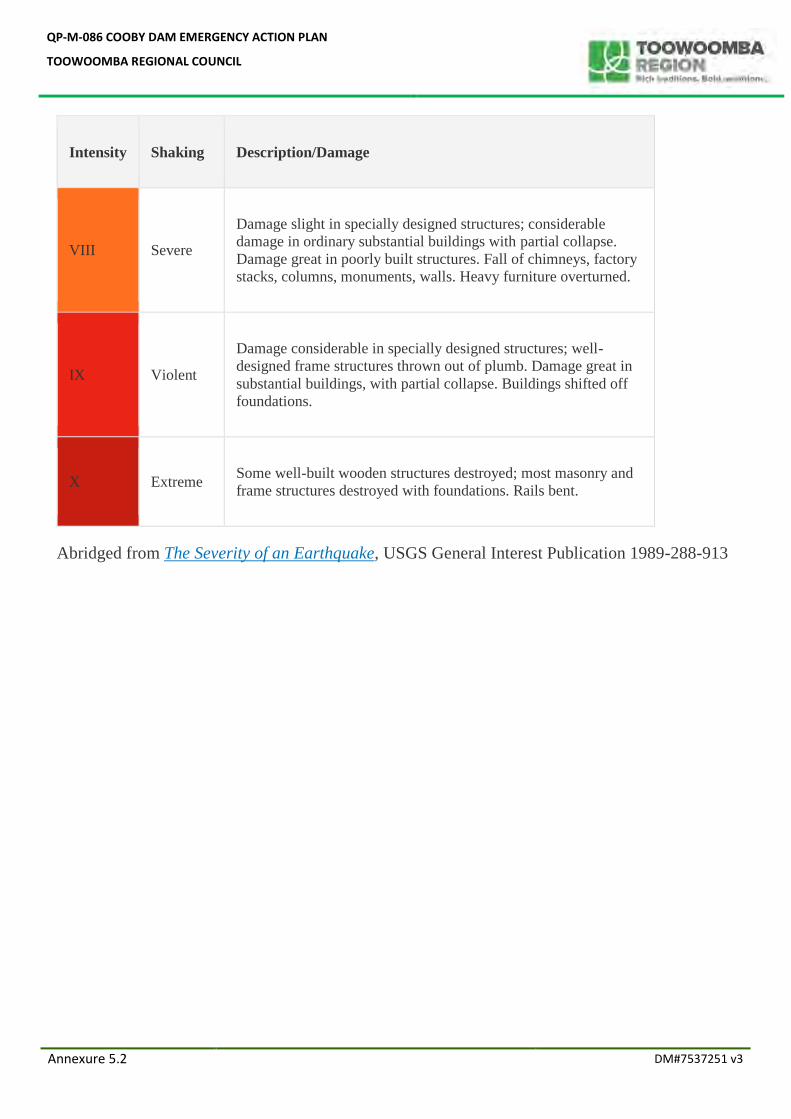
QP-M-086 COOBY DAM EMERGENCY ACTION PLAN
TOOWOOMBA REGIONAL COUNCIL
Annexure 5.2 DM#7537251 v3
Intensity Shaking Description/Damage
VIII Severe
Damage slight in specially designed structures; considerable
damage in ordinary substantial buildings with partial collapse.
Damage great in poorly built structures. Fall of chimneys, factory
stacks, columns, monuments, walls. Heavy furniture overturned.
IX Violent
Damage considerable in specially designed structures; well-
designed frame structures thrown out of plumb. Damage great in
substantial buildings, with partial collapse. Buildings shifted off
foundations.
X Extreme Some well-built wooden structures destroyed; most masonry and
frame structures destroyed with foundations. Rails bent.
Abridged from The Severity of an Earthquake, USGS General Interest Publication 1989-288-913