electromagnetic interference assessment2.4 planning guidelines ... telstra 3g and gsm coverage map...
TRANSCRIPT

Electromagnetic Interference Assessment
EMI Assessment of Flat Rocks Wind Farm
Moonies Hill Energy Pty Ltd
April 2011
Prepared by Moonies Hill Energy Pty Ltd 78 Pensioner Rd
Kojonup, WA, 6395 [email protected]

EMI Assessment – FRWF
Table of Contents
1. EXECUTIVE SUMMARY ............................................................................................... 1
2. INTRODUCTION............................................................................................................. 1
2.1 Description of the Site and Project ................................................................................ 2
2.2 Proposed Wind Farm Layout......................................................................................... 2
2.3 House Locations ............................................................................................................ 2
2.4 Planning Guidelines....................................................................................................... 2
3. METHODOLOGY AND RESULTS ................................................................................ 2
3.1 Communication Towers ................................................................................................ 3
3.2 Fixed license of point-to-point (microwave) type ......................................................... 3
3.3 Fixed licenses of point-to-multipoint type..................................................................... 5
3.4 Other License Types..................................................................................................... 6
3.5 Emergency and Local Shire Services ............................................................................ 6
3.6 Differential Geographical Positioning System (GPS) ................................................... 6
3.7 Meteorological Radar .................................................................................................... 7
3.8 Citizens Band Radio ...................................................................................................... 7
3.9 Mobile Telephones ........................................................................................................ 8
3.10 Wireless Internet............................................................................................................ 9
3.11 Satellite Television and Internet .................................................................................... 9
3.12 Radio Broadcasting........................................................................................................ 9
3.13 Television Broadcasting .................................................................................................. 11
3.14 Mitigation Options....................................................................................................... 13
4. CONCLUSIONS ..................................................................................................... 14
References............................................................................................................................ 15
Figures
Figure 1: Locality Map - Proposed Flat Rocks Wind Farm. ............................................... 17

EMI Assessment – FRWF
Figure 2: Transmission vectors for Fixed Point to Point Licenses within 50km of the Flat
Rocks wind farm.................................................................................................................. 18
Figure 3: Location of Point-to-Multipoint licenses. ............................................................ 19
Figure 4: BOM radar sites relative to the Flat Rocks wind farm......................................... 20
Figure 5: Telstra 3G and GSM Coverage Map proximate to the Flat Rocks wind farm. .... 21
Figure 6: Telstra Next G Coverage Map proximate to the Flat Rocks wind farm............... 21
Figure 7: Optus Open Network Coverage Map proximate to the Flat Rocks wind farm. ... 22
Figure 8: AM and FM Broadcast transmitters proximate to the Flat Rocks wind farm. ..... 23
Figure 9: Perth digital radio coverage (12).......................................................................... 24
Figure 10: ABC Digital TV - Southern Agricultural, WA .................................................. 25
Figure 11: ABC Digital TV - Wagin, WA........................................................................... 26
Figure 12: Analogue broadcast transmitters proximate to the Flat Rocks wind farm. ........ 27
Figure 13: Potential analogue television interference zones around a wind turbine ........... 27
Tables
Table 1 – Proposed layout for 74 turbines for the Flat Rocks wind farm............................ 28
Coordinate system UTM zone 50H, WGS84 datum ........................................................... 29
Table2 – Location of Residences......................................................................................... 30
Table 3 – Radiocommunications sites within 25km radius of the Flat Rocks wind farm from
ACMA Database (1) ............................................................................................................ 31
Table 4: Assignments to Site ID 29045 – Closest radiocommunications tower.................. 32
Table 5: Point to point links passing the FRWF site from Site 29045. ............................... 33
Table 6: Point to point links passing the FRWF site from Site 29044 ................................ 33
Table 7: Closest Fixed Point-to-Multipoint Licenses to the Flat Rocks Wind Farm........... 33
Table 8: Registered Emergency and Local Shire Services within 25km of the Flat Rocks
wind farm – ACAM database July 2011 ............................................................................. 34
Table 9: Name, location and distance of BOM relative to the proposed Flat Rocks wind
farm site ............................................................................................................................... 35
Table 10: Satellite internet providers operating in the vicinity of the proposed Flat Rocks
wind farm............................................................................................................................. 35

EMI Assessment – FRWF
Appendices
Appendix 1 - Summary of Stakeholder Comments ............................................................. 36
Appendix 2 – Written Responses from Interested Parties ................................................... 37
Abreviations
ACMA Australian Communications and Media Authority
BOM Bureau of Meteorology
CB Citizens Band
DAB Digital Audio Broadcasting
DGPS Differential Global Positioning System
DNWFG Draft National Guidelines for Wind Farm Development
EMI Electromagnetic Interference
EPHC Environmental Protection and Heritage Council
FESA Fire and Emergency Services Authority
FRWF Flat Rocks Wind Farm
GPS Global Positioning Systems
GSM Global System for Mobile Communications
MHE Moonies Hill Energy
RTK Real Time Kinematic
TV Television
UHF Ultra High Frequency
VHF Very High Frequency
WTG Wind Turbine Generator

EMI Assessment – Flat Rocks Wind Farm
1
1. EXECUTIVE SUMMARY
This report summarises the results of an electromagnetic interference (EMI) assessment conducted in and
around the proposed Flat Rocks wind farm site located 20 km south east of Kojonup, 27 km north west of
Tambellup, 16 km west of Broomehill and 27 km south west of Katanning in the Great Southern region
of Western Australia. An up to date list of radiocommunications sites located in the vicinity of the
proposed wind farm was obtained from the Australian Communications and Media Authority (ACMA) (1).
Throughout this report radiocommunications is used as a broad term to encompass all services that rely
on electromagnetic or radio waves to transfer information. There are many forms of radio
communication services operating in the vicinity of the proposed wind farm, and their susceptibility to
interference from wind turbines associated with the proposal are discussed.
VHF and UHF radio signals, GPS and digital technologies are essentially unaffected by wind farm
developments. This includes land mobile repeaters, radio, the audio component of analogue television
and mobile phones. However, if not properly designed, wind farms can cause interference to analogue
television broadcast and microwave signals. Currently analogue broadcast signals are used to transmit
domestic television in Western Australia, while microwave signals are used for line of sight connections
for data, voice and video. As the interference mechanisms are different for each of these signals, there are
different methods used to avoid interference.
Conclusions from this assessment are included in Section 4 of this report.
2. INTRODUCTION
To conduct the EMI assessment for the proposed Flat Rocks wind farm, current radiocommunications
sites and licenses in the vicinity of the proposed wind farm were identified from the Australian
Communication and Media Authority (ACMA) database (1). The ACMA classifies geographic
regions of Australia according to the demand for spectrum. The proposed development site is
classified as a “Low Density Area”.
This assessment investigates the impact of the proposed Flat Rocks wind farm on:
• Fixed point-to-point links
• Fixed point-to-multipoint links
• Radiocommunications assets belonging to emergency services
• Meteorological radar
• GPS systems
• Wireless internet
• Broadcast radio
• Satellite television and internet
• Broadcast television
Airspace communications and navigational aids are discussed in a separate Airspace Assessment Report.

EMI Assessment – Flat Rocks Wind Farm
2
2.1 Description of the Site and Project
The proposed Flat Rocks wind farm development is located approximately 20 km south east of Kojonup,
27 km north west of Tambellup, 16 km west of Broomehill and 27km south west of Katanning in the
Great Southern region of Western Australia. The general location of the area under investigation is
shown in Figure 1. The site comprises predominantly of cleared agricultural land used for broadacre crop
and livestock farming with small areas of scattered vegetation. Topography of the site is characterised by
gentle slopes and hills which vary in elevation from 290m to 390m.
2.2 Proposed Wind Farm Layout
The proposed wind farm will comprise of up to 74 turbines with a maximum hub height of 84m and
maximum blade tip of 140m, corresponding to a maximum rotor diameter of 112m. This EMI analysis
has been conducted using wind turbines with the dimensions described above.
A list of co-ordinates of the proposed turbine locations is presented in Table 1 – Proposed 74 turbine
layout for the Flat Rocks Wind Farm.
2.3 House Locations
A list of the dwellings located within 2km of the proposed Flat Rocks wind farm boundary is provided in
Table 2 - Location of Residences.
2.4 Planning Guidelines
In Western Australia there are no specific guidelines for the assessment of the electromagnetic impact of
wind farm developments. For the purposes of this assessment Planning Bulletin No 67 (2) from the
Western Australian Planning Commission has been considered, in combination with the Draft National
Guidelines for Wind Farm Development (DNWFG) published by the Environmental Protection and
Heritage Council (EPHC) in July 2010 (3). These draft guidelines provide advice and suggest
methodologies to identify and consult with likely affected parties, assess the EMI impacts and develop
mitigation steps to address the likely EMI impacts. The DNWFG are currently in draft form and have not
been endorsed by the planning authorities in Western Australia.
3. METHODOLOGY AND RESULTS
If not properly designed wind farms can interfere with both analogue television broadcast signals and
microwave signals. Analogue broadcast signals are the common form of transmitting domestic
television, while microwave signals are used for line of sight connections for data, voice and video. The
mechanisms of interference are different for each of these technologies, and hence, there are different
ways to avoid interference.

EMI Assessment – Flat Rocks Wind Farm
3
The methodology for assessing the potential interference to radiocommunications from the proposed Flat
Rocks wind farm was to locate all communication towers within a 25-50km radius of the proposed site,
and assess the communications licenses that are attached to these towers.
Other services operating within the vicinity of the proposed wind farm such as GPS and meteorological
radar, have been identified and the potential for interference to these services is discussed. Relevant
stakeholders have been consulted to identify likely impacts. A list of consulted stakeholders and their
comments are contained in Appendix 1 – Stakeholder Consultation.
3.1 Communication Towers
Review of the ACMA database (1), identified 31 licensed sites within 25km radius of the proposed wind
farm site. Table 3, Radiocommunications sites within 25km radius of the Flat Rocks wind farm from
ACMA Database, shows the details of these sites
The closest communication tower to the proposed wind farm boundary is SEC Site Potts Rd Enter Gate
Opposite Bilney Rd KOJONUP - ACMA Site ID 29045 which is approximately 2.45 km from the nearest
wind turbine, WTG 40. Details of the licenses assigned to this communication tower are presented in
Table 4. The closest telecommunication tower to the proposed development is located 5.8 km from the
nearest wind turbine, WTG 72. This site is operated by Telstra, Telstra Exchange Lumeah via
Cranbrook - ACMA Site ID 54257.
The DNWFG (3) state that operators of all telecommunication towers within 2km of a wind farm site
need to be consulted to assess the likely impact on their services. Despite the proposed wind farm site
exceeding these proposed proximity rules, MHE contacted Telstra Corporation Ltd in October 2010.
Correspondence was received in November 2010 stating that following a desktop assessment of the
telecommunication infrastructure around the proposed Flat Rocks wind farm site there is no potential for
undue interference. This correspondence is contained in Appendix 2, Written Responses from Interested
Parties.
3.2 Fixed license of point-to-point (microwave) type
Wind turbines can potentially cause interference to point-to-point microwave signals through diffraction,
reflection/scattering and near field effects. It is possible to design wind farm layouts to avoid this
interference, as the path and interference zone of point-to-point signals is generally well known. ACMA
Site ID 29045 - SEC Site Potts Rd Enter Gate Opposite Bilney Rd KOJONUP is the nearest communication
tower with fixed point-to-point type licenses to the proposed wind farm, located approximately 2.45 km
from the closest proposed wind turbine, WTG 40. Figure 2 illustrates the transmission vectors for the
fixed point to point type licenses within a 50km radius of the wind farm site. Point-to-point links are
often used for line of sight connections for data, voice and video.
3.2.1 Diffraction
Wind turbines can diffract or interfere with point-to-point microwave signals. To avoid diffraction
effects of these signals exclusion zones of circular cross-section around the direct path from the
transmitter to the receiver are used. The exclusion zone is defined in terms of Fresnel zones. It is

EMI Assessment – Flat Rocks Wind Farm
4
generally accepted that to avoid interference to these signals wind turbines, including blades, should be
kept outside the second Fresnel zone (3). The general equation for calculating the Fresnel zone radius at
any point P in between the endpoints of the link is the following:
where,
Fn = The nth Fresnel Zone radius in metres
d1 = The distance of P from one end in metres
d2 = The distance of P from the other end in metres
λ = The wavelength of the transmitted signal
The transmission vectors resulting from the licensed point to point links identified from the ACMA
database within a 50 km radius of the development area are shown in Figure 2. Four fixed point-to-point
transmission vectors cross the proposed development site, two in an area proposing wind turbines and
two in an area without wind turbines. Table 5 and Table 6 present the details of these links and their
associated exclusion zones. Three of these links are licensed to Electricity Networks Corporation trading
as Western Power, and one is licensed to the Western Australian Police Service. Both operators have
been contacted for comment on the wind farm proposal and potential effects to current services.
Responses from these operators are documented in Appendix 2.
Generally interference to point to point links occurs at frequencies operating above 1 GHz (4). At
frequencies below 1 GHz, point to point links are less reliant on line of sight as the signal is more able to
propagate around objects. Link licenses 1624134 and 331238 have the greatest potential for interference
by the proposed turbine layout. WTG 40 is located 50m from the vector 1624134 and WTG 67 100m
from link license 331238. Table 5 shows the calculated exclusion zones are 111.98m and 148.9m
respectively including the turbine blade. Both links operate on frequencies less than 1GHz at 451.05
MHz and 450.6 MHz, meaning they are less reliant on line of site. MHE has contacted Western Power,
the operator of these links, requesting comment on the proposal. At the time of writing this report, no
formal response had been received.
It is therefore recommended that MHE contact Western Power prior to finalisation of the layout and
consider micrositing WTG 40 and WTG 67 by 60m and 50m, respectively. All other turbines are outside
the exclusion zones.
3.2.2 Near –field effects and scattering
The DNWFG (3) mention the possibility of interference from wind turbines to point-to-point microwave
links via two additional mechanisms, near field effects and scattering.
All transmitting and receiving antennas have a “near-field” zone, which requires freedom from any object
that can conduct or absorb radio waves. If a wind turbine is located in close proximity to an antenna it
can change the characteristics of that antenna resulting in near-field effects. The near field zone is easily

EMI Assessment – Flat Rocks Wind Farm
5
calculated using various antenna characteristics. Below are typical “near field” zones of common point
to point microwave links:
• High Band Ultra High Frequency (UHF) signals, such as cellular telephones (800MHz to 1900MHz)
approximately 20m.
• For point-to-point Microwave links approximately 720m.
• For Low Band VHF paging systems approximately 4m.
The above examples provide a conservative criterion for assessing potential impacts due to near-field
effects from wind farms. The draft wind farm guidelines state that near field effects are usually limited to
approximately 720m from a telecommunication tower or facility and it is recommended that consultation
occur with the service operators should a wind turbine be proposed within 1km from a
telecommunication facility.
Scattering is interference to radio signals which can be caused by the reflection of the signal by the
blades of the wind turbines (3). The DNWFG state that scattering is best avoided by placing wind
turbines more than 2km from telecommunication towers. The closest proposed wind turbine to a
telecommunication tower in the Flat Rocks wind farm development is 5.8 km, which is outside the
recommended distance of 2km, thereby making interference to the signals unlikely. Despite this, MHE
has contacted the service provider, Telstra Pty Ltd, requesting feedback on the potential interference of
the wind farm on current services. A letter was received from Greg Parker, Area Planner, Network and
Technology Forecasting and Area Planning, stating that “based on the information provided, the
proposed wind farm has no potential to produce undue interference.” This correspondence is attached at
Appendix 2 - Written Responses from Interested Parties.
3.3 Fixed licenses of point-to-multipoint type
Fixed point-to-multipoint type licenses are a variation of the point-to-point license. Whilst a point-to-
point license permits communication between two static sites, where the locations of the sites are detailed
in a licence register such as the ACMA Radiocommunications Database, a point-to-multipoint license
allows communication between one or more static sites and multiple points, or between the points. The
point-to-multipoint type is usually licensed for a defined operational area.
The ACMA database (1) details the location of the static station for fixed point-to-multipoint licenses
only, not the multipoint or operational area, thus making identification of transmission vectors difficult.
Review of fixed point-to-multipoint type licenses on the ACMA database identified two static points in
the vicinity of the proposed Flat Rocks wind farm. The Telstra Microwave Site Fairfield Road 9km S
from Kojonup Katanning Road -– ACMA Site ID 28315 and the Wawa Site Fairfield Road KATANNING
– ACMA Site ID 28330. Site 28315 is located approximately 16.85 km north east of the closest wind
turbine (WTG 2) whilst site 28330 is located approximately 16.7 km north east of the closest wind
turbine (WTG 2). The details of the license holders associated with these sites are provided inTable 7
and the location of licensed static stations are displayed in Figure 3 - Location of Point-to-Multipoint
licenses. MHE has contacted the license operators seeking feedback in regards to potential interference
from the wind farm on these services. No formal response had been received to date from either
operator.

EMI Assessment – Flat Rocks Wind Farm
6
3.4 Other License Types
The ACMA database (1) was reviewed for other license types in the general vicinity of the proposed Flat
Rocks wind farm. Those identified can generally be described as base to mobile station communications,
including radio broadcasting, commercial and private telephony. The presence of wind turbines do not
generally affect these types of licenses any more than effects such as alterations in terrain, vegetation and
other forms of signal obstruction. Additionally, there are no base stations located within the wind farm
development site so only minor local obstructions may occur. Should reception difficulty be encountered,
the amelioration method consists of the user simply moving a short distance to receive a clearer signal.
3.5 Emergency and Local Shire Services
Radio communication assets operated by the local shires and emergency services in the vicinity of the
proposed wind farm were identified via the ACMA database (1). FESA, Western Australian Police, St
John Ambulance and the local bush fire radio (through the local shire and FESA) were found. All
operators have been contacted requesting comment on the likely effect of the proposed wind farm
development on current services, Appendix 1. The details of these services and their location are
presented in Table 8.
3.6 Differential Geographical Positioning System (GPS)
GPS signal reception satellites are not detrimentally affected by wind farms (4). At any one time a
standard GPS receiver will be communicating with many GPS satellites located in various positions in
the sky. The receiver should therefore be able to communicate and operate with several of these satellites
at any one time regardless of its position, or the position of the wind turbines. Therefore the likelihood of
interference to GPS signals will be limited to users in the immediate vicinity of the wind farm, i.e.
moving between the turbines.
MHE is aware that a number of farmers in the area within and surrounding the proposed wind farm may
use GPS in their agricultural activities. Typically these services are utilised in the form of tractor auto-
steer to accurately locate farm machinery on the ground, so that cropping activities such as seeding,
fertiliser and chemical applications and harvesting can be completed with very high accuracy. There are
two types of systems available, Differential GPS (DGPS), or a Real-Time Kinematic (RTK) GPS system,
the later delivering greater accuracy. Both systems utilise ground based stations to improve the spatial
accuracy above that achievable with conventional GPS systems.
In Australia transmissions between the base station and the GPS receiver for DGPS systems occur at
frequencies of around 300 kHz or 100 MHz (5, 6) and are unlikely to be influenced by wind turbines.
RTK systems communicate between the base station and a vehicle at frequencies between 400 and 900
MHz, and depending on the frequency of operation, maybe susceptible to interference. It should be noted
these systems are designed to operate in the close proximately of other objects, such as trees and
buildings and are expected to be robust to any potential interference from a wind turbine. As the vehicle
fitted with the auto-steer system is continually moving, any potential interference is likely to be transient,
and these systems are designed to quickly reacquire the base station signal when it becomes available
again. If continual signal interference between the base station and vehicle occurs, it is possible to move

EMI Assessment – Flat Rocks Wind Farm
7
the base station to a new location, or use a mobile base station to provide coverage from a location where
interference from the turbines is not likely to occur.
MHE will consult with surrounding landowners prior to final design layouts to ensure the location of
services are known to further minimise the potential for disruption to these services.
3.7 Meteorological Radar
Wind turbines have the potential to interfere with meteorological and aviation radar. Reflection off
turbine blades may give false readings or create a radar “shadow” behind turbines. Due to the distance
from meteorological radar assets, it is unlikely that the proposed wind farm will cause any significant
interference to meteorological radar. As per the draft national wind farm guidelines, MHE contacted the
Bureau of Meteorology to provide feedback on the potential impacts of the Flat Rocks wind farm on
meteorological radar operations. To date, this correspondence has been acknowledged but no comment
on the effects of the proposed wind farm on operations has been received.
The Bureau of Meteorology (BOM) operates a network of weather stations across Australia, many of
which use radar instruments for measuring wind speeds in the upper atmosphere (known as wind finding
radar), and determining rain and storm activity (known as weather watch radar).
The “wind finding” radar uses radar echo from a target to determine wind speeds and direction. The
target is attached to a balloon and tracked by ground radar. The “weather watch or surveillance” radar
consists of a rotating antenna located on a building that is used to direct a thin beam of radio energy
upward into the atmosphere which is then reflected back by a cloud mass. The location of the cloud is
then determined by the direction and travel time of the reflected beam.
Wind profile measurements are used to ensure safe operation of aircraft and play a vital role in the
Bureau’s general weather forecasting system. “Weather watch” radars monitor weather situations and
have the ability to predict potentially severe storms out to a distance of 250km or more. So whilst a
meteorological radar may not be as critical as perhaps an aviation radar, they play a significant role when
you consider public safety if severe weather is not predicted.
Wind farms located at distances greater than 5km from a BOM field station are unlikely to affect wind
finding radar operations (3). However, wind farms can impact upon weather watch radar when located
within several hundred kilometers of a radar station. The DNWFG recommend consultation with
operators of weather stations if wind farms are proposed within 200nm of operating weather stations.
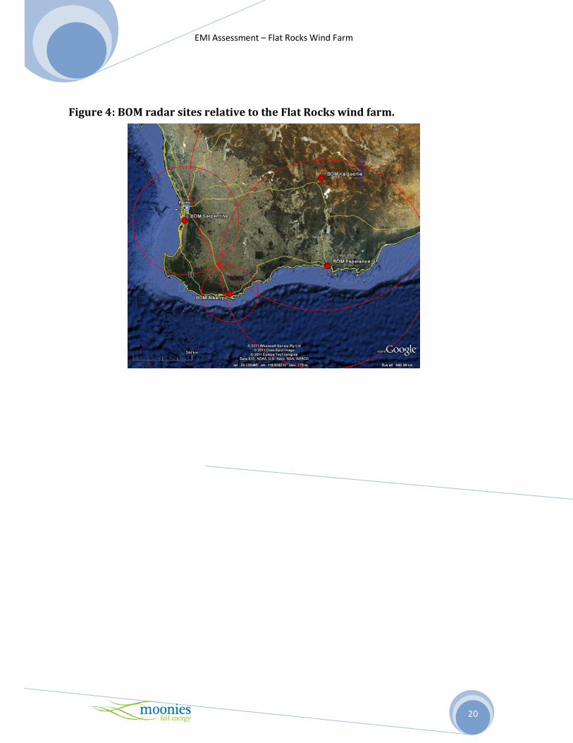
Table 9 shows the location and distance of the operating BOM radar stations in the southern regions of
Western Australia. Figure 4 displays this information graphically in Goggle Earth.
MHE has highlighted these operating stations and the location of the proposed wind farm with the BOM.
3.8 Citizens Band Radio
Citizen’s Band Radio, or CB radio, is a class-licensed two-way, short distance, communication service
that can be used in Australia by any person, for private use or work purposes. The class license means
that all users of the CB radio operate within the same frequency on a shared basis and no individual
license is required.

EMI Assessment – Flat Rocks Wind Farm
8
The CB radio service operates on two frequency bands, High Frequency (HF) band between 26.965 MHz
and 27.405 MHz, and Ultra High Frequency (UHF) band between 476.425 MHz and 477.400 MHz.
Over the last decade the use of 27 MHz or HF CB radio service has declined and has been replaced by
UHF CB radio. CB radio services can be used for voice communication activities, telemetry and
telecommand applications.
The UHF CB radio uses the FM transmission mode and is unique to Australia providing clear
communication over 5-10km. In order to work well, UHF CB radio requires line of sight and is easily
hindered by hilly terrain and forested areas. If on a hill top CB radio signals can be transmitted over at
least 50km. Repeater stations are often set up on hilltops by community and commercial organisations to
transmit signals from one channel to another. Whist no individual or organisation owns or has a right to
use a channel exclusively of the 40 channels available, some are allocated to emergency, repeater and
telemetry inputs.
As users of CB radio are not required to have a license, there are no records of users of the service and
their locations and the channels are shared among the users and the repeater stations without a right of
protection from interference. The impact of the proposed wind farm on local CB radio is expected to be
minimal. In the event that interference from a wind turbine does occur, the simple mitigation steps are to
move a short distance until the signal strength improves, a process currently used with existing forms of
interference.
3.9 Mobile Telephones
The mobile telephone network operates at frequencies of between 800 and 900 MHZ, or between 1800
and 2100 MHz. At these frequencies, signals are likely to be affected by physical obstructions such as
buildings and wind turbines. These networks are however designed to operate in such conditions and in
most cases, if there is sufficient mobile network coverage and signal strength, the presence of wind
turbines is unlikely to cause interference.
In rural areas, the mobile network coverage may be more susceptible to physical obstructions due to the
large distance between the telephone towers and the mobile phone user. In that case, wind turbines could
cause some interference to the signal.
MHE has obtained mobile telephone network coverage maps from Telstra and Optus (7, 8). The mobile
network coverage of these providers in the Flat Rocks area is shown in Figures 5, 6 and 7, respectively.
Overall the development area has variable mobile GSM coverage for Telstra and in some locations, only
mobile satellite coverage is available. In terms of Telstra’s Next G network again there is considerable
variation coverage in and around the proposed site, however a higher level of access is present in
comparison to the GSM network. The Optus mobile network coverage in the area is also varied with the
majority illustrated as good service with areas requiring an external antenna. For these areas, the signal
might be susceptible to interference if a wind turbine intercepts the signal between a mobile phone and
the tower. In cases of marginal network coverage, simple mitigation procedures such as moving a short
distance to a new location until the signal strength improves or installing an external antenna may
improve signal quality. Again this is a practice currently used by individuals in areas of variable
coverage.

EMI Assessment – Flat Rocks Wind Farm
9
3.10 Wireless Internet
A desktop review of wireless internet service providers operating in the Flat Rocks, Great Southern,
Kojonup and Broomehill regions revealed that internet access in the area surrounding the proposed wind
farm is likely to be provided via the 3G mobile network or satellite. Please refer to Section 3.9 of this
report for additional comments on the likely impact of the Flat Rocks wind farm on the 3G network.
Implications for interference of wind farms to satellite internet services are similar to those affecting
satellite television services, refer to section 3.11.
3.11 Satellite Television and Internet
Some residents in the vicinity of the Flat Rocks wind farm may access television or the internet, or both
via satellite. Satellite television is delivered from a communication satellite to a satellite dish connected
to a set-top box. The satellite transmits television signals to the user’s antenna at two frequency bands;
the C band at between 4GHz and 8 GHz, and the Ku band at between 12 GHz and 18 GHz. Signals in the
C band are susceptible to interference due to radio relay links, radar systems and other devices operating
at a similar frequency. Meanwhile Ku band signals are most likely to be affected by rain which acts as an
excellent absorber of microwave signals at this frequency.
In case of satellite internet, a user’s computer is connected to a satellite modem which is in turn liked to a
satellite dish mounted on the roof. According to the Australian ISP directory (9), there are at 13 satellite
internet providers operating in the vicinity of the proposed Flat Rocks wind farm. The contact details of
these providers are presented in Table 10 - Satellite internet providers operating in the vicinity of the
proposed Flat Rocks wind farm. These providers have been contacted for comment on the likely impact
of the proposed wind farm on their services. To date there have been no responses.
The main satellite for Pay TV and free-to-air TV in Australia is the Optus C1 satellite. From the
proposed wind farm site, the Optus C1 satellite has an elevation of approximately 33.1o and azimuth
(true) 55.1 o and azimuth (magn.) 56.8 o (10). It is unlikely that the proposed wind farm will impact upon
the line of sight from this satellite to any dwelling in and around the wind farm.
3.12 Radio Broadcasting
In Australia, AM radio operates in the Medium Wave (MW) band at frequencies of between 520 kHz and
1610 kHz, while FM radio operates in the very high frequency band (VHF) at between 87.5 MHz and
108 MHz. The locations of the AM and FM broadcast transmitters in the vicinity of the proposed wind
farm are shown in Figure 8.
Broadcast radio signals generally do not experience interference from wind turbines unless residences are
within tens of meters from a wind turbine (4). AM radio signals are very unlikely to be affected by wind
farms. FM radio signals are more susceptible to interference in the form of low level hiss or distortion,
but generally only in close proximity to a wind turbine. Any reception difficulties experienced should be
rectified by the installation of a high quality antenna.

EMI Assessment – Flat Rocks Wind Farm
10
3.12.1 AM Radio
AM radio waves are able to travel significant distances under the right conditions as they are diffracted
by the ground as they propagate, such that they follow the curvature of the earth, and are refracted by the
ionosphere at night. Their long wavelength means they can readily propagate around relatively small
physical obstructions (such as a wind turbine). They do not however propagate easily through dense
building materials like brick, concrete and aluminum.
The large distances that AM radio waves can travel means that by the time the signal reaches a receiver,
it may be weak and therefore susceptible to interference. Some of the possible sources of interference
include changes in atmospheric conditions, other distant signals from AM broadcasters operating on a
similar frequency, electrical power lines and electrical equipment including electric motors.
As AM radio signals are able to propagate around obstructions such as wind turbines, it is expected that
the proposed wind farm will not cause significant interference for a receiver. The long wavelength of the
AM radio signal means interference is only likely in the immediate vicinity of a turbine (11). Any
interference which may occur is likely to be resolved through the installation of a high quality antenna
and or amplifier.
3.12.2 FM Radio
Unlike lower frequency signals, FM radio waves are more suited to short range broadcasting as they are
not reflected or refracted off the ionosphere. The waves are slightly refracted by the atmosphere and
curve back towards the earth, this means they can propagate slightly beyond the visual horizon. They
may however be blocked by significant terrain features. Subsequently FM radio stations tend to have
only local coverage which means that signals are less susceptible to interference from other distant FM
broadcasters. They are also less susceptible to interference from changes in atmospheric conditions and
electrical equipment than AM signals.
FM radio signals are susceptible to interference from buildings and other structures, although less
vulnerable than higher frequency signals. Reflection or scattering of radio waves commonly associated
with hissing or distortion can be caused by physical structures which reduce signal strength at the
receiver. Physical structures can also cause multi-path errors through reception of a reflected signal in
addition to the primary signal from the transmitter. Generally any interference to FM signals is only
likely to occur in the immediate vicinity of the wind turbine (11), and can be easily rectified through the
installation of a high quality antenna and or amplifier.
3.12.3 Digital Radio
Metropolitan license areas have had access to digital radio services since July 2009. The digital radio
services offered use an updated version of the digital audio broadcasting (DAB) digital radio standard,
DAB+, to broadcast digital radio to Adelaide, Brisbane, Perth, Melbourne and Sydney. Figure 9 - Perth
digital radio coverage, shows the current digital radio footprint for Western Australia. This map
illustrates that digital radio is not yet available in the Flat Rocks region (12). The digital radio channels
ABC Dig, Music, ABC Jazz, SBS Radio 1 and SBS Radio 2 however are being broadcast as digital TV
channels and are accessible with a high definition digital tuner.

EMI Assessment – Flat Rocks Wind Farm
11
3.13 Television Broadcasting
Large scale interference to analogue television broadcast signals (point-to-area) can generally be avoided
by locating wind turbines at least 1km away from a broadcast tower. No analogue television broadcast
towers are located within 1km of the proposed Flat Rocks wind farm development. There are two
broadcast towers within the 50 km radius investigated; the closest is located 23.2km west of the proposed
site, 1.6 km south of Kojonup. The other broadcast tower is 24.3km north east of the proposed site at the
Wawa Site on Fairfield road in the Shire of Katanning. Even with such large buffers from the broadcast
towers interference to analogue television is still possible at residences in and around the wind farm site.
It is important to note however that by the end of 2013 analogue television is scheduled to be replaced by
digital television in the Flat Rocks area and digital television signals are less susceptible to interference
from wind turbines. The introduction of digital television in the area coincides with the project‘s
expected construction and connection dates of late 2013 early 2014.
Television broadcast signals are omni-directional or point-to-area signals, so interference from wind
turbines is dependent on several factors, including:
• proximity of wind turbines to television broadcast towers;
• proximity of wind turbines to receivers (in most cases residential dwellings);
• location of wind turbines in relation to dwellings and television broadcast towers;
• the rotor blade material, rotor speed and rotor blade direction (always into the wind);
• type of receiving antenna (e.g. directional and height); and
• the frequency and power of the television broadcast signal.
Broadcast towers are either relay or primary transmitters. Relay TV transmitters tend to be located in
rural areas whilst primary TV transmitter towers of higher power are more commonly located in larger
urban areas. Typically a clearance of at least 6km is recommended for primary TV transmitters, while a
clearance of at least 1km is recommended for relay TV transmitters (13).
For more information on the proximity of the proposed wind farm to television transmitters refer to
section 3.13.2.
3.13.1 Digital Television
The switch to digital television for the Great Southern region in Western Australia is scheduled for the
second half of 2013 between July and December (14). From this point onwards, analogue television
signals will cease transmission. It is therefore highly likely that analogue television signals will be
unavailable by the time the proposed wind farm has commenced constructed. Digital television will
therefore be the main form of free to air television when the Flat Rocks wind farm is operational. It is
important to note that digital television signals are less susceptible to interference from wind turbines
than traditional analog television signals.
A recent report published by the UK telecommunications regulator Ofcom (15), made the following
conclusions regarding interference to digital television reception.

EMI Assessment – Flat Rocks Wind Farm
12
“Digital television signals are much better at coping with signal reflections, and digital television
pictures do not suffer from ghosting. However a digital receiver that has to deal with reflections needs a
somewhat higher signal level than one that has to deal with the direct path only. This can mean that
viewers in areas where digital signals are fairly weak can experience interruptions to their reception
should new reflections appear… reflections may still affect digital television reception in some areas,
although the extent of the problem should be far less than for analogue television”.
Two conclusions can be drawn from this report:
• Firstly that digital television signals are very robust and do not suffer from ghosting. In most
cases digital television reception should be satisfactory in and around wind farm developments.
• Secondly, that areas of weak signal can experience interruptions to their reception should new
reflections appear, such as those from nearby wind turbines.
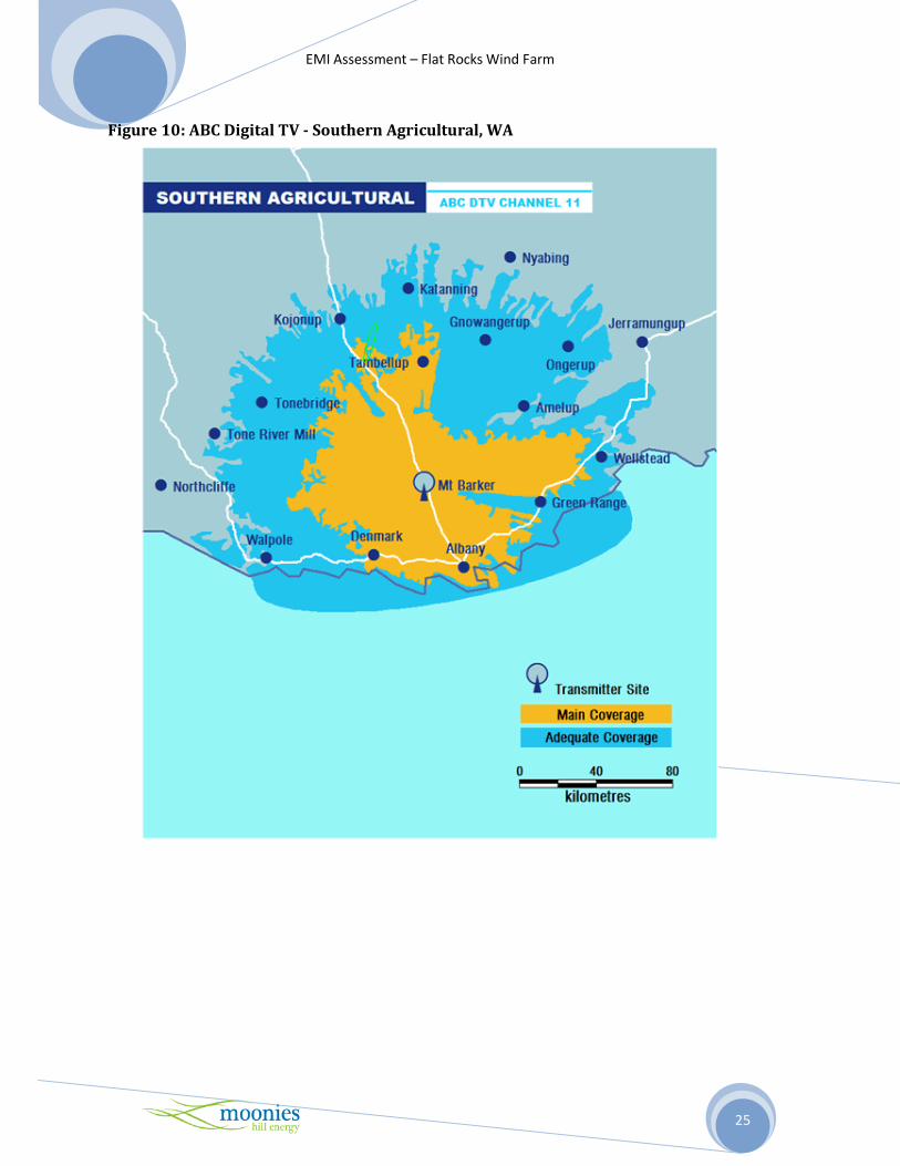
The ABC Reception Advice website (16), illustrates that the area around the wind farm is able to receive
an adequate digital television signal mainly from the Southern Agricultural WA, Mt Barker transmitter,
Figure 10 - ABC Digital TV - Southern Agricultural WA, and to a lesser extent the Wagin transmitter,
and Figure 11 - ABC Digital TV - Wagin, WA .
3.13.2 Analogue Television
The Broadcast Transmitter Database (17) was reviewed to identify the location of broadcaster
transmitters close to the proposed wind farm, Figure 12 - Analogue broadcast transmitters proximate to
the Flat Rocks wind farm.
Local interference to analogue television can occur at individual houses in and around the proposed wind
farm. A wind turbine has the potential to scatter analogue television waves forwards and backwards.
Forward scatter only occurs if the wind turbine is located between the dwelling and the broadcast site.
The forward scatter region is shown in Figure 13 - Potential analogue television interference zones
around a wind turbine, and generally does not extend further than 5km (14, 18). Interference may extend
beyond the 5km zone if the dwellings are screened from the broadcast tower, whilst having line of sight
to wind turbines. Forward scatter effects can cause the brightness of the television picture to vary with
the rotation of each blade. Modern television sets tend to contain Automatic Gain Compensators (AGC)
which lessen or eliminate these variations in picture gain or brightness.
Back scattered signals arrive at the dwelling delayed relative to the source signal from the broadcast
tower. The back scatter region shown in the Figure 13, generally does not extend further than 500m (14).
Therefore if a dwelling is within 500m of a wind turbine and its receiving antenna is not sufficiently
directional to discriminate between the original and delayed signal, then a pulsating ghost or secondary
signal may appear on the television screen. No residential dwellings are located closer than 1km from a
wind turbine in the proposed wind farm, thereby making back scattering unlikely to occur. The potential
for interference will be reduced in houses already using set top boxes to receive digital television, as a
digital TV signal are less susceptible to interference from a wind farm.
Potential interference to analogue television signals in and around the proposed site have not been
directly identified in this report, as analogue TV signals are due to be switched off in the Flat Rocks area
and replaced with digital TV between July and December 2013 (14). As the current digital TV coverage
in the vicinity of the proposed wind farm is adequate, refer to Figure 10, and that the wind farm is not

EMI Assessment – Flat Rocks Wind Farm
13
expected to be operational until late 2013 early 2014, this simplified analysis of analogue TV interference
is appropriate as the potential for interference to signals are minimal. Should interference occur, MHE
has a range of mitigation options discussed in the following section. MHE is aware through the local
council public submissions process, that many residents in the vicinity of the wind farm are already
experiencing poor analogue television reception. In view of this fact and the recommendations made in
the DNWFG, all houses within a 5-10km of the wind farm should undergo baseline testing of TV signals
prior to construction for picture quality and sound level.
During construction and operations, MHE will monitor any television reception interference as part of
local community consultation with consideration of baseline, construction and operational status.
3.14 Mitigation Options
In the event that TV interference is encountered and attributable to the wind farm, the following
mitigation options are available to rectify the situation:
1. Realigning the resident’s TV antenna more directly towards their existing transmitter;
2. Tuning the resident’s antenna into alternative sources of the same or suitable TV signal;
3. Installation of more directional and/or higher gain antenna at the affected residence;
4. Relocating the antenna to a less affected position;
5. Installation of satellite TV at the affected residence; and
6. Installation of a TV relay station.
The introduction of digital television broadcasts provide an attractive mitigation option for residences in
and around wind farms as digital television signals are essentially unaffected by wind turbines. Analogue
television is currently scheduled to be phased out in regional Western Australia in mid to late 2013 (14).
In the unlikely event that digital television can not provide an acceptable outcome, satellite television
represents another mitigation option. Satellite based television services comprise of both free to air and
subscription based broadcasts.

EMI Assessment – Flat Rocks Wind Farm
14
4. CONCLUSIONS
MHE has investigated the potential of electromagnetic interference from the Flat Rocks wind farm and
identified all broadcast towers and transmission vectors in the vicinity of the proposed development.
MHE has contacted all relevant stakeholders requesting comment on the potential for interference to
services as a direct result of the proposed wind farm. At the time of writing this report, no operator had
identified any problems or potential for interference.
Radio signals, GPS and digital technologies will be unaffected by the wind farm development and
includes land mobile repeaters, radio, the audio component of analogue television and mobile phones.
Currently analogue broadcast signals, which may be susceptible to interference from wind turbines, are
used to transmit domestic television in Western Australia. In mid 2013 and coinciding with
commencement of construction, digital television will be the main form of TV broadcast signal in the Flat
Rocks region. As digital signals are less likely to be affected by interference from wind turbines,
interference to TV signals is not expected.
Two point to point type microwave link vectors pass through the proposed wind farm in close proximity
to proposed wind turbines, WTG 40 and WTG 67. Appropriate exclusion zones for these links have been
calculated and compared to the current buffer zones for the proposed wind turbine layout. MHE has
contacted the operator of the links for feedback on service effects and to date has had no reply. It is
recommended that prior to finalisation of the turbine layout MHE liaise with the license operator or
consider relocating WTG 67 and WTG 40 by 50m and 60m respectively. It is also advised that the
accuracy if the radiocommunications sites co-ordinates obtained from the ACMA database be verified as
the accuracy of these coordinates is variable (3).

EMI Assessment – Flat Rocks Wind Farm
15
References
1. Register of Radiocommunications Licenses , Australian Communications and MediaAuthority
(ACMA), http://web.acma.gov.au/pls/radcom/register_search.search_dispatcher, viewed April & July
2011.
2. Guidelines for Wind Farm Development, Planning Bulletin No 67, ISSN 1324-9142, May 2004.
http://www.planning.wa.gov.au/Publications/210.aspx;
3. EPHC, National Wind Farm Development Guidelines- Public Consultation Draft, released July 2010,
http://www.ephc.gov.au/sites/default/files/DRAFT%20National%20Wind%20Farm%20
Development%20Guidelines_JULY%202010_v2.pdf;
4. Buckley, S., and S. Knight Merz. 2005. Wind Farms and Electromagnetic Interference – Dispelling the
Myths. SKM Consulting [online]. Available:
http://www.skmconsulting.com/Markets/energy/Wind_farms_Electromagnetic_Interfernce.htm
[accessed Aug. 24, 2006];
5. “AMSA’s DGPS Service”, Australian Maritime Safety Authority, July 2007,
http://www.amsa.gov.au/Shipping_System/Service_Status/index.asp;
6. “Differential GPS in Australia”, Fairall, J., The Australasian Geographical Information Systems
Applications Journal, Issue 23, 1997,
http://positionmag.com.au/GU/content/1997/GU23/gu23_DGPS.html
7. Telstra Mobile coverage maps��, Telstra, 2010, viewed April 2011 http://www.telstra.com.au/mobile/networks/coverage/maps.cfm
8. Optus Network Coverage, Optus, 2010, viewed April 2011
http://www.optus.com.au/aboutoptus/About+Optus/Network+Coverage
9. “The Australian ISP Directory”, viewed 06 January 2011, http://bc.whirlpool.net.au/
10. Satellite Finder/Dish Pointing Calculator with Google Maps�, http://www.dishpointer.com/,
Accessed April 2011
11. Spera, D.A. (ed.), “Wind Turbine Technology”, ASME Press, 1994;
12. http://www.abc.net.au/radio/digital/ – viewed April 2011;
13. Hall, S.H, 1992, “The assessment and avoidance of Electromagnetic Interference due to Wind
farms”, Wind Engineering, Vol 16 No 6, pp 326-338;
14. “Digital Television Switchover”, Department of Broadband, Communications and the Digital
Economy, 20 December 2010, viewed April 2011,
http://www.dbcde.gov.au/television/digital_televison_switchover;
15. “Tall structures and their impact on broadcast and other wireless services”, Ofcom,
http://licensing.ofcom.org.uk/radiocommunication-licenses/fixed-terrestrial-links/guidancefor-
licensees/wind-farms/tall_structures/ 26 August 2009;

EMI Assessment – Flat Rocks Wind Farm
16
16. ABC Transmitter Frequencies- ABC Reception Advice��, Australian Broadcasting Corporation,
accessed 29 April 2011, http://www.abc.net.au/reception/freq/];
17. The Radio and Television Broadcasting Stations Book, Australian Communications and Media
Authority (Internet Edition, April 2011)
http://www.acma.gov.au/webwr/_assets/main/lib100059/tv_9.pdf;
18. Assessment of the impairment caused to television reception by a wind turbine��, Recommendations ITU-R BT.805, 1992

EMI Assessment – Flat Rocks Wind Farm
17
Figure 1: Locality Map - Proposed Flat Rocks Wind Farm.

EMI Assessment – Flat Rocks Wind Farm
18
Figure 2: Transmission vectors for Fixed Point to Point Licenses within 50km of the Flat Rocks wind farm.

EMI Assessment – Flat Rocks Wind Farm
19
Figure 3: Location of Point-to-Multipoint licenses.
EMI Assessment – Flat Rocks Wind Farm
20
Figure 4: BOM radar sites relative to the Flat Rocks wind farm.

EMI Assessment – Flat Rocks Wind Farm
21
Figure 5: Telstra 3G and GSM Coverage Map proximate to the Flat Rocks wind farm.
Figure 6: Telstra Next G Coverage Map proximate to the Flat Rocks wind farm.

EMI Assessment – Flat Rocks Wind Farm
22
Figure 7: Optus Open Network Coverage Map proximate to the Flat Rocks wind farm.
Optus Open Network Coverage Locator
Address : BROOMEHILL WEST 6318 WA Date/time : 23/04/2011 7:24:48 PM
LEGEND
The Open Network includes:
3G dual band: on street voice, data & video *
3G dual band: on street voice, data & video with external antenna *
3G single band: on street voice, data & video ^
Future 3G dual band: on street voice, data & video*
2G on street voice & GPRS #
2G car kit with external antenna voice & GPRS #

EMI Assessment – Flat Rocks Wind Farm
23
Figure 8: AM and FM Broadcast transmitters proximate to the Flat Rocks wind farm.

EMI Assessment – Flat Rocks Wind Farm
24
Figure 9: Perth digital radio coverage (12)
EMI Assessment – Flat Rocks Wind Farm
25
Figure 10: ABC Digital TV - Southern Agricultural, WA

EMI Assessment – Flat Rocks Wind Farm
26
Figure 11: ABC Digital TV - Wagin, WA

EMI Assessment – Flat Rocks Wind Farm
27
Figure 12: Analogue broadcast transmitters proximate to the Flat Rocks wind farm.
Figure 13: Potential analogue television interference zones around a wind turbine

EMI Assessment – Flat Rocks Wind Farm
28
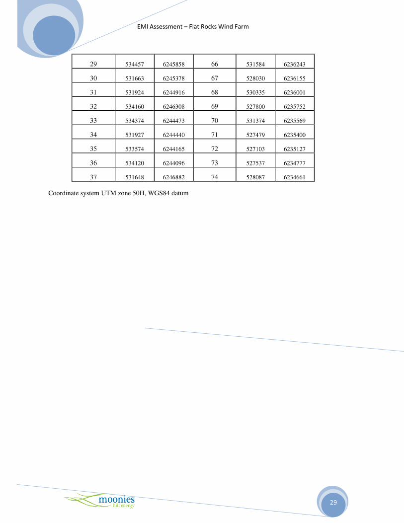
Table 1 – Proposed layout for 74 turbines for the Flat Rocks wind farm
Turbine ID Easting Northing Turbine ID Easting Northing
1 533353 6251758 38 526877 6242486
2 533872 6251546 39 527681 6242229
3 532675 6251443 40 526488 6242210
4 533626 6251119 41 527310 6241900
5 532328 6250880 42 528113 6241847
6 533248 6250736 43 531840 6241787
7 533756 6250500 44 532391 6241738
8 531575 6250252 45 527860 6241246
9 532922 6250191 46 532100 6241227
10 532333 6250139 47 531471 6241171
11 533464 6250113 48 530014 6241007
12 533791 6249619 49 530604 6240976
13 533260 6249574 50 532458 6240750
14 536267 6247980 51 530327 6240492
15 536201 6247429 52 532848 6240303
16 534497 6246947 53 530035 6240010
17 530818 6247319 54 533060 6239760
18 536269 6246950 55 529575 6239800
19 534021 6246789 56 533224 6239233
20 535002 6246668 57 533285 6238735
21 531467 6246454 58 533253 6238266
22 530744 6246520 59 531682 6237572
23 535002 6245864 60 530107 6237475
24 535977 6246267 61 531221 6237400
25 531130 6246118 62 530660 6237354
26 534675 6246351 63 530360 6236850
27 535305 6246210 64 531585 6236810
28 531636 6245855 65 530044 6236516
EMI Assessment – Flat Rocks Wind Farm
29
29 534457 6245858 66 531584 6236243
30 531663 6245378 67 528030 6236155
31 531924 6244916 68 530335 6236001
32 534160 6246308 69 527800 6235752
33 534374 6244473 70 531374 6235569
34 531927 6244440 71 527479 6235400
35 533574 6244165 72 527103 6235127
36 534120 6244096 73 527537 6234777
37 531648 6246882 74 528087 6234661
Coordinate system UTM zone 50H, WGS84 datum

EMI Assessment – Flat Rocks Wind Farm
30
Table2 – Location of Residences
House
ID
Easting
(m)
Northing
(m)
Distance to
closest
turbine (km) Occupied?
NSH01 529798 6252398 2.8 Y
NSH02 534034 6254130 2.5 N
NSH03 534715 6252104 1.0 Y
NSH04 533706 6248509 1.1 N
NSH05 538397 6245086 2.7 Y
NSH06 536092 6244487 1.7 Y
NSH07 536187 6243019 2.3 Y
NSH08 533602 6237033 1.3 Y
NSH09 533299 6237262 1.0 Y
NSH10 527067 6249862 4.5 Y
NSH11 527858 6248864 3.3 Y
NSH12 529822 6247171 1.0 Y
NSH13 530084 6245361 1.3 Y
NSH14 531650 6243477 1.0 Y
NSH15 532980 62442569 1.0 Y
NSH16 527583 6245239 2.8 Y
NSH17 525526 6244591 2.5 Y
NSH18 525548 6238704 3.4 Y
NSH19 528558 6237293 1.3 Y
NSH20 531581 6233170 2.4 Y
NSH21 526817 6247723 4.0 Y
NSH22 529707 6247138 1.1 Y
NSH23 527880 6245017 2.7 Y
NSH24 529664 6247150 1.2 N
NSH25 539639 6249790 3.8 Y
SH26 537647 6239337 4.4 Y
SH27 534084 6239794 1.0 Y
SH28 531662 6251703 1.0 Y
SH29 533630 6245183 1.0 Y
SH30 528913 6240557 1.0 Y
SH31 529077 6237156 1.1 Y
SH32 528718 6236883 1.0 Y
SH33 537743 6239372 4.5 N
Proposed NSH34 531507 6239494 1.5 N
NHS – Non Stakeholder, SH – Stakeholder, Coordinate system is UTM zone 50H, WGS84 datum

EMI Assessment – Flat Rocks Wind Farm
31
Table 3 – Radiocommunications sites within 25km radius of the Flat Rocks
wind farm from ACMA Database (1)
ACMA
Site ID Site Name Location
Referenced from Monitoring Mast Location -33.970511 117.345604
29026 4 Km East of JINGALUP -33.933945 117.349492
29045 SEC Site Potts Rd Enter Gate Opposite Bilney Rd KOJONUP -33.963025 117.260639
9009820 Wellard Site 2.4 km West of Bilney and Potts Road KOJONUP -33.962638 117.260421
9913254 Mobile Spectrum Licensing Site ALBANY HIGHWAY -34.050808 117.287745
28344 Telstra West Site TAMBELLUP -34.024725 117.443048
54257 Telstra Exchange Lumeah via CRANBROOK -34.000528 117.237429
9913195 Mobile Spectrum Licensing Site ALBANY HIGHWAY -33.961395 117.201753
600973 Telstra Tunney Exchange 25 km SW of TAMBELLUP -33.118731 117.367784
9913275 Mobile Spectrum Licensing Site ALBANY HIGHWAY -34.121826 117.370433
29028 Korong Vale Trust 8 km East of KOJONUP -33.859819 117.22973
50138 Etna Rd BROOMEHILL -33.89732 117.507248
461483 Kings Cross Rd TAMBELLUP -34.113611 117.450556
601719 Sunny Valley Merino Stud 8 km S of KOJONUP -33.9049 117.172729
9913125 Mobile Spectrum Licensing Site ALBANY HIGHWAY -33.886578 117.175395
29037 Danetree KOJONUP -33.801614 117.24632
602029 CMTS Site Farm Property 2431 Albany Hwy Kojonup -33.859005 117.16348
29044 Police Site South of Kojonup -33.858573 117.163241
54255 Telstra Sturry Road Repeater 20 km NW of CRANBROOK -34.182063 117.387397
601275 St Clair Farm Carlecatup Nth Rd -33.769502 117.265494
41222 Broadcast Site 1.6km S of Kojonup -33.847754 117.159978
29018 12 Delaney Street Kojonup -33.848211 117.155547
200727 Cnr Spencer and Honner St Kojonup -33.837743 117.159635
28320 Cheviot Hills Rd KATANNING -33.863851 117.551268
29040 Kojonup VFB Lot 101 Albany Hwy Kojonup -33.833507 117.157465
29038 Hospital Spring St Kojonup -33.830178 117.151191
28328 WAGR Site Fairfield Rd Katanning -33.793758 117.515214
28315 Telstra Microwave Site Fairfield Rd -33.79354 117.515752
151105 Broadcast Site Fairfield -33.792703 117.515294
28330 WAWA Site Fairfield Rd -33.793427 117.516918
28313 Shire Site Fairfield Rd -33.795181 117.520105
29050 Telstra Radio Terminal Bell Rd -33.790865 117.157214

EMI Assessment – Flat Rocks Wind Farm
32
Table 4: Assignments to Site ID 29045 – Closest radiocommunications tower.
Assignment ID Frequency Client Licence No
116831-58475 163.8500000 MHz Forts Valley Pastoral Co (229765) 327853
369920-30162 460.0000000 MHz Electricity Networks Corporation
(1139619) 331012
370026-30163 450.6000000 MHz Electricity Networks Corporation
(1139619) 331238
370037-3803 81.3500000 MHz Electricity Networks Corporation
(1139619) 331253
370096-30164 460.9250000 MHz Electricity Networks Corporation
(1139619) 331348
1607840-58475 159.2500000 MHz Forts Valley Pastoral Co (229765) 327853
8160682-8153488 460.5250000 MHz Electricity Networks Corporation
(1139619) 1624134
8160684-8153492 451.0250000 MHz Electricity Networks Corporation
(1139619) 1624134
8160685-8153493 460.8000000 MHz Electricity Networks Corporation
(1139619) 1624133
8160686-8153497 451.3000000 MHz Electricity Networks Corporation
(1139619) 1624133
8168150-8163722 150.2500000 MHz Electricity Networks Corporation
(1139619) 1149371
117085-2795 78.9375000 MHz Electricity Networks Corporation
(1139619) 328957
8168151-8163723 154.8500000 MHz Electricity Networks Corporation
(1139619) 1149371
8173741-8172080 460.6500000 MHz Electricity Networks Corporation
(1139619) 1182656
8173742-8172083 451.1500000 MHz Electricity Networks Corporation
(1139619) 1182656
117430-30161 460.2750000 MHz Electricity Networks Corporation
(1139619) 330686
117733-30162 450.5000000 MHz Electricity Networks Corporation
(1139619) 331012
117955-30163 460.1000000 MHz Electricity Networks Corporation
(1139619) 331238
117970-3803 78.8500000 MHz Electricity Networks Corporation
(1139619) 331253
118061-30164 451.4250000 MHz Electricity Networks Corporation
(1139619) 331348
369528-2795 81.4375000 MHz Electricity Networks Corporation
(1139619) 328957
369827-30161 450.7750000 MHz Electricity Networks Corporation
(1139619) 330686

EMI Assessment – Flat Rocks Wind Farm
33
Table 5: Point to point links passing the FRWF site from Site 29045.
Licence
Operator
License
No
Link Site
ID Assignment ID
Lowest
frequency
(GHz)
Link
length
(km)
2nd
Fresnel
Zone
(m)
Exclusion
Zone (m)
331238 28372 370026-30200 0.4506 95 92.92 148.9
1624134 28511 8160684-8153491 0.451025 65.9 55.98 111.98
Western Power
Corporation GPO
Box L921, Perth,
WA, 6842 331348 28306 370096-30179 0.451425 40.2 115.5 171.50
Table 6: Point to point links passing the FRWF site from Site 29044
Licence Operator
Licence
No
Link
Site ID Assignment ID
Lowest
frequency
(GHz)
Link
length
(km)
2nd
Fresnel
Zone
(m)
Exclusion
Zone (m) Western Australia Police Service, 2
Swanbank rd MAYLANDS WA
6501 281061 28350 366460-1601202 0.4043 62.8 152.55 208.55
Table 7: Closest Fixed Point-to-Multipoint Licenses to the Flat Rocks Wind Farm
Site ID
Assignment ID
ACMA
License Site ID Location Contact Details
8185856-8189500 1562872 28315 -33.7935 117.515752 Optus Networks Pty Limited
8185865-8189503 1562872 28315 -33.7935 117.515752
PO Box 888 NORTH RYDE BC NSW
1670
1604211-1604346 1607438 28330 -33.7934 117.516918 Water Corp (MESB - Henery Oosterbann)
1604210-1604346 1607438 28330 -33.7934 117.516918 PO Box 100 LEEDERVILLE WA 6902

EMI Assessment – Flat Rocks Wind Farm
34
Table 8: Registered Emergency and Local Shire Services within 25km of the Flat
Rocks wind farm – ACAM database July 2011
Site ID ACMA Licence Type of Service Service Operator
28313 254569 Land Mobile System->30MHz Shire of Broomehill Tambellup
1906785 Point to Point
1906784 Point to Point
514002 Land Mobile System->30MHz 28328
1906785 Point to Point
28313 514002 Land Mobile System->30MHz
29040 270667 Land Mobile System->30MHz
1906785 Point to Point 29044
1906786 Point to Point
29046 513825 Land Mobile System->30MHz
514003 Land Mobile System->30MHz
1610331 Point to Point 28337
1906784 Point to Point
FESA
270597 Land Mobile System->30MHz
270655 Land Mobile System->30MHz 29046
1601939 CBRS Repeater
Shire of Kojonup
278433 Land Mobile System->30MHz 29044
281061 Point to Point
278385 Land Mobile System->30MHz
281165 Point to Point 28306
281292 Point to Point
WA Police Service
1905520 Land Mobile System->30MHz
1905521 Land Mobile System->30MHz
1905522 Land Mobile System->30MHz
284856 Land Mobile System->30MHz
1905523 Land Mobile System->30MHz
1905694 Land Mobile System->30MHz
28313
1905695 Land Mobile System->30MHz
29038 284780 Land Mobile System->30MHz
29044 284910 Land Mobile System->30MHz
St John Ambulance Australia

EMI Assessment – Flat Rocks Wind Farm
35
Table 9: Name, location and distance of BOM relative to the proposed Flat Rocks
wind farm site
BOM Radar Sites
Site Lat Long Distance from FRWF in km
Albany 34.95 S 117.80 E 110.0
Esperance 33.83 S 121.89 E 415.8
Kalgoorlie-Boulder 30.79 S 121.45 E 513.6
Perth (Serpentine) 32.39 S 115.87 E 211.5
Note: 1. Coordinate system used is Lat/Long GDA94 datum.
Table 10: Satellite internet providers operating in the vicinity of the proposed Flat Rocks
wind farm
Provider Contact Details Telephone Fax Response
Skymesh
37 Baxter St, PO Box 255 Fortitude
Valley, QLD 4006 08 6365 4000 1300 859 637 No response to date
Activ8me
Level 2, Building 2, 13A Albert Street,
PRESTON VIC 3072 1800 80 44 10 03 8080 1617 No response to date
Clear Networks PO Box 333, BLACKBURN VIC 3130 1300 855 215 1300 139 774 No response to date
DragNet 1105 Mate Street Albury, NSW 2640 02 6049 0700 02 6049 0710 No response to date
Genius8 Telecom PO Box 240, Montville, QLD 4560 1300 654 302 No response to date
Optus 1 Lyonpark Rd, Macquarie Park, NSW 02 8082 7800 02 8082 7100 No response to date
Telstra BigPond 242 Exhibition Street Melbourne VIC 133 933 08 8211 9297 Response Nov 2010, No issues
Westnet Locked Bag 16, Cloisters Square WA 1300 786 068 1300 554 160 No response to date
Ocean Broadband
Ocean Broadband Ltd, Suite 7, 295
Rokeby Road, SUBIACO WA 6008 08 9380 0222 08 9467 6217 No response to date
IPSTAR
Artarmon Central, Unit 13, 12-18
Clarendon St, Artarmon, NSW 02 9966 4793 02 9966 4794 No response to date
Harbour IT PO Box 572, Mudgee NSW 2850 1300 366 169 1300 766 909 No response to date
Iinet Locked Bag 16, Cloisters Square, WA 08 9214 2207 1300 785 632 No response to date
BorderNET 702/434 St Kilda Road, Melbourne VIC 1300 730 302 03 8080 0712 No response to date

EMI Assessment – Flat Rocks Wind Farm
36
Appendix 1 - Summary of Stakeholder Comments
Licensee Address
Date of
Enquiry
Date of
Response Comment
Fire and Emergency Services PO Box P1174, Perth, WA, 6844 28-Oct-10 No response
Western Australian Police Service 2 Swanbank Rd, Maylands, WA, 6051 28-Oct-10 16-Nov-10 Raised no concerns over the proposed development
St John Ambulance Australia WA PO Box 183, Belmont, WA, 6984 28-Oct-10 No response
Air Services Australia GPO Box 367, Canberra, ACT, 2601 28-Oct-10 Raised no concerns, see response and FRWF Airspace
Study
Telstra Corporation Limited email to Bruno Remigio 7-Oct-10 1-Nov-10 Raised no concerns over the proposed development
Singtel Optus Pty Ltd PO Box 888, Macquarie Park, NSW, 2113 28-Oct-10 No response
ABC GPO Box 9994, Sydney, NSW, 2001 28-Oct-10 No response
SBS Locked Bag 028, Crows Nest, NSW, 1585 28-Oct-10 No response
WIN Locked Bag 8800, Wollongong, NSW, 2500 28-Oct-10 No response
GWN PO Box 878, Dickson, ACT, 2602 28-Oct-10 No response
Southern Cross Media (HOTFM &
RadioWest)
PO Box 5910, Gold Coast Mail Ctr, Bundall, Qld,
9726 28-Oct-10 No response
Western Power Corporation GPO Box L921, Perth, WA, 6842 28-Oct-10 No response
Vodafone Australia Ltd Locked Bag 1581, Chatswood, NSW, 2057 28-Oct-10 No response
Intelligent IP Communications PO Box 589, Belmont LPO, WA, 6984 28-Oct-10 No response
Broadcast Australia PO Box 1212, Crows Nest, NSW, 1585 8-Dec-10 Raised no concerns over the proposed development
Aerial Ag Assoc of Australia PO Box 353, Mitchell, ACT, 2911 26-Jan-11 No response
Goodwin McCarthy Helicopters Manna Park, Nyabing, WA, 6341 Various Discussion regarding Aerial Spraying
Dunn Aviation Wongan-Ballidu Airport, Ballidu, WA, 6606 22-Feb-11 Discussion regarding Aerial Spraying
Tauras Aviation Aerodrome Road, Cunderdin, WA 6407 22-Feb-11 Discussion regarding Aerial Spraying
Shire of Kojonup PO Box 163, Kojonup, WA, 6395 Ongoing Involved in Local Emergency Services discussions
Shire of Katanning PO Box 130, Katanning, WA, 6317 Ongoing No concerns, mainly involved in Airspace considerations
Shire of Broomehill Tambellup 46 - 48 Norrish St, Tambellup 6320 Ongoing

EMI Assessment – Flat Rocks Wind Farm
37
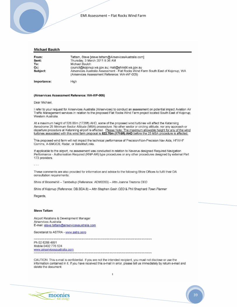
Appendix 2 – Written Responses from Interested Parties
-----Original Message-----
From: GRIFFITHS Martin [PD85886] [mailto:[email protected]]
Sent: Tuesday, 16 November 2010 9:24 AM
To: '[email protected]'
Cc: MANNA Phillip [PD83020]; STARLING Tina [PD86271]
Subject: Moonies Energy farm Kojonup (EMI - Michael Baulch)
Dear Michael
Thank you for your letter (28 October 2010) in reference to your EMI study; WA Police have reviewed the
coordinates of your wind farm proposal near Kojonup. To make an engineered assessment of your
proposal we would have to know more about the amount of EMI the farm is likely to emit.
I can inform you that WA Police operate 4 x 450-460MHz analogue repeaters and 400-420MHz point to
point links at 4 sites within 50km of the proposed location. The nearest site is at a distance of 18 km and
we do have 400MHz point to point links with directional yagi antennas that will look past your farms
location. It is my technical understanding that the distances involved and the frequency band we operate
in should not be affected by EMI emissions from your wind farm proposal.
If you are aware of any likelihood of interference to the WA Police services it would be necessary for you
to contact me as soon as possible for us to make arrangements to mitigate the effect on our services.
Regards
Martin Griffiths
Business Integration Supervisor
WA Police Service
Radio and Electronic Services Unit
Ph: 08 9370 7196
Fax: 08 9370 7194
Mob: 0488 908 025

EMI Assessment – Flat Rocks Wind Farm
38
-----Original Message-----
From: Peter Rowswell [mailto:[email protected]]
Sent: Thursday, 16 June 2011 9:21 AM
To: '[email protected]'
Subject: Wind farm in Kojonup/Broomehill Shire [SEC=UNCLASSIFIED]
Sarah,
We do appreciate you advice about the wind farm and my apologies for not getting back to
you sooner. I forwarded your email to our Head Office in Melbourne and unfortunately they have
been slow to respond however I expect that you will have a response by early next week.
If you do not get a response by Thursday next week please email me and I’ll take it up again.
Regards,
Peter Rowswell
Engineering Services Manager WA
Bureau Of Meteorology
08 9263 2203
EMI Assessment – Flat Rocks Wind Farm
39

EMI Assessment – Flat Rocks Wind Farm
40

EMI Assessment – Flat Rocks Wind Farm
41