el cajon bay era complex management plan - michigan
TRANSCRIPT

1
Michigan Department of Natural Resources, Forest Resources Division. Michigan.gov/Forestry. June 2021.
El Cajon Bay ERA Complex Management Plan
Contents Contents ............................................................................................................................................................ 1
Administrative Information: ............................................................................................................................. 1
El Cajon Bay ERA Complex ............................................................................................................................ 1
Conservation Values ......................................................................................................................................... 2
Northern Fen Description: ............................................................................................................................ 2
Coastal Fen Description: ............................................................................................................................... 3
Limestone Cliff Description: .......................................................................................................................... 4
Great Lakes Marsh Description: .................................................................................................................... 5
Emergent Marsh Description: ....................................................................................................................... 5
Rich Conifer Swamp Description: ................................................................................................................. 6
Threats Assessment .......................................................................................................................................... 7
Management Goals, Objectives and Actions .................................................................................................... 9
Monitoring ...................................................................................................................................................... 10
Imagery ........................................................................................................................................................... 11
Photos: ............................................................................................................................................................ 13
References: ..................................................................................................................................................... 17
Administrative Information:
El Cajon Bay ERA Complex This plan encompasses six Ecological Reference Areas:
• Northern Fen • Coastal Fen • Limestone Cliff • Great Lakes Marsh • Emergent Marsh

2
Michigan Department of Natural Resources, Forest Resources Division. Michigan.gov/Forestry. June 2021.
• Rich Conifer Swamp All six Ecological Reference Areas are located in Compartment 107 of the Alpena Lake Plain Management Area of the Atlanta Forest Management Unit. T 31N R 09E, Sections: 9, 10, 15, 16, 22 & 27
• Location: o Atlanta Forest Management Unit, Alpena Lake Plain Management Area,
Compartment 107 o Alpena County T 31N R 09E, Sections: 9, 10, 15, 16, 22 & 27
• Contact information: o Doug Tyran (plan writer)
• State of Michigan owned lands o SOM ownership
• Existing infrastructure/facilities o None, only adjacent county roads and powerlines. No state infrastructure.
Conservation Values
Northern Fen Description: Summary: Northern fen is a sedge- and rush-dominated wetland occurring on neutral to moderately alkaline saturated peat and/or marl influenced by groundwater rich in calcium and magnesium carbonates. Northern fens occur on flat areas or shallow depressions of glacial outwash and glacial lakeplains, often in close proximity to the Great Lakes shoreline. Within outwash channels, fens are typically found where a constant flow of cold, calcareous groundwater seeps from the base of adjacent moraines. The overall topography of fens is flat to gently undulating with microtopography characterized by hummocks and hollows. Northern fens often occur within large wetland complexes, where they grade into other peatland communities such as poor fen, northern wet meadow, northern shrub thicket, and rich conifer swamp (1). Element of Occurrence Description:
Natural Community EO_ID EO Rank Last Observed
Northern Fen 16763 B 06/25/2020
Coastal Fen 1936 AB 06/25/2020
Limestone Cliff 9208 B 06/23/2020
Great Lakes Marsh 18590 AB 06/24/2020
Emergent Marsh 18820 BC 06/25/2020
Rich Conifer Swamp
5676 B 06/24/2020

3
Michigan Department of Natural Resources, Forest Resources Division. Michigan.gov/Forestry. June 2021.
High floristic diversity (42 vascular plants noted) and distinct ecological zonation due to gradients in soil and water chemistry. Ecological zones within the fen include shrub fen, fen meadow, marl flats, and marl ponds. The development of sphagnum mounds or islands throughout the fen and carex tussocks along the meadow margins of the fen generates fine-scale gradients in soil moisture and soil chemistry. Trees and shrubs are concentrated on the sphagnum mounds. In 2020 a 25.1cm Thu occ was cored and estimated to be over 180 years old. Numerous animal trails occur throughout the fen and provide flat, inundated linear features that increase the fen's overall structural diversity. Groundwater seepage generates nutrient rich growing conditions suitable for fen species. The northern fen features two marl ponds that hold 10-40cm of water. A stream connects the two marl ponds. Crayfish burrows occur scattered in the marl flats. Glossy buckthorn was observed on some of the sphagnum islands within the fen. Other invasive species were noted along the roads and trails, more surveys will be required to identify the specific species. Complex is within the large block of relatively unfragmented private and state forest managed for timber production, wildlife, recreation, and biodiversity. Surrounding upland forest is primarily actively managed early successional forest. Local incursions by ORVs appear on aerial photographs. Otherwise in good condition, well-buffered. The main management recommendations are to allow natural processes to operate unhindered, retain an intact buffer of natural communities surrounding the wetland to minimize the threat of hydrological alteration, and remove and monitor for invasive species. Reducing local deer densities is also recommended. Contractors should be instructed to visit each tree cluster and either hand pull or cut and herbicide the cut buckthorn stumps (2). Coastal Fen Description: Summary:
A coastal fen is a sedge- and rush-dominated wetland. The community occurs along the flat, saturated shorelines of northern Lake Huron, Lake Michigan, and the Georgian Bay on glacial lakeplains and where thin, discontinuous layers of glacial till overlay limestone. The community frequently develops where groundwater seepage percolates from either calcareous uplands or joints in the underlying limestone bedrock. Coastal fens frequently occur as part of a larger wetland complex that may include Great Lakes marsh, wooded dune and swale complex, rich conifer swamp, and northern fen. The surrounding uplands are typically dominated by mesic northern forest and boreal forest and can contain a significant component of northern white-cedar (1). Element of Occurrence Description: Excellent ecological zonation and high species diversity (78 species identified), minimal disturbance (a few ORV trails). Otherwise found to be nearly pristine.

4
Michigan Department of Natural Resources, Forest Resources Division. Michigan.gov/Forestry. June 2021.
Soils range from saturated alkaline sand in the bay to areas of dense stone and cobble mixed with sand to a thin layer of sapric peat over saturated sands in the northern fen zone. Coastal fen is locally inundated with 10-30cm of water. Low sphagnum hummocks and hollows and crayfish burrows occur locally. In areas of inundated coastal fen, tops of sphagnum hummocks are saturated while surrounding fen is inundated: Sphagnum hummocks, boulders, and ant mounds providing small-scale island refuges for coast fen vegetation. Unique juxtaposition of dead cedar and bulrush in 60-100cm of water. Cored a 14cm Thu occ in the coastal fen and estimated it to be over 135 years old. Within the southernmost lobe of coastal fen marl fen is expansive. This portion of coastal fen extends a quarter of a mile inland. Marl pools and streams occur within this portion of the fen and potentially provide habitat for Hine's Emerald Dragonfly (federally endangered/ threatened). Along the edge of the adjacent rich conifer swamp Dwarf lake iris was observed (threatened). Control invasive species populations and monitor control efforts. Coastal fen is actively transitioning to Great Lakes marsh following four years of high water levels. This dynamic shift demands the substantial buffering of these coastal ecosystems to allow these ecosystems to change in space and time (2). Rare/Rank: G1G2, S2 Imperiled HVCA: None Known
Limestone Cliff Description: Summary:
Limestone cliff consists of vertical or near-vertical exposures of bedrock, which typically support less than 25% vascular plant coverage, although some rock surfaces can be densely covered with lichens, mosses, and liverworts. The community occurs predominantly in the Upper Peninsula, most typically within a few kilometers of the Lake Michigan and Lake Huron shorelines, on the Niagaran Escarpment and Cuestra, but with isolated occurrences of much older Precambrian-aged limestones and dolomites in the western Upper Peninsula. Limestone cliffs also occur within sinkholes within Devonian Limestone in the northern Lower Peninsula. Like most of Michigan’s cliffs, vegetation cover is sparse, but abundant cracks and crevices combined with calcareous conditions result in greater plant diversity and coverage than on most other cliff types (1). Rank/ Rare: G4G5 S2 – imperiled in state, globally unsure Element of Occurrence Description: This is a natural exposure of the Genshaw formation of the Traverse group of limestone that is found within a quarter mile of El Cajon Bay. The limestone cliffs are twelve to fifteen feet high, forming a three-four foot wide crevice with one-two feet of overhang. The crevice runs northeast to southwest with small upland interruptions. Numerous large boulders and broken slabs have fallen into the crevice indicating that limestone dissolution and erosional forces have been shaping this natural feature for thousands of years. Moderate to small size as compared to other moist non-acid cliffs in the state. There is an abundance of coarse woody debris. The ridges surrounding the cliffs are dominated by northern white-cedar with occasional paper birch and quaking aspen with dense pockets of understory balsam fir. The cliffs are covered by mosses in places and are bare in others Within the crevice and on the ledges there is sparse ground cover of boreal forest species (22 vascular noted) , a few include mayflower, wild columbine, and large-leaved. No invasive species observed. A turkey vulture chick was observed during the 2006 survey and a strong smell was noted where it was found, suggesting the presence of a nesting territory within the site. In 2020 turkey vulture casts were

5
Michigan Department of Natural Resources, Forest Resources Division. Michigan.gov/Forestry. June 2021.
noted as well as moss that looked to have been vomited on. Some erosion has occurred from foot traffic. The main management recommendations are to maintain a forested buffer adjacent to the cliffs to minimize the threat of invasion by non-native species and to allow natural processes (i.e., fire and windthrow) to operate unhindered (2). HVCA: none known.
Great Lakes Marsh Description: Summary:
Great Lakes marsh is an herbaceous wetland community occurring statewide along the shoreline of the Great Lakes and their major connecting rivers. Vegetational patterns are strongly influenced by water level fluctuations and type of coastal feature, but generally include the following: a deep marsh with submerged plants; an emergent marsh of mostly narrow-leaved species; and a sedge-dominated wet meadow that is inundated by storms. Great Lakes marsh provides important habitat for migrating and breeding waterfowl, shore-birds, spawning fish, and medium-sized mammals (1). Rank/ Rare: G2 imperiled S3 Vulnerable Element of Occurrence Description: Excellent ecological zonation and high species diversity (75 species identified), minimal disturbance (a few ORV trails). Otherwise found to be nearly pristine. A few invasive species noted: Phragmites, narrowleaf cattail, creeping thistle, purple loosestrife, Broad marly flats presently recovering from high water conditions, in El Cajon Bay marsh zone 500 m wide. Marsh generally 300 m wide, bordered by narrow wet meadow and dense cedar swamp. Surveyed Great Lakes marsh following four consecutive years of high Great Lakes water levels and as a result emergent marsh is the most prevalent zone within the complex with areas of wet meadow and adjacent coastal being inundated. Vegetative cover within areas of emergent marsh and wet meadow ranges from 30 to 80%. Scattered shrubs and trees (1-2% cover) occur within the wet meadow zon. Woody species that expanded into the marsh during low water years (2000-2016) are now being impacted by sustained inundation (2). Emergent Marsh Description: Summary: Emergent marsh is a shallow-water wetland along the shores of lakes and streams characterized by emergent narrow- and broad-leaved herbs and grass-like plants as well as floating-leaved herbs. The community occurs on both mineral and organic soils. Emergent marshes line the margins of many streams and inland lakes, as well as protected portions of the Great Lakes shoreline, where it is classified as Great Lakes marsh (1).
Rank/ Rare: GU – Unrankable, S4 Apparently secure Element of Occurrence Description

6
Michigan Department of Natural Resources, Forest Resources Division. Michigan.gov/Forestry. June 2021.
Road occurs just west of northern wet meadow and has locally altered the wetland's hydrology. Emergent marsh occurring on poorly drained lakeplain near Lake Huron shoreline. Observed bald eagle, great blue heron and egret. The main management recommendations are to allow natural processes to operate unhindered and to retain an intact buffer of natural communities surrounding the wetland to minimize the threat of hydrological alteration (2). Rich Conifer Swamp Description: Summary:
Rich conifer swamp is a groundwater-influenced, minerotrophic, forested wetland dominated by northern white-cedar (Thuja occidentalis) that occurs on organic soils (i.e., peat) primarily north of the climatic tension zone in the northern Lower and Upper Peninsulas. Often occuring in outwash channels, outwash plains, glacial lakeplains, and in depressions on coarse- to medium- textured ground moraines. Rich conifer swamp typically occurs in association with lakes and cold, groundwater-fed streams. It also occurs along the Great Lakes shoreline in old abandoned embayments and in swales between former beach ridges where it may be part of a wooded dune and swale complex. Climatic conditions in the community are influenced by its northerly distribution, low topographic position, and thick layer of mosses, especially sphagnum (Sphagnum spp.), which insulate the organic soils. At night, cold air drains down from the surroundings uplands throughout the growing season, causing condensation to collect on plants. This constant source of nocturnal moisture helps sustain the community’s abundant lichen and bryophyte flora. The cold air drainage may also cause nighttime temperatures to drop below freezing throughout the growing season. The insulating properties of sphagnum moss allow ice to remain within the upper layers of soil until mid-June or July, but in the fall, soils remain unfrozen until after snowfall, and deep penetration of frost may not occur until February. Thus, rich conifer swamp has a shorter, cooler, and more humid growing season than the surrounding uplands, while winters are milder and more even in temperature. The community is also referred to as cedar swamp (1). Rank/ Rare: G4 Apparently secure, S3 Vulnerable Element of Occurrence Description: Dwarf lake iris (threatened) is a common ground cover (50-75%) in a 15-100 m wide swath along swamp's lakeward margin, especially in the N. half of sections 15 & 22. The canopy is dominated by second-growth northern white-cedar that was estimated to be 100 to 110 years old (ranging from 130-157 years old in 2023 YOE inventory) Canopy trees range in DBH from 7-16 inches and canopy coverage ranges from 80 to 95%. Canopy associates include white spruce, paper birch, white pine, tamarack, and balsam fir. Super canopy white pine occur locally within the swamp and are used by bald eagle for perching and feeding. The subcanopy and tall shrub layer is characterized by northern white-cedar, balsam fir, and round-leaved dogwood Cedar regeneration is lacking in the swamp adjacent to El Cajon Bay. However, cedar regeneration is prevalent in the swamp associated with Misery Bay. The most cedar regeneration Cohen has seen on the mainland of the Lower Peninsula. The low shrub layer

7
Michigan Department of Natural Resources, Forest Resources Division. Michigan.gov/Forestry. June 2021.
is sparse to patchy. The ground cover is sparse to absent in the northern section near El Cajon Bay but a dense carpet of ebony sedge dwarf lake iris (federal/state threatened), starflower, large-leaved aster, twinflower, and sweet coltsfoot occurs along Misery Bay. Dwarf lake iris is most prevalent along the swamp’s lakeward margin where the canopy is more open and dwarf lake iris extends into the adjacent coastal fen. Deer sign is prevalent in the northern section near El Cajon Bay and likely limiting cedar regeneration and altering forest structure in this section. In the Misery Bay section cedar regeneration is common, perhaps as a result of the abundance of wind snapped snags that provide protection for cedar seedlings. South of Misery Bay Road (Thiem Canal Road) private landowners are creating roads throughout the swamp and treating state land like private property. EO rank B due to large size; moderate landscape context of high-quality Great Lakes Marsh and Northern Fen, managed boreal forest and aspen stands, and scattered residential development; mature 2nd growth cedar, fir, and spruce with minimal human disturbance and exotic species. The primary threat is posed by deer herbivory, which could limit northern white-cedar regeneration and alter the swamp’s structure and species composition. Deer sign is prevalent in the northern section near El Cajon Bay and likely limiting cedar regeneration and altering forest structure. The main management recommendations are to allow natural processes (i.e., windthrow and fire) to operate unhindered and to reduce deer densities in the surrounding landscape to dampen deer browse pressure. Deer densities could be reduced through direct measures and also by reducing early-successional habitat in the surrounding landscape. Monitoring deer densities and deer herbivory will allow for the assessment of whether deer herbivory threatens northern white-cedar regeneration and impacts species composition and structure Illegal off-road vehicle activity should be restricted. Buffer and potentially expand site by creating an unmanaged buffer of forest to the west. Protect site from future logging (2).
Threats Assessment
Threat: ERAs Affected: Considerations:
Invasive Species Northern Fen, Coastal Fen &
Great Lakes Marsh
Glossy buckthorn, phragmites, narrowleaf cattail, creeping cattail & creeping thistle
Illegal ORV Trails
Northern Fen, Coastal Fen, Great Lakes
Marsh, Rich Conifer Swamp
Worse in Rich Conifer Swamp
Altered Hydrology
Northern Fen, Coastal Fen, Great Lakes
Marsh & Emergent Marsh
Road stops natural flow of emergent marsh, great lakes water levels changing ecosystems
8
Michigan Department of Natural Resources, Forest Resources Division. Michigan.gov/Forestry. June 2021.
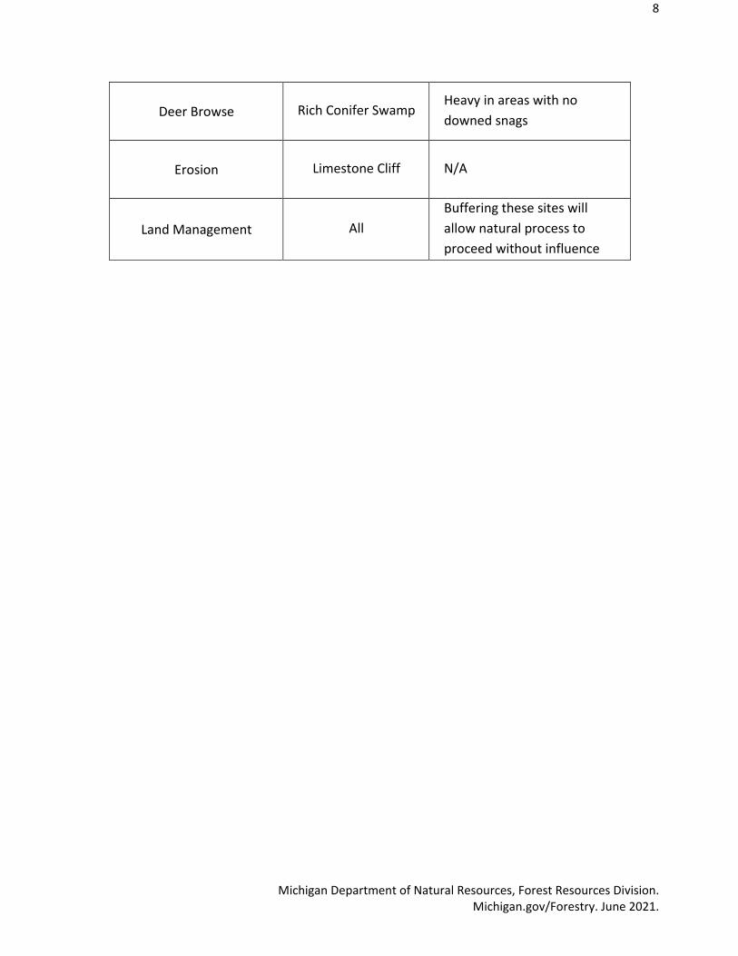
Deer Browse Rich Conifer Swamp Heavy in areas with no downed snags
Erosion Limestone Cliff N/A
Land Management All Buffering these sites will allow natural process to proceed without influence

9
Michigan Department of Natural Resources, Forest Resources Division. Michigan.gov/Forestry. June 2021.
Management Goals, Objectives and Actions
Goal 1: Manage to limit the extent of invasive species o Objective: Identify specific locations & treat as possible within funding abilities & 10-
year planning cycle • Action 1: Survey affected ERA’s to better understand infected areas • Action 2: Create treatment plan • Action 3: Work with local shareholders to complete treatment plan
Goal 2: Manage to hinder ORV access
o Objectives: Identify previous ORV access locations & block any occurrences within funding abilities in the 10-year planning cycle
• Action 1: Map specific gated or blocked off access points • Action 2: Enter any new access in resource damage reporting (RDR) • Action 3: Purchase supplies & block access with physical obstacles
Goal 3: Manage for intact and functioning hydrology
o Objectives: Minimize threats to hydrological alteration as budget constraints allow in the 10-year planning cycle
• Action 1: Investigate ability to place a culvert along North Point Rd • Action 2: Consider potential threats to hydrology if conducting timber harvests • Action 3: Maintain natural barrier to prevent artificial changes in hydrology
Goal 4: Manage to maintain or reduce deer densities
o Objectives: Encourage sport hunters to harvest deer over the 10-year planning cycle • Action 1: Do not restrict foot access for hunters. • Action 2: Limit timber harvests that may increase deer densities as determined.
Goal 5: Minimize management activities that will influence natural processes. o Objectives: Do not allow timber harvesting and limit fire suppression activities within
all ERAs within the 10 year planning cycle. • Action 1: Write a wildfire plan to incorporate a “let it burn” policy where
safety concerns allow. • Action 2: Timber harvesting should not occur within 100 -feet of any ERA
boundary by the wildlife biologists.

10
Michigan Department of Natural Resources, Forest Resources Division. Michigan.gov/Forestry. June 2021.
Monitoring
Indicators Current Status Desired Future Status
Invasive Plants Various found in 3 of 6 ERAs At least maintained or reduced
ORV Access Various unmarked gates blocking access
Gates mapped & future access blocked off
Altered hydrology Rising lake levels & road blocking natural flow
Monitored, and at least maintained or reduced
Deer density Deer density affecting regeneration in some areas
Deer density at least maintained or reduced
Minimize management None None

11
Michigan Department of Natural Resources, Forest Resources Division. Michigan.gov/Forestry. June 2021.
Imagery

12
Michigan Department of Natural Resources, Forest Resources Division. Michigan.gov/Forestry. June 2021.

13
Michigan Department of Natural Resources, Forest Resources Division. Michigan.gov/Forestry. June 2021.
Photos:
Rich Conifer Swamp

14
Michigan Department of Natural Resources, Forest Resources Division. Michigan.gov/Forestry. June 2021.
Imag Coastal Fen

15
Michigan Department of Natural Resources, Forest Resources Division. Michigan.gov/Forestry. June 2021.
Limestone Cliff

16
Michigan Department of Natural Resources, Forest Resources Division. Michigan.gov/Forestry. June 2021.
Dwarf Lake Iris
Hine's Emerald Dragonfly

17
Michigan Department of Natural Resources, Forest Resources Division. Michigan.gov/Forestry. June 2021.
Vegetation.
References: Cohen, J.G., M.A. Kost, B.S. Slaughter, D.A. Albert, J.M. Lincoln, A.P. Kortenhoven, C.M. Wilton, H.D. Enander, and K.M. Korroch. 2020. Michigan Natural Community Classification [web application]. Michigan Natural Features Inventory, Michigan State University Extension, Lansing, Michigan. Available https://mnfi.anr.msu.edu/communities/classification. (Accessed: March 26, 2021). (1). 2020. Element of Occurrence Reports for 2020 Natural Community Surveys on FRD Lands. (pp. 21-28, 97-102, 140-146, 212-218, 290-296, 378-386) (2)