efficacy of cover systems in high elevation andean climates · 1 efficacy of cover systems in high...
TRANSCRIPT
1
Efficacy of Cover Systems in High Elevation Andean Climates
Michael Milczarek1, Jason Keller1, Tzung-mow Yao1, Ernesto Prieto2, Carlos Venegas2, William Ludwick2, Raul Orellana2, Francisco Quevedo2 and Guosheng Zhan3 1. GeoSystems Analysis, Inc, USA 2. Minera Barrick Misquichilca, Peru 3. Barrick Gold Corporation, USA
ABSTRACT A number of mining properties are present in the high-elevation (> 4 000 m) tropical Andes. The environmental conditions at these properties present challenges for mine closure. Precipitation is typically characterized by wet and dry seasons: in Peru wet season precipitation can exceed1 000 mm over a six-month period. Conversely, average potential evaporation rates are typically 60 to 80% of precipitation on an annualized basis. This precipitation and potential evaporation imbalance precludes the control of infiltration and percolation into mine waste solely via evapotranspiration cover systems.
To evaluate the efficacy of different cover systems in controlling infiltration and net percolation, cover system trials and studies have been initiated by Minera Barrick Misquichilca at their Pierina and Lagunas Norte properties. Large-scale test panels have been constructed over waste rock and heap leach facilities to evaluate different multi-layer cover systems to include the use of variable clay and topsoil depths and the use of drainage layers. Study results indicate that infiltration and net percolation is highly variable and greatly affected by surface water channeling and topographic depressions. In addition, the hydraulic properties of the cover system change over time.
The presence of a drainage layer can reduce the amount of net percolation; however drainage layers require high drain rock permeability and low permeability of the underlying layer, and are equipment and labor intensive to construct, and hence costly.
Keywords: Evapotranspiration, unsaturated flow, waste rock, ore, clay, hydraulic conductivity, drainage layer

2
INTRODUCTION
Peru is the leading gold-producing country in Latin America and second only to Chile in copper production. Many of the Peruvian mining properties are located in the high tropical Andes at elevations in excess of 4 000 meters above mean sea level (amsl). The climate at these locations is characterized by a bimodal precipitation pattern, cool temperatures, and high relative humidity. Precipitation is typically greater than 1 200 mm/yr, with over 80% of precipitation occurring during the rainy season which characteristically occurs between the months of October and April. Average potential evaporation rates are typically 60 to 80% of precipitation on an annualized basis. Mines are increasingly using evapotranspiration (ET) soil cover systems to control infiltration and percolation into mine waste. ET cover systems function by storing infiltrated precipitation in the soil cover overlying the waste until it is removed by either plant transpiration or evaporation. These systems require that ET be in excess of precipitation to be effective. However, the precipitation and PET imbalance in the Peruvian Andes precludes the sole use of ET cover systems for this purpose. In the wet environment of the Peruvian Andes, a multi-layer cover system that includes a low-permeability clay layer underneath the ET soil layer is an alternative to the single-layer ET cover system. To alleviate build-up of soil pore pressures, high-permeability drainage materials or perforated drainage pipes (suction breaks) can be placed above the clay layer on sloped surfaces to remove infiltrated water. Drainage tends to reduce pore pressures and percolation into the underlying material. Cover system trials and studies have been initiated by Minera Barrick Misquichilca at their Pierina and Lagunas Norte properties to evaluate the efficacy of different multi-layer cover systems in controlling infiltration and net percolation. Large-scale test panels have been constructed over waste rock and heap leach facilities to evaluate cover systems comprised of variable clay and topsoil thicknesses and with or without subsurface flow manipulation. In this paper we examine the performance of the clay layer and different subsurface drainage configurations in reducing net percolation.
Site Conditions
Minera Pierina The Pierina mine is located on the eastern flank of the Cordillera Negra, about 10 km northwest of the City of Huaraz in the Ancash Region of Peru. Elevations of the Pierina mine facilities range between 3 800 m and 4 200 m amsl. Test panels were constructed in late 2005 and monitored through 2009. Temperatures at the site rarely fall below 0° C and do not change significantly month by month; the average annual temperature is about 6° C. The recorded average annual precipitation during the 2006 to 2009 monitoring period was approximately 1 290 mm. Recorded pan evaporation and estimated reference crop evapotranspiration (ETo) averaged approximately 935 mm/yr and 745 mm/yr, respectively, for the four year monitoring period. Two test panels, approximately 20 m by 55 m, were constructed on a 2.5(H):1(V) heap leach pad side-slope to test different clay layer construction methods. Each test panel had clay/silt borrow material placed over the waste, followed by 30 cm of topsoil material for an ET soil layer. The clay/silt material in Panel 3 was roller compacted after placement to approximately 90% of maximum Proctor density (2.07 g/cm3) with a final approximate thickness of 35 cm. In Panel 4, only equipment traffic compaction occurred on the clay/silt material, resulting in a final approximate thickness of 55 cm. The Pierina cover system used a network of perforated drainage pipes placed at regular 10-m intervals in the topsoil layer to act as suction breaks. Surface water runoff was routed to a geomembrane-lined canal. Test panels were installed in December, 2005 and subsequently seeded with a mix of native and non-native grasses and sedges. After plant establishment, vegetative ground and canopy cover generally approached or exceeded 100%. A cover performance monitoring system was installed and brought online in February 2006 to develop a better understanding of the capability of the cover systems to minimize net percolation into the heap leach material after closure. Monitoring nests were installed at four locations in each

3
panel. Monitoring system sensors included soil water potential sensors (heat dissipation sensors (HDS), and advanced tensiometers, (ATs)); soil moisture content sensors (ECH2Os); water flux meters (WFMs); oxygen content sensors (Figaros); and surface water flumes (H-Type flumes). Drainage from the suction breaks was monitored manually on a weekly basis. Instrument cross-sections are provided in Orellana et al. (2010). Soil water potential (HDS and AT) and water content (ECH2O) sensors monitored the wetness of the soil cover and the removal of water through drainage and evapotranspiration. WFM measurements provided a small-scale point measurement of deep flux at each location. Oxygen sensors monitored the efficiency of the clay/silt layer in minimizing oxygen flux into the leach ore. Finally, the H-flumes provided a very precise measurement of surface water runoff. A detailed discussion of the monitoring system and installation procedures is presented in Zhan et al. (2007). In January 2010, a test panel decommissioning program was conducted at Pierina to excavate monitoring instruments and check for functionality, conduct in-situ bulk density and saturated hydraulic conductivity (Ksat) tests; collect cores for laboratory testing, and, conduct a rooting survey to measure root density and thickness. Excavation trenches were typically two meters in depth.
Minera Lagunas Norte The Lagunas Norte mine is located approximately 175 kilometers north of the Pierina mine, in the La Libertad Region. Elevations at the Lagunas Norte facilities range between 4 000 m and 4 260 m above mean sea level. Average temperatures at Lagunas Norte are slightly cooler compared to Pierina, though temperatures at the site rarely fall below 0° C. The recorded average annual precipitation during the 2009 to 2013 monitoring period was approximately 1 420 mm; estimated ETo was approximately 775 mm/yr. Two test panels were installed in late 2008 and have since been monitored continuously. The two test panels, each approximately 42 m by 100 m were constructed on a 2.5(H):1(V) waste rock facility side-slope to test dual- and triple-layer cover systems with suction breaks. The South Panel dual-layer cover system consists of approximately 30 cm of a topsoil ET layer above approximately 60 cm of clayey material. The North Panel triple-layer cover system consists of approximately 30 cm of topsoil over approximately 30 cm of coarse-textured drainage material (gravel) overlying approximately 30 cm of clayey material. Placement of the drainage layer on top of the clay layer is intended to facilitate lateral subsurface flow through the drainage layer. In both panels a series of suction breaks consisting of gravel filled trenches were placed at the base of the topsoil (South Panel) and drainage layer (North Panel) at approximately 10-m spacing. Test panels were installed in December, 2008 with subsequent seeding using a mix of native and non-native grasses and sedges. A cover performance monitoring system similar to that at Pierina was installed at Lagunas Norte in December 2008 and included four sensor nests for each panel. Cross-sections of Lagunas Norte monitoring nest installations for the triple layer (North) test panel are presented on Figure 1.

4
Figure 1 Cross-section of North Panel monitoring nest installation
RESULTS
For both sites the lowest precipitation rates were observed in July. Therefore, the water year was defined as the 12-month period from July 1 to June 30, and is designated by the calendar year in which it ends. For example, the water year starting July 1, 2012 and ending June 30, 2013 is called “Water Year 2013”.
Surface Water Runoff and Subsurface Drainage Measured stormwater runoff rates at the Pierina test panels were approximately 15% of precipitation (194 mm/yr). Similarly, the test panel runoff at Lagunas Norte has averaged approximately 18% of precipitation (256 mm/yr). For both sites, the observed stormwater runoff was simulated using the U.S. Soil Conservation Service (SCS) model (SCS, 1986) to estimate the approximate amount of runoff from a rainfall event in a defined area. Curve numbers (CNs) of 91 and 93 were needed to simulate the measured average panel runoff for Pierina and Lagunas Norte, respectively. Both CNs are much greater than what would be estimated using standard SCS method assumptions for hydrologic soil type and vegetative cover. These data indicate that stormwater runoff estimates using SCS curve numbers in this climate and soil types may need to be adjusted upwards to account for steep slopes and the hydrophobicity of the topsoil surface. At Pierina, only minor amounts of drainage were recorded from the suction breaks at both panels (less than 1% of total precipitation). High topsoil and clay water content values were observed in the monitoring data. However, saturation of the topsoil is required for significant seepage from the suction breaks to occur. Low topsoil, or high clay, hydraulic conductivities could have reduced suction break efficiency. In addition, rooting around and into the geotextile material surrounding the suction break pipes could have resulted in reduced efficiency.

5
At Lagunas Norte, subsurface layer/suction break drainage was approximately 12% of precipitation (170 mm/yr) at the North Panel and 1% of precipitation (14 mm/yr) at the South Panel. Greater suction break flow from the North Panel indicates that the presence of a gravel drainage layer resulted in increased subsurface drainage efficiency.
Water Fluxmeter Data
WFM-measured flux at Pierina averaged 26% of precipitation (336 mm/yr) for Panel 3 and 16% of precipitation (207 mm/yr) for Panel 4. Panel 3 WFMs generally showed increasing fluxes over time. Average WFM-measured flux greater than 250% of precipitation was recorded at the Lagunas Norte test panels during the first water year of monitoring (water year 2009), due primarily to several WFMs measuring flux in excess of 1 000% of precipitation. The high measured flux was believed to be due to topographical depressions resulting from ground settlement after sensor installation. These depressions were filled with topsoil in August 2009. The WFM-measured flux in the subsequent water years (water years 2010 – 2013) decreased, although not to rates consistent with other measurements of surface and subsurface flow. Continued high WFM-measured flux after water year 2009 may be due to: 1) subsidence of the clay layer at the sensor nests resulting in accumulation of subsurface flow at these points, or 2) convergence of soil water flow into the WFM because of soil water potential conditions in the WFM being more negative (i.e. drier) than surrounding conditions. Based on AT data recorded during the rainy season, the soil water potential conditions are generally greater (i.e. wetter) than -30 cm, indicating that water potential conditions may be converging water into the WFM.
Water Content Data
Changes in water content over time indicate how the cover responds to seasonal climatic processes (precipitation and ET) and of the overall effectiveness of the cover system. At both sites water contents increased in response to the rainy season and decreased throughout the dry season (April through September) due to drainage and ET demand (Figure 2 and Figure 3). Wetting and drying occurred at all depths, in all panels, indicating that percolation occurs through the cover system. Water content in the topsoil layers generally decreased throughout the study period. This general drying trend is likely due to increasing vegetation and root density over the course of monitoring.

6
Figure 2 Pierina Mine Panel 3 and Panel 4 water content data
Figure 3 Lagunas Norte Mine South Panel and North Panel water content data
Clay layer wetting occurred within a short period after observed wetting in the overlying topsoil or drainage layer. Shallow and deep waste rock sensors immediately responded with little lag

7
compared to wetting of the overlying clay, indicating that the clay is allowing water to quickly percolate through that layer. At Pierina, the clayey layer significantly dried out in both panels during the dry season and the ability of the clay to limit net percolation may therefore have been greater in Panel 4 due to its greater thickness (55 cm versus 35 cm). Additionally, the earlier wetting front arrival and greater water content in the leach ore in Panel 3 during each rainy season indicate that greater net percolation occurred in Panel 3. At Lagunas Norte, topsoil sensors in the North Panel consistently recorded greater seasonal changes in water content than those in the South Panel, indicating that the North Panel drainage layer is removing water from the upper soil profile and accelerating the drying process. North Panel drainage layer sensors also showed rapid response to precipitation and subsequent drainage, which correlates with topsoil water content trends for North Panel. In general, the water potential (HDS and AT) wetting and drying trends were similar to water content sensor trends.
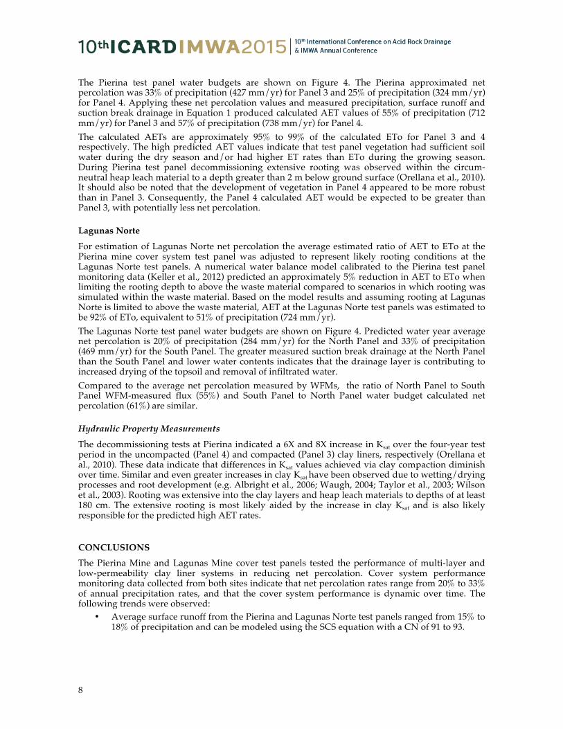
Estimated Net Percolation
A cover system water budget can be formulated as follows:
(1) where R is net percolation, P is precipitation, SR is surface runoff, AET is actual evapotranspiration, SB is suction break drainage and �S is soil storage change. Precipitation, runoff, and suction break drainage were monitored at both sites; AET is calculated by solving Equation 1 and directly measuring or estimating net percolation. Estimated water budgets for each of the test panels are provided on Figure 4.
Figure 4 Estimated Pierina and Lagunas Norte test panel water budgets
Pierina Mine At Pierina, the clay soil water potential data were used to approximate net percolation by applying the closed-form analytical solution by van Genuchten et al. (1980) to solve Darcy’s law. Laboratory and field observed saturated hydraulic conductivity (Ksat), water content, and water potential relationships were combined to estimate van Genuchten parameters with a best fit. These parameters were further refined by comparing the predicted net percolation fluxes to the WFM-measured data and modifying the Ksat value until relative agreement was achieved. Additional details about the Pierina net percolation approximation are available in Orellana et al. (2010).
8
The Pierina test panel water budgets are shown on Figure 4. The Pierina approximated net percolation was 33% of precipitation (427 mm/yr) for Panel 3 and 25% of precipitation (324 mm/yr) for Panel 4. Applying these net percolation values and measured precipitation, surface runoff and suction break drainage in Equation 1 produced calculated AET values of 55% of precipitation (712 mm/yr) for Panel 3 and 57% of precipitation (738 mm/yr) for Panel 4. The calculated AETs are approximately 95% to 99% of the calculated ETo for Panel 3 and 4 respectively. The high predicted AET values indicate that test panel vegetation had sufficient soil water during the dry season and/or had higher ET rates than ETo during the growing season. During Pierina test panel decommissioning extensive rooting was observed within the circum-neutral heap leach material to a depth greater than 2 m below ground surface (Orellana et al., 2010). It should also be noted that the development of vegetation in Panel 4 appeared to be more robust than in Panel 3. Consequently, the Panel 4 calculated AET would be expected to be greater than Panel 3, with potentially less net percolation.
Lagunas Norte
For estimation of Lagunas Norte net percolation the average estimated ratio of AET to ETo at the Pierina mine cover system test panel was adjusted to represent likely rooting conditions at the Lagunas Norte test panels. A numerical water balance model calibrated to the Pierina test panel monitoring data (Keller et al., 2012) predicted an approximately 5% reduction in AET to ETo when limiting the rooting depth to above the waste material compared to scenarios in which rooting was simulated within the waste material. Based on the model results and assuming rooting at Lagunas Norte is limited to above the waste material, AET at the Lagunas Norte test panels was estimated to be 92% of ETo, equivalent to 51% of precipitation (724 mm/yr). The Lagunas Norte test panel water budgets are shown on Figure 4. Predicted water year average net percolation is 20% of precipitation (284 mm/yr) for the North Panel and 33% of precipitation (469 mm/yr) for the South Panel. The greater measured suction break drainage at the North Panel than the South Panel and lower water contents indicates that the drainage layer is contributing to increased drying of the topsoil and removal of infiltrated water. Compared to the average net percolation measured by WFMs, the ratio of North Panel to South Panel WFM-measured flux (55%) and South Panel to North Panel water budget calculated net percolation (61%) are similar.
Hydraulic Property Measurements
The decommissioning tests at Pierina indicated a 6X and 8X increase in Ksat over the four-year test period in the uncompacted (Panel 4) and compacted (Panel 3) clay liners, respectively (Orellana et al., 2010). These data indicate that differences in Ksat values achieved via clay compaction diminish over time. Similar and even greater increases in clay Ksat have been observed due to wetting/drying processes and root development (e.g. Albright et al., 2006; Waugh, 2004; Taylor et al., 2003; Wilson et al., 2003). Rooting was extensive into the clay layers and heap leach materials to depths of at least 180 cm. The extensive rooting is most likely aided by the increase in clay Ksat and is also likely responsible for the predicted high AET rates.
CONCLUSIONS The Pierina Mine and Lagunas Mine cover test panels tested the performance of multi-layer and low-permeability clay liner systems in reducing net percolation. Cover system performance monitoring data collected from both sites indicate that net percolation rates range from 20% to 33% of annual precipitation rates, and that the cover system performance is dynamic over time. The following trends were observed:
• Average surface runoff from the Pierina and Lagunas Norte test panels ranged from 15% to 18% of precipitation and can be modeled using the SCS equation with a CN of 91 to 93.

9
• At Pierina, suction breaks installed within the topsoil layer collected 1% or less of the total precipitation; relatively high clay Ksat for both the compacted and uncompacted clay liners is likely to have reduced the effectiveness of the suction breaks.
• The long-term estimated percolation through the Pierina Panel 3 compacted clay cover was 33% of precipitation; net percolation through Panel 4 uncompacted clay cover was 25% of precipitation, which indicates greater efficiency was achieved from using a thicker clay layer.
• WFM measured percolation at Pierina Panel 3 increased over time, suggesting that the effect of compaction in decreasing clay permeability decreased over time. This conclusion is further supported by observed increases in measured clay Ksat during panel decommissioning.
• The estimated net percolation through the Lagunas Norte North Panel cover, containing a drainage layer, was 20% of precipitation and net percolation through the South Panel cover system without a drainage layer system was 32% of precipitation.
• Suction break drainage averaged 12% of precipitation from the Lagunas Norte North Panel and reduced the estimated net percolation by about 40% compared to the South Panel cover system without the drainage layer.
• Numerical modeling indicates that the hydraulic conductivity of the clay layer largely influences the effectiveness of the drainage layer systems.
• Numerical modeling also indicates that, with extensive rooting into the underlying waste material, increasing cover thickness only nominally decreases predicted net percolation.
Based on these data, we conclude the following: • There is no long-term advantage to roller-compacting a thin (30 cm) clay liner at these sites
compared to a 50 cm clay layer compacted solely by the equipment used to place the clay. • Drainage layers and/or suction breaks can significantly increase the efficiency of the cover
system if there is high-drain rock permeability and low permeability underlying clay.
ACKNOWLEDGEMENTS We thank staff and management at Minera Barrick Misquichilca S.A., for their support of these projects.
REFERENCES Albright, W.H., Benson, C.H. Gee, G.W., Abichou, T., Mcdonald, E.V., Tyler, S.W. and Rock, S. (2006) Field
performance of a compacted clay landfill final cover at a humid site, Journal of Geotechnical and Geoenvironmental Engineering 132(11), pp. 1393-1403.
Keller, J., Milczarek, M., Banerjee, M., Orellana, R., Ludwick, W., and Zhan, G. (2012) Evaluation of alternative cover systems in high precipitation environments using unsaturated flow modeling, Proceedings of the 9th International Conference on Acid Rock Drainage, May 20-25, Ottawa, Canada.
Orellana, R., Ludwick, W., Zhan, G., Bauman, W., Milczarek, M., Rice, R.C., Yao, T-M., and Keller, J. (2010) Final results of the cover system test panel trials at the Pierina Mine. Proceedings Mine Closure 2010, November 23-26, Viña del Mar, Chile.
SCS – See U.S. Soil Conservation Service
Taylor G., Spain, A., Timms, G., Kuznetsov, V. and Bennett, J. (2003) The medium-term performance of waste rock covers – Rum Jungle as a case study, Proceedings of the 6th International Conference on Acid Rock Drainage, July 12-18, Cairns, Australia.
U.S. Soil Conservation Service (SCS) (1986) Urban hydrology for small watersheds, Tech. Release 55, Washington, D.C.
van Genuchten, M Th (1980) A closed form equation for predicting the hydraulic conductivity of unsaturated soils, Soil Sci Soc Am J 44, pp. 892-898.
Waugh, W.J. (2004) Design, performance, and sustainability of engineered covers for uranium mill tailings, Proceedings of Long-term Performance Monitoring of Metals and Radionuclides in the Subsurface:

10
Strategies, Tools, and Case Studies. U.S. Environmental Protection Agency, U.S. Department of Energy, U.S. Geological Survey, Nuclear Regulatory Commission, April 21-22, 2004, Reston, VA.
Wilson, G.W., Williams, D.J. and Rykaart, E.M. (2003) The integrity of cover systems – An update, Proceedings of the 6th International Conference on Acid Rock Drainage, July 12-18, Cairns, Australia.
Zhan G., Baumann, W., Milczarek, M.A., Yao, T-M. and Rice, R.C. (2007) Cover system design and testing for Pierina Mine, Ancash, Peru. II International Seminar on Mine Closure, Santiago, Chile, October 16-19, 2007.