effectiveness of the new hampshire stream-gaging network in
TRANSCRIPT

In cooperation with theNEW HAMPSHIRE DEPARTMENT OF ENVIRONMENTAL SERVICES
Effectiveness of the New HampshireStream-Gaging Network in Providing RegionalStreamflow Information
Water-Resources Investigations Report 03-4041
U.S. Department of the InteriorU.S. Geological Survey

Effectiveness of the New Hampshire Stream-Gaging Network in Providing Regional Streamflow Information
By Scott A. Olson
U.S. GEOLOGICAL SURVEY
Water-Resources Investigations Report 03-4041
In cooperation with the
NEW HAMPSHIRE DEPARTMENT OF ENVIRONMENTAL SERVICES
Pembroke, New Hampshire2003


Contents iii
CONTENTS
Abstract ............................................................................................................................................................... 1Introduction ......................................................................................................................................................... 1
Purpose and Scope ..................................................................................................................................... 2Previous Studies ......................................................................................................................................... 2Acknowledgments ...................................................................................................................................... 3
Description of the Stream-gaging Network in New Hampshire ......................................................................... 3Network Analysis ................................................................................................................................................ 5
Description of Technique ........................................................................................................................... 5Application and Limitations of Results ............................................................................................................... 15Summary and Conclusions .................................................................................................................................. 19Selected References ............................................................................................................................................. 19Appendix 1. Basin Characteristics of Stream-gaging Stations in the New Hampshire Stream-gaging Network 43Appendix 1. References ...................................................................................................................................... 64
iv Figures
FIGURES
Figure 1. Diagram showing distribution of stream-gaging station characteristics in New Hampshire ............ 4Figure 2. Map showing active stream-gaging stations in, and adjacent to, New Hampshire, used in the
network analysis ............................................................................................................................... 7Figure 3. Map showing discontinued stream-gaging stations in, and adjacent to, New Hampshire, used in the
network analysis ............................................................................................................................... 8Figure 4. Map showing location of proposed and new stream-gaging stations used in the New Hampshire
network analysis ............................................................................................................................... 10Figure 5. Graph showing average sampling error for the 100-year peak-flow characteristic as a function
of the number of stations operated for selected strategies in the analysis of the New Hampshire stream-gaging network ..................................................................................................................... 13
Figure 6. Graph showing average sampling error for the mean-flow characteristic as a function of the number of stations operated for selected strategies in the analysis of the New Hampshire stream-gaging network ..................................................................................................................... 14
Figure 7. Graph showing average sampling error for the low-flow (7Q10) characteristic as a function of the number of stations operated for selected strategies in the analysis of the New Hampshire stream-gaging network ................................................................................................................................. 15
Figure 8. Map showing location of stream-gaging stations and identifying numbers providing data used for flood-hazard mitigation ................................................................................................................ 17

Tables v
TABLES
Table 1. Selected information on stream-gaging stations having 10 years of record or more in or adjacent to New Hampshire as of the 2000 water year ..................................................................... 20
Table 2. Regression equations for estimating flow frequency on New Hampshire streams .......................... 9Table 3. Selected information on the proposed and new and stream-gaging stations used in the
New Hampshire network analysis .................................................................................................... 9Table 4. Average sampling error for selected network strategies ................................................................... 12Table 5. Station ranking in order of importance for providing regional streamflow information for
selected peak-, mean-, and low-flow characteristics and planning horizons, by station number ..... 26Table 6. Station ranking in order of importance for providing regional streamflow information for
selected peak-, mean-, and low-flow characteristics and planning horizons, by rank order ............ 34Table 7. Active and proposed stream-gaging stations providing the greatest enhancements to regional
streamflow information ..................................................................................................................... 16
vi Conversion Factors and Vertical Datum
CONVERSION FACTORS AND VERTICAL DATUM
CONVERSION FACTORS
VERTICAL DATUM
Vertical coordinate information is referenced to the National Geodetic Vertical Datum of 1929 (NGVD of 1929).
Multiply By To obtain
foot (ft) 0.3048 meter (m)
mile (mi) 1.609 kilometer (km)
square mile (mi2) 2.589 square kilometer (km2)
cubic foot (ft3) 0.09290 square meter (m2)
cubic foot per second (ft3/s) 0.02832 cubic meter per second (m3/s)

Effectiveness of the New Hampshire Stream-gaging Network in Providing Regional Streamflow Information
By Scott A. Olson
ABSTRACT
The stream-gaging network in New Hampshire was analyzed for its effectiveness in providing regional information on peak-flood flow, mean-flow, and low-flow frequency. The data available for analysis were from stream-gaging stations in New Hampshire and selected stations in adjacent States. The principles of generalized-least-squares regression analysis were applied to develop regional regression equations that relate streamflow-frequency characteristics to watershed characteristics. Regression equations were developed for (1) the instantaneous peak flow with a 100-year recurrence interval, (2) the mean-annual flow, and (3) the 7-day, 10-year low flow. Active and discontinued stream-gaging stations with 10 or more years of flow data were used to develop the regression equations.
Each stream-gaging station in the network was evaluated and ranked on the basis of how much the data from that station contributed to the cost-weighted sampling-error component of the regression equation. The potential effect of data from proposed and new stream-gaging stations on the sampling error also was evaluated. The stream-gaging network was evaluated for conditions in water year 2000 and for estimated conditions under various network strategies if an additional 5 years and 20 years of streamflow data were collected.
The effectiveness of the stream-gaging network in providing regional streamflow information could be improved for all three flow characteristics with the collection of additional flow data, both temporally and spatially. With
additional years of data collection, the greatest reduction in the average sampling error of the regional regression equations was found for the peak- and low-flow characteristics. In general, additional data collection at stream-gaging stations with unregulated flow, relatively short-term record (less than 20 years), and drainage areas smaller than 45 square miles contributed the largest cost-weighted reduction to the average sampling error of the regional estimating equations. The results of the network analyses can be used to prioritize the continued operation of active stations, the reactivation of discontinued stations, or the activation of new stations to maximize the regional information content provided by the stream-gaging network. Final decisions regarding altering the New Hampshire stream-gaging network would require the consideration of the many uses of the streamflow data serving local, State, and Federal interests.
INTRODUCTION
The earliest known systematic record collection of surface-water data in New Hampshire began in 1886 on the Pemigewasset River at Plymouth, N.H., by the Proprietors of Locks and Canals at Lowell. By 1900, the U.S. Geological Survey (USGS) began operating stream-gaging stations in the State of New Hampshire. Through the years, the stream-gaging program has evolved as Federal and State interests in surface-water resources have increased and as funds for operating the stream-gaging network have become available. Today, more than 45 stations are operated as a multi-purpose network funded by USGS and other Federal, State and local agencies.
Introduction 1

The USGS has operated most of the stream-gaging network in New Hampshire on behalf of multiple cooperators to achieve consistency of data collection and analysis, quality control, and wide availability of resultant databases, and economies of scale. Funding for a station typically is shared in proportion to the extent of Federal interests relative to those of the cooperating agencies, and ranges from full USGS funding to full funding by the cooperator. Because the streamflow data-collection networks in New Hampshire have evolved in response to a diverse range of needs during the past 100 years, it is important to periodically examine these networks relative to their effectiveness in meeting current and anticipated data needs.
Individual stream-gaging stations in the network typically have been installed and funded for specific purposes, such as flood forecasting and warnings, flood-control operations, operation of lakes and reservoirs, water allocation, monitoring of streamflow withdrawals, and water-quality management, including the maintenance of instream flows. Long-term flow records are necessary to assess water resources, the flow-frequency characteristics of streams, and trends in basin yield.
Streamflow characteristics often are needed at a site where no data have been collected. In this situation, estimating techniques, usually based on regional regression equations of selected streamflow and basin characteristics, are used to estimate the desired streamflow characteristic. Although stations rarely are established exclusively to provide information for these estimation techniques, it is important that the stream-gaging network as a whole is effective in providing regional streamflow coverage. A stream-gaging network that is effective in providing regional streamflow information will result in accurate regional regression equations for estimating streamflow characteristics at ungaged locations. In 2002, the USGS and the New Hampshire Department of Environmental Services (NHDES) began a cooperative study to evaluate if the current (2000) stream-gaging network is effective in providing regional streamflow information.
Purpose and Scope
This report presents an analysis of the stream-gaging network in New Hampshire. The network analysis conducted for this investigation identifies the contribution of each stream-gaging station in New Hampshire to regional streamflow information. This contribution is expressed in terms of a cost-weighted reduction in the average sampling error associated with a regional regression equation. The stream-gaging network was analyzed for the 2000 water year (ending September 30, 2000) and for the 5- and 20-year planning horizons.
Specifically, this report (1) identifies the value and uses of the New Hampshire stream-gaging network; (2) identifies the stations in New Hampshire and adjacent areas for which 10 or more years of record are available; (3) describes the development of regional regression equations for estimating selected peak-flow, mean-flow, and low-flow characteristics; (4) ranks the stations in terms of their contribution in reducing the average sampling error of the regional regression equations; and (5) proposes the activation of new stations in underrepresented basins where additional streamflow data would improve regional streamflow information.
Previous Studies
Two earlier evaluations of the stream-gaging network applicable to New Hampshire have been published. Johnson (1970) evaluated the stream-gaging network of central New England. One of the major findings of this study was the lack of representation of drainage basins smaller than 15 mi2. Smath and Blackey (1985) evaluated the combined New Hampshire and Vermont stream-gaging networks. This study showed areas of poor hydrologic data coverage and recommended the establishment of a station on the Ossipee River and a station in the White Mountains. Neither study, however, used the technique of generalized-least-squares (GLS) regression to ascertain which stations were most effective in minimizing the error of regional regression equations.
2 Effectiveness of the New Hampshire Stream-gaging Network in Providing Regional Streamflow Information

Acknowledgments
The streamflow data at stream-gaging stations in New Hampshire have been collected largely through the cooperation of the USGS with many other agencies. The USGS wishes to thank all the Federal, State, and local cooperators who assist or have assisted in funding the stream-gaging network. In particular, the U.S. Army Corps of Engineers and the New Hampshire Department of Environmental Services have made substantial, long-term contributions to the operation of the network.
DESCRIPTION OF THE STREAM-GAGING NETWORK IN NEW HAMPSHIRE
In August 1900, the USGS began collecting streamflow data on the Connecticut River at Orford, N.H. By 1903, stations were added on the Merrimack River at Franklin Junction, N.H., and the Contoocook River at West Hopkinton, N.H. Flooding in 1927, 1936, and 1938, along with interest in developing reservoir sites, led to the expansion of the stream-gaging program to 32 stations by 1939. Interest in the streamflow characteristics of small drainage basin (less than 10 square miles [mi2]) prompted the establishment of many new stream-gaging stations in the 1960s. The number of continuous recording stations on New Hampshire’s waterways peaked at 64 in 1970.
Currently (2002 water year), 45 continuous recording stations, 1 lake station, and 6 peak-flow stations are operated on New Hampshire waterways as a multi-purpose network funded by USGS and other Federal, State and local agencies. Near real-time data from nearly all the stations are made available to the public by satellite and the World Wide Web (http://nh.water.usgs.gov/) updated every 4 hours, and more frequently in times of flooding. More than 13,000 pages of New Hampshire real-time stream-gaging data are requested over the Web site each month. This availability of near real-time stream-gaging data has improved the ways and timeliness with which water-resource managers can respond to floods and droughts. The existing stream-gaging network provides vital information that safeguards lives, property, and water resources; however, the increasing
costs of stream-gaging operations and the constraints on funds and manpower limit the number of stations serving local, State, and Federal interests.
Funding for a station often is shared in proportion to the extent of Federal interests relative to those of the cooperating agencies, and ranges from full USGS funding to full funding by the cooperator. This funding scheme has led to instability in the number of stations in the network. The National Streamflow Information Program (NSIP) was created to reverse the loss of stations nationwide and to provide a more stable network of stations that address Federal interests through direct allocation of Federal funds to the USGS.
The NSIP was designed to meet five Federal objectives, including the collection of (1) critical streamflow information, in real time, for flood forecasting; (2) long-term streamflow information, unaffected by regulation or diversion, for improving techniques for estimating streamflow characteristics at ungaged locations and for assessing the response of streamflow to changes in climate and land use; (3) accurate and impartial streamflow data at State and International boundaries; (4) streamflow information for supporting USGS water-quality networks; and (5) streamflow information needed by resource managers to track and quantify water budgets (Hirsch and Norris, 2001). In New Hampshire, 45 stream-gaging stations meet at least one of the Federal objectives. Of these 45 stations, 39 are active stations operated by the USGS, 2 are partial-record stations, 2 are discontinued stations, 1 is a proposed station, and 1 is operated by an agency other than the USGS (http://water.usgs.gov/nsip/). Maintaining or re-establishing data collection at Federal-interest sites is a priority of NSIP; however, budgetary constraints limited the number of New Hampshire stations receiving NSIP funding, or partial funding, to 14 stations.
The New Hampshire stream-gaging network serves State and local interests in addition to Federal interests. In fact, the network has evolved in response to specific data needs rather than a planned information-collection system. Of the stations, 25 are used for flood control operations, 18 are used in flood forecasting, 10 are used for the management of water resources and water quality, and 7 are used to manage hydropower generation. Many stations have more than one use (table 1, back of report). Streamflow data also are valuable for assessing flood and drought conditions, defining long-term hydrologic trends
Description of the Stream-gaging Network in New Hampshire 3

related to changes in land use or climate, evaluating riverine habitat required of fish and bird populations, assessing flood risks and developing accurate flood insurance rate and zoning maps, and designing bridges, culverts, dams, and wastewater-treatment facilities. The ski industry relies on data from stream-gaging stations to manage snowmaking operations. Outdoor enthusiasts, from canoeists to fishermen, benefit from streamflow data as well.
With the current stream-gaging network, most major waterways in New Hampshire are gaged. Several significant drainages are not gaged, however, including the Swift River in the Saco River Basin; Israel River, Nash Stream, Wild Ammonoosuc River, and Gale River in the Upper Connecticut River Basin; Cold River in the Upper Connecticut-Mascoma River Basin; Peabody River in the Upper Androscoggin River Basin; and Suncook River in the Merrimack River Basin.
A stream-gaging network that is effective in providing regional information must have stations with basin characteristics representing the range of those characteristics that will be encountered throughout the region. The range of a selected basin characteristic provided by the stream-gaging network and how well the range is covered by active stream-gaging stations in New Hampshire are shown in figures 1a-e. Each line in a graph represents a station.
A review of the graphs indicates that there is a gap in the network of stations representing sites having a drainage area of 15-35 mi2 (fig. 1a), and a lack of stations that have most of their drainage in an urban land-use area (fig. 1b). Mean stream slope (fig. 1c) and mean basin elevation (fig. 1d) are well represented, considering the ranges of these characteristics applicable to New Hampshire. There seems to be a lack of sites representing mean annual precipitation greater than 50 in. (fig. 1e). Considering that the land area of New Hampshire having mean annual precipitation greater than 50 in. is relatively small, however, this gap is considered inconsequential.
4
Figure 1. Distribution of stream-gaging station characteristics in New Hampshire.
EXPLANATION
One stream-gaging station
36 38 42 46 50 52 58 60MEAN ANNUAL BASIN PRECIPITATION, IN INCHES
5654484440
0 10 20 30 40 50 60 70 80 90 100PERCENTAGE OF BASIN AREA IN URBAN LAND USE
100 101 102 103 104
DRAINAGE AREA, IN SQUARE MILES
2 3 4 5 6 7 8 2 3 4 5 6 7 8 2 3 4 5 6 7 8 2 3 4 5 6 7 8
10-3.000 10-2.000 10-1.000
MEAN BASIN STREAM SLOPE, IN FEET PER FOOT
2 3 4 5 6 7 2 3 4 5 6 7 2 3 4 5
0 500 1,000 1,500 2,000 2,500 3,000 3,500 4,000 4,500 5,000MEAN BASIN ELEVATION, IN FEET
a.
b.
c.
d.
e.
Effectiveness of the New Hampshire Stream-gaging Network in Providing Regional Streamflow Information

NETWORK ANALYSIS
Network analysis is used to maximize the amount of regional streamflow information obtainable under specified time and budget restraints. The network-analysis methods used in this study are based on GLS regression (Tasker and Stedinger, 1989). Tasker (1986) describes the mathematical formulation of the network-analysis methods used in this study. These methods have been refined and incorporated into the software generalized-least-squares and NETwork analysis (GLSNET) (Tasker, G.D., Flynn, K.M., Lumb, A.M., and Thomas, Jr., W.O., U.S. Geological Survey, written commun., 1995).
Description of Technique
The network analysis done in this study is based upon reducing the error associated with regional regression equations used for estimating flow characteristics at ungaged stream locations. The equations are developed from streamflow and basin characteristics at gaged locations. For regionalization to be effective, the range of basin characteristics of the stream-gaging stations in a network must represent the range of basin characteristics that will be encountered throughout the region. An optimum regional network would include flow data from stream-gaging stations that spatially cover the region of interest, have an adequate length of record, and provide a complete range of basin and streamflow characteristics (Straub, 1998). The results of this network evaluation allow the ranking of stream-gaging stations in order of their contribution to regional streamflow information. The application of this ranking, along with other means of identifying the usefulness of a station, is an integral part of determining how to apply funds and manpower in order to best meet all hydrologic data needs.
Generalized-least-squares regression is used to develop regional regression equations that would be used to estimate streamflow characteristics at ungaged sites. The principles of GLS are then utilized to estimate the prediction mean-square error at each stream-gaging station for a flow characteristic being estimated by a regional regression equation. The prediction mean-square error for a given site consists of a sampling error and a model error. The sampling error is a measure of the error in the regression prediction as a result of the regression equation being developed
with observed (sampled) streamflow characteristics instead of true streamflow characteristics. It is a function of record length, basin characteristics, and the location of the site in relation to other stations. Sampling error can be reduced by collecting additional streamflow data at new or existing sites. The model error can be reduced only by choosing a better form of the model. Tasker (1986) describes the mathematical formulation for computing the sampling error, Esamp, of a flow-frequency estimate as
, (1)
where
Because xi is not required to be a row of X, sampling error at an ungaged location also can be estimated with equation 1. If the model error is assumed to be constant, then a network analysis can be performed by investigating the effect of data from each existing or proposed stream-gaging station on the sampling error, averaged over all stations in the analysis.
The GLSNET software uses these concepts to determine the relative contribution of each station in providing regional streamflow information. The program determines which station provides the smallest cost-weighted reduction in the average sampling error and selects this station to be removed from the analysis. Each station is incrementally
xi is a row vector of the logarithms of the basin characteristics for the study site i, augmented by a 1 as the first element;
T is the matrix algebra symbol for transposing the matrix; and
(XTΛ−1X)-1 is the (p x p) matrix with X being a (n x p) matrix that has a row of logarithmically transformed basin characteristics augmented by a leading 1 and Λ being the (n x n) covariance matrix used for weighting sample data in the GLS regression; n is the number of stream-gaging stations used in the regression analysis and p is the number of basin characteristics, plus 1.
Esamp xi XTΛ 1– X( )
1–xiT[ ]1 2⁄
=
Network Analysis 5
removed from the network until no stations remain. The last station that is removed from the network contributes the largest cost-weighted reduction in the average sampling error. Reversing the order in which GLSNET removes stations from the network provides a ranking for the stream-gaging stations in order of their value in providing regional streamflow information. A proposed station can be included in the network analysis because sampling error is a function of basin characteristics and the station location in relation to other stations in the network.
Application of the Network Analysis Technique
Network analyses were done for three flow characteristics selected to represent peak-flood flow, mean flow, and low flow—the instantaneous peak discharge with a 100-year recurrence interval, the mean annual discharge, and the 7-day, 10-year low flow, respectively. Stream-gaging stations selected for the network analysis were screened to ensure that their record was suitable for the respective flow characteristic being assessed. For example, data from stations with no flow diversion and minimal or no regulation at high flows were used in the network analysis for the 100-year peak discharge. It was assumed that regulation with less than 4.5 million cubic feet (ft3) of usable capacity per square mile of drainage area would have minimal effect on peak discharges (Benson, 1962). Data from stations with no flow diversion and no regulation other than diurnal regulation were used in the network analysis for the low-flow characteristic. Data from sites with no flow diversion were used in the network analysis for the mean annual flow characteristic.
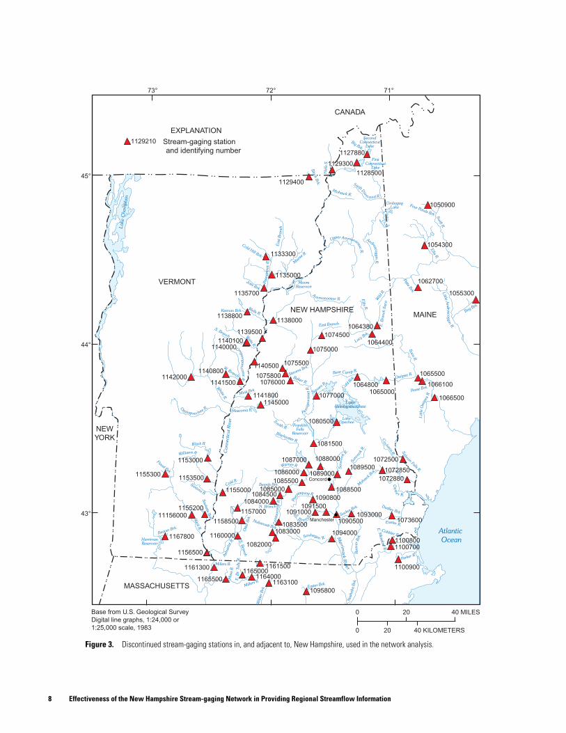
Separate regression models were developed for each of the three flow characteristics using GLS. Discontinued and active stations with greater than 10 years of record (table 1 in back of report; figs. 2 and 3) for the respective flow characteristics were included in the regression analyses. The use of GLS regression allows for weighting of the station data to compensate for the differences in record length and the cross-correlation of concurrent record among stations. The regression analyses for the 100-year peak discharge and the mean annual discharge tested 32 different basin characteristics as potential independent variables (see Appendix 1). A stepwise, ordinary-least-squares (OLS) regression analysis was used as a preliminary screening of physical and climatic characteristics to determine those that were most significant in estimating
streamflow characteristics. The basin and climatic characteristics used in the final regressions for the 100-year peak discharge were drainage area, the average basin slope, and the 24-hour rainfall expected, on average, once each 100 years. The basin and climatic characteristics used in the final regressions for the mean annual discharge were drainage area, the average basin slope, and the basinwide averaged mean annual precipitation.
The basin characteristics used in the annual 7-day, 10-year low-flow regression were taken from a study recently completed by Flynn (2003). In that study, the basin and climatic characteristics that were determined to be most significant in estimating the low-flow characteristics were drainage area, the basin-wide averaged mean annual temperature, and the mean precipitation during the months June through October at the station location. The regression equation for the annual 7-day, 10-year low flow was re-determined using an additional year of streamflow data than was available for the study by Flynn (2003). The regression equations are shown in table 2.
All stream-gaging stations used in the regression analyses, as well as proposed and new stations (table 3), were included in the network analyses. Three planning horizons for the collection of streamflow data were considered in this study. The 0-year planning horizon represents current conditions (2000) and includes no additional data collection. The 5-year planning horizon represents the short-term period, and the 20-year planning horizon represents the long-term period of additional data collection. Ten active or discontinued stations with less than 10 years of unregulated data were included as new station locations in the 5- and 20-year planning horizons (table 3). An additional 19 proposed stations were included in the network analysis for the 5- and 20-year planning horizons. The proposed stations were selected to represent drainage basins with locations in New Hampshire that had inadequate streamflow data, or basin characteristics that were underrepresented in the development of regression equations. Eight of these station sites were proposed in a report by Flynn (2003), which investigated low-flow characteristics in New Hampshire. Another eight station sites correspond to those proposed in an investigation on the sustainability of water resources in the rapidly growing coastal area of New Hampshire. Three additional proposed locations were selected solely for this study. The proposed and new station sites are identified in table 3 and shown in figure 4.
6 Effectiveness of the New Hampshire Stream-gaging Network in Providing Regional Streamflow Information

Kirby
Brk.
KentBrk.
Saxtons R.
Sacketts
Brk.
WildR.
SwiftR.
EllisR.
Parker R.
Nash
obaBrk.
Millers R.
Saco
R.
South
Branch
Manchester
Concord
AyersBrk.
BeaverBrk.
Base from U.S. Geological SurveyDigital line graphs, 1:24,000 or1:25,000 scale, 1983
73° 72° 71°
45°
44°
43°
Atlantic
Ocean
MAINE
VERMONT
MASSACHUSETTS
CANADA
NEW HAMPSHIRE
20 40 MILES0
0 20 40 KILOMETERS
EXPLANATION
Stream-gaging stationand identifying number
1129440
Paul S.QuimbyBrk.
PopeBrk.
SleepersR.
E. Orange Branch
ThirdBranch
MiddleBranch
Whetstone Brk. OtterBrk.
Otter
R.
N. Nashua
R.
NashuaR.S
quannaco
okR.
SpicketR.
Stony Brk.
Lamprey R.
Salm
on
Falls R.
Shannon Brk.
Winnip
esaukeeR.
PoorfarmBrk.
Ossipee R.
West Branch
Sugar R.
Mascoma R.
Swift R.NashS.
Israel R.
PeabodyR.
Gale R.
SuncookR.
Cold R
.
NEWYORK
1129200
1129440
1052500
10535001129500
1055000
1054500
1057000
1066000
1129700
1130000
11330001133200
11345001135150
1135300 1131500
1134800
1135500
1054000
1054200
106430011375001138500
1139700
1139800
1139000
1074520
1064500
1064801
10799001076500
1078000 10796021080000
1081000 1072100
1072800
1073000
1073500
1073587
11425001142400
11440001150800
1150900
11505001144500
1151500
1152500
108580011533001153550
1154000 1154500
11580001158600
109380011603501156300
11610001156450
1166500
11620001162500
1163200
1092000
1100505
110056110965852
10973001094500
10944001096000
1101000
1089100
11555001155350
1151200
W
ild AmmonoosucR.
Little
Androsco
gginR.
Figure 2. Active stream-gaging stations in, and adjacent to, New Hampshire, used in the network analysis.
Network Analysis 7
Saxtons R.
Sacketts
Brk.
WildR.
SwiftR.
EllisR.
Parker R
.
NashobaBrk.
Millers
R.
Saco
R.
Manchester
Concord
BeaverBrk.
Base from U.S. Geological SurveyDigital line graphs, 1:24,000 or1:25,000 scale, 1983
20 40 MILES0
0 20 40 KILOMETERS
EXPLANATION
Stream-gaging stationand identifying number
1129210
MAINE
VERMONT
MASSACHUSETTS
CANADA
NEW HAMPSHIRE
East Branch
ConnecticutRiver
Merrim
ack
Rive
r
11640001165000
73° 72° 71°
45°
44°
43°
Atlantic
Ocean
HallsS.
Black
Brk.
Four Ponds Brk.
PatteBrk.
Bog B
rk.
E.Branch
Saco
LucyBrk.
Cold Hill Brk.
Ompompanoosu
cR.
Black R.
FloodBrk.
Beaver
Brk.
Millers B.
1127880
11285001129300
1129400
1050900
1054300
1062700
1055300
1066500
1066100
1065500
1133300
1135000
1135700
1138800
11401001140000
11395001064380
10644001074500
1075000
11420001140800
1141500
1140500
1145000
1081500
10758001076000 1064800
1065000
1072500
107288010728501089500
1088500
1087000
1086000
10850001090800
1073600
11008001100700
1100900
1094000
1090500
10958001163100
11615001161300
1156500
1167800
1158500 1083500
1082000
10845001084000
1155000
115700011156000
1155200
1155300 1153500
1153000
1138000
1089000
1088000
1085500
10930001091500
1165500
Joes Brk.
Keenan Brk.
S. Branch
W. Branch
MossB.
E.Br.TullyR.
WilderBrk. Easter
Brk.
E.MeadowR.
Cobbler Brk.
Salm
on
Falls R.
Dudley Brk.Sucke
r Brk.
Nubanusit Brk.
OtterBrk.
N. Branch
LakeOpechee
Blackwater R.
Mascoma R.
MinkBrk. Sq
uamR.
ColdBrk. Ossip
ee R.
PeaseBrk.
LittleOssipee
R
Steven
s Brk.
Big Brk.
NEWYORK
10830001160000
S.
B ra n
ch
1091000
Cold R
.
S.Bran
ch
Beards Brk. MohawkBrk.
SuncookR.
1080500
1141800 1077000
1075500
Little
Androsco
gginR.
Figure 3. Discontinued stream-gaging stations in, and adjacent to, New Hampshire, used in the network analysis.
8 Effectiveness of the New Hampshire Stream-gaging Network in Providing Regional Streamflow Information
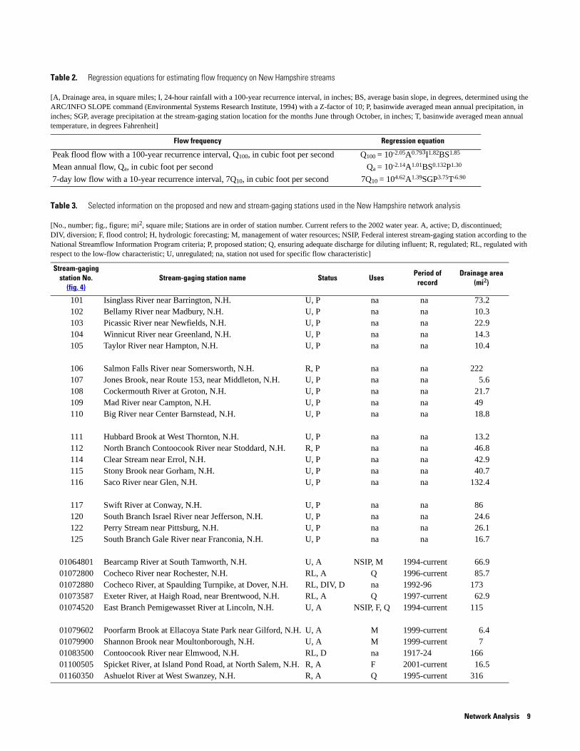
Table 2. Regression equations for estimating flow frequency on New Hampshire streams
[A, Drainage area, in square miles; I, 24-hour rainfall with a 100-year recurrence interval, in inches; BS, average basin slope, in degrees, determined using the ARC/INFO SLOPE command (Environmental Systems Research Institute, 1994) with a Z-factor of 10; P, basinwide averaged mean annual precipitation, in inches; SGP, average precipitation at the stream-gaging station location for the months June through October, in inches; T, basinwide averaged mean annual temperature, in degrees Fahrenheit]
Flow frequency Regression equation
Peak flood flow with a 100-year recurrence interval, Q100, in cubic foot per second Q100 = 10-2.05A0.793I1.82BS1.85
Mean annual flow, Qa, in cubic foot per second Qa = 10-2.14A1.01BS0.132P1.30
7-day low flow with a 10-year recurrence interval, 7Q10, in cubic foot per second 7Q10 = 104.62A1.39SGP3.75T-6.90
Table 3. Selected information on the proposed and new and stream-gaging stations used in the New Hampshire network analysis
[No., number; fig., figure; mi2, square mile; Stations are in order of station number. Current refers to the 2002 water year. A, active; D, discontinued; DIV, diversion; F, flood control; H, hydrologic forecasting; M, management of water resources; NSIP, Federal interest stream-gaging station according to the National Streamflow Information Program criteria; P, proposed station; Q, ensuring adequate discharge for diluting influent; R, regulated; RL, regulated with respect to the low-flow characteristic; U, unregulated; na, station not used for specific flow characteristic]
Stream-gaging station No.
(fig. 4)Stream-gaging station name Status Uses
Period of record
Drainage area (mi2)
101 Isinglass River near Barrington, N.H. U, P na na 73.2102 Bellamy River near Madbury, N.H. U, P na na 10.3103 Picassic River near Newfields, N.H. U, P na na 22.9104 Winnicut River near Greenland, N.H. U, P na na 14.3105 Taylor River near Hampton, N.H. U, P na na 10.4
106 Salmon Falls River near Somersworth, N.H. R, P na na 222107 Jones Brook, near Route 153, near Middleton, N.H. U, P na na 5.6108 Cockermouth River at Groton, N.H. U, P na na 21.7109 Mad River near Campton, N.H. U, P na na 49110 Big River near Center Barnstead, N.H. U, P na na 18.8
111 Hubbard Brook at West Thornton, N.H. U, P na na 13.2112 North Branch Contoocook River near Stoddard, N.H. R, P na na 46.8114 Clear Stream near Errol, N.H. U, P na na 42.9115 Stony Brook near Gorham, N.H. U, P na na 40.7116 Saco River near Glen, N.H. U, P na na 132.4
117 Swift River at Conway, N.H. U, P na na 86120 South Branch Israel River near Jefferson, N.H. U, P na na 24.6122 Perry Stream near Pittsburg, N.H. U, P na na 26.1125 South Branch Gale River near Franconia, N.H. U, P na na 16.7
01064801 Bearcamp River at South Tamworth, N.H. U, A NSIP, M 1994-current 66.901072800 Cocheco River near Rochester, N.H. RL, A Q 1996-current 85.701072880 Cocheco River, at Spaulding Turnpike, at Dover, N.H. RL, DIV, D na 1992-96 17301073587 Exeter River, at Haigh Road, near Brentwood, N.H. RL, A Q 1997-current 62.901074520 East Branch Pemigewasset River at Lincoln, N.H. U, A NSIP, F, Q 1994-current 115
01079602 Poorfarm Brook at Ellacoya State Park near Gilford, N.H. U, A M 1999-current 6.401079900 Shannon Brook near Moultonborough, N.H. U, A M 1999-current 701083500 Contoocook River near Elmwood, N.H. RL, D na 1917-24 16601100505 Spicket River, at Island Pond Road, at North Salem, N.H. R, A F 2001-current 16.501160350 Ashuelot River at West Swanzey, N.H. R, A Q 1995-current 316
Network Analysis 9
Upper
Androscoggin
River Basin
Lower
Androsoggin
River Basin
Upper
Connecticut
River Basin
Saco River Basin
Pemigewasset
River Basin
Upper
Connecticut-
Mascoma
River Basin
Contoocook
River Basin
Middle
Connecticut
River Basin
Millers
River BasinNashua
River Basin
Merrimack
River Basin
Piscataqua-
Salmon Falls
River Basin
Swift R.
IsraelR.
S. Branch
PerryStr.
S. Branch
SpicketR.
Shannon B.
PoorfarmBrk.
Kirby
Brk.
Saxtons R.
ColdBrk.
Saco
R.
Manchester
Concord
BeaverBrk.
Base from U.S. Geological SurveyDigital line graphs, 1:24,000 or1:25,000 scale, 1983
73° 72° 71°
45°
44°
43°
Atlantic
Ocean
MAINE
VERMONT
MASSACHUSETTS
CANADA
20 40 MILES0
0 20 40 KILOMETERS
1160350
EXPLANATION
Stream-gaging stationand identifying number
River basin boundary
Little
Androsco
gginR.
Picassic R.
Salm
onFallsR.
Taylor R.
Bellamy R.
Isinglass R.
Jones Brk.
Cockermouth R.
MadR.
N. Branch
Conto
ocook R
.
Clear Str.
SuncookR.
Big R.
Gale R.
NEWYORK
114
125
116
117
1064801109
111
1074520
1079900108
1071079602
110 1061072880
1072800101
102
105104
103
1073587
110050511603501083500
112
NEW HAMPSHIRE
122
120 115
Winnicut R.
Hubbard B.
StonyBrk.
Figure 4. Location of proposed and new stream-gaging stations used in the New Hampshire network analysis.
10 Effectiveness of the New Hampshire Stream-gaging Network in Providing Regional Streamflow Information
GLSNET cost-weights the sampling error for each station in the network analysis. Thus, operation costs must be assigned to all stations in the network. Because costs for operation of existing stream-gaging stations are uniform in New Hampshire, a cost equal to one unit was assigned to each active station, including several sites that were re-established while this study was being completed. For proposed stations, installation costs were amortized over the length of the planning horizon and added to the operation costs. There were two exceptions. The first exception was for the low-flow and peak-flow networks, which had unregulated streamflow data from as many as five sites that are now regulated. Future streamflow data from these regulated active sites would be of no use to the low- or peak-flow regionalization efforts; therefore, these sites were assigned a cost twice that of other active stations to ensure that these regulated stations would be removed in the early stages of the low-flow and peak-flow network analyses. The second exception was for active partial-record stations in the peak-flow network. These stations were assigned a cost unit equal to 0.1 if peak flows were determined from indirect measurement or 0.3 if peak flows were currently determined from a maintained rating curve. These costs represent the true fractional cost of a partial-record station compared to a full-record active station.
Discontinued stations had their own cost structure. For the 0-year planning horizon, discontinued stations were given a cost twice that of a continuously recording active site. This assured that discontinued sites would be eliminated before active sites. For the 5- and 20-year planning horizon, discontinued stations were assigned the cost of a comparable active site—continuous or partial—plus the cost to re-establish the station amortized over the planning horizon. The exception was for stations where additional streamflow data would be of no use because of regulation or diversion. A cost equal to twice that of a continuously recording active site was given to these sites.
For each planning horizon and flow characteristic, stream-gaging stations were ranked in reverse order from the order in which the GLSNET model removed them from the network. Therefore, the station that was assigned a rank of 1 was the station whose data provided the largest cost-weighted reduction in the average sampling error of the regression equation. A composite ranking also was determined for each planning horizon by summing the individual ranks for the high-, mean-, and low-flow
characteristic for each station and re-ranking the stations in ascending order based on this summed rank. In the composite ranking, all stations whose continued data collection could not contribute to a flow characteristic because of regulation or diversion were given a rank of N+1 in that flow characteristic, where N equals the total number of stations that can contribute to the given flow characteristic and planning horizon. Furthermore, stations where only peak flows were determined (crest-stage gage) were given a rank of N+1 in the mean- and low-flow characteristic ranking when summing for the composite rank. Hence, stations with a composite ranking closest to 1 (high priority) represent stations that contribute the most information to all three flow characteristics. The reader should keep in mind, when reviewing these results, that a station assigned a relatively high composite rank (low priority) under this approach may still provide important regional information with respect to one or two of the individual flow characteristics.
Effectiveness of the Stream-gaging Network
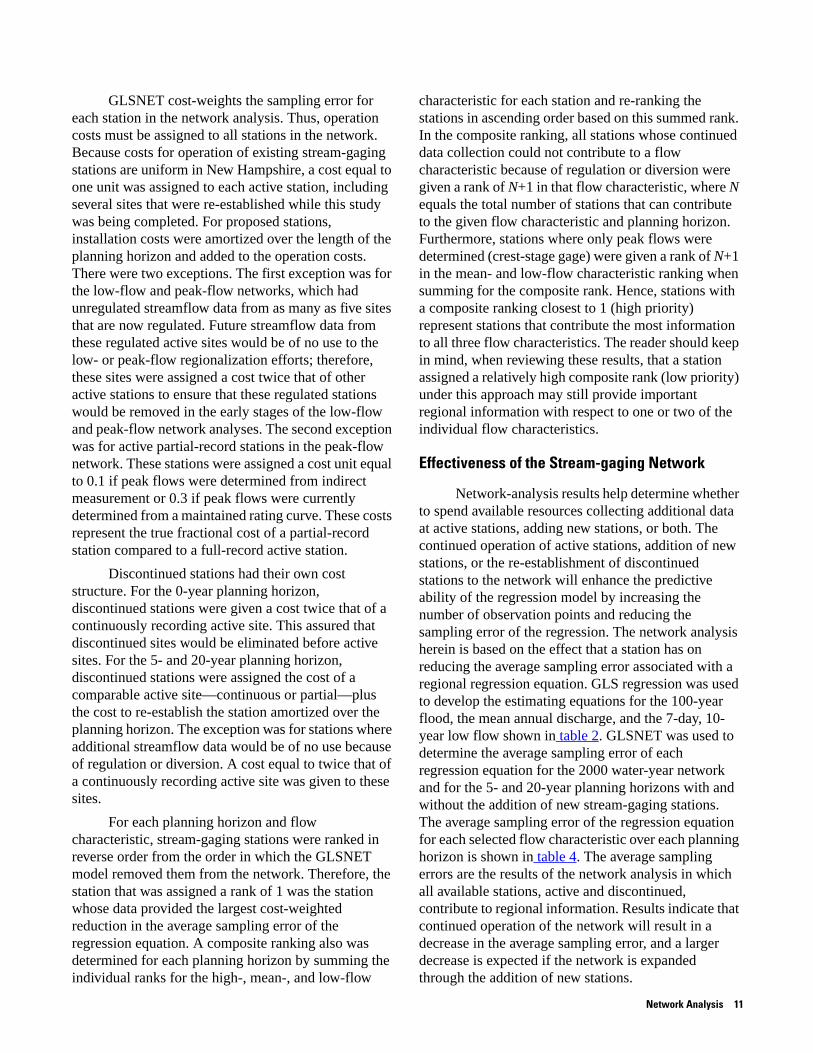
Network-analysis results help determine whether to spend available resources collecting additional data at active stations, adding new stations, or both. The continued operation of active stations, addition of new stations, or the re-establishment of discontinued stations to the network will enhance the predictive ability of the regression model by increasing the number of observation points and reducing the sampling error of the regression. The network analysis herein is based on the effect that a station has on reducing the average sampling error associated with a regional regression equation. GLS regression was used to develop the estimating equations for the 100-year flood, the mean annual discharge, and the 7-day, 10-year low flow shown in table 2. GLSNET was used to determine the average sampling error of each regression equation for the 2000 water-year network and for the 5- and 20-year planning horizons with and without the addition of new stream-gaging stations. The average sampling error of the regression equation for each selected flow characteristic over each planning horizon is shown in table 4. The average sampling errors are the results of the network analysis in which all available stations, active and discontinued, contribute to regional information. Results indicate that continued operation of the network will result in a decrease in the average sampling error, and a larger decrease is expected if the network is expanded through the addition of new stations.
Network Analysis 11
Table 4. Average sampling error for selected network strategies
[Sampling error can be converted to percent units using SE% = 100 (e5.302SE^2-1)0.5, where SE% is the sampling error in percent and SE is the sampling error in logarithmic units]
Streamflow characteristic
Average sampling error in log units
0-year 5-year planning horizon 20-year planning horizon
Excluding new stations Including new stations Excluding new stations Including new stations
100-year peak discharge 0.0605 0.0590 0.0581 0.0548 0.0526
Annual mean discharge .0120 .0120 .0120 .0114 .0114
7-day, 10-year low flow .0833 .0826 .0770 .0811 .0733
A review of table 4 in detail shows that if no new stations are added to the network, the average sampling error of the 100-year peak discharge regression equation is reduced from the conditions in the 2000 water year by 2.5 percent and 9.4 percent for the 5- and 20-year planning horizons, respectively. If the proposed and new stations (table 3) are added to the network, the average sampling error of the 100-year peak discharge regression equation is reduced by 4.0 percent and 13.1 percent for the 5- and 20-year planning horizons, respectively. Substantial reductions in the average sampling error of the 7-day, 10-year low-flow regression equations are also predicted in the network analysis. If no new stations are added to the network, the average sampling error of this low-flow regression equation is reduced from the conditions in the 2000 water year by 0.8 percent and 2.6 percent for the 5- and 20-year planning horizons, respectively. If the proposed and new stations are added to the network, the average sampling error of the low-flow regression equation is reduced by 7.6 percent and 12.0 percent for the 5- and 20-year planning horizons, respectively.
Although considerable improvements to the peak-flow and low-flow regional information are predicted with additional data or the addition of new stream-gaging stations, improvement to the mean-flow regression equation average sampling error—which is already relatively small—is insignificant. The relatively small sampling error of the mean-flow regression equation is because more stations were available to develop the equation and because better estimates of mean annual flows can be obtained from shorter periods of record than for flow statistics with less frequent recurrence intervals. If no new stations are added to the network, the average sampling error for the mean-flow regression equation is reduced from the
conditions in the 2000 water year by 0 percent and 5.0 percent for the 5- and 20-year planning horizons, respectively. If the proposed and new stations (table 3) are added to the network, the average sampling error of the mean-flow regression equation also is decreased 0 percent and 5.0 percent for the 5- and 20-year planning horizons, respectively.
The decrease in the average sampling error as a function of the number of stations being operated is presented in figures 5, 6, and 7. In these figures, the average sampling error is expressed in base-10 logarithmic units, and each point on the graphs represents the sampling error associated with a network that would result if it, plus all the stations plotted to the left of it, were operated over the planning horizon. Thus, the stations where additional data would be most effective in reducing the average sampling error are at the left end of the curves. As a reference point, the square represents the network conditions in the 2000 water year with no additional years of data and no additional stream-gaging stations added to the network and is the average sampling error associated with the regression equation.
The curves associated with the scenarios of including or excluding new stations have different starting points (left end of the curve) because the average sampling errors are computed over different stream-gaging networks. Sometimes, the starting point of a curve that includes new stations has a larger sampling error than the starting point of a curve that excludes new stations or the current conditions (0-year planning horizon) point. This is because the starting point of any of the curves is the sampling error for the 0-year planning horizon for the entire network being analyzed, which can include proposed stations.
12 Effectiveness of the New Hampshire Stream-gaging Network in Providing Regional Streamflow Information
80 100 120 140
NUMBER OF STATIONS OPERATED, OR RANK
AV
ER
AG
ES
AM
PLI
NG
ER
RO
R,I
NLO
GA
RIT
HM
ICU
NIT
S
0 20 40 60
0-year planning horizon
5-year planning horizon, excluding new stations
5-year planning horizon, including new stations
20-year planning horizon, excluding new stations
20-year planning horizon, including new stations
0.050
0.053
0.056
0.059
0.062
0.065
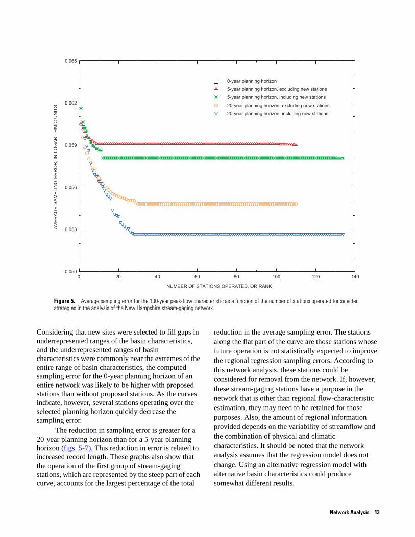
Figure 5. Average sampling error for the 100-year peak-flow characteristic as a function of the number of stations operated for selected strategies in the analysis of the New Hampshire stream-gaging network.
Considering that new sites were selected to fill gaps in underrepresented ranges of the basin characteristics, and the underrepresented ranges of basin characteristics were commonly near the extremes of the entire range of basin characteristics, the computed sampling error for the 0-year planning horizon of an entire network was likely to be higher with proposed stations than without proposed stations. As the curves indicate, however, several stations operating over the selected planning horizon quickly decrease the sampling error.
The reduction in sampling error is greater for a 20-year planning horizon than for a 5-year planning horizon (figs. 5-7). This reduction in error is related to increased record length. These graphs also show that the operation of the first group of stream-gaging stations, which are represented by the steep part of each curve, accounts for the largest percentage of the total
reduction in the average sampling error. The stations along the flat part of the curve are those stations whose future operation is not statistically expected to improve the regional regression sampling errors. According to this network analysis, these stations could be considered for removal from the network. If, however, these stream-gaging stations have a purpose in the network that is other than regional flow-characteristic estimation, they may need to be retained for those purposes. Also, the amount of regional information provided depends on the variability of streamflow and the combination of physical and climatic characteristics. It should be noted that the network analysis assumes that the regression model does not change. Using an alternative regression model with alternative basin characteristics could produce somewhat different results.
Network Analysis 13
100 120 140 160
NUMBER OF STATIONS OPERATED, OR RANK
AV
ER
AG
ES
AM
PLI
NG
ER
RO
R,I
NLO
GA
RIT
HM
ICU
NIT
S
800 20 40 60
0-year planning horizon
5-year planning horizon, excluding new stations
5-year planning horizon, including new stations
20-year planning horizon, excluding new stations
20-year planning horizon, including new stations
0.0110
0.0114
0.0118
0.0122
0.0126
0.0130
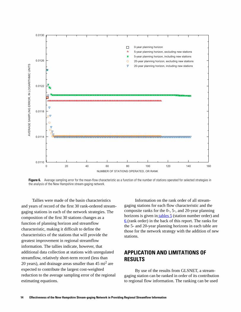
Figure 6. Average sampling error for the mean-flow characteristic as a function of the number of stations operated for selected strategies in the analysis of the New Hampshire stream-gaging network.
Tallies were made of the basin characteristics and years of record of the first 30 rank-ordered stream-gaging stations in each of the network strategies. The composition of the first 30 stations changes as a function of planning horizon and streamflow characteristic, making it difficult to define the characteristics of the stations that will provide the greatest improvement in regional streamflow information. The tallies indicate, however, that additional data collection at stations with unregulated streamflow, relatively short-term record (less than 20 years), and drainage areas smaller than 45 mi2 are expected to contribute the largest cost-weighted reduction to the average sampling error of the regional estimating equations.
Information on the rank order of all stream-gaging stations for each flow characteristic and the composite ranks for the 0-, 5-, and 20-year planning horizons is given in tables 5 (station number order) and 6 (rank order) in the back of this report. The ranks for the 5- and 20-year planning horizons in each table are those for the network strategy with the addition of new stations.
APPLICATION AND LIMITATIONS OF RESULTS
By use of the results from GLSNET, a stream-gaging station can be ranked in order of its contribution to regional flow information. The ranking can be used
14 Effectiveness of the New Hampshire Stream-gaging Network in Providing Regional Streamflow Information

0.074
0.078
0.082
0.086
0.090
0.070100
NUMBER OF STATIONS OPERATED, OR RANK
AV
ER
AG
ES
AM
PLI
NG
ER
RO
R,I
NLO
GA
RIT
HM
ICU
NIT
S
800 20 40 60
0-year planning horizon
5-year planning horizon, excluding new stations
5-year planning horizon, including new stations
20-year planning horizon, excluding new stations
20-year planning horizon, including new stations
Figure 7. Average sampling error for the low-flow (7Q10) characteristic as a function of the number of stations operated for selected strategies in the analysis of the New Hampshire stream-gaging network.
to specify stations where additional data are needed, specify sites where new stations are needed, or indicate which stations are providing little new regional information and could be considered for discontinuation. The reader should note that not all the proposed and new stations used in the network-analysis strategies would be ideal locations for a station. Because the streamflow of some of these locations is regulated (see table 3), their true usefulness in providing regional streamflow data is limited; however, the basin characteristics of these sites would better represent the basin characteristics of the network.
Furthermore, the largest relative decrease in average sampling error typically corresponds to the stations with the fewest years of record. Thus, a network analysis that includes new stations will tend to
rank new stations among stations that are contributing the most to regional streamflow information. This is because the marginal worth of new data at a site with no or little data is greater than the marginal worth of additional data at a site that already has several years of record (G.D. Tasker, U.S. Geological Survey, written commun., March 26, 2002).
Stream-gaging stations in tables 5 and 6 (back of report) that are ranked closest to 1 should be given first consideration for future data collection. Stations with a low priority (high rank) could be considered for removal from the stream-gaging network if budgetary conditions require such action. Such considerations would apply only in the context of improving the regional streamflow information. The composite ranks determined for the network analysis on the high-,
Application and Limitations of Results 15
mean-, and low-flow characteristics are an indicator of the overall contribution of the data from a station to regional streamflow information; however, caution is warranted when interpreting the results. A station that provides a significant reduction in the average sampling error of the regression equation used to estimate a particular streamflow characteristic might have a low-priority ranking if the station cannot provide flow information for another streamflow characteristic. For example, many crest-stage stations that collect only peak-flow data have a high-priority ranking (close to 1) for the high-flow characteristic, indicating that they provide important information. In the composite ranking, however, the same station will have a low-priority rank because it cannot provide information on mean flows or low flows.
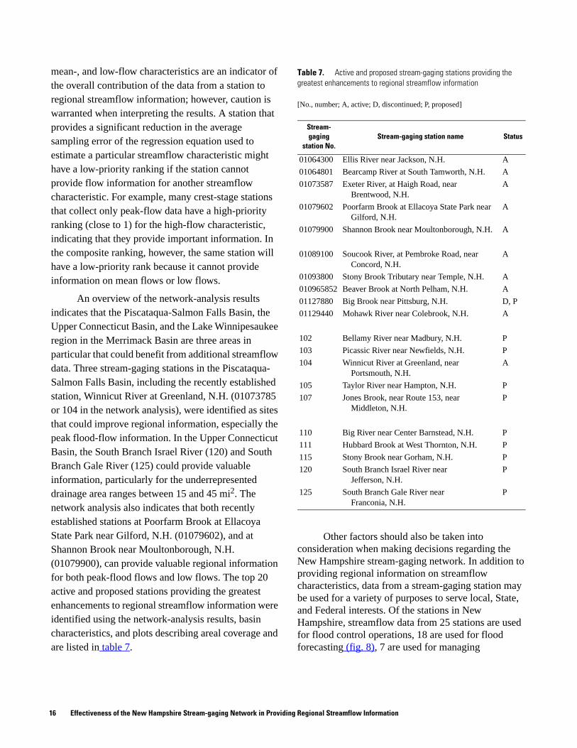
An overview of the network-analysis results indicates that the Piscataqua-Salmon Falls Basin, the Upper Connecticut Basin, and the Lake Winnipesaukee region in the Merrimack Basin are three areas in particular that could benefit from additional streamflow data. Three stream-gaging stations in the Piscataqua-Salmon Falls Basin, including the recently established station, Winnicut River at Greenland, N.H. (01073785 or 104 in the network analysis), were identified as sites that could improve regional information, especially the peak flood-flow information. In the Upper Connecticut Basin, the South Branch Israel River (120) and South Branch Gale River (125) could provide valuable information, particularly for the underrepresented drainage area ranges between 15 and 45 mi2. The network analysis also indicates that both recently established stations at Poorfarm Brook at Ellacoya State Park near Gilford, N.H. (01079602), and at Shannon Brook near Moultonborough, N.H. (01079900), can provide valuable regional information for both peak-flood flows and low flows. The top 20 active and proposed stations providing the greatest enhancements to regional streamflow information were identified using the network-analysis results, basin characteristics, and plots describing areal coverage and are listed in table 7.
Other factors should also be taken into consideration when making decisions regarding the New Hampshire stream-gaging network. In addition to providing regional information on streamflow characteristics, data from a stream-gaging station may be used for a variety of purposes to serve local, State, and Federal interests. Of the stations in New Hampshire, streamflow data from 25 stations are used for flood control operations, 18 are used for flood forecasting (fig. 8), 7 are used for managing
Table 7. Active and proposed stream-gaging stations providing the greatest enhancements to regional streamflow information
[No., number; A, active; D, discontinued; P, proposed]
Stream-gaging
station No.Stream-gaging station name Status
01064300 Ellis River near Jackson, N.H. A
01064801 Bearcamp River at South Tamworth, N.H. A
01073587 Exeter River, at Haigh Road, near Brentwood, N.H.
A
01079602 Poorfarm Brook at Ellacoya State Park near Gilford, N.H.
A
01079900 Shannon Brook near Moultonborough, N.H. A
01089100 Soucook River, at Pembroke Road, near Concord, N.H.
A
01093800 Stony Brook Tributary near Temple, N.H. A
010965852 Beaver Brook at North Pelham, N.H. A
01127880 Big Brook near Pittsburg, N.H. D, P
01129440 Mohawk River near Colebrook, N.H. A
102 Bellamy River near Madbury, N.H. P
103 Picassic River near Newfields, N.H. P
104 Winnicut River at Greenland, near Portsmouth, N.H.
A
105 Taylor River near Hampton, N.H. P
107 Jones Brook, near Route 153, near Middleton, N.H.
P
110 Big River near Center Barnstead, N.H. P
111 Hubbard Brook at West Thornton, N.H. P
115 Stony Brook near Gorham, N.H. P
120 South Branch Israel River near Jefferson, N.H.
P
125 South Branch Gale River near Franconia, N.H.
P
16 Effectiveness of the New Hampshire Stream-gaging Network in Providing Regional Streamflow Information

Saxtons R.
Saco
R.
Manchester
Concord
Base from U.S. Geological SurveyDigital line graphs, 1:24,000 or1:25,000 scale, 1983
73° 72° 71°
45°
44°
43°
Atlantic
Ocean
MAINE
VERMONT
MASSACHUSETTS
CANADA
20 40 MILES0
0 20 40 KILOMETERS
Little
Androsco
gginR.
1129500
1131500
1135500
1138500
1088400
1087000
10860001085500
1085000
NashuaR.
SpicketR.
Ompompanoosu
cR.
Blackwater R.
OtterBrk.
NEWYORK
NEW HAMPSHIRE
Stream-gaging stationused for flood forecasting
Stream-gaging stationused for flood control
Stream-gaging stationused for both floodforecasting and control
Red identifying numberindicates station notused in network analysis
EXPLANATION
1074520
1075000
01141500
1144000
1144500
10760001076500
1078000
10810001081500
1087850
1154500
1158000
1158600115811010830001082000
10908001091500
10920001094000 1100505
1096500
1158110
Figure 8. Location of stream-gaging stations and identifying numbers providing data used for flood-hazard mitigation.
Application and Limitations of Results 17
hydropower, and 10 are used for management of water resources for regulatory purposes. It would be remiss to discontinue or disregard activation of a stream-gaging station with important functions such as flood hazard mitigation. Because many stations have more than one category of use, it is not practical to rely solely on a network analysis using GLSNET results for decisions regarding the alteration of a stream-gaging network.
Also, the network analysis cannot be used to identify stream-gaging stations that should be reactivated or added to the network to improve flood forecasting or other functions unrelated to regionalization. For example, the network analysis gave discontinued stream-gaging stations, Ammonoosuc River near Bath, N.H. (01138000), and Suncook River at North Chichester, N.H. (01089500), a low-priority ranking, presumably because of the large amount of data already collected at these stations, 41 and 52 years, respectively. Yet, the Northeast River Forecast Center of the National Oceanic and Atmospheric Administration (NOAA) has identified both stations as important to improving flood forecasting if reactivated. The Northeast River Forecast Center also indicated that a station on the Merrimack River in Concord, N.H., would improve hydrologic forecasting (Ronald Martin, National Oceanic and Atmospheric Administration, written commun., 2002).
SUMMARY AND CONCLUSIONS
The effectiveness of the New Hampshire stream-gaging network in providing regional streamflow information was evaluated by the use of generalized- least-squares NETwork (GLSNET) software. Stations with 10 or more years of data were used to develop estimating equations for the 100-year peak flood discharge, the mean annual discharge, and the 7-day, 10-year low flow by generalized-least-squares regression. Each station used in the development of a regression equation was then evaluated for its cost-weighted contribution to reduce the average sampling error of the regression equation for conditions existing in the 2000 water year and for hypothetical periods of additional data collection for 5 years and 20 years. Additionally, new stream-gaging stations with less than 10 years of record and proposed stream-gaging stations with underrepresented values of the basin characteristics were evaluated in the network analysis.
All stations were ranked on the basis of their contribution to the reduction of the average sampling error of the regression equations.
The network analysis showed that the effectiveness of the stream-gaging network in providing regional streamflow information could be improved for all three flow characteristics with the collection of additional streamflow data. The addition of new stations to the network would result in an increase in regional streamflow information. With continued data collection, the greatest reduction in the average sampling error of the regional regression equations was found for the peak- and low-flow characteristics. In general, additional data collection at stations with unregulated streamflow, relatively short-term (less than 20 years) records, and drainage areas less than 45 mi2 are expected to contribute the largest cost-weighted reduction to the average sampling error of the regional estimating equations. In New Hampshire, drainage basins between 15 and 35 mi2 are not represented in the network.
The results of the network analyses can be used to prioritize stream-gaging stations for continued operation, reactivation, or establishment of new stations. In addition to optimizing regional information on flow characteristics, other uses of data from a stream-gaging station serving local, State, and Federal interests need to be considered before modifying the stream-gaging network in New Hampshire.
SELECTED REFERENCES
Benson, M.A., 1962, Factors influencing the occurrence of floods in a humid region of diverse terrain: U.S. Geological Survey Water-Supply Paper 1580-B, 64 p.
Environmental Systems Research Institute, Inc. (ESRI), 1994, ARC/INFO users guide, version 7.0: Redlands, Calif.
Flynn, R.H., 2003, A stream-gaging network analysis for the annual 7-day, 10-year low-flow in New Hampshire streams: U.S. Geological Survey Water-Resources Investigations Report 03-4023.
Hirsch, R.M., and Norris, J.M., 2001, National streamflow information program, implementation plan and progress report: U.S. Geological Survey Fact Sheet FS-048-01, 6 p.
Johnson, C.G., 1970, A proposed streamflow data program for central New England: U.S. Geological Survey Open-File Report 70-174, 38 p.
18 Effectiveness of the New Hampshire Stream-gaging Network in Providing Regional Streamflow Information

Medina, K.D., 1987, Analysis of surface-water data network in Kansas for effectiveness in providing regional streamflow information: U.S. Geological Survey Water-Supply Paper 2303, 29 p.
Moss, M.E., and Tasker, G.D., 1991, An intercomparison of hydrological network-design technologies: Journal of Hydrologic Sciences, v. 36, no. 3, p. 209-221.
Ruhl, K.J., 1993, Effectiveness of the streamflow-gaging network in Kentucky in providing regional streamflow information: U.S. Geological Survey Water-Resources Investigations Report 93-4106, 28 p.
Smath, J.A., and Blackey, F.E., 1985, Cost effectiveness of the U.S. Geological Survey’s stream-gaging programs in New Hampshire and Vermont: U.S. Geological Survey Water-Resources Investigations Report 85-4173, 134 p.
Straub, D.E., 1998, Analysis of the streamflow-gaging station network in Ohio for effectiveness in providing regional streamflow information: U.S. Geological Survey Water-Resources Investigations Report 98-4043, 53 p.
Tasker, G.D., 1986, Generating efficient gaging plans for regional information, in Moss, M.E., ed., Integrated design of hydrologic networks—Proceeding of the Budapest Symposium, July 1986: International Association of Hydrologic Sciences, Publication 158, p. 269-281.
———1987, Theory and application of generalized least squares, in Medina, K.D., Analysis of surface-water data network in Kansas for effectiveness in providing regional streamflow information: U.S. Geological Survey Water-Supply Paper 2303, p. 24-26.
Tasker, G.D., and Stedinger, J.R., 1989, An operational GLS model for hydrologic regression: Journal of Hydrology, v. 3, p. 361-375.
U.S. Geological Survey, 1999, Streamflow information for the next century—A plan for the National Streamflow Information Program of the U.S. Geological Survey: U.S. Geological Survey Open-File Report 99-456, 13 p.
Selected References 19
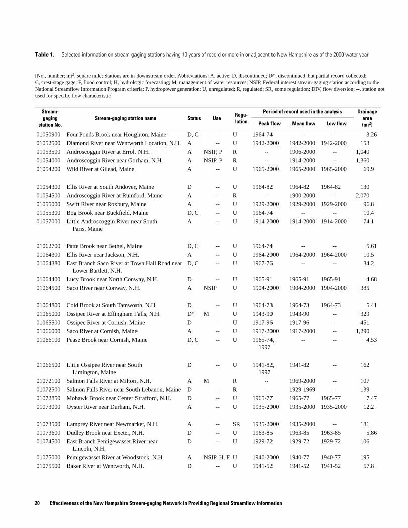
Table 1. Selected information on stream-gaging stations having 10 years of record or more in or adjacent to New Hampshire as of the 2000 water year
[No., number; mi2, square mile; Stations are in downstream order. Abbreviations: A, active; D, discontinued; D*, discontinued, but partial record collected; C, crest-stage gage; F, flood control; H, hydrologic forecasting; M, management of water resources; NSIP, Federal interest stream-gaging station according to the National Streamflow Information Program criteria; P, hydropower generation; U, unregulated; R, regulated; SR, some regulation; DIV, flow diversion; --, station not used for specific flow characteristic]
Stream-gaging
station No.Stream-gaging station name Status Use
Regu-lation
Period of record used in the analysis Drainage area (mi2)Peak flow Mean flow Low flow
01050900 Four Ponds Brook near Houghton, Maine D, C -- U 1964-74 -- -- 3.26
01052500 Diamond River near Wentworth Location, N.H. A -- U 1942-2000 1942-2000 1942-2000 153
01053500 Androscoggin River at Errol, N.H. A NSIP, P R -- 1906-2000 -- 1,040
01054000 Androscoggin River near Gorham, N.H. A NSIP, P R -- 1914-2000 -- 1,360
01054200 Wild River at Gilead, Maine A -- U 1965-2000 1965-2000 1965-2000 69.9
01054300 Ellis River at South Andover, Maine D -- U 1964-82 1964-82 1964-82 130
01054500 Androscoggin River at Rumford, Maine A -- R -- 1900-2000 -- 2,070
01055000 Swift River near Roxbury, Maine A -- U 1929-2000 1929-2000 1929-2000 96.8
01055300 Bog Brook near Buckfield, Maine D, C -- U 1964-74 -- -- 10.4
01057000 Little Androscoggin River near South Paris, Maine
A -- U 1914-2000 1914-2000 1914-2000 74.1
01062700 Patte Brook near Bethel, Maine D, C -- U 1964-74 -- -- 5.61
01064300 Ellis River near Jackson, N.H. A -- U 1964-2000 1964-2000 1964-2000 10.5
01064380 East Branch Saco River at Town Hall Road near Lower Bartlett, N.H.
D, C -- U 1967-76 -- -- 34.2
01064400 Lucy Brook near North Conway, N.H. D -- U 1965-91 1965-91 1965-91 4.68
01064500 Saco River near Conway, N.H. A NSIP U 1904-2000 1904-2000 1904-2000 385
01064800 Cold Brook at South Tamworth, N.H. D -- U 1964-73 1964-73 1964-73 5.41
01065000 Ossipee River at Effingham Falls, N.H. D* M U 1943-90 1943-90 -- 329
01065500 Ossipee River at Cornish, Maine D -- U 1917-96 1917-96 -- 451
01066000 Saco River at Cornish, Maine A -- U 1917-2000 1917-2000 -- 1,290
01066100 Pease Brook near Cornish, Maine D, C -- U 1965-74, 1997
-- -- 4.53
01066500 Little Ossipee River near South Limington, Maine
D -- U 1941-82, 1997
1941-82 -- 162
01072100 Salmon Falls River at Milton, N.H. A M R -- 1969-2000 -- 107
01072500 Salmon Falls River near South Lebanon, Maine D -- R -- 1929-1969 -- 139
01072850 Mohawk Brook near Center Strafford, N.H. D -- U 1965-77 1965-77 1965-77 7.47
01073000 Oyster River near Durham, N.H. A -- U 1935-2000 1935-2000 1935-2000 12.2
01073500 Lamprey River near Newmarket, N.H. A -- SR 1935-2000 1935-2000 -- 181
01073600 Dudley Brook near Exeter, N.H. D -- U 1963-85 1963-85 1963-85 5.86
01074500 East Branch Pemigewasset River near Lincoln, N.H.
D -- U 1929-72 1929-72 1929-72 106
01075000 Pemigewasset River at Woodstock, N.H. A NSIP, H, F U 1940-2000 1940-77 1940-77 195
01075500 Baker River at Wentworth, N.H. D -- U 1941-52 1941-52 1941-52 57.8
20 Effectiveness of the New Hampshire Stream-gaging Network in Providing Regional Streamflow Information

01075800 Stevens Brook near Wentworth, N.H. D -- U 1964-98 1964-98 1964-98 3.29
01076000 Baker River near Rumney, N.H. A NSIP, H, F U 1929-2000 1929-77 1929-77 143
01076500 Pemigewasset River at Plymouth, N.H. A NSIP, H U 1904-2000 1904-2000 1904-2000 623
01077000 Squam River at Ashland, N.H. D -- R -- 1940-95 -- 57.8
01078000 Smith River near Bristol, N.H. A NSIP, H, F U 1919-2000 1919-2000 1919-2000 86
01080500 Lake Winnipesaukee Outlet at Lakeport, N.H. A M R -- -- -- 363
01081000 Winnipesaukee River at Tilton, N.H. A F, M R -- -- -- 471
01081500 Merrimack River at Franklin Junction, N.H. A NSIP, H, F R -- 1904-78 -- 1,510
01082000 Contoocook River at Peterborough, N.H. A NSIP, H, F U 1938, 1946-2000
1946-77 1946-77 67
01083000 Nubanusit Brook below MacDowell Dam near Peterborough, N.H.
D* F R -- 1922-89 -- 45.1
01084000 North Branch Contoocook River near Antrim, N.H.
D -- R -- 1925-1970 -- 54
01084500 Beards Brook near Hillsboro, N.H. D -- U 1946-70 1946-70 1946-70 55.3
01085000 Contoocook River near Henniker, N.H. D* NSIP, H, F SR -- 1940-77 -- 367
01085500 Contoocook River below Hopkinton Dam at West Hopkinton, N.H.
A F DIV, R -- -- -- 427
01085800 West Branch Warner River near Bradford, N.H. A -- U 1963-2000 1963-2000 1963-2000 5.91
01086000 Warner River at Davisville, N.H. A NSIP, H, F U 1940-78, 1999-2000
1940-78 1940-78 146
01087000 Blackwater River near Webster, N.H. D* F R -- 1919-89 -- 128
01088000 Contoocook River at Penacook, N.H. D NSIP DIV, R -- -- -- 766
01088500 Merrimack River at Garvin Falls, N.H. D NSIP DIV, R -- -- -- 2,427
01089000 Soucook River near Concord, N.H. D -- U 1952-87 1952-87 1952-87 77.8
01089100 Soucook River, at Pembroke Road, near Concord, N.H.
A NSIP U 1989-2000 1989-2000 1989-2000 82.9
01089500 Suncook River at North Chichester, N.H. D -- SR 1919-70 1919-70 -- 154
01090500 Merrimack River at Manchester, N.H. D -- R -- 1928-1950 -- 2,850
01090800 Piscataquog River below Everett Dam near East Weare, N.H.
D* NSIP, F DIV, R -- -- -- 63.1
01091000 South Branch Piscataquog River near Goffstown, N.H.
D -- U 1941-78 1941-78 1941-78 103
01091500 Piscataquog River near Goffstown, N.H. D* H, F DIV -- -- -- 202
01092000 Merrimack River near Goffs Falls, below Manchester, N.H.
A NSIP, H, F R -- 1937-2000 -- 3,080
01093000 Sucker Brook at Auburn, N.H. D -- R -- 1939-70 -- 28.8
Table 1. Selected information on stream-gaging stations having 10 years of record or more in or adjacent to New Hampshire as of the 2000 water year --Continued
[No., number; mi2, square mile; Stations are in downstream order. Abbreviations: A, active; D, discontinued; D*, discontinued, but partial record collected; C, crest-stage gage; F, flood control; H, hydrologic forecasting; M, management of water resources; NSIP, Federal interest stream-gaging station according to the National Streamflow Information Program criteria; P, hydropower generation; U, unregulated; R, regulated; SR, some regulation; DIV, flow diversion; --, station not used for specific flow characteristic]
Stream-gaging
station No.Stream-gaging station name Status Use
Regu-lation
Period of record used in the analysis Drainage area (mi2)Peak flow Mean flow Low flow
Tables 21

01093800 Stony Brook Tributary near Temple, N.H. A -- U 1964-2000 1964-2000 1964-2000 3.62
01094000 Souhegan River at Merrimack, N.H. A NSIP, H, F U 1910-2000 1910-76 -- 170
01094400 North Nashua River at Fitchburg, Mass. A -- DIV 1973-2000 -- -- 63.5
01094500 North Nashua River near Leominster, Mass. A -- DIV 1936-2000 -- -- 107
01095800 Easter Brook near North Leominster, Mass. D, C -- U 1964-74 -- -- 0.92
01096000 Squannacook River near West Groton, Mass. A -- SR 1950-2000 1950-2000 -- 66
010965852 Beaver Brook at North Pelham, N.H. A -- U 1987-2000 1987-2000 1987-2000 47.8
01097300 Nashoba Brook near Acton, Mass. A -- U 1963-2000 1963-2000 1963-2000 12.8
01100700 East Meadow River near Haverhill, Mass. D -- U 1963-74 1963-74 1963-74 4.74
01100800 Cobbler Brook near Merrimack, Mass. D, C -- U 1963-83 -- -- 0.76
01100900 Parker River Tributary near Georgetown, Mass. D, C -- U 1964-74 -- -- 0.71
01101000 Parker River at Byfield, Mass. A -- U 1946-2000 1946-2000 1946-2000 21.2
01127880 Big Brook near Pittsburg, N.H. D -- U 1964-84 1964-84 1964-84 6.52
01128500 Connecticut River at First Connecticut Lake near Pittsburg, N.H.
D -- R -- 1917-1990 -- 83
01129200 Connecticut River below Indian Stream near Pittsburg, N.H.
A M R -- 1957-2000 -- 254
01129300 Halls Stream near East Hereford, Quebec D -- U 1943, 1963-94
1963-92 1963-92 84.8
01129400 Black Brook at Averill, Vt. D, C -- U 1964-78 -- -- 0.88
01129440 Mohawk River near Colebrook, N.H. A -- U 1987-2000 1987-2000 1987-2000 35.3
01129500 Connecticut River at North Stratford, N.H. A NSIP, H, P R -- 1931-2000 -- 796
01129700 Paul Stream Tributary near Brunswick Springs, Vt.
A, C -- U 1966-78, 1999-2000
-- -- 1.48
01130000 Upper Ammonoosuc River near Groveton, N.H. A P U 1941-80, 1983-2000
1941-80, 1983-2000
1941-80, 1983-2000
230
01131500 Connecticut River near Dalton, N.H. A NSIP, H, P R -- 1928-2000 -- 1,510
01133000 East Branch Passumpsic River near East Haven, Vt.
A -- U 1940-45, 1949-79, 1998-2000
1940-45, 1949-79, 1998-2000
1940-45, 1949-79, 1998-2000
51.3
01133200 Quimby Brook near Lyndonville, Vt. A, C -- U 1964-74, 1999-2000
-- -- 2.15
01133300 Cold Hill Brook near Lyndon, Vt. D, C -- U 1964-78 -- -- 1.64
Table 1. Selected information on stream-gaging stations having 10 years of record or more in or adjacent to New Hampshire as of the 2000 water year --Continued
[No., number; mi2, square mile; Stations are in downstream order. Abbreviations: A, active; D, discontinued; D*, discontinued, but partial record collected; C, crest-stage gage; F, flood control; H, hydrologic forecasting; M, management of water resources; NSIP, Federal interest stream-gaging station according to the National Streamflow Information Program criteria; P, hydropower generation; U, unregulated; R, regulated; SR, some regulation; DIV, flow diversion; --, station not used for specific flow characteristic]
Stream-gaging
station No.Stream-gaging station name Status Use
Regu-lation
Period of record used in the analysis Drainage area (mi2)Peak flow Mean flow Low flow
22 Effectiveness of the New Hampshire Stream-gaging Network in Providing Regional Streamflow Information

ot
01134500 Moose River at Victory, Vt. A -- U 1948-2000 1948-2000 1948-2000 75.2
01134800 Kirby Brook at Concord, Vt. A -- U 1964-74, 1999-2000
1964-74 1964-74 8.13
01135000 Moose River at St. Johnsbury, Vt. D -- U 1928-83 1928-83 1928-83 129
01135150 Pope Brook near North Danville, Vt. A -- U 1991-2000 1991-2000 -- 3.27
01135300 Sleepers River near St. Johnsbury, Vt. A -- U 1991-2000 1991-2000 1991-2000 42.5
01135500 Passumpsic River at Passumpsic, Vt. A H U 1929-2000 1929-2000 -- 434
01135700 Joes Brook Tributary near East Barnet, Vt. A, C -- U 1964-74, 1999
-- -- 0.7
01137500 Ammonoosuc River at Bethlehem Junction, N.H. A NSIP U 1940-2000 1940-2000 1940-2000 88.2
01138000 Ammonoosuc River near Bath, N.H. D -- U 1940-80 1940-80 1940-80 396
01138500 Connecticut River at Wells River, Vt. A H, F, P R -- 1951-2000 -- 2,640
01138800 Keenan Brook at Groton, Vt. D, C -- U 1964-74 -- -- 4.72
01139000 Wells River at Wells River, Vt. A -- U 1941-2000 1941-2000 1941-2000 98.7
01139500 Connecticut River at South Newbury, Vt. D -- R -- 1919-1949 -- 2,820
01139700 Waits River Tributary near West Topsham, Vt. A, C -- U 1964-74, 1999-2000
-- -- 1.21
01139800 East Orange Branch at East Orange, Vt. A -- U 1959-2000 1959-2000 1959-2000 8.79
01140000 South Branch Waits River near Bradford, Vt. D -- U 1940-51 1940-51 1940-51 43.8
01140100 South Branch Waits River Tributary near Bradford Center, Vt.
D, C -- U 1964-74 -- -- 0.21
01140500 Connecticut River at Orford, N.H. D -- R -- 1901-21 -- 3,090
01140800 West Branch Ompompanoosuc River Tributary at South Strafford, Vt.
D, C -- U 1964-77 -- -- 1.35
01141500 Ompompanoosuc River at Union Village, Vt. D, F -- R -- 1941-89 -- 131
01141800 Mink Brook near Etna, N.H. D -- U 1963-98 1963-98 1963-98 4.88
01142000 White River near Bethel, Vt. D -- U 1932-55 1932-55 1932-55 239
01142400 Third Branch White River Tributary at Randolph, Vt.
A, C -- U 1964-74, 1998-2000
-- -- 0.83
01142500 Ayers Brook at Randolph, Vt. A -- U 1940-75, 1977-2000
1940-75, 1977-2000
1940-75, 1977-2000
30.5
01144000 White River at West Hartford, Vt. A H, F U 1916-2000 1916-2000 1916-2000 689
01144500 Connecticut River at West Lebanon, N.H. A NSIP, H, F, P
R -- 1913-2000 -- 4,090
01145000 Mascoma River at West Canaan, N.H. D* M U 1940-78, 1985-2000
1940-78 1940-78 80.4
01150500 Mascoma River at Mascoma, N.H. A -- R -- 1924-2000 -- 153
Table 1. Selected information on stream-gaging stations having 10 years of record or more in or adjacent to New Hampshire as of the 2000 water year --Continued
[No., number; mi2, square mile; Stations are in downstream order. Abbreviations: A, active; D, discontinued; D*, discontinued, but partial record collected; C, crest-stage gage; F, flood control; H, hydrologic forecasting; M, management of water resources; NSIP, Federal interest stream-gaging station according to theNational Streamflow Information Program criteria; P, hydropower generation; U, unregulated; R, regulated; SR, some regulation; DIV, flow diversion; --, station nused for specific flow characteristic]
Stream-gaging
station No.Stream-gaging station name Status Use
Regu-lation
Period of record used in the analysis Drainage area (mi2)Peak flow Mean flow Low flow
Tables 23

ot
01150800 Kent Brook near Killington, Vt. A -- U 1964-74, 1999-2000
-- 1964-74 3.26
01150900 Ottauquechee River near West Bridgewater, Vt. A -- U 1985-2000 1985-2000 1985-2000 23.3
01151200 Ottauquechee River Tributary near Quechee, Vt. A, C -- U 1964-74, 1999-2000
-- -- 0.77
01151500 Ottauquechee River at North Hartland, Vt. A F R 1928, 1931-60, 1973
1930-2000 -- 222
01152500 Sugar River at West Claremont, N.H. A M SR 1929-2000 1929-2000 -- 270
01153000 Black River at North Springfield, Vt. D -- R 1930-60, 1973
1931-89 -- 158
01153300 Middle Branch Williams River Tributary at Chester, Vt.
A, C -- U 1964-78, 1999-2000
-- -- 3.18
01153500 Williams River at Brockway Mills, Vt. D -- U 1941-84 1941-84 1941-84 102
01153550 Williams River near Rockingham, Vt. A -- U 1987-2000 1987-2000 1987-2000 112
01154000 Saxtons River at Saxtons River, Vt. A -- U 1941-82 1941-82 1941-82 72.1
01154500 Connecticut River at North Walpole, N.H. A NSIP, H, F R -- 1943-2000 -- 5,490
01155000 Cold River at Drewsville, N.H. D -- U 1941-78 1941-78 1941-78 83.4
01155200 Sackets Brook near Putney, Vt. D -- U 1964-74 1964-74 1964-74 10.1
01155300 Flood Brook near Londonderry, Vt. D -- U 1964-74 1964-74 1964-74 9.29
01155350 West River Tributary near Jamaica, Vt. A, C -- U 1964-78, 1999-2000
-- -- 0.93
01155500 West River at Jamaica, Vt. A F R 1936, 1938, 1947-60, 1973, 1987
1947-89, 1996-2000
1947-60 177
01156000 West River at Newfane, Vt. D -- R 1920-23, 1928-60
1921-23, 1929-89
1921-23, 1929-60
306
01156300 Whetstone Brook Tributary near Marlboro, Vt. A, C -- U 1963-74, 1999-2000
-- -- 1.08
01156450 Connecticut River Tributary near Vernon, Vt. A, C -- U 1964-74, 1999-2000
-- -- 1.1
01156500 Connecticut River at Vernon, Vt. D -- R -- 1944-73 -- 6,270
01157000 Ashuelot River near Gilsum, N.H. D -- U 1923-80 1923-80 -- 70.8
01158000 Ashuelot River below Surry Mt. Dam, near Keene, N.H.
A NSIP, F R -- 1946-89, 1996-2000
-- 102
01158500 Otter Brook near Keene, N.H. D -- R 1924-58 1924-58 1924-58 41.9
01158600 Otter Brook below Otter Brook Dam near Keene, N.H.
A F R -- 1959-89, 1996-2000
-- 47.2
Table 1. Selected information on stream-gaging stations having 10 years of record or more in or adjacent to New Hampshire as of the 2000 water year --Continued
[No., number; mi2, square mile; Stations are in downstream order. Abbreviations: A, active; D, discontinued; D*, discontinued, but partial record collected; C, crest-stage gage; F, flood control; H, hydrologic forecasting; M, management of water resources; NSIP, Federal interest stream-gaging station according to theNational Streamflow Information Program criteria; P, hydropower generation; U, unregulated; R, regulated; SR, some regulation; DIV, flow diversion; --, station nused for specific flow characteristic]
Stream-gaging
station No.Stream-gaging station name Status Use
Regu-lation
Period of record used in the analysis Drainage area (mi2)Peak flow Mean flow Low flow
24 Effectiveness of the New Hampshire Stream-gaging Network in Providing Regional Streamflow Information
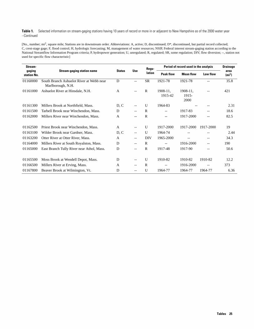
01160000 South Branch Ashuelot River at Webb near Marlborough, N.H.
D -- SR 1921-78 1921-78 -- 35.8
01161000 Ashuelot River at Hinsdale, N.H. A -- R 1908-11, 1915-42
1908-11, 1915-2000
-- 421
01161300 Millers Brook at Northfield, Mass. D, C -- U 1964-83 -- -- 2.31
01161500 Tarbell Brook near Winchendon, Mass. D -- R -- 1917-83 -- 18.6
01162000 Millers River near Winchendon, Mass. A -- R -- 1917-2000 -- 82.5
01162500 Priest Brook near Winchendon, Mass. A -- U 1917-2000 1917-2000 1917-2000 19
01163100 Wilder Brook near Gardner, Mass. D, C -- U 1964-74 -- -- 2.44
01163200 Otter River at Otter River, Mass. A -- DIV 1965-2000 -- -- 34.3
01164000 Millers River at South Royalston, Mass. D -- R -- 1916-2000 -- 190
01165000 East Branch Tully River near Athol, Mass. D -- R 1917-48 1917-90 -- 50.6
01165500 Moss Brook at Wendell Depot, Mass. D -- U 1910-82 1910-82 1910-82 12.2
01166500 Millers River at Erving, Mass. A -- R -- 1916-2000 -- 373
01167800 Beaver Brook at Wilmington, Vt. D -- U 1964-77 1964-77 1964-77 6.36
Table 1. Selected information on stream-gaging stations having 10 years of record or more in or adjacent to New Hampshire as of the 2000 water year --Continued
[No., number; mi2, square mile; Stations are in downstream order. Abbreviations: A, active; D, discontinued; D*, discontinued, but partial record collected; C, crest-stage gage; F, flood control; H, hydrologic forecasting; M, management of water resources; NSIP, Federal interest stream-gaging station according to the National Streamflow Information Program criteria; P, hydropower generation; U, unregulated; R, regulated; SR, some regulation; DIV, flow diversion; --, station not used for specific flow characteristic]
Stream-gaging
station No.Stream-gaging station name Status Use
Regu-lation
Period of record used in the analysis Drainage area (mi2)Peak flow Mean flow Low flow
Tables 25

Table 5. Station ranking in order of importance for providing regional streamflow information for selected peak-, mean-, and low-flow characteristics and planning horizons, by station number
[No., number; Abbreviations: Peak, instantaneous peak flow with 100-year recurrence interval; Mean, mean annual discharge; Low, 7-day low flow with 10-year recurrence interval; Comp, composite rank; reg, regulated with respect to flow characteristic; csg, crest-stage gage; div, diversion; na, not applicable]
Stream-gaging
station No.Stream-gaging station name
Rank for 0-year planning horizon Rank for 5-year planning horizon Rank for 20-year planning horizon
Peak Mean Low Comp Peak Mean Low Comp Peak Mean Low Comp
101 Isinglass River near Barrington, N.H.
na na na na 48 9 16 11 19 37 16 16
102 Bellamy River near Madbury, N.H.
na na na na 7 7 2 4 4 9 3 5
103 Picassic River near Newfields, N.H.
na na na na 1 3 7 3 2 11 6 6
104 Winnicut River near Greenland, N.H.
na na na na 2 1 4 1 1 7 5 4
105 Taylor River near Hampton, N.H.
na na na na 3 2 3 2 3 4 4 3
106 Salmon Falls River near Somersworth, N.H.
na na na na reg 11 reg 61 reg 43 reg 84
107 Jones Brook, near Route 153, near Middleton, N.H.
na na na na 9 8 5 5 7 2 2 2
108 Cockermouth River at Groton, N.H.
na na na na 36 15 14 10 11 14 10 11
109 Mad River near Campton, N.H. na na na na 41 81 17 34 15 15 17 14
110 Big River near Center Barnstead, N.H.
na na na na 27 10 15 9 8 13 8 9
111 Hubbard Brook at West Thornton, N.H.
na na na na 16 80 13 20 9 8 9 7
112 North Branch Contoocook River near Stoddard, N.H.
na na na na reg 53 reg 104 reg 12 reg 63
114 Clear Stream near Errol, N.H. na na na na 21 55 12 13 17 101 15 31
115 Stony Brook near Gorham, N.H.
na na na na 26 5 11 7 13 10 14 13
116 Saco River near Glen, N.H. na na na na 68 28 18 22 22 65 20 23
117 Swift River at Conway, N.H. na na na na 130 60 19 57 21 91 19 30
120 South Branch Israel River near Jefferson, N.H.
na na na na 35 4 10 8 14 5 12 10
122 Perry Stream near Pittsburg, N.H.
na na na na 11 130 8 42 16 6 13 12
125 South Branch Gale River near Franconia, N.H.
na na na na 19 135 9 45 12 3 11 8
01050900 Four Ponds Brook near Houghton, Maine
22 csg csg 72 24 csg csg 81 39 csg csg 95
01052500 Diamond River near Wentworth Location, N.H.
62 41 46 34 99 78 74 83 97 80 76 71
01053500 Androscoggin River at Errol, N.H.
reg 35 reg 77 reg 83 reg 131 reg 89 reg 137
01054000 Androscoggin River near Gorham, N.H.
reg 83 reg 127 reg 119 reg 159 reg 123 reg 164
26 Effectiveness of the New Hampshire Stream-gaging Network in Providing Regional Streamflow Information
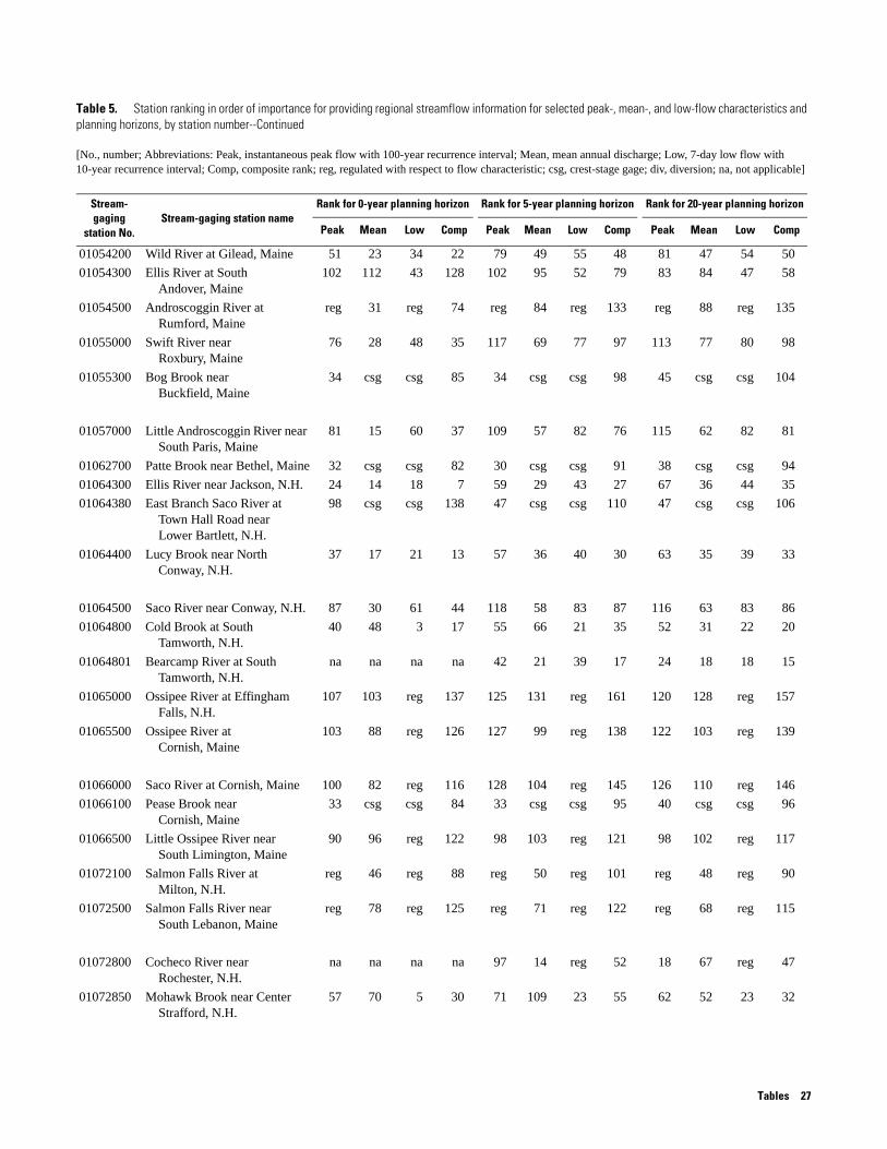
01054200 Wild River at Gilead, Maine 51 23 34 22 79 49 55 48 81 47 54 50
01054300 Ellis River at South Andover, Maine
102 112 43 128 102 95 52 79 83 84 47 58
01054500 Androscoggin River at Rumford, Maine
reg 31 reg 74 reg 84 reg 133 reg 88 reg 135
01055000 Swift River near Roxbury, Maine
76 28 48 35 117 69 77 97 113 77 80 98
01055300 Bog Brook near Buckfield, Maine
34 csg csg 85 34 csg csg 98 45 csg csg 104
01057000 Little Androscoggin River near South Paris, Maine
81 15 60 37 109 57 82 76 115 62 82 81
01062700 Patte Brook near Bethel, Maine 32 csg csg 82 30 csg csg 91 38 csg csg 94
01064300 Ellis River near Jackson, N.H. 24 14 18 7 59 29 43 27 67 36 44 35
01064380 East Branch Saco River at Town Hall Road near Lower Bartlett, N.H.
98 csg csg 138 47 csg csg 110 47 csg csg 106
01064400 Lucy Brook near North Conway, N.H.
37 17 21 13 57 36 40 30 63 35 39 33
01064500 Saco River near Conway, N.H. 87 30 61 44 118 58 83 87 116 63 83 86
01064800 Cold Brook at South Tamworth, N.H.
40 48 3 17 55 66 21 35 52 31 22 20
01064801 Bearcamp River at South Tamworth, N.H.
na na na na 42 21 39 17 24 18 18 15
01065000 Ossipee River at Effingham Falls, N.H.
107 103 reg 137 125 131 reg 161 120 128 reg 157
01065500 Ossipee River at Cornish, Maine
103 88 reg 126 127 99 reg 138 122 103 reg 139
01066000 Saco River at Cornish, Maine 100 82 reg 116 128 104 reg 145 126 110 reg 146
01066100 Pease Brook near Cornish, Maine
33 csg csg 84 33 csg csg 95 40 csg csg 96
01066500 Little Ossipee River near South Limington, Maine
90 96 reg 122 98 103 reg 121 98 102 reg 117
01072100 Salmon Falls River at Milton, N.H.
reg 46 reg 88 reg 50 reg 101 reg 48 reg 90
01072500 Salmon Falls River near South Lebanon, Maine
reg 78 reg 125 reg 71 reg 122 reg 68 reg 115
01072800 Cocheco River near Rochester, N.H.
na na na na 97 14 reg 52 18 67 reg 47
01072850 Mohawk Brook near Center Strafford, N.H.
57 70 5 30 71 109 23 55 62 52 23 32
Table 5. Station ranking in order of importance for providing regional streamflow information for selected peak-, mean-, and low-flow characteristics and planning horizons, by station number--Continued
[No., number; Abbreviations: Peak, instantaneous peak flow with 100-year recurrence interval; Mean, mean annual discharge; Low, 7-day low flow with 10-year recurrence interval; Comp, composite rank; reg, regulated with respect to flow characteristic; csg, crest-stage gage; div, diversion; na, not applicable]
Stream-gaging
station No.Stream-gaging station name
Rank for 0-year planning horizon Rank for 5-year planning horizon Rank for 20-year planning horizon
Peak Mean Low Comp Peak Mean Low Comp Peak Mean Low Comp
Tables 27
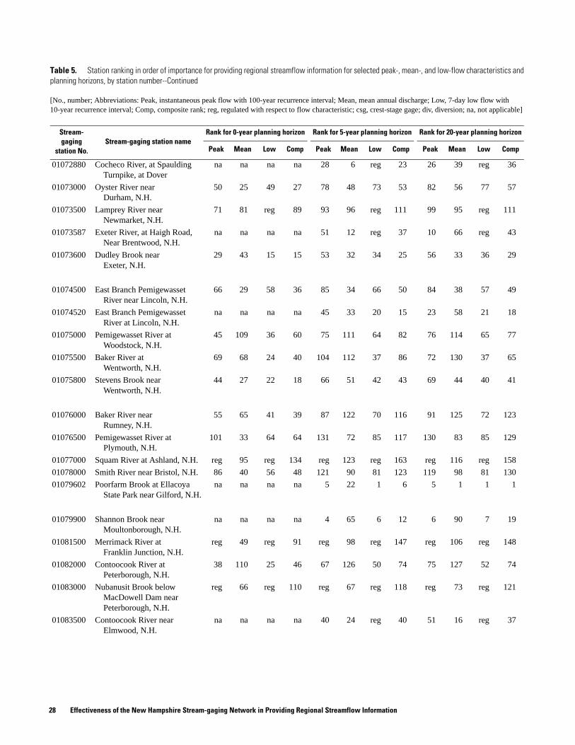
01072880 Cocheco River, at Spaulding Turnpike, at Dover
na na na na 28 6 reg 23 26 39 reg 36
01073000 Oyster River near Durham, N.H.
50 25 49 27 78 48 73 53 82 56 77 57
01073500 Lamprey River near Newmarket, N.H.
71 81 reg 89 93 96 reg 111 99 95 reg 111
01073587 Exeter River, at Haigh Road, Near Brentwood, N.H.
na na na na 51 12 reg 37 10 66 reg 43
01073600 Dudley Brook near Exeter, N.H.
29 43 15 15 53 32 34 25 56 33 36 29
01074500 East Branch Pemigewasset River near Lincoln, N.H.
66 29 58 36 85 34 66 50 84 38 57 49
01074520 East Branch Pemigewasset River at Lincoln, N.H.
na na na na 45 33 20 15 23 58 21 18
01075000 Pemigewasset River at Woodstock, N.H.
45 109 36 60 75 111 64 82 76 114 65 77
01075500 Baker River at Wentworth, N.H.
69 68 24 40 104 112 37 86 72 130 37 65
01075800 Stevens Brook near Wentworth, N.H.
44 27 22 18 66 51 42 43 69 44 40 41
01076000 Baker River near Rumney, N.H.
55 65 41 39 87 122 70 116 91 125 72 123
01076500 Pemigewasset River at Plymouth, N.H.
101 33 64 64 131 72 85 117 130 83 85 129
01077000 Squam River at Ashland, N.H. reg 95 reg 134 reg 123 reg 163 reg 116 reg 158
01078000 Smith River near Bristol, N.H. 86 40 56 48 121 90 81 123 119 98 81 130
01079602 Poorfarm Brook at Ellacoya State Park near Gilford, N.H.
na na na na 5 22 1 6 5 1 1 1
01079900 Shannon Brook near Moultonborough, N.H.
na na na na 4 65 6 12 6 90 7 19
01081500 Merrimack River at Franklin Junction, N.H.
reg 49 reg 91 reg 98 reg 147 reg 106 reg 148
01082000 Contoocook River at Peterborough, N.H.
38 110 25 46 67 126 50 74 75 127 52 74
01083000 Nubanusit Brook below MacDowell Dam near Peterborough, N.H.
reg 66 reg 110 reg 67 reg 118 reg 73 reg 121
01083500 Contoocook River near Elmwood, N.H.
na na na na 40 24 reg 40 51 16 reg 37
Table 5. Station ranking in order of importance for providing regional streamflow information for selected peak-, mean-, and low-flow characteristics and planning horizons, by station number--Continued
[No., number; Abbreviations: Peak, instantaneous peak flow with 100-year recurrence interval; Mean, mean annual discharge; Low, 7-day low flow with 10-year recurrence interval; Comp, composite rank; reg, regulated with respect to flow characteristic; csg, crest-stage gage; div, diversion; na, not applicable]
Stream-gaging
station No.Stream-gaging station name
Rank for 0-year planning horizon Rank for 5-year planning horizon Rank for 20-year planning horizon
Peak Mean Low Comp Peak Mean Low Comp Peak Mean Low Comp
28 Effectiveness of the New Hampshire Stream-gaging Network in Providing Regional Streamflow Information

01084000 North Branch Contoocook River near Antrim, N.H.
reg 61 reg 107 reg 70 reg 120 reg 64 reg 112
01084500 Beards Brook near Hillsboro, N.H.
73 100 33 79 92 120 48 100 86 131 46 93
01085000 Contoocook River near Henniker, N.H.
reg 59 reg 103 reg 108 reg 153 reg 99 reg 143
01085800 West Branch Warner River near Bradford, N.H.
30 13 13 8 63 42 41 38 71 42 42 42
01086000 Warner River at Davisville, N.H.
43 101 35 50 76 132 61 105 78 141 63 114
01087000 Blackwater River near Webster, N.H.
reg 60 reg 105 reg 110 reg 155 reg 112 reg 152
01089000 Soucook River near Concord, N.H.
75 69 52 69 89 138 63 125 87 140 61 122
01089100 Soucook River, at Pembroke Road, near Concord, N.H.
39 9 6 6 70 30 35 31 134 30 38 55
01089500 Suncook River at North Chichester, N.H.
96 71 reg 101 110 88 reg 119 112 86 reg 113
01090500 Merrimack River at Manchester, N.H.
reg 104 reg 139 reg 129 reg 167 reg 54 reg 101
01091000 South Branch Piscataquog River near Goffstown, N.H.
88 111 47 118 96 137 60 128 94 135 60 125
01092000 Merrimack River near Goffs Falls, below Manchester, N.H.
reg 74 reg 119 reg 105 reg 149 reg 134 reg 168
01093000 Sucker Brook at Auburn, N.H. reg 75 reg 121 reg 74 reg 124 reg 69 reg 116
01093800 Stony Brook Tributary near Temple, N.H.
26 7 12 4 64 35 36 32 70 40 41 38
01094000 Souhegan River at Merrimack, N.H.
56 24 reg 33 82 73 reg 70 92 78 reg 76
01094400 North Nashua River at Fitchburg, Mass.
46 div div 97 74 div div 134 77 div div 136
01094500 North Nashua River near Leominster, Mass.
83 div div 131 108 div div 160 111 div div 163
01095800 Easter Brook near North Leominster, Mass.
20 csg csg 70 17 csg csg 75 28 csg csg 75
01096000 Squannacook River near West Groton, Mass.
59 6 reg 28 88 19 reg 51 93 20 reg 54
010965852 Beaver Brook at North Pelham, N.H.
19 4 8 2 49 20 30 16 55 26 32 25
Table 5. Station ranking in order of importance for providing regional streamflow information for selected peak-, mean-, and low-flow characteristics and planning horizons, by station number--Continued
[No., number; Abbreviations: Peak, instantaneous peak flow with 100-year recurrence interval; Mean, mean annual discharge; Low, 7-day low flow with 10-year recurrence interval; Comp, composite rank; reg, regulated with respect to flow characteristic; csg, crest-stage gage; div, diversion; na, not applicable]
Stream-gaging
station No.Stream-gaging station name
Rank for 0-year planning horizon Rank for 5-year planning horizon Rank for 20-year planning horizon
Peak Mean Low Comp Peak Mean Low Comp Peak Mean Low Comp
Tables 29
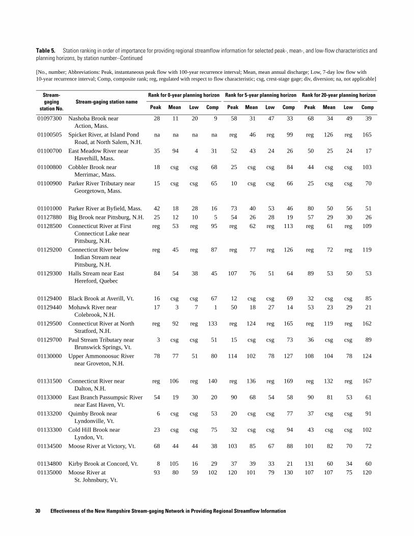
01097300 Nashoba Brook near Action, Mass.
28 11 20 9 58 31 47 33 68 34 49 39
01100505 Spicket River, at Island Pond Road, at North Salem, N.H.
na na na na reg 46 reg 99 reg 126 reg 165
01100700 East Meadow River near Haverhill, Mass.
35 94 4 31 52 43 24 26 50 25 24 17
01100800 Cobbler Brook near Merrimac, Mass.
18 csg csg 68 25 csg csg 84 44 csg csg 103
01100900 Parker River Tributary near Georgetown, Mass.
15 csg csg 65 10 csg csg 66 25 csg csg 70
01101000 Parker River at Byfield, Mass. 42 18 28 16 73 40 53 46 80 50 56 51
01127880 Big Brook near Pittsburg, N.H. 25 12 10 5 54 26 28 19 57 29 30 26
01128500 Connecticut River at First Connecticut Lake near Pittsburg, N.H.
reg 53 reg 95 reg 62 reg 113 reg 61 reg 109
01129200 Connecticut River below Indian Stream near Pittsburg, N.H.
reg 45 reg 87 reg 77 reg 126 reg 72 reg 119
01129300 Halls Stream near East Hereford, Quebec
84 54 38 45 107 76 51 64 89 53 50 53
01129400 Black Brook at Averill, Vt. 16 csg csg 67 12 csg csg 69 32 csg csg 85
01129440 Mohawk River near Colebrook, N.H.
17 3 7 1 50 18 27 14 53 23 29 21
01129500 Connecticut River at North Stratford, N.H.
reg 92 reg 133 reg 124 reg 165 reg 119 reg 162
01129700 Paul Stream Tributary near Brunswick Springs, Vt.
3 csg csg 51 15 csg csg 73 36 csg csg 89
01130000 Upper Ammonoosuc River near Groveton, N.H.
78 77 51 80 114 102 78 127 108 104 78 124
01131500 Connecticut River near Dalton, N.H.
reg 106 reg 140 reg 136 reg 169 reg 132 reg 167
01133000 East Branch Passumpsic River near East Haven, Vt.
54 19 30 20 90 68 54 58 90 81 53 61
01133200 Quimby Brook near Lyndonville, Vt.
6 csg csg 53 20 csg csg 77 37 csg csg 91
01133300 Cold Hill Brook near Lyndon, Vt.
23 csg csg 75 32 csg csg 94 43 csg csg 102
01134500 Moose River at Victory, Vt. 68 44 44 38 103 85 67 88 101 82 70 72
01134800 Kirby Brook at Concord, Vt. 8 105 16 29 37 39 33 21 131 60 34 60
01135000 Moose River at St. Johnsbury, Vt.
93 80 59 102 120 101 79 130 107 107 75 120
Table 5. Station ranking in order of importance for providing regional streamflow information for selected peak-, mean-, and low-flow characteristics and planning horizons, by station number--Continued
[No., number; Abbreviations: Peak, instantaneous peak flow with 100-year recurrence interval; Mean, mean annual discharge; Low, 7-day low flow with 10-year recurrence interval; Comp, composite rank; reg, regulated with respect to flow characteristic; csg, crest-stage gage; div, diversion; na, not applicable]
Stream-gaging
station No.Stream-gaging station name
Rank for 0-year planning horizon Rank for 5-year planning horizon Rank for 20-year planning horizon
Peak Mean Low Comp Peak Mean Low Comp Peak Mean Low Comp
30 Effectiveness of the New Hampshire Stream-gaging Network in Providing Regional Streamflow Information

01135150 Pope Brook near North Danville, Vt.
13 1 na 14 46 13 na 36 49 19 na 40
01135300 Sleepers River near St. Johnsbury, Vt.
63 8 1 12 84 23 25 28 65 22 26 24
01135500 Passumpsic River at Passumpsic, Vt.
99 87 reg 123 129 127 reg 162 124 122 reg 154
01135700 Joes Brook Tributary near East Barnet, Vt.
10 csg csg 56 22 csg csg 78 29 csg csg 78
01137500 Ammonoosuc River at Bethlehem Junction, N.H.
70 85 42 71 106 63 68 67 104 71 71 66
01138000 Ammonoosuc River near Bath, N.H.
109 108 54 135 134 133 76 164 132 133 73 161
01138500 Connecticut River at Wells River, Vt.
reg 55 reg 98 reg 93 reg 142 reg 105 reg 147
01138800 Keenan Brook at Groton, Vt. 52 csg csg 106 38 csg csg 102 42 csg csg 100
01139000 Wells River at Wells River, Vt. 80 72 40 61 116 121 69 137 110 118 69 131
01139500 Connecticut River at South Newbury, Vt.
reg 64 reg 109 reg 97 reg 146 reg 109 reg 150
01139700 Waits River Tributary near West Topsham, Vt.
1 csg csg 47 8 csg csg 65 27 csg csg 73
01139800 East Orange Branch at East Orange, Vt.
31 10 19 10 69 44 46 44 74 45 48 46
01140000 South Branch Waits River near Bradford, Vt.
48 26 27 19 60 114 38 59 64 70 35 48
01140100 South Branch Waits River Tributary near Bradford Center, Vt.
14 csg csg 62 6 csg csg 63 20 csg csg 69
01140500 Connecticut River at Orford, N.H.
reg 22 reg 63 reg 38 reg 85 reg 32 reg 68
01140800 West Branch Ompompanoosuc River Tributary at South Strafford, Vt.
61 csg csg 115 80 csg csg 140 59 csg csg 118
01141500 Ompompanoosuc River at Union Village, Vt.
reg 67 reg 113 reg 140 reg 170 reg 137 reg 169
01141800 Mink Brook near Etna, N.H. 49 39 26 23 72 59 44 47 73 46 43 44
01142000 White River near Bethel, Vt. 64 36 39 32 86 56 57 54 85 51 55 52
01142400 Third Branch White River Tributary at Randolph, Vt.
11 csg csg 57 44 csg csg 108 121 csg csg 166
01142500 Ayers Brook at Randolph, Vt. 60 21 37 25 95 79 62 68 100 79 67 67
01144000 White River at West Hartford, Vt.
108 57 63 96 133 113 84 154 133 120 84 156
Table 5. Station ranking in order of importance for providing regional streamflow information for selected peak-, mean-, and low-flow characteristics and planning horizons, by station number--Continued
[No., number; Abbreviations: Peak, instantaneous peak flow with 100-year recurrence interval; Mean, mean annual discharge; Low, 7-day low flow with 10-year recurrence interval; Comp, composite rank; reg, regulated with respect to flow characteristic; csg, crest-stage gage; div, diversion; na, not applicable]
Stream-gaging
station No.Stream-gaging station name
Rank for 0-year planning horizon Rank for 5-year planning horizon Rank for 20-year planning horizon
Peak Mean Low Comp Peak Mean Low Comp Peak Mean Low Comp
Tables 31

01144500 Connecticut River at West Lebanon, N.H.
reg 107 reg 141 reg 134 reg 168 reg 139 reg 170
01145000 Mascoma River at West Canaan, N.H.
41 98 31 43 77 141 58 114 79 138 59 110
01150500 Mascoma River at Mascoma, N.H.
reg 56 reg 100 reg 107 reg 152 reg 113 reg 153
01150800 Kent Brook near Killington, Vt.
4 na 2 26 18 na 22 49 34 na 25 56
01150900 Ottauquechee River near West Bridgewater, Vt.
21 2 17 3 56 16 32 18 61 24 33 28
01151200 Ottauquechee River Tributary near Quechee, Vt.
12 csg csg 58 39 csg csg 103 33 csg csg 87
01151500 Ottauquechee River at North Hartland, Vt.
85 84 reg 129 123 116 reg 157 125 115 reg 155
01152500 Sugar River at West Claremont, N.H.
106 89 reg 130 132 128 reg 166 129 124 reg 160
01153000 Black River at North Springfield, Vt.
82 63 reg 108 119 106 reg 151 117 111 reg 151
01153300 Middle Branch Williams River Tributary at Chester, Vt.
7 csg csg 54 31 csg csg 92 46 csg csg 105
01153500 Williams River at Brockway Mills, Vt.
94 93 53 114 113 125 71 144 103 129 66 132
01153550 Williams River near Rockingham, Vt.
36 5 23 11 62 25 45 29 66 28 45 34
01154000 Saxtons River at Saxtons River, Vt.
91 91 50 104 112 118 65 129 105 121 64 126
01154500 Connecticut River at North Walpole, N.H.
reg 51 reg 93 reg 86 reg 135 reg 96 reg 141
01155000 Cold River at Drewsville, N.H. 105 97 45 120 126 139 59 150 118 136 58 140
01155200 Sackets Brook near Putney, Vt. 95 86 14 66 65 52 31 41 54 85 28 45
01155300 Flood Brook near Londonderry, Vt.
104 102 9 86 83 37 26 39 58 21 27 22
01155350 West River Tributary near Jamaica, Vt.
9 csg csg 55 29 csg csg 89 41 csg csg 99
01155500 West River at Jamaica, Vt. 72 73 29 117 115 89 49 136 127 87 51 134
01156000 West River at Newfane, Vt. 89 90 57 132 124 100 80 148 128 100 79 145
01156300 Whetstone Brook Tributary near Marlboro, Vt.
2 csg csg 49 13 csg csg 71 31 csg csg 83
01156450 Connecticut River Tributary near Vernon, Vt.
5 csg csg 52 14 csg csg 72 30 csg csg 82
Table 5. Station ranking in order of importance for providing regional streamflow information for selected peak-, mean-, and low-flow characteristics and planning horizons, by station number--Continued
[No., number; Abbreviations: Peak, instantaneous peak flow with 100-year recurrence interval; Mean, mean annual discharge; Low, 7-day low flow with 10-year recurrence interval; Comp, composite rank; reg, regulated with respect to flow characteristic; csg, crest-stage gage; div, diversion; na, not applicable]
Stream-gaging
station No.Stream-gaging station name
Rank for 0-year planning horizon Rank for 5-year planning horizon Rank for 20-year planning horizon
Peak Mean Low Comp Peak Mean Low Comp Peak Mean Low Comp
32 Effectiveness of the New Hampshire Stream-gaging Network in Providing Regional Streamflow Information

01156500 Connecticut River at Vernon, Vt.
reg 50 reg 92 reg 45 reg 96 reg 49 reg 92
01157000 Ashuelot River near Gilsum, N.H.
97 79 reg 111 122 94 reg 132 114 93 reg 127
01158000 Ashuelot River below Surry Mt. Dam, near Keene, N.H.
reg 76 reg 124 reg 117 reg 158 reg 117 reg 159
01158500 Otter Brook near Keene, N.H. 79 20 62 59 105 41 75 90 102 41 74 80
01158600 Otter Brook below Otter Brook Dam near Keene, N.H.
reg 32 reg 76 reg 91 reg 139 reg 92 reg 138
01160000 South Branch Ashuelot River at Webb near Marlborough, N.H.
92 58 reg 83 111 75 reg 106 109 74 reg 97
01160350 Ashuelot River at West Swanzey, N.H.
na na na na reg 17 reg 62 reg 17 reg 64
01161000 Ashuelot River at Hinsdale, N.H.
65 34 reg 41 100 87 reg 109 123 94 reg 133
01161300 Millers Brook at Northfield, Mass.
47 csg csg 99 43 csg csg 107 48 csg csg 108
01161500 Tarbell Brook near Winchendon, Mass.
reg 52 reg 94 reg 61 reg 112 reg 59 reg 107
01162000 Millers River near Winchendon, Mass.
reg 37 reg 81 reg 64 reg 115 reg 76 reg 128
01162500 Priest Brook near Winchendon, Mass.
67 16 32 24 101 47 56 56 106 57 62 62
01163100 Wilder Brook near Gardner, Mass.
27 csg csg 78 23 csg csg 80 35 csg csg 88
01163200 Otter River at Otter River, Mass.
58 div div 112 81 div div 143 88 div div 144
01164000 Millers River at South Royalston, Mass.
reg 99 reg 136 reg 115 reg 156 reg 108 reg 149
01165000 East Branch Tully River near Athol, Mass.
74 62 reg 73 91 82 reg 93 96 75 reg 79
01165500 Moss Brook at Wendell Depot, Mass.
77 38 55 42 94 54 72 60 95 55 68 59
01166500 Millers River at Erving, Mass. reg 47 reg 90 reg 92 reg 141 reg 97 reg 142
01167800 Beaver Brook at Wilmington, Vt.
53 42 11 21 61 27 29 24 60 27 31 27
Table 5. Station ranking in order of importance for providing regional streamflow information for selected peak-, mean-, and low-flow characteristics and planning horizons, by station number--Continued
[No., number; Abbreviations: Peak, instantaneous peak flow with 100-year recurrence interval; Mean, mean annual discharge; Low, 7-day low flow with 10-year recurrence interval; Comp, composite rank; reg, regulated with respect to flow characteristic; csg, crest-stage gage; div, diversion; na, not applicable]
Stream-gaging
station No.Stream-gaging station name
Rank for 0-year planning horizon Rank for 5-year planning horizon Rank for 20-year planning horizon
Peak Mean Low Comp Peak Mean Low Comp Peak Mean Low Comp
Tables 33
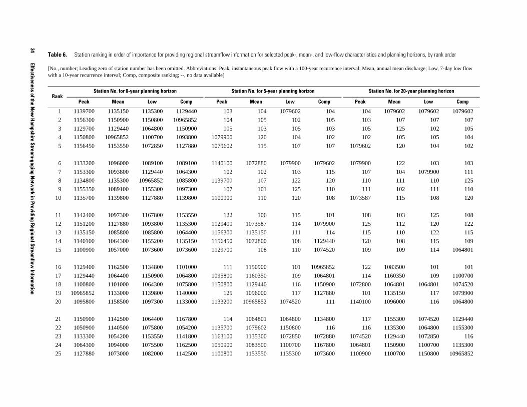
34
Effectiveness of the New
Hampshire Stream
-gaging Netw
ork in Providing Regional Streamflow
Information
tics and planning horizons, by rank order
an, annual mean discharge; Low, 7-day low flow
Station No. for 20-year planning horizon
Mean Low Comp
4 1079602 1079602 1079602
3 107 107 107
5 125 102 105
2 105 105 104
2 120 104 102
0 122 103 103
7 104 1079900 111
0 111 110 125
1 102 111 110
7 115 108 120
8 103 125 108
5 112 120 122
5 110 122 115
0 108 115 109
9 109 114 1064801
2 1083500 101 101
4 1160350 109 1100700
0 1064801 1064801 1074520
1 1135150 117 1079900
0 1096000 116 1064800
7 1155300 1074520 1129440
6 1135300 1064800 1155300
0 1129440 1072850 116
1 1150900 1100700 1135300
0 1100700 1150800 10965852
Table 6. Station ranking in order of importance for providing regional streamflow information for selected peak-, mean-, and low-flow characteris
[No., number; Leading zero of station number has been omitted. Abbreviations: Peak, instantaneous peak flow with a 100-year recurrence interval; Mewith a 10-year recurrence interval; Comp, composite ranking; --, no data available]
RankStation No. for 0-year planning horizon Station No. for 5-year planning horizon
Peak Mean Low Comp Peak Mean Low Comp Peak
1 1139700 1135150 1135300 1129440 103 104 1079602 104 10
2 1156300 1150900 1150800 10965852 104 105 102 105 10
3 1129700 1129440 1064800 1150900 105 103 105 103 10
4 1150800 10965852 1100700 1093800 1079900 120 104 102 10
5 1156450 1153550 1072850 1127880 1079602 115 107 107 107960
6 1133200 1096000 1089100 1089100 1140100 1072880 1079900 1079602 107990
7 1153300 1093800 1129440 1064300 102 102 103 115 10
8 1134800 1135300 10965852 1085800 1139700 107 122 120 11
9 1155350 1089100 1155300 1097300 107 101 125 110 11
10 1135700 1139800 1127880 1139800 1100900 110 120 108 107358
11 1142400 1097300 1167800 1153550 122 106 115 101 10
12 1151200 1127880 1093800 1135300 1129400 1073587 114 1079900 12
13 1135150 1085800 1085800 1064400 1156300 1135150 111 114 11
14 1140100 1064300 1155200 1135150 1156450 1072800 108 1129440 12
15 1100900 1057000 1073600 1073600 1129700 108 110 1074520 10
16 1129400 1162500 1134800 1101000 111 1150900 101 10965852 12
17 1129440 1064400 1150900 1064800 1095800 1160350 109 1064801 11
18 1100800 1101000 1064300 1075800 1150800 1129440 116 1150900 107280
19 10965852 1133000 1139800 1140000 125 1096000 117 1127880 10
20 1095800 1158500 1097300 1133000 1133200 10965852 1074520 111 114010
21 1150900 1142500 1064400 1167800 114 1064801 1064800 1134800 11
22 1050900 1140500 1075800 1054200 1135700 1079602 1150800 116 11
23 1133300 1054200 1153550 1141800 1163100 1135300 1072850 1072880 107452
24 1064300 1094000 1075500 1162500 1050900 1083500 1100700 1167800 106480
25 1127880 1073000 1082000 1142500 1100800 1153550 1135300 1073600 110090

Tables 35
80 10965852 1135300 1127880
00 1167800 1155300 1167800
00 1153550 1155200 1150900
00 1127880 1129440 1073600
50 1089100 1127880 117
00 1064800 1167800 114
00 1140500 10965852 1072850
00 1073600 1150900 1064400
00 1097300 1134800 1153550
00 1064400 1140000 1064300
00 1064300 1073600 1072880
00 101 1075500 1083500
00 1074500 1089100 1093800
00 1072880 1064400 1097300
00 1093800 1075800 1135150
50 1158500 1093800 1075800
00 1085800 1085800 1085800
00 106 1141800 1073587
00 1075800 1064300 1141800
00 1139800 1153550 1155200
00 1141800 1084500 1139800
80 1054200 1054300 1072800
00 1072100 1139800 1140000
50 1156500 1097300 1074500
00 1101000 1129300 1054200
stics and planning horizons, by rank order--Continued
ean, annual mean discharge; Low, 7-day low flow
Station No. for 20-year planning horizon
Mean Low Comp
26 1093800 1140000 1141800 1150800 115 1127880 1155300 1100700 10728
27 1163100 1075800 1140000 1073000 110 1167800 1129440 1064300 11397
28 1097300 1055000 1101000 1096000 1072880 116 1127880 1135300 10958
29 1073600 1074500 1155500 1134800 1155350 1064300 1167800 1153550 11357
30 1085800 1064500 1133000 1072850 1062700 1089100 10965852 1064400 11564
31 1139800 1054500 1145000 1100700 1153300 1097300 1155200 1089100 11563
32 1062700 1158600 1162500 1142000 1133300 1073600 1150900 1093800 11294
33 1066100 1076500 1084500 1094000 1066100 1074520 1134800 1097300 11512
34 1055300 1161000 1054200 1052500 1055300 1074500 1073600 109 11508
35 1100700 1053500 1086000 1055000 120 1093800 1089100 1064800 11631
36 1153550 1142000 1075000 1074500 108 1064400 1093800 1135150 11297
37 1064400 1162000 1142500 1057000 1134800 1155300 1075500 1073587 11332
38 1082000 1165500 1129300 1134500 1138800 1140500 1140000 1085800 10627
39 1089100 1141800 1142000 1076000 1151200 1134800 1064801 1155300 10509
40 1064800 1078000 1139000 1075500 1083500 1101000 1064400 1083500 10661
41 1145000 1052500 1076000 1161000 109 1158500 1085800 1155200 11553
42 1101000 1167800 1137500 1165500 1064801 1085800 1075800 122 11388
43 1086000 1073600 1054300 1145000 1161300 1100700 1064300 1075800 11333
44 1075800 1134500 1134500 1064500 1142400 1139800 1141800 1139800 11008
45 1075000 1129200 1155000 1129300 1074520 1156500 1153550 125 10553
46 1094400 1072100 1052500 1082000 1135150 1100505 1139800 1101000 11533
47 1161300 1166500 1091000 1139700 1064380 1162500 1097300 1141800 10643
48 1140000 1064800 1055000 1078000 101 1073000 1084500 1054200 11613
49 1141800 1081500 1073000 1156300 10965852 1054200 1155500 1150800 11351
50 1073000 1156500 1154000 1086000 1129440 1072100 1082000 1074500 11007
Table 6. Station ranking in order of importance for providing regional streamflow information for selected peak-, mean-, and low-flow characteri
[No., number; Leading zero of station number has been omitted. Abbreviations: Peak, instantaneous peak flow with a 100-year recurrence interval; Mwith a 10-year recurrence interval; Comp, composite ranking; --, no data available]
RankStation No. for 0-year planning horizon Station No. for 5-year planning horizon
Peak Mean Low Comp Peak Mean Low Comp Peak
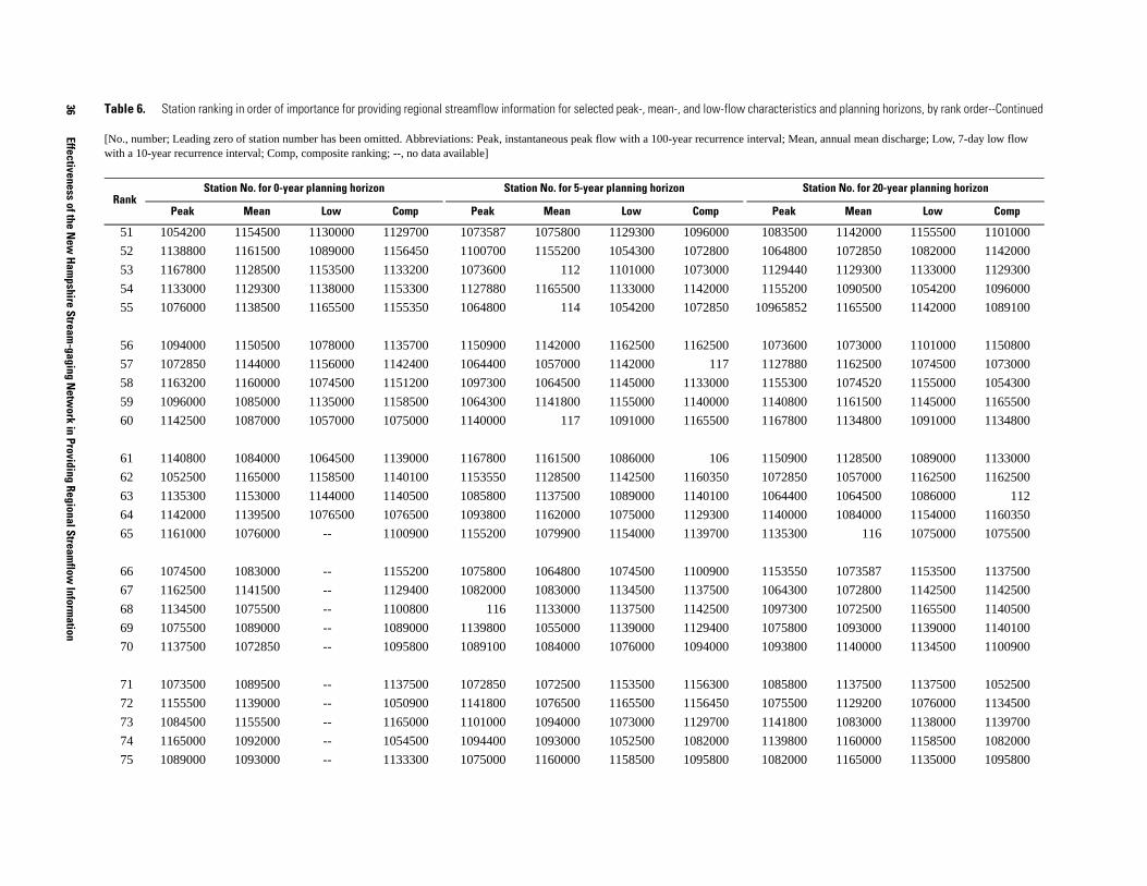
36
Effectiveness of the New
Hampshire Stream
-gaging Netw
ork in Providing Regional Streamflow
Information
00 1142000 1155500 1101000
00 1072850 1082000 1142000
40 1129300 1133000 1129300
00 1090500 1054200 1096000
52 1165500 1142000 1089100
00 1073000 1101000 1150800
80 1162500 1074500 1073000
00 1074520 1155000 1054300
00 1161500 1145000 1165500
00 1134800 1091000 1134800
00 1128500 1089000 1133000
50 1057000 1162500 1162500
00 1064500 1086000 112
00 1084000 1154000 1160350
00 116 1075000 1075500
50 1073587 1153500 1137500
00 1072800 1142500 1142500
00 1072500 1165500 1140500
00 1093000 1139000 1140100
00 1140000 1134500 1100900
00 1137500 1137500 1052500
00 1129200 1076000 1134500
00 1083000 1138000 1139700
00 1160000 1158500 1082000
00 1165000 1135000 1095800
ristics and planning horizons, by rank order--Continued
ean, annual mean discharge; Low, 7-day low flow
Station No. for 20-year planning horizon
k Mean Low Comp
51 1054200 1154500 1130000 1129700 1073587 1075800 1129300 1096000 10835
52 1138800 1161500 1089000 1156450 1100700 1155200 1054300 1072800 10648
53 1167800 1128500 1153500 1133200 1073600 112 1101000 1073000 11294
54 1133000 1129300 1138000 1153300 1127880 1165500 1133000 1142000 11552
55 1076000 1138500 1165500 1155350 1064800 114 1054200 1072850 109658
56 1094000 1150500 1078000 1135700 1150900 1142000 1162500 1162500 10736
57 1072850 1144000 1156000 1142400 1064400 1057000 1142000 117 11278
58 1163200 1160000 1074500 1151200 1097300 1064500 1145000 1133000 11553
59 1096000 1085000 1135000 1158500 1064300 1141800 1155000 1140000 11408
60 1142500 1087000 1057000 1075000 1140000 117 1091000 1165500 11678
61 1140800 1084000 1064500 1139000 1167800 1161500 1086000 106 11509
62 1052500 1165000 1158500 1140100 1153550 1128500 1142500 1160350 10728
63 1135300 1153000 1144000 1140500 1085800 1137500 1089000 1140100 10644
64 1142000 1139500 1076500 1076500 1093800 1162000 1075000 1129300 11400
65 1161000 1076000 -- 1100900 1155200 1079900 1154000 1139700 11353
66 1074500 1083000 -- 1155200 1075800 1064800 1074500 1100900 11535
67 1162500 1141500 -- 1129400 1082000 1083000 1134500 1137500 10643
68 1134500 1075500 -- 1100800 116 1133000 1137500 1142500 10973
69 1075500 1089000 -- 1089000 1139800 1055000 1139000 1129400 10758
70 1137500 1072850 -- 1095800 1089100 1084000 1076000 1094000 10938
71 1073500 1089500 -- 1137500 1072850 1072500 1153500 1156300 10858
72 1155500 1139000 -- 1050900 1141800 1076500 1165500 1156450 10755
73 1084500 1155500 -- 1165000 1101000 1094000 1073000 1129700 11418
74 1165000 1092000 -- 1054500 1094400 1093000 1052500 1082000 11398
75 1089000 1093000 -- 1133300 1075000 1160000 1158500 1095800 10820
Table 6. Station ranking in order of importance for providing regional streamflow information for selected peak-, mean-, and low-flow characte
[No., number; Leading zero of station number has been omitted. Abbreviations: Peak, instantaneous peak flow with a 100-year recurrence interval; Mwith a 10-year recurrence interval; Comp, composite ranking; --, no data available]
RankStation No. for 0-year planning horizon Station No. for 5-year planning horizon
Peak Mean Low Comp Peak Mean Low Comp Pea

Tables 37
00 1162000 1052500 1094000
00 1055000 1073000 1075000
00 1094000 1130000 1135700
00 1142500 1156000 1165000
00 1052500 1055000 1158500
00 1133000 1078000 1057000
00 1134500 1057000 1156450
00 1076500 1064500 1156300
00 1054300 1144000 106
00 1155200 1076500 1129400
00 1089500 -- 1064500
00 1155500 -- 1151200
00 1054500 -- 1163100
00 1053500 -- 1129700
00 1079900 -- 1072100
00 117 -- 1133200
00 1158600 -- 1156500
00 1157000 -- 1084500
00 1161000 -- 1062700
00 1073500 -- 1050900
00 1154500 -- 1066100
00 1166500 -- 1160000
00 1078000 -- 1055000
00 1085000 -- 1155350
00 1156000 -- 1138800
istics and planning horizons, by rank order--Continued
ean, annual mean discharge; Low, 7-day low flow
Station No. for 20-year planning horizon
k Mean Low Comp
76 1055000 1158000 -- 1158600 1086000 1129300 1138000 1057000 10750
77 1165500 1130000 -- 1053500 1145000 1129200 1055000 1133200 10944
78 1130000 1072500 -- 1163100 1073000 1052500 1130000 1135700 10860
79 1158500 1157000 -- 1084500 1054200 1142500 1135000 1054300 11450
80 1139000 1135000 -- 1130000 1140800 111 1156000 1163100 11010
81 1057000 1073500 -- 1162000 1163200 109 1078000 1050900 10542
82 1153000 1066000 -- 1062700 1094000 1165000 1057000 1075000 10730
83 1094500 1054000 -- 1160000 1155300 1053500 1064500 1052500 10543
84 1129300 1151500 -- 1066100 1135300 1054500 1144000 1100800 10745
85 1151500 1137500 -- 1055300 1074500 1134500 1076500 1140500 11420
86 1078000 1155200 -- 1155300 1142000 1154500 -- 1075500 10845
87 1064500 1135500 -- 1129200 1076000 1161000 -- 1064500 10890
88 1091000 1065500 -- 1072100 1096000 1089500 -- 1134500 11632
89 1156000 1152500 -- 1073500 1089000 1155500 -- 1155350 11293
90 1066500 1156000 -- 1166500 1133000 1078000 -- 1158500 11330
91 1154000 1154000 -- 1081500 1165000 1158600 -- 1062700 10760
92 1160000 1129500 -- 1156500 1084500 1166500 -- 1153300 10940
93 1135000 1153500 -- 1154500 1073500 1138500 -- 1165000 10960
94 1153500 1100700 -- 1161500 1165500 1157000 -- 1133300 10910
95 1155200 1077000 -- 1128500 1142500 1054300 -- 1066100 11655
96 1089500 1066500 -- 1144000 1091000 1073500 -- 1156500 11650
97 1157000 1155000 -- 1094400 1072800 1139500 -- 1055000 10525
98 1064380 1145000 -- 1138500 1066500 1081500 -- 1055300 10665
99 1135500 1164000 -- 1161300 1052500 1065500 -- 1100505 10735
100 1066000 1084500 -- 1150500 1161000 1156000 -- 1084500 11425
Table 6. Station ranking in order of importance for providing regional streamflow information for selected peak-, mean-, and low-flow character
[No., number; Leading zero of station number has been omitted. Abbreviations: Peak, instantaneous peak flow with a 100-year recurrence interval; Mwith a 10-year recurrence interval; Comp, composite ranking; --, no data available]
RankStation No. for 0-year planning horizon Station No. for 5-year planning horizon
Peak Mean Low Comp Peak Mean Low Comp Pea
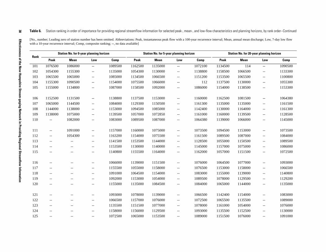
38
Effectiveness of the New
Hampshire Stream
-gaging Netw
ork in Providing Regional Streamflow
Information
0 114 -- 1090500
0 1066500 -- 1133300
0 1065500 -- 1100800
0 1130000 -- 1055300
0 1138500 -- 1153300
0 1081500 -- 1064380
0 1135000 -- 1161500
0 1164000 -- 1161300
0 1139500 -- 1128500
0 1066000 -- 1145000
0 1153000 -- 1073500
0 1087000 -- 1084000
0 1150500 -- 1089500
0 1075000 -- 1086000
0 1151500 -- 1072500
0 1077000 -- 1093000
0 1158000 -- 1066500
0 1139000 -- 1140800
0 1129500 -- 1129200
0 1144000 -- 1135000
0 1154000 -- 1083000
0 1135500 -- 1089000
0 1054000 -- 1076000
0 1152500 -- 1130000
0 1076000 -- 1091000
tics and planning horizons, by rank order--Continued
ean, annual mean discharge; Low, 7-day low flow
Station No. for 20-year planning horizon
Mean Low Comp
101 1076500 1086000 -- 1089500 1162500 1135000 -- 1072100 113450
102 1054300 1155300 -- 1135000 1054300 1130000 -- 1138800 115850
103 1065500 1065000 -- 1085000 1134500 1066500 -- 1151200 115350
104 1155300 1090500 -- 1154000 1075500 1066000 -- 112 113750
105 1155000 1134800 -- 1087000 1158500 1092000 -- 1086000 115400
106 1152500 1131500 -- 1138800 1137500 1153000 -- 1160000 116250
107 1065000 1144500 -- 1084000 1129300 1150500 -- 1161300 113500
108 1144000 1138000 -- 1153000 1094500 1085000 -- 1142400 113000
109 1138000 1075000 -- 1139500 1057000 1072850 -- 1161000 116000
110 -- 1082000 -- 1083000 1089500 1087000 -- 1064380 113900
111 -- 1091000 -- 1157000 1160000 1075000 -- 1073500 109450
112 -- 1054300 -- 1163200 1154000 1075500 -- 1161500 108950
113 -- -- -- 1141500 1153500 1144000 -- 1128500 105500
114 -- -- -- 1153500 1130000 1140000 -- 1145000 115700
115 -- -- -- 1140800 1155500 1164000 -- 1162000 105700
116 -- -- -- 1066000 1139000 1151500 -- 1076000 106450
117 -- -- -- 1155500 1055000 1158000 -- 1076500 115300
118 -- -- -- 1091000 1064500 1154000 -- 1083000 115500
119 -- -- -- 1092000 1153000 1054000 -- 1089500 107800
120 -- -- -- 1155000 1135000 1084500 -- 1084000 106500
121 -- -- -- 1093000 1078000 1139000 -- 1066500 114240
122 -- -- -- 1066500 1157000 1076000 -- 1072500 106550
123 -- -- -- 1135500 1151500 1077000 -- 1078000 116100
124 -- -- -- 1158000 1156000 1129500 -- 1093000 113550
125 -- -- -- 1072500 1065000 1153500 -- 1089000 115150
Table 6. Station ranking in order of importance for providing regional streamflow information for selected peak-, mean-, and low-flow characteris
[No., number; Leading zero of station number has been omitted. Abbreviations: Peak, instantaneous peak flow with a 100-year recurrence interval; Mwith a 10-year recurrence interval; Comp, composite ranking; --, no data available]
RankStation No. for 0-year planning horizon Station No. for 5-year planning horizon
Peak Mean Low Comp Peak Mean Low Comp Peak

Tables 39
00 1100505 -- 1154000
00 1082000 -- 1157000
00 1065000 -- 1162000
00 1153500 -- 1076500
00 1075500 -- 1078000
00 1084500 -- 1139000
00 1131500 -- 1153500
00 1138000 -- 1161000
00 1092000 -- 1155500
1091000 -- 1054500
1155000 -- 1094400
1141500 -- 1053500
1145000 -- 1158600
1144500 -- 1065500
1089000 -- 1155000
1086000 -- 1154500
-- -- 1166500
-- -- 1085000
-- -- 1163200
-- -- 1156000
-- -- 1066000
-- -- 1138500
-- -- 1081500
-- -- 1164000
-- -- 1139500
stics and planning horizons, by rank order--Continued
ean, annual mean discharge; Low, 7-day low flow
Station No. for 20-year planning horizon
Mean Low Comp
126 -- -- -- 1065500 1155000 1082000 -- 1129200 10660
127 -- -- -- 1054000 1065500 1135500 -- 1130000 11555
128 -- -- -- 1054300 1066000 1152500 -- 1091000 11560
129 -- -- -- 1151500 1135500 1090500 -- 1154000 11525
130 -- -- -- 1152500 117 122 -- 1135000 10765
131 -- -- -- 1094500 1076500 1065000 -- 1053500 11348
132 -- -- -- 1156000 1152500 1086000 -- 1157000 11380
133 -- -- -- 1129500 1144000 1138000 -- 1054500 11440
134 -- -- -- 1077000 1138000 1144500 -- 1094400 10891
135 -- -- -- 1138000 -- 125 -- 1154500 --
136 -- -- -- 1164000 -- 1131500 -- 1155500 --
137 -- -- -- 1065000 -- 1091000 -- 1139000 --
138 -- -- -- 1064380 -- 1089000 -- 1065500 --
139 -- -- -- 1090500 -- 1155000 -- 1158600 --
140 -- -- -- 1131500 -- 1141500 -- 1140800 --
141 -- -- -- 1144500 -- 1145000 -- 1166500 --
142 -- -- -- -- -- -- -- 1138500 --
143 -- -- -- -- -- -- -- 1163200 --
144 -- -- -- -- -- -- -- 1153500 --
145 -- -- -- -- -- -- -- 1066000 --
146 -- -- -- -- -- -- -- 1139500 --
147 -- -- -- -- -- -- -- 1081500 --
148 -- -- -- -- -- -- -- 1156000 --
149 -- -- -- -- -- -- -- 1092000 --
150 -- -- -- -- -- -- -- 1155000 --
Table 6. Station ranking in order of importance for providing regional streamflow information for selected peak-, mean-, and low-flow characteri
[No., number; Leading zero of station number has been omitted. Abbreviations: Peak, instantaneous peak flow with a 100-year recurrence interval; Mwith a 10-year recurrence interval; Comp, composite ranking; --, no data available]
RankStation No. for 0-year planning horizon Station No. for 5-year planning horizon
Peak Mean Low Comp Peak Mean Low Comp Peak
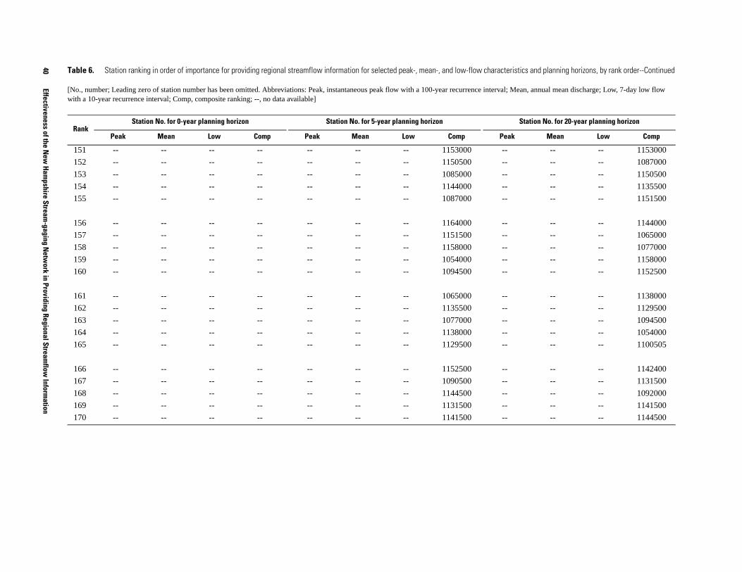
40
Effectiveness of the New
Hampshire Stream
-gaging Netw
ork in Providing Regional Streamflow
Information
-- -- 1153000
-- -- 1087000
-- -- 1150500
-- -- 1135500
-- -- 1151500
-- -- 1144000
-- -- 1065000
-- -- 1077000
-- -- 1158000
-- -- 1152500
-- -- 1138000
-- -- 1129500
-- -- 1094500
-- -- 1054000
-- -- 1100505
-- -- 1142400
-- -- 1131500
-- -- 1092000
-- -- 1141500
-- -- 1144500
tics and planning horizons, by rank order--Continued
ean, annual mean discharge; Low, 7-day low flow
Station No. for 20-year planning horizon
Mean Low Comp
151 -- -- -- -- -- -- -- 1153000 --
152 -- -- -- -- -- -- -- 1150500 --
153 -- -- -- -- -- -- -- 1085000 --
154 -- -- -- -- -- -- -- 1144000 --
155 -- -- -- -- -- -- -- 1087000 --
156 -- -- -- -- -- -- -- 1164000 --
157 -- -- -- -- -- -- -- 1151500 --
158 -- -- -- -- -- -- -- 1158000 --
159 -- -- -- -- -- -- -- 1054000 --
160 -- -- -- -- -- -- -- 1094500 --
161 -- -- -- -- -- -- -- 1065000 --
162 -- -- -- -- -- -- -- 1135500 --
163 -- -- -- -- -- -- -- 1077000 --
164 -- -- -- -- -- -- -- 1138000 --
165 -- -- -- -- -- -- -- 1129500 --
166 -- -- -- -- -- -- -- 1152500 --
167 -- -- -- -- -- -- -- 1090500 --
168 -- -- -- -- -- -- -- 1144500 --
169 -- -- -- -- -- -- -- 1131500 --
170 -- -- -- -- -- -- -- 1141500 --
Table 6. Station ranking in order of importance for providing regional streamflow information for selected peak-, mean-, and low-flow characteris
[No., number; Leading zero of station number has been omitted. Abbreviations: Peak, instantaneous peak flow with a 100-year recurrence interval; Mwith a 10-year recurrence interval; Comp, composite ranking; --, no data available]
RankStation No. for 0-year planning horizon Station No. for 5-year planning horizon
Peak Mean Low Comp Peak Mean Low Comp Peak

APPENDIX 1: BASIN CHARACTERISTICS OF STREAM-GAGING STATIONS IN THE NEW HAMPSHIRE
STREAM-GAGING NETWORK

APPENDIX 1: DEFINITIONS
No. numberfigs. figuresft footft/mi foot per milein. inchin/h inch per hourmi milemi2 square mile-- not available° degreeBasin length is measured along a line areally centered through the drainage area from the basin
outlet to where the main channel meets the basin divideBasin slope is computed as (total length of selected elevation contours) x (contour interval) /
drainage areaRelief is the difference between elevations of the highest point in the basin and the outletAzimuth is the direction of a line from the point on the main channel where, if extended, it
intersects the drainage divide to the outlet; The line is measured in degrees clockwise from north at 0 degrees
Width is drainage area/basin length; Active status stations are on fig. 2; Discontinued stations are on fig. 3
Shape factor is the ratio computed by basin length/widthElongation ratio is the ratio of the diameter of a circle having an area the same as the drainage area to
the basin lengthCompactness ratio is the ratio of the perimeter of the basin to the circumference of a circle having an area
the same as the drainage areaChannel length is the length of the main channel extended to the basin divideChannel slope is the slope computed between points 10 and 85 percent up the main channel, which is
extended to the basin divideSinuosity ratio channel length / basin lengthSlope ratio channel slope / basin slope
42 Effectiveness of the New Hampshire Stream-gaging Network in Providing Regional Streamflow Information
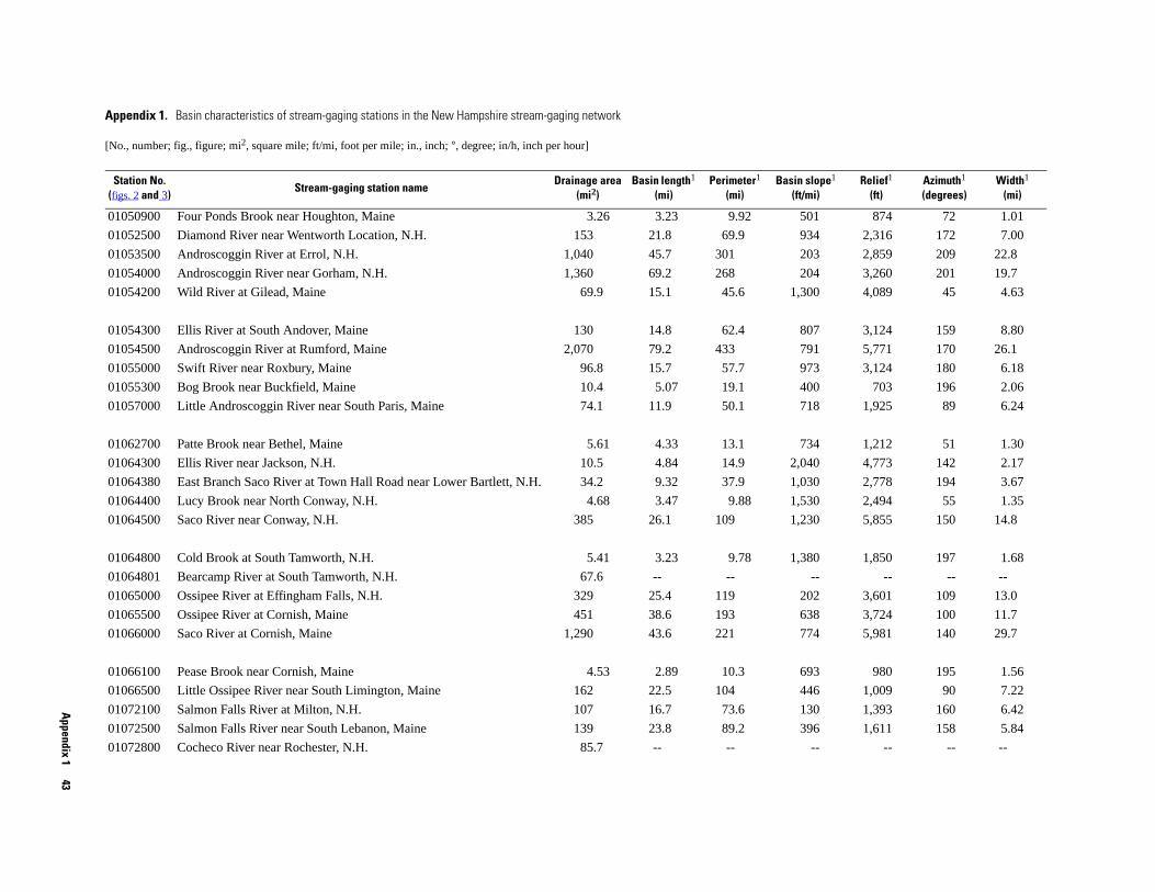
Appendix 1
43
lope1 i)
Relief1 (ft)
Azimuth1 (degrees)
Width1 (mi)
1 874 72 1.01
4 2,316 172 7.00
3 2,859 209 22.8
4 3,260 201 19.7
0 4,089 45 4.63
7 3,124 159 8.80
1 5,771 170 26.1
3 3,124 180 6.18
0 703 196 2.06
8 1,925 89 6.24
4 1,212 51 1.30
0 4,773 142 2.17
0 2,778 194 3.67
0 2,494 55 1.35
0 5,855 150 14.8
0 1,850 197 1.68
-- -- -- --
2 3,601 109 13.0
8 3,724 100 11.7
4 5,981 140 29.7
3 980 195 1.56
6 1,009 90 7.22
0 1,393 160 6.42
6 1,611 158 5.84
-- -- -- --
Appendix 1. Basin characteristics of stream-gaging stations in the New Hampshire stream-gaging network
[No., number; fig., figure; mi2, square mile; ft/mi, foot per mile; in., inch; °, degree; in/h, inch per hour]
Station No. (figs. 2 and 3)
Stream-gaging station nameDrainage area
(mi2)Basin length1
(mi)Perimeter1
(mi)Basin s
(ft/m
01050900 Four Ponds Brook near Houghton, Maine 3.26 3.23 9.92 50
01052500 Diamond River near Wentworth Location, N.H. 153 21.8 69.9 93
01053500 Androscoggin River at Errol, N.H. 1,040 45.7 301 20
01054000 Androscoggin River near Gorham, N.H. 1,360 69.2 268 20
01054200 Wild River at Gilead, Maine 69.9 15.1 45.6 1,30
01054300 Ellis River at South Andover, Maine 130 14.8 62.4 80
01054500 Androscoggin River at Rumford, Maine 2,070 79.2 433 79
01055000 Swift River near Roxbury, Maine 96.8 15.7 57.7 97
01055300 Bog Brook near Buckfield, Maine 10.4 5.07 19.1 40
01057000 Little Androscoggin River near South Paris, Maine 74.1 11.9 50.1 71
01062700 Patte Brook near Bethel, Maine 5.61 4.33 13.1 73
01064300 Ellis River near Jackson, N.H. 10.5 4.84 14.9 2,04
01064380 East Branch Saco River at Town Hall Road near Lower Bartlett, N.H. 34.2 9.32 37.9 1,03
01064400 Lucy Brook near North Conway, N.H. 4.68 3.47 9.88 1,53
01064500 Saco River near Conway, N.H. 385 26.1 109 1,23
01064800 Cold Brook at South Tamworth, N.H. 5.41 3.23 9.78 1,38
01064801 Bearcamp River at South Tamworth, N.H. 67.6 -- --
01065000 Ossipee River at Effingham Falls, N.H. 329 25.4 119 20
01065500 Ossipee River at Cornish, Maine 451 38.6 193 63
01066000 Saco River at Cornish, Maine 1,290 43.6 221 77
01066100 Pease Brook near Cornish, Maine 4.53 2.89 10.3 69
01066500 Little Ossipee River near South Limington, Maine 162 22.5 104 44
01072100 Salmon Falls River at Milton, N.H. 107 16.7 73.6 13
01072500 Salmon Falls River near South Lebanon, Maine 139 23.8 89.2 39
01072800 Cocheco River near Rochester, N.H. 85.7 -- --
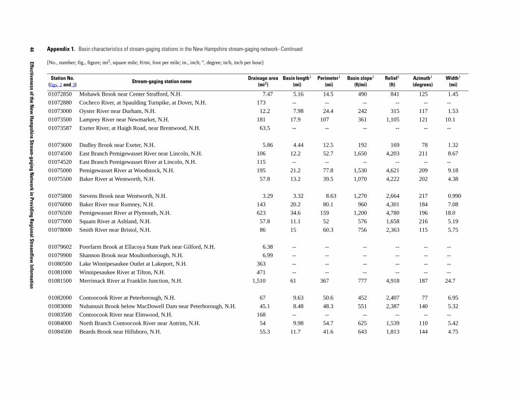
44
Effectiveness of the New
Hampshire Stream
-gaging Netw
ork in Providing Regional Streamflow
Information
490 841 125 1.45
-- -- -- --
242 315 117 1.53
361 1,105 121 10.1
-- -- -- --
192 169 78 1.32
1,650 4,203 211 8.67
-- -- -- --
1,530 4,621 209 9.18
1,070 4,222 202 4.38
1,270 2,664 217 0.990
960 4,301 184 7.08
1,200 4,780 196 18.0
576 1,658 216 5.19
756 2,363 115 5.75
-- -- -- --
-- -- -- --
-- -- -- --
-- -- -- --
777 4,918 187 24.7
452 2,407 77 6.95
551 2,387 140 5.32
-- -- -- --
625 1,539 110 5.42
643 1,813 144 4.75
sin slope1 (ft/mi)
Relief1 (ft)
Azimuth1 (degrees)
Width1 (mi)
01072850 Mohawk Brook near Center Strafford, N.H. 7.47 5.16 14.5
01072880 Cocheco River, at Spaulding Turnpike, at Dover, N.H. 173 -- --
01073000 Oyster River near Durham, N.H. 12.2 7.98 24.4
01073500 Lamprey River near Newmarket, N.H. 181 17.9 107
01073587 Exeter River, at Haigh Road, near Brentwood, N.H. 63.5 -- --
01073600 Dudley Brook near Exeter, N.H. 5.86 4.44 12.5
01074500 East Branch Pemigewasset River near Lincoln, N.H. 106 12.2 52.7
01074520 East Branch Pemigewasset River at Lincoln, N.H. 115 -- --
01075000 Pemigewasset River at Woodstock, N.H. 195 21.2 77.8
01075500 Baker River at Wentworth, N.H. 57.8 13.2 39.5
01075800 Stevens Brook near Wentworth, N.H. 3.29 3.32 8.63
01076000 Baker River near Rumney, N.H. 143 20.2 80.1
01076500 Pemigewasset River at Plymouth, N.H. 623 34.6 159
01077000 Squam River at Ashland, N.H. 57.8 11.1 52
01078000 Smith River near Bristol, N.H. 86 15 60.3
01079602 Poorfarm Brook at Ellacoya State Park near Gilford, N.H. 6.38 -- --
01079900 Shannon Brook near Moultonborough, N.H. 6.99 -- --
01080500 Lake Winnipesaukee Outlet at Lakeport, N.H. 363 -- --
01081000 Winnipesaukee River at Tilton, N.H. 471 -- --
01081500 Merrimack River at Franklin Junction, N.H. 1,510 61 367
01082000 Contoocook River at Peterborough, N.H. 67 9.63 50.6
01083000 Nubanusit Brook below MacDowell Dam near Peterborough, N.H. 45.1 8.48 48.3
01083500 Contoocook River near Elmwood, N.H. 168 -- --
01084000 North Branch Contoocook River near Antrim, N.H. 54 9.98 54.7
01084500 Beards Brook near Hillsboro, N.H. 55.3 11.7 41.6
Appendix 1. Basin characteristics of stream-gaging stations in the New Hampshire stream-gaging network--Continued
[No., number; fig., figure; mi2, square mile; ft/mi, foot per mile; in., inch; °, degree; in/h, inch per hour]
Station No. (figs. 2 and 3)
Stream-gaging station nameDrainage area
(mi2)Basin length1
(mi)Perimeter1
(mi)Ba

Appendix 1
45
529 2,652 189 11.4
-- -- -- --
959 1,542 122 1.96
704 2,259 129 6.88
680 2,476 135 5.57
-- -- -- --
-- -- -- --
431 1,189 193 4.97
402 1,197 194 4.66
467 1,979 190 7.58
646 5,011 179 30.9
-- -- -- --
570 1,708 87 7.49
-- -- -- --
634 5,069 178 32.0
298 678 178 3.53
913 1,358 137 1.37
484 2,091 53 5.63
457 1,575 96 5.53
461 1,705 116 6.33
561 264 56 1.10
426 1,240 99 5.16
321 483 200 3.33
248 301 158 2.08
-- -- -- --
slope1 t/mi)
Relief1 (ft)
Azimuth1 (degrees)
Width1 (mi)
01085000 Contoocook River near Henniker, N.H. 367 32.1 115
01085500 Contoocook River below Hopkinton Dam at West Hopkinton, N.H. 427 -- --
01085800 West Branch Warner River near Bradford, N.H. 5.91 3.02 11
01086000 Warner River at Davisville, N.H. 146 21.2 73.1
01087000 Blackwater River near Webster, N.H. 128 23 97.8
01088000 Contoocook River at Penacook, N.H. 766 -- --
01088500 Merrimack River at Garvin Falls, N.H. 2,430 -- --
01089000 Soucook River near Concord, N.H. 77.8 15.7 53.7
01089100 Soucook River, at Pembroke Road, near Concord, N.H. 82.9 17.8 72.8
01089500 Suncook River at North Chichester, N.H. 154 20.4 92.6
01090500 Merrimack River at Manchester, N.H. 2,850 92.3 550
01090800 Piscataquog River below Everett Dam near East Weare, N.H. 63.1 -- --
01091000 South Branch Piscataquog River near Goffstown, N.H. 103 13.7 61.9
01091500 Piscataquog River near Goffstown, N.H. 202 -- --
01092000 Merrimack River near Goffs Falls, below Manchester, N.H. 3,080 96.4 524
01093000 Sucker Brook at Auburn, N.H. 28.8 8.17 44.4
01093800 Stony Brook Tributary near Temple, N.H. 3.62 2.65 7.71
01094000 Souhegan River at Merrimack, N.H. 170 30.1 122
01094400 North Nashua River at Fitchburg, Mass. 63.5 11.5 66.2
01094500 North Nashua River near Leominster, Mass. 107 16.9 85.4
01095800 Easter Brook near North Leominster, Mass. 0.92 0.833 5.3
01096000 Squannacook River near West Groton, Mass. 66 12.8 62.4
010965852 Beaver Brook at North Pelham, N.H. 47.8 14.3 48.1
01097300 Nashoba Brook near Action, Mass. 12.8 6.15 20.5
01100505 Spicket River, at Island Pond Road, at North Salem, N.H. 16.5 -- --
Appendix 1. Basin characteristics of stream-gaging stations in the New Hampshire stream-gaging network--Continued
[No., number; fig., figure; mi2, square mile; ft/mi, foot per mile; in., inch; °, degree; in/h, inch per hour]
Station No. (figs. 2 and 3)
Stream-gaging station nameDrainage area
(mi2)Basin length1
(mi)Perimeter1
(mi)Basin
(f
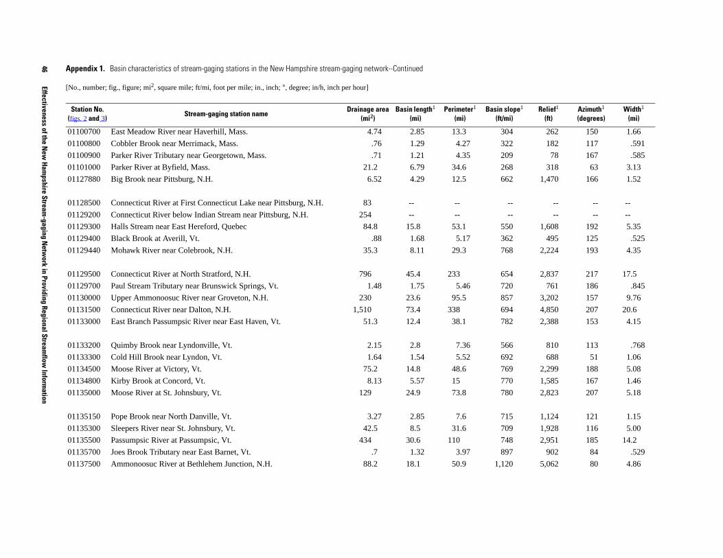
46
Effectiveness of the New
Hampshire Stream
-gaging Netw
ork in Providing Regional Streamflow
Information
04 262 150 1.66
22 182 117 .591
09 78 167 .585
68 318 63 3.13
62 1,470 166 1.52
-- -- -- --
-- -- -- --
50 1,608 192 5.35
62 495 125 .525
68 2,224 193 4.35
54 2,837 217 17.5
20 761 186 .845
57 3,202 157 9.76
94 4,850 207 20.6
82 2,388 153 4.15
66 810 113 .768
92 688 51 1.06
69 2,299 188 5.08
70 1,585 167 1.46
80 2,823 207 5.18
15 1,124 121 1.15
09 1,928 116 5.00
48 2,951 185 14.2
97 902 84 .529
20 5,062 80 4.86
slope1 /mi)
Relief1 (ft)
Azimuth1 (degrees)
Width1 (mi)
01100700 East Meadow River near Haverhill, Mass. 4.74 2.85 13.3 3
01100800 Cobbler Brook near Merrimack, Mass. .76 1.29 4.27 3
01100900 Parker River Tributary near Georgetown, Mass. .71 1.21 4.35 2
01101000 Parker River at Byfield, Mass. 21.2 6.79 34.6 2
01127880 Big Brook near Pittsburg, N.H. 6.52 4.29 12.5 6
01128500 Connecticut River at First Connecticut Lake near Pittsburg, N.H. 83 -- --
01129200 Connecticut River below Indian Stream near Pittsburg, N.H. 254 -- --
01129300 Halls Stream near East Hereford, Quebec 84.8 15.8 53.1 5
01129400 Black Brook at Averill, Vt. .88 1.68 5.17 3
01129440 Mohawk River near Colebrook, N.H. 35.3 8.11 29.3 7
01129500 Connecticut River at North Stratford, N.H. 796 45.4 233 6
01129700 Paul Stream Tributary near Brunswick Springs, Vt. 1.48 1.75 5.46 7
01130000 Upper Ammonoosuc River near Groveton, N.H. 230 23.6 95.5 8
01131500 Connecticut River near Dalton, N.H. 1,510 73.4 338 6
01133000 East Branch Passumpsic River near East Haven, Vt. 51.3 12.4 38.1 7
01133200 Quimby Brook near Lyndonville, Vt. 2.15 2.8 7.36 5
01133300 Cold Hill Brook near Lyndon, Vt. 1.64 1.54 5.52 6
01134500 Moose River at Victory, Vt. 75.2 14.8 48.6 7
01134800 Kirby Brook at Concord, Vt. 8.13 5.57 15 7
01135000 Moose River at St. Johnsbury, Vt. 129 24.9 73.8 7
01135150 Pope Brook near North Danville, Vt. 3.27 2.85 7.6 7
01135300 Sleepers River near St. Johnsbury, Vt. 42.5 8.5 31.6 7
01135500 Passumpsic River at Passumpsic, Vt. 434 30.6 110 7
01135700 Joes Brook Tributary near East Barnet, Vt. .7 1.32 3.97 8
01137500 Ammonoosuc River at Bethlehem Junction, N.H. 88.2 18.1 50.9 1,1
Appendix 1. Basin characteristics of stream-gaging stations in the New Hampshire stream-gaging network--Continued
[No., number; fig., figure; mi2, square mile; ft/mi, foot per mile; in., inch; °, degree; in/h, inch per hour]
Station No. (figs. 2 and 3)
Stream-gaging station nameDrainage area
(mi2)Basin length1
(mi)Perimeter1
(mi)Basin
(ft
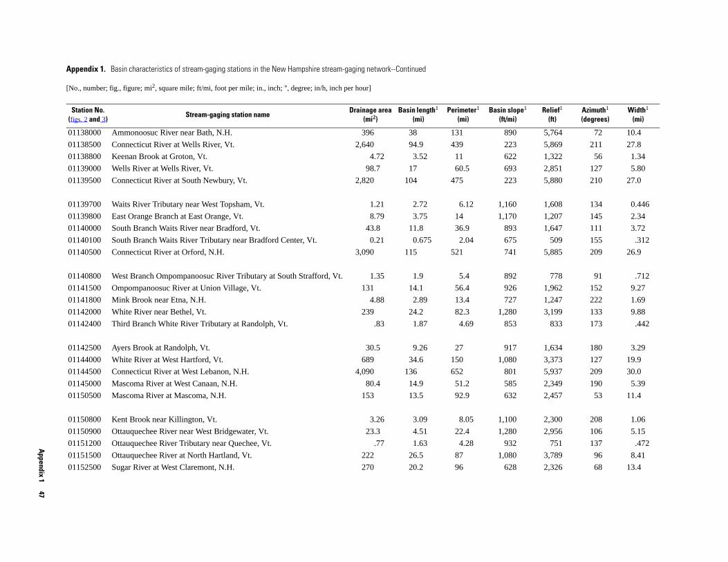
Appendix 1
47
890 5,764 72 10.4
223 5,869 211 27.8
622 1,322 56 1.34
693 2,851 127 5.80
223 5,880 210 27.0
160 1,608 134 0.446
170 1,207 145 2.34
893 1,647 111 3.72
675 509 155 .312
741 5,885 209 26.9
892 778 91 .712
926 1,962 152 9.27
727 1,247 222 1.69
280 3,199 133 9.88
853 833 173 .442
917 1,634 180 3.29
080 3,373 127 19.9
801 5,937 209 30.0
585 2,349 190 5.39
632 2,457 53 11.4
100 2,300 208 1.06
280 2,956 106 5.15
932 751 137 .472
080 3,789 96 8.41
628 2,326 68 13.4
slope1 t/mi)
Relief1 (ft)
Azimuth1 (degrees)
Width1 (mi)
01138000 Ammonoosuc River near Bath, N.H. 396 38 131
01138500 Connecticut River at Wells River, Vt. 2,640 94.9 439
01138800 Keenan Brook at Groton, Vt. 4.72 3.52 11
01139000 Wells River at Wells River, Vt. 98.7 17 60.5
01139500 Connecticut River at South Newbury, Vt. 2,820 104 475
01139700 Waits River Tributary near West Topsham, Vt. 1.21 2.72 6.12 1,
01139800 East Orange Branch at East Orange, Vt. 8.79 3.75 14 1,
01140000 South Branch Waits River near Bradford, Vt. 43.8 11.8 36.9
01140100 South Branch Waits River Tributary near Bradford Center, Vt. 0.21 0.675 2.04
01140500 Connecticut River at Orford, N.H. 3,090 115 521
01140800 West Branch Ompompanoosuc River Tributary at South Strafford, Vt. 1.35 1.9 5.4
01141500 Ompompanoosuc River at Union Village, Vt. 131 14.1 56.4
01141800 Mink Brook near Etna, N.H. 4.88 2.89 13.4
01142000 White River near Bethel, Vt. 239 24.2 82.3 1,
01142400 Third Branch White River Tributary at Randolph, Vt. .83 1.87 4.69
01142500 Ayers Brook at Randolph, Vt. 30.5 9.26 27
01144000 White River at West Hartford, Vt. 689 34.6 150 1,
01144500 Connecticut River at West Lebanon, N.H. 4,090 136 652
01145000 Mascoma River at West Canaan, N.H. 80.4 14.9 51.2
01150500 Mascoma River at Mascoma, N.H. 153 13.5 92.9
01150800 Kent Brook near Killington, Vt. 3.26 3.09 8.05 1,
01150900 Ottauquechee River near West Bridgewater, Vt. 23.3 4.51 22.4 1,
01151200 Ottauquechee River Tributary near Quechee, Vt. .77 1.63 4.28
01151500 Ottauquechee River at North Hartland, Vt. 222 26.5 87 1,
01152500 Sugar River at West Claremont, N.H. 270 20.2 96
Appendix 1. Basin characteristics of stream-gaging stations in the New Hampshire stream-gaging network--Continued
[No., number; fig., figure; mi2, square mile; ft/mi, foot per mile; in., inch; °, degree; in/h, inch per hour]
Station No. (figs. 2 and 3)
Stream-gaging station nameDrainage area
(mi2)Basin length1
(mi)Perimeter1
(mi)Basin
(f
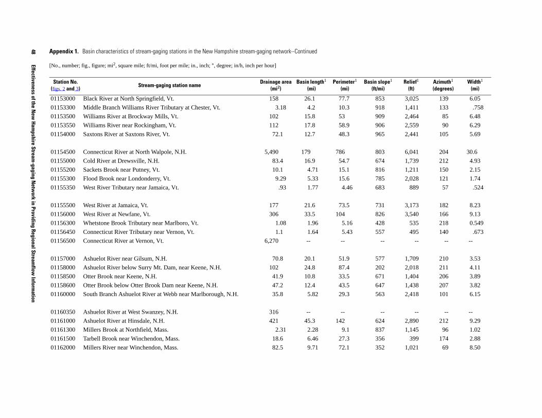
48
Effectiveness of the New
Hampshire Stream
-gaging Netw
ork in Providing Regional Streamflow
Information
53 3,025 139 6.05
18 1,411 133 .758
09 2,464 85 6.48
06 2,559 90 6.29
65 2,441 105 5.69
03 6,041 204 30.6
74 1,739 212 4.93
16 1,211 150 2.15
85 2,028 121 1.74
83 889 57 .524
31 3,173 182 8.23
26 3,540 166 9.13
28 535 218 0.549
57 495 140 .673
-- -- -- --
77 1,709 210 3.53
02 2,018 211 4.11
71 1,404 206 3.89
47 1,438 207 3.82
63 2,418 101 6.15
-- -- -- --
24 2,890 212 9.29
37 1,145 96 1.02
56 399 174 2.88
52 1,021 69 8.50
slope1 /mi)
Relief1 (ft)
Azimuth1 (degrees)
Width1 (mi)
01153000 Black River at North Springfield, Vt. 158 26.1 77.7 8
01153300 Middle Branch Williams River Tributary at Chester, Vt. 3.18 4.2 10.3 9
01153500 Williams River at Brockway Mills, Vt. 102 15.8 53 9
01153550 Williams River near Rockingham, Vt. 112 17.8 58.9 9
01154000 Saxtons River at Saxtons River, Vt. 72.1 12.7 48.3 9
01154500 Connecticut River at North Walpole, N.H. 5,490 179 786 8
01155000 Cold River at Drewsville, N.H. 83.4 16.9 54.7 6
01155200 Sackets Brook near Putney, Vt. 10.1 4.71 15.1 8
01155300 Flood Brook near Londonderry, Vt. 9.29 5.33 15.6 7
01155350 West River Tributary near Jamaica, Vt. .93 1.77 4.46 6
01155500 West River at Jamaica, Vt. 177 21.6 73.5 7
01156000 West River at Newfane, Vt. 306 33.5 104 8
01156300 Whetstone Brook Tributary near Marlboro, Vt. 1.08 1.96 5.16 4
01156450 Connecticut River Tributary near Vernon, Vt. 1.1 1.64 5.43 5
01156500 Connecticut River at Vernon, Vt. 6,270 -- --
01157000 Ashuelot River near Gilsum, N.H. 70.8 20.1 51.9 5
01158000 Ashuelot River below Surry Mt. Dam, near Keene, N.H. 102 24.8 87.4 2
01158500 Otter Brook near Keene, N.H. 41.9 10.8 33.5 6
01158600 Otter Brook below Otter Brook Dam near Keene, N.H. 47.2 12.4 43.5 6
01160000 South Branch Ashuelot River at Webb near Marlborough, N.H. 35.8 5.82 29.3 5
01160350 Ashuelot River at West Swanzey, N.H. 316 -- --
01161000 Ashuelot River at Hinsdale, N.H. 421 45.3 142 6
01161300 Millers Brook at Northfield, Mass. 2.31 2.28 9.1 8
01161500 Tarbell Brook near Winchendon, Mass. 18.6 6.46 27.3 3
01162000 Millers River near Winchendon, Mass. 82.5 9.71 72.1 3
Appendix 1. Basin characteristics of stream-gaging stations in the New Hampshire stream-gaging network--Continued
[No., number; fig., figure; mi2, square mile; ft/mi, foot per mile; in., inch; °, degree; in/h, inch per hour]
Station No. (figs. 2 and 3)
Stream-gaging station nameDrainage area
(mi2)Basin length1
(mi)Perimeter1
(mi)Basin
(ft

Appendix 1
49
354 1,016 178 1.78
298 361 209 1.21
345 445 143 5.24
104 1,062 59 12.9
453 1,237 181 4.14
558 1,112 181 1.91
422 1,478 71 12.4
752 820 76 1.62
slope1 t/mi)
Relief1 (ft)
Azimuth1 (degrees)
Width1 (mi)
01162500 Priest Brook near Winchendon, Mass. 19 10.7 29.6
01163100 Wilder Brook near Gardner, Mass. 2.44 2.03 11.4
01163200 Otter River at Otter River, Mass. 34.3 6.54 42
01164000 Millers River at South Royalston, Mass. 190 14.7 125
01165000 East Branch Tully River near Athol, Mass. 50.6 12.2 43.5
01165500 Moss Brook at Wendell Depot, Mass. 12.2 6.38 18.6
01166500 Millers River at Erving, Mass. 373 30.1 183
01167800 Beaver Brook at Wilmington, Vt. 6.36 3.94 14.21Basin characteristic computed with Basinsoft (Harvey and Eash, 1995).
Appendix 1. Basin characteristics of stream-gaging stations in the New Hampshire stream-gaging network--Continued
[No., number; fig., figure; mi2, square mile; ft/mi, foot per mile; in., inch; °, degree; in/h, inch per hour]
Station No. (figs. 2 and 3)
Stream-gaging station nameDrainage area
(mi2)Basin length1
(mi)Perimeter1
(mi)Basin
(f

50
Effectiveness of the New
Hampshire Stream
-gaging Netw
ork in Providing Regional Streamflow
Information
n basin vation2 (ft)
Percent lake and pond
area3
Basinwide mean annual
Snowfall4 (in.)
Precipitation4 (in.)
414 18.3 153 45.7
119 .34 158 48.6
956 8.09 144 45.3
893 6.41 136 44.7
051 .02 120 53.0
449 1.55 121 44.2
774 4.49 128 45.7
863 .18 145 46.6
490 .21 82.9 46.1
930 1.73 79.4 45.1
958 1.29 75.6 42.3
355 .03 219 73.5
994 .39 113 54.4
517 0 114 55.0
805 .39 125 56.7
677 .01 138 61.0
-- -- -- --
977 3.95 89.8 47.6
878 3.67 87.3 47.3
090 3.17 96.2 49.9
650 .16 82.8 49.4
537 4.02 78.6 47.4
679 6.96 85.4 48.0
617 5.53 83.2 47.9
-- -- -- --
Appendix 1. Basin characteristics of stream-gaging stations in the New Hampshire stream-gaging network--Continued
[No., number; fig., figure; mi2, square mile; ft/mi, foot per mile; in., inch; °, degree; in/h, inch per hour]
Station No.Shape factor1
Elongation ratio1
Compactness ratio1
Channel length1
(mi)
Channel slope1 (ft/mi)
Sinuosity ratio1 Slope ratio1
Station MeaeleLatitude
(degrees)Longitude (degrees)
01050900 3.21 0.631 1.55 3.62 29.1 1.12 0.191 44.8319 70.7022 2,
01052500 3.12 .640 1.60 25.5 42.1 1.17 .045 44.8778 71.0570 2,
01053500 2.00 .796 2.63 59.9 4.67 1.31 .023 44.7825 71.1294 1,
01054000 3.52 .601 2.05 93.9 3.02 1.36 .015 44.4361 71.1908 1,
01054200 3.27 .625 1.54 17.4 116 1.15 .089 44.3906 70.9795 2,
01054300 1.68 .869 1.54 17.7 65.0 1.20 .081 44.5936 70.7336 1,
01054500 3.04 .648 2.69 143 10.1 1.80 .013 44.5425 70.5472 1,
01055000 2.53 .707 1.65 19.8 81.6 1.27 .084 44.6422 70.5881 1,
01055300 2.46 .718 1.67 6.10 25.1 1.21 .063 44.2658 70.3161
01057000 1.90 .816 1.64 14.0 59.3 1.18 .083 44.3036 70.5400
01062700 3.34 .617 1.56 4.99 105 1.15 .143 44.3447 70.7922
01064300 2.24 .755 1.30 6.60 552 1.36 .270 44.2189 71.2497 3,
01064380 2.54 .708 1.83 11.9 154 1.27 .150 44.1217 71.1306 1,
01064400 2.57 .703 1.29 3.86 352 1.11 .230 44.0703 71.1733 1,
01064500 1.77 .848 1.57 39.3 55.0 1.51 .045 43.9908 71.0914 1,
01064800 1.93 .813 1.19 3.94 377 1.22 .272 43.8158 71.2975 1,
01064801 -- -- -- -- -- -- -- -- --
01065000 1.96 .806 1.86 29.2 8.95 1.15 .044 43.7956 71.0600
01065500 3.30 .621 2.56 44.2 13.6 1.15 .021 43.8072 70.7986
01066000 1.47 .930 1.73 74.3 12.0 1.70 .016 43.8081 70.7814 1,
01066100 1.85 .831 1.37 3.49 144 1.21 .208 43.7886 70.7661
01066500 3.11 .638 2.31 32.5 12.4 1.45 .028 43.6894 70.6708
01072100 2.59 .699 2.01 18.7 4.07 1.12 .031 43.4133 70.9875
01072500 4.08 .559 2.14 27.0 18.8 1.14 .047 43.3278 70.9278
01072800 -- -- -- -- -- -- -- -- --

Appendix 1
51
572 1.36 79.5 47.4
-- -- -- --
193 1.45 60.1 43.2
357 2.01 66.9 44.8
-- -- -- --
140 .27 61.1 44.1
,682 .05 168 61.8
-- -- -- --
,369 .18 147 57.4
,712 .13 95.3 45.4
,629 0 89.6 43.1
,510 0.70 89.8 43.9
,780 .50 117 51.3
800 20.9 81.1 42.2
,182 .74 92.3 43.1
-- -- -- --
-- -- -- --
-- -- -- --
-- -- -- --
,226 7.93 98.1 46.0
,160 3.41 75.1 44.8
,297 7.17 83.5 46.6
-- -- -- --
,479 4.06 90.2 47.3
,158 1.62 85.6 46.1
an basin vation2 (ft)
Percent lake and pond
area3
Basinwide mean annual
Snowfall4 (in.)
Precipitation4 (in.)
01072850 3.57 0.598 1.50 5.90 89.1 1.14 0.182 43.2631 71.0972
01072880 -- -- -- -- -- -- -- -- --
01073000 5.22 .494 1.97 8.36 20.7 1.05 .086 43.1486 70.9656
01073500 1.77 .848 2.24 36.9 12.6 2.06 .035 43.1025 70.9531
01073587 -- -- -- -- -- -- -- -- --
01073600 3.37 .615 1.46 4.76 14.3 1.07 .075 42.9931 71.0222
01074500 1.41 .952 1.44 17.3 90.2 1.42 .055 44.0614 71.6167 2
01074520 -- -- -- -- -- -- -- -- --
01075000 2.31 .743 1.57 26.2 79.1 1.23 .052 43.9761 71.6800 2
01075500 3.02 .650 1.47 16.5 172 1.25 .161 43.8681 71.9095 1
01075800 3.36 .616 1.34 4.36 416 1.31 .328 43.8367 71.8853 1
01076000 2.85 .668 1.89 24.4 102 1.21 .106 43.7961 71.8450 1
01076500 1.93 .814 1.79 45.1 41.1 1.30 .034 43.7592 71.6861 1
01077000 2.15 .773 1.93 14.1 10.6 1.26 .018 43.7053 71.6303
01078000 2.60 .698 1.84 24.1 22.4 1.61 .030 43.5678 71.7483 1
01079602 -- -- -- -- -- -- -- -- --
01079900 -- -- -- -- -- -- -- -- --
01080500 -- -- -- -- -- -- -- -- --
01081000 -- -- -- -- -- -- -- -- --
01081500 2.47 .719 2.67 72.8 21.8 1.19 .028 43.4228 71.6533 1
01082000 1.39 .959 1.75 14.1 39.7 1.46 .088 42.8625 71.9597 1
01083000 1.60 .894 2.03 13.6 43.1 1.61 .078 42.8953 71.9869 1
01083500 -- -- -- -- -- -- -- -- --
01084000 1.84 .831 2.10 14.2 52.6 1.43 .084 43.0817 71.9789 1
01084500 2.46 .717 1.58 13.7 74.1 1.17 .115 43.1142 71.9267 1
Appendix 1. Basin characteristics of stream-gaging stations in the New Hampshire stream-gaging network--Continued
[No., number; fig., figure; mi2, square mile; ft/mi, foot per mile; in., inch; °, degree; in/h, inch per hour]
Station No.Shape factor1
Elongation ratio1
Compactness ratio1
Channel length1
(mi)
Channel slope1 (ft/mi)
Sinuosity ratio1 Slope ratio1
Station MeeleLatitude
(degrees)Longitude (degrees)
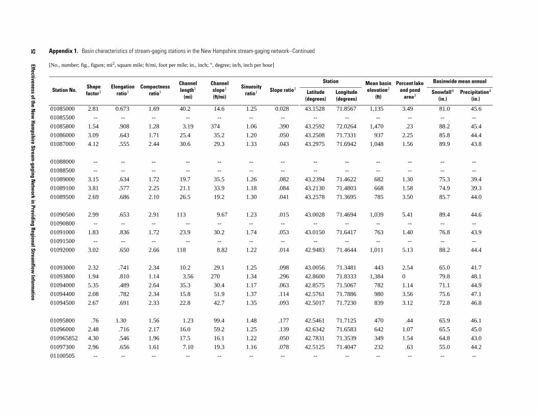
52
Effectiveness of the New
Hampshire Stream
-gaging Netw
ork in Providing Regional Streamflow
Information
1,135 3.49 81.0 45.6
-- -- -- --
1,470 .23 88.2 45.4
937 2.25 85.8 44.4
1,048 1.56 89.9 43.8
-- -- -- --
-- -- -- --
682 1.30 75.3 39.4
668 1.58 74.9 39.3
785 3.50 85.7 44.0
1,039 5.41 89.4 44.6
-- -- -- --
763 1.40 76.8 43.9
-- -- -- --
1,011 5.13 88.2 44.4
443 2.54 65.0 41.7
1,384 0 79.8 48.1
782 1.14 71.1 44.9
980 3.56 75.6 47.1
839 3.12 72.8 46.8
470 .44 65.9 46.1
642 1.07 65.5 45.0
349 1.54 64.8 43.0
232 .63 55.0 44.2
-- -- -- --
ean basin levation2
(ft)
Percent lake and pond
area3
Basinwide mean annual
Snowfall4 (in.)
Precipitation4 (in.)
01085000 2.81 0.673 1.69 40.2 14.6 1.25 0.028 43.1528 71.8567
01085500 -- -- -- -- -- -- -- -- --
01085800 1.54 .908 1.28 3.19 374 1.06 .390 43.2592 72.0264
01086000 3.09 .643 1.71 25.4 35.2 1.20 .050 43.2508 71.7331
01087000 4.12 .555 2.44 30.6 29.3 1.33 .043 43.2975 71.6942
01088000 -- -- -- -- -- -- -- -- --
01088500 -- -- -- -- -- -- -- -- --
01089000 3.15 .634 1.72 19.7 35.5 1.26 .082 43.2394 71.4622
01089100 3.81 .577 2.25 21.1 33.9 1.18 .084 43.2130 71.4803
01089500 2.69 .686 2.10 26.5 19.2 1.30 .041 43.2578 71.3695
01090500 2.99 .653 2.91 113 9.67 1.23 .015 43.0028 71.4694
01090800 -- -- -- -- -- -- -- -- --
01091000 1.83 .836 1.72 23.9 30.2 1.74 .053 43.0150 71.6417
01091500 -- -- -- -- -- -- -- -- --
01092000 3.02 .650 2.66 118 8.82 1.22 .014 42.9483 71.4644
01093000 2.32 .741 2.34 10.2 29.1 1.25 .098 43.0056 71.3481
01093800 1.94 .810 1.14 3.56 270 1.34 .296 42.8600 71.8333
01094000 5.35 .489 2.64 35.3 30.4 1.17 .063 42.8575 71.5067
01094400 2.08 .782 2.34 15.8 51.9 1.37 .114 42.5761 71.7886
01094500 2.67 .691 2.33 22.8 42.7 1.35 .093 42.5017 71.7230
01095800 .76 1.30 1.56 1.23 99.4 1.48 .177 42.5461 71.7125
01096000 2.48 .716 2.17 16.0 59.2 1.25 .139 42.6342 71.6583
010965852 4.30 .546 1.96 17.5 16.1 1.22 .050 42.7831 71.3539
01097300 2.96 .656 1.61 7.10 19.3 1.16 .078 42.5125 71.4047
01100505 -- -- -- -- -- -- -- -- --
Appendix 1. Basin characteristics of stream-gaging stations in the New Hampshire stream-gaging network--Continued
[No., number; fig., figure; mi2, square mile; ft/mi, foot per mile; in., inch; °, degree; in/h, inch per hour]
Station No.Shape factor1
Elongation ratio1
Compactness ratio1
Channel length1
(mi)
Channel slope1 (ft/mi)
Sinuosity ratio1 Slope ratio1
Station MeLatitude
(degrees)Longitude (degrees)
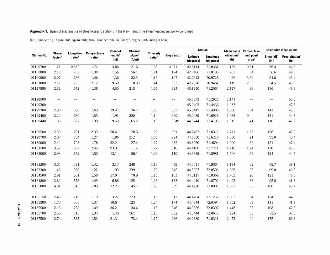
Appendix 1
53
129 0.81 56.4 44.6
207 .04 56.6 44.6
96 3.80 54.8 45.4
119 2.36 54.5 45.0
,127 .96 186 48.8
,141 -- -- 50.0
,937 -- -- 47.5
,650 .04 141 43.6
,935 0 131 44.3
,915 .41 110 47.2
,771 1.68 138 45.0
,358 .21 95.0 40.4
,900 .62 131 47.4
,716 1.24 128 45.6
,706 .79 124 44.7
,194 .02 88.7 39.1
,306 .06 99.0 40.5
,783 .20 121 46.3
,493 .36 95.8 41.8
,567 .36 108 43.7
,602 .04 124 44.0
,352 .09 111 41.9
,446 .37 108 42.6
994 .05 73.5 37.6
,472 .04 175 63.8
an basin vation2 (ft)
Percent lake and pond
area3
Basinwide mean annual
Snowfall4 (in.)
Precipitation4 (in.)
01100700 1.71 0.862 1.72 3.86 21.6 1.35 0.071 42.8114 71.0331
01100800 2.18 .763 1.38 1.56 56.1 1.21 .174 42.8486 71.0195
01100900 2.07 .786 1.46 1.36 22.5 1.13 .107 42.7342 70.9728
01101000 2.17 .765 2.12 9.59 8.90 1.41 .033 42.7528 70.9461
01127880 2.82 .672 1.38 4.50 215 1.05 .324 45.1350 71.2064 2
01128500 -- -- -- -- -- -- -- 45.0872 71.2928 2
01129200 -- -- -- -- -- -- -- 45.0403 71.4436 1
01129300 2.96 .658 1.63 19.4 36.7 1.23 .067 45.0447 71.4983 1
01129400 3.20 .630 1.55 1.91 250 1.14 .690 45.0039 71.6928 1
01129440 1.86 .827 1.39 9.59 65.2 1.18 .0849 44.8744 71.4106 1
01129500 2.59 .701 2.33 58.6 20.5 1.29 .031 44.7497 71.6317 1
01129700 2.07 .784 1.27 1.86 212 1.06 .294 44.6850 71.6217 1
01130000 2.42 .725 1.78 32.2 27.4 1.37 .032 44.6250 71.4694 1
01131500 3.57 .597 2.45 93.3 11.4 1.27 .016 44.4100 71.7211 1
01133000 2.98 .652 1.50 13.1 86.1 1.06 .110 44.6339 71.8981 1
01133200 3.65 .591 1.42 3.17 248 1.13 .439 44.5811 71.9864 1
01133300 1.46 .938 1.22 1.93 239 1.25 .345 44.5297 72.0503 1
01134500 2.91 .661 1.58 17.0 78.9 1.15 .103 44.5117 71.8369 1
01134800 3.82 .578 1.49 6.88 125 1.23 .163 44.4419 71.8792 1
01135000 4.81 .515 1.83 32.2 45.7 1.29 .059 44.4228 72.0006 1
01135150 2.48 .716 1.19 3.27 223 1.15 .312 44.4764 72.1258 1
01135300 1.70 .865 1.37 10.6 123 1.24 .174 44.4344 72.0394 1
01135500 2.16 .768 1.49 36.2 34.4 1.18 .046 44.3656 72.0397 1
01135700 2.50 .715 1.34 1.46 567 1.10 .632 44.3444 72.0645
01137500 3.74 .585 1.53 21.3 73.4 1.17 .066 44.2689 71.6311 2
Appendix 1. Basin characteristics of stream-gaging stations in the New Hampshire stream-gaging network--Continued
[No., number; fig., figure; mi2, square mile; ft/mi, foot per mile; in., inch; °, degree; in/h, inch per hour]
Station No.Shape factor1
Elongation ratio1
Compactness ratio1
Channel length1
(mi)
Channel slope1 (ft/mi)
Sinuosity ratio1 Slope ratio1
Station MeeleLatitude
(degrees)Longitude (degrees)
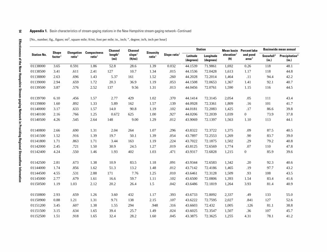
54
Effectiveness of the New
Hampshire Stream
-gaging Netw
ork in Providing Regional Streamflow
Information
1,692 0.26 118 48.1
1,613 1.17 118 44.8
1,464 .11 94.4 42.2
1,367 1.41 92.1 40.7
1,590 1.15 116 44.5
2,054 .05 111 43.4
1,809 .16 101 41.7
1,425 .17 86.6 39.8
1,039 0 73.9 37.8
1,563 1.10 113 44.1
1,375 .09 87.5 40.5
1,269 .90 83.7 39.0
1,502 .29 79.2 40.8
1,774 .07 110 47.8
1,215 0 85.9 39.6
1,342 .20 92.3 40.6
1,465 .19 97.7 43.2
1,509 .93 108 43.5
1,393 1.54 83.4 41.6
1,264 3.93 81.4 40.9
2,337 .49 133 55.0
2,027 .841 127 52.6
1,005 .126 81.1 38.8
1,507 .36 107 45.7
1,255 4.31 78.1 41.2
ean basin levation2
(ft)
Percent lake and pond
area3
Basinwide mean annual
Snowfall4 (in.)
Precipitation4 (in.)
01138000 3.65 0.591 1.86 52.8 28.6 1.39 0.032 44.1539 71.9861
01138500 3.41 .611 2.41 127 10.7 1.34 .015 44.1536 72.0428
01138800 2.63 .696 1.43 5.37 161 1.52 .260 44.2028 72.2014
01139000 2.94 .659 1.72 20.3 36.9 1.19 .053 44.1508 72.0653
01139500 3.87 .576 2.52 137 9.56 1.31 .013 44.0456 72.0761
01139700 6.10 .456 1.57 2.77 429 1.02 .370 44.1414 72.3145
01139800 1.60 .892 1.33 5.89 162 1.57 .139 44.0928 72.3361
01140000 3.17 .633 1.57 14.0 90.8 1.19 .102 44.0181 72.2083
01140100 2.16 .766 1.25 0.672 625 1.00 .927 44.0206 72.2039
01140500 4.26 .545 2.64 148 9.00 1.29 .012 43.9069 72.1397
01140800 2.66 .690 1.31 2.04 264 1.07 .296 43.8322 72.3722
01141500 1.52 .916 1.39 19.7 50.1 1.39 .054 43.7897 72.2553
01141800 1.71 .863 1.71 3.44 163 1.19 .224 43.7022 72.1875
01142000 2.45 .721 1.50 30.9 24.5 1.27 .019 43.8125 72.6569
01142400 4.24 .550 1.46 1.93 402 1.03 .471 43.9317 72.6828
01142500 2.81 .673 1.38 10.9 83.5 1.18 .091 43.9344 72.6583
01144000 1.74 .856 1.62 51.3 13.2 1.48 .012 43.7142 72.4186
01144500 4.55 .531 2.88 171 7.76 1.25 .010 43.6461 72.3128
01145000 2.77 .679 1.61 16.6 59.7 1.11 .102 43.6500 72.0806
01150500 1.19 1.03 2.12 20.2 26.4 1.5 .042 43.6486 72.1819
01150800 2.93 .659 1.26 3.60 432 1.17 .393 43.6733 72.8092
01150900 0.88 1.21 1.31 9.71 138 2.15 .107 43.6222 72.7595
01151200 3.45 .607 1.38 1.55 294 .948 .316 43.6603 72.432
01151500 3.15 .634 1.65 39.4 25.7 1.49 .024 43.6025 72.3547
01152500 1.51 .918 1.65 32.4 28.2 1.60 .045 43.3875 72.3625
Appendix 1. Basin characteristics of stream-gaging stations in the New Hampshire stream-gaging network--Continued
[No., number; fig., figure; mi2, square mile; ft/mi, foot per mile; in., inch; °, degree; in/h, inch per hour]
Station No.Shape factor1
Elongation ratio1
Compactness ratio1
Channel length1
(mi)
Channel slope1 (ft/mi)
Sinuosity ratio1 Slope ratio1
Station MeLatitude
(degrees)Longitude (degrees)

Appendix 1
55
1.08 95.1 45.9
0.06 84.7 43.0
.13 90.6 44.7
.13 89.8 44.4
.21 95.0 45.7
1.09 102 43.3
3.63 77.0 40.9
.49 81.6 43.3
.40 116 51.2
.07 91.6 47.3
.66 107 50.4
.50 104 49.8
1.04 91.5 50.3
.08 66.6 44.7
-- -- 43.6
3.36 87.6 44.3
2.88 82.6 43.0
2.12 82.4 43.9
2.41 80.9 43.5
1.79 73.6 43.6
-- -- --
1.99 72.0 42.0
.06 63.5 44.3
3.92 69.5 43.0
5.66 72.6 43.9
Percent lake and pond
area3
Basinwide mean annual
Snowfall4 (in.)
Precipitation4 (in.)
01153000 4.32 0.543 1.74 35.3 28.1 1.35 0.033 43.3333 72.5153 1,497
01153300 5.53 .479 1.63 4.53 229 1.08 .249 43.2703 72.6089 1,242
01153500 2.43 .721 1.48 19.5 64.3 1.24 .071 43.2086 72.5181 1,323
01153550 2.83 .671 1.57 21.7 63.2 1.22 .070 43.1917 72.4856 1,280
01154000 2.23 .754 1.60 18.1 76.2 1.43 .079 43.1372 72.4881 1,294
01154500 5.85 .467 2.99 214 5.15 1.20 .006 43.1261 72.4372 1,440
01155000 3.43 .610 1.69 21.6 46.0 1.28 .068 43.1317 72.3897 1,246
01155200 2.19 .761 1.34 5.04 181 1.07 .221 42.9992 72.5331 991
01155300 3.06 .645 1.45 6.06 186 1.14 .237 43.2364 72.8564 1,966
01155350 3.38 .615 1.31 1.77 380 1.00 .557 43.1256 72.8131 1,571
01155500 2.62 .695 1.56 25.7 31.7 1.19 .043 43.1089 72.7758 1,768
01156000 3.67 .589 1.67 39.0 31.1 1.16 .038 42.9953 72.6370 1,664
01156300 3.57 .598 1.40 2.03 140 1.04 .327 42.8783 72.7083 1,620
01156450 2.44 .722 1.46 1.87 194 1.14 .348 42.7836 72.5325 608
01156500 -- -- -- -- -- -- -- 42.7694 72.5139 1,417
01157000 5.68 .472 1.74 23.1 37.5 1.15 .065 43.0392 72.2706 1,509
01158000 6.04 .460 2.44 32.0 43.1 1.29 .065 42.9947 72.3117 1,381
01158500 2.77 .676 1.46 12.5 65.6 1.16 .098 42.9653 72.2333 1,413
01158600 3.24 .625 1.79 14.1 63.9 1.14 .099 42.9458 72.2372 1,373
01160000 0.95 1.16 1.38 9.60 79.3 1.65 .141 42.8722 72.2142 1,275
01160350 -- -- -- -- -- -- -- -- -- --
01161000 4.87 .511 1.95 57.4 23.9 1.27 .038 42.7853 72.4867 1,095
01161300 2.23 .752 1.68 2.32 377 1.02 .450 42.6853 72.4531 945
01161500 2.24 .753 1.79 8.84 32.7 1.37 .092 42.7125 72.0858 1,041
01162000 1.14 1.06 2.24 16.2 20.6 1.67 .058 42.6842 72.0839 1,117
Appendix 1. Basin characteristics of stream-gaging stations in the New Hampshire stream-gaging network--Continued
[No., number; fig., figure; mi2, square mile; ft/mi, foot per mile; in., inch; °, degree; in/h, inch per hour]
Station No.Shape factor1
Elongation ratio1
Compactness ratio1
Channel length1
(mi)
Channel slope1 (ft/mi)
Sinuosity ratio1 Slope ratio1
Station Mean basin elevation2
(ft)Latitude
(degrees)Longitude (degrees)

56
Effectiveness of the New
Hampshire Stream
-gaging Netw
ork in Providing Regional Streamflow
Information
eological Survey, 2002).
1.52 70.0 43.0
.16 74.6 43.1
3.23 72.7 43.6
3.52 70.3 43.3
2.49 68.6 43.0
1.18 62.1 42.9
2.8 66.2 42.9
0.52 103 53.0
in 2
Percent lake and pond
area3
Basinwide mean annual
Snowfall4 (in.)
Precipitation4 (in.)
1Basin characteristic computed with Basinsoft (Harvey and Eash, 1995).2Basin characteristic computed with data from the National Elevation Dataset (U.S. Geological Survey, 2001b).3Basin characteristic computed with data from preliminaries of the National Hydrography Dataset (U.S. Environmental Protection Agency and U.S. G4Basin characteristics computed from the PRISM climatic dataset (Daly, 2000).
01162500 6.04 0.460 1.91 12.4 27.8 1.16 0.078 42.6825 72.1156 1,097
01163100 1.68 .868 2.07 2.32 60.3 1.15 .202 42.5950 72.0147 1,106
01163200 1.25 1.01 2.03 10.0 23.2 1.53 .067 42.5883 72.0414 1,077
01164000 1.14 1.06 2.55 23.5 17.5 1.6 .052 42.6297 72.1508 1,069
01165000 2.96 .658 1.72 12.6 52.8 1.03 .117 42.6422 72.2261 1,035
01165500 3.34 .618 1.50 7.27 53.6 1.14 .096 42.6028 72.3600 868
01166500 2.43 .724 2.67 44.0 18.0 1.46 .043 42.5975 72.4386 981
01167800 2.44 .722 1.58 4.53 115 1.15 .153 42.8606 72.8511 1,951
Appendix 1. Basin characteristics of stream-gaging stations in the New Hampshire stream-gaging network--Continued
[No., number; fig., figure; mi2, square mile; ft/mi, foot per mile; in., inch; °, degree; in/h, inch per hour]
Station No.Shape factor1
Elongation ratio1
Compactness ratio1
Channel length1
(mi)
Channel slope1 (ft/mi)
Sinuosity ratio1 Slope ratio1
Station Mean baselevation
(ft)Latitude
(degrees)Longitude (degrees)

Appendix 1
57
24-hour rainfall with a recurrence interval8
Basinwide mean
precipitation for the months
of June through
October4 (in.)
2 year (in.)
100 year (in.)
2.07 4.96 --
1.94 4.08 17.9
1.99 4.50 --
2.00 4.63 --
2.51 6.24 19.9
2.20 5.27 17.7
2.14 5.05 --
2.18 5.17 18.1
2.59 6.06 --
2.54 6.16 18.3
2.53 6.26 --
2.51 6.21 22.4
2.59 6.42 --
2.60 6.49 20.3
2.56 6.38 19.1
2.56 6.60 21.2
-- -- --
2.62 6.67 --
2.65 6.74 --
2.63 6.60 --
2.77 7.00 --
2.78 7.04 --
2.75 7.03 --
2.76 7.05 --
-- -- --
Appendix 1. Basin characteristics of stream-gaging stations in the New Hampshire stream-gaging network--Continued
[No., number; fig., figure; mi2, square mile; ft/mi, foot per mile; in., inch; °, degree; in/h, inch per hour]
Station No.
Basinwide
Forest cover6
(in decimal percent)
Percent of basin greater than 1,200 in
altitude2
(in decimal percent)
X-coordinate of basin
centroid in N.H. State
plane coordinates
(ft)
Y-coordinate of basin
centroid in N.H. State
plane coordinates
(ft)
Average basin slope2, 7
(degrees)
Percent of basin having a slope greater than
Mean annual temperature4 (° Fahrenheit)
Mean permeability5
(in/h)
2, 740°(in decimal
percent)
40° and north facing2, 7
(in decimal percent)
01050900 38.0 5.01 0.758 1.00 1,241,600 854,796 37.6 0.489 0.105
01052500 37.0 2.17 .943 1.00 1,112,244 897,731 53.5 .806 .248
01053500 37.4 2.61 .853 1.00 1,176,099 906,438 42.6 .602 .194
01054000 38.0 2.98 .866 0.983 1,161,954 877,205 42.9 .602 .194
01054200 40.7 2.90 .989 .874 1,143,322 660,512 62.4 .921 .343
01054300 40.0 4.66 .916 .555 1,219,921 791,460 46.6 .643 .192
01054500 39.1 3.69 .881 .847 1,170,297 823,451 46.6 .659 .214
01055000 38.9 3.21 .895 .853 1,254,565 822,546 55.2 .841 .230
01055300 44.0 3.67 .811 0 1,340,963 659,961 32.8 .379 .0661
01057000 42.6 4.19 .849 .170 1,262,630 674,521 45.3 .635 .182
01062700 42.6 3.65 .956 .128 1,206,850 666,241 46.6 .673 .304
01064300 36.8 2.24 .915 1.00 1,088,371 636,792 70.9 .969 .154
01064380 40.8 3.06 .975 .926 1,130,748 612,278 56.8 .865 .192
01064400 41.7 6.90 .983 .604 1,106,694 568,815 60.3 .814 .311
01064500 40.5 5.37 .946 .718 1,091,712 580,298 55.8 .789 .208
01064800 41.6 6.31 .974 .855 1,080,526 472,476 64.3 .949 .453
01064801 -- -- -- -- -- -- -- -- --
01065000 42.6 7.00 .866 .223 1,100,674 479,198 39.7 .514 .149
01065500 42.8 7.17 .865 .169 1,121,036 476,831 39.4 .509 .152
01066000 42.2 6.41 .874 .309 1,133,562 539,790 43.6 .583 .163
01066100 43.2 7.74 .928 .0061 1,220,004 463,977 45.5 .645 .290
01066500 44.3 8.89 .823 .0005 1,203,440 421,739 31.6 .339 .106
01072100 45.3 5.98 .818 .0265 1,158,269 373,378 31.8 .345 .117
01072500 45.5 6.10 .806 .0204 1,161,052 361,308 30.2 .310 .0971
01072800 -- -- -- -- -- -- -- -- --

58
Effectiveness of the New
Hampshire Stream
-gaging Netw
ork in Providing Regional Streamflow
Information
2.67 7.01 18.0
-- -- --
2.76 7.17 16.9
2.66 7.04 --
-- -- --
2.75 7.21 17.4
2.39 6.02 22.0
-- -- --
2.34 5.87 19.6
2.22 5.54 17.7
2.25 5.69 17.8
2.23 5.57 18.2
2.32 5.87 17.4
2.43 6.30 --
2.32 5.90 18.4
-- -- --
-- -- --
-- -- --
-- -- --
2.39 6.17 --
2.48 5.93 18.1
2.45 5.84 --
-- -- --
24-hour rainfall with a recurrence interval8
Basinwide mean
precipitation for the months
of June through
October4 (in.)
2 year (in.)
100 year (in.)
01072850 45.4 4.51 0.866 0 1,129,071 289,137 33.7 0.359 0.0882
01072880 -- -- -- -- -- -- -- -- --
01073000 46.8 5.63 .742 0 1,160,602 240,355 21.2 .0873 .0297
01073500 46.3 5.87 .779 0 1,118,479 221,808 28.6 .255 .0723
01073587 -- -- -- -- -- -- -- -- --
01073600 46.9 6.05 .746 0 1,146,954 182,908 15.3 .0272 .0052
01074500 39.4 5.25 .988 0.994 1,019,333 588,479 64.2 .906 .250
01074520 -- -- -- -- -- -- -- -- --
01075000 40.3 5.19 .965 .912 998,938 578,565 62.2 .883 .240
01075500 42.2 6.23 .937 .689 930,310 526,402 54.8 .808 .181
01075800 42.9 5.89 .984 .711 931,362 494,433 61.3 .910 .028
01076000 42.5 5.95 .932 .650 919,076 501,716 51.5 .754 .207
01076500 41.7 5.60 .941 .719 973,939 525,742 56.1 .807 .226
01077000 42.9 5.87 .722 .0980 1,016,152 455,940 36.5 .481 .102
01078000 43.1 5.96 .858 .411 924,358 387,096 46.1 .666 .195
01079602 -- -- -- -- -- -- -- -- --
01079900 -- -- -- -- -- -- -- -- --
01080500 -- -- -- -- -- -- -- -- --
01081000 -- -- -- -- -- -- -- -- --
01081500 42.9 5.61 .813 .382 1,000,787 453,155 44.9 .619 .180
01082000 44.4 5.58 .770 .285 897,465 114,582 32.9 .356 .103
01083000 44.4 3.24 .821 .600 881,653 155,766 39.2 .524 .135
01083500 -- -- -- -- -- -- -- -- --
Appendix 1. Basin characteristics of stream-gaging stations in the New Hampshire stream-gaging network--Continued
[No., number; fig., figure; mi2, square mile; ft/mi, foot per mile; in., inch; °, degree; in/h, inch per hour]
Station No.
Basinwide
Forest cover6
(in decimal percent)
Percent of basin greater than 1,200 in
altitude2
(in decimal percent)
X-coordinate of basin
centroid in N.H. State
plane coordinates
(ft)
Y-coordinate of basin
centroid in N.H. State
plane coordinates
(ft)
Average basin slope2, 7
(degrees)
Percent of basin having a slope greater than
Mean annual temperature4 (° Fahrenheit)
Mean permeability5
(in/h)
2, 740°(in decimal
percent)
40° and north facing2, 7
(in decimal percent)

Appendix 1
59
2.41 5.79 --
2.40 5.80 17.5
2.44 5.86 --
-- -- --
2.37 5.78 18.3
2.38 5.87 17.0
2.35 5.93 --
-- -- --
-- -- --
2.47 6.50 16.5
2.47 6.50 16.1
2.54 6.77 --
2.42 6.17 --
-- -- --
2.47 6.04 17.0
-- -- --
2.42 6.17 --
2.57 6.82 --
2.48 6.00 18.9
2.51 6.23 --
2.57 6.36 --
2.58 6.48 --
2.64 6.87 --
24-hour rainfall with a recurrence interval8
Basinwide mean
precipitation for the months
of June through
October4 (in.)
2 year (in.)
100 year (in.)
01084000 44.7 3.52 .886 .927 874,684 218,624 41.6 .580 .161
01084500 45.1 3.40 .890 .362 893,686 241,289 42.0 .579 .137
01085000 44.9 4.59 0.827 0.374 897,416 182,730 37.4 0.474 0.127
01085500 -- -- -- -- -- -- -- -- --
01085800 44.6 3.58 .938 .698 882,109 278,339 52.3 .757 .214
01086000 44.4 4.39 .845 .183 919,635 290,437 43.6 .611 .178
01087000 43.9 5.34 .849 .316 931,164 338,869 42.9 .594 .169
01088000 -- -- -- -- -- -- -- -- --
01088500 -- -- -- -- -- -- -- -- --
01089000 44.5 5.20 .816 .0136 1,041,229 308,155 32.2 .328 .0794
01089100 44.5 5.46 .808 .0126 1,040,925 305,581 32.2 .329 .0812
01089500 44.5 3.76 .793 .0462 1,084,501 317,006 34.0 .376 .119
01090500 43.7 5.45 .802 .278 987,822 362,065 40.8 .535 .153
01090800 -- -- -- -- -- -- -- -- --
01091000 44.8 5.05 .833 .0343 960,419 180,209 37.0 .458 .143
01091500 -- -- -- -- -- -- -- -- --
01092000 43.8 5.43 .798 .258 986,893 349,120 40.4 .526 .151
01093000 45.9 5.94 .746 0 1,070,568 197,446 25.5 .180 .0412
01093800 44.6 3.46 .948 .694 933,925 135,453 52.1 .790 .160
01094000 45.4 5.63 .752 .132 959,755 120,452 36.5 .446 .126
01094400 45.4 2.32 .678 .0802 923,993 30,313 34.5 .400 .112
01094500 46.1 2.98 .594 .0495 935,539 26,821 33.8 .384 .0981
01095800 47.8 1.22 .512 0 970,028 15,156 41.1 .530 .185
Appendix 1. Basin characteristics of stream-gaging stations in the New Hampshire stream-gaging network--Continued
[No., number; fig., figure; mi2, square mile; ft/mi, foot per mile; in., inch; °, degree; in/h, inch per hour]
Station No.
Basinwide
Forest cover6
(in decimal percent)
Percent of basin greater than 1,200 in
altitude2
(in decimal percent)
X-coordinate of basin
centroid in N.H. State
plane coordinates
(ft)
Y-coordinate of basin
centroid in N.H. State
plane coordinates
(ft)
Average basin slope2, 7
(degrees)
Percent of basin having a slope greater than
Mean annual temperature4 (° Fahrenheit)
Mean permeability5
(in/h)
2, 740°(in decimal
percent)
40° and north facing2, 7
(in decimal percent)

60
Effectiveness of the New
Hampshire Stream
-gaging Netw
ork in Providing Regional Streamflow
Information
2.57 6.47 --
2.64 7.05 17.4
2.73 7.27 17.6
-- -- --
2.76 7.34 17.4
2.77 7.34 --
2.79 7.44 --
2.79 7.42 17.6
1.91 3.97 23.1
-- 3.96 --
-- 3.93 --
1.92 3.93 20.2
1.93 4.27 --
1.94 4.18 21.1
1.94 4.12 --
1.97 4.80 --
2.04 4.95 19.1
2.01 4.54 --
1.96 4.88 20.9
1.97 4.94 --
1.97 4.94 --
1.97 4.94 20.2
1.97 4.96 18.8
24-hour rainfall with a recurrence interval8
Basinwide mean
precipitation for the months
of June through
October4 (in.)
2 year (in.)
100 year (in.)
01096000 46.6 4.78 .778 .0177 959,153 66,781 33.0 .356 .0815
010965852 46.8 6.05 .537 0 1,074,167 135,352 25.4 .170 .0472
01097300 48.3 7.26 .710 0 1,049,179 14,966 21.9 .125 .0273
01100505 -- -- -- -- -- -- -- -- --
01100700 48.5 9.94 0.736 0 1,151,624 121,109 25.0 0.196 0.0679
01100800 48.5 1.30 .901 0 1,154,550 127,676 27.0 .247 .105
01100900 48.7 7.14 .577 0 1,169,833 83,130 17.7 .0476 .0113
01101000 48.7 4.30 .684 0 1,162,746 85,905 22.9 .154 .0546
01127880 36.0 1.43 .907 1.00 1,099,324 969,524 45.5 .633 .087
01128500 -- -- -- -- -- -- 41.1 -- --
01129200 -- -- -- -- -- -- 42.3 -- --
01129300 38.0 1.07 .878 0.958 1,029,811 961,050 39.7 .536 .138
01129400 38.5 3.11 .867 1.00 974,205 915,090 33.5 .377 .0845
01129440 37.8 1.71 .811 1.00 1,065,574 872,428 48.5 .703 .195
01129500 38.1 2.29 .866 .932 1,032,577 909,015 43.5 .607 .177
01129700 40.5 2.45 .962 .837 995,671 792,744 48.1 .706 .419
01130000 40.0 3.95 .925 .872 1,065,714 769,914 50.1 .713 .220
01131500 39.3 3.12 .861 .826 1,030,437 832,112 44.3 .609 .183
01133000 39.2 2.85 .932 .895 923,996 804,180 49.2 .731 .135
01133200 40.7 2.19 .724 .551 894,506 760,950 41.9 .589 .113
01133300 40.5 1.60 .854 .762 880,909 737,731 48.5 .756 .420
01134500 40.2 2.57 .886 .933 950,087 756,675 47.6 .683 .164
01134800 41.3 2.72 .775 .740 923,098 723,648 49.4 .744 .091
Appendix 1. Basin characteristics of stream-gaging stations in the New Hampshire stream-gaging network--Continued
[No., number; fig., figure; mi2, square mile; ft/mi, foot per mile; in., inch; °, degree; in/h, inch per hour]
Station No.
Basinwide
Forest cover6
(in decimal percent)
Percent of basin greater than 1,200 in
altitude2
(in decimal percent)
X-coordinate of basin
centroid in N.H. State
plane coordinates
(ft)
Y-coordinate of basin
centroid in N.H. State
plane coordinates
(ft)
Average basin slope2, 7
(degrees)
Percent of basin having a slope greater than
Mean annual temperature4 (° Fahrenheit)
Mean permeability5
(in/h)
2, 740°(in decimal
percent)
40° and north facing2, 7
(in decimal percent)
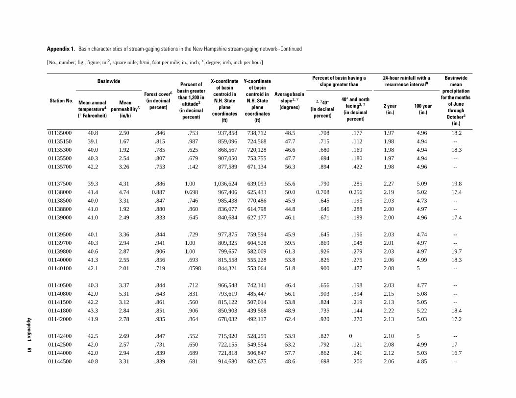
Appendix 1
61
1.97 4.96 18.2
1.98 4.94 --
1.98 4.94 18.3
1.97 4.94 --
1.98 4.96 --
2.27 5.09 19.8
2.19 5.02 17.4
2.03 4.73 --
2.00 4.97 --
2.00 4.96 17.4
2.03 4.74 --
2.01 4.97 --
2.03 4.97 19.7
2.06 4.99 18.3
2.08 5 --
2.03 4.77 --
2.15 5.08 --
2.13 5.05 --
2.22 5.22 18.4
2.13 5.03 17.2
2.10 5 --
2.08 4.99 17
2.12 5.03 16.7
2.06 4.85 --
24-hour rainfall with a recurrence interval8
Basinwide mean
precipitation for the months
of June through
October4 (in.)
2 year (in.)
100 year (in.)
01135000 40.8 2.50 .846 .753 937,858 738,712 48.5 .708 .177
01135150 39.1 1.67 .815 .987 859,096 724,568 47.7 .715 .112
01135300 40.0 1.92 .785 .625 868,567 720,128 46.6 .680 .169
01135500 40.3 2.54 .807 .679 907,050 753,755 47.7 .694 .180
01135700 42.2 3.26 .753 .142 877,589 671,134 56.3 .894 .422
01137500 39.3 4.31 .886 1.00 1,036,624 639,093 55.6 .790 .285
01138000 41.4 4.74 0.887 0.698 967,406 625,433 50.0 0.708 0.256
01138500 40.0 3.31 .847 .746 985,438 770,486 45.9 .645 .195
01138800 41.0 1.92 .880 .860 836,077 614,798 44.8 .646 .288
01139000 41.0 2.49 .833 .645 840,684 627,177 46.1 .671 .199
01139500 40.1 3.36 .844 .729 977,875 759,594 45.9 .645 .196
01139700 40.3 2.94 .941 1.00 809,325 604,528 59.5 .869 .048
01139800 40.6 2.87 .906 1.00 799,657 582,009 61.3 .926 .279
01140000 41.3 2.55 .856 .693 815,558 555,228 53.8 .826 .275
01140100 42.1 2.01 .719 .0598 844,321 553,064 51.8 .900 .477
01140500 40.3 3.37 .844 .712 966,548 742,141 46.4 .656 .198
01140800 42.0 5.31 .643 .831 793,619 485,447 56.1 .903 .394
01141500 42.2 3.12 .861 .560 815,122 507,014 53.8 .824 .219
01141800 43.3 2.84 .851 .906 850,903 439,568 48.9 .735 .144
01142000 41.9 2.78 .935 .864 678,032 492,117 62.4 .920 .270
01142400 42.5 2.69 .847 .552 715,920 528,259 53.9 .827 0
01142500 42.0 2.57 .731 .650 722,155 549,554 53.2 .792 .121
01144000 42.0 2.94 .839 .689 721,818 506,847 57.7 .862 .241
01144500 40.8 3.31 .839 .681 914,680 682,675 48.6 .698 .206
Appendix 1. Basin characteristics of stream-gaging stations in the New Hampshire stream-gaging network--Continued
[No., number; fig., figure; mi2, square mile; ft/mi, foot per mile; in., inch; °, degree; in/h, inch per hour]
Station No.
Basinwide
Forest cover6
(in decimal percent)
Percent of basin greater than 1,200 in
altitude2
(in decimal percent)
X-coordinate of basin
centroid in N.H. State
plane coordinates
(ft)
Y-coordinate of basin
centroid in N.H. State
plane coordinates
(ft)
Average basin slope2, 7
(degrees)
Percent of basin having a slope greater than
Mean annual temperature4 (° Fahrenheit)
Mean permeability5
(in/h)
2, 740°(in decimal
percent)
40° and north facing2, 7
(in decimal percent)

62
Effectiveness of the New
Hampshire Stream
-gaging Netw
ork in Providing Regional Streamflow
Information
2.25 5.25 17.6
2.25 5.65 --
2.21 5.15 22.8
2.21 5.16 21
2.20 5.21 --
2.22 5.24 --
2.30 5.55 --
2.29 5.44 --
2.35 5.63 --
2.36 5.66 17.5
2.36 5.67 17.5
2.42 5.81 18.0
2.11 5.03 --
2.39 5.76 16.8
2.47 5.92 17.4
2.37 5.63 20.2
2.45 5.87 --
2.39 5.7 19.1
2.43 5.81 18.0
2.50 6 --
2.50 5.99 --
-- 5.13 --
2.41 5.81 --
24-hour rainfall with a recurrence interval8
Basinwide mean
precipitation for the months
of June through
October4 (in.)
2 year (in.)
100 year (in.)
01145000 42.9 5.03 .853 .646 893,086 437,294 42.4 .583 .127
01150500 43.1 4.46 .827 .498 881,145 428,427 42.0 .576 .126
01150800 41.5 3.32 .950 1 678,853 422,860 60.4 .905 .468
01150900 41.3 2.79 .858 .978 686,519 424,567 59.9 .868 .313
01151200 43.4 2.01 .655 .0866 780,474 427,981 56.0 .856 .036
01151500 42.2 2.83 .858 .698 733,070 409,846 57.7 .866 .255
01152500 44.2 4.39 .781 .534 854,361 329,715 42.5 .590 .168
01153000 42.8 2.78 0.861 0.703 722,797 341,718 51.3 0.758 0.217
01153300 43.4 1.70 .960 .563 727,201 291,021 54.9 .852 .194
01153500 43.0 2.49 .893 .567 723,723 282,924 54.1 .820 .252
01153550 43.1 2.64 .886 .523 726,870 280,703 54.0 .818 .247
01154000 42.6 3.31 .906 .556 733,359 239,472 54.8 .825 .223
01154500 41.5 3.37 .833 .632 882,494 597,525 48.8 .703 .206
01155000 44.6 3.09 .855 .653 822,023 251,882 44.9 .639 .185
01155200 43.9 2.67 .846 .224 745,144 191,015 51.7 .811 .152
01155300 42.0 2.92 .922 1.00 654,567 277,579 49.0 .716 .170
01155350 41.4 3.35 .977 1.00 674,732 228,200 49.2 .789 .409
01155500 41.7 2.53 .898 .933 668,424 266,455 46.8 .665 .169
01156000 41.7 2.83 .906 .846 676,562 242,612 50.1 .731 .203
01156300 43.0 2.97 .807 1.00 703,055 135,179 36.4 .404 .155
01156450 45.9 2.05 .854 0 747,986 105,241 40.7 .550 .088
01156500 -- -- -- -- -- -- 48.3 -- --
01157000 44.4 3.98 .876 .900 847,456 233,666 41.4 .568 .155
Appendix 1. Basin characteristics of stream-gaging stations in the New Hampshire stream-gaging network--Continued
[No., number; fig., figure; mi2, square mile; ft/mi, foot per mile; in., inch; °, degree; in/h, inch per hour]
Station No.
Basinwide
Forest cover6
(in decimal percent)
Percent of basin greater than 1,200 in
altitude2
(in decimal percent)
X-coordinate of basin
centroid in N.H. State
plane coordinates
(ft)
Y-coordinate of basin
centroid in N.H. State
plane coordinates
(ft)
Average basin slope2, 7
(degrees)
Percent of basin having a slope greater than
Mean annual temperature4 (° Fahrenheit)
Mean permeability5
(in/h)
2, 740°(in decimal
percent)
40° and northfacing2, 7
(in decimal percent)

Appendix 1
63
Z-factor of 10.
53 2.41 5.78 --
99 2.45 5.9 17.6
86 2.43 5.81 --
28 2.48 5.98 --
-- -- --
57 2.47 5.94 --
53 2.50 5.99 --
49 2.48 5.9 --
59 2.50 5.99 --
345 2.48 5.89 17.7
20 2.53 6.09 --
586 2.54 6.16 --
55 2.51 6.01 --
55 2.50 5.99 --
15 2.50 5.99 18.2
72 2.51 5.97 --
40 2.51 6.03 21.8
ng a 24-hour rainfall with a recurrence interval8
Basinwide mean
precipitation for the months
of June through
October4 (in.)
north 2, 7
imal nt)
2 year (in.)
100 year (in.)
2Basin characteristic computed with data from the National Elevation Dataset (U.S. Geological Survey, 2001b).4Basin characteristic computed with data from the PRISM climatic dataset (Daly, 2000).5Basin characteristic computed with data from the STATSGO soils dataset (U.S. Geological Survey, 1997).6Basin characteristic computed with data from the Global Land Cover Characterization Dataset (U.S. Geological Survey, 2001a).7Average basin slope in degrees determined using the ARC/INFO SLOPE command (Environmental Systems Research Institute, 1994) with a 8Basin characteristic computed with a coverage made from data in Wilkes and Cember (1993).
01158000 44.3 3.84 .873 .759 836,461 224,039 43.7 .611 .1
01158500 43.9 2.80 .882 .891 850,072 189,905 45.7 .676 .1
01158600 44.0 2.80 .878 .823 847,956 188,273 45.6 .670 .1
01160000 43.7 3.54 .839 .574 849,463 125,573 39.0 .482 .1
01160350 -- -- -- -- -- -- -- -- --
01161000 44.6 4.20 .829 .420 825,888 160,410 42.6 .594 .1
01161300 45.3 4.18 .880 .216 780,961 65,195 52.7 .791 .3
01161500 44.1 3.80 .729 .0266 872,709 94,056 27.8 .239 .0
01162000 44.0 4.34 .692 .190 892,558 77,785 28.4 .251 .0
01162500 44.0 3.81 0.794 0.197 860,720 93,669 29.8 0.269 0.0
01163100 44.0 1.75 .847 .0633 894,027 43,459 23.8 .177 .0
01163200 44.1 3.68 .542 .0458 893,469 23,263 26.8 .231 .0
01164000 44.1 4.58 .678 .118 883,086 59,646 28.1 .243 .0
01165000 44.2 4.23 .825 .142 841,736 78,782 35.1 .408 .0
01165500 44.8 5.11 .876 .0050 798,183 54,117 39.8 .531 .1
01166500 44.5 4.92 .730 .0869 853,914 55,520 32.8 .355 .0
01167800 42.6 1.72 .868 1.00 674,198 132,718 48.9 .731 .2
Appendix 1. Basin characteristics of stream-gaging stations in the New Hampshire stream-gaging network--Continued
[No., number; fig., figure; mi2, square mile; ft/mi, foot per mile; in., inch; °, degree; in/h, inch per hour]
Station No.
Basinwide
Forest cover6
(in decimal percent)
Percent of basin greater than 1,200 in
altitude2
(in decimal percent)
X-coordinate of basin
centroid in N.H. State
plane coordinates
(ft)
Y-coordinate of basin
centroid in N.H. State
plane coordinates
(ft)
Average basin slope2, 7
(degrees)
Percent of basin havislope greater than
Mean annual temperature4 (° Fahrenheit)
Mean permeability5
(in/h)
2, 740°(in decimal
percent)
40° andfacing
(in decperce

APPENDIX 1. REFERENCES
Daly, Christopher, 2000, PRISM (Parameter-elevation Regressions on Independent Slopes Model), U.S. Department of Agriculture and Natural Resources Conservation Service Climate Mapping Project: National Water and Climate Center, Oregon State University Partnership.
Environmental Systems Research Institute, Inc. (ESRI), 1994, ARC/INFO users guide, version 7.0: Redlands, Calif.
Harvey, C.A. and Eash, D.A., 1995, Description, instructions, and verification for Basinsoft, a computer program to quantify drainage-basin characteristics: U.S. Geological Survey Water-Resources Investigations Report 95-4287, 25 p.
U.S. Environmental Protection Agency and U.S. Geological Survey, 2002, National hydrography dataset, accessed June 18, 2002, at URL <http://nhd.usgs.gov/.
U.S. Geological Survey, 1997, STATSGO soil characteristics for the conterminous United States: U.S. Geological Survey Open-File Report 656, accessed December 21, 2001, at URL http:// water.usgs.gov/GIS/metadata/usgswrd/muid.html
———2001a, Global land cover characterization, accessed December 21, 2001, at URL http://edcdaac.usgs.gov/glcc/glcc.html
———2001b, National elevation dataset, accessed December 21, 2001, at URL http://edcnts12.cr.usgs.gov/ned/.
Wilks, D.S., and Cember, R.P., 1993, Atlas of precipitation extremes for the northeastern United States and southeastern Canada: Northeast Regional Climate Center Research Series RR 93-5, 40 p.
64 Effectiveness of the New Hampshire Stream-gaging Network in Providing Regional Streamflow Information