edwin w. tooker1 and ralph j. roberts2 - usgs geologic map, cross sections, and explanation pamphlet...
TRANSCRIPT

DEPARTMENT OF THE INTERIOR
U.S. GEOLOGICAL SURVEY
PRELIMINARY GEOLOGIC MAP, CROSS-SECTIONS, AND EXPLANATION PAMPHLET
FOR THE BINGHAM CANYON 7 1/2-MINUTE QUADRANGLE,
SALT LAKE AND TOOELE COUNTIES, UTAH
By
Edwin W. Tooker1 and Ralph J. Roberts2
Open-File Report 88-699
This report is preliminary and has not been reviewed for conformity with U.S. Geological Survey editorial standards and stratigraphic nomenclature. Any use of trade names is for descriptive purposes only and does not imply endorsement by the USGS.
1988
^Menlo Park, CaliforniaConsultant, Seattle, Washington (formerly USGS, Menlo Park, Calif.)

PRELIMINARY GEOLOGIC MAP, CROSS SECTIONS, AND EXPLANATION
PAMPHLET FOR THE BINGHAM CANYON QUADRANGLE, UTAH
By Edwin W. Tooker and Ralph J. Roberts
INTRODUCTION
The Bingham Canyon quadrangle lies in the north-central part of the Oquirrh Mountains, and includes the surface and (or) underground workings of the Bingham (Utah Copper), U.S., Lark, and Carr Fork mines, which comprise the greater Bingham mining district. Mining activity in this area began in the early 1860's, and continued until 1985, when the last mine in Bingham Canyon, Kenncott's Utah Copper mine, was closed temporarily. Plans to reopen and modernize mining and milling methods were announced (Skilling, 1985) and new production resumed in 1987. In 1987, SOHIO (Standard Oil of Ohio), who then owned Kennecott, announced the discovery of carbonate-hosted disseminated gold in the Barneys Canyon area, about 6 km north of the Utah Copper Mine (Standard Oil Co., 1986). The discovery has been confirmed and enlarged by Barrick Resources (U.S.A.) (Skillings Mining Record, 1987). BP Minerals America, who has since purchased Kennecott, plans to recover the gold by open pit-bulk mining and heap leaching.
A number of previous reports trace the gradual development of geological information about this historic mining area (Boutwell, 1905; Hunt, 1924; Peacock, 1948; James and others, 1961; Peters and others, 1966; Swensen, 1975; Lanier and others, 1978; Atkinson and Einaudi, 1978). We have drawn heavily upon their maps, reports, and the data developed by the many geologists who have preceded us in geologic studies of the area. While our interpretation of the development of the geologic setting for the Bingham mining district, in particular, may be controversial at the outset, we hope that our hypothesis at least represents a tentative step forward in integrating the local and regional geologic data shown on our maps (Tooker and Roberts, 197la, 1971b, 1987, 1988; Tooker, 1980, 1983). Therefore, we attempt to identify the points of contention and the obvious remaining data gaps, and to explain the rationale for our preliminary interpretations.
This brief report provides descriptions and preliminary interpretations of data shown on the geologic map, and accompanying cross sections. Emphasis in this pamphlet is on the stratigraphic and structural features of the sedimentary rocks of the map area. Descriptions of the igneous rocks and ore deposits in the district have been amply well-documented by the authors (cited above) of reports in the Bingham issue of Economic Geology (1978, v. 73, no. 7) and are only summarized here. Geologic mapping within the Bingham mining district is based on a compilation of Kennecott data by George Lanier (1978); however, the structural data are, in part, reinterpreted by Tooker in light of adjoining regional geologic constraints. Tooker and Roberts share principal responsibility for their regional geologic mapping in the Oquirrh Mountains, which occurred irregularly between 1956 and 1986, and structural interpretations derived thereto in the areas beyond the mining district.
The authors gratefully acknowledge the assistance of Geological Survey colleagues W.J. Moore and E.H. McKee in classifying and dating the igneous rocks, MacKenzie Gordon Jr., R.C. Douglass, E.L. Yochelson, H.M. Duncan, and W.J. Sando for paleontologic identifications, and sedimentary rock chronology and correlations. We are equally grateful for company-sponsored geologic studies, in particular those of A.H. James, W.H. Smith, W.C. Peters, R.E. Bray, F.W. Warnaars, and J.E. Welsh of Kennecott (now BP Minerals America), M.T. Einaudi and W.W. Atkinson, Jr. of the former Anaconda Minerals Company, and R.N. Hunt, R.D. Rubright, and O.J. Hart of U.V. Industries formerly the U.S. Smelting, Refining and Mining Company). Reference to other contributors of data are made subsequently in this report. Permission for
entrance by U.S. Geological Survey personnel on privately controlled lands by these companies is also acknowledged and appreciated.
GENERAL GEOLOGIC AND GEOPHYSICAL
CHARACTERISTICS OF THE QUADRANGLE
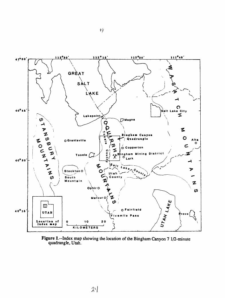
Location.--The Bingham Canyon 7-1/2 quadrangle, Utah, lies in the central part of the Oquirrh Mountains, about 30 km west-southwest of Salt Lake City, Utah (fig. 1). The quadrangle includes parts of Tooele and Salt Lake Counties, and the well-known Bingham (West Mountain) mining district. The Oquirrh Mountains, which extend 55 km south from the south end of the Great Salt Lake to Fivemile Pass, comprise an easternmost block-faulted mountain range in the Cordilleran Great Basin of western Utah.
Geologic overview.-The Oquirrh Mountains are composed of allochthonous upper Paleozoic sedimentary rocks emplaced over Precambrian cratonal rocks in the foreland of the Mesozoic Sevier thrust belt. These rocks subsequently were intruded by Tertiary porphyritic and volcanic igneous rocks, segmented by basin-and-range faults, and deeply eroded to form the present surface. On the basis of our mapping, we propose that the upper plates of three thrust nappe plates, the early Pass Canyon, a later Bingham, and the latest Rogers Canyon nappes, which are composed of similar thick and in part comparably aged clastic and carbonaceous shelf sediments converged and were stacked sequentially in the Bingham Canyon quadrangle, Utah. The Bingham mining district is located at an intrusive center formed along the leading edge of the structurally disturbed Bingham thrust nappe. The structural features of the nappes are distinctive, and their stratigraphic characteristics seem to indicate their deposition on different parts of the miogeoclinal craton shelf. They were moved from diverse source areas to their present site in the Oquirrh Mountains. This thesis is in direct opposition to previous investigators (Gilluly, 1932; James and others, 1961; and Swensen, 1975) who have considered that Oquirrh Mountain rocks essentially represent a folded autochthonous stratigraphic sequence, which has been shortened locally as much as 1.6 km by a minor thrust fault, the Midas (Smith, 1975).
Regional geophysical attributes. The gravity and aeromagnetic surveys of this region provide added insight to the basin-and-range structure of the Oquirrh Mountains and definition of the Uinta-Cortez axis or lineament of Roberts and others (1965). Gravity studies of Cook and Berg (1961) and Cook and others (1966) show that the Oquirrh Mountains are the site of a gravity high that overlies a horst block lying between a system of graben blocks. On the east side of the, horst the system includes the Jordan Valley and Utah Valley downdropped and tilted graben blocks. Similarly on the west side of the range are the complex Tooele Valley and Rush Valley graben systems. The deepest part of the Tooele Valley trench may be a much as 2,400 meters below the surface. The South Mountain and West Traverse Mountains represent gravity saddles, which are fault-block spurs, graben blocks that were not as deeply dropped as the Jordan Valley or Tooele Valley block. These spurs are aligned along the Uinta-Cortez axial zone.
Within the Oquirrh Mountains, Mabey and others (1963) infer that basement rocks have a higher relief in the vicinity of the North Oquirrh thrust Density contrasts between Precambrian basement rocks and the younger sedimentary rocks south of the North Oquirrh thrust suggest that about 7,600 m of sedimentary rocks may overlie the basement. These data provide support for the existence of a west-plunging basement promontory ridge underlying the overlapping nappe plates in this area.
The aeromagnetic data of Zeitz and other (1976) show an east-northeast zone of increased magnetic intensity along the trend of the Uinta-Cortez axis, presumably related to the zone of granitic intrusives and volcanics that occur along that trend (Mabey and others, 1963). They believe that the absence of any magnetic anomaly north of the Bingham stock essentially eliminates the possibility that concealed intrusive bodies underlie the northern Oquirrh Mountains. The magnetic intensity increases at a normal rate north of the range over the Precambrian basement rock

exposures on Antelope Island in the Great Salt Lake, owing to contrast in magnetic properties of the basement rocks.
A more detailed aeromagnetic map of the area by Mabey and others (1964) identifies three east-west zones of anomalies. One over Antelope Island, north of the Oquirrh Mountains, is a response to metamorphosed Precambrian basement rocks exposed there. A second zone trends eastward from the Tooele-Stockton area to Park City in the Wasatch Range, and is correlated with the previously mentioned belt of Tertiary intrusive and extrusive rocks. The third zone lies south of the Oquirrh Mountains in the East Tintic Mountains. The strongest positive anomaly in the Oquirrh Mountains is over the Last Chance stock. The adjoining altered and mineralized Bingham stock does not have a strong magnetic expression, perhaps due to the alteration of the magnetic minerals.
Strati graph v.--Three thrust plates of nearly comparably aged sedimentary rocks in the quadrangle are composed of closely related thick stratigraphic successions, a fact that heretofore has made it difficult to distinguish and delineate the individual thrust plates. Sedimentary rocks were deposited during the Paleozoic on the miogeoclinal shelf west of their present sites, but in different parts of that shelf. Sedimentary materials were derived in variable proportions from different parts of the craton on the east and from the Antler Highland to the west (Roberts, 1964). Thus, the nappes contain rock units of nearly comparable ages but consist of lithologic facies that contain some similar as well as a number of differing stratigraphic attributes. Each of the plates has some distinctive regional lithologic as well as mapped structural characteristics that now permit their identification. The general stratigraphic character of sedimentary rocks in the Bingham and Rogers Canyon thrust nappes in the following descriptions of the mapped units are abstracted from the more detailed published reports cited. The stratigraphic succession in the complex Pass Canyon thrust nappe as interpreted from this map, has not been measured and satisfactorily reconstructed in this geologic model. However, its general lithology has been described by James and others (1961) and Swensen (1975).
The rocks of the Bingham thrust nappe have been described in detail by James and others (1961), Tooker and Roberts (1970), and Swensen (1975), and their stratigraphic features are generalized in figure 2. Within the quadrangle, the type section (Tooker and Roberts, 1970) includes rocks of the Middle Pennsylvania Butterfield Peaks (Pb) and Late Pennsylvanian Bingham Mine Formations. About 490 m of the upper part of the Butterfield Peaks Formation crop out in the quadrangle. The Bingham Mine Formation (about 2,680 m thick) is composed of the lower Clipper Ridge (Pbc) and upper Markham Peak (Pbm) Members. Erosion has removed any younger parts of the stratigraphic section in this plate that may have been present in the Oquirrh Mountians.
The Rogers Canyon thrust nappe has been described in detail by Tooker and Roberts (1970) and its general stratigraphy also is summarized in figure 2. Within the Bingham Canyon quadrangle, this sequence includes the upper part of the Early Pennsylvanian-Late Mississippian Lake Point Limestone (PM1), portions of the Middle Pennsylvanian Erda Formation (Pe), lower part of the Permian-Pennsylvanian Kessler Canyon (PPk) Formation, and the lowermost part of the Grandeur Member (Ppg) of the Permian Park City Formation. As only faulted fragments of the uppermost and lowermost parts of Rogers Canyon formational units crop out in the northern part of the quadrangle, no thicknesses for these units were determined here and are presumed to be comparable with those in the less-faulted type sections. The upper part of the Lake Point Limestone occurs in Bates Canyon, truncated on the east by the Nelson Peak fault. The lower parts of the formation were sheared-out by the North Oquirrh thrust fault. Erda Formation strata are also incompletely exposed in a series of thrust imbrications east of the Nelson Peak fault. East of the Garfield fault and north of the Tooele fault (fig. 3C), a down-dropped block contains rocks of the Kessler Canyon Formation in thrust contact with Erda Formation rocks. An outlying down- dropped fault block southeast of the Tooele fault and north of the Garfield fault exposes the lower part of the Grandeur Member of the Park City Formation.
The Pass Canyon nappe is defined provisionally here because of structural and stratigraphic complexities. However, the structures and sedimentary rocks are sufficiently different from those in the adjoining nappe plates that we feel justified in presenting our interpretation of a Pass Canyon

nappe plate in spite of a lack of completely definitive data. This proposal will require additional testing before formational designation of units within the plate are advisable.
We recognize two informal units of Permian (?) age ~ the Flood Canyon (Pf) and Dry Fork (Pdf) units; their designation as formations requires more information than is currently available. The bases and tops of the units are not exposed. However, the general characteristics of the upper Flood Canyon and underlying Dry Fork units are distinguishable in spite of the fact that all contacts between them and the formations in adjoining sequences seem to be along faults. The Pass Canyon nappe and Flood Canyon unit are named for outcrops in those canyons that empty into Tooele Valley in sees. 8 and 6 ~T. 3 S., R. 3 W., respectively. The Dry Fork unit is named for exposures in the unnamed branch canyon known locally by mining companies as Dry Fork. It empties into Bingham Canyon in sec. 13, T. 3 S., R. 3 W. The Flood Canyon unit is assumed to be younger than the Dry Fork unit, in agreement with Swensen (1975), and on the basis of regional stratigraphic correlations with rock sequences of comparable age, such as those in the Rogers Canyon and Timpanogos nappes in the northern Oquirrh and Wasatch Mountains (Tooker and Roberts, 1963). The names of the partially described formational units of Swensen (1975) and their relative ages and thickness in what we call the Pass Canyon nappe are compared with the map units that we designate on the Bingham Canyon quadrangle.
Map units of Formational units of Pass Canyon sequenceSwensen (1975)
Kirkman-Diamond Creek
Freeman Peak (Clinker)
Thickness
>610 m(?)
732m
in this report
Flood Canyon
Dry Fork Curry Peak (Curry) 747 m
The Flood Canyon unit, much less competent than the Dry Fork unit, has locally been deformed structurally by both of the post-Pass Canyon thrust events. Some beds have been sheared-out along strike, parts of the unit have been over-ridden, and repeated along intra-unit reverse faults or thrusts. Some of the carbonate beds locally appear to have been altered, particularly where intruded by porphyritic rocks. The unit's stratigraphy is still imperfectly known but seems to include a thick series of medium- to thick-bedded yellow-brown to reddish brown- weathering calcareous sandstone and quartzite beds at the base. These are succeeded by a series of cliff-forming interbedded thin- to medium-bedded, light gray to brownish tan calcareous sandstones, interformational breccias, and arenaceous limestone, dolomitic limestone, and white calcareous sandstone. The upper part grades into thinly laminated dark gray limestone and arenaceous limestone that weathers bluish-gray.
The Dry Fork unit is distinguished both stratigraphically and structurally. The lower part exposed on Freeman Peak is characterized by massive thick- to medium-bedded, dark brownish tan quartzite and sandstone beds, which weather dark brown and black and occur in generally broad north northeast-trending open folds. The upper part consists of interbedded thin to medium- bedded light brown to tan calcareous sandstone, siltstone, local chert pebble conglomerate, that weather light gray to tan. The unit is exposed mainly in two structural blocks, one east of Barneys Peak and a second more tightly folded and locally overturned folds in a block north of Flood Canyon.
Structure.-Complexly folded and faulted sedimentary rocks in the quadrangle are allochthonous and are on the upper plates of one of several regional thrust faults (Tooker, 1983, 1970) produced during the late Mesozoic Sevier orogeny (Armstrong, 1963, 1970). Variably directed thrust nappes of the Sevier decollement were moved unknown distances eastward toward a foreland in the Salt Lake recess (Tooker, 1983) during late Cretaceous time. Three distinct lobate thrust nappes arrived sequentially forming an imbricate thrust stack as they moved up against a buttress foreland ramp (fig. 3). A west-south west-trending basement promontory of the foreland is inferred both from indirect structural evidence of variable deflection of sediments shown in the geometry of folds and fault segmentation within and between individual thrust plates, and indirectly from regional geophysical consideration.
The three structurally and stratigraphically distinctive thrust plate blocks present in the Bingham Canyon quadrangle (fig. 3) have been named the Pass Canyon, Bingham, and Rogers Canyon thrust nappes (previously termed sequences by Tooker and Roberts (1970)). These plates are also cut by imbricate thrusts of lesser magnitudes. The Pass Canyon nappe is underlain by an unexposed unnamed thrust. The thrust fault system that underlies the Rogers Canyon nappe is called the North Oquirrh thrust; that underlying the Bingham nappe is the Midas thrust system.
On the basis of the geometry and stratigraphy of folded rocks, we believe that the Pass Canyon sequence was the first thrust nappe to be emplaced (figs. 3 and 4A), having been moved an unknown but probably a minimum distance from the west, measured in tens of kilometers. Broad, open, north- northeast-trending folds formed in the massive dark brown quartzite (in contrast to tan to light brown Bingham sequence quartzites) beds on Freeman Peak and on the ridge south of Bates Canyon are believed to represent the original structural configuration (fig. 4A) of the sequence as the thrust plate ramped onto a promontory in the Salt Lake salient (Tooker, 1983). This basal thrust fault is not exposed in the quadrangle; however, a number of lesser imbrications in upper plate rocks are observed. Because it was the first thrust nappe to arrive, it was redeformed and in some cases moved locally by later overriding nappes. The arcuate orientation of folds and tear fault offset of folded strata in the most competent (Dry Fork) basal unit in the Pass Canyon nappe is shown diagramatically in figure 4A. We infer that the mobile nappe plate was deformed into a series of tight folds as it impacted the foreland, which here was a southwest-plunging basement craton promontory ridge. The area overlying the inferred promontory, shown in figure 4B, contains a divergent structural fabric in the less competent strata of the (Flood Canyon) upper unit. We interpret the pattern differences in fold axis and intra-umt thrusts and sheared-out beds as resulting from intense pressures from the advance of the overlying Bingham nappe, as it rode up over the basement promontory ridge from the southwest. The basal unit originally present here was sheared-out and (or) removed to the east and subsequently eroded or overlapped by the North Oquirrh thrust. Finally, the Pass Canyon nappe was deformed once more by the advance of the Rogers Canyon nappe from the northwest, as interpreted in figure 3C. The nappe plates were refolded, locally overturned and moved southeast along thrusts bordered by through-going tear faults. The Pass Canyon thrust nappe thereby overlapped the Midas thrust of the Bingham nappe, as inferred in figure 4B.
The Bingham thrust nappe (figs. 3 and 4B) moved northeast on the Midas thrust system and overrode the Pass Canyon plate. The folds characterizing the Bingham nappe lie in an arcuate northwest-trend as broad, wide-spaced, locally overturned structures. The plate was segmented locally along near-bedding intraplate thrusts, where the bend in the arc is tightest. Subsidiary folds or flexures also occur within the larger fold structures. The Bingham nappe is truncated northeast of the open pit mine by the steep north-dipping AJ fault.
Following its original definition by James and others (1961), we erred in assuming initially that the Midas thrust, which they mapped, was the major structure required to separate the two allochthonous thrust nappes recognized on the basis of our broad regional mapping of the Sevier belt. However, subsequent subsurface studies of the Carr Fork and North (skarn) ore bodies by Anaconda and Kennecott geologists have shown that tightly folded and overturned Bingham plate rocks underlie the mapped Midas thrust. This fault is that an upper plate imbrication formed by slippage in the core of the overturned Bingham syncline, has only modest stratigraphic

displacement of up to 1.6 km, as reported by Smith (1975). As such it resembles the Middle Canyon and Markham Peak imbricate thrusts in the upper (Bingham) plate, which also occur in or near overfolds. This means that the basal thrust underlying the Bingham nappe has not been observed at the surface. Our present tentative conclusion (diagrammed in cross-section CC) is that the lowest Midas strand has been concealed by movement of the North Oquirrh thrust system. The Bingham plate must have moved tens of kilometers from the west and southwest along this thrust to form the observed major fold system in a plate that trends from Bingham Canyon to the Leamington fault (Morris, 1983) southeast of the Tintic district. The name Midas has assumed regional significance and is retained here to include all of the imbricate faults at or near the base of the Bingham thrust plate. The direction of refolding, overturning (to the northeast), and the thrust- activitated shearing-out of beds of the Pass Canyon nappe along the range front in Tooele Valley, near the mouth of the Bingham Canyon (west of Copperton), and southeast of the Tooele fault within the range, all suggest that the overriding Bingham plate was a likely cause of redeformation.
The third thrust event along the North Oquirrh thrust fault system, exposed in Bates Canyon, and on Nelson and Barneys Peaks, brought the Rogers Canyon thrust nappe southeastward (figs. 3 and 4C). This thrust also locally refolded previously overturned Pass Canyon nappe rocks and caused formation of imbricate thrust plates locally in Flood Canyon unit rocks on the lower plate. Later extensional basin and range faulting, particularly east of the Nelson Peak and Tooele faults, has down-dropped the Rogers Canyon nappe. Upper imbricate Erda Formation slices in the North Oquirrh fault system east of Nelson peak have concealed the Lake Point Limestone, which is exposed partially in Bates Canyon, if it were not sheared out in this area. Erda Formation rocks have been repeated by thrust faults in the fault blocks lying between the Nelson Peak and Garfield normal-tear faults. The amount of movement on the North Oquirrh thrust is unknown, but is presumed to be large, possibly as much as 64 km, based on fold reconstructions and stratigraphic fades differences between it and the other sequences.
It seems highly unlikely to us that further fold deformation occurred in this area subsequent to emplacement of the Roger Canyon thrust nappe during the Great Basin extensional tectonic activity. This structural event did cause additional movement on thrust related faults.
Some northwest-trending tear or strike-slip faults that segmented nappe plates during emplacement, later assumed normal fault displacement; some of these normal faults were reactivated during the subsequent formation of the basin-and-range extensional phase in the late Tertiary (Pliocene), which also resulted in the tilting of the range as much as 25 eastward (Atkinson and Einaudi, 1978). Intrusion of the porphyritic stocks, dikes, sills, and extrusive flows during the Tertiary (Oligocene) was along the northeast-trending tears in the Bingham nappe. Undoubtedly these faults were further developed locally and influenced the size, location, and shape of the plutons, as well as providing access-ways for hydrothermal solutions that altered the sedimentary rocks and deposited the base and precious metal deposits (Smith, 1975; Rubright and Hart, 1968; Tooker, 1971).
Geologic basis for distinguishing multiple thrust nappes.-Our proposal of the convergence of the three Sevier thrust nappes in the Bingham Canyon quadrangle requires additional explanation because some of the critical, albiet permissive interpretive factors are derived from regional stratigraphic and structural geologic and geophysical considerations. The geologic evidence for the Bingham and Rogers Canyon nappe plates is accepted by most workers (Armstrong, 1963; Tooker, 1983), but the evidence for a Pass Canyon plate requires further discussion. Palinspastic restoration of the Bingham and Rogers Canyons thrust plates to the southwest and northwest infers that sedimentation features along the miogeoclinal shelf during the early Permian varied from south to north. While Permian sediments are absent in the southern Oquirrh Mountains, Morris and others (1977) show that the Bingham Mine Formation (Missourian) in the regionally extensive Bingham plate at Tintic (Morris, 1983) is succeeded by the more than 90 percent carbonate-bearing beds of the Furner Valley Limestone (Missourian to Wolfcampian). Formations below the Furner Valley Limestone are, in large part, comparable with their counterparts in the central and southern Oquirrh Mountains. The Rogers Canyon stratigraphic section of Permian age along the northern part of the shelf is much more arenaceous (Tooker and Roberts, 1970) than those in the south. The Pass Canyon sedimentary rocks were deposited on

that part of the shelf immediately west of the quadrangle, between those of the Bingham and Rogers Canyon stratigraphic sections, and seem to have derived a major sediment conponent from the Antler highland. The stratigraphy of the Pass Canyon plate is also predominatly arenaceous at the base with a prominent limestone unit at the top. Pebble and intraformational breccias are found in the lower and upper Pass Canyon units, and are unique to this plate. These features suggest that local uplifts occurred along that part of the shelf where Pass Canyon plate sediments formed, resulting in local reworking of previously consolidated sediments as well as slumping and brecciation of incompletely consolidated layers as the host sedimentary bed was being deposited. An east-west trending zone, the Uinta-Cortez axis of Roberts and others (1965), is believed to overlie a basement lineament zone of Precambrian accretion and shearing along which local uplifts in Phanerzoic cover rocks are recorded in western Utah (Roberts and Tooker, 1969) and eastern Nevada (Coats, 1987, p. 35). Local Tertiary plutonic intrusions have also occurred along this structural zone (Moore and McKee, 1983).
Structural dislocation of stratigraphic units and their fold systems in the Pass Canyon plate are in marked contrast to similar features in the overlying Bingham and Rogers Canyon thrust nappes. These features have led to our inference that the foreland on which the thrust plates rode up and halted was an irregular promontory or buried ridge projecting from a craton highland immediately east of the quadrangle. This basement ridge is supported by the gravity data cited earlier. The by then gravity-driven plates were diversely deflected as they approached from separate (westerly) directions, and distinctive fold and fault patterns developed in each plate. An earlier plate such as the Pass Canyon could be expected to suffer redeformation by the overriding plates in a situation when local intense compression caused by the thrust plate overriding the west- plunging basement ridge, which, is shown in doubly overturned isoclinal folds near the mouth of Flood Canyon. Several other structural features in the quadrangle add strength to these regional inferences. The Bingham plate's west-trending overturned (to north) fold structures are abruptly cut off north of the open pit mine. The adjoining Copperton asymetrical (to the east) anticlinal fold system of Smith (1975) is a north-trending structure. The tight overturned west-trending folds in the Bingham plate on Markham Peak contrast with more open folds on Freeman Peak, which, eastward across Bingham Canyon, are north-trending, tightly folded and overturned to the east. We cannot directly compare stratigraphic sections because those on the Pass Canyon plate are younger than those on the Bingham plate. We do point out, however, that the massive quartzite and sandstone units in the Pass Canyon plate are composed of darker-appearing, less reworked arenaceous materials than those in the Bingham plate, which are well sorted and clean appearing sands, and that conglomeratic beds occur locally only in the Pass Canyon section.
The geometry of Bingham plate fold and fault structures in the Bingham mine area (see quadrangle map and fig. 5) provide added evidence for recognizing that a major structural discontinuity separates the Bingham and Pass Canyon plates. These structures also support a model to explain the location of the intrusives and ores. The Bingham syncline, which is the main structure, is a tight, locally overturned fold at the crest of the range on Markham Peak. The asymmetry of that fold persists eastward to the vicinity of Bingham Canyon and a series of northeast-trending steep-dipping faults and subparallel-trending intrusive dikes related to, but younger than the Bingham stock. The faults that have been mapped along Bingham Canyon include the Main Hill fault zone of Lanier (1978) and Bingham Canyon fault of Swensen (1975). Evidence of differential movement and style of folding suggests that these steep faults were formed initially as normal tension faults, and subsequently, locally, became tear fault structures during the emplacement of the Bingham nappe; much later they were used as a zone of intrusion by the magmas. Southeastward, across this zone, the Bingham syncline is offset to the north and is a broad open fold. The precise nature of the tear fault offset is unclear, owing to the cover of extensive mine dumps and the fact that the intrusives apparently formed discontinuously along the fault(s), destroying their continuity. The sense of movement, the east plate farther north, is apparent (fig. 5). A marked difference in the style of folding across the break suggests that movement of the main fold structure on the west side was impeded, causing tightening and overturning of the Bingham syncline there, and similarly, the production of several small subsidiary folds south along the zone of offset. Unobstructed, the east side moved more readily

and retained its broad open fold structure. The Bingham and Last Chance Stocks are located mainly on the southeastern side of the northeast-trending tear fault-dike swarm zone. The more tightly folded west side apparently was a less hospitable structural block for stoping by the magma that formed the Bingham stock.
Evidence of structural shortening by folding and reverse faults (or minor imbricate thrusts) also can be inferred from structures on the south side of the open pit. South of Giant Chief and Copper Center faults (Lanier, 1978), structures such as the Galena Gulch folds are tight, in contrast to the open Bingham syncline, and their intersection with the Bingham syncline is at an angular unconformity along Copper Center fault. This suggests that southeast of the main northeast-trending tear fault zone, one or more imbricate block or blocks formed and were thrust against the Bingham syncline block, and were tightly folded in the process. The Giant Chief and Copper Center faults are also part of the northwest-trending regional steep fault set in the range. A short distance south, the fold structures once more are more open, and are the site of the intrusion of the Last Chance stock.
Thus the Bingham thrust nappe was distinctively deformed at its northern edge and provided favorable structural openings for intrusion of the igneous rock precursors of the ore deposits. These structures do not project into the areas north of the AJ and Midas faults, even though the steep northeast regional faults extend across the plate contact.
Resolution of the different structural interpretations (by Kennecott geologists and us), whether one plate or two nappe plates are present in the area of the Bingham mining district is clouded by a lack of subsurface data in the critical areas along the AJ-Midas faults. Company geologists have reported (orally) that the Bingham lithology on the upper plate of the Midas thrust, as described by Smith (1975), overlies tightly folded lower plate rocks of the same genre. This relation has been observed (Shrier, oral communication) in underground workings of the north (skarn) ore body, north of the Utah Copper mine. Company geologists have also assumed a continuous sequence of sedimentary rocks to the north. This relation cannot be seen clearly at the surface owing to cover by mine dumps and the exposed dissimilar lithology and structures we have called the Pass Canyon plate. Our interpretation to explain this apparent structural complexity is shown in cross section CC. We propose that the southeast-directed North Oquirrh thrust dragged parts of the underlying Pass Canyon plate along the AJ (tear) fault and covers the critical zone here. This inferred lower plate thrust imbrication also remains to be identified. We hope that our discussion will stimulate the search for and publication of more definitive structural and stratigraphic details in this critical area in order to resolve the differences and identify the basal Midas system thrust.
Igneous rocks.-A number of intrusive porphyritic and volcanic rocks, concentrated in the southest part of the quadrangle, are closely related to the evolution of hydrothermal ore deposits in the Bingham mining district. The petrology and geochronology of these rocks have been detailed in the publications cited in the brief summaries that follow. The earliest igneous rocks that intrude the Bingham sequence include the equigranular Last Chance and Bingham monzonite to quartz monzonite (Tm) stocks and the connecting monzonitic Phoenix dike. Moore, 1973b, and Warnaars, and others (1978) believe that these intrusive rocks were emplaced concurrently (39.8+0.4 Ma). The Last Chance stock is largely unaltered; the epizonal Bingham stock is altered and is the center of sulfide porphyry mineralization. The Bingham stock is estimated to have had a maximum cover of 2,300+300 m; some phases apparently vented along breccia pipes and as volcaniclastic rocks forming the volcanic pile to the east the range (Moore 1973a).
The Bingham stock was cut by a small but thick unaltered porphyritic quartz monzonite dike (Tpqm) that trends northwest and plunges west (Ohio Copper dike of Lanier and others, 1978) along the northeast side of the stock. The monzonite stocks and dikes are cut by latite dikes and sills of latite breccia, latite porphyry, and quartz latite porphyry. The latite dike swarms generally parallel the northeast trend of earlier fault-controlled intrusives. Several small discontinuous poorly exposed dike- or sill-like bodies of altered porphyritic rocks occur on ridge crests in Flood, Pass, and Barneys Canyons, and intrude the folded, faulted, and adjacent altered Pass Canyon sequence.

Monzonite porphyry is believed to be the heat source for hydrothermal activity that deposited the base and precious metal ores of the Bingham mining district (Warnaars and others, 1978). Porphyry dikes in the Barney's Canyon area are similarily areally associated with the disseminated gold propect.
Ore deposits.-The Bingham district initially (1863) was mined for the lead, silver, and zinc in vein and replacement deposits, and achieved world class copper production, beginning in 1906, with the developement of the Utah dispersed copper (low-grade porphyry deposit). In 1979 the copper-gold -silver skarn ores peripheral to the monozonite poryhyry host of the dispersed copper- molybdenum-gold ore body were developed and production began in the Carr Fork mine (Cameron and Garmoe, 1987). James (1978) records district production through 1972 as:
Copper................................. about 11.9 million t
Lead.................................... about2.4million t
Zinc.................................... about l.Omilliont
Molybdenite........................... estimated 44 thousand t
Silver................................... about 7.6 million kg
Gold.................................... about 457 thousand kg
Up to 1980, the Bingham mine had produced 13 million tonnes of copper and 435 million g of gold from 1.8 billion tonnes of ore (Joklik, 1988). An apparent discrepancy in reported gold production may result from the inclusion of non-porphyry gold production in the district in the values reported by James (1978). Production data released for the years 1982-1986 by the British Petroleum Company (1986, p. 112-114) provide recent information concerning the Utah Copper Mine.
Bingham (Utah Copper) Mine Production
1982 1983 1984 1985 1985
Copper (000 1)
Silver (000 oz)
Gold (000 oz)
Molybdenum (000 1)
181.0
2,333.0
178.0
2.3
183.0
2,690.0
192.0
1.7
127.0
2,117.0
167.0
1.5
46.0
1,012.0
79.0
.7
14.0
As a result of the completed plant modernization, full capacity annual production at Bingham is expected to total 220,000 tonnes of copper, 5.4 million kilograms of molybdenite, 9.3 million grams of gold, and 71.5 million grams of silver (Skilling, 1988).
Reserves in the open pit mine include 698 mt averaging: copper 0.705 percent, silver 3.32 g/t, gold 0.48 g/t, molybdenum 0.05 percent. Skillings (1988) reports ore reserves of 750 million tonnes. Reserves from underground mining include 81 mt averaging: copper 2.81 percent, silver

20.91 g/t, gold 1.57 g/t, molybdenum 0.03 percent. Preliminary reserves at the Barneys Canyon (disseminated) prospect include 5.7 m t that average 2.39 g/t gold.
The geologic setting and complex zoned base and precious metal sulfide ore deposits, which occur about the central Bingham stock are described by Bray, and others (1975), John, (1975, 1978), Rubright and Hart (1968), Peters, and others (1966), Atkinson and Einaudi (1978), and Cameron and Garnoe (1987). The general spatial distribution of the ores in the district is shown in figure 4.
10

DESCRIPTION OF MAP UNITS
IN THE BINGHAM CANYON QUADRANGLE, UTAH
Brief lithologic or petrologic descriptions of the map units shown on the map, in order of increasing age, include unconsolidated and consolidated sedimentary and igneous rock formational units. References to more detailed descriptions of them, including measured sections in some cases, are given in the following sections.
Mine overburden or waste dump materials (Holocene)
Alluvium and colluvium (Holocene)--Undifferentiated, unconsolidated alluvial fan and stream gravel, sand, silt, talus, gravel, and boulder deposits within and bordering the mountain range and its flanking sediments. Thickness of fan deposits is variable and estimated to range from less than 0.3 m at distal edges to more than 10m locally in the upper parts. Stream-fill deposits are estimated to be less than 1.5 m thick except, possibly, in the large canyons such as Middle, Pine, Barneys, and Bingham Canyons. Small talus deposits, generally irregular in shape and of variable thickness, flank the alluvial deposits in many parts of streams courses
Landslide debris (Holocene)--Generally irregular unconformable slide blocks in the upper reaches of Harkers Canyon composed of detached and rotated Erda Formation blocks in structurally oversteepened and deeply eroded thrust faulted terrain
Alluvium (Pleistocene)--Pre- and post-Lake Bonneville, post-Harkers Alluvium fine-grained alluvial deposits consisting of poorly sorted thin gravel, sand, and silt layers and lenses in an extensive series of coalescing fans issuing from most of the canyons emptying into Tooele Valley. Thickness of these range-front fans is unknown but is estimated to be tens of meters thick at the range front, thinning toward the distal margins of the fans, where locally they merge with shoreline deposits. The fans generally lie unconformably on the Harkers Alluvium
Talus deposits (Pleistocene)-Pre-Lake Bonneville deposits, post-Harkers Alluvium talus slope deposits occur along the walls of larger canyons in quartzite-dominant rock terranes, such as in Pine Canyon. The poorly sorted angular to subrounded fragments range up to 0.3 m in diameter, and the deposit may be several meters thick at its base
Lake Bonneville deposits (Pleistocene)--Undifferentiated andunconsolidated thin layers of silt, sand, and gravel in shoreline and pluvial lake bottom deposits (Eardley and others, 1957). Prominent sand and gravel bar and spit deposits are found in the adjoining Tooele quadrangle. Only the uppermost of the major still-stands of the lake are marked by prominent wave-cut terraces and coarse boulder fields (from erosion of
1 1
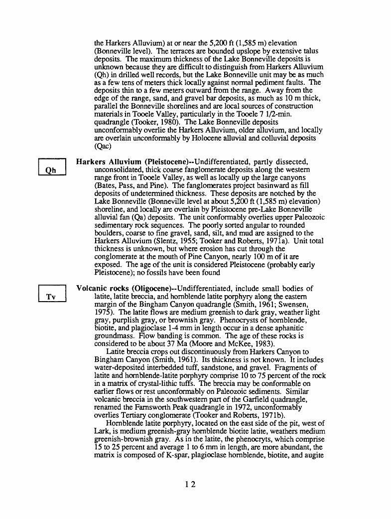
the Barkers Alluvium) at or near the 5,200 ft (1,585 m) elevation (Bonneville level). The terraces are bounded upslope by extensive talus deposits. The maximum thickness of the Lake Bonneville deposits is unknown because they are difficult to distinguish from Markers Alluvium (Qh) in drilled well records, but the Lake Bonneville unit may be as much as a few tens of meters thick locally against normal pediment faults. The deposits thin to a few meters outward from the range. Away from the edge of the range, sand, and gravel bar deposits, as much as 10 m thick, parallel the Bonneville shorelines and are local sources of construction materials in Tooele Valley, particularly in the Tooele 7 1/2-min. quadrangle (Tooker, 1980). The Lake Bonneville deposits unconformably overlie the Harkers Alluvium, older alluvium, and locally are overlain unconformably by Holocene alluvial and colluvial deposits (Qac)
Harkers Alluvium (Pleistocene)--Undifferentiated, partly dissected, unconsolidated, thick coarse fanglomerate deposits along the western range front in Tooele Valley, as well as locally up the large canyons (Bates, Pass, and Pine). The fanglomerates project basinward as fill deposits of undetermined thickness. These deposits are notched by the Lake Bonneville (Bonneville level at about 5,200 ft (1,585 m) elevation) shoreline, and locally are overlain by Pleistocene pre-Lake Bonneville alluvial fan (Qa) deposits. The unit conformably overlies upper Paleozoic sedimentary rock sequences. The poorly sorted angular to rounded boulders, coarse to fine gravel, sand, silt, and mud are assigned to the Markers Alluvium (Slentz, 1955; Tooker and Roberts, 197la). Unit total thickness is unknown, but where erosion has cut through the conglomerate at the mouth of Pine Canyon, nearly 100 m of it are exposed. The age of the unit is considered Pleistocene (probably early Pleistocene); no fossils have been found
Volcanic rocks (Oligocene)--Undifferentiated, include small bodies of latite, latite breccia, and hornblende latite porphyry along the eastern margin of the Bingham Canyon quadrangle (Smith, 1961; Swensen, 1975). The latite flows are medium greenish to dark gray, weather light gray, purplish gray, or brownish gray. Phenocrysts of hornblende, biotite, and plagioclase 1-4 mm in length occur in a dense aphanitic groundmass. Flow banding is common. The age of these rocks is considered to be about 37 Ma (Moore and McKee, 1983).
Latite breccia crops out discontinuously from Markers Canyon to Bingham Canyon (Smith, 1961). Its thickness is not known. It includes water-deposited interbedded tuff, sandstone, and gravel. Fragments of latite and hornblende-latite porphyry comprise 10 to 75 percent of the rock in a matrix of crystal-lithic tuffs. The breccia may be conformable on earlier flows or rest unconformably on Paleozoic sediments. Similar volcanic breccia in the southwestern part of the Garfield quadrangle, renamed the Farnsworth Peak quadrangle in 1972, unconformably overlies Tertiary conglomerate (Tooker and Roberts, 197 Ib).
Hornblende latite porphyry, located on the east side of the pit, west of Lark, is medium greenish-gray hornblende biotite latite, weathers medium greenish-brownish gray. As in the latite, the phenocryts, which comprise 15 to 25 percent and average 1 to 6 mm in length, are more abundant, the matrix is composed of K-spar, plagioclase hornblende, biotite, and augite
12
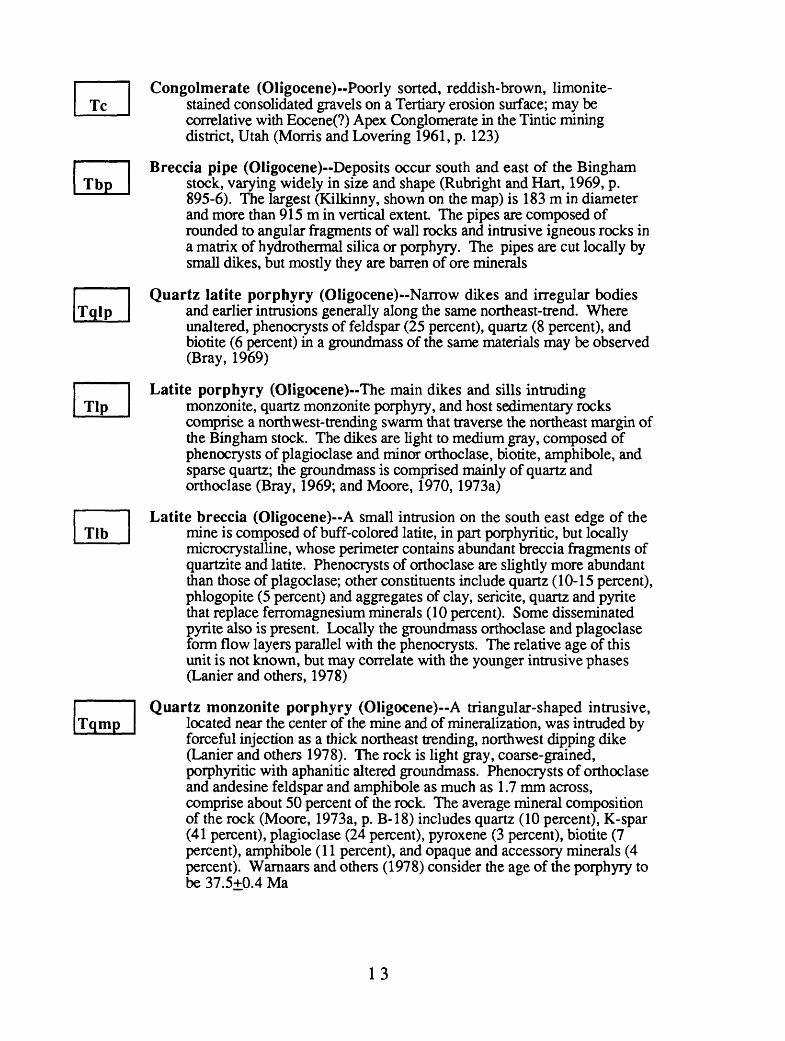
Congolmerate (Oligocene)--Poorly sorted, reddish-brown, limonite- stained consolidated gravels on a Tertiary erosion surface; may be correlative with Eocene(?) Apex Conglomerate in the Tintic mining district, Utah (Morris and Levering 1961, p. 123)
Breccia pipe (Oligocene)--Deposits occur south and east of the Bingham stock, varying widely in size and shape (Rubright and Hart, 1969, p. 895-6). The largest (Kilkinny, shown on the map) is 183 m in diameter and more than 915 m in vertical extent The pipes are composed of rounded to angular fragments of wall rocks and intrusive igneous rocks in a matrix of hydrotherrnal silica or porphyry. The pipes are cut locally by small dikes, but mostly they are barren of ore minerals
Quartz latite porphyry (Oligocene)--Narrow dikes and irregular bodies and earlier intrusions generally along the same northeast-trend. Where unaltered, phenocrysts of feldspar (25 percent), quartz (8 percent), and biotite (6 percent) in a groundmass of the same materials may be observed (Bray, 1969)
Latite porphyry (Oligocene)--The main dikes and sills intruding monzonite, quartz monzonite porphyry, and host sedimentary rocks comprise a northwest-trending swarm that traverse the northeast margin of the Bingham stock. The dikes are light to medium gray, composed of phenocrysts of plagioclase and minor orthoclase, biotite, amphibole, and sparse quartz; the groundmass is comprised mainly of quartz and orthoclase (Bray, 1969; and Moore, 1970,1973a)
Latite breccia (Oligocene)--A small intrusion on the south east edge of the mine is composed of buff-colored latite, in part porphyritic, but locally rnicrocrystalline, whose perimeter contains abundant breccia fragments of quartzite and latite. Phenocrysts of orthoclase are slightly more abundant than those of plagoclase; other constituents include quartz (10-15 percent), phlogopite (5 percent) and aggregates of clay, sericite, quartz and pyrite that replace ferromagnesium minerals (10 percent). Some disseminated pyrite also is present. Locally the groundmass orthoclase and plagoclase form flow layers parallel with the phenocrysts. The relative age of this unit is not known, but may correlate with the younger intrusive phases (Lanier and others, 1978)
Quartz monzonite porphyry (Oligocene)--A triangular-shaped intrusive, located near the center of the mine and of mineralization, was intruded by forceful injection as a thick northeast trending, northwest dipping dike (Lanier and others 1978). The rock is light gray, coarse-grained, porphyritic with aphanitic altered groundmass. Phenocrysts of orthoclase and andesine feldspar and amphibole as much as 1.7 mm across, comprise about 50 percent of the rock. The average mineral composition of the rock (Moore, 1973a, p. B-18) includes quartz (10 percent), K-spar (41 percent), plagioclase (24 percent), pyroxene (3 percent), biotite (7 percent), amphibole (11 percent), and opaque and accessory minerals (4 percent). Warnaars and others (1978) consider the age of the porphyry to be 37.5+0.4 Ma
13
Porphyritic quartz monzonite (Oligocene)--A small northwest-trending, rectangular dike-like intrusion that plunges to the northwest occurs along the northwest margin of the Bingham stock. The greenish gray porphyry contains pale pink orthoclase phenocrysts (10 percent) set in an equigranular phaneritic groundmass. Lanier and others (1978) believe that the dike is more closely related compositionally and texturally to the monzonite than with porphyry phases of the Bingham stock; where sharp contacts are absent, the dike boundary is defined by the increase in the phenocryts
Monzonite and quartz monzonite (Oligocene)--The most common type and earliest intrusive rock, which is exposed in the Last Chance and composite Bingham stocks, was emplaced mainly by stoping and assimilation (Lanier and others, 1978; Moore, 1973a). In the Last Chance stock the rock is unaltered, equigranular, dark gray, fine grained (0.5 mm) and composed of sub- to anhedral crystals of augite (11 percent), hornblende (7 percent), biotite (8 percent), K-feldspar (30 percent), plagioclase feldspar (33 percent), quartz (7 percent), and opaque and accessary minerals (4 percent) (Moore, 1973a, p. B-8). The composition of monzonite in the altered Bingham stock is comparable. Locally the monzonite contains 1 to 2 percent feldspar phenocrysts (Lanier and others, 1978). Xenolithic wallrock blocks are larger and more common in the Bingham stock. The carbonate wall rocks of the Last Chance stock have been altered along narrow selvage zones to contact metamorphic (skam) mineral assemblages. Calc-sUicate alteration of wall rocks of the Bingham stock locally is extensive, particularly in the areas of skarn copper ore on the western side of the mine (fig. 6) (Atldnson and Einaudi, 1978). Warnaars and others (1978) report a late Eocene age of 39.8+0.4 Ma
"Monzonite" porphyry undifferentiated (Oligocne)-Smalldiscontinuous dike- and (or) sill-like bodies occur mainly on ridge crests in the Flood, Pass, and Barneys Canyons areas. They intrude Pass Canyon Sequence sedimentary rocks. The porphyritic rocks are poorly exposed and highly altered, medium-grained, locally porphyritic, buff to tan, and weather light brown, resembling monzonite float elsewhere.
Park City Formation (lower part) (Lower Permian)-Only the lower limestone (Grandeur) member of the formation crops out in the Rogers Canyon nappe in the northern part of the Oquirrh Mountains (Tooker and Roberts, 1970, 197 la):
Grandeur Member-In this quadrangle, a down-faulted lowermost part of the member occurs north of Barneys Canyon on the upper plate of the North Oquirrh thrust in fault contact with rocks of the Dry Fork unit (Pass Canyon nappe). Where measured in the Garfield quadrangle (Tooker and Roberts 1971b) the member is conformable on the Kessler Canyon Formation of the Oquirrh group. The lower limestone unit is about 65 m thick. It is composed of interbedded thin to medium bedded, light gray, fossiliferous (in part coquina) (Gordon and Duncan, 1970, table 4), argillaceous, arenaceous, and cherty limestones
14
Oquirrh group (Permian, Pennsylvanian, and Mississippian)--Originally called Oquirrh Formation (Gilluly, 1932), these rocks have been raised to Oquirrh Group (Welsh and James, 1961; looker and Roberts, 1970). Three sequences of Oquirrh Group sediments of nearly comparable age and lithology, the Bingham, Rogers Canyon and Pass Canyon, occur in the quadrangle on the upper plates of thrust nappes on the Midas, North Oquirrh, and unnamed thrusts in the foreland of the Sevier erogenic belt
Bingham nappe (Pennsylvanian)-The Butterfield Peaks and Bingham Mine Formations are exposed in the southern part of the quadrangle on the upper plate of the Midas thrust fault system and include the type localities (looker and Roberts, 1970).
Bingham Mine Formation (Upper Pennsylvanian)-Named byWelsh and James (1961, p. 8-9) for quartzitic sandstone and limestone in the Bingham mining district. Tooker and Roberts (1970, p. A-33) described the formation based on the section measured south of Markham Peak and across Clipper Ridge. They subdivided the formation into the lower Clipper Ridge Member, 910m thick, and overlying Markham Peak Member, 1,319 m thick. The Bingham Mine Formation is conformable with the underlying Butterfield Peaks Formation, and is now believed to have an upper fault/erosion contact with the Freeman-Curry unit of the Pass Canyon sequence, as reported provisionally in this report. The sequence is divided into:
Markham Peak Member Predominatly composed of multi-bedded medium to thick quartzite and sandstone and thin limestone beds. The lower contact is conformable with the Clipper Ridge Member, the upper contact is along faults or is erosional (Roberts and Tooker, 1970). Interbedded buff to tan orthoquartzite and light-tan calcareous quartzite, tan calcareous sandstone, calcareous silt, and all possible intergradiations, are locally separated by a few thin 0.3-1 m thick light olive brown fusulinid-bearing arenaceous limestone beds. Sparse fragmental megafossils (colonial corals, brachopods, and fusulinids) occur in arenaceous limestone. Gordon and Duncan (1970) consider the member to be of Missouri age
Clipper Ridge Member-A series of prominent orthoquartzite, calcareous quartzite, and calcareous and quartzose sandstones interbedded with a few thick cherty, arenaceous argillaceous and fossiliferous limestone beds in the lower part of the unit; limestones become more arenaceous and thinner (3-21 m) in the upper part (Tooker and Roberts, 1970). Two prominant limestone beds, the 110m (360 ft) thick Jordan limestone marker bed at the base of the member, and the 41 m (135 ft) thick commercial limestone marker bed beginning at 157 m (515 ft) above the base of the member (Tooker and Roberts, 1970, p. A35), cross the range from Bingham to Tooele. These beds are the sites of replacement and skarn ores on the west side of the mining district. The member is about 910 m thick. Gordon and Duncan (1970) report a probable Missouri age, based mainly on the presence of the fusulinid Triticites
15
Butterfield Peaks Formation (Middle Pennsylvanian) Cyclicallyinterlayered, thin- to medium-bedded, locally cross-bedded calcareous quartzite; tan to grayish-brown orthoquartzite and calcareous sandstone; medium-gray limestone and fossiliferous limestone; and olive-gray, brownish-gray, and dark-gray arenaceous, cherty, and argillaceous limestone. Limestones predominate over quartzites (Tooker and Roberts, 1970). Only the upper part (approximately 750 m) of an approximate total of 2,740 m of the formation is exposed in Middle Canyon on the north side of Long Ridge anticline and in Middle and Butterfield Canyons. The formation conformably overlies the West Canyon Limestone. Butterfield Peaks limestone beds contain an abundant brachiopod, bryozoan, coral, and fusulinid fauna. The age of rocks in the quadrangle is Desmoinesian (Middle Pennsylvanian) (Gordon and Duncan, 1970)
Rogers Canyon nappe (Permian, Pennsylvanian, andMississippi an )-The Kessler Canyon and Erda Formations, and Lake Point Limestone, whose type localities are in the Garfield quadrangle (Tooker and Roberts, 1970), are exposed in part in the northern part of the Bingham Canyon quadrangle. Although generally age-correlative with the rocks in the Bingham sequence, the lithologic facies differs. The sequence is underlain by the North Oquirrh thrust fault system, and parts of the formations represented in the quadrangle are approximately 2,939 m thick in the type section (Tooker and Roberts, 1970). However, owing to faulting, only partial sections of the three formations crop out in the Bingham Canyon quadrangle
Kessler Canyon Formation (Lower Permian? and UpperPennsylvanian)-A small unmeasured section of the uppermost part of the formation, described by Tooker and Roberts (1970), is exposed as the upper plate of a thrust fault overlying the Erda Formation in the northeast part of the quadrangle in Markers Canyon. North of Markers Canyon in the Garfield quadrangle (Tooker and Roberts, 1970,197 Ib) the upper contact of the formation is conformable with the overlying Grandeur Member and lower contact is conformable with the Erda Formation. Beds are thin- to medium-bedded, interbedded tan orthoquartzite, calcareous red-brown ferruginous and light gray and tan dolomitic sandstone and dolomite. Worm trails are common in the ferruginous sandstone; fusulinids are poorly preserved in dolomite and bedded chert layers. The age here is probably lower Permian (Gordon and Duncan, 1970); lower parts of the section somewhat resemble the Markham Peak Member and are correlative with the Markham Peak. South of Markers Canyon, orthoquartzite and calcareous quartzite in the Kessler Canyon Formation are coarsely brecciated and altered to calc- silicates along a thrust fault imbrication in the North Oquirrh plate, and over-rides the Erda Formation
16

Erda Formation (Middle Pennsylvanian)-Blocks containing fault- bounded Erda strata occur in the north central part of the quadrangle, mostly north of Barneys Canyon and east of the Oquirrh Mountains divide ridge. The formation is repeated by imbricate thrust faults of the North Oquirrh thrust system in the area of Nelson Peak. The contact with the underlying Lake Point Limestone is conformable north of Bates Canyon, west of Nelson Peak. Sedimentary contacts elsewhere are concealed by faults. The Erda Formation is characterized by cyclically repeated layers of medium-gray limestone, medium dark greenargillaceous limestone, light brown, brown to tan calcareous quartzite, and variegated calcareous sandstone. Fossils at the type locally (Gordon and Duncan, 1970) are considered middle Pennsylvanian, and are age correlative with the Butterfield Peaks Formation
Lake Point Limestone (Lower Pennsylvanian and UpperMississippian)-The formation is exposed in and along Bates Canyon west from Nelson Peak to the range front. The contact with the overlying Erda Formation is conformable, the lower contact, along the North Oquirrh thrust, is tectonic with the Dry Fork unit of the Pass Canyon sequence. The formation is also exposed in thrust klippen on the ridge south of Bates Canyon. Only about one third of the 1,737 ft of section, which includes the Mississippian strata measured in the type locality (Garfield quadrangle) a few miles to the north (Tooker and Roberts, 1970) is present above the North Oquirrh thrust fault, which has truncated the lower part of this section in the quadrangle. The rocks chiefly are interbedded medium-gray, weathering light-gray to tan, medium grained, medium bedded limestone and massive thick bedded gray limestone, which locally is cherty and bioclastic. The unit locally contains an abundant megafossil assemblage. Gordon and Duncan (1970) considered that Lake Point Limestone was of late Mississippian (late Chester) and Early Pennsylvanian (Morow) age. Only the early Pennsylvanian part of the formation seems to be exposed in the quadrangle
Pass Canyon nappe (Lower Series Permian) An allochthonouscomplexly folded and faulted of rocks crop out in the central part of the quadrangle between Nelson Peak, on the north, and Markham Peak, on the south. Originally believed to represent a continuous sedimentary succession above the Bingham Mine Formation (Welsh and James, 1961; Swensen, 1975), it now appears to us to be a coeval sedimentary sequence formed in a separate part of the Oquirrh basin.
The sedimentary rocks are divided provisionally into the Dry Fork and Flood Canyon units on the basis of general lithologic similarities and structural differences. They are everywhere separated by faults. These rocks are believed to be Early Permian (Wolfcamp), according to Welsh and James (1961). The rocks generally resemble those of comparable age, the Kessler Canyon Formation, in the northern Oquirrh Mountains (Tooker and Roberts, 1970), and upper parts of the Oquirrh Formation, Diamond Creek Sandstone, and Kirkman Limestone in the Wasatch Mountains (Baker and others, 1949)
17

Flood Canyon Unit (Lower Permian?)--This informally named unit is exposed in a broad U-shape pattern from the area south of Bates Canyon, at the north end of the quadrangle, south to the Markham Peak area, and thence northeast toward Markers Canyon. The unit contacts with the underlying Dry Fork unit are normal faults and thrust faults. A reliable measured section of the unit is not possible here because of complex tight folding, cut-out or shearing of beds by near bedding reverse faults segmentation of the nappe by tear faults, and concealment of a recognized base and top by normal faults. More detailed mapping of the unit is required to resolve this problem. These rocks superficially resemble the Kirkman and Diamond Creek Formations in the Wasatch Mountains (Baker and others, 1949). Because of this, tentatively, they are now considered to be younger than those of the Dry Fork unit. The rocks probably are age correlative with those in the Wasatch Range, but a local Oquirrh Mountain name is proposed to empasize the lithologic facies and structural differences between rocks of comparable age in the Wasatch Mountains (Timpanogos nappe, Tooker and Roberts, 1963) and those in the Oquirrh Mountain nappes.
In general, the unit seems to include a series of thin to medium bedded brown to reddish-brown calcareous quartzite beds at the base followed upward by a unit of thick cliff-forming light gray or tan to brownish tan calcareous sandstone, intraformational breccia interbedded with arenaceous limestone and light tan-gray dolomite, dolomitic limestone, white to light-gray calcareous sandstone, and quartzose sandstone. The upper thinner part of the unit grades into thinly laminated dark gray limestone and arenaceous limestone that weather medium bluish gray. The age of these rocks is uncertain owing to generally poor preservation of sparse megafossils, but Welsh and James (1961) reported Wolfcamp fusulinids in the upper limestone. A correlation of these rocks with upper Oquirrh Formation rocks (Baker and others, 1949) seems reasonable, especially in view of similarities between the upper laminated limestone and the Kirkman Limestone in the Timpanogos sequence, and the similarity of the lower section with rocks found in the upper Kessler Canyon Formation
Dry Fork Unit (Lower Permian?)--Located mainly on the east side of the central part of the range in Bingham and Barneys Canyons, and locally on the west side near the range front south of Bates Canyon, the unit includes (at least in part) the Curry Peak and Freeman Peak Formations of Swensen (1975). Contacts of the east block are faults; these are normal and thrust (Midas) faults with the Bingham sequence on the southwest, and a thrust fault on the west with the Flood Canyon unit. The northwestern block is bounded on the north by the overlying North Oquirrh thrust fault and on the south by the tear faults that separate the Pass Canyon unit from Dry Fork rocks. The thickness reported by Welsh and James (1961) and Swensen (1975) (on p. 4) is based on an incomplete folded and fault-fragmented section of the sequence.
The upper part on the unit predominatly is composed of thin to medium bedded light-gray to light-tan calcareous sandstone and siltstone, that weather tan to brownish-tan on a punky rind, and light-gray to tan quartzite and orthoquartzite. Local discontinuous lenses of tan to brownish-tan chert pebble conglomerate and breccia and thin interbedded silty limestone and calcareous sandstone and siltstone are present. Worm
18
trails are abundant; fossils are rare, but Welsh and James (1961) report Wolfcampian age fusulinids that suggest an Early Permian age.
The lower part (the Freeman Peak Formation of Swensen, 1975) is mostly massive thick-bedded light-gray to tan to brownish-tan, which weathers brownish-red and dark-brownish gray calcareous quartzite and orthoquartzite, thin calcareous sandstone and argillaceous siltstone and shale. Fossils, mainly fusulinids, occur in thin bedded chert and are Early Permian (Wolfcamp) (Swensen, 1975).
The unit is in fault contact with the Bingham Mine Formation along the AJ fault in Freeman Gulch, which seems to be a normal fault, down on the north, but which originally may have moved as a tear fault, the northeast side to the southeast. Normal faults that nearly parallel the trend of Bingham Canyon are down faulted on the northwest, and expose the Bingham sequence on the southeast
CORRELATION OF MAP UNITS
Tentative correlations of map units shown on the chart (fig. 7) are based on age and field relations. Some changes from previous interpretations have been made, particularly in the correlation of the three nappes, each of which contains rocks of the Oquirrh Group.
19
REFERENCES CITED
Armstrong, R.L., 1963, Geochronology and geology of the eastern Great Basin in Nevadaand Utah: New Haven, Conn., Yale University, Ph.D. disertation, 202 p.
_1970, Geochronology of Tertiary igneous rocks, eastern Basin and Range Province,western Utah, eastern Nevada, and vicinity, U.S.A.: Geochemica et CosmochimicaActa, v. 34, p. 203-232.
Atkinson, W.W. Jr., and Einaudi, M.T., 1978, Skarn formation and mineralization in thecontact aureole at Carr Fork, Bingham, Utah: Economic Geology, v. 73, no. 7, p.1326-1365.
Baker, A.A., Huddle, J.W., and Kinney, D.M., 1949, Paleozoic geology of north andwest sides of Unita Basin, Utah: Bulletin of the American Association PetroleumGeologist, v. 33, no. 7, p. 1161-1197.
Boutwell, J.M., 1905, Economic geology of the Bingham mining district, Utah; withsections by Keith, Arthur, and Emmons, S. R: U.S. Geological SurveyProfessional Paper 38, 413 p.
Bray, R.E., 1969, Igneous rocks and hydrothermal alteration at Bingham, Utah:Economic Geology, v. 64, n. 1, p. 34-49.
Bray, R.E., Lanier, George, and John, E.G., 1975, General geology of the open-pit mine(Bingham), in Bray, R.E. and Wilson, J.C., Guidebook to the Bingham miningdistrict, Society of Economic Geology, October 23,1975: Bingham Canyon, Utah,Kennecott Copper Corporation, p. 49-58.
British Petroleum Company, 1986, Financial and operating information: The BritishPetroleum Company, London, Great Britain, p. 112-114.
Cameron, D.E., and Garmoe, W.J., 1987, Geology of skarn and high-grade gold in theCarr Fork Mine, Utah: Bulletin Economic Geology, v. 82, n. 5, p. 1318-1333.
Coats, R.R., 1987, Geology of Elko County, Nevada: Nevada Bureau of Mines andGeology Bulletin 101, 112 p.
Cook, K.L., and Berg, J.W., Jr., 1961, Regional gravity survey along the central andsouthern Wasatch Front, Utah: U.S. Geological Survey Professional Paper 316-E,p. 75-89.
Cook, K.L., Berg, J.L., Jr., Johnson, W.W., and Novotny, R.T., 1966, Some Cenozoicstructural basins in the Great Salt Lake area, Utah, indicated by regional gravitysurveys, in Stokes, W.L., ed., The Great Salt Lake: Utah Geological Society,Guidebook to the geology of Utah, no. 20, p. 57-75.
Eardley, A.J., Gvosdetsky, Vasyl, and Marsell, R.E., 1957, Hydrology of LakeBonneville and the sediments and soils of the basin (Utah): Geological Society ofAmerica Bulletin, v. 68, no. 9, p. 1141-1201.
Gilluly, James, 1932, Geology and ore deposits of the Stockton and Fairfield quadrangles,Utah: U.S. Geological Survey Prof.Paper 17.3, 171 p.
Gordon, Mackenzie, Jr., and Duncan, H.M., 1970, Biostratigraphy and correlation of theOquirrh Group and related rocks in the Oquirrh Mountains, Utah, in Tooker, E.W.,and Roberts, R.J., Upper Paleozoic rocks in the Oquirrh Mountains and Binghammining district, Utah: U.S. Geological Survey Professional Paper 629-A, p. A38-A69.
Hunt, R.N., 1924, The ores in the limestones at Bingham, Utah: Transactions of theInstitution of Mining and Metallurgy Engineers, v. 70, p. 856-883.
James, A.H., Smith, W.H., and Bray, R.E., 1961, The Bingham district~a zonedporphyry ore deposit, in Cook, D.R., ed., Geology of the Bingham mining districtand northern Oquirrh Mountains: Utah Geological Society Guidebook 16, p. 81-100.
20
James, A.H., Smith, W.H., and Welsh, J.E., 1961, General geology and structure of theBingham district, Utah, in Cook, D.R., ed., Geology of the Bingham miningdistrict and northern Oquirrh Mountains: Utah Geological Society Guidebook 16,p. 49-69.
James, L.P., 1978, The Bingham copper deposits, Utah, as an exploration target: Historyand pre-excavation geology: Economic Geology, v. 73, n. 7, p. 1218-1227.
John, E.G., 1975,, Mineral zones of the Bingham district, in Bray, R.E., and Wilson,J.C., eds., Guidebook to the Bingham mining district: Society of EconomicGeologists, October 23, 1975: Bingham Canyon, Utah, Kennecott CopperCorporation, p. 59-72.
_1978, Mineral zones in the Utah Copper orebody: Economic Geology, v. 73, n. 7, p.1250-1259.
Joklik, G.F., 1988, Turnaround of historic mine mirrors industry renewal: AmericanMining Congress Journal, v. 74, no. 10, p. 10-12.
Lanier, George, compiler, 1978, Geologic map of the Bingham Mine, Bingham Canyon,Utah, in Lanier and others, 1978, General geology of the Bingham Mine, BinghamCanyon, Utah: Kennecott Copper Corporation, Utah Copper Division, BinghamCanyon, Utah, scale 1:9600.
Lanier, George, John, E.G., Swensen, A.J., Reid, Julia, Caddey, S.W., and Wilson,J.C., 1978, General geology of the Bingham Mine, Bingham Canyon, Utah:Economic Geology, v. 73, no. 7, p. 1228-1241.
Mabey, D.R., 1960, Regional gravity survey of part of the Basin and Range province:U.S. Geological Survey Professional Paper 400B, p. B283-285.
Mabey, D.R., Tooker, E.W., and Roberts, R.J., 1963, Gravity and magnetic anomalies inthe northern Oquirrh Mountains, Utah: U.S. Geological Survey Professional Paper450E, p. E28-E31.
Mabey, D.R., Crittenden, M.D., Jr., Morris, H.T., Roberts, R.J., and Tooker, E.W.,1964, Aeromagnetic and generalized geologic map of part of North-Central Utah:U.S. Geological Survey Geophysical Investigations Map GP-422, scale 1:250,000.
Moore, W.J., 1970, Igneous rocks in the Bingham mining district, Utah-A petrologicframework: Stanford, California, Stanford University, Ph.D dissertation, 184 p.
_1973a, Igneous rocks in the Bingham mining district, Utah: U.S. Geological SurveyProfessional Paper 629-B, 42 p.
_1973b, A summary of radiometric ages of igneous rocks in the Oquirrh Mountains,north-central Utah: Economic Geology, v. 68, no. 1, p. 97-107.
Moore, W.J., and McKee, E.H., 1983, Phanerozoic magmatism and mineralization in theTooele 1° x 2° quadrangle, Utah, in Miller, D.M., Todd, V.R., and Howard,K.A., eds., Tectonic and stratigraphic studies in the Eastern Great Basin:Geological Society of America Memoir 157, p. 183-190.
Morris, H.T., 1983, Interrelations of thrust and transcurrnet faults in the central Seviererogenic belt near Leamington, Utah, in Miller, D.M., and others, eds., Tectonicand stratigraphic studies in the eastern Great Basin: Geological Society of AmericaMemoir 157, p. 75-82.
Morris, H.T., and Levering, T.S., 1961, Stratigraphy of the East Tintic Mountains, Utah:U.S. Geological Survey Professional Paper 361, 143 p.
Morris, H.T., Douglass, R.C., and Kopf, R.W., 1977, Stratigraphy and microfaunas ofthe Oquirrh Group in the southern East Tintic Mountains, Utah: U.S. GeologicalSurvey Professional Paper 1025, 22 p.
Peacock, H.G., 1948, An outline of the geology of the Bingham district: A.I.M.E.,Mining and Metallurgy, v. 29, no. 502, p. 533-534.
Peters, W.C., James, A.H., and Field, C.W., 1966, Geology of the Bingham Canyonporphyry copper deposit, Utah, in Titley, S.R., and Hicks, C.L., eds., Geology of
21

the porphyry copper deposits, southwestern North America: Tucson, UniversityArizona Press, p. 165-175.
Roberts, R.J., 1964, Stratigraphy and structure of the Antler Peak quadrangle, Humboldtand Lander Counties, Nevada: U.S. Geological Survey Professional Paper 459-A,93 p.
Roberts, R.J., Crittenden, M.D., Jr., looker, E.W., Morris, H.T., Hose, R.K., andCheney, T.M., 1965, Pennsylvanian and Permian basins in northwestern Utah,northeastern Nevada, and south-central Idaho: Bulletin of the American Associationof Petroleum Geologists, v. 49, n. 7, p. 1926-1956.
Roberts, R.J., and Tooker, E.W., 1969, Age and regional significance of conglomerate inthe Newfoundland and Silver Island Mountains, Utah [abs.]: Geological Society ofAmerica Abstracts with Program 1969, pt. 5, p. 69.
Rubright, R.D., and Hart, O.J., 1968, Non-porphyry ores of the Bingham district, Utah,in Ridge, J.D., ed., Ore deposits in the United States, 1933-1967 (Graton-Salesvol.): New York, American Institute of Mining Metallurgy Petroleum Engineers, v.1, p. 886-907.
Skilling's Mining Review, 1985, Sohio to moderize Kennecott's Utah Copper Division in$400 million project over three-year period: Skillings, v. 74, n. 50, p. 6-7.
Skillings, D.N. Jr., 1988, BP Minerals American marks completion of Bingham Canyonmodernization Sept. 23rd: Skilling's Mining Review, v. 77, no. 44, p. 4-7.
Slentz, L.W., 1955, Salt Lake Group in lower Jordan Valley, Utah, in Eardley, A.J., ed.,Guidebook to the geology of Utah, Tertiary and Quaternary geology of the easternBonneville Basin: Utah Geological Society, v. 10, p. 23-36.
Smith, W.H., 1961, The volcanics of the eastern slopes of the Bingham district, Utah, inCook, D.R. ed., Geology of the Bingham mining district and northern OquirrhMountains: Utah Geological Society Guidebook to the Geology of Utah 16, p. 101-119.
_1975, General structural geology of the Bingham mining district, in Bray, R.E., andWilson, J.C., eds., Guidebook to the Bingham mining district: Society ofEconomic Geologists, October 23,1975: Bingham Canyon, Utah, KennecottCopper Corporation, p. 41-48.
Standard Oil Co., 1986,1986 Financial and operating information: Cleveland, Ohio, TheStandard Oil Company, p. 40.
Swensen, A.J., compiler, 1975, Geologic map of the Bingham district, in Bray, R.E., andWilson, J.C., eds., Guidebook to the Bingham mining district, Society ofEconomic Geologists, October 23,1975: Bingham Canyon, Utah, KennecottCopper Corporation, pi. 1, scale 1:24,000.
Tooker, E.W., 1971, Regional structural controls of ore deposits, Bingham miningdistrict, Utah, U.S.A.: Society of Mining Geologists, Japan, Special Issue 3 (Proc.IMA-IAGOD vol), p. 76-81.
_1980, Preliminary geologic map of the Tooele quadrangle (7-1/2 min.), Tooele County,Utah: U.S. Geological Survey Open-File Report 86-623.
_1983, Variations in structural style and correlation of thrust plates in the Sevier forelandthrust belt, Great Salt Lake area, Utah, in Miller, D.M., and others, eds., Tectonicand stratigraphic studies in the eastern Great Basin: Geological Society of AmericaMemoir 157, p. 61-74.
Tooker, E.W., and Roberts, R. J., 1963, Comparison of Oquirrh Formation sections inthe northern and central Oquirrh Mountains, Utah, in U.S. Geological SurveyProfessional Paper 450-E, p. E32-E36.
_1970, Upper Paleozoic rocks in the Oquirrh Mountains and Bingham mining district,Utah: U.S. Geological Survey Professional Paper 629-A, 76 p.
_197 la, Geologic map of the Magna quadrangle, Salt Lake County, Utah: U.S.Geological Survey Geologic Quadrangle Map GQ-923, scale 1:24,000.
22
_1971b, Geologic map of the Garfield quadrangle, Salt Lake and Tooele Counties, Utah: U.S.Geological Survey Geologic Quadrangle Map GQ-922, scale 1:24,000.
_1988, Interim geologic maps and explanation pamphlet for parts of the Stockton and Lowe Peak 7 1/2-minute quadrangle, Utah: U.S. Geological Survey Open-File Report 88-280, scale 1:24,000, 20 p.
Warnaars, F.W., Smith, W.H., Bray, R.E., Lanier, George, and Shafiqullah, Muhammed, 1978, Geochronology of igneous intrusions and porphyry copper mineralization at Bingham, Utah: Economic Geology Bulletin, v. 73, no. 7, p. 1242-1249.
Welsh, I.E., and James, A.H., 1961, Pennsylvania and Permian stratigraphy of the central Oquirrh Mountains, Utah, in Cook, D.R., ed., Geology of the Bingham mining district and northern Oquirrh Mountains: Utah Geological Society Guidebook 16, p. 1-16.
Zietz, Isadore, Shuey, Ralph, and Kirby, Jr., 1976, Aeromagnetic map of Utah: U.S. Geological Survey, Geophysical Investigations Map, GP-907, scale 1:1,000,000.
23
41°00
40V 46 -
40"80 -
40°16'-
Bingham Canyon / Quadrangle
Bingham Mining District O
Figure l.--Index map showing the location of the Bingham Canyon 7 1/2-minute quadrangle, Utah.

EX
PLA
NA
TIO
N
0
20
00
M
ITIM
V«rt
lo«l
8o
«U
RO
GE
RS
C
AN
YO
N
TH
RU
ST
N
AP
PE
8E
SYSTEMS (f> O UJ
u.
Z
O
CO u
SYSTEM Z rr UJ
Q. P en Z UJ
Q.
1 Z
cn<
CO
U
J
K
UJ
CO
c
u
It **i
**2 !|i i
II =
a Z
Q.
§
U
c
-£
2
c i Q.
3 0 5
FORMATION
III
^5L-
5 -i E ?
1'.( c
,-
Green
Rav Format
io
MEMBER 1^^*
{ /
t V
\ in
V /
^'
! I
\
X
' I ' .
' .
1 1
1 I
1 I
1 1
III!
fx
BIN
QH
AM
T
HR
US
T
NA
PP
E
Figu
re 2
.~G
ener
aliz
ed s
tratig
raph
ic s
ectio
ns o
f sed
imen
tary
rock
s in
the
Rog
ers
Can
yon,
Pa
ss C
anyo
n an
d B
ingh
am th
rust
nap
pe p
late
s ex
pose
d in
the
Bin
gham
Can
yon
quad
rang
le, m
odifi
ed f
rom
look
er a
nd R
ober
ts (
1970
) an
d Sw
enso
n (1
975)
. Se
e fig
ure
3 fo
r dire
ctio
ns o
f mov
emen
t for
the
napp
es.
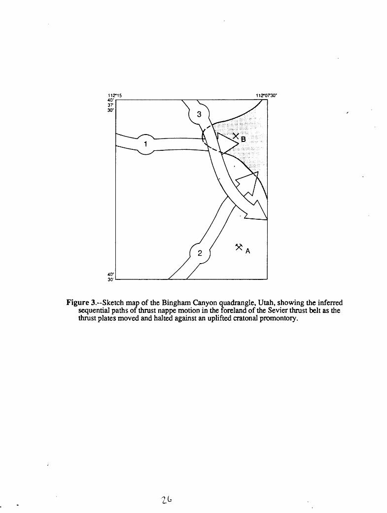
112°0730"
Figure 3. Sketch map of the Bingham Canyon quadrangle, Utah, showing the inferred sequential paths of thrust nappe motion in the foreland of the Sevier thrust belt as the thrust plates moved and halted against an uplifted cratonal promontory.

112°16 f 40 S7'30"i
112°07'30'
40°SO'
A N»l«on P*»k
// ,X / /
/ /
/
/.
/Tr««» *f ' >> f w«»t yl«a|taf
V-
/ /
/
^y / x/ x^
' /' ^ X''' 4 /V B»rn»y« rwrnh^"
/ f
/ /' ̂
**?f//*'
~* ?
*r
^
~<-±Ax»r--
/
->k ^
x/ ^ Marfcham P»»k
A Clipper P»»k
1 .6 0 1 KILOMETER
Figure 4A --Pattern of fold deformation in the lower part of the exposed Pass Canyon on the uDoer plate of an unnamed earliest Sevier thrust fault imbncanon A
P nt romotor is assumed from the fold and tear
and in figures 3B and 3C.

0 40°37'80't t2°07'30'
Trace of Inferred thruet In lower plate of Midaa thruet
Interred concealed leweat etrand of Mlda* thruat ayttem
1 MILE
1 . 0 KILOMETER
Figure 4B.-Patterns of fold and fault deformation in the exposed Bingham nappe (in screened pattern) on the upper plate of the Midas thrust system, a second lobe emplaced during the Sevier orogeny, which followed the emplacement of the Pass Canyon nappe within the Bingham Canyon quadrangle. Deformation and secondary thrusting occurred in the underlying Pass Canyon plate where overridden by northeast directed motion of the Midas thrust system block.

112 07'30'40°»7'»0'
40°30-
1 KILOMETER
Figure 4C.~Patterns of fold and fault deformation in the exposed Rogers Canyon nappe (in screened pattern) on the upper plate of the North Oquirrh thrust, the third of the Sevier thrust lobes to be emplaced in the Bingham Canyon quadrangle. Refolding of sedimentary strata and secondary thrusting in the underlying Pass Canyon plates occurred mainly southeast of the basement promotory ridge.

112°07'30'
40° 30
40032'30'
Figure 5.--Map emphasizing contrasts in the patterns of fold and fault structures in the Bingham and Pass Canyon nappes in the area of the Bingham mine. Data from Bingham Canyon quadrangle (Tooker and Roberts, this report; and Lanier (1978).
EXPLANATION
Porphyry dikes (Tertiary)
Porphyry intrusives (Tertiary)
Pass Canyon nappe sedimentary rocks (Lower Permian)
Bingham nappe sedimentary rocks (Upper Pennsylvanian)
Bingham (Utah Copper) mine (approximate open pit boundary)
KILOMETERS
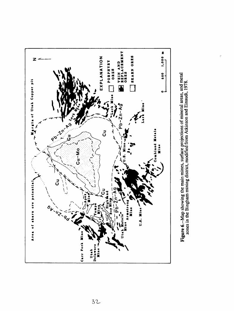
Are
a
of
ak
arn
ore
p
ote
nti
al
Ma
rg
in
of
Uta
h
Cop
per
p
it
Uta
h
Met
al.
M
ine
. 4
Arm
atr
oB
f ^
Min
e
N
Car
r F
ork
M
ine
Uta
h
Del
aw
are
M
ine
-*
EX
PL
AN
AT
ION
PO
RP
HY
RY
M
ine
| J
OR
ES
VE
IN
AN
DR
EP
LA
CE
ME
NT
OR
ES
[ ]
8KA
RN
O
RE
S
Lar
k
Min
e *
Com
bin
ed
Met
al*
V
M
ine
60
0
1,0
00
Figu
re 6
.~M
ap s
how
ing
the
mai
n m
ines
, sur
face
pro
ject
ions
of m
iner
al a
reas
, and
met
al
zone
s in
the
Bin
gham
min
ing
dist
rict,
mod
ifie
d fr
om A
tkin
son
and
Ein
audi
, 19
78.

Unconformity
Ql Qac
Unconformity
Qa Qt
Qh
Unconformity
Tqlp
Tip
Tib
Tqmp
Tpqm
Tm
1.Unconformity
PPQ
PPk
Pe
PM1
2.
Pbm
Pbc
Pb
1. Rogers Canyon nappe2. Bingham nappe3. Pass Canyon nappe
Holocene
- Pleistocene
- QUATERNARY
- Oligocene
Lower Permian
Upper Pennsylvanian
- Middle Pennsylvanian
- Lower Pennsylvanian
- Upper Mississippian
- TERTIARY
- PALEOZOIC
Figure 7.-Correlation chart of the map units in the Bingham Canyon quadrangle, Utah.