education demographic and geographic estimates … demographic and geographic estimates program ......
TRANSCRIPT

Education Demographic and Geographic Estimates Program (EDGE)
Locale Boundaries User’s Manual
DECEMBER 2015
Douglas E. Geverdt
National Center for Education Statistics
NCES 2016-012 U.S. Department of Education

U.S. Department of Education
Arne Duncan Secretary Institute of Education Sciences
Ruth Neild Deputy Director for Policy and Research Delegated Duties of the Director National Center for Education Statistics
Peggy Carr Acting Commissioner Administrative Data Division
Ross Santy Associate Commissioner The National Center for Education Statistics (NCES) is the primary federal entity for collecting, analyzing, and reporting data related to education in the United States and other nations. It fulfills a congressional mandate to collect, collate, analyze, and report full and complete statistics on the condition of education in the United States; conduct and publish reports and specialized analyses of the meaning and significance of such statistics; assist state and local education agencies in improving their statistical systems; and review and report on education activities in foreign countries. NCES activities are designed to address high-priority education data needs; provide consistent, reliable, complete, and accurate indicators of education status and trends; and report timely, useful, and high-quality data to the U.S. Department of Education, Congress, states, other education policymakers, practitioners, data users, and the general public. Unless specifically noted, all information contained herein is in the public domain. We strive to make our products available in a variety of formats and in language that is appropriate to a variety of audiences. You, as our customer, are the best judge of our success in communicating information effectively. If you have any comments or suggestions about this or any other NCES product or report, we would like to hear from you. Please direct your comments to
NCES, IES, U.S. Department of Education 550 12
th Street SW
Washington, DC 20202 December 2015 The NCES Home Page address is http://nces.ed.gov. The NCES Publications and Products address is http://nces.ed.gov/pubsearch. This publication is only available online. To download, view, and print the report as a PDF file, go to the NCES Publications and Products address shown above. Mention of trade names, commercial products, or organizations does not imply endorsement by the U.S. Government. Suggested Citation Geverdt, D. (2015). Education Demographic and Geographic Estimates Program (EDGE): Locale Boundaries User’s Manual (NCES 2016-012). U.S. Department of Education. Washington, DC: National Center for Education Statistics.
Retrieved [date] from http://nces.ed.gov/pubsearch. Content Contact
Doug Geverdt (202) 245-8230 [email protected]

iii
Contents
1.0 INTRODUCTION .....................................................................................................................1
2.0 NCES LOCALE FRAMEWORK ....................................................................................................1
2.1 Classifications and criteria ........................................................................................................................ 1
2.2 Geographic components .......................................................................................................................... 3
Urban (Urbanized Areas, Urban Clusters) and Rural ....................................................................................... 3 2.2.1
Core Based Statistical Areas (Metropolitan and Micropolitan Statistical Areas) ....................................... 3 2.2.1.1
Principal City ............................................................................................................................................... 4 2.2.1.2
Place ........................................................................................................................................................... 4 2.2.1.3
2.3 Framework considerations ....................................................................................................................... 4
City................................................................................................................................................................... 5 2.3.1
Suburban ......................................................................................................................................................... 5 2.3.2
Town ................................................................................................................................................................ 6 2.3.3
Rural ................................................................................................................................................................ 6 2.3.4
2.4 Data sources ............................................................................................................................................ 7
Vintage and sourcing ....................................................................................................................................... 7 2.4.1
Principal City .................................................................................................................................................... 7 2.4.2
Suburban ......................................................................................................................................................... 7 2.4.3
Town ................................................................................................................................................................ 8 2.4.4
Rural ................................................................................................................................................................ 8 2.4.5
2.5 Locale boundary files ............................................................................................................................... 8
File format ....................................................................................................................................................... 8 2.5.1
Datum .............................................................................................................................................................. 9 2.5.2
Attributes ........................................................................................................................................................ 9 2.5.3
National and state-level files ........................................................................................................................... 9 2.5.4
Metadata ....................................................................................................................................................... 10 2.5.5
3.0 REAP LOCALE FRAMEWORK ................................................................................................. 10
3.1 Classifications and criteria ...................................................................................................................... 10
3.2 Geographic components and framework considerations ....................................................................... 11

iv
City................................................................................................................................................................. 11 3.2.1
Urban Fringe .................................................................................................................................................. 12 3.2.2
Town .............................................................................................................................................................. 12 3.2.3
Rural .............................................................................................................................................................. 12 3.2.4
3.3 Data sources .......................................................................................................................................... 12
City................................................................................................................................................................. 13 3.3.1
Urban Fringe .................................................................................................................................................. 13 3.3.2
Town .............................................................................................................................................................. 13 3.3.3
Rural .............................................................................................................................................................. 13 3.3.4
3.4 Locale boundaries .................................................................................................................................. 13
4.0 LOCALE ASSIGNMENTS ......................................................................................................... 13
4.1 Accuracy of locale assignments .............................................................................................................. 13
4.2 School location rather than service area ................................................................................................ 14
4.3 Source of school points for REAP assignments and awards .................................................................... 14
4.4 NCES school district locale assignments ................................................................................................. 14
4.5 REAP school district locale assignments ................................................................................................. 14
5.0 NCES LOCALE DESIGN AND DEVELOPMENT: SUMMARY BACKGROUND ................................. 15
5.1 Introduction to 1995 .............................................................................................................................. 15
5.2 1996 to 2003 .......................................................................................................................................... 16
5.3 2003 to 2007 .......................................................................................................................................... 17
5.4 2008 to 2013 .......................................................................................................................................... 17
5.5 2014 to present ...................................................................................................................................... 18
6.0 DEVELOPMENT OF CENSUS URBAN DEFINITION: SUMMARY BACKGROUND .......................... 19
6.1 Origins (1950 to 1990 Census) ................................................................................................................ 19
6.2 Modernization (Census 2000) ................................................................................................................. 20
6.3 Current (2010 Census) ............................................................................................................................ 22
v
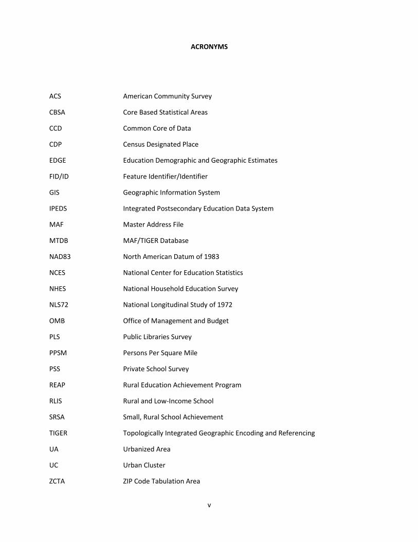
ACRONYMS
ACS American Community Survey
CBSA Core Based Statistical Areas
CCD Common Core of Data
CDP Census Designated Place
EDGE Education Demographic and Geographic Estimates
FID/ID Feature Identifier/Identifier
GIS Geographic Information System
IPEDS Integrated Postsecondary Education Data System
MAF Master Address File
MTDB MAF/TIGER Database
NAD83 North American Datum of 1983
NCES National Center for Education Statistics
NHES National Household Education Survey
NLS72 National Longitudinal Study of 1972
OMB Office of Management and Budget
PLS Public Libraries Survey
PPSM Persons Per Square Mile
PSS Private School Survey
REAP Rural Education Achievement Program
RLIS Rural and Low-Income School
SRSA Small, Rural School Achievement
TIGER Topologically Integrated Geographic Encoding and Referencing
UA Urbanized Area
UC Urban Cluster
ZCTA ZIP Code Tabulation Area

iii
This page intentionally left blank.

1
1.0 INTRODUCTION The National Center for Education Statistics (NCES) Education Demographic and Geographic Estimates (EDGE) program develops geographic data to help policymakers, program administrators, and the public understand relationships between educational institutions and the communities they serve. One of the commonly used geographic data items is the NCES locale classification, a general geographic indicator that categorizes U.S. territory into four types of areas: City, Suburban, Town, and Rural. Each type of area contains three subtypes. NCES uses the locale indicators to support research, analysis, and sample design. It provides a locale code for each institution in its administrative data collections—Common Core of Data (CCD), Integrated Postsecondary Education Data System (IPEDS), and the Private School Survey (PSS)—and includes locale assignments as indicators in most NCES school-based sample surveys.
Although NCES includes a locale assignment as a data item in most of its activities, the geographic boundaries used to create the assignments were first developed and published as a data product in 2015. The purpose of the NCES locale file is to provide annually updated locale boundaries in a spatial data format that can be used to support supplemental research and analysis. The NCES locale file allows data users to create locale indicators for additional institutions or locations, and enables a closer examination of physical features and social conditions that may affect education in each type of locale.
In addition to the NCES locale framework, the U.S. Department of Education maintains a separate, supplemental classification to support the needs of the Rural Education Achievement Program (REAP), an initiative that targets resources and provides additional administrative flexibility for small school systems that serve rural areas. The NCES EDGE program also provides a separate REAP locale file to support REAP-specific research and program needs.
The NCES and REAP locale boundary files do not include information about school locations, and therefore the files do not provide a direct source for school locale assignments. NCES includes locale assignments and estimated latitude and longitude values of school locations as part of its institutional data collections, but discussion of school address geocodes falls outside the scope of the locale boundary files.
2.0 NCES LOCALE FRAMEWORK The NCES locale framework was designed to provide a general indicator of the type of geographic area
where a school is located.
2.1 Classifications and criteria The NCES locale framework is composed of four basic types (City, Suburban, Town, and Rural) that each contains three subtypes. It relies on standard urban and rural definitions developed by the U.S. Census Bureau, and each type of locale is either urban or rural in its entirety. The NCES locales can be fully collapsed into a basic urban–rural dichotomy, or expanded into a more detailed collection of 12 distinct categories. These subtypes are differentiated by size (in the case of City and Suburban

2
assignments) and proximity (in the case of Town and Rural assignments). The NCES classifications and corresponding two-digit locale codes are as follows:
City – Large (11): Territory inside an Urbanized Area and inside a Principal City with population of 250,000 or more.
City – Midsize (12): Territory inside an Urbanized Area and inside a Principal City with population less than 250,000 and greater than or equal to 100,000.
City – Small (13): Territory inside an Urbanized Area and inside a Principal City with population less than 100,000.
Suburban – Large (21): Territory outside a Principal City and inside an Urbanized Area with population of 250,000 or more.
Suburban – Midsize (22): Territory outside a Principal City and inside an Urbanized Area with population less than 250,000 and greater than or equal to 100,000.
Suburban – Small (23): Territory outside a Principal City and inside an Urbanized Area with population less than 100,000.
Town – Fringe (31): Territory inside an Urban Cluster that is less than or equal to 10 miles from an Urbanized Area.
Town – Distant (32): Territory inside an Urban Cluster that is more than 10 miles and less than or equal to 35 miles from an Urbanized Area.
Town – Remote (33): Territory inside an Urban Cluster that is more than 35 miles from an Urbanized Area.
Rural – Fringe (41): Census-defined rural territory that is less than or equal to 5 miles from an Urbanized Area, as well as rural territory that is less than or equal to 2.5 miles from an Urban Cluster.

3
Rural – Distant (42): Census-defined rural territory that is more than 5 miles but less than or equal to 25 miles from an Urbanized Area, as well as rural territory that is more than 2.5 miles but less than or equal to 10 miles from an Urban Cluster.
Rural – Remote (43): Census-defined rural territory that is more than 25 miles from an Urbanized Area and also more than 10 miles from an Urban Cluster.
2.2 Geographic components The NCES locale criteria rely on three primary geographic concepts to define and classify territory—urban areas, core based statistical areas (CBSAs), and places. NCES has used these concepts to make locale assignments since the late 1980s, though the way the concepts have been delineated and applied has changed over time.
Urban (Urbanized Areas, Urban Clusters) and Rural 2.2.1
The Census Bureau’s urban areas represent densely developed territory, and encompass residential, commercial, and other non-residential urban land uses. The boundaries of this urban footprint have been defined using measures based primarily on population counts and residential population density, but also through criteria that account for non-residential urban land uses, such as commercial, industrial, transportation, and open space that are part of the urban landscape. The Census Bureau delineates urban areas after each decennial census. Since the 1950 Census, the Census Bureau has reviewed and revised the urban criteria, as necessary, for each decennial census. These changes are discussed in Section 6.0.
Urban area boundaries are constructed from qualifying census tracts and census blocks. To qualify as an urban area, the territory must encompass at least 2,500 people, at least 1,500 of which reside outside institutional group quarters. Urban areas that contain 50,000 or more people are designated as Urbanized Areas (UAs); urban areas that contain at least 2,500 and less than 50,000 people are designated as Urban Clusters (UCs). The term “urban area” refers to both UAs and UCs. The term “rural” encompasses all population, housing, and territory not included within an urban area.
Core Based Statistical Areas (Metropolitan and Micropolitan Statistical Areas) 2.2.1.1
A CBSA is a geographic entity associated with at least one population core of 10,000 or more, plus adjacent territory that has a high degree of social and economic integration with the core, as measured by commuting ties. CBSAs that contain a UA are designated as Metropolitan Statistical Areas, while those that contain only a UC are designated as Micropolitan Statistical Areas. CBSAs consist of counties and equivalent entities throughout the United States and Puerto Rico. They are not delineated for other U.S. Island Areas. The CBSA classification is not an urban–rural classification; Metropolitan and Micropolitan Statistical Areas and many counties outside CBSAs contain both urban and rural populations. The purpose of the Metropolitan and Micropolitan Statistical Area standards is to provide nationally consistent delineations for collecting, tabulating, and publishing federal statistics for a set of geographic areas. The Office of Management and Budget (OMB) establishes and maintains these areas solely for statistical purposes. Although OMB annually
4
updates qualifying metropolitan area components in the years between the decennial census (e.g., from 2003 to 2009), the criteria for defining metropolitan areas are revised only once a decade.
Principal City 2.2.1.2Principal Cities are incorporated places with a large population of residents and workers located within a CBSA. More specifically, the Principal City (or Cities) of a CBSA include (a) the largest incorporated place with a population of at least 10,000 in the CBSA or, if no incorporated place with at least 10,000 population is present in the CBSA, the largest incorporated place or Census-designated place (CDP) in the CBSA; (b) any additional incorporated place or CDP with a population of at least 250,000 or in which 100,000 or more persons work; (c) any additional incorporated place or CDP with a population of at least 50,000, but less than 250,000, and in which the number of workers working in the place meets or exceeds the number of workers living in the place; (d) any additional incorporated place or CDP with a population of at least 10,000, but less than 50,000, and at least one-third the population size of the largest place, and in which the number of workers working in the place meets or exceeds the number of workers living in the place. Prior to the 2000 Metropolitan Area standards, principal cities were referred to as central cities. OMB’s annual update of CBSA components includes an annual update of places that function as Principal Cities. Additional information about the designation of Principal Cities and the Metropolitan Area standards is available from OMB.
Place 2.2.1.3The Census Bureau defines a place as a concentration of population that has a name and is locally recognized. It may or may not have legally prescribed limits, powers, or functions. Places are always contained within a single state or equivalent entity, but may extend across county boundaries.
Incorporated places provide governmental functions for a concentration of people and are established under the authorization of the governments in each of the 50 states. Requirements for incorporation vary widely among the states; some states have few specific criteria, while others have established population thresholds and occasionally other conditions (for example, minimum land area, population density, and distance from other existing incorporated places) that must be met for incorporation. Different states recognize a variety of entities as incorporated places. An incorporated place usually is a city, town, village, or borough, but can have other legal descriptions. The Census Bureau recognizes incorporated places in all states except Hawaii; for Hawaii, by agreement with the Office of the Governor, the Census Bureau recognizes all places as CDPs rather than as incorporated places. Puerto Rico and several of the outlying areas under U.S. jurisdiction (Guam and the Northern Mariana Islands) also have no incorporated places.
CDPs are communities that lack separate governments but otherwise resemble incorporated places. They are settled population centers with a definite residential core, a relatively high population density, and a degree of local identity. Often a CDP includes commercial, industrial, or other urban types of land use. For more information related to place geography, see http://www.census.gov/geo/reference/gtc/gtc_place.html.
2.3 Framework considerations

5
The NCES locale framework relies on population size and proximity to urban areas to offer a more detailed subtype for each locale. The design and intent for these areas was influenced by locale criteria used for early NCES surveys, historical changes in geographic definitions by the Census Bureau and the OMB, and an increasing need for geographic information by education program administrators and researchers. A brief synopsis of NCES locale development is included in Section 5.0.
City 2.3.1The NCES City locale designation is limited to territory located within principal cities of metropolitan areas. It does not include principal cities of micropolitan areas. More specifically, City classifications are limited to the portion of a principal city that is contained within a UA. Therefore, schools located in rural territory are designated as rural, even if they are contained within a principal city boundary. This approach focuses city classifications on large, densely populated areas, and avoids spurious classifications of rural schools resulting from overextended city boundaries primarily intended to accommodate future annexation and growth. The locale framework disaggregates city classifications by size, using 250,000 and 100,000 population thresholds to identify large, midsize, and small areas. Most principal cities of metropolitan areas are classified as small cities.
Suburban 2.3.2
The NCES Suburban designation applies to territory inside a UA that is located outside the boundary of a principal city of a metropolitan area. Although most suburban territory is located within metropolitan areas, micropolitan areas may contain suburban territory as well. As with City classifications, suburban subtypes are defined by population size using the same thresholds (250,000 and 100,000) to determine large, midsize, and small areas. Although the geographic extent of suburban territory is restricted to the portion of UAs located outside principal cities, the size designation for suburban locales is based on the population of the entire UA, not just the suburban portion.
The NCES locales are not equivalent to the ”urban, suburban, rural” framework often found in social research and discussions of educational conditions. This familiar three-part construct is a blend of the Census Bureau’s metropolitan and urban hierarchies. Unlike NCES, the Census Bureau does not explicitly define suburban areas. All territory is either urban or rural. The suburban classification included in the three-part scheme largely stems from metropolitan area data that the Census Bureau occasionally disaggregates for three types of areas—territory inside a metropolitan area and inside a principal city, territory inside a metropolitan area and outside a principal city, and the balance of territory outside metropolitan areas. Unfortunately, some data users unfamiliar with Census geography mistakenly equate these categories with urban, suburban, and rural, when in fact all three categories may contain both urban and rural territory. The non-city balance of most metropolitan areas contains a wide range of land uses, much of which looks nothing like stereotypical suburban areas envisioned by many users of suburban data. In addition to this overgeneralization, some federal programs designate all non-metropolitan areas as rural territory, while others refer to cities and urban areas interchangeably.
The NCES Suburb locale relies on a clearer and more constrained definition of suburban areas than that offered by the metropolitan-based approach. As a result, it also has limitations. It does not

6
include emerging exurban areas that are too sparsely populated to be included within a UA, and it may leave out well-established bedroom communities that have strong functional ties to a UA but are too distant to be included as part of it. Moreover, because the Census Bureau delineates urban area boundaries only once per decade, the extent of the UA boundary may become less representative of the actual urban fringe later in the decade as population and settlement grow.
Town 2.3.3The NCES locale framework classifies all UCs as towns. As with the city classification, town locale assignments are based on the extent of the UC boundary rather than the extent of a place boundary (though a UC and place may share the same name). Therefore, schools in rural portions of an incorporated place or CDP are considered rural, while schools located inside a UC are identified as town—regardless of whether the area is contained within an incorporated place or CDP.
Unlike city and suburban subclassifications that are based on population size, town subtypes are identified based on the town’s proximity to a UA. UCs located within 10 miles of a UA are identified as fringe, while those more than 10 miles but less than 35 miles away are designated as distant. UCs located more than 35 miles away from a UA are categorized as remote. All proximity thresholds for town and rural classifications are based on geodesic distance between the vertices of the UC and UA polygon boundaries.
Towns are commonly located near UAs, often radiating along major roadways that provide easy access to the larger population core. Although they range in size (from 2,500 to 49,999), most Towns have a population less than 10,000.
NCES town assignments differ considerably from the REAP town locale criteria. These differences are identified and discussed later as part of a broader discussion of REAP and NCES locale differences. Likewise, NCES’s use of UCs for town assignments is not the same as that used by the Federal Communication Commission’s E-rate program. Although E-rate makes use of Census urban/rural definitions to determine discounts, the program reclassifies UCs with a population less than 25,000 as rural territory.
Rural 2.3.4The NCES rural locale assignments rely on the Census Bureau’s designation of non-urban territory as rural. This category accounts for the overwhelming majority of U.S. land area, and it includes a considerable range of settlement patterns and land uses. Some rural areas where school-age children live are extremely remote and difficult to access, while rural areas just outside large urban cores may have relatively easy access to a broad range of specialized goods and services typically associated with suburban and city schools. As previously noted, metropolitan areas can contain both urban and rural territory. Because counties serve as the building blocks of metropolitan areas, and the extent of some metropolitan counties is quite large, some rural portions of metropolitan areas may be farther from urban cores than rural territory outside metropolitan areas. Therefore, the traditional metropolitan-based urban-suburban-rural framework poses difficulties for rural classifications as well.

7
The NCES rural locale provides fringe, distant, and remote subtypes that differentiate rural locations based on the distance and size of the nearest urban area. Distance thresholds applied for UCs (2.5 miles and 10 miles) are shorter than the distances used for UAs (5 miles and 25 miles) to reflect potential differences in the functional relationship between rural and urban areas. These criteria assume that families served by a rural school located 10 miles from a town of 10,000 are likely to have different options than families served by a rural school located 10 miles from an urban core with a population of 110,000. Therefore the rural locale criteria take into consideration not only distance, but also distance from which type of urban core.
The basic unit for these distance indicators (2.5 miles) was borrowed from the Census Bureau’s criterion for connecting densely settled noncontiguous territory to a qualifying core of an urbanized area (UA) or a UC during the urban delineation process, officially referred to as a “jump.” Distances used to define locale subtypes are simple multiples of the basic distance unit (i.e., 1x, 2x, 4x, and 10x for Rural; 4x and 14x for Towns).
2.4 Data sources
Vintage and sourcing 2.4.1The Census Bureau’s Topologically Integrated Geographic Encoding and Referencing (TIGER) database provides the source for all geographic data used to construct the NCES locale boundaries. The NCES locale framework relies on multiple data sources that are collected and produced on different schedules. The Census Bureau’s TIGER/Line boundaries are benchmarked for January 1 each production year. For example, TIGER/Line boundaries released in the fall of 2014 reflect the geography reported as of January 1, 2014. Collection schedules for NCES administrative surveys (CCD, IPEDS, PSS) operate independently of TIGER/Line production, and are influenced by the academic calendar. Consequently, NCES locale assignments typically rely on the vintage of geography available at the beginning of the survey collection cycle. For example, the 2014-15 CCD and IPEDS collections rely on geographic boundaries from TIGER/Line 2014.
Principal City 2.4.2Classifications for principal cities are a function of three primary inputs. First, the OMB, with assistance from the Census Bureau, updates the set of places that qualify as principal cities as part of its overall annual update of CBSA components. Second, population thresholds for determining large, midsize, and small cities rely on annually updated place-level population estimates developed by the Census Bureau’s Population Estimates Program. The official population estimates have a one-year production lag, i.e., estimates centered on July 1 of the prior year are released in the summer of the following year. The Census Bureau’s Boundary and Annexation Survey provides annual updates of municipal boundaries to support the population estimates program. Lastly, the boundaries needed to designate principal cities are based on TIGER/Line place boundaries that are constrained to include only those portions of a principal city that overlap TIGER/Line UA boundaries. Although final principal city boundaries do not include territory outside of UAs, the population data used to classify city subtypes is based on residential population for the full extent of the municipal boundary.
Suburban 2.4.3

8
Suburban classifications rely on the same TIGER/Line place and UA boundaries that are used to create principal city boundaries. The physical extent of principal cities is removed from the UA layer, and the resulting residual area is classified as suburban. Like principal cities, suburban subtypes (large, midsize, and small) are based on Census population data. However, unlike principal cities, the population data for UAs is based on 2010 Census counts, rather than updated population estimates. Although updated estimates are available for UAs from the American Community Survey (ACS), the NCES suburban locales rely on 2010 Census population data for two reasons. First, urban areas and UA/UC distinctions were originally determined by population data collected from the 2010 Census. Second, although segments or portions of UA boundaries may be adjusted as a result of edits to coincident geographic areas in the Master Address File (MAF)/TIGER database (MTDB), the fundamental UA boundaries and universe are delineated only once a decade. Therefore, the 2010 population data provide maximum consistency with the UA boundaries. As with Principal Cities, the UA population is based on the full extent of the UA rather than the non-city residual portion classified as suburban.
Town 2.4.4Town classifications rely on three primary inputs: TIGER/Line UC boundaries, TIGER/Line UA boundaries, and the geodesic distance between UCs and UAs. UAs are buffered at 10- and 35-mile thresholds, and UCs are classified according to their location within the buffered areas. If a UC boundary spans a threshold, the town subtype is classified according to the location of the center point of the UC polygon.
Rural 2.4.5Rural classifications rely on four primary inputs: TIGER/Line UC boundaries, TIGER/Line UA boundaries, the geodesic distance from a UC boundary, and the geodesic distance from a UA boundary. The assessment is similar to that applied for town assignments, except that UAs are buffered at 5- and 25-mile thresholds, and UCs are buffered at 2.5- and 10-mile thresholds. The intersection of these areas is then used to identify rural subtypes. Rural territory within 5 miles of a UA or within 2.5 miles of a UC is designated as Rural – Fringe. Rural territory more than 25 miles from a UA and more than 10 miles from a UC is designated as Rural – Remote. All remaining territory is designated as Rural – Distant.
2.5 Locale boundary files Spatial data for the NCES locale boundaries were developed to support the needs of researchers and to help data users visualize and understand how schools and areas are classified by the locale framework. The spatial data require a geographic information system (GIS) or other spatially enabled application to read, display, and analyze the data.
File format 2.5.1The EDGE program uses ArcGIS to assess spatial relationships and to construct boundaries. The NCES locale boundaries are provided as shapefiles, an industry standard format that combines a collection of different file types to represent and document geographic data. Each shapefile includes the following components:

9
.shp – The .shp file contains information about feature geometry. It encapsulates information for all of the vertices needed to construct the locale polygons. Note that the locale boundaries are organized as multipart polygons, with each locale subtype represented by a single feature for each state.
.dbf – The .dbf file is a table that provides attributes (fields) for each feature. The .dbf table contains a unique record for each feature identified in the .shp file.
.shx – The .shx file provides an index that supports the link between feature geometry and table attributes.
.prj – The .prj file specifies the spatial coordinate system applied to the features. It identifies how the features are referenced and centered relative to an ellipsoidal representation of the earth. The locale boundaries use North American Datum of 1983 (NAD83), the native coordinate system used for Census TIGER/Line boundaries.
.sbn, .sbx – The .sbn and .sbx files are additional index files that divide features into regions to improve processing efficiency.
.shp.xml –The .shp.xml file contains metadata about the shapefile in Federal Geographic Data Committee (FGDC) format.
.cpg – The .cpg file defines the character encoding used for the .dbf file.
Datum 2.5.2The native coordinate system is NAD83.
Attributes 2.5.3The shapefile attribute (.dbf) table includes three fields: Feature Identifier (FID), Shape, and LOCALE. The FID field identifies a unique ID assigned to each feature. Features may consist of more than one polygon, but individual polygons are not separately identified. The Shape field represents the geometry type with the constant text string “Polygon.” This field helps to integrate and index the attribute table with the geometric information housed in the .shp file. The asterisk following the field name is an indicator that the shapefile has been indexed. Lastly, the LOCALE field contains the two-digit NCES locale code.
National and state-level files 2.5.4

10
The NCES locale shapefiles are provided at the national and state levels. The national file provides the locale boundaries as a single, national-level shapefile that contains locale boundaries for the full extent of U.S. territory, including the U.S. Island Areas of Puerto Rico, the U.S. Virgin Islands, American Samoa, Guam, and the Commonwealth of the Northern Mariana Islands. The national file is best suited for data users who need to visualize and analyze locale-related data for the United States, or for those who wish to analyze locale data at different scales or across states. A separate set of shapefiles is also produced for individual states. These files provide the same boundaries included in the national file, but offer easier access for data users with a more limited scope of interest.
Metadata 2.5.5The NCES locale shapefiles include basic metadata that define the source, vintage, and other fundamental data features.
3.0 REAP LOCALE FRAMEWORK The U.S. Department of Education’s Rural Education Achievement Program (REAP) relies on locale assignments based on a prior version of the NCES locale framework that was in effect in 2001 when the REAP program was authorized. This framework is not directly comparable with the current NCES locale criteria adopted by NCES in 2006, but the EDGE program maintains REAP locale boundaries to support research, analysis, and program administration.
3.1 Classifications and criteria The REAP locale framework is composed of four basic types (City, Urban Fringe, Town, and Rural) that each contain two subtypes. It incorporates urban and rural designations defined by the Census Bureau, but does not apply them the same way as the NCES locale framework. REAP subtypes are differentiated by place size (in the case of City, Urban Fringe, and Town assignments) and location relative to a metropolitan area (in the case of Rural assignments). The one-digit locale codes and criteria for each REAP classification are as follows:
Large City (1): A principal city of a metropolitan area, with the city having a population greater than or equal to 250,000.
Midsize City (2): A principal city of a metropolitan area, with the city having a population less than 250,000.
Urban Fringe of a Large City (3): Any incorporated place, Census-designated place, or non-place territory within a metropolitan area of a large city and defined as urban by the Census Bureau.

11
Urban Fringe of a Midsize City (4): Any incorporated place, Census-designated place, or non-place territory within a metropolitan area of a midsize city and defined as urban by the Census Bureau.
Large Town (5): An incorporated place or Census-designated place with a population greater than or equal to 25,000 and located outside a metropolitan area.
Small Town (6): An incorporated place or Census-designated place with a population less than 25,000 and greater than or equal to 2,500 and located outside a metropolitan area.
Rural, Outside Metropolitan Area (7): Any incorporated place, Census-designated place, or non-place territory not within a metropolitan area and defined as rural by the Census Bureau.
Rural, Inside Metropolitan Area (8): Any incorporated place, Census-designated place, or non-place territory within a metropolitan area and defined as rural by the Census Bureau.
3.2 Geographic components and framework considerations The REAP locale framework relies on the same geographic concepts and data sources used for the NCES locale boundaries, but the two frameworks apply these concepts and sources differently. The REAP classifications are a previous incarnation of the NCES locale framework, and the criteria and classifications were adopted at a time when the Census Bureau primarily relied on place-level boundaries to delineate urban areas. Earlier versions of the Census Bureau’s urban area criteria usually classified places as either urban or rural in their entirety. As part of its preparation for Census 2000, the Census Bureau revised this approach and instead decided to delineate urban areas based on more granular Census block and block group boundaries. As a result, the REAP and NCES frameworks now have notable differences in the way they handle the intersection of urban and place boundaries.
City 3.2.1The REAP City locale classification is limited to territory within principal cities of metropolitan areas. Principal cities of micropolitan areas are not included. Unlike NCES city classifications, REAP city classifications are not constrained to UA boundaries. This has two primary implications. First, it enables principal cities of UCs located in metropolitan areas to qualify as city territory. Second, it creates the potential for Census-defined rural territory to be located within REAP city boundaries. If this occurs, the classification follows the precedent of the original design criteria, and the territory is classified as City (i.e., the entire municipal area is classified uniformly). The REAP locale framework disaggregates city classifications into large and midsize cities based on a 250,000

12
population size threshold. REAP classifications rely on the same place-level population estimates used for NCES city classifications.
Urban Fringe 3.2.2The REAP Urban Fringe classification is applied to all urban territory within a metropolitan area that is not otherwise classified as city. This includes non-city portions of UA areas that may be proximate to city boundaries, as well as distant UCs that may be located on the outskirts of a metropolitan area. By definition, the REAP locale criteria limit town classifications to locations outside of metropolitan areas. Therefore, small population cores inside metropolitan areas are classified as urban fringe regardless of their proximity to principal cities or primary population cores. REAP uses a population threshold of 250,000 to disaggregate urban fringe classifications into two subtypes—urban fringe of a large city and urban fringe of a midsize city. If a metropolitan area contains a large city, all non-city urban territory is classified as urban fringe of a large city. If the metropolitan area contains midsize and large cities, the large city designation still applies, regardless of the location of the non-city urban territory. If a metropolitan area contains only a midsize city, then the urban territory is identified as urban fringe of a midsize city.
Town 3.2.3The REAP locale criteria limit towns to locations outside of metropolitan areas. In cases where town boundaries straddle metropolitan area (county) boundaries, the full extent of the place boundary is retained, and all portions are classified as town—including the portion inside the metropolitan area boundary. As with principal city boundaries, incorporated place and CDP boundaries can contain both urban and rural territory. In situations where rural territory is contained within the boundary of a qualifying town, the territory is classified as Town. Again, the classification follows the precedent of the original design criteria, and the place is classified in its entirety. Place-level population estimates are used to determine whether a place satisfies the minimum size requirement (2,500), and—if eligible—are then used to designate large and small towns based on a 25,000 population threshold. According to the 2010 Census, about 8 percent of towns have a population of 25,000 or more.
Rural 3.2.4The REAP Rural classification is applied to all rural territory inside and outside a metropolitan area that is not contained within a city or town. The REAP locale framework originally relied on a single rural classification, but expanded the framework in 1998-99 to distinguish between rural territory outside a metropolitan area (8) and rural territory inside a metropolitan area (7). However, as mentioned previously, rural territory outside metropolitan areas is not necessarily more rural or more remote than rural territory inside a metropolitan area. In addition to classifying Census-designated rural territory outside cities and towns as rural, the REAP framework also classifies small portions of urban territory as rural as well. Most urban territory outside of metropolitan areas is located within municipal boundaries that qualify as towns. However, some non-metropolitan urban territory is located outside of town boundaries, and therefore falls outside the criteria for REAP categorization. In these cases, the area is designated rural, outside metropolitan area.
3.3 Data sources

13
City 3.3.1
REAP city classifications rely on four inputs. First, the universe of principal cities and place codes is provided by OMB as part of its overall annual update of CBSA components. Second, population thresholds for determining large and midsize cities rely on annually updated place-level population estimates developed by the Census Bureau’s Population Estimates Program. Third, the boundaries for principal cities are represented by TIGER/Line place boundaries. Fourth, metropolitan area boundaries are based on the TIGER/Line CBSA boundary layer.
Urban Fringe 3.3.2REAP urban fringe classifications rely on TIGER/Line boundary layers for places, urban areas, and metropolitan areas (CBSAs). The physical extent of principal cities is removed from urban territory located within metropolitan areas, and the remaining urban territory is classified as urban fringe. Like principal cities, urban fringe subtypes (large and midsize) depend on Census place-level population data.
Town 3.3.3REAP town classifications rely on TIGER/Line boundary layers for places and metropolitan areas (CBSAs), and town size designations rely on place-level population estimates developed by the Census Bureau’s Population Estimates Program.
Rural 3.3.4REAP rural classifications rely on TIGER/Line boundary layers for urban and metropolitan areas (CBSAs).
3.4 Locale boundaries The REAP locale boundary files were constructed in the same manner as the NCES locale files. The REAP boundaries are provided in shapefile format with the same file set and the same attribute table structure. The primary difference is that the LOCALE field in the REAP attribute table is a single-digit, rather than two-digit, code. REAP locale boundaries are also provided as national and state-level files.
4.0 LOCALE ASSIGNMENTS School locale assignments are determined by intersecting school point locations (estimates of latitude and longitude based on school addresses) with locale boundaries, and then assigning the school to the locale value associated with the matched location. The process for developing school point estimates (address geocodes) has changed considerably over the years, and the availability of geographic information and technologies for managing and analyzing it have evolved rapidly. Those processes are outside the scope of this manual, but the close interaction between locale boundaries and school point location data warrants some clarification.
4.1 Accuracy of locale assignments

14
Inaccurate locale assignments are not a result of inaccurate locales. Rather, they typically result from inaccurate institutional locations that are joined with locale boundaries. The accuracy of institutional locale assignments depends on the accuracy of institutional point locations, and the accuracy of point estimates may be affected by a variety of issues and conditions.
4.2 School location rather than service area School locale assignments are based on the estimated physical location of a school and do not necessarily reflect the full extent of a school service area. Most school attendance areas are fully contained within a single type of locale, but large schools or large college campuses may enroll students or include territory in multiple types of geographic areas. For example, a county-based school system in a sparsely populated area may operate a single high school that serves students who live in a town and in the rural areas surrounding it. Although rural territory may account for a majority of the school’s attendance area, the physical location of the school within the urban core would cause it to be classified as “town.”
4.3 Source of school points for REAP assignments and awards Although REAP and NCES apply different locale frameworks, REAP locale assignments rely on annually updated public school data collected and developed by the NCES CCD program. REAP assignments are based on information about the public school universe collected for the prior academic year. For example, REAP assignments used for program eligibility in fiscal year 2015 were primarily based on school point estimates developed for the NCES 2013-14 CCD public school universe produced in fall 2014.
4.4 NCES school district locale assignments Unlike NCES school locale assignments that are based on the physical location of the school, NCES school district locale assignments are based on enrollment-weighted locale assignments of the schools operated by the district. If a single locale accounts for the majority of students in schools, that locale is also assigned to the district. If the district lacks a majority locale, the assignment is determined by first identifying whether a majority of students in schools are attributable to a basic type (city, suburban, town, rural), and the district is assigned to the subtype that accounts for a plurality of students in its schools. If the district lacks a majority basic type, the district is assigned to the locale that accounts for a plurality of enrollment-weighted schools. Although most district assignments are based on a majority locale, many school systems—particularly large, county-based districts in the mid-Atlantic and Southern states—contain substantial geographic variation that is not reflected by the single locale assigned to the district in CCD. Note that unlike the locale assignment, school district geocodes for county, CBSA, and other types of geographic areas are based on the reported location of the school district administrative office.
4.5 REAP school district locale assignments The REAP program uses district-level locale conditions to determine eligibility, but it does not assign locales to districts. Instead, the program relies on school locale assignments to determine district eligibility. REAP Subpart 1, the Small, Rural School Achievement (SRSA) program, requires that all schools operated by a district be assigned as rural (“7” or “8”). REAP Subpart 2, the Rural and Low-Income School (RLIS) program, requires that all schools operated by a district be assigned as small town or rural (“6,” “7,” or “8”).

15
5.0 NCES LOCALE DESIGN AND DEVELOPMENT: SUMMARY BACKGROUND The criteria and application of the NCES locales have changed considerably since the framework originated. What began as a single, supplemental indicator for schools quickly expanded into multiple data items and data types that now directly or indirectly affect most NCES surveys and program areas, and are widely used for research and program administration. Because geography is an important feature that affects the organization and outcomes of education, and NCES’s core mission is to collect, aggregate, analyze, and disseminate information about the conditions of education in the United States, it was not surprising that the interest and need for geographic data would increase over time. The following sections provide a brief summary of how the NCES locale framework was developed and how it has changed since its inception.
5.1 Introduction to 1995 The oldest geographic classification in the NCES data portfolio is the framework used for the National Longitudinal Study of 1972 (NLS72), initiated by the Center when it was part of the Department of Health, Education, and Welfare. The NLS72 classified schools into one of nine self-reported categories: (1) a rural or farming community, (2) a small city or town of fewer than 50,000 people that is not a suburb of a larger city; (3) a medium-sized city (50,000 to 100,000 people); (4) a suburb of a medium-sized city; (5) a large city (100,000 to 500,000 people); (6) a suburb of a large city; (7) a very large city (more than 500,000 people); (8) a suburb of a very large city; and (9) a military base. This framework was modified by NCES in the mid-1980s, with help from the Census Bureau, to support a new set of annual and biennial administrative surveys. The Common Core of Data (CCD) program initially adopted a seven-category framework similar to the current REAP classifications, except Rural was identified as a single category without metropolitan distinctions. These original categories and criteria remained relatively stable for almost two decades, with only a few notable changes. In 1994-95 NCES opted to ease the large and mid-size city requirement from a population size threshold of 400,000 down to 250,000. NCES also eliminated a population density requirement for cities—6,000 persons per square mile (ppsm)—which left the central city designation as the core requirement for assigning city locales.
After the locales had been implemented for CCD, NCES decided to include the framework in its other administrative surveys so that all public, private, elementary, secondary, and postsecondary schools in the United States could be classified the same way. The locale framework was included in the 1989-90 inaugural collection of the PSS, and a slightly revised framework was adopted for IPEDS in 1995-96 as an urbanicity indicator for colleges and universities. By the mid-1990s, all of the NCES administrative survey collections included a common geographic indicator to identify the type of community where a school was located. The locale indicator was the first supplemental school characteristic added to the NCES elementary and secondary school universe files that was not reported directly by survey respondents, but rather derived through the use of external data sources, and it did not take long for the indicator to became a mainstay for analyzing and reporting differences in educational conditions across different types of geographic areas.
The locale categories and criteria during the mid-1980s to mid-1990s were relatively stable; however, the methods used to assign locales to schools were not. Locale classifications were initially assigned by NCES staff, but were later shifted to a contractor as the scale of the work increased. Beginning with the 1994-95 school year, the task was given to the Census Bureau’s

16
Governments Division, which worked with the Bureau’s Geography Division to assign the criteria. Locale assignments from 1987-93 primarily depended on matching the city or place in a respondent’s mailing address with place-level information provided by internal Census files. Cases that could not be assigned by a place-level match received supplemental assignments based on matching ZIP Codes and by various other means. However, the reliability of the resulting assignments was uncertain due to inherent limitations in the matching process and the lack of consistent geographic definition between Census place boundaries and the place references reported in school postal addresses. For more information about NCES locale assignments during this period, see NCES Working Paper No. 2002-02.
5.2 1996 to 2003 The locale assignment process improved considerably in 1998-99, when the Census Bureau began using its TIGER database to geocode new CCD information about a school’s physical address down to the level of a census block. Although many school addresses could not be geocoded, those that could be geocoded received a more accurate locale assignment based on an estimated location along a street segment, rather than simply a general location based on the city or town reported in the school address. The 1998-99 CCD collection was the first opportunity states had to report information about a school and/or school district’s physical address, rather than simply the standard mailing address.
The 1998-99 cycle also introduced a change in rural classifications. The single rural category that had been in place since the NLS72 survey collection was disaggregated according to metropolitan status. The new classifications—“rural, outside metropolitan area” (7), and “rural, inside metropolitan area” (8)—provided parity with the other core classifications (city, urban fringe, and town) that had been distinguished by two types since the framework was first introduced.
As mentioned previously, the most significant changes during this period were those that were least visible. New urban and metropolitan area standards adopted by the Census Bureau and OMB in 2000 substantially redefined the criteria and processes for establishing urban and metropolitan areas. However, the changes were not immediately obvious to data users because the terms used for these fundamental geographic areas remained relatively unchanged. The most noticeable differences appeared later, in 2002-03, with the introduction of principal cities as a replacement for central cities, and the reclassification of metropolitan areas as a subcategory within CBSAs.
In addition to the changes in rural classification and urban and metropolitan definitions, this period saw the ongoing migration of locale classifications into other NCES data sources, and, more important, the introduction of new data items and improved spatial accuracy as a result of ongoing locale development. The CCD Agency file added a locale assignment in 2000-01 based on the reported physical location of the agency’s primary administrative office. More significantly, one year earlier, the 1999-2000 CCD school file added two new fields for the estimated latitude and longitude values used to determine the school locale assignment. (These fields were later added to the CCD Local Education Agency file in 2006-07). The introduction of latitude and longitude values not only provided information for the basis of the locale assignment, it also provided new spatial data and new opportunities for data users to examine the specific geographic context of schools with the use of GIS. In other words, work on the locale indicators not only spawned other data items
17
and expanded into other survey areas, it also introduced a new type of data—spatial data—into NCES’s overall data collection. NCES had previously partnered with the Census Bureau to produce a comprehensive collection of 1989-90 digital school district boundaries, but the boundary data were difficult to access and use. The introduction of annual school address geocodes (latitude and longitude values) in 1999-2000 was NCES’s first direct foray into annual spatial data production. Similar information was subsequently added for PSS in 2005-06 and to the CCD Agency file in 2006-07.
5.3 2003 to 2007 In 2003, the Census Bureau published updated urban and metropolitan area boundaries developed from data collected in Census 2000 and applied to the 2000 urban and metropolitan area standards. These updates introduced conflicts with the NCES locale framework, whose criteria and classifications were originally based on urban and metropolitan standards from 1980. For example, the expectation that incorporated places would be classified as either urban or rural in their entirety was no longer applicable. The combination of new geographic area standards and key analytic limitations in the existing framework prompted the need for a new locale typology. However, as part of the 2001 reauthorization of the Elementary and Secondary Education Act of 1965 (ESEA), REAP was directed to make program grants based on locale classifications as they existed at the time of authorization. This restricted REAP’s ability to adopt a new locale framework until the program was reauthorized, and it ensured that any changes to the NCES typology would create two parallel locale frameworks—one to maintain REAP, and one to support NCES data programs.
The Census Bureau initiated discussions with NCES program managers in 2004 to explain the change in geographic standards and their impact on the existing locale framework. The discussions included a review of spatial data quality issues and key analytic limitations inherent in the existing locales. Census Bureau staff later initiated research to design a new typology that resolved core limitations and improved the usefulness of the resulting locale indicators. A challenge was to balance the analytic benefits of a more detailed, nuanced typology with the need to maintain familiarity and minimize disruption for existing data users. Additional considerations were reviewed and discussed in a final project technical memo. The original 8-category framework primarily relied on metropolitan area distinctions, but the new 12-category framework was designed around urban areas to provide more flexibility and clarity for data users. As a result, the two frameworks were initially distinguished as the “metro-centric” and “urban-centric” classifications.
The new design was adopted by NCES in 2005 and first implemented by IPEDS and PSS for 2005-06. CCD adopted the new codes for the 2006-07 school and agency files, but retained the old codes for one additional year to help data users transition to the new framework. The new locales were soon incorporated into the sampling frames for NCES sample surveys and propagated as school or agency-level characteristics in sample survey data products. The locales were also soon incorporated into law, with the first official statutory use of the new classifications occurring in the America Competes Act of 2007.
5.4 2008 to 2013

18
By the end of the decade, the new locale framework had been integrated into the NCES administrative collections and school-based sample surveys, and interest in the framework had expanded into non-school surveys. The Public Libraries Survey (PLS), a non-NCES federal collection administrated by the Institute of Museum and Library Services, adopted the framework in 2010-11. More significantly, in 2011-12 the NCES National Household Education Survey (NHES) experimented with integrating the locale framework so that household-level data could be disaggregated into the same types of geographic areas used by NCES school-based surveys. Because the only geographic information available to match to NHES household records was a ZIP Code, Census Bureau staff developed a supplemental set of locale assignments for Zip Code Tabulation Areas (ZCTAs), i.e., geographic statistical areas designed by the Census Bureau to approximate U.S. Postal Service ZIP Code service areas. The ZCTA-based locale assignments offered new flexibility to apply the locale framework in situations where street address information was unavailable.
The advent of the 2010 Census, and the introduction of new urban and metropolitan standards released in 2010, had significant implications for NCES locales. Unlike the locale framework adopted in 2000, the revised framework was largely unaffected by the updated standards. However, the locale geography—and subsequent locale assignments—was significantly affected by 2010 Census operations. First, metropolitan areas defined in 2009 were used to report data collected in the 2010 Census, and although the revised locale framework does not rely on metropolitan counties, it does rely on principal cities that are included as part of OMB’s annual metropolitan area update. Second, efficient execution of the decennial census depends on extensive geographic update operations that take place in the years prior to the census. One consequence of this effort is that the Census Bureau delayed its regular annual release of TIGER/Line boundaries, and instead released its 2010 geographic updates in 2011 as part of the broader 2010 Census data release schedule. Locale assignments for 2011-12 were based on the 2010 Census geographic update.
The most significant impact of the 2010 Census for locales is the effect it had on urban areas, metropolitan areas, and population counts, and the lag involved in releasing that updated information. The decennial census is a massive data collection operation, and the population data must be compiled, reviewed, and completed before new urban and metropolitan area delineation can begin (which is also a significant undertaking). The 2010 population counts were incorporated into the locales beginning in 2010-11, but the effects of the new urban and metropolitan area delineation first appeared for NCES and REAP locale assignments beginning in 2012-13. This was also when the locales reincorporated the annual population estimates for setting city and place size thresholds. By 2013-14, most of the disruptions and changes introduced by the 2010 Census operations and updates were complete. The locales returned to using annual population estimates and annually updated TIGER boundaries, and OMB reinstituted annual updates to metropolitan area components.
5.5 2014 to present Although NCES had developed geographic locale indicators for its surveys and administrative data collections for decades, and locale information was critical for research and program administration, geographic data for the locale boundaries was not available. In 2014, Census EDGE staff initiated a project to develop spatial data boundaries for NCES and REAP locales. The locale boundary files allow data users with GIS to create locale assignments for other institutions, and to integrate locales with other data such as imagery and street maps to better analyze the social and spatial context of schools. These files were released by NCES for the first time in 2015.
19
6.0 DEVELOPMENT OF CENSUS URBAN DEFINITION: SUMMARY BACKGROUND 6.1 Origins (1950 to 1990 Census) Prior to the 1950 Census, the Census Bureau defined “urban” as any population, housing, and territory located within incorporated places with a population of 2,500 or more. That definition was easy to implement, requiring no need to calculate population density, to understand and account for actual settlement patterns on the ground in relation to boundaries of administrative units, or to consider densely settled populations existing outside incorporated municipalities. For much of the first half of the twentieth century, that definition was adequate for defining “urban” and “rural” in the United States, but by 1950, it became clear that it was incomplete. Increasing suburbanization, particularly outside the boundaries of large incorporated places, led the Census Bureau to adopt the UA concept for the 1950 Census. At that time, the Census Bureau formally recognized that densely settled communities outside the boundaries of large incorporated municipalities were just as urban as the densely settled population inside those boundaries. Due to the limitations in technology for calculating and mapping population density, delineation of UAs was limited to cities of at least 50,000 people and their surrounding territory. The geographic units used to analyze settlement patterns were enumeration districts, but to facilitate and ease the delineation process, each incorporated place was analyzed as a single unit—that is, the overall density of the place was calculated, and if it met the minimum threshold, it was included in its entirety in the UA. Outside UAs, “urban” was still defined as any place with a population of at least 2,500. The Census Bureau recognized the need to identify distinct unincorporated communities existing outside the UAs, and thus created the CDP and designated those with populations of at least 2,500 as urban.
Starting with the 1960 Census and continuing through the 1990 Census, the Census Bureau made a number of changes to the methodology and criteria for defining UAs, but retained the 1950 Census basic definition of urban, which was defined as UAs with a population of 50,000 or more and defined primarily on the basis of population density; and places with a population of 2,500 or more located outside UAs. The enhancements made by the Census Bureau to the methodology and criteria used during this period included the following:
1. Lowering, and eventually eliminating, the minimum population criteria for places that formed the starting point for delineating a UA. This made recognition of population concentrations independent of the size of any single place within the concentration.
2. Identification of extended cities—incorporated places containing substantial amounts of territory with very low population density, which were divided into urban and rural components using 100 ppsm as the criterion. This kept the extent of urban territory from being artificially exaggerated by sparsely settled corporate annexations.
3. Implementation for the 1990 Census of nationwide coverage by census blocks, and use of interactive analysis of population density patterns at the census block level, or by groups of blocks known as analysis units, using Census Bureau-developed delineation software. This enhancement allowed greater flexibility when analyzing and defining potential UAs, as opposed to using enumeration districts and other measurement units defined prior to data tabulation.

20
4. Implementation of qualification criteria for incorporated places and CDPs for inclusion in a UA based on the existence of a densely populated core containing at least 50 percent of the place’s population. This eliminated certain places from the urban area classification because much of their population was scattered rather than concentrated.
6.2 Modernization (Census 2000) For Census 2000, the Census Bureau took advantage of technological advances associated with GIS and spatial data processing to classify urban and rural territory on a more consistent and nationally uniform basis than had been previously possible. Rather than delineating urban areas in an interactive and manual fashion, the Census Bureau developed and applied software that automated the examination of population densities and other aspects of the criteria to delineate urban areas. This new automated urban area delineation methodology provided for a more objective application of criteria compared to previous censuses, in which individual geographers applied the urban area criteria to delineate urban areas interactively. This new automated approach also established a baseline for future delineations that enabled the Census Bureau to provide comparable data for subsequent decades. The Census Bureau adopted six substantial changes to its urban area criteria for Census 2000:
1. Defining urban clusters (UCs): Beginning with Census 2000, the Census Bureau created and implemented the concept of an urban cluster, or UC. UCs are defined as areas of at least 2,500 and less than 50,000 people using the same residential population density-based criteria as applied to UAs. This change provided for a conceptually consistent, seamless classification of urban territory. For previous censuses, the lack of a density-based approach for defining urban areas of less than 50,000 people resulted in underbounding of urban areas where densely settled populations existed outside place boundaries or overbounding when cities annexed territory with low population density. Areas where annexation had lagged behind expansion of densely settled territory, or where communities of 2,500 up to 50,000 people were not incorporated and the areas were not defined as CDPs, were most affected by the adoption of density-based UCs. As a result of this change, the Census Bureau no longer needed to identify urban places located outside UAs for the purpose of its urban–rural classification.
2. The Census Bureau first introduced the UC concept for Census 2000 to provide a more consistent and accurate measure of urban population, housing, and territory throughout the United States, Puerto Rico, and the U.S. Island Areas. Based on agreements with Guam, the Commonwealth of the Northern Mariana Islands, and the U.S. Virgin Islands, all qualifying urban areas on these islands are identified as UCs, regardless of their final population counts. Thus, UCs may exceed 50,000 people in these areas.
3. Disregarding incorporated place and CDP boundaries when defining UAs and UCs: Taking place boundaries into account in previous decades resulted in the inclusion of territory with low population density within UAs when the place as a whole met minimum population density requirements, and excluded densely settled population when the place as a whole
21
fell below minimum density requirements. Implementation of this change meant that territory with low population density located inside place boundaries (perhaps due to annexation, or the way in which a CDP was defined) no longer necessarily qualified for inclusion in an urban area. However, it also meant that non-residential urban land uses located inside a place’s boundary and located on the edge of an urban area might not necessarily qualify to be included in a UA or UC.
4. Adoption of 500 ppsm as the density criterion for recognizing some types of urban territory: The Census Bureau adopted a 500 ppsm population density threshold at the same time that it adopted its automated urban area delineation methodology. This ensured census blocks that might contain a mix of residential and non-residential urban uses, but might not have a population density of at least 1,000 ppsm, could qualify for inclusion in an urban area. For the 1990 Census, geographers could interactively modify analysis units to include census blocks with low population density that might contain non-residential urban uses, while still achieving an overall population density of at least 1,000 ppsm. Adoption of the lower density threshold facilitated use of the automated urban area delineation methodology, and provided for comparability with the 1990 methodology. This change did not result in substantial increases to the extent of urban areas.
5. Increase in the jump distance from 1.5 to 2.5 miles: The Census Bureau increased the jump distance from 1.5 to 2.5 miles. A jump is the distance across territory with low population density separating noncontiguous qualifying territory from the main body of an urban area. The increase in the jump distance was a result of changing planning practices that led to the creation of larger clusters of single-use development. In addition, research conducted prior to Census 2000 showed that some jumps incorporated in UA definitions in 1990 were actually longer than 1.5 miles as a result of the subjective identification of undevelopable territory. As used in previous censuses, only one jump was permitted along any given road connection.
6. Introduction of the hop concept to provide an objective basis for recognizing small gaps within qualifying urban territory: For Census 2000, the Census Bureau officially recognized the term “hops,” which is defined as gaps of 0.5 miles or less within a qualifying urban territory. Hops are used primarily to account for territory in which planning and zoning processes result in alternating patterns of residential and non-residential development over relatively short distances. This provided for a more consistent treatment of short gaps with low population density, some of which had been treated as jumps in the 1990 urban area delineation process (and not permitted if identified as a second jump), while others were interpreted as part of the pattern of urban development and grouped with adjacent, higher density blocks to form qualifying analysis units.
7. Adoption of a zero-based approach to defining urban areas: The urban area delineation process in previous censuses had generally been an additive process, where the boundary of a UA from the previous census provided the starting point for review for the next census. The changes made for Census 2000 were substantial enough to warrant the Census Bureau to re-evaluate the delineation of all urban areas, rather than simply making adjustments to

22
the existing boundary. The Census Bureau adopted this zero-based approach to ensure that all urban areas were defined in a consistent manner.
These six changes represented major modifications implemented for Census 2000, and they illustrate the substantial shift the Census Bureau adopted in its procedure for delineating urban areas. However, the availability of new datasets and continued research since Census 2000 showed the potential for further improvements for the 2010 Census.
6.3 Current (2010 Census) The Census Bureau defined 2010 urban areas primarily on the basis of residential population density measured for census tracts and census blocks. Two population density thresholds were used in the delineation of urban areas: 1,000 ppsm and 500 ppsm. The higher threshold was consistent with final population density criteria used in the 1960 through 1990 urban area delineation processes; it was used to identify the starting point for delineation of individual, potential urban areas and ensured that each urban area contained a densely settled core that was consistent with previous decades’ delineations. The lower threshold was adopted for the Census 2000 process when the Census Bureau applied an automated delineation methodology; this ensured that additional territory that may have contained a mix of residential and non-residential urban uses could qualify for inclusion in an urban area.
As a result of the urban area delineation process, an incorporated place or CDP may be partly within and partly outside an urban area. Any place split by an urban area boundary is referred to as an extended place. Any census geographic areas, with the exception of census blocks, may be partly within and partly outside an urban area. All criteria based on land area, population, and population density reflected the information contained in the Census Bureau’s MTDB at the time of the initial delineation. All calculations of population density included only land; the areas of water contained within census tracts and census blocks were not used to calculate population density. For additional information on the development of Census urban/rural criteria, see https://www.census.gov/geo/reference/urban-rural.html. More detailed discussion of the urban criteria applied for the 2010 Census is available at http://www2.census.gov/geo/pdfs/reference/fedreg/fedregv76n164.pdf.
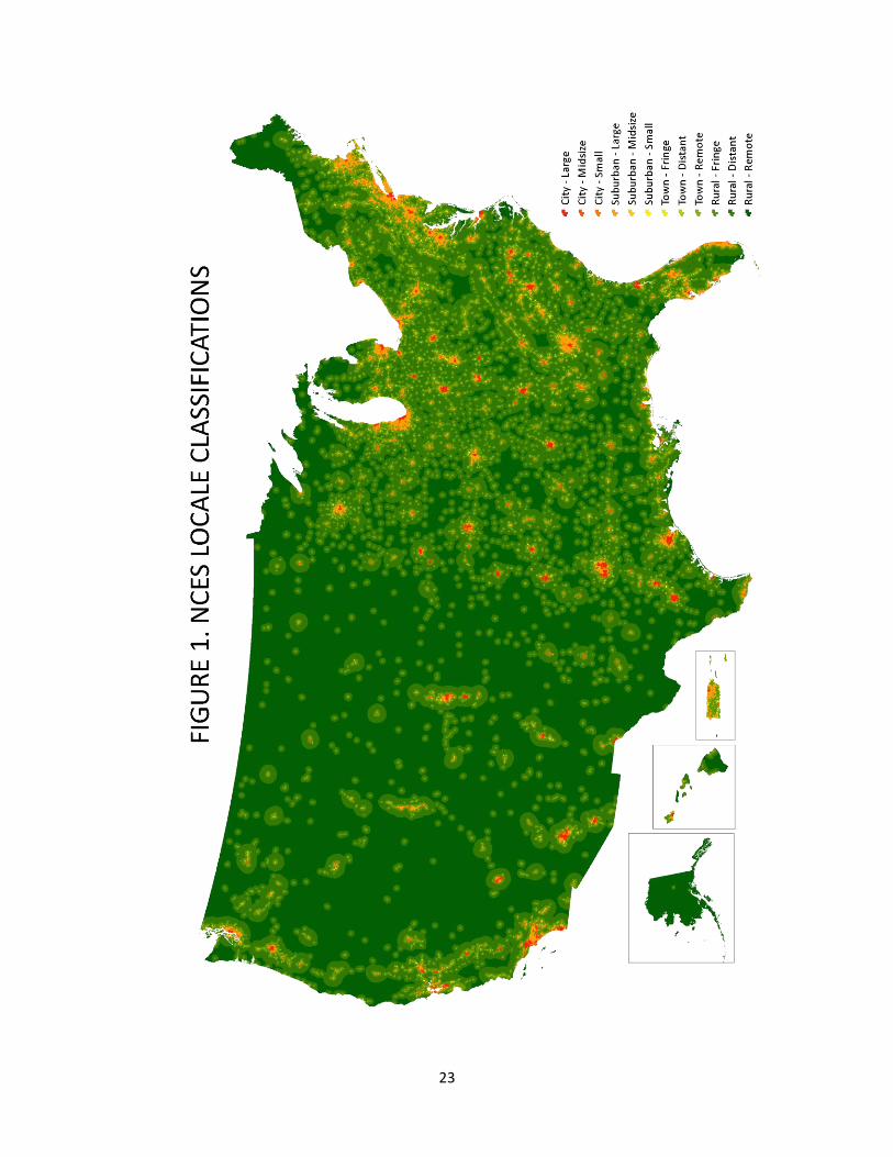
23