education and training surveying and the spatial sciences university of tasmania challenges and...
TRANSCRIPT

Education and TrainingSurveying and the Spatial Sciences
University of Tasmania
Challenges and Opportunities
Jon Osborn29th February 2013
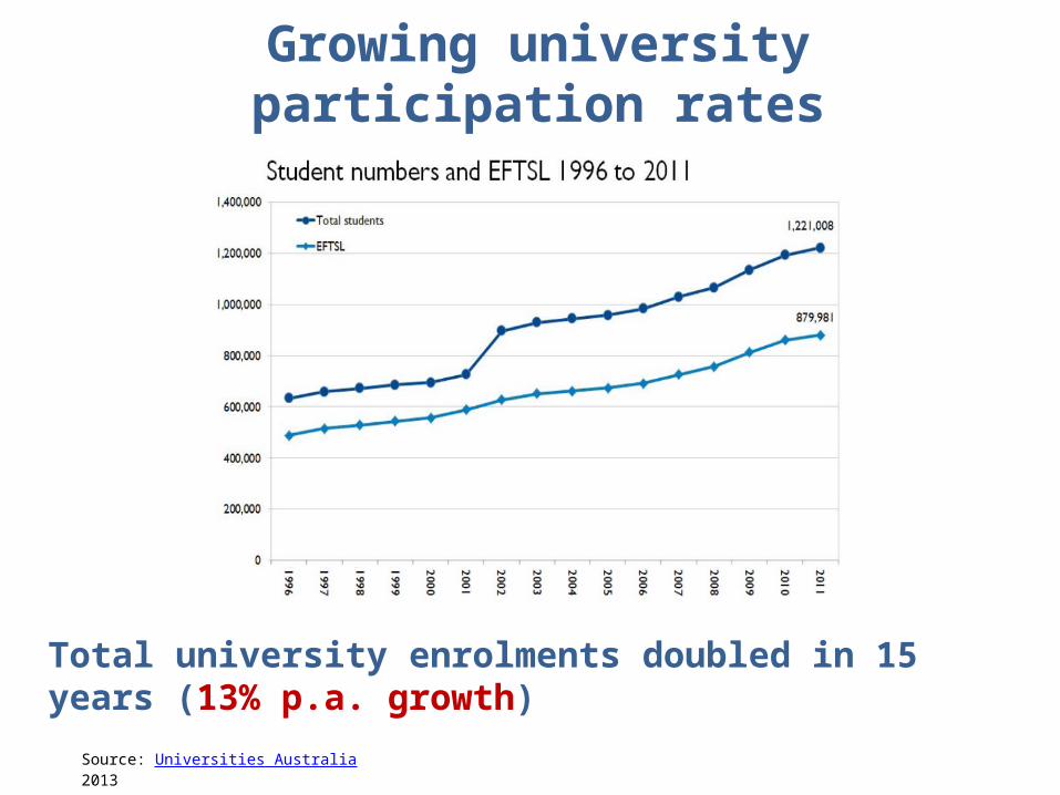
Growing university participation rates
Source: Universities Australia 2013
Total university enrolments doubled in 15 years (13% p.a. growth)
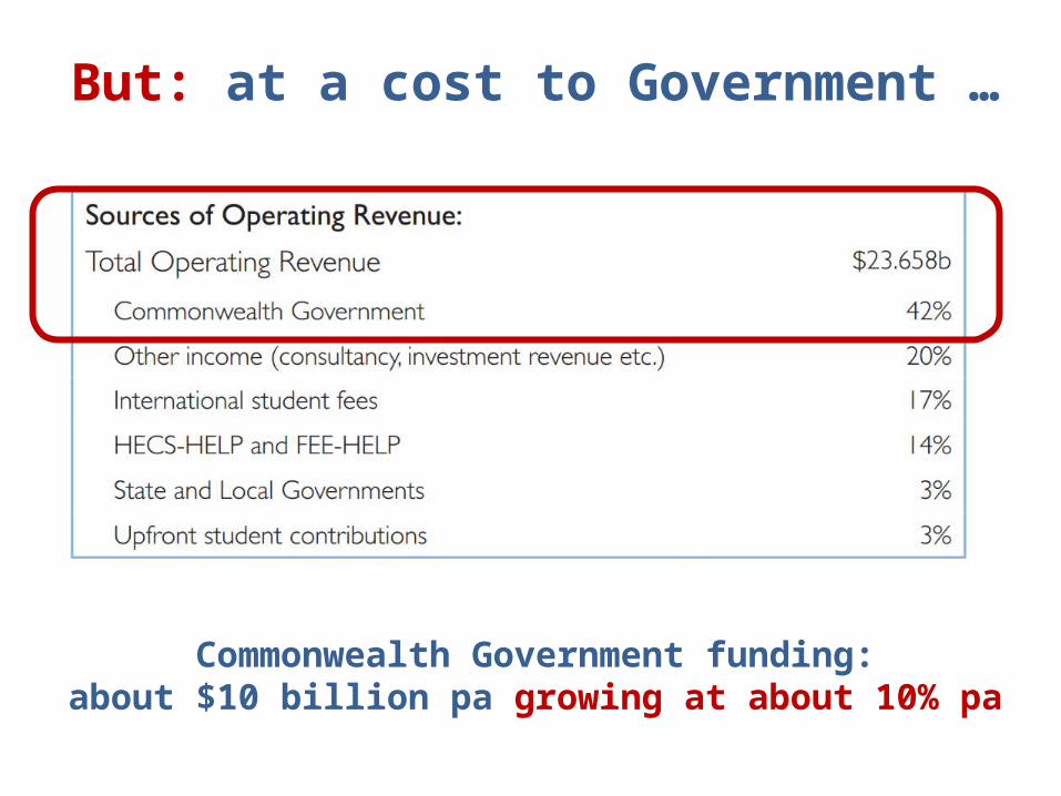
But: at a cost to Government …
Commonwealth Government funding:about $10 billion pa growing at about 10% pa

UTAS response to the squeezeBIG CHANGES
• Strong business focus
• Big research agenda
• Big growth agenda
• School mergers: large business units
• Curriculum reviews: efficiency / affordability
• Large investments in large classes for large returns …
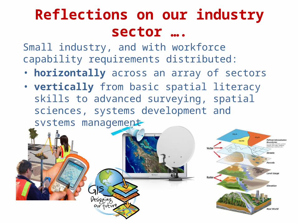
Reflections on our industry sector ….Small industry, and with workforce capability requirements distributed:• horizontally across an array of sectors• vertically from basic spatial literacy skills to advanced
surveying, spatial sciences, systems development and systems management

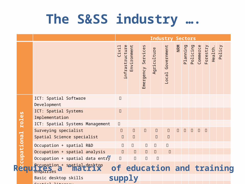
The S&SS industry ….
A “matrix” of education and training demand ….
Industry Sectors Ci
vil infrastructur
e
Environment
Emergency Services
Agriculture
Loca
l G
overnm
ent
NRM
Pl
anni
ng
Poli
ci
ng
Commerce
Forestry
Health.
Poli
cy
Occupation
al role
s
ICT: Spatial Software Development
ICT: Spatial Systems Implementation
ICT: Spatial Systems Management
Surveying specialistSpatial Science specialist
Occupation + spatial R&D
Occupation + spatial analysis
Occupation + spatial data entry
Occupation + spatial desktop enquiries
Basic desktop skills
Spatial literacy
The S&SS industry …. Industry Sectors Ci
vil infrastructur
e
Environment
Emergency Services
Agriculture
Loca
l G
overnm
ent
NRM
Pl
anni
ng
Poli
ci
ng
Commerce
Forestry
Health.
Poli
cy
Occupation
al role
s
ICT: Spatial Software Development
ICT: Spatial Systems Implementation
ICT: Spatial Systems Management
Surveying specialistSpatial Science specialist
Occupation + spatial R&D
Occupation + spatial analysis
Occupation + spatial data entry
Occupation + spatial desktop enquiries
Basic desktop skills
Spatial literacy
Requires a “matrix” of education and training supply

UTAS programs inSurveying and Spatial Sciences
How do we position in this environment?

Year 1
Year 2
Year 3
Bachelor of Surveying and Spatial Sciences

Year 1
Maths 1
Maths 2
Surveying 1
Surveying 2
Year 3
Analysis of Observations
Surveying 3
Elective Geodesy
Bachelor of Surveying and Spatial Sciences
Surveying Major

Year 1
GIS 1 Maths 1
Remote Sensing 1 Maths 2
Year 2
GIS 2 Surveying 1
Remote Sensing 2 Surveying 2
Year 3
GIS 3 GNSS Analysis of Observations
Surveying 3
Remote Sensing 3 Research Project Elective Geodesy
Bachelor of Surveying and Spatial Sciences
Surveying MajorGIS & Remote Sensing Major

Year 1
GIS 1 Geography Computing Maths 1
Remote Sensing 1 Geography Computing Maths 2
Year 2
GIS 2 Geography Elective Surveying 1
Remote Sensing 2 Geography Elective Surveying 2
Year 3
GIS 3 GNSS Analysis of Observations
Surveying 3
Remote Sensing 3 Research Project Elective Geodesy
Bachelor of Surveying and Spatial Sciences
Only 4 “Specialist” small class units in the undergraduate degree

GIS and Remote Sensing Major and MinorYear 1
GIS 1
Remote Sensing 1
GIS 2
Remote Sensing 2
GIS 3 GNSS
Remote Sensing 3 Research Project
GeographyGeologyComputingInformation Systems
Agricultural Science
= INCREASED ENROLMENTS
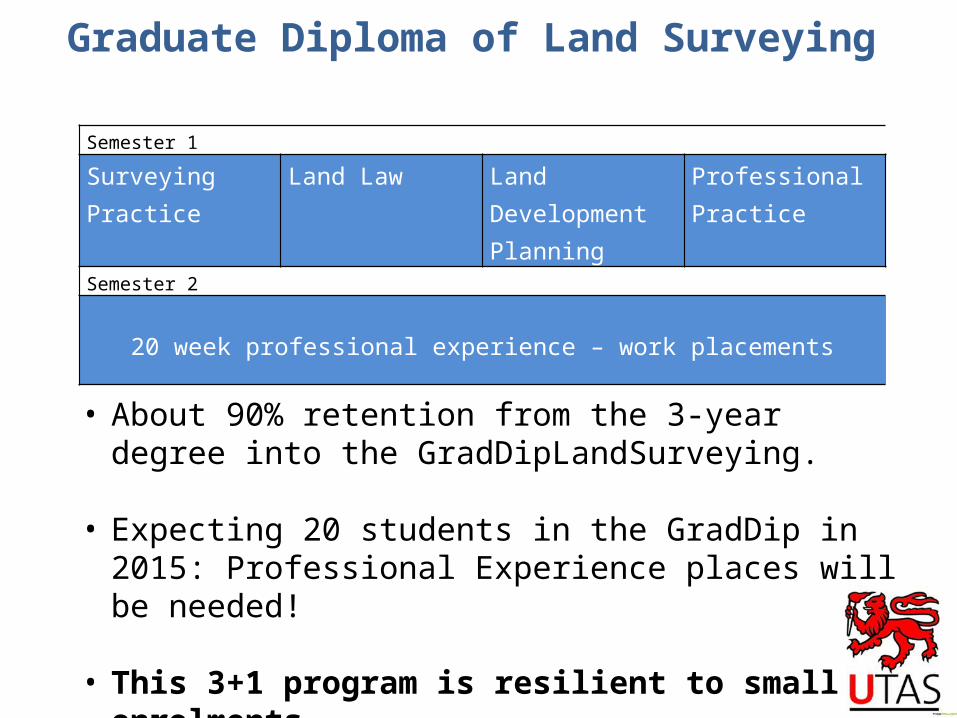
Semester 1Surveying Practice Land Law Land Development
PlanningProfessional Practice
Semester 2
20 week professional experience – work placements
Graduate Diploma of Land Surveying
• About 90% retention from the 3-year degree into the GradDipLandSurveying.
• Expecting 20 students in the GradDip in 2015: Professional Experience places will be needed!
• This 3+1 program is resilient to small enrolments.

How does this fit with the industry….
Minor and Major in BSc.GradCert, GradDip and Masters coursework
BSurvSpSc GradDipLandSurveying
Some options – but not yet substantive
Not UTAS priority
UTAS is well positioned to meet some of this demand
Industry Sectors Ci
vil infrastructur
e
Environment
Emergency Services
Agriculture
Loca
l G
overnm
ent
NRM
Pl
anni
ng
Poli
ci
ng
Commerce
Forestry
Health.
Poli
cy
Occupation
al role
s
ICT: Spatial Software Development
ICT: Spatial Systems Implementation
ICT: Spatial Systems Management
Surveying specialistSpatial Science specialist
Occupation + spatial R&D
Occupation + spatial analysis
Occupation + spatial data entry
Occupation + spatial desktop enquiries
Basic desktop skills
Spatial literacy
Minor and Major in BSc.GradCert, GradDip and Masters coursework
BSurvSpSc GradDipLandSurveying
Some options – but not yet substantive
Not UTAS priority

But … current discussions in Tasmania:
• How do we ensure education and training to support all sectors?
• How do we ensure access from all workplaces, across the State?
• How do we achieve efficiencies through growth and innovative course delivery?
• How do we recruit into the BSurvSpSc
• What role UTAS?
• What role TAFE sector?
• What role K-12 schools and colleges?
• What role Private Sector providers?
• What role interstate/international providers?

Thanks.